general engineering requirements manual
TRANSCRIPT

GENERAL
ENGINEERING
REQUIREMENTS
MANUAL
2018

General Engineering Requirements Manual Table of Contents
CHAPTER 1 INTRODUCTION ........................................................................... 1-1
1.1 Purpose and Intent ......................................................................................................... 1-1 1.2 Integration with City Codes, Ordinances, and Regulations ............................................ 1-1
1.3 Project Classifications .................................................................................................... 1-2 1.4 Comprehensive Planning ............................................................................................... 1-2 1.5 Geographic Information System (GIS) Technology ........................................................ 1-3 1.6 Land Surveying .............................................................................................................. 1-3 1.7 Technical Reports .......................................................................................................... 1-6
1.8 Registrant’s Seal and Signature .................................................................................... 1-7 1.9 General Improvement Plan Requirements .................................................................... 1-7 1.10 Deviation from City Engineering Standards ................................................................ 1-13
CHAPTER 2 GRADING AND DRAINAGE ....................................................... 2-16
2.1 General Information ...................................................................................................... 2-16 2.2 Availability of City Storm Drain ..................................................................................... 2-17
2.3 City Code ..................................................................................................................... 2-18 2.4 City Policies .................................................................................................................. 2-18 2.5 Federal, State and County Regulations ........................................................................ 2-18
2.6 Drainage Reports ........................................................................................................... 2-20 2.7 Design Standards and Guidelines ................................................................................ 2-24
2.8 Onsite Stormwater Management .................................................................................. 2-25 2.9 Offsite Stormwater Management .................................................................................. 2-27 2.10 Finished Floor Elevations ........................................................................................... 2-33
2.11 Grading Improvements ............................................................................................... 2-33
2.12 Retaining Walls .......................................................................................................... 2-34 2.13 Final Grading and Drainage Plan Requirements ........................................................ 2-34
CHAPTER 3 TRAFFIC AND TRANSPORTATION........................................... 3-35
3.1 General Information ...................................................................................................... 3-35 3.2 Integration with City Codes, Ordinances and Regulations ........................................... 3-36
3.3 State Route 30 Corridor ............................................................................................... 3-36 3.4 Design Standards and Guidelines ................................................................................ 3-36 3.5 Traffic Impact Analysis ................................................................................................. 3-36
3.6 Street Classification ...................................................................................................... 3-37 3.7 Street Right-of-Way Requirements ............................................................................... 3-38 3.8 Easements and Dedications ......................................................................................... 3-39 3.9 Curb and Gutter ............................................................................................................ 3-41
3.10 Sidewalks ................................................................................................................... 3-43 3.11 Pavement Cross Sections .......................................................................................... 3-44 3.12 Horizontal Alignment .................................................................................................. 3-44 3.13 Vertical Alignment ....................................................................................................... 3-47 3.14 Horizontal and Vertical Curves .................................................................................... 3-48
3.15 Longitudinal Street Grades .......................................................................................... 3-48 3.16 Intersections ................................................................................................................ 3-48
3.17 Auxiliary Traffic Lanes ................................................................................................. 3-51 3.18 Median Design ........................................................................................................... 3-52
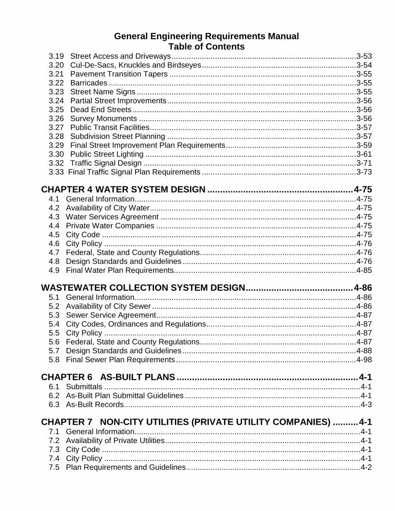
General Engineering Requirements Manual Table of Contents
3.19 Street Access and Driveways ..................................................................................... 3-53
3.20 Cul-De-Sacs, Knuckles and Birdseyes ....................................................................... 3-54 3.21 Pavement Transition Tapers ...................................................................................... 3-55 3.22 Barricades .................................................................................................................. 3-55 3.23 Street Name Signs ..................................................................................................... 3-55 3.24 Partial Street Improvements ....................................................................................... 3-56
3.25 Dead End Streets ....................................................................................................... 3-56 3.26 Survey Monuments .................................................................................................... 3-56 3.27 Public Transit Facilities ............................................................................................... 3-57 3.28 Subdivision Street Planning ....................................................................................... 3-57 3.29 Final Street Improvement Plan Requirements ............................................................ 3-59
3.30 Public Street Lighting ................................................................................................. 3-61 3.32 Traffic Signal Design .................................................................................................. 3-71
3.33 Final Traffic Signal Plan Requirements ....................................................................... 3-73
CHAPTER 4 WATER SYSTEM DESIGN ......................................................... 4-75
4.1 General Information ...................................................................................................... 4-75 4.2 Availability of City Water ............................................................................................... 4-75
4.3 Water Services Agreement .......................................................................................... 4-75 4.4 Private Water Companies ............................................................................................ 4-75
4.5 City Code ..................................................................................................................... 4-75 4.6 City Policy .................................................................................................................... 4-76 4.7 Federal, State and County Regulations ........................................................................ 4-76
4.8 Design Standards and Guidelines ................................................................................ 4-76 4.9 Final Water Plan Requirements.................................................................................... 4-85
WASTEWATER COLLECTION SYSTEM DESIGN .......................................... 4-86
5.1 General Information ...................................................................................................... 4-86
5.2 Availability of City Sewer .............................................................................................. 4-86 5.3 Sewer Service Agreement ............................................................................................ 4-87
5.4 City Codes, Ordinances and Regulations ..................................................................... 4-87
5.5 City Policy .................................................................................................................... 4-87 5.6 Federal, State and County Regulations ........................................................................ 4-87
5.7 Design Standards and Guidelines ................................................................................ 4-88 5.8 Final Sewer Plan Requirements ................................................................................... 4-98
CHAPTER 6 AS-BUILT PLANS ....................................................................... 4-1
6.1 Submittals ...................................................................................................................... 4-1
6.2 As-Built Plan Submittal Guidelines ................................................................................. 4-1 6.3 As-Built Records ............................................................................................................. 4-3
CHAPTER 7 NON-CITY UTILITIES (PRIVATE UTILITY COMPANIES) .......... 4-1
7.1 General Information ........................................................................................................ 4-1 7.2 Availability of Private Utilities .......................................................................................... 4-1 7.3 City Code ....................................................................................................................... 4-1 7.4 City Policy ...................................................................................................................... 4-1 7.5 Plan Requirements and Guidelines ................................................................................ 4-2

General Engineering Requirements Manual Table of Contents
7.6 Utility Trenching .............................................................................................................. 4-3
7.7 Plan Submittal ................................................................................................................ 4-3 7.8 Permit Required ............................................................................................................. 4-4 7.9 Fees ............................................................................................................................... 4-4
CHAPTER 8 LANDSCAPING AND IRRIGATION .............................................. 4-1
CHAPTER 9 GLOSSARY .................................................................................. 4-1
9.1 Definitions ...................................................................................................................... 4-1
LIST OF TABLES TABLE 1-1 Plan Sheet Scale * .............................................................................................. 1-9 TABLE 2-1 Storm Drain Manhole Spacing ........................................................................... 2-32 TABLE 3-1 Street Right-of-Way Required ........................................................................... 3-39
TABLE 3-2 Intersection Right-of-Way Triangle Requirements* ........................................... 3-39 TABLE 3-3 Curb Return Radii .............................................................................................. 3-42
TABLE 3-4 Minimum Horizontal Curve Radius .................................................................... 3-45 TABLE 3-5 Tangent Sections (Curves in Same Direction) ................................................... 3-46 TABLE 3-6 Minimum Tangent Sections (Reverse Curves) .................................................. 3-47
TABLE 3-7 Tangent Sections at Intersections ..................................................................... 3-47 TABLE 3-8 Vertical Curves Requirements ........................................................................... 3-48
TABLE 3-9 Longitudinal Street Grade.................................................................................. 3-48 TABLE 3-10 Driveway Spacing .............................................................................................. 3-53
TABLE 3-11 Minimum Photometric Design Requirements .................................................... 3-62 TABLE 3-12 Streetlight Pole and Spacing Requirements ...................................................... 3-62
TABLE 4-1 Minimum Waterline Size .................................................................................... 4-78 TABLE 4-2 Fire Hydrant Spacing ......................................................................................... 4-85 TABLE 0-1 Minimum Slopes for Circular Pipes ................................................................... 4-91
TABLE 0-2 Manhole Spacing (1) ......................................................................................... 4-93

PREFACE The 2018 City of Avondale General Engineering Requirements Manual (this “2018 Manual” or “Manual”) sets forth the engineering requirements as they pertain to all projects within the City of Avondale. The 2018 Manual replaces the City of Avondale’s 2008 General Engineering Requirements Manual.

General Engineering Requirements Manual City of Avondale 2018
5-1
CHAPTER 1 INTRODUCTION
1.1 Purpose and Intent
The City of Avondale (the “City”) desires to achieve the development and improvement of property in a manner that provides a quality of life improvement for public health, safety and welfare. This Manual will provide standards and minimum design criteria for the planning and designing of City of Avondale Capital Improvement Projects (CIP) and Development Services (DS) projects as defined in Section 1.3 of this Manual. The intent of this Manual is to present clear and concise direction regarding technical requirements, policies, and processes to facilitate consistent uniform design during the plan preparation phase. In following the requirements of this Manual, sound engineering judgment must be exercised.
1.2 Integration with City Codes, Ordinances, and Regulations
The Avondale City Code (the “City Code”) (i) outlines and establishes the minimum acceptable standards for improvement of public streets, utilities, and related infrastructure, (ii) defines the responsibility of the engineer or developer in the design, construction and financing of public improvements, and (iii) establishes procedures for review and approval of engineering plans. The Manual clarifies and supplements requirements in the City Code, including the zoning ordinance, subdivision, floodplain and stormwater regulations, fire and building codes, and other regulations for land development within the City of Avondale. The Manual is not intended to interfere with, abrogate, or annul any other ordinance, rule or regulations, statute, or other provision of law except as provided in this Manual. Where any provision of this Manual imposes restrictions different from those imposed by any other provision of law, the provision that is more restrictive or imposes the higher standard upon the development and use of land shall control.

General Engineering Requirements Manual City of Avondale 2018
5-2
1.3 Project Classifications
1.3.1 Development Services Projects (DS): Development Services (DS) projects are projects with construction improvements that are to be installed as part of land development. Requirements are outlined in this Manual as well as the City codes, ordinances and regulations. Refer to the City website at www.avondaleaz.gov www.avondaleaz.govunder Development and Engineering Services for specific information regarding the development services processes. The website includes the applications, permits and a detailed flowchart outlining each step in the process. 1.3.2 Capital Improvement Projects (CIP): Capital Improvement Projects (CIP) are projects that are installed as part of the City’s adopted Capital Improvement Plan. CIP are City funded projects, usually inside the public right-of-way, that are managed by City staff and designed by private engineering consultants.
1.4 Comprehensive Planning
The City of Avondale has developed water, sewer, and transportation master plans to ensure that future improvement requirements are achieved through orderly development of the City planning areas. Any engineer working on construction improvements shall review the comprehensive plans and incorporate the requirements into improvement plans submitted to the City. 1.4.1 Transportation Plan: The Transportation Plan identifies forecasted infrastructure need and sets directions for undertaking transportation projects that will provide the City with an optimal transportation system to effectively serve the future travel demands. The Transportation Plan is available on the City of Avondale website atwww.avondaleaz.gov. 1.4.2 Wastewater Plan and Water Plan: The City of Avondale is experiencing rapid growth requiring improvements in the water and wastewater infrastructure to serve the growing community. The latest editions of the Water and Wastewater Master Plan that outline the City’s water and wastewater systems, and determine how new infrastructure should grow to provide customers with an appropriate level of service are available by contacting the City. 1.4.3 Drainage Master Plan:

General Engineering Requirements Manual City of Avondale 2018
5-3
The City of Avondale has not developed a drainage master plan that covers its entire jurisdictional boundaries. The Flood Control District of Maricopa County has prepared Area Drainage Master Plans (ADMP) for areas of the City of Avondale which are available at www.fcd.maricopa.gov. Some of the ADMPs include, but are not limited to: White Tanks/Agua Fria Area Drainage Master Plan and Durango Area Drainage Master Plan. 1.4.4 General Plan: The City of Avondale General Plan provides the community with a vision to guide growth and development. The Design Engineer shall review the document to ensure proposed construction improvements accommodate the requirements described in the General Plan. The General Plan is available at www.avondaleaz.gov.
1.5 Geographic Information System (GIS) Technology
The City is using GIS technology for capturing, managing, analyzing, and displaying all forms of geographically referenced data and information. GIS data submitted to the City shall comply with the Arizona Spatial Data Accuracy and Geo-Referencing Standards available from Arizona Professional Land Surveyors (APLS).
1.6 Land Surveying
1.6.1 General Information The intent of this section is to ensure all improvement projects involving surveys, aerial mapping, and land transactions will apply consistent methods and standards pertaining to ground surface measurement within the City of Avondale. All survey work in the City of Avondale must be performed under the direction of a professional land surveyor registered in accordance with requirements of the Arizona State Board of Technical Registration. 1.6.2 Boundary Survey Standards A. Boundary Surveys: All land survey work will be performed within the guidelines
of the Arizona Boundary Survey Minimum Standards. These standards may be obtained from the Arizona State Board of Technical Registration at 1110 West Washington Street, Suite 240, Phoenix, Arizona 85007, or online at:
https://btr.az.gov/laws-standards/standards/land-surveyors
B. ALTA Surveys: ALTA surveys will be based on American Land Title Association,
American Congress on Surveying & Mapping, and National Society of Professional Surveyors 2016 Minimum Standard Detail Requirements for ALTA/NSPS Land Title Surveys:
https://www.alta.org/forms/download.cfm

General Engineering Requirements Manual City of Avondale 2018
5-4
1.6.3 Horizontal Datum A. Horizontal Datum: The horizontal datum for all engineering work (mapping,
planning, design, right-of-way engineering and construction) for City of Avondale projects shall be the North American Datum of 1983, (NAD83) as defined by the National Geodetic Survey (NGS) National Spatial Adjustment System (NSRS2007). The physical, on the ground based survey datum shall be Arizona State Plane coordinate system, central zone with a common unit of measure, the International foot.
B. Ground Adjustment Scale Factor: The combined scale factor of 1.000126 shall
be used to convert the horizontal control point values (grid) to ground measurements. To convert from ground to grid, multiply by 0.999874.
1.6.4 Vertical Datum The vertical control datum for use within the City of Avondale is the North American Vertical Datum of 1988 (NAVD88), as defined by the National Geodetic Survey (NGS). 1.6.5 Horizontal and Vertical Control System A. Horizontal Control: Horizontal control for determining NAD83 coordinates will be
based on published NGS control stations of 1st order accuracy or better. More than forty published 1st order accuracy NGS horizontal and vertical control stations are located within or in the immediate vicinity of the City of Avondale planning area. Many of these monuments were established in November 2006 in semi-protected locations readily accessed off traveled roadways. All surveys will reference a minimum of three of these stations. GPS Global Navigation satellite system surveys may use a recognized local continuously operating broadcast/reference (COBS or COR) station signal as an approved alternate method provided they check into two of the NGS control stations. Control station data used will be documented, described and referenced by name, position, elevation and date on the plans.
B. Vertical Control: Vertical control for determining NAVD88 elevations will be based on published NGS control stations of 2nd order class II accuracy or better.
C. NGS Data Sheets: Current NGS survey control data sheets should be
downloaded for each project from the following website:
www.ngs.noaa.gov/cgi-bin/datasheet.prl

General Engineering Requirements Manual City of Avondale 2018
5-5
1.6.6 Benchmarks A. Plan Benchmark References: All improvement plans must reference on the
cover the published NGS monument used for vertical control. Description and elevation in the required NAVD88 datum will be shown.
B. Plan Datum Reference: All improvement plans shall contain a statement
certifying the datum used for all elevations which are represented in the plans. The statement shall be included on the cover sheet immediately below the benchmark.
C. Current Datum: Former City of Avondale Benchmarks in use prior to May 2007,
which used the NGVD29 datum, are no longer acceptable for vertical control. If conversions of as-built plans are required to convert from old control in the NVGD29 datum, contact the City of Avondale for a GIS division approved equation.
1.6.7 Updating of Standards and Specifications It is recognized that positioning technologies are continuously evolving and that control available for geo-referencing may be revised or augmented. Therefore, these standards will be periodically updated and the version in force during data collection shall be specifically referenced in the project scope or provided by the City upon request. 1.6.8 Digital Images Digital images shall be obtained to adequately cover the project. The images shall be geo-referenced by survey point number and annotated with the cardinal direction. 1.6.9 Deliverables A. Non-Digital Media
(1) Final full size base map drawings signed and sealed by an Arizona registered land surveyor
(2) Unrecorded surveys or as-built plans NOT obtained from City of Avondale B. Digital Media
Directories and subdirectories shall be created so as to produce an organized structure that is easily followed to obtain the copied files. The following items shall be copied into the appropriate directories of a CD with the City of Avondale project name, work order number, land surveyors stamp and signature on the label.

General Engineering Requirements Manual City of Avondale 2018
5-6
C. Data Collection Files
All files associated with the data collection, including but not limited to: (1) GPS project(s) (i.e. Trimble Geomatics Office, Prism, etc.) (2) Digital level runs
D. Computer Aided Design (CAD)
All files associated with generating the base map drawing, including but not limited to:
(1) Raw Data – The appropriate raw data for the software utilized (2) Coordinates – Comma delimited ASCII format listing point number,
northing, easting, elevation, descriptor code and notes (3) Digital Terrain Model (4) Drawings/Exhibits (.dwg)
E. Images: All images taken on the project F. Miscellaneous: Any and all files that were used in conjunction with the base map
generation.
1.7 Technical Reports
The reports listed below are required for all Development Services projects and may be required for CIP projects. The need for reports on capital improvement projects will be determined by staff on a case-by-case basis. 1.7.1 Traffic Impact Analysis (TIA): The Design Engineer shall be required, at the time of preliminary plat or site plan submittal, to submit a final Traffic Impact Analysis per City Standards (available on the City of Avondale website at: https://www.avondaleaz.gov/government/departments/development-engineering-services/brochures-publications for review and approval. The TIA shall incorporate Avondale Transportation Plan Guidelines and state any deviations. Other traffic study requirements for rezoning, Planned Area Developments (PADs) or Conditional Use Permits (CUPs) and other submittals are listed on the City’s website. 1.7.2 Geotechnical Report: The Design Engineer shall be responsible to submit a geotechnical report with the improvement plans. Report shall include boring logs for underground utilities such as water/sewer/reclaimed/force mains. Soil borings are required for proposed pipe trenches at intervals not exceeding 660’ and at a depth of two (2’) feet below proposed

General Engineering Requirements Manual City of Avondale 2018
5-7
pipe invert. The report shall also recommend a pavement section for any new street construction. The Design Engineer is responsible for investigating and evaluating the existing pavement structure. 1.7.3 Drainage Report: Engineers shall be required, at the time of civil plan submittal, to submit a Final Drainage Report or memorandum for review and approval. The report shall be prepared in accordance with the current City of Avondale General Engineering Requirements Manual, and the Flood Control District of Maricopa County Drainage Manuals. Drainage reports should incorporate drainage master plan and area drainage master plan guidelines and state deviations, if any. 1.7.4 Water and Wastewater Design Reports: Water and wastewater design reports shall provide an analysis of the impact that a development will have on the City’s water and wastewater systems. The objectives of the design report are to verify the water demand, verification of sufficient fire flows, available system flows, pressures, proposed hydraulics and determine the wastewater demand capacities, and analyze the hydraulics of the proposed sanitary sewer system. The system design shall comply with ADEQ Engineering Manual Bulletin No. 11 for the wastewater system.
1.8 Registrant’s Seal and Signature
The City requires that all project improvement plans, specifications, reports, and technical documents that are submitted for review be sealed and signed in accordance with the requirements of the Arizona State Board of Technical Registration.
1.9 General Improvement Plan Requirements
1.9.1 General Information: All proposed improvement projects that involve construction of engineered improvements (streets, grading and drainage facilities, utilities, etc.) must include plans and supporting reports to the City for review, approval, and permitting. This section describes the general requirements for all civil improvement plans prepared for projects within the City. Additional improvement plan requirements that are specific to the type of improvements proposed are identified in the following chapters of this manual. 1.9.2 Improvement Plan Submittals: The improvement plans submitted to the City of Avondale for approval shall adhere to professional standards governed by the Arizona State Board of Technical Registration. Improvement plans shall be complete and in compliance with City and State Board requirements. Improvement plans that do not meet industry standards, or are incomplete, will be returned by the City without review comments and shall be classified

General Engineering Requirements Manual City of Avondale 2018
5-8
as an inadequate project submittal. Repetitive submittals of non-compliant and inadequate improvement documents may be subject to an Arizona State Board of Technical Registration review. 1.9.3 General Requirements: A. Civil Engineering Standards: For public infrastructure improvements, the City of
Avondale uses the Maricopa Association of Governments’ (MAG) Uniform Standard Specifications and Details for Public Works Construction (available at www.mag.maricopa.gov), the City of Avondale General Engineering Requirements Manual and the City of Avondale’s Supplement to the MAG Uniform Specifications and Details for Public Works Construction, available on City of Avondale website at www.avondaleaz.gov.
B. Sheet Size: Typical improvement plans shall be on 24” x 36” sheets with blue or
blackline types with a minimum of a 1½” left border and a ½” border on other sides. The City reserves the right to request scaled half size sets for review purposes.
C. Sheet Orientation: Plans shall be oriented with north towards the top, or right of
each sheet. A north arrow and scale (both written and graphic) shall be provided on all sheets. Each sheet shall be sequentially numbered. All phase limits and match lines should be clearly designated. The lot numbers, tracts & subdivision names shall be shown. Phase lines shall be at lot lines or even stations.
D. Text Designation: Minimum lettering and numbering size shall be 3/16” for
manually drafted or 12-point font for mechanically/electronic produced letters, numbers and symbols. Lettering, numbering line work and shading must be uniform and with clear definition to be retrievable after microfilming or digitizing.
E. Improvement Plan Designation: Separate improvement plans may be provided
for the following:
(1) Map of Dedication (2) Subdivision Plats (3) Site Plans (4) Street Improvements (5) Storm Drain Improvements (6) Water System Improvements (7) Wastewater Improvements (8) Grading and Drainage Improvements (9) Traffic Signalization (10) Traffic Signing and Pavement Marking Improvements (11) Temporary Traffic Control (12) Landscape and Irrigation Improvements (13) Streetlight Improvements

General Engineering Requirements Manual City of Avondale 2018
5-9
(14) Reclaimed Water Improvements (15) Storm Water Management Plan (SWMP)
F. Drawing Scales: Table 1-1 represents the standard minimum drawing scales to
be used for improvement plans submitted to City. Note: The Design Engineer shall take into account when selecting drawing scales, line weights and lettering size that the improvement plans may be photocopied, microfilmed or digitally scanned. Depending on the complexity of the design, a larger scale may be required by City staff.
TABLE 1-1
Plan Sheet Scale * DS Projects CIP Projects
Map of Dedication 1” = 50’ Horizontal Not Applicable
Subdivision Plats 1” = 100’ Horizontal Not Applicable
Site Plan 1” = 50’ Horizontal 1” = 50’ Horizontal
Paving Plans Local Streets 1” = 40’ Horizontal 1” = 4’ Vertical
1” = 20’ Horizontal 1” = 4’ Vertical
Paving Plans Arterial and Collector Streets
1” = 20’ Horizontal 1” = 2’ Vertical
1” = 20’ Horizontal 1” = 2’ Vertical
Storm Drain 1” = 40’ Horizontal 1” = 4’ Vertical
1” = 20’ Horizontal 1” = 4’ Vertical
Water 1” = 40’ Horizontal 1” = 4’ Vertical
1” = 20’ Horizontal 1” = 2’ Vertical
Wastewater 1” = 40’ Horizontal 1” = 4’ Vertical
1” = 20’ Horizontal 1” = 2’ Vertical
Grading and Drainage 1” = 40’ Horizontal 1” = 4’ Vertical
1” = 40’ Horizontal 1” = 4’ Vertical
Temporary Traffic Control 1” = 40’ Horizontal 1” = 40’ Horizontal
Traffic Signalization 1” = 20’ Horizontal 1” = 2’ Vertical
1” = 20’ Horizontal 1” = 2’ Vertical
Traffic Signing and Pavement Marking
1” = 40’ Horizontal 1” = 40’ Horizontal
Landscape and Irrigation 1” = 40’ Horizontal 1” = 40’ Horizontal
Streetlight 1” = 40’ Horizontal 1” = 40’ Horizontal
Reclaimed Water 1” = 40’ Horizontal 1” = 4’ Vertical
1” = 20’ Horizontal 1” = 2’ Vertical
Storm Water Management Plan 1” = 40’ Horizontal 1” = 40’ Horizontal
G. All existing topography shall be screened, or shown differently. This will typically
include existing contours with adequate spot elevations to show:
(1) Drainage (2) Existing aerial and underground utilities (3) Existing irrigation facilities (4) Adjacent land uses (5) City limits

General Engineering Requirements Manual City of Avondale 2018
5-10
(6) County limits, where applicable (7) 100-year floodplain (8) Flood elevations and floodway limits, where applicable
H. Plans shall show existing and proposed right-of-way, easements and property
lines. Dimensions of these shall be clearly indicated. Add the Assessor Parcel Number (APN), property address and lot numbers.
I. New construction line work and construction notes shall be sufficiently heavier
than existing topography, so as to allow it to be quickly and clearly identified. J. Grade breaks shall be clearly shown with the applicable symbol on the plan
and/or profile sheets. K. “Blue Stake” notification shall be provided on each sheet. L. Title Blocks: All plan sheets shall note the project’s title and address in a title
block on the sheet’s right hand margin. M. Dimensioning: All existing and proposed improvements shall be dimensioned in
accordance with the following:
(1) All plan sheets showing street improvements or dedicated rights-of-way shall be dimensioned per MAG Standard Detail 112.
(2) All plan sheets showing the construction of new utilities or existing utilities shall be dimensioned per MAG Standard Detail 112.
(3) All plan sheets showing an easement shall dimension the overall width of the easement.
N. Symbols: Symbols noted on the plan sheets shall be per MAG Standard Detail
110. Special symbols not represented on MAG Standard Detail 110 may be used provided the symbol representation is identified in the legend and approved by the City.
O. Construction Notes: Construction notes for all new construction shall be noted
on each plan sheet. P. General Notes: All General Notes shall be in accordance with the most recent
editions of the MAG Uniform Standard Specifications and Details and the City of Avondale Supplement to the MAG Uniform Standard Specifications and Details available on the City of Avondale website at www.avondale.org.
1.9.4 Cover Sheet: An individual cover sheet is required for each type of improvement plan. Refer to the following City website link for a typical CIP or DS projects cover sheet and the required information to be provided on the cover sheet.

General Engineering Requirements Manual City of Avondale 2018
5-11
https://www.avondaleaz.gov/government/departments/development-engineering-services/brochures-publications 1.9.5 Plan Design Sheets Construction plans for improvements typically consist of a variety of types of sheets. All construction plan design sheets shall include the following: A. Horizontal Control:
(1) The origination point of all position systems shall be based on an established survey point or monument and identified on the plans and be on a City approved benchmark.
(2) Position systems shall be designed to proceed from south to north, west to east, left to right.
(3) All plan sheets shall be stationed in 100-foot intervals. (4) Bearing and distance on all horizontal control need to be clearly identified
on each sheet. Bearing and distances need to be identified for each change in bearing.
(5) CIP projects require Temporary Benchmarks (TBM) established by a Project Engineer or Surveyor when it is necessary to maintain vertical control. All TBMs shall be per City datum.
B. Required Information to be shown on Plans:
(1) All jurisdictions (City, County, and State) in which this project falls. Projects that are adjacent to corporate limits of municipalities, County or State shall delineate the location of the corporate limits and identify the jurisdictions on all applicable sheets.
(2) Plans shall differentiate between the existing and proposed improvements and show all the existing conditions.
(3) Plans shall show all existing utilities complete with line sizes, types (water, sewer, gas, electrical, telecommunication, etc.) and locations. A distinct line type shall be created for each type of utility that notes the size and pipe material of the utility line.
1.9.6 Plan and Profile Sheets A. Plan and profile sheets are required for the following:
(1) All arterial, collectors, and local streets shall show separate profiles for left curb or left edge of pavement, right curb or right edge of pavement, profile grade line or left and right median curb profile, and left and right median curb.

General Engineering Requirements Manual City of Avondale 2018
5-12
(2) All public waterline improvement plans with pipe diameter 12-inch or greater; note the pipe slope and pipe material.
(3) All public sanitary sewer improvement plans (4) All public storm drain improvement plans (5) All public reclaimed waterline improvement plans with pipe diameter 12-
inch and greater
B. The profile shall indicate elevations and shall utilize the same horizontal control as the plan view.
C. The profile of the existing surface shall be shown with the proposed construction
line work and construction notes (i.e. elevations, slopes, grade breaks). D. The new or existing utility crossings with elevations shall be shown in the profile
view. Note the pipe material when known. Utility conflicts and design resolutions shall be noted in all the appropriate profiles with the required minimum clearance dimensioned and maintained per the applicable design standards of MAG, Arizona Department of Environmental Quality, or Maricopa County Environmental Services Department.
1.9.7 Detail Sheets Detail sheets are supplemental sheets that depict special construction details required to clarify some aspect of the proposed improvements. MAG or City of Avondale Standard Details are not to be included on the detail sheets unless the Detail is being modified. The modifications shall be clearly identified and the detail shall be titled “Modified MAG or Modified COA Detail.” 1.9.8 Plan Review Comments A. The project’s plan review comments (including redlines) shall be addressed by
correction or clarification response. If there is a discrepancy concerning a redline comment, contact the City plan review staff. The redline set of plans shall be returned with the next improvement plan submittal. Include a separate redline correction response letter addressing each comment and correction measure provided. The letter shall address each comment with plan sheet location noted, along with the applicable resolution of the comment.
B. For CIP projects, review comments shall be tabulated by the Design Engineer,
and an initial disposition shall be attempted. The table shall depict the comment, comment originator, sheet number of the comment, and disposition to the comment. Upon completion the table shall be forwarded to City staff for review prior to the comment resolution meeting. During the comment resolution meeting final disposition will be determined. The subsequent submittal shall then reflect all necessary changes as outlined by the direction in the disposition table. The
General Engineering Requirements Manual City of Avondale 2018
5-13
subsequent submittal shall include a copy of the comment disposing table and final disposition with a set of the revised documents.
C. Failure to identify all of the changes may result in the return of the plans with an
additional review required, and may require additional review fees based on the approved fee schedule. For CIP projects, this may require additional submittals at no cost to the City.
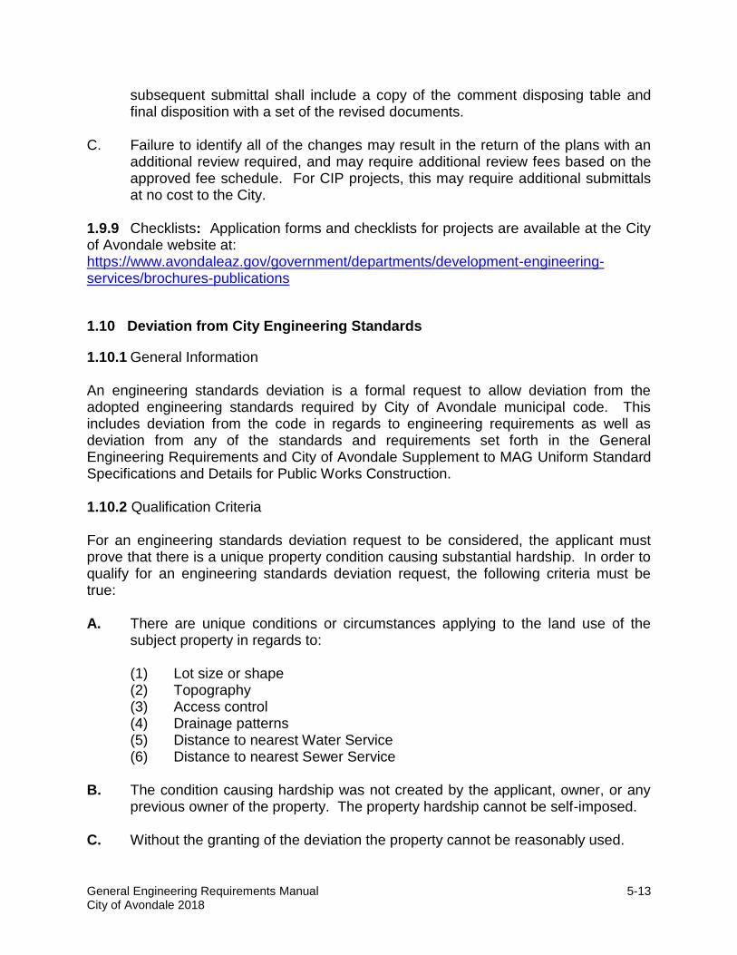
1.9.9 Checklists: Application forms and checklists for projects are available at the City of Avondale website at: https://www.avondaleaz.gov/government/departments/development-engineering-services/brochures-publications
1.10 Deviation from City Engineering Standards
1.10.1 General Information An engineering standards deviation is a formal request to allow deviation from the adopted engineering standards required by City of Avondale municipal code. This includes deviation from the code in regards to engineering requirements as well as deviation from any of the standards and requirements set forth in the General Engineering Requirements and City of Avondale Supplement to MAG Uniform Standard Specifications and Details for Public Works Construction. 1.10.2 Qualification Criteria For an engineering standards deviation request to be considered, the applicant must prove that there is a unique property condition causing substantial hardship. In order to qualify for an engineering standards deviation request, the following criteria must be true: A. There are unique conditions or circumstances applying to the land use of the
subject property in regards to:
(1) Lot size or shape (2) Topography (3) Access control (4) Drainage patterns (5) Distance to nearest Water Service (6) Distance to nearest Sewer Service
B. The condition causing hardship was not created by the applicant, owner, or any
previous owner of the property. The property hardship cannot be self-imposed. C. Without the granting of the deviation the property cannot be reasonably used.

General Engineering Requirements Manual City of Avondale 2018
5-14
D. Authorization of the deviation will not be materially detrimental to persons residing or working in the vicinity, to the adjacent property, to the neighborhood, or public welfare in general.
It is the burden of the applicant to prove all of the above criteria true. If all of the above criteria can be proven, an Design Engineer should contact the Engineering Plan Review Manager to discuss the feasibility of applying for a deviation. In no case shall economic hardship qualify as criteria for evaluating an engineering deviation. 1.10.3 Engineering Standards Deviation Process In general, the appropriate time to submit a formal engineering standards deviation request is in the preliminary stages of a project’s development. Once an applicant decides to move forward with the formal request for an engineering standards deviation, the applicant must follow the process outlined below and submit the formal request prior to, or concurrently with, the first report or civil plan submittal affected. Submittal of the formal request for an engineering deviation does not guarantee approval. Therefore, the applicant should understand that to proceed with design prior to City staff providing a written determination on the deviation is at the applicant’s own risk. A. The applicant’s Design Engineer must discuss the feasibility of applying for a
deviation in their specific situation with the Engineering Plan Review Manager.
B. Once an applicant decides to move forward with the formal request for an Engineering Deviation the applicant’s Design Engineer must submit the following for review.
(1) A completed Application for Engineering Standards Deviation: An
Engineering Standards Deviation application must be filled out completely. Applications without the required information may not be accepted in the Development Services Center at the time of submittal. The Engineering Deviation Application form may be downloaded at: https://www.avondaleaz.gov/government/departments/development-engineering-services/brochures-publications
(2) Narrative describing the project as well as the proposed deviation. The narrative shall include the following: (a) Section of City engineering standards or code which relates to the
proposed deviation outlining the existing City engineering standard and the deviation from the City engineering standard requested.
(b) Justification for the proposed deviation. The written request shall state the factors which would make approval of the request necessary, and how the development proposal differs from other developments and adopted standards. The basis for the argument shall be per the criteria listed in section 1.10.2 above.

General Engineering Requirements Manual City of Avondale 2018
5-15
(c) Site/civil plans detailing the proposed deviation shall include at a minimum a drawing showing the applicable conditions, topographic features, traffic patterns and any unusual or unique conditions not generally found in other developments.
(d) Supporting documents detailing engineering analysis such as traffic studies, drainage reports, typical sections, alternative designs etc. Each supporting document shall be signed and dated. When required, each document shall be sealed in accordance with the Arizona State Board of Technical Registration.
(e) Other pertinent data.
C. Once the application has been filled out and the technical documents have been prepared, four copies of the Application and the supporting technical documents shall be prepared and submitted with the appropriate fees to:
City of Avondale
Development & Engineering Services Dept. Engineering Plan Review Manager
11465 West Civic Center Drive, Suite 110 Avondale, Arizona 85323-6804
D. Engineering Standards Deviation Fees:
There are two fees for processing an Engineering Standards Deviation. The first fee is an application fee, and the second fee is a City review fee. The application fee is a flat rate fee that is assessed at the time of submittal and covers staff time in processing the submittal and providing a preliminary review for completeness. The City review fee shall be assessed at an hourly rate and shall be dependent on any additional time it takes City staff to review the Engineering Standards Deviation request during the review process. In no case shall an applicant be billed in excess of 40 hours for review of any single deviation from City Engineering Standards. The current Engineering Standards Deviation Fees can be found in the City’s currently-adopted fee schedule at www.avondaleaz.gov.
E. Once submitted to the City, a preliminary review shall be performed to determine
if the application and supporting technical documents are complete in nature. If either is found to be incomplete, the applicant will be contacted within one week of submitting and shall be notified of any inadequacies. The applicant shall then have one opportunity to revise and re-submit the application and technical documents at no charge. Subsequent submittals due to inadequacies shall require the developer pay the deviation application fee each time they need to resubmit.
F. Once the application and technical documents are accepted as complete by City
of Avondale Engineering staff, evaluation shall commence. Engineering standard deviations shall be decided upon within 15 working days of the date of

General Engineering Requirements Manual City of Avondale 2018
5-16
acceptance, or within a longer period of time as agreed upon by the applicant and the City.
G. City staff shall evaluate the engineering deviation request and reach a
determination based upon the criteria listed below:
(1) Public Safety (No deviation will be granted which compromises the public’s safety)
(2) Function (3) Traffic Management (4) Durability (5) Cost of Maintenance (6) Water and Sewer Service availability (7) Environmental Quality (8) Storm Water Quality (9) Appearance (10) Community Development (11) Quality of Life (12) Other appropriate factors that may contribute to the council goals for the
planning and development of the City. H. Prior to receiving final determination the applicant will be notified of any
outstanding review fees assessed by City staff during review of the deviation request. After all fees have been paid, the findings on the deviation request shall be provided to the applicant in a formal letter of determination.
I. Appeals Process:
An applicant may appeal the determination rendered by Development and Engineering Services staff by submitting a formal appeal to the City Engineer. Submitting a formal appeal requires payment of a subsequent engineering standards deviation application fee, and the completion of an appeal application with a brief narrative discussing the reasoning for appeal. The City Engineer will evaluate the appeal and make a final determination. The City Engineer’s determination shall be final. The same standard may not be submitted for deviation review more than one time in the same location.
Although deviation requests can be submitted up to construction plans approval, any additional plan review fees required as a direct result of submitting later in the process will be the sole responsibility of the applicant.
CHAPTER 2 GRADING AND DRAINAGE
2.1 General Information

General Engineering Requirements Manual City of Avondale 2018
5-17
2.1.1 Purpose
The purpose of this chapter is to present general information, outline minimum specific guidelines, and provide minimum design criteria and guidance regarding the preparation of drainage reports and grading, drainage, and storm water facility plans. Storm water facilities may include the following: A. Surface and sub-surface storm drain systems B. Sub-surface retention systems C. Retention basins 2.1.2 Drainage Design The City of Avondale has adopted the Uniform Drainage Policies and Standards for Maricopa County, as published by the Flood Control District of Maricopa County (FCDMC). The FCDMC has developed the Drainage Design Manuals Volume One (Hydrology), Volume Two (Hydraulics), and Volume Three (Erosion Control). Specific guidance is presented for preparing drainage reports and grading and drainage plans using design standards and methodologies developed by the FCDMC. Refer to FCDMC website at www.fcd.maricopa.gov for the Drainage Design Manuals. 2.1.3 Flood Hazards Refer to Chapter 8, Article I Division 3; Provisions for Flood Hazard Reduction of the Avondale City Code for requirements and restrictions of development within an area designated as a special flood hazard area.
2.2 Availability of City Storm Drain
The existing City of Avondale storm drain system is limited. New developments may be required to install a storm system to serve the development. Due to the additional impact caused by new development on the limited City storm drain system, developments are required to retain their own runoff plus the runoff from adjacent half streets along the perimeter of the development. 2.2.1 Area Drainage Master Plan A. Area Drainage Master Plans (ADMP) that may impact areas within the City of
Avondale are on file with the FCDMC, including but not limited to the following: (1) The White Tanks/Agua Fria Area Drainage Master Study (2) The Durango Area Drainage Master Study B. New developments shall reference the applicable ADMPs and include the study’s
pertinent data in the preparation of the development’s drainage report.

General Engineering Requirements Manual City of Avondale 2018
5-18
2.3 City Code
The City is authorized to adopt floodplain management regulations to promote the public health, safety and general welfare of its residents. Chapter 8 of the Municipal Code addresses developments in special flood hazard areas, floodplain management, storm water quality and the discharge of pollutants into public storm sewer systems. An electronic version of the City Code can be found at www.avondaleaz.gov.
2.4 City Policies
2.4.1 New land development activities may result in potentially higher storm water drainage, more frequent flooding and increased pollutants. The City of Avondale has developed standards to alleviate or reduce these potential results. Applicants and their Design Engineers should be aware of and become familiar with the various standards that pertain to land development within the City of Avondale. 2.4.2 Adequate provisions shall be made for disposal of storm water runoff from both private lots and public streets and to avoid ponding at any point within the subdivision. Existing major surface drainage courses shall be maintained and dedicated as drainage easements including maintenance access. Final location, capacity, and type of drainage ways shall be recommended by the Design Engineer and approved by the City. Where storm water is discharged into any outfall not controlled by the City, the development shall submit satisfactory evidence that the discharge can be accommodated by the outfall and is approved by the owner/custodian thereof. 2.4.3 Projects shall provide retention of the 100-year, two-hour storm event within the project’s boundaries. The retention calculations for the project shall include the adjacent streets to the centerline, alleys, easements, tracts or other rights-of-way.
2.5 Federal, State and County Regulations
2.5.1 Maricopa County Environmental Services Department (MCESD) Maricopa County Earth Moving Permit and Dust Control Plan: MCESD regulates development projects that involve earth-moving operations or dust-generating operations that will disturb 0.10 contiguous acres or greater. The developers/contractors shall provide the City with copies of their Maricopa County Earth Moving Permit and Dust Control Plan in conjunction with the issuance of any Construction and/or right-of-way permits. For additional information refer to: www.maricopa.gov/aq. 2.5.2 Arizona Department of Environmental Quality (ADEQ) ADEQ regulates water quality and the quality of storm water discharges, including those directed to drywells. Prior to drilling, installing or abandoning a drywell, permission must be obtained from ADEQ. It is the responsibility of the Design Engineer or drywell owner

General Engineering Requirements Manual City of Avondale 2018
5-19
to obtain the required ADEQ Drywell Registration. For additional information regarding this aspect of ADEQ, refer to: www.adeq.state.az.us/environ/water/permits/. 2.5.3 Storm Water Quality In 1987 Congress amended the Clean Water Act (CWA) to add storm water pollution Prevention to the National Pollution Discharge Elimination System (NPDES) program. Although the Environmental Protection Agency (EPA) oversees and monitors the program for the federal government, it has channeled much of the responsibility down through ADEQ. ADEQ requires that all municipalities obtain a permit if they have any storm drain that ultimately outfalls into the waters of the United States. The City of Avondale obtained its permit in March of 2003. The permit issued by ADEQ to the City is a Phase II Small Municipal Storm Sewer System (MS4) permit. As a requirement of the MS4 permit the City of Avondale developed its own storm water management plan (AV-SWMP). The AV-SWMP consists of six Measurement Control Measures (MCMs) which must be reported to ADEQ on an annual basis. Two of these six MCMs effect construction Improvements. The first is Construction Site Runoff Control, and the second is Post Construction Runoff Control. A. Municipal code for Storm Water Quality Control
Another condition of the MS4 permit was for the City to develop and adopt a municipal code to monitor and regulate storm water quality and control. In June of 2005, the City adopted Article II (Storm Water Quality Protection) of Chapter 8 (Drainage and Flood Control) of the City Code, which covers storm water quality and control. The City enforces storm water quality protection through these code provisions. It is the responsibility of every operator, owner, developer, Design Engineer and contractor to abide by the City Code when doing work in Avondale; there are penalties and fees involved with violations. Every operator, owner, developer, Design Engineer, and contractor is encouraged to review the City Code and become familiar with its requirements, including the types of violations and fines associated with violating the City Code.
B. Construction Site Runoff Control
(1) EPA requires that any owner, developer, Design Engineer or contractor that disturbs one acre or more of land must submit a Storm Water Pollution Prevention Plan (SWPPP). Every SWPPP must demonstrate how the owner, developer, Design Engineer, or contractor is going to maintain and protect adjacent lands from storm water runoff. This typically includes a site plan which shows the implementation of a system of approved Best Management Practices (BMPs) details. The use of the BMPs should limit the storm water runoff from a site and under all circumstances should protect the public storm drain system from pollutants. Storm water pollutants include, but are not limited to, phosphorous, nitrogen, pesticides, petroleum derivatives, construction

General Engineering Requirements Manual City of Avondale 2018
5-20
chemicals, solid wastes, and sediment that adversely affect water quality. For additional information refer to: www.adeq.state.az.us.
(2) In addition, ADEQ requires that an owner, developer, Design Engineer or
contractor must file a Notice of Intent (NOI) and Notice of Termination (NOT) with ADEQ prior to and after completion of construction. The City will not issue a construction permit until it receives an ADEQ-signed copy of the NOI; two copies of the NOI must be submitted to the City. The City may not issue final acceptance on a project until receiving an ADEQ-signed NOT.
(3) During the construction period, the contractor is responsible to maintain a
copy of the SWPPP on site at all times. The SWPPP must be followed at all times during construction. If during construction any one of the BMPs is compromised, the SWPPP must contain documentation regarding the breakdown and how it was mitigated. For an example of a SWPPP or a copy of the City-approved BMPs, please visit the following City webpage: https://www.avondaleaz.gov/government/departments/development-engineering-services/brochures-publications
(4) Control of post construction runoff may be required due to special
circumstances on a project. The City may require that an owner, developer, Design Engineer or contractor install more permanent prevention devices to protect the City’s right-of-way or storm drain system if the City feels that there is a potential for post construction pollution.
2.6 Drainage Reports
2.6.1 Preliminary Drainage Report
A. A preliminary drainage report shall be provided for projects with the site plan submittal. A preliminary drainage report shall be provided on CIP projects at the 30% submittal. The report shall verify that the site will have sufficient drainage facilities to accommodate the required storm water retention and other drainage requirements of the site plan.
The preliminary drainage report shall delineate the 100-year floodplain and floodway limits for all drainage areas that are more than one-quarter square miles in area, or which generate an estimated flow rate of more than 500 cubic feet per second for the 100-year event per State Standard Attachment SSA 2-96 (as amended) regardless of the drainage area size. B. The preliminary drainage report shall include:
(1) Cover (a) Project name (b) Developer’s name, address and phone number

General Engineering Requirements Manual City of Avondale 2018
5-21
(c) Design Engineer’s name, address and phone number (d) Design Engineer’s signed seal (e) Date prepared, along with revision dates
(2) Introduction (a) Table of Contents (b) Executive Summary (c) Description and location of the project (d) Topography of the site (e) Benchmark information (f) Proposed land use, number of units, etc. (g) General description of the offsite area impacting the site (h) Statement confirming that onsite and offsite retention requirements
are being met (i) Drywell calculations using a 0.1 cubic feet per second dissipation
rate; one drywell shall be designed for 12,960 cubic feet of volume provided
(j) The existing floodplain and the FEMA map for the proposed site (k) Flood Insurance Rate Map (FIRM) information as follows:
Community Number
Panel # Panel Date
Suffix
Date of FIRM (Index Date)
FIRM Zone
Base Flood Elevation (in AO Zone use Depth)
(3) Analyses of onsite and offsite runoff, including HEC models, if applicable (4) Sizing of channels for conveyance of offsite runoff (5) Required volume and capacity (provided volume) of proposed basins (6) Locations of drainage facilities, (retention basins, storm drain pipes, catch
basins, etc.) drainage easements, and tracts. The size of storm drains and catch basins do not have to be calculated in the preliminary drainage report.
(7) An overall drainage map with retention basins and sub-basins to improve the proposed Time of Concentration (Tc) flow path
(8) Design criteria and assumptions (9) Methodology used for onsite and offsite drainage (10) Computer programs to be utilized (11) Location and elevation of the site’s outfall
2.6.2 Final Drainage Report A. The final drainage report for private developments shall include the information
required in the preliminary drainage report along with a detailed narrative, topographic maps and available aerial maps that describe (i) the location and condition of the property to be developed, (ii) the upstream watershed and (iii)

General Engineering Requirements Manual City of Avondale 2018
5-22
downstream conditions that may affect the development property. The final drainage report and the development’s improvement plans shall be submitted to the City for review and approval.
B. For CIP projects, the final drainage report shall be submitted with the 60%
submittal and shall include the following:
(1) Cover (Refer to Preliminary Drainage Report Section) (2) Table of Contents, including Appendices and Exhibits (3) Introduction (Refer to Preliminary Drainage Report Section) (4) Summary Tables near the front of the report. Include the following tables:
(a) Summary of streets and the required curb types and curb heights (b) Summary of catch basins or scuppers and sizes (c) Summary of retention basins noting the required and provided
volumes (5) Methodology
(a) Description of the existing studies which are referenced for this project
(b) Description of the methods used to quantify runoff (c) Description of the criteria used to accommodate runoff
(6) Offsite Runoff (a) Description of the extent and nature of the watershed contributing offsite flow to the project (b) Description of flows based on existing or new analyses and how
they were developed (c) Description of how the offsite flows currently enter, exit or pass
around the site (d) Description of the approach to managing offsite flows through or
around the site (i.e., Do offsite flows enter the subdivision at the street connections, or intercepted at other points?)
(e) Hydrologic and hydraulic calculations, including HEC analyseswhere applicable, shall be provided in the Appendix
(7) Onsite Runoff (a) Description of the approach to managing onsite runoff and
stormwater retention (b) Description of how runoff volumes are quantified (C-values, rainfall
volume, etc.) (c) Summary of retention basin sizing calculations (include the
capacities of the basins being provided) (d) Where insufficient retention volume is being provided for a sub
area, describe where the excess will be stored and how it flows there.
(e) A section on emergency overflows shall be provided to describe how each retention basin will overflow and at what elevation. These overflow elevations shall be compared to adjacent finished

General Engineering Requirements Manual City of Avondale 2018
5-23
floor elevations, and in no case shall the overflow elevation be higher than the finished floors.
(f) Drywell calculations using a 0.1 cubic feet per second dissipation rate; one drywell shall be designed for 12,960 cubic feet of volume provided.
(g) Runoff dissipation via a retention basin’s natural ground surface percolation rate shall not be considered an acceptable method of runoff dissipation.
(h) Calculations, including hydrologic summary sheets, shall be included in the Report’s Appendix.
(i) The drainage report should contain a schematic indicating what portion of the storm water runoff flows will be picked up in a specific drainage sub-basin and that excess flows have been accounted for in downstream sub-basins.
(8) Street Capacities (a) The Design Engineer shall demonstrate that the stormwater
conveyance for each street within the project does not exceed the City’s standards, as outlined in this chapter.
(b) A spreadsheet or table shall be provided to summarize the street capacity calculations.
(c) The use of 4-inch or 6-inch high curb throughout the project shall be demonstrated with notations in the summary spreadsheet. Construction plans shall match the spreadsheet.
(d) Street capacity calculations shall be included in an Appendix, or table.
(9) Drainage Facilities (a) All facilities shall be designed in accordance with City standards
and construction specifications. (b) Calculations for all catch basins, scuppers, pipes and channels
shall be provided. (c) Appropriate formulas for sump or on-grade conditions for catch
basins or scuppers shall be used. (d) Pipes shall be sized using a hydraulic grade line analysis including
a network analysis where pipes serve multiple inlets. (e) The storm drain analysis shall utilize a hydraulic grade line based
on the assumption that the receiving retention basin is one-half full at the time that the pipe is carrying peak discharge.
(f) A freeboard of at least one foot shall be provided between the hydraulic grade line and the gutter elevation at the inlet.
(g) Profiles of each storm drain system shall be provided showing: (i) Catch basins, pipes, headwalls, and basin floor and water
storage elevations (ii) Nomenclature for each inlet and pipe to match the
calculation sheets (iii) Proposed finished grade over the pipes

General Engineering Requirements Manual City of Avondale 2018
5-24
(iv) The 2-year, 10-year and 100-year hydraulic grade line, pipe diameter and slope, as applicable
(h) Open channel capacity calculations shall be provided along with 100-year 2-hour water surface elevation to determine the finished floor elevations.
(10) Exhibits (a) A drainage area map drawn to scale shall be provided for offsite
and onsite watersheds. (b) The onsite drainage map shall include, as a minimum:
(i) Topography in the form of contours (ii) All rights-of-way, street names, lots, tracts and drainage
facilities (iii) Drainage sub-area boundaries with Time of Concentration
flow path (iv) Flow arrows (v) North arrow, legend, etc. (vi) Retention basins and their emergency overflow points (c) Provide an area drainage map that indicates the inundation
limits for the 100-year, 2-hour peak storm event.
2.7 Design Standards and Guidelines
2.7.1 General A. The design of all drainage systems shall conform to the most current edition of
the Maricopa County Drainage Regulation, Flood Control District of Maricopa County (FCDMC) Drainage Design Manuals, for hydrology and hydraulics.
B. The volume of storage provided onsite must equal or exceed the total runoff
volume generated by the 100-year, 2-hour storm from the entire area within the site for fully-developed conditions. Storm drainage retention and conveyance systems shall be designed to eliminate and reduce the storm water runoff impact on downstream properties. No storm water drainage system shall be approved if the effect may (i) cause an increase in peak discharge, volume, runoff velocity or (ii) change the point of entry of drainage onto another property during the storm event.
C. In no case shall the post-construction runoff volume exceed the pre-construction
runoff. D. All charts, tables, constants and other information used in the calculations shall
be attached to the drainage report that is submitted to the City. This information shall be in relative and logical order when submitted.
E. For each project, the Design Engineer shall account for both onsite and offsite
drainage flows and volumes relative to the management of storm water runoff. All drainage management and design shall be in accordance with City of
General Engineering Requirements Manual City of Avondale 2018
5-25
Avondale requirements, the Maricopa County Drainage Ordinance and the MCFCD Drainage Design Manuals (Volumes I, II, III). Refer to the MCFCD Drainage Design Manuals for the following:
(1) Methodology to Calculate the Watershed Areas
(2) Runoff Coefficients (C). Note: Care should be taken in using weighted runoff coefficients. City staff reserves the right to request the Design Engineer adjust the coefficients used in the calculations above minimum requirements.
(3) Rainfall Intensity (i) (4) Time of concentration (Tc) (5) Volume of Retention Required (Vr) (6) Basin and Sub-Basin Geometry
The above data shall be included in all Final Drainage Reports submitted to the City for review and approval.
2.8 Onsite Stormwater Management
This section discusses the requirements and provides the criteria for the stormwater management of the onsite portion of the proposed land development site. Onsite drainage is defined as the stormwater runoff generated within the site to be developed. 2.8.1 Retention Basins A. Retention basins shall be designed to retain the runoff, as delineated by the
contributing drainage area, for the 100-year, 2-hour storm. B. The contributing drainage area is the total area being developed, consisting of all
private, public, and right-of-way areas, including adjacent collector and arterial half-street rights-of-way.
C. Retention basins shall be designed with a maximum water storage depth of three
feet for the 100-year, 2-hour volume. Greater depths may be approved provided the retention basin side slopes are a minimum of 6:1.
D. Retention basin side slopes shall not exceed a 4:1 (4 foot horizontal to 1 foot
vertical ratio). A side slope of 6:1 is preferred. E. Freeboard in the amount of one foot minimum shall be provided for all retention
basins. F. Each basin shall have an emergency overflow that allows for excess runoff to
flow from the basin through an adjacent street or drainage easement without causing any adjacent lots to be inundated.

General Engineering Requirements Manual City of Avondale 2018
5-26
G. Retention basin floors shall be designed to slope toward the drywells. Minimum slope of retention basin floors is 0.005 ft/ft.
H. Retention in Parking Lots: Retention in parking lots of multi-family developments
is not allowed. All retention in such developments shall be in landscaped areas. Retention in parking lots of industrial/commercial developments is allowed subject to the following standards:
(1) No more than 25% of the retention volume required may be retained in
parking lots. The balance shall be provided in landscaped areas. The parking lot shall be sloped to drain the paved retention areas to the landscaped areas.
(2) Depth in parking lots shall not exceed six inches, nor shall it exceed two inches at the midpoint of any parking space for the 100-year, 2-hour storm.
(3) A continuous emergency vehicle access lane shall be provided throughout the development, and it shall be free of ponded water from the retention areas.
I. Storm water retained within basins and on paved surfaces shall be dissipated within
36 hours following the end of the storm through drywells. 2.8.2 Drywells
A. Drywells must be installed in all retention basins. The number of drywells shall be
determined by a 0.1 cubic feet per second dissipation rate per drywell. One drywell shall be designed for every 12,960 cubic feet of the basin’s capacity (volume-provided).
B. Drywells installed in basins shall comply with the City of Avondale Supplement to
MAG Uniform Standard Specifications and Standard Details for Public Works Construction.
C. In small retention basins where the drywell cannot be located away from the inlet,
or where the storm drain discharges below the floor elevation of the retention basin, a dual chamber type drywell shall be installed.
D. Drywells installed in retention basins within commercial or industrial areas shall
be dual chamber type. Each chamber shall use a floating absorbent pillow to enhance the removal of petroleum-based organics floating on the water. A hydrophobic petrochemical absorbent with a minimum capacity of 100 ounces shall be provided in each drywell chamber.
E. In general, no storm drain shall connect directly into a drywell as the only means
of outfall.
General Engineering Requirements Manual City of Avondale 2018
5-27
F. Drywell grates shall be installed at an elevation of at least four inches above the finished grade of the retention basin.
G. Drywells installed in asphalt parking lots shall have concrete adjustment rings
placed around the grate per MAG Standard Detail 422. 2.8.3 Underground Storage and Catch Basins Underground stormwater retention may only be permitted if approved by the City Engineer. The Design Engineer shall consider the following during the design process: A. Venting of the underground drainage structure B. Access to the underground drainage structure for routine maintenance will be
required. All maintenance shall be the responsibility of the property owner or developer.
C. Structural loads including any surface loads D. Buoyancy of the underground drainage structure E. De-watering of the underground drainage structure within the required 36 hours
will be required. Drywells used for de-watering shall be a dual chambered design.
F. The Design Engineer shall include in the drainage report for the project the
design criteria, operation and maintenance schedule for the underground structure and any associated equipment, such as pumps.
G. The Design Engineer shall prepare a Geotechnical report for recommendation of
corrosion protection (pH and resistivity) of the underground facility and allowable materials.
H. No portion of the underground system may be located within public right-of-way
or a public utility easement. I. Each catch basin in a paved parking lot shall have an 8” thick by 12” wide
concrete apron placed around it prior to paving the parking lot. J. The property owner will be liable for maintenance or property damage resulting
from failure of the storage system.
2.9 Offsite Stormwater Management
This section includes the requirements and provides the criteria for offsite drainage for proposed projects including any public street right-of-way. Offsite drainage is

General Engineering Requirements Manual City of Avondale 2018
5-28
considered to be drainage that originates upstream of the proposed project and that has historically traversed either through or adjacent to the project site. 2.9.1 Offsite Stormwater Requirements A. All improvement projects are required to convey the 100-year, 2-hour storm peak
offsite flows through the project’s site. The preferred conveyance route of the offsite flows through the site is in their historic conveyance patterns.
B. Offsite flows shall be carried through the development and discharged at a
location and in a manner consistent with historical flow patterns without adverse impact to adjacent, upstream or downstream properties.
C. Offsite flows shall not be mixed with any stormwater flows originating from within
the project’s contributing drainage area, unless specifically approved by the City Engineer.
D. When offsite flows are discharged into public right-of-way, a storm drain analysis
related to those offsite flows shall be prepared by the Design Engineer and submitted to the City.
E. Offsite drainage shall be identified either through existing approved drainage or
flood control studies or through project-specific studies. F. Offsite drainage analysis may also be accomplished by updating an existing
study through the development of better and more recent topographic information and field work.
G. Offsite runoff shall be modeled by the Design Engineer for the 100-year, 2-hour,
6-hour, or 24-hour event in accordance with the FCDMC Manual. The 10-year runoff volumes and peak flows shall also be modeled for comparison and verification of stormwater runoff conveyance.
H. For the hydrologic analysis of small watersheds (160 acres or less), the rational
method (as described in Section 4.6 of the MCFCD Drainage Design Manuals) may be used. For larger watersheds (over 160 acres), the HEC-1 model shall be used.
I. The Design Engineer shall demonstrate through modeling and design that the
offsite flows, up to and including the 100-year event, will be stored within the site or will be passed through the site in a safe manner, returned to their historical discharge points, and discharged in the same manner as previous to the development of the site.
J. Offsite flows may be carried in arterial streets as long as the street capacities are
not compromised as specified in this manual. A drainage conveyance system

General Engineering Requirements Manual City of Avondale 2018
5-29
shall be provided to carry the offsite drainage that exceeds the street capacities. The designed conveyance system shall not negatively impact adjacent or downstream properties.
2.9.2 Street Design and Capacity Public street surfaces and the adjacent paved or unpaved right-of-way area may be utilized as a means to convey stormwater flows subject to the following: A. Arterial streets and collectors shall be designed such that the peak flows
generated by a 10-year, 2-hour peak storm shall be conveyed while maintaining one 12-foot dry traffic lane in each direction.
B. All other public streets shall be designed to carry runoff from a 10-year, 2-hour
peak storm between the tops of curbs. C. All public streets shall be designed so that during the 100-year, 2-hour peak
storm, the street runoff shall be confined within the right-of-way limits of the street.
D. No street shall be designed to convey flows greater than 100 cubic feet per
second, nor with velocities greater than 10 feet per second. E. Six-inch vertical curb shall be used where needed to meet the street capacity
requirements. Curbs higher than six inches shall not be used without specific permission of the City.
F. Storm runoff being conveyed in streets shall be intercepted by a drainage inlet
and removed from the street before the intersection with an arterial street. Any exceptions must be approved by the City Engineer.
G. Inverted crown designs are not permitted for public streets. H. Conflicts between any of these requirements shall be resolved with the City
Engineer. The Design Engineer shall contact the City to review recommended solutions.
2.9.3 Storm Drain Facilities The installation of storm drain facilities (storm drain pipe, catch basins, scuppers, channel, etc.) will be required where the peak flows exceed the capacity of the public street to convey the peak flows. Storm drain facilities shall be sized to carry the excess flows (i.e., when the 10-year, 2-hour peak exceeds the spread criteria or exceeds the curb capacity of the public street).

General Engineering Requirements Manual City of Avondale 2018
5-30
A. Catch basins, scuppers, and storm facilities shall be designed to meet the street design criteria for the 10-year, 2-hour storm peak event such that spread on street does not exceed the right-of-way limits during the 100-year, 2-hour storm.
B. Depressed curbs and sidewalks are not permitted to be used for drainage
purposes in the right-of-way. C. Catch basins in public streets are to be avoided where possible. Where
approved by the City Engineer, catch basins must be open curb type and must not have grates. Catch basins shall be in accordance with the City’s Standard Details. All catch basins shall have a round access cover. No square access openings will be allowed. Wing lengths and V-depths shall be called out on the plans. Inlet capacities shall be calculated in accordance with the Drainage Design Manual for Maricopa County, Volume II, Hydraulics. The Design Engineer shall make allowances for clogging factor of the inlet structure, per FCDMC manual.
D. Scuppers and spillways are encouraged for conveyance of street runoff into the
nearest onsite retention basin. Scuppers shall be in accordance with MAG Standard Detail 206 with the length of the scupper called out. All scuppers shall have a handrail installed in accordance with MAG Standard Detail 145 Type A - Weld Plate.
E. Below grade outlet structures shall be avoided wherever possible. In order to
avoid a below grade outlet structures, a depression in the floor of the retention basin at the headwall up to one foot deep may be provided, as long as the depression is large enough to allow a dual chamber drywell to be installed within the depression for positive drainage
F. Headwalls shall be reinforced concrete construction in accordance with MAG
Standard Detail 501. Headwalls shall be located on the plans such that the ends of the wing walls are located one foot above the toe of slope. The back of the headwall must be located to provide for a minimum of one foot of cover over the pipe. Headwalls with pipes greater than or equal to 24 inches in diameter shall have access barriers. Barriers shall be flush mounted to the headwall and be child resistant. The Design Engineer shall provide separate details on the construction plans. A safety rail per the MAG Standard Detail 145 shall be provided at all headwalls. Provide erosion protection at the pipe outlet and along the sides of the headwalls.
G. Drainage channels shall be designed to convey up to the 100-year peak flow with
a water surface elevation which does not create backwater conditions within the upstream street. Channel calculations shall be provided by the Design Engineer in the drainage report.

General Engineering Requirements Manual City of Avondale 2018
5-31
2.9.4 Storm Drain Storm drains shall be designed to convey the storm water from the street inlets to an outfall location. The storm drain pipe shall be a minimum diameter of 15 inches for catch basin laterals and 24 inches for trunk mains. A. Pipe Classification
Storm drains installed within City of Avondale right-of-way shall be designed per the following:
(1) For H-20 loading factors, the pipe shall be a minimum of one foot below
street subgrade as measured from the bell. (2) The minimum D-load class specification shall be ASTM C-76 Class III, or
the actual installation requirement per the pipe manufacturer, whichever is greater.
(3) Trench loading calculations shall be provided upon request by the City. (4) The improvement plans shall clearly identify the class of the pipe for all
storm drains, whether public or private within the City of Avondale right-of-way.
(5) The horizontal clear distances between water/sewer pipes and storm drain pipes shall follow City of Avondale Standard Details
B. Pipe Material
Rubber Gasket Reinforced Concrete Pipe (RGRCP). Class III (minimum) must be used under pavement in public right-of-way.
C. Velocity
The City of Avondale requires that the minimum velocity at the peak flow conditions of the storm drain shall be two feet per second (fps). The maximum velocity shall not exceed eight fps.
D. Hydraulic Grade Line
The hydraulic grade line for the designed storm event may be above the pipe, provided that it remains at least one foot below the ground elevation at all manholes, catch basins, inlets, etc.
E. Manholes and Junction Structures
Manholes shall be per MAG Standard Details and Specifications. Maximum spacing for manholes shall be per Table 2-1:

General Engineering Requirements Manual City of Avondale 2018
5-32
TABLE 2-1
Storm Drain Manhole Spacing
Pipe Size (Inches) Maximum Spacing (Feet)
18" to 36" 400’
42" to 48" 660’
Larger than 48” (case by case basis)
Manholes and/or junction boxes are required at the following locations unless otherwise approved:
(1) Junctions of two or more trunk main pipes (except for 15” catch basin lateral pipes). Storm drain to a single catch basin lateral may be done with a tee connection.
(2) Changes in grade (3) Changes in alignment greater than 22.5°; Less than 22.5º requires
installation of a pipe collar per MAG Standard Detail 505. (4) Changes in pipe sizes (5) Junction of two laterals and a trunk main
2.9.5 Storm Drain Connector Lines Storm drain connector lines are pipes that connect the inlet structure to the storm drain line or to an outlet structure. The storm drain connector pipe shall be RGRCP with a minimum diameter of 15 inches. A. The top of the connector pipe shall be a minimum of one foot below street sub-
grade as measured from the bell. B. A single lateral connection of the connector pipe to the main storm drain pipe(s)
shall be per MAG Standard Detail 524 or with a prefabricated tee. Design shall not have an adverse effect to the hydraulics of the storm drain. Two lateral connections at the same point on the trunk main will require a manhole.
2.9.6 Watercourse Crossing of Street A. Dip or Sag Street Sections: The design of public streets to install a dip/sag
section in which to channelize the storm water flows across public streets is prohibited, except where specifically approved by the City Engineer.
B. Existing dip/sag sections on public streets that are subject to street widening
improvements required by the development of the adjacent project site shall be removed and replaced with a storm drain system to convey flows beneath the street.

General Engineering Requirements Manual City of Avondale 2018
5-33
C. Where the historical watercourse crosses an arterial or collector street, and the street is required to be improved as part of a private development or capital improvement project, the improvements shall include installing culverts beneath the street. The culverts shall be designed to convey the 50-year, 2-hour peak storm with no flows overtopping the street. The 100-year, 2-hour peak storm shall be conveyed by culverts and allow a maximum flow depth of six inches overtopping the street.
2.10 Finished Floor Elevations
2.10.1 New construction or substantial improvements to any existing structure shall be constructed to have the lowest finished floor elevation at a minimum of 12 inches above the 100-year flood elevation. In FEMA Flood Zone D, the finished floor elevation shall be 24 inches above the 100-year base flood elevation with floodway delineation. City of Avondale Subdivision Regulations require a minimum finished floor of 14 inches above the lowest top of curb grade along the street frontage of the parcel. If no curb exists, then the finished floor shall be a minimum of 14 inches above the crown of the street. The City of Avondale Building Code may require greater than 14 inches. The finished floor elevation shall comply with the most stringent requirement. 2.10.2 The Design Engineer shall also demonstrate that finished floor elevations are above all emergency flood conditions (i.e. finish floor to be 12” minimum above the ultimate basin outfall elevation). 2.10.3 Mobile/manufactured homes shall be elevated so that the bottom of the structural frame complies with Paragraph A of this section.
2.11 Grading Improvements
2.11.1 General The existing topography shall be noted a minimum of 100 feet beyond the site’s boundaries. The proposed grades of the new development shall be designed to match the existing grades adjacent to the site along the property lines. The general site grading and drainage flows should be maintained as much as the field conditions will allow. 2.11.2 Design A. Grading in public rights-of-way shall not exceed 1.5% from the top of curb to the
edge of the right-of-way, with the sidewalk draining toward the street. B. Slopes within any utility easements shall not exceed 8 to 1. C. Where lots back up to a retention basin, a level area with a minimum width of two
feet shall be provided between the wall and the top of slope.

General Engineering Requirements Manual City of Avondale 2018
5-34
D. Walls taller than seven feet (measured from the highest finished grade adjacent to wall) require building permit.
2.12 Retaining Walls
Retaining walls may be used to reduce the horizontal and vertical distances required to construct cut and fill slopes.
(1) A retaining wall with a difference of two feet or greater at the base of the wall requires a retaining wall design and shall comply with the City’s Building Codes.
(2) If the grade difference on each side of the retaining wall is four feet or greater, it must be engineered and will require a building permit.
(3) Acceptable types of retaining walls include stone gravity, structural masonry and reinforced concrete. Other types, such as metal cribbing walls and rock gabion walls, will require special approval by the City Engineer.
(4) For retaining walls greater than six feet in height, terraced retaining walls should be used in lieu of one continuous retaining wall, unless the Design Engineer can show that best practices support using the single retaining wall. The minimum dimension for the landscaped level located between the lower and upper terrace walls shall be at least equal to the visible height of the lower wall, but not less than four feet.
(5) In general, match the finish material and color of retaining walls with the surrounding structures walls, natural stone, rock, or soil color.
(6) Plans for retaining walls shall be signed and sealed by a professional engineer registered in the State of Arizona.
2.13 Final Grading and Drainage Plan Requirements
Construction plan submittal requirements for final plans are described in Chapter 1. This section supplements the requirements of Chapter 1. 2.13.1 Grading and Drainage Plan Requirements The following requirements apply to all grading and drainage plans prepared for submittal to the City: A. Plans must encompass the entire development site and a minimum of 100 feet
outside the limits of the development. B. Plans must indicate and clearly label all existing utilities and improvements,
topographic features and show topography within the site and 100 feet outside the limits of the development.
C. Plans must indicate and clearly label all existing and proposed easements or
rights-of-way. Existing easement or rights-of-way should be provided and labeled

General Engineering Requirements Manual City of Avondale 2018
5-35
as to the type of easement (drainage, emergency and service vehicle access, sight visibility, public utility, sidewalk, etc.). For new easements, the easement type and width should be labeled.
D. If an overall key map is needed, the map shall provide the proposed street
names and identify the adjacent properties with property lines. E. Existing topography shall be noted at one foot contours. The five foot contour
line shall be darkened and/or utilize a different line type than the remaining one foot contour lines for readability of the plan. If the site is relatively flat, sufficient spot elevations should be added to allow for proper evaluation of the design.
F. All portions of the development within the FEMA 100-year flood zones shall be
delineated. For any areas within a FEMA flood plain, a City-issued floodplain use permit will be required.
G. For washes with 100-year flow rates of 500 cubic feet per second or greater, the
100-year water surface elevations within the limits of 100-year floodplain shall be shown and labeled on the plans.
H. All retention basins shall be properly described, including the volume required,
volume provided, basin bottom elevation and high water elevation for each basin. I. Plans must include a drywell detail. Drywells shall be drilled a minimum of 10 feet
into permeable porous strata. J. A typical lot grading detail is required for all subdivision plans. Minimum side lot
slope is 0.5%; no drainage from lot to lot is allowed. K. Plans must show sections views at the outside boundaries of the project
indicating how the new construction is matching to the existing conditions. L. Plans must identify the location and elevation of each drainage basin outfall. M. For culverts and storm drains, the location of the culvert and storm drain should
be shown on the plans with linear footage, material and size of pipes, and upstream and downstream invert elevation labels. Culverts and storm drains should provide a cross reference to the sheet containing the profile for the structure.
CHAPTER 3 TRAFFIC AND TRANSPORTATION
3.1 General Information
3.1.1 This chapter provides standards and geometric requirements for the design and construction of project improvements within the City of Avondale. Transportation facilities may include arterial, collector and local streets, alleys, traffic signals,

General Engineering Requirements Manual City of Avondale 2018
5-36
streetlights, street signing, pavement markings, public transit, pedestrian facilities, bicycle paths, traffic calming features, trails, and other facilities. The minimum requirements described herein are primarily based on safety considerations; therefore, under most circumstances, standards that provide a greater degree of safety should be used. 3.1.2 The City of Avondale has adopted the Avondale Transportation Plan (ATP) which addresses the City’s long range plans for local and regional transportation requirements. The ATP, an electronic version of which may be found at https://www.avondaleaz.gov/government/departments/development-engineering-services/brochures-publications and a current traffic impact analysis shall be used to determine the roadway requirements.
3.2 Integration with City Codes, Ordinances and Regulations
The Design Engineer shall ensure all projects are designed in compliance with all other City Codes, Ordinances and Regulations.
3.3 State Route 30 Corridor
The proposed freeway State Route 30 (SR 30) will generally be aligned parallel to, and south of, Interstate 10 (I-10), and north of the Salt and Gila Rivers, to connect the South Mountain Freeway with the Loop 303. More information can be obtained on the SR 30 from the Arizona Department of Transportation (ADOT). The City of Avondale will have approximately four miles of frontage on the SR 30 freeway, from 107th Avenue on the east to Dysart Road on the west. Development within the SR 30 corridor shall be required to mitigate the effects of freeway noise, and protect the public health, welfare and safety by implementing noise reduction measures.
3.4 Design Standards and Guidelines
The American Association of State Highway and Transportation Officials (AASHTO) policies on highway design, Development of Bicycle Facilities, and Guide for the Planning, Design and Operation of Pedestrian Facilities, and the Manual on Uniform Traffic Control Devices (MUTCD) prepared by the U.S. Department of Transportation are approved references and shall be used in conjunction with this manual. MAG Uniform Standard Details, City of Avondale Supplement to MAG Specifications and Details, Manual of Approved Signs (ADOT), and Pavement Marking Manual (ADOT & MCDOT) shall also be used.
3.5 Traffic Impact Analysis
Traffic Impact Analyses shall be required for all new development, project expansions, change of use, or rezoning within the City. The Traffic Impact Analysis shall be prepared, signed, and sealed in accordance with the requirements of the Arizona State

General Engineering Requirements Manual City of Avondale 2018
5-37
Board of Technical Registration. It is the responsibility of the Design Engineer to provide a Traffic Impact Analysis per Avondale Traffic Impact Analysis Procedures. Traffic impact analysis procedures can be found at www.avondaleaz.gov.
3.6 Street Classification
The City of Avondale has four basic classifications of streets for use relating to land development. The location and street classification is determined as part of the site planning and platting process. The City will review each subdivision plat and will specify any changes needed to conform with previously planned and approved street alignments. The City will also specify the classification for each street involved in the subdivision plat. Refer to City of Avondale Standard Details for street cross sections. All land development shall provide for public arterial and collector streets in accordance with City of Avondale Transportation Plan at their normal alignments, widths and geometrics, as determined by the City. 3.6.1 Arterial Street: (Six Lane): Arterials are six-lane roadways to be built with a 130-foot right-of-way envelope, located approximately on the one mile grid serving major traffic within the City connecting neighborhoods and business centers. The typical cross section provides for six through traffic lanes, six foot wide detached sidewalks (except for adjacent to a school, which requires 10 foot detached sidewalks), two bicycle lanes, and a six foot wide raised landscaped median, and the appropriate median openings. Auxiliary turn lanes may be required at intersections or driveways with additional right of way requirements. Refer to the Avondale Transportation Plan and/or street classifications map for the location of the six lane arterial streets. A. Phased Arterial Street (Four/Five Lanes):
Phased arterial roadways are to be built within a 130-foot right-of-way envelope. There are two options for phasing as follows: (1) Option One: An inside lane widening option provides for future widening
on the inside (median) of the street section. The street section includes a 38 foot wide median, four through traffic lanes, six foot wide sidewalks (except for adjacent to a school, which requires 10 foot detached sidewalks), two bike lanes, and appropriate median openings.
(2) Option Two: An outside lane widening option provides for widening on the outside curb of the street section. The street section includes an optional 16 foot wide median, four through traffic lanes, six foot wide sidewalks (except for adjacent to a school, which requires 10 foot detached sidewalks), two bike lanes, and appropriate median openings.
B. Minor Arterials are configured with four through traffic lanes, six foot wide sidewalks (except for adjacent to a school, which requires 10 foot detached sidewalks), bicycle lanes, and a center turn lane, or optional raised median typically located at one-half mile alignments.

General Engineering Requirements Manual City of Avondale 2018
5-38
3.6.2 Collector Streets: Collector streets provide limited continuity serving the primary function of carrying traffic from local streets to arterial routes, and the secondary function of providing access to abutting properties. Collectors have low access control as they primarily provide connections to the local streets, but connections must be at a safe spacing. Auxiliary turn lanes may be required at intersections with additional right-of-way requirements. A. Industrial Collector: Industrial collectors are configured with two through traffic
lanes, six foot wide sidewalks and striped bicycle lanes. Bike lane markings may be deleted with the City Traffic Engineer’s approval.
B. Minor Collector: Minor Collectors are configured with two through traffic lanes, six
foot wide sidewalks, bicycle lanes, and a center turn lane, or optional raised median typically located at one-quarter and one-eighth mile alignments.
3.6.3 Local Street: Local streets are generally two lane roadways that serve residential neighborhoods within the City, facilitating traffic movements between collector streets and adjacent lands involving relatively short distances. Local streets shall be so arranged as to discourage their use by traffic originating outside the immediate area. Local streets shall not be connected to arterial streets unless approved by the City Engineer.
3.7 Street Right-of-Way Requirements
3.7.1 All public street right-of-way dedication shall be unencumbered and free of environmental contamination per ASTM E-1527 current requirements. All right-of-way purchased by the City of Avondale is subject to the requirements as outlined in Chapter 21 of the Avondale City Code. The public right-of-way requirements shall be based upon the requirements of the transportation plan and the ultimate needs of the development. The dedicated right-of-way shall provide sufficient area for the installation of utilities, cut or fill slopes, sidewalks, traffic control devices, signs, fire hydrants, landscaping, auxiliary turn lanes, transit facilities, and other public facilities that may be located adjacent to street corridors. 3.7.2 Additional right-of-way widths may be required in special circumstances for the following conditions: A. When auxiliary traffic lanes are required at arterial-to-arterial or collector-to-
arterial intersections. B. Auxiliary lanes at commercial driveways. C. To facilitate public transit facilities (bus pull-outs and concrete pads). D. Auxiliary lanes or other conditions per the results of the traffic impact study.

General Engineering Requirements Manual City of Avondale 2018
5-39
E. Offsets or roadway shifts. F. Other conditions that may be required by the City. 3.7.3 The minimum right-of-way requirements are per Table 3-1:
TABLE 3-1 Street Right-of-Way Required
Street Classification Required Right-of-Way
Major Arterial (Six-Lane) 130 feet
Phased Arterial (Four/Five Lane) 130 feet
Minor Arterial 100 feet
Arterial to Arterial Street Intersection 160 feet*
Collector (Industrial) 60 feet*
Collector (Minor) 80 feet*
Local (Streetscape) 60 feet
Local 50 feet
*Additional right-of-way at collector or local street intersections as warranted by the Traffic Impact Analysis (TIA).
3.7.4 Intersection Right-of-Way Triangle Requirements: All street intersections will require the dedication of a right-of-way corner triangle per Table 3-2.
TABLE 3-2 Intersection Right-of-Way Triangle Requirements*
Intersection Classification Minimum Requirements (Feet)
Arterial to Arterial 40 x 40
Arterial to Collector 30 x 30
Collector to Collector 20 x 20
Local to Local 20 x 20
Local to Arterial** 25 x 25
*The minimum requirement lengths refer to the non-hypotenuse legs of the triangle.
**Local to Arterial intersection must be approved by the City Engineer.
3.8 Easements and Dedications
3.8.1 Public Utility Easements (PUE): PUEs shall be located adjacent to each side of the dedicated street right-of-way. Public Utility Easements may not be located within the side or back property lines without the

General Engineering Requirements Manual City of Avondale 2018
5-40
approval of the City Engineer. Landscaping installed in PUEs shall be of the shallow root, and non-intrusive variety, and shall be maintained by the property owner. 3.8.2 Vehicular Non-Access Easement (VNAE): VNAE limits vehicular access to a site from arterial, and collector streets. On local streets a VNAE on private lots is required adjacent to all greenbelts and open space areas. Vehicular access shall be restricted by use of a one foot VNAE at all locations other than street intersections and designated driveways. The ownership and maintenance of the VNAE remains with the property owner of the parcel from which the VNAE is granted. 3.8.3 Drainage Easement (DE): DE dedications shall conform with the lines of any existing water course, drainage way, channel, or stream and such further width or construction, or both, as will be adequate for the purpose. Parallel streets or parkways may be required in connection therewith. All drainage easements shall be outside the roadway right-of-way. The ownership and maintenance of the DE remains with the property owner of the parcel from which the DE is granted. 3.8.4 Sight Visibility Triangle Sight Visibility Triangle (not to be confused with the intersection right-of-way triangle requirements in Table 3-2), should be used as a means to limit the height of structures, vegetation, and other improvements on corner properties immediately adjacent to intersections and driveways. Refer to City of Avondale Standard Detail A1120 for the sight visibility triangle design. Sight visibility triangles shall not preclude additional right-of-way requirements at the intersection. The guidance provided in City of Avondale Standard Detail A1120 shall not preclude restrictions per AASHTO calculations. Sight visibility triangles and line of sight shall be designed by an Arizona registered Land Surveyor or Professional Engineer. Sight visibility triangles shall be shown on both civil and landscape plans. 3.8.5 Temporary Drainage Easement (TDE): A TDE is an easement placed on a parcel of land temporarily for the conveyance or storage of storm water. The easement shall be extinguished upon the development and completion of the permanent drainage facility. 3.8.6 Temporary Construction Easement (TCE): A TCE is an easement placed on a parcel of land temporarily for the use of construction personnel and equipment. The easement shall be extinguished upon the completion of the construction project.

General Engineering Requirements Manual City of Avondale 2018
5-41
3.9 Curb and Gutter
3.9.1 Vertical Curbs Vertical curbs are required for all streets throughout the City, except local residential streets, which may be designed with roll curbs; provided, however, vertical curbs shall be used in place of roll curbs on local streets to meet the street drainage requirements. On local streets the vertical height of the curb shall be either four inch, or six inch. On arterial or collector streets the vertical height of the curb shall be six inches unless otherwise approved by the City Engineer. Installation shall be per MAG Standard Detail 220-1, Type “A”. Vertical curbs shall be six inches at all medians and all curbs adjacent to landscaping tracts or vertical structures. 3.9.2 Roll Curb Roll curb per MAG Standard Detail 220-1 Type “C” may be installed on local streets as long as the 10-year, 2-hour storm can be contained between the street curbs. Roll type curbing shall not exceed four inches in height. 3.9.3 Median Curb In locations where raised medians are constructed, vertical curb and gutter is preferred. Median curb shall be installed per MAG Standard Detail 220-1 Type “A” modified with an inverted gutter plan. In certain situations, the City may require curb to be constructed per MAG Standard Detail 222 Type “A”. With City approval, roll curb may be used around medians installed in low speed, low volume streets, to facilitate truck turning movements with traffic calming projects, or where needed to maintain adequate width for emergency vehicles, provided a deviation from City Engineering Standards is granted per Chapter 1 Section 1.10 of this manual. 3.9.4 Curb Returns Vertical curb shall be used through the curb return from the point of curvature to the point of tangent regardless of whether the tangent curb sections are vertical or roll curb. Sidewalk at curb returns shall be per City of Avondale Standard Details. The maximum grade at all curb returns is 1.5%. A. Curb Return Radii on Streets
The radii for curb returns shall be in accordance with Table 3-3. All dimensions are to back of curb.

General Engineering Requirements Manual City of Avondale 2018
5-42
TABLE 3-3
Curb Return Radii
Intersecting Street Classification
Street Classification
Arterial
Phased Arterial
Minor Arterial
Minor Collector
Industrial Collector
Local
Arterial 35’ 35’ 30’ 30’ 30’ -
Phased Arterial
35’
35’
30’
30’
30’
-
Minor Arterial
30’
30’
30’
30’
30’
25’
Minor Collector
30’
30’
30’
30’
30’
25’
Industrial Collector
30’
30’
30’
30’
30’
25’
Local - - 25’ 25’ 25’ 20’
B. Sidewalk Ramp: Sidewalk ramps shall be constructed at all curbed return street intersections, at medians and wherever a pedestrian access route crosses a street, in accordance with the latest adopted Americans with Disabilities Act (ADA) Standards. Sidewalk ramps shall align with the sidewalk ramps on the opposite side of the street. If a traffic signal exists or is planned, the sidewalk ramp and apron shall provide access to the pedestrian push button, per ADA requirements.
(1) Directional or double sidewalk ramps per City of Avondale Standard Detail A1235 shall be installed at all arterial and collector street intersections, with exceptions as approved by the City Engineer. Where directional sidewalk ramps are required, the minimum curb return radius shall be 20 feet.
(2) Single sidewalk ramps per MAG Standard Details shall be installed at all local street intersections.
(3) At “T” intersections, one sidewalk ramp shall be installed per City of Avondale Standard Detail A1238. Ramps shall be located so they do not conflict with driveways.
(4) Along safe routes to school, any crosswalk location or trail connections, additional sidewalk ramps may be required.
(5) Projects that include construction improvements at existing street intersections where existing sidewalk ramps are located shall note whether the ramps are in compliance with current City of Avondale Standard Details. If the sidewalk ramps are not in compliance, they shall be removed and replaced with sidewalk ramps that meet MAG and City of Avondale Standard Details.

General Engineering Requirements Manual City of Avondale 2018
5-43
3.10 Sidewalks
Installation of sidewalks shall promote and enhance pedestrian safety and the aesthetic quality of the roadway. Streets constructed to City of Avondale standards shall have sidewalks installed per City of Avondale Standard Details and conform to MAG Standard Detail 230. Sidewalks shall remain within the right-of-way. Special Note: Sidewalks abutting schools require a minimum width of 10 feet. Sidewalks along designated safe routes to schools may be required to have wider than minimum width as directed by the City. Additional right-of-way or a sidewalk easement may be required to accommodate the extra width sidewalk. 3.10.1 Sidewalk Widths A. Arterial Street:
Six foot wide detached sidewalks. The back of walk shall match the ROW. Attached sidewalks will only be approved adjacent to auxiliary lanes and turning lanes at intersections and bus stops.
B. Collector Street:
Six foot wide detached sidewalks. The back of walk shall match the ROW. Attached sidewalks will only be approved adjacent to auxiliary lanes and turning lanes at intersections and bus stops.
C. Industrial Collector Street:
Six foot wide attached sidewalk
D. Local Street:
Five feet wide detached sidewalk NOTE: Detached sidewalks shall connect to the attached sidewalk at each curb return. Use a concave type design with a minimum radius of three feet for the connection at curb return sidewalk. E. Pedestrian Ways:
Pedestrian ways shall be constructed to connect sidewalks with public and private facilities not located in the public street right-of-way. Public pedestrian ways shall be within a tract or easement for such purposes that define the access and maintenance responsibility. The minimum width shall be six feet, or a width consistent with adjacent trails, and may be used for additional purposes as approved by the City. If additional uses are approved, the minimum required width may be increased depending on the specific use.

General Engineering Requirements Manual City of Avondale 2018
5-44
F. Multi-Use Paths/Trails:
Multi-use path or trail surfaces should be firm, stable, and slip resistant material. Minimum design criteria for a multi-use path is as follows:
(1) Minimum 12-foot in width paved/concrete, unless the Design Engineer can
show that 12 feet cannot be accommodated; in such cases, 10-foot shall be the minimum.
(2) Maximum longitudinal grade shall be five percent unless otherwise approved by the City.
(3) Minimum foot graded area adjacent to both sides of the path (4) Minimum separation of five feet from a roadway (5) Maintain a minimum vertical clearance of eight feet, and keep free to
protruding objects. (6) Edge protection, if required, shall be a minimum height of 42 inches. (7) Paths designated for equestrian and pedestrian use, the vertical clearance
must be 10 feet.
3.11 Pavement Cross Sections
Undivided streets should have a normal crown that is a two-way cross-slope with the cross section high point on the street centerline. A raised crown with a constant cross slope of 0.02 ft/ft (2.0%) is required on all public streets. Inverted crown sections are not allowed except as required at arterial or collector street intersections designated by the City Engineer. Within an arterial or collector street intersection, the cross-slope shall comply with City of Avondale Standard Detail A1209 to accommodate ride ability through the intersection. Divided streets should have cross-slope on each pavement section. The high point of each slope on each pavement section must occur on the edge of the pavement nearest to the median. Unusual conditions may cause cross slope requirements to vary, but normally, the desirable cross-slope is 0.02 ft/ft (2.0%). The desirable slope from top of median curb to top of median curb shall not exceed 10%.
3.12 Horizontal Alignment
A horizontal curve is required when the angle of change in horizontal alignment is equal to or greater than five degrees. The nature of the surrounding development and topography, and the street classification will establish the factors that determine the radius of the curve for small deflection angles. 3.12.1 Minimum Curve Radius: The minimum radius of curvature is determined by the design speed or by the stopping distance.

General Engineering Requirements Manual City of Avondale 2018
5-45
A. Minimum Radii Based on Design Speed: Table 3-4 contains the minimum radius of curvature for each street classification with and without a super-elevation of 0.02 ft/ft; wherever possible, the radii used should be larger. If stopping sight distance conditions require a larger radius than that shown, then that larger radius becomes the minimum radius for the curve.
TABLE 3-4 Minimum Horizontal Curve Radius
Arterial
Phased
Arterial
Major Collecto
r
Minor Collecto
r
Industrial
Collector
Local
Minimum Radius of Horizontal Curve without Superelevation
1800’
1800’
1100’
550’
450’
275’
Minimum Radius of Horizontal Curve with 2% Superelevation
1350’
1350’
850’
450’
350’
230’
Minimum Horizontal Curve Length
500’
500’
500’
400’
250’
100’
Stopping Sight Distance
550’ 550’ 365’ 300’ 225’ 200’
Design Speed (MPH) 55 55 45 35 30 25
B. Minimum Radii Based on Stopping Sight Distance: When walls, buildings, bridge
piers, cut slopes, vegetation, or other obstructions are near the roadway on the inside of a curve, they can block a driver's view of the road ahead. If they are too close, the driver will not have sufficient distance along the curved roadway to stop when a hazardous condition comes into view. For design purposes, the driver's eye is assumed to be three and one-half (3½) feet above the center of the inside lane (the driving lane closest to the inside of the curve) and a hazardous condition is assumed to be an object two feet high in the center of the inside lane, or most recent accepted AASHTO standards. The clear distance is measured from the center of the inside lane to the view obstruction. Refer to Table 3-4 for the minimum stopping sight distances for various street classifications.
3.12.2 Super-elevation in Curves Super-elevation is discouraged on horizontal curves; however, super-elevation of 2% may be used when the minimum radius cannot be provided due to circumstances beyond the control of the Design Engineer, when the general alignment cannot be changed. Super-elevations greater than 2% may not be used, except when approved by the City Engineer. In no case shall a super-elevation exceed 6%.

General Engineering Requirements Manual City of Avondale 2018
5-46
A. Runout and Runoff: For super-elevation transitions refer to the AASHTO publication, “A Policy on Geometric Design of Highways and Streets”.
B. Storm Drain Requirement: Whenever a super-elevation is allowed on a divided
street, a storm drainage system to collect the runoff along the median curb shall be provided. In no case shall nuisance water from the higher traveled way be allowed to cross to the lower traveled way.
3.12.3 Compound Curves Compound curves (two curves with different radii in same direction) should be avoided. However, if site conditions make the use of compound curves unavoidable, the shorter radius shall be at least two-thirds (⅔) the length of the longer radius when the shorter radius is 1,000 feet or less. Compound curves are not permitted when design speeds require the shorter radius to be greater than 1,000 feet. 3.12.4 Special Tangent Sections Between Curves in the Same Direction On bi-directional roads, tangent sections are needed between two curves in the same direction. If the pavement cross-sections throughout the curves do not have a super-elevation, then the minimum lengths for tangent sections are per Table 3-5:
TABLE 3-5 Tangent Sections (Curves in Same Direction)
Arterial 660’
Arterial (Phased) 660’
Arterial (Minor) 500’
Collector (Minor) 400’
Collector (Industrial) 400’
Local 250’
If super-elevation is provided in the curved portions of the roadway, then the super-elevation transition lengths per AASHTO will determine the tangent lengths. 3.12.5 Tangent Sections Between Reverse Curves Tangent sections shall be provided between two curves that curve in the opposite direction. Abrupt reversals in alignment should be avoided when possible. The distance between reverse curves should be at least the sum of the super-elevation runout length and the tangent runout lengths. The required minimum lengths for tangent sections between reverse curves without super-elevation are provided in Table 3-6:

General Engineering Requirements Manual City of Avondale 2018
5-47
TABLE 3-6 Minimum Tangent Sections (Reverse Curves)
Arterial 300’
Arterial (Phased) 300’
Arterial (Minor) 250’
Collector (Minor) 200’
Collector (Industrial) 250’
Local 100’
The City Engineer may approve the elimination of the tangent section between reverse curves provided the reverse curve radii are at least 50% greater than the minimum radii required. 3.12.6 Tangent Sections Approaching Intersections A tangent section shall be provided between a street intersection and a curve unless otherwise approved by the City Engineer. The minimum tangent length is shown in Table 3-7:
TABLE 3-7 Tangent Sections at Intersections
Arterial 300’
Arterial (Phased) 300’
Arterial (Minor) 250’
Collector (Minor) 200’
Collector (Industrial) 200’
Local 100’
3.13 Vertical Alignment
Vertical curves shall be designed to provide adequate sight distance, public safety and effective street drainage. Refer to AASHTO for sight distance requirements. Vertical curves are required when there is a grade change equal to or greater than the percentages listed in Table 3-8. All sections of a street’s vertical alignment must meet passing and stopping sight distance requirements for design speeds established for the street. Refer to the AASHTO publication, “A Policy on Geometric Design of Highways and Streets” for vertical alignment design.

General Engineering Requirements Manual City of Avondale 2018
5-48
TABLE 3-8 Vertical Curves Requirements
Street Classification Required When Grade Change is this % (Algebraic Difference of the Two Grades)
Arterial One (1) %
Arterial (Phased) One (1) %
Arterial (Minor) Two (2) %
Collector (Minor) Two (2) %
Collector (Industrial) Two (2) %
Local Three (3) %
3.14 Horizontal and Vertical Curves
When horizontal and vertical curves are combined, the horizontal curve needs to lead or follow the vertical curve, and not be introduced near the top of a crest vertical curve or near the bottom of a sag vertical curve.
3.15 Longitudinal Street Grades
The maximum longitudinal street grade requirements are per Table 3-9:
TABLE 3-9 Longitudinal Street Grade
Street Classification Maximum Minimum
Arterial 6% 0.25%
Arterial (Phased) 6% 0.25%
Arterial (Minor) 7% 0.25%
Collector (Minor) 7% 0.25%
Collector (Industrial) 7% 0.25%
Local 10% 0.25%
3.16 Intersections
All street intersections share the same aspects to accommodate the traffic movements through the intersection safely. However, each intersection shall be evaluated based on individual characteristics. Design shall be based on standard engineering criteria and the Traffic Impact Analysis requirements to minimize conflicts. 3.16.1 Typical Intersection Design Considerations A. Traffic factors: Street capacities, turning movements, vehicle size and operating
characteristics, vehicle speed, ride quality, pedestrian and bicycle movements, transit operations, schools in vicinity, traffic control, percentage of truck traffic,

General Engineering Requirements Manual City of Avondale 2018
5-49
and accident history are factors for the intersection design, and future traffic projections.
B. Physical factors: Existing topography, existing conditions, channelization
requirements, and sight distances shall be taken into consideration. C. Human factors: Driving habits, reaction to surprises, decision and reaction time,
and natural paths of movement. 3.16.2 Intersection Offsets (Centerline to Centerline) Intersections along arterial streets should be kept to a minimum. All intersections shall align or shall meet the minimum separations listed below. New public or private street intersections on arterial streets should be located to align with planned median openings. New intersections on collector streets should be located to avoid creating conflicting turning movements with existing intersections or driveways. A. Arterial streets:
(1) Arterial to arterial intersection: No offset. Intersections shall align. (2) Arterial to collector intersection: Minimum offset is 330 feet. (3) Arterial to local intersection: Local streets may not intercept arterial.
B. Collector streets:
(1) Collector to collector intersection: Minimum offset is 250 feet. (2) Collector to local intersection: Minimum offset is 250 feet.
C. Local streets:
Local to local intersection: Minimum offset is 125 feet. 3.16.3 Lane/intersection alignment: Maximum offset of lanes across street intersections from each other is two feet. The offset dimension is measured from the traffic lane centerline to the corresponding traffic lane centerline across the intersection. 3.16.4 Angle of Intersection A. Right-Angle Intersections should be designed with right-angle street intercepts. Right-angle intersections provide the shortest crossing distance for intersecting traffic streams, meet driver expectations and are the most favorable condition for drivers to judge the relative position and speed of intersecting vehicles. Where special conditions exist, intersection angles may diverge from a right-angle by a maximum of 2º (up to 4º with approval of the City Engineer).

General Engineering Requirements Manual City of Avondale 2018
5-50
B. Skewed Angle For skewed intersections, where any of the intersection angles are less than 88º, sight distances must be calculated in accordance with the procedures described in AASHTO’s Policy on Geometric Design of Highways and Streets. C. Number of Streets at Intersection The maximum number of streets to intersect at any one intersection is four. 3.16.5 Alignment and Profile Intersections occurring on the inside of horizontal or crest vertical curves are prohibited for all street types. Where the grade of the through roadway is steep, flattening through the intersections is required as a safety measure. The intersecting streets’ profiles and cross slopes shall be coordinated with one another to ensure a safe and comfortable driving surface. Typically, this may mean extending grades through the intersection for approximately 75 feet to 150 feet. Short vertical curves may be necessary in lieu of grade breaks. 3.16.6 Sight Distance (Intersections and Driveways) A. Adequate sight distance shall be provided at all intersections and driveways on
all streets, or types of roadways per City of Avondale Standard Detail A1120 and A1122. The determination of whether an object constitutes a sight obstruction shall consider both the horizontal and vertical alignment of both intersecting roadways, as well as the height and position of the object. The sight distance required varies according to traffic speeds on the through road and widths of the intersecting streets or driveways. The Design Engineers may provide sight distance from their own calculations, as long as they are based on the AASHTO Policy on Geometric Design of Highways and Streets and are submitted with the plans.
B. Continuous unobstructed line of sight must be provided along required sight lines
and throughout the approach to the intersection, providing an unobstructed sight triangle to the side street driver. Sight lines are to be drawn on roadway and landscaping plans to represent the areas that must be free of all objects. There shall be no fence, wall, shrubbery, sign, or any other object within the sight triangle that would obstruct vision within the area between two feet and seven feet above the centerline grades of the intersecting streets. This prohibition extends to any objects, such as the overgrowth of a plant that is placed on the edge of the sight triangle, that may extend into the sight triangle.
C. Visibility must also be provided for traffic control devices, such as STOP signs
and signal heads at intersections.

General Engineering Requirements Manual City of Avondale 2018
5-51
D. The Design Engineer must consider that other vehicles such as opposing left-
turn vehicles in a median, can block sight distance, and the design must account for this possibility. This is particularly evident along curves.
3.16.7 Valley Gutters at Intersections Valley gutters and aprons are to be installed per MAG Standard Detail 240. At arterial and collector street intersections modify MAG Standard Detail 240 width as appropriate. Minimum longitudinal slope for a valley gutter is 0.35%.
3.17 Auxiliary Traffic Lanes
Auxiliary turning lanes permit the separation of conflicting traffic movements and remove turning vehicles from the flow of through traffic. Auxiliary traffic lanes apply to right and left turn lanes at street intersections and for deceleration lanes at mid-block driveways. The requirement for an auxiliary lane may necessitate additional right-of-way. Refer to City of Avondale Standard Detail A1257 and A1258 for specific dimensions. Modifications to the storage and transition lengths may be allowed by the City where the conditions do not allow the full design standard to be met. 3.17.1 Right-Turn Lanes/Deceleration Lanes A. Right-Turn Lanes: Dedicated right-turn lanes are required at all major arterial intersections. Dedicated right-turn lanes may be required by the City at collector street intersections and on collector streets at major arterial intersections. Refer to City of Avondale Standard Detail A1257 for specific dimensions. B. Deceleration Lanes Deceleration lanes allow entering vehicles to slow and complete a right-turn out of the through traffic flows. Refer to City of Avondale Standard Detail A1257. Note that longer storage or tapers may be required depending on the site and the Traffic Impact Analysis. The criteria for deceleration lanes are found in the City of Avondale Traffic Impact Analysis Procedures. Deceleration lanes may be required on streets in conjunction with driveways per the approved Traffic Impact Analysis, and may require additional right-of-way. 3.17.2 Left-Turn Lanes Left-turn lanes are required at all street intersections on and with arterials. Left-turn lanes may also be required at street intersections on minor collectors based on the projected left-turn volume and conflicting through volume, or other safety issues. Left-turn lanes can be accommodated with a two-way left-turn lane on a collector street at uncontrolled minor intersections. For left turn lanes at signalized intersections, dual turn

General Engineering Requirements Manual City of Avondale 2018
5-52
lanes may be required based the Traffic Impact Analysis, or the Avondale Transportation Plan.
3.18 Median Design
In the interest of public safety, traffic management and street aesthetics, raised medians are required on arterial streets to separate traffic flows, channelize left turns, control access, and reduce conflicts. On collector streets, raised medians help separate conflicting turning movements and can serve as a traffic calming measure. 3.18.1 Raised Medians Raised median islands shall be installed in accordance with Avondale Transportation Plan and City of Avondale Standard Detail A1220 through A1225
(1) Storage Lane Lengths and Tapers: Refer to City of Avondale Standard Details for minimum specific dimensions, unless the Traffic Impact Analysis results or City Engineer demonstrates longer lengths are required.
(2) Termination: Medians shall terminate in a bull nose per City of Avondale Standard Details.
3.18.2 Median Openings Raised medians on arterial streets are provided to reduce conflicts, channelize turning movements for safety, and improve traffic flow. It is not possible to provide an opening in the median for every street intersection or driveway location. Careful consideration should be given to each request for a median opening to ensure that the safety and the intent of the median is not compromised by a proliferation of median cuts. A. Full Access Median Openings: The full access openings consist of right-in/right-
out and left-in/left-out turning movements. Full Access median openings may be required to be signalized.
B. Partial Access Median Openings: The partial access openings consist of right-
in/right-out and left ingress only while prohibiting left egress. Partial openings allow fewer traffic conflicts and create a lower potential for collisions.
C. Unless permitted by the City Engineer, access along arterial streets must have
full access median openings that align at not less than one-quarter mile (1320 L.F.) intervals. The Design Engineer should line up full access openings in compliance with the street grid system planned for the arterial corridor. Full access openings should generally occur at the mile, one-half mile, and one-quarter mile intervals. The preference for access at less than one-quarter mile spacing is to have a partial access median opening; however these openings are subject to such parameters as safety of operation, flow of traffic, requirements for storage, and feasibility of geometrics. These parameters should be addressed

General Engineering Requirements Manual City of Avondale 2018
5-53
in a Traffic Impact Study when requesting a partial access opening. Unless specifically authorized as described below, all median openings are prohibited within 660 feet of an arterial to arterial intersection.
D. Full access median openings at less than one-quarter mile intervals or within 660
feet of an arterial to arterial intersection must go through the Engineering Standards Deviation process outlined in Section 1.10 of this manual and be approved by the City Engineer. The applicant will be required to submit a standard Traffic Impact Study which also demonstrates the following:
(1) The full access opening is spaced safely and will not be in conflict with the
planned grid system for the corridor. (2) The full access opening will allow for safe operation. (3) The full access opening shall not compromise storage requirements. (4) The full access opening shall not compromise safety for all other turning
movements. (5) The full access opening shall not significantly impact the flow of traffic on
the arterial. Spacing for median openings is measured from the center of the median opening to the center of the adjacent median opening or intersection.
3.19 Street Access and Driveways
All driveways serving property abutting public streets in the City shall conform to City of Avondale Standard Details A1250-1, A1250-2, A1251-1 and A1251-2. 3.19.1 Driveway Spacing Minimum driveway spacing shall conform to the standards noted in Table 3-10. This minimum spacing applies to proposed site driveway separation, as well as separation from existing or planned driveways on adjacent parcels and across the street. To provide safe turning movements from driveways, on streets without raised medians, new driveways shall align with existing driveways on the opposite side of the street. The distance is measured from the nearest curb return (point of curvature) of either an intersecting street or nearby driveway to the nearest curb return (point of curvature) of the proposed driveway or street.
TABLE 3-10 Driveway Spacing
Street Classification Minimum Distance Driveway Spacing
Arterial 250 feet*
Minor Collector 150 feet
Industrial Collector 150 feet *Can be 50% less if right-in/right-out only

General Engineering Requirements Manual City of Avondale 2018
5-54
3.19.2 Number of Driveways Per Avondale City Code, the following schedule shall serve as a guide for allowable number of driveways on a site unless justified by a traffic impact analysis. Safe driveway spacing requirements per the above section shall be provided at a minimum.
(1) At least one driveway per abutting street will be allowed unless physical
constraints prevent safe access along that street; in such instances, the City Engineer may approve of alternative locations proved to be safe by the Design Engineer.
(2) One additional driveway may be allowed for a site with continuous frontage of at least 300 feet.
(3) Two additional driveways (three total) may be allowed for a site with continuous frontage of at least 600 feet.
(4) An additional service driveway may be allowed for a site with continuous frontage of more than 600 feet, where the site layout is designed such that the service driveway is unlikely to be used by customers of the businesses on the site.
(5) Joint use of a single driveway by two or more adjoining parcels is encouraged.
3.19.3 Driveway Location Limitations A new driveway will not be allowed within 20 feet of any commercial property line, except when it is a joint use driveway serving two abutting commercial properties and recorded access agreements have been exchanged between the two abutting property owners. Full access commercial driveways will not be allowed within 75 feet of the right of way line of an intersecting collector street or within 250 feet of an intersecting arterial street. Driveway locations must be evaluated with respect to the particular site layout and location. The City Engineer may approve variations where a traffic analysis justifies a departure from these requirements.
3.20 Cul-De-Sacs, Knuckles and Birdseyes
3.20.1 Cul-De-Sac Street A cul-de-sac street is a street that serves more than one property owner and has only one direct access to the public street system. Cul-de-sac streets shall be a maximum of 400 feet in length and terminate in a circular turnaround. Refer to City of Avondale Standard Detail A1114 and A1115 for right-of-way, street improvement requirements, and dimensions for cul-de-sacs. 3.20.2 Street Knuckle Street knuckles are areas on the roadway expanded to provide a turn-around and additional access or lot frontage on local streets. Knuckles are required at intersections

General Engineering Requirements Manual City of Avondale 2018
5-55
where each street extends in only one direction from the intersection. Knuckles are permitted between intersections to improve accessibility to odd-shaped sites. The use of knuckles (except for on a cul-de-sac) on other than local streets must be approved by the City Engineer. Refer to City of Avondale Standard Detail A1117 for right-of-way, street improvements, and dimensions for street knuckles.
3.21 Pavement Transition Tapers
For improvement projects that require the widening of a portion of the pavement of an existing road, pavement transitions tapers may be required at each end of the widened portion. Pavement transition tapers shall be constructed with a thickened edge per MAG Standard Detail 201. A. Transition Tapers to a Wider Pavement Section: The taper rate may be 8:1 for
design speeds up to 30 mph and 15:1 for design speeds up to 50 mph, per AASHTO Guidelines, with a minimum taper length of 50 feet.
B. Transition Tapers to a Narrower Pavement Section: Taper lengths on roads with
a design speed less than 45 mph shall be: L = (WS2)/60* Where the design speed is 45 mph or greater: L = WS* Where: W = Offset from drivable through lane in feet S = Design speed L = Taper length *Source: FHWA, Manual on Uniform Traffic Control Devices
C. Roadside delineators are required to guide traffic along transition pavement
tapers. Minimum spacing between delineators is one foot times the speed limit (in miles per hour) for the roadway. Refer to MCDOT Traffic Sign Manual for roadside delineator installation at www.mcdot.maricopa.gov/manual.
3.22 Barricades
Temporary dead-end streets are required to be barricaded with advanced warning signs. Traffic barricades are to be installed per MAG Standard Detail 130, Type “A”. A barricade per MAG Standard Detail 130, Type “A” is required to be installed at the back of a temporary turn-around.
3.23 Street Name Signs
Projects are required to install the street name sign posts and street name signs for all public streets within the project and all adjoining or abutting public streets per City of Avondale Standard Details A1600, A1602-A1606

General Engineering Requirements Manual City of Avondale 2018
5-56
3.24 Partial Street Improvements
For all DS projects a full street cross-section is required for interior streets and a complete half-street cross-section for perimeter streets if the street centerline is the project’s boundary line. A. Design of Cross-Section for Half-Streets Half-street construction must consist of a minimum 24-foot wide pavement. In the event half-street construction is to be provided, the Design Engineer shall design the full cross-section of the street. The plans must include, in dashed lines, the half-street portion that will be constructed in the future. The half-street construction needs to provide adequate transitions and tapers to the adjoining roadways. Half-street improvements terminating at the roadway monument or centerline shall be constructed with a thickened edge per MAG Standard Detail 201 Type “A”. B. Joining Existing Street Pavement The half-street is to be designed to match existing construction as much as possible, unless doing so is likely to create an unsatisfactory condition, as determined by the City Engineer. If changes are needed to correct conditions on an existing half-street in order to properly construct the other half of the street, the solutions must be developed with City staff on a case-by-case basis. The plans for the new half-street must contain sufficient information on the profile and cross-sections of the existing street to demonstrate that the new construction will match the old construction and result in a full-street with proper cross-sections. C. Culverts Under Half-Streets A culvert to be provided in conjunction with half-street construction must extend a minimum of 10 feet beyond the edge of the traveled way into the area where the other half of the street will be constructed in the future (subject to right-of-way availability). The 10-foot distance is measured perpendicular to the street alignment. The culvert capacity, flow line slope, and alignment must be based upon the ultimate design requirements for the culvert if it were to be built under the full cross-section.
3.25 Dead End Streets
Dead end streets shall be required where a street connection is necessary to serve adjacent land that will develop at a future date. A paved temporary turn-around shall be provided within the subdivision at all dead end streets.
3.26 Survey Monuments
Projects are required to install survey monuments at all street intersections, section corners, quarter corners, and points of curvature per MAG Standard Detail 120-1 Type

General Engineering Requirements Manual City of Avondale 2018
5-57
A (in arterials) and MAG Standard Detail 120-1 “Type B” (in collectors and locals). The monuments shall be set to the City of Avondale datum
3.27 Public Transit Facilities
The Avondale Transportation Plan has identified the existing and future public transit system throughout the Avondale Urbanized Area. Projects that create high-activity centers, such as shopping malls or high-density living areas may require the installation of transit facility improvements. The design of the transit facility shall consider the needs of the transit user, transit operator, the general public, and neighbors adjacent to stops. 3.27.1 Bus Pull-Out Bays Unless an alternate design is approved by the City Engineer bus pull-out bays must be installed on the departure side of the intersection and allow buses to pull completely out of the traffic lane while loading and unloading passengers. Bus pull-out bays shall be installed along arterial streets at one mile and one-half mile locations, or at other locations required by the City’s Traffic Engineering staff. The bus pull-out bays shall be designed per City of Avondale Standard Detail A1252 and A1253-1 3.27.2 Bus Shelter Pads A bus shelter pad shall be installed at all bus stops locations. Bus shelter pads shall be designed per City of Avondale Standard Detail A1253-2 and be ADA compliant modified by the City of Avondale standard sidewalk width connections.
3.28 Subdivision Street Planning
The planning of subdivision streets should produce the minimum number of intersections with adjacent arterials and should discourage through traffic. 3.28.1 Street Location and Arrangement A. Street layout shall provide for the continuation of arterial and collector streets in
adjacent areas, and shall conform to a standard grid system. Other street classifications may be required to follow a grid system as well.
B. Certain proposed streets, as designated by the City, shall be extended to the
subdivision boundary to provide future connection with adjoining unsubdivided lands. In general, these extensions should not be farther apart than the maximum permitted length of a block, as specified in the Avondale City Code Chapter 22 (Subdivision Regulations), SubSection 22-80(e).
C. Local streets shall be so arranged as to discourage their use as through routes
by traffic originating outside the immediate area.

General Engineering Requirements Manual City of Avondale 2018
5-58
D. Traffic Calming
Traffic calming measures can be implemented as part of new communities, or retrofitted into existing neighborhoods. If a community design calls for traffic-calming elements, as required by the City, the City will work with the Design Engineer on suggestions and guidance on acceptable treatments. Traffic calming measures can vary, depending on the specific application. Example traffic calming measures include medians, traffic circles, street narrowing, and other elements designed as integral parts of the roadway infrastructure. The City Engineer must approve the use of traffic calming measures within City right-of-way.
E. When a proposed subdivision abuts or contains an existing or proposed arterial
route, the City may require limited access streets or reverse frontage with non-access easements along the arterial route, or such other treatment as may be justified for protection of properties and for preservation of the traffic function of the arterial route.
F. When a residential subdivision abuts the right-of-way of a railroad, a limited
access highway, or a commercial or industrial land use, the City may require location of a frontage street parallel to such right-of-way or may require the area to be utilized as a buffer area at a distance suitable for appropriate use of intervening land: such distance being determined with due regard for approach grades, drainage, bridges or future grade separations.
G. Streets shall be so arranged in relation to existing topography as to produce
desirable lots of maximum utility and streets of reasonable gradient, and to facilitate adequate drainage.
H. Alleys: Construction of new alleys shall only be considered by the City under the
following conditions: (1) Contribution to a logical outlet to an existing dead-end alley (2) Extension of an existing alley pattern where utilities are located in alleys 3.28.2 Subdivision Blocks Block lengths, widths, and shapes of blocks shall be determined with due regard to: A. Provision of sites suitable to the type of use contemplated B. Zoning requirements as to lot sizes and dimensions C. Need for convenient access, circulation, control and safety of street and
pedestrian traffic

General Engineering Requirements Manual City of Avondale 2018
5-59
D. Limitations and opportunities of topography E. Circulation within the subdivision, and access to the community facilities F. Block lengths shall be as short as practical and shall be designed to discourage
excessive vehicular speeds. Blocks shall not to exceed 1,200 feet, measured along the centerline of street and between intersecting street centerlines. Longer blocks may be approved by the City Engineer only if traffic calming measures included in the design.
3.29 Final Street Improvement Plan Requirements
Construction Plan Submittal Requirements for the preparation of final plans in the City are described in Chapter 1; this section supplements the requirements of Chapter 1. A. An index map with the following information:
(1) Street names (2) Sheet numbers (3) City limits, where applicable (4) Phasing construction limits, phase numbers and indication of phase in
which the model homes are located B. Typical sections for each street to be improved shall be shown on the detail
sheet. The sections shall include the following information:
(1) Right-of-way width (2) Width of sidewalk (3) Dimensions to back of curb (4) Width of paved surface (5) Type of curb and gutter; i.e. roll, vertical, or ribbon (6) Pavement cross-section (7) 2% pavement cross-slope (8) Pavement structural sections conforming to geotechnical report or
minimum City of Avondale standard pavement sections (9) Finished slope behind sidewalk to right-of-way limits
C. The following utility items shall be shown on each sheet:
(1) All existing and proposed manholes under new pavement must be adjusted to grade per MAG Standard Detail 422 and MAG Specification Section 345 with concrete collar.
(2) All existing and proposed valve boxes and covers affected by construction must be adjusted to grade per MAG Standard Details.
(3) Fire hydrant locations must be indicated with a note to install a hydrant reflective marker at each hydrant location.

General Engineering Requirements Manual City of Avondale 2018
5-60
D. The following design items shall be shown on each sheet in plan view:
(1) Existing right-of-way, with width dimensioned (2) Existing pavement, with width dimensioned (3) Existing curbs, with width dimensioned (4) Existing sidewalk, with width dimensioned (5) Existing sidewalk ramps (6) Proposed right-of-way, with width dimensioned (7) Proposed pavement, with width dimensioned (8) Proposed curbs, with width dimensioned and standard detail number call-
out (9) Proposed sidewalk, with width dimensioned and standard detail number
call-out (10) Proposed sidewalk ramps at intersections, including T-intersections (11) Existing items "to be protected in place" shall be noted (12) Curb transitions (13) Curb return radii with dimensions (14) Curb radii at cul-de-sacs, and knuckles, with dimensions (15) Survey monuments, with standard detail number callout (16) City limits where applicable (17) Valley gutters at all locations where storm water will cross the street, with
width and standard detail number call out E. The following design items shall be shown on each sheet in profile view:
(1) Existing grade at right curb line (2) Existing grade at left curb line (3) Existing grade at centerline (when no median) (4) Proposed grade at right curb line (5) Proposed grade at left curb line (6) Proposed grade at right median curb (7) Proposed grade at left median curb (8) Proposed grade at centerline (when no median) (9) The proposed longitudinal grades shall be labeled (10) Longitudinal grades on curves must be computed based on their true
lengths. (11) Concrete longitudinal slopes around cul-de-sacs, knuckles, “birdseye” and
across valley (12) Storm drain, utility and other crossings whenever minimal cover below
subgrade, is encountered
F. All existing water wells within the right-of-way must be shown on the plans with their ADWR registration number. If not registered, so note on the plans.
G. The following traffic engineering items shall be shown in plan view:

General Engineering Requirements Manual City of Avondale 2018
5-61
(1) Street name sign bases (2) Traffic control devices (all signs, signals, flashers, streetlights) (3) Temporary turn-around at dead-end streets, and at phase lines (4) Street barricade per MAG Standard Detail 130 Type B (5) Traffic signal conduits, four inch diameter (PVC Schedule 80) with ADOT
#7 pull boxes at future signalized intersections (four-way) (6) Traffic signal conduits, three inch diameter (PVC Schedule 40) with ADOT
#5 pull boxes every 400 feet H. The following survey design items shall be shown on each sheet:
(1) Construction centerline station numbers with sheet reference at all match lines in plan or profile views
(2) Centerline survey data (3) Station numbers at all changes in street alignment, intersections, curb
returns, and grade breaks in profile (4) Gutter and centerline spot elevations at all grade breaks (5) Gutter spot elevations at all intersections (6) Centerline spot elevations at all intersections
3.30 Public Street Lighting
Developers of all residential, commercial, industrial or other types of properties are responsible for the design and installation of street lighting on all streets within and adjacent to their sites. Street light plans shall be prepared and sealed by a licensed Civil or Electrical engineer registered in the State of Arizona. The street lighting design shall be reviewed and approved by the City Engineer. The street light design shall include the numbering of the street light poles as directed by the City Engineer. A. The developer shall retain a Professional Civil or Electrical Engineer, registered
in the State of Arizona, to prepare the lighting system design and appropriate calculations relative to illumination levels. Illumination design shall follow the recommendation of the American National Standard Practice for Roadway Lighting, Illuminating Engineering Society of North America (IES), IES RP-8. The Luminance criteria shall be used to determine the compliance with the IES RP-8 and City street lighting design guidelines. Light Emitting Diode (LED) fixtures are the standard for all installations. All photometric calculations shall be for maintained values using a lighting loss factor (LLF) defined as LLF=LLD X LDD. The lamp lumen depreciation factor (LLD) shall be the specified percentage of LED lumen maintenance at 70,000 hours and 25°C from the TM-21 report. The luminaire dirt depreciation factor (LDD) shall be 0.90.
B. Photometric Design Requirements.

General Engineering Requirements Manual City of Avondale 2018
5-62
TABLE 3-11 Minimum Photometric Design Requirements
Street
Classification Pedestrian
Area Classification
Average Luminance
cd/m2
Average Uniformity
Ratio
Correlated Color
Temperature (CCT)
Arterial Street Medium 0.9 3 to 1 4,000° K
Low 0.6 3 to 1 4,000° K
Industrial Collector Street Medium 0.6 4 to 1 4,000° K
Minor Arterial Street Medium 0.6 4 to 1 4,000° K
Low 0.4 4 to 1 4,000° K
Minor Collector Street Medium 0.6 4 to 1 4,000° K
Low 0.4 4 to 1 3,000° K
Local Street Low 0.3 6 to 1 3,000° K
C. Intersection lighting levels should be at least equal to the sum of the values recommended by IES for each street that forms the intersection. Photometric lighting analysis shall be provided to show that this requirement is satisfied.
3.30.1 Streetlight Pole and Spacing Requirements.
TABLE 3-12 Streetlight Pole and Spacing Requirements
Street
Classification Street Width
(Back of Curb to Back
of Curb)
Pole Type (Height)
Mast Arm
Mounting Type
Fixture Height
Pole Spacing*
Arterial Street (No Median)
76’ Square
Decorative (32’) 8’ X 8’
Concrete Foundation
40’ 100’**
Arterial Street (Median)****
76' or 98' Square
Decorative (32') 8' X 8' Double
Concrete Foundation
40' 200'
Industrial Collector
Street *** 42'
Square Decorative (32')
8' X 8' Concrete
Foundation 40' 150'
Minor Collector
50’ or 74’
Round SRP (31’)
6’ Radius Embedment
32’
100** Round APS
(38’) 8’ x 3’ 34’
Square Decorative (32’)
8’ x 8’ Concrete
Foundation 40’
Local Street ***
34’
Round SRP (31’)
6’ Radius Embedment
32’ 200’
Round APS (38’)
8’ x 3’ 34’
* Average Street light spacing is a recommendation. The minimum photometrics must be verified by an Arizona registered
engineer through a sealed photometric lighting analysis.
** Pole spacing per linear mile, staggered. Spacing on each road side shall be 200 ft. on center.
General Engineering Requirements Manual City of Avondale 2018
5-63
*** Local road and industrial road pole located on one side of street.
****The use of streetlights in the median will only be considered if a similar placement there has been established in an existing
and adjacent corridor.
A. All round poles and mast arms shall be steel construction with a galvanized finish
in gray color. All decorative square poles shall be steel construction with a dark bronze color.
B. Round pole bottoms shall be uniformly half lap taped with Scotch 50 corrosion
protection tape or approved equal, up to two inches below hand hole.
C. All street light design plans, including layout and construction, shall be prepared and sealed by a Civil or Electrical Engineer registered in Arizona. Construction permits shall not be issued until the design plans and Contractor submittals have been approved by the City Engineer.
D. Contractors shall submit technical material specifications on all items listed
above for City review and approval.
3.30.2 Streetlight Luminaire Requirements:
A. All luminaires to be “Cobra” head style, gray color (except for the decorative style
as noted above). Decorative style luminaires shall be dark bronze (cocoa) in color.
B. Luminaires are to be fuseless with photoelectric control. In-line fuses are
installed in the pullbox (waterproof).
C. LED Luminaire General Requirements:
The luminaire shall be a fully integrated assembly and shall comply with the measurement, performance and safety standards listed below.
(1) The entire fixture including internal components and as a whole unit shall
be either Underwriters Laboratories (UL) certified, Canadian Standards Association (CSA) international certified, or equivalent.
(2) The luminaire shall be listed and labeled by a Nationally Recognized
Testing Laboratory (NRTL) as being in compliance with UL 1598 and suitable for use in wet locations.
(3) The luminaire shall be in compliance with the following UL standards
(latest approved): (i) 8750 Light Emitting Diode (LED) Light Sources for Use in
Lighting Products
General Engineering Requirements Manual City of Avondale 2018
5-64
(ii) 1012 Power Units other than Class 2 (iii) 2108 Low Voltage Lighting Systems
(4) The luminaire shall start and operate in an ambient temperature range of -
40°C to 50°C. The In-SITU Temperature Measurement Test (ISTMT) laboratory must be approved by OSHA as a NRTL, must be qualified, verified and recognized through the U.S. Department of Energy (DOE) CALiPER program, or must be recognized through UL’s Data Acceptance Program.
(5) The light sources and drivers shall be Restriction of Hazardous
Substances (RoHS) compliant.
(6) The luminaire shall have an IEC 529 Ingress Protection (IP) rating of IP 66 or greater for the optical assemblies of the luminaire.
(7) The power supply shall meet or exceed Federal Communications
Commission (FCC) 47 Part 15/18 to achieve consumer interference emission limits.
(8) The power supply shall have a minimum Class A sound rating per ANSI
Standard C63.4.
(9) The luminaire shall be in compliance with American National Standards Institute (ANSI) C78.377.2011 – Specifications for the Chromaticity of Solid-State Lighting Products.
(10) The luminaire shall be tested according to Illuminating Engineering
Society of North America (IESNA) LM-79-08 - IESNA Approved Method: Electrical and Photometric Measurements of Solid-State Lighting Products.
(11) The luminaire shall have lumen maintenance measured in accordance
with IESNA LM-80-08 – IESNA Approved Method: Measuring Lumen Maintenance of LED Lighting Sources.
(12) The luminaire shall have long term lumen maintenance documented
according to IESNA TM-21-11 – Projecting Long Term Lumen Maintenance (LM) of LED Light Sources.
(13) The luminaire shall have LM-79 testing conducted by a National Voluntary
Laboratory Accreditation Program (NVLAP) accredited lab or a lab that is qualified, verified and recognized through DOE’s CALiPER program.

General Engineering Requirements Manual City of Avondale 2018
5-65
(14) The luminaire shall be classified in accordance with IESNA TM-15-07 Luminaire Classification System for Outdoor Luminaires, Addendum A: Backlight, Uplight and Glare (BUG) ratings.
D. LED Luminaire Housing Requirements:
(1) The luminaire housing shall be constructed of cast aluminum housing with a corrosive resistant powder coat finish in gray or dark bronze. No parts shall be polycarbonate. The surface treatment shall withstand a minimum of 3,000 hours for salt and fog condition in accordance with testing performed per ASTM Standard B117.
(2) All hardware on the exterior of the housing including cover and latch shall
be stainless steel, zinc, or steel with zinc alloy electroplate and chromate top coat.
(3) A die-cast trigger latch or stainless steel tool-less screw on the door frame
shall allow for tool-less entry and enable easy and secure opening with one hand.
(4) The door assembly shall have a safety latch to prevent the door from
falling when opening.
(5) The luminaire shall have readily accessible internal parts.
(6) The driver must be internally mounted, easily accessible, replaceable and thermally separated from the optical compartment.
(7) The luminaire shall mount on nominal two inch (2 3/8 OD) horizontal
tenon.
(8) Two and four bolt mounting must provide 3G vibration rating per American Standards Institute and Institute of Electrical and Electronics Engineers (IEEE) C136.31.
(9) The mounting assembly shall permit ±5 degrees adjustment for leveling in
a minimum of five steps.
(10) The luminaire shall have an integrated bubble level.
(11) The luminaire housing shall have passive cooling fins integrated as part of the housing for heat dissipation (no vents, internal fans or moving parts) and shall be designed for water shedding and be self-cleaning.
(12) The luminaire shall have field installable and manufacturer installed
options for house side light shields.

General Engineering Requirements Manual City of Avondale 2018
5-66
(13) The luminaire shall not weigh more than 35 pounds when fully assembled
and installed.
(14) The luminaire shall have an effective projected area of no more than 1.2 square feet (when viewed from either side or either end).
(15) The luminaire shall have a seven-prong twist-lock photo-electric control
receptacle (PECR) in accordance with ANSI C136.41-2013. The driver dimming leads shall be wired to prongs four and five. The PECR shall be rotatable up to 359 degrees. Housing shall provide 360 degree stop to prevent the internal twisting of PECR wire assemblies resulting in potential electrical short. The PECR shall be connected to the same voltage as the luminaire.
(16) The luminaire shall be labeled internally and externally in accordance with
ANSI C136.15. E. LED Luminaire Electrical Requirements:
(1) The power supply shall fully operate in a temperature range no less than -20º C to 50° C.
(2) The electronic driver shall have the following:
(a) Rated life of 100,000 hours based on thermal data for the driver
case temperature in the luminaire at a 25°C ambient temperature
(b) Input voltage of 120 to 277 volt at 60 Hz
(c) Output frequency >120 to avoid visible flicker
(d) A power factor of 0.90 or greater at full load
(e) A total harmonic distortion of 20% or less at full load
(f) Thermal overload protection
(g) Self-limited short circuit protected and over load protected
(h) Electrical components that are protected per ANSI/IEEE Standard C62.41, for Category C (10kv/5ka) applications. The transient suppressor is not required to be RoHS compliant.
(i) Driver case shall meet Ingress Protection (IP) 66 standards
(j) Capable of 0-10V dimming
(k) Terminated with quick disconnect wire harnesses for easy maintenance. Wire nut termination is not acceptable.
(l) A terminal block for terminating pole wiring to the luminaire that will accommodate #6 thru #18 American Wire Gauge (AWG) pole wire.

General Engineering Requirements Manual City of Avondale 2018
5-67
F. LED Performance Requirements:
(1) The luminaire shall meet the chromaticity requirements as follows:
(a) The standard color for the LED luminaire shall be white. The colors shall conform to the color regions based on the 1931 International Commission on Illumination (CIE) chromaticity diagram.
(b) Nominal Correlated Color Temperatures of 3,000K ± 300K or
4,000K ± 300K. (2) The 4,000K luminaire shall have a minimum luminaire efficacy of 100
lumens/watt.
(3) The 3,000K luminaire shall have a minimum luminaire efficacy of 85 lumens/watt.
(4) The luminaire shall have a minimum Color Rendering Index (CRI) of 70.
(5) The Lumen Maintenance Life (L70) from the TM-21 Report must not be
below 82% or L82 at 70,000 hours at 25°C ambient for the 3,000K and 4,000K luminaires.
(6) The luminaire shall have an IESNA BUG rating as follows:
(a) Backlight rating shall not exceed 3. (b) Uplight rating shall not exceed 0. (c) Glare rating shall not exceed 3.
G. All luminaires must have a minimum five-year hardware warranty for fixtures; any failures must be replaced at no cost to the City.
3.30.3 Streetlight Plan Requirements A. Show all utility locations, sizes, easements, rights-of-way, and other structural
features. B. A key map with the following information:
(1) All streets, alleys, easements, tracts and parcels (2) Existing utility systems, including fire hydrants and valves in and around
the development (3) Proposed utility systems including fire hydrants and valves (4) Utility pipe line sizes

General Engineering Requirements Manual City of Avondale 2018
5-68
C. The following information shall be included on the streetlight plans:
(1) Street classification (2) Street width (3) Electric service provider – Arizona Public Service (APS) or Salt River
Project (SRP) (4) Light pole type (5) Luminaire mounting height (6) LED luminaire including manufacturer, model, part number, wattage,
lumen output, correlated color temperature (CCT) and finish color. D. Meandering sidewalks shall not conflict with streetlight poles. E. All point of curvature and point of tangency to be stationed off of centerline. F. Streetlight poles shall be a minimum of six feet from the edge of a driveway wing. G. Streetlight poles shall not be located in the radius of intersections. H. All streetlights shall be located within right-of-way. I. All pole foundations and pull boxes shall be at sidewalk grade unless otherwise
noted. J. All designs must apply specific construction requirements of APS and SRP. K. Show all existing and proposed waterlines and fire hydrants and provide
dimensional ties to waterlines and fire hydrants where potential conflicts may occur.
L. All future and existing streetlights adjacent to and within 300 feet from the first
proposed streetlight must be shown with stationing and dimensional ties to the street centerline.
M. Streetlights on lot frontages in residential areas shall be located at property lines
whenever possible. Lights on non-frontage conditions may be located by station only.
N. Arterial-to-arterial intersections must have four streetlights. All other
intersections require two streetlights, and cul-de-sacs require one streetlight. O. All phasing must be shown on the plans. P. Lights in elbows and cul-de-sacs (anywhere other than standard street locations)
require radial ties.

General Engineering Requirements Manual City of Avondale 2018
5-69
Q. Survey Data is required for street centerlines (bearing and distances). R. Provide stations at all intersections and changes of alignment. S. Pole centerline offsets must meet City of Avondale Standard Details 3.30.4 Final Streetlight Plan Requirements A. Submit a streetlight site plan, drawn to scale, indicating the streetlight locations
with the corresponding photometric calculations/distribution sheets for review and approval by the City Engineer.
B. The approved streetlight site plan shall be submitted to the appropriate utility
company (Arizona Public Service or Salt River Project) to prepare the streetlight improvement plans.
C. Submit a minimum of two sets of the streetlight improvement plans to the City for
issuance of the streetlight improvement construction permit. D. Private streetlights must be labeled as “Private Streetlights” and must meet
public street illumination standards.
3.31 Signing and Pavement Markings
The most current of the following publications are to be used in conjunction with the design criteria in this Manual for traffic signs and pavement markings design work. (1) Manual on Uniform Traffic Control Device for Streets and Highways
(MUTCD) (2) Signs and Marking – Standard Drawings (ADOT) (3) ADOT Traffic Control Design Guidelines (ADOT) (4) Manual of Approved Signs (ADOT) (5) Traffic Engineering Policies, Guidelines and Procedures (ADOT) (6) Pavement Marking Manual (MCDOT) (7) Uniform Standard Specifications for Public Works Construction (MAG) (8) Uniform Standard Details for Public Works Construction (MAG) (9) Construction Specifications and Standard Details Manual, (City of
Avondale) 3.31.1 Signing Requirements A. Traffic signing and pavement markings plans shall be submitted with a scale no
less than 1” = 40’ and shall include all centerline curve data. B. Traffic signing and pavement markings design should be in the same plan view
as the improvement plans. Dimension all pavement markings to face of curb.
General Engineering Requirements Manual City of Avondale 2018
5-70
C. Include the dimensioning at each change in traffic channelization. D. The entire length of the project is to be shown in plan view. Typical sections
representative of traffic signing and pavement markings will not be accepted. Show the existing roadway, signing and marking and proposed signing and markings for approximately 500 feet beyond the project limits on each approach to the project.
E. Identify all ingress/egress points to include street intersections and
residential/commercial driveways within 500 of the project limits on both approaches and on both sides of the street.
F. Show all new, existing and relocated signs within the right-of-way and identify
them. Label existing signs to remain “EXISTING” and show them screened back. Label existing signs to be relocated or removed, and all new signs. Include sign code, size, and show figure of sign.
G. Right-of-way lines, City, County and State limits are to be clearly identified. H. All islands on arterial roadways shall be signed per the MUTCD guidelines. The
beginning of each median where none exists prior, is to be signed. Median breaks in a continuous median are required to have object markers. Refer to City of Avondale Standard Detail.
I. STOP signs are to be shown at all local streets that intersect with collector
streets within a subdivision. Local/local street intersections may not be STOP controlled unless directed by the City Engineer. STOP signs will be shown at all collector and non-signalized arterial street intersections.
J. All signing and pavement marking shall conform to the latest edition of the
MUTCD as supplemented by the Arizona Department of Transportation with regard to size, color, shape, and placement. Sign retro-reflective sheeting shall be in accordance with ADOT Section 1007.
K. Sign location shall be coordinated with landscaping plans to insure sign viability
per AASHTO standards. 3.31.2 Pavement Marking Requirements A. All pavement markings shall conform to the Arizona Department of
Transportation and Specifications, or Pavement Marking Manual (MCDOT), unless otherwise specified in the Manual of Uniform Traffic Control Devices, (Latest Editions), or as noted on the plans.
B. Show stationing of all match lines.

General Engineering Requirements Manual City of Avondale 2018
5-71
C. Add lane width dimensioning of all changes in channelization. All dimensions to
be to face of curb. D. Use MCDOT label notations for each stripe and symbol and include a legend. E. Restriping over existing pavement marking to nearest intersection, or 200 feet
beyond match point, may be required to be refreshed and cleaned due to construction.
3.32 Traffic Signal Design
This section will present the criteria and procedures to be utilized by consultants when performing traffic signal design work in and for the City of Avondale. 3.32.1 City of Avondale Traffic Signal Policies A. Install warranted traffic signals so that one-quarter (¼) mile signal spacing is
maintained on parkways and all arterials, where possible. The spacing must be consistent with the City's traffic management system plan.
B. Install warranted traffic signals so that one-half (½) mile spacing is maintained on
minor arterials, where possible. These spacing must be consistent with the City's traffic management plan.
C. Provide pedestrian signals at vehicular signal locations and install crosswalks at
intersections, when sidewalk connections exist or are installed. At schools and high-activity centers, install countdown signals.
D. Install leading or protected left turn arrows when warranted in accordance with
the City of Avondale Engineering Traffic Studies. E. Any traffic signal improvement that requires traffic signal relocation will require a
full traffic signal plan that details the changes to the intersection. F. Any traffic signal construction shall be supervised by a certified I.M.S.A. Level II
Signal Technician on site. 3.32.2 Traffic Signal Design Criteria A. Abbreviations
(1) AASHTO -American Association of State Highway and Transportation Officials
(2) ADOT - Arizona Department of Transportation (3) ASTM - American Society for Testing and Materials (4) ATSSA - American Traffic Safety Services Association

General Engineering Requirements Manual City of Avondale 2018
5-72
(5) AZTECH - Arizona Technology Council (6) COA - City of Avondale (7) FHWA - Federal Highway Administration (8) MAG - Maricopa Association of Governments (9) MCDOT - Maricopa County Department of Transportation (10) MUTCD - Manual on Uniform Traffic Control Devices (11) NEMA - National Electrical Manufactures Association (12) QPL - "Quality Products List" (13) USDOT - United States Department of Transportation B. Traffic Signal Design Specifications
The following publications most recent editions and approved supplements by the State and County are to be used in conjunction with the design criteria when designing traffic signals in the City of Avondale.
(1) Manual on Uniform Traffic Control Devices for Streets and Highways;
USDOT/FHWA (2) Traffic Signals and Lighting (Standard Drawings) (ADOT) (3) Informational Guide for Roadway Lighting (AASHTO) (4) Guide to Standardized Highway Lighting Pole Hardware (AASHTO) (5) Standard Specifications for Road and Bridge Construction and
Supplemental Maintenance Specifications (6) Signing and Marking (Standard Drawings) (ADOT) (7) Traffic Control Manual for Highway Construction and Maintenance (ADOT) (8) Manual of Signs Approved for Use on State Highway System (ADOT) (9) Policies, Guide and Procedure Manual (ADOT) (10) Uniform Standard Specifications for Public Works Construction (MAG) (11) Uniform Standard Detail for Public Works Construction (MAG) (12) City of Avondale Supplement to MAG Specifications and Details
C. Standard Traffic Signal Plan Base Sheet
Upon completion of signal construction, the Design Engineer shall provide the City with a Standard Traffic Signal Plan for the signal system installation. The City will keep this plan on file for future reference. The content of this plan is discussed in the City of Avondale Supplement to MAG Specifications and Details.
D. Construction Specifications
The specifications for controllers, controller cabinets, lighting and other equipment details are provided in the City of Avondale Supplement to MAG Specifications and Details.

General Engineering Requirements Manual City of Avondale 2018
5-73
E. Controllers and Cabinets
The City will indicate the type of controllers and controller cabinets to be provided.
F. Emergency Vehicle Preemption
Emergency vehicle preemption is required at all traffic signal intersections. The City Engineer will inform the consultant concerning requirements for emergency preemption. See City of Avondale Supplement to MAG Specifications and Details for information concerning equipment and construction requirements for emergency vehicle preemption systems.
G. Pedestrian Signals
Pedestrian signals are normally required. If the requirement is to be deleted for a specific signal installation, the City will inform the consultant. ADA compliant audio pedestrian signals, countdown pedestrian signals, and/or pedestrian push buttons for the hearing and visually impaired may also be required.
H. Additional City Specifications
Refer to the City’s website for video detection requirements, internally illuminated street name signs and conductor schedules, etc.
3.33 Final Traffic Signal Plan Requirements
A. Design and Construction Specifications
Use the basic specifications provided by the City Engineer and modify them as necessary to meet the needs of a specific job. Do not prepare new specifications without first discussing the proposal with the City Engineer. Ensure that the latest revision of the City of Avondale’s base specifications are utilized.
B. Construction Plan Submittals
Two sets of the construction plans for a traffic signal installation must be submitted to the City Engineer, and one set to the building inspector by the Design Engineer in conjunction with submission of improvement plans. This requirement also applies to the second and succeeding plan submissions when plans are revised prior to plan approval. Upon final approval of construction plans, Design Engineer will provide as-built photo mylar to the City Engineer and a copy of “as-builts” to Avondale's Traffic Signal Division.

General Engineering Requirements Manual City of Avondale 2018
5-74
3.33.1 Traffic Signal Construction Plans The plans shall be developed in accordance with ADOT standard practices and shall be included with, at a minimum, the following items. A. Cover Sheet
(1) Utility company contacts with notification and clearance dates (2) Street index map
B. Traffic Signals Plan Sheet
(1) Layout at 1" = 20' scale, unless otherwise specified by the City Engineer. Provide "bearing" for each leg of the intersection and station intersection or reference documentation.
(2) Location and number of each conduit and conductor run (3) Location of loop detectors or Video Detection Zone (VDZ), stationed from
centerline (4) Location and designation of controller, stationed from center line (5) Location of telephone and electrical service pole, stationed from centerline (6) Notes (Construction and General) (7) Symbols shall conform to ADOT Standard Drawing T.S. O-I. (8) Location and elevation of signal foundations (9) Address and location of the power source
C. Pole Schedule and Phase Movements Signal Design
(1) Pole Schedule: (To include traffic signal controller designation, type of auxiliary controller, remarks and location, pole designation, type, mast arm lengths, signals, signs, remarks, location and circuit number).
(2) A diagram indicating each phase of the signal cycle (3) Pole and cabinet location by station and offset dimension and control
cabinet D. Conductor Schedule
(1) AWG number (2) Circuit phase (3) Number of wires (4) Conduit run number (5) Conduit size (Legend to identify special cables)

General Engineering Requirements Manual City of Avondale 2018
5-75
E. Detail Sheet
Detail sheet shall include any details or requirements not covered by COA or MAG standard details. These may be required or determined during the pre-design conference.
CHAPTER 4 WATER SYSTEM DESIGN
4.1 General Information
The purpose of this chapter is to provide a consistent engineering approach for the minimum criteria for design, construction, and modification of the public water system. The chapter is intended for use in plan design, plan preparation, and plan review. The information provided in this chapter is not intended to cover all situations that arise; it is not a substitute for sound engineering principles.
4.2 Availability of City Water
Questions pertaining to the availability of public water service, water system expansion or extension requirements to serve proposed new projects should be directed to the City’s Public Works Department.
4.3 Water Services Agreement
Land subdivision developments are required to file a “Water Service Agreement” document with the Maricopa County Environmental Services Department. This document should be completed by the Design Engineer and submitted with the final plans to the City of Avondale. The following is the specific information regarding the City of Avondale municipal water system, and the appropriate identification numbers:
(1) Potable water system # 07088 (2) System Name: City of Avondale Public Works Department (3) Address: 399 East Lower Buckeye Road, Avondale, Arizona 85323
4.4 Private Water Companies
Liberty Water (formerly LPSCO), provides water service to a portion of the corporate limits of the City. Construction improvement projects within Liberty Water Company’s service area shall clearly indicate on the improvement plans the intent to dedicate the improvements to Liberty upon completion. Provide a signature block on the cover sheet for plan approval by Liberty.
4.5 City Code
Various City Code provisions apply to the development of the municipal water system including, but not limited to Chapter 19 (Subdivision Regulations), Article VI (Street and Utility Improvement Requirements) and Chapter 24 (Water Sewers and Sewage

General Engineering Requirements Manual City of Avondale 2018
5-76
Disposal), Article II (Municipal Water System). An electronic version of the City of Avondale Municipal Code can be at www.avondaleaz.gov. 4.5.1 Fire Code The City has adopted the 2012 Phoenix Fire Code, in addition to the August 14, 2017 Avondale Amendments to the Phoenix Fire Code. The Design Engineer shall be familiar with the fire code and design the water system to meet the fire code requirements. Provide a signature approval block on the water improvement plans cover sheet for City approval.
4.6 City Policy
Developers are required to construct all improvements necessary to provide water service to their developments. This includes any waterlines, booster pump stations, or other facilities in accordance with the most current version of the Integrated Utility System Master Plan, and the payment of all required fees.
4.7 Federal, State and County Regulations
4.7.1 Maricopa County Environmental Services Department (MCESD) The developer and the Design Engineer are expected to be aware of and comply with the MCESD regulations. MCESD is required to review and approve all public water main extensions and construction of water related facilitates within the City’s service area. Prior to City approval of final plans, the Design Engineer must submit a cover sheet for the final plans with a completed signature and date of approval from MCESD. 4.7.2 Arizona Department of Environmental Quality (ADEQ) ADEQ’s Engineering Manual Bulletin No. 8 “Disinfection of Water Systems” and Bulletin No. 10, “Guidelines for the Construction of Water Systems” and the Arizona Administrative Code, Title 18 – “Environmental Quality,” contain specific requirements for submittals, approvals, and notifications when extension of a public waterline is proposed. The developer and the Design Engineer are expected to be aware of and comply with the above referenced regulations.
4.8 Design Standards and Guidelines
New public water supply distribution and storage facilities shall be designed in accordance with the City of Avondale Supplement to MAG Specifications and Details, Maricopa Association of Governments (MAG) Standard Specifications and Details, and American Water Works Association (AWWA) Standards. The City of Avondale public water system is a looped system that is grid based. The City operates separate pressure zones with the water distribution system. Please contact the City Engineer to determine which pressure zone supplies a particular

General Engineering Requirements Manual City of Avondale 2018
5-77
property. To insure appropriate water pressure, water circulation, and redundancy, all new water mains must be designed in a looped and interconnected system wherever possible so that there is more than one path for water to flow to supply customer’s demands and fire flows. The City’s supply and distribution mains currently include the following components:
(1) Transmission Mains, which are pipelines 16 inches in diameter and larger. Size and location will be in accordance with the City of Avondale Integrated Utility Master Plan. NOTE: Service connections will not be allowed on transmission mains without City Engineer approval.
(2) Distribution Mains, which are pipelines eight inches to twelve inches in diameter.
(3) Service Connections, which are pipelines connecting the distribution main to the water meter.
(4) Well Transmission Mains, which are low pressure pipelines used to transfer well water to treatment facilities or booster stations. They are sized in accordance with the City of Avondale Integrated Utility Master Plan. Well supply mains may not be tapped for service.
Water mains shall be installed along the entire length of the property line frontage. The property line frontage is defined as that portion of a parcel of property that abuts a street, easement, or public right-of-way. If a parcel to be developed has more than one frontage, improvements shall be installed along all frontages. 4.8.1 Water System Analysis All projects require a Water System Design Report, unless the City Engineer determines a report is unnecessary due to the size of the project. The purpose of this report is to provide the City with the potential water demands of the project and to verify the capability of the City water supply to provide the necessary domestic and fire flows that will be required. The Fire Flow Demand Report will be included in the Water System Design Report. The Water System Design Report shall be in the form approved by the City Engineer. Requirements for the Water System Design Report can be found at: https://www.avondaleaz.gov/government/departments/development-engineering-services/brochures-publications
4.8.2 Water System Design The water system design shall accommodate future extensions to the water system with appropriate placement of valves, stub-outs, etc. to prevent future loss of service and avoid future pavement cuts.

General Engineering Requirements Manual City of Avondale 2018
5-78
A. Utility Trenching
All trenching, bedding, backfill, compaction, and pavement replacement shall comply with City of Avondale Supplement to MAG Construction Specifications and Standard Details, MAG Specification 601. All pavement replacement shall be accordance with City of Avondale Standard Detail A1130.
B. Pipe Sizing
(1) Table 4-1 below lists the minimum waterline sizes for the City’s water distribution system. Larger waterlines may be required if warranted by the development’s Water System Design Report, by specific water demands, or by the City’s Integrated Utility Master Plan.
TABLE 4-1
Minimum Waterline Size
Street Classification Size
Residential Street 8 inch
Industrial/Collector (½ mile street.) 12 inch
Arterials or Section Line Streets 16 inch
(2) Refer to the City’s adopted codes for the maximum length of dead end fire
lines that may be used for fire protection. C. Pipe Materials
Alternate pipe material may be approved by the City Engineer on a case by case basis after submittal of sufficient proof of compatibility and consistency.
(1) All waterlines 4-inch to 16-inch in diameter:
(a) Ductile Iron Pipe (DIP) cement mortar lined and seal coated, or City Engineer approved equal
(b) No 3-inch ductile iron pipe will be allowed. (c) All DIP shall be polywrapped per MAG Standard Specifications
Sec. 610.6. (d) 10-inch pipe will not be allowed.
(2) Service connection lines from the water main to the meters
(a) 1-inch services shall be Type K soft copper (b) 2-inch services shall be rigid Type K copper pipe with braze
soldering method. (c) Do not use 1.5-inch or 3-inch copper pipe. (d) 4-inch and greater shall use DIP.
(3) Electronic Marker

General Engineering Requirements Manual City of Avondale 2018
5-79
(a) Tracer wire shall be placed above all public waterlines. (b) Install electronic marker balls at each waterline bend (11¼, 22½,
45, and 90 degree), per City of Avondale Standard Details A1130. (4) Fire Lines, Stub-outs and Laterals
(a) 4-inch – 12-inch (DIP)
D. Pipe locations
Public water main locations are required to be located within dedicated public right-of-way or within waterline easements.
(1) Horizontal Location: All waterlines will be aligned parallel to property lines
or street center lines and shall not cross and re-cross the center line, except in cases justifiable to the City Engineer. (a) Waterlines under streets in the public rights-of-way refer to City of
Avondale Standard Details (b) Public waterlines in commercial, multifamily, and industrial
developments shall be located under driveways, or drive aisles and provided with a 20 foot wide waterline easement. Generally, the waterline shall be in the center of the waterline easement.
(c) In general, the preferred horizontal location of waterlines shall be 10 feet from the centerline on local streets.
(d) In all other street corridors, the horizontal location shall be determined on a project by project basis. The waterline should maintain a 6-foot minimum spacing from non-potable lines and should be centered in a through lane.
(2) Vertical Location: Water mains shall be installed to minimum depth
measured from the proposed finished grade to top of pipe as follows: (a) For waterlines 16 inches in diameter and smaller, provide a
minimum cover of 48 inches over the top of pipe. (b) For waterlines larger than 16 inches in diameter, provide a
minimum cover of 60 inches over the top of pipe. (c) Public water mains that are installed through undeveloped property
(i.e., locations where the final finished grade elevation is not known, particularly along future street alignments), shall have a minimum cover of 60 inches over the top of the pipe from the existing grades.
(d) New waterlines, fire lines, and water service lines are not allowed to pass under retention basins. This does not apply to landscape irrigation lines downstream of proposed backflow prevention devices.

General Engineering Requirements Manual City of Avondale 2018
5-80
E. Minimum Separation
For the protection of the public water supply from contamination, the Design Engineer shall maintain separation distances in accordance with the Maricopa County Health Code, Arizona Department of Environmental Quality Engineering Bulletin 10, MAG Specification Section 610.5 and MAG Standard Details 404 Water and Sanitary Sewer Separation/Protection.
F. Vertical Realignment
The City of Avondale allows for water mains eight inches to twelve inches in diameter to be realigned per MAG Standard Detail 370. Waterlines larger than 12 inches shall have all vertical realignments detailed by the Design Engineer on the construction plans. The vertical realignment shall be constructed of ductile iron pipe and shall not be deflected or swept. Air release valves and isolation valves will be installed as per the following:
(1) Install air release valves at localized high points where air entrapment or
cavitation may occur. At pipe line terminations, fire hydrants can be used in lieu of Air release valves, when approved by the City Engineer
(2) Do not place tees, fire hydrants, service lines, and other appurtenances within any portion of the vertical realignment unless approved by the City Engineer.
(3) Give special attention to vertical realignments on existing waterlines in order to avoid disruption to the distribution system.
(4) Separation from Storm Drains and Culverts: Water mains shall maintain a minimum six foot horizontal and minimum one foot vertical separation from storm drains and culverts. No waterline joints will be allowed within 10 feet of the crossing location on waterlines crossing below a storm drain or culvert.
G. Couplings, Joints, Gaskets, and Flanges
Couplings, joints, gaskets, and flanges shall conform to Section 610.13 of the MAG Uniform Standard Specifications, unless otherwise approved by the City Engineer.
(1) Thrust Restraint: Joint restraint shall be used at all bends elbows, tees,
crosses, dead ends, stubs, curb stops, fire hydrants, taps, valve locations on large diameter water mains, etc. where water flow changes direction or is stopped. The joint restraint limits shall be shown on the plan in the profile view. Restrained joint calculations shall be prepared and submitted when necessary, keeping in mind that concrete thrust blocks are not to be considered in the calculations.
(2) Acceptable restrained joint systems include the following:

General Engineering Requirements Manual City of Avondale 2018
5-81
(a) Ductile Iron Pipe (DIP) joint restraint, when in compliance with MAG Standard Detail 303.
(b) All restrained fitting shall be protected from corrosion by encasement in a polyethylene (polywrap) wrapping and installed per MAG Specification 610.6.3.
(3) Thrust Blocks will not be allowed for new construction on the City’s water system unless approved by the City Engineer after presentation of sufficient justification.
H. Easement Width
Waterlines located outside of public right-of-way shall be installed in a minimum 20-foot wide dedicated waterline easement. The easement shall be accessible from public right-of-way, free of obstruction and accessible at all times to City service equipment
(1) 12 inch and smaller water main: Twenty foot minimum or as otherwise
approved by the City Engineer (2) 16 inch and larger: Width based on design conditions (20 foot minimum)
The City staff may require additional easement width if the laying depth of the pipe would require additional width for maintenance purposes. I. Easement Dedication
Waterline easements or right-of-way dedication shall be accomplished through a map of dedication, subdivision plat approval or separate instrument. Contact the City Engineer for the best method for a particular project. All dedicated land shall be free of environmental contamination per ASTM E-1527 current requirement.
J. Dead-End Waterlines
(1) Whenever possible, temporary dead-end waterlines must be extended beyond paved surfaces to avoid pavement cutting at time of future connection. Temporary dead-end waterlines must be equipped with a flushing pipe assembly installed out of traffic per MAG Standard Detail 390 Type A.
(2) A gate valve must be installed on every dead-end waterline (existing and those that will be extended in the future) between the last fitting and the flushing pipe assembly at the terminus of the waterline. The minimum distance between the gate valve and the flushing pipe assembly is 20 feet. The gate valve must be restrained so it remains on the pipe after it is exposed and the thrust block is removed.
(3) At the end of a waterline in a cul-de-sac, place a curb stop with flushing pipe per MAG Standard Detail 390 Type A. A fire hydrant shall be placed as close to the end of the line as possible.

General Engineering Requirements Manual City of Avondale 2018
5-82
K. Valves
The City of Avondale requires the installation of isolation valves to facilitate the operation, maintenance, and expansion of the water distribution system. Waterline valves shall meet or exceed the pressure classification of the waterline. Gate valves are required to control the operation of the water system and shall be installed and the valve box adjusted per MAG Standard Detail 391-1.
L. Valve Spacing
(1) Twelve inch and smaller
(a) Maximum of 600 feet spacing in industrial/commercial districts. (b) Maximum of 800 feet spacing in residential areas.
(2) Sixteen inch and larger maximum of 1000 feet spacing (a) At every mile section line, install a valve on each leg of the
waterline. (3) In residential developments, valves shall be located so that a maximum of
30 single family dwelling units, or a maximum of two fire hydrants, or a maximum of four valves are involved in a waterline shutdown.
M. Valve Location
(1) A valve shall be located on each side of a canal, wash, railroad, or freeway crossing.
(2) Avoid valve locations in curbs, sidewalks, driveways and valley gutters, bike lanes, and vehicle wheel paths. Provide a valve on each fire hydrant lateral and flange the valve to the tee. Provide a valve for all fire protection water supply connections in accordance with City Fire Code.
(3) On Arterial streets, the preferred location of the valves shall be at the curb return of the intersecting street, or at a fire hydrant location.
(4) On local and minor collector streets, the preferred location of the valves shall be flanged to the tee/cross.
N. Valve Types
(1) All valves 24 inches and smaller shall be resilient seat/wedge gate valves, epoxy-coated inside per AWWA C-550.
(2) Valves 16 inches to 24 inches shall be double disc gate valves, epoxy-coated inside per AWWA C-550.
(3) Valves larger than 24 inches shall be butterfly valves per MAG Specification 630.5 and shall provide a 6 inch bypass.
(4) All gate valves shall conform to Section 630.3 of the MAG Uniform Standard Specifications.

General Engineering Requirements Manual City of Avondale 2018
5-83
O. Air Release Valves
Air release valves will be installed at all changes in slope of waterlines eight inches or larger in diameter, as follows:
(1) When waterline changes from a positive slope to a zero slope, or a
negative slope, in the primary direction of flow (2) For vertical alignment changes to cross under or over another facility such
as other utilities, drainage washes, etc.) (3) Slopes on all waterlines shall not be less than 0.002 ft/ft. No zero slopes
in the waterline will be approved. Air release valves will be installed only at high points.
(4) All air release valves will be a combination air/vacuum release type, per City of Avondale Standard Details A1320 and A1320-1.
(5) When high points in the waterline are required on local streets, place high point at fire hydrant location. No air release valves will be placed in local streets without specific City Engineer approval.
P. Service Lines, Water Meters, and Backflow Prevention
Final plans shall indicate the water service, sewer service, and water meter location for each proposed development. For single family residential developments, a typical lot layout indicating the water service, sewer service and water meter location in relation to the driveway will be required. Service lines and meter boxes will be located within public rights-of-way, or a public utility easement. Meters are to be accessible to City workers at all times. Service taps on a line that is primarily designed to service fire sprinkler systems and/or fire hydrants are prohibited unless approved by the City Engineer. The fire line as well as each service connection requires its own backflow prevention device.
(1) The Developer shall install all water services and meter boxes in new
development projects. The Developer is responsible for application and payment of all applicable fees.
(2) Water meter boxes shall be installed out of traffic and out of sidewalk ramps. Residential meter boxes are to be at the back edge of the sidewalk.
(3) Services shall maintain a minimum 3 foot separation between each other. (4) Metered Services
(a) Subdivision plans shall provide a typical water service location detail
(b) Where water services are being designed for isolated locations, provide stationing and offset to property line.
(c) Minimum water service size is one inch. (5) Backflow Prevention Devices (BPD): The City of Avondale is responsible
for protecting the quality of the public water supply. To prevent contamination of the public water supply by backflow and cross

General Engineering Requirements Manual City of Avondale 2018
5-84
connections, the installation of backflow prevention devices is required for all developments except single family residential. (a) Per City Code Chapter 24 (Municipal Water System), Article I,
Section 24-6, the following types of backflow prevention devices are approved for installation on the City of Avondale water system: (i) Double Check Valve Assembly (DC); (ii) Reduced Pressure Principle (RP) Device; (iii) Reduced Pressure Detector Assembly (RPDA); (iv) Air Gap Separation (AG) Assembly
(b) Refer to the above referenced Avondale City Code Sections for the types of developments that require an approved backflow preventive device, and the installation method of the said devices.
(c) All backflow preventive devices shall be approved by the “Foundation of Cross Connection Control Research of the University of Southern California”, American Water Works Association (AWWA), and the City of Avondale Development & Engineering Services Department. The manufacturer shall have a local parts and service center.
(d) All testing, maintenance and repairs to the backflow preventive devices shall be made at the water service customer’s expense by a certified backflow prevention device tester approved by the Development & Engineering Service Department. The initial testing and the required annual testing are the responsibility of the water service customer.
(e) Install a double check valve backflow prevention assembly per City of Avondale Standard Detail A1325 at all fire protection water connections. The assembly shall be located within 150 feet of a fire hydrant that is connected directly to a City waterline.
(f) The backflow prevention device locations shall be located outside the public right-of-way and utility easements.
Q. Fire Hydrants
All new fire hydrants are required to be “wet-barrel” type. Fire hydrants shall comply with the City Fire Code and shall be located in the public rights-of-way. NOTE: Separate types of fire hydrants are required in single family subdivisions and commercial and multi-family developments. Refer to the City Fire Code for specific requirements. The Fire Marshal shall make the determination regarding fire hydrant spacing, flow, and pressure requirements where special fire protection conditions are warranted
(1) Fire Hydrant Spacing: The spacing of fire hydrants shall comply with the
City Fire Code and is to be measured along the street or roadway in which a fire hose would be laid. Generally, this spacing is measured along the curb line.

General Engineering Requirements Manual City of Avondale 2018
5-85
TABLE 4-2 Fire Hydrant Spacing
Description Spacing* Single Family Residential 500 ft. maximum spacing
Cul de Sacs 250 ft. maximum spacing
Multi-family Residential 300 ft. maximum spacing
Commercial and Industrial
300 ft. maximum spacing (including shopping centers), but at least 1 hydrant per 100,000 sq. feet of coverage
Arterial/Collector without Frontage Structures and with Medians
500 ft maximum spacing
Arterial/Collector without Median 1,000 ft. maximum spacing *Refer to the City Fire Code for fire hydrant spacing with the installation of automatic fire sprinkler system.
(2) Locations: Fire hydrants must be place to have three feet clearance on all
sides and a maximum of eight feet from face of curb. Offsets from the street monument line shall comply with City of Avondale Standard Detail A1362.
(3) Use as Air Release: Fire hydrants shall be used at the end of the dead-end waterlines on 12 inch and larger as an air release mechanism and installed using a tangential tee.
(4) Private Fire Protection Water Supply Systems: On private property, the fire hydrant shall be contained within a dedicated waterline easement or right-of-way. Fire hydrants not in dedicated easement or right-of-way are considered private and shall comply with the City Fire Code.
(5) Pavement Markers: All fire hydrants shall be clearly identified by installation of reflective blue markers in accordance with City of Avondale Standard Detail A1609.
4.9 Final Water Plan Requirements
Construction Plan Submittal Requirements for the preparation of final plans in the City are described in Chapter 1; this section supplements the requirements of Chapter 1. 4.9.1 Show all existing utility locations, sizes, easements, rights-of-way, and other
structural features of the waterline. 4.9.2 A key map with the following information:
(1) All streets, alleys, easements, tracts and parcels (2) Existing water system including fire hydrants and valves in and around the
development (3) Proposed water system including fire hydrants and valves (4) Pipe sizes
4.9.3 Note all jurisdictions in which the project is located, including City, State, and
County. It is the contractor's responsibility to acquire the appropriate permits.

General Engineering Requirements Manual City of Avondale 2018
5-86
4.9.4 Phase limits and phase numbers if applicable 4.9.5 Match lines and sheet references must be shown on each sheet with stations. 4.9.6 Phase limits and numbers must be shown on all applicable sheets. Phase lines
are to follow lot lines where possible. 4.9.7 All existing waterlines and all existing fire hydrants (within 350 feet) must be
shown with dimensions to the centerline of the street. 4.9.8 All waterlines proposed by adjacent projects shall be shown and dimensioned. 4.9.9 Station waterlines along the centerline of the street or the pipe. Profile all
waterlines 12 inches and larger with slope and invert elevation depicted. Show in profile the finish ground elevations over the waterline where the waterline is constructed outside of paving, or show in profile the finish pavement design elevations where the waterline is constructed under paving.
4.9.10 Where waterlines cross sewer lines, storm drains, or drainage culverts, show the
relationship in both plan and profile with minimum clearances dimensioned. Identify all pipes, valves, and appurtenances, etc.
4.9.11 No permits for public waterline construction will be issued until the owner or
Design Engineer has provided the necessary easements and rights-of-way. The instruments of dedication must be approved and submitted to the City for recording at the Maricopa County Recorder’s Office.
WASTEWATER COLLECTION SYSTEM DESIGN
5.1 General Information
The purpose of this chapter is to present a consistent engineering approach for the minimum criteria for design of a public wastewater collection system. This chapter is intended for use in planning, design, plan preparation, and the plan review process. The information put forth in this chapter is not intended to cover all situations that arise, nor may it be a substitute for sound engineering principles.
5.2 Availability of City Sewer
Questions pertaining to the availability of public sewer service, system expansion or extension requirements to serve proposed new projects from the City of Avondale should be directed to the City’s Public Works Department.

General Engineering Requirements Manual City of Avondale 2018
5-87
5.3 Sewer Service Agreement
5.3.1 All sewage collection systems must obtain a General Aquifer Protection Permit from ADEQ prior to construction of sewer infrastructure. The first phase is for construction authorization. The Design Engineer shall submit to ADEQ a Notice of Intent to Discharge for a Sewage Collection System, Sewage Collection System Capacity Assurance form (if applicable), and Sewage Treatment Facility Capacity Assurance form and applicable fee. ADEQ will review the NOI and the supplemental information to verify that the applicant has submitted all required documents. Refer to ADEQ website www.azdeq.gov for further information and applicable forms. 5.3.2 The Design Engineer shall prepare a preliminary sewer report for a proposed development; the report must contain sufficient information to allow the City to evaluate the proposed development’s sewer needs. The Design Engineer shall submit the preliminary sewer report to the City along with a request that the City confirm sewer capacity for the proposed development. Upon review of the preliminary sewer report and confirmation of sewer capacity, the City’s Public Works Department will issue a letter to Maricopa County Environmental Services Department acknowledging that the City of Avondale has adequate capacity in the public sanitary sewer system to serve the proposed development.
5.4 City Codes, Ordinances and Regulations
The Design Engineer shall ensure all projects are designed in compliance with all other City Codes, Ordinances and Regulations.
5.5 City Policy
5.5.1 Developers are required to install all improvements necessary to provide wastewater service to their developments. This includes any sanitary sewer lines, lift stations, force mains, or other facilities, and the payment of all required fees. 5.5.2 Developers must also adhere to the City's standards for extension of the City's wastewater system to newly developed areas and subdivisions inside the City's service area.
5.6 Federal, State and County Regulations
5.6.1 EPA Regulations The U.S. Environmental Protection Agency (EPA) requires the City to develop and implement a program to control discharges that might harm the Publicly Owned Treatment Works (POTW). The program establishes local discharge limits for non-residential users, and provides a permitting process based on the users' discharges and types of businesses. Details of the program and requirements are found in Chapter 24, Article III (Sewers and Sewage Disposal) of the Avondale City Code. The City has a sewer pre-treatment program. Specific information may be obtained in Chapter 24,

General Engineering Requirements Manual City of Avondale 2018
5-88
Article III, Division 2 of the City Code. Refer to website www.avondaleaz.gov/directory.asp for telephone number. 5.6.2 Arizona Department of Environmental Quality (ADEQ) Engineering Bulletin No. 11, "Guidelines for the Construction of Water Systems" published by ADEQ, and Arizona Administrative Code, "Title18 - Environmental Quality”, contain specific requirements for submittals, approvals, and notifications when extension of a public sanitary sewer line is proposed. 5.6.3 Maricopa County Department of Environmental Services (MCESD) MCESD is required to review and approve all public sanitary sewer line extensions and construction of wastewater-related facilities within the City's service area, prior to the City approving the final plans. As stipulated by the Maricopa County Health Code, all sewage systems including the installation of septic tank systems require an "Approval to Construct" document, which is issued by the MCESD. Maricopa County also requires a Sewer Service Agreement be executed by the City of Avondale for all industrial and residential subdivisions, including multifamily developments.
5.7 Design Standards and Guidelines
All public sanitary sewer systems must be a gravity flow design, unless other factors dictate the use of a force main and lift station. For force main and lift station requirements, refer to Sections 5.7.2(M) (Force Mains) 5.7.2(N) (Wastewater Lift Stations). Developments that require force mains and lift station facilities shall address the facilities’ compatibility with the City’s Integrated Utility Master Plan. The Design Engineer should be familiar with the MAG Uniform Standard Specifications for Public Works Construction and the City of Avondale Supplement to MAG’s Uniform Standard Specifications for Public Works Construction, including all applicable Standard Details. These documents contain construction-related specifications, and details that impact the design of wastewater systems, including trenching, bedding, backfill, pavement replacement, etc. 5.7.1 Wastewater Collection Analysis All projects shall be required to submit a Wastewater Design Report. The purpose of this Report is to provide the City with the potential wastewater demands of the project and verify the capability of the City sewer system to carry the required flows. Requirements for this Report can be found at: https://www.avondaleaz.gov/government/departments/development-engineering-services/brochures-publications

General Engineering Requirements Manual City of Avondale 2018
5-89
5.7.2 Wastewater System Design Sewer main lines installed as part of improvement projects that are adjacent to undeveloped parcels are required to install main line stubs from the adjoining manhole(s) to facilitate the future extension of the public sewer system to serve future developments. Stubs from the manholes must be extended to the right-of-way line and must be eight inches minimum in diameter. A. Utility Trenching
All trenching, bedding, backfill, compaction, and pavement replacement shall comply with City of Avondale Supplement to MAG Construction Specifications and Standard Details, MAG Specification 601. All pavement replacement shall be in accordance with City of Avondale Standard Detail A1131.
B. Pipe Sizing
Minimum size for sewer main lines shall be eight inches in diameter. Sewer line sizing criteria shall comply with ADEQ Bulletin No. 11. Larger sewer lines may be required if warranted by the project’s Wastewater System Design Report, specific sewer loads, or by the City’s Integrated Utility Master Plan.
C. Pipe Material
The following pipe materials shall be required as listed, unless alternate pipe material has been approved by the City Engineer on a case-by-case basis.
(1) Polyvinyl chloride (PVC) ASTM D-3034, SDR-35 (for depths between 5
feet and 12 feet of cover) (2) Polyvinyl chloride (PVC) ASTM D-3034, SDR-26 (for depths less than 5
feet and greater than 12 feet of cover) (3) Ductile iron pipe (DIP) with approved lining with less than 3 foot of cover.
D. Curvilinear Sewer
The installation of new curvilinear sewer mains for public sanitary sewer collection systems are not permitted within the City of Avondale service area.
E. Sewer Main Locations
Public sewer main locations are required to be within dedicated street rights-of-way or a public easement. Sewer alignments should generally be parallel to property or street center line. Alignment should be straight and uniform within the street or easement.
(1) Horizontal Locations

General Engineering Requirements Manual City of Avondale 2018
5-90
(a) Minimum horizontal separation from the sewer main to any underground wet utility shall be six feet, outside diameter to outside diameter. Exceptions must be approved by the City Engineer.
(b) In general, the preferred horizontal location of sewer lines on local streets shall be six feet from the centerline on the opposite side of the waterline placement.
(c) In all other street corridors, the horizontal location shall be determined on a project by project basis. The sewer line must be installed according to minimum spacing from potable lines and should be centered in a through lane.
(2) Vertical Location (a) New Sewer mains shall have a minimum five foot cover over top of
the sewer main as measured from the finished grade. (b) Trench loading calculations shall be made available to the City
upon request. (c) Where a sewer main crosses below an irrigation ditch, there shall
be at least two feet of separation between the flow line of the ditch and the top of the sewer.
Where cover must be less than three feet due to topography such as unlined canals, washes, etc., the sewer main line shall be constructed inside a casing. The casing shall extend a minimum of 10 feet each side of the canal, wash, etc., and shall be protected from any settlement or washout.
F. Minimum Separations
(1) Caution should be taken in the design and construction of the sanitary sewer lines to protect all water supplies from wastewater contamination. To minimize the potential of contamination, the Design Engineer must design the horizontal and vertical separation of water and sanitary sewer lines in accordance with Engineering Bulletin No. 10, “Guidelines for the Construction of Water Systems” published by the Arizona Department of Environmental Quality, and the Arizona Administrative Code, Title 18, Chapter 9, "Water Pollution Control" and MAG Specification Section 610.5.
(2) Separation from Structures: Sanitary sewer lines will have a six foot minimum horizontal clearance from any structural footing, or substantial improvement.
(3) Separation from Storm Drains and Culverts: Sanitary sewer lines shall have a six foot minimum horizontal and one foot minimum vertical separation.
G. Sewer Line Easement Width
(1) Sewer mains located outside of public right-of-way shall be installed in a
minimum 20 foot wide dedicated sewer line easement. The easement

General Engineering Requirements Manual City of Avondale 2018
5-91
shall be accessible from public right-of-way, free of obstructions and accessible at all times to City maintenance equipment. (a) Sewer line depth of 10 feet or less: Minimum width shall be 20 feet (b) Sewer line depth greater than 10 feet: Minimum width shall be two
times the depth (centered in easement). (2) Regardless of pipe size, there shall be a minimum of six feet between the
sewer line and any property line. (3) Sewers placed between private lots shall be required to provide a 30 foot
wide easement with the sewer line located in the center of the easement. H. Easement Dedication
Sewer line easements or rights-of-way may be dedicated by a Map of Dedication Subdivision Plat or separate instrument and conveyed to the City. Contact the City for the best method for a particular project. All dedicated land shall be free of environmental contamination per ASTM E-1527 current requirements.
I. Pipe Slopes
(1) Gravity sewer main velocities for 8 inch mains shall have a minimum 2.5 feet per second velocity. All other mains shall not be less than two feet per second with the pipe flowing half full in order to maintain cleaning velocities.
(2) Table 5-1 lists the minimum slopes for maintaining self-cleaning full flow velocities with d/D = 0.5. The minimum slope listed in the table is 0.0008 ft/ft, which is the minimum practical slope for gravity sewer construction.
(3) Greater slopes are desirable so long as the flow velocity does not exceed the maximum allowable.
(4) The maximum velocity shall not exceed eight feet per second.
TABLE 0-1 Minimum Slopes for Circular Pipes
Pipe Size (inches) Minimum Slope (ft/ft)
8 0.0050
10 0.0025
12 0.0020
14 0.0016
15 0.0015
16 0.0014
18 0.0012
20 0.0010
21 0.0010

General Engineering Requirements Manual City of Avondale 2018
5-92
Pipe Size (inches) Minimum Slope (ft/ft)
24 0.0008
Notes:
(1) Slopes below these minimums require approval by Public Works Department
(2) Mains larger than 24 inches should still have a slope no less than 0.0008.
(3) Pipe Capacity presented based on full capacity flow.
(4) Table assumes Manning's N coefficient of 0.013.
J. Manholes and Cleanouts
(1) Manholes with pipeline deflections shall provide 0.1 feet of invert drop through the manhole.
(2) Manholes with a through line shall have the inverts on a continuous slope or a minimum of 0.1 foot drop across the manhole.
(3) When lines intersect within a manhole, inverts of the intersecting lines shall have a minimum 0.1 foot drop to the flow line.
(4) When pipe sizes change through a manhole, the crown of the upstream pipe(s) shall be equal to or higher than the crown of the downstream pipe. If this causes an invert drop greater than 12 inches, match spring lines. In large trunk lines, inverts at junctions should be designed to maintain the energy gradient across the junction and prevent backflow.
(5) Standard manholes on the City of Avondale public sewer system shall conform to MAG Standard Details 420 -1, 420 -2 and 424. Use only cast in place manhole bases. The manholes shall have no steps. Manholes are required but not limited to, the following situations: (a) Changes in slope (b) Changes in alignment (c) Change in pipe size (d) New main connection into existing main/trunk line
(6) Manholes on boundaries of the subdivision shall have stubs with shaped inverts in appropriate directions for future connections.
(7) Manhole Lining (a) Manholes are required to have a form of corrosion protection.
Approved coating systems that provide corrosion protection are listed in the City of Avondale Supplement to MAG Specifications, Section 625.
(8) Drop Manholes (a) Sewer mains may have a maximum of 12 inches drop (flow line-to-
flow line) without a drop connection. Drop manholes are to be avoided due to the increased maintenance issues, generation of odors due to the turbulence of the flow, and safety hazards for maintenance personnel.
(b) Design Engineers who are contemplating the use of drop structures to address grade and depth issues are required to discuss the situations with the City Engineer and receive approval to proceed with a design that includes drop manholes.

General Engineering Requirements Manual City of Avondale 2018
5-93
(9) Approval to Use: The City Engineer shall determine when the use of drop manhole structure(s) is appropriate. When specifically approved by the City Engineer, the drop manhole structures shall be in accordance with MAG Standard Detail 426. (a) For drops up to and including five feet, use type “A”. (b) For drops greater than five feet, use type “B”.
(10) Cleanouts: Sewer cleanouts may be utilized on public sewer lines where special conditions exist. City approval is required prior to the design of a cleanout on public sewer lines.
K. Manhole Spacing (Refer to Table 5-2)
TABLE 0-2 Manhole Spacing (1)
Pipe Size (Inches) Maximum Spacing (Feet)
8 to 10 400
12 to 21 500
24 and larger 600
L. Sewer Services
Final plans shall indicate the sewer service location for each proposed development. The location shall not be changed in the field except with approval by the City Engineer. For single family residential developments, a typical lot layout indicating the sewer service in relation to the driveway will be required. Service lines will be located within public rights-of-way. As-Built plans shall reflect any revisions made during construction.
(1) Building Connections (Sewer Taps) (a) The Design Engineer shall make every effort to utilize the existing
sewer line that has been stubbed out to the property by previous construction.
(b) All building line connections will be installed per MAG Standard Details 440-1 through 440-4.
(c) New taps into existing manholes shall be avoided when possible. The maximum number of taps into manholes shall be two. No tap is allowed into a manhole against incoming flow through the manhole.
(d) Sewer lines 12 inches in diameter or larger may be tapped only with City approval.
(e) All taps shall be a minimum of six feet from the centerline of the manhole.
(f) A three foot minimum separation between service taps is required.

General Engineering Requirements Manual City of Avondale 2018
5-94
(g) All taps shall be stationed using the closest downstream manhole as station 0+00.
(h) Plans shall be reviewed by the City for backflow prevention valves which are required where finish floor elevations are below either upstream or downstream manhole rim elevations. When a backflow prevention valve is required, the owner of the property will be responsible for maintaining the backflow prevention valve.
(i) The owner shall be responsible for the sewer service line from the sewer line to the facility.
(j) A single tap per lot is required and permitted. Additional taps for any one lot must specifically provide written request submitted to the City and receive written acknowledgment of approval by the City Engineer.
(k) All sewer taps into existing sewer main lines shall be performed by a licensed contractor. Contractor shall obtain a right-of way permit and provide not less than 24-hour notification for inspection services prior to installation of the sewer tap.
(2) Size of sewer taps shall be determined as follows: (a) Single family residential developments shall have a minimum four
inch tap for each platted lot. Additional taps for common areas shall be determined by the Design Engineer and approved by the City Engineer.
(b) Multi-family developments shall have a minimum six inch tap. (c) Commercial developments shall have a six inch tap unless a
smaller size is demonstrated to be sufficient. (d) Commercial/Industrial subdivisions shall provide six inch services to
each lot. (e) All taps larger than six inches require the installation of a manhole.
M. Public Sewer Force Mains
Proposed sewer force mains to serve a land development project will be reviewed and approved on a case by case basis by the City Engineer. Public force mains will be located within a public right-of-way or sewer line easement. The line should be located under pavement wherever possible.
(1) Velocity Requirements. The operational flow velocity in the force main
must be between three and seven feet per second. The pipe diameter must be approved by the City to verify adequate scour velocity and the City’s ability to maintain the pipe.
(2) Pipe Material (a) All pipe material used in design of the force mains must have
established ASTM, ANSI, AWNA, and NSF standards of manufacture, or seals of approval, and shall be designated as pressure sanitary sewer pipe. Force mains must be identified as such, with marking tape buried one foot above the pipe.

General Engineering Requirements Manual City of Avondale 2018
5-95
(b) Force mains shall not be constructed of restrained ductile iron pipe unless approval is obtained. If approved, DIP shall have an approved liner install as well for the following conditions: (i) All locations where a vertical realignment is required; (ii) Drainage wash crossings; (iii) Air release assemblies; (iv) Clean-out assemblies.
(3) Air Release Valves. Air release valves designed for sewage must be
provided on force mains at all peaks in elevation. See City of Avondale Standard Details.
(4) Line Separation ..Where a force main crosses a water main or transmission line, protection must be provided as per ADEQ Engineering Bulletin No. 10, and the Arizona Administrative Code, Title 18, Chapter 9 (Water Pollution Control). At a minimum, pipe separation and extra protection shall comply with MAG Specification 610.5.5 and MAG Standard Details 404-1 through 404-3.
(5) Odor Control (a) A nuisance odor is defined as an emission of any gas, vapor, fume,
or mist, or combination thereof, from a facility, in whatever quantities, that cause, either alone or in reaction with other air contaminants:
(b) Unreasonable interference with the comfortable enjoyment of life or property. Injurious effects to human health or safety
(c) Unreasonable injurious effects to animal life, plant life of significant value, or property
(d) The Design Engineer must evaluate and provide provisions for the potential for odor to develop from a force main downstream of the receiving manhole. One-way valves on building service lines shall be specified where there is potential for gasses to seep from the waste stream. The valves should be located at or near the building cleanout and include provisions for access and maintenance by the property owner.
N. Wastewater Lift Stations
Private lift stations are not permitted to be located within dedicated public rights-of-way or public easements. Lift stations shall be designed and sized to serve a regional area to avoid having multiple lift stations serving a specific development. The use of lift stations shall be minimized wherever possible.
(1) Site Selection. Lift station sites shall be selected considering the
following: (i) Accessibility, drainage patterns, visual impact, functions, design
constraints, and ultimate street cross-section

General Engineering Requirements Manual City of Avondale 2018
5-96
(ii) The potential for flooding when selecting a pump station location The station's equipment must be protected from damage and remain operable during a 100 year storm event.
(iii) Reasonable access for vactor trucks and other maintenance vehicles.
(iv) Visual compatibility with surrounding developments, block walls around the lift station are required.
(2) Lift Station Requirements (a) Arizona Administrative Code, Title 18, Chapter 9, "Water Pollution
Control,” contains minimum requirements for a wastewater lift station. Additional requirements specific to the City must be obtained from the Public Works Department before beginning design. At a minimum, telemetry, dual pumps, backup power supply, three-phase power, odor control, and perimeter walls will be required. The site must also be large enough to contain all the permanent equipment and service equipment for repairs.
(b) Prior to the preparation of construction drawings, a preliminary wastewater design report will be prepared and submitted to the Development and Engineering Services Department for review and approval. The preliminary report will outline the type of equipment and controls proposed for the station. A final wastewater design report prepared by a Registered Professional Engineer licensed in the State of Arizona must accompany all pump station design drawings submitted to the City for review.
(3) Lift Station Design (Submersible Pump) (a) The lift station shall include the following as a minimum:
(i) Lift station shall be sized so that the number of pump starts per hour does not exceed seven.
(ii) Design for current, interim and ultimate conditions. (iii) Triple the station’s minimum requirements, unless approved
otherwise by the City Engineer. (iv) Station shall have a minimum of two pumps and be capable
of operating at the designed flow with the largest pump out of service.
(v) Size of pumps to be the same, except as approved otherwise by the City’s Public Works Department.
(vi) Pumps are to be submersible (Chopper style pumps, or other approved equal).
(vii) Aluminum trash rack with stainless steel rails. Provide detail on plans.
(viii) Portable hoists with separate mounts for each pump and trash rack. Provide electric winch (12 volt) with manual override.
(ix) Valve pit with shut-off and check valves. (x) Aeration odor control. (xi) Aluminum access covers.

General Engineering Requirements Manual City of Avondale 2018
5-97
(xii) Precast or cast-in-place concrete walls. All interior walls shall be lined per City of Avondale requirements.
(xiii) Electrical control unit (EG Controls, or City-approved equal). (xiv) Controls must have hour meters, run and failure lights with
rotating beacon light, HOA switch, auto dialers, and must provide for alternating sequencing of pumps.
(xv) Four inch minimum static vent. (xvi) All pump rails and hardware should be stainless steel. (xvii) Six inch DIP emergency by-pass line with valve and a quick
coupling hose nozzle with cap, or flanged end with blind flange.
(xviii) Emergency power source and redundant level controls that provide immediate service when required
(xix) Communication to City’s SCADA monitoring system or for operations, monitoring and security.
(xx) Discharge piping by-pass system. (xxi) Equipped with visual or audible alarms if exceedingly high or
low water levels are detected.
O. Flow Metering Structure
The City Engineer has sole discretion when to require a Design Engineer to install a flow metering structure for monitoring of the wastewater collection system capacities. The Design Engineer shall design the flow metering structure as part of the project’s improvements. The flow metering structure design shall include:
(1) Adequate land area for the structure with access to public right-of-way (2) Perimeter fence for site (3) Parshall flume installed true and level without distortions (4) Vault or structure for flume and appurtenances (5) SCADA radio monitoring system (6) Electrical control system (7) Flow meter (ultrasonic transducer type) (8) Ventilation system design including all wiring, conduits, switches and
designed to comply with the current OSHA confined space regulations (9) Odor control equipment (10) Pipe and conduit penetrations in a vault shall be core drilled. (11) Access hatches with 36” clear opening (12) Fiberglass reinforced polyester grating
P. Wastewater Monitoring Appurtenances
(1) Monitoring Vaults: The City Engineer has sole discretion when to require a Design Engineer to install a monitoring vault for testing wastewater flow and composition. Generally, properties in industrial land use/zoned areas

General Engineering Requirements Manual City of Avondale 2018
5-98
with a projected wastewater discharge of 25,000 gallons per day will be required to install a monitoring vault.
(2) Monitoring Manholes: The City Engineer retains sole discretion as to when to require a Design Engineer to install a monitoring manhole. Generally, commercial properties with potential mixed uses, restaurants, and developments that will use chemicals or solvents are required to install monitoring manholes. Monitoring manholes will be constructed per MAG Standard Details 420-1 & 420-2, with a straight channel, and no taps or bends for 10 feet upstream or downstream, or as approved by the City Engineer. Design details for monitoring manholes on sanitary sewer lines six inches or larger with a peak flow greater than 40 gallons per minute (gpm) must be approved by the City Engineer.
(3) Location for Vaults and Manhole (4) Monitoring vaults and manholes will be located in a minimum 20 foot wide
access and maintenance easement that extends from the vault/manhole/structure to the existing public wastewater system, and be designed for access at all times to monitoring crews and vehicles.
Q. Septic Systems
The City of Avondale does not issue approval for the installation of a septic system. Approval for septic systems, in lieu of connection to the City of Avondale public sanitary sewer system is granted by the Maricopa County Environmental Services Department. The property owner is responsible for the design, receipt of a permit from MCESD, construction, operation, and maintenance of septic systems.
5.8 Final Sewer Plan Requirements
Construction plan submittal requirements for the preparation of final plans in the City are described in Chapter 1. This section supplements the requirements of Chapter 1. 5.8.1 All proposed public sewer lines must be shown in both plan and profile views on
the same sheet, and pipe material called out. Sewer lines that are not public sewer lines may not require a profile.
5.8.2 Phase limits and numbers must be shown on all applicable sheets. Phase lines
are to run on lot lines. 5.8.3 Dimensional ties must be provided for all connections to existing sewer lines.
Providing both the street centerline station and the perpendicular distance (offset) from the street centerline usually satisfies this requirement.
5.8.4 Manholes on boundaries of subdivisions must have stubs with shaped inverts for
future connections. Both slopes and elevations must be shown on all proposed sanitary sewer lines stubbed-out for future extension.

General Engineering Requirements Manual City of Avondale 2018
5-99
5.8.5 Where sanitary sewer lines cross waterlines, storm drain, or drainage culverts the clearance shall be indicated in the profile view.
5.8.6 The following items must be shown on the plans for existing and proposed
manholes:
(1) Rim elevation to the nearest 0.10 foot (2) Invert elevations (3) Manhole station: Each manhole will have a unique identifier and be
labeled in both plan and profile. (4) Dimensional ties, i.e., station and offset, from the street centerline to the
manhole (5) Where a proposed manhole is constructed on an existing sewer,
horizontal distance from the nearest downstream manhole; the invert elevation of that manhole, and the slope of the existing sewer.
(6) Distance from centerline to centerline of manholes 5.8.7 Sewer stationing is measured horizontally along the horizontal alignment of the
sewer. 5.8.9 The minimum cover allowed for sewer mains is five feet. At crossings of open
ditches, four feet is required between crown of pipe and flow line of ditch. At canal or wash crossings, minimum cover is three feet from the scour line. If less than three feet cover is designed, the pipe must be DIP with approved lining, and extended six feet beyond each side of the wash and protected from any settlement or washout.
5.8.10 All abandoned sewer taps must be capped. 5.8.11 Concrete encasement will be shown in both plan and profile. The beginning and
ending stations of the encasement shall be called out. 5.8.12 Lift station plans will show all invert elevations, structural elevations, existing and
finished grades, control setting elevations, structural design of the wet well and drywell, valves and piping, surge control devices, pump suction and discharge details, and any other details necessary to provide construction of the design.
5.8.13 Plans and profiles of force mains will show size, invert and grade elevations,
material, existing and proposed utility locations, and any other necessary details.

General Engineering Requirements Manual 6-1 City of Avondale 2008
CHAPTER 6 AS-BUILT PLANS
This chapter provides guidance and minimum requirements for the preparation of As-Built plans. The contractor/surveyor must follow this section for documentation of improvements installed. NOTICE: THE RIGHT-OF-WAY INFRASTRUCTURE IMPROVEMENT CERTIFICATES OF COMPLETION RELEASES AND BUILDING CERTIFICATES OF OCCUPANCY WILL NOT BE RELEASED UNTIL CERTIFIED "AS-BUILT" PLANS HAVE BEEN SUBMITTED TO AND APPROVED BY THE CITY.
6.1 Submittals
6.1.1 As-Built plans shall be submitted on a portable digital storage device, in a digital file, “TIF” or “PDF” format.
6.1.2 As-Built plans shall be signed and sealed by a Professional Engineer or Land
Surveyor registered in the State of Arizona with a completed and sealed “AS-BUILT CERTIFICATION” approval block as shown below.
AS-BUILT CERTIFICATION I HEREBY CERTIFY THAT THE “AS-BUILT” MEASUREMENTS AS SHOWN OR NOTED HEREON WERE MADE BY MYSELF OR UNDER MY SUPERVISION AND ARE CORRECT TO THE BEST OF MY KNOWLEDGE AND BELIEF. ______________________________________________________________________
SIGNATURE DATE REGISTRATION NUMBER
NAME/COMPANY: ADDRESS: CITY/STATE / ZIP CODE PHONE:
6.2 As-Built Plan Submittal Guidelines
All as-built plans contained on portable digital storage devices shall have a company transmittal attached as documentation of who is submitting them. This is necessary in order to have contact information when the review is complete. Plans will not be reviewed if transmittal documentation is missing. The plans on the storage devices will be reviewed and returned if there are City comments. All comments must be addressed. The plans shall be resubmitted on a portable digital storage device, in digital file, “TIF” or “PDF” format until final City approval is obtained. Items out of

General Engineering Requirements Manual 6-2 City of Avondale 2008
tolerance shall be required to be reconstructed and corrected prior to starting the next construction phase. All final as-built plans shall be submitted immediately following completion of the paving phase. Partial as-built information/plans will be required during construction as outlined below. If the project is developed in phases, as-built plans for each phase shall be submitted once the work is complete in that phase. Letters of Completion and Acceptance will not be issued until all items out of tolerance have been corrected and all final as-builts have been submitted to and approved by the City. NOTE: The checklist for the various as-built items may be downloaded at: https://www.avondaleaz.gov/government/departments/development-engineering-services/brochures-publications 6.2.1 Grading As-Built Plans
(1) Partial as-built plans shall be required when the initial mass grading is complete. Retention basins, channels, and lot pad elevations must be on this initial submittal.
(2) Final grading as-built plans shall be required immediately after the paving phase is complete. Any storm sewer facilities, offsite sidewalk and other grading related improvements must be as-built reviewed. See checklist for items to be included.
6.2.2 Water and Sewer As-Built Plans
(1) For construction inspection purposes, City-furnished sewer invert worksheets shall be submitted, reviewed and approved by the City prior to the start of any street/concrete work. All as-built manhole inverts, pipe lengths and recalculated pipe slopes shall be submitted. Items out of tolerance shall be required to be reconstructed prior to starting the next construction phase. The sewer slope and invert worksheet may be downloaded at: https://www.avondaleaz.gov/government/departments/development-engineering-services/brochures-publications
(2) Final water and sewer as-built plans shall be required immediately after the paving phase is completed. See checklist for items to be included.
6.2.3 Concrete Only As-Built Plans
Concrete work only as-builts shall be submitted and approved prior to the start of any actual paving work. Concrete work only as-built plans shall include all curb and gutter elevations, valley gutters, aprons, concrete bus bays, and concrete right-turn/deceleration lanes. All longitudinal gutter slopes shall be recalculated including the valley gutters. Cross-street valley gutters shall also be included.

General Engineering Requirements Manual 6-3 City of Avondale 2008
Items out of tolerance shall be required to be reconstructed prior to starting any adjacent paving construction. Any item/area reconstructed will then need to be as-built as reviewed outlined above.
6.2.4 Paving As-Built Plans
Final paving as-built plans, including the traffic signage and pavement marking, shall be required immediately after the paving phase is completed. See checklist for items to be included.
6.2.5 Street Light and Traffic Signal As-Built Plans
(1) Final Street Light as-built plans and final Traffic Signal as-built plans shall be required immediately after the paving phase is completed. See checklist for items to be included.
(2) Stationing, location and limits of encasement and caps must be included.
6.2.6 Certified Retention Volume The property owner shall provide the City with certified as-built dimensions of the retention basins and the actual volume of storage provided. This must be based on as-built topographic surveys performed by an engineer or land surveyor licensed in the State of Arizona. These as-built volumes must reflect permanent, finished landscaping in place. The as-built retention volume must meet or exceed the required design volume specified in the approved drainage report. A Letter of Certification prepared by an engineer licensed in the State of Arizona, must be submitted to the City, stating that the provided volume meets or exceeds the required retention volume, and that the drainage facility is constructed in accordance with the approved construction plans. The volume of storage provided must equal or exceed the approved design volume before the city will issue a Letter of Acceptance.
6.3 As-Built Records
6.3.1 The City of Avondale assumes no responsibility for the accuracy of as-built information provided as a public record. 6.3.2 The following records are required for City-owned facilities or facilities that will be transferred to the City, including, but not limited to, test results, permits, certifications, registrations and reports such as: A. Property legal descriptions, survey, registration and certification B. Well abandonment registration and certification C. Drywell registration and drilling log for each drywell D. Acknowledgement of completion to satisfaction of other jurisdiction or agency
requirements

General Engineering Requirements Manual 7-1 City of Avondale 2008
CHAPTER 7 NON-CITY UTILITIES (PRIVATE UTILITY COMPANIES)
7.1 General Information
Private utilities are those companies, corporations, or entities that provide some type of utility service, whether it is electricity, telecommunications, water, or information services that are not owned, operated or generated by the City of Avondale. Utility companies providing non-City owned or operated utility services within the City of Avondale include: Arizona Public Service, Salt River Project (Electric) Cox Communications & Fiber Optics Insight Cablevision Qwest Communications Southwest Gas Corporation Salt River Project (Irrigation) Roosevelt Irrigation District El Paso Natural Gas Liberty Water (formerly LPSCO) This chapter presents the special provisions for design, permitting, and requirements for construction of private utilities in dedicated City right-of-way. Prior to the issuance of a permit to allow the excavation and installation of underground utilities, i.e., (electric power, cable, fiber optic, telephone, and water) in any City right-of-way the developer or contractor installing underground private utilities shall conform to the requirements of this Chapter.
7.2 Availability of Private Utilities
The developer is responsible to contact the individual private utility companies regarding the availability of services, operation and processes to provide services to the development.
7.3 City Code
Various City Codes may apply to the development of non-City utility improvements including, but not limited to, Chapter 22 Subdivision Regulations, Article IV (Streets and Utilities Improvement Requirements), which contains information for the installation of private utilities. An electronic version of the Avondale City Code is found at www.avondaleaz.gov.
7.4 City Policy
Private utilities located within City of Avondale public rights-of-way or public easements will require a conflict review by the City prior to the issuance of construction permits.

General Engineering Requirements Manual 7-2 City of Avondale 2008
The private utility construction plans for improvements, facilities or structures to be constructed or located within City of Avondale public rights-of-way or public easements are reviewed to ensure that the integrity of the City utilities and the public rights-of- way are maintained. 7.4.1 Power and Telecommunication Lines Overhead utility lines including, but not limited to, electrical, communication, and cable television shall be constructed underground. All new and existing utility, electrical facilities smaller than 69 KV, cable TV, telecommunications, fiber optics, etc. shall be installed underground as part of the street improvements. If new facilities are proposed in an area that has existing overhead lines, the new facilities shall be installed underground along with any existing overhead facilities. 7.4.2 Irrigation Facilities (Flood Irrigation) A. All new developments shall provide for continued and undiminished service of
affected irrigation systems. The Developer is responsible to coordinate with the irrigation provider for the design and construction of the irrigation facilities. A license may be required for construction and entry onto the irrigation providers’ rights-of-way. New irrigation pipe may be located within the public right-of-way at the sole cost of the developer or district; the City shall bear no portion of the cost, including costs to relocate City facilities. The exact location shall be subject to permits issued by the City.
B. Private irrigation facilities shall be located outside of public rights- of-way and,
within a private irrigation easement. The facility shall be designed to match the capacities of the existing or replaced facilities, or as may otherwise be directed by the City Engineer.
7.5 Plan Requirements and Guidelines
Non-City utility improvements require plan submittal, approval and permit. The plans submitted may be of the schematic or “shop drawing” style. The City reserves the right to reject the plans as submitted by the private utility agency. It is recommended that a meeting be scheduled with the City to review requirements and specifications. At a minimum, the plans shall include the following: 7.5.1 Identify and dimension from the monument and/or centerline of the road all
existing and/or proposed public right of way; 7.5.2 All existing and/or proposed public utility and/or public utility easements; 7.5.3 The existing and/or proposed street improvements (pavement, curb and gutter,
sidewalk, driveways, street light poles and cabinets);

General Engineering Requirements Manual 7-3 City of Avondale 2008
7.5.4 Identify and dimension all existing and/or proposed City of Avondale public utilities, (water, sewer, storm drain, street lights).
7.5.5 All above ground facilities including those owned by other providers within the
public right of way or public utility easements shall be clearly identified and dimensioned.
7.5.6 Plans shall be a minimum sheet size of 11”x17” or a maximum sheet size of 24”x36”. Plans shall be legible when digitized for City record drawings. 7.5.7 Separation of dry utility lines. Proposed non-city dry utility lines or facilities shall
maintain adequate clearances between the proposed non-City dry facility and the City of Avondale public utilities. Minimum clearances are: (1) Horizontal – Three feet (2) Vertical – One foot
7.6 Utility Trenching
7.6.1 Pavement Cuts Reserved for Future Use 7.6.2 Horizontal Bores Designs with pavement boring shall include a boring profile to ensure proper separation is maintained from City of Avondale utilities. Profiles of existing City of Avondale facilities that cannot be verified by as-built records shall be potholed.
7.7 Plan Submittal
Non-City utility construction plans for the installation of their facilities for the development project should not be submitted to the City for plan review prior to City approval of the civil improvement plans for the project. Non-City utility providers should coordinate with the project’s developer/Design Engineer regarding the appropriate time frame to submit their plans to the City for review and approval. Plans submitted prior to the City approval of the project’s civil improvement plans will not be reviewed, and will be returned to the utility provider without a plan review. 7.7.1 Required Copies Submit three complete sets of plans along with the completed permit application. The applicant is required to pick up its plans, correction comments and/or permit at the City’s Offices.

General Engineering Requirements Manual 7-4 City of Avondale 2008
7.7.2 Application Form Copies of the application form are available online at: https://www.avondaleaz.gov/government/departments/development-engineering-services/brochures-publications The application must be signed by an appropriate and authorized representative of the utility provider, and must be included with the construction plan submittal. 7.7.3 Plan Review City staff will review the proposed non-City utility plans for conflicts with existing or proposed City of Avondale utilities and facilities. Staff will generate plan review comments or will approve for construction.
7.8 Permit Required
Any construction of non-City utilities in public rights-of-way requires obtaining a separate right-of-way permit from the City. The City of Avondale will perform inspections on all facilities located, constructed or installed within the public rights-of-way and easements.
7.9 Fees
Fees for the plan review and the permit are available as part of the City’s currently-adopted fee schedule at www.avondaleaz.gov.

General Engineering Requirements Manual 8-1 City of Avondale 2008
CHAPTER 8 LANDSCAPING AND IRRIGATION
THIS CHAPTER IS RESERVED FOR FUTURE USE

General Engineering Requirements Manual City of Avondale 2018
9-1
CHAPTER 9 GLOSSARY
9.1 Definitions
100-Year Flood: A flood with a one percent chance of being equaled or exceeded in any given year. Throughout the United States, the standard for floodplain management is protection from flooding up to and including the 100-year flood event. In hydrology the 100-year flood is determined statistically from long-term records of stream flow or rainfall data. 50 cubic feet per second (c.f.s.): An active stream or wash is defined as having a 100-year storm flow of 50 c.f.s. flow or more within its cross section, as measured from top of bank, or bankfull. ALTA/ACSM Land Title Survey: A land survey that is performed according to the set of minimum standard requirements. Requirements published jointly by the American Land Title Association (ALTA), American Congress on Surveying & Mapping (ACSM), and the National Society of Professional Surveyors, Inc. (NSPS). Arterial Route: is a general term including freeways, expressways, major arterial streets and interstate, state or county highways, and usually section line roads. Arterial Streets: Large, multi-lane streets that provide regional continuity and carry large volumes of traffic between areas of the City and through the City. Full access to abutting commercial and multi-family land uses is limited to the greatest extent possible to facilitate the movement of traffic. Pedestrian and bicycle crossings should be grade separated when feasible. Asphalt Concrete Course: The total depth of asphalt concrete that may be placed in two or more layers. Back slope: The cut bank formed by the excavation of material on the uphill side of the trail tread. Bike Lanes: An integral section of a roadway that is marked for exclusive bicycle use. Located on each side of the roadway bike lanes are always one-way in the direction of the traffic flow. Capital Improvement Projects (CIP): Improvement projects that are installing construction improvements as part of a City of Avondale Capital Improvement Plan and are funded by the City. City Engineer: For the purpose of matters involved in this Manual, except for Chapters 4 and 5 the “City Engineer” shall mean the person appointed by the City Manager to serve in the capacity of City Engineer, or that person’s designee; for Chapters 4 and 5, “City Engineer” means the City’s Director of Public Works, or that person’s designee.

General Engineering Requirements Manual City of Avondale 2018
9-2
City Fire Code: Collectively, the 2012 Phoenix Fire Code and the August 14, 2017, Avondale Amendments to the 2012 Phoenix Fire Code. Collector Street: means a street with limited continuity serving the primary function of carrying traffic from local streets to arterial routes, and the secondary function of providing access to abutting properties. Cross Slope: The slope of the surface perpendicular to the center line, expressed as a percent or a ratio. Gradient determined by dividing the difference in elevation from crown to pavement edge by the horizontal distance from crown to pavement edge, expressed as a percentage. Datum: A reference point of the earth’s surface against which position measurements are made. The City of Avondale uses NAVD 88 Datum elevations. Design Engineer: The engineer licensed in the State of Arizona who is responsible to the property owner or developer for designing the project improvements covered by this Manual, or that person’s authorized designee. Destroying: To kill or to cause the death of any protected native plant by any means. Development Services Projects (DS): Improvement projects that are installing construction improvements required by City Codes, City Ordinances, City Regulations and approved City Manuals. Easement: means a grant by the owner of the use of a strip of land by the public, a corporation or persons, for specific and designated uses and purposes. Embankment: An earthen structure formed by placing and compacting earth material using artificial means (used interchangeably with "fill"). Erosion: The entrainment of sediment from the ground surface as a result of movement by wind or water. Erosion and Sediment Control: Refers to actions, measures or best management practices designed to minimize the accelerated erosion and suspension of sediment by water or wind. Fill slope: Material added to the downhill edge of the trail tread; this material is often removed as part of the back slope, or is derived from nearby borrow pits. Final Plat: means a map of all or part of a subdivision essentially conforming to an approved preliminary plat, prepared in accordance with all applicable state laws, the City Code, and this Manual.

General Engineering Requirements Manual City of Avondale 2018
9-3
Floodway: A part of the floodplain which, to facilitate the passage of floodwater, is kept clear of encumbrances (USGS WSP 1541-A, 1960). The channel of a river or stream, and those parts of the flood plains adjoining the channel, which are reasonably required to carry and discharge the floodwater or flood-flow of any river or stream (Erbe and Flores, 1957). The channel of a river and the adjacent floodplain that must be reserved in an unobstructed condition in order to discharge the base flood without increasing flood levels by more than one foot (FEMA FIA-2, 2/1990). Freeways: Limited access highways under the jurisdiction of the Arizona Department of Transportation. Improvement Projects: The erection, installation, remodeling, alteration, of durable facilities upon, under, or over the ground. This shall include, but not limited to buildings, roadways and utility pipes, lines, poles, or other structures. Local Street: means a street serving the primary function of providing access to abutting property; including marginal access streets and cul-de-sac streets. Longitudinal Slope: The slope of a roadway along the centerline, expressed as a percentage or a ratio. MAG Specifications: The Uniform Standard Specifications for Public Works Construction distributed by the Maricopa Association of Governments. Native Plant: Any plant listed on the City of Avondale protected native plant list. Native Plant Permit: A permit issued by the City of Avondale pursuant for the purpose of removing from the premises, relocating back on to the site, or destroying any protected native plant. NAVD 88: North American Vertical Datum of 1988. Elevations on all improvement plans submitted to the City must use the NAVD 88 datum. NGVD 29: National Geodetic Vertical Datum of 1929. In 1988, NGVD 29 was adjusted to remove inaccuracies and renamed NAVD 88. Preliminary Plat: Means a preliminary map, including supporting data, indicating a proposed subdivision design prepared in accordance with this Manual, the City Code and State law. Public Viewpoint: A location from which the impacts on the viewshed are analyzed. This may include sections of public roadway, a public gathering area, a public park, or public building complex. These points will be identified by the City of Avondale. Real Property: Real estate, physical land and appurtenances.

General Engineering Requirements Manual City of Avondale 2018
9-4
Relocate: To transplant a protected native plant to another location on the premises. Remove: To transport a protected native plant from the premises on which it has been growing for the purpose of transplanting it on another site. Revegetated: The replacement of indigenous living plant materials or seeds on areas where the natural vegetation has been removed. The areas include disturbed natural areas and manmade cut and fill slopes. Slope: The inclined exposed ground surface of an embankment, excavation or natural terrain. Soil: All earth material of any origin that overlies bedrock and may include a decomposed zone of bedrock that can be excavated readily by mechanical equipment. Subdivision Plat: A surveyed map showing the subdivision of a specifically defined property into lots, tracts, and common areas, and the dedication of roadways, easements, and other rights to accommodate the service needs of the development. Tread: The surface of the trail upon which trail users travel. Vegetation: The existing vegetation patterns (type, size, density) and the wildlife habitat that exist are included in this element. Viewshed: A given, visible area, usually calculated from public viewpoints such as roadways, parks, and open spaces. The viewshed category characterizes specific forms of landmark topography found within each landform. Adjacent viewshed opportunities, including the designation of scenic corridors, are important parameters. Wash: A natural watercourse, wet or dry.