gediz earthquake: 1970
TRANSCRIPT
Geophys. J . R. astr. SOC. (1972) 30, 229-252.
Seismotec tonic Aspects of the Gediz, Turkey, Earthquake of March 1970
N. N. Arnbraseys and J. S. Tchalenko
(Received 1972 October 4)
Summary In 1970 March 28, Asia Minor was shaken by a severe earthquake of magnitude 7. The shock affected the region of Gediz where 1100 people were killed. The earthquake was associated with 45 km of surface faulting, most of which occurred on pre-existing faults and zones of weakness. The sense of movement was predominantly normal, with a relatively small horizontal component. Maximum relative displacements of 220 cm vertical and 30 cm horizontal were measured. The overall regional deformation seems to be an extension in the north-east-south-west direction. The earthquake was preceded and followed by a long series of shocks.
Introduction
In 1970 March 28, at 21 h 02min GMT, Asia Minor was shaken by a severe earthquake of magnitude 7. The shock affected the Province of Kiitahya, Turkey, particularly the region of Gediz, and it was felt over an area of about one million square kilometres. The macroseismic effects in the epicentral region were severe; within an area of about 3000km' about 15000 housing units were destroyed or damaged beyond repair. The main shock and its numerous and comparatively large aftershocks killed 1088 and injured 1290 people. Much of the damage was due to landslides, aftershock activity and to fires started soon after the earthquake. The total damage is estimated at about f10 million.
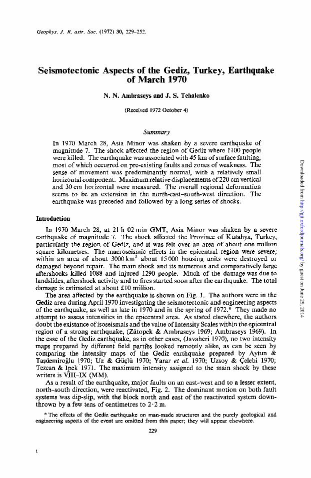
The area affected by the earthquake is shown on Fig. 1. The authors were in the Gediz area during April 1970 investigating the seismotectonic and engineering aspects of the earthquake, as well as late in 1970 and in the spring of 1972.* They made no attempt to assess intensities in the epicentral area. As stated elsewhere, the authors doubt the existance of isoseismals and the value of Intensity Scales within the epicentral region of a strong earthquake, (Zhtopek & Ambraseys 1969; Ambraseys 1969). In the case of the Gediz earthquake, as in other cases, (Javaheri 1970), no two intensity maps prepared by different field parties looked remotely alike, as can be seen by comparing the intensity maps of the Gediz earthquake prepared by Aytun & Tasdemiroglu 1970; Uz & Gii~lii 1970; Yarar et al. 1970; Uzsoy & Celebi 1970; Tezcan & Ipek'l971. The maximum intensity assigned to the main shock by these writers is VIZI-IX (MM).
As a result of the earthquake, major faults on an east-west and to a lesser extent, north-south direction, were reactivated, Fig. 2. The dominant motion on both fault systems was dipslip, with the block north and east of the reactivated system down- thrown by a few tens of centimetres to 2.2 m.
* The effects of the Gediz earthquake on man-made structures and the purely geological and engineering aspects of the event are omitted from this paper; they will appear elsewhere.
229
1
by guest on June 29, 2014http://gji.oxfordjournals.org/
Dow
nloaded from
230 N. N. Ambraseys and J. S. Tchalenko
--
FIG. 1. Location map.
Seismicity of the Gediz area
Gediz is situated in an area of complex block faulting, typical of Asia Minor, with no well-defined tectonic pattern. For example, the Izmir sheet of the 1 :500 000-scale Geological Map of Turkey (MTA 1964), reflects very little, if any tectonic background and other geological maps (CTIA 1968; CTIE 1964; Ketin 1964, 1967, 1970) are too general and on a scale too small for the purpose intended. Published geological reports on specific regions, such as on the region between Kutahya and Gediz (Akkus 1962), on the Simav depression (Zeschke 1954), on the western Taurus (Graciansky 1966) and the references given by Dubertret (1970) for Asia Minor, are valuable and of considerable interest but the synthesis of all these reports into a comprehensive tectonic model of Asia Minor is still lacking.
Certain aspects of the tectonics of the Gediz region have been studied recently (Abdiisselamoglu 1970; Ketin 1970; TaSdemiroglu 1971) and they will not be discussed here. The reader is referred, however, to the geological map of Asia Minor (MTA 1964; Dubertret 1970) and to the sketch given in Fig. 3. Part of the region considered in this paper has been studied in detail by L. Dvbertret, to whom we are grateful for comments on the geology of the greater Gediz area.
The dominant faults in the area are the Simav fault in the west and the Muratdag fault-system in the east. The former fault, which shows a large vertical offset, separates the subsided Upper Simav and Hamamsuvu valleys from the metamorphic Demircidag massif. This fault continues, in an east-south-east direction, under the Neogene cover of the Hamamsuvu and possibly further east, under the Murat valley; its trace is in fact marked by the Ilica and Gazino thermal springs.
The Muratdag region is crossed by two main faults which converge east of Gediz. They separate the subsided TavSandag wedge, which is covered largely by ophiolitic rocks, from the metamorphic block of Muratdai: in the south and from the TavSandag in the north. It does not appear that these two faults continue beyond the vicinity of Gediz.
by guest on June 29, 2014http://gji.oxfordjournals.org/
Dow
nloaded from

Seismotectooic aspects of the Gediz, Turkey 23 1
ri
I f
..'
by guest on June 29, 2014http://gji.oxfordjournals.org/
Dow
nloaded from

232 N. N. Ambraseys and J. S. Tchalenko
29OOO' 29030' 30000'
'4u, (Eorthquake) \ F a u l t 0 T h e r m a l s p r i n g
Km --- 0 10 20 30 (Geologic1
FIG. 3. Sketch of general tectonic features of the Gediz region.
Many of the rivers in the Gediz region run along north-south trending basins, filled with upper Tertiary lacustrine deposits and Quaternary alluvium. Between these rivers one finds the granitodioritic Eiigozdag and the metamorphic massifs of Kocadai: and Saphanedag. To our knowledge, the latter two have not been mapped in any detail, but the earthquake brought to light at least one important fault zone running south-south-east, along the eastern slope of the Saphanedag, i.e. the Agikpaga- Muhipler fault break, Figs 2, 4 and 5.
The town of Gediz is located at the intersection of the Simav-Muratdag fault system with the north-south trending Quaternary alignment of the Emet and Murat river basins. A line of andesitic and basaltic volcanic plugs extends from Gediz to the west along the southern periphery of the Saphanedag.
The Gediz earthquake occurred in Central Asia Minor were destructive earth- quakes are known to have caused damage intermittently for 24 centuries (Ambraseys 1971). Like most parts of Asia Minor, the region affected by the earthquake is predominantly a complex of young block faulting, vestiges of which can be found in the surface faulting associated with the earthquakes of April 1896 (Agamennone 1900), September 1899 (Schaffer 1900), June 1944 (Foucht & Pinar 1944; Press Reports 1944), and with earlier events (Hamilton 1837).
Of these earthquakes, the shock of 1944 is of particular interest as it occurred in the immediate vicinity of Gediz, Fig. 6. The magnitude of this earthquake was about 6, and the shock was felt within a radius of 230 km; it was followed by many aftershocks of which at least one showed a magnitude of 53. The instrumental location of the epicentre of these events is in error and the data available today are totally inadequate for analysis. The lack of information about earthquakes prior to 1960 is probably in no way unusual for seismic events in Asia Minor. Much of the information about the 1944 earthquake was gathered from press reports and from interviews with the inhabitants of the region. From this information it appears that the 1944 earthquake
by guest on June 29, 2014http://gji.oxfordjournals.org/
Dow
nloaded from

Seismotectonic aspects of the Gediz, Turkey 233
I 2970' 2Y30' 2970'
I
FIG. 6. Damage and faulting associated with the earthquake of 1944 June 25.
caused heavy damage to the extreme western part of the epicentral area of the 1970 earthquake and also faulting which extended intermittently from Ayvak to Muhipler, Pinarbasi, Yelki and Sazak, Fig. 6. Part of these ruptures were reactivated during the Gediz earthquake and they were still visible in the spring of 1972. The villages of Celtikci, Erdogmus and Pinarbasi were almost totally ruined and they were rebuilt some time after the 1944 earthquake.
Foreshock and aftershock sequences of the Gediz earthquake
An interesting feature of the Gediz earthquake is that this shock was the largest event in a series of earthquakes in Central Asia Minor which began almost a year earlier and continued for more than a year after the earthquake. Fig. 7 shows the distribution of epicentres for the period March 22 1969-1971 May 11. During this period, the seismological networks of the Kandilli Observatory and of the Institute of Earth Sciences at the University of Istanbul recorded more than 6000 aftershocks of all magnitudes. A considerable number of shocks of magnitude greater than 3$ were also recorded by the network of the National Observatory in Athens. The location of about 450 shocks of magnitude over 4 has been determined by the National Oceanic and Atmospheric Administration, the Bureau Central Internationale de Seismologie, as well as by local and combined networks of Turkey and Greece. The best located epicentres in Fig. 7 may be 5-1 5 km in error. Epicentral determinations based on less than four stations or with residuals greater than 30 km were not used (Uz & Gii~lii 1970; Ergin, Uz & Guclii 1972). All shocks seem to be superficial and most of them have been assigned to depths between 10 and 25 km; a large part of them, especially in the early part of the series, are even shallower. Magnitudes determined by various stations vary as usual, and for the smaller events, M L values given by Athens have been adopted.
The Demirci sequence The first shock of the series occurred near Demirci on 1969 March 23. It was a
shallow shock of magnitude 5+ which, onlMarch 22 was preceded by a foreshock of magnitude 43, and followed by a series of relatively small events, two of which showed M = 5 and 53 respectively. The Demirci earthquake caused considerable damage,
by guest on June 29, 2014http://gji.oxfordjournals.org/
Dow
nloaded from

234 N. N. Ambraseys and J. S. Tchalenlco
b % \ E x ‘\ 3
by guest on June 29, 2014http://gji.oxfordjournals.org/
Dow
nloaded from

Seismotectonic aspects of the Gediz, Turkey 235
destroying 1700 houses in the Demirci region without casualties. There is some unauthenticated evidence that the main shock was associated with ground ruptures near Sevciler, which extended for a few kilometres striking N-30" W up the Akdag mountains (Press reports, Can 1969; Ketin & Abdiisselamoglu 1969).
The Ala~ehir sequence A few days later, on the 1969 March 28, a large shock of magnitude 6 occurred near
Alagehir, about 60 km south of Demirci, Fig. 7, starting a new and very long sequence of low magnitude shocks which, with intermissions, lasted for almost a whole year. Two comparatively large aftershocks near Demirci in April and October 1969 were followed by many small ones from the same region, continuing for months. According to local reports, at least three swarms of small shocks occurred during that period near Demirci, each swarm lasting a few days.
The Alagehir earthquake and its aftershocks caused considerable damage in the Gediz River Valley and particularly in the smaller valleys to the north of the Gediz River where 40 people were killed and a few thousand houses destroyed. Slumping of the ground in the Valley and landslides on higher ground were responsible for some of the damage. The maximum intensity reported for the main shock did not exceed VII (MM), (Aytun 1971). Some of the later aftershocks of the Alagehir sequence caused much damage with casualties in the Demirci region as well as in the Simav Valley (Can 1969; Ketin & Abdiisselamoglu 1969).
The Demirkoprii dam, a 77-m high earthfill construction completed in 1960, and located 15 km from the instrumental epicentre of the main shock, suffered no damage. Minor slumping and accelerated settlements of the fill were noticed. It is not known whether in 196 1 the impounding of the 165-million-cubic-metres reservoir (1 600 mill.m3 maximum volume) triggered any shocks.
As a result of the Alagehir earthquake, a series of ground ruptures developed on either side of the Valley near Alagehir. All of them are purely tensional, still visible, suggesting large scale slumping of the Valley slopes. The longest and most continuous rupture, extends for 12 km from a point 2 km from Alagehir on the road to Kula, to near Kurudere, Fig. 7. This rupture, probably of tectonic origin, crosses the Alasehir- Salihli railway tracks which were damaged and the service was disrupted after the earthquake. The origin of these and other ruptures further west, is not clear. Arpat & Bingol (1969) imply that the motion was in fact purely tensional and that the generic cause was the tectonic subsidence of the Valley floor. A cursory inspection of the area early in 1972, however, suggests that some of these newly-formed ruptures originated through settling and slumping of the alluvium on the flanks of the low hills bordering the Valley, while other ruptures, beyond those already reported by Arpat & Bingol (1969), were of tectonic origin.
The Gediz sequence The largest shock of the series, M = 7, ociurred almost exactly one year after the
Alasehir earthquake, on 1970 March 28. The epicentre is reasonably well located and lies to the east of the area of the preceding aftershock activity, about 20 km north of Gediz, Fig. 7.
More than 350 aftershocks of the Gediz sequence, of magnitude equal to or greater than 3$, were recorded through February 1971 and located. About three quarters of the epicentres, including those of the larger aftershocks, can be associated with the east-west trending fault system and with the central part of the downthrown block. The larger and more numerous aftershocks occurred a few kilometres to the north of the east-west trending surface ruptures and of their extension towards Muratdag in the east, and towards Simav in the west. A smaller number of shocks occurred on the northern extension of the north-south trending line of surface ruptures.
by guest on June 29, 2014http://gji.oxfordjournals.org/
Dow
nloaded from

236 N. N. Ambraseys and J. S. Tchalenko
During the year following the Gediz earthquake, aftershocks continued inter- mittently; large ones of magnitude between 5 and 6, being followed by many smaller ones. All aftershocks for the period March 1970-March 1971 fall within a zone 40-50 km wide and 300 km long, trending west-north-west from the area of the main shock near Gediz on the east, through the Demirci aftershock region, to Edremit on the west, Fig. 7. Initially, aftershocks in the western part of the zone, near Edremit and BigadiG, were few and rather weak. Near the close of the Gediz sequence, they became numerous and strong, a shock of magnitude 5+ on 1971 February 23 and its aftershocks near Edremit, marking the end of the sequence.
Since 1944 major crustal strains have not been relieved by earthquakes in Central Asia Minor as would normally be expected in a highly active region. Moderate shocks have originated at relatively unexpected points, but this may be due to errors in the location of epicentres prior to 1960. The 1969-1971 activity, being one of the very few instances where the data is at all adequate for analysis, provided the opportu- nity to study, in a very cursory manner, the development and pattern of seismic activity in Central Asia Minor. A series of strain energy release maps were prepared, starting with the Demirci shock, in a manner somewhat similar to that described originally by BAth (1953) and later by St Amand (1956), i.e. by contouring the normalized sum of the square roots of the energies of all shocks occurring in the region for different time periods.
A comparison of the strain energy release maps shows that the earthquake of 1969 March 3 effectively marks the beginning of a systematic strain release process in Central Asia Minor. With time, the readjustment of strain, progressing gradually outward from Demirci, delineates an west-north-west trending zone of strain relief, not apparent from the tectonics of the region, extending from Gediz to Edremit.
Fig. 8 shows one of the strain release maps for a later stage of the Gediz sequence from which the main shock of 1970 March 28 has been excluded. The effect of excluding the main shock is apparent in the conspicuously low value of strain in the epicentral area and in the area contained by the surface ruptures where, apparently, strains were relieved through faulting. The strain released by the aftershocks alone, which is comparable to that released by the main shock, follows a pattern very similar to that of the stress concentration at the tips of a crack. The relatively low strain release in the region between Saphane and Simav, may be due to a much earlier relaxation brought about by the 1944 activity.
Ground deformation accompanying the Gediz earthquake
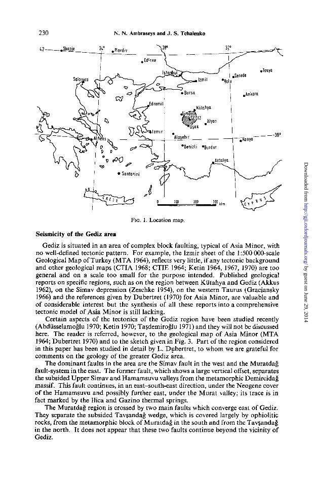
The account given in the Appendix is a brief description of the ground effects associated with the Gediz earthquake. It supplements the information already published by Arsovski (1970), Ambraseys & Tchalenko (1970), Aytun & Tasdemiroglu (1970) and Tasdemiroglu (1971) and it is given here in greater detail in order to put on record facts that may facilitate further field work in this part of Turkey, Figs 9 and 10.
The ground fractures associated with the Gediz earthquake may be grouped into three distinct types according to their relation with pre-existing faults and with the terrain in general.
Type A fractures were formed by re-activation of fault zones in hard rocks, Fig. 11. The rocks involved were serpentines (Pinarbasi, Giimiilekoy, Sazkoy, Hamamlar), basalts and tuffs (AkGaalan) and metamorphic limestones (Asikpasa). The surface effects varied from severe shattering and disordered fissuring of the rocks, Fig. 5, to the creation of clean scarps.
Type B fractures were as type A, but they formed in regions where the rock was overlain by later Tertiary and Quaternary sediments (Giimiilekoy, Sazkoy, Pinarbasi) or by weathered slope material (Asikpasa), Figs 4 and 5 . On sloping ground the fault
by guest on June 29, 2014http://gji.oxfordjournals.org/
Dow
nloaded from

FIG
. 8. S
trai
n re
leas
e map
of t
he G
ediz
afte
rsho
ck sequence: co
ntou
rs in
109
(erg
)*.
by guest on June 29, 2014http://gji.oxfordjournals.org/
Dow
nloaded from
by
gues
t on
June
29,
201
4ht
tp://
gji.o
xfor
djou
rnal
s.or
g/D
ownl
oade
d fr
om

FIG. I I . Striations on andesite outcrop caused by relative motion of tuffs: looking north-east.
by guest on June 29, 2014http://gji.oxfordjournals.org/
Dow
nloaded from

Seismotectonic aspects of the Gediz, Turkey 239
by guest on June 29, 2014http://gji.oxfordjournals.org/
Dow
nloaded from

240 N. N. Ambraseys and J. S. Tchalenko
scarp was generally accompanied by secondary fractures which formed subsidence zones and gravity grabens of the type described by Slemmons (1957). On flat ground the surface fractures formed elongated grabens of comparatively small throws or en echelon series of open ruptures. At first glance this en echelon pattern seemed to be evidence for strike-slip fault displacement. However, the detailed mapping of a number of B type fractures on flat ground, such as those shown in Fig. 12, demonstrated that invariably fissures were arranged in a zig-zag pattern rather than en echelon and that all of them were open showing no preferential lateral displacement on a large scale. A likely explanation is that zig-zag fractures opened directly; they cannot be explained in terms of strike-slip displacement, for such motion would necessarily have produced compression features or at least significant changes in the opening of these fractures along their trace.
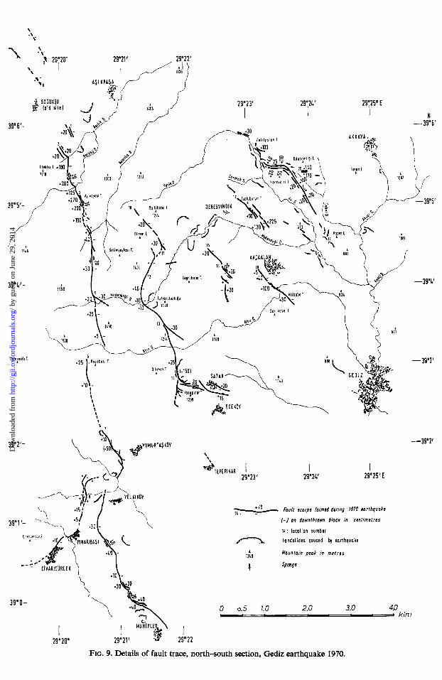
Type C fractures formed primarily in sub-horizontally bedded Neogene marls with intercalated limestone beds, running uninterrupted as single fractures from a few hundred metres to three kilometres (Odacamligi, Muhipler, Tuzluburun, Nennikiri), Fig. 13.
Fig. 14 shows a map and a diagrammatic profile of some of these ruptures. In most cases the ruptures are double, running in pairs parallel to each other, a few metres to 300 m apart, with the block in between them downthrown by a few tens of centimetres to over 2 m. Invariably, they run along the sides of a hill, the flanks of which were raised in a sense opposite to the direction of slope, with the hill crest downthrown. The floor of the graben thus formed is broken up into long, narrow strips, traversing the whole length of the crest and both end sides of the hill. At first sight, these factures seemed to be the upper boundaries of large-scale double slides, of the type shown in the lower part of Fig. 14. A search on the flanks of the hills, however, showed no evidence of emerging landslide toes; nor was there any evidence of the upper boundaries turning in the same direction, with opposite sense of lateral motion. Therefore, double landsliding or spreading of the hills seems improbable.
At a time it was thought probably that C-type fractures were due to an oblique rather than vertical fault movement, of the type described by Tarr & Martin (1912) in connection with the Yakutat earthquake of 1899, brought to our attention by A. Grantz. However, further examination of these ruptures showed no signs of scissoring or apparent reversal of throw along their trace. Consequently, oblique movement also seems improbable.
I t is perhaps significant that a closer examination of exposures of the Nennikiri C-type fractures, brought to view in road excavations, showed that two of them were in fact pre-existing normal faults in the mark. This coincidence is so striking that it seems probable that all C-type fractures are in fact the result of normal faulting of the underlying bedrock rather than of large-scale landsliding or strike-slip motion.
It is not difficult to show that normal faulting along a concealed bedrock fault may produce a graben structure in the overlying overburden which may exhibit C-type features with throws greater than those in the bedrock. Consider an overburden of thickness h overlying bedrock which is subjected to normal faulting on a fault plate dipping at an angle 4. If the angle of active failure in the overburden is b and the throw due to normal faulting in bedrock d, then the throw in the overburden would be of the order of
D = d/2tan($). tan(b).
Assuming that the value of ( d / h ) is negligeably small, the width ofthe graben structure will be of the order of
L = 212. tan(b).
Thus for b = 10" and 4 = 45", the throw in the overburden will be almost three times greater than that in bedrock. For a steeper bedrock fault, say 4 = 70°, both
by guest on June 29, 2014http://gji.oxfordjournals.org/
Dow
nloaded from

FIG. 13. Fault-scarp in marls, north-east branch of Tuzluburun fractures; looking south-east.
[Focirig p. 240
by guest on June 29, 2014http://gji.oxfordjournals.org/
Dow
nloaded from
Seismotectonic aspects of the Gediz, Turkey 24 1
29.22' 2Q623' 29024'E a, P
Y
Flo. 14. Map and diagrammatic profile of type C ruptures.
by guest on June 29, 2014http://gji.oxfordjournals.org/
Dow
nloaded from
242 N. N. Ambraseys and J. S. Tchalenko
throws, in bedrock and overburden, are equal and the width of the graben at the surface is about one third of the thickness of the overburden.
Although the tectonic origin of type C fractures cannot be established beyond doubt, their attitude and location fit a pattern of regional extension. This pattern is the same for the motions observed on the main north-west-south-east Asikpasa- Muhipler and the east-west trending Erdogmus-Hamamlar ruptures. The dominant motion on both major tectonic ruptures is dip-slip, with the Gediz block downthrown along planes dipping between 60" and 70" to the north-east in the first case and to the north in the second, (see Appendix). The dips that can be deduced for these two main ruptures from surface evidence can hardly extend to a great depth; they do suggest, however, a block surface displacement to the north-north-east.
Another indication of regional but considerable extension, most probably of tectonic origin, is provided by the reversals of the lateral motion observed along certain parts of the fault breaks. At Hamamlar, Ecekoy and elsewhere at Nennikiri, Figs 2 ,9 and 10, where one fault segment exhibits for 1 or 2 km strike-slip offsets of a few tens of centimetres, the next segment has the same amount of opposite displace- ment.
The Gediz earthquake seems to be the result of a re-adjustment of a relatively new structural system in which east-west trending blocks are being segmented by a north- eastward regional extension, a crustal movement not related in any obvious way with that of the Aegean Sea or the Anatolian Fault Zone. It is very probable that Tertiary features in the Gediz area are closely affected by a pre-existing complex of basement faults, perhaps created initially by a different stress pattern, which predispose the region to react today in an irregular and complex fashion to what appears to be a north-easterly extension. Fault plane solutions of the Demirci and Alasehir shocks and of two aftershocks of these events do show normal faulting. They suggest that present day faulting in Central Asia Minor is the consequence of the interference of a new direction of motion with old structural trends which has reactivated pre-existing faults in a complicated manner to accommodate the new motion (McKenzie 1973 to be published).
It is significant perhaps that the Simav and Muratdag faults, Fig. 3, are arranged in an en echelon pattern, and the conjecture for the existance originally of an east-west trending right-lateral fault system in Asia Minor, is tempting. The new fractures associated with the 1970 Gediz earthquake between Erdogmus and Hamamlar could then be interpreted as the surface expression of a fault linking the en echelon Simav-Muratdai: system.
Structural interpretations such as those made above will, however, remain purely speculative until further field mapping clarifies the tectonics of the region.
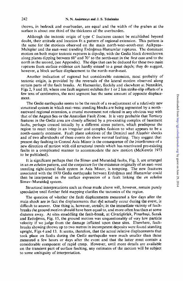
The question of whether the fault displacements measured a few days after the main shock are in fact the displacements that did actually occur during the event, is difficult to answer. One thing is, however, certain; in the immediate vicinity of fault- breaks the ground motion should have been equal to, and more often less than at some distance away. At sites straddling the fault-break, a t Civarigiirlek, Pinarbagi, Sazak and Erdogmus, Fig. 15, the ground motion was unquestionably of very low particle velocity if we judge from the damage inflicted upon these sites. Elsewhere, fault- breaks showing throws up to two metres in incompetent deposits were found standing upright, Figs 4 and 13. It seems, therefore, that the actual relative displacements that took place on faults during the Gediz earthquake were much smaller than those measured a few hours or days after the event and that the latter must contain a considerable component of rapid creep. However, until more details are available on the transient part of surface faulting, any estimates of the motion will be subject to some ambiguity of interpretation.
by guest on June 29, 2014http://gji.oxfordjournals.org/
Dow
nloaded from
FIG. 15. Fault break approaching Erdogmiis from the west.
, Fucinx p. 242
by guest on June 29, 2014http://gji.oxfordjournals.org/
Dow
nloaded from

Seismotectonic aspects of the Gediz, Turkey 243
Acknowledgments
Following the earthquake, and with the agreement of the Government of Turkey, UNESCO sent a reconnaissance mission to Gediz. The chief objectives of the mission were to make a preliminary study of the seismotectonic and engineering aspects of the earthquake. In addition to the writers, members of the mission were, Dr M. Arsovski of the Earthquake Research Institute of the University of Skopje, Jugoslavia; Professor J. Grases of the University of Caracas, Venezuela; Mr A. Moinfar of the Plan Organization, Tehran, Iran, and Mr G. Valenzuela of the University of Santiago, Chile. The Mission was the guest of the Earthquake Research Institute of the Ministry of Housing in Ankara, headed by Mr A. Aytun and the late M. Tasdemiroglu. The writers acknowledge the use of considerable help from many Turkish engineers and geologists and the assistance of the United Nations Office in Ankara. Subsequent field trips of the senior author to the epicentral area late in 1970 and again in the spring of 1972 were partly supported by the Natural Environment Research Council.
Dedication
This paper is dedicated to Mehmet Tasdemiroglu, whose protracted illness and premature death deprived Turkey of one of its leading field geologists and the authors of an old friend and companion of a great many reconnaissance missions.
Engineering Seismology Section, Imperial CoIlege of Science,
London, S. W.7
References
Abdusselamoglu, S. , 1970. Observations of the seismic activity of the Gediz region, Gediz Depremi Simpozyumu, Ankara 8-1 6 (in Turkish).
Agamennone, M., 1900. Tremblements de terre dans 1’Empire Ottoman, Beit. Geophys., Leipzig, 4, 136.
Akkus, M., 1962. The geology of the area between Kiitahya and Gediz, Bull. Min. Explor. Inst. Turkey, 21-30.
Ambraseys, N., 1969. On the seismicity of earthquake motion, Izo. Fiziki Zemli, 7, 86-90, Moscow.
Ambraseys, N., 1971. Value of historical records of earthquakes, Nature, 232, 375-379.
Ambraseys, N. & Tchalenko, J., 1970. The Gediz earthquake of March 28, 1970, Nature, 227, 592-3, London. Also Proceedings 3rd European Symposium Earthq. Eng., 1, 193-199, Sofia.
Arpat, E. & Bingol, E., 1969. The rift system of the Western Turkey, Bull. Min. Explor. Inst. Turkey, No. 73, 1-9.
Arsovski, M., 1970. Tectonics of the Gediz earthquake, UNESCO Reconnaissance Mission Report, Paris.
Aytun, A., 1971. Experience gained from recent earthquakes in Turkey, Proc. NATO Earthquake Conference, Paper 7, San Francisco.
Aytun, A. & Tasdemiroglu, M., 1970. First report on the Gediz earthquake of 28 March 1970, Imar ve Iskan Bakanligi, Afet Isleri Gene1 Miidiirlugu, Ankara (in Turkish).
Bith, M., 1953. Seismicity of Fennoscandia and related problems, Gerlands Beitr. Geophys., 63, 186.
Can, R., 1969. The earthquakes of Demirci and Alasehir of March 1969; a field report. Unpublished Report, Engineering Seism. Section, Imperial College.
by guest on June 29, 2014http://gji.oxfordjournals.org/
Dow
nloaded from

244 N. N. Ambraseys and J. S. Tchalenko
Celebi, M. & Uzsoy, S., 1970. Structural damage at Gediz earthquake on March 28 1970, Publ. Middle East Tech. Univ., Ankara.
CTIA, 1968. Carte Tectonique Internationale de I’Afrique, 1 : 5,000,000 scale, Feuille 2, UNESCO, Paris.
CTIE, 1964. Carte Tectonique Internationale de l’Europe, 1 : 2,500,000 scale, Feuille 15, Moscow.
Dubertret, L., 1970. Explanatory text of the Geological Map of Turkey, 1 : 500,000 scale, Izmir Sheet, Maden Tetkik ve Arama Enstitiisii, Ankara.
Ergin, K., Uz, Z. & Gii~lii, U., 1972. 28 Mart 1970 Gediz depremi art sarsintilarin- in incelenmesi, Madan Fakiiltesi Publ. no. 29, Istanbul Teknik Univ., Istanbul.
FouchC, M. & Pinar, N., 1944. Etude gtologique et mCtCorologique du tremble- ment de terre d’Adapazar du 20 juin 1943. Istanbul Univ. Fen Fakiilt. Mecmuasi, Seri A, Cilt 7 (dated 1943).
Gilbert, G. K., 1890. Lake Bonneville, Monogr. U.S. Geol. Survey no. 1, p. 354. Graciansky, P. de, 1966. Le massif cristallin du Menderes, un exemple possible de
vieux socle granitique remobilid, Rev. Geogr. Phys. Geol. Dynam., 8, fasc. 4,
Hamilton, W., 1837. Extracts from notes made on a journey in Asia Minor in 1836,
Javaheri, J. H., 1970. Dasht-e Bayaz earthquake-Numbluk Valley. DIC Thesis,
Ketin, I., 1964. Carte de Turquie, Tectonique de I’Europe, 258, Moscow. Ketin, I., 1967. Relations between general tectonic features and the main earth-
quake regions of Turkey. Publ. Dept. Geol. Tech. Univ., Istanbul, also Bull. Min. Res. Explor. Inst. Turkey, no. 71 (1968), 63-67.
Ketin, I., 1970. Seismic activity of the neogene regions of Western Anatolia, Gediz Depremi Simpozyumu, Ankara, 8-16 (in Turkish).
Ketin, I. & Abdiisselamoglu, S., 1969. 23 Mart 1969 Demirci ve 28 Mart 1969 Alasehir-Sarigol depremleri hakkinda makrosismik gozlemler, Maden Mecu- muasi, 4, no. 5 Geology Dept., Univ. Istanbul.
MTA, 1964. Tiirkiye Jeoloji Haritasi, Izmir 1 : 500,000 Maden Tetkik va Arama Enstitusii, Ankara.
St Amand, P., 1956. Two proposed measures of seismicity, Bull. seism. SOC. Am., 46. Schaffer, F., 1900. Das Meanderthalbeben von 20 September 1899, Mittheil. Kais.
Konigl. Geograph. Gesellsch. Wien, 43, 221-230. Slemmons, D. B., 1957. Geological effects of the Dixie Valley-Fairview Peak,
Nevada, earthquake of December 16, 1954, Bull. seism. SOC. Am., 47, 368. Tarr, R. S. & Martin, L., 1912. The earthquakes at Yakutat Bay, Alaska, in
September 1899, U.S. Geological Survey, Profess. Paper 69, 36-40. Tasdemiroglu, M., 1971. The 1970 Gediz earthquake in Western Anatolia, Turkey,
Bull. seism. SOC. Am., 61, 1507-1528. Tezcan, S. & Ipek, M., 1971. March 28 1970, Gediz Turkey earthquake and its
long distance effects, Publ. Research Centre, Robert College, Istanbul. Uz, Z. & Gii~lii, U., 1970. Distribution of aftershocks and intensity of the Gediz
earthquake, Gediz Depremi Simpozyumu, Ankara, 3348 (in Turkish). Uzsoy, S. & Celebi, M., 1970. Structural damage caused by the Gediz-Kiitahya
earthquake of 28 March 1970, Publ. Middle East Tech. Univ., 75, Ankara (in Turkish).
Yarar, R., Demir, H., Kumbasar, N. & Trusia, A., 1970. Preliminary report of the Gediz earthquake, Publ. Istanbul Tech. Univ., Istanbul (in Turkish).
ZAtopek, A. & Ambraseys, N., 1969. On the determination of macroseismic intensi- ties, Izv. Fiziki Zemli, 7, 86-90, Moscow.
Zeschke, G., 1954. Der Simav-Graben und seine Gesteine, Bull. geol. SOC. Turkey, 179-189.
289-306.
Journ. Royal Geogr. SOC., 7, 34.
Engineering Seismology Section, Imperial College, London.
by guest on June 29, 2014http://gji.oxfordjournals.org/
Dow
nloaded from

Seismotectonic aspects of the Gediz, Turkey
Appendix
Description of the ground deformations associated with the Gediz earthquake
245
The reader is referred to Figs 9 and 10, and also to Fig. 2. Vertical and horizontal displacements have been rounded off to the nearest 5 cm, and their actual value is shown on Figs 9 and 10. Values of vertical motion refer to the vertical component of the fault displacement and are shown on the side of relative uplift of the fracture. Unless otherwise stated, relative horizontal displacements refer to individual fractures at a point and they are not representative of the general motion of the two sides of the rupture. Dotted traces indicate that they are not definitely connectable throughout their whole length.
The description of the ground deformations begins at the extreme north of the ASikpaSa-Muhipler section, Fig. 2. It is followed by the description of the shorter features to the east of Ballibaba-Ecekoy, AkGaalan, Tuzluburun, Nennikiri, and ends with the description of the main east-west section of Erdogmus-Hamamlar.
Mapping was carried out on a 1 : 25 000 scale with the exception of the Erdobus- Hamamlar section east of 29" 34', which was mapped on a scale 1 : 100 000, and which was not completed. It is very probable that ground ruptures extended for 2-3 km towards Ugurluca; also details of these fractures were not studied. Orienta- tions were checked magnetically, and altitudes by aneroid barometers. Along the immediate vicinity of the fault-break the geology was also plotted, but with less accuracy.
In what follows we give a description of the fault zone together with the effects of the earthquake on man-made structures and on the ground itself. In Figs 9 and 10, numbers refer to specific localities on the fault break; the reader may find these numbers helpful as references.
AyikpaSa-Muhipler section
The northernmost ground ruptures observed in the area lie between the old site of Soguksu and the new village to the north, point 0, Fig. 9. These ruptures are masked by slides and show a very small throw to the east; their origin may not be tectonic. One of these ruptures, showing tensional features, crosses the road from Old Soguksu to the north, the whole region including the site of the old village being situated on a vast landslide of comparatively recent development. It appears that as a result of a major flood, the old site was abandoned shortly before the earthquake, and the village moved across the Daryeri stream and rebuilt there. The new village, built on travertine, was totally ruined by the earthquake while still under construction.
Another series of rupture lies about 1 km south-west of Agikpaaa. They occur along the contact between crystalline and upper Tertiary limestones and marls which, without any sign of lateral displacement, have been downthrown to the east by about 20cm. Slumping of the marls has produced second line of ruptures which runs parallel with and 50 m to the north-east of the contact. These two parallel fractures run down the slope of the hill for a few hundred metres and die out before reaching the Asilik Dere, point 1.
Another set of ruptures was found further up the thickly wooded slopes of the Efeklik Tepe, near point 2. From this point the fault-trace can be followed to the south, almost continuously for 5km. Between point 2 and its crossing with the Asilik Dere, the trace is again double. One branch follows the contact between crystalline limestones and marls and the other runs parallel with the contact, cutting through weathered limestones and topsoil. The motion on these two ruptures is mainly tensional, with the block in between downthrown by about 20 cm and with a perceptible but not persisting left-lateral offset of a few tens of centimetres.
After crossing the Asilik Dere, the trace becomes single for almost 1 km and
2
by guest on June 29, 2014http://gji.oxfordjournals.org/
Dow
nloaded from

246
follows a pre-existing fault in Mesozoic limestones. Between the Asilik and the Karasu Dere the trace develops a neat vertical throw at the foot of an existing terrace in weathered red limestones and topsoil, of 100 to 180 centimetres on the east, Fig. 4. It exposes at irregular intervals parts of an old fault surface of endured limestone. Here, en echelon cracks in the downthrown topsoil indicate a possible, but small, left-lateral offset of about 20cm. However, this en echelon pattern seems to be connected with the separation of the two sides of the trace, which opened directly rather than with a genuine strike-slip displacement.
At its crossing with the Karasu Dere, the trace frays out in a number of irregular tensional fractures which produced a series of small waterfalls in the bed of the stream. At the time of our first visit, about 2 m3 s-l was flowing into these open fractures; for about six days after the earthquake, the Karasu Dere dried up below this point, and the whole discharge of the stream, about 3-4 m3 s-', disappeared into these fractures.
South of the Karasu Dere, the trace continues as a single rupture in crystalline limestones, running up the thickly wooded slopes of the Ayikayasi Tepe to the south. Here the trace is a reactivated old fault on which there has been repeated movements during late Quaternary time. Within 200 m from its crossing with the Karasu Dere, the throw to the east increases from a few tens to 125 cm with a clear left-lateral offset of about 20cm, (see Fig. 2 in Ambraseys et al. 1970). Dips of the fault plane in crystalline limestones are between 65" and 70" east.
The exposed face of the fault surface shows slikensides and striations caused by earlier movements on this fault in this sense.
Between points 3 and 4 the trace follows very closely the contact between crystalline limestones and Tertiary conglomerates, mainly weathered limestones. From point 3, the throw to the east increases from 125 to 270cm, and near the summit of the Ayikayasi Tepe the trace becomes a gaping fissure, 4 m deep at the foot of the scarp, large enough to admit a man. The vertical offset is variable; the east side, that is the downhill side, is downthrown, in places up to 200cm and the total height of the hanging wall to the bottom of the gap is more than 6 m. The morphology of the scarp along this section of the trace is very similar to that described by Gilbert (1890) as a subsidence zone and gravity graben; one or more fractures cutting through the conglomerates of the hanging wall, produce the spreading and settling of the Tertiary superficial material.
Past the summit of the Ayikayasi Tepe the trace runs up and down over a number of low ridges, following the contact between limestones and conglomerates, main- taining a throw to the east of 150-200 cm and an apparent left-lateral offset of about 30 cm.
To the south of point 4, the trace becomes difficult to follow; it passes through upper Tertiary tuffs and volcanic agglomerates in the form of a rather wide fracture zone, in places 100 m wide. Here, it was not possible to measure the total amount of vertical movement across the zone, but it should be more than 150 cm with a few tens of centimetres of cummulative left-lateral offset. The vertical offset on few fractures is about 30 cm, down on the east.
Between points 4 and 5 the trace lies in upper Tertiary volcanics and runs at the base of a series of low hills. It shows a throw to the east of 20-100 cm and a small left-lateral offset the magnitude of which is difficult to measure because of the shattering in the fracture zone. In places this zone of fractures shows a tendency to bifurcate to the south-east, particularly near point 4 as well as west of the Selimayaylasi Tepe, but individual fractures never leave the main zone for more than a few hundred metres before they die out. Near its crossing with the Kalenlik Dere, the trace shows strong tensional features; it becomes double and develops a comparatively large gravity graben which caused a small lake to form.
Near point 5, just before reaching the Madendagi Dere, the trace makes a sharp
N. N. Ambraseys and J. S. Tchalenko
by guest on June 29, 2014http://gji.oxfordjournals.org/
Dow
nloaded from

Seismotectonic aspects of the Gediz, Turkey 247
turn to the south-east and for a few hundred metres follows as a single crack the contact between upper Tertiary volcanics and an andesitic outcrop which was downthrown by a few tens of centimetres with no evidence of lateral motion.
After crossing the Madendaki Dere, the trace frays out into a zone of small fractures and, uninterrupted for about a kilometre, resumes its southward course through shattered upper Tertiary volcanics and weathered limestones. This fracture zone consists of numerous irregular cracks on a very gentle topography, the east side being generally downthrown by 5-25 cm. On some cracks there is evidence of left- lateral movement but the overall movement is tensional. Near the Ahir Dere, the zone of ruptures dies out and it cannot be found on the opposite banks of the stream.
South of the Ahir Dere, at point 6, another trace in andesites winds along the base of a series of low scarps on the west slope of the Kayabasi Tepe. Here, the up-hill side has dropped by 10-25 cm with respect to the downhill side with no conclusive evidence of preferential lateral movement. Further south the trace becomes very weak to follow.
At point 7, west of Yumurtaskoy, a long rupture in young volcanics was found running for a few hundred metres. It is probably of landslide origin and its east side is downthrown by 10-50 cm, showing a small left-lateral movement.
West of Yelkikoy the trace reappears in marls mainly as a wide zone of relatively weak fractures. It continues for about 1 km, until east of Pinarbasi the trace encounters a series of ophiolitic outcrops which it shatters. At this point the trace turns in a southeasterly direction and for about one kilometre cuts through a thin cover of marls which were intensely sheared and offset in a left-lateral sense by about 40 cm, downthrown on the north-east by a few tens of centimetres, Fig. 5.
The trace continues towards Muhipler, and in a number of places becomes double and discontinuous. On all traces the direction of uplift is fairly consistent and it is on the west or south-west. However, occasionally the trace, where it becomes double, shows strong extensional features and the formation of small gravity grabens. North- west of Muhipler, the road to Pinarbasi runs on the summit of a low hill of limestones and marls, the axis of which nears N-30" W. The trace here is double and follows the flanks of the hill which were raised by 10-30 cm opposite to the direction of slope so that the downhill sides of the hill were uplifted. Approaching Muhipler the trace is obscured by numerous shallow landslides.
Near point 9, a series of discontinuous cracks was found running along the contact between serpentines and marls, leading towards Pinarbasi. In places a combination of open cracks and pressure ridges were found to radiate away from ophiolitic outcrops suggesting a significant displacement of the outcrops with respect to the overlying marls which, however, did not produce any definite surface pattern of fractures.
Approaching Pinarbasi, the trace consists of a series of long but weak fractures, two of which pass through the back of the'village, showing a throw to the south-east of 5-15 cm. Five timber frame houses straddling one of the fractures were distorted but they did not collapse. Of the 102 houses of the village, two collapsed but no one was killed. Villagers state that the earthquake of 1944 had caused considerable damage and that the ground ruptures in the region, particularly those in the immediate vicinity of the village, appeared in 1970 at the same place as in 1944.
Between Pinarbasi and Civarigiirlek the trace disappears and re-appears above Civarigurlek, running along a reactivated contact between serpentines and tuffs, the latter downthrown to the south-east by 10cm. Small en echelon fissures show no preferential lateral displacement and may be due to opening up of the contact. Between these two villages a spring of water increased its yield after the earthquake flooding the downstream part of the village. At Civarigiirlek, only four out of the 110 houses collapsed and no one was killed.
by guest on June 29, 2014http://gji.oxfordjournals.org/
Dow
nloaded from

248
Ballibaba-Ecekoy section
Some of the most complicated cracks and fissures produced by the earthquake were found east of the fault-section just described. A discontinuous series of fractures was found near point 10, running along a wide saddle between Efrem and Ballibaba Tepe.
Much of the Efrem Tepe consists of Mesozoic limestones, in places covered with andesitic lavas. The whole system is heavily fractured and weathered, making it extremely difficult to identify structural elements activated by the earthquake. The fractures observed follow the contact between crystalline schists and upper Tertiary tuffs, down on the east by a few tens of centimetres with no sign of lateral motion. The trace here is discontinuous and dies out in tuffs before reaching the Madendagi Dere.
After branching off at point 11, the trace trends N40" E and follows faithfully the 1300-m contour all the way to its crossing with the Madendaiji Dere. Up to point 12 the trace follows the contact between crystalline schists and upper Tertiary tuffs, after which point it follows a reactivated contact zone of upper Tertiary lime- stones and tuffs. The trace is weak and discontinuous, with no clear evidence of lateral movement but with a vertical throw on the east of 10-40 cm.
Near its crossing with the Madendaii Dere the trace is obscured by numerous landslides which make it impossible to determine the nature and sense of movement After crossing the river the trace runs up and down a series of low saddles towards Sazak, passing through upper Tertiary tuffs which it shatters, showing a small throw, down on the north-east side by 10-30cm with no evidence of consistent lateral motion. At point 13, the trace turns south-east and follows for 500 m a reactivated contact between andesites and upper Tertiary tuffs.
From point 13, showing small and irregular vertical displacements in andesite and topsoil, the trace continues to the.south and crosses the Ahir Dere. It then passes behind and to the west of an old massive landslide, covered in places with scree and slope debris, utilizing the upper boundary of the slide and in places modifying it.
Here, a number of springs of water were found issuing from behind the slide. On entering the slope debris area, apparent vertical displacements increase from 20 to about 150 cm, and the trace, following the upper boundary of the slide, turns near point 14 due east and passes between Karapinar Tepe and Sazak. This segment of the trace is marked by left-lateral en echelon cracks and the lateral movement of the conjugate fracture, north of the Karapinar Tepe, is right-lateral.
From point 14 the fractures fray out and skirt Karapinar Tepe with small vertical displacements. Fractures leading east pass between the villages of Ecekoy and Sazak and show tensional features. In Sazak 38 out of the 75 houses collapsed and 14 people were killed. Out of 70 houses in Eckoy, 20 collapsed killing 13 people. Near Sazak the trace becomes double; one rupture zone passes through the village and forms a graben 150 m wide and 20 cm deep, with h o evidence of strike-slip movement of opposite walls.
N. N. Ambraseys and J. S. Tchalenko
Akcaalan section Structures west of AkGaalan that were activated during the earthquake all follow
pre-existing contact zones along at least some of which there has been repeated movement during late Quaternary time. At point 15 a series of irregular cracks in tuffs, which follow the 1050-m contour for about 500 my show that the north-east side was downthrown by about 30cm with no evidence of lateral displacement. Near point 16, these cracks die out and they re-appear higher up the hillside in the form of a double trace between andesites and tuffs. Here the zone of shattering exhibits primarily extensional characteristics and demonstrates a 20-cm right-lateral offset,
by guest on June 29, 2014http://gji.oxfordjournals.org/
Dow
nloaded from
Seismotectonic aspects of the Gediz, Turkey 249
with the tuffs between the two walls downthrown by the same amount in the form of a gravity graben, Fig. 11.
Old striations on the south-west facing wall suggest that since the overflow of andesites-dacites in early Pleistocene there has been a total vertical movement of at least 500 cm associated with a right-lateral movement of the same amount.
To the south of this point, another trace can be followed for 500 m before it dies out within a zone of landslides and rockfalls. The valley north-east of this trace is littered with large blocks of volcanics that have rolled down from above before and during the earthquake.
The ground deformations found at the Tuzluburun Tepe are of particular interest. This hill of white upper Tertiary mark and limestones rises about 60m above the surrounding topography; to the north-east it is bounded by the Ak Dere and to the south-west by the Madendagi Dere. Near the north-west edge of the hill Point 17, a trace heading south-eastward, was noted. The ground deformations here are greatly complicated by landsliding into the Cakmak Dere, the sliding utilizing the trace as an upper bound and modifying it. Near point 17 the trace crosses, at a very small angle, the axis of the hill and as a single fracture follows the midheight of the south-west slope for about 1 km; the south-west side of this fracture went up. This means that the upthrow was on the downhill side by 60-120 cm. Another trace was found running parallel with and along the midheight of the north-east slope of the hill, also with the downhill side uplifted by as much as 220 cm, Fig. 13. Both traces follow the 1050-m contour and suggest that as a result of the earthquake the flanks of the hill spread out so that the central part of the massif slumped. Elsewhere the central part of the Tuzluburun Tepe abounds with tensional features, gravity grabens, slumping and gaping fissures 200 cm wide. The origin of these ruptures, although in appearance tectonic, is not clear. Both of them die out before they reach the valley below.
About 300 m south-west of AkGaalan, at Point 18, another trace can be followed for a few hundred metres to the south-east along the contact between tuffs and Tertiary marls. The northeast side of this series of ruptures was downthrown by 5-40 cm without any perceptible lateral motion of the two sides. Approaching the Ak Dere the trace skirts a landslide area showing irregular vertical displacements, in places 100 cm down on the north-east. After crossing the Ahir Dere, the trace follows the contact zone between andesites and tuffs and shows tensile features, but again with no evidence of lateral motion, continuing up on the south-west by 30 cm. For another 500 m the trace follows faithfully the contact zone between andesites and upper Tertiary volcanics on the south-east slopes of Alibaba Tepe before it becomes too faint to follow. A number of ground fractures passing through Akqialan were found to be due to landsliding. In this village 126 people out of 1200 were killed and 371 houses out of 490 were destroyed either by collapse or by fire which was started by an aftershock.
Nennikiri section Another interesting series of fractures was found north of Gediz. The Kepez and
Nennikiri Tepe form a continuous narrow ridge of white lacustrine mark and upper. Tertiary limestones, about 3 - 5 km long. These hills stand 40-60 m above the general topography. To the south-west they are bounded by the Ak Dere and to the north-east by the Cukur Dere. The road from Gediz to Kutahia follows the crest of these hills. A major fracture flanking the hills on both sides was found running a few tens of metres below the crest. The uphill side was downthrown by 40-1 10 cm.
The scarps of these fractures show clear breaks in indured calcareous marls, slickensided by the downward movement of the central part of the hills on a plane dipping about 80" SW or 80" S. On east-west trending fractures the motion was right- lateral becoming left-lateral on north-west-south-east ruptures.
by guest on June 29, 2014http://gji.oxfordjournals.org/
Dow
nloaded from

250 N. N. Ambraseys and J. S. Tchalenko
Again here, the tectonic origin of these large-scale features is not clear. However, road excavations near the point where the road from Gediz to Kiitahia crosses these ruptures for the third time, exposed cross-sections of the ruptures which show that movements at this point occurred on pre-existing failure surfaces in calcareous marls on which repeated movements in the past were much larger than those observed on the ground surface after the Gediz earthquake.
Approaching the Zelifiyaren Tepe, the trace turns to the north and follows the steep slopes of the Yayla Dere. Here the trace has developed characteristics of a landslide or slump feature in marls and limestones with throws of the order of 100 cm.
Similar features of hill spreading, but on a very much smaller scale were found on the Odacamligi Tepe, north-east of Nennikiri.
Erdogmus-Hamamlar section Near point 20, north of the Bakir Tepe, in the plains of the Gediz river, a series
of ground ruptures passing through cultivated fields can be followed for almost a kilometre. In places the trace is marked by open cracks with 10-cm gaps but with no evidence of lateral movement. The vertical movement varies from 10 to 20 cm, down on the east side. In at least two places the trace is double with the central block downthrown by 10-30 cm.
Another trace, near point 21, follows the west bank of the Gediz river. It shows a double scarp one of which appears to be due to slumping of the river banks. Here it was not possible to judge the amount of vertical movement, both traces being compli- cated by secondary fractures in the fields.
At point 22, a long rupture in cultivated fields was found to lead towards Erdogmus, displaying a throw to the north-east of 10-20 cm. At point 23 this rupture becomes double as it cuts across a spur of outcropping marls and forms a small gravity graben. Approaching Erdobus, at point 24, the trace becomes double again showing strong tensile features and gaping fissures, with the central block downthrown by 20-40 cm. Of the two traces, the one that appears near point 24 exhibits, on flat ground, consider- able tensional characteristics with gaps 10-4Ocm wide, Fig. 15. Both traces pass through E r d o b u s destroying two out of 276 houses and distorting another 15 timber frame dwellings including a mosque and a large barn which were straddling the traces No one was killed in the village. The ground deformations caused steps to form in narrow streets and a spring of water to dry up permanently. Eye-witnesses state that a group of people standing together outside a coffee-shop in the village at the time of the earthquake felt the shock but were not thrown down; one of the main fractures divided the group, two persons found themselves on the downthrown side, still standing, and a third person was thrown into the gap injuring his leg. It is significant that E r d o b u s had been rebuilt after almost total destruction during the earthquake of 1944 June 25.
Between Erdogmus and its crossing with the Canbulat Cay, the trace is discontinu- ous, with the north side downthrown by 10-40 cm. It crosses flat ground for almost 3.5 km showing fissures, open in places, gaping by as much as 30 cm but without any evidence of lateral movement. Some of these traces are double with the block in between downthrown and the depression flooded.
Near the Canbulat Cay the trace becomes double. One branch in gravel crosses the river at point 26, forming a series of rapids and shows a total throw to the north of about 20 cm. The other branch appears at point 25. Both branches cross the road to Gumulekoy exhibiting a left-lateral offset of 5-15 cm with the north side downthrown by a few tens of centimetres.
From point 26 the trace is continuous and it can be followed through cultivated fields running up the slopes of Hill-878, cutting through limestones and marls, with the north side downthrown by 20-50cm. In places the trace is an open fissure and
by guest on June 29, 2014http://gji.oxfordjournals.org/
Dow
nloaded from

Seismotectonic aspects of the Gediz, Turkey 25 1
exhibits a small discontinuous left-lateral movement which does not exceed 25 cm. Near the summit of Hill-878 the trace breaks up into a series of tensional cracks and joins the northern branch in a zone of intense fracturing. Here it was not possible to judge the amount of total vertical movement, but it should have been more than 100 cm, down on the north.
The northern branch, also in marls, shows larger vertical displacements, down on the north, in places by 100cm. The trace is discontinuous and consists of long en echelon cracks demonstrating a left-lateral displacement not exceeding 20 cm.
Near the summit of Hill-878 the trace becomes single again and runs down the slope into the Genez valley in marls and limestones.
The vertical displacement here is lW120cm, down on the north. The trace continues due east, mainly as a tensional feature, with no well-defined evidence of lateral movement. Near its crossing with the Genez Dere a series of small gravity grabens, flooded after heavy rains, produced a shallow pond.
The trace runs up the Naliburnu Hill and for about 2km follows the 900-m contour on relatively flat ground. In places the trace is an open fissure, the two sides having been pulled apart by as much as 100 cm with no sign of lateral offset, down on the north by 20-70 cm. Elsewhere tensional features have produced small gravity grabens downthrown by a few tens of centimetres. A number of footpaths which cross the trace were found offset not more than 25 cm in a left-lateral sense.
Approaching the Cevizli Dere the trace becomes more linear and continuous and it shows a throw to the north of about 100 cm. Here, as well as in a number of isolated exposures, the fault plane in limestone dips 60" to 65" to the north. Near the Cevizli Dere the trace follows the base of an old reactivated escarpment of pink brecciated limestones which it follows with a comparatively small vertical displacement. Near point 27 the trace crosses the Cevizli Dere and runs parallel with and about 10 m to the north (downstream) of the contact between serpentines and marls exposed in the river bed and further east on Hill-927. Here the trace shows a throw to the north of about 20 cm with some evidence of left-lateral movement of 10-20 cm. Open cracks and small fissures in the serpentines suggest some reactivation of this contact. Between Genez and Cevizli the manner in which the fault break crosses ridges and small valleys suggests that the fault plane dips about 60" to the north.
Further east the trace runs parallel with the serpentines and dies out before reaching the Muratdaii Cay in a zone of heavy fracturing.
Here the trace is double for a short distance with the block in between down- thrown.
Between Giimuslu and Sazkoy, at point 28, another trace was found following the 800-m contour, running parallel with and to the north-west of Akdere. The trace is in marls and limestones and shows a discontinuous vertical offset of 10-40 cm on the south-east. An en echelon system of fissures suggest left-lateral motion of small amplitude. This trace dies out near the source of Akdere; no attempt was made to search for ground deformations north-east of this point.
Two days after the main shock, near point 28, a new thermal source burst out in the banks of the Muratdaii Cay, not far from another permanent source near the Mill at point 29. For a few days after the earthquake, this source behaved like a geyser, ejecting at intervals, sand mixed with warm water, occasionally spouting to heights of a few metres. At the time of our visit the source continued to flow, discharging a few tens of litres per second of relatively cool water at 2OC.
From point 29 another trace can be followed east for almost 5 km. From this point to its crossing with the Goklet Dere, the trace is in marls and limestones; it runs up and down several thickly wooded hills and gradually climbs the south side of Sazkoy Hill, showing a throw of 30-60 cm to the north with a 25-cm left-lateral offset.
After crossing the Gokler Dere, the trace becomes double for a short distance. A short rupture in limestones shows small vertical movements with some evidence of
by guest on June 29, 2014http://gji.oxfordjournals.org/
Dow
nloaded from
252 N. N. Ambraseys and J. S. Tchalenko
left-lateral movement on offset forest foot-paths. Another trace runs parallel with and a few tens of metres to the north of a contact zone between upper Tertiary limestones and serpentines, showing a throw of 20-30 cm to the north with little or no evidence of lateral motion.
Past point 30, the trace consists of a series of long en echelon fractures, wholly in limestones, showing a small throw to the north of 10-20 cm but with clear evidence of left-lateral movement of the same amount.
As it approaches the Kogur Dere, the trace branches off and skirts a wide zone of shattered limestones which is bounded to the north and south by prominent fractures, the whole system giving the impression of an incipient gravity graben. Here, as well as in other parts of this trace, a number of springs of water appeared shortly after the earthquake, some of them behaving like geysers.
South of Somakli a series of discontinuous ground ruptures can be followed with difficulty, the terrain in places being almost inaccessible. Of the two traces south of Somakli, the one to the south-east can be seen in places but it was not followed up.
Between Yumurak Kayazi and Murat Daii-Hamanlar, the ground deformations follow pre-existing structures, along at least some of which, notably east of Fikiriz, there has been repeated movements in a right-lateral sense during late Quaternary time and again during the earthquake. Displacements of 40 cm of right-lateral movement on some of these faults with a throw to the north of about 40 cm were measured. Where the trace crosses the Baybiyen Dere the sense of lateral movement is reversed. Here the trace follows the contact zone between crystalline schists and serpentines and shows a left-lateral motion of 70 cm with the north side downthrown by 60 cm.
by guest on June 29, 2014http://gji.oxfordjournals.org/
Dow
nloaded from