ge05errch coi1si j uk1 1 :;w5 › mndmfiles › afri › data › imag… · j uk1 1 :;w5 projects...
TRANSCRIPT

GE05ERRCH COI1SI3.1821 BALMER TWP 010
J UK1 1 :;W5
PROJECTS UNIT,
ELECTROMAGNETIC AND MAGNETIC SURVEYS
for
DOME EXPLORATION (CANADA) LIMITED
on
PROJECT 80
BALMER TOWNSHIP, ONTARIO.
(To Accompany Maps75-65 75-66 75-6?
May 5th, 1975.
SUMMARY
During February 19751 we carried out mag
netic and electromagnetic surveys on a claim group
in the Red Lake Area for Dome Exploration (Canada)
Ltd.
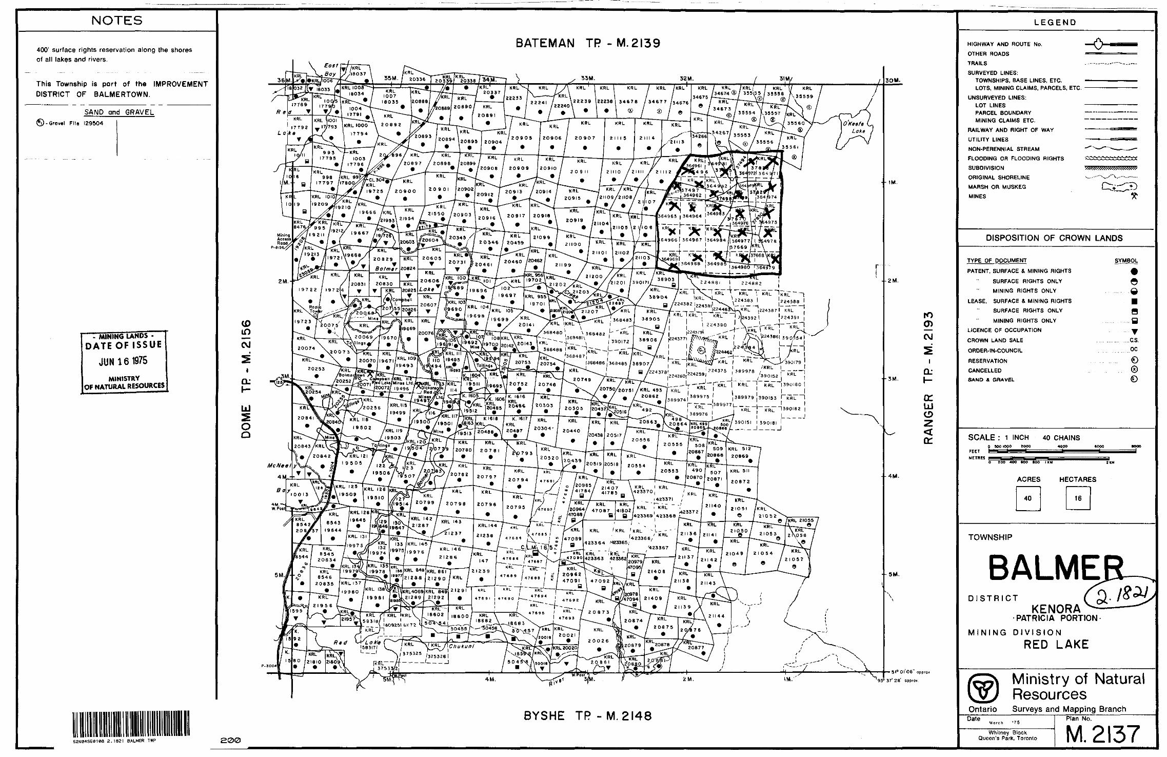
The property consisting of 2 h claims
(364961 -969,, 3,6f4271 .-983) is located in the north
east part of Balmer Township. Access was made by*WW**WV-*!*W*''!IV*
motor toboggan via lumber roads leading from Balmer-
town.
Several electromagnetic conductors were
located most of which occur intermittently in three
zones which arc also magnetic. Strike lengths and
conductivities of individual conductors are variable.
The conductor pattern and magnetic correl
ation are not uncharacteristic of banded iron form
ation. Fm-tiier exploration should be considered in
the light of previous exploration on the claims arid
available geological data.

METHOD AND INTERPRETATION OF RESULTS
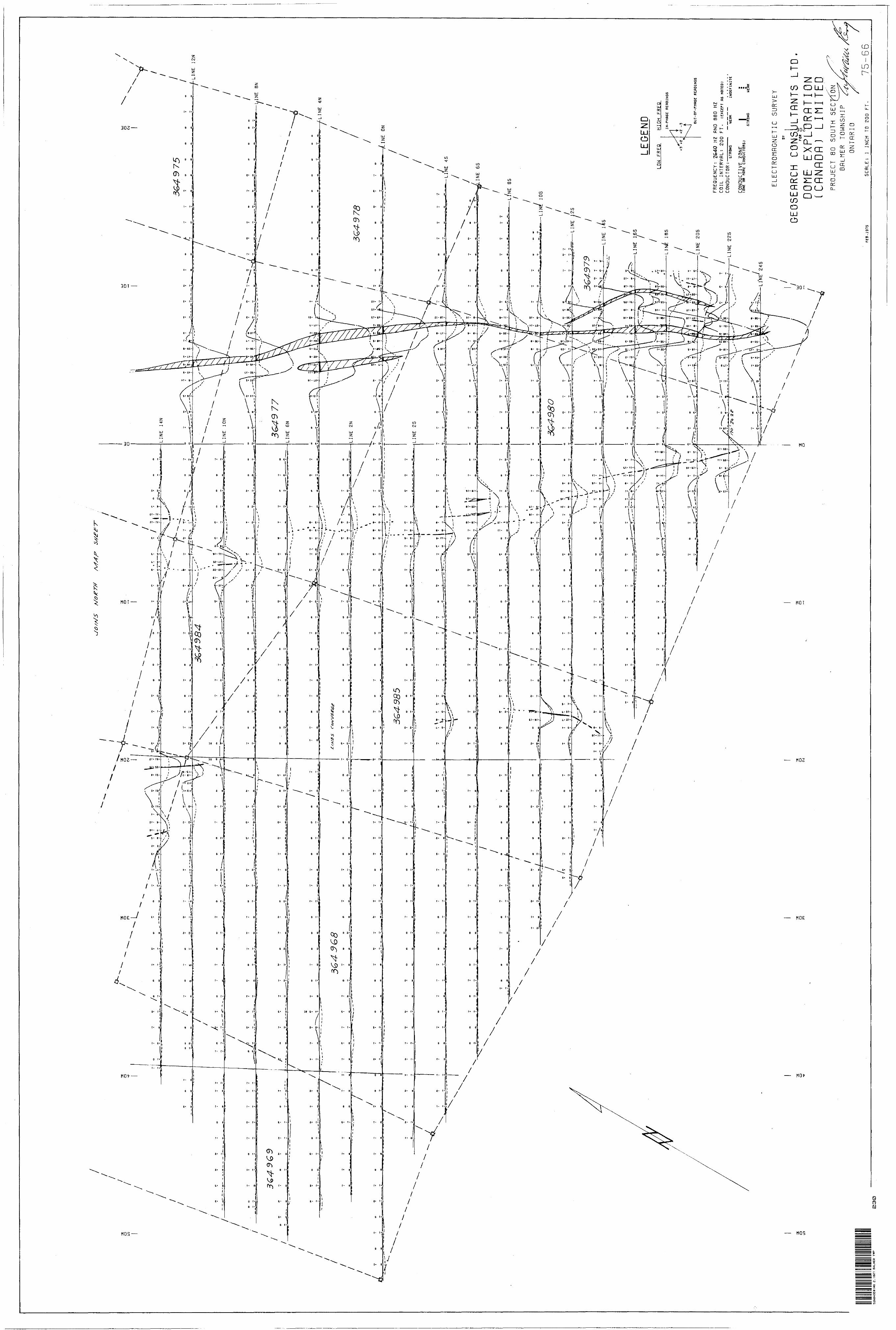
*M. GUN ELECTROMAGNETIC SURVEY
QP The ABBM E.M, Qun and Demigun are moving-source, phase-measuring electromagnetic instruments. They use the operating principle that,when an electrical conductor is subjected to a primary alternating field, a
secondary current is induced in the conductor* This current produces a secondary alternating field which together with the primary field pro duces a resultant field of different amplitude and phase from the app lied primary field* These differences may indicate the presence of a conductor*
In operation, the battery-powered transmitter sets up a primary field while the in-phase and out-of-phase components of the complex secondary vertical field are detected by a receiving coil and measured by means of a compensator-amplifier unit located a fixed distance from the transmitter unit* These parameters are expressed in percentage of the primary field.
The typical curve over a steeply-dipping conductor shows a low (negative - greater than 5?0 over the centre of the conductor! flanked by positive readings on both sides of the conductor. Both the in-phase and the out-of-phase components usually produce the same general shape of curve* An asymmetrical curve may indicate one or more of the follow ing conditions! (l) more than one conductor (2) variable conductive
overburden (3) a shallow dipping conductor.
The ratio of the amplitudes of the two measured components, in-phase to out-of-phase y is directly proportional to the conductivity
of the conductor.
In the case of a single conductor, both component readings are normally zero when either the transmitting or receiving coil is directly above the conductor. The location of the conductor is calculated by adding one-half the distance between the transmitting coil and the receiving coil (coil interval) to the co-ordinate at which the readings are zero. A unique solution is generally not possible in the case of
multiple conductors spaced less than one coil interval apart* This results in the possibility that an apparently wide conductor may actually
consist of two or more narrow conductors*The maximum depth of penetration for detection of a steeply-
dipping conductor in a geo-electrically neutral background is about 0*7 times the coil interval. Over horizontal or flatly-dipping conductors,
penetration of up to 1.5 times the coil interval is possible*
- 3 -
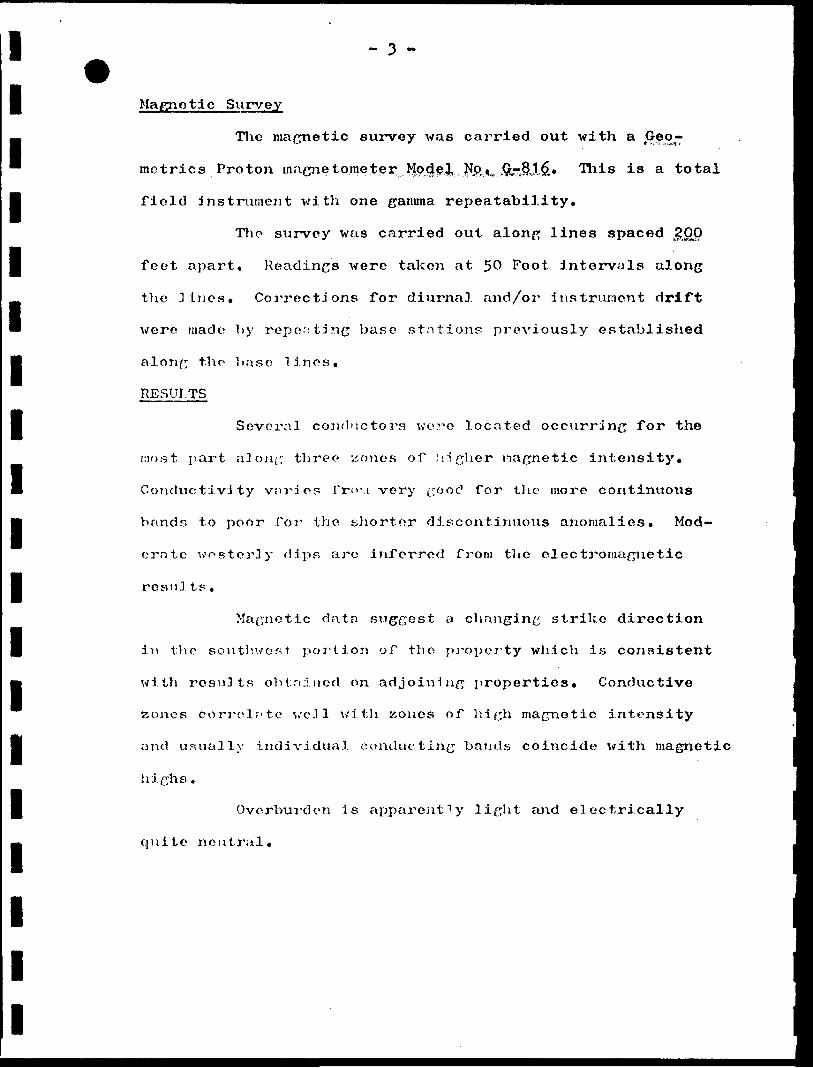
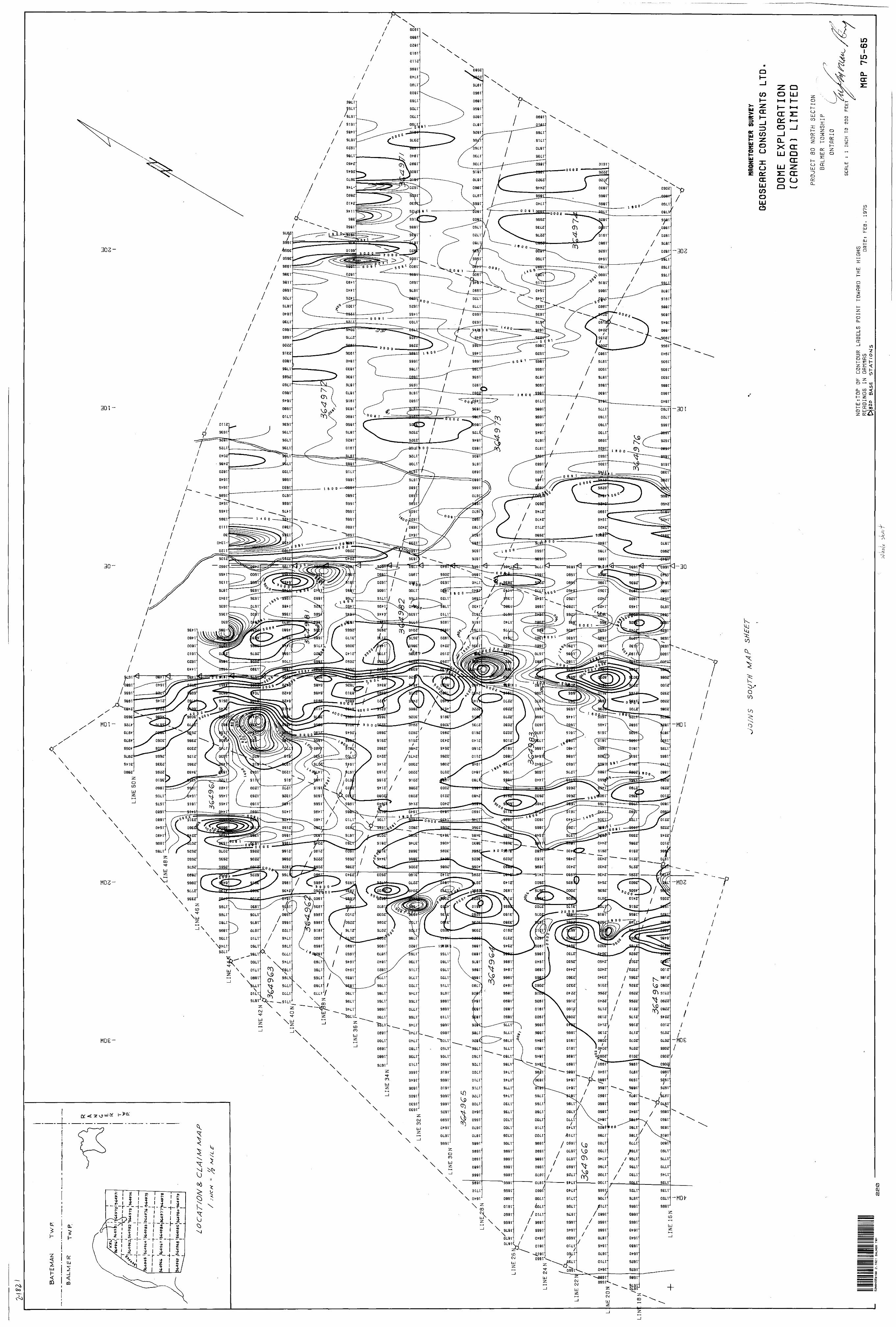
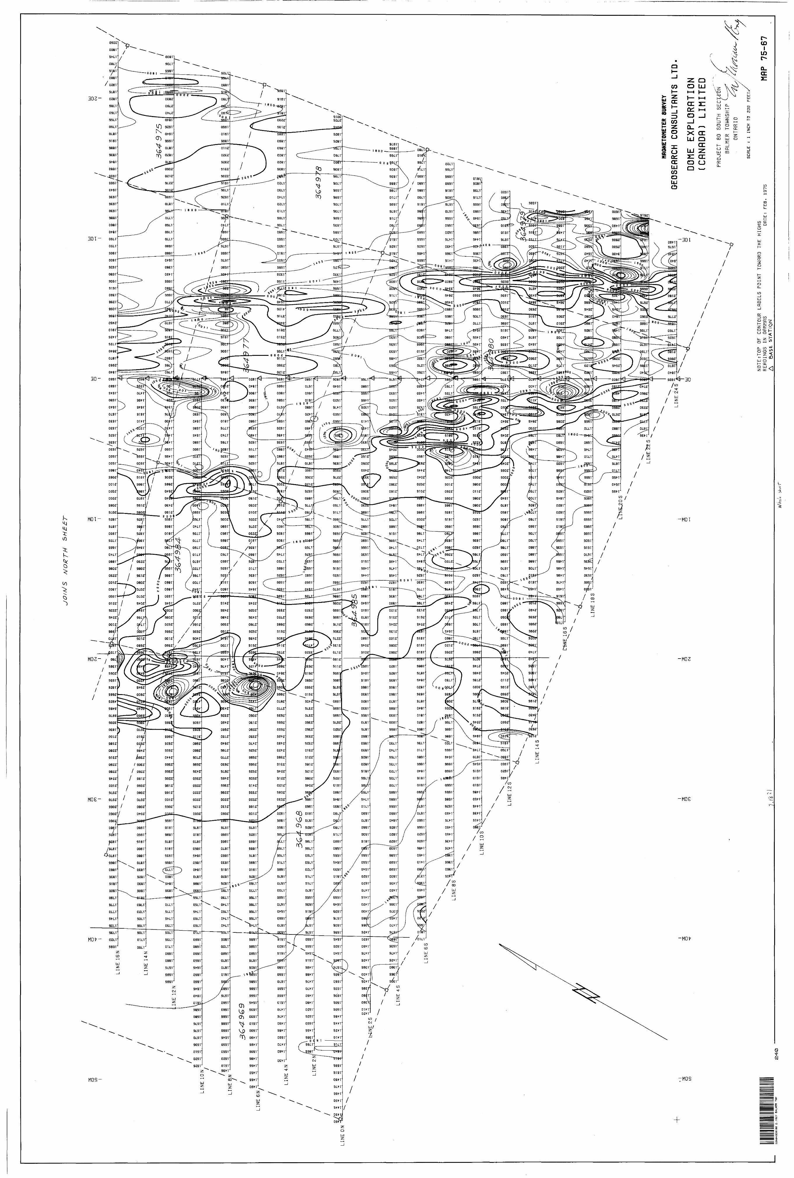
Magnetic Survey
The magnetic survey was carried out with a jSeo-
metrics Proton inagne tome ter;. Mode.3, NP,*,u ,QrJl1J?.* This is a total
field instrument with one gamma repeatability.
The survey was carried out along lines spaced jglOO
feet apart. Readings were taken at 50 Foot intervals along
the .lines. Corrections for diurnal and/or instrument drift
were made by repenting base stations previously established
along the base linos.
RESULTS
Several conductors wore located occurring for the
most part along three* xones of higher nagnetic intensity.
Conductivity varies fro-1 very go o r? for the more continuous
bands to poor for the shorter discontinuous anomalies. Mod-
crate westerly clips arc inferred from the electromagnetic
rosnJ ts.
Magnetic data sxiggest a changing strike direction
in the southwest portion of the property which is consistent
with results obtained on adjoining properties. Conductive
zones correlate wcJl with zones of high magnetic intensity
and usually individual conducting bands coincide with magnetic
highs.
Overburden is apparently light and electrically
quite neutral.

- k .
CONCLUSIONS
Numerous targets nould be selected from the electro
magnetic data which could reflect important concentrations of
sulphide mineralization* Most of these are likely caused by
sulphide iron formation*
Specific reconunendations for further exploration
and drilling should follow a review of previous exploration
history and geological data*
Respectfully submitted,
GEOSEARCH CONSULTANTS LTD.
M. J.^Mofreau, P". Eng*
ntario
Ministry of Natur,
GEOPHYSICAL - GEOLOGIC TECHNICAL DATA
BALMER TWP
TO BE ATTACHED AS AN APPENDIX TO TECHNICAL REPORTFACTS SHOWN HERE NEED NOT BE REPEATED IN REPORT
TECHNICAL REPORT MUST CONTAIN INTERPRETATION, CONCLUSIONS ETC.
900
JUN 101975
PROJECTS UNIT
Type of Survey(s) Electromagnetic and Magnetic———^Township or Area Balmer Township_^____________Claim Holdcr(s) Dome Exploration (Canada) Limited
Survey Company Geosearch Limited_____________ Author of Report M. J. Moreau____________________Address of Author Suite 1114? 100 University Ave.,Covering Dates of Survey..
Total Miles of Line Cut 35.0
Ocl/7? -{\\ni*(linecutting'to
SPECIAL PROVISIONS CREDITS REQUESTED
ENTER 40 days (includes line cutting) for first survey.
ENTER 20 days for each additional survey using same grid.
DAYS~ i-i Pcr claim Geophysical /^~~\
—Electromagnetic——-LM^—
—Magnetometer——Radiometric—-—
—Other
Geological.Geochemical.
AIRBORNE CREDITS (Special provision credits do not apply to airborne surveys)
Magnetometer .Electromagnetic
DATE . g// s(enter days per cl/im)
SIGNATURE:/Author of Report or Agent
Res. Geol.. .Qualifications.Previous Surveys
File No. Type Date Claim Holder
./Lh..L, •H:
,, \\'' ' ''- n
MINING CLAIMS TRAVERSEDList numerically
(prefix) (number)
TOTAL CLAIMS.

List of Claims
Dorr:a^^Exj?lpration.. (Canada) Limited,
Balmer Township, Ontario
(Project 80)
Claim
KRL 364961
364962
364963
364964
364965
364966
364967
364968
364969
364971
364972
Claim
KRL 364973
364974
364975364976
364977364978
364979 364930 36498!364982364983364984 3649^5
NOTES
400' surface rights reservation along the shores of all lakes and rivers.
This Township is part of the IMPROVEMENT
DISTRICT OF BALMERTOWN.
SAND and GRAVEL
'-Grovel Pila 139504
- MINING LANDS -DATEOFISSUE
JUN161975
MINISTRY OF NATURAL RESOURCES
CDin
CM
ia:h-
UJ5 O Q
BATEMAN TP - M.2I39
S5M./ 2o336 7To^r2Lo 33e7*uir(RL 1008
18034(R"
1004 17791
KRL 7 KfiL /KRL: l K RL 34S74 / 333VS5 l 3 3558
22238 34678 34677 J46760889J 20890/ KRL
2089
KRL 1000 \ 20892
993 '-f- K RL
17795 l 1003 17796
96/ KRL KRL l KRl
20897 l 2 0898 /20899KRL
20908 i 2 0909*
KRL998 /KRL 997
17797 /I780
364721 354 9/7 lCL30
KRL
19725 l 2 0900
• mKRL
20913 20914
19666 /KRL
2I933 2195421550 20903
21105 2 II O 6
20346 t 2 0459*
20460 20462
2I200/KRL
21201 /390I7I 4B81 2 2488219722 19724
t |224387l KRL
9690 KRL .04
\ 368482 , K RL20069Xl9670 38906 24377,
.969llVl9 '?.2V.9700, 368488 I KBL
p'/ 207 5-3 120754
Boimer/Iown ^V /KRL , ; 390152~~~~
KRL
20731 /KRL 493 J KflL
20752 l 20748
20862 l j 389975 389974'
K. 1616KRL20486 f 20303
389979 390IS3
KI618 K. 1617 f K RL
20555 508Tafiina* /.^C^-r^l l /-/Z* * /19/304^/2/07^/9 2 0 7BO20843/KRL
20842
KRL KRL
20794 f 4768I
KRL IKRL423370
20799 f 20798
A23372 B J423369 423368
KRL 142
21287
21258 l 4 7684 ;\ i e (470B9423364 '423365;tf—- - .^C,l.M
423363 423362
KRL 848 KRL 861
2I288 2 1290 4709,^47092^;^
21289 21292
,,O*T^ K RL C ***- ' KRLV L l 8602 l 18600 ZI95 Ut5B3IB.
1609251 61172 KRL
ro O)OJ
iCLI-
cr LJ o
(T
5l0 0l'06" approii.
BYSHE TP - M. 2148
52N04SE0ieS 2.1821 BALMER TWP 300
LEGEND
HIGHWAY AND ROUTE No.
OTHER ROADS
TRAILS
SURVEYED LINES:TOWNSHIPS, BASE LINES, ETC.
LOTS, MINING CLAIMS. PARCELS, ETC.
UNSURVEYED LINES:
LOT LINES PARCEL BOUNDARY
MINING CLAIMS ETC.
RAILWAY AND RIGHT OF WAY
UTILITY LINES
NON-PERENNIAL STREAM
FLOODING OR FLOODING RIGHTS
SUBDIVISION
ORIGINAL SHORELINE
MARSH OR MUSKEG
MINES
DISPOSITION OF CROWN LANDS
TYPE OF DOCUMENT
PATENT, SURFACE S MINING RIGHTS
SURFACE RIGHTS ONLY
MINING RIGHTS ONLY
LEASE. SURFACE * MINING RIGHTS
SURFACE RIGHTS ONLY
MINING RIGHTS ONLY
LICENCE OF OCCUPATION
CROWN LAND SALE
ORDER-IN-COUNCIL
RESERVATION
CANCELLED
SAND 4 GRAVEL
SYMBOL
aQB H QV
.c.s. oc
SCALE : 1 INCH 40 CHAINSO 900 1000 1000
FECT
METRESO t OO 4OO tOO BOO l KM
ACRES HECTARES
TOWNSHIP
BALMEFUDISTRICT
KENORA PATRICIA PORTION
MINING DIVISION
RED LAKE
Ontario
Ministry of Natural ResourcesSurveys and Mapping Branch
DaleMarch '75
Whitney Block Queen's Park, Toronto
Plan No.
M. 2137

BA
TE
MA
N
TW
P.
BA
LM
ER
(364
964
(3C
4983
(364
976
-r—
— l-
--—
—36
4978
____
___ ,,,
|364
968
I364
985I
3649
SO
LO
CA
T/O
MZ
C L
A t
M
R A M G E R T
W
P.
fvf/
LS
-
\ \/
\O m
o CMx
I NE
40N
UJ o (D
INE
36N
---X
, '
w \ r
w ^
. \
. ,
.M
\
o
r-
. IT
.
Y
* -
P
-.
nx~
7jfl
3™
i*
i
' ,
'i*
T
\
if
. ——
—"
" ^\
t-M
^—
"-._
__
* \
**
3C4-
982
3649
71
M
Ul
f-f
* —
—^
^
* O
li
*— ~
"^^
w--
**
f
3&4-
9GG
LEG
END
U3H-FREQ
LINE 16N
HIGH FREQ
JN-PHBSE REPCING5
32N
l l
RE
PD
INC
S
FRE
QU
EN
CY
: 2
64-0
H
Z RN
D 88
0 HZ
CO
IL
INTE
RV
AL:
20
0 F
T.
IEXC
EPT
ns N
OTEO
JC
ON
DU
CTO
R:
J D
IM S
S
OU
TH
CO
ND
UC
TIV
E
ZON
E[O
NE
OR
MOR
E C
ON
DU
CTO
RS)
UEHK
STRO
NG
IND
EF
INIT
E
WEP
K
ELECTROMflGNETIC SURVEY
GEOSEflRCH CONSULTflNTS LT
D.FOR
DOME EX
PLORfl
TION
(CflNflDfl)
LIMITED
PROJECT 80 NORTH SECTION
BflL
MER
TO
WNS
Hfl'p
ON
TflR
IO
FEB.
5aN04SE0)08 2.1621 BALMER TWP
210
SC
RLE
: l
INC
H
TO
200
75
-64
BA
TE
MA
N
TW
P.
BA
LM
ER
T
vv/P
'364
973
3449
7—
1^ —
— -L
___L
___j.,,
49
65
'3
64
96
4-'3
64
98
3 1
3649
76 fc
6497
l l
l l
- —
-t-
——
—l--—
—L-.
.
3649
6?
.364
968
t364
9SS
l36
49
Bo
'36
49
7
LO
CA
T/O
N8
* C
LA
/M
/
,'fi
/CH
=
/? M
/L t
.
O
COo CM
UJ
O
LU
OLU
O
CN
J l
LIN
E 4
LIN
E 4
2N
L
LIN
LIN
E S
ON
LIN
E 4
6N
x
10
OO
IO
OIO
OIO
O1O
10
10
IO
—
to
—'
CM
CM
l m
CM
CM
LIN
E 3
6N
LIN
E 3
4N
to
toy
01
OD
CD
en
c•-
t *-
*/
*4a
^^
—^
**
-s
LIN
E 3
2N
"-
^
LIN
E 3
0N
ID
10
IO
IOO
10
IO
O
O
O
O
•*
*
W
o
r-
r-
TOr-
r-
i-
co
(o
to
(oa
il
m •
*L\O
--
10
-w
ID
r-
o
l r-
T
- t-
to
to
to
to
f-
co
-*
10
jo
CD
-*
m
to
^O
TO
/T
O
CD
OD
CO
CD
O)
LIN
E 1
6N
/
LIN
E 2
6 It
/1-
LIN
E 2
4N
LIN
E 2
2N
NE 2
0N
+
iO/N
S
SO
UT
H
MA
PHflONETOMETER
SURVEY
GEO
SEflR
CH
CO
NSU
LTflN
TS
LTD
DOM
E E
XP
LOR
flTIO
N
(CflN
flDR
) LI
MIT
ED
PROJECT 80 NORTH SECTION
BflLME
R TOWNSHIP
QNTRRIO
(
SCRLE
: l
INCH TO 200
FEET
NO
TE:T
OP
O
F CO
NTO
UR
LflB
ELS
P
OIN
T TO
WflR
D
THE
HI&
HS
RE
flDIN
GS
IN
G
flMM
RS
0AS
E
ST
AT
(ON
/5D
flTP
: F
EB
. 19
75M
flP
75-6
552
Ne4S
Eaiia
e 2,
t82i
BA
LMER
TWP
220
vl
lIl
O inl l l
ll lL
INE
12
N
l
iii^
m
j^t*
v
—
r*
r*
-*
r*
r'
r™*
--'-
'^ '
\
' '
* '
' V
-\
' '
-^-—
r*^
s; V
2
i^
^ /.V
~*
.--*
—*
*
' *
* *"^
-
\\ i
'
3649/7
LIN
E
6N
3G4-
3G8
ea
t-
v
l in
HI
n
-.
-.
L
, -.
—
-.
* "
___
V
/'
\ -O
- — i-
-X
' '
- -N
-
T--
*-^
'
in
o
iui\
v
l
w
^^
r 7
T /T
\ r4
T A
t*^~
~~
'\ - \
~l*
*
\
F-
- \
-
*\
' '
\
'n
—*-\
MI
l
o—
^ —f
—A
" *"
\w*-
^
* A
^ \
i
LEG
END
LDH
FR
EQ
HIG
H
FREQ
IN-P
HflS
E RERDINCS
t2 -3
OUT-OF-PMR5E RE
flOI
NCS
FRE
QU
EN
CY
; 26
40
H?
FIND
88
0 HZ
CO
IL
INT
ER
VB
L:
20
0
FT
. (E
XCEP
T flS
NOT
ED)
COND
UCTO
R:
5TRQ
NC
——
——
..
.--.
CONDUCTIVE ZONE
l ONE OR
rtOR
E CONDUCTORS)
UEPK
INDEFINITE
STRONG
HERK
O mO
(NJ
ELECTROMflGNETIC SURVEY
GEO
SEflR
CH
C
ON
SJJ
LTflN
TS
LTD
.FOR o
DOME EX
PLDR
flTI
ON
(CflNflDfl)
LIMITED
FEB.
1975
PR
OJE
CT
80
SO
UTH
BR
LME
R
TOW
NS
HIP
O
NTR
RIO
SC
flLE
; l
INC
H
TO
200
FT
.
^
75-66
S30
52N04SEai06 2.1821 BALMER TWP
o LO
7 7 7
LIN
E I
ON
LIN
E 8
N
LIN
E 6
N
LIN
E O
N
IB
ID
ID
tOtO
CM
tO
CMT
OJ
tO
CO
O
ID
ID
ID
O
IO
tOLO
CO
LO
CD
O)
—
' LO
OD
O
CM
CO
IO
CM
o
LO o
(D
CM O
CD1O
ID
CD
CD
ID O
ID
O)
CM
(O
o o
to(O
IO
IO
o o o
(M
CM
o o
to o
to
10**
to
st
to m
toO
CD o
en
CD
enO
LO
LO
tO
tO
OO
LO
OL
O
ID
10
OD^
tn
OD
—'
r-
tO
LO
LO
CO
CD
' CD
CD
CD
CO
CD
CD
CD
P
* P
* P
* P
*
D
ID
IDo ~
toCD
CD
COCD
CO
CD
CD
ID
tOOD
tOO —
CM
CM
tO
IO O O
O O
CM
flD
p*
p-
r-
p-
O
ID•*
CD
CO
CD(M
CM
o
to \o
to
r-
ID
\o)
tocf
o \
r-
co
uo
10o o
CM
to—t O
CM
CM
O O
ID O
ID O
CM
P-
ID
-*
CM
-*OD
CD
O)
O)
O)
CD
O
tO
LOen
-^
p*r-
r-
r-
O
ID O O
CD
CM O
CMO —
CM
CMCM
CM
CM
CM
O
LO-*
ID
LO
P-
P-
P*
O
LO
OCO
O
) P
-CD
CD
CO
LO
OO
LO
OL
OL
OO
IO
IO
QIO
O
CM
CM
—•C
OP
-P
'P-C
DC
D
\—
-T
-*
LO
ID
LO
lD
lD
tO
lO
lO
ID
lD
\C
O
CO
CO
(O
LO
LO
O
Om
o
to
to
to
co
r-LO O O
LO
LOCO
LO
CD O
CMID
CD
CD
CD O
—"
-~*
—i
CM
o o o
toCD
CO
O
CDO —
CM
CMCM
CM
CM
CM
O O
IDCD
CD
(M
CO ^
PICM
CM
CM
O O O
-*
r-
r-GD
(D
(D
O\
LO O
IOOD\
CM
CM
—'t-
\ CO
OD
CD
to
oo
oo
to
oL
OL
oa
oto
ex
. LO
CO
-*
CM
LO
LO
-+
U
J to
tO
(D
CD
P
- (D
•^
•L
DtO
LO
tO
tO
LO
LD
LO
LO
LO
LO
LO
O
OCM
—
i l
CD
—t
LOtO
—
i l
CD
O)
CD
KDCD
CM
CM
l-t
-t
-t
O
LO
LO
OO
P
- CM
-i
CM
O
O
OCM
CM
CM
CM
LO
LO
LO
f3
LB
OOD
—
CM
/O
3
(0\
CDID
r-
CO
f
-*
LO
\ IB
O
IO
O
LO
OO
CO
CM
CO
-r
t—
—
CM
CO
-*
CM
CM
CM
CM
CM
tO
ID
LOCO
O
) CM
LO
LO
LOCM
CM
CM
O
LO
LOCO
CO
O
O)
OD
OD
LO
LO
LO
LOCO
LO
(D
LO
r-
r-
r-
r-tO
LO
LO
tO
LO
LO
tO
LO
LO
to o
CD
CMo o —
CM
CM
CM
LO
LO~*
CD
to
coCM
CM
LO 10 O
LO0 LO
(H
l CM
LO
—i
LOCD
l -*
to —
CM
CM
CM —
O O
LOo
r-
p-r-
to
CDO
O
OO
U3O
LO
OO
IO
tO
(D
P-O
CO
OD
P-p
'-'L
O
LO
l O
LO O
LO(D
\
CD
P-
OD
CMP-
\T-
P-
CD
CD
tO
lD
OO
OlD
IO
—
-•C
ML
OO
JO
JO
JLO
LO
CD
CMO
—
'CM
CM
LO
LOtn
f~*
v4—'
CM
(O
CM
CM
CM
LO O O
CM
F-
-^
CO
CDCD
CD
a)
en
CD CTP
o CM
LO
LO
LO
O—
i -*
- LO
LO
LO
LO
LO
LO
O
LO
O
LO
LO
LO
Oco
TO
CM
r-
w
o)
a}
O)
O
O
O)
CD
CD—
CM
CM
—
—
—
i
lD
lD
tD
lD
LO
LO
OOD
CD
O
LO
LO
tO
LO
a
uo—
CD
ID
r*
r-
r-O
O
LO
O
tO
O
P-
CMLO
LO
-*
LO
LO
LO
LO
IDco
a)
o
o)
to
co
P-
r-tO
ID
ID
tO
IO
•r*
CM
"T
CO
O
O-*
-*
- -T
-*
LO
LO
O)
—
— .-.-.C
MtO
—
CM
CM
CM
CM
CM
CM
CM
10
O
l LO
f
OtO
O
) f
CM
COtO
LO
f
tO
CD
o
oLO
CO
PJ
OCM
tn
O
LO
OCM
CM
CO
OD
CD
CD
LO
O
O-i
CO
CD
CD
CD
CO
O
LO
LO
LOT
OD
—
" CO
p-
tO
CO
tOO
LO
LO
CD
—
r-p-
p-
to
LO
AD
O
O
CD
f OD
P
- (O
P-
P-
tOo
o
a
LO
LO
OD
-i
CO
OD
O-*
-*
-*
1 LO
LO
LO
OID
OD
~*
to
to
r-
O
LO
LO
LO l
LO
LO
-i
CO
Ojl
O
)co
o)
CD
en
l o
-t
—i
—
-tf
CM
LO
D
fOLO
CD
/
ID
-VOD
OD
l -*
CDCM
CM
O
LO
LO
ID
OCM
(O
tO
O
) CM
CO
CO
CD
CD
CD
O
LO
O
O
LOtO
OD
—
-i
-H
to
LO
toLO
LO
CO
CDr-
-*
r-
CM
CM
CM
o
to
o
to
oOD
OD
^
CD
IO
O
O
-H
O
OCM
CM
CM
CM
CM
LO
LO
LO
-t
tO
-*-
LO
LO
LO
O-H
(O
O
*-
iP
* P
* CD
OD
to
. o
o
o
o
LO
**
LO
LO
LO
tOCD
(D
O
O
) CD
LO /LO /t
O O
LO
LO
ID
—
00
CM/ CO /-t
CD
P-
CD
O)C
DtO
CD
tO
tO
CO
IA
lO
"X
O
CO ^
LO
LO
LO-* O
(DID
LO
ID
O
LO O
CO
CO
LO
LO
LO
IO
IDto
enp-
to
to o o
CM
-*
P-CO
CD
CO
HflO
NETO
HETE
R SURVEY
GEO
SEflR
CH
CO
NSU
LTflN
TS
LTD
-
DOM
E E
XP
LOR
flTIO
N
(CflN
flDfl)
LI
MIT
ED
PROJ
ECT
80 SOUTH
BflLME
R TOWN
SHIP
O N T
fi RIO
SC
flLE
:
l IN
CH
TO
20
0 FE
ET
NOTE:TOP
RERDINGS
A
&ASE
.
OF CONT
OUR
IN GR
MMRS
STATION
LRBELS POINT
TOWR
RD TH
EH
IGH
S
DRTE
FE
B.
1975
MflP
75
-67
S40
52N
04S
E01
*8
2.1
821
BAL
MER
TW
P