garmin international, inc. garmin.com/aviation · garmin international, inc. ... aviation gps...
TRANSCRIPT

PURPOSE-BUILT DEVICES AND APPS FOR PILOTING YOUR OWN COURSE
PORTABLE FLIGHT SOLUTIONS
Garmin.com/aviation
©2017 Garmin Ltd. or its subsidiaries. All rights reservedSpecifications and descriptions are preliminary and subject to change without notice. The Bluetooth word mark and logos are registered trademarks owned by Bluetooth SIG, Inc. and any use of such marks by Garmin is under license.iPad, iPhone and Apple are trademarks of Apple Inc., registered in the U.S. and other countries.
GARMIN INTERNATIONAL, INC.1200 East 151st Street, Olathe, KS 66062 p: 866.739.5687 f: 913.397.8282
GARMIN (EUROPE) LTD., Liberty House, Hounsdown Business Park Southampton, Hampshire, SO40 9LR, U.K. p: +44 (0)87.0850.1243 f: +44 (0)23.8052.4004
GARMIN SINGAPORE PTE. LTD., 46 East Coast Road #05-06, Singapore 428766 p: 65.63480378 f: 65.63480278 e: [email protected]
M02-10114-00 0717

Aviation GPS Portables 06
aera® 796/795 07
aera® 660 09
GPSMAP® 696/695 11
D2™ Series Pilot Watches 13
Garmin Pilot™ App 15
Garmin GLO™ 17
Database Updates 18
SiriusXM® & ADS-B Receiver 19
SiriusXM® Weather and Music Receiver 20
VIRB® Series Action Cams 21
Garmin Connext™ 22
Total Support 24
CONTENT
It wasn’t so very long ago that the words “aviation portable” could be used to categorize, fairly concisely, a segment of stand-alone GPS handheld products. But nowadays with the emergence of sophisticated navigation, mapping and digital flight bag apps for iPads®, smartphones and other tablet-type computer devices, the very idea of what constitutes a “portable product” for aviation has taken on a whole new range of meanings.
What’s more, the industry’s accelerating move toward satellite-based air traffic control in the NextGen airspace system has brought with it an array of new cockpit connectivity options, including subscription-free U.S. weather, NEXRAD imagery and ADS-B traffic monitoring services – which can all now easily be accessed via portable, pocket-sized datalink receivers that pilots can carry with them into any aircraft they fly. Moreover, a number of these products now include their own wireless local link capabilities (via our Garmin Connext™ technology), which enable them to remotely connect, control, activate and/or “talk with each other“ in ways that promise even greater things to come.
In other words, it’s a new world out there.
But rest assured, it’s a world where Garmin innovation continues to set the pace. Over the past quarter-century, we’ve been steadily building our brand with the kind of performance, value and first-in-class features that make GPS-based navigation truly portable and affordable for everyone who flies.
Designed for pilots by pilots, our portable solutions are known for their reliability, durability, practicality, safety-enhancing features and simplicity of operation – no matter what hardware and/or software configuration they might take. They’ve all been tested and optimized for use in demanding cockpit environments. And they’re backed by the most highly acclaimed service/support network in the aviation industry. No wonder pilots around the globe look to Garmin as their go-to source for today’s best in portable flight technology.
THE FAST-EVOLVING WORLD OF PORTABLE GPS
PORTABLES

5
Featuring cockpit-proven technology that’s optimized for pilot use in ways that most generic GPS devices or apps clearly are not, the Garmin aviation portable lineup puts the absolute best in satellite-based flight guidance right at your fingertips. No matter which model you select, you can count on the Garmin GPSMAP® and aera® series portables to provide the features, reliability, processing power and onboard resources to help you make better piloting decisions. Each navigator comes with detailed aerial mapping, a built-in terrain/obstacles database, WAAS GPS position accuracy and our patented Panel page graphics for situational reference. SafeTaxi® diagrams and an AOPA Airport Directory are included on select models. Plus, there’s support for Sirius XM® satellite weather and entertainment – or subscription-free ADS-B uplinked weather, traffic and more on aera 660/796/795 via Connext™ cockpit connectivity.
DEDICATED GARMIN GPS PORTABLES BRING CARRY-ON CONVENIENCE TO FLIGHT NAVIGATION
AVIATION GPS PORTABLES

76
SPECIFICATIONS
1 Not intended to be used as a source of attitude information for flight in instrument meteorological conditions (IMC) and should not be used under these conditions.2 Initial Garmin FlightCharts® and SafeTaxi® are available for the U.S., Canada and Europe. VFR Sectional charts and AOPA Directory are for U.S. only.3 JeppView subscription required (sold separately).4 SiriusXM® subscription required (sold separately) for use with aera 796. See SiriusXM for coverage areas and subscription plans.
Convenient “scratch pad” for writing down clearances and other notes.
Optional SiriusXM® weather can overlay on moving map³.
PDF document viewer offers easy access to aircraft flight manual data.
Receiver WAAS-enabled, 12 channel, high-sensitivity
Waypoints 3,000
Routes 50 with up to 300 points each
Basemap Americas, Atlantic or Pacific
Uploadable maps Supports optional detailed maps
Battery life 3 - 8 hours of use (nominal)
Size 5.1”W x 8.0”H x 1.5”D
Display size 7.0” diagonal (17.78 cm)
Weight 1.65 lb (.75 kg) with batteryOptional European VFR terminal approach charts are available on the aera 796/795, with coverage for over 2,200 airports in 29 countries.
Georeferenced U.S. FliteCharts® come preloaded, along with SafeTaxi® diagrams for thousands of U.S. airports.
Your choice of standard AOPA Airport Directory for the U.S. or optional worldwide AC-U-KWIK directory provides access to facility and fuel price information on thousands of locations.
Ever think you’d see so much “big picture” perspective from a GPS portable? Say hello to the Garmin aera® 796. It’s bringing touchscreen control and unique 3-D Vision flight terrain imagery with attitude display cues¹ to those pilots who want the very best in carry-on navigation. Providing a computer-generated “virtual reality” picture of ground and water features, airports, towers, obstacles, enroute legs and more, the aera’s 3-D flight graphics offer a detailed simulation of the flightscape beneath your aircraft. And with the flick of a finger, you can rotate the 3-D view completely around the aircraft for easy scanning of your surroundings from various “camera-ship” vantage points. The aera® 796’s screen orientation – from vertical portrait view to horizontal landscape format – is pilot-selectable. And initial Garmin IFR FliteCharts® terminal procedures, IFR Enroute and VFR Sectional charts, SafeTaxi® diagrams and AOPA Airport Directory data all come preinstalled on the system2, along with database-driven terrain and obstacle alerting. (A worldwide AC-U-KWIK airport directory and IFR/VFR sectional charts for Europe and Canada are also optionally available.) Plus, you can easily connect a Garmin GDL® 52 ADS-B “In” datalink receiver – or other Connext-capable avionics, such as a GTX™ 345 all-in-one ADS-B transponder – to display traffic targets, weather and more, including SVX™ synthetic vision and attitude command bars. The aera’s big 7” capacitive touchscreen lets you view an entire approach plate at a glance. High and low altitude airways can be navigated on the MFD moving
THE AERA® OF LARGE-FORMAT TOUCHSCREENS HAS ARRIVED
map. And now both the standard Garmin FliteCharts® and the optionally available ChartView™ Jeppesen-format instrument approach plates³ feature georeferencing capability – with an overlaid aircraft symbol that displays your aircraft’s exact position in relation to most instrument approaches. (It’s worth noting that VFR Approach procedures for Europe are also available from Jeppesen.) A built-in document viewer expands the aera 796’s utility as an electronic flight bag (EFB) by enabling you to load and view PDF documents, JPEG photos and other electronically formatted materials of all kinds – everything from basic checklists and charts to detailed performance/procedural data from the aircraft flight manual. There’s also a handy scratchpad for writing down clearances or other important notes.
For urban aviators, such as helicopter pilots, who sometimes need to navigate to specific ground locations or addresses, the addition of an optional City Navigator® map allows the user to search and locate any desired surface address for use as a flight plan waypoint or for “direct-to” aerial navigation. You might also consider an optional wired GXM™ 42 Smart Antenna or wireless GDL® 51 portable for SiriusXM® satellite coverage. Both units work with the aera 796 to provide North American customers with access to datalinked NEXRAD imagery, METARS and other flight-useful weather capabilities – plus some 150+ channels of digital audio programming4 through SiriusXM satellite radio.
For pilots flying in Europe, detailed VFR and IFR aeronautical charts from DFS are optionally available.
VFR Sectional chart data with geo-referencing is included for the U.S.
AERA® 796/795
9
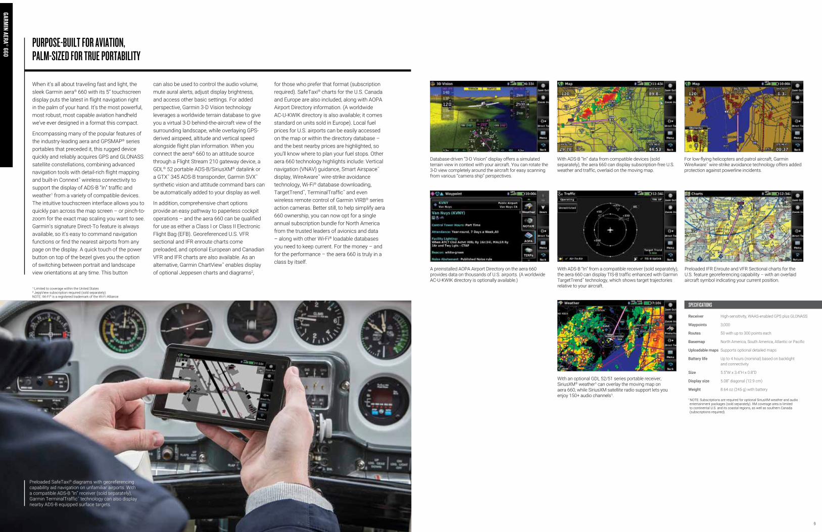
When it’s all about traveling fast and light, the sleek Garmin aera® 660 with its 5” touchscreen display puts the latest in flight navigation right in the palm of your hand. It’s the most powerful, most robust, most capable aviation handheld we’ve ever designed in a format this compact.
Encompassing many of the popular features of the industry-leading aera and GPSMAP® series portables that preceded it, this rugged device quickly and reliably acquires GPS and GLONASS satellite constellations, combining advanced navigation tools with detail-rich flight mapping and built-in Connext™ wireless connectivity to support the display of ADS-B “In” traffic and weather1 from a variety of compatible devices. The intuitive touchscreen interface allows you to quickly pan across the map screen – or pinch-to-zoom for the exact map scaling you want to see. Garmin’s signature Direct-To feature is always available, so it’s easy to command navigation functions or find the nearest airports from any page on the display. A quick touch of the power button on top of the bezel gives you the option of switching between portrait and landscape view orientations at any time. This button
can also be used to control the audio volume, mute aural alerts, adjust display brightness, and access other basic settings. For added perspective, Garmin 3-D Vision technology leverages a worldwide terrain database to give you a virtual 3-D behind-the-aircraft view of the surrounding landscape, while overlaying GPS-derived airspeed, altitude and vertical speed alongside flight plan information. When you connect the aera® 660 to an attitude source through a Flight Stream 210 gateway device, a GDL® 52 portable ADS-B/SiriusXM® datalink or a GTX™ 345 ADS-B transponder, Garmin SVX™ synthetic vision and attitude command bars can be automatically added to your display as well.
In addition, comprehensive chart options provide an easy pathway to paperless cockpit operations – and the aera 660 can be qualified for use as either a Class I or Class II Electronic Flight Bag (EFB). Georeferenced U.S. VFR sectional and IFR enroute charts come preloaded, and optional European and Canadian VFR and IFR charts are also available. As an alternative, Garmin ChartView™ enables display of optional Jeppesen charts and diagrams2,
for those who prefer that format (subscription required). SafeTaxi® charts for the U.S. Canada and Europe are also included, along with AOPA Airport Directory information. (A worldwide AC-U-KWIK directory is also available; it comes standard on units sold in Europe). Local fuel prices for U.S. airports can be easily accessed on the map or within the directory database – and the best nearby prices are highlighted, so you’ll know where to plan your fuel stops. Other aera 660 technology highlights include: Vertical navigation (VNAV) guidance, Smart Airspace™ display, WireAware™ wire-strike avoidance technology, Wi-Fi® database downloading, TargetTrend™, TerminalTraffic™ and even wireless remote control of Garmin VIRB® series action cameras. Better still, to help simplify aera 660 ownership, you can now opt for a single annual subscription bundle for North America from the trusted leaders of avionics and data – along with other Wi-Fi® loadable databases you need to keep current. For the money – and for the performance – the aera 660 is truly in a class by itself.
PURPOSE-BUILT FOR AVIATION, PALM-SIZED FOR TRUE PORTABILITY
¹ Limited to coverage within the United States² JeppView subscription required (sold separately).NOTE: Wi-Fi® is a registered trademark of the Wi-Fi Alliance
SPECIFICATIONS
Receiver High-sensitivity, WAAS-enabled GPS plus GLONASS
Waypoints 3,000
Routes 50 with up to 300 points each
Basemap North America, South America, Atlantic or Pacific
Uploadable maps Supports optional detailed maps
Battery life Up to 4 hours (nominal) based on backlight and connectivity
Size 5.5”W x 3.4”H x 0.8”D
Display size 5.08” diagonal (12.9 cm)
Weight 8.64 oz (245 g) with battery
1 NOTE: Subscriptions are required for optional SiriusXM weather and audio entertainment packages (sold separately). XM coverage area is limited to continental U.S. and its coastal regions, as well as southern Canada (subscriptions required).
With an optional GDL 52/51 series portable receiver, SiriusXM® weather¹ can overlay the moving map on aera 660, while SiriusXM satellite radio support lets you enjoy 150+ audio channels¹.
Database-driven “3-D Vision” display offers a simulated terrain view in context with your aircraft. You can rotate the 3-D view completely around the aircraft for easy scanning from various “camera ship” perspectives.
With ADS-B “In” data from compatible devices (sold separately), the aera 660 can display subscription-free U.S. weather and traffic, overlaid on the moving map.
For low-flying helicopters and patrol aircraft, Garmin WireAware™ wire-strike avoidance technology offers added protection against powerline incidents.
A preinstalled AOPA Airport Directory on the aera 660 provides data on thousands of U.S. airports. (A worldwide AC-U-KWIK directory is optionally available.)
With ADS-B “In” from a compatible receiver (sold separately), the aera 660 can display TIS-B traffic enhanced with Garmin TargetTrend™ technology, which shows target trajectories relative to your aircraft.
Preloaded IFR Enroute and VFR Sectional charts for the U.S. feature georeferencing capability – with an overlaid aircraft symbol indicating your current position.
Preloaded SafeTaxi® diagrams with georeferencing capability aid navigation on unfamiliar airports. With a compatible ADS-B “In” receiver (sold separately), Garmin TerminalTraffic™ technology can also display nearby ADS-B equipped surface targets.
GARMIN AERA® 660
1110
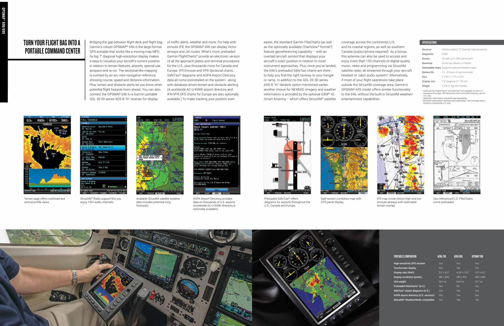
Terrain page offers overhead and vertical profile views.
SiriusXM® Radio support lets you enjoy 150+ audio channels¹.
Available SiriusXM satellite weather data includes potential icing forecasts¹.
AOPA Airport Directory provides data on thousands of U.S. airports (worldwide AC-U-KWIK directory is optionally available).
Preloaded SafeTaxi® offers diagrams for airports throughout the U.S., Canada and Europe.
Split-screen combines map with GPS panel display.
Geo-referenced U.S. FliteCharts come preloaded.
IFR map mode shows high and low enroute airways with selectable terrain overlay.
1 Initial Garmin FlightCharts® and SafeTaxi® are available for the U.S., Canada and Europe. VFR Sectional charts and AOPA Directory are for U.S. only.
2 JeppView subscription required (sold separately).3 SiriusXM subscription required (sold separately). XM coverage area is
limited to continental U.S. only.
Bridging the gap between flight deck and flight bag, Garmin’s robust GPSMAP® 696 is the large-format GPS portable that works like a moving-map MFD. Its big 7” diagonal high-resolution display makes it easy to visualize your aircraft’s current position in relation to terrain features, airports, special use airspace and so on. The sectional-like mapping is overlaid by an arc-view navigation reference showing course, speed and distance information. Plus, terrain and obstacle alerts let you know when potential flight hazards loom ahead. You can also connect the GPSMAP 696 to a Garmin portable GDL 39 3D series ADS-B “In” receiver for display
of traffic alerts, weather and more. For help with enroute IFR, the GPSMAP 696 can display Victor airways and Jet routes. What’s more, preloaded Garmin FlightCharts® provide an electronic version of all the approach plates and terminal procedures for the U.S., plus thousands more for Canada and Europe. IFR Enroute and VFR Sectional charts, SafeTaxi® diagrams and AOPA Airport Directory data all come preinstalled on the system1, along with database-driven terrain and obstacle alerting. (A worldwide AC-U-KWIK airport directory and IFR/VFR DFS charts for Europe are also optionally available.) To make tracking your position even
TURN YOUR FLIGHT BAG INTO A PORTABLE COMMAND CENTER
easier, the standard Garmin FliteCharts (as well as the optionally available ChartView® format²) feature georeferencing capability – with an overlaid aircraft symbol that displays your aircraft’s exact position in relation to most instrument approaches. Plus, once you’ve landed, the 696’s preloaded SafeTaxi charts are there to help you find the right taxiway to your hangar or ramp. In addition to the GDL 39 3D series ADS-B “In” datalink option mentioned earlier, another choice for NEXRAD imagery and weather information is provided by the optional GXM® 42 Smart Antenna – which offers SiriusXM® satellite
coverage across the continental U.S. and its coastal regions, as well as southern Canada (subscriptions required). As a bonus, this antenna can also be used to access and enjoy more than 150 channels of digital-quality music, news and programming via SiriusXM satellite radio, all streamed through your aircraft headset or cabin audio system³. Alternatively, if most of your flight operations take place outside the SiriusXM coverage area, Garmin’s GPSMAP 695 model offers similar functionality to the 696, without the built-in SiriusXM weather/entertainment capabilities.
SPECIFICATIONS
Receiver WAAS-enabled, 12 channel, high-sensitivity
Waypoints 3,000
Routes 50 with up to 300 points each
Basemap Americas, Atlantic or Pacific
Uploadable maps Supports optional detailed maps
Battery life 2.5 - 8 hours of use (nominal)
Size 5.7”W x 7.7”H x 2.0”D
Display size 7.0” diagonal (17.78 cm)
Weight 2.2 lb (1 kg) with battery
PORTABLES COMPARISON AERA 796 AERA 660 GPSMAP 696
High-sensitivity GPS receiver Yes Yes Yes
Touchscreen display Yes Yes Yes
Display size (WxH) 3.6” x 6.0” 4.35” x 2.61” 3.6” x 6.0”
Display resolution (pixels) 480 x 800 480 x 800 480 x 800
Unit weight 26.4 oz 8.64 oz 35.7 oz
Preloaded FliteCharts® (U.S.) Yes No Yes
SafeTaxi® airport diagrams (U.S.) Yes Yes Yes
AOPA airport directory (U.S. versions) Yes Yes Yes
SiriusXM® Weather/Radio compatible Yes Yes Yes
GPSMAP® 696/695
GPSMAP® 696/695

1312
D2™ Bravo
SPECIFICATIONS
Garmin D2™ Charlie
GARMIN D2
™ SERIES PILOT WATCHES
Receiver High-sensitivity GPS
Waypoints 1,000
Routes 50
Basemap Worldwide, preloaded
Interface USB
Battery type Rechargeable Li-ion
Battery life D2 Charlie – up to 20 hours in GPS flight mode; up to 12 days in watch mode D2 Bravo – up to 20 hours in GPS flight mode; up to 6 weeks in watch mode
Unit Size 2.0”W x 2.0”H x 0.7”D
Display size 1.2” diameter (3.1 cm)
Weight D2 Charlie – 3.46 oz (.098 kg) with battery D2 Bravo – 2.98 oz (.084 kg) with battery
The Garmin D2™ family of pilot watches was the first to put true global navigation capability right on your wrist – for the ultimate in portability and situational awareness. Featuring a worldwide airport database that enables Garmin’s signature Direct-To and Nearest navigation functions, these versatile devices also incorporate a built-in altimeter with adjustable baro setting, altitude alerting capabilities, display of both local and Zulu/UTC time, various timers and alerts, internal compass with HSI, and the ability to seamlessly integrate with the Garmin Pilot™ app, including automated logbook and flight plan transfer, VIRB® action cameras and more.
Both the premium D2™ Charlie and D2™ Bravo series watches will work wirelessly with your compatible smartphone to bring you a screenful of current meteorological (METARs) information: Winds, visibility, precipitation, cloud cover and heights, temperature, dew point, barometric pressure, and so on – all the vital, quick-scan updates you need for smart preflight decision-making. You can also assign customized data fields to display GPS groundspeed, GPS track, distance, estimated time enroute, bearing, glide ratio, and other useful flight parameters.
In addition to all the D2 Bravo series functions, the D2 Charlie model adds a rich array of color mapping, NEXRAD weather, airport information and automatic flight logging features, plus built-in activity tracking and multisport profiles with Elevate™ wrist-based heart rate monitoring¹ to help you meet your fitness goals and maintain an active lifestyle. The D2 Charlie model’s dynamic moving map display offers detailed surface features and key landmarks for at-a-glance navigation and VFR situational reference. You can pan and zoom the map to quickly see what airports, waypoints or other features lie outside the currently displayed view. And you can also overlay estimated time enroute (ETE) and Zulu/UTC time right on top of the moving map display.
Expanded weather display capabilities let you overlay high-resolution radar graphics on the D2 Charlie map display. And enhanced Direct-To capabilities allow you to add multiple waypoints and select a direct-to route to any waypoint in your flight plan. You can easily transfer and sync flight plans from your iPad® or other compatible mobile device running our Garmin Pilot™ app. And you can also use the app to update the free lifetime databases that come with your D2 Charlie watch.
Crafted of premium grade materials and featuring a titanium bezel with diamond-like carbon (DLC) finish, the D2 Charlie aviator watch is available in 2 distinctive versions: one featuring a vintage-style leather band; the other sporting a deluxe brushed titanium hybrid bracelet. Available QuickFit™ bands – that you can change without tools – let you tailor your watch’s look to any lifestyle or activity – from office to flight deck to golf course.
Smart notifications², available with all the D2 series watches, let you leave your phone in your pocket or flight bag – and still quickly screen phone calls, texts and other messages right on your watch. Other connected features include automatic sportwatch uploads to our online fitness community, as well as live tracking and social media sharing through our free Garmin Connect™ mobile app. What’s more, when wirelessly connected to the Garmin VIRB® series of HD action cameras via Garmin Connext, , all D2 model watches can remotely start/stop video, view elapsed time for active recording, and even capture high-quality still photos – while live video is being recorded. Garmin D2 series: It’s what the world’s most confident navigators are proud to have up their sleeves.
GPS NAVIGATION AT YOUR FINGERTIPSFROM THE TIMEPIECE ON YOUR WRIST
1 See Garmin.com/ataccuracy2 When paired with compatible smartphone; See Garmin.com/ble

1514
1 Available on Apple iOS devices2 Requires supported receivers using Wi-Fi connectivity3 Not intended to be used as a source of attitude information for flight in instrument meteorological conditions (IMC) and should not be used under these conditions
4 In addition to attitude, the GDL52 also provides built-in GPS positioning reference
Garmin Pilot™ can serve as your electronic logbook. It tracks date, time, aircraft, arrival/departure airports, landings and more. Plus, it will automatically log your total time from takeoff to landing.
With an expanded suite of tools for preflight planning and in-flight operations, Garmin Pilot lets you turn a whole array of iOS® and Android™-based mobile devices (including Apple’s iPad®, iPhone® and iPod Touch®, as well as other popular smartphones and tablets) into some of the most versatile piloting tools you’ve ever slipped into a flight bag.
Garmin continues to pack more features and capabilities into Garmin Pilot to make it aviation’s premier, all-in-one application – merging flight plan data with other information such as integrated weight-and-balance calculations, aircraft performance tables and more¹. Freehand flight planning allows for quick and easy editing of flight plans directly from the moving map page. And pilot-configurable checklists¹ let you create custom checklists that are quickly accessible from within the app.
Global in its scope and coverage, the Garmin Pilot app features detail-rich interactive mapping and charts, advanced MFD-like navigation capabilities, complete global flight planning, airport directory and weather briefing resources – plus available inflight weather and traffic display links².
The app’s easy-to-use menu icons mirror those of the newest Garmin touchscreen avionics – with a graphic interface that allows you to quickly pan across the display and “pinch zoom” to scale the map view up or down. Using your unit’s internal (or compatible external) GPS reference, Garmin Pilot provides full enroute navigation on its moving map display, while keeping track of your ETE, ETA, crosstrack error, distance to waypoint and more. Smart Airspace™ automatically highlights airspace features close to your current altitude¹, providing you with increased situational awareness. Also, the exclusive NavTrack feature
CLEAR YOUR TABLET FOR TAKEOFFWITH OUR GARMIN PILOT™ APP
lets you “look ahead” to preview changing weather conditions along your route, while connected to the internet, a GDL® 52 portable receiver, or other Connext-capable avionics. VFR sectional or IFR enroute charts can be selected for navigation. And Garmin Pilot also allows you to establish personal minimums for VFR, IFR and wind speed in both day and night conditions. Plus, a unique radial menu offers easy on-screen access for creating user waypoints or navigating Direct-To, as well as the ability to view current weather conditions and airport/navaid information at a glance.
Global terrain data, as well as U.S., Canadian and European obstacle alerting and detail-rich surface mapping with Visual Reporting Points (VRPs), are also available within Garmin Pilot. Plus, in addition to U.S. charts, IFR and VFR aeronautical chart coverage is available for Europe and Canada, providing valuable information such as radio frequencies, airspace boundaries, landmark information, and so on. As an option, Garmin Pilot is also available with mapping formats and global navigation data powered by Jeppesen™ as well as Jeppesen-format charts with built-in Garmin Chartview™.
With Database Concierge, Garmin Pilot also allows you to wirelessly update the aviation databases of your compatible avionics. At home, you can simply select the individual databases on Garmin Pilot, download them, and then store them to your mobile device. Then, at the airport, once your device establishes a wireless connection in the airplane, Garmin Pilot will
transfer your up-to-date databases directly to the compatible avionics in minutes, where they’ll wait in standby until their effective dates. This app-to-avionics interface really saves you time and tedious data entry – so you can complete your checklist items quicker and get airborne sooner.
To further extend your tablet’s capability, you can wirelessly link – via Garmin Connext™ – to a portable GDL 52 series receiver. That connection not only lets you access subscription-free weather and uplinked ADS-B traffic, but it also adds reliable backup attitude reference³ to enable 3-D Vision with virtual terrain, horizon cues, HSI, airspeed, altitude and vertical speed reference all integrated on the flight display4. Along with this, the datalinked traffic is enhanced with our exclusive TargetTrend™ relative motion tracking technology to help you better visualize traffic trajectories and closing rates in relation to your flight path. And once you’ve landed, Garmin TerminalTraffic™ technology also enables ADS-B equipped surface targets to be displayed on the SafeTaxi® diagram, so you can see what’s happening, traffic-wise, on busy runways and taxiways. Better still, at the end of your flight, there’s even a handy Logbook feature in Garmin Pilot that will automatically capture and record your total flight time from takeoff to landing – as well as day/night recency for FAR requirements. This feature also provides a place for logbook endorsements, and it even syncs in the cloud with flyGarmin to keep all your flight entries up to date.
The exclusive NavTrack feature on the display lets you “look ahead” to preview changing weather conditions along your route of flight.
Optional SafeTaxi® diagrams with geo-referencing capability help you navigate on unfamiliar airports. With an optional GDL 39 receiver, TerminalTraffic™ technology displays ADS-B equipped surface targets right on these diagrams.
With an optional GDL 52 ADS-B receiver, Garmin Pilot can display subscription-free weather and datalink traffic. Traffic displays with our patented TargetTrend™ technology that shows traffic trajectories relative to your aircraft.
The Garmin Pilot™ app enables you to incorporate weight-and-balance calculations into a flight plan or saved trip. In the event CG limits entered in the app for your aircraft are exceeded, you’ll receive a visual alert.
GARMIN PILOT
® FLIGHT APP
The terrain page on Garmin Pilot™ offers overhead and vertical profile views to help you identify potential flight hazards ahead.
A terrain and obstacle database provides high-resolution contour mapping to show your aircraft’s proximity to potentially hazardous terrain or obstacles such as towers, while providing audible and visual cautions and warnings as you near these obstructions.
Garmin Pilot™ is global in scope. Its highlights for international pilots include: available FliteCharts® for Europe, Canada and the U.S. – as well as DFS charts and detail-rich surface mapping with Visual Reporting Points (VRPs).
Aircraft performance tables in Garmin Pilot make it easy to input figures for such calculations as power setting and fuel/distance profiles. Calculations take into account such factors as outside air temperature, altitude, and so on.
1716
SPECIFICATIONS
Receiver WAAS-enabled GPS plus GLONASS
Update rate 10 Hz
Accuracy +/- 3 meters
Battery life Up to 12 hours
Size 0.70”W x 1.65”H x 3.04”D
Weight 2.12 oz (60.1 g)
Your Garmin GPS comes complete with an extensive aviation database. It’s the mainstay of your unit’s moving map navigation capabilities. In addition, other databases found on select Garmin portables include: Garmin FliteCharts®, SafeTaxi®, Airport Directory, plus terrain alerting, towers/obstacles databases, and much more.
Over time, as airport and airspace information changes, your databases will require updating. Fortunately, Garmin makes the process easy – just 3 simple steps to update online – via our website: flyGarmin.com.
After accessing the Garmin website, on-screen instructions will ask you to identify your GPS, select a database and region. Using the internet connection from your home computer and a Garmin PC interface cable accessory, you can select and update your database in just a matter of minutes. Simply follow the online prompts.
As an added incentive, Garmin’s bundled pricing program for the popular GPSMAP® 696/695 and aera® series navigators offers multi-database annual updates at a cost of up to 50% less than data sets purchased individually. And you can look for even more product/database combo bundles to be added in the future. From the moving-map NavData, Obstacles and Terrain databases to graphical FlightCharts®, SafeTaxi® and AOPA Directory information, Garmin’s new portable update packages make it easier and more affordable to keep all your aviation databases up-to-date. Spending less while getting more: That’s what Garmin value is all about.
MANAGE YOUR DATABASE SUBSCRIPTIONS, LOGBOOKS AND MORE WITH FLYGARMIN.COM
SPECIFICATIONS
Coverage Varies by product
Airports Identifier, city/state, country, facility name, lat/long, elevation, fuel service, control, approach information
VORs Identifier, city/state, country, facility name, lat/long, frequency, co-located DME/TACAN, magnetic variation, weather broadcast
NDBs Identifier, city/state, country, facility name, lat/long, frequency, weather broadcast
Intersections Identifier, country, lat/long, nearest VOR
Runways Designation, length, width, surface, lighting, pilot-controlled lighting frequency
FSS Identifier, reference VOR, frequency usage
Frequencies Approach, arrival, control area, departure, Class B, Class C, TMA, TRSA with sector, altitude and text usage info; also, ASOS, ATIS, AWOS, center, clearance delivery, ground, pre-taxi, tower, unicom, localizer and ILS
ARTCC Identifier, frequency usage
MSA Minimum safe altitude along and in proximity to active flight plan
Approaches Non-precision and precision approaches from FAF to MAP
Airspaces Class B and C with sectors, International CTA and TMA with sectors; all special-use airspace, including MOA’s, prohibited and restricted areas with controlling agency and airport
If you’ve tried to do airborne navigation with the typical built-in GPS on many of today’s tablet computers or other smart devices, you know how frustrating that can be. Too often, these units simply aren’t up to the task of providing the robust, high-precision guidance you expect from a Garmin-grade GPS navigator. That’s why it makes sense to upgrade your signal with a Garmin GLO® portable receiver. This light, compact, easy-to-use portable solution is able to receive its position information from both GPS and GLONASS (Global Navigation Satellite System) constellations, adding 24 extra satellites to the mix – and assuring you of the best, most accurate positioning solutions worldwide. Your GLO® wireless sensor can lock on to satellites some 20% faster than most single-network receivers. And its high-capability 10 Hz receiver updates its position information up to 10 times more frequently than the garden-variety GPS sensors used in many mobile devices. GLO® works seamlessly with a variety of apps,
including Garmin Pilot™, to turn your Apple iPad® or other iOS® or Android™-based mobile device into a true go-anywhere moving map navigator. In fact, your GLO even comes with a 6-month free trial of our Garmin Pilot app to make your choice even simpler.
Featuring easy Bluetooth® connectivity, the GLO pairs wirelessly with up to four compatible devices simultaneously. Just set GLO within range of your mobile device, and in moments you’ll be receiving GLO’s enhanced position data. With up to 12 hours of battery life, your GLO can go a long, long way between recharges. And even then, charging your GLO between uses is easy with the included USB cable or optional 12/24 volt cigarette lighter adapter. For optimum reception, an optional friction mount is available to keep your GLO safely positioned atop your aircraft’s panel – in full view of all available satellites, both foreign and domestic. Garmin GLO: It’s all about bringing you the best of both worlds in satellite-based portable navigation.
GARMIN GLO®. HIGHER-PRECISION GPS FOR YOUR TABLET OR MOBILE DEVICE
GARMIN PILOT® FLIGHT APP
GARMIN GLO®
FLY GARMIN

1918
SIRIUSXM® & ADS-B RECEIVER
PORTABLE SIRIUSXM® W
EATHER AND SATELLITE RADIO RECEIVER
Now, with this compact portable antenna/receiver in your aircraft, you have access to a whole new level of “glass cockpit” type flight information. Providing an easy-to-use and totally portable aviation satellite link, the compact GDL® 52 combines SiriusXM® Aviation service coverage — accessible from ground or air — with the subscription-free weather and traffic features of an ADS-B “In” datalink¹. Together, these two network link technologies bring a world of safety-enhancing features — plus access to more than 150 channels of digital-quality music, news, sports and other entertainment programming² — directly to your cockpit. Better still, you can add simultaneous display of backup attitude (pitch and roll) reference³, along with detailed moving-map navigation and WAAS-level satellite positioning accuracy from the unit’s built-in GPS.
Continuous SiriusXM satellite updates — accessible by ground and air — help you make better, more timely flight decisions. The SiriusXM network’s powerful satellites deliver seamless coverage across the continental United States and its coastal regions, as well as southern Canada. Choose from available SiriusXM Aviation packages that provide METAR data and animated NEXRAD imagery, plus current reports on precipitation, lightning, winds aloft, echo tops, turbulence, freezing levels, TFRs and more.
Using the Garmin Pilot™ app, you can view all this data on your Apple iPad® or other compatible
iOS® or Android™ devices4. And you can even split the display on your iPad® screen to show traffic and weather overlaid on the moving map above, while monitoring your backup attitude on synthetic vision (SVX). It’s like having a virtual flight deck you can pack in your flight bag. Similarly, if you own an aera® 660 or 796/795 series portable, the GDL 52’s weather and traffic uplinks are also compatible with these products, and it will provide Garmin SVX™ synthetic vision and attitude command bar functionality as well.
The ADS-B weather link is continuously broadcast on the 978 MHz Universal Access Transceiver (UAT) frequency. For example, you can access NEXRAD imagery, METARs, TAFs, winds and temperatures aloft, PIREPs, NOTAMs, and more5. Along with this, you can also receive ADS-B traffic position reports (and threat-level symbology) to help you see and avoid converging targets in busy airspace. Spoken audio alerts call out potential flight path conflicts (“Traffic, traffic.”) to get you looking right away. Meanwhile, on your screen, Garmin’s patented TargetTrend™ relative motion display6 offers a faster, more intuitive way of judging target trajectories and closure rates in relation to your flight path. As an added safety feature, Garmin TerminalTraffic™ technology supports the display of ADS-B equipped surface targets on the map screen, to help you keep track of other aircraft or ground vehicles that may be moving in your vicinity on the airport. The GDL 52 is, by far, one of the simplest and smartest ways
to gain the benefits of ADS-B technology. It’s a dual-link system, so it can receive on both ADS-B frequencies (978 MHz and 1090 MHz) authorized for ADS-B operations in the U.S. However, for best traffic uplink results, your aircraft needs to be a “participant” in the ADS-B system and have an approved ADS-B “Out” system (such as a 1090 MHz extended squitter transponder) on board. The GDL 52 does not provide this “Out” function, but it can serve as an affordable “In” receiver to access the benefits of ADS-B weather and traffic data, subscription-free.
FLY WITH WEATHER, TRAFFIC AND GPSWHILE WATCHING YOUR ATTITUDE
¹ Note: The GDL 52 is a noncertified receive-only product. It does not provide ADS-B “Out” capability to satisfy FAA mandate requirements.
² SiriusXM subscription required (sold separately). See SiriusXM.com/aviation³ Not intended to be used as a source of attitude information for flight in
instrument meteorological conditions (IMC) and should not be used under these conditions.
4 See Garmin website or dealer for our growing list of compatible devices5 Note: Not all FIS-B weather products may be available on all Garmin displays.
Please check your Pilot’s Guide for the specifics on your product.6 Both the audible traffic alerting feature and TargetTrend™ require compatible
displays. Please check your Pilot’s Guide for specific capabilities available on your display.
SPECIFICATIONS
Receiver Dual-channel ADS-B (978 MHz UAT/1090MHz)
Operating temp -20°C to +60°C (-4°F to 140°F)
Power input 10 to 32 VDC; 3.5 W max.
Battery type Rechargeable Li-ion
Battery life Up to 5 hours with GDL52
Unit Size 4.9” W x 1.3”H x 3.4”D
Weight 0.77 lb (.35 kg)
With the compact GDL® 51 Portable SiriusXM Weather and Satellite Radio Receiver, you can access continuous, all-altitude North American weather coverage – while enjoying more than 150 channels of digital-quality music, news, sports and other entertainment programming – from the subscription-based SiriusXM® satellite network. An internal antenna in the GDL 51 makes for easy positioning and reception aboard your aircraft. And, as a bonus, you can use Garmin Connext® wireless connectivity to stream SiriusXM services onto compatible portables or mobile devices equipped with the Garmin Pilot® app. So, you get more access – on more devices – without spending more money. Likewise, if you fly with a Garmin aera 660 or 796/795 series aviation portable, the receiver’s data links can also be accessed with these products, as well.
The SiriusXM network’s powerful satellites deliver seamless coverage across the continental U.S. and its coastal regions, as well as southern Canada. The weather suite’s high-resolution color graphics provide detailed NEXRAD and METARs data, as well as current reports on precipitation, lightning, winds aloft, echo tops, turbulence, freezing levels, TFRs and more. Plus, to help you maintain the most current weather picture, your GDL 51 receiver can queue the weather from SiriusXM while the device is sleeping or turned off, so it automatically updates when you turn the screen back on.
On the audio entertainment side, you can simply sync a Bluetooth® -compatible headset with
your GDL 51 to wirelessly access an industry-leading digital playlist with channels tailored to your tastes and interests. If you prefer, you can also opt to hardwire the GDL 51 through your compatible audio panel (or use the wireless connectivity of Garmin Connext™) for routing through the cabin headsets. A 3.5 mm audio jack positioned on the side of your GDL 51 makes it easy to provide audio out to an auxiliary source or audio panel in your aircraft.
The GDL 51 also includes a built-in attitude sensor which enables your tablet or aviation portable device to serve as a backup attitude reference³ during your flights. It also enables select devices with our SVX synthetic vision technology to provide full 3-D perspective view navigation – with virtual terrain, obstacles, runways, horizon cues, HSI, airspeed, altitude and vertical speed reference all integrated on the display. Along with this, a built-in WAAS GPS receiver enables the GDL 51 to deliver highly accurate aircraft position, speed and altitude information on a variety of compatible devices.
THIS IS ONE SERIOUSSIRIUSXM® SATELLITE RECEIVER
SPECIFICATIONS
Receiver SiriusXM datalink (2332.5 to 2345 MHz)
Operating temp -20°C to +60°C (-4°F to 140°F)
Operating altitude To 55,000 ft.
Power input 10 to 32 VDC; 3.5 W max.
Battery type Rechargeable Li-ion
Battery life Up to 7 hours
Unit Size 4.9” W x 1.3”H x 3.4”D
Weight 0.77 lb (.35 kg)

2120
Using the Garmin Pilot™ app on your mobile device, you can link and view text messages, calendar notifications, and other alerts on your D2™ series pilot watch.
Wireless connectivity lets you stream live video from the VIRB™ series action cameras onto your Garmin Pilot™ enabled device or G3X™ cockpit display.
In addition to ADS-B weather and traffic, you can also view 3-D synthetic vision and backup attitude reference¹ provided by the GDL 39 3D portable ADS-B receiver.
GARMIN VIRB™
SERIES HD ACTION CAMERA
GARMIN CONNEXT™
VIRB® is the word for pilots who want to record and enjoy their aerial adventures, hands-free. With our VIRB® series HD aviation action cameras and their bundled accessories, you’re all set to capture flight footage – even those horizon-flipping aerobatic maneuvers – right out of the box. And video enhancement features such as digital image stabilization, automatic distortion correction, prop filter, and optional wireless remote control ensure that footage recorded with your VIRB will look great, even before editing.
Two models in the VIRB camera lineup – the VIRB 360 and the VIRB Ultra 30 – are especially adapted for aviation use. As the name implies, the VIRB 360 offers an immersive 360-degree viewing experience, capturing impressive high-quality video up to 5.7K/30 fps, with 4 built-in microphones to ensure that everything sounds as good as it looks – in any direction. The unit’s 4K Spherical Stabilization1 technology makes every video smooth and steady – even in bumpy air or during non-straight-and-level maneuvers. And you can forget about timely post-production work, because VIRB 360 will auto-stitch² your 4K footage in camera.
Framing the view more conventionally, the VIRB Ultra 30 model captures forward-looking, ultra-sharp 4K HD video footage at up to 30 fps, as well as 1080p/120 fps or 720p/240 fps HD slow-mo, with wide-angle and zoom options.
Both the VIRB 360 and VIRB Ultra 30 offer crisp, steady image stabilization and voice control that lets you tell the camera to start, stop and “remember that” while you’re doing your thing. Each camera also features our G-Metrix™ performance data-sensing and overlay capability to graphically display relevant parameters such as location, speed, altitude, direction, G-forces, etc., right on your video. Built-in Garmin GPS, G-force and orientation sensors, plus the ability to wirelessly connect with external sensors, let you track your flight data in real time and display it all in compelling on-screen gauges, graphs and more. Better still, you can also use the VIRB’s wireless Bluetooth® connectivity with compatible audio panels (such as the Garmin GMA™ 350c) to capture ATC radio calls and cabin audio communications on your video soundtrack. Plus, for quick, easy sharing of your videos, the VIRB app on your compatible tablet or smartphone
can be used to instantly playback, edit and share your recorded footage on the go. To make the most of “in-the-moment” experiences, the VIRB 360 even features livestream capabilities3 – so you can post to YouTube™ or Facebook® Live with a compatible smartphone or tablet.
In addition to high-quality video footage, your VIRB camera can also take ultra-sharp still photos with photo burst and time lapse options. It can even capture still shots while you’re recording video. With the camera’s Pro Mode, you can also access advanced manual camera adjustments such as white balance control, sharpness control, color profile control, ISO limit and exposure bias. Moreover, built-in WiFi/ANT+ connectivity via Garmin Connext™ allows you to remotely start/stop recording, capture still shots, view elapsed time and other functions, right from your D2™ series pilot watch, G3X™ Touch display, or Garmin Pilot™ equipped smart device. You can also use this wireless connectivity to sync and control several connected VIRB devices from a single master unit to simplify the editing process later.
VIRB® ULTRA 30 SPECIFICATIONS
Bundle up. With a VIRB® Aviation Bundle, Garmin includes virtually everything you need to get started: camera, suction cup mount, SD card, headset audio cable, prop filter - the works.
¹ Note: Stabilization is applied using VIRB Mobile app or VIRB Edit desktop software and is only available for videos stitched in camera
² On-device stitching only up to 4K/30fps³ Live streaming only available on compatible Apple devices
VIRB® 360 SPECIFICATIONS
Image Sensor 12.4 megapixel, 1/2.3” CMOS
File type .mp4
HD Video 5.7K/30fps, unstitched; 5K/30fps, unstitched; 4K/30fps, stitched; 3K/60fps, unstitched
Interfaces Micro USB, USB 2.0, ANT+, NFC, Wi-Fi, Bluetooth®
Battery type Rechargeable Li-ion
Battery life Up to 1 hour, 5 min (nominal)
Unit Size 2.33”W x 1.54”H x 2.75”D
Display size 1.75” diagonal (4.45 cm)
Weight 5.6 oz (160 grams) with battery
Whether it’s a datalink that brings weather and traffic information from a nationwide ADS-B network, or a localized Bluetooth®/wireless connection between individual devices, wireless technology is revolutionizing how pilots use and connect with their portable devices in the cockpit. Garmin’s flight data connection services (known collectively as Garmin Connext™) provide the means to wirelessly link people, devices and information – on the ground and in the air.
For example, you can use Connext – via one of the Garmin Flight Stream series of cockpit-mounted transceivers – to stream information in real time between your Apple iPad® (or other compatible mobile device) and your avionics. Using our Garmin Pilot™ app, it’s easy to preload flight plan data onto your tablet or smart device, whenever and wherever it’s convenient. Then, once you’re ready to go to the airport, use Connext to wirelessly upload the data – waypoints, airway routings and all – into your plane’s GTN™ or GNS series avionics during preflight. It’s fast. It’s easy. It’s seamless. And, even better, keeping flight plans in sync between your device and your avionics is a cinch: You enter the data on one device, and with a tap or two, your entries are automatically transferred to the other. So, there’s no duplication of effort on your part when it comes to keeping everything in sync. Moreover, by streaming data from your avionics to your iPad, you can also integrate the tablet’s map and flight displays with graphical weather, traffic, GPS position reference, and backup attitude reference¹ and 3-D synthetic vision displays – virtually turning your mobile device into a touchscreen flight display.
As you can see, today’s aviation world is becoming a far more interactive, information-driven environment than ever before. Which is why you’ll be seeing more and more Garmin portable products with Connext capability built right in – allowing wireless access, control and sharing of information between multiple devices. In addition to the flight planning and navigation functions, other Connext-enabled features include the ability to use your mobile device – or even your Garmin D2™ series pilot watch – to remotely control your Garmin VIRB® aviation action camera (or several of them), which you can mount to record live video footage or still photography from your aircraft. Then, using Connext, you can also stream and integrate live VIRB video using the Garmin Pilot™ app on your iPad®.
In so many ways, both large and small, the links made possible by Garmin Connext are already redefining how pilots view, control and access all their electronic connections in the cockpit.
PORTABILITY MEETS CONNECTIVITYWITH GARMIN CONNEXT™
VIRB 360
CAPTURE VIDEO ON THE FLYDIRECT FROM YOUR COCKPIT
VIRB ULTRA 30
Image Sensor 12.4 megapixel, 1/2.3” CMOS
File type .mp4
HD Video 4K/30fps; 2.7K/60fps; 1080p/120fps; 720p/240fps and 480p/300fps
Interfaces USB 2.0, micro HDMI, ANT+, Wi-Fi
Battery type Rechargeable Li-ion
Battery life Up to 2 hours, 15 min (nominal) at 1080p/30 fps
Unit Size 2.3”W x 1.8”H x 1.2”D
Display size 1.75” diagonal (4.45 cm)
Weight 3.1 oz (87.9 grams) with battery
¹ Not intended to be used as a source of attitude information for flight in instrument meteorological conditions (IMC) and should not be used under these conditions.

2322
Pilots are attracted to our GPS portables for any number of valid reasons: Innovative designs. Quality construction. Useful features. Smart technology. Compact size. Value pricing. Simple operation.
But, in the end, it’s the total support we put behind every product in our lineup that turns first-time Garmin buyers into loyal, long-term Garmin customers.
We want you to have a great user experience with any and every Garmin product you select:
• That’s why every Garmin product is warranted to be free from defects in materials or workmanship for one full year from your date of purchase.
• That’s why you’ll find more than 700 authorized service centers standing by to support our aviation customers in virtually every corner of the globe.
• And that’s why Garmin attracts and hires some of the industry’s brightest technical minds to serve in our factory support positions. They’re also pilots who speak aviation. And their troubleshooting expertise is available by phone or online – whenever you have a question or service issue that demands the right answer, right now!
No other manufacturer does more to put total navigation confidence at your fingertips.
To see for yourself, we invite you to call or visit one of the nearby Garmin avionics centers in your area.
TOTAL SUPPORT AT YOUR FINGERTIPS
THE PERSONAL TOUCH: