galileo awareness programme€¦ · - public applications (police, civil protection, emergency...
TRANSCRIPT
Ref. 55_140403_007_S_V1_1
GALILEO AWARENESS PROGRAMME
From EGNOS to Galileo,Europe is Offering
Satellite Navigation services
Ref. 55_140403_007_S_V1_2
THE CONTEXT
“A Worldwide Approach”
Ref. 55_140403_007_S_V1_3 3
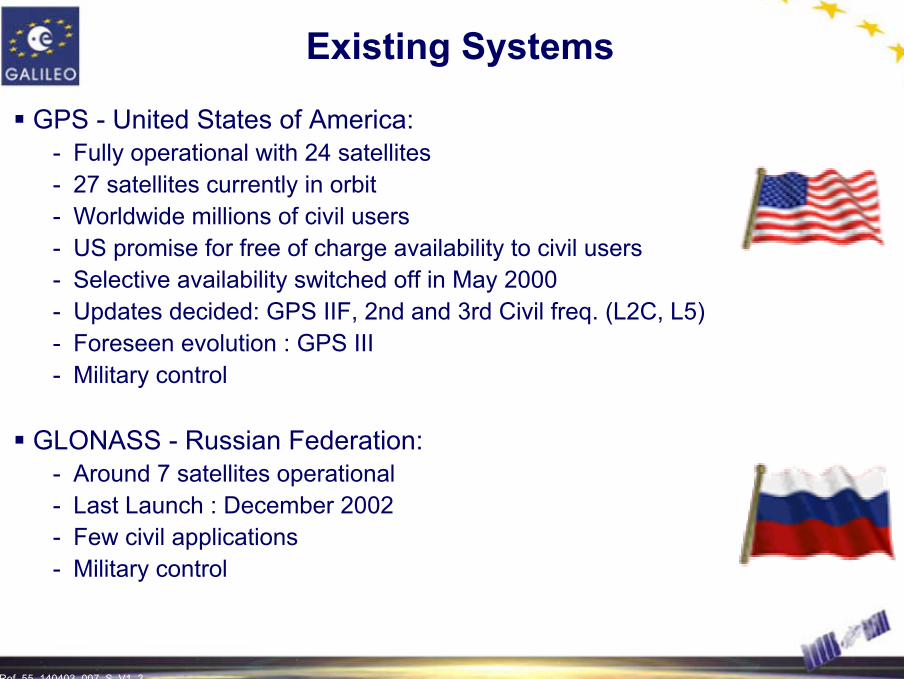
Existing Systems
GPS - United States of America:- Fully operational with 24 satellites- 27 satellites currently in orbit- Worldwide millions of civil users- US promise for free of charge availability to civil users- Selective availability switched off in May 2000- Updates decided: GPS IIF, 2nd and 3rd Civil freq. (L2C, L5)- Foreseen evolution : GPS III- Military control
GLONASS - Russian Federation:- Around 7 satellites operational- Last Launch : December 2002- Few civil applications- Military control

Ref. 55_140403_007_S_V1_4 4
Augmentations to Existing Systems
GPS/GLONASS are augmented by Satellite Based Augmentation Services (SBAS)
- USA : WAAS (Wide Area Augmentation System)
- EUROPE : EGNOS (European Geostationary Navigation Overlay Service)
- JAPAN :
• MSAS (Multifunctional Transport Satellite Augmentation System)
• QZSS (Quasi Zenith Satellite System)
- INDIA : GAGAN
- CHINA : BEIDOU
Ref. 55_140403_007_S_V1_5 5
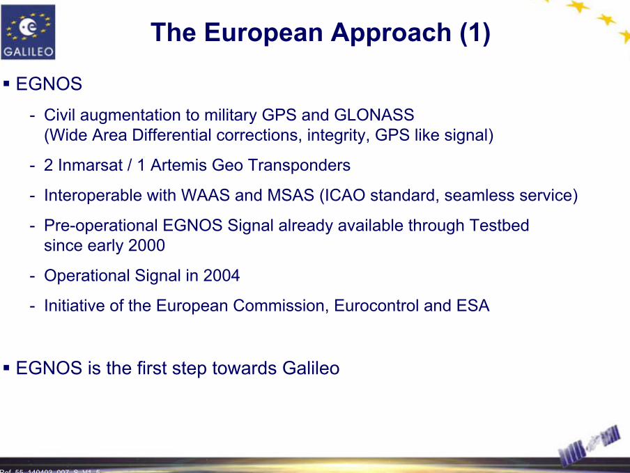
The European Approach (1)
EGNOS - Civil augmentation to military GPS and GLONASS
(Wide Area Differential corrections, integrity, GPS like signal)
- 2 Inmarsat / 1 Artemis Geo Transponders
- Interoperable with WAAS and MSAS (ICAO standard, seamless service)
- Pre-operational EGNOS Signal already available through Testbed since early 2000
- Operational Signal in 2004
- Initiative of the European Commission, Eurocontrol and ESA
EGNOS is the first step towards Galileo

Ref. 55_140403_007_S_V1_6 6
The European Approach (2)
Galileo- Global Navigation Satellite System
- Under Civil Control
- Independent but compatible and interoperablewith GPS and GLONASS
- With service guarantees
- Operational by 2008
- Initiative of the European Commission and ESA

Ref. 55_140403_007_S_V1_7 7
European Motivation
Galileo 4 main arguments
Political
European independence and sovereigntyIndustrial politics
Social
Better and new services for the citizensImproved safety of transport systems
Environmental benefits
Economic
Global market sharesGlobal competitiveness of all segments of the Value Chain
EmploymentEfficiency of transport industry
Technological
Technological lead to European industryExplore synergy of a number of technologies

Ref. 55_140403_007_S_V1_8 8
Galileo Programme Key Features
Market driven, commercially orientedGlobal Positioning, Timing and Search and Rescue servicesWorldwide coverage (including Northern & Southern latitudes)Built-in Global System Integrity Provision for additional Regional Integrity ComponentsSatellite-only services Services
- OS: Open Service - CS: Commercial Service - SoL: Safety of life- PRS: Public Regulated Service- SAR: Search and Rescue
(extension of COSPAS-SARSAT features)

Ref. 55_140403_007_S_V1_9
EUROPEAN ENVIRONMENT
Setting the Scene
Ref. 55_140403_007_S_V1_10 10
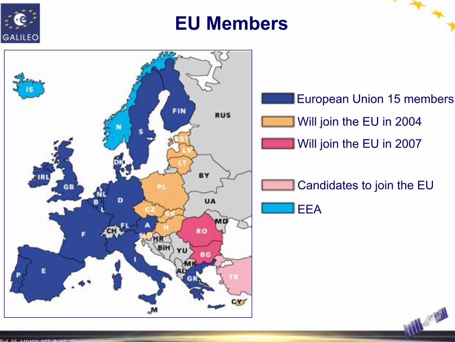
EU Members
European Union 15 members
Will join the EU in 2004
Will join the EU in 2007
Candidates to join the EU
EEA
Ref. 55_140403_007_S_V1_11 11
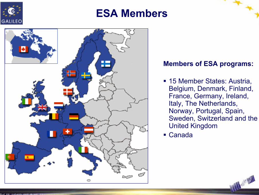
ESA Members
Members of ESA programs:
15 Member States: Austria, Belgium, Denmark, Finland, France, Germany, Ireland, Italy, The Netherlands, Norway, Portugal, Spain, Sweden, Switzerland and the United KingdomCanada
Ref. 55_140403_007_S_V1_12 12
European Organisations
European Parliament and European Council
European Parliament
- Approval of annual budgets
- Consultative role (hardly comparable to national parliaments)
- Steadily increasing importance
European Council (Heads of State; Ministers)
- Legislative role
- Presidency changes every 6 months
- Interface between Member States and Commission
Ref. 55_140403_007_S_V1_13 13
European Organisations
European Commission
European Commission (EC)- Executive role- Makes proposals to EU Council(s)
“ La Commission propose, les Etats Membres disposent ”- EC has “its” own budget; Member States decide only on priorities
within given budget lines- Main Directorates General (DG) involved in Galileo:
• DG TREN (Energy and Transport)• DG INFSO (Information Society) • DG Research• DG RELEX (External Relations)
EC is a Supra National BodyEC is a Supra National Body
Ref. 55_140403_007_S_V1_14 14
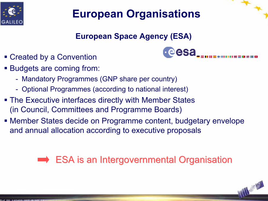
European Space Agency (ESA)
Created by a ConventionBudgets are coming from:
- Mandatory Programmes (GNP share per country) - Optional Programmes (according to national interest)
The Executive interfaces directly with Member States (in Council, Committees and Programme Boards)Member States decide on Programme content, budgetary envelope and annual allocation according to executive proposals
European Organisations
ESA is an Intergovernmental OrganisationESA is an Intergovernmental Organisation
Ref. 55_140403_007_S_V1_15 15
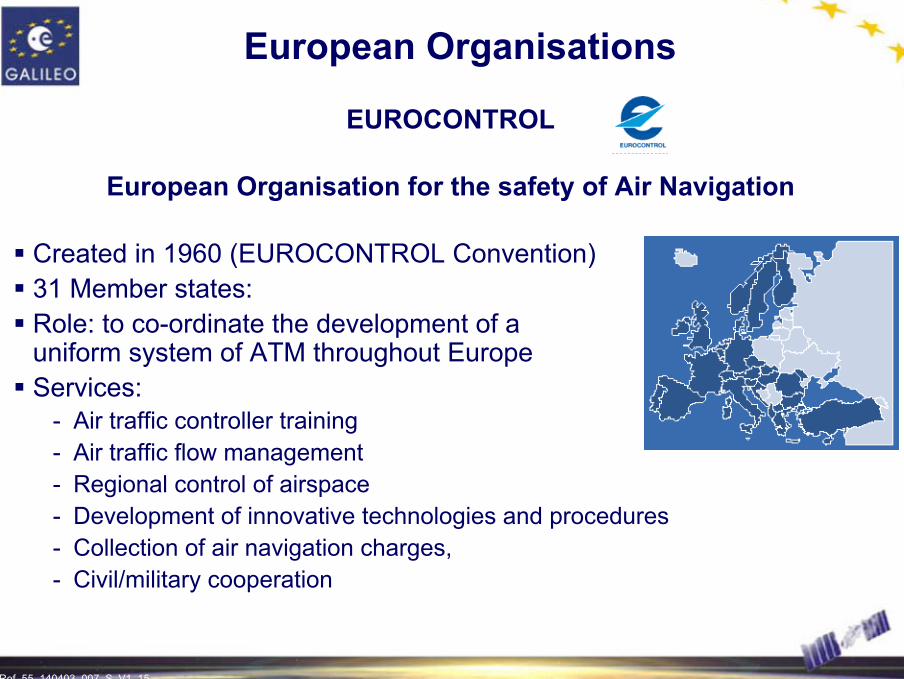
European Organisations
EUROCONTROL
European Organisation for the safety of Air Navigation
Created in 1960 (EUROCONTROL Convention)31 Member states:Role: to co-ordinate the development of a uniform system of ATM throughout EuropeServices:
- Air traffic controller training - Air traffic flow management - Regional control of airspace - Development of innovative technologies and procedures- Collection of air navigation charges, - Civil/military cooperation

Ref. 55_140403_007_S_V1_16 16
Private Sector
Private sector is key for - commercial orientation (secure revenues)- efficient management- financing
Public Private Partnership (PPP) should be based on a concessionstructure with a clear legal relationship between the public sector and a private sector company formed to deploy and operate the systemSteps:
- The Joint Undertaking for the development phase- The concession for the subsequent phases
Grouping of industries already started
…
Ref. 55_140403_007_S_V1_17 17
Galileo Interim Support Structure
Overall Presentation
It is a structure working under a support contract of EC, and is locatedin BrusselsThe main tasks of this structure are to provide support to:
- the definition of the infrastructure, services, mission requirements - the assessment and proposals for the private sector participation in the
programme- standardisation- the integration and promotion of EGNOS (European Geostationary Navigation
Overlay Service) - the consolidation and maintenance of the overall Galileo Programme
work-plan, elaborated jointly by the Commission and ESA The GISS is followed by the Joint Undertaking
Ref. 55_140403_007_S_V1_18 18
Joint Undertaking
Mission - Management and financing of the development and validation phases- Selection of the Concessionaire for the preparation of the next phases :
• Full deployment • Operations and exploitation
- Support the local elements and users receiver/applications development- Help to mobilise funding for next phase
Legal Status- Joint Undertaking acc. to article 171 of the EU Treaty- Legal Personality
Members- Founding members: EC, ESA- Possible future members:
• European Investment Bank• Private Companies
(after concession awarding to avoid conflict of interest)• Third Countries

Ref. 55_140403_007_S_V1_19 19
Joint Undertaking
Single effective management body for Galileo combining public and private fundingDecision Making Process
- Board decisions taken by simple majority- ESA and EC each 40% of voting rights
Structure
Set up: 2002-2005Seat: Brussels
JOINT UNDERTAKING JOINT UNDERTAKING ORGANSORGANS
Administrative Board
DirectorExecutive Committee

Ref. 55_140403_007_S_V1_20 20
Joint Undertaking
Galileo Management (from end 2003 to 2005)
ADMINISTRATIVE BOARD
GALILEO JOINT UNDERTAKING
Executive Committee Director
Infrastructure(Ground/ Space)
Application Development
Concession Preparation
FOUNDING MEMBERS POSSIBLE FUTURE MEMBERS
European Investment Bank
Private Companies
Third CountriesEuropean Community
European Space Agency
ESA/JU agreement

Ref. 55_140403_007_S_V1_21
GALILEO COSTS AND REVENUES
A Solid Basis for a Public Private Partnership

Ref. 55_140403_007_S_V1_22 22
Royalties ServiceRevenues
CHIP MANUFACTURERS PRODUCTS SERVICE
PROVIDERS
PRIVATE CUSTOMERS
GALILEO OPERATING COMPANY
Chip
Price
Product
Price
Service Charge
ROYALTIES ON CHIPSET SALES
SERVICE REVENUES VIA SERVICE PROVIDERS
Source: PWC Final Report 2003
Potential Revenue Scheme
Ref. 55_140403_007_S_V1_23 23
050
100150200250300350400450500550600
2000
2002
2004
2006
2008
2010
2012
2014
2016
2018
2020
2022
2024
2026
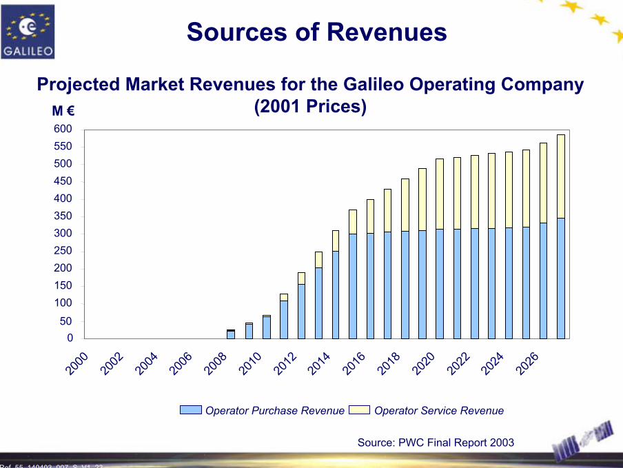
M €
Operator Purchase Revenue Operator Service Revenue
Source: PWC Final Report 2003
Sources of Revenues
Projected Market Revenues for the Galileo Operating Company (2001 Prices)
Ref. 55_140403_007_S_V1_24 24
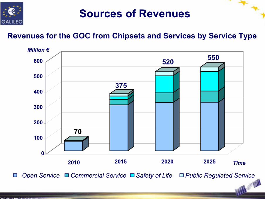
Sources of Revenues
Revenues for the GOC from Chipsets and Services by Service Type
Open Service Commercial Service Safety of Life Public Regulated Service
70
375
520 550
100
200
300
400
500
600
Million €
2010 2015 2020 20250
100
200
300
400
500
600
Time

Ref. 55_140403_007_S_V1_25 25
Social Benefits
Source: PWC Final Report November 2001
NPV (Net Present
Value)
Annual Values (M€ at 2000
prices)Description of benefits
2008-202020202010Years
7,4763,381166Improvements in air traffic
control cost savings for airlines
17,787
4,864
5,447
7,686
2,638
1,667
329
81
82
TOTAL
Marine Navigation
Time Savings for passengers
Ref. 55_140403_007_S_V1_26 26
PPP Mechanisms
Calendar
2008200720062005200420032002
Development Phase
Deployment Phase
Operation
EoI
Initial bid phase
Business PlanDevelopment
Concession
Conceding authority
Joint undertaking
10 weeks
14 weeks
35 weeks
Ref. 55_140403_007_S_V1_27
GALILEO HISTORICAL BACKGROUND
Milestones and Phases

Ref. 55_140403_007_S_V1_28 28
The Decision Process Towards Galileo
1994 - 1999
EGNOS offer (ESA, Commission, Eurocontrol) to InmarsatAutumn 1994:
ESA Member States approve EGNOS ProgrammeOct. 1998:
EU Transport council endorses Galileo Resolution17 June 1999:
ESA Ministerial Council approves GalileoSat Programme12 May 1999:
GNSS-2 Forum discusses technical, legal and institutional aspects
2nd half 1998:
Council of Transport Ministers requests elaboration of European Position on GNSS
March 1998:

Ref. 55_140403_007_S_V1_29 29
The Decision Process Towards Galileo
2000 - 2002
EC Council release of 100 M€ to start the development phase
5 April 2001:
Start of ESA Phase B2Mid 2001:
Decision of EU Transport Council to start next phase(450 M€) and to create the Joint Undertaking (published 21 May 2002)
26 March 2002:
European Summit provides positive signal and intends for decision in March 2002
14/15 Dec. 2001:
EC Council refers decision on phase C/D to European Summit
7 Dec. 2001:
Approval by ESA Ministerial Council of phase C/D budget (550 M€)
15 Nov. 2001:
Ref. 55_140403_007_S_V1_30 30
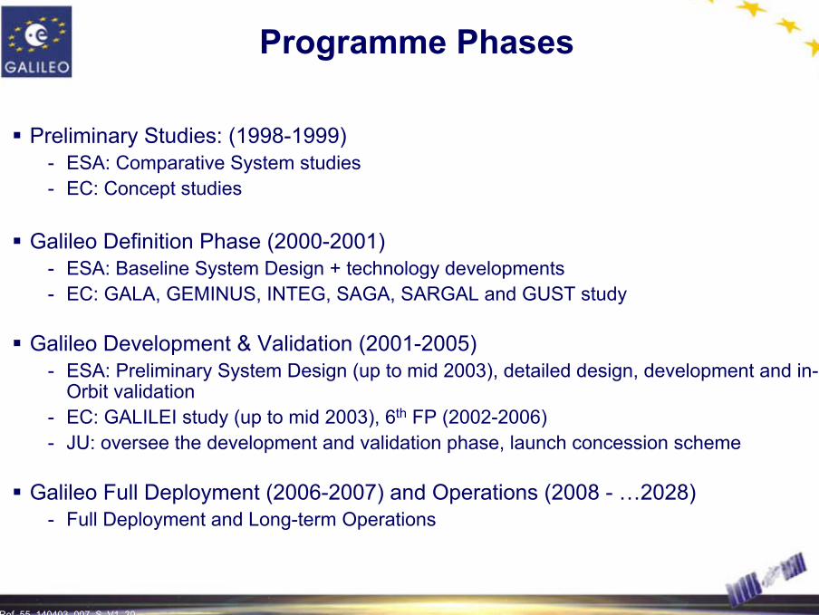
Programme Phases
Preliminary Studies: (1998-1999)- ESA: Comparative System studies- EC: Concept studies
Galileo Definition Phase (2000-2001)- ESA: Baseline System Design + technology developments- EC: GALA, GEMINUS, INTEG, SAGA, SARGAL and GUST study
Galileo Development & Validation (2001-2005)- ESA: Preliminary System Design (up to mid 2003), detailed design, development and in-
Orbit validation- EC: GALILEI study (up to mid 2003), 6th FP (2002-2006)- JU: oversee the development and validation phase, launch concession scheme
Galileo Full Deployment (2006-2007) and Operations (2008 - …2028)- Full Deployment and Long-term Operations
Ref. 55_140403_007_S_V1_31 31
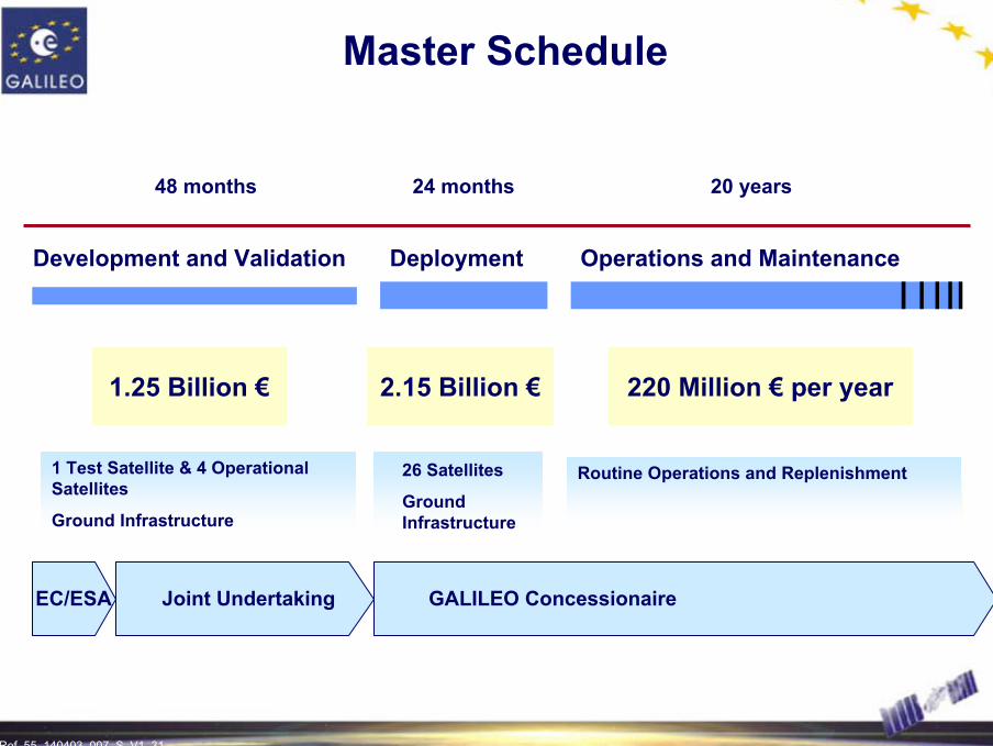
Master Schedule
Development and Validation Deployment Operations and Maintenance
1.25 Billion € 220 Million € per year
1 Test Satellite & 4 Operational Satellites
Ground Infrastructure
2.15 Billion €
26 Satellites
Ground Infrastructure
Joint Undertaking GALILEO ConcessionaireEC/ESA
Routine Operations and Replenishment
48 months 24 months 20 years

Ref. 55_140403_007_S_V1_32
GALILEO SERVICES DEFINITION
A Design Based on Civil Users Needs

Ref. 55_140403_007_S_V1_33 33
The Galileo Services
Galileo Satellite-only services (provided by Galileo Signal-In-Space only)- Open Service (OS) - Commercial Service (CS)- Safety of Life Service (SoL)- Public Regulated Service (PRS)- Support to the Search and Rescue Service (SAR)
Galileo locally assisted services- Galileo SIS plus local additions for improvements of performances
EGNOS services - Wide area differential corrections- Integrity messages- GPS-like ranging signals
Galileo combined Services- Galileo + other satellite navigation system (SBAS, GPS, GLONASS,...)- Galileo + other non-satellite navigation systems (LORAN C, mobile systems,…)- Galileo + communications systems (GSM, GPRS, UMTS,…)

Ref. 55_140403_007_S_V1_34 34
Galileo Satellite-only Services (1/2)
Open service- Mass market applications- Competitiveness with other GNSS open services and their evolutions- Interoperability with other GNSS systems (dual receivers)- Free of charge
Safety of life- ICAO and IMO regulations- Service guarantees- Certification-liability
Commercial service- Added value services (higher accuracy, data broadcast, authentication)
with respect to the open service- Service guarantees- Interface with Service Providers

Ref. 55_140403_007_S_V1_35 35
Galileo Satellite-only Services (2/2)
Public Regulated Service- Public applications (police, civil protection, emergency services,…)- Critical and strategic applications (energy, telecommunications,…)- Continuity and robustness- Controlled access and service denial through encryption
Support to the international Search and Rescue effort- Compatible with international SAR: COSPAS-SARSAT- Improvement of accuracy of locations of distress beacons- Near real time detection- Return link for acknowledgement message from SAR operators to distress
emitting beacons, to improve SAR operations efficiency

Ref. 55_140403_007_S_V1_36 36
Services Coverage and Availability
Global coverage is required for the satellite-only services and for the integrity function
Global coverage comprises the whole Earth surface (including Northern and Southern latitudes)
Unobstructed visibility down to a masking angle of 10 deg. over horizon
Availability shall be better than 99.8% over life-time for standard services, and better than 99.9% over life-time for the Safety of Life services

Ref. 55_140403_007_S_V1_37 37
Open Service
Performances (positioning)
GlobalCoverage
Dual FrequencySingle FrequencyCarriers
Based on dual-frequency measurements
Based on simple model
Ionospheric correction
Not Applicable
Integrity risk
Integrity
Availability
Time-To-Alarm
99.8 %
Alarm Limit
H: 4 mV: 8 m
H: 15 mV: 35 m Accuracy (95%)

Ref. 55_140403_007_S_V1_38 38
Open Service
Performances (timing)
99.8%Availability30 n sec.Timing Accuracy wrt UTC/TAIGlobalCoverage
Three FrequenciesCarriers

Ref. 55_140403_007_S_V1_39 39
Open ServiceSignal Mapping to Service
Provision of Navigation and Timing FunctionsBased on Freely Accessible Signals and/or Data
10 McpsData 50 sps
Pilot Channel
E5b L1
10 McpsData 250 spsPilot Channel
BOC(2,2)Data 250 spsPilot Channel
E5a
Ref. 55_140403_007_S_V1_40 40
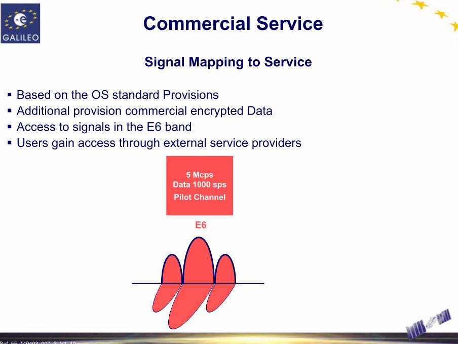
Commercial Service
Signal Mapping to Service
Based on the OS standard ProvisionsAdditional provision commercial encrypted Data Access to signals in the E6 bandUsers gain access through external service providers
5 McpsData 1000 spsPilot Channel
E6

Ref. 55_140403_007_S_V1_41 41
Safety of Life Service
Performance
3 service levels for integrity have been defined:
Level A- operations with horizontal and/or vertical guidance, with short exposure time,
and with stringent dynamic conditions (aviation, some rail and road applications)
Level B- aviation operations in the range from en-route to Non Precision Approaches
Level C- maritime operations (ocean/costal navigation, port approach, restricted waters
and inland waterways)
Ref. 55_140403_007_S_V1_42 42
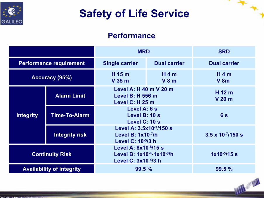
Safety of Life Service
Performance
SRDMRD
H 4 mV 8 m
Dual carrier
99.5 %
1x10⁻⁵/15 s
3.5 x 10⁻⁷/150 s
6 s
H 12 mV 20 m
H 4 mV 8m
Dual carrier
99.5 %
Level A: 8x10⁻⁶/15 s Level B: 1x10⁻⁴-1x10⁻⁸/hLevel C: 3x10⁻⁴/3 h
Level A: 3.5x10⁻⁷/150 s Level B: 1x10⁻⁷/hLevel C: 10-5/3 h
Level A: 6 sLevel B: 10 sLevel C: 10 s
Level A: H 40 m V 20 mLevel B: H 556 mLevel C: H 25 m
H 15 mV 35 m
Single carrierPerformance requirement
Availability of integrity
Continuity Risk
Integrity risk
Time-To-Alarm
Alarm Limit
Integrity
Accuracy (95%)

Ref. 55_140403_007_S_V1_43 43
Safety of Life Service
Signal Mapping to Service
Based on the OS standard ProvisionsAdditional Integrity DataAdditional Signal-in-Space Accuracy (SISA) information
E5a
10 McpsData 50 sps
Pilot Channel
IntegrityData SISA10 Mcps
Data 250 spsPilot Channel
E5b
BOC(2,2)Data 250 spsPilot Channel
L1
Ref. 55_140403_007_S_V1_44 44
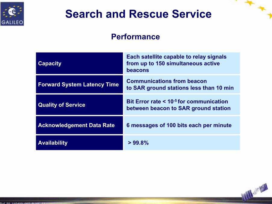
> 99.8%Availability
6 messages of 100 bits each per minuteAcknowledgement Data Rate
Bit Error rate < 10-5 for communication between beacon to SAR ground stationQuality of Service
Communications from beacon to SAR ground stations less than 10 minForward System Latency Time
Each satellite capable to relay signals from up to 150 simultaneous active beacons
Capacity
Search and Rescue Service
Performance

Ref. 55_140403_007_S_V1_45 45
Public Regulated Service
Performance
Dual-FrequencyCarriers
Based on dual-frequency measurementsIonospheric correction
99.5 %Availability
100 nsecTiming Accuracy w.r.t. UTC/TAI
10-5/15 sContinuity Risk
Integrity risk
Time-To-Alarm
H:20-V:3510 s
3.5 x10⁻⁷/150 sec(Under evaluation)
Alarm Limit
Integrity
H: 6.5 mV: 12 mAccuracy (95%)
GlobalCoverage
Ref. 55_140403_007_S_V1_46 46
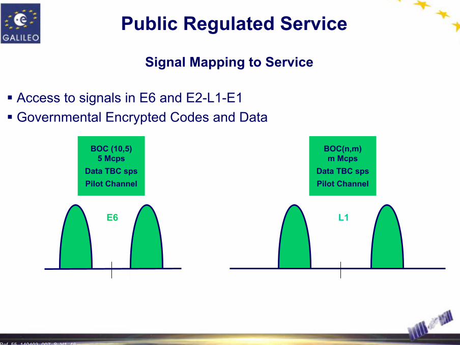
Public Regulated Service
Signal Mapping to Service
Access to signals in E6 and E2-L1-E1Governmental Encrypted Codes and Data
BOC(n,m)m Mcps
Data TBC spsPilot Channel
BOC (10,5)5 Mcps
Data TBC spsPilot Channel
E6 L1
Ref. 55_140403_007_S_V1_47 47
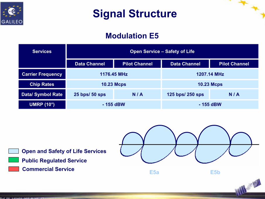
Signal Structure
Modulation E5
1207.14 MHz1176.45 MHzCarrier Frequency
N / A
Pilot Channel
- 155 dBW
25 bps/ 50 sps
10.23 Mcps
Data Channel
Open Service – Safety of Life
N / A
Pilot Channel
- 155 dBW
125 bps/ 250 sps
10.23 Mcps
Data Channel
UMRP (10°)
Data/ Symbol Rate
Chip Rates
Services
E5a E5b
Open and Safety of Life Services
Commercial ServicePublic Regulated Service
Ref. 55_140403_007_S_V1_48 48
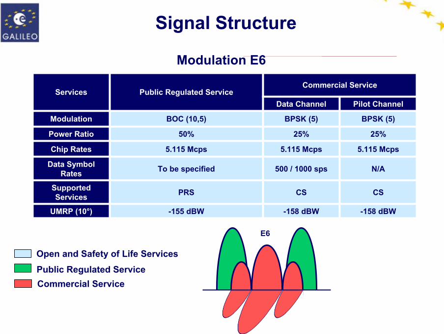
Signal Structure
Modulation E6
-158 dBW
CS
N/A
5.115 Mcps
25%
BPSK (5)
Pilot Channel
-158 dBW
CS
500 / 1000 sps
5.115 Mcps
25%
BPSK (5)
Data Channel
Commercial Service
-155 dBWUMRP (10°)
BOC (10,5)Modulation
PRS
To be specified
5.115 Mcps
50%
Public Regulated Service
Supported Services
Data Symbol Rates
Chip Rates
Power Ratio
Services
Open and Safety of Life Services
Commercial ServicePublic Regulated Service
E6
Ref. 55_140403_007_S_V1_49 49
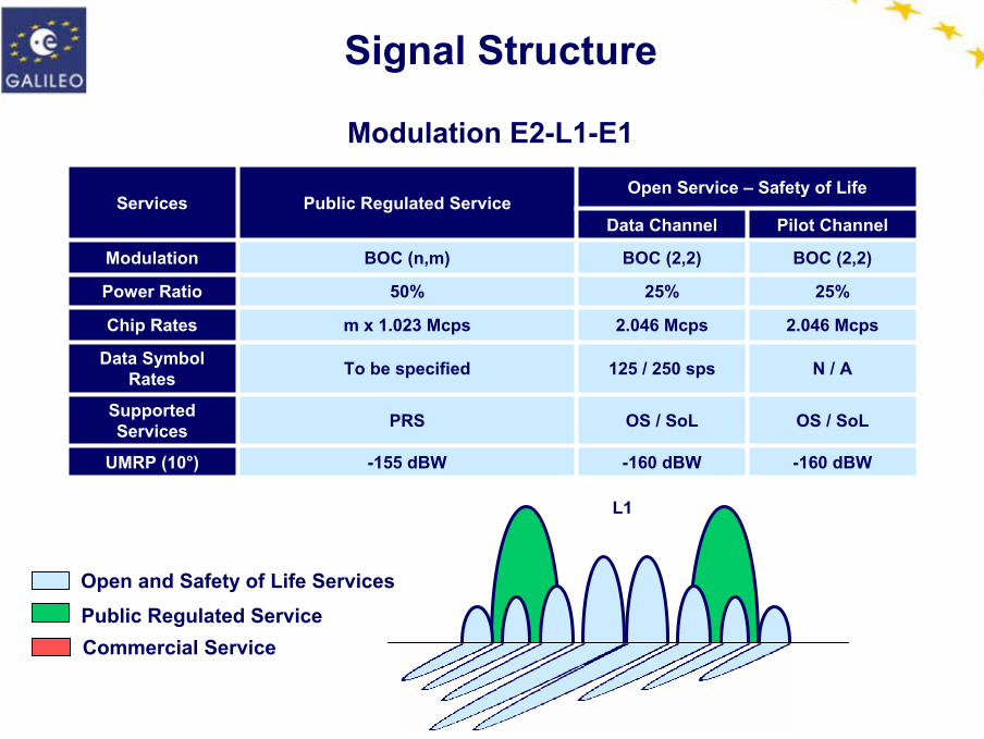
Signal Structure
Modulation E2-L1-E1
-160 dBW
OS / SoL
N / A
2.046 Mcps
25%
BOC (2,2)
Pilot Channel
-160 dBW
OS / SoL
125 / 250 sps
2.046 Mcps
25%
BOC (2,2)
Data Channel
Open Service – Safety of Life
-155 dBWUMRP (10°)
BOC (n,m)Modulation
PRS
To be specified
m x 1.023 Mcps
50%
Public Regulated Service
Supported Services
Data Symbol Rates
Chip Rates
Power Ratio
Services
Open and Safety of Life Services
Commercial ServicePublic Regulated Service
L1

Ref. 55_140403_007_S_V1_50
GALILEO ARCHITECTURE
Offering a Global Seamless Coverage

Ref. 55_140403_007_S_V1_51 51
Galileo Architecture
GALILEO Data Links
GALILEO Sensor Station
GALILEO Communication Network
x 29
GALILEO Control Center x 2
GALILEO Assets Control Facility
Integrity Processing
Facility
x 5Uplink StationTT&C - S-Band ULS – C-Band C-Band
Mission Uplink Station x 5
Mission Management
Office
EGNOS
z
yx
GALILEO Satellite Constellation
Walker (27/3/1) + 3 active spares
Precision Timing Facility
Orbit Sync.and Timing
Facility
Service Products Facility
Satellite Control Facility
Mission Control Facility
Space Segment
User segment
Ground segment
Signal-in-Space
Delta Integrity Process Facility
Search &
Rescue Center
UniversalTime
Coordinated
GALILEO Communication Network
x 5
Ref. 55_140403_007_S_V1_52 52
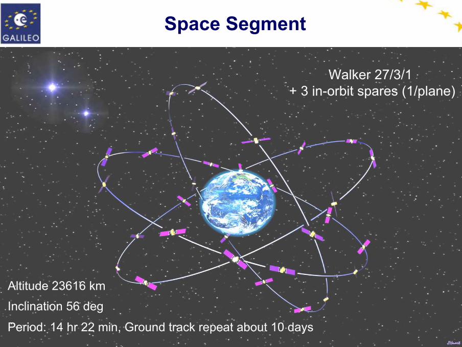
Walker 27/3/1 + 3 in-orbit spares (1/plane)
Inclination 56 deg
Altitude 23616 km
Period: 14 hr 22 min, Ground track repeat about 10 days
Space Segment

Ref. 55_140403_007_S_V1_53 53
Overall Spacecraft: 680 Kg / 1.6 kW class
Launcher Options: Ariane, Proton, Soyuz
Dimensions:2.7 x 1.2 x 1.1 m3
Galileo Satellite
• No apogee motor• AOCS is capable to shift
the orbit position of the S/C (spare S/C)
Ref. 55_140403_007_S_V1_54 54
Galileo Payload
C-bandRX
Timing Sub-System
NavigationSignal
Generator
L-bandTX/RX
Navigation & SARS-bandTC/TM
SARUHFRX
E5
E6
L1
Ref. 55_140403_007_S_V1_55 55
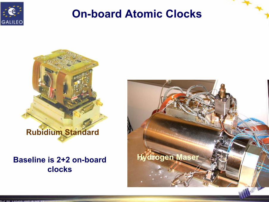
Rubidium Standard
Hydrogen Maser
On-board Atomic Clocks
Baseline is 2+2 on-board clocks

Ref. 55_140403_007_S_V1_56 56
• Baseline is direct injection into MEO orbit
• Multiple launch capability with A5-ECB (up to 8 S/C) and with Proton (up to 6 S/C)
• Soyuz ST-2003 can launch 2 MEOs into direct orbit
• Combinations of launchers allow all phases to be fulfilled & offer flexibility
Launchers
8 Spacecraftin Ariane 5 fairing
6 Spacecraftin Proton fairing

Ref. 55_140403_007_S_V1_57 57
Ground Segment Description
Generic Description
Galileo Control System
Galileo Mission System
Galileo Control Center
Telemetry, Tracking and Command Station
Galileo Sensor Station
(Mission Data) Uplink Station
GCS
GMS
GCC
TT&C
GSS
ULS
External RegionalIntegrity Systems
ULS10 Sites5 Sites 29 Sites
2 Centers
GSSTT&C
C-BandS-Band L-Band
GCS GMS
SAR Return LinkService Provider
Satellite LaserRanging
Service Centres
Mission ManagementOffice
Time Reference ProviderGeodetic Reference Providers
Space Segment
Leased Satellite Control Facilities
Sat/Payload manufacturers
GCC

Ref. 55_140403_007_S_V1_58 58
Ground Segment Description
Ground Control Segment
Constellation Management& Satellite Control Management & Control
of Ground Assets
L-Band Signal in Space
S-Band TC/TM and Ranging
C-BandMissionUp-Links
Ground Mission SegmentGround Control Segment
Management& Control data
SCF – Satellite Control FacilityGACF – Ground Assets Control FacilityKMF – Key Management FacilityTTC – Telemetry Tracking & Command
Key Management
TTCx5
KMF
GACFSCF

Ref. 55_140403_007_S_V1_59 59
Ground Segment Description
Ground Mission SegmentS-Band TC/ TM
and RangingL-Band Signal in Space
C-BandMissionUp-Links
GSS – Galileo Sensor StationIPF – Integrity Processing FacilityOSPF – Orbit. & SynchronisationProcessing FacilityPTF – Precision Timing FacilityMCF – Mission Control FacilitySPF – Service Product Facility
GSSULSx10 x29
GCSGCS GMSGMS
IPF OSPF
PTFMCFMGF
SPF
GACF
KMF
Ref. 55_140403_007_S_V1_60
GALILEO SUPPORT TO COSPAS / SARSAT SERVICES
Search and Rescue Function

Ref. 55_140403_007_S_V1_61 61
406 MHz
GEO Satellites
Mission Control Center
Local UserTerminal
Rescue Coordination
Center
LEO Satellites
1544 MHz
Rescue Team
MEO Satellites
Emergency beacon
SAR/Galileo Description
Integration of the MEOSAR Component in the International SAR Satellite System
Ref. 55_140403_007_S_V1_62 62
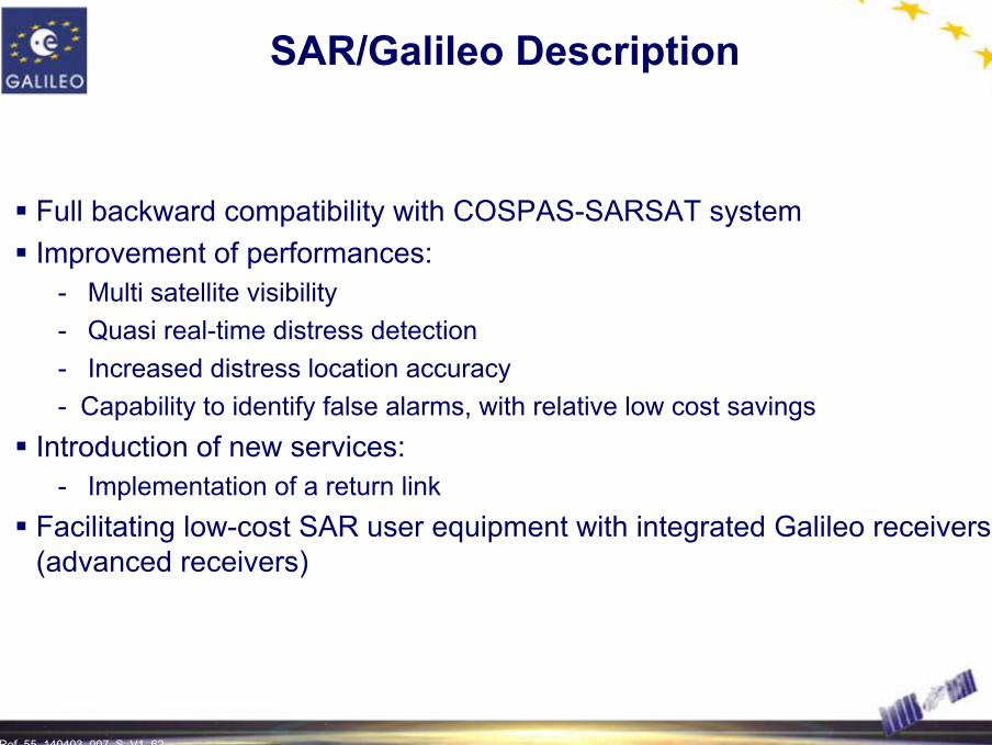
SAR/Galileo Description
Full backward compatibility with COSPAS-SARSAT systemImprovement of performances:
- Multi satellite visibility- Quasi real-time distress detection- Increased distress location accuracy- Capability to identify false alarms, with relative low cost savings
Introduction of new services:- Implementation of a return link
Facilitating low-cost SAR user equipment with integrated Galileo receivers (advanced receivers)
Ref. 55_140403_007_S_V1_63
LOCAL ELEMENTS AND USER SEGMENT
To Meet the Most StringentUser Requirements

Ref. 55_140403_007_S_V1_64 64
Local Element
Potential Performance Enhancement:- Position
• Differential Code• Differential Carrier - TCAR
- Availability• Pseudolite• Assisted Galileo
- Integrity• Time To Alarm (TTA), alarm limit, risk of misdetection
- Communication• Single or bi-directional• Voice, Data or Both
Local element AvailabilityIntegrity
Accuracy
Communications
Ref. 55_140403_007_S_V1_65 65
Local Element
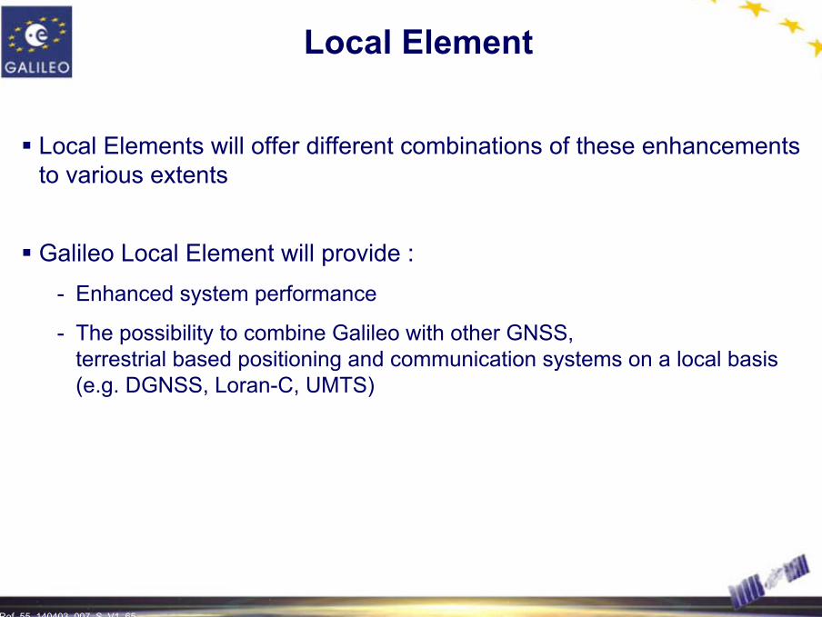
Local Elements will offer different combinations of these enhancements to various extents
Galileo Local Element will provide :- Enhanced system performance
- The possibility to combine Galileo with other GNSS, terrestrial based positioning and communication systems on a local basis (e.g. DGNSS, Loran-C, UMTS)
Ref. 55_140403_007_S_V1_66 66
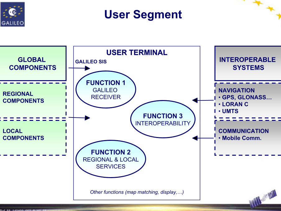
User Segment
USER TERMINALUSER TERMINALINTEROPERABLE
SYSTEMS
NAVIGATION• GPS, GLONASS…• LORAN C• UMTS
COMMUNICATION• Mobile Comm.
FUNCTION 1GALILEO
RECEIVER
FUNCTION 3INTEROPERABILITY
FUNCTION 2REGIONAL & LOCAL
SERVICES
Other functions (map matching, display,…)
GLOBAL COMPONENTS
REGIONAL COMPONENTS
LOCAL COMPONENTS
GALILEO SIS

Ref. 55_140403_007_S_V1_67
EARLY GALILEO SERVICE DEMONSTRATION
Galileo System Test Bed
Ref. 55_140403_007_S_V1_68 68
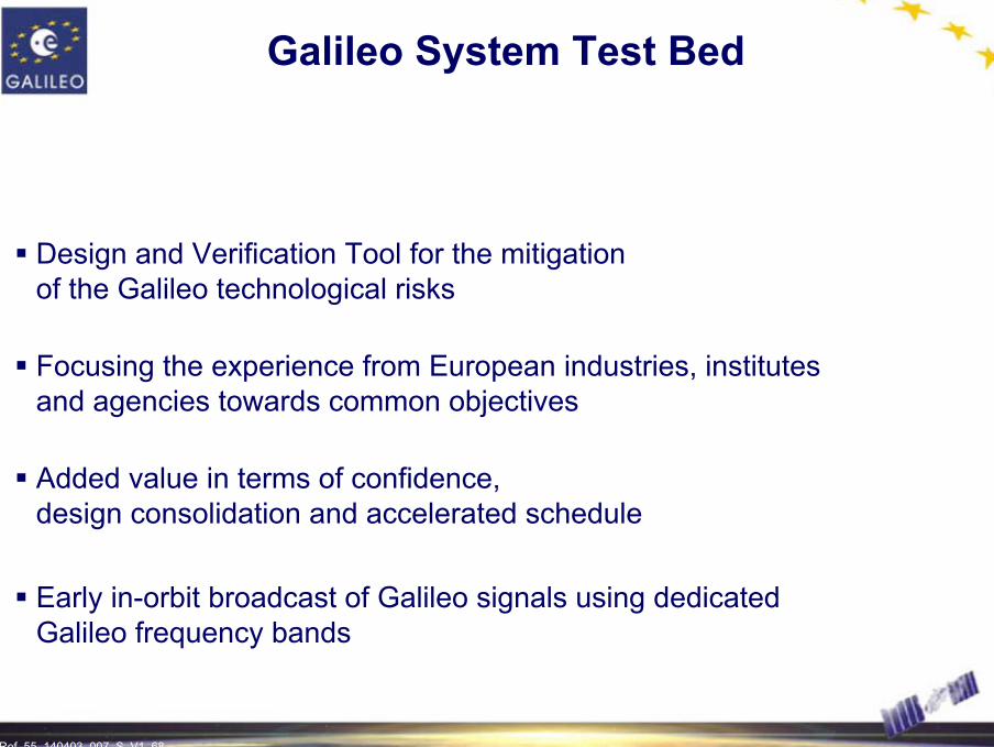
Galileo System Test Bed
Design and Verification Tool for the mitigation of the Galileo technological risks
Focusing the experience from European industries, institutes and agencies towards common objectives
Added value in terms of confidence, design consolidation and accelerated schedule
Early in-orbit broadcast of Galileo signals using dedicated Galileo frequency bands

Ref. 55_140403_007_S_V1_69 69
UTC(k)
UTC(k) clocks
Experim.receiver
GPSConstellation GEO
OD&TS Processing
GSTBProcessingCentre
ExperimentalPTSData Collection
FormattingArchiveMonitoring & Cntrl
Experim.receiver
Experim.receiver
Rubidium clock
Experim.receiver
SensorStations
Internet ftp transfer
IntegrityProcessing
Two-waytime transfer
ExistingSensor StationsNetwork
Core Products DeliveryStation1 Stationn...
...
GSTB V1 Architecture

Ref. 55_140403_007_S_V1_70 70
OD&TS Processing
GSTB Processing Centre
Data CollectionFormattingArchiveMonitoring & Cntrl
Integrity Processing
ExperimentalPTS
EXP. P/L Command &Control
EXP. P/L Verification
Galileo EXP SVSat. Control Facility
...
Real-Tim
e Com
ms. N
etwork
GPS L1/L2
S-Band TT&C,non-real time navigation messagesGSTB-V2
SIS
Galileo Experimental Satellite
GSTB V2 Architecture
Experim.receiver
Experim.receiver
CLOCK
GPS/GSTB V2 receiver Sensor
Stations
Experim.receiver
Experim.receiver
CLOCK
GPS/GSTB V2 receiver Sensor
Stations

Ref. 55_140403_007_S_V1_71 71
1st Galileo Signal in Space in 2005
GSTB V2 Schedule
2003 2004 2005 2006
E2-L1-E1
Contingency
E5-E6Launchcampaign
Satellite phase C/D
06/0509/05
06/06 12/06
24 months
Ref. 55_140403_007_S_V1_72
SIMULATION AND VALIDATION OF GALILEO PERFORMANCES
Galileo System Simulation Facility
Ref. 55_140403_007_S_V1_73 73
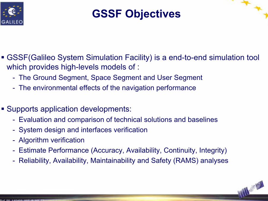
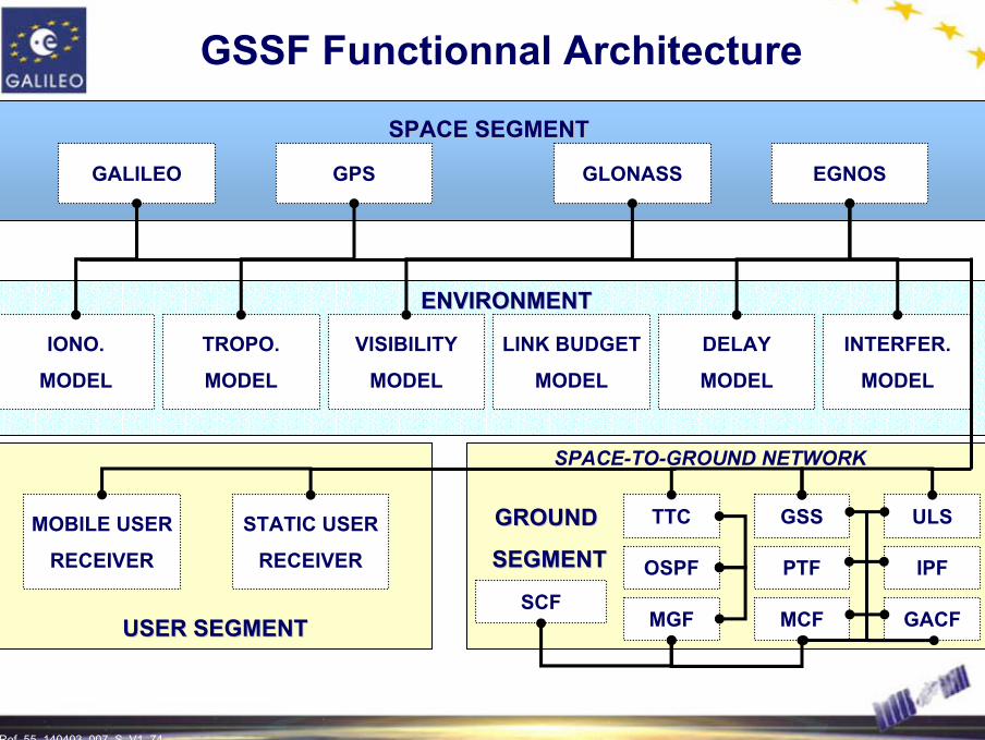
GSSF Objectives
GSSF(Galileo System Simulation Facility) is a end-to-end simulation tool which provides high-levels models of :
- The Ground Segment, Space Segment and User Segment- The environmental effects of the navigation performance
Supports application developments:- Evaluation and comparison of technical solutions and baselines- System design and interfaces verification- Algorithm verification- Estimate Performance (Accuracy, Availability, Continuity, Integrity)- Reliability, Availability, Maintainability and Safety (RAMS) analyses
Ref. 55_140403_007_S_V1_74 74
GALILEO
SPACE SEGMENTSPACE SEGMENT
GPS GLONASS EGNOS
ENVIRONMENTENVIRONMENT
IONO.
MODEL
TROPO.
MODEL
VISIBILITY
MODEL
LINK BUDGET
MODEL
DELAY
MODEL
INTERFER.
MODEL
GROUND GROUND
SEGMENTSEGMENT
SPACE-TO-GROUND NETWORK
SCFMGF MCF GACF
OSPF PTF IPF
TTC GSS ULS
USER SEGMENTUSER SEGMENT
STATIC USER
RECEIVER
MOBILE USER
RECEIVER
GSSF Functionnal Architecture

Ref. 55_140403_007_S_V1_75 75
Simulation Results
Mean horizontal positioning accuracy (95%) achieved through the GPS constellation alone (in meters)
Results include atmospheric and local effects, the ranging performance of modernized GPS was assumed to be equal to Galileo.
Ref. 55_140403_007_S_V1_76 76
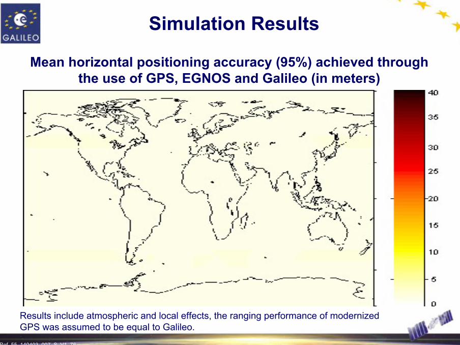
Simulation Results
Mean horizontal positioning accuracy (95%) achieved through the use of GPS, EGNOS and Galileo (in meters)
Results include atmospheric and local effects, the ranging performance of modernized GPS was assumed to be equal to Galileo.
Ref. 55_140403_007_S_V1_77 77
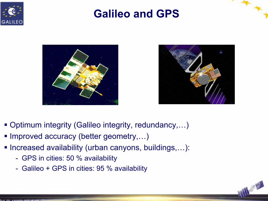
Optimum integrity (Galileo integrity, redundancy,…)Improved accuracy (better geometry,…)Increased availability (urban canyons, buildings,…):
- GPS in cities: 50 % availability- Galileo + GPS in cities: 95 % availability
Galileo and GPS

Ref. 55_140403_007_S_V1_78 78
Interference with GPS
Max C/No GPS degradation in dB due to inter-system interference from a Galileo BOC(2,2) on L1
Max C/No GPS degradation is below 0.2 dB
Ref. 55_140403_007_S_V1_79
A USER DRIVEN DESIGN APPROACH
Galileo Applications
Ref. 55_140403_007_S_V1_80 80
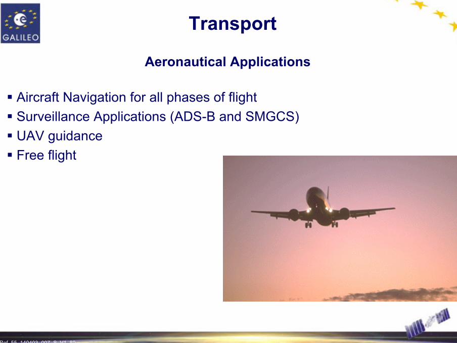
Transport
Aeronautical Applications
Aircraft Navigation for all phases of flightSurveillance Applications (ADS-B and SMGCS)UAV guidanceFree flight

Ref. 55_140403_007_S_V1_81 81
Transport
Road Applications
Route Guidance (including real-time traffic information)Emergency and Breakdown Assistance ServicesAutomatic Driver AssistanceFleet ManagementStolen Vehicle RecoveryTraffic Information in Public Transport

Ref. 55_140403_007_S_V1_82 82
Transport
Maritime Applications
Maritime NavigationFishingPrecision harbour approach and dockingSurvey and inspectionDredging and cable layingMarine constructionEmergency and rescue operationsPositioning of navigation buoysInland waterways navigation

Ref. 55_140403_007_S_V1_83 83
Transport
Rail Applications
Signalling and train control: Infrastructure data collection, End of movement authority, Supervision to buffer stops, …Passenger information: Pre-trip information, On-trip informationManagement information systems: Fleet management, Cargo monitoring, Rolling stock maintenance
Ref. 55_140403_007_S_V1_84 84
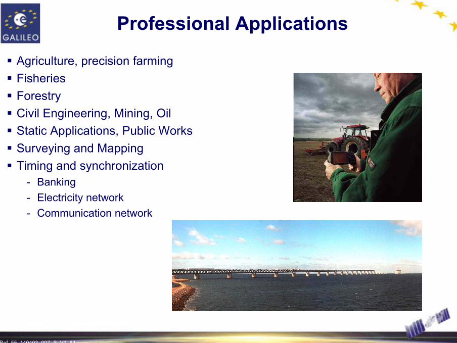
Professional Applications
Agriculture, precision farmingFisheriesForestryCivil Engineering, Mining, OilStatic Applications, Public WorksSurveying and MappingTiming and synchronization
- Banking- Electricity network- Communication network

Ref. 55_140403_007_S_V1_85 85
Scientific Applications
SurveyingGeodesyGeologyMeteorologyVulcanologyMonitoring dam deformations

Ref. 55_140403_007_S_V1_86 86
Location Based Services Applications
Local Information
Navigation Assistance
Emergency Services (E 112)
Commerce
Mobile Call routing/billing
Personal Assistance
Gaming
Ref. 55_140403_007_S_V1_87 87
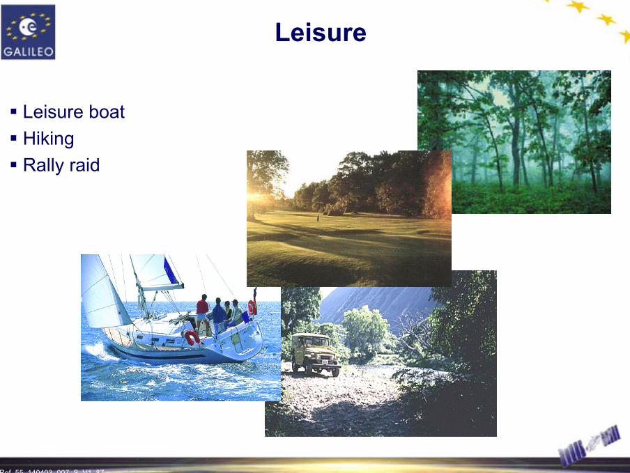
Leisure
Leisure boatHikingRally raid
Ref. 55_140403_007_S_V1_88 88
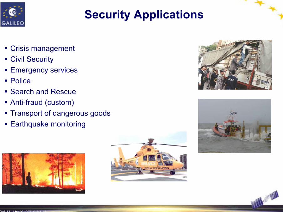
Security Applications
Crisis managementCivil SecurityEmergency servicesPoliceSearch and RescueAnti-fraud (custom)Transport of dangerous goodsEarthquake monitoring

Ref. 55_140403_007_S_V1_89 89
GNSS Applications Oriented Projects
The EC/ESA Joint Effort for GNSS Applications
EC and ESA have launched about 100 projects/studies aimed to assessthe GNSS applications and services from different point of views(more than 60 M€)Other projects and studies will be funded by EC/ESA and Galileo Joint Undertaking in order to prepare and develop the EGNOS and Galileo User Community and corresponding market
Ref. 55_140403_007_S_V1_90 90
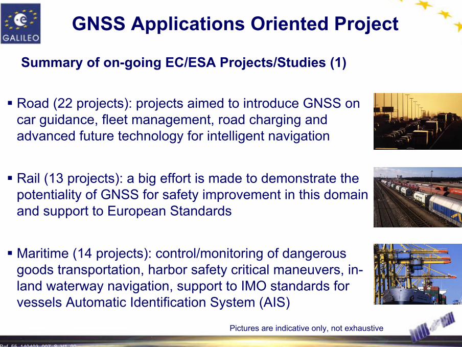
GNSS Applications Oriented Project
Summary of on-going EC/ESA Projects/Studies (1)
Road (22 projects): projects aimed to introduce GNSS on car guidance, fleet management, road charging and advanced future technology for intelligent navigation
Rail (13 projects): a big effort is made to demonstrate the potentiality of GNSS for safety improvement in this domain and support to European Standards
Maritime (14 projects): control/monitoring of dangerous goods transportation, harbor safety critical maneuvers, in-land waterway navigation, support to IMO standards for vessels Automatic Identification System (AIS)
Pictures are indicative only, not exhaustive
Ref. 55_140403_007_S_V1_91 91
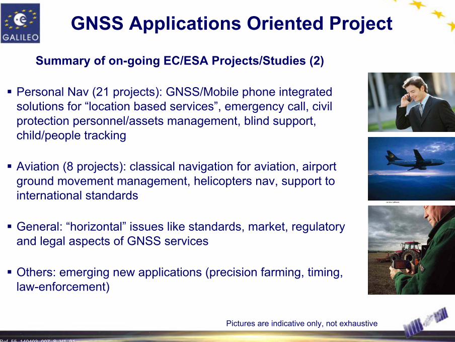
GNSS Applications Oriented Project
Summary of on-going EC/ESA Projects/Studies (2)
Personal Nav (21 projects): GNSS/Mobile phone integrated solutions for “location based services”, emergency call, civil protection personnel/assets management, blind support, child/people tracking
Aviation (8 projects): classical navigation for aviation, airport ground movement management, helicopters nav, support to international standards
General: “horizontal” issues like standards, market, regulatory and legal aspects of GNSS services
Others: emerging new applications (precision farming, timing, law-enforcement)
Pictures are indicative only, not exhaustive
Ref. 55_140403_007_S_V1_92 92
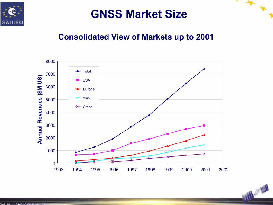
GNSS Market Size
Consolidated View of Markets up to 2001
0
1000
2000
3000
4000
5000
6000
7000
8000
1993 1994 1995 1996 1997 1998 1999 2000 2001 2002
Ann
ualR
even
ues
($M
US)
Total
USA
Europe
Asia
Other

Ref. 55_140403_007_S_V1_93 93
GNSS Market Size
European Market in 1999 per Application
Car Navigation73%
Aviation5%
Fleet Mgt4%
Surveying5%
Augmentation5%
Other3%
Leisure5%
Market Size €1Bn
Source: Cost Benefit Analysis EC November 2000
Ref. 55_140403_007_S_V1_94 94
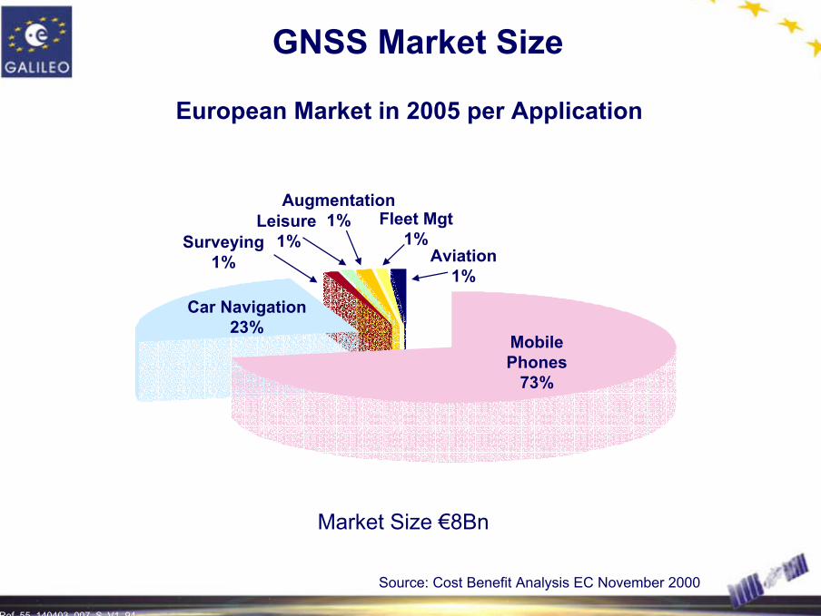
GNSS Market Size
European Market in 2005 per Application
Car Navigation23%
Mobile Phones
73%
Aviation1%
Fleet Mgt1%
Augmentation1%Leisure
1%Surveying1%
Source: Cost Benefit Analysis EC November 2000
Market Size €8Bn
Ref. 55_140403_007_S_V1_95 95
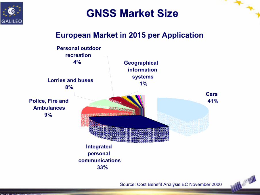
GNSS Market Size
European Market in 2015 per Application
Cars41%
personal Integrated
communications33%
Police, Fire and Ambulances
9%
Lorries and buses8%
recreationPersonal outdoor
4% Geographical
systemsinformation
1%
Source: Cost Benefit Analysis EC November 2000
Ref. 55_140403_007_S_V1_96 96
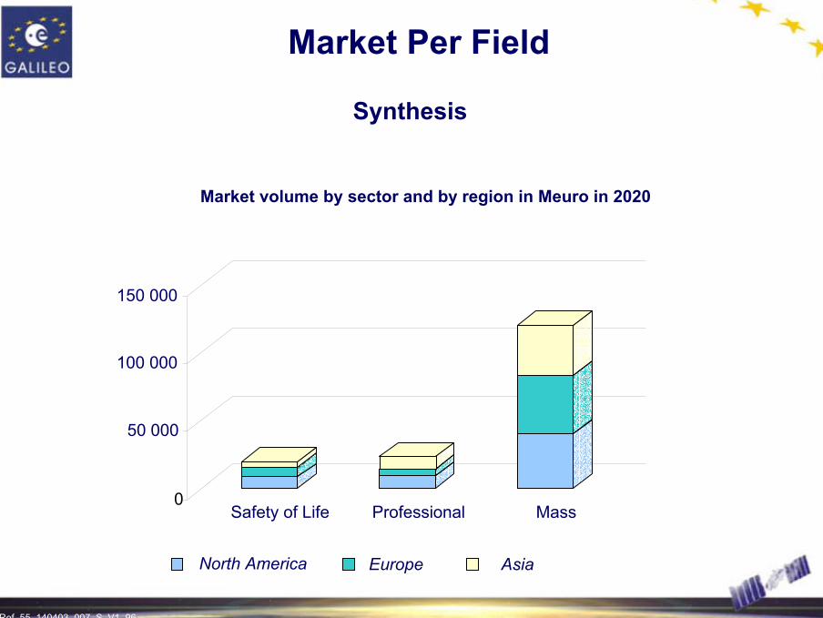
Market Per Field
Synthesis
Market volume by sector and by region in Meuro in 2020
0
50 000
100 000
150 000
Safety of Life Professional Mass
North America Europe Asia
Ref. 55_140403_007_S_V1_97
EGNOSEUROPEAN GEOSTATIONARY
OVERLAY SERVICE
Paving the Way Towards Galileo
Ref. 55_140403_007_S_V1_98 98
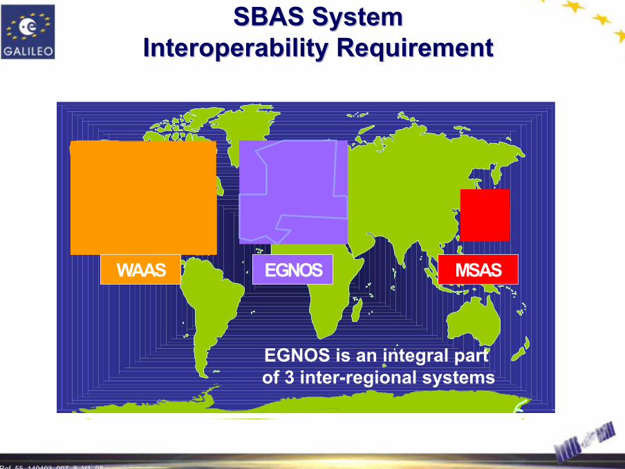
SBAS SystemSBAS SystemInteroperability RequirementInteroperability Requirement
EGNOSWAAS MSAS
EGNOS is an integral part of 3 inter-regional systems
Ref. 55_140403_007_S_V1_99 99
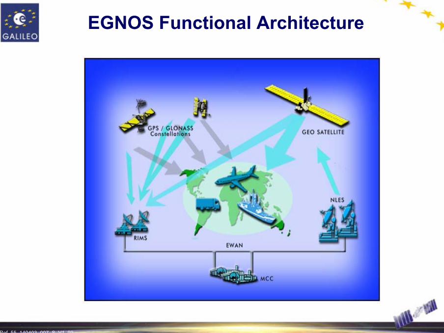
EGNOS Functional Architecture

Ref. 55_140403_007_S_V1_100 100
EGNOS GEO SatellitesEGNOS GEO Satellites
Triple Coverage over Europe and Africa
Ref. 55_140403_007_S_V1_101 101
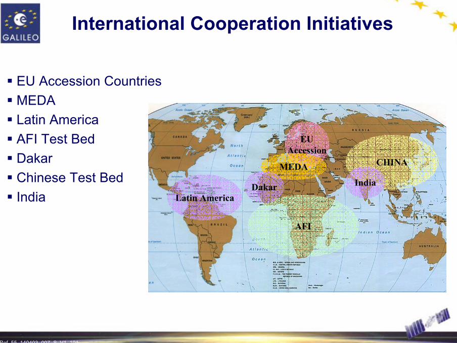
International Cooperation Initiatives
EU Accession CountriesMEDALatin AmericaAFI Test BedDakarChinese Test BedIndia
CHINA
EUAccession
MEDA
Latin America
AFI
Dakar India
Ref. 55_140403_007_S_V1_102 102
-40 -30 -20 -10 0 10 20 30 4020
30
40
50
60
70
Longitude (°)
Latit
ude
(°)
AOR-EIORArtemis
Monitoring Stations
Control Centers
GEO Satellites Access
Technical Centers
LAN
FU
GVLA
LB
HBK (South Africa)
ZRH
LAP
WRS
SCZ
CIAT
OR
AUS
GON
RKK
PAR
KOU (French Guyana)
SGP(Singapore)
TAV
SWA
MON(Canada)
EGI
GLGC
RK
TRO
TRD
ACR
MAL
PDM
GOL
BRN
CNR
SDCLS
B
MAD
SOF
KIR
DJA
DAB
TLS
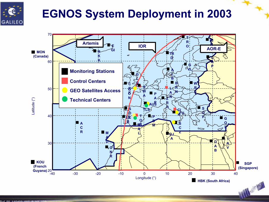
EGNOS System Deployment in 2003

Ref. 55_140403_007_S_V1_103 103
EGNOS Operational Trials
Ref. 55_140403_007_S_V1_104 104
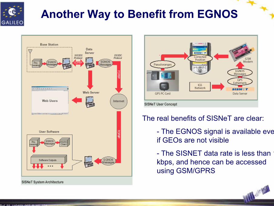
The real benefits of SISNeT are clear:
- The EGNOS signal is available even if GEOs are not visible
- The SISNET data rate is less than 1 kbps, and hence can be accessed using GSM/GPRS
Another Way to Benefit from EGNOS
Ref. 55_140403_007_S_V1_105
GALILEO FREQUENCY ALLOCATIONS
An International Process

Ref. 55_140403_007_S_V1_106 106
RNSS Bands RNSS Bands
ARNS Bands ARNS Bands
SARE5a/L5 E5b E6 L1E2 E1
1164
MHz
1214
MHz
1260
MHz
1300
MHz
1176
.45
MHz
1278
.75
MHz
1544
MHz
1545
MHz
1559
MHz
1587
MHz
1591
MHz
1563
MHz
1575
.42
MHz
1215
MHz
1237
MHz
L2
1207
.140
MHz
GALILEO Bands (Navigation)
GALILEO SAR Downlink
GPS Bands
Frequency Plan
Three Frequency Bands are part of the ARNS allocated bandsE2-L1-E1 and E5a/L5 are common to the GPS frequency bands for interoperability
1189
MHz

Ref. 55_140403_007_S_V1_107 107
RNSS Allocations after WRC2000
L2 G2 L1 G1
L2 Band L1 Band
1215 MH
z
1260 MH
z
1559 MH
z
1610 MH
z
1164 MH
z
E5/L5 Band1300 M
Hz
E6 Band
5010 MH
z
5030 MH
z
CBand
New allocations decided by WRC-2000
E5a/E5b L1E6
Galileo signals
1188 MH
z
L5
New GPS signal
Other systems?

Ref. 55_140403_007_S_V1_108 108
1164-1215 MHz Band Issues
Resolution 605
- Compatibility between RNSS and ARNS (Distance Measuring Equipment)
- Revision of aggregate pfd limit applied to RNSS (-115dBW/m²/MHz) 1215 M
Hz
1164 MH
z
1188 MH
z
DME
E5/L5 Band
E5a/E5b
L5
Ref. 55_140403_007_S_V1_109 109
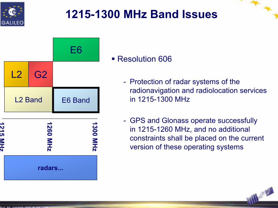
1215-1300 MHz Band Issues
Resolution 606
- Protection of radar systems of the radionavigation and radiolocation services in 1215-1300 MHz
- GPS and Glonass operate successfullyin 1215-1260 MHz, and no additional constraints shall be placed on the current version of these operating systems
1215 MH
z
1260 MH
z
1300 MH
z
radars...
L2 G2
L2 Band E6 Band
E6
Ref. 55_140403_007_S_V1_110 110
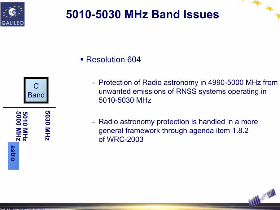
5010-5030 MHz Band Issues
Resolution 604
- Protection of Radio astronomy in 4990-5000 MHz from unwanted emissions of RNSS systems operating in 5010-5030 MHz
- Radio astronomy protection is handled in a more general framework through agenda item 1.8.2 of WRC-2003
5010 MH
z
5030 MH
z
5000 MH
zastro
CBand

Ref. 55_140403_007_S_V1_111
EUROPEAN GALILEO PROGRAMME
Offering Cooperation Opportunities
Ref. 55_140403_007_S_V1_112 112
International Cooperation
International cooperation is essential to:- Gain maximum advantage from the Galileo programme- Help to increase European know-how and reduce the technological
and political risks of the programme- Assist technical standardization, to penetrate markets and to develop
ground-based equipment
Cooperation with third countries means solving problems such as:- System supervision and security- Technology transfer- Intellectual property and control of exports especially with regard
to dual-use goods

Ref. 55_140403_007_S_V1_113
SECURITY
Safety and European Responsibility are at Stake
Ref. 55_140403_007_S_V1_114 114
Security Issues
Main issues:- The Galileo service has to be reliable and safe whatever the circumstances
are- Malicious and hostile misuse of any satellite navigation system has to be
precludedConstraints:
- To protect vital infrastructure as well as the signal especially for users with safety critical and/or high security requirements, including in times of crisis
- To be able to deny the access to enemy forces in a war situation as well as other potential hostile or malevolent user
Ref. 55_140403_007_S_V1_115 115
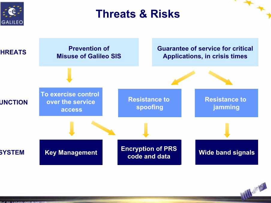
Threats & Risks
THREATS
FUNCTION
SYSTEM
Prevention ofMisuse of Galileo SIS
Key Management
Resistance to jamming
Guarantee of service for criticalApplications, in crisis times
Wide band signalsEncryption of PRScode and data
Resistance to spoofing
To exercise control over the service
access
Ref. 55_140403_007_S_V1_116 116
Existing Group and Activities
GSB: Galileo security board
Composition:
- Member States representatives- Co-Chaired by EC and EU Presidency
Missions:
- Advice on system technical characteristics with regard to security- Support to the EC in its negotiations with third countries- Help to set up the future operational security framework for security

Ref. 55_140403_007_S_V1_117
BASICS
Ref. 55_140403_007_S_V1_118 118
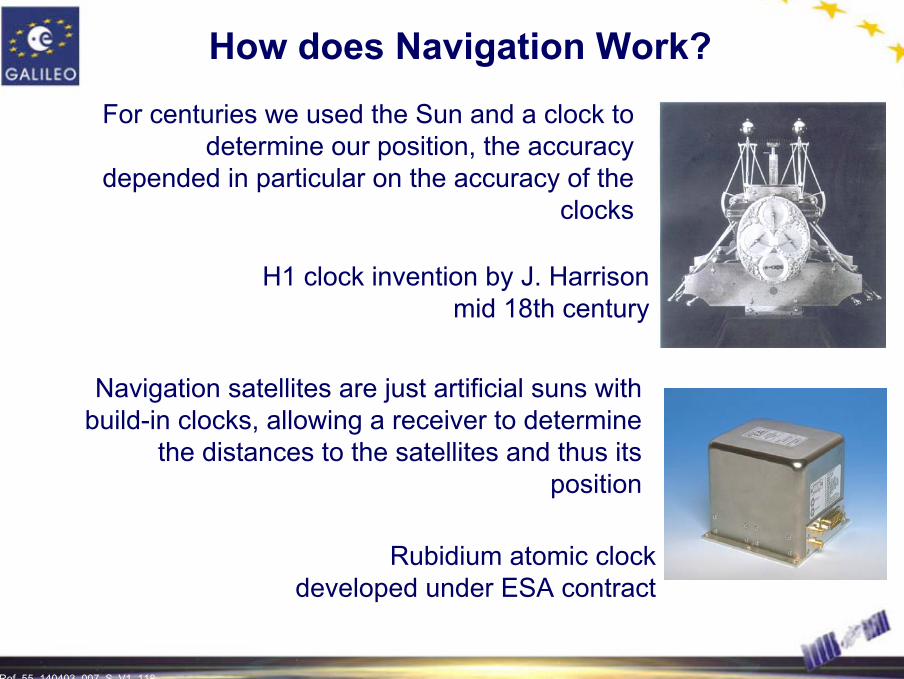
For centuries we used the Sun and a clock to determine our position, the accuracy
depended in particular on the accuracy of the clocks
Navigation satellites are just artificial suns with build-in clocks, allowing a receiver to determine
the distances to the satellites and thus its position
H1 clock invention by J. Harrisonmid 18th century
Rubidium atomic clockdeveloped under ESA contract
How does Navigation Work?

Ref. 55_140403_007_S_V1_119 119
How does Navigation Work?
Actually, a 4th measurement is needed for time determination

Ref. 55_140403_007_S_V1_120 120
Integrity Principle
Integrity is a measure of the trust which can be placed in the correctness of the information supplied by the total systemIntegrity includes the ability of a system to provide timely and valid warnings to usersIntegrity is provided through the useof Protection Levels and Alarm LimitsApplication: Stanford diagram
Ref. 55_140403_007_S_V1_121 121
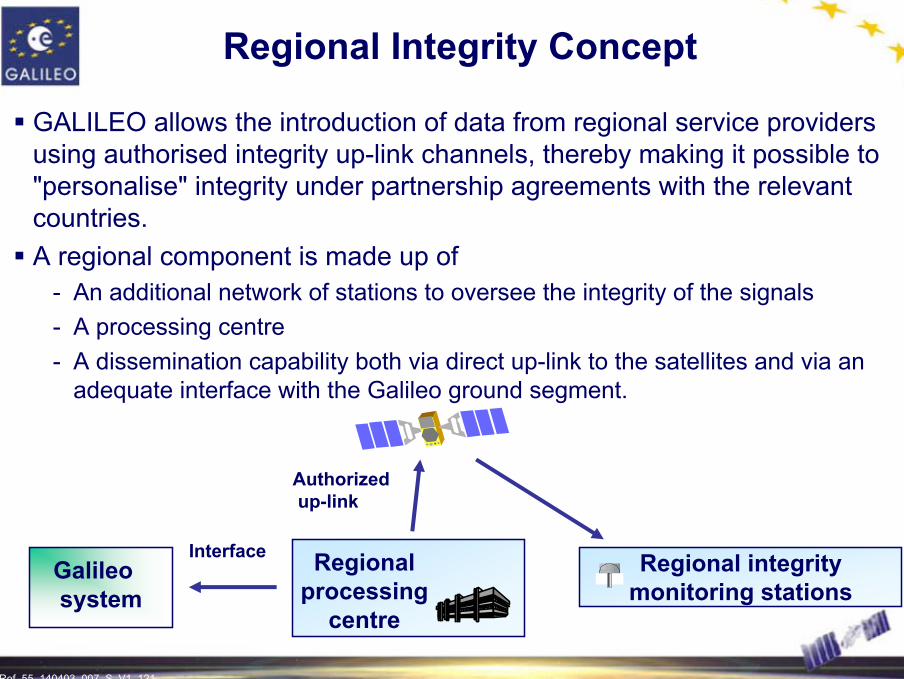
Regional Integrity Concept
GALILEO allows the introduction of data from regional service providers using authorised integrity up-link channels, thereby making it possible to "personalise" integrity under partnership agreements with the relevant countries. A regional component is made up of
- An additional network of stations to oversee the integrity of the signals - A processing centre- A dissemination capability both via direct up-link to the satellites and via an
adequate interface with the Galileo ground segment.
Galileosystem
Regional integrity monitoring stations
Regional processing
centre
Interface
Authorizedup-link
Ref. 55_140403_007_S_V1_122 122
Galileo website:
http://europa.eu.int/comm/dgs/energy_transport/galileo
GENESIS (where you can download and subscribe to the Galileo Newsletter on line):http:// www.genesis-office.org
Useful Internet links
Navigation page on ESA website:
http:// www.esa.int/export/esaSA/navigation.html

Ref. 55_140403_007_S_V1_123 123
Contact Points
European Space AgencyApplications Directorate, Navigation Department8-10 rue Mario Nikis, F-75738 Paris CEDEX 15, FranceTel: +33 1 5369 7247, Fax: +33 1 5369 7445Email: [email protected]://www.esa.int/navigation/
European CommissionDirectorate General for Energy and Transport, Unit E.4 Satellite Navigation System (Galileo), Intelligent TransportDM28 1/64, B-1049 Brussels, BelgiumPhone: +32 2 29 56040, Fax: +32 2 296 5372Email: [email protected]://europa.eu.int/comm/energy_transport/en/gal_en.html