gain perspective download information west call box … 3.5 3.0 2.5 2.0 1.9 1.5 1.3 1.0 0.5 0.3...
TRANSCRIPT
Hiking Only
Hiking, Bicycling
Hiking, Bicycling, Equestrian
Trail Junction
Point of Interest
Parking Lot
Restroom
Shelter
Picnic Table
Bench
Water Trough (Non-Potable)
Accessible Features
0
b
Map Legend
L
I
K
HG
E
D
C
B
A
F
J
3,400
3,300
3,200
3,100
3,000
2,900
2,800
2,700
2,600
2,500
2,400
3.7 3.5 3.0 2.5 2.0 1.9 1.5 1.3 1.0 0.5 0.3
Elev
atio
n (F
eet)
East Summit1,150’ Gain
3.0 Mile Marker878’ Gain
2.5 Mile Marker688’ Gain
West Bridge andCabin Ruins540’ Gain
0.5 Mile Marker137’ Gain
Barlow Road99’ Gain
1.5 Mile Marker388’ Gain
Guadalupe Creek
Overlook354’ Gain
East Bridge235’ Gain
Central Bridge492’ Gain
Bald MountainParking Area
0’ Gain
C
D
EF
GH
I
J
KTrailhead Shelter Cut-off1,020’ Gain
L
AB
Trail Profile
Distance in Miles (Cumulative)
Mount Umunhum Area and Trails
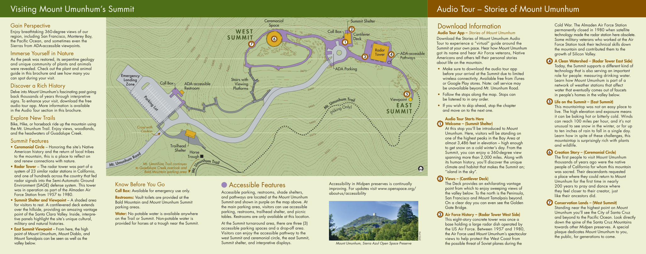
ADA-accessiblePathways
ADA Parking
Stairs withViewing
Platforms
Call BoxCantileverDeck
EmergencyLandingZone
Parking Lot
TrailheadShelter
Summit Shelter
RadarTower
CeremonialSpace
ADA-accessibleRestroom
Viewpoint
HorseTrough
Call Box
E A S TS U M M I T
W E S TS U M M I T
Mt. Umunhum Trail continuesto Guadalupe Creek overlook and
Bald Mountain parking area
Cross withCaution
Mt. Umunhum Road
Mt. U
munhum Trail
(
Hiking Only)
3475
3450
3425
3400
3375
3350
3325
3300
345034
25340033
753350
3325
3300
3275
Mt.
Umunhum Trail
NN
1
2
3 4
5
67
Visiting Mount Umunhum’s Summit Audio Tour – Stories of Mount Umunhum
Gain PerspectiveEnjoy breathtaking 360-degree views of our region, including San Francisco, Monterey Bay, the Pacific Ocean, and sometimes even the Sierras from ADA-accessible viewpoints.
Immerse Yourself in NatureAs the peak was restored, its serpentine geology and unique community of plants and animals were revealed. Check out the plant and animal guide in this brochure and see how many you can spot during your visit.
Discover a Rich HistoryDelve into Mount Umunhum’s fascinating past going back thousands of years through interpretive signs. To enhance your visit, download the free audio tour app. More information is available in the Audio Tour section in this brochure.
Explore New TrailsBike, Hike, or horseback ride up the mountain using the Mt. Umunhum Trail. Enjoy views, woodlands, and the headwaters of Guadalupe Creek.
Summit Features• Ceremonial Circle – Honoring the site’s Native
American history and the return of local tribes to the mountain, this is a place to reflect on and renew connections with nature.
• Radar Tower – The radar tower was part of a system of 23 similar radar stations in California, and one of hundreds across the country that fed radar signals into the Semi-Automatic Ground Environment (SAGE) defense system. This tower was in operation as part of the Almaden Air Force Station from 1957 to 1980.
• Summit Shelter and Viewpoint – A shaded area for visitors to rest. A cantilevered deck extends over the hillside, providing an amazing vantage point of the Santa Clara Valley. Inside, interpre-tive panels highlight the site’s unique cultural, military and natural histories.
• East Summit Viewpoint – From here, the high point of Mount Umunhum, Mount Diablo, and Mount Tamalpais can be seen as well as the valley below.
Trails and RecreationThe new 3.7-mile Mt. Umunhum Trail extends from the Bald Mountain parking area to the Summit, crossing through varied habitats and offering incredible views of the valley below, the ridgelines above, and the other great peaks of the Bay Area. This multi-use trail offers moderate terrain for hikers, bicyclists, and horseback riders and, at the Summit, is the highest point on the Bay Area Ridge Trail. Note, the highest 0.2 mile section is limited to hiking only.
Mount Umunhum TrailThis gorgeous trail passes through mixed chaparral scrub dominated by chamise, big berry manzanita, birch-leafed mountain mahogany, and poison oak. With elevation gain, the trail passes through knobcone pine woodland, and eventually enters the coastal woodlands dominated by coast live oak, foothill pine, and California bay interspersed with Pacific madrone. The majority of the trail – approximately the upper 3.0 miles – is under the cool canopy of these trees. Eventually, the trail emerges near the top onto steep terrain with cliffs and rocky outcrops, including serpentine boulders. Rocky, nutrient-poor serpentine soils are home to numerous endemic plant species, including rare flowering plants that continue to reveal themselves each spring.
Know Before You GoCall Box: Available for emergency use only.
Restrooms: Vault toilets are provided at the Bald Mountain and Mount Umunhum Summit parking areas.
Water: No potable water is available anywhere on the Trail or Summit. Non-potable water is provided for horses at a trough near the Summit.
Restoration in ProgressPlease Stay on the TrailsThe rock gardens at the Summit of Mount Umunhum support fragile plant communities.
Vegetation can take years to establish in newly planted restoration areas. Thank you for protecting these sensitive resources.
Accessible FeaturesAccessible parking, restrooms, shade shelters, and pathways are located at the Mount Umunhum Summit and shown in purple on the map above. At the main parking area, visitors can use accessible parking, restrooms, trailhead shelter, and picnic tables. Restrooms are only available at this location.
At the Summit turnaround area, there are three (3) accessible parking spaces and a drop-off area. Visitors can enjoy the accessible pathway to the west Summit and ceremonial circle, the east Summit, Summit shelter, and interpretive displays.
Accessibility in Midpen preserves is continually improving. For updates visit www.openspace.org/about-us/accessibility
Download InformationAudio Tour App – Stories of Mount Umunhum Download the Stories of Mount Umunhum Audio Tour to experience a “virtual” guide around the Summit at your own pace. Hear how Mount Umunhum got its name and hear Air Force veterans, Native Americans and others tell their personal stories about life on the mountain.• Make sure to download the audio tour app
before your arrival at the Summit due to limited wireless connectivity. Available free from iTunes or Google Play stores. Note: cell service may be unavailable beyond Mt. Umunhum Road.
• Follow the stops along the map. Stops can be listened to in any order.
• If you wish to skip ahead, stop the chapter and move on to the next one.
Audio Tour Starts Here Welcome – (Summit Shelter) At this stop you’ll be introduced to Mount Umunhum. Here, visitors will be standing on one of the highest peaks in the Bay Area at almost 3,486 feet in elevation – high enough to get snow on a cold winter’s day. From the Summit, you can enjoy a 360-degree view spanning more than 2,000 miles. Along with its human history, you’ll discover the unique climate and habitat that makes the Summit an; “island in the sky”.
Views – (Cantilever Deck) The Deck provides an exhilarating vantage point from which to enjoy sweeping views of the valley below. To the north is the Peninsula, San Francisco and Mount Tamalpais beyond. On a clear day you can even see the Golden Gate Bridge.
Air Force History – (Radar Tower West Side) This eight--story concrete tower was once a base holding a large radar dish operated by the US Air Force. Between 1957 and 1980, the Air Force used Mount Umunhum’s spectacular views to help protect the West Coast from the possible threat of Soviet planes during the
Cold War. The Almaden Air Force Station permanently closed in 1980 when satellite technology made the radar station here obsolete. Some military veterans who worked at the Air Force Station took their technical skills down the mountain and contributed them to the growth of Silicon Valley.
A Clean Watershed – (Radar Tower East Side) Today, the Summit supports a different kind of technology that is also serving an important role for people: measuring drinking water. Learn how Mount Umunhum is part of a network of weather stations that affect water that eventually comes out of faucets in people’s homes in the valley below.
Life on the Summit – (East Summit) This mountaintop was not an easy place to live. The high elevation and exposure means it can be baking hot or bitterly cold. Winds can reach 100 miles per hour, and it’s not unusual to see snow in the winter, or for up to ten inches of rain to fall in a single day. Learn how in spite of these challenges, this mountaintop is surprisingly rich with plants and wildlife.
Creation Story – (Ceremonial Circle) The first people to visit Mount Umunhum thousands of years ago were the native people of California for whom this mountain was sacred. Their descendants requested a place where they could return to Mount Umunhum for the first time in nearly 200 years to pray and dance where they feel closer to their creator, just like their ancestors did.
Conservation Lands – (West Summit) Standing near the highest point on Mount Umunhum you’ll see the City of Santa Cruz and beyond to the Pacific Ocean. Look directly down the spine of the Santa Cruz Mountains towards other Midpen preserves. A special plaque dedicates Mount Umunhum to you, the public, for generations to come.
1
2
3
4
5
6
7
Mt. Umunhum Trail ProfileTrail Entry Point: The Mt. Umunhum trailhead is located at the Bald Mountain parking area. The Trail can also be accessed via Barlow Road from Woods Trail.Bald Mountain Parking Area Elevation: 2,336 feet. Mount Umunhum Summit Elevation: 3,486 feet. Total Elevation Gain: 1,150 feet of continuous gain at approximately 10% grade.Total Length: 3.7 miles; multi-use = 3.5 miles, hiking only (at Summit) = 0.2 miles.At the Summit: The 0.2 miles of trail between the trailhead shelter to the east Summit is hiking only and includes steps, facilities to secure horses and bicycles are provided at the trailhead shelter. A second bike rack is also provided near the Summit shelter. Summit paths at the very top are ADA accessible and open to hiking only.Bicyclists: Can access the Summit by using the final0.2 miles of Mt. Umunhum Road instead of theTrail and using the Summit bike rack; bikes arenot permitted on Summit paths.Equestrians: Horses are not permitted beyond the trailhead shelter.
Mount Umunhum, Sierra Azul Open Space Preserve
Karl Gohl
The distinctive canyon liveforever thrives on exposed rocky outcrops
The mountain is called “Umunhum”, which contains the root word for hummingbird in five Ohlone languages
Hummingbirds love scarlet beardtongue flowers and the Summit’s abundant flowering plants
Bobcats, like this baby one, live at Mount Umunhum
Lindley’s blazing star is limited to a small range in California
Soaring and peak-loving birds such as golden eagles are frequent Summit visitors
Brewer’s clarkia is a rare endemic flower found only on local Bay Area peaks
Photos to left by Ken Hickman
Plant and Animal Guide
To see more images go to www.openspace.org