g4 u8 ovr grade 4 unit 8 overview - noaa office … 4 unit 8 overview ocean geography and geology...
TRANSCRIPT

GRADe 4 UNIT 8 OVeRVIeWOcean Geography and Geology
Introduction
Oceans cover approximately 70 percent of the Earth’s surface. Although these large bodies of seawater surround all continents, they are really part of one ocean that is subdivided into fi ve smaller ocean basins. These ocean basins are differentiated according to specifi c geological features, and include the Arctic, the Southern (formerly, the Antarctic), the Atlantic, the Pacifi c, and the Indian Oceans.
The Pacifi c Ocean is the Earth’s largest ocean basin. It is home to the Hawaiian Islands archipelago, more than 25,000 other islands, and the deepest trench formation in the world (more than 36,000 ft below the ocean surface), known as the Mariana Trench.
In this unit, students identify the fi ve ocean basins and their unique features. Given coordinate points, students determine the location of ocean basins, continents, and geologic features of interest, including the Hawaiian Islands, then plot their fi ndings on large ocean maps. They also learn to differentiate between ocean basins and seas.
Students are also introduced to the plate tectonics theory of continental drift formulated by Oceanographer Alfred Wegener in 1915. They gain an elementary understanding of how seamounts, deep trenches, and volcanoes are formed, and then apply this knowledge to recreate seafl oor features with modeling clay. They are also made aware that tectonic plate movements can trigger Earthquakes, or create islands, such as the Hawaiian Islands, that show the direction of plate movement above a hot spot. Students will be able to visualize how the Hawaiian Islands were formed, and how they slowly move in a northwesterly direction.
Students undertake an imaginary dive into the deep, dark depths of the ocean, noting seamounts, trenches, and other features, and sketching these features in their journals. They then make models of these features in a preferred media of their choice, such as modeling clay, diorama, book design, or a multimedia presentation. Also, there are crossword puzzles to help them review, and retain, what they have learned throughout the unit.
In the extension lesson, students are introduced to an educational technique, the Orff Approach developed by German Composer Carl Orff, during which they use simple rhythmic instruments to accompany a chant about the ocean.
1
G4 U8 OVR

At A
Gla
nce
Each Lesson addresses HC
PS III Benchm
arks.The Lessons provide an opportunity for students to m
ove toward m
astery of the indicated benchmarks.
ESSENTIA
L QU
ESTION
SH
CPSIII B
ENC
HM
AR
KS*
LESSON
, Brief Sum
mary, D
urationW
hat is the most dom
inant feature on E
arth and how is this
feature divided?
Why is the dom
inance of this feature so im
portant?
How
do we pinpoint locations
on the Earth?
Social S
tudies Standard 7: G
eography: World In S
patial Term
s:S
S 4.7.2 C
ollect, organize and analyze data to interpret and construct geographic representations.M
ath Standard 8: G
eometry and S
patial Sense:
Representational S
ystems:
MA 4.8.1 U
se ordered pairs to plot points on a coordinate grid.
Lesson 1: A Watery W
orldS
tudents are given a blank world
map, w
hich they use to label the five ocean basins. They w
ill refer to this m
ap throughout the unit. To engage the learners, students w
ill play a ball toss gam
e with an inflatable globe.
This activity serves as an informal
formative assessm
ent about learners’ geography background, and at the sam
e time creates interest in the
topic. Students w
ill be led in a mini-
lesson on longitude and latitude. Then they w
ill receive an area map w
ith latitude and longitude inform
ation of the county in H
awai‘i w
here they live. U
sing the map, they w
ill identify a list of places on their island. The lesson w
ill close with students posing
a question and forming a hypothesis
about the formation of the surface of
the Earth.
Two 45-m
inute periods
2
G4 U8 OVR

ESSENTIA
L QU
ESTION
SH
CPSIII B
ENC
HM
AR
KS*
LESSON
, Brief Sum
mary, D
urationW
hat would the w
orld look like if all the w
ater were drained out?
Social S
tudies Standard 7: G
eography: World In S
patial Term
s:S
S 4.7.2 C
ollect, organize and analyze data to interpret and construct geographic representations.S
cience Standard 1:
SC
4.1.1 Describe a testable hypothesis and an
experimental procedure.
Lesson 2: Into The Deep
Students pose questions about the
ocean fl oor and make predictions
about what they think the ocean fl oor
might look like and the kinds of E
arth m
aterials that make up the ocean
fl oor. They learn about the continental slope, continental rise, abyssal plain, m
id-ocean ridge, trench and much
more.
Two 45-m
inute periods
How
do fast and slow
processes shape and reshape the geologic features of the ocean fl oor?
How
are Earthquakes and
volcanoes related to ocean geology?
Science S
tandard 8: S
C 4.8.1 D
escribe how slow
processes sometim
es shape and reshape the surface of the E
arth.S
C 4.8.2 D
escribe how fast processes (e.g., volcanoes,
Earthquakes) som
etimes shape and reshape the surface
of the Earth.
Lesson 3: A Moving C
rustS
tudents are introduced to plate tectonics in this lesson. In Lesson 2, they discovered that the ocean bottom
is not fl at when they
viewed bathym
etric maps show
ing representations of different ocean geologic features, and the geographic location of som
e of the most
prominent underw
ater features. In this lesson, they learn how
some
of the features of the ocean bottom
are formed. S
tudents watch a
demonstration and conduct a sim
ple experim
ent of their own to learn m
ore about seam
ounts, ridges, trenches, and subm
arine canyons. They will
also play a concentration game to
reinforce the concepts of fast and slow
processes that shape and reshape the surface of the E
arth.
Two 45-m
inute period
3
G4 U8 OVR

ESSENTIA
L QU
ESTION
SH
CPSIII B
ENC
HM
AR
KS*
LESSON
, Brief Sum
mary, D
urationW
hat are the major features of
the ocean?S
cience Standard 8:
SC
4.8.1 Describe how
slow processes som
etimes
shape and reshape the surface of the Earth.
SC
4.8.2 Describe how
fast processes (e.g. volcanoes, E
arthquakes, etc.) sometim
es shape and reshape the surface of the E
arth. S
ocial Studies S
tandard 7: Geography: W
orld In Spatial
Terms:
SS
4.7.2 Collect, organize, and analyze data to interpret
and construct geographic representationsLang. A
rts Standard 6: O
ral Com
munication:
Conventions and S
kills: LA 4.6.1 P
articipate in grade-appropriate oral group activities.LA
.4.6.2 Give short, inform
al presentations to inform or
persuadeM
ath Standard 8: G
eometry and S
patial Sense:
Representational S
ystems:
MA 4.8.1 U
se ordered pairs to plot points on a coordinate grid.
Culm
inating Lesson: Ocean Floor
Geology
After a short review
of the different geological form
ations found on the ocean fl oor, students construct three-dim
ensional models of the ocean
fl oor’s specifi c geological features. S
tudents imagine w
hat it might be like
from the edge of a continent dow
n to the deepest part of the ocean. S
tudent groups cooperatively design their ow
n ocean using modeling clay
or dough. Although clay m
odels are suggested, students m
ay choose other representations, such as, paper M
ache or Plaster of P
aris.
Two - Four 45-m
inute periods over tw
o weeks
* “Haw
ai‘i Content &
Performance Standards III D
atabase.” Haw
ai‘i Departm
ent of Education. June 2007. Departm
ent of Education. 17 Dec. 2007.
4
G4 U8 OVR

Benchmark RubricI. HCPS III Benchmarks*
Below is a general Benchmark Rubric. Within each lesson, there are other assessment tools and additional rubrics specific to the performance tasks within each lesson.
Topic Scientific InquiryBenchmark SC.4.1.1 Describe a testable hypothesis and an
experimental procedureRubricAdvanced Proficient Partially Proficient NoviceCreate a testable hypothesis and an experimental procedure to test it
Describe a testable hypothesis and an experimental procedure
Identify, with assistance, a testable hypothesis and an experimental procedure
Recognize, with assistance, a testable hypothesis or an experimental procedure
Topic Forces that Shape the EarthBenchmark SC.4.8.1 Describe how slow processes sometimes shape
and reshape the surface of the EarthRubricAdvanced Proficient Partially Proficient NoviceUse evidence to explain how slow processes have shaped and reshaped the surface of the Earth
Describe how the shaping and reshaping of the Earth’s land surface is sometimes due to slow processes
Provide examples of the shaping and reshaping of the Earth’s land surface due to slow processes
Recognize that the shaping and reshaping of the Earth’s land surface is sometimes due to slow processes
Topic Forces that Shape the Earth
Benchmark SC.4.8.2Describe how fast processes (e.g., volcanoes, Earthquakes) sometimes shape and reshape the surface of the Earth
RubricAdvanced Proficient Partially Proficient NoviceUse evidence to explain how fast processes have shaped and reshaped the surface of the Earth
Describe how the shaping and reshaping of the Earth’s land surface is sometimes due to fast processes
Provide examples of the shaping and reshaping of the Earth’s land surface due to fast processes
Recognize that the shaping and reshaping of the Earth’s land surface is sometimes due to fast processes
Topic Coordinate Geometry
Benchmark MA.4.8.1 Use ordered pairs to plot points on a coordinate grid
RubricAdvanced Proficient Partially Proficient NoviceUse ordered pairs to plot points on a coordinate grid, with accuracy
Use ordered pairs to plot points on a coordinate grid, with no significant errors
Use ordered pairs to plot points on a coordinate grid, with a few significant errors
Use ordered pairs to plot points on a coordinate grid, with many significant errors
Topic World In Spatial TermsBenchmark SS.4.7.2 Collect, organize, and analyze data to interpret
and construct geographic representationsRubricAdvanced Proficient Partially Proficient NoviceCollect, organize, and analyze data to interpret and construct geographic representations, with accuracy
Collect, organize, and analyze data to interpret and construct geographic representations, with no significant errors
Collect, organize, and analyze data to interpret and construct geographic representations, with a few significant errors
Collect, organize, and analyze data to interpret and construct geographic representations, with many significant errors
5
G4 U8 OVR
Topic Discussion and PresentationBenchmark LA.4.6.1 Participate in grade-appropriate oral group activitiesRubricAdvanced Profi cient Partially Profi cient NoviceParticipate in grade-appropriate oral group activities, in a highly effective way
Participate in grade-appropriate oral group activities
Participate in grade-appropriate oral group activities, in a limited way or in a way that only partially facilitates the group’s work
Participate very little in grade-appropriate oral group activities or participate in a way that does not facilitate the group’s work
Topic Discussion and PresentationBenchmark LA.4.6.2 Give short, informal presentations to inform or persuadeRubricAdvanced Profi cient Partially Profi cient NoviceGive creative, short, highly effective informal presentations to inform or persuade
Give short, informal presentations to inform or persuade
Give short, informal presentations that are somewhat informative or persuasive
Give short, informal presentations that do not inform or persuade
II. General Learner Outcomes*Below is a list of the HIDOE General Learner Outcomes (GLOs). Each Unit of the Lessons from the Sea Curriculum addresses the GLOs. Within some lessons, there is more specifi c mention of individual GLOs with specifi c pertinence.
I. Self-directed Learner (The ability to be responsible for one’s own learning)II. Community Contributor (The understanding that it is essential for human beings to work together)III. Complex Thinker (The ability to demonstrate critical thinking and problem solving)IV. Quality Producer (The ability to recognize and produce quality performance and quality products)V. Effective Communicator (The ability to communicate effectively)VI. Effective and Ethical User of Technology (The ability to use a variety of technologies effectively and
ethically)
* “Hawai‘i Content & Performance Standards III Database.” Hawai‘i Department of Education. June 2007. Department of Education. 17 Dec. 2007.
6
G4 U8 OVR

science Background for the TeacherNote: Bolded words found within this section are defi ned in the Science Background for the Teacher Glossary. The footnotes refer to the references found in the Science Background for Teacher Bibliography at the end of this section.
What are the characteristics of the Ocean? 1 (Lessons 2 and 4)
The ocean is defi ned as an entire body of seawater that covers about 70 percent of the Earth’s surface. This world ocean encompasses all continents, and can be subdivided into fi ve ocean basins: the Arctic (extension of the North Atlantic Ocean), the Southern Ocean (circumpolar at latitudes greater than 50 degrees south formerly called the Antarctic Ocean), the Atlantic, the Pacifi c and the Indian Oceans. For additional facts, go towww.bbc.co.uk/nature/blueplanet/blue/world_oceans.shtml
Important characteristics of the ocean include temperature, salinity, and currents. Temperature is the measure of the kinetic energy (energy of motion) of the molecules that make up a substance; in this case, the kinetic energy of the water molecules that make up the ocean. As heat fl ows into the ocean, it increases the motion of the water molecules, which leads to an increase in temperature. The temperature of the ocean is less variable than that of air due to the exceptionally high specifi c heat of water compared to air. Specifi c heat is defi ned as the amount of heat that must be absorbed to raise the temperature of 1 gram (g) of a given substance 1 degree Celsius (C). The specifi c heat of a substance can be thought of as a way to measure how well the substance resists changes in its temperature as it absorbs or releases heat. Water strongly resists changes in temperature, and thus it takes a relatively large amount of absorbed or released heat to change the temperature of water by 1 degree C. The ocean, therefore, has a high capacity to absorb heat without increasing its temperature. The Earth’s surface is constantly being bombarded by radiation from the sun, but unlike on land, the ocean has a special transparency property that allows for the transmission of energy to an average depth of 60 meters (although, in some areas, this transmission of energy can go as deep as 300 meters). Warmer waters also tend to fl oat above cooler waters. Ocean currents are constantly mixing the surface water with the deeper water, and these conditions, together with the high specifi c heat of water, allow for the distribution of heat and enable the ocean to store and release large amounts of heat.
Ocean seawater is 96.5 percent water and 3.5 percent dissolved solids. Salinity, or the total amount of dissolved salts in the water (also called ions), affects water temperature. While pure water freezes at 0°C, increasing salinity decreases the temperature at which water freezes. Salinity also affects the density (mass per given volume) of water. Water with a higher degree of salinity is heavier (more dense) and therefore sinks beneath water with a lower degree of salinity. In the ocean, temperature, salinity, and density are closely related. As previously described, the variable freezing point of a body of water caused by variable salinity infl uences the temperature of that water. In addition, both temperature and salinity are affected by evaporation. Ocean temperature is lowered due to evaporation, while ocean salinity and therefore density, is increased by evaporation. These characteristic relationships can be used to identify water masses, which tend to have stable temperatures and salinities.
The last important characteristic of the ocean is currents. Currents in the ocean, or large masses of water with similar characteristics and properties of motion, allow for the circulation of the ocean and its contents. Ocean currents are affected by winds, the Earth’s rotation, density differences caused by temperature and salinity, and the confi guration of the continents and the ocean fl oor. Currents caused by differences in temperature and salinity in the ocean are termed thermohaline circulation (thermo- for temperature and -haline for salinity), and describe the slow moving water masses of the deep ocean. Vertical movement of currents is produced at the surface due to evaporation that cools surface waters and increases salinity. This creates high-density masses of water that sink and spread beneath the surface waters, resulting in deep-water movement or circulation. For more information on ocean characteristics, go to: www.onr.navy.mil/Focus/ocean/regions/bluewater1.htm
7
G4 U8 OVR

Describe different methods used to study the ocean floor 2 (Lessons 2)
In order to analyze seafloor sediment, a geological oceanographer must collect and examine samples from the bottom of the ocean. A variety of devices have been developed to take samples of the seafloor for laboratory work. Dredges are net or wire baskets that are dragged across the seafloor to collect loose bulk material, surface rocks, and shells. Grab samplers are hinged devices that are spring- or weight-loaded to snap shut when the sampler strikes the bottom. A corer is a hollow pipe with a sharp cutting end. This free-falling pipe is forced down into the sea floor by its weight or, for longer cores, by a piston device within the core barrel that uses water pressure to help drive the corer into the seafloor sediments. The piston device can drive down to 20 meters (60 feet) to retrieve undisturbed deep sediment layers. A box corer is used when a large, undisturbed sample of surface sediment is needed. These corers drive a rectangular metal box into the sediment, with doors that close over the bottom of the box before the sample is lifted.
Remotely operated vehicles (ROVs) are a below-the-surface system tethered to a surface vessel or a manned submersible. The tether is the umbilical cord between the ROV and operator; it supplies power and transmits information over an electrical or fiber optic cable. ROVs use video, electronic-digital, and still cameras with lights to explore their environment. They may be equipped with mechanical hands to manipulate objects and, depending on their mission, other sensors such as sonar, and temperature and salinity monitors. The operator controls the ROV as it cruises over the seafloor. The ROV sends data to the operator and, in return, receives directions to change position, manipulate, or retrieve objects, or to use cameras and other sensors.
Autonomous underwater vehicles (AUVs) are independent, mobile, instrument platforms equipped with sensors. They are not tethered to another vessel and, therefore, their range of movement is greater than that of ROVs. AUVs may be linked acoustically to an operator in a surface vessel, or they may be programmed to complete surveys and take samples with little or no human supervision. Many of these vehicles are small, less than 25 kg (50 lbs) and have specialized capabilities and restricted depth ranges. Other vehicles work effectively in deep water and in harsh environments such as under ice.
Manned deep-diving submersibles offer another opportunity to explore the ocean’s depths. The NOAA established program at the University of Hawai‘i ’s Hawai‘i Underwater Research Laboratory (HURL) currently has two submersibles, the Pisces IV and Pisces V, that are supported from the research ship R/V Ka‘imikai o Kanaloa. These submersibles can dive up to 2,000 meters below the surface. Along with an ROV that can dive to 3,000 m, HURL uses these state-of-the-art vehicles to study a variety of ocean research topics. The Habitats, Ecosystems, and Fisheries Resources Program focuses on seamount ecosystems and the biological and physical factors important in their maintenance. The program’s particular emphasis is on assessing the status of protected species and how seamount ecosystems support commercial or potentially commercial fishery resources, such as fishes, corals and crustaceans. The Submarine Volcanic Processes Program studies the geology, geophysics, geochemistry, and biology of volcanic processes and their implications for island development. Lō‘ihi Volcano, its surface just 1 km below the ocean’s surface south of the Big Island of Hawai‘i , is their main site for monitoring these processes using an Ocean Bottom Observatory. Other HURL’s led research programs include coral reefs and coastal processes. For additional information concerning HURL’s programs, go to http://www.soest.Hawaii .edu/HURL/
To listen to an interview with John Wiltshire of NOAA’s Hawai‘i Undersea Research Laboratory (HURL) regarding technology used to monitor island formation, please visit http://www.Earthsky.org/interviewpost/water/john-wiltshires-undersea-laboratory-explores-expanding-Hawaii or listen to the podcast included with this unit.
8
G4 U8 OVR

What is the difference between an ocean and a sea? 3 (Lesson 1)
A sea is a relatively large body of salt water completely, or partially, enclosed by land, e.g. the Red Sea, Mediterranean Sea, and Black Sea. In contrast, an ocean refers to the entire body of salt water that covers nearly 70 percent of the Earth’s surface. The ocean is the largest uninterrupted expanses of water. The IHO (International Hydrographic Organization) is the leading authority in defi ning the boundaries of ocean basins and seas. Their special publication S-23, Limits of Oceans and Seas, 3rd edition, lists all the different internationally recognized ocean basins and seas, and can be accessed at http://www.iho.shom.fr/
How does the fl oor of the ocean form? Describe processes of plate tectonics, seafl oor spreading, and subduction. 4 (Lessons 3 and 4)
The Earth is made up of a series of layers. The outer surface is called the crust, followed by the inner mantle, liquid outer core, and solid inner core. The crust is composed of two parts: 1) the solid masses of the continents lie on the continental crust, which is formed of less dense material called granite, and 2) the oceanic crust that lies under the seafl oor formed of denser material called basalt. Below the crust is the mantle, which is fused to the crust to form the rigid lithosphere including the continental and ocean crusts and the upper part of the mantle. The lithosphere fl oats on the deformable (capable of being reshaped) upper mantle, which is called the asthenosphere.
Seafl oor spreading describes the geologic process that creates the ocean fl oor. Spreading centers at mid-ocean ridges produce new Earthen material that spreads away from the ridges. Seafl oor spreading involves movement of both the lithosphere and the asthenosphere, the deeper, partially molten interior of the Earth.
The theory of continental drift was based on the geographic puzzle-like fi t of the continents and the similarity of fossils collected on different continents. The discovery of the mid-ocean ridge system and the idea of convection cells, or the up and down movement of the sub-crustal mantle matter due to temperature variation in the asthenosphere, led to the hypothesis of seafl oor spreading as the mechanism for continental drift, the movement of the continents. New ocean fl oor is formed and spreads at the ridges, or rift zones, where molten rock rises at spreading centers and cools forming new oceanic crust. Old crust material is forced to descend into oceanic trenches, or subduction zones, regions where portions of the Earth’s tectonic plates are sinking beneath other plates into the Earth’s interior. The rate of
seafl oor spreading ranges from 1 to 10 centimeters per year. The concept of continental drift and the theory of seafl oor spreading were combined to produce the theory of plate tectonics, in which the plates are made up of continental and ocean lithosphere bounded by ridges, trenches, and faults. For diagrams and descriptions of these processes, see http://www.windows.ucar.edu/ Click “our Planet,” then “Interior and Surface” then “Surface.”
9
G4 U8 OVR
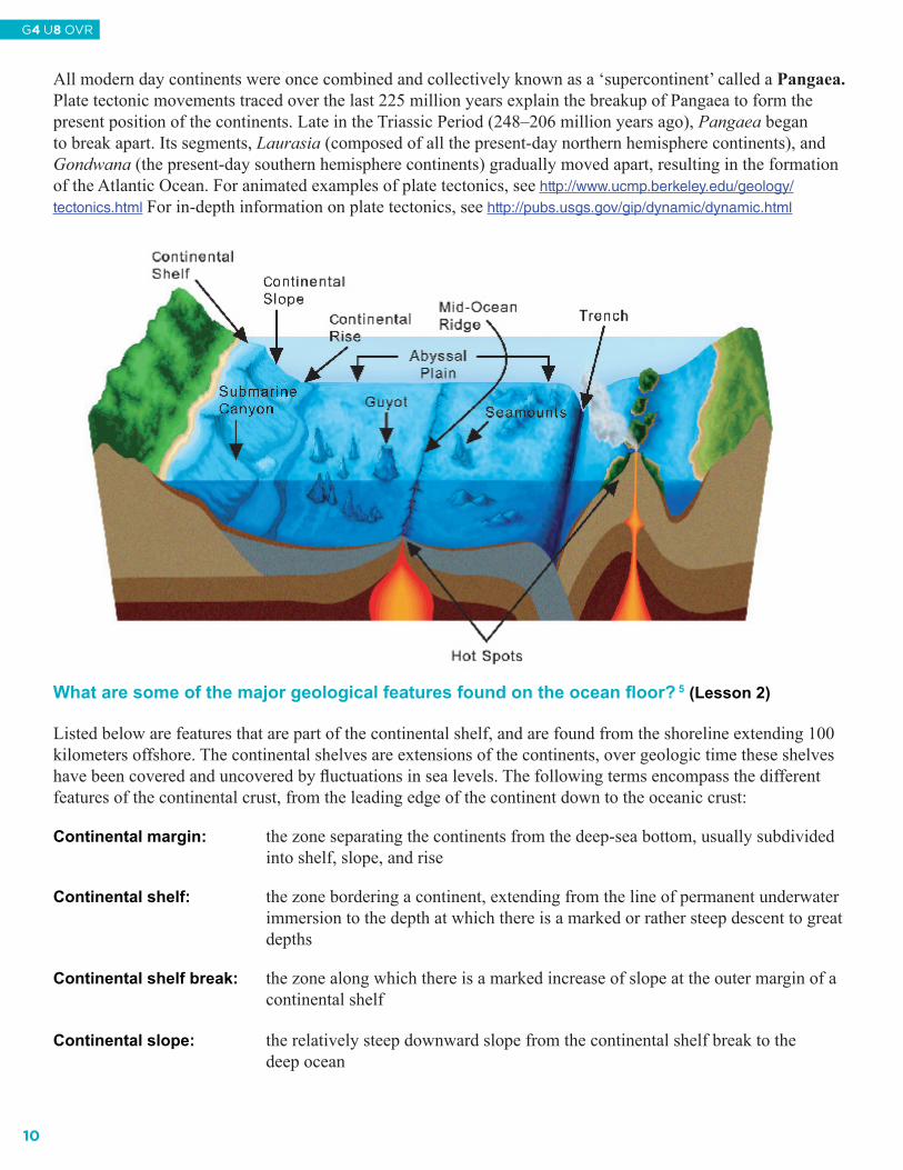
All modern day continents were once combined and collectively known as a ‘supercontinent’ called a Pangaea. Plate tectonic movements traced over the last 225 million years explain the breakup of Pangaea to form the present position of the continents. Late in the Triassic Period (248–206 million years ago), Pangaea began to break apart. Its segments, Laurasia (composed of all the present-day northern hemisphere continents), and Gondwana (the present-day southern hemisphere continents) gradually moved apart, resulting in the formation of the Atlantic Ocean. For animated examples of plate tectonics, see http://www.ucmp.berkeley.edu/geology/tectonics.html For in-depth information on plate tectonics, see http://pubs.usgs.gov/gip/dynamic/dynamic.html
What are some of the major geological features found on the ocean floor? 5 (Lesson 2)
Listed below are features that are part of the continental shelf, and are found from the shoreline extending 100 kilometers offshore. The continental shelves are extensions of the continents, over geologic time these shelves have been covered and uncovered by fluctuations in sea levels. The following terms encompass the different features of the continental crust, from the leading edge of the continent down to the oceanic crust: Continental margin: the zone separating the continents from the deep-sea bottom, usually subdivided
into shelf, slope, and rise
Continental shelf: the zone bordering a continent, extending from the line of permanent underwater immersion to the depth at which there is a marked or rather steep descent to great depths
Continental shelf break: the zone along which there is a marked increase of slope at the outer margin of a
continental shelf
Continental slope: the relatively steep downward slope from the continental shelf break to the deep ocean
8
G4
U8
L2
Lesson 2 Features of the Ocean Floor - Page 1
10
G4 U8 OVR

Continental rise: long, broad elevation that rises gently and generally smoothly from the seafloor
The deep ocean, including the ocean floor, can be characterized as the abyss, or the great depths of the oceanbelow 13,000 feet (4,000 meters). Little is known about this vast expanse of the ocean bottom where the followingfeatures are found:
Abyssal hills: low, rounded submarine hills which rise less than 1,000 meters off the ocean floor Abyssal plain: the flat, ocean basin floor extending seaward from the base of the continental
slope and continental rise
Guyot: (gee-oh) submerged, flat-topped seamount
Seamount: isolated volcanic peak that rises at least 1,000 meters from the seafloor
For more information on features of the ocean floor, see http://www.msstate.edu/dept/geosciences/CT/TIG/WEBSITES/RESEARCH/Christine_Oxenford/index.html
What is a hot spot, and how did the Hawaiian Islands form? 6 (Lessons 1 and 2)
Scattered around the Earth are approximately 40 usually fixed areas of isolated volcanic activity known as hot spots. They are found under continents and the ocean, in the center of plates, and at mid-ocean ridges. These hot spots periodically channel hot material to the surface from deep within the mantle. At these sites, mantle material may force its way through the lithosphere and form a seamount directly above. Hot spots may also re-supply the asthenosphere, which is constantly cooling and becoming attached to the base of the lithosphere.
As a crustal plate moves over a hot spot due to plate tectonics, successive and usually non-explosive eruptions can produce a linear series of peaks, islands, or seamounts. The youngest peak is above the hot spot and seamounts increase in age as the distance from the hot spot increases. In the islands and seamounts of the Hawaiian Archipelago, the Big Island of Hawai‘i , with its active and currently erupting volcanoes, is presently over the hot spot and is the youngest island in the chain. The newest volcanic seamount in this series is Lō‘ihi, lying 45 kilometers (28 miles) east of the Big Island’s southernmost tip, rising more than 2,450 meters (8,000 feet) above the sea floor and 969 meters (3,178 feet) below the surface. Currently, Lō‘ihi is taller than Mount St. Helens when measured from the sea floor.
The entire Hawaiian Archipelago begins at Lō‘ihi and continues for another 2,400 kilometers to the northwest, ending at Kure Atoll. The eight main islands of Hawai‘i , include the Big Island of Hawai‘i , Maui, Kaho‘olawe, Lāna‘i, Moloka‘i, O‘ahu, Kaua‘i, and Ni‘ihau. After Ni‘ihau lie the Northwestern Hawaiian Islands, where the volcanic peaks that were once above sea level as high islands have since eroded and subsided over millions of years to become small pinnacles, atolls, and seamounts. At Kure Atoll, the chain bends in a more northerly direction, indicating that the Pacific plate began moving more westward 40–50 million years ago. In this region are completely submerged seamounts that comprise the Emperor Seamount Chain. Subsidence of these seamounts occurs when the plate under the seamount moves away from the bulge of the hot spot and into the Aleutian Trench off Alaska. This movement, accompanied by the weight of the seamounts, leads to the depression of the mantle below the seamounts. For more information on hot spots and the formation of the Hawaiian Islands, see http://pubs.usgs.gov/gip/dynamic/hotspots.html. This site connects hot spot formation to Hawaiian legends as well.
11
G4 U8 OVR

Science Background for the Teacher Glossaryabyss: pertaining to the great depths of the ocean greater than 13,000 feet (4,000 meters).archipelago: a large group or chain of islands.asthenosphere: upper, deformable portion of the Earth’s mantle that lies below the lithosphere and extends approximately 700 meters below the surface; probably partially molten; convection currents present in this layer drive plate tectonics.continental crust: the solid masses of the continents; composed primarily of granite.continental drift: motion of the continents due to plate tectonics.convection cells: a concept in plate tectonics that accounts for the lateral or the upward and downward movement of sub-crustal mantle material due to temperature variations within the Earth. This concept also applies to weather.currents: the regular movement of ocean water in a usually continuous direction.density: the volume-to-mass ratio of a liquid.hot spots: localized plumes of volcanism. island: a land mass, especially one smaller than a continent, entirely surrounded by water.lithosphere: outer, rigid portion of the Earth; includes the continental and oceanic crust and the upper part of the mantle.mantle: main volume of the Earth between the crust and the core; increases in pressure and temperature with depth.mid-ocean ridges: oceanic mountain ranges where Earth’s tectonic plates are gradually moving apart.ocean: the entire connected body of seawater that covers approximately 70 percent of the Earth’s surface.oceanic crust: a thick mass of basalt rock which lies under the ocean floor. oceanic trenches: long, narrow depressions of the ocean floor where Earth’s tectonic plates meet and where the denser plate sinks beneath the less dense in the process called subduction. The subducting plate sinks back into the mantle.Pangaea: hypothetical proto-continent proposed by Alfred Wegener in 1912 as part of his theory of continental drift. Pangaea (from the Greek: pangaia, all Earth) supposedly covered about half the Earth and was completely surrounded by a world ocean called Panthalassa.plate tectonics: geologic theory that combines the concepts of seafloor spreading and continental drift to explain the large-scale movement of the Earth’s crust.rift zones, also called spreading zones: regions where the lithosphere splits, separates, and is forced apart as new mantle material moves into the crack or rift.salinity: a measure of total dissolved salts in water.sea: a relatively large body of salt water completely or partially enclosed by land.seafloor spreading: the process that describes how new ocean floor is created by volcanic activity at the mid-ocean ridges’ rift zones; upwelling mantle pushs the existing seafloor away from the rift zones. spreading centers: axes of oceanic rises and ridges where new geologic material is formed in the process of seafloor spreading.subduction zones: regions where portions of the Earth’s tectonic plates are sinking beneath other plates, into the Earth’s interior. subsidence: lowering or sinking of a portion of the Earth’s crust.tectonic plates: the dozen or so plates that make up the surface of the Earth. Their motion is studied in the field of plate tectonics. temperature: is the measure of the average kinetic energy (energy of motion) of the molecules that make up a substance.thermohaline circulation: the density-driven circulation of the ocean due to differences in temperature and salinity of different water masses.
12
G4 U8 OVR

Science Background for the Teacher-Bibliography
1: BBC. (2007). Major world oceans-facts and fi gures. Retrieved April 5, 2007, from http://www.bbc.co.uk/nature/blueplanet/blue/world_oceans.shtml
Duxbury, A. B., & Duxbury, A. C. (1999). Fundamentals of Oceanography (3rd Edition). N.Y.:McGraw-Hill Companies, Inc.
Offi ce of Naval Research (n.d.). Ocean Regions: Blue water characteristics. Retrieved April 5, 2007, from http://www.onr.navy.mil/Focus/ocean/regions/bluewater1.htm2: Duxbury, A. B., & Duxbury, A. C. Duxbury (1999). Fundamentals of Oceanography (3rd
Edition). N.Y.:McGraw-Hill Companies, Inc. Malahof, A. (March 23, 2007). HURL organization and history. Retrieved April 5, 2007, from
http://www.soest.Hawaii .edu/HURL/3: Duxbury, A. B., & Duxbury, A. C. Duxbury (1999). Fundamentals of Oceanography (3rd
Edition). N.Y.:McGraw-Hill Companies, Inc. IHO. (2007). The international hydrographic organization. Retrieved April 5, 2007, from http://www.iho.
shom.fr/4: Gardiner,L. (February 26, 2007). Plate tectonics. Retrieved April 5, 2007, from
http://www.windows.ucar.edu/tour/link=/Earth/interior/plate_tectonics.html Kious, J. W., & Tilling, R. I. (February 1996). This dynamic Earth. Retrieved April 5, 2007,
from http://pubs.usgs.gov/gip/dynamic/dynamic.html UC Berkeley. (1997). Geology: Plate tectonics. Retrieved April 5, 2007, from
http://www.ucmp.berkeley.edu/geology/tectonics.html5: Duxbury, A. B., & Duxbury, A. C. Duxbury (1999). Fundamentals of Oceanography (3rd
Edition). N.Y.:McGraw-Hill Companies, Inc. Gupta, S., & Williams, R. (July 1997). General characteristics of the world’s oceans. Retrieved
April 4, 2007, from, http://icp.giss.nasa.gov/research/ppa/1997/oceanchars/Oxenford, C. (July 26, 2003). The ocean fl oor. Retrieved April 5, 2007, from http://www.msstate.edu/dept/geosciences/CT/TIG/WEBSITES/RESEARCH/Christine_Oxenford/index.html
6: Gupta, S., & Williams, R. (July 1997). General characteristics of the world’s oceans. Retrieved April 4, 2007, from, http://icp.giss.nasa.gov/research/ppa/1997/oceanchars/ Watson, J. M. (1999) Hotspots: Mantle thermal plumes. Retrieved April 5, 2007, from
http://pubs.usgs.gov/gip/dynamic/hotspots.html
13
G4 U8 OVR

NOAA ResourcesBelow is a list of resources compiled by the Outreach Education Office of the National Oceanic and Atmospheric Administration. The science standards and the ocean literacy principles addressed in this unit were used as a guideline in selecting the following resources. To access the print resources listed below, contact NOAA’s Outreach Education Office directly:
Outreach Unit NOAAOfficeofPublicandConstituentAffairs 1305EastWestHighway#1W514 SilverSpring,MD20910 Phone:(301)713-1208 Email:[email protected]
http://www.education.noaa.gov/
Resources:
• “Surface of the Earth” poster from NOAA NGDC: www.ngdc.noaa.gov/mgg/fliers/00mgg05.html
• Crustage Poster: http://www.ngdc.noaa.gov/mgg/image/crustageposter.jpg
• “From Sea to Shining Sea: Exploring America’s Ocean Realms” map made in collaboration with National Geographic Society www.mcbi.org/shining_sea/shining_sea.htm
• Oceans for Life lesson plans and videos found on http://oceanslive.org include geography standards
Multiple videos featuring topics from subduction to seamounts. http://oceanexplorer.noaa.gov/edu/learning/welcome.html
Information on sea floor mapping: http://www.ngdc.noaa.gov/mgg/bathymetry/multibeam.html
• Oceans for Life lesson Hawaiian Hot Spots about undersea volcanic studies (grades 6–8, but can be adapted).
• Oceans for Life lesson Natural Disasters about undersea plate tectonics (grades 6–8, but can be adapted).
• Ocean Explorer lesson Mystery of Alaskan Seamounts – good for compare and contrast (grades 9–12), from: http://www.oceanexplorer.noaa.gov/explorations/02Hawaii /background/education/media/nwhi_lessons.html
• Ocean Explorer lesson What’s the Difference? – volcanic processes at convergent and divergent tectonic plate boundaries, from:http://oceanexplorer.noaa.gov/explorations/05fire/background/edu/media/rof05_difference.pdf
• NWHI (Papahanaumokuakea) lesson Life of an Island for grades 4–6, which teaches about the evolution of a volcanic island from origin to erosion, from:http://www.Hawaii atolls.org/teachers/lesson_life_of_an_island.php
• Ocean Explorer lesson Islands, Reefs, and a Hot Spot for grades 5–6 about the eight stages in the formation of the island in the Hawaiian archipelago, from:http://www.oceanexplorer.noaa.gov/explorations/02Hawai‘i /background/education/media/nwhi_hot.pdf
• Ocean Explorer lesson Hawaiian Bowl! for grades 7–8 about plate tectonics in the Hawaiian archipelago, from:http://www.oceanexplorer.noaa.gov/explorations/02Hawaii /background/education/media/nwhi_hot.pdf
• Ocean Explorer lesson Roots of the Hawaiian Hot Spot for grades 9–12 on plate tectonics and volcanism, from:http://www.oceanexplorer.noaa.gov/explorations/02Hawaii /background/education/media/nwhi_roots.pdf
14
G4 U8 OVR

OCEAN LITERACY ESSENTIAL PRINCIPLES
1. The Earth has one big ocean with many features. 1a. The ocean is the dominant physical feature on our planet Earth- covering approximately 70% of the planet’s surface. There is one ocean with many ocean basins, such as the North Pacifi c, South Pacifi c, North Atlantic, South Atlantic, Indian and Arctic. 1b. An ocean basin’s size, shape and features (islands, trenches, mid-ocean ridges, rift valleys vary due to the movement of the Earth’s lithospheric plates. Earth’s highest peaks, deepest valleys and fl attest vast plains are all in the ocean.
2. The ocean and life in the ocean shape the features of the Earth. 2a. Many Earth materials and geochemical cycles originate in the ocean. Many of the sedimentary rocks now exposed on land were formed in the ocean. Ocean life laid down the vast volume of siliceous and carbonate rocks. 2c. Erosion- the wearing away of rock, soil and other biotic and abiotic Earth materials- occurs in coastal areas as wind, waves, and currents in rivers and the ocean move sediments. 2e. Tectonic activity, sea level changes, and force of waves infl uence the physical structure and landforms of the coast.
7. The ocean is largely unexplored 7d. New technologies, sensors and tools are expanding our ability to explore the ocean. Ocean scientists are relying more and more on satellites, drifters, buoys, subsea observatories and unmanned submersibles.
Lesson 1: 1a. 1b. Lesson 2: 1a.1b. 2a. 7d. Lesson 3: 1a. 1b. 2a. 2c. 2e. Culminating: 1a. 1b. 2a.
CLIMATE LITERACY ESSENTIAL PRINCIPLESThere is no appropriate alignment of Climate Literacy Essential Principles to the unit lessons.
15
G4 U8 OVR

Glossary of Cooperative Learning TechniquesIn an effort to maximize student engagement and learning, the NOAA Sea Earth and Atmosphere curricular resources were designed using cooperative learning techniques. This guide defines the expectations for implementation of each technique.
What is Cooperative Learning?Cooperative learning may be broadly defined as any classroom learning situation in which students of all levels of performance work together in structured groups toward a shared or common goal. According to Johnson, Johnson and Holubc, (1994): “Cooperative learning is the instructional use of small groups through which students work together to maximize their own and each other’s learning.” In classrooms where collaboration is practiced, students pursue learning in groups of varying size: negotiating, initiating, planning and evaluating together. Rather than working as individuals in competition with every other individual in the classroom, students are given the responsibility of creating a learning community where all students participate in significant and meaningful ways. Cooperative learning requires that students work together to achieve goals which they could not achieve individually.
JigsawTo Jigsaw materials refers to the use of a strategy in which each student on a team receives only a piece of the material that is to be learned in which that student becomes the “expert.” Once the material is learned each member of the team takes a turn teaching the other members their assigned content. This type of dynamic makes the students rely on the other members of their team to learn all of the material.
Think-Pair-Share This four-step discussion strategy incorporates wait time and aspects of cooperative learning. Students (and teachers) learn to LISTEN while a question is posed, THINK (without raising hands) of a response, PAIR with a neighbor to discuss responses, and SHARE their responses with the whole class. Time limits and transition cues help the discussion move smoothly. Students are able to rehearse responses mentally and verbally, and all students have an opportunity to talk.
Numbered HeadsThis structure is useful for quickly reviewing objective material in a fun way. The students in each team are numbered (each team might have 4 students numbered 1, 2, 3, 4). Students coach each other on material to be mastered. Teachers pose a question and call a number. Only the students with that number are eligible to answer and earn points for their team, building both individual accountability and positive interdependence.
16
G4 U8 OVR

KWL Chart A pre-assessment tool consisting of three vertical columns. Students list what they “Know” about a topic. What they “Want” to know about a topic. The last column students share what they have “Learned” about a topic.
KWL CHARTBesuretobulletyourlist.
Usecontentwordsonly(nouns,verbs,namesofpeopleandplaces,dates,numbers,etc.).
WHAT DO I KNOW?WHAT DO I WANT
TO KNOW? or
WHAT DO I WANT TO SOLVE?
WHAT HAVE I
LEARNED?
• •
Role CardsAssign students to cooperative learning groups. Once students are in their groups the teacher will hand out premade role cards that will help each member of the group contribute to the completion of the given task. Before roles are assigned, the teacher should explain and model the task as well as the individual roles for students so that they know and understand how his/her individual role will contribute to the success of the group completing the task. When this technique is used, taking on a different role will aid in student proficiency.
Example of role cards:
Role Card #1
Facilitator:
Makes certain that everyone contributes and keeps the group on task.
Role Card #3
Reporter:
Shares summary of group with large group. Speaks for the group, not just a personal view.
Role Card #2
Recorder:
Keeps notes on important thoughts expressed in the group. Writes final summary.
Role Card #4
Materials Manager:
Picks up, distributes, collects, turns in, or puts away materials. Manages materials in the group during work.
Role Card #6
Checker:
Checks for accuracy and clarity of thinking during discussions. May also check written work and keeps track of group point scores.
Role Card #5
Time Keeper:
Keeps track of time and reminds groups how much time is left.
17
G4 U8 OVR

Round Table
Round table can be used for brainstorming, reviewing, or practicing while also serving as a team builder. Students sit in teams of 3 or more, with one piece of paper and one pencil. The teacher asks a question which has multiple answers. Students take turns writing one answer on the paper, then passing the paper and pencil clockwise to the next person. When time is called, teams with the most correct answers are recognized. Teams reflect on their strategies and consider ways they could improve.
Three-Step Interview This involves structured group activity with students. Using interviews/listening techniques that have been modeled; one student interviews another about an announced topic. Once time is up, students switch roles as interviewer and interviewee. Pairs then join to form groups of four. Students take turns introducing their pair partners and sharing what the pair partners had to say. This structure can be used as a team builder, and also for opinion questions, predicting, evaluation, sharing book reports, etc.
Venn Diagram A diagram using circles to represent sets, with the position and overlap of the circles comparing and contrasting the relationships between two given pieces of information. Ramona
girl
skis
walks to school
classmates
like pizza
live in a house
play together
boy
swims
rides bus to school
Nguyen
18
G4 U8 OVR