from landscape archaeology to social archaeology....
TRANSCRIPT
117
1 Introduction
In 2003, the German Federal Research Foundation granted a large research program dealing with the “Fürstensitze.” Under the title Early Centralization and Urbanization. Formation and Development of “Early Celtic Fürstensitze” and their Territorial Surrounding, several projects began in spring 2004 and will continue until 2010, hoping to find answers to the questions of the “Fürstensitz” phe-nomenon. The project “Comparative Analysis of the Early Celtic ‘Princely Sites’ (“Fürstensitze”) and their Environs with the help of GIS”—or for short, “‘Princely sites’ and Environs”—aims to analyze different types of settlements and graves in their natural environments. We want to con-nect the sites from the Late Bronze Age (Urnfield period) to the end of the Early Iron Age (Early Latène) with aspects of their natural environment as part of their area of economic and cultural activities. On the one hand, we hope to find patterns that will allow us to recognize different types of settlements with different economic and/or cultural back-grounds. On the other hand, we want to compare the sites and their patterns of preference for special environmental factors, diachronic and interregional, to show the ways of development as well as regional tendencies.
Another aim of the GIS project is the investigation of territories, hypothetical paths of communication, and traf-fic routes, which we will explore with the help of views-hed and least-cost path analyses. The first should also help in detailed research of special problems, such as the vis-ibility of singular sites, landmarks (i.e., the intervisibility of the “princely settlements,” and the grave mounds prob-ably associated with them), or astronomic fixed points that can give us a hint of how prehistoric people conceptualized their surroundings and what they perceived as important in environment.
1.1 Celtic “Princely Sites”
During the Early Iron Age—in the middle of the first mil-lennium BC—large areas of Europe north of the Alps were inhabited by Protoceltic or Celtic societies. In southern German Bavaria, Baden-Württemberg, Rhineland-Palatine and Hesse, in Bohemia, Austria, Switzerland, Western France, and more, we find relicts of these people in settle-ments and in graveyards with grave mounds. Also during this period, we can see a change in the society; for example, in the occurrence of a special kind of settlement: fortified hill forts, often placed above rivers and near very large, out-standing grave mounds. Finds of Italian vessels or Greek pottery like amphorae and bowls reflect contact of the Protocelts north of the Alps with the so-called advanced civilizations in the Mediterranean south.
There is a long-lasting discussion in European, and espe-cially German, archaeology about the role of these hill forts, which have been named “Fürstensitze”—“princely sites” (e.g., Fischer 1973; Eggert 1991; Pare 1991; Veit 2000). In 1969, Wolfgang Kimmig published his definition of what he thought was a Fürstensitz. One aspect is the fortification, and another is the position on a prominent hill site. There should be Mediterranean imported goods, and, last but not least, there should be large grave mounds with extraor-dinary finds of the nobility who lived at the Fürstensitz nearby. Kimmig and his disciples not only gave a definition of the term Fürstensitze, they also tried to interpret this kind of settlements as central places, inhabited by the reigning nobility, who had the power and the wealth to participate in a system of long-distance contacts to Italy, Greece, and Southern France. In many respects, this image is similar to the system of a mediaeval aristocracy.
From Landscape Archaeology to Social Archaeology. Finding Patterns toExplain the Development of Early Celtic “Princely Sites” in Middle Europe
Axel G. Posluschny
Roman-Germanic CommissionGerman Archaeological Institute
DFG-project “Princely Sites” and EnvironsFrankfurt/M., Germany
Abstract
Granted by the German Research Foundation (DFG), the research project “‘Princely sites’ and Environs” (part of DFG research program SPP1171) investigates the so-called “Fürstensitze” of the Early Iron Age in Middle Europe (http://www.fuerstensitze.de/1121). These sites and their (social) meaning have been the subject of intensive debate by numerous archaeologists. Undoubtedly they are the mani-festation of a change in settlement, social, and cultural behavior between the Late Bronze Age and the beginning of the “Celtic” Iron Age. With the help of Geographic Information Systems (GIS), we connect settlements and burials with aspects of their natural environ-ment. Another aim is the investigation of territories, lines of communication, and landscape perception to provide an indication of how prehistoric peoples realized their surroundings. This paper presents the theoretical and methodological background as well as preliminary results of the first two years of research.

118
1.2 Research Areas
For our investigations, we have selected several Fürstensitze and their surrounding areas of about 50 x 50 km as well as areas with no known Fürstensitz as a comparison. In most cases, the Fürstensitz is in the center of the project area (Figure 1). That does not mean that the central role these
kinds of settlements might have played is a result of or is resulting in a central position of these sites in a landscape that can be seen as a territory. But if the “princely site” is situated in the periphery of the investigated areas, it might become more difficult to find out whether it was usually situ-ated in the center or in the periphery of a landscape that can be described as in some way belonging to this Fürstensitz.
The first area of our research, and the focus of this paper, is the River Main Triangle (Maindreieck) in Lower Franconia, Northern Bavaria with its “princely site” of the Marienberg in the city of Würzburg (Figure 2). The area is dominated by the river Main and its valley with fer-tile loess grounds, and is surrounded by midrange hills to the east and especially to the west.
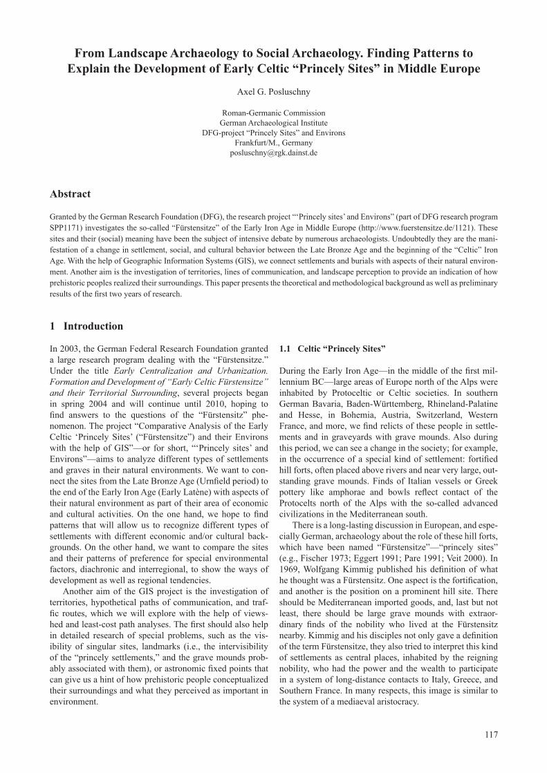
Another area of interest is the Wetterau in southern Hesse, near Frankfurt (Figure 3). Again, it is a region with fertile loess grounds but also with the steep slopes of the Vogelsberg Mountains in the north-east. This area is still agriculturally used; the Roman frontier Limes even made a detour just to incorporate the fertile area.
1.3 Sources of the Investigations
Archaeological Sources. We are collecting information from all set-tlement sites along with graves and graveyards, when they can be dated to one of the following periods:
the Late Bronze Age period (so • called Urnfield culture), dating from about 1200 to 750 BC;the Early Iron Age Hallstatt pe-• riod, being the first Protoceltic culture, dating from about 750 to 450 BC; it is in a late phase of this period that the first of the Fürstensitze emerge;the Early Iron Age Early Latène • period, with its famous pieces of Early Celtic art, dating from 450 to 250 BC; the Fürstensitze usu-ally do not reach the second half of this period.The information is derived
from databases and records of the state agencies for cultural heritage management in Bavaria, Baden-Württemberg, Rhineland-Palatine and Hesse, complemented by the appropriate literature.
Considering the length of the
Figure 1. Areas of research of the project “‘Princely sites’ and Environs.”
Figure 2. The area of the River Main Triangle in Northern Bavaria.
119
investigated periods, we can first ascertain that there is a great difference in the numbers of settlements in the differ-ent areas. While usually in south and southwest Germany we find more settlements of the Hallstatt period, like in the River Main Triangle, the proportion in the Wetterau is the inverse of that situation (Figure 4). That might give us a first hint that there are regional differences not only in the appearance of certain cul-tural phenomena, such as ceramics, fibulae, and others, but also in the dynamics of settlement.
Environmental Sources. Besides the archaeological sources, environ-mental data are basic of the proj-ect. Most of this information can be described as standard data when working with archaeological sites and their environments. The digital elevation model (DEM), from which slope, aspect, morphometric features, and relief intensity can be derived, is based mainly on the DGM50/M745 with its 25 m grid. Additionally, we can use the SRTM 25 m grid for some of our research areas. When investigating least-cost paths of long distances (i.e., across the Alps from northern Italy to southern Germany), the fine details of a 25 m grid are not helpful because, on the one hand, one can imagine that slope differ-ences in an area of 25 or even 100 m might be of no relevance when trav-eling hundreds of kilometers, and on the other hand, it is simply a ques-tion of computer abilities when cal-culating a cost surface model of an area of more than 1,000,000 sq km. To reduce the amount of data, the SRTM DEM with a 90 m grid width was used when calculating large-area cost surface models and least cost pathways.
Important topographic fea-tures are based on the Basis-DLM of the German Federal Office for Cartography and Geodesy (BKG). Working with sites of societies with a mainly agricultural economy, water supply is one of the most important factors of everyday life, but streams can be the basis of a traffic flow, as well. Other information from the Basis-DLM is the distribution of modern forests, traffic ways, and buildings as a filter of site discovery.
Climatic information is also strongly connected to the needs and
possibilities of prehistoric humans. Precipitation plays a key role in farming societies, and can be scrutinized without the help of modern instruments along with phenological dates such as the beginning of apple tree flowering time.
Another important factor for agriculture is the soil
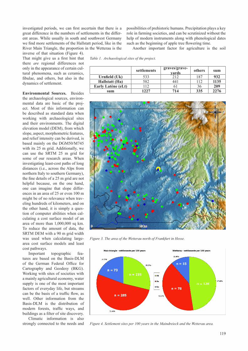
Table 1. Archaeological sites of the project.
settlements graves/grave-yards others sum
Urnfield (Uk) 533 212 187 932Hallstatt (Ha) 582 441 112 1135
Early Latène (eLt) 112 61 36 209sum 1227 714 335 2276
Figure 3. The area of the Wetterau north of Frankfurt in Hesse.
Figure 4. Settlement sites per 100 years in the Maindreieck and the Wetterau area.

120
fertility. Since there are no soil maps of a scale of 1:25,000 (or even more precise) available for all areas of research, we had to find ways to make different kinds of soil information comparable regarding soil fertility for prehistoric societies.
2 Methods and Theories
One main aspect of our work is the methodological and theoretical background. Geographic Information Systems (GIS) in this project are simply used as tools. GIS is not a method in itself; it will not give direct answers but it can help to find and analyze patterns, and it can help to build models, or at least it can transform data into another data type that can be interpreted by the archaeologist.
With experience, GIS becomes simply an exten-sion of one’s own analytical thinking. The system has no inherent answers, only those of the analyst. It is a tool, just like statistics is a tool. It is a tool for thought. ... In many ways, learning GIS involves learning to think—learning to think about patterns, about space and about processes that act in space. (Eastman 2003:20)
The other important prerequisite of our work is the idea that human behavior was influenced among other things by the natural environment and that this behavior—like the decision where to settle—left recognizable and interpreta-ble patterns on the landscape. It is the work of the archaeol-ogist—with the help of GIS—to find patterns and to explain them. “The key point to emphasis is that external factors influenced behaviour, and this behaviour left patterns in space that could be objectively measured and quantified” (Wheatley and Gillings 2002:7).
Prehistoric economy in the Late Bronze and Early Iron Age, as mentioned above, is based mainly on agriculture. Farming and cattle breeding were the basis of survival and also the basis of surplus. The production, processing, and trade of metal and other important goods played an impor-tant role for certain parts of the society. but people were still dependent on agriculture. As a result, we can predict that the choice of at least settlement sites was dependent on, among other things, the suitability of the chosen places for agricultural needs.
At the same time, we cannot expect a mono-cultural adjustment to environmental factors to maximize agricul-tural yields. To be able to react to the dependency on climate and environment, prehistoric settlers would have acted in a way to minimize risks, which means they would have tried to break down into different lines of agricultural production, such as the cultivation of different kinds of crops, the breed-ing of different kinds of animals, and the completion of the diet by hunting and gathering (Eichfeld 2005:91). When speaking about patterns of human behavior in the landscape, this would mean that different aspects of the environment could have played a role in the decision of where to settle, and that the resulting patterns might overlap.
When choosing a site for activities (installation of settle-ments, erection of burial mounds, etc.), other aspects could have been important for prehistoric people, also. Belief,
cult, religion, and personal experiences and perceptions might have had an influence, as well. The problem of the perception of landscapes of prehistoric people is not new and has yet not been solved satisfactory. It is in the nature of post-processual approaches (e.g., Bender et al. 1997) that they have their limits according their unbiased cognitive faculties (Eichfeld 2005; Posluschny 2006). The discrep-ancy between a purely eco-deterministic interpretation of human behavior (where eco is short for economic and for ecologic) and the lack of consideration of personal/private, ritual and cultural motives in the interpretation of human patterns in the landscape (Gaffney and van Leusen 1995) can be solved by the use of GIS.
When detecting patterns of human behavior in the landscape, one will always find departures from these pat-terns. Scrutinizing these deviant occurrences means analyz-ing aspects that are not subject to economic determinism. Recent works have shown the existence of settlement pat-terns dependent on the natural environment as a result of ecological possibilities and economic necessities as well as the unique occurrences that do not fit into the patterns of distribution and interpretation (e.g., Schier 1990; Saile and Zimmermann 1996; Saile 1998; Posluschny 2002; Eichfeld 2005). It is very reasonable to believe that sites with loca-tions that differ significantly from the recognized site loca-tion preferences in a certain area in a certain period, and that cannot be explained by the mere necessities of an agricultural economy, can be interpreted as sites that might have to do with aspects of personal, cultural, or general, non-economic perceptions of landscape in a much stronger way than those sites with a predominant agricultural requirement.
3 Interpretation of Patterns
In order to receive an interpretable image (or pattern) of sites and their preferred factors of natural environment, all sites from the Urnfield to the Early Latène period have been connected to the environmental sources mentioned above. Test of statistical significance (χ2-test and Attwell/Fletcher-test; cf. Posluschny 2002:16 footnote 72–73; Attwell and Fletcher 1987) have been carried out to make sure that all recognized patterns are significant and did not come about by chance.
Comparing observed and expected values can give an idea whether the analyzed environmental data can be described as a relevant locational factor. In this connection the observed value (OV) is the amount of sites in a special environmental area (e.g., percentage of settlement sites on loess soil) whereas the expected value (EV) is the share of that environmental area relative to the whole area of research (e.g., percentage of loess soil in the Wetterau). The simple division of the observed value by the expected value shows if the environmental factor/area was avoided (OV/EV < 1) or preferred (OV/EV > 1); but it does not show anything about the reasons of that behavior.

121
3.1 Sites, Slope, Aspect and the Combination of Patterns
One important factor when choosing a settlement site is slope. The example from the River Main Triangle shows that people in all three periods preferred slightly steep slopes between 2 and 12 % (Figure 5).
Recent research (e.g., Posluschny 2002; Eichfeld 2005) has shown that aspect is a factor that can also play a role when selecting a site to settle. Again in the River Main Triangle, in all periods places fac-ing southwest, southeast, and east are preferred (Figure 6).
But the mere information of pre-ferring or avoiding special environ-mental classes is not information of any archaeological worth; the next step must be the interpretation of the patterns build from this behav-ior. The situation in the River Main Triangle—and in all other regions we are investigating—is character-ized by a heterogeneous landscape with different slopes, aspects, soil types, and so on. Some of these factors apparently had an influ-ence on human behavior, especially related to choosing settlement sites. The patterns that they form are the basis for further investigations and interpretations.
The combination of the slope and aspect patterns (preference for slight slopes, facing to the east, southeast, and southwest) and the knowledge of a prevailing wind from western or northwestern directions give other hints concern-ing the economic determinants of the choice of locations for settle-ments. Prehistoric people knew about their environment and how to deal with it. One way for people to cope with their surroundings was to build their houses in the lee of slight slopes. In this way, the rec-ognized patterns provide a direct reflection of culture (the way how and where to build houses) in the face of surrounding nature.
3.2 Changing Habits—Cattle or Crops?
Another example of a pattern and its interpretation is based on the knowledge that during all periods of interest, there has always been an environment suitable for all
kinds of basic agricultural needs in the River Main Triangle area. We can ascertain a change in the settlement behavior between the Late Bronze Age/beginning of the Early Iron Age and the end of the Early Iron Age. Prehistoric settlers changed their preferences from more humid to more arid (or at least less humid) areas and from more ploughable soils to those that are more suitable for stock farming. This leads to the idea that cattle breeding became more impor-tant than before—while still not dominant over crop farm-ing (cf., Saile and Zimmermann 1996). The role of climatic
Figure 5. Slope preferences in the River Main Triangle.
Figure 6. Aspect preferences in the River Main Triangle.

122
change in that period can still not be judged but it might have been important for human behavior related to chang-ing settlement habits. It is still not clear what that means for the development of the society, for processes of social dif-ferentiation, and so on; we don’t even know whether there is a coherence between the development of environmental preferences and the development of the society in this con-nection. To answer these questions will be one of the main targets of our future work.
3.3 Human Behavior—Economic and Cultural Determinism
Coming back to the question of environmental, economic, ecological, and cultural forces (Gaffney and van Leusen 1995), it really becomes clear that there is—to a certain extent—an economic determinism in human behavior. On the other hand, anything beyond the things we would rec-ognize as economics-based patterns in the landscape has to be interpreted in a different way. A settlement site on a very steep slope, far away from water sources, streams, and fertile ground, is not what we would expect as “normal” human behavior in prehistoric times, where people usually earned their living by agriculture. But there are these sites in “unexpected places” and again it seems very obvious that
their situation can be explained by non-economic, maybe non-environmental causes.
There are a lot of possible motifs to affect human behav-ior beyond economic necessities: religious taboos could have had an influence as could personal experiences; maybe it was not permissible to settle near a holy source, or maybe the village’s chief did not want to live near a place where once his grandmother was bitten by a snake.
Thinking about the questions posed for our project, we can assume that there might be social reasons creating a pattern of sites on a landscape. Connecting these patterns with the well-known archaeological or cultural contexts—in our case with the emergence of the so called “princely sites”—and looking at the development of these patterns can help to understand the contextual background. The question is whether prominent places like the Early Iron Age Fürstensitze had an influence on the site patterns in their area. And, did these patterns change due to the change in social life during those periods?
3.4 Site Distribution
We have seen that there were different proportions of settlements from different periods in the Wetterau and in the River Main Triangle (Figure 4). But what can we see
when comparing the “princely sites” with the settlement dis-tribution? Did the Fürstensitze attract people in a way that they wanted to settle near such a cen-tral place? Or did the inhabitants of the “Glauberg-Fürstensitz” or of the “Marienberg-Fürstensitz” urge or even force the people to settle near their hill forts in order to make their ”subjects” work for them?
One of many ways to calcu-late and visualize densities of point distributions was devel-oped by Andreas Zimmermann and his team from the Cologne University (Zimmermann et al. 2004). Without going further into details, his way of generating iso-lines is based on the principle of the largest empty circle, which means it takes into account the radius of all empty circles with no sites, placed between known sites (Zimmermann et al. 2004:52 Figure 5). The result is a set of different isolines where the value of each line is the radius of the largest empty circle. The 5 km-isoline defines an area in which the radius of the largest empty circle—the circle with no points in between the surrounding
Figure 7. Settlement density in the River Main Triangle.
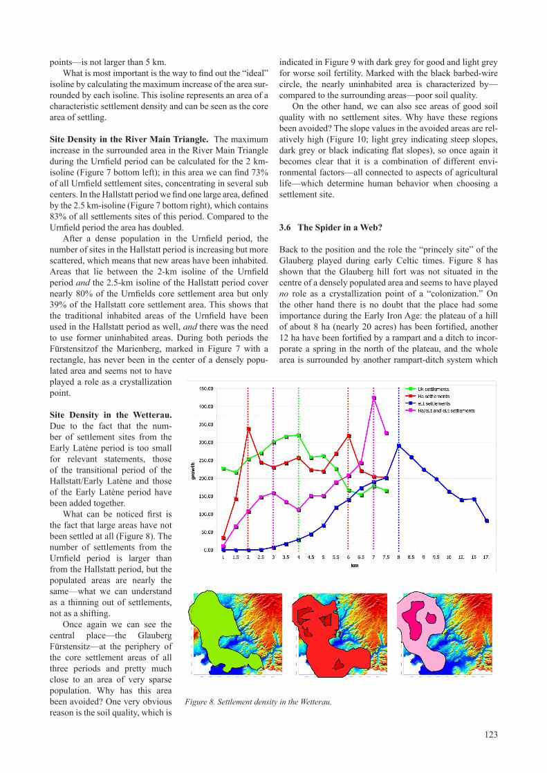
123
points—is not larger than 5 km.What is most important is the way to find out the “ideal”
isoline by calculating the maximum increase of the area sur-rounded by each isoline. This isoline represents an area of a characteristic settlement density and can be seen as the core area of settling.
Site Density in the River Main Triangle. The maximum increase in the surrounded area in the River Main Triangle during the Urnfield period can be calculated for the 2 km-isoline (Figure 7 bottom left); in this area we can find 73% of all Urnfield settlement sites, concentrating in several sub centers. In the Hallstatt period we find one large area, defined by the 2.5 km-isoline (Figure 7 bottom right), which contains 83% of all settlements sites of this period. Compared to the Urnfield period the area has doubled.
After a dense population in the Urnfield period, the number of sites in the Hallstatt period is increasing but more scattered, which means that new areas have been inhabited. Areas that lie between the 2-km isoline of the Urnfield period and the 2.5-km isoline of the Hallstatt period cover nearly 80% of the Urnfields core settlement area but only 39% of the Hallstatt core settlement area. This shows that the traditional inhabited areas of the Urnfield have been used in the Hallstatt period as well, and there was the need to use former uninhabited areas. During both periods the Fürstensitzof the Marienberg, marked in Figure 7 with a rectangle, has never been in the center of a densely popu-lated area and seems not to have played a role as a crystallization point.
Site Density in the Wetterau. Due to the fact that the num-ber of settlement sites from the Early Latène period is too small for relevant statements, those of the transitional period of the Hallstatt/Early Latène and those of the Early Latène period have been added together.
What can be noticed first is the fact that large areas have not been settled at all (Figure 8). The number of settlements from the Urnfield period is larger than from the Hallstatt period, but the populated areas are nearly the same—what we can understand as a thinning out of settlements, not as a shifting.
Once again we can see the central place—the Glauberg Fürstensitz—at the periphery of the core settlement areas of all three periods and pretty much close to an area of very sparse population. Why has this area been avoided? One very obvious reason is the soil quality, which is
indicated in Figure 9 with dark grey for good and light grey for worse soil fertility. Marked with the black barbed-wire circle, the nearly uninhabited area is characterized by—compared to the surrounding areas—poor soil quality.
On the other hand, we can also see areas of good soil quality with no settlement sites. Why have these regions been avoided? The slope values in the avoided areas are rel-atively high (Figure 10; light grey indicating steep slopes, dark grey or black indicating flat slopes), so once again it becomes clear that it is a combination of different envi-ronmental factors—all connected to aspects of agricultural life—which determine human behavior when choosing a settlement site.
3.6 The Spider in a Web?
Back to the position and the role the “princely site” of the Glauberg played during early Celtic times. Figure 8 has shown that the Glauberg hill fort was not situated in the centre of a densely populated area and seems to have played no role as a crystallization point of a “colonization.” On the other hand there is no doubt that the place had some importance during the Early Iron Age: the plateau of a hill of about 8 ha (nearly 20 acres) has been fortified, another 12 ha have been fortified by a rampart and a ditch to incor-porate a spring in the north of the plateau, and the whole area is surrounded by another rampart-ditch system which
Figure 8. Settlement density in the Wetterau.

124
grave mound in the center of another ditch system (Figure 11). During excavations in the 1990s, two cremations in this mound brought excellent and rich finds, like bronze jugs, gold rings, weapons, and four life-sized stone statues of
Celtic warriors, chiefs, or priests, of which one is nearly completely pre-served (Baitinger and Pinsker 2002). But what made this place so impor-tant and some of its occupants rich and wealthy?
Estimated Communication Routes. To find out whether the Glauberg was situated conveniently for suprare-gional connections, the least-cost paths from several areas of distri-bution of a specific kind of pottery that can be found on the Glauberg, in the Hunsrück region and in the low mountain range of Westphalia, Hesse and Thuringia (Figure 12), have been calculated. It is obvious that the Glauberg is part of a transfer region but it is not lying at one of the estimated traffic routes. It seems as if the position to a hypothetic traf-fic or communication system is not the reason for the importance of this place. So still the question remains: what made this place so special?
Astronomical Implications. A ditch system around the big grave mound with its spectacular finds was clearly shown in geophysical surveys. This ditch system is part of the large system of ditches all around the Glauberg hill and especially around the grave mound and was recently called “Prozessionsstrasse” (“pro-cession alley”).
Without going into detail it is clear that all these ditches have special astronomic and math-ematical meaning, with the great “Prozessionsstrasse” aiming at the point of the Southern Major Standstill of the moon’s 18.61-year precession (maximum extreme of the moon set-ting), and other ditches aiming at the dates of the solstices (Deiss unpub-lished; figure 13). This is evidence for the implications of the whole structure as a ritual or holy place with long term calendrical meaning as well as with short-term seasonal meaning. Observations very simi-lar to these can be made at several places on earth like, for instance, the great Hopewell earthworks in Ohio
is only known to a small extent now but covers at least an area of 206 ha or 510 acres (Baitinger and Pinsker 2002; Herrmann 2005).
Part of this fortified or at least demarcated area is a large
Figure 9. Soil quality in the Wetterau.
Figure 10. Slope values in the Wetterau.

125
(Hively and Horn 1984; the align-ment in Newark is aiming to the point of the moon’s Northern Major Standstill).
This does not mean that every “princely site” can be interpreted as a place with a calendar construc-tion and therefore with a ritual back-ground. All the other sites we know have not brought information about these kinds of structures yet. But on the other hand, it becomes clear that the so called Fürstensitz phenom-enon cannot be lumped together—every site has its own history and its own meaning, embedded into the social and cultural history of its era.
4 Future Work
To find out more about the “spatial pattern books of human behavior,” we have to put together more sites with more environmental data so there is still a lot of work to do to get all the archaeological data of all areas of research.
Once having recognized standard patterns, we would like to focus our work on the deviant sites and their meaning, taking into account recon-structed areas of activities for each settlement and incorporating inves-tigations on intra- and supraregional communication lines. Network analyses—together with corre-spondence analyses—are planned to map similarities and differences of the different areas of research. Last but not least, we would like to intensify our methodological back-ground research—for example, by working on the meaning and the possibilities of 3D models and 3D reconstructions.
Acknowledgements
I would like to thank the German Research Foundation (DFG) for granting the project. Much help could be received by the Roman-Germanic Commission and the Central Department of the German Archaeological Institute. Most of the topographic data (DGM50/M745, Basis-DLM) was made available by the German Federal Office for
Figure 11. The ditch and rampart system around the grave mounds on the southeastern flankoftheGlaubergintheWetterau.
Figure 12. Estimated least cost paths from the Hunsrück region (lower left) to the low moun-tain ranges of Westphalia, Hesse and Thuringia (upper right). The Glauberg is marked with a black square.

126
Baitinger, Holger and Pinsker, Bernhard, eds. 2002. Das Rätsel der Kelten vom Glauberg. Ausstellungskatalog Frankfurt am Main. Stuttgart: Theiss.
Bender, Barbara, Hamilton, Sue, and Tilley, Christopher. 1997. Leskernick: Stone Worlds; Alternative Narratives; Nested Landscapes. Proceedings of the Prehistoric Society 63:147-178.
Eastman, J. Ronald. 2003. IDRISI Kilimanjaro. Guide to GIS and Image Processing. Worcester/MA: Clark Labs.
Eggert, Manfred. K. H. 1991. Prestigegüter und Sozialstrukturen in der Späthallstattzeit: Eine kulturanthro-pologische Perspektive. Saeculum 42:1-28
Eichfeld, Ingo. 2005. Die vorrömische Eisenzeit im Landkreis Rotenburg (Wümme). Eine landschaftsarchäolo-Eine landschaftsarchäolo-gische Untersuchung mit Hilfe von GIS. Archäologische Berichte des Landkreises Rotenburg (Wümme) 12. Oldenburg.
Cartography and Geodesy (BKG), additional DEM data (SRTM25) by the German Aerospace Centre (DLF). Archaeological data came from the Baden-Württemberg, Hessian and Bavarian State Offices for Cultural Heritage Management as well as from Jana E. Fries and Doris Mischka who made the digital lists of sites of their PhD theses available for my work.
Bruno Deiss supported us with his investigations on the archaeoastronomical background of the Glauberg ditch structures. My warmest thanks go to Andreas Zimmermann, K. Peter Wendt and Thomas Frank from the University of Cologne (Institute for Pre- and Protohistory) for discus-sions, help and advices. Last but not least I would like to thank Marco Allendorf for his hardworking and eager commitment in the process of data aggregation and data improvement.
References Cited
Attwell, M. R. and Fletcher, M. 1987. An analytical tech-nique for investigating spatial relationship. Journal of Archaeological Science 14:1-11.
Figure13.The“processionalley”fromthegravemoundsonthesoutheasternflankoftheGlaubergintheWet-terau, aiming to the point of the Southern Moon Standstill.

127
Posluschny, Axel. 2006. Erkenntnisse auf Knopfdruck? GIS und PC in der Kulturlandschaftsforschung. Siedlungsforschung 24. Bonn: ARKUM e. V. pp. 289-312.
Saile, Thomas. 1998. Untersuchungen zur ur- und früh-geschichtlichen Besiedlung der nördlichen Wetterau. Materialien zur Vor- und Frühgeschichte von Hessen 21. Wiesbaden: Landesdenkmalamt Hessen.
Saile, Thomas and Zimmermann, Andreas. 1996. Cattle or Crops. Applications of GIS in Central Germany. In, Theoretical and Methodological Problems. XIII International Congress of Prehistoric and Protohistoric Science U.I.S.P.P. Forlì (Italia) September 8–14 1996. Colloquium II, The Present state of GIS applications and analogous systems in prehistoric archaeology, A. Bietti, A. Cazzella, I. Johnson, and A. Voorrips, eds., pp. 149-158. Forlì, Italy: USIPP.
Schier, Wolfram. 1990. Die vorgeschichtliche Besiedlung im südlichen Maindreieck. Materialhefte zur Bayerischen Vorgeschichte A 60. Kallmünz/Opf.: Verlag Michael Lassleben.
Veit, Ulrich. 2000. König und Hohepriester? Zur These einer sakralen Gründung der Herrschaft in der Hallstattzeit. Archäologisches Korrespondenzblatt 30:549-568.
Wheatley, David and Gillings, Mark. 2002. Spatial tech-nology and archaeology. The archaeological application of GIS. London, New York: Taylor & Francis.
Zimmermann, Andreas, Richter, Jürgen, Frank; Thomas, and Wendt, Karl Peter. 2004. Landschaftsarchäologie II – Überlegungen zu Prinzipien einer Landschaftsarchäologie. Berichte der Römisch-Germanischen Kommission 85:37-95.
Fischer, Franz. 1973. Keimelia. Bemerkungen zur Kulturgeschichtlichen Interpretation des sogenannten Südimports in der späten Hallstatt- und frühen Latènekultur des westlichen Mitteleuropa. Germania 51:436-459.
Fries, Jana E. 2005. Die Hallstattzeit im Nördlinger Ries. Materialhefte zur Bayerischen Vorgeschichte A 88. Kallmünz/Opf.: Verlag Michael Lassleben.
Gaffney, Vincent and van Leusen, Martijn. 1995. Postscript–GIS, environmental determinism and archaeology: a paral-lel text. In, Archaeology and Geographical Information Systems: A European Perspective. G. Lock and Z. Stančič, eds., pp. 367-382. London: Taylor & Francis.
Herrmann, Fritz-Rudolf. 2005. Glauberg – Olympia des Nordens oder unvollendete Stadtgründung? In, Frühkeltische Fürstensitze. Älteste Städte und Herrschaftszentren nördlich der Alpen? Archäologische Informationen aus Baden-Württemberg 51. J. Biel and D. Krausse, eds., pp. 18-27. Stuttgart: Landesdenkmalamt Baden-Württemberg.
Hively, R. and Horn, R. 1984. Hopewellian geometry and astronomy at High Bank. Archaeoastronomy 7:85-100.
Kimmig, Wolfgang. 1969. Zum Problem späthallstättischer Adelssitze. In, Siedlung, Burg und Stadt. Studien zu ihren Anfängen. K.-H. Otto and J. Herrmann, eds., pp. 95-113. Festschrift P. Grimm. Berlin.
Pare, Christopher F. E. 1991. “Fürstengräber,” Celts and the Mediterranean world: Developments in the West Hallstatt culture in the sixth and fifth centuries BC. Proceedings of the Prehistoric Society 57:183-202.
Posluschny, Axel 2002. Die hallstattzeitliche Besiedlung im Maindreieck. GIS-gestützte Fundstellenanalysen. Oxford: BAR International Series 1077. (Additional with differ-ent page numbering: http://archiv.ub.uni-marburg.de/diss/z2002/0092/ (Accessed 20 June 2006)).