from kashgar to xanadu in the travels of marco polo
TRANSCRIPT
HAL Id: hal-02563026https://hal.archives-ouvertes.fr/hal-02563026
Preprint submitted on 5 May 2020
HAL is a multi-disciplinary open accessarchive for the deposit and dissemination of sci-entific research documents, whether they are pub-lished or not. The documents may come fromteaching and research institutions in France orabroad, or from public or private research centers.
L’archive ouverte pluridisciplinaire HAL, estdestinée au dépôt et à la diffusion de documentsscientifiques de niveau recherche, publiés ou non,émanant des établissements d’enseignement et derecherche français ou étrangers, des laboratoirespublics ou privés.
From Kashgar to Xanadu in the Travels of Marco PoloAmelia Carolina Sparavigna
To cite this version:Amelia Carolina Sparavigna. From Kashgar to Xanadu in the Travels of Marco Polo. 2020. �hal-02563026�
From Kashgar to Xanadu in the Travels of Marco Polo
Amelia Carolina Sparavigna
Politecnico di Torino
Uploaded 21 April 2020 on Zenodo DOI: 10.5281/zenodo.3759380
Abstract: In two previous papers (Philica, 2017, Articles 1097 and 1100), we investigated the travels
of Marco Polo, using Google Earth and Wikimapia. We reconstructed the Polo’s travel from Beijing to
Xanadu and from Sheberghan to Kashgar. Here we continue the analysis of this travel from today
Kashgar to Xanadu.
Keywords: Satellite Images, Google Earth, Wikimapia, Marco Polo, Taklamakan, Southwest Xinjiang, Lop
Desert, Xanadu, Marco Polo, China.
The Travels of Marco Polo is a 13th-century book writen by Rustchello da Pisa, reportng the stories
told by Marco to Rustchello while they were in prison together in Genoa. This book is describing the
several travels through Asia of Polo and the period that he spent at the court of Kublai Khan [1]. We can
read Polo’s words in the English version given by the Scotsh orientalist Sir Henry Yule (1820–1889), at
web site htpss::en.wikisource.org:wiki:The_Travels_of_Marco_Polo . In [2], some concerns are
discussed about authentcity and veracity of the travels described in Rustchello's book, however many
contents that we can fnd in it are giving an “ultmately overwhelming probability of the broad
authentcity" of the travels of Marco Polo [3].
As told in [4], an approach useful to demonstrate that Polo actually travelled from Venice to Beijing and
visited the court of Kublai Kahn is that of verifying the accuracy of the itneraries described in the book.
For this purpose, we can use Google Earth and Wikimapia. In [4], we studied the road to Xanadu, the
Summer Capital of Kublai Khan, from Beijing, the Winter Capital of the Yuan empire. The results were so
good to encourage further analyses of the travels of Marco Polo. In [5], we analysed the travel from
Sapurgan, today Sheberghan in Afghanistan, to Cascar, the oasis city of Kashgar in Xinjiang. In
partcular, we proposed a possible way for crossing the Pamir mountains, afer Polo’s words and the
roads, rivers and lakes displayed by Google Earth. In [5], we told that "in a forthcoming artcle, we will
show the itnerary from Kashgar to Xanadu, the Summer Capital of Kublai Khan. It seems that Marco
Polo moved towards this capital when he lef the Taklamakan desert".
Thanks to Google Earth and Wikimapia, we can try to perform this task. Let us read Polo's words in [1],
and contnue the travel from Kashgar to Xanadu. We propose a possible itnerary; its rule is to follow
water and trading routes, besides the names of the places given by Polo of course. Let us note that
from Calacian to Tenduc, Polo is giving poor informaton, therefore some possible places are guessed.

Here in the following, the screenshots of the itnerary that I prepared in 2017 are given, with the aim
of helping and stmulatng further studies on the subject.
Figure 1: From Cascar to Ciarcian (names of places are given as in [1] too).
Figure 2: From Ciarcian to the Lop Desert.
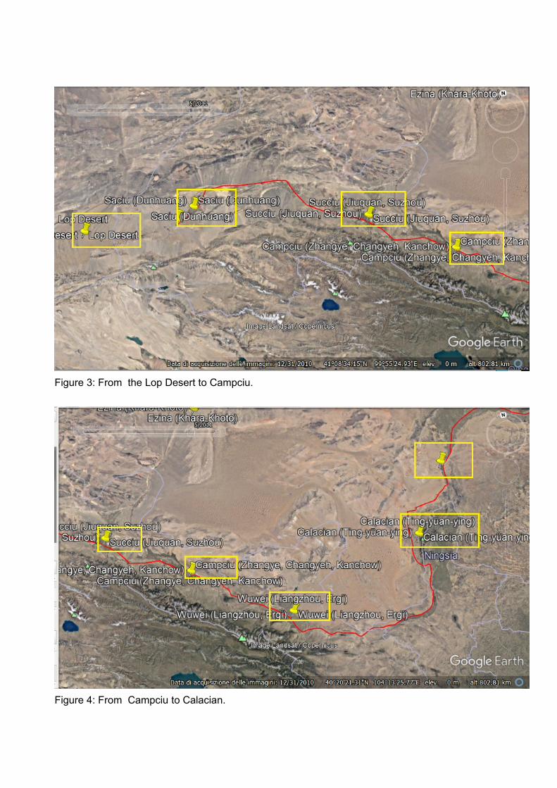
Figure 3: From the Lop Desert to Campciu.
Figure 4: From Campciu to Calacian.
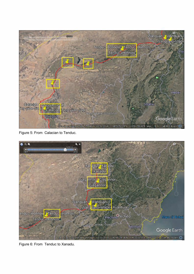
Figure 5: From Calacian to Tenduc.
Figure 6: From Tenduc to Xanadu.

Figure 7: Detail of the road from Sindaciu to Xanadu, made by means of the fundamental help of Google
Earth and Wikimapia.
In the travel to reach Xanadu, Marco Polo followed a branch of the Silk Road. The Silk Road consisted
of several routes. From the ancient commercial centers of China, the overland intercontinental Silk Road
divided into northern and southern routes bypassing the Taklimakan Desert and Lop Nur.
http://en.wikipedia.org/wiki/Silk_Road . Polo used the southern route. The travel from Kashgar to
Ciarcian is quite clear, because is it fixed by the local environment. Some references can help us in
finding the places on the maps from the travel from Ciarcian to Xanadu. Of course, first of all, there are
the words written by Rustichello [1], about the route to reach the palace of Giandu, that is Xanadu.
Ciarcian is the modern Qiemo, or Qarqan in Uighur. Qiemo is a county in the Xinjiang Uyghur
Autonomous Region of the People's Republic of China, bordering the Tibet Autonomous Region to the
south. The county seat is at Qiemo Town. en.wikipedia.org/wiki/Qiemo_County
Stephen Haw tells, in his book [6], that Ciarcian or Qiemo is on the Charchan River. “Below Qiemo, the
course of this river turns to run roughly east-north-east for a considerable distance. The bed is often dry
from a short distance beyond Qiemo, but there would usually be water below the surface of the land.
This would make it reasonably easy to follow the river valley until it finally loses itself in the desert” [6].
In the book [6], "Marco Polo's China: A Venetian in the Realm of Khubilai Khan", Stephen Haw re-
examines Marco Polo's book, arguing convincingly that he did indeed go to China. The book concludes
that Marco Polo's work is an accurate, important and useful source for an extraordinary period of
Chinese history.
Then, let us use Google Maps, and there we can see clearly the river, connecting Charchan to
Loubuzhuang. After Ciarcian, Polo is mentioning Lop. "Lop is Lob or Luobuzhuang, which still exists
north of modern Ruoqiang (Charklikh), more or less exactly where the course of the Charchan River
becomes indistinct. It stands near the south-eastern limit of the Taklimakan Desert, where it become
possible to cross the Tarim Basin from South to north by following the valleys of the Charchan and
Tarim Rivers", as told in [6].
"It was recorded that the Buddhist monk Xuanzang passed through a town called Na-Fu-Bo on his way
home to China in 645 CE, and Marco Polo in the 13th century passed through a place he called the
town of Lop, and both of these were suggested by Aurel Stein to be Charklik. Stein indicated that there
is "conclusive evidence" that Charklik was already the chief centre of the region when Xuanzang passed
through the town". From item on the Kingdom of Charklik en.wikipedia.org/wiki/Kingdom_of_Charklik .
Rustichello tells that "va una città ch'à nome Sachion, che è a lo Grande Cane. La provincia si chiama
Tangut; La terra è tra levante e greco. Quegli dagl'idoli ànno per loro speziale favella; no sono
mercatanti, ma vivono di terra". Saciu (Sachiu, Sachion) is Shazhou, now Dunhuang in the far north-
west of Gansu province. "The old town was on the western side of the modern one. Remains of its
walls, made of compacted earth, can still be seen today. The name Shazhou was applied to the town
and the district is governed early in the seventh century, under the Tang Dynasty. After about the middle
of the eight century, it came under Tibetan control. Later, it formed part of the Gansu Uighur state and
then of the Xi Xia kngdom. It was officially named Shazhou again in 1277 and become the seat of a lu
three years later. Marco notes that there were many Buddhist temples and monasteries there.
Dunhuang is famour today for the Mogao cave-temples near the town. Tangut is Xi Xia". From [6]. After
Saciu, Polo found Succiu, which is SUCHOW, Suzhou, now Jiuquan. Formerly, 'Su' was pronounced
'Suk' or 'Siuk' [6].
About Ca(n)picion (Campiciu, Campciu in Tangut, KANCHOW, 38.9342,100.4520, ZHANGYE), we
have information from [7], "Marco Polo's Asia", by Leonardo Olschki, University of California Press,
1960. "Canpicion è una cittade ch'è in Ta(n)gut, e è molto nobile e grande; e è capo della provincia di
Tangut. La ge(n)te sono idoli, e àvi di quelli ch'adorano Malcomet, e èvi cristiani; e èvi in quella città tre
chiese grandi e belle. ... Or ci partiamo di qui, e conteremovi d'altre verso tramontana. E sí vi dico che
messer Niccolò e messer Mafeo e messer Marco dimorarono uno anno per loro fatti in questa terra. Ora
anderemo 60 giornate verso tramontana". Polo arrived to Sindaciu.
Tenduc and Sindaciu. Tenduc is a province (Tanduc, near TOQTO, KWEIHWACHENG, 40.810556,
111.65222). About these places we find information in [8] and in the notes given by the Henry Yule
translation, https://en.wikisource.org/wiki/The_Travels_of_Marco_Polo . SINDATUI (Sindacui, Sindatury,
Sindacin, Saindatus, Sindatur, Sindincin, ZHANGJIAKOU may be). SINDACHU (Sindacui,
Suidatui, etc., of the MSS.) is SIUEN-HWA-FU, "called under the Kin Dynasty Siuen-te-chau, more than
once besieged and taken by Chinghiz. It is said to have been a summer residence of the later Mongol
Emperors, and fine parks full of grand trees remain on the western side. It is still a large town and the
capital of department or Fu, about 25 miles south of the Gate on the Great Wall at Chang Kia Kau,
which the Mongols and Russians call Kalgan. There is still a manufacture of felt and woollen articles
here".
The city called by Polo Ciagannor (Chagannour, meaning in Mongol "White Lake”) "is the Chaghan
Balghasun mentioned by Timkowski as an old city of the Mongol era, the ruined rampart of which he
passed about 30 miles north of the Great Wall at Kalgan, and some 55 miles from Siuen-hwa, adjoining
the Imperial pastures. It stands near a lake still called Chaghan–Nor, and is called by the Chinese Pe-
ching-tzu, or White City, a translation of Chaghan Balghasun. Dr. Bushell says of one of the lakes (Ichi–
Nor), a few miles east of Chaghan–Nor: “We ... found the water black with waterfowl, which rose in
dense flocks, and filled the air with discordant noises. Swans, geese, and ducks predominated,
and three different species of cranes were distinguished” (from Yule's book).
About this town we read in [9], in a IUB Lectures, Meetingd and Conferences, entitled "The Chaghan
Naghur Palace and Yuan Royal Falconing", by Baohai Dang. "Chaghan Na’ur (Mongolian name for
White Lake) Palace was an important imperial residence of Khubilai Khan and other emperors of the
Yuan Dynasty. Its site, Xiao Hong Cheng, lies on the steppe of Guyuan County, Hebei Province, on the
way between Khanbaliq (Dadu) and Xanadu (Shangdu). Chaghan Na’ur Palace was developed from
temporary traveling ordo (royal yurts) into a permanent royal town in the reign of Khubilai Khan. It was
presumably called the Royal Town of Asigh Dabusu. In the 1980s, the palaces and Buddhist temples
built there were found in an archaeological investigation. Falconry was the most popular hunting form for
ancient Mongol nobles. Because of the excellent environment, Chaghan Na’ur and the surrounding
areas became the biggest falconry ground of the Yuan emperors. Thousands of falconers were
organized to provide service for Yuan royal falconry". Since the Chaghan Na’ur falconry was vividly
narrated in The Travels of Marco Polo, Ref.9 is analysing the related description given by Polo.
"Xiao Hong Chang, which has been identifies as Chaghan Na’ur, is located in a vast meadow near the
Shandian he River in Guyuan xian. A large salt lake called Hulun Naoer (i.e. Hulan Na’ur, Red Lake) lies
south-west of the ruins and can be identified with the lake of Chahgan Na’ur. A summer palace called
Jingming gong had been constructed by the Jin dynasty nearby (in Lianxing). Chinggis and Qubilai
visited it, but it was abandoned for a new construction. According to the archaeological reports by Zheng
Shaozong and Yin Zixian, Xiao Hong Cheng consisted of two walled enclosures side by side. The walls
of the larger enclosure were made of blocks of reddish stone and formed a rectangle of 346 m (north-
south) by 308 m (east-west)". Coordinates 41.743529, 115.758393 [10].
References
[1] Bellonci, M., Rimoaldi, A. M., & Della Valle, V. (2013). Il Milione di Marco Polo. Oscar Mondadori.
[2] Vv. Aa. (2017). Wikipedia. The Travels of Marco Polo. htpss::en.wikipedia.org:wiki:
The_Travels_of_Marco_Polo
[3] Vogel, H. U. (2012). Marco Polo Was in Chinas New Evidence from Currencies, Salts and Revenues,
BRILL.
[4] Sparavigna, A. C. (2017). The road to Xanadu in the Travels of Marco Polo, PHILICA Artcle number
1097, ISSN 1751-3030
[5] Sparavigna, A. C. (2017). From Sheberghan to Kashgar in the Travels of Marco Polo, PHILICA Artcle
number 1100, ISSN 1751-3030
[6] Haw. S. G. (2006). Marco Polo's Chinas A Venetan in the Realm of Khubilai Khan. Routledge.
[7] Leonardo Olschki (1960). Marco Polo's Asia. University of California Press.
[8] René Grousset (1970). The Empire of the Steppes, A History of Central Asia. Rutgers Univ. press.
[9] Baohai Dang. The Chaghan Naghur Palace and Yuan Royal Falconing. IUB Lectures, Meetngs and
Conferences, in the ASC Colloquium.
[10] Drompp, M.R., & DeWeese, D. (2013). Turko-Mongol Rulers, Cites and City Life, BRILL.