freeways as corridors for plant dispersal of the 2013 international conference on ecology and...
TRANSCRIPT
Proceedings of the 2013 International Conference on Ecology and Transportation (ICOET 2013)
FREEWAYS AS CORRIDORS FOR PLANT DISPERSAL:
A CASE STUDY FROM CENTRAL ARIZONA
Kristin J. Gade, Ph.D. (602-712-7649, [email protected]), Biology Team Lead, Environmental Planning Group, Arizona Department of Transportation, 1611 W. Jackson Street, Mail Drop EM02, Phoenix, Arizona, 85007

Gade 2
ABSTRACT
Introduction General ecological thought pertaining to plant biology, conservation, and urban areas has rested on two potentially contradictory underlying assumptions. The first is that non-native plants can spread easily from human developments to “pristine” areas. The second is that native plants cannot disperse through developed area. Both assume anthropogenic changes to ecosystems create conditions that favor non-native plants and hinder native species. However, it is just as likely that conditions in developed habitats will favor certain groups of plant species with similar functional traits, whether native or not.
The function of corridors as conduit for plant movement has long been suggested, but the actual mechanisms at work in the process have only recently begun to be studied. Functional traits of species determine which are the most successful at each of the stages of invasion or range enlargement. I studied the traits that allow both native and non-native plant species to disperse into freeway corridors, germinate, establish, reproduce, and then disperse along those corridors in Phoenix, Arizona.
Methods Sampling sites were selected along freeways throughout the Phoenix metro area, on both gravel-landscaped and non-landscaped road verges. Field methods included measurements of soil nitrogen content, seed bank sample collection and germination, vegetation surveys, and seed trapping.
Results Some uncommon native species were found on the roadsides. More seeds were trapped at the gravel-landscaped sites, which also had greater average daily traffic loads than the non-landscaped sites. The seed bank study showed the opposite pattern, with higher numbers of seeds germinating in the samples from the non-landscaped sites. The majority of the seeds trapped in developed areas had adaptations for wind dispersal; the proportion was much smaller at the desert sites. Near the urbanized area there was little evidence of use of the freeway verges by birds or other animals.
Discussion Currently, plants with weedy traits are the most likely to move along highways in the Arizona desert. The seed trapping data show that wind plays a large role in seed dispersal along the highways in developed areas. While both landscape design and maintenance choices play a large role in determining the initial roadside conditions and species assemblage, it appears that ongoing maintenance regimes and dry nitrogen deposition influence species composition and distribution along highways over the long term.
This study adapted methods to gain insight into the functional traits of plants that are able to survive and potentially migrate along highways. Studying roadside plants using a functional trait approach will allow road ecologists to move toward assessing the ecological roles of design and maintenance practices. Eventually, we may be able to manipulate design and maintenance processes to achieve goals in preventing or promoting migration of different groups of plants along roadways. This could result in benefits ranging from decreasing maintenance costs, to more effectively managing invasive species, and potentially to integrating larger ecological goals, such as promoting migration of species under changing climate conditions, into transportation system planning and maintenance.

Gade 3
INTRODUCTION
The growth of cities, suburbs and associated land uses has long been regarded as an undesirable disturbance by U.S. ecologists. Urban and suburban development is seen as a process of fragmentation, creating urban centers that can also serve as sources of non-native and potentially invasive plants and propagules. The fragmentation associated with developed areas is seen by some as potentially assisting non-native plants in dispersal (Pitelka and the Plant Migration Workshop Group 1997, Vila and Pujadas
2001) while forming a barrier for migration of native plants in response to climate change (Higgins and
Richardson 1999, Higgins et al. 2003). While both of these conditions may hold in particular cases, generalizations about the effect of developed and fragmented habitats on plant migration require further research.
While the importance of corridors for migration of native and non-native plant species is ambiguous, it is clear that more information is needed to determine how corridors may actually function as conduits for plants in developed and fragmented landscapes. Transportation corridors such as roads and freeways provide fairly consistent habitat conditions traversing nearly all human developments, including cropland, suburbs, reserves and cities, and connecting them with undeveloped areas. The combination of the particular conditions along road and freeway verges and the characteristics of the plants that reach these corridors will ultimately determine which species, native or not, will be able to use them to disperse within cities and developed areas, as well as to and from cities and surrounding undeveloped areas.
This project examines the factors determining plant migration along transportation corridors by examining the tradeoffs between groups of traits that affect the ability of plants to migrate. The research is based on stages of plant migration, defined as 1) dispersal to a new location, 2) germination, 3) establishment, 4) reproduction and 5) spread. The characteristics and conditions that allow success at each of these stages vary; a species must pass through all five stages in order to successfully migrate. I focus on freeway corridors in the Phoenix, Arizona metropolitan area. Much of the expected urban development globally in the coming decades is expected to be in arid and semi-arid environments (White et al. 2002), suggesting that these results can be generalized to many other urban and urbanizing areas.
BACKGROUND
Roads, railroads, hedgerows, utility corridors and other linear corridors associated with human development are recognized as important pathways and shortcuts for the dispersal of species, both in terms of biological invasions (Saunders and Hobbs 1991, Spellerberg 1998, Trombulak and Frissell
2000, Forman 2003, Hansen and Clevenger 2005, Rentch et al. 2005) and for conservation purposes (Haddad et al. 2003, Williams et al. 2005, Levey et al. 2005). Corridors may function as preferred habitat and movement conduits for certain species within larger landscapes (Forman 1995, Christen and Matlack 2009). Species dispersal along linear corridors is known for birds (Haas 1995, Meunier et al. 1999a), raptors (Meunier et al. 2000), butterflies (Tewksbury et al. 2002, Haddad and Tewksbury 2005), pathogens (Jules et al. 2002), small mammals (Meunier et al. 1999b, Haddad et al. 2003), and plants, as discussed below.
Non-native plants are often found in the habitat along roads (Frenkel 1970, Ross 1986, Forman 2003,
Hansen and Clevenger 2005, Coffin 2007), railways (Ernst 1998, Hansen and Clevenger 2005, Essl et al.
2009, Penone et al. 2012), trails (Tyser and Worley 1992), pipelines (Zink et al. 1995) and rivers (Planty-
Tabacchi et al. 1996, Parendes and Jones 2000, Levine 2000). Non-native plants may disperse from corridors into adjacent habitat or matrix (Gelbard and Belnap 2003, Hansen and Clevenger 2005). However, roadside verges also can serve as important habitat for rare native species of plants (Tikka et al.
2000, Tikka et al. 2001), endangered mammals (Lookingbill et al. 2010) and marsupials (Martin et al.
2007).

Gade 4
Movement along corridors occurs via differing mechanisms for plants compared with animals as well as for individual species within these groups (Damschen et al. 2008). Plants move preferentially along road corridors due to seed dispersal by birds (Levey et al. 2005), from vehicles (Schmidt 1989, Lonsdale and
Lane 1994, von der Lippe and Kowarik 2007, 2008, Pickering and Mount 2010), as a result of road maintenance activities (Christen and Matlack 2009) and combinations of other methods of dispersal (Ernst 1998, Tikka et al. 2001, Lavoie et al. 2007). More recently, secondary wind dispersal has been shown to increase dispersal of plant seeds (Kowarik and von der Lippe 2011, von der Lippe et al. 2013).
However, the overall effectiveness of dispersal along road corridors is not clear. Studies have had complex or contradictory results on the effectiveness of roadsides for plant migration. In a study comparing the abundance of non-native species along roadside transects to a simple diffusion model of dispersal, Christen and Matlack (2009) found that verges along unpaved roads in deciduous forest sites in southeastern Ohio, USA served mainly as preferred habitat for non-native species. Two species arrived to a few widely separated patches of roadside and then spread only short distances. One of the species (Rosa
multiflora) is dispersed by birds but spread mainly vegetatively. The mode of dispersal for the second (Tussilago farfara) appeared to be via rhizomes and short-range wind dispersal of seeds. A third species, the grass Microstegium vimineum, moved along the road axis and spread into adjacent habitat as a result of dispersal of long-lived seeds by road grading activities and surface water (Christen and Matlack 2009).
Kalwij et al. (2008) examined whether human-inhabited areas serve as propagule sources for non-native plants along road corridors in an arid area in South Africa by examining roadside plant cover of non-native plants at 5 km intervals over 100-km stretches of road. They concluded that urban centers do not serve as the main sources of propagules to corridors; rather, propagules reach verges mainly by short-distance dispersal from diverse sources and directions. Short-distance dispersal along roadsides can be mediated by wind, water, animals, vehicles, maintenance equipment, construction materials, dumped materials and people’s clothing. They suggest that while roadsides serve as habitat for ruderal plants, they do not function as conduits for their movement at the scale evaluated in their study.
Studies of corridor function in the context of conservation biology may be useful for considering whether road corridors may benefit species conservation. Damschen et al. (2006) showed that corridors of intact habitat within a landscape promote species richness at a large scale without increasing the spread of exotic species. A study of railway corridors within an urban area (Penone et al. 2012) found that some functional groups of grassland plants appear to move along the corridors while movement of invasive species did not seem to be favored.
METHODS
Sampling sites were selected along freeways throughout the Phoenix metro area, on both gravel-landscaped and non-landscaped road verges (Figure 1). Field methods included measurements of soil nitrogen content, seed trapping, vegetation surveys, and seed bank sample collection and germination.
Site Selection
Roads and freeways traverse the fragmented urban area of central Arizona connecting it with surrounding undeveloped land (Figure 1). Roadside verges provide fairly consistent habitat conditions across large swaths of land. Within the city, most roadsides are planted with landscape plants with drip irrigation and gravel mulch; outside the city, verges are typically dirt areas that are mowed once or twice a year. I conducted soil sampling at 20 sites across the Phoenix metropolitan area; additional sites were added for seed trapping (Figure 1). Sites were located at least one mile apart with relatively homogeneous land use in the surrounding square mile and no barriers (sound walls, etc.) between the highway and adjacent land.

Gade 5
FIGURE 1 Study sites in Central Arizona.
Site Types
Desert Not landscaped,
adjacent to desert
Cropland Landscaped with
gravel
Fringe Not landscaped,
adjacent to low density use
Urban Landscaped with
gravel, adjacent to higher density use
Kristin J. G
ade
3

Gade 6
Four categories of sites were ultimately selected: cropland and urban, which both had landscaped verges, and fringe and desert, which had non-landscaped verges (Figure 1). A total of 20 primary sites and 4 backup sites were selected, six in each of the four categories. A subset of 12 of the 20 original sites used for soil sampling and vegetation surveys was selected for seed trapping and three additional sites were selected within the center of the freeway system in Phoenix to provide further information on potential seed movement in the most developed portion of the freeway system (Sites 31, 33, and 35 on Figure 1)
At each site, three zones were defined within the highway verge to guide stratified sample collection. The zones were determined in the field based on topography and substrate. Each zone comprised a fairly homogeneous band parallel to the freeway, as shown in Figure 2. All sites had shoulder, approach and embankment zones (Zones A, B, and C, Figure 2). In general, Zone A (shoulder) extended from the edge of the pavement to 2-5m, depending on topography and/or substrate or vegetation changes. Zone B began at 2-5m and extended to a range of 4-36m. Zone C extended from the back of Zone B to the right-of-way fence, which ranged from 8 to 68m from the edge of the pavement. The Zone A transect was located at the pavement edge or as close to it as possible. In a few instances, rocky road base extended beyond the edge of the pavement, precluding collection of soil samples; where that occurred, the initial transect was set where the first samples could be collected. The distance from the beginning of the zone to the transect location within Zones B and C was determined using a random number table in the field. The first random number that fell within the width of the zone was selected.
FIGURE 2. Roadside zones, transect arrangement and sample collection at sites.
Soil Sampling
Soil samples were analyzed to determine resources available to plants in roadside habitats. Soil samples were collected from five locations in each zone (Figure 2). Separate samples were collected from 0-2 cm and 2-12 cm to capture differences in the uppermost soil. The samples were sieved through a 2-mm sieve and composited into a single surface sample and deeper sample for each zone, resulting in 3 surface samples and 3 deeper samples (one per zone) at each of the 20 sites.

Gade 7
The extractable nitrate (NO3), total nitrogen (N)and carbon, organic content, and gravimetric water content of the soil samples were analyzed following methodology developed for the Central Arizona-Phoenix Long-Term Ecological Research (CAP LTER) project (Hope et al. 2005, Zhu et al. 2006).
Seed Trapping
Seed trapping shows seeds that are dispersing to the sites, indicating which may be spreading along the roadway but not necessarily whether they are able to establish and reproduce. A set of five funnel seed traps filled with gravel (Page et al. 2002) were used to trap seeds within Zone A at each of the 15 selected sites. The gravel from the traps was collected 3 times, approximately 6 weeks apart. Each time, the gravel removed for sieving and analysis and new gravel was placed in the funnel. At each sample collection period, several funnels were missing or damaged as a result of being run over by vehicles; missing and damaged funnels were replaced with new ones. For each type of seed, 3-dimensional and overall shape, minimum and maximum dimensions, and dispersal appendages or characters were recorded (Table 1). The total count of seeds of each type was also noted for each sample. Extremely small seeds were defined as those seeds measuring less than 0.5 by 0.5 mm. These seeds are assumed to be wind dispersed despite the lack of additional physical appendages.
TABLE 1 Seed trait categories.
Trait Category Codes Trait Category Character
Dimensions 1 < 0.5 mm Dispersal 1 Plume (Minimum 2 > 0.5 to 1.0 mm Appendages 2 Wing
and 3 > 1.0 to 2.0 mm or 3 Barbed/bur Maximum) 4 > 2.0 to 5.0 mm Characters 4 Hairs
5 > 5.0 mm 5 Stem or spine 6 Sticky
Dispersal Syndrome Characters 7 Extremely small Anemochory 1,2,4,5,7 8 Elaiosome
Barochory 0 9 Fleshy fruit Ectozoochory 3, 6 0 None
Multiple Various
Vegetation Surveys
Vegetation surveys provide a record of plants that were able to establish and in many cases, reproduce, at the sites. Vegetative cover data was collected at the 20 original sites in the spring and fall for three consecutive years. The dates of the surveys varied with precipitation patterns each year; they were timed to occur 3 to 6 weeks after significant rainfall to allow plants to mature enough to facilitate identification. At each site, data were collected in 15 1-m2 quadrats (Figure 2). Percent cover was estimated for each species found in the quadrat, as well as canopy cover and bare ground.
Seed Germination Study
Seed bank samples were collected along with the soil samples to get an idea of the seed fall at each site and to evaluate the potential for germination. A total of 15 seed bank samples were collected at each of the 20 sites (Figure 2). At each site, a 10 cm diameter section of PVC pipe was worked into the soil to a depth of 2 cm and the soil inside of it was scooped out and placed in a labeled paper bag. The samples were stored at room temperature until they were processed as described below.

Gade 8
At the landscaped sites with gravel mulch, pre-emergent herbicides are regularly applied to prevent weed growth. Seed samples from those sites were washed to remove the fine soil particles using a minimum sieve size of 63 µm, contained in coffee filters and allowed to air dry. At a subset of the sites that were not treated with pre-emergent herbicides, double size seed bank samples were collected. These samples were homogenized and split. One half was washed using the same method for the other samples and the other half was planted without washing to determine if there were any effects on seed germination or loss of small seeds from the seed washing process.
The samples were arranged in a randomized complete block design in 8-cell greenhouse trays. A drip watering system was calibrated to deliver equal amounts of water to each tray once a week. To serve as controls for contaminant seeds, 45 “blank” cells containing only the potting soil-sand mix were included in the design.
Functional Traits
The species identified in vegetation surveys and from the seed bank germination study were classified into functional groups based on growth habit, length of life cycle (annual or biennial versus perennial), and seed weight. Shorter life spans and smaller growth habits were equated with ruderal characteristics of rapid growth and reproduction and adaptation to disturbance, as were lower seed weights.
RESULTS
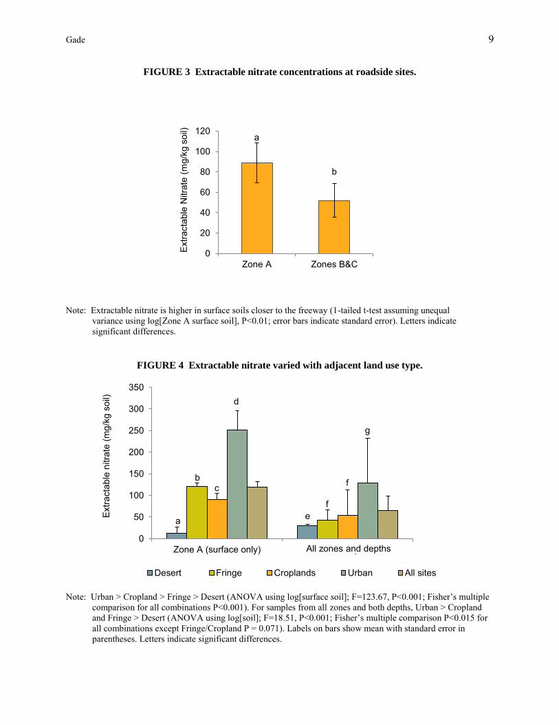
Nitrogen Availability
Extractable NO3 was found in significantly higher concentrations in Zone A surface samples than in Zones B and C (Figure 3). There was also a significant difference between adjacent land use types and extractable soil NO3, with the highest concentrations found in the urban sites, followed by fringe, cropland and desert sites. The difference between each of the land use types was significant for Zone A surface samples and also held for samples from all zones and both depths except that fringe and cropland were grouped together (Figure 4). These relationships were significant for the total N concentrations as well.
Gade 9
FIGURE 3 Extractable nitrate concentrations at roadside sites.
Note: Extractable nitrate is higher in surface soils closer to the freeway (1-tailed t-test assuming unequal
variance using log[Zone A surface soil], P<0.01; error bars indicate standard error). Letters indicate significant differences.
FIGURE 4 Extractable nitrate varied with adjacent land use type.
Note: Urban > Cropland > Fringe > Desert (ANOVA using log[surface soil]; F=123.67, P<0.001; Fisher’s multiple
comparison for all combinations P<0.001). For samples from all zones and both depths, Urban > Cropland and Fringe > Desert (ANOVA using log[soil]; F=18.51, P<0.001; Fisher’s multiple comparison P<0.015 for all combinations except Fringe/Cropland P = 0.071). Labels on bars show mean with standard error in parentheses. Letters indicate significant differences.
0
20
40
60
80
100
120
Zone A Zones B&C
Extra
ctab
le N
itrat
e (m
g/kg
soi
l) b
0
50
100
150
200
250
300
350
Zone A (surface only) All samples
Desert Fringe Croplands Urban All sites
All zones and depths
a
b c
d
e f
f
g
Extra
ctab
le n
itrat
e (m
g/kg
soi
l)
a

Gade 10
Seed Trapping
Figure 5 shows the number of seeds trapped by month and site type. There was a general trend for the number of seeds trapped to decrease over time, with fairly low numbers of seeds recovered from September samples. The largest numbers of seeds were found at the cropland sites, followed by desert and urban sites. Fringe sites had the lowest number of seeds.
FIGURE 5 Seeds recovered by site type and month.
A summary of dispersal syndromes by site type and month is presented in Figure 6. The traits used to define each dispersal syndrome are shown in Table 1. Wind dispersed seeds (anemochory) were defined as extremely small seeds and those with physical appendages that assist in catching the wind. Animal dispersed seeds were defined as those that were sticky or had barbs, spines, or hooks that could attach externally to animals (ectozoochory), including humans and their equipment or vehicles. Barochory (dispersal by gravity alone) and anemochory were the main dispersal syndromes found, with the two combined accounting for over 66% of the seed types at all sites and sampling periods. The desert sites had significantly more ectozoochorous seed types than the other sites (12-16% vs. 0-9%) and fewer anemochorous seed types (16-27% vs. 20-64%). The fringe and cropland sites had over 55% anemochorous seed types in May and July while the urban sites averaged 45% and the desert sites 22%.
0
5
10
15
20
25
30
May July September
DesertFringeCroplandUrban
Mea
n N
umbe
r of S
eeds
per
Site
(c
onte
nts
of 2
funn
el tr
aps)

Gade 11
FIGURE 6 Percent seed dispersal syndromes by month and adjacent land use type.
Desert Fringe Cropland Urban
May
July
Dispersal Syndromes
Vegetation Surveys
Of the 133 plants identified to species in the surveys and seed bank study, 66 (49.6%) were annuals or biennials. Of those, 51 (77%) had a 1000-seed weight under 2.0 grams (including grasses), 11 (17%) were annual or biennials with 1000-seed weight of 2 or more grams, and 4 (6%) did not have seed weight data. There were 16 species (12%) that could have either annual or perennial life spans. Overall, 16 species were grasses (12%), 81 were herbs or forbs (61%), 31 were shrubs or subshrubs (23%), and 10 (7.5%) were trees. The results of principal coordinates analysis (PCoA) using presence/absence in the vegetation surveys by site are shown in Figure 7.
Two unexpected species were found during vegetation surveys. A fairly rare species of spiderling known only from southeastern Arizona, Boerhavia pterocarpa, was discovered growing along with two other Boerhavia species at Site 11 adjacent to desert land. A South African iceplant sometimes used in landscaping, Mesembryanthemum nodiflorum, was identified at Site 17, a desert site south of Phoenix during all three spring surveys but did not emerge in the seed bank study.
Wind (including
vehicle-related) Animal (external) Wind and animal Other

Gade 12
FIGURE 7 Principal coordinates analysis of sites by species detected in vegetation surveys.
Note: Numbers indicate sites; Site 9 dot is behind the square for Site 13 in the center bottom of the figure. The
analysis used the Jaccard similarity index for binary data with c=2, resulting in 3 major eigenvalues. Eigenvalue 1 explained 15.6% of the total variance; eigenvalue 2 explained 13.3% of the total variance.
Seed Germination Study
The results of a PCoA using presence/absence in the seed bank germination study by site are shown in Figure 8. The desert and fringe sites had generally similar species groupings in the seed bank, while the cropland and urban sites were less similar based on the Jaccard similarity index. Figure 8 includes the results from the split washed samples that were used as a control to test for an effect on species detected from washing the samples. No systematic impact on the germination results was apparent from washing the samples.
Analysis of variance showed that there was a significant difference between sites with different adjacent cover types. There were many more germinating seeds in the samples from the non-landscaped sites (adjacent to desert and fringe land use types) than in the landscaped sites (adjacent to urban and cropland). The percent of samples with germinating seeds was also much higher for the non-landscaped sites. Among the samples from different zones, Zone B had the highest number of different species germinating across all the sites. The percent of samples with seed germination increased with distance from the pavement, with the highest rate in Zone C (70% of samples) and slightly lower rates in Zone B (67% of samples).
123
45
6
7
8
910
11
12
13
15
16
17
18
1920
23
-0.4 -0.3 -0.2 -0.1 0 0.1 0.2 0.3Coordinate 1
-0.2
-0.1
0
0.1
0.2
0.3
0.4C
oord
inat
e 2
Desert
Fringe
Urban
Cropland

Gade 13
FIGURE 8 Principal coordinates analysis of sites by species detected in seed bank germination.
Note: The analysis used the Jaccard similarity index for binary data with c=2, resulting in 3 major eigenvalues. Eigenvalue 1 explained 13.9% of the total variance; eigenvalue 2 explained 12.8% and eigenvalue 3 explained 11.3%. Ovals indicate 95% confidence areas.
DISCUSSION
Nitrogen Availability
The patterns of higher available NO3 and in Zone A, closest to the pavement edge suggest that significant N deposition is occurring adjacent to freeways. The greater concentrations of available NO3 in the top 2 cm of soil and Zones A and B, closer to the pavement edge, is likely a result of direct N deposition from fossil fuel combustion and from inputs of road surface runoff that contains N washed from the road surface. The decreasing concentrations of available NO3 in each of the zones is similar to patterns of exponential decreases in gas concentrations measured in other freeway locations, including Los Angeles (Rodes and Holland 1981), Texas (Clements et al. 2009), and along motorways in Scotland (Cape et al.
2004).
Seed Trapping
The dominance of anemochorous and barochorous seeds in the urban, cropland and fringe sites supports the hypothesis that wind and possibly vehicle- related dispersal are the most important mechanisms for seed dispersal along highways in urban areas.
Seed dispersal syndrome proportions at the desert sites suggest that animals are playing a larger role in determining the plant community composition in those sites than in the other site types investigated. The relatively less important role of anemochorous seed types and higher proportion of ectozoochorous seed types found at the desert sites indicate that those sites are likely being used by more wildlife than the sites
Desert
Fringe
Urban Cropland
Analysis of Variance: Site type x species Wilks’ λ= 0.5169
F = 1.437 df = 162 p<0.001
-2 -1.6 -1.2 -0.8 -0.4 0 0.4 0.8 1.2 1.6Coordinate 1
-2
-1.6
-1.2
-0.8
-0.4
0
0.4
0.8
1.2
1.6C
oord
inat
e 2

Gade 14
in the urban areas. In the desert sites, wildlife use may be an important source of plant diversity on the roadside, in that the presence of wildlife likely influences the overall mix of species at the sites.
Based on the low percentage of ectozoochorous seeds at the non-desert sites and the lack of wildlife sightings at the sites, there does not appear to be significant use of the roadside by animals in the urban areas. The common pattern at the cropland, fringe and urban sites could be influenced by a few different factors. The number of vehicles passing by the roadside may have a relationship with the number of seeds caught in the funnel. The freeways are cleaned by street sweepers on a biweekly schedule which may remove a portion of the available seed rain from the sites. However, it is apparent that seeds are still moving along the verge despite the frequency of street sweeping.
The larger seeds found at sites were generally attributable to local landscape plants; when Acacia sp. and Simmondsia chinensis seeds were found in seed traps, mature individuals of those plants had been noted nearby. There was no indication of long distance dispersal of large seeds (none were found at sites without a potential local source). Many of these larger seeds from landscape plants were often visible on the gravel mulch at the urban and cropland sites, lending more evidence that there are few animals using the roadside in the landscaped sites.
Wind dispersal appears to be the main mechanism for seed movement along highway corridors in developed areas. It is likely that vehicles and street sweeping also play a role in seed dispersal, but that will require additional investigation. Although birds and wildlife are known to use road corridors in some conditions, it does not appear that there is much animal activity along the highway roadsides in the Phoenix metro area. Plants that are adapted to wind dispersal, either with specialized seed appendages or just small seeds, are the most likely to be able to move along the roadsides.
Vegetation Surveys and Seed Germination Study
The main site differences appear to be influenced by site history, management regime and propagule pools. Landscaped sites have lower overall plant cover, species diversity, percent native species and seed bank germination. Use of pre-emergent herbicides and gravel mulch to discourage volunteer plants plays a large role in the pattern.
The seed bank germination study supported the finding that plants with smaller seeds are more likely to successfully navigate urban freeway corridors. The majority of the species that germinated from seed bank samples had 1000 seed weights under 2 grams. The larger seeds that germinated were Tribulus
terrestris, a noxious weed known as puncturevine. The seeds of this species have large spines that allow them to attach to tires, shoes, and other vectors to move along the roadway.
The differences between species found during the vegetation surveys and in the seed bank samples points to one of the hurdles that many species may have trouble overcoming in the desert roadside environment: establishment. Eragrostis lehmanniana was found in the seed bank at several sites but was able to establish at only three. Many Sonoran Desert plants, particularly annuals, are known to successfully establish only every few years when the correct combination of environmental conditions occur. The species that will be most likely to establish along roadsides will vary with the distance from the pavement. Closest to the roadside, levels of available nitrate and disturbance are both very high; creating conditions that will favor species with ruderal tendencies. Plants with fewer requirements for breaking seed dormancy, especially flexibility with regard to high levels of light availability and warmer temperatures than in typical conditions, will have an advantage in roadside environments.

Gade 15
SUMMARY
The most diverse assemblages of roadside plants were found at sites located adjacent to desert and fringe land use. These sites are not landscaped or managed as intensively as the landscaped verges adjacent to urban and cropland land use. The seed bank germination study showed that the contents of the seed bank are different in the landscaped and non-landscaped sites and there is variation depending on distance from the pavement. Analysis of the vegetation survey results in conjunction with soil nitrate and soil moisture at each site shows that native, non-native and invading species found during the study largely overlap in their affinity for resources. Species in all three groups are able to take advantage of conditions found in roadside habitats. The study results indicate that many ruderal characteristics, such as wind dispersal, small seed size, broad tolerance of germination conditions and fast life cycle appear to confer the most advantage for plant migration along roadways. These characteristics are advantageous for both native and non-native species.
The seed bank germination experiment showed that the contents of the seed bank are different in the landscaped and non-landscaped sites and there is variation in species composition and germination rates depending on distance from the pavement. The majority of the seeds germinating in the experiment were small; empirically, producing small seeds is clearly an advantage in being able to potentially establish along freeway verges. Species producing seeds that last longer in the seedbank and have delayed or variable dormancy times would also have an advantage, but this was not specifically tested in the study.
There is a band of soil with elevated nitrogen concentrations located directly adjacent to the pavement on the freeway verge, likely resulting from nitrogen deposition associated with fossil fuel combustion. The roadside zone immediately adjacent to the pavement edge is also frequently disturbed by vehicles pulling over, while a lower frequency of disturbance occurs in Zone B, located slightly farther away from the road. The study results indicate that many ruderal characteristics, such as small seeds, tolerance of high disturbance conditions and ability to use high levels of available soil nutrients to complete a rapid life cycle (a trait found in many ruderal species) appear to confer the most advantage for plant migration along roadways. These characteristics confer advantages to both native and non-native species.
The current style of highway landscaping and maintenance regime in the Phoenix area (use of gravel mulch and pre-emergent herbicide) appears to be suppressing movement of both native and non-native seeds along urban highway corridors. The gravel mulch effectively traps seeds that disperse to the site, but pre-emergent herbicide prevents most seeds from germinating. Street sweeping is also regularly scheduled, typically on a weekly or twice-weekly basis, along most urban freeways in the Phoenix area due to concerns with particulate matter and air quality. The effect of street sweeping on seed dispersal was considered indirectly, in that street sweeping was occurring during the seed trapping effort for this study. It may play a large role in the determination of the size of seeds that ultimately comprise the seed bank, in that small and wind-dispersed seeds may be blown into the gravel from the turbulence created by the sweeper, while larger seeds that have made it to the pavement are vacuumed up and removed. While both landscape design and maintenance choices play a large role in determining the initial roadside conditions and species assemblage, it appears that ongoing maintenance regimes and dry nitrogen deposition influence species composition and distribution along highways over the long term.
This study adapted methods to gain insight into the functional traits of plants that are able to survive and potentially migrate along highways. Studying roadside plants using a functional trait approach may allow road ecologists to move toward assessing the ecological roles of design and maintenance practices. Eventually, we may be able to manipulate design and maintenance processes to achieve goals in preventing or promoting migration of different groups of plants along roadways. This could result in benefits ranging from decreasing maintenance costs, to more effectively managing invasive species, and

Gade 16
potentially to integrating larger ecological goals, such as promoting migration of species under changing climate conditions, into transportation system planning and maintenance.
ACKNOWLEDGEMENTS
Ann Kinzig, Julie Stromberg, and Nancy Grimm provided invaluable guidance as I developed this research topic. This research was funded by National Science Foundation grants to Arizona State University (ASU): the Integrated Graduate Education Research and Traineeship (IGERT) in Urban Ecology program and the Central Arizona - Phoenix Long-Term Ecological Research (CAP LTER) program (grant numbers BCS-1026865 and DEB-0423704). The Global Institute of Sustainability, School of Life Sciences, Graduate and Professional Students’ Association, Community of Undergraduate Research Scholars, Goldwater Environmental Lab and Vascular Plant Herbarium, all at ASU also supported this research. I would not have pursued the project without the assistance of the Arizona Department of Transportation, particularly Bruce Eilerts and Randy Matas.
BIOGRAPHICAL SKETCH
Kris Gade is the Biology Team Lead in the Environmental Planning Group at the Arizona Department of Transportation. She has over thirteen years of experience as an environmental professional in both environmental planning and ecological risk assessment. Kris holds a B.A. in Environmental Science with a Biology Emphasis from the University of California, Berkeley and a Ph.D. in Biology with a minor in Geography as part of the Urban Ecology fellowship program at Arizona State University. Her research interests include plant movement along roadways and waterways, collaboration in project design and implementation to improve environmental outcomes, and ecosystem-level changes associated with urban development.
REFERENCES
Cape, J.N., Y.S. Tang, N. van Dijk, L. Love, M.A. Sutton, and S.C.F. Palmer. 2004. Concentrations of ammonia and nitrogen dioxide at roadside verges, and their contribution to nitrogen deposition. Environmental Pollution 132: 469-478.
Christen, D.C. and G.R. Matlack. 2009. The habitat and conduit functions of roads in the spread of three invasive plant species. Biological Invasions 11: 453-465.
Clements, A.L., Y.L. Jia, A. Denbleyker, E. McDonald-Buller, M.P. Fraser, D.T. Allen, D.R. Collins, E. Michel, J. Pudota, D. Sullivan, and Y.F. Zhu. 2009. Air pollutant concentrations near three Texas roadways, part II: Chemical characterization and transformation of pollutants. Atmospheric
Environment 43: 4523-4534.
Coffin, A. W. 2007. From roadkill to road ecology: A review of the ecological effects of roads. Journal of
Transport Geography 15: 396-406.
Damschen, E.I., L.A. Brudvig, N.M. Haddad, D.J. Levey, J.L. Orrock, and J.J. Tewksbury. 2008. The movement ecology and dynamics of plant communities in fragmented landscapes. Proceedings of
the National Academy of Sciences of the United States of America 105: 19078-19083.
Damschen, E.I., N.M. Haddad, J.L. Orrock, J.J. Tewksbury, and D.J. Levey. 2006. Corridors increase plant species richness at large scales. Science 313: 1284-1286.
Ernst, W.H.O. 1998. Invasion, dispersal and ecology of the South African neophyte Senecio inaequidens in the Netherlands: From wool alien to railway and road alien. Acta Botanica Neerlandica 47: 131-151.
Gade 17
Essl, F., S. Dullinger, and I. Kleinbauer. 2009. Changes in the spatio-temporal patterns and habitat preferences of Ambrosia artemisifolia during its invasion of Austria. Preslia 81: 119-133.
Forman, R.T.T. 1995. Corridor attributes, roads, and powerlines. Pages 145-176 In Land mosaics: The
ecology of landscapes and regions. Cambridge: Cambridge University Press.
Forman, R.T.T. 2003. Road ecology: Science and solutions. Washington, DC ; London: Island Press.
Frenkel, R.E. 1970. Ruderal vegetation along some California roadsides. Ed H.P Bailey, C.J. Glacken, J.J. Parsons, J.E. Spencer and K. Thompson. University of California Publications in Geography. Berkeley and Los Angeles, California: University of California Press.
Gelbard, J.L. and J. Belnap. 2003. Roads as conduits for exotic plant invasions in a semiarid landscape. Conservation Biology 17: 420-432.
Haas, C.A. 1995. Dispersal and use of corridors by birds in wooded patches on an agricultural landscape. Conservation Biology 9: 845-854.
Haddad, N.M., D.R. Bowne, A. Cunningham, B.J. Danielson, D.J. Levey, S. Sargent, and T. Spira. 2003. Corridor use by diverse taxa. Ecology 84: 609-615.
Haddad, N.M. and J.J. Tewksbury. 2005. Low-quality habitat corridors as movement conduits for two butterfly species. Ecological Applications 15: 250-257.
Hansen, M.J. and A.P. Clevenger. 2005. The influence of disturbance and habitat on the presence of non-native plant species along transport corridors. Biological Conservation 125: 249-259.
Higgins, S.I., S. Lavorel, and E. Revilla. 2003. Estimating plant migration rates under habitat loss and fragmentation. Oikos 101: 354-366.
Higgins, S.I. and D.M. Richardson. 1999. Predicting plant migration rates in a changing world: The role of long-distance dispersal. American Naturalist 153: 464-475.
Hope, D., W.X. Zhu, C. Gries, J. Oleson, J. Kaye, N.B. Grimm, and L. Baker. 2005. Spatial variation in soil inorganic nitrogen across an arid urban ecosystem. Urban Ecosystems 8: 251-273.
Jules, E.S., M.J. Kauffman, W.D. Ritts, and A.L. Carroll. 2002. Spread of an invasive pathogen over a variable landscape: A nonnative root rot on Port Orford cedar. Ecology 83: 3167-3181.
Kalwij, J.M., S.J. Milton, and M.A. McGeoch. 2008. Road verges as invasion corridors? A spatial hierarchical test in an arid ecosystem. Landscape Ecology 23: 439-451.
Kowarik I. and M. von der Lippe. 2011. Secondary wind dispersal enhances long-distance dispersal of an invasive species in urban road corridors. NeoBiota 9: 49-70.
Lavoie, C., Y. Jodoin, and A.G. de Merlis. 2007. How did common ragweed (Ambrosia artemisiifolia l.) spread in Quebec? A historical analysis using herbarium records. Journal of Biogeography 34: 1751-1761.
Levey, D.J., B.M. Bolker, J.J. Tewksbury, S. Sargent, and N.M. Haddad. 2005. Effects of landscape corridors on seed dispersal by birds. Science 309: 146-148.
Levine, J.M. 2000. Species diversity and biological invasions: Relating local process to community pattern. Science 288: 852-854.
Lonsdale, W.M. and A.M. Lane. 1994. Tourist vehicles as vectors of weed seeds in Kakadu National Park, northern Australia. Biological Conservation 69: 277-283.
Lookingbill, T.R., R.H. Gardner, J.R. Ferrari, and C.E. Keller. 2010. Combining a dispersal model with network theory to assess habitat connectivity. Ecological Applications 20: 427-441.

Gade 18
Martin, J.K., K.A. Handasyde, and A.C. Taylor. 2007. Linear roadside remnants: Their influence on den-use, home range and mating system in bobucks (Trichosurus cunninghami). Austral Ecology 32: 686-696.
Meunier, F.D., J. Corbin, C. Verheyden, and P. Jouventin. 1999b. Effects of landscape type and extensive management on use of motorway roadsides by small mammals. Canadian Journal of Zoology-
Revue Canadienne De Zoologie 77: 108-117.
Meunier, F.D., C. Verheyden, and P. Jouventin. 1999a. Bird communities of highway verges: Influence of adjacent habitat and roadside management. Acta Oecologica-International Journal of Ecology 20: 1-13.
Meunier, F.D., C. Verheyden, and P. Jouventin. 2000. Use of roadsides by diurnal raptors in agricultural landscapes. Biological Conservation 92: 291-298.
Page, M.J., L. Newlands, and J. Eales. 2002. Effectiveness of three seed-trap designs. Australian Journal
of Botany 50: 587-594.
Parendes, L.A. and J.A. Jones. 2000. Role of light availability and dispersal in exotic plant invasion along roads and streams in the H. J. Andrews Experimental Forest, Oregon. Conservation Biology 14: 64-75.
Penone, C.; N. Machon; R. Julliard; and I. Le Viol. 2012. Do railway edges provide functional connectivity for plant communities in an urban context? Biological Conservation 148: 126-133.
Pickering, C. and A. Mount. 2010. Do tourists disperse weed seed? A global review of unintentional human-mediated terrestrial seed dispersal on clothing, vehicles and horses. Journal of Sustainable
Tourism 18, no. 2: 239-256.
Pitelka, L.F. and the Plant Migration Workshop Group. 1997. Plant migration and climate change. American Scientist 85: 464-473.
Planty-Tabacchi, A.M., E. Tabacchi, R.J. Naiman, C.M. DeFerrari, and H. Decamps. 1996. Invasibility of species-rich communities in riparian zones. Conservation Biology 10: 598-607.
Rentch, J.S., R.H. Fortney, S.L. Stephenson, H.S. Adams, W.N. Grafton, and J.T. Anderson. 2005. Vegetation-site relationships of roadside plant communities in West Virginia, USA. Journal of
Applied Ecology 42, no. 1: 129-138.
Rodes, C.E. and D.M. Holland. 1981. Variations of NO, NO2 and O3 concentrations downwind of a Los Angeles freeway. Atmospheric Environment 15: 243-250.
Ross, S.M. 1986. Vegetation changes on highway verges in south-east Scotland. Journal of Biogeography 13: 109-113.
Saunders, D.A. and R.J. Hobbs, eds. 1991. Nature conservation 2: The role of corridors. Chipping Norton, Australia: Surrey Beatty.
Schmidt, W. 1989. Plant dispersal by motor cars. Vegetatio 80: 147-152.
Spellerberg, I.F. 1998. Ecological effects of roads and traffic: A literature review. Global Ecology and
Biogeography Letters 7: 317-333.
Tewksbury, J.J., D.J. Levey, N.M. Haddad, S. Sargent, J.L. Orrock, A. Weldon, B.J. Danielson, J. Brinkerhoff, E.I. Damschen, and P. Townsend. 2002. Corridors affect plants, animals, and their interactions in fragmented landscapes. Proceedings of the National Academy of Sciences of the
United States of America 99: 12923-12926.
Tikka, P.M., H. Hogmander, and P.S. Koski. 2001. Road and railway verges serve as dispersal corridors for grassland plants. Landscape Ecology 16: 659-666.

Gade 19
Tikka, P.M., P.S. Koski, R.A. Kivela, and M.T. Kuitunen. 2000. Can grassland plant communities be preserved on road and railway verges? Applied Vegetation Science 3: 25-32.
Trombulak, S.C. and C.A. Frissell. 2000. Review of ecological effects of roads on terrestrial and aquatic communities. Conservation Biology 14: 18-30.
Tyser, R.W. and C.A. Worley. 1992. Alien flora in grasslands adjacent to road and trail corridors in Glacier National Park, Montana. Conservation Biology 6: 253-262.
Vila, M. and J. Pujadas. 2001. Land-use and socio-economic correlates of plant invasions in European and North African countries. Biological Conservation 100: 397-401.
von der Lippe, M. and I. Kowarik. 2007. Long-distance dispersal of plants by vehicles as a driver of plant invasions. Conservation Biology 21, no. 4: 986-996.
von der Lippe, M. and I. Kowarik.. 2008. Do cities export biodiversity? Traffic as dispersal vector across urban-rural gradients. Diversity and Distributions 14: 18-25.
von der Lippe, M., J.M. Bullock, I. Kowarik, T. Knopp, and M. Wichmann. 2013. Human-Mediated Dispersal of Seeds by the Airflow of Vehicles. Plos ONE 8: 1-10.
Williams, P., L. Hannah, S. Andelman, G. Midgley, M. Araujo, G. Hughes, L. Manne, E. Martinez-Meyer, and R. Pearson. 2005. Planning for climate change: Identifying minimum-dispersal corridors for the cape Proteaceae. Conservation Biology 19: 1063-1074.
Zhu, W.X., D. Hope, C. Gries, and N.B. Grimm. 2006. Soil characteristics and the accumulation of inorganic nitrogen in an arid urban ecosystem. Ecosystems 9: 711-724.
Zink, T.A., M.F. Allen, B. Heindl-Tenhunen, and E.B. Allen. 1995. The effect of a disturbance corridor on an ecological reserve. Restoration Ecology 3: 304-310.