four excavations in kilkenny city (1999–2001): …homepage.eircom.net/~kas5/paul stevens maudlin...
TRANSCRIPT
FOUR EXCAVATIONS IN KILKENNY CITY (1999–2001):
SITE REPORTS &
SUPPORTING DOCUMENTATION
PAUL STEVENS
This publication has received support from the Heritage Council under the 2006 Publications Grant Scheme.

EXCAVATION 3: Maudlin Street
Kilkenny
Licence Reference 98E346ext.
By Paul Stevens, Margaret Gowen & Co. Ltd.,
With Contributions by M. McCarthy, C. McCutcheon
October 5, 2000

CONTENTS
1. Introduction
2. Methodology
3. Archaeological Results
4. Conclusions
5. References
Appendix 1: Ceramic Finds Report by Clare McCutcheon
Appendix 2 Ceramic Tobacco Pipe Report by Paul Stevens
Appendix 3: Glass Finds Report by Paul Stevens
Appendix 4: Metal Finds Report by Paul Stevens
Appendix 5: Building Materials Report by Paul Stevens
Appendix 6: Faunal Analysis by Margaret McCarthy
Figures
Figure 1 Site Location
Figure 2 Rocque’s Map of Kilkenny (1758)
Figure 3 6'' Ordnance Survey, 1st Edition (1840)
Figure 4 6'' Ordnance Survey, 3rd Edition (1921)
Figure 5 Site Plan, Level I, Phases I and II
Figure 6 Site Plan, Level II, Phases III and IV
Figure 7 East-facing section, Test Trench 1
Figure 8 West-facing section through Trench A
Figure 9 West-facing section through Trench C
Figure 10 West-facing section through Trench D
Figure 11 Elevation of rear walls C55/C45/C46
Figure 12 Front elevation of stone wallC40
Figure 13 Plan of Flag floor, C5
Plates
Plate 1 Trench A, from southwest, showing ditch C1
Plate 2 Trench A, from northeast, showing cut C99
Plate 3 Trench C, from south, showing C1 and C70
Plate 4 Trench D, from west, showing ditch C1
Plate 5 Wall C70 and Trench 1, from east
Plate 6 Drain C65, cutting C70, from west
Plate 7 Paved floor C5 from the north
Plate 8 Street frontage wall C40
Plate 9 Rear of frontage wall C40, re-excavation

Appendix Plates
Plate 1 Find # 1: thimble fragment
Plate 2 Find # 89:9: belt buckle
Plate 3 Find # 79:7: glazed decorated floor tiles
Plate 4 Find # 89:12: glazed decorated floor tiles

Non Technical Summary
Paul Stevens This reports details the results of an archaeological excavation undertaken in May 2000, in advance of a proposed apartment block development. The site is situated at the western corner of Maudlin Street (N.G.R. 251000/155900), on the northern side, within the medieval suburb of St. John’s on the north bank of the River Nore. The site lies directly on the line of the medieval town ditch for the suburb, close to John’s Gate Outer and St. John’s Priory. An assessment (Stevens 1998, 117–118) and a full building survey of upstanding remains, was carried out between 1998 and 2000. This work revealed the line of the town ditch, that ran east–west across the site, to the north of Maudlin Street and was sealed by later post-medieval occupation and a number of eighteenth-, nineteenth- and early twentieth-century houses and stables. Excavation involved lowering the ground level of surviving archaeology to allow for a buffer of hard core between the preserved lower levels of archaeology and a raft foundation for the development. The proposed car park and turning space, to rear of the site, did not intrude into archaeological levels. Excavation consisted of an area measuring 16.5m east–west by 10m north–south, located in the southwest corner of the site up against the street frontage, was undertaken for the footprint of the development. The location of the medieval ditch was identified, curving across the site and aligned approximately east–west across the excavation area, measuring 6m in width and 1.45m in dept. The ditch contained a number of sandy re-deposited or weathered natural primary fills and dark clays containing medieval pottery, metal artefacts, animal bone and a decorated floor tile. The partially backfilled ditch appeared to have been dry and open for a long period. During the seventeenth century the ditch was backfilled and sealed by a uniform layer of mid-brown clay containing clay pipe, bone and pottery. This may in fact relate to the Cromwellian siege of the city and subsequent partial dismantling of Kilkenny’s defences. The site appeared to have been waste ground for a decade or so after this and was peppered by fourteen medium to large circular or oval rubbish pits, also containing post-medieval assemblages with a few containing later early modern assemblages. Around the early eighteenth century (before 1758), a range of stone built houses and stables were constructed on the street frontage and to the rear or the site. These were adapted and remodelled as a terrace of houses, which remained in use until the late twentieth century when the site was in use as a painters yard, with associated prefabricated sheds.

Four Excavations in Kilkenny Excavation 3: Maudlin Street ______________________________________________________________________________________________ 1 Introduction
This report describes the results of an archaeological excavation in advance of a proposed development at Maudlin Street, Kilkenny. The site was subject to archaeological impact assessment and test trenching in 1998 (Stevens 1998), a Building Survey (Stevens 1999) and revised engineering foundation design (Stevens 2000). The proposed development involves the construction of an apartment block on the site. Excavation was carried by the writer under licence to the Department of Arts, Culture, Gaeltacht and the Islands, and the National Museum of Ireland (Licence Reference 98E0364 extension) from 10 April 2000 to 5 May 2000, on behalf of the developer, Andrew O’Keefe, John Street, Kilkenny. The site is located in the centre of the city on the north bank of the river Nore, within the medieval suburb of St. Johns (S.M.R. Ref. KK019:026), and to the rear of O’Neills public house, No. 60 John Street Upper (Figure 1; N.G.R. 251000/155900). The medieval suburb of St. John’s was created by William de Mareschall as a monastic precinct, by incorporating almost two hectares (five acres) (Bradley 2000, p. 124). The suburb was formed around the priory for the Cannons Regular of St. Augustine (also called the Brethre of the Hospital of St. John), who were originally sited opposite St. Canices Cathedral, near Green’s Bridge, but who moved in 1211 to a site near John’s Bridge, following a grant of the lands by William Marshall (Finn and Murphy 1962, p. 35). The priory then moved to its present location near Michael Street, where the remains of the Blessed Lady Chapel of the priory, c. 1280, survive and have been incorporated into the present Protestant Church, now named St. John’s Church. The priory was suppressed in 1540, and given to the Jesuits Order in 1645, before being taken over by Cromwell in 1650 (Farrelly et al. 1993). The earliest references to defensive walling around the suburb date to the early sixteenth century, with references to a stone and lime wall, and a turret, in 1570 (Thomas 1992). James Bruin rented houses over St. John’s Gate in 1638 (Farrelly et al. 1993). The medieval suburb of St. John’s is also mentioned in Cromwell’s account of the siege of Kilkenny in 1650. The line of the medieval, defensive, suburb town-wall has been discussed in detail by Bradley (1975–6) and Thomas (1992), who speculated on its whereabouts on the basis of Rocque’s map (Figure 2). However, the line of a defensive ditch was located during testing that extended east–west, partly running under Maudlin Street (Stevens 1998) to the small mural tower at No. 89 Maudlin Street, where it turns south. The wall survives along part of the rear property plots of John Street and was located at the rear of No. 68/69 John Street (O’Donovan 1997), and within the Bridge House complex, to the rear of No. 86 (O’Donovan 1998). Maudlin Street runs from John Street to the Dublin Road, along the line of the medieval suburb’s defensive wall and ditch (Bradley 1975; Bradley 1976; Farrelly et al. 1993, p. 14; Thomas, 1992, p. 128). The original outer gate to the suburb was located at the junction of John Street, Michael’s Street and Maudlin Street. (Urban Survey Ref: Map 4c:20). The site was recently in use as a store yard and contained several structures that served as sheds or garages, but were in poor repair. A building survey of the site revealed three, or possibly four, rectangular stables and dwellings of early 18th century date. These were substantially remodelled into a terrace of brick and stone dwellings and, in more recent times, as out buildings, sheds and a workshop. 2. Methodology This excavation covered the footprint of the proposed apartment block, covering 17.5 m in length, along the street frontage, by 10 m in width. Archaeological test trenching was carried out in the area of the car park and turning space, as this was not subject to any below-ground disturbance. A full building survey was also carried out of the post medieval/modern structures on the site prior to demolition. Archaeological excavation involved the initial removal of overburden by hand and re-excavation of Assessment Test Trenches 1 and 2, by hand and mini-digger. Excavation of the site by hand then took place down to the agreed level or natural (if higher), with deeper trenching in places to establish the depth and morphology of the medieval town’s ditch. For simplicity of recording, the site was divided into four areas, 1–4; Areas 1 and 2 were located along the west and east street frontage, and Areas 3 and 4 were to the rear.
Paul Stevens 1 Margaret Gowen & Co. Ltd.

Four Excavations in Kilkenny Excavation 3: Maudlin Street ______________________________________________________________________________________________ 3. Archaeological Results
Archaeological excavation of an area 16.5 m east–west by 10 m north–south, located in the southwest corner of the site, up against the street frontage, was undertaken for the footprint of the development. Five archaeological phases were identified in this program of work, which dated from the mid 13th century to the most recent activity on the site. This is outlined below in stratigraphic order. A full listing of artefacts and analysis of the animal bone is presented in Appendix 1-6. Phase 0: Natural The site is situated on sloping, raised, ground, overlooking the River Nore, to the south of the site, and the opposing bank, which rises sharply and is dominated by Kilkenny Castle. The underlying topography is alluvial sand and gravels. Natural on this site was recorded as C2, C23 and C163 and consisted of pinky-orange riverine sands and gravel, occurring at a height of 46.01–44.81+ m O.D. (Figures 5 and 8–10). Phase I: Medieval (AD 1180–1554) The earliest stratigraphic feature on this site was the medieval defensive ditch for St. John’s suburb, recorded as C1. This was revealed in excavation to be a curvilinear ditch that ran northeast–southwest across the site (Figure 5) and curved to the south and west on either side. The ditch profile was V-shaped, with straight sides and a flat base (where exposed), and measured over 22 m in length, 6 m in width and over 1.24 m in depth, 46.01–45.43 m to 44.81+ m O.D. (Figures 8–10; Plates 1, 3 and 4). The ditch was excavated in a number of places (Trenches A–D) in order to obtain a full cross-section and excavate a portion of the basal fills. However, it was found to contain a number of disparate, truncated, fills, some of which are recorded in more than one trench. The general pattern that emerged was that the ditch was open (and dry) for a long period throughout the early medieval phase of use. The natural gravel into which it was cut was allowed time to weather and silt up the base. Therefore, primary basal fills of the medieval ditch were re-deposited natural sands and gravels. In Areas 1 and 4, the basal fill was C77 (also seen as C63/C94/C164), a dark grey gravel, 0.26–0.17 m in thickness. In Area 3, C124, and in Area 4, C159 represented a bright yellow sand and gravel, measuring 0.75 m in thickness. C134 was a dark, buff sand with gravel and was in Area 3. These basal fills were overlaid by a number of different stony clay and silty clay deposits, representing deliberate in-filling or dumping episodes during the ditches’ use-phase, throughout the medieval period. In Area 1, C88, a grey–brown, sandy clay with stone, overlaid C77 and measured 0.44 m in thickness. In Area 2, C81 was a dark brown clay with occasional small stones, and was overlaid by C93, a light grey, stony, sandy gravel, which, in turn, was sealed by a thin, dark brown clay (C113), C114, a thin layer of light grey gravel, C76, a dark brown clay with small stones, C75, a light yellowish-grey stony sand, C172, a stony sand and C62, stony clay. In Area 3, C80 was a thin layer of clayey, sandy silt over C94 (C77/C63/C164). C162 (also seen as C158 and C179) in Area 4 represented a cobble and gravel fill that was up to 0.26 m in thickness, overlying C164. Phase II: Post-medieval Period (AD 1650–1750) At some stage, possibly during the Cromwellian conquest of the city, the ditch was finally capped with C79/C121, clay containing pottery dating to the mid-seventeenth century, measuring 0.45 m in thickness and containing posthole C137. This was not a uniform layer and was seen throughout the site, largely due to later truncation. Following the formal sealing of the ditch, Phase II effectively represented the use of the site as a waste-ground for the dumping of rubbish in large (sometimes very large) pits (Figure 5). These pits were located across the site and cut into the backfilled ditch and the natural gravels in the former location of the town wall,. which was probably dismantled along with the ditch backfilling after
Paul Stevens 2 Margaret Gowen & Co. Ltd.

Four Excavations in Kilkenny Excavation 3: Maudlin Street ______________________________________________________________________________________________ Cromwell. Some short time later, the site was occupied, and buildings were constructed within a hundred years or so, although the garden area continued to be the site of rubbish pits. Pits (Figure 5) Pit features C152, C169, C171, C173 and C184 are all stratigraphically later than, and cut, tertiary backfills of the medieval ditch, C1. A second level of pits, which cut one or more of the above pits, but may have been contemporary with them, was recorded in this phase. These included C115, C116, C166, C183, C187, C188 and C189. Area 1 C152 was a truncated, ovoid pit with a concave profile and flat base, and measured 2.3 m+ in length, 2.3 m+ in width and 0.4 m in depth. This pit was filled by C72, a dark, clayey, stony gravel. C116, which was also recorded as C147, was a large, oval, partially excavated, pit with a concave profile that spanned Areas 1 and 3, and measured 4.9 m in diameter, 1 m+ in excavated depth, and cut C152 and C1. The pit was bisected by the assessment trench, Trench 1, C100 (during which, it was originally believed to be the upper fills and southern edge of the medieval ditch). The pit contained a number of fills that varied on either side of the test trench. C145/C149 represented the basal fill, consisting of dark sandy clay with small stones, and was 0.4 m in thickness. This was overlaid by an intermittent dump layer: C144, a stony silty sand; C143, a sandy clay with stone; C142, sand; C146/186, a dark, mottled, stony sand; C141, a stony sandy clay, and was sealed by C140, a stony, sandy silty clay. Area 2 C173 was the earliest of a complex of inter-cutting pits that all cut the southern edge of ditch C1. C173 represented a truncated oval pit with a concave profile and base, measured 2.5 m in length, 1.5 m in width and 0.6 m in depth, and was filled by C174, a dark silty clay with occasional stone. C184 was a small oblong pit, with a U-shaped profile and flat base, measuring 2 m in length, 1 m+ in width and 0.5 m in depth, and was filled by C185, a black, sandy, stony gravel. C166 was a partially excavated, circular, pit that cut C184, with a concave profile, measuring 2.9m in diameter, 0.5 m+ in depth and filled by C136/C135, a light sandy gravel. This pit was cut by C115, an oblong pit located to the south of C1, with a U-shaped profile, flat base, measuring 3 m in diameter, 0.5 m in depth and filled by C104, a dark brown, stony gravel. C183 was a partially excavated pit located in the southwest corner of the site, south of C1, that cut C115. This truncated circular pit had a concave profile and base, and measured 3.4 m in diameter, 1.8 m+ in exposed length and 0.7 m in depth, and was filled by C176, a sandy clay with small stones. C188 represented a linear cut that was noted in Trench A, Area 2. C188 cut pit C173, was oriented north–south, with straight east side, measured 5.8 m+ in length, 1.9 m+ in width and 0.3 m in depth and was filled by C153, a silty clay that was 0.3 m in thickness and C154, a stony clay, 0.3 m in thickness. C187 was an oblong pit with a concave profile and flat base, which cut C188. This pit measured 1.5 m in diameter, 0.3 m in depth and was filled by C131, a silty clay with rubble. Area 4 C171, located in Area 4, immediately south of C169, was only exposed in section, with a concave profile and flat base, and measured 0.5 m+ in exposed length, 2.4 m+ in exposed width and 0.8 m in depth. This pit was filled by C181, an orange sandy clay with stone, 0.54 m in thickness that overlaid C182, a mid-brown clay sand with occasional stone, and 0.3 m in thickness. C189 represented a circular pit that cut C171 and was seen only in section, with a concave south side and a flat base, and measured 3.24 m+ in exposed width and 0.8 m in depth. This pit was filled with basal fill C167, re-deposited natural sand, 0.8 m in thickness, overlaid by C180, a sandy clay with stones, and C150, a mottled sandy clay and possibly by C18 and C19.
Paul Stevens 3 Margaret Gowen & Co. Ltd.
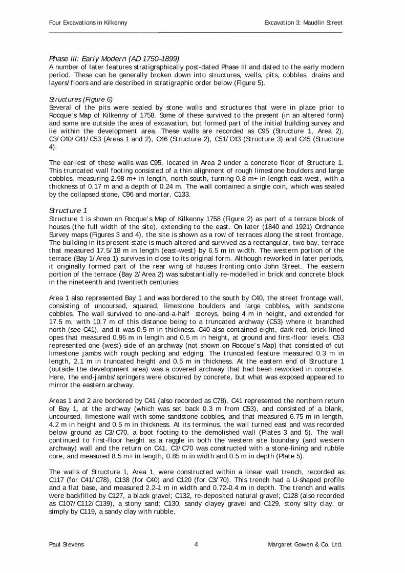
Four Excavations in Kilkenny Excavation 3: Maudlin Street ______________________________________________________________________________________________ Phase III: Early Modern (AD 1750–1899) A number of later features stratigraphically post-dated Phase III and dated to the early modern period. These can be generally broken down into structures, wells, pits, cobbles, drains and layers/floors and are described in stratigraphic order below (Figure 5). Structures (Figure 6) Several of the pits were sealed by stone walls and structures that were in place prior to Rocque’s Map of Kilkenny of 1758. Some of these survived to the present (in an altered form) and some are outside the area of excavation, but formed part of the initial building survey and lie within the development area. These walls are recorded as C95 (Structure 1, Area 2), C3/C40/C41/C53 (Areas 1 and 2), C46 (Structure 2), C51/C43 (Structure 3) and C45 (Structure 4). The earliest of these walls was C95, located in Area 2 under a concrete floor of Structure 1. This truncated wall footing consisted of a thin alignment of rough limestone boulders and large cobbles, measuring 2.98 m+ in length, north–south, turning 0.8 m+ in length east–west, with a thickness of 0.17 m and a depth of 0.24 m. The wall contained a single coin, which was sealed by the collapsed stone, C96 and mortar, C133. Structure 1 Structure 1 is shown on Rocque’s Map of Kilkenny 1758 (Figure 2) as part of a terrace block of houses (the full width of the site), extending to the east. On later (1840 and 1921) Ordnance Survey maps (Figures 3 and 4), the site is shown as a row of terraces along the street frontage. The building in its present state is much altered and survived as a rectangular, two bay, terrace that measured 17.5/18 m in length (east–west) by 6.5 m in width. The western portion of the terrace (Bay 1/Area 1) survives in close to its original form. Although reworked in later periods, it originally formed part of the rear wing of houses fronting onto John Street. The eastern portion of the terrace (Bay 2/Area 2) was substantially re-modelled in brick and concrete block in the nineteenth and twentieth centuries. Area 1 also represented Bay 1 and was bordered to the south by C40, the street frontage wall, consisting of uncoursed, squared, limestone boulders and large cobbles, with sandstone cobbles. The wall survived to one-and-a-half storeys, being 4 m in height, and extended for 17.5 m, with 10.7 m of this distance being to a truncated archway (C53) where it branched north (see C41), and it was 0.5 m in thickness. C40 also contained eight, dark red, brick-lined opes that measured 0.95 m in length and 0.5 m in height, at ground and first-floor levels. C53 represented one (west) side of an archway (not shown on Rocque’s Map) that consisted of cut limestone jambs with rough pecking and edging. The truncated feature measured 0.3 m in length, 2.1 m in truncated height and 0.5 m in thickness. At the eastern end of Structure 1 (outside the development area) was a covered archway that had been reworked in concrete. Here, the end-jambs/springers were obscured by concrete, but what was exposed appeared to mirror the eastern archway. Areas 1 and 2 are bordered by C41 (also recorded as C78). C41 represented the northern return of Bay 1, at the archway (which was set back 0.3 m from C53), and consisted of a blank, uncoursed, limestone wall with some sandstone cobbles, and that measured 6.75 m in length, 4.2 m in height and 0.5 m in thickness. At its terminus, the wall turned east and was recorded below ground as C3/C70, a boot footing to the demolished wall (Plates 3 and 5). The wall continued to first-floor height as a raggle in both the western site boundary (and western archway) wall and the return on C41. C3/C70 was constructed with a stone-lining and rubble core, and measured 8.5 m+ in length, 0.85 m in width and 0.5 m in depth (Plate 5). The walls of Structure 1, Area 1, were constructed within a linear wall trench, recorded as C117 (for C41/C78), C138 (for C40) and C120 (for C3/70). This trench had a U-shaped profile and a flat base, and measured 2.2–1 m in width and 0.72–0.4 m in depth. The trench and walls were backfilled by C127, a black gravel; C132, re-deposited natural gravel; C128 (also recorded as C107/C112/C139), a stony sand; C130, sandy clayey gravel and C129, stony silty clay, or simply by C119, a sandy clay with rubble.
Paul Stevens 4 Margaret Gowen & Co. Ltd.

Four Excavations in Kilkenny Excavation 3: Maudlin Street ______________________________________________________________________________________________ The eastern archway, dividing Area 1 and Area 2, was demolished in the early modern period for the insertion of dwellings; however, it may have measured up to 4.5 m in width. The street frontage wall, C40, possibly continued in Area 2 for 6.7–8m, where it was truncated and abutted by a north–south stone wall, C49. No trace of a wall could be found to continue the line of C3/C70 in Bay 2. However, the original rear wall was represented by wall trench C169, located in the northeast corner of Area 2, which measured 2.5 m+ in length, 2.4 m in width and 0.98 m+ in depth and was filled by C155, a sandy clay. Structure 2 Structure 2 is clearly shown on the first edition Ordnance Survey Map of 1840 (Figure 3) as part of a row of outhouses along the rear property boundary, extending east, and an adjoining structure between the street terrace and the outhouses, situated up against the eastern site boundary. This indicates that Structure 2 was in place before 1840, but, although the cartographic evidence is unclear, it may also have been in place before 1758 (Figure 2). C46 represented two surviving walls of this building, located to the rear of the development area, and forming part of the northern site boundary. The limestone wall, of coursed sub-rounded/squared boulders with some sandstone cobbles, measured 3.5 m in length east–west, 1.2 m in truncated length north–south, 5.35 m in height and 0.4 m in thickness. Structure 3 Structure 3 is also recorded on the 1758 Rocque Map (Figure 2) as a rectangular, northern, rear wing to the property fronting John Street. It is located along the northwestern site boundary and is recorded as C43, C51 and C52. C43 is a limestone and sandstone cobble wall that measured 5 m in length north–south, 2.6–4.5 m in truncated height and 0.5 m in thickness. C51 is the southern return of this wall and C52 represents the modern timber door inserted in a break in the wall. Structure 4 Structure 4 was originally a stone garden wall. C45 now forms part of the northern site boundary, abutting Structures 2 and 3, walls C46 and C43, respectively. It is unclear on Rocque’s 1758 Map (Figure 2) as the site area is blocked in, but is clearly shown on the first edition Ordnance Survey map of 1840 (Figure 3). C45 consisted of an uncoursed limestone wall of sub-rounded and sandstone cobbles and a substantial proportion of intrusive brick, oriented east–west and measuring 12.55 m in truncated length and 4.2 m in height. Partition Walls (Figure 6) C42 represents an inserted stone partition wall between C40 and C3/70, at the western boundary of the site. C42 measured 5.5 m in length, 2.6 m in height and 0.55 m in thickness, and was truncated by a later inserted brick-lined entrance that was broken through the middle of the wall and that measured 2.4–2.6 m in width. C49 also represented a partition wall of similar construction, oriented north–south parallel to C43, at the eastern end of the site. This wall measured 4.9 m in length, 4 m in height, 0.5 m in thickness, and contained a dark red-brick chimney-stack, with fire-places front and rear, that was inserted later in the nineteenth century. The northern plot boundary wall, C45, also contained two (possibly three) blocked, brick-lined, windows of dark handmade bricks, dating to the late nineteenth century (0.8–1 m in height and 1 m in width). Abutting C45 at right angles was a cobbled limestone wall, C44, which was 5 m in length, 2.6 m in height and 0.5 m in width, and formed an out-building that abutted Structure 2, as clearly shown on the 3rd edition Ordnance Survey map of 1921 (Figure 4). Pits (Figure 6) C86 was a small pit that was located in Area 1 and cut layer C79/C121/C123, Trench C120, and Pits C116 and C152. C86 was a truncated oblong pit with a concave profile and flat base, and measured 1.5 m in diameter and 0.4 m in depth. C86 was filled by C85, a sandy clay with boulders and bone.
Paul Stevens 5 Margaret Gowen & Co. Ltd.

Four Excavations in Kilkenny Excavation 3: Maudlin Street ______________________________________________________________________________________________ C170 was partially revealed in excavation as a sub-circular pit with an irregular, U-shaped, profile, cutting C189 in Area 4, with a steep southern side and flat base, measuring 1.45 m in length, 1 m+ in width and 1.1 m in depth. C170 was filled by a number of intermittent sands and clays: C165, a stony sand primary fill overlaid by C168, a stony sandy clay; C161, a stony silty clay, overlaid by both C160, brown clay and C175, a sandy clay, and sealed by C156, comprising pebbles with gravel and C157, stony gravel. Flag Floor (Figure 11) Sealing C85, but dating to around the same time as the sub-division of Structure 1 and C42, was a Limestone flag floor, C5, and a mortar foundation, C4, measuring 9 m in maximum length, 5.5 m in maximum width, 0.2 m in total depth and located within Area 1. Well (Figure 6) To the southwest of Structure 4 was a large pit, C99 (Plate 2), containing a fine-limestone-lined well, C10 (revealed in Test Trench 2 during 1998). The cut for this well was excavated in Areas 3 and 4 as C99 (also seen as C125/C122). It was a large circular pit with a concave profile, and it had an estimated diameter of 7 m and a depth of 1.5 m+. Although C10 was outside the area of excavation, a number of associated backfills were recorded. These were a primary backfill of C109 (a stony, clayey silt), which was under C87/C126 (a stony sand), which was sealed by C108 (a stony, sandy silt) or C97 (a silty clay with occasional stone) and by C9, C22 and C16, which were all sealed by C15/C91/C98/C111 (a sandy clay with stone). Cobbling (Figure 6) Within Area 2, an isolated area of cobbling, C60, was revealed, which consisted of a truncated linear alignment of cobbles that were oriented northeast–southwest, and that measured 2.6 m+ in length, 0.3 m+ in truncated width and 0.1 m in depth. C61,an associated area of burning, was also found here. Garden Soil The well, C10/C99, and cobbling, C60, were sealed by a layer of garden soil, C8 (C64/C105/C118) that abutted the walls of Structure 1: C40/C3/C70 and contained early modern material. Drain (Figure 6) This garden soil was cut by a late nineteenth-century drain, C65, which was located within Trench C82 and filled by C66, a silt accumulation containing modern material, suggesting a more recent abandonment. C65 (Plate 6) was a mortared, stone-lined drain with a cobbled base, which measured 5 m+ in length and 0.57 m in depth, and was located within cut C82, which measured 0.8 m in width and 0.72 m in depth. C82 also truncated C3/C70, suggesting that the wall was already demolished at this stage, or that an entranceway was located at this point. Phase V: Modern A large number of features were dated to the modern period, i.e., the twentieth century. These can be broken down into four categories: pits, walls, layers and test trenches (Figure 6). Pits (Figure 6) Two pits were modern in date; C59, in Area 1, was filled by C56/58 and appeared to be associated with the break in the wall, C42, and C83, in Area 3 (also seen in Test Trench 2), was filled by C7/C84. Walls (Figure 6) C42 was reinforced by an additional concrete skin, C57, during the modern rebuild of the neighbouring property. Structure 1 also contained a modern, ceramic, drainage pipe, C67, within cut C68, filled by C69, which cut along the western boundary of Areas 1 and 3.
Paul Stevens 6 Margaret Gowen & Co. Ltd.

Four Excavations in Kilkenny Excavation 3: Maudlin Street ______________________________________________________________________________________________ C71 in Area 2 was a massed-concrete car-mechanic’s pit, built in 1950 (pers. comm., former resident, Mr. Quinn). This was sealed by a concrete floor that was associated with an inserted timber partition wall, C50, and a concrete-block lintel and garage door, C54. Following partial demolition of Structure 4, the construction of a paint shed involved the insertion of a timber wall, C44, and massed-concrete repair to C45, recorded as C55. The demolition of Structure 2, involving the removal of part of the north–south wall C46 and backfilling (C20 and C24), resulted in the rebuilding of the eastern property boundary in concrete blocks (C48) and the construction of a small block wall, C47. Layers The site was sealed with gravel, C22, in Area 4 and humus, C29, in Trench 3, which represented 1998 ground-level garden soils. Elsewhere, the ground was laid with concrete, as represented by C28, with rubble foundation, C27 (Trench 3) and C14, and rubble foundation, C13 in Area 3. Test Trenches (Figures 5 and 6; Plate 5) Licensed test trenching was carried out by the author in September 1998 (98E364). Two of the three trenches were partially or fully re-excavated as part of this excavation and were recorded as Test Trench 1: C100 backfilled by C101, and Test Trench 2: C102 backfilled by C103/89/90. 4. Conclusions Archaeological excavation revealed a heavily truncated medieval suburb defensive ditch that curved across the site and aligned east–west and that measured 6 m in width and 1.45 m+ in depth. The ditch appeared to have been dry and open for a long time. Interestingly, no trace of the medieval suburb wall was revealed in the excavation, either in the form of a foundation or in the fills. However, the site lies directly on the line of the medieval suburb wall, close to John’s Gate Outer, and the town wall can be seen at No. 89 Maudlin Street, a bastion tower that extends towards the site. John’s Gate Outer was recorded in 1638 (see Section 2) but was removed prior to 1757. Recent excavation of the medieval suburb ditch and/or wall have shown the line of the defences to extend from the Outer Gate at Maudlin Street/John Street, towards the bastion tower, and turn south towards the river. It was originally thought that the defences ran parallel with John Street (Bradley 1990; Thomas 1992) but they can now be shown to run towards the rear of Bridge House, creating a segmental enclosure (O’Donovan 1998). Traces of the wall still survive to the rear of Lanigan’s Pub, to the south (O’Donovan 1997) and the garden centre, to the north, although much of the wall has been removed along this stretch. Analysis of the artefactual assemblage from archaeological excavation of this site revealed evidence of continuous urban settlement on or close to this site dating back to the thirteenth century, when the suburb of St. John’s was founded. Medieval, late medieval and post-medieval artefacts were recovered across this site. The enclosing suburb ditch (Phase I) contained a number of sherds of early thirteenth-century medieval pottery, effectively dating the ditch. This ditch was sealed by a layer of clay, dated by clay pipe and pottery to the mid to late seventeenth century, at which time the area was used for refuse pits; this continued up to the early eighteenth century when the first buildings were constructed on the site. Analysis of the animal bone appears to suggest a medieval diet of cattle, sheep and pig. Horse and domestic fowl were also detected in small numbers although the latter was known to be an important food source. The earlier layers of this site indicating primary silting of the town ditch, point to primary butchery and domestic hearth waste, which is compatible with refuse being thrown over the town wall into the ditch. This is contrasted with the later, more complete skeletal remains that show secondary butchery to have been in operation in a
Paul Stevens 7 Margaret Gowen & Co. Ltd.

Four Excavations in Kilkenny Excavation 3: Maudlin Street ______________________________________________________________________________________________ settlement close by. This would concur with post-medieval settlement spreading northwards outside the medieval confines of the walls. A single sherd of medieval floor tile recovered from the ditch fill C89 matches that of a similar tile found by the author in an assessment (Stevens 2000b Licence Ref: 99 E0662) where the northern transept of the medieval priory was revealed. The actual date of the backfilling of the town ditch appears to be in the mid-seventeenth century, which would be compatible with the dissolution of the monasteries and Cromwellian sacking of the city. This site is of significance to the study of the defensive architecture of medieval towns and their suburbs and contributes to the wider understanding of Kilkenny in the Middle Ages. The assemblage of artefacts from this site is proposed to be permanently stored in the National Museum of Ireland. Paul Stevens
Paul Stevens 8 Margaret Gowen & Co. Ltd.

Four Excavations in Kilkenny Excavation 3: Maudlin Street ______________________________________________________________________________________________ References
Bradley, J. (2000) Discover Kilkenny. Bradley, J. (1990) ‘The early development of the medieval town of Kilkenny, in Kilkenny: history and society, ed. W.
Nolan and K. Whelan. Bradley, J. (1975) The town wall of Kilkenny, Part I (OKR). Bradley, J. (1976) The town wall of Kilkenny, Part II (OKR). Farrelly, J., O’Reilly, B., and Loughran, A. (1993) The urban archaeological survey County Kilkenny. Finn, J., and Murphy, J. C. J. (1962) ‘John Street—north and south sides,’ Old Kilkenny Review 14, 25–39. O’Donovan, E. (1997) Archaeological assessment, No. 67–68 John Street, Kilkenny, unpublished report, Margaret
Gowen & Co. Ltd. O’Donovan, E. (1998) Archaeological assessment, Bridge House complex, Kilkenny, Report 3, unpublished report,
Margaret Gowen & Co. Ltd. Stevens, P. (1998) Archaeological assessment, Maudlin Street, Kilkenny, unpublished report, Margaret Gowen & Co.
Ltd. Stevens, P. (1999) Building survey and impact assessment at Maudlin Street, Kilkenny, unpublished report, Margaret
Gowen & Co. Ltd. Stevens, P. (2000) Archaeological impact assessment, Maudlin Street, Kilkenny, unpublished report, Margaret Gowen &
Co. Ltd. Thomas, A. (1992) The walled towns of Ireland, 2 vols.
Paul Stevens 9 Margaret Gowen & Co. Ltd.

Four Excavations in Kilkenny Excavation 3: Maudlin Street ______________________________________________________________________________________________
Paul Stevens 10 Margaret Gowen & Co. Ltd.

Four Excavations in Kilkenny (1999-2000) Excavation 3: Maudlin Street, Kilkenny ________________________________________________________________________________________________
Paul Stevens 11 Margaret Gowen & Co. Ltd.

Four Excavations in Kilkenny (1999-2000) Excavation 3: Maudlin Street, Kilkenny ________________________________________________________________________________________________
Paul Stevens 12 Margaret Gowen & Co. Ltd.
Four Excavations in Kilkenny (1999-2000) Excavation 3: Maudlin Street, Kilkenny ________________________________________________________________________________________________
Paul Stevens 13 Margaret Gowen & Co. Ltd.

Four Excavations in Kilkenny (1999-2000) Excavation 3: Maudlin Street, Kilkenny ________________________________________________________________________________________________
Paul Stevens 14 Margaret Gowen & Co. Ltd.

Four Excavations in Kilkenny (1999-2000) Excavation 3: Maudlin Street, Kilkenny ________________________________________________________________________________________________
Paul Stevens 15 Margaret Gowen & Co. Ltd.

Four Excavations in Kilkenny (1999-2000) Excavation 3: Maudlin Street, Kilkenny ________________________________________________________________________________________________
Figure 11 Elevation of rear walls, C55/C45/C46
Figure 12. Front elevation of stone wall C40
Paul Stevens 16 Margaret Gowen & Co. Ltd.

Four Excavations in Kilkenny (1999-2000) Excavation 3: Maudlin Street, Kilkenny ________________________________________________________________________________________________
Paul Stevens 17 Margaret Gowen & Co. Ltd.
Figure 13 Plan of stone flag floor C5

Four Excavations in Kilkenny (1999-2000) Excavation 3: Maudlin Street, Kilkenny ________________________________________________________________________________________________
18 Margaret Gowen & Co. Ltd.
Paul Stevens

Four Excavations in Kilkenny (1999-2000) Excavation 3: Maudlin Street, Kilkenny ________________________________________________________________________________________________
19 Margaret Gowen & Co. Ltd. Paul Stevens

Four Excavations in Kilkenny (1999-2000) Excavation 3: Maudlin Street ___________________________________________________________________________________________________________________________________________________________
Paul Stevens 20 Margaret Gowen & Co. Ltd.

Four Excavations in Kilkenny (1999-2000) Excavation 3: Maudlin Street ___________________________________________________________________________________________________________________________________________________________
Paul Stevens 21 Margaret Gowen & Co. Ltd.
Plate 8: Wall stub C46 from the south, showing base of wall Plate 7: Paved floorC5 from the north

Four Excavations in Kilkenny (1999-2000) Excavation 3: Maudlin Street ________________________________________________________________________________________________
Paul Stevens 22 Margaret Gowen & Co. Ltd.
Plate 9: Rear of frontage wall C40, pre-excavation
Plate 8: Street frontage wall C40

Four Excavations in Kilkenny (1999-2000) Excavation 3: Maudlin Street ________________________________________________________________________________________________
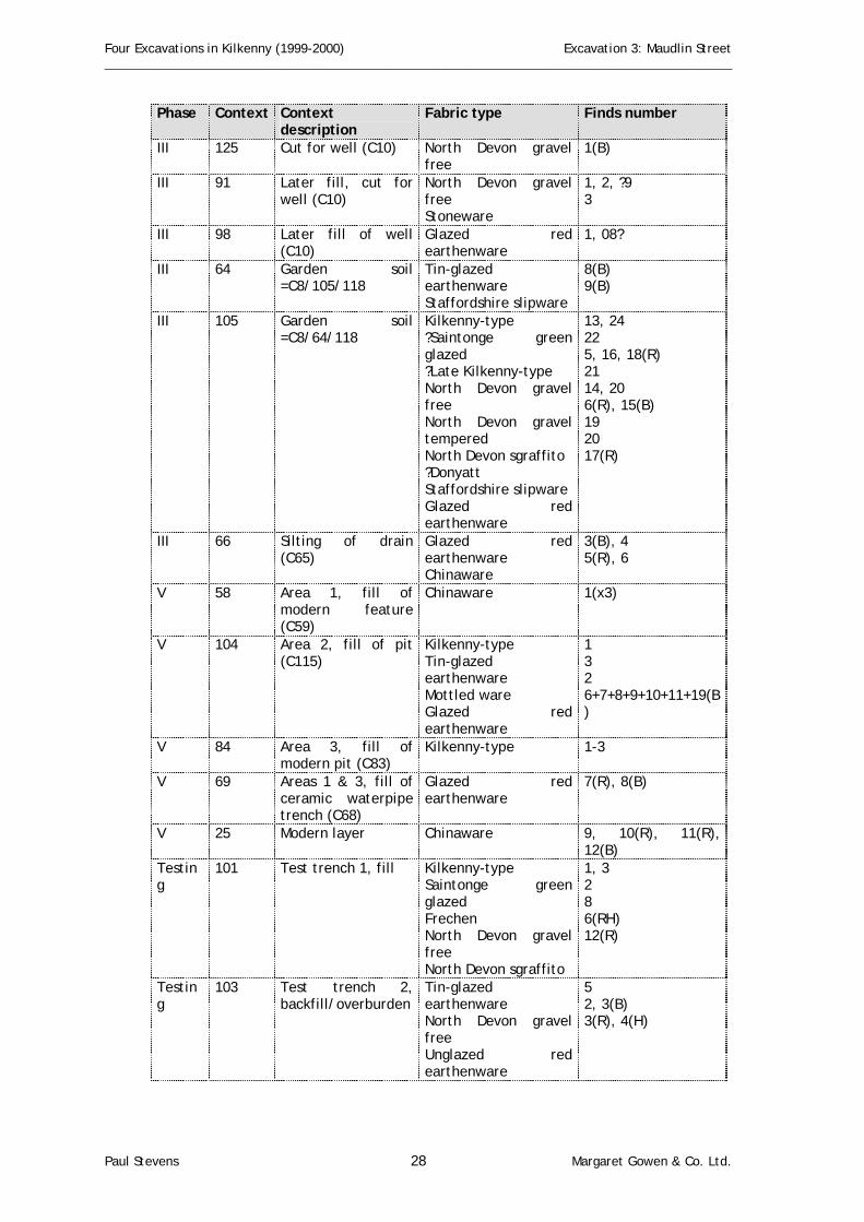
Appendix 1: Ceramic Finds Report By Clare McCutcheon Introduction Seventy (48.6%) of the total one hundred and forty-four sherds of pottery recovered were found to be medieval in date. This number was reduced from an original calculation of one hundred and fifty-three, following a reassembling of the finds. In addition, four sherds of ridge tile were recovered, and eleven sherds of nineteenth– to twentieth–century stoneware and chinawares. The fabrics have been identified visually and the information is presented in Tables 1.1 and 1.2. The tables contain the quantity of sherds in each fabric type, the probable form of vessels and the date range of the fabric type based on extensive assemblages in Ireland. Table 1.3 contains the identification of sherds by context, arranged in stratigrapgic order. The diagnostic sherds are indicated by the letters R, B, H, S for rim, base, handle and spout respectively. Where two or more sherds have been reassembled, the symbol + is used. In general, the medieval wares present date to the thirteenth century. The quantities of Kilkenny-type ware (87%) would both explain the lack of contemporary Bristol and Saintonge wares and also point to a fairly self-sufficient production of pottery locally. In this, Kilkenny appears to be closer to the Dublin experience than to that of Waterford or Cork; for example, the ease of access into Waterford or Cork may have precluded the development of a local production in the early thirteenth century. In both cities, therefore, the relative percentages of locally made ware varies between only 10–20% whereas in Dublin this may reach as much as 65–85% (McCutcheon in prep; 1995, Table 1). In a site at 29–33 Patrick Street, Kilkenny, locally made ware accounted for 92% of the total medieval assemblage (McCutcheon forthcoming (a)). Stratigraphically the ditch fill should date to the thirteenth century, possibly earlier rather than later in the century. The fill contains a sherd of Ham Green B, Saintonge Green Glazed and the main locally made wares. The absence of Bristol Redcliffe, which dates from the mid-thirteenth century onwards, may also indicate an earlier date but the overall assemblage is small (twenty-eight sherds in the fills and layers sealing the ditch) and so only a tentative date can be proposed. Table 1.1: Medieval pottery
Fabric type Sherds Form Date Leinster Cooking Ware 7 cooking pot L12th–14th Kilkenny-type coarseware 4 jug 13th Kilkenny-type 46 jugs 13th –14th Kilkenny-type cooking ware 4 ?storage vessel 13th–14th Ham Green B 2 jug L12th–M13th Saintonge green glazed 7 jug M13th–14th Total medieval 70
Table 1.2: Post-medieval pottery
Fabric type Sherds Form Date ?Late Kilkenny-type 5 bowl ?15th–16th Frechen 1 jug 16th Westerwald 1 ?jug 17th ?Donyatt 1 plate 17th North Devon gravel free 13 bowl 17th North Devon gravel tempered
7 bowl; (+1 ridge tile) 17th
North Devon sgraffito 3 plate, bowl 17th North Devon slipware 1 plate 18th Tin glazed earthenware 5 plate M17th–18th Staffordshire slipware 4 cup 18th Mottled ware 1 tankard 18th Glazed red earthenware 27 jug, bowl L17th–19th Unglazed red earthenware 2 flowerpot 18th–19th Unidentified 3 jug post-medieval
Paul Stevens 23 Margaret Gowen & Co. Ltd.

Four Excavations in Kilkenny (1999-2000) Excavation 3: Maudlin Street ________________________________________________________________________________________________
Stoneware (1) jar 19th–20th Chinaware (10) plates, cup 19th–20th Total post-medieval 74
Medieval Leinster Cooking Ware ‘Leinster Cooking Ware is the single most widespread medieval pottery type in Leinster’ (Ó Floinn 1988, 340). The ware is distinguished by the presence of large flakes of mica and much quartz but the most distinctive characteristic of the Leinster Cooking Ware is the sand marked base, which ‘suggests that unfired vessels were deliberately placed on a bed of sand to dry before firing’ (Ó Floinn 1988, 327). The vessels are generally created in the form of cooking pots; they follow the standard medieval pattern with everted rims, ovoid bodies and a slightly sagging base. Kilkenny-type wares: The use of the suffix -type is recommended in pottery studies to indicate that while a fabric has been found regularly in a particular area, as yet no production site has been located (Blake & Davey 1983, 39–40). The terminology used below reflects that adopted for the Dublin wares, and aims to avoid any chronological implications (McCutcheon in prep). This follows the practice in London where the ceramic specialists selected the broader terms of Coarse London-type ware, London-type ware and Late London-type ware (Pearce et al 1985, 2). The process of regrouping in London is described thus: 'The terminology is adopted here, since it conveniently brings together pottery types whose similarities in fabric and methods of manufacture suggest either a single source, or group of sources sharing a potting tradition' (Pearce et al 1985, 2). In the excavations at Kells Priory, the thin-section report describes a number of different medieval fabrics (McCorry forthcoming) and these were described as Kells-type A–G (McCutcheon forthcoming (b)). The consistency in manufacture, forms and decorations, however, make these a closely linked group and they may more usefully be described within this system. If and when kilns are found, it may be possible to identify particular fabrics although the experience in Britain, where a number of kilns have been excavated, is not encouraging. 'In areas where the underlying geology is bland, pottery from widely separated sources can have a very similar appearance, while excavations at kilns sites of all dates have shown that a wide variation in colour, texture and inclusions can be expected within the products of a single source' (Vince 1987, 203). Kilkenny-type coarse ware: A number of sherds, assumed to be local, have been designated as Kilkenny-type coarseware. The vessels represented appear to be of a standard medieval jug form. Kilkenny-type: The majority of the medieval ware recovered on site was of a local wheel-thrown fabric. The fabrics range from lightly micaceous, hard-fired finish to a more calcareous, softer finished fabric. A complete jug was found at Castleinch, about two miles southwest of Kilkenny city (Prendergast 1977), and the principal glazed ware recovered at Kilkenny Castle has been described as 'Castleinch ware' (B. Murtagh pers. comm.). Similar material, also described as Kilkenny-type ware, has been recovered at recent excavations at 29–33 Patrick Street and at Pudding Lane (McCutcheon forthcoming (a & c)). A minimum of one jug is represented in the assemblage, based on rim/handle fragments. One handle fragment was decorated with a central continuous line between two lines of slashing (C5). The design code is based primarily on the large assemblage at Wood Quay, Dublin (McCutcheon in prep). The rim/handle sherd has an undetermined pattern but at least one diagonal slash is present. These designs are typical of later thirteenth-century jugs made in the local area (Foley 1989; McCutcheon forthcoming (a-c)). The designs are also characteristic of locally made pottery in Ireland and are a testament to the apparent lack of regional variation (McCutcheon in prep). Kilkenny-type cooking ware: A small quantity of sherds has been provisionally identified as Kilkenny-type cooking ware. The fabric is generally somewhat calcareous, similar to the jug fabric described above. The vessels
Paul Stevens 24 Margaret Gowen & Co. Ltd.

Four Excavations in Kilkenny (1999-2000) Excavation 3: Maudlin Street ________________________________________________________________________________________________
may well have been used for storage rather than for cooking, as this fabric would not have been suitable for the severe shock of heating; however, they are in the form of medieval cooking pots with everted rims, ovoid bodies and slightly sagging bases. The vessels follow the tradition of Leinster Cooking Ware as the bases appear to have a slight kick and a gritted base as evidenced by a semi-complete pot recovered from 29–33 Patrick Street (McCutcheon forthcoming (a)). Ham Green B: This is a hand built ware from Bristol that has been extensively described (Barton 1963) and dates from the early twelfth to the mid-thirteenth century (Ponsford 1991, 98). The ware is found widely in Ireland, particularly in the Waterford city excavations where it accounts for some 46% of the medieval material (Gahan & McCutcheon 1997, table 11.1). A base sherd with thumbing, typical of Ham Green B, and an undecorated body sherd from a jug were found. Saintonge green glazed: The presence of this green glazed white ware from near Bordeaux has been seen as closely linked to the very large quantities of wine exported from the area (Deroeux & Dufournier 1991). The white ware jugs were decorated with a lead glaze that contained copper filings thus giving the vessels the characteristic mottled effect. Late and Post-Medieval Possible late Kilkenny type A small number of sherds may be of a late medieval date and locally made. Little fifteenth- and sixteenth-century ware is present in Ireland, perhaps because of a change in the method of dealing with the disposal of rubbish. The small amounts of this date that are present are generally imported and therefore identifiable, but occasionally some non-imported sherds appear that fall into a transitional category i.e. medieval in fabric but post-medieval in form. The identification is very subjective and is based on the experience of working with large quantities of material. Frechen: A single sherd of this mottled brown salt-glazed ware was found. The ware was produced near Koln (Cologne), Germany and the best known vessels are the Bartman (bearded man) jugs, which were often further embellished with silver or pewter lids, a tradition that continues with the modern lidded tankard. Westerwald: This ware was made at a number of centres in the Westerwald area, east of the Rhine, following the move by potters from Raeren in the 1590s (Hurst et al 1986, 221). The ware was widely traded in the seventeenth and eighteenth centuries in America, Africa and the Far East and the industry continues up to the present day ((Hurst et al 1986, 221). The fabric is a grey, salt-glazed stoneware with an overall blue-grey glaze that results from cobalt blue in the glaze. ?Donyatt: A possible sherd of this south Somerset ware was recovered in a sandy red earthenware with slip-trailed decoration. North Devon wares: These wares were produced from the late fifteenth century and a large-scale export trade to Ireland developed in the mid-seventeenth century and continued, to a lesser extent, in the eighteenth century (Grant 1983). North Devon gravel free: The fabric is a fine earthenware, firing to pinkish in colour with a grey margin; the lead glaze appears brown or dark green. North Devon gravel tempered: The same basic fabric is used with the addition of fine gravel for the production of heavier vessels for use in the kitchen and dairy. The glaze is that of gravel-free vessels. North Devon sgraffito: The same basic fabric as the gravel-free wares is used but the vessels are coated with a white slip and designs are scratched or incised (sgraffito) onto the vessels before the application of a clear lead glaze. The result produces a yellow vessel with brown designs.
Paul Stevens 25 Margaret Gowen & Co. Ltd.

Four Excavations in Kilkenny (1999-2000) Excavation 3: Maudlin Street ________________________________________________________________________________________________
North Devon slipware: In the eighteenth century, the sgraffito designs were reserved for speciality items such as harvest jugs and the tablewares were slipped but otherwise undecorated. Tin-glazed earthenware: Tin-glazed earthenware was made in England throughout the seventeenth and eighteenth centuries until it was superseded in the late eighteenth century by creamware or 'Queensware', which had the advantage of being lighter, cheaper and stronger (Draper 1984, 25). Staffordshire slipware: This ware was made primarily in the Staffordshire area in the late seventeenth and eighteenth centuries (Jennings 1981, 104). The fabric is light creamy-buff and the decoration is a combination of white and brown slips that give a brown or yellow background with combed, feathered or trailed decoration (Jennings 1981, 104.). Mottled ware: A single sherd from a tankard was found. These were also made in Staffordshire in the eighteenth century. Glazed red earthenware: These wares, also known as 'brownwares' were made in Britain and Ireland from the late seventeenth century. Many centres in Ireland were developed by potters from England and 'the wares, glazed and decorated with slip or in sgraffito, were similar to those made in centres in the south and west of England and north Wales.’ (Dunlevy 1988, 24–5). Unidentified: One of the sherds came from the lowest level on site and may be no more than baked clay, as identification is impossible. The spout sherd is possibly modern i.e. late nineteenth to twentieth century in date. Table 1.3: Pottery identification by context, arranged stratigraphically
Phase Context Context description
Fabric type Finds number
I 88 Area 1, secondary fill ditch (C1)
Glazed red earthenware Unidentified
1(R) 2
I 81 Secondary fill ditch (C1), under C76 & C62
Kilkenny-type Kilkenny-type cooking
2, 3 4
I 76 Secondary fill ditch (C1), over C81, under C62
Leinster Cooking Ware Kilkenny-type
3 1, 2, 5
I 62 Secondary fill ditch (C1), over C76 & C81
Leinster Cooking Ware Kilkenny-type Ham Green B Saintonge green glazed
9(x4) 6, 7, 8(H), 11, 12 5 4, 10
II 79 Layer sealing ditch (C1) cut by post-medieval pits
Kilkenny-type coarse ware Kilkenny-type Kilkenny-type cooking
6 2+4, 3 5
II 121 Layer sealing ditch (C1)
Kilkenny-type Glazed red earthenware
5 4
II 80 Layer sealing ditch (C1)
Ham Green B 2(B)
II 143 Fill of pit (C116) Kilkenny-type 1
Paul Stevens 26 Margaret Gowen & Co. Ltd.

Four Excavations in Kilkenny (1999-2000) Excavation 3: Maudlin Street ________________________________________________________________________________________________
Phase Context Context description
Fabric type Finds number
II 146 Fill of pit (C116) North Devon gravel tempered Glazed red earthenware
2+5 1(RH), 6(H), 15(RH), 16
II 141 Fill of pit (C116) Saintonge green glazed
2(B)
II 140 Fill of pit (C116) Kilkenny-type North Devon gravel free Glazed red earthewnare
1, 4 2, 3 5-7
II 135 Fill of pit (C166) Kilkenny-type 1(B) II 136 Fill of pit (C166) Kilkenny-type
Kilkenny-type cooking 1(B), 3 2(RH)
II 176 Fill of pit (C183) Leinster Cooking Ware Kilkenny-type Saintonge green glazed
1 3 2
II 131 Fill of pit (C187) Glazed red earthenware
1
II 150 Fill of C189 Kilkenny-type coarse ware Kilkenny-type Saintonge green glazed
2, 5, 6 1(B), 4, 7 3
II 153 Fill of linear cut (C188)
Glazed red earthenware
1
II 154 Fill of linear cut (C188)
North Devon gravel free
1
III 96 Rubble collapse from wall (C95)
Glazed red earthenware
1
III 40 Frontage, south wall of Structure 1
Kilkenny-type ?Late Kilkenny-type Glazed red earthenware
1 3 2(R)
III 78 East (partition) wall of Structure 1
North Devon gravel free North Devon gravel tempered Glazed red earthenware
1+2+3 7 8(B), 9(R)
III 119 Fill of wall trench (C120), Structure 1
Kilkenny-type 1(B), 2, 3
III 112 Lower fill of wall trench Structure 1 (C117) pottery intrusive? =C128
Unidentified (modern) 2(S)
III 155 Fill of wall trench (C169)
Kilkenny-type cooking 1
III 85 Stony fill pit (C86) Leinster Cooking Ware Kilkenny-type ?Late Kilkenny-type Tin-glazed earthenware Unidentified
10 20 15 14(B) 11
Paul Stevens 27 Margaret Gowen & Co. Ltd.
Four Excavations in Kilkenny (1999-2000) Excavation 3: Maudlin Street ________________________________________________________________________________________________
Phase Context Context description
Fabric type Finds number
III 125 Cut for well (C10) North Devon gravel free
1(B)
III 91 Later fill, cut for well (C10)
North Devon gravel free Stoneware
1, 2, ?9 3
III 98 Later fill of well (C10)
Glazed red earthenware
1, 08?
III 64 Garden soil =C8/105/118
Tin-glazed earthenware Staffordshire slipware
8(B) 9(B)
III 105 Garden soil =C8/64/118
Kilkenny-type ?Saintonge green glazed ?Late Kilkenny-type North Devon gravel free North Devon gravel tempered North Devon sgraffito ?Donyatt Staffordshire slipware Glazed red earthenware
13, 24 22 5, 16, 18(R) 21 14, 20 6(R), 15(B) 19 20 17(R)
III 66 Silting of drain (C65)
Glazed red earthenware Chinaware
3(B), 4 5(R), 6
V 58 Area 1, fill of modern feature (C59)
Chinaware 1(x3)
V 104 Area 2, fill of pit (C115)
Kilkenny-type Tin-glazed earthenware Mottled ware Glazed red earthenware
1 3 2 6+7+8+9+10+11+19(B)
V 84 Area 3, fill of modern pit (C83)
Kilkenny-type 1-3
V 69 Areas 1 & 3, fill of ceramic waterpipe trench (C68)
Glazed red earthenware
7(R), 8(B)
V 25 Modern layer Chinaware 9, 10(R), 11(R), 12(B)
Testing
101 Test trench 1, fill Kilkenny-type Saintonge green glazed Frechen North Devon gravel free North Devon sgraffito
1, 3 2 8 6(RH) 12(R)
Testing
103 Test trench 2, backfill/overburden
Tin-glazed earthenware North Devon gravel free Unglazed red earthenware
5 2, 3(B) 3(R), 4(H)
Paul Stevens 28 Margaret Gowen & Co. Ltd.

Four Excavations in Kilkenny (1999-2000) Excavation 3: Maudlin Street ________________________________________________________________________________________________
Phase Context Context description
Fabric type Finds number
Testing
89 Test trench 2, backfill/overburden
Westerwald Kilkenny-type North Devon gravel free North Devon gravel tempered North Devon slipware Staffordshire slipware Glazed red earthenware
3(H) 6 18 13(B), 15(R), 16(rooftile) 1 2, 19 4(R), 5, 14(R), 17(B)
90 Test trench 2, backfill/overburden
Kilkenny-type Tin-glazed earthenware North Devon gravel tempered Chinaware
1, 4, 5(RH), 6, 7, 10, 11, 13, 15 16(R) 12 17
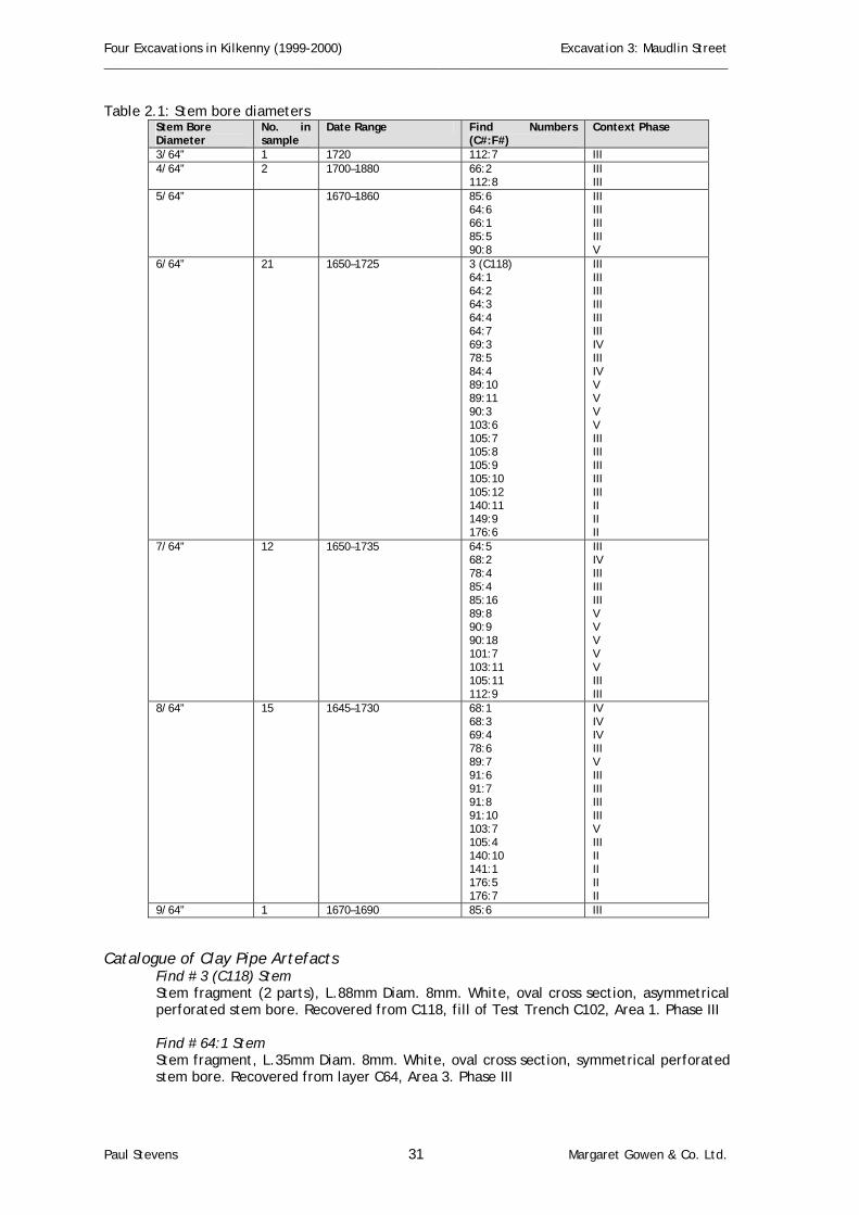
Appendix 2: Ceramic Clay Tobacco Pipe Report By Paul Stevens Introduction A total of sixty-four fragments of clay tobacco pipe were recovered from this excavation. Of these, seven examples were complete or nearly complete bowls. Three of these examples were decorated, including a stem with a herring-bone pattern, a bowl with criss-cross shield pattern and a bowl with a partial inscription. No country of production was established for this assemblage, which was relatively small.
Dating by measurement A stem bore dating technique was used based on that employed by S. Lane (1997) and developed by Harrington (1954) and Binford (1961). The basis of this technique is that the stem bore diameter decreases with age. Drill bits graduated between 4/64 and 8/64 of an inch were
Paul Stevens 29 Margaret Gowen & Co. Ltd.

Four Excavations in Kilkenny (1999-2000) Excavation 3: Maudlin Street ________________________________________________________________________________________________
used to measure bore diameter. The resulting figure (Table 2.1) was then compared with Lane’s table of date ranges (Lane 1997, 236). Stem bores that did not fit into the size ranges and were assigned to the closest diameter that fitted.
Paul Stevens 30 Margaret Gowen & Co. Ltd.
Four Excavations in Kilkenny (1999-2000) Excavation 3: Maudlin Street ________________________________________________________________________________________________
Table 2.1: Stem bore diameters Stem Bore Diameter
No. in sample
Date Range Find Numbers (C#:F#)
Context Phase
3/64” 1 1720 112:7 III 4/64” 2 1700–1880 66:2
112:8 III III
5/64” 1670–1860 85:6 64:6 66:1 85:5 90:8
III III III III V
6/64” 21 1650–1725 3 (C118) 64:1 64:2 64:3 64:4 64:7 69:3 78:5 84:4 89:10 89:11 90:3 103:6 105:7 105:8 105:9 105:10 105:12 140:11 149:9 176:6
III III III III III III IV III IV V V V V III III III III III II II II
7/64” 12 1650–1735 64:5 68:2 78:4 85:4 85:16 89:8 90:9 90:18 101:7 103:11 105:11 112:9
III IV III III III V V V V V III III
8/64” 15 1645–1730 68:1 68:3 69:4 78:6 89:7 91:6 91:7 91:8 91:10 103:7 105:4 140:10 141:1 176:5 176:7
IV IV IV III V III III III III V III II II II II
9/64” 1 1670–1690 85:6 III Catalogue of Clay Pipe Artefacts
Find # 3 (C118) Stem Stem fragment (2 parts), L.88mm Diam. 8mm. White, oval cross section, asymmetrical perforated stem bore. Recovered from C118, fill of Test Trench C102, Area 1. Phase III Find # 64:1 Stem Stem fragment, L.35mm Diam. 8mm. White, oval cross section, symmetrical perforated stem bore. Recovered from layer C64, Area 3. Phase III
Paul Stevens 31 Margaret Gowen & Co. Ltd.
Four Excavations in Kilkenny (1999-2000) Excavation 3: Maudlin Street ________________________________________________________________________________________________
Find # 64:2 Stem Stem fragment, L.32mm Diam. 8mm. White, oval cross section, Asymmetrical perforated stem bore, Recovered from layer C64, Area 3. Phase III Find # 64:3 Stem Stem fragment, L.45mm Diam. 9mm. White, broken lengthways. Recovered from layer C64, Area 3. Phase III Find #64:4 Stem Stem fragment, L.35mm, Diam. 9mm. White, oval cross section, symmetrical perforated stem bore. Recovered from layer C64, Area 3. Phase III Find # 64:5 Bowl Bowl fragment, H.26mm, external diam. 19mm, internal diam. 15mm. Foot L. 7mm, W.4mm, D. 4mm. Bowl broken at top, foot plain oval with flat cut base. Recovered from layer C64, Area 3. Phase III Find # 64:6, Stem Stem fragment, L.33mm, Diam. 9mm. White, oval cross section, symmetrical perforated stem bore. Recovered from layer C64, Area 3. Phase III Find # 64:7 Stem Stem fragment, L.21mm, Diam. 7mm, White, oval cross section, asymmetrical perforated stem bore, Recovered from layer C64, Area 3. Phase III Find # 66:1 Stem Stem fragment, L.26mm, Diam. 8.5mm. White with grey core, circular cross section, symmetrical perforated stem bore. Recovered from layer C64, Area 3, Phase III Find # 66:2, Decorated Stem Decorated stem fragment, L.20mm, Diam. 7mm. White with herringbone incisions oval cross section, asymmetrical perforated stem bore. Recovered from layer C64, Area 3. Phase III Find # 68:1 Stem Stem fragment, L.38mm, Diam.9mm, White with brown patina, circular cross section, symmetrical perforated stem bore. Recovered from C68, Pipe trench Area 1 & 3. Phase IV Find # 68:2 Stem Stem fragment, L.27mm, 7mm. White, circular cross-section, symmetrical perforated stem bore. Recovered from Pipe trench C68, Area 1 & 3. Phase IV Find # 68:3 Stem Stem fragment, L.19mm, 8mm. White with brown patina, circular cross section, asymmetrical perforated stem bore. Recovered from C68, Pipe trench, Area 1 & 3. Phase IV Find # 69:3 Stem Stem fragment, L.63mm, Diam.9mm. White with grey patina, circular cross section, asymmetrical perforated stem bore. Recovered from C69, fill of pipe trench C68, Area 1 & 3. Phase IV Find # 69:4 Stem Stem fragment, L.23mm, Diam.6mm. White with brown patina, oval cross section, and asymmetrical perforated stem bore. Recovered from C69, fill of pipe trench C68, Area 1 & 3. Phase IV Find # 78:4 Stem
Paul Stevens 32 Margaret Gowen & Co. Ltd.

Four Excavations in Kilkenny (1999-2000) Excavation 3: Maudlin Street ________________________________________________________________________________________________
Stem fragment, L.50mm, Diam.10mm. White, oval cross section, asymmetrical perforated stem bore. Recovered from C78, fill of wall trench C40, Area 1. Phase III Find # 78:5 Stem Stem fragment, L.35mm, Diam.6.5mm. White with brown patina, oval cross section, asymmetrical perforated stem bore. Recovered from C78, fill of wall trench C40, Area 1. Phase III Find # 78:6 Stem Stem fragment, L.32mm, Diam.7.5mm. White with brown patina, oval cross section, asymmetrical perforated stem bore. Recovered from C78, fill of wall trench C40, Area 1. Phase III Find # 84:4 Stem Stem fragment, L.30mm, Diam.8mm. White, oval cross section, asymmetrical perforated stem bore. Recovered from C84, fill of pit C83, Area 3. Phase IV Find # 85:4 Stem Stem fragment, L.0.31m, Diam. 8mm. White with grey staining, circular cross section, asymmetrical perforated stem bore. Recovered from C85, fill of pit C86, Area 1. Phase III Find # 85:5 Stem Stem fragment, L.0.4m, Diam. 10mm. White with fire damage, oval cross section, asymmetrical perforated stem bore. Recovered from C85, fill of pit C86, Area 1, Phase III Find # 85:6 Stem Stem fragment, L.0.18m, Diam. 7mm, White, oval cross section, asymmetrical perforated stem bore. Recovered from C85 fill of pit C86, Area 1. Phase III Find # 85:16 Stem Stem fragment, L.0.45m, Diam. 65mm. White, with brown patina, circular cross section, Asymmetrical perforated stem bore. Recovered from C85, fill of pit C86, Area 1. Phase III Find # 85:17 Bowl Bowl fragment, H.0.3m+, W. 0.18m, Th. 1.5mm. Outside bowl face. Recovered from C85, fill of pit C86, Area 1. Phase III Find # 85:19 Bowl Complete bowl and foot, H.30mm, external diam. 0.19m, internal diam. 0.13m. Foot L.6mm, W.7mm, D.5mm. Angled bowl with slight bulge in outer face, chipped inner top. Foot rectangular and clipped pointed base. Recovered from C85, fill of pit C86, Area 1. Phase III Find # 89:7 Stem Stem, bowl and base fragment, L.0.39m, Stem diam. 9mm. Foot L.11mm, W.8.5mm, D.3mm. White broken bowl, oval stem cross section, with asymmetrical stem bore. Foot oval with flat cut base. Recovered from C89 fill of Test Trench 2 C102, Area 3. Phase V Find # 89:8 Stem & Bowl Stem and bowl fragment, L.0.33m, Stem diam. 8mm, bowl width 14mm. White with brown patina and grey core, oval stem with base of bowl, asymmetrical perforated stem bore. Recovered from C89, fill of Test Trench 2 C102, Area 3. Phase V Find # 89:10 Stem Stem fragment, L.53mm, Diam.9mm. White, oval cross section, asymmetrical perforated stem bore. Recovered from C89, fill of Test Trench 2 C102, Area 3. Phase V Find # 89:11 Stem
Paul Stevens 33 Margaret Gowen & Co. Ltd.
Four Excavations in Kilkenny (1999-2000) Excavation 3: Maudlin Street ________________________________________________________________________________________________
Stem fragment, L.78mm, Diam.9mm. White with brown patina, oval cross section, asymmetrical perforated stem bore. Recovered from C89, fill of Test Trench 2 C102, Area 3. Phase V Find # 90:3 Stem Stem fragment, L.23mm, Diam.7.5mm. White, oval cross section, symmetrical perforated stem bore. Recovered from C90, fill of Test Trench 2 C102, Area 3. Phase V Find # 90:8, Stem Stem fragment, L.34mm, Diam.6mm, White, oval cross section, Symmetrical perforated stem bore. Recovered from C90, fill of Test Trench 2 C102, Area 3. Phase V Find # 90:9 Stem Stem fragment, L.30mm, Diam.7mm, White with orange brown patina, oval cross section, asymmetrical perforated stem bore, Recovered from C90, fill of Test Trench 2 C102, Area 3. Phase V Find # 90, 18, Stem Stem fragment, L.52mm, Diam.8mm. White with orange brown patina, oval cross section, asymmetrical perforated stem bore. Recovered from C90 fill of Test Trench 2 C102, Area 3. Phase V Find # 91:5, Stem Stem fragment, L.36mm, Diam.7mm, White, oval cross section, Asymmetrical perforated stem bore, Recovered from C91, Fill of Pit C99, 2, 4, III Find # 91:6 Stem Stem fragment, L.41mm, Diam.6mm. White, oval cross section, asymmetrical perforated stem bore. Recovered from C91 fill of pit C99, Area 2 & 4, Phase III Find # 91:7 Stem Stem fragment, L.20mm, Diam.7mm. White with brown patina, oval cross section, asymmetrical perforated stem bore. Recovered from C91 fill of pit C99 Area 2 & 4, Phase III Find # 91:8 Stem Stem fragment, L.32mm, Diam.8mm. White with brown patina, oval cross section, asymmetrical perforated stem bore. Recovered from C91 fill of pit C99, Area 2 & 4, Phase III Find # 91:10 Stem Stem fragment, L.25mm, Diam.7mm. White, circular cross section, symmetrical perforated stem bore. Recovered from C91 fill of pit C99, Area 2 & 4, Phase III Find # 101:7 Stem Stem fragment, L.13mm, Diam.6.5mm. White, circular cross section, asymmetrical perforated stem bore. Recovered from C101 fill of Test Trench 1 C100, Area 1 & 3. Phase V Find # 103:6 Stem Stem fragment, L.42mm, Diam.9mm. White, oval cross section, asymmetrical perforated stem bore. Recovered from C103 rubble layer, Area 1 & 3. Phase V Find # 103:7 Stem Stem fragment, L.25mm, Diam.8mm. White, oval cross section, asymmetrical perforated stem bore. Recovered from C103 rubble layer, Area 1 & 3, Phase V Find # 103:11 Stem Stem fragment, L.43mm, Diam.8.5mm. White with grey brown patina, oval cross section, symmetrical perforated stem bore. Recovered from C103 rubble layer, Area 1 & 3. Phase V
Paul Stevens 34 Margaret Gowen & Co. Ltd.

Four Excavations in Kilkenny (1999-2000) Excavation 3: Maudlin Street ________________________________________________________________________________________________
Find # 105:4 Stem Stem fragment, L.39mm, Diam.8.5mm. White with brown patina, oval cross section, and symmetrical perforated stem bore. Recovered from C105 fill of Test Trench 2 C102, Area 1. Phase III Find # 105:7 Stem Stem fragment, L.36mm, Diam.8.5mm. White with brown patina, circular cross section, symmetrical perforated stem bore. Recovered from C105 fill of Test Trench 2 C102, Area 1. Phase III Find # 105:8 Stem Stem fragment, L.32mm, Diam.7mm. White, oval cross section, symmetrical perforated stem bore. Recovered from C105 fill of Test Trench 2 C102, Area 1. Phase III Find # 105:9 Stem Stem fragment, L.45mm, Diam.9mm. White, oval cross section, asymmetrical perforated stem bore. Recovered from C105, fill of Test Trench 2 C102, Area 1. Phase III Find # 105:10 Stem Stem fragment, L.48mm, Diam.9mm. White with brown patina, oval cross section, symmetrical perforated stem bore. Recovered from C105 fill of Test Trench 2 C102, Area 1. Phase III Find # 105: 11 Stem Stem fragment, L.48mm, Diam.7mm. White, circular cross section, symmetrical perforated stem bore. Recovered from C105, fill of Test Trench 2 C102, Area 1. Phase III Find # 105:12 Stem Stem fragment, L.46mm, Diam.8mm. White with brown patina circular cross section, asymmetrical perforated stem bore. Recovered from C105 fill of Test Trench 2 C102, Area 1. Phase III Find # 112:3 Stem Decorated bowl fragment, L.25mm, W.15mm, Th. 4mm. White outer bowl fragment, with crosshatched shield. Recovered from C112 fill of wall trench C138, Area 1. Phase III Find # 112:6 Decorated Bowl Decorated bowl fragment, L.25mm, W.20mm, Th.2.5-4mm, depth of bowl 23mm. White outer bowl fragment, with inscription “RI…CU”. Recovered from C112, fill of wall trench C138, Area 1. Phase III Find # 112:7 Stem Stem fragment, L.36mm, Diam.6.5mm. White, circular cross section, symmetrical perforated stem bore. Recovered from C112 fill of wall trench C138, Area 1. Phase III Find # 112:8 Stem Stem fragment, L.23mm, Diam.5mm. White, oval cross-section, symmetrical perforated stem bore. Recovered from C112 fill of wall trench C138, Area 1. Phase III Find # 112:9 Stem Stem fragment, L.32mm, Diam.8.5. White, oval cross-section, asymmetrical perforated stem bore. Recovered from C112, Fill of wall trench C138, Area 1. Phase III Find # 140:10 Stem Stem fragment, L.66mm, Diam.10mm. White with brown patina, oval cross section, symmetrical perforated stem bore. Recovered from C140 fill of pit C116, Area 1. Phase II
Paul Stevens 35 Margaret Gowen & Co. Ltd.

Four Excavations in Kilkenny (1999-2000) Excavation 3: Maudlin Street ________________________________________________________________________________________________
Find # 140:11 Stem Stem and foot fragment, L.40mm, Diam.9mm. Foot L.8mm, W.7mm,D.4mm, White, circular stem cross section, symmetrical perforated stem bore. Recovered from C140 fill of pit C116, Area 1. Phase II Find # 141:1 Stem Stem fragment, L.29mm, Diam.9mm. White, circular cross section, asymmetrical perforated stem bore. Recovered from C141 fill of pit C116, Area 1. Phase II Find # 149:9 Stem Stem fragment, L.52mm, Diam.8mm. Grey, oval cross-section, symmetrical perforated stem bore. Recovered from C149 fill of pit C147/C116, Area 1. Phase II Find # 176:4 Bowl, foot & stem Bowl, foot and stem fragment, L.30mm, stem diam.10mm, Th. 1.5mm. Foot L.8mm, W.5mm, D.4mm. White bowl, tapering at mouth, foot oblong with flat cut base. Recovered from C176 fill of pit C183, Area 2. Phase II Find # 176:5 Stem Stem fragment, L.49mm, Diam.8mm. White with grey patina oval cross section, symmetrical perforated stem bore. Recovered from C176 fill of pit C183, Area 2. Phase II Find # 176:6 Stem Stem fragment, L.29mm, Diam.8mm. White, oval cross section, symmetrical perforated stem bore. Recovered from C176 fill of pit C183, Area 2. Phase II Find # 176:7 Stem Stem fragment, L.14mm, Diam.8.5mm. White, oval cross-section, symmetrical perforated stem bore. Recovered from C176 fill of pit C183, Area 2. Phase II
Appendix 3: Glass Finds Report By Paul Stevens Introduction The glass assemblage from this site consists of five sherds of window glass, including two sherds of medieval soda glass, possibly from a vessel, two late post-medieval crown glass sherds and a plate modern glass sherd; in addition, there are twenty-seven sherds of eighteenth/nineteenth or modern age bottle glass. Glass was recovered from across the site in various context types. Catalogue of Window Glass
Find # 176:8 Sherd Window crown glass fragment. Late post-medieval/early modern. Recovered from C176, fill of pit C183, Area 2. Phase II Find # 176:9 Sherd Window crown glass fragment. Late post-medieval/early modern. Recovered from C176, fill of pit C183, Area 2. Phase II Find # 62:3 Sherd Soda glass fragment, possibly from vessel. Clear, devitrified and opalescent patina. Medieval. Recovered from C62, fill of ditch C1, Area 2. Phase I Find # 69:10 Sherd Plate glass sherd, clear. Nineteenth/twentieth century. Recovered from drain C69, Area 1. Phase IV Find # 153:2 Sherd
Paul Stevens 36 Margaret Gowen & Co. Ltd.

Four Excavations in Kilkenny (1999-2000) Excavation 3: Maudlin Street ________________________________________________________________________________________________
Window glass sherd, very decayed soda glass. Clear with opalescent patina. Medieval. Recovered from pit C153 (fill C74), Area 1 & 3. Phase II
Catalogue of Bottle Glass
Find # 5 Bottle Blown bottle body sherd, olive green. Eighteenth/nineteenth century. Recovered from C119, fill of wall trench C120, Test trench 1. Phase III Find # 58:3 Bottle Blown bottle body sherd, greeny-blue opaque. Nineteenth/twentieth century. Recovered from C176, fill of pit C183, Area 2. Phase IV Find # 66:7 Bottle Blown bottle body sherd, dark olive green. Late eighteenth/early nineteenth century. Recovered from C66, fill of drain C65, Area 1.Phase III Find # 66:8 Bottle Blown bottle body sherd, dark olive green. Late eighteenth/early nineteenth century. Recovered from C66, fill of drain C65, Area 1. Phase III Find # 66:9 Bottle Blown bottle body sherd, dark olive green. Late eighteenth/early nineteenth century. Recovered from C66, fill of drain C65, Area 1. Phase III Find # 66:10 Bottle Blown bottle body sherd, dark olive green. Late eighteenth/early nineteenth century. Recovered from C66, fill of drain C65, Area 1. Phase III Find # 66:11 Bottle Blown bottle body sherd, dark olive green. Late eighteenth/early nineteenth century. Recovered from C66, fill of drain C65, Area 1. Phase III Find # 66:12 Bottle Blown bottle body sherd, dark olive green. Late eighteenth/early nineteenth century. Recovered from C66, fill of drain C65, Area 1. Phase III Find # 66:13 Bottle Bottle body sherd, bright blue. Nineteenth/twentieth century. Recovered from C66, fill of drain C65, Area 1. Phase III Find # 66:14 Bottle Blown bottle body sherd-light green. Nineteenth century. Recovered from C66, fill of drain C65, Area 1. Phase III Find # 66:15 Bottle Blown bottle body sherd clear. Nineteenth/twentieth century. Recovered from C66, fill of drain C65, Area 1. Phase III Find # 68:5 Bottle Bottle body sherd, opaque with light blue hue. Modern. Recovered from C68, fill of drain C69, Area 1. Phase IV Find # 68:6 Bottle Blown bottle sherd, opaque with gold patina. Late eighteenth/early nineteenth century. Recovered from C68, fill of drain C69, Area 1. Phase IV Find # 69:1 Bottle Blown bottle base kick and body sherd, light grey blue. Late eighteenth/early nineteenth century. Recovered from drain C69, Area 1. Phase IV
Paul Stevens 37 Margaret Gowen & Co. Ltd.
Four Excavations in Kilkenny (1999-2000) Excavation 3: Maudlin Street ________________________________________________________________________________________________
Find # 69:2 Bottle Blown bottle base kick, dark olive green. Late eighteenth/early nineteenth century. Recovered from drain C69, Area 1. Phase IV Find # 69:9 Bottle Blown body bottle sherd, clear. Nineteenth/twentieth century. Recovered from drain C69, Area 1. Phase IV Find # 85:12 Bottle Bottle body sherd, dark olive green. Eighteenth/nineteenth century. Recovered from C85, fill of pit C86, Area 1. Phase III Find # 85:13 Bottle Bottle body sherd, dark olive green. Eighteenth/nineteenth century. Recovered from C85, fill of pit C86, Area 1. Phase III Find # 90:4 Bottle Bottleneck fragment of beer bottle, dark olive green. Modern. Recovered from C90, fill of test trench 2, Area 1. Phase V Find # 91:4 Bottle Bottle sherd. Clear with opalescent patina. Eighteenth/nineteenth century. Recovered from C91, fill of pit C99, Area 2. Phase III Find # 101:11 Bottle Bottle body and base kick sherd, dark brown. Nineteenth century. Recovered from C101, fill of Test trench 1, Area 1. Phase V Find # 112:1 Bottle Blown bottle body sherd, blue. Eighteenth/nineteenth century. Recovered from C112, fill of wall trench C139, Area 1. Phase III Find # 112:10 Bottle Blown bottle body sherd, blue green Smithwicks beer bottle. Late eighteenth/early nineteenth century. Recovered from C112, fill of wall trench C139, Area 1. Phase III Find # 112:11 Bottle Blown bottle body sherd, blue green Smithwicks beer bottle. Late eighteenth/early nineteenth century. Recovered from C112, fill of wall trench C139, Area 1. Phase III Find # 119:5 Bottle Blown bottle base and body, dark olive green. Late eighteenth/early nineteenth century. Recovered from C119, fill of wall trench C120, Area 1 & 3. Phase III Find # 119:6 Bottle Blown bottle body sherd. Clear with opalescent patina. Nineteenth/early twentieth century. Recovered from C119, fill of wall trench C120, Area 1 & 3. Phase III Find # 160:1 Bottle Blown bottle body sherd, dark brown, devitrified. Late eighteenth/early nineteenth century. Recovered from C160, fill of wall trench C170, Area 4. Phase III
Appendix 4: Metal Finds Report By Paul Stevens Introduction A total of seventeen metal artefacts were recovered from this excavation; twelve of these were ferrous objects consisting of six nails, two metal punches and four unidentified objects. The
Paul Stevens 38 Margaret Gowen & Co. Ltd.

Four Excavations in Kilkenny (1999-2000) Excavation 3: Maudlin Street ________________________________________________________________________________________________
non-ferrous artefacts were all copper or bronze and dated to either the medieval or the post-medieval period. Finds were recovered from a number of differing early features and were comprised of a post-medieval bronze coin, a pin, a post-medieval thimble (Plate 1), a belt buckle (Plate 2), and a possible medieval spoon head.
Catalogue of Ferrous Metal Artefacts
Find # 84: 5 Nail Nail, L.55mm, W.4-7mm, Th. 3-4mm. Corroded iron nail with circular flat head, broken at tip. Head diam. 21mm, Th. 6mm, D. 11mm. Recovered from C84, fill of pit C83, Area 3. Phase IV Find # 85: 18 Nail Iron nail, L.32mm, W. 5mm, Th. 3mm. Corroded with square head, broken tip. Recovered from C85, fill of pit C86, Area 1. Phase III Find # 101: 4 Nail Iron nail, L.68mm, W. 3-5mm. Th. 2-4mm. Corroded with rectangular head, tip broken. Recovered from C101, fill of Test trench 1, Area 1. Phase V Find # 101: 5 Nail Iron nail, L.42mm, W. 24mm. Corroded with square head, tip broken. Recovered from C101, fill of Test trench 1, Area 1. Phase V Find # 104: 5 Nail Iron nail, L.57mm, W. 20mm,Th. 5mm. Corroded iron nail with circular head, bent shaft and point. Recovered from C104, fill of pit C115, Area 2. Phase IV Find # 105: 3 Punch Iron punch, L. 120mm, Max. diam 19mm, min. diam. 13mm. Cylindrical body with bevelled butt and off-centred pointed shaft. Point blunted. Recovered from C105, garden soil, Area 1. Phase III Find # 121: 1 Object Iron nail? L.34mm, Diam. 5mm. Long corroded shaft, possibly from nail. Recovered from C121, fill of ditch C1, Area 1. Phase II Find # 121: 3 Fragment Unidentified small fragment of corroded iron. Recovered from C121, fill of ditch C1, Area 1.Phase II Find # 146: 3 Nail Iron nail? L.45mm, Diam. 8mm.Long corroded shaft, possibly from nail. Recovered from C146, fill of pit C147/116, Area 1. Phase II Find # 146: 4 Object
Paul Stevens 39 Margaret Gowen & Co. Ltd.

Four Excavations in Kilkenny (1999-2000) Excavation 3: Maudlin Street ________________________________________________________________________________________________
Iron nail? L.40mm, Diam. 8mm. Long corroded shaft, possibly from nail. Recovered from C146, fill of pit C147/116, Area 1. Phase II Find # 151: 2 Nail Iron nail, L.45mm, Th.2mm.Corroded medieval nail, oval head and shaft, point broken. Recovered from C151, lens in fill C94 of ditch C1, Area 1. Phase I
Catalogue of Non-ferrous Metal Artefacts Find # 1 Thimble Fragment (Plate 1) Post-medieval thimble fragment, L.22mm, max diam. 21mm, Th. 2-7mm. Flattened with one side missing, curved head and rounded thicker base. Regular stippled decoration. Recovered from C142, fill of pit C116, Area 1. Phase II Find # 76: 4 Pin Head Medieval pinhead, L.18mm, max. diam. 9mm, shaft diam.6mm.Broken head of stickpin, with flat circular head and circular shaft. Recovered from C76 fill of ditch C1, Area 1. Phase I Find # 79: 8 Spoon Handle Medieval spoon handle, L 45mm, W. 2mm, D. 2mm. Corroded and broken at head. Flat circular head and rounded oval shaft. Recovered from C79 fill of wall trench C117, Area 1. Phase II Find # 89: 9 Belt Buckle (Plate 2) Decorated medieval belt buckle, L.26mm, W. 26mm, Th. 2-4mm. D-shaped body with thumb-impressed type decoration around shank, slightly pointed to centre. Plain shaft with no pin surviving. Recovered from C89 Test Trench 2. Phase V Find # 105: 23 Coin Eighteenth-century coin, Diam. 29mm, Th, 2mm, Weight. Corroded illegible copper Irish penny of George I, II or III. Recovered from C105 Test Trench 2, Area 1. Phase III
Appendix 5: Building Materials Report By Paul Stevens Introduction The archaeological excavations at Maudlin Street produced fragments of building materials from all archaeological areas. These included decorated and undecorated medieval and post-medieval floor tile and roof tile, plus fragments of post-medieval and early modern brick. In total, five fragments of floor tile and three fragments of roof tile, together with thirty-one samples of brick, were recorded. Brick Three different types of brick were noted from this site, and were recorded as follows: Type 1. Handmade bright orange with yellow or white mica and black limestone inclusions. This was probably locally made, due to the inclusion of black Kilkenny limestone and chert inclusions, and dating from the late seventeenth/early eighteenth century. This brick was used primarily in construction in concealed locations and was not made for visual amenity. Type 2. Handmade mid-orange and purple, with manganese and iron incrustations. This brick was contemporary with Type 1 but used in construction of window and doorway lining and was used for visual affect. This brick was noted prior to demolition in building 1, Area 1. Type 3. Clamp made dark red or purple with strata of yellow veins and buff sand inclusions and incrustations. This brick is slightly later and probably dates to the eighteenth and nineteenth century.
Paul Stevens 40 Margaret Gowen & Co. Ltd.

Four Excavations in Kilkenny (1999-2000) Excavation 3: Maudlin Street ________________________________________________________________________________________________
The majority of brick recovered was of the poor quality Type 1. In all twenty-three examples of Type 1 were recovered from ten features. These included a layer, pit and the wall trench of Building 1, all within Phase II. In addition, there were three pits in Phase IV and a pit, a pipe-trench and garden soil within Phase IV. Five examples of Type 2 brick were recovered from four features, consisting of a Phase II pit, the wall trench of Building 1 (also Phase II), a Phase III pit and Phase IV pipe trench. Two examples of Type 3 brick were also recovered from two features and consisted of pits within Phase III. Catalogue of Brick
Find # 4 Brick Brick fragment. Type 1: Handmade bright orange with yellow or white mica and black limestone inclusions. Recovered from layer C118, Area 3. Phase III Find # 7 Brick Brick fragment. Type 1: Handmade bright orange with yellow or white mica and black limestone inclusions. Recovered from C84 fill of pit C83, Area 3. Phase IV Find # 119: 8 Brick Brick fragment. Type 1: Handmade bright orange with yellow or white mica and black limestone inclusions. Recovered from C119, fill of wall trench C170, Area 1. Phase III Find # 121: 2 Brick Brick fragment. Type 1: Handmade bright orange with yellow or white mica and black limestone inclusions. Recovered from C121 layer, Area 1 & 3. Phase II Find # 121: 6 Brick Brick fragment. Type 1: Handmade bright orange with yellow or white mica and black limestone inclusions. Recovered from C121 layer, Area 1 & 3. Phase II Find # 121: 7 Brick Brick fragment. Type 1: Handmade bright orange with white mica and black limestone inclusions. Recovered from C121 layer, Area 1 & 3. Phase II Find # 126: 1 Brick Brick fragment. Type 1: Handmade bright orange with white mica and black limestone inclusions. Recovered from C126, fill of pit C?99, Area 3. Phase III Find # 146: 10 Brick Brick fragment. Type 1: Handmade bright orange with white mica and black limestone inclusions. Recovered from C149, fill of pit C116, Area 1. Phase II Find # 149: 1 Brick Brick fragment. Type 1: Handmade bright orange with white mica and black limestone inclusions. Recovered from C149, fill of pit C116, Area 1. Phase II Find # 151: 1 Brick Brick fragment. Type 1: Handmade bright orange with white mica and black limestone inclusions. Recovered from C151, lens within fill of ditch C1, Area 1. Phase I Find # 160: 2 Brick Brick fragment. Type 1: Handmade bright orange with yellow mica and black limestone inclusions. Recovered from C160, fill of pit C170, Area 4. Phase III Find # 160: 3 Brick Brick fragment. Type 1: Handmade bright orange with yellow or white mica and black limestone inclusions. Recovered from C160, fill of pit C170, Area 4. Phase III Find # 160: 4 Brick
Paul Stevens 41 Margaret Gowen & Co. Ltd.

Four Excavations in Kilkenny (1999-2000) Excavation 3: Maudlin Street ________________________________________________________________________________________________
Brick fragment. Type 1: Handmade bright orange with yellow or white mica and black limestone inclusions. Recovered from C161, fill of pit C170, Area 4. Phase III Find # 161: 1 Brick Brick fragment. Type 1: Handmade bright orange with yellow or white mica and black limestone inclusions. Recovered from C161, fill of pit C170, Area 4. Phase III Find # 161: 3 Brick Brick fragment. Type 1: Handmade bright orange with yellow or white mica and black limestone inclusions. Recovered from C161, fill of pit C170, Area 4. Phase III Find # 165: 1 Brick Brick fragment. Type 1: Handmade bright orange with yellow or white mica and black limestone inclusions. Recovered from C165, fill of pit C170, Area 4. Phase III Find # 69: 5 Brick Brick fragment. Type 1: Handmade bright orange with yellow or white mica and black limestone inclusions. Recovered from C69 fill of pipe trench C67, Area 1 & 3. Phase IV Find # 84: 6 Brick Brick fragment. Type 1: Handmade bright orange with yellow or white mica and black limestone inclusions. Recovered from C84 fill of C83, Area 1. Phase IV Find # 85: 7 Brick Brick fragment. Type 1: Handmade bright orange with yellow or white mica and black limestone inclusions. Recovered from C85 fill of C86, Area 1. Phase III Find # 85: 8 Brick Brick fragment. Type 1: Handmade bright orange with yellow or white mica and black limestone inclusions. Recovered from C85 fill of C86, Area 1. Phase III Find # 85: 9 Brick Brick fragment. Type 1: Handmade bright orange with yellow or white mica and black limestone inclusions. Recovered from C85 fill of C86, Area 1. Phase III Find # 91: 11 Brick Brick fragment. Type 1: Handmade bright orange with yellow or white mica and black limestone inclusions. Recovered from C91 fill of pit C99, Area 3, 4.Phase III Find # 97: 1 Brick Brick fragment. Type 1: Handmade bright orange with yellow or white mica and black limestone inclusions. Recovered from layer C97, Area 4.Phase III Find # 119: 9 Brick Brick Fragment. Type 2: Handmade mid orange and purple, with manganese and iron incrustations. Recovered from C119, fill of wall trench C170, Area 1. Phase III Find # 146: 7 Brick Brick Fragment. Type 2: Handmade mid orange and purple, with manganese and iron incrustations. Recovered from C149, fill of pit C116, Area 1. Phase II Find # 68: 4 Brick Brick Fragment. Type 2: Handmade mid orange and purple, with manganese and iron incrustations. Recovered from C68 fill of pipe trench C67, Area 1 & 3. Phase IV Find # 85: 21 Brick Brick Fragment L.110mm W.90mm, D.4.75mm. Type 2: Handmade mid-orange and purple, with manganese and iron incrustations. Recovered from C85 fill of C86, Area 1. Phase III
Paul Stevens 42 Margaret Gowen & Co. Ltd.

Four Excavations in Kilkenny (1999-2000) Excavation 3: Maudlin Street ________________________________________________________________________________________________
Find # 85: 22 Brick Brick Fragment. Type 2: Handmade mid-orange and purple, with manganese and iron incrustations. Recovered from C85 fill of C86, Area 1. Phase III Find # 161: 2 Brick Brick Fragment. Type 3: Clamp made dark red or purple with strata of yellow veins and buff sand inclusions and incrustations. Recovered from C161, fill of pit C170, Area 4. Phase III Find # 176: 10 Brick Brick Fragment. Type 3: Clamp made dark red or purple with strata of yellow veins and buff sand inclusions and incrustations. Recovered from C176, fill of pit C183, Area 4. Phase II
Tile A small number of medieval floor and roof tile fragments were retrieved from residual contexts in this excavation. All were medieval in date and possibly originated in part from St. John’s Priory, which lies across the road from the site. In particular, a decorated and glazed fragment was recovered that matched one from an excavation carried out in the priory by the author (Stevens 2000b). The floor tile fragments were retrieved from four features, consisting of a Phase II pit, the wall trench of Building 1 (Phase II), and two later modern contexts. The roof
tiles were all retrieved from modern contexts.
Catalogue of Tile Find # 69: 6 Floor Tile Floor tile fragment. Flat coarse dark red/orange fabric with mica. ?Medieval. Recovered from C69, fill of pipe trench C67, Area 1, 3. Phase IV Find # 79:7 Floor Tile Glazed decorated floor tile. Recovered from C79, fill of wall trench C117, Area 1. Phase II Find # 89: 12 Decorated Floor Tile Decorated floor tile fragment. L.50mm, W. 40mm, Th. 1.1mm. Flat square. Dark green glazed, grey and orange fabric floor tile. Medieval, similar in form and decoration to decorated tile found in the thirteenth-century St. John’s Priory Kilkenny Find (99E662: 12:1). Recovered from test trench 2. Phase V Find # 89: 16 Roof tile. See 103:1. Roof Tile. Recovered from test trench 2, Phase V. Find # 90: 2 Roof Tile Apex roof tile fragment. L. 70mm, W.35mm-25mm. Brown glaze on orange fabric. ?Medieval. Recovered from garden layer C90, Area 4. Phase V
Paul Stevens 43 Margaret Gowen & Co. Ltd.

Four Excavations in Kilkenny (1999-2000) Excavation 3: Maudlin Street ________________________________________________________________________________________________
Find # 103: 1 Roof Tile Roof tile fragment. L-shaped fragment, slight concave depression in apex. L.65mm, W.50mm, 10mm. Yellow-speckled glaze on orange fabric with grey core. Recovered from test trench 2. Find # 140: 8 Floor Tile Floor tile fragment. Flat, plain and unglazed with a bright orange fabric. Post-medieval. Recovered from C140, fill of pit C116, Area 1. Phase II Find # 140: 9 Floor Tile Floor tile fragment. Flat, square, plain unglazed with single perforation in base. Yellow buff fabric. ?Medieval. Recovered from C140, fill of pit C116, Area 1. Phase II
Appendix 6: Faunal Analysis By Margaret McCarthy Introduction A small collection of animal bones became available from excavations at Maudlin Street, Kilkenny. These were found in association with a range of objects dating from the medieval to the modern period. The earliest bone samples came from a ditch broadly dated by ceramic association to between the twelfth and the sixteenth centuries. A number of layers, which accumulated over the ditch during the late sixteenth century, produced lesser quantities of bone. The largest and most varied samples came from various fills of post-medieval and early modern pits. Although the faunal sample was small, it was hoped that the bones would give some socio-economic indications. The faunal remains were hand collected and, with the exception of a single bird bone, consisted entirely of mammalian species. Most of the bones were in a good state of preservation enabling clear and precise identification of butchery marks and other traces of utilisation. Despite the absence of dogs in the assemblage, gnawing was observed on four bones indicating that a certain amount of food waste was scavenged prior to deposition into the ditch and pits. Fragmentation rates were high resulting in large numbers of bones that could only be classified as large and medium mammal remains. This has to be attributed to butchering and food preparation techniques as the material was generally well preserved. A few bones were charred and scorched and this type of damage probably occurred while various joints of meat were being spit roasted over a large open fireplace. The whitened cracked nature of other fragments suggests that bones were swept into the fireplace during housekeeping duties and remained there for a sufficient time to become totally calcined. The very fragmented unburnt appearance of most of the assemblage suggests that meat joints were generally boiled rather than roasted. All fragments were identified to species, or as nearly as possible, using the modern comparative collections of mammals, birds and fish in the Department of Archaeology, University College Cork. Data was recorded onto the Archaeological Services Unit's faunal sheets, which include categories for butchery, ageing and sexing as well as species and element identification. Identifications were taken to species where possible while those fragments for which specific identification could not be made were classed in terms of size and morphological character. The material recorded as 'large mammal' in Table 6.1 for instance is likely to belong to cattle but was too small to eliminate the possibility of horse and red deer. Similarly, specimens that in all probability were sheep but that may have also originated from goat, pig or large dog were recorded as 'medium mammal'. The separation of ovicaprid material relied on comparison with reference collections and to the discussion in Boessneck (1969). There were no specific identifications of goat and those postcranial bones, which allow for discrimination between the two species, were all identified to sheep. Ageing data were determined using procedures outlined by Silver (1971) for longbones and Grant (1975) for mandibles. Calculations were made using total numbers only as the samples were considered too small to allow an assessment of the minimum number of individuals present.
Paul Stevens 44 Margaret Gowen & Co. Ltd.

Four Excavations in Kilkenny (1999-2000) Excavation 3: Maudlin Street ________________________________________________________________________________________________
Analysis The animal bones were recorded by phase and examined according to the contexts in which they were found. In all, four hundred and eleven fragments were recovered and one hundred and eighty-seven (44%) of these could be positively identified. The data is summarised in Table 6.1 in terms of fragment numbers for each species and context. In the absence of any certain goat bones, all the ovicaprid specimens are classified as ‘sheep’ although a minority of them bore anatomical criteria distinguishing them to that species. Medium mammal fragments are probably mostly sheep as pig bones are fairly distinctive even when very fragmentary. Large mammal fragments are likely to be mostly cattle. Phase 1 – Medieval ditch Three secondary ditch fills (C62, C75 & C81) in Area 2 yielded a total sample of eighty-two bones and thirty-five of these were identified to species. Most of the bones were either specific to domestic mammals or to small fragments derived from them. Cattle and sheep dominated the samples with cattle forming the major species. Pig was the least frequently occurring of the three main livestock animals. Most of the cattle skeletal elements represented extremities such as skull and lower leg bones. There was no evidence for prime meat-bearing bones from the upper regions of the body. This would seem to indicate that the primary waste from butchery was dumped into the ditch while the prepared joints were removed elsewhere for consumption and eventual disposal. The only ageing evidence advanced was from a complete first phalanx representing an individual at least over one and a half years old at slaughter. Butchery was equally scarce and the only chop marks noted were on an unfused thoracic vertebra, which had been chopped both laterally and transversely. Ten sheep bones were identified and the sample, unlike that for cattle, mostly represented meat-bearing elements including humerus, radius, pelvis and ulna. Ageing data was minimal but the results indicated that all of the sheep had reached adulthood before slaughter. The only other species identified in this first phase of activity was pig. All five bones were from individuals in their first or second year and no butchery marks were noted. Phase 2i Three mid-sixteenth century layers (C79, C80 & C121) sealed the upper fills of the medieval ditch and these yielded a sample of seventy-three bones. Cattle were the dominant species and most parts of the body were represented. There were more vertebrae than any other individual bone and two were chopped axially along the midline of the body, a procedure that would have required the suspension of the carcass prior to butchery. The distal portion of a calcaneum was completely calcined and this bone must have lain in the fire for sometime before disposal. The two other mammal species, sheep and pig, were present in very small amounts. Seven sheep bones were identified and the mandibular wear stage of a right mandible suggested the presence of an individual over three years old. The proximal portion of a fused tibia came from an individual at least three and a half years old. Butchery evidence included superficial knife marks on the longbones and the single tibia was chopped transversely. The remainder of the material represented small fragments of bone from large and medium sized mammals, presumably from the three livestock represented. Phase 2ii Two pits in Areas 1 & 2 were dated by ceramic association to the seventeenth/early eighteenth century. The pit in Area 1 (C152) is most notable in producing the only horse and fowl bones to be recovered from the site. The distal portion of a humerus from a domestic fowl was identified and an adult horse was represented by a heavily worn molar. The remainder of the identifiable species consisted of cattle (eight) and sheep (six) and there were no pig bones. Some of the cattle bones were noticeably eroded and weathered indicating that they were left scattered about the occupation surface for a while before ending up in the pit. The pit in Area 2 (C173) contained just ten bones and the three main species were all represented. The sample consisted of the distal end of a pig femur and three bones each of cattle and sheep. The pig bone came from an individual less than three years old and the sheep and cattle remains were all from adults.
Paul Stevens 45 Margaret Gowen & Co. Ltd.
Four Excavations in Kilkenny (1999-2000) Excavation 3: Maudlin Street ________________________________________________________________________________________________
Phase 2iii This phase of eighteenth-century activity at the site contributed the greatest quantity of material to the bone assemblage. A total of four pits in three of the excavated areas contained faunal material and it is presumed that these were used for the disposal of food waste. The small amount of bone in some of these pits, however, indicates that their original function cannot have been as repositories for meat waste. Five fills of a single pit in Area 1 (C116) collectively yielded sixty-two bones. The three main livestock animals were the only species present with cattle (twenty) predominating followed by sheep (eleven) and then pig (five). Most parts of the skeleton were represented indicating local slaughter and consumption of the animals. Pigs were mainly represented by loose teeth including a complete canine from an adult boar. Most of the bones had unfused epiphyses suggesting that the animals were slaughtered at their prime meat-bearing stage i.e. two to three years of age. Evidence of butchering was present on cattle remains only and mainly consisted of chop and cut marks associated with disarticulation and jointing. Two astragalii were chopped horizontally presumably when the hide was being removed from the carcass. All of the vertebrae were chopped axially and two metatarsals were split open for marrow extraction. Two pits in Area 2 produced animal bones but the samples involved are so small that it would be difficult to conclude they were dug solely as refuse pits. Context 166 contained just six bones, four cattle, one sheep and a rib fragment from a large mammal. Ageing data for cattle indicated the presence of animals that were slaughtered at their prime meat-bearing stage. A fragment of a mandible bore chop had marks consistent with the removal of marrow from the horizontal ramus. The other pit (C183) contained twenty-eight bones. Cattle, sheep and pig were all represented and there was a high incidence of juvenile animals that was consistent with their slaughter for meat and not for their secondary products. Two cattle metapodia were split down the midline for the extraction of marrow. Medially chopped bones are regularly found on medieval sites and their occurrence in an eighteenth-century century context at Maudlin Street indicates that marrow continued to be relished as a food item into the early modern period. A single pit (C189) in Area 4 contained a small quantity of animal remains and this again supports the notion that not all the pits at Maudlin Street were dug specifically for the disposal of meat waste. Just five bones were present in this pit, two cattle phalanxes, a lower canine from an adult male pig and two fragments of a longbone from a large sized animal, probably cattle. Phase 3 The largest individual sample of bones from Maudlin Street came from a pit (C86) in Area 1. This was dated to the late eighteenth/early nineteenth by associated pottery finds. A total of one hundred and eighteen bones were recovered but most of these could only be classified as unidentifiable fragments of medium-sized mammals. The high rate of fragmentation may indicate that the bones were not lying in a primary position when they were excavated. Bones left strewn about on the living surface to be subjected to various degrees of trampling and weathering become more fragmented than meat waste that is immediately incorporated into pits and ditches. Cattle and sheep dominated the identified sample and this pit is most notable for having a slightly larger quantity of sheep bones. These were dominated by remains of meat-bearing upper limb fragments. The unfused distal portion of a metacarpus indicated an individual less than twenty-four months old at slaughter. After sheep, cattle were the next most commonly represented animal with fourteen bones being positively identified to this species. The majority of the bones came from the region of the skull and the vertebral column and there was no evidence for any butchery. A few large mammal rib fragments showed superficial knife marks. The distal portion of a metatarsus was unfused and belonged to an individual less than two years of age. Two first phalanges also suggested animals at around two to three years of age. An almost complete horncore represented a short-horned breed of cattle. Pig remains were extremely scarce but at least one individual was present. The total sample consisted of just
Paul Stevens 46 Margaret Gowen & Co. Ltd.

Four Excavations in Kilkenny (1999-2000) Excavation 3: Maudlin Street ________________________________________________________________________________________________
three bones, a fragment of a maxilla, a worn molar and the distal portion of a scapula. None of the pig bones showed any signs of having been butchered and the only ageing evidence advanced was from the scapula, which represented an individual less than one year old. Conclusions The animal bones excavated at Maudlin Street, Kilkenny constitute a usual domestic urban assemblage and the data adds little to the trend observed at contemporary sites. The total number of bones is too small to be significant but it is noted that beef played an important dietary role for the occupants of the site throughout its history. Mutton was of secondary importance with just one context producing more sheep bones than cattle. Pig remains were extremely scarce apparently indicating that pork served as an occasional supplement to the diet. The complete absence of wild animals and gamebirds shows that hunting was not relied upon to supplement the meat diet. The limited ageing data available showed that most cattle two to three years old. There was no evidence of very young individuals and little to suggest that the animals chosen for slaughter had also been exploited for their secondary products. The overall patterning of skeletal elements suggested that slaughtering and primary butchery of animals was carried out in the vicinity of the area excavated. There is no certainty about the methods of cooking at the site but the very fragmented nature of the sample together with low instances of charring suggested that boiling was the preferred method of food preparation. The faunal sample also included a single specimen each of horse and domestic fowl. While there is little evidence for the consumption of horsemeat in urban centres, it is likely that fowl and geese would have been reared. There is plentiful evidence from other towns (McCarthy, 1988) that domestic birds were prized for their eggs and meat as well as being valuable sources of down and fat. The overall conclusion from examining this small sample of bones from Maudlin Street is that the recovered assemblage, while establishing the expected significance of livestock in the diet, cannot fully represent the complete range of species that were exploited for their meat by the former residents of Kilkenny. Table 6.1: Representation of species Horse Cattle Sheep* Pig Fowl LM* MM* Total
Phase 1: medieval ditch
C62 - 14 3 4 - 6 26 53 C75 - 6 7 - - 1 14 28 C81 - - - 1 - - - 1 Phase 2i: layers sealing ditch
C79 - 3 1 1 - 12 13 30 C80 - 2 2 - - - 3 7 C121 - 18 4 - - 8 6 36 Phase 2ii: pit fills
C72 1 8 6 - 1 7 4 27 C174 - 3 3 1 - 3 - 10 Phase 2iii: pit fills
C136 - 4 1 - - 1 - 6 C140 - 4 2 1 - 8 3 18 C143 - 1 - - - 1 - 2 C145 - - 1 - - 3 - 4 C146 - 8 4 2 - 6 - 20 C149 - 7 6 2 - 3 - 18
Paul Stevens 47 Margaret Gowen & Co. Ltd.

Four Excavations in Kilkenny (1999-2000) Excavation 3: Maudlin Street ________________________________________________________________________________________________
Horse Cattle Sheep* Pig Fowl LM* MM* Total
C150 - 2 - 1 - 2 - 5 C176 - 12 5 2 - - 9 28 Phase 3: pit fill
C85 - 14 16 3 - 12 73 118 Total 1 106 61 18 1 73 151 411
Key *LM = large mammal; MM = medium mammal
Paul Stevens 48 Margaret Gowen & Co. Ltd.

Four Excavations in Kilkenny (1999-2000) Excavation 3: Maudlin Street ________________________________________________________________________________________________
References Binford, L.R. 1961. ‘New methods of calculating dates from kaolin pipe stem samples’ South
Eastern Archaeological Conference Newsletter. 9. 19–21
Blake, H. & Davey, P. (eds). 1983. Guidelines for the processing and publication of medieval
pottery from excavations. London.
Boessneck, J. 1969. 'Osteological differences between sheep and goat' In D.R. Brothwell and E.
Higgs (eds), Science in archaeology, a survey of progress and research. Bristol.
Deroeux, D. & Dufournier, D. 1991. ‘Réflexions sur la diffusion de la céramique très decorée
d’origine française en Europe du Nord-Ouest XIIIe-XIVe siècles’ Archéologie Médiévale 21, 163–77.
Draper, J. 1984. Post-medieval pottery 1650–1800. Princes Risborough.
Dunlevy, M. 1988. Ceramics in Ireland. Dublin.
Foley, C. 1989 ‘Excavations at a medieval settlement site in Jerpointchurch townland, County
Kilkenny’ Proceedings of the Royal Irish Academy, 89C, 71–126.
Gahan, A. & McCutcheon, C. 1997. ‘Medieval pottery’ in M.F. Hurley & O.M.B. Scully, Late
Viking age and medieval Waterford: Excavations 1986–1992. 285–336. Waterford.
Grant, A. 1983. North Devon pottery: the seventeenth century. Exeter.
Grant, A. 1975. 'The Animal Bones' and 'Appendix B: The use of tooth wear as a guide to the age
of domestic animals' In: B. Cunliffe (ed), Excavations at Portchester Castle, Vol. 1:
Roman. 378–408, 437–50. London.
Harrington, J.C. 1954. ‘Dating stem fragments of seventeenth-century and eighteenth-century
tobacco pipes’ Journal of Archaeological Science, 1. 151–75
Hurst, J.G., Neal, D.S. & van Beuningen, H.J.E. 1986. Pottery produced and traded in north-
west Europe 1350-1650. Rotterdam.
Jennings, S. 1981. Eighteen centuries of pottery at Norwich. Norwich.
Lane, S. 1997. ‘Clay Pipes’ in R.M. Cleary et al (eds.) Skiddy’s Row Castle and Christ Church
Cork Excavations 1974-77 by D. C. Twohig. 224–238.
McCarthy, M. 1988. Animals in the economy of medieval and post-medieval Cork. Unpublished
MA thesis. NUI.
McCorry, M. forthcoming 'Thin-section report’ in C. McCutcheon, 'The medieval pottery' in M.
Clyne, Excavations by Thomas Fanning at Kells Priory, County Kilkenny, 1975.
McCutcheon, C. 1995. 'The medieval pottery' in L. Simpson, Excavations at Essex Street West,
Dublin. 40–53. Dublin.
McCutcheon, C. forthcoming (a) 'The pottery' in J. Carroll, Excavations at 29–33 Patrick Street,
Kilkenny.
McCutcheon, C. forthcoming (b) 'The medieval pottery' in M. Clyne, Excavations by Thomas
Fanning at Kells Priory, County Kilkenny.
McCutcheon, C. forthcoming (c) ‘The pottery’ in J. Carroll, Excavations at Pudding Lane,
Kilkenny.
McCutcheon, C. in prep. The medieval pottery from the waterfront excavations at Wood Quay,
Paul Stevens 49 Margaret Gowen & Co. Ltd.

Four Excavations in Kilkenny (1999-2000) Excavation 3: Maudlin Street ________________________________________________________________________________________________
Dublin.
Ó Floinn, R. 1988. ‘Handmade medieval pottery in S. E. Ireland-’Leinster Cooking Ware’ in G.
MacNiocaill & P.F. Wallace (eds), Keimelia. 325–47. Galway.
Pearce, J.E., Vince, A.G. & Jenner, M.A. 1985. A dated type-series of London medieval pottery
part 2: London-type ware. London.
Prendergast, E. 1977. 'Medieval jug from Castleinch' Old Kilkenny Review 1:4, 238–44.
Silver, I.A. 1971. 'The Ageing of domestic animals' In: In D.R. Brothwell and E. Higgs (eds),
Science in Archaeology, a survey of progress and research. Bristol.
Stevens, P. 1998. ‘Archaeological Assessment of Maudlin Street, Kilkenny’ Unpublished report.
Stevens, P. 2000a. ‘Archaeological Excavation of Maudlin Street, Kilkenny’ Unpublished report.
Stevens, P. 2000b. ‘Archaeological Assessment of Evan’s Home, Barrack Lane, Kilkenny’
Unpublished report.
Vince, A.G. 1987. 'The study of pottery from urban excavations' in J. Schofield & R. Leech
(eds), Urban archaeology in Britain. CBA Research Report 61, 201–13.
Paul Stevens 50 Margaret Gowen & Co. Ltd.