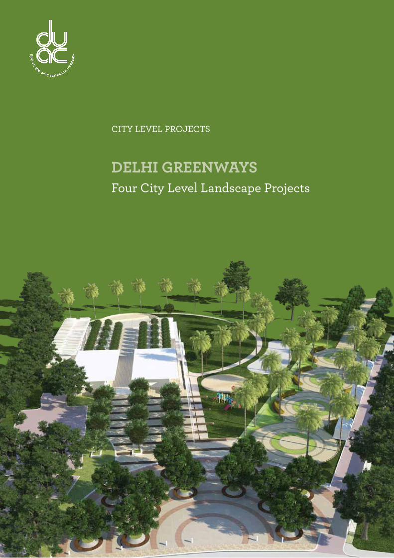
four city level landscape projects - delhi urban art ...e.duac.org/images/pdf/4 delhi...
TRANSCRIPT
CITY LEVEL PROJECTS
Delhi GreenwaysFour City Level Landscape Projects

Delhi Urban art Commission
Raj Rewal Chairman
Satish Khanna MemberSonali Bhagwati MemberEric P. Mall MemberD. Diptivilasa Member & Addl. Secretary, Ministry of Urban DevelopmentVinod Kumar Secretary
DUaC staff
Rajeev Kumar Gaur, Raghvendra Singh, Amit Mukherji, V. K.Tyagi, Siddharth Sagar, Neelam Bhagat, Manju Anjali, Indu Rawat, Nihal Chand
senior ConsultantsSamir MathurRahoul B Singh
ConsultantsSnigdha SarkarRanu Farooqui
acknowledgements
It is said that for an artist to join establishment is a kiss of death. I was fully aware of this
aphorism when the Minister of Urban Development, Mr. Kamal Nath, asked me to be the
Chairman of the Delhi Urban Art Commission. I had three conditions before accepting
the assignment and one of these was that DUAC should be allowed to carry out site
specific studies for improving slums and unauthorized colonies. Subsequently, the Minister
along with the then Lieutenant Governor of Delhi, Mr. Tejendra Khanna, and Secretary,
Ministry of Urban Development, Dr. Sudhir Krishna, approved the proposal to carry out
three dimensional studies for improving slums and unauthorized colonies. I am grateful for
their support.
I would like to thank other members of the Commission, Eric P. Mall, Satish Khanna, Sonali
Bhagwati and D. Diptivilasa for helping to make success of problematic urban design
exercises and charting new paths.
I take this opportunity to thank senior consultants, architects, urbanists and planners as
well as younger colleagues who have been working full time. DUAC Secretary, Vinod
Kumar, and other permanent staff have enthusiastically supported us and guided us
through government procedures. Many thanks to all of them.
Raj Rewal Chairman
DELHI URBAN ART COMMISSION with gratitude duly acknowledges the valuable
contributions of the following Government organizations in making this report:
Ministry of Urban Development
Delhi Development Authority
Government of National Capital Territory of Delhi
North Delhi Municipal Corporation
East Delhi Municipal Corporation
South Delhi Municipal Corporation
New Delhi Municipal Council
Geospatial Delhi Limited
Delhi Metro Rail Corporation
Delhi Urban Shelter Improvement Board
BSES Rajdhani Power Limited
BSES Yamuna Power Limited
RWA’s and Area Councillors

Preface
Half of Delhi lives in ramshackle slums and shabby unauthorized colonies. This state of
affairs is a serious blot on the face of the city which has great historical monuments and
aspires to be a world class city. The centre of New Delhi is lined with leafy trees and can
boast of superb example of contemporary architecture but its growth under exploding
population has disintegrated into shanty towns.
My first memory of Delhi is that of a child going in a tonga from the railway station
to our government quarter in New Delhi around a square which became our home
for several years. The squares were built near Birla temple and when my father was
promoted in the government hierarchy, he was offered an independent house with a
larger area but my mother refused to move as she had developed kinship with families
around the square. This was my first lesson in neighbourhood “mohalla” as an urban
phenomenon.
In fact the word ‘urb’ in Latin stands for neighbourhood space. It was a period when
Connaught Place was the leisurely centre for social, shopping and cultural activities and
the Old Delhi was lively and still gracious, dominated by Jama Masjid and Red Fort. Delhi’s
monuments like Humayun’s Tomb, Qutab Minar and Lodhi Garden were favourite places
for picnics.
Seventy years have passed since the tonga ride, Delhi has dramatically changed as the
population of Delhi has exploded from under a million before partition in 1947 to about
twenty million today.
As a Professor in the School of Planning and Architecture in Delhi, I had ample scope
of studying typology of Indian cities which helped me to design Asian Games Village in my
mid-career around 1980 as a series of clusters (mohalla neighbourhood) woven around
pedestrian pathways, segregated from road networks. This was a low rise high density
housing built within the framework of 150 FAR (FSI 1.5).
Delhi has changed even more drastically during the last thirty years since the Asian
Games Village was built, but the idea of a city as a series of sympathetic, humane
interconnected neighbourhood building blocks interspersed with social, cultural and
educational facilities has remained embedded in my mind.
Delhi Urban Art Commission was established to preserve, develop and maintain the
aesthetic quality of urban and environmental design within Delhi. During the last 40 years
of its existence, DUAC has not received any three dimensional exercises which visualizes
neighbourhoods, wards etc. The emphasis has often been only appraising individual
buildings and complexes submitted through local municipal agencies. After taking over the
direction of DUAC in 2011, members of the Commission arranged meetings with wide
spectrum of advisors and formulated principles on which a building can be automatically
and speedily approved and decided to take over the job of visualization and three
dimensional planning for various aspects of the site specific designs which need to be
urgently developed if Delhi has to maintain standard as a world capital city.
A large part of Delhi lives in unauthorized colonies and slums and even the Master Plan
of Delhi had suggested a detailed design proposal to augment the Master Plan based on
ground realities.
In order to fulfil the requirements of neighbourhoods, wards, the DUAC has
undertaken a few pilot projects which can be eventually developed in a manner that the
local municipal agencies can implement them. In order to carry out these studies, DUAC
developed in its own office a core group of architects and urban planners. This was done
on the basis of DUAC mandate that “the Commission may suo motu promote and
secure the development, re-development of which no proposals in that behalf have been
received from any local body”.
The studies involve the visual tools for ground studies combined with extra assistance
of Google images. It is hoped that the proposals and their conclusions would be
evolved to such an extent that a process can be worked out with the resident welfare
associations to make meaningful designs for the neighbourhood upgradation for the
different kind of wards.
The DUAC’s site specific designs are the seeds which can grow and it is hoped that
economic principles would be evolved to implement the meaningful neighbourhood
upgradation for the different kind of slums and wards. India cannot remain shabby and
ramshackle forever and solutions have to be found for shanty towns.
Raj RewalChairman, DUAC
January 2014

Contents1 Context 6 1.1 Historic Overview of Delhi 6
1.2 Ridges of Delhi 8
1.3 Delhi Forest Cover 9
1.4 Delhi’s Significant Forest and Areas 10
1.5 Location of Potential Nodes 12
1.6 Area of Study 14
1.7 Greenway Concept 15
1.8 Existing Linkages 16
1.9 Neighbourhoods and Monuments 18
1.10 Identification of Nodes 20
2 Proposals 22 2.1 Proposal 1 22 2.1.1 Masjid Moth Node Analysis 22 2.1.2 Existing Condition 24 2.1.3 Masjid Moth Node Proposal 25
2.2 Proposal 2 32 2.2.1 Siri Fort Node Analysis 32 2.2.2 Siri Fort Node Proposal 34 2.3.2 Tree Walk Examples 36
2.4 Proposal 3 38 2.4.1 Don Bosco School Node Analysis 38 2.4.2 Don Bosco School Node Proposal 44
3 Recommendations 58
summary
Delhi, perhaps more so than any other historic metropolis is characterized by its
extensive and varied green cover. These “Greenways” form an integral part of modern
day Delhi. Historically they have formed a connective tissue between the multiple cities
that constitute “Delhi” as well as the numerous historical monuments that are found
throughout Delhi today.
The “Greenways” aim to re-establish the role of these green spaces as connective tissue.
The proposal aims to establish a interconnected green belt system for the South Delhi
region. Once established this approach could be applied to other such locations in the city.
The proposal uses the tools of analysis to determine a strategy for both landscape and
architectural interventions at key locations on the green belt. The analysis, which forms a
part of this document, examines the circulation networks, land use and ownership patterns,
native flora and fauna and the location of key historical monuments and contemporary
structures. Based on this, a selection of key connective nodes in the urban landscape have
been identified for pilot projects. The “Greenways” under the purview of this proposal are
built from Tughlaqabad to Panchsheel Forest which stretches across 20 km.
Design proposals have been done for three identified nodes and a compendium of
conceptual drawings and details have been put together for application at other potential
locations.
Objectives To connect “Urban Greens” and rejuvenate key locations in the city to
enable practice of everyday living.
To assess and identify other areas of intervention
Approach Through minimal built interventions and the selective reorganization of
pedestrian circulation networks.
Methodology Regional and site analysis of South Delhi’s dominant green cover, its
linkages and boundaries.
Proposal To create an environmentally friendly pedestrian and cycling network
through approximately 27 km of inner city forest. To identify key points
of intervention in order to connect otherwise disparate “Urban Greens”
and revitalize their intersections and access nodes.

Co
nte
xt
6 CITY LEVEL ProjECT
Co
nte
xt
7dELhI grEEnwaYs
1.1 historic overview of Delhi
ShahajahanbadShahjahanabad, the walled city built by
Shah Jahan from 1638 to 1649, containing
the Lal Qila and Chandni Chowk. It was
the capital of the Mughal Empire during
Shah Jahan’s reign. It is presently referred
to as “Old Delhi”.
Lutyens’s DelhiLutyens’s Delhi or New Delhi, the city
built by the British on the southwest,
declared capital on 12 December 1911.
Dinpanah (1538–1545)
Dinpanah built by Humayun and Shergarh built by Sher Shah Suri.
SiriSiri, built by Alauddin Khilji in 1303
IndraprasthaThe first instance of the region being
capitalized was in the ancient era, during the
time of the Mahabharata War, perhaps some
5,000 years ago, when the five Pandava
brothers built an immense and highly
sophisticated fortress called Indraprastha
and ruled the country from there.
Firozabad (1351–1388)
Firozabad, built by Firoz Shah Tughluq.
Jahapanah (1325–1351)
Jahanpanah, built by Muhammad bin Tughluq.
Tuglaqabad (1321–1325)
Tughlaqabad, built by Ghiyasuddin Tughluq.
Lal KotLal Kot, built by the Tomars was renamed
Qila Rai Pithora after Prithvi Raj Chauhan
(also known as Rai Pithora). It was a
thirteen-gated fort in Delhi.
Source: INTACH Delhi Chapter, Exhibition Catalogue: Delhi - A Living Heritage
Delhi, has a much larger green cover than any of the other metropolitian city in the country, consisting of 19 % of the total urban area of 44,777 ha. This includes 1,577 ha under the northern, central and south-central Ridge, the remaining of which is under recreational/greens.
Master Plan Delhi 2021
Lalkotcirca 736 - 1060 A.D
Indraprasthacirca 1450 B.C
Siricirca 1297 - 1307 A.D
Tuglaqabad1321–1325
Jahapanah1325 –1351
Ferozabad1351–1388
Dinpanah1538 –1545
Shahajahanbad1638 - 1649
Lutyens’ Delhi1931 A.D
Present Delhi
Chronological evolution of the city of Delhi
Firozabad
Shahjahanabad
Sher GharDinpanah
Jahanpanah
Qila Rai Pithora
DInPAnAh (1533 AD – 1538 AD)SheR GARh (1540 AD)ShAhJAhAnABAD (1639 AD – 1649 AD)
Tughlaqabad
Siri
nizamuddin Basti
Kilokri
hauz Khas
Mahipalpur
hastal
Mehrauli
Chiragh Delhi

Co
nte
xt
8 CITY LEVEL ProjECT
Co
nte
xt
9dELhI grEEnwaYs
1.2 ridges of Delhi
The Delhi Ridge is the northernmost extension of the Aravalli Range to the southwest, perhaps the oldest mountain chain in the world over 1,500 million years old. The Ridge is one of the most striking features of Delhi.
The Ridge was declared a Reserved Forest in 1878 and extensively planted with Prosopis juliflora (kikar), an exotic species, from 1913 onwards. It is a naturalized forest which is the largest habitat to Delihi’s remaining fauna. The official area notified as Reserved Forest is 7,777 ha.
S.no Ridge Forest Approximate Area in ha. (to be demarcated/reconciled)
Proportion of different parts of Ridge (in %)
1 Northern Ridge Forest 87 1.13
2 Central Ridge Forest 864 11.10
3 South-Central Ridge Forest 626 8.05
4 Southern Ridge Forest 6,200 79.72
Total 7,777 100
1. north Ridge The hilly area near Delhi University is by
far the smallest segment of the Ridge.
Nearly 170 ha were declared a Reserved
Forest in 1915. Less than 87 ha remain
today.
2. Central Ridge
It was made into a Reserved Forest in 1914 and stretches from just south of Sadar Bazar to Dhaula Kuan. It extends over 864 ha, but some areas have been encroached upon.
3. South-Central Ridge It is centred on Sanjay Vana, near JNU,
and encompasses 626 ha. Large chunks
have been encroached and built upon.
4. South Ridge
It sprawls across 6,200 ha and includes the Asola and Bhatti wildlife sanctuaries. The least urban of the four segments, a lot of it is village or privately-owned farmland.
Following are the Four Types of Ridge Formations found in Delhi Region
Urban morphology in relation to green cover in Delhi
The total recorded forest area in Delhi is 85 sq. km. i.e. 5.73% of the geographic area, of which the Reserved and Protected Forests constitute 91.76% and 8.24% of the total forest area, respectively.
DelhiDelhiForest Cover1912
DelhiForest Cover Pre-Modern Urbanization
Forest Cover
1.3 Delhi’s Forest Cover
1.
2.
3.
4.
Up to medieval times dense forestation existed in the east
In 1878 the Ridge, consisting of scrub vegetation, was declared a Reserved Forest, and in 1912 afforestation was undertaken
Most forest areas in Delhi are naturalized forest with less than 40% falling under very dense classification.
Historical records inform us that other than in the Ridge areas, trees were in profusion and the countryside well wooded. Forests surrounded Shahjahanabad, and could be seen from the ramparts of Purana Qila. There was a shortage of firewood in the seventeenth century, and in the eighteenth century, armies are known to have cut down vast quantities of timber.
Co
nte
xt
10 CITY LEVEL ProjECT
Co
nte
xt
11dELhI grEEnwaYs
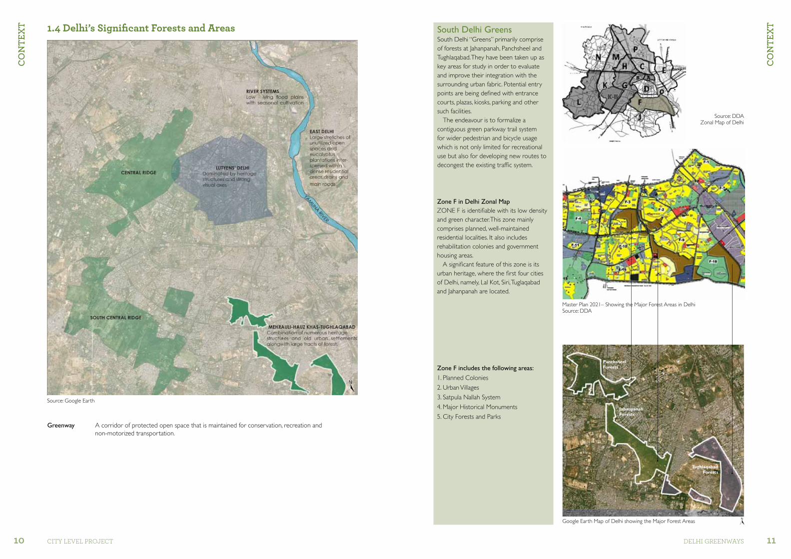
PanchsheelForests
Jahanpanah Forests
TughlaqabadForests
Google Earth Map of Delhi showing the Major Forest Areas
1.4 Delhi’s significant Forests and areas
Greenway A corridor of protected open space that is maintained for conservation, recreation and non-motorized transportation.
Source: Google Earth
Source: DDA
Source: DDAZonal Map of Delhi
Master Plan 2021– Showing the Major Forest Areas in Delhi
South Delhi GreensSouth Delhi “Greens” primarily comprise of forests at Jahanpanah, Panchsheel and Tughlaqabad. They have been taken up as key areas for study in order to evaluate and improve their integration with the surrounding urban fabric. Potential entry points are being defined with entrance courts, plazas, kiosks, parking and other such facilities.
The endeavour is to formalize a contiguous green parkway trail system for wider pedestrian and bicycle usage which is not only limited for recreational use but also for developing new routes to decongest the existing traffic system.
Zone F in Delhi Zonal MapZONE F is identifiable with its low density and green character. This zone mainly comprises planned, well-maintained residential localities. It also includes rehabilitation colonies and government housing areas.
A significant feature of this zone is its urban heritage, where the first four cities of Delhi, namely, Lal Kot, Siri, Tuglaqabad and Jahanpanah are located.
Zone F includes the following areas:
1. Planned Colonies
2. Urban Villages
3. Satpula Nallah System
4. Major Historical Monuments
5. City Forests and Parks

Co
nte
xt
12 CITY LEVEL ProjECT
Co
nte
xt
13dELhI grEEnwaYs
TUGHLAQABAD
MASJID MOTH
1
2A
2B
3
OUTER RING ROAD
PANCHSHEEL MARG
GU
RU R
AVID
AS
MA
RG
SIRI FORT
JAHANPANAH
Proposed Greenway
Nodes
DON BOSCO SCHOOL NODE
MASJID MOTH NODE
2A AND 2BSIRIFORT NODE
1.5 location of Potential nodes

Co
nte
xt
14 CITY LEVEL ProjECT
Co
nte
xt
15dELhI grEEnwaYs
Panchsheel ForestsPanchsheel Forest comprises forest land on either side of the Joseph Broz Tito Marg, beyond Chirag Delhi crossing, with 70 ha on the west and 50 ha on the east. Some peripheral parks have been developed by DDA. The site is characterized by a major drain (Nallah), five ASI monuments and the Siri Fort Sports Complex.
Tughlaqabad ForestsTughlaqabad and Adilabad forts are protected ASI monuments.They contain large parcels of green forest and protected Ridge area. Some parts of this green cover are proposed as archaeological parks as per MPD 2021
Panchsheel Forests
Jahanpanah Forests
Tughlaqabad Forests
Tughlaqabad Forests
Greenway Objectives
• Connecting neighbourhoods
• Vehicular free movement-city network
• Animating intersections
Greenway Activities
• Natural: Habitats (flora and fauna)
• Health and wellness: Cycling, jogging, yoga, sports
• Leisure and recreation: Amphitheatre, picnic huts, food kiosks, children’s play area, yoga
• Culture and heritage: Monuments
The Greenway provides a thematic and scalar opportunity to engage directly with the systems of forces that continuously reconfigure the city. It also offers the double opportunity to re-frame urban problems in these areas and to re-contextualize these areas in general.
1.6 area of study
Jahanpanah ForestsJahanpanah is 175 ha of notified forest land in the heart of South Delhi. It spans a large area extending from Masjid Moth DDA flats on the north to Dakshinpuri on the south. It extends from Greater Kailash II on the east to the end of BRT on the west. The forest has nine entries at present and is under severe threat of encroachment from surrounding colonies.
PanchsheelForests
Jahanpanah Forests
TughlaqabadForests
Key Plan
Jahapanah Forests
Categorization of Green areas and activities allowed in Master Plan 2021
S.no. Category Permisible activities as per master plan 2021
1. Green Belt Forest, vegetation belt, bird sanctuary, biodiversity, police post, fire post, veterinary centre, dairy farms.
2. Regional Parks
Ridge, residential flat for watch and ward, picnic huts, shooting range, zoological garden, bird sanctuary, botanical garden, open air theatre, police post, fire post, orchard, plant nursery.
3. City ParksAqua/water sports park, arboretum, botanical garden, national memorial, amphitheatre, open playground, aquarium and activities permitted under District Park.
4. District Parks
Theme parks, recreational club, national memorial, open air foodcourt, children’s park, orchard, plant nursery, area for water harvesting, archaeological park, specialized park, amusement park upto 10 ha, sports, activity, playground, amenity structures, restaurant in District Park of area over 25 ha.
1.7 Greenway Concept

Co
nte
xt
16 CITY LEVEL ProjECT
Co
nte
xt
17dELhI grEEnwaYs
1.8 existing linkages
Satpula DrainA city drain or Nallah runs from Satpula through Panchsheel Forest extending to Greater Kailash and Defence Colony. This is being covered in Greater Kailash.
Google earth Map Showing existing Linkages
Satpula Drain
Edge Conditions
Trees Along the Edge of the Road
Interface between Residential Areas and BRT
The Edge Condition
Bus Rapid TransitThe second road from Khanpur is the BRT to Ambedkar Nagar terminal via Chirag Delhi. It crosses Moolchand.
Outer Ring RoadThe first road is Joseph Broz Tito
Marg or the Outer Ring Road connecting Nehru Place and Okhla
to the airport via Vasant Vihar.
Mehrauli-Badarpur RoadThe third important road is the Mehrauli-Badarpur Road linking
Badarpur to Gurgaon via Tughlaqabad. This also caters to massive labour
settlements of Dakshinpuri and Sangam Vihar.
Legend
Arterial Roads
Sub-Arterial Roads
Existing Metro Line
Proposed Metro Station
Existing Subway
Existing Bus Stands
Existing Foot Over-Bridge
KHANPUR
MEHRAULI BADARPUR ROAD
NEHRU PLACEM
ATHURA
ROA
D
TO MOOLCHAND
OUTER RING ROADN
ALL
AH
CHIRAG DELHI
BRT
GK II
GOVINDPURIJAHAPANAH CITY
FOREST
TUGHLAQABAD FOREST

Co
nte
xt
18 CITY LEVEL ProjECT
Co
nte
xt
19dELhI grEEnwaYs
GK II
GK III
CHITTARANJAN PARK
MADANGIR
DAKSHINPURIExTN.
JAHANPANAHFOREST
ALAKNANDA
PANCHSHEEL ENCLAVE
SATP
ULL
A D
RAIN
PANCHSHEEL FOREST
GK IASIAN GAMESVILLAGE
SHAHPURJAT
DDA PARK
HAMDARD NAGAR
TUGHLAQABAD ExTN.
TUGHLAQABADFOREST
TUGHLA
QABAD
FORT
ADILABAD FORT
METRO LAND
TUGHLAQABAD
GOVIND-PURI
KALKAJI ExTN.
CHIRAGDELHI
Siri Fort Complex
Chirag Delhi Dargah
Lal Gumbad
The main residential areas surrounding Jahanpanah Forests are Alaknanda, Chittaranjan Park, Greater Kailash, Kalkaji Extn. and Chirag Delhi. The main heritage structures/monuments surrounding the forest area are Tughlaqabad Fort and Adilabad Fort.
The unauthorized colonies which are in the vicinity are Dakshinpuri Extn., Govindpuri, Tughlaqabad and Tughlaqabad Extn.
The major circulation routes are from Dakshinpuri Extn. to GK-II and Alaknanda colonies. Also from Tughlaqabad to the Kalkaji Extn. area.
1.9 neighbourhoods and Monuments
Google earth Map Showing Various Site Parameters
Tughlaqabad Fort
Kali Mandir in Chittaranjan Park
Apartments in Alaknanda
Adilabad Fort

Co
nte
xt
20 CITY LEVEL ProjECT
Co
nte
xt
21dELhI grEEnwaYs
node 2, 2ASatpula Drain bisects Panchsheel Forest. Node 2 and 2A are at the points of intersection.
node 1Masjid Moth Node connecting Pancheel
Forest to Jahanpanah Forest
Node 1: Near Panchsheel Forest
Node 2: Masjid Moth Entrance
Node1: Near Panchsheel Forest
1.10 identification of nodes
CONNECTOR NODE
CONNECTOR NODE
CONNECTOR NODE
ENTRANCE NODE
1
2
2 A
3
4
Jahapanah City Forest
TUGHLAQABAD FORESTS
SIRI FORT
node 3Entrance to Jahanpanah Forest from Don Bosco School and main DDA
site office for Jahanpanah Forest
node 4 for Future Proposal:
Green edge along the road, crossing between Jahanpanah Forest and
Tughlaqabad Forest
Node 3: Entrance opposite Don Bosco School
Node 3: Existing DDA Site Office
Node 4: Tughlaqabad Fort

PRo
Posa
ls
22 CITY LEVEL ProjECT
PRo
Posa
ls
23dELhI grEEnwaYs
existing Condition of Masjid Moth node
The subway does not have ample clear height in the midway which is also a deterrent to the user.The wicket gate entrance to 178 ha forest is very
insignificant and closed most of the time and generally opened from 4-7pm.
2.1.1 Masjid Moth node – Analysis
Plan of Masjid Moth node showing Boundary of Intervention
The road is closed by putting retaining walls at the entrance.
Existing Subway
Existing Subway
Existing Bus Stop
Delhi Jal BoardMasjid Moth Flats
Metro
Jahapanah Forest
A drain flows between the commercial and the residential neighbourhood towards the Chirag Delhi Nallah.
Boom barrier has been put up by the RWA on the road.
The ad-hoc and unplanned marble market has resulted in land grabbing. Spill outs of the road and development of unauthorized bamboo market opposite. The road discourages visitors to Jahanpanah from that side.
Unkempt MCD park is a haven for antisocial elements.
Plan of Masjid Moth node showing Ownership Patterns
Legend
DMRC
DDA
MCD
PRIVATE
DELHI JAL BOARD
Existing Commercial Area
Google earth Map showing Masjid Moth node

PRo
Posa
ls
24 CITY LEVEL ProjECT
PRo
Posa
ls
25dELhI grEEnwaYs
Land Use Patterns
LEGEND
COMMERCIAL
PUBLIC/SEMI PUBLIC
RESIDENTIAL AREA
DELHI METRO LAND
GARDENS/PARKS
FOREST AREA
2.1.2 existing Condition – Masjid Moth node
existing Circulation networks
Proposed View showing the Landscape Boulevard near existing Commercial Complex
Forest Edge
2.1.3 Masjid Moth node Proposal
1
LEGEND
VEHICULAR ACCESS
RESTRICTED VEHICULAR ACCESS
PEDESTRAIN ACCESS
CYCLE TRACK
1
Proposed Circulation networks

PRo
Posa
ls
26 CITY LEVEL ProjECT
PRo
Posa
ls
27dELhI grEEnwaYs
Masjid Moth node Plan
Legend
Cycle Parking and Existing Amenities
2 & 4 Wheeler Parking
Forest Entry Area
Pedestrian Plaza with Bosques5
7
6
8 Pedestrian Movement Zone
Cycle Track
Vehicular Path
Kiosks and Food Court9
11
10
12Subway Sunken Plaza/Amphitheater
Bus Stop
Vehicular Drop Off
Metro Exit1
3
2
4
Ped
est
rian
arc
ad
e c
onn
ec
ting
me
tro
to ja
hanp
ana
h
Key Plan of Forests
Jahanpanah Forests Tughlaqabad
ForesTs
PanchsheelForests
JahanpanahForests
TuglaqabadForests

PRo
Posa
ls
28 CITY LEVEL ProjECT
PRo
Posa
ls
29dELhI grEEnwaYs
Existing image: Pedestrian access along the road near theproposed Metro station
Proposed Plan
Part Plan I Proposed image for Pedestrian Walkway
existing Condition
Proposed Condition
Masjid Moth node
Proposed image showing Landscape Plaza
Proposed view showing Landscape Court near existing subway
Proposed Condition
Road barricaded to restrict vehicular movement Barricaded road with Pedestrian Walkway leading to subway
existing Conditions
Existing bus stand along Outer Ring Road near GK IIKey Plan View 1VIEW 1
Proposed Key Plan existing Key Plan
1 2
3
1 2
3

PRo
Posa
ls
30 CITY LEVEL ProjECT
PRo
Posa
ls
31dELhI grEEnwaYs
Proposed image for Pedestrian Path and Cycle Track with avenue of tree plantation
LANDSCAPE BOULEVARD
JAHANPANAH FORESTS
MASJID MOTH FLATS
Part Plan 4 – Proposed Condition
Part Plan 3 – Proposed Condition Proposed view showing Pedestrian Plaza
Proposed View 2: Landscape entrance Court near existing subway
Proposed View 1: Landscape entrance Court near existing subway
Masjid Moth
Proposed view showing Landscape Entrance Court with tree planters
Part Plan 2 – Proposed Condition
Key Plan
Part Plan 4
Part Plan 3
VIEW 2
VIEW 1
Part Plan 2

PRo
Posa
ls
32 CITY LEVEL ProjECT
PRo
Posa
ls
33dELhI grEEnwaYs
Google earth Map of Siri Fort node
Model Park maintained by DDA
Satpula Drain viewed from the roadside
ZONE 1 DETAIL
Plan showing land use patterns
Plan showing existing circulation networks
2.2.1 Siri Fort node Analysis
Plan Showing Boundary of Intervention
Boundary of InterventionBOUNDARY OF INTERVENTION
AREA=511350 SQM
1
1
2
Pathways with overgrown shrubs
2
Barren land near the Nallah
3
1
2
3
4
Existing pathways – not maintained
4
2
1
Ruins of monuments
1
2
1
2
3
4

PRo
Posa
ls
34 CITY LEVEL ProjECT
PRo
Posa
ls
35dELhI grEEnwaYs
Proposal for Siri Fort node
Key Plan Pedestrian bridge over the Nallah Pedestrian bridge over the Nallah
Proposal For Siri Fort node
2.2.2 Siri Fort node

PRo
Posa
ls
36 CITY LEVEL ProjECT
PRo
Posa
ls
37dELhI grEEnwaYs
Pathway edging in forests Tree walkway
Boardwalk examples
Outdoor seating made of natural material
Tree Walk examples through Forests
Tree Walk through forests with pavilions in-between for seating
View of Tree Line
View of Tree Walk
Example showing Tree Walk along with the City Line (Alexandra Road & Telok Blangah Hill Park, Singapore)
2.2.3 Tree Walk examples Intent within Forests
Tree Walk Garden
Tree Walk example (Kew Garden)

PRo
Posa
ls
38 CITY LEVEL ProjECT
PRo
Posa
ls
39dELhI grEEnwaYs
Images Showing Proposed Pedestrian Plaza forming the entrance to the Forest
Reference images showing the character of spaces that needs to be provided at the entrance nodes for the forests.With our proposal our intent is to create spaces that:• Define the entrance to the forest.• Provide visual connection between the forest areas and the street.• Provide spaces for Impromptu activities that bring life to the Area.• Provide proper space for people in vicinity of transport interchanges.• Provide for safe and efficient pedestrian movement.
Examples of pedestrian movement worldwide are when the pedestrian movement is integrated within the landscape, providing for commercial and informal gathering spaces.
2.4.1 Don Bosco School node

PRo
Posa
ls
40 CITY LEVEL ProjECT
PRo
Posa
ls
41dELhI grEEnwaYs
Plan showing ownership pattern: DDA
Pedestrian access readily used by the workers
Existing structure in the park
existing Condition
Plan showing Boundary of Intervention
Gate after which Jahanpanah Forests starts
2.4.1 Don Bosco School node
existing Issues1. Lack of adequate parking space for visitors2. Lack of defined entrance area3. Lack of security provisions for domestic help who cross over from Dakshinpuri Extn. to Alaknanada and GK II4. Lack of defined space for the vendors and street hawkers5. There is no food kiosk within the forest area Plan Showing existing Circulation networks
Native trees like kadamb and neem are being proposed by DDA
Plan Showing Land Use Patterns Existing DDA site office
1
2
3
4
5
Boundary of Intervention

PRo
Posa
ls
42 CITY LEVEL ProjECT
PRo
Posa
ls
43dELhI grEEnwaYs
Proposed view of Landscape Court with tree planters which can be used for open seating
Don Bosco School node – Option 1

PRo
Posa
ls
44 CITY LEVEL ProjECT
PRo
Posa
ls
45dELhI grEEnwaYs
PART PLAN 2
PART PLAN 3
Proposal for Don Bosco School entrance node
2.4.2 Don Bosco School node – Option 1
Legend
Kids Play Area
Multiutility Space
Plaza
Pedestrian Mall with Seats5
7
6
8
F&B Space (Cafe)
Amphitheatre
Sculpture and Food Court
Yoga Lawn9
11
10
12Vehicular Parking (30 Cars)
Auto Parking
Pathway for Local Pedestrian Movement with Kiosks
Entrance Plaza with Seats1
3
2
4
Key Plan
PanchsheelForests
Jahanpanah Forests
Tughlaqabad
ForesTs
Don Bosco School node- Option 2
Part Plan 2 Proposed image showing Pedestrian Walkway (Reference Imagenary)
Key Plan
Part Plan 3 Proposed image showing Amphitheatre
Proposed image showing Amphitheatre

PRo
Posa
ls
46 CITY LEVEL ProjECT
PRo
Posa
ls
47dELhI grEEnwaYs
Rendered View of the Restaurant Block
Don Bosco School node: Design Intervention for Option 1

PRo
Posa
ls
48 CITY LEVEL ProjECT
PRo
Posa
ls
49dELhI grEEnwaYs
Proposed Circulation networks for Don Bosco School node
Proposed View for Don Bosco School entrance node
LegendVehicular Access
Pedestrain Access
Don Bosco School node – Option 1
Part Plan 1 Proposed View showing entrance Court
entrance Court for Don Bosco School entrance node
PART PLAN 1
Key Plan

PRo
Posa
ls
50 CITY LEVEL ProjECT
PRo
Posa
ls
51dELhI grEEnwaYs
View of Open Seating and Restaurant with solar panels on its roofKey Plan
Don Bosco School node
PRo
Posa
ls
52 CITY LEVEL ProjECT
PRo
Posa
ls
53dELhI grEEnwaYs
Don Bosco School node – Option 2
Proposal for Don Bosco School entrance node
Legend
Utility Area
Ramp
Plaza
Pedestrian Mall with Seats5
7
6
8
Multiutility Space
F&B Space
Amphitheatre and Food Court
Sculpture Court
Kids Play Area
Retail Area9
11
10
12
13
14
Vehicular Parking (30 Cars)
Auto Parking
Pathway for Local Pedestrian Movement With Kiosks
Entrance Plaza with Seats1
3
2
4
Features for Option 1 & 2:
• Defined pedestrian walkway with avenue of trees
• Large inviting entrance plazas
• Restaurant blocks with large spillout seating space
• Amphitheatre located at the end of pedestrian plaza
• Option-2 has a defined children’s play area
• Adequate parking space
Part Plan 4 Reference imagery showing Landscape Plaza
PART PLAN 4
Key Plan

PRo
Posa
ls
54 CITY LEVEL ProjECT
PRo
Posa
ls
55dELhI grEEnwaYs
Rendered View of Open Spaces like magazine kiosk and planters with seating
Don Bosco School node – Option 2
Key Plan
PRo
Posa
ls
56 CITY LEVEL ProjECT
PRo
Posa
ls
57dELhI grEEnwaYs
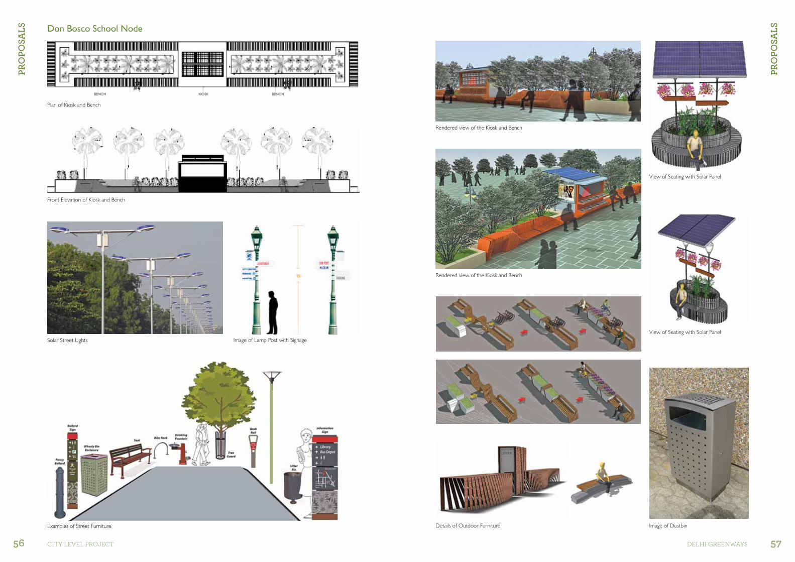
Details of Outdoor Furniture
Rendered view of the Kiosk and Bench
Rendered view of the Kiosk and Bench
Image of Dustbin
View of Seating with Solar Panel
View of Seating with Solar Panel
Plan of Kiosk and Bench
Front Elevation of Kiosk and Bench
Solar Street Lights Image of Lamp Post with Signage
Examples of Street Furniture
Don Bosco School node

ReC
om
men
dat
ion
s
58 CITY LEVEL ProjECT
ReC
om
men
dat
ion
s
59dELhI grEEnwaYs
Key Points
• The other nodes will be taken up in a similar manner as marked in this plan.
• District park maintained by DDA will be further integrated in the Greenway Project.
• Preserve the natural flora and fauna of the forests.
• The existing invasive trees like vilaithi keekar which hinder the growth of other plants will be replaced by native trees.
• All existing native trees will be incorporated in the final design.
• Make prominent entrance nodes which are more visible and accessible.
• Create spaces for informal gathering and activities at the entrance nodes.
• Providing visual connection between forested areas and the outside activities. Also, open up forest edges for visual connection.
• Designing spaces to cater to all demographics.
• Provide safe environment for kids to play and for women.
• Design a bike trail and pedestrian pathway connecting the important historic sites.
• Intersecting these pathways and bike trails at regular intervals with kiosks, cafes, rest-areas and picnic spots.
• Provide facilities for outdoor sports activities like volleyball, badminton and cricket.
• Provide proper signages in and around the site.
• Extend the landscape character to adjoining streets, resldential areas and commercial areas.
• Provide adequate parking spaces.• Pedestrian pathways and forest
areas should be adequately lit for safety purposes.
MASJID MOTH
2A
2B
3
OUTER RING ROAD
PANCHSHEEL MARG
SIRI FORT
DON BOSCO SCHOOL NODE
2A AND 2BSIRIFORT NODE
GU
RU R
AVID
AS
MA
RG
TUGHLAQABADJAHANPANAH
4.
5.
6.
1MASJID MOTH
NODE


ReC
om
men
dat
ion
s
62 CITY LEVEL ProjECT