former pinjin townsite european heritage survey
TRANSCRIPT

FORMER PINJIN TOWNSITE
EUROPEAN HERITAGE SURVEY
Prepared forAngloGold Ashanti Australia
JUNE 2008
By
Hocking Planning & Architecture

Pinjin European Heritage Survey Hocking Planning & Architecture
June 2008 1
CONTENTS
FIGURES.................................................................................................................. 3
1.0 INTRODUCTION............................................................................ 5
2.0 STUDY TEAM................................................................................ 5
3.0 ACKNOWLEDGMENTS................................................................. 6
4.0 METHODOLOGY........................................................................... 6
5.0 CURRENT HERITAGE LISTINGS ................................................. 7
6.0 STATEMENT OF SIGNIFICANCE ................................................. 7
6.0 LOCATION..................................................................................... 8
7.0 CHRONOLOGY ........................................................................... 10
8.0 HISTORICAL BACKGROUND ..................................................... 12
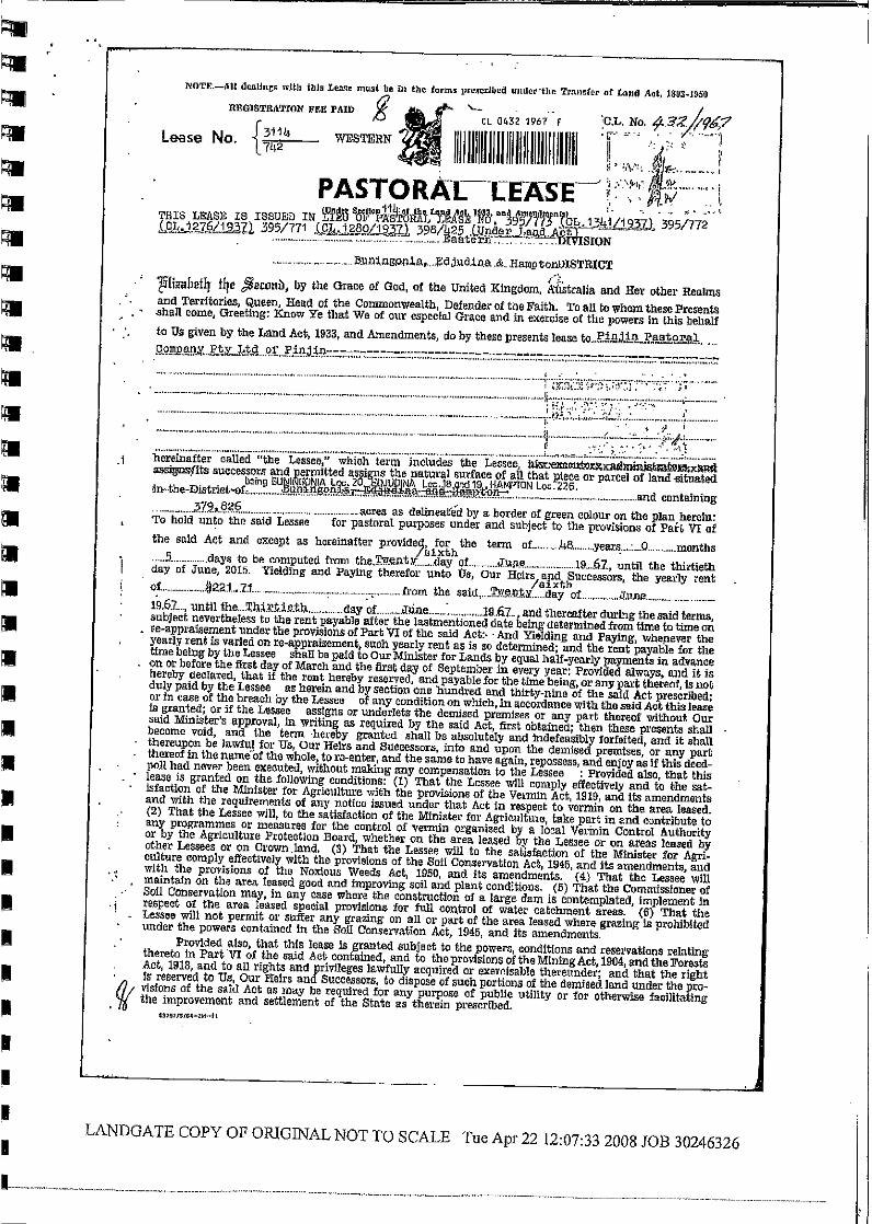
8.1 Pinjin Pastoral Lease.................................................................... 12
8.2 Pinjin Mining Centre and Town..................................................... 14
9.0 CURRENT LAND OWNERSHIP AND RESPONSIBILITY............ 24
10.0 CONCLUSIONS........................................................................... 25
10.1 Guidelines for future management ............................................... 25
11.0 BIBLIOGRAPHY .......................................................................... 26
12.0 APPENDICES.............................................................................. 28
Current and past pastoral Leases 28
Land Reserves 28

Pinjin European Heritage Survey Hocking Planning & Architecture
June 2008 2
Pinjin European Heritage Survey Hocking Planning & Architecture
June 2008 3
FIGURES
Figure 1 Location Plan ..........................................................................8
Figure 2 Detailed site plan ....................................................................9
Figure 3 Portion of a plan showing mining leases at Pingin in 1906 ...15
Figure 4 Pinjin Cemetery c.1970s. ......................................................17
Figure 5 Grave in Pinjin Cemetery c.1970s. .......................................17
Figure 6 Grave in Pinjin Cemetery for Dennis Donovan c.1970s. .......17
Figure 7 Tablet for Dennis Donovan. ..................................................18
Figure 8 Windmill at Pinjin c.1970s. ....................................................18
Figure 9 Square tanks at Pinjin c.1970s. ............................................18
Figure 10 Old Boiler at Pinjin c.1970s...................................................19
Figure 11 Churn Drill at Pinjin c.1970s..................................................19
Figure 12 Churn Drill brake pad at Pinjin c.1970s.................................19
Figure 13 Old 'Spring' Cart at Pinjin. .....................................................20
Figure 14 Dietz lamp, Tubular No. 3 found at Pinjin c.1970s. ...............20
Figure 15 Old hut at Pinjin c.1970s. ......................................................20
Figure 16 Old hut at Pinjin c.1970s. ......................................................21
Figure 17 Scoop at Pinjin c.1970s. .......................................................21
Figure 18 Scoop at Pinjin c.1970s. .......................................................21
Figure 19 Wagon at Pinjin c.1970s. ......................................................22
Figure 20 Wagon at Pinjin c.1970s. ......................................................22
Figure 21 Wagon at Pinjin c.1970s. ......................................................22
Figure 22 Wagon Brake pad at Pinjin c.1970s......................................23
Figure 23 Plough at Pinjin c.1970s. ......................................................23

Pinjin European Heritage Survey Hocking Planning & Architecture
June 2008 4
Pinjin European Heritage Survey Hocking Planning & Architecture
June 2008 5
1.0 INTRODUCTION
Since white settlement of the Shire of Menzies region in the 1890s, the area hasbeen characterised by the rapid settlement and abandonment of small miningsettlements. The pastoral industry has had a more permanent association with theregion although the difficult conditions have seen many leases fail to thrive. Theformer town of Pinjin and the adjacent pastoral lease and homestead are typicalexamples of the pattern of settlement and abandonment seen in this region. There isnow little physical evidence of the town’s former existence and the Old Pinjinhomestead is in ruins.
The Tropicana Gold Project is a joint venture (Tropicana JV) between AngloGoldAshanti Australia (70% share and managers) and Independence Group (30% share).A pre-feasibility study is currently being conducted for the Tropicana Gold Project todetermine whether it can become a viable gold mining operation. The proposedTropicana Gold Project is to be located approximately 330km north-north-east ofKalgoorlie on the western edge of the Great Victoria Desert. Access road options tothe proposed site are currently being investigated and one road option passesthrough the Pinjin pastoral lease area.
The Pinjin pastoral area was identified through an initial desktop assessment asbeing a potential European heritage site. As part of the pre-feasibility study for theTropicana Gold Project, AngloGold Ashanti commissioned Hocking Planning &Architecture to conduct a heritage study of Pinjin pastoral area to identify the heritagevalue of Pinjin. AngloGold Ashanti will incorporate the findings of this report into itsroad alignment evaluation process and any potential impact on any identifiedheritage value will be avoided where possible.
This report provides a brief history of the Pinjin mining industry, town and pastorallease and include a detailed bibliography of the sources available for furtherresearch.
2.0 STUDY TEAM
The study team comprised:
Hocking Planning & Architecture
Ian Hocking, B.Arch.(Hons.)(Melb.),Dip.T.P.(UCL.),CIVVIH, FRAIA, Principal, Director
Yen Nee Goh, B Arch (Curtin) Graduate Architect
Prue Griffin, BA, Post Grad. Dip. Public History
Dinelka Perera, B.Arch (UWA) Student
With additional research byPhillip Pascoe BA (Hons.) (UWA).
Pinjin European Heritage Survey Hocking Planning & Architecture
June 2008 6
3.0 ACKNOWLEDGMENTS
The study team wishes to acknowledge the involvement of the following individuals inthe preparation of this study:
Belinda Bastow AngloGold Ashanti AustraliaEmma Bamforth AngloGold Ashanti AustraliaJustin Lee Community Development Officer, Shire of MenziesJan Pruyn Regional Manager, State Land Services, Department of
Planning and Infrastructure
4.0 METHODOLOGY
To determine the current cadastral boundaries, the origin of these reserves and thehistory of the region since white settlement; research was undertaken at the BattyeLibrary of Western Australian History, State Records Office of Western Australia andLandgate. A desktop survey was undertaken by Hocking Planning & Architecture tofurther research the history of the Pinjin area.
The report follows the approach recommended by Australia ICOMOS (InternationalCouncil on Monuments and Sites). It applies the principles set out in The AustraliaICOMOS Charter for the Conservation of Places of Cultural Significance (The BurraCharter), Guidelines to the Burra Charter: Cultural Significance, Guidelines to theBurra Charter: Conservation Policy, and Guidelines to the Burra Charter: Proceduresfor Undertaking Studies and Reports.1
The preparation of the report has also been informed by the principles of TheConservation Plan,2 and the Criteria of Cultural Heritage Significance for Assessmentof Places for Entry into the Register of Heritage Places. 3
1 Peter Marquis-Kyle & Meredith Walker, The Illustrated Burra Charter: Making GoodDecisions About the Care of Important Places, Australia ICOMOS, Sydney, 1994.The Burra Charter and guidelines are available from www.icomos.org/australia.
2 James Semple Kerr, The Conservation Plan: A Guide to the Preparation ofConservation Plans for Places of European Cultural Significance. National TrustNSW, Sydney, 1990 – 5
thEdition 2000.
3 Heritage Council of Western Australia, Criteria of Cultural Heritage Significance forAssessment of Places for Entry into the Register of Heritage Places. RevisedNovember 1996.

Pinjin European Heritage Survey Hocking Planning & Architecture
June 2008 7
5.0 CURRENT HERITAGE LISTINGS
Register of Heritage Places: Not included
National Trust Classification: Not classified
Town Planning Scheme: Not included
Municipal Inventory: Not included
Register of the National Estate: Not included
The former Pinjin townsite and the associated area are not included on any currentheritage listing. The Shire of Menzies prepared an inventory of heritage places in1996 and no sites relating to the Pinjin area were included in the inventory. It is arequirement of the Heritage Act (1980) that the Local Government Authority’s reviewtheir inventories regularly. The Shire of Menzies is not currently undertaking a reviewof their inventory of heritage places. Information from the Shire of Menzies statesthat there are no current plans to include any sites within the Pinjin area for inclusionin any future inventory of Heritage Places.
It should be noted that the area is not included or near the Goldfields EsperanceHeritage trail network. This trail recognises places of heritage interest in the regionand the Pinjin area has not been identified as a place of heritage significance.
6.0 STATEMENT OF SIGNIFICANCE
The former settlement of Pinjin which is located north east of Kalgoorlie in the Shireof Menzies is an area historically associated with the mining and the pastoralindustries. It has potential cultural heritage significance for the following reasons:
the site is likely to contain material relating to the period of settlement inthe early 20th century, the material could relate to mining activities, thepastoral industry or the domestic lifestyle of the people who occupied thesettlement;
the site is likely to provide information about former mining processes andactivities that will inform an understanding of past mining practices;
the site has the potential to inform an understanding of the conditionsexperienced by early white settlers in the region;
the site has the potential to inform about the relationship between theearly white settlers and the local aboriginal groups who occupied theregion; and
the site has the potential to inform about the practice of abandoningsettlements in regional Western Australia as it is an example of thispractice.
Pinjin European Heritage Survey Hocking Planning & Architecture
June 2008 8
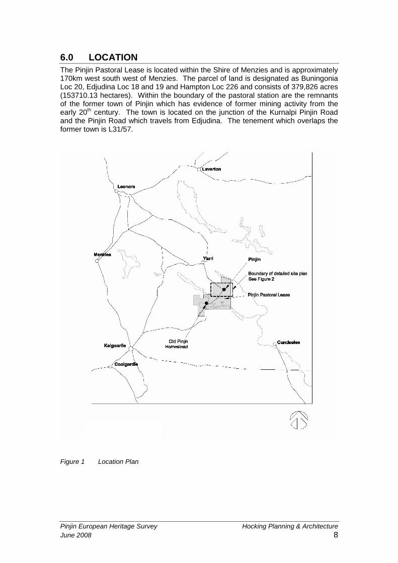
6.0 LOCATION
The Pinjin Pastoral Lease is located within the Shire of Menzies and is approximately170km west south west of Menzies. The parcel of land is designated as BuningoniaLoc 20, Edjudina Loc 18 and 19 and Hampton Loc 226 and consists of 379,826 acres(153710.13 hectares). Within the boundary of the pastoral station are the remnantsof the former town of Pinjin which has evidence of former mining activity from theearly 20th century. The town is located on the junction of the Kurnalpi Pinjin Roadand the Pinjin Road which travels from Edjudina. The tenement which overlaps theformer town is L31/57.
Figure 1 Location Plan

Pinjin European Heritage Survey Hocking Planning & Architecture
June 2008 9
Figure 2 Detailed site plan
Pinjin European Heritage Survey Hocking Planning & Architecture
June 2008 10
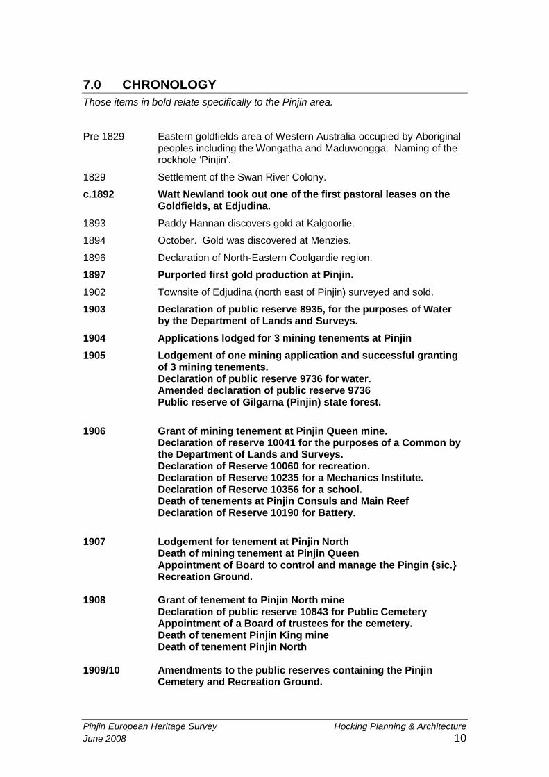
7.0 CHRONOLOGY
Those items in bold relate specifically to the Pinjin area.
Pre 1829 Eastern goldfields area of Western Australia occupied by Aboriginalpeoples including the Wongatha and Maduwongga. Naming of therockhole ‘Pinjin’.
1829 Settlement of the Swan River Colony.
c.1892 Watt Newland took out one of the first pastoral leases on theGoldfields, at Edjudina.
1893 Paddy Hannan discovers gold at Kalgoorlie.
1894 October. Gold was discovered at Menzies.
1896 Declaration of North-Eastern Coolgardie region.
1897 Purported first gold production at Pinjin.
1902 Townsite of Edjudina (north east of Pinjin) surveyed and sold.
1903 Declaration of public reserve 8935, for the purposes of Waterby the Department of Lands and Surveys.
1904 Applications lodged for 3 mining tenements at Pinjin
1905 Lodgement of one mining application and successful grantingof 3 mining tenements.Declaration of public reserve 9736 for water.Amended declaration of public reserve 9736Public reserve of Gilgarna (Pinjin) state forest.
1906 Grant of mining tenement at Pinjin Queen mine.Declaration of reserve 10041 for the purposes of a Common bythe Department of Lands and Surveys.Declaration of Reserve 10060 for recreation.Declaration of Reserve 10235 for a Mechanics Institute.Declaration of Reserve 10356 for a school.Death of tenements at Pinjin Consuls and Main ReefDeclaration of Reserve 10190 for Battery.
1907 Lodgement for tenement at Pinjin NorthDeath of mining tenement at Pinjin QueenAppointment of Board to control and manage the Pingin {sic.}Recreation Ground.
1908 Grant of tenement to Pinjin North mineDeclaration of public reserve 10843 for Public CemeteryAppointment of a Board of trustees for the cemetery.Death of tenement Pinjin King mineDeath of tenement Pinjin North
1909/10 Amendments to the public reserves containing the PinjinCemetery and Recreation Ground.
Pinjin European Heritage Survey Hocking Planning & Architecture
June 2008 11
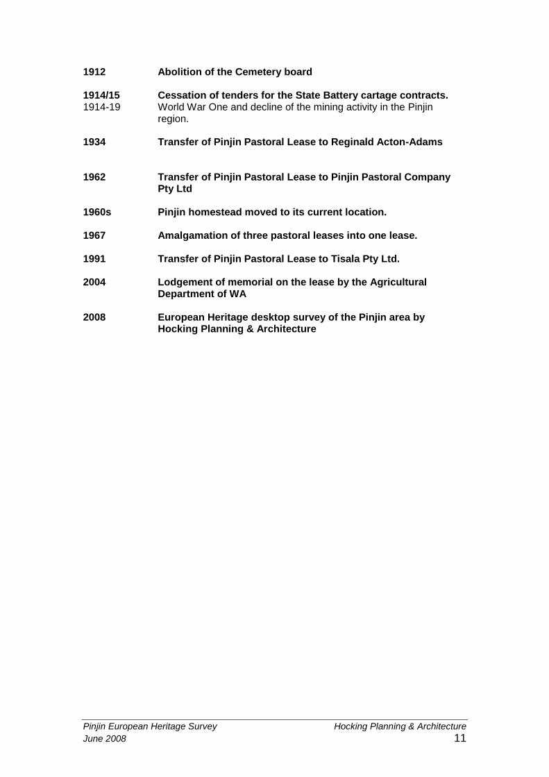
1912 Abolition of the Cemetery board
1914/15 Cessation of tenders for the State Battery cartage contracts.1914-19 World War One and decline of the mining activity in the Pinjin
region.
1934 Transfer of Pinjin Pastoral Lease to Reginald Acton-Adams
1962 Transfer of Pinjin Pastoral Lease to Pinjin Pastoral CompanyPty Ltd
1960s Pinjin homestead moved to its current location.
1967 Amalgamation of three pastoral leases into one lease.
1991 Transfer of Pinjin Pastoral Lease to Tisala Pty Ltd.
2004 Lodgement of memorial on the lease by the AgriculturalDepartment of WA
2008 European Heritage desktop survey of the Pinjin area byHocking Planning & Architecture
Pinjin European Heritage Survey Hocking Planning & Architecture
June 2008 12
8.0 HISTORICAL BACKGROUND
The former town of Pinjin and the pastoral lease Pinjin station take their name fromthe water hole in the vicinity [30º 05’ S. 122º 34’ E]. The meaning of this aboriginalname was not able to be found from the sources consulted. Variations of the spellingof the word have included Pingin and Pingan. Throughout this report the spellingPinjin will be used as this is the version most commonly used today.4
8.1 Pinjin Pastoral Lease
The pastoral lease at Pinjin was taken up by Watt Newland in the 1890s and run byhis brother Simpson.5 The Newland brothers had moved to Western Australia fromSouth Australia in search of work in the gold fields. Watt Newland came with abullock team and diversified into condensing water and suppling meat to the growingnumbers of miners in the district. The Newland brothers were related to adistinguished South Australian family who had several pastoral properties in thestate. Their uncle Simpson Newland (1835-1925) was a pastoralist, author andpolitician in South Australia. He is well known for his novels ‘Paving the Way’ (1893)and ‘Blood Tracks of the Bush’ (1900).6
The Newland brothers had a long association with the region. Watt Newland had arelationship with Aboriginal woman, Goondair also known as ‘Larrikin Kitty’, withwhom he had a son. This son, Windtharra or Arthur moved to the Old Pinjin stationand lived with his uncle until 1926.7
Watt Newland is a figure in whom the European history of Pinjin and the Aboriginalhistory of the eastern Goldfields intersects. Remembered by present-day Aboriginalpeople as ‘Old Thamu Watt’, he was known to hide indigenous people from the policeand the protector of Aborigines. The Newland family continued their association withthe region as a nephew of the Newland brothers, Colin Newland was the stationmanager of the Edjudina pastoral lease from 1938 to 1950.8
Simpson Newland continued to manage the Pinjin Pastoral Lease but in 1920 he isrecorded as a miner and living in Yarri, as was Watt Newland.9 It is apparent that thepastoral leases were often managed by an employee and the leaseholder livedelsewhere. Little information was found about the management of Pinjin Stationhowever it is apparent that local Aboriginal people worked on the station. As the
4Geographic Names Database, Landgate, information provided by LandgateCartographic Officer, June Gronow, January 2008.
5The date of the original lease is estimated to be 1897 as this was the year given onthe original lease number. Often however formal recognition of land acquisition couldbe some time after the physical acquisition by Newland.
6 Australian Dictionary of Biography online edition, Simpson Newland, accessed April2008, http://www.adb.online.anu.edu.au/biogs/A110012b.htm
7Information from the transcripts from hearings from the Federal Court of Australia,Harrington-Smith on behalf of the Wongatha People v State of Western Australia (no9) [2007] FCA 31, http://www.fedcourt.gov.au/judgments/2007FCA0031.pdf ; andannexure F thereto, http://www.fedcourt.gov.au/judgments/2007FCA0031_AnnF.pdfThis source states that Windatharra (Arthur) Newland was sent to live at Pinjin by theProtector of aborigines. He apparently left the station in 1926 to join a boxing troupe.
8Colin Newland Oral History, OH 2799, Battye Library.
9Wises Post Office Directories, 1920, Battye Library, online editionhttp://www.slwa.wa.gov.au/pdf/battye/pods
Pinjin European Heritage Survey Hocking Planning & Architecture
June 2008 13
adjacent station, Edjudina ran sheep it is surmised that sheep were the main stockon the station.
The chain of ownership and occupancy of Pinjin has not been clearly established forthe early part of the 20th century however the Newland brothers continued to beinvolved in its management and ownership.
Pinjin Pastoral lease was transferred to Reginald Acton Adams in 1934. Acton-Adams is recorded as the leaseholder of Pinjin station from 1934 although there isevidence that he acquired the lease prior to that.10 Acton Adams also leased anadjacent property at the same time and together the two leases totalledapproximately 350,000 acres.11 Limited research has found that Reginald Acton-Adams was originally from New Zealand and lived at one time in Otago.12
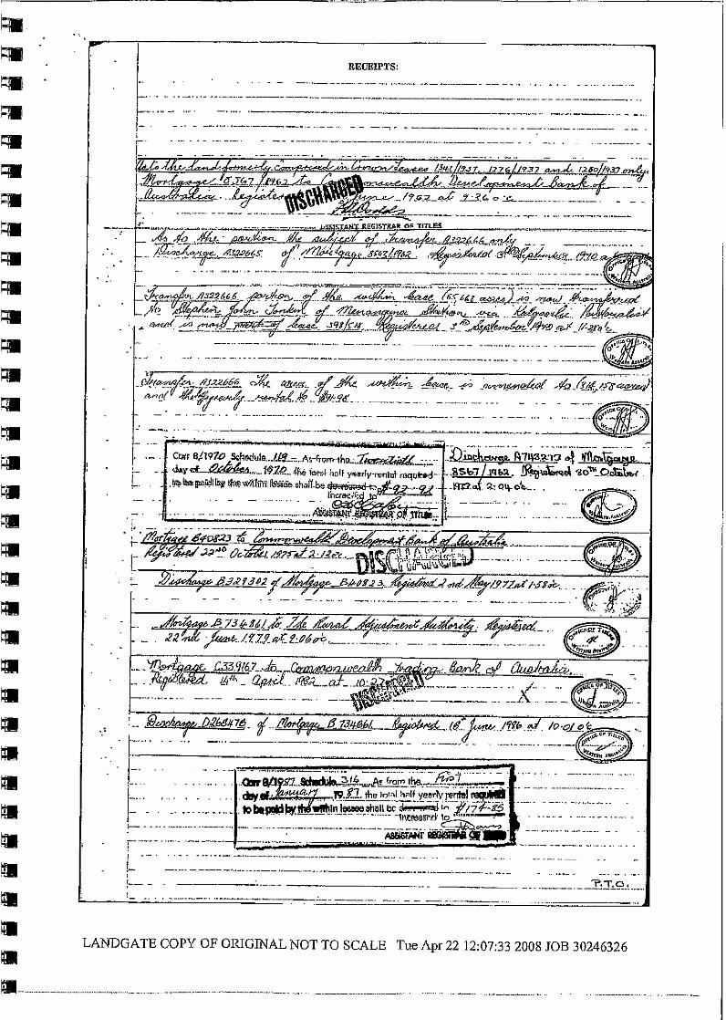
Reginald Acton-Adams died in 1958 and the lease was transferred to his widow,Anne Acton-Adams. In 1962, the lease was transferred to the Pinjin PastoralCompany Pty. Ltd and for a number of years Anne Acton-Adams was the mortgageefor the company.13
During the 1960s a new homestead was built for Pinjin station at a different location.Information from Landgate’s Geographic Names section indicates that thehomestead was moved between 1964 and 1966 when the new homestead isrecorded. This probably coincided with the change of leaseholder to Pinjin PastoralCompany. The individuals who were responsible for the management of the PastoralLease at this time has not been determined. In 1967, the three former leases werecombined under one lease 432/1967. In 1968, the former homestead is recorded byLandgate as being abandoned.
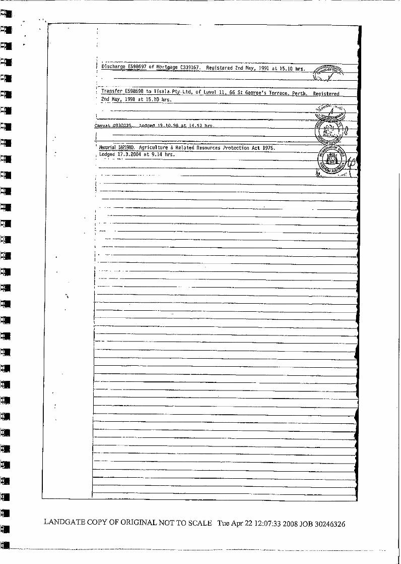
The Pinjin pastoral lease was transferred to the current leaseholders Tisala Pty Ltd in1991.14 Tisala is the company name for an Aboriginal group who own the lease andoperate the station. In November 2004, plans for the future directions of Pinjin werediscussed in a two day workshop hosted by Tisala and the Goldfields Land and SeaCouncil (GLSC). As recorded in GLSC News the workshop brought together a rangeof participants.
Early November saw the GLSC and Aboriginal owners of Pinjin Station, Tisala PtyLtd, host a two-day workshop to discuss the property’s future. Also participating wererepresentatives from the Eastern Goldfields Aboriginal Advancement Council, NingaMia Village Aboriginal Corporation, Menzies Aboriginal Corporation and theIndigenous Land Corporation (ILC), which funded the workshop. The workshop setpriorities for making the most of Pinjin’s natural resources and exploring opportunitiesfor youth employment and training, tourism and business possibilities (e.g. Sellinggoats and native seed harvesting), use of new technologies for power and water, and
10The Pinjin Tank was leased to Acton Adams in 1928 as stated in file Mines WaterSupply – Pingin Well and Tank (continued from 1104/19), Cons 1109, item1935/0958, SROWA.
11Pastoral leases 1280/1937; 1341/1937 and 432/1967, Landgate.
12Online genealogical referencehttp://www.rootsweb.ancestry.com/~nzlscant/elworthy.htm contains excerpts from theOtago newspaper and refers to Reginald Acton-Adams who was involved in a trafficincident in 1908. Another index for genealogy in New Zealand http://www.genealogy-index.co.nz/go_search/deaths_view.php records deaths and states that ReginaldLeardon Acton-Adams died in Perth, Western Australia in 1958 which correspondswith the information on the Pastoral Lease.
13Pastoral leases 1280/1937; 1341/1937 and 432/1967, Landgate.
14Pastoral leases 1280/1937; 1341/1937 and 432/1967, Landgate.
Pinjin European Heritage Survey Hocking Planning & Architecture
June 2008 14
working more closely with miners and exploration companies. Various governmentagencies were on hand to provide advice on agriculture, conservation, aridenvironment management, regional development, indigenous affairs and justice. Thenext step for making Pinjin a productive, sustainable station is a planning processwith the ILC.
15
In 2004, a memorial was lodged on the pastoral lease under the Agriculture andRelated Resources Protection Act 1976.
Currently [2008] the station is operating as a pastoral station and Tisala Pty Ltdcontinue to manage the property.
8.2 Pinjin Mining Centre and Town
The mining town of Pinjin was established for a relatively short period of time to servethe mining community that was in the area in the early 1900s. From the first goldproduction at Pinjin mine in 1897 the town was settled in the early 1900s. Reserveswere created to ensure water supplies for the miners and settlers in the vicinity from1903. It appears that the town was most densely occupied around 1906 whenapplications for a school, mechanics institute, recreation area and common weremade. This appears to have been a peak period of activity as the request for aschool teacher from the local Leaseholders and Prospectors Association stated that14 children were living at Pinjin. Although the local community built a school, and ateacher and supplies were provided by the state government, by March the followingyear all the women and children had gone to Kalgoorlie.16 The school building waslater sold and removed.
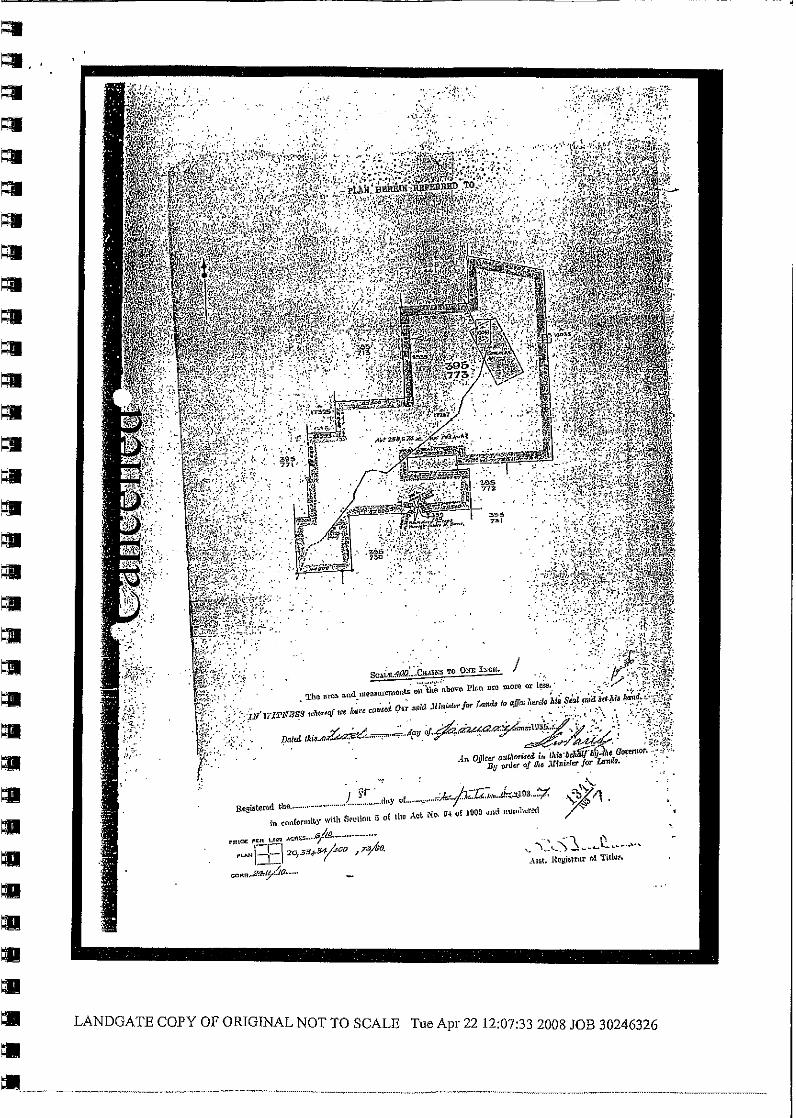
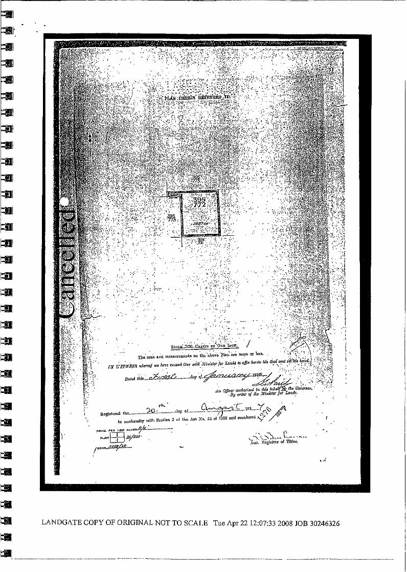
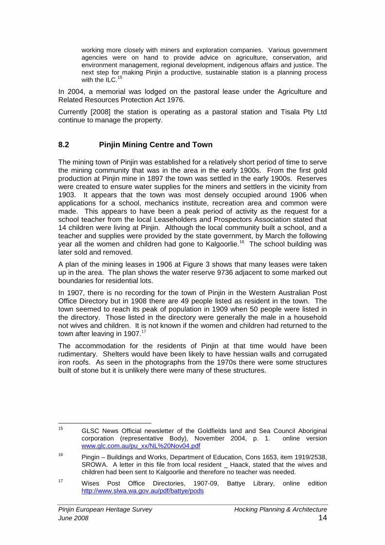
A plan of the mining leases in 1906 at Figure 3 shows that many leases were takenup in the area. The plan shows the water reserve 9736 adjacent to some marked outboundaries for residential lots.
In 1907, there is no recording for the town of Pinjin in the Western Australian PostOffice Directory but in 1908 there are 49 people listed as resident in the town. Thetown seemed to reach its peak of population in 1909 when 50 people were listed inthe directory. Those listed in the directory were generally the male in a householdnot wives and children. It is not known if the women and children had returned to thetown after leaving in 1907.17
The accommodation for the residents of Pinjin at that time would have beenrudimentary. Shelters would have been likely to have hessian walls and corrugatediron roofs. As seen in the photographs from the 1970s there were some structuresbuilt of stone but it is unlikely there were many of these structures.
15GLSC News Official newsletter of the Goldfields land and Sea Council Aboriginalcorporation (representative Body), November 2004, p. 1. online versionwww.glc.com.au/pu_xx/NL%20Nov04.pdf
16Pingin – Buildings and Works, Department of Education, Cons 1653, item 1919/2538,SROWA. A letter in this file from local resident _ Haack, stated that the wives andchildren had been sent to Kalgoorlie and therefore no teacher was needed.
17Wises Post Office Directories, 1907-09, Battye Library, online editionhttp://www.slwa.wa.gov.au/pdf/battye/pods
Pinjin European Heritage Survey Hocking Planning & Architecture
June 2008 15
Figure 3 Portion of a plan showing mining leases at Pingin in 1906. The area in red is theland set aside for a school. Note the areas allocated for roads and lot subdivision. Planaccompanying a gazettal notice, in file, Pingin – Buildings and Works, Department ofEducation, Cons 1653, item 1919/2538, folio 27, SROWA.
After this peak of activity in the area and the formation of community groups such asthe Pinjin Progress Association (later the Leaseholders and Prospectors association)and the Cemetery Board, the quantities of accessible minerals presumably dwindledand the population moved away from the town. In 1910, there were 36 residentslisted in the town and the spelling of the town name was recorded as Pingin. In1912, the Cemetery Board was abolished and it was recorded that at this time onlytwo people had been buried at Pinjin.18
By 1913, there were 13 residents listed at Pinjin and the state battery was no longerlisted. Mining activity was still occurring in the area as it was recorded that miner,
18Wises Post Office Directories, 1909-1912, Battye Library, online editionhttp://www.slwa.wa.gov.au/pdf/battye/pods

Pinjin European Heritage Survey Hocking Planning & Architecture
June 2008 16
Denis Donovan working a claim at the Unification Mine, died when he fell down themine shaft when the rope broke.
Population numbers steadily declined until in 1918 only miner, James Stein isrecorded as living at Pinjin.19 The following year he is recorded as living at Edjudina.The decline of the town is in direct relationship with the decline of the accessibleminerals and probably the difficulty of accessing reliable water.
The remaining structures in the town were left to decay or were transportedelsewhere as is common practice in regional Western Australia. Some undatedphotographs of the area taken c1970s (see figures 4-23) indicate that there was littleremaining of the former town except for the windmill, gravesites and some machineryleft in situ. Since the 1970s the remaining artefacts have decayed or been removedfor use elsewhere. Information about the existing artefacts on site was not obtainedfor this report.
19Wises Post Office Directories, 1913-1920, Battye Library, online editionhttp://www.slwa.wa.gov.au/pdf/battye/pods

Pinjin European Heritage Survey Hocking Planning & Architecture
June 2008 17
Figure 4 PinjinCemetery c.1970s.
Courtesy of Shire ofMenzies
Figure 5 Grave inPinjin Cemeteryc.1970s.
Courtesy of Shire ofMenzies
Figure 6 Grave inPinjin Cemetery forDennis Donovanc.1970s.
Courtesy of Shire ofMenzies

Pinjin European Heritage Survey Hocking Planning & Architecture
June 2008 18
Figure 7 Tabletfor Dennis Donovan.
Courtesy of Shire ofMenzies
Figure 8 Windmillat Pinjin c.1970s.
Courtesy of Shire ofMenzies
Figure 9 Squaretanks at Pinjinc.1970s.
Courtesy of Shire ofMenzies

Pinjin European Heritage Survey Hocking Planning & Architecture
June 2008 19
Figure 10 OldBoiler at Pinjinc.1970s.
Courtesy of Shire ofMenzies
Figure 11 ChurnDrill at Pinjin c.1970s.
Courtesy of Shire ofMenzies
Figure 12 ChurnDrill brake pad atPinjin c.1970s
Courtesy of Shire ofMenzies

Pinjin European Heritage Survey Hocking Planning & Architecture
June 2008 20
Figure 13 Old'Spring' Cart at Pinjin.
Courtesy of Shire ofMenzies
Figure 14 Dietzlamp, Tubular No. 3found at Pinjinc.1970s.
Courtesy of Shire ofMenzies
Figure 15 Old hutat Pinjin c.1970s.
Courtesy of Shire ofMenzies

Pinjin European Heritage Survey Hocking Planning & Architecture
June 2008 21
Figure 16 Old hutat Pinjin c.1970s.
Courtesy of Shire ofMenzies
Figure 17 Scoop atPinjin c.1970s.
Courtesy of Shire ofMenzies
Figure 18 Scoop atPinjin c.1970s.
Courtesy of Shire ofMenzies

Pinjin European Heritage Survey Hocking Planning & Architecture
June 2008 22
Figure 19 Wagonat Pinjin c.1970s.
Courtesy of Shire ofMenzies
Figure 20 Wagonat Pinjin c.1970s.
Courtesy of Shire ofMenzies
Figure 21 Wagonat Pinjin c.1970s.
Courtesy of Shire ofMenzies
Pinjin European Heritage Survey Hocking Planning & Architecture
June 2008 23
Figure 22 WagonBrake pad at Pinjinc.1970s.
Courtesy of Shire ofMenzies
Figure 23 Ploughat Pinjin c.1970s.
Courtesy of Shire ofMenzies
Mining in the area since the period of activity in the early 1900s was intermittent untilthe 1950s. After that time mining in the area further declined.
The above photographs indicate that there are few built structures still evident on thesite in the 1970s and it is likely that even less items are still extant.
It has been noted that tourism is beginning to play a small part in the region. Fourwheel drive enthusiasts travel to the region in small numbers and there is someevidence of individual travellers in the area.

Pinjin European Heritage Survey Hocking Planning & Architecture
June 2008 24
9.0 CURRENT LAND OWNERSHIP AND RESPONSIBILITY
The current reserves which fall within the pastoral lease and the mining tenementboundaries are remnants of the period of mining activity in the region in the early partof the 20th century. These crown land reserves were created to serve thecommunity of the region and their continued existence, despite the lack of population,is a feature of many former mining settlements.
Crown land reserves are overseen by the Department of State Land Services and themanagement of these reserves is with an individual state government department orlocal authority.
C Class Reserves were created under the 1895 Parks and Reserves Act andpreceded the Land Act 1898. These acts were superseded by the Land Act 1933and there is no longer reference to Class C reserves. The administration of reservesof state land is under Part 4 of the Land Administration Act 1997.
The crown land reserves which remain as legal boundaries on the site are as follows.
9736 Reserve for Water (C class Reserve)Responsible agency the Water Corporation since 1985. Created in 1905 to securethe water supply for the community and mining industry at Pinjin. Tanks or wells mayhave been constructed to secure the water supply.
10041 Reserve for Common comprising Lot 61 on DP38349 (C class Reserve)Responsible Agency the Department for Planning and Infrastructure since 2005.Created in 1906 for the use of the residents of the small settlement at Pinjin to enablethe grazing of stock and the collection of firewood etc. Often used as a preliminarystatus before a townsite although a townsite and common could coexist.
10060 Reserve for Recreation comprising lot 59 on DP128144 (C class Reserve)Responsible agency the Department for Planning and Infrastructure since 2005.Created in 1906 for the community at the small settlement at Pinjin. The land couldhave been used for a variety of purposes such as a cricket ground/ football field orrace track.
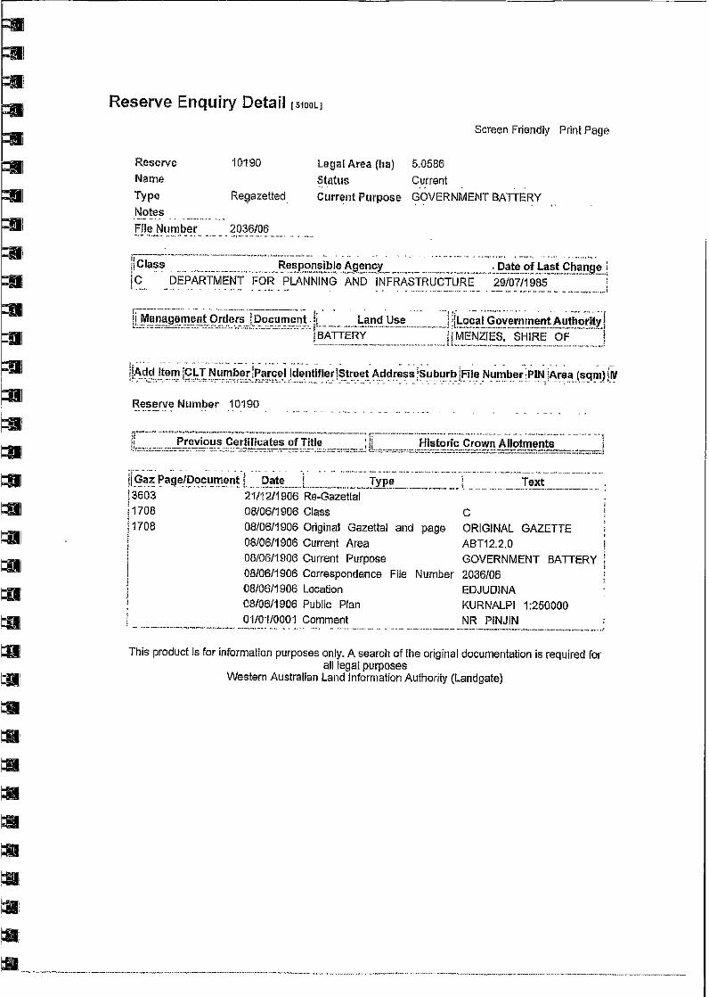
10190 Reserve for Battery (C class Reserve)Responsible agency the Department for Planning and Infrastructure since 1985.Created in 1906 to serve the mining industry at Pinjin and surrounds.
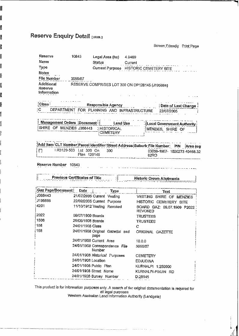
10843 Reserve for Historical Cemetery comprising lot 300 on Plan 128145 (Cclass Reserve)Responsible agency the Department for Planning and Infrastructure since 2005.Created in 1908.
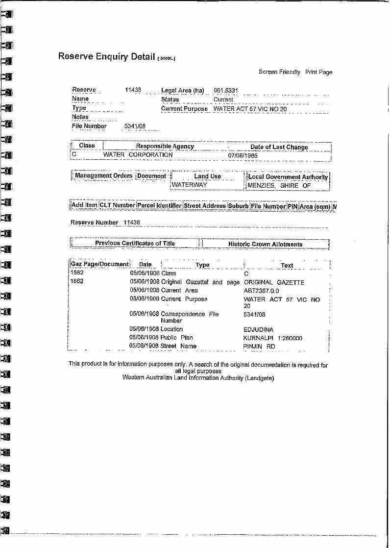
11438 Reserve for Water (C class Reserve)Responsible agency the Water Corporation since 1985. Created in 1908 to securewater supply for the community and mining industry at Pinjin. Tanks or wells mayhave been constructed to secure the water supply.

Pinjin European Heritage Survey Hocking Planning & Architecture
June 2008 25
10.0 CONCLUSIONS
10.1 Guidelines for future management
It is recognised that AngloGold Ashanti has no ownership or responsibility over thePinjin site. The following guidelines are to assist in the management of the site if theproposed road alignment impacts on any artefacts.
Any proposed disturbance of this site should avoid any remaining structuresand artefacts where possible in order to preserve this site in its current state.
Any proposed disturbance should be discussed with the Shire of Menzies andany interested community groups, and the leaseholders of the Pinjin pastorallease.
If any artefacts on site are disturbed they should be documented andphotographed and copies of the records deposited with the Shire of Menzies.These would include any remaining structures from former buildings ormachinery.
The advice of a professional archaeologist or heritage professional should besought if any remaining artefacts are to be removed.
If it is necessary to remove items from the site for protection from futuredevelopment then it is required that a suitable repository be found. This couldbe a body nominated by the Shire of Menzies for example a local historygroup or mining heritage group.
The maintenance of the remaining structures that cannot be removed forexample the cemetery and graves may require the specific advice of aprofessional archaeologist or heritage professional.
A copy of this report should be forwarded to the Shire of Menzies and theHeritage Council of WA as a courtesy and source of future informationrelating to the site.
Pinjin European Heritage Survey Hocking Planning & Architecture
June 2008 26
11.0 BIBLIOGRAPHY
PRIMARY SOURCES
Database held by Geographic Names Section, Landgate.
Oral History OH 2799 Recording of Colin Newland, former station manager ofEdjudina Station, Battye Library.
Pastoral Leases 1280/1937; 1341/1937, 432/1967 and 1276/1937, Landgate.
State Records Office of Western Australia
Hall, Reserve 10235, Pingin Lot 45, Mines Department, Shire of Menzies, Cons3640, item 1906/00200v1, SROWA
Forest, Gilgarna State forest, Pingin Progress Association, Cons 4697, item1907/6768v!, SROWA
Pingin District – geological examination, cons 3712, item 1907/131, SROWA
Mines Water Supply – Pingin Well and Tank (continued from 1104/19), Cons 1109,item 1935/0958, SROWA
Mines Water Supply – Eastern Goldfields – Gilgarna-Pingin Road Water Supply –Gilgarna Wells, Cons 1522, item 1918/0477, SROWA.
Pingin – Reforming Local Board of Health, cons 1003, item 1906/0065, SROWA.
Pingin – medicine chest and drugs for, Cons 1003, item 1910/0860, SROWA.
Mining Districts W.S. Pingin Well and Tank, Cons 1109, item 1919/1104, SROWA.
Pingin – Buildings and Works, Department of Education, Cons 1653, item 1919/2538,SROWA
School Reserve 10356 Edjudina District Pingin Shire of Menzies, Cons 6243, item1906/04464v01, SROWA
NewspapersKalgoorlie MinerGovernment GazetteNorth Coolgardie Herald
Pinjin European Heritage Survey Hocking Planning & Architecture
June 2008 27
SECONDARY SOURCES
Adamides, N.G. Inventory of state battery sites in Western Australia, prepared forGeological Survey of Western Australia, 2000.
Argus, Harry Joseph The forgotten pioneers of the eastern goldfields, self-published,second edition, 2005.
Coate, Yvonne and Kevin, More Lonely Graves of Western Australia, HesperianPress, 2000.
N.W. Tindale, Aboriginal tribes of Australia, 1974, cited inhttp://www.samuseum.sa.gov.au/orig/tindale/HDMS/tindaletribes/maduwongga.htmNote that subsequent anthropological research, and the history of colonisation, willhave resulted in altered boundaries.
Swager, C.P. Geology of the greenstone terranes in the Kurnalpi-Edjudina region,south-eastern Yilgarn Craton, Geological survey of Western Australia, 1995.
Talbot, H. W. B. (Henry William Beamish) Geological sketch map of the country tothe north of Pinjin, North Coolgardie Goldfield, 1926 in Bulletin (Geological Survey ofWestern Australia), No. 87, 1926.
Online sources
MINEDEX Online database created by the Department of Industry and Resources,http://www.doir.wa.gov.au/minedex2 Searched January 2008
Federal Court of Australia, Harrington-Smith on behalf of the Wongatha People vState of Western Australia (no 9) [2007] FCA 31,http://www.fedcourt.gov.au/judgments/2007FCA0031.pdf ; and annexure F thereto,http://www.fedcourt.gov.au/judgments/2007FCA0031_AnnF.pdf
Info-Mine Mining Company and property Databasehttp://www.infomine.com/companiesproperties/infodbweb/ChargePropertyReport.asp?SearchID=35053
Information from the Office of Development Approvals Co-ordinationhttp://www.odac.dpc.wa.gov.au/

Pinjin European Heritage Survey Hocking Planning & Architecture
June 2008 28
12.0 APPENDICES
Current and past pastoral Leases
Copies of Pastoral Leases from Landgate.
Land ReservesResults of Land Reserves Index inquiry from Landgate