former cemex cement works barrington · at the former cemex cement works to provide ... scope of...
TRANSCRIPT

P L A N N I N G S T A T E M E N TO c t o b e r 2 0 1 4
F O R M E R C E M E X C E M E N T W O R K SB A R R I N G T O N

FORMER CEMENT WORKS
HASLINGFIELD ROAD, BARRINGTON
OUTLINE PLANNING APPLICATION FOR RESIDENTIAL DEVELOPMENT
PLANNING STATEMENT
SUBMITTED ON BEHALF OF CEMEX UK PROPERTIES LTD
OCTOBER 2014

2
Table of Contents
1. INTRODUCTION ................................................................................................................ 4
THE PLANNING APPLICATION SUBMISSION ......................................................................... 4
2 THE SITE AND SURROUNDING AREA ......................................................................... 8
SITE LOCATION – BARRINGTON ............................................................................................. 8
THE SITE ..................................................................................................................................... 8
3. STAKEHOLDER & COMMUNITY ENGAGEMENT ..................................................... 12
MEETINGS AND DIALOGUE WITH SCDC OFFICERS ........................................................... 12
DIALOGUE WITH CAMBRIDGESHIRE COUNTY COUNCIL OFFICERS ............................... 13
CONTACT WITH UTILITIES PROVIDERS ............................................................................... 13
MEETINGS WITH BARRINGTON PARISH COUNCIL REPRESENTATIVES ......................... 13
ENGAGEMENT WITH LOCAL RESIDENTS ............................................................................ 13
4 PROPOSED DEVELOPMENT ........................................................................................... 15
DESCRIPTION OF DEVELOPMENT ........................................................................................ 15
PROPOSED LAND USES ......................................................................................................... 15
VEHICULAR ACCESS .............................................................................................................. 16
PEDESTRIAN AND CYCLE LINKS........................................................................................... 16
5 PLANNING POLICY CONTEXT ....................................................................................... 18
THE DEVELOPMENT PLAN ..................................................................................................... 18
THE IMPACT OF THE NPPF ON THE DECISION TAKING PROCESS .................................. 19
OTHER MATERIAL CONSIDERATIONS ................................................................................. 20
6 ASSESSMENT OF THE SCHEME ................................................................................... 23
WHAT IS SUSTAINABLE DEVELOPMENT? ........................................................................... 23
THE BENEFITS OF REDEVELOPMENT FOR HOUSING DEVELOPMENT........................... 24
ENHANCEMENTS TO OPEN SPACE PROVISION & LOCAL FACILITIES ............................ 28
HIGHWAYS AND SUSTAINABLE TRANSPORT ..................................................................... 30
7. ENVIRONMENT & DESIGN ............................................................................................ 33
ECOLOGY AND BIODIVERSITY .............................................................................................. 33
GROUND CONDITIONS AND CONTAMINATION ................................................................... 34
LANDSCAPE AND VIEWS ........................................................................................................ 34
NOISE AND VIBRATION .......................................................................................................... 36
FLOOD RISK AND DRAINAGE ................................................................................................ 37

3
DESIGN APPROACH ................................................................................................................ 37
CULTURAL HERITAGE ............................................................................................................ 39
SUMMARY ................................................................................................................................ 40
8 PLANNING OBLIGATIONS - DRAFT HEADS OF TERMS ............................................ 41
AFFORDABLE HOUSING ......................................................................................................... 41
OPEN SPACE ........................................................................................................................... 41
SOCIAL INFRASTRUCTURE ................................................................................................... 42
HIGHWAYS WORKS AND TRANSPORT INITIATIVES ........................................................... 42
COUNCIL’S ADMINSTRATIVE COSTS ................................................................................... 42
9 CONCLUSIONS ...............................................................................................................44
BENEFITS ARISING FROM THE DEVELOPMENT ................................................................. 45
SUMMARY ................................................................................................................................ 46
APPENDIX 1 .................................................................................................................................. 47
COUNCIL’S EIA SCOPING OPINION, DATED 28 APRIL 2014 ............................................... 47
APPENDIX 2 .................................................................................................................................. 48
APPLICATION SITE AND ADJOINING OWNERSHIP PLAN ................................................... 48
APPENDIX 3 .................................................................................................................................. 49
RELEVANT SITE PLANNING HISTORY RECORDS (FROM SCDC ONLINE REGISTER) .... 49

4
1. INTRODUCTION
1.1 This Planning Statement has been prepared by Carter Jonas LLP in support of an outline planning
application made to South Cambridgeshire District Council (‘SCDC’) for the redevelopment of land
at the former CEMEX Cement Works to provide up to 220 (Class C3) dwellings.
1.2 The planning application is made by CEMEX UK Properties Limited (‘CEMEX’), the landowner.
1.3 The principal purpose of the Planning Statement is to test the suitability of the proposed
development for housing against prevailing national and local planning policy and guidance.
THE PLANNING APPLICATION SUBMISSION
Environmental Impact Assessment Scoping Opinion
1.4 On the 18 February 2014, Campbell Reith Hill LLP submitted a Scoping request to SCDC under
the Town and Country Planning (Environmental Impact Assessment) (England) Regulations 2011.
1.5 The request assumed a development of up to 250 dwellings, open space provision including cycle
tracks, walking and running paths, sports pitches and children’s play areas; areas of hard and soft
landscaping; new vehicular and pedestrian accesses.
1.6 The Council’s EIA Scoping Opinion was issued on 28 April 2014. This response confirmed the
scope of the chapters and supporting information required as part of an Environment Statement. A
copy of the Council’s EIA Scoping Opinion is attached at Appendix 1.
Outline Planning Application Submission
1.7 The outline planning application consists of the following documentation, plans and drawings, the
scope of which was agreed with the allocated case officer at SCDC, Mr Andrew Fillmore, as part of
the formal pre-application process.
Documentation
Documents Author
Outline planning application forms and certificates Carter Jonas (agent on behalf of CEMEX UK Properties Ltd)
Planning Statement (including draft Heads of Terms) Carter Jonas
Design and Access Statement John Thompson & Partners
Statement of Community Involvement Community Connect Ltd
Transport Assessment (including Framework Travel Plan) Vectos
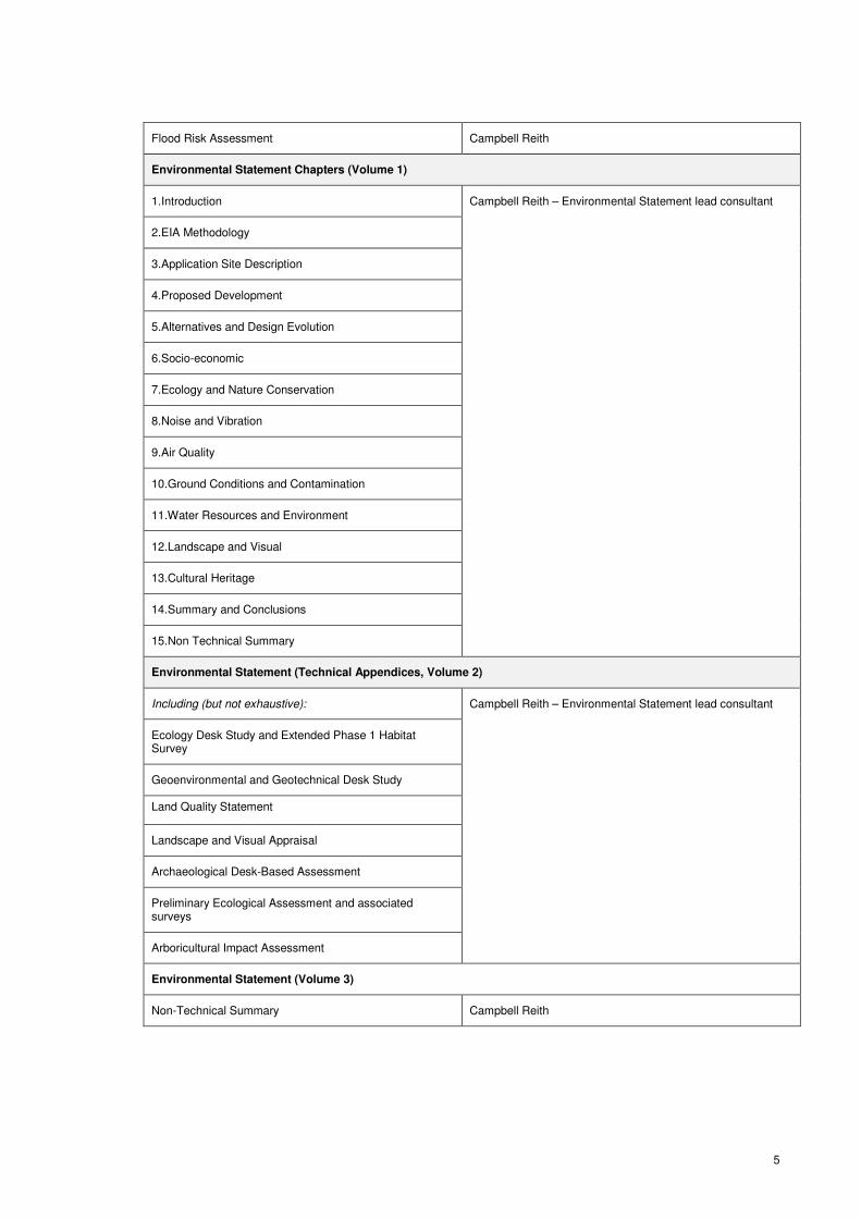
5
Flood Risk Assessment Campbell Reith
Environmental Statement Chapters (Volume 1)
1.Introduction Campbell Reith – Environmental Statement lead consultant
2.EIA Methodology
3.Application Site Description
4.Proposed Development
5.Alternatives and Design Evolution
6.Socio-economic
7.Ecology and Nature Conservation
8.Noise and Vibration
9.Air Quality
10.Ground Conditions and Contamination
11.Water Resources and Environment
12.Landscape and Visual
13.Cultural Heritage
14.Summary and Conclusions
15.Non Technical Summary
Environmental Statement (Technical Appendices, Volume 2)
Including (but not exhaustive): Campbell Reith – Environmental Statement lead consultant
Ecology Desk Study and Extended Phase 1 Habitat Survey
Geoenvironmental and Geotechnical Desk Study
Land Quality Statement
Landscape and Visual Appraisal
Archaeological Desk-Based Assessment
Preliminary Ecological Assessment and associated surveys
Arboricultural Impact Assessment
Environmental Statement (Volume 3)
Non-Technical Summary Campbell Reith

6
Plans and Drawings
Plan / Drawing Reference Plans / Drawing Title Scale
For administrative purposes
00462_SV_01 rev P1 Site Location Plan 1:10000 at A1
00462_SV_02 rev P1 Application Site and Adjoining Ownership Plan 1:5000 at A0
For formal approval at outline planning stage
00462_PP_01 rev P1 Land Use and Access Parameter Plan 1:2500 at A1
00462_PP_02 Building Height Parameter Plan 1:2500 at A1
110278/A/18 Northern Site Access 1:500 at A3
110278/A/19 Southern Site Access 1:500 at A3
110278/A/20 School Car Park Access 1:500 at A3
For illustrative purposes only
00462_SK_01 rev P1 Illustrative Masterplan 1:1250 at A1
00462_SK_02 rev P1 Access and Connections 1:2500 at A3
Structure of Planning Statement
1.8 The remaining sections of this Statement are structured as follows:
• Section 2 (Site and Surrounding Area): Provides a commentary on Barrington and identifies the
extent of the planning application site boundary.
• Section 3 (Stakeholder and Community Engagement): Summarises CEMEX's approach to pre-
application engagement with stakeholders including SCDC and CCC officers, the local
community, utilities providers, and Barrington Parish Council.
• Section 4 (Proposed Development): Provides a summary of the key components of the outline
application, and lists the ‘matters’ which are to be reserved for future approval.
• Section 5 (Planning Policy Context): Provides an overview of the planning policy documents and
guidance notes relevant to the Council’s determination of the outline application, and identifies
those policies which are out-of-date, or to which only limited weight can be attached.
• Section 6 (Assessment of the Scheme): Assesses the proposed development’s compliance with
relevant planning policy and guidance.

7
• Section 7 (Environment and Design): Assesses the proposed development against relevant key
environmental and design criteria set out in the NPPF, and in adopted and draft local planning
policy and guidance.
• Section 8 (Planning Obligations): Sets out the scope of potential planning obligations which could
form part of a Section 106 Agreement.
• Section 9 (Conclusions): Provides key conclusions, and an overview of the planning case for
development.
8
2 THE SITE AND SURROUNDING AREA
SITE LOCATION – BARRINGTON
2.1 The planning application site is located immediately to the north of Barrington village, and forms
part of CEMEX’s ownership. The village of Haslingfield is circa 1.9km to the north-east, Harlton is
circa 2km to the north/north-west, Orwell is 1.9km to the west, and Foxton 2.7km to the south-east.
2.2 Barrington has a population of circa 1,000. The urban form consists of a variety of different
dwelling types and densities.
Retail and community facilities
2.3 Barrington has a post office and village store (51 High Street), a village hall (63 High Street), and a
public house (Royal Oak, West Green).
Schools and colleges
2.4 Barrington has one primary school (Barrington Church of England Primary School); but does not
have a secondary school. Barrington is, however, in the catchment area for Melbourn Village
College, circa 8km to the south of Barrington. The Happy Bunnies Nursery (for 2-5 year olds) is
located at Barrington Village Hall.
Existing recreational and leisure facilities
2.5 Barrington has high quality children’s equipped play areas (totalling 1.5ha), outdoor sports
including a recreational ground (1.5ha) and a bowling green (0.1ha). There are also pockets of
informal open spaces dispersed throughout the village (extending to 6.5ha).
Public transport
2.6 There are three bus routes serving Barrington which provide connections to/from Cambridge (5-6
buses daily, Monday-Saturday), and a further service to/from Royston on a Wednesday (1 bus
daily).
2.7 The closest passenger railway station is Foxton which is located circa 2.2km from the Site,
providing connections to Cambridge (journey time of 13 minutes), and London (journey time 1
hour). Shepreth Station is circa 3.2km miles from the Site and is on the same train line as Foxton.
THE SITE
CEMEX’s ownership and operations at Barrington
2.8 CEMEX’s landholdings at Barrington extend to circa 400ha, the majority of which (390ha) comprise
quarry areas, agricultural, and restored land. 9.88 ha of the landholdings are previously developed
land (‘PDL’), comprising the plant, buildings, structures, hardstanding and ancillary offices
associated with the Cement Works. A plan showing the existing context is set out below (Figure 1).

9
Figure 1: Existing Site Context
2.9 With the onset of the recession, production ceased at the Cement Works (the pink area on Figure 1
above) in 2008 with the loss of 80 jobs. The Cement Works was finally decommissioned in 2012
and is now vacant and derelict, with the exception of a small site office and a security presence.
2.10 Other areas of CEMEX’s landholdings at Barrington are still operational. The quarry (the
‘Excavated Area’ on Figure 1 above) still holds a limited stock of hard limestone material (‘clunch’)
which is sold in large blocks as a building stone to be used in the restoration of historic buildings.
Clunch is not, however, still quarried at Barrington, with the planning permission having expired.
Leachate is also removed from the quarry and transported from the site by road.
2.11 Two areas of previously excavated land have been restored to agriculture (‘restored areas’ on
Figure 1 above), and a further area is awaiting restoration to agriculture and nature conservation
after-uses (‘Area to be Restored’ on Figure 1 above).
2.12 CEMEX’s landholdings also include the Barrington Light Railway which runs between the Foxton
sidings and the quarry. The line enters from across Haslingfield Road, and then dissects the
Cement Works, terminating inbetween two areas of restored land. The line is currently unused, but
upgrade works are due to be completed early in 2015 to enable the importation by rail of inert
materials required to infill the ‘Area to be Restored’. Further details of the upgrade and the infill are
set out in the ‘Relevant Planning History’ section later in this section of the Statement.
The planning application site
2.13 This outline planning application principally relates to the site of the former Cement Works
(hereafter referred to as ‘the Cement Works’). This is PDL extending to circa 9.88ha and is where
the residential development is proposed.

10
2.14 Also included within the planning application boundary are the following land parcels:
• the Barrington Light Railway from the point at which it crosses Haslingfield Road on the Cement
Works’ eastern boundary, running south-east to Foxton sidings – for a potential future shared
pedestrian and cycle link to Foxton Station.
• an area of woodland immediately to the south of the Cement Works, adjacent to Haslingfield
Road – in part, for a direct shared pedestrian and cycle link to Barrington, and for a car park for
the Primary School
• agricultural land to the west of the Cement Works including the southern lake – for informal and
formal open space, including allotments.
2.15 In total, the planning application site (hereafter referred to as ‘the Site’) extends to circa 34.27
hectares, which equates to only circa 8% of CEMEX landholdings at Barrington.
2.16 A combined planning application (redline) and land ownership (blueline) boundary plan is attached
at Appendix 2.
2.17 The Cement Works sit on lower ground compared to the rest of CEMEX’s ownership in Barrington,
and displays a gentle slope from north to the south. It is well screened from Haslingfield Road and
Barrington village by an established tree belt which runs along its eastern and southern
boundaries.
2.18 Many of the buildings and structures associated with the Cement Works remain, some of which
extend up to circa 27m in height. The chimney extends to circa 60m. All existing buildings and
structures within the planning application boundary of the Site would be demolished and
remediation undertaken prior to redevelopment for housing.
2.19 Existing vehicular access into the Cement Works is taken from two points from Haslingfield Road.
The northernmost of the two provides the principal point of access for operational vehicles going to
the quarry and restoration areas in CEMEX’s wider ownership. There is also an existing secondary
access to the quarry and restored land via Orwell Road to the south-west.
2.20 Due to the nature of operations on the site, no direct pedestrian access exists between the Cement
Works and Barrington to the south or Haslingfield to the north. There are, however, footpaths and
bridleways running across the agricultural land within CEMEX’s wider ownership.
Relevant planning history
2.21 The planning history for the Site (and CEMEX’s wider landholdings) at Barrington is complex and
extensive. A summary schedule of planning history records obtained from CEMEX and from
SCDC’s online records is attached at Appendix 3.
11
2.22 The Cement Works: Planning history records for this area of the Site predominantly relate to the
incremental development of buildings and structures to support the processing, handling and
storage of building materials.
2.23 Material importation by rail and land restoration: In August 2011, planning permission was granted
by Cambridgeshire County Council (CCC ref S/01080/10/CW) for the following works and
operations:
‘Importation, by rail, of the requisite inert material, for a period of five years, to partially infill an
existing quarry void and provide for the restoration of the western and north-western areas of
Barrington Quarry to a combination of agriculture and nature conservation after-uses, and all
associated works including railway refurbishment and the retention and continued use of the
existing weighbridge, office and workshop’.
2.24 This relates to the infill of the ‘Area to be Restored’ on Figure 1, to the west of the Site. The rail
upgrade works are underway, with importation of inert material envisaged to commence in
February 2015.
2.25 The planning conditions attached to the permission require these works to have finished by 31
December 2018. The continuation of importation and restoration after that date would require a
new planning permission from CCC (as Mineral Planning Authority).

12
3. STAKEHOLDER & COMMUNITY
ENGAGEMENT
3.1 CEMEX has taken an inclusive and transparent approach to pre-application engagement with
stakeholders and the local community. The approach to engagement accords with paragraphs 188
– 194 of the NPPF, and Section 122 of the Localism Act 2011.
3.2 A review of CEMEX’s engagement with stakeholders is set out in the Statement of Community
Involvement submitted in support of this planning application. The way in which comments
received have informed the evolution of scheme proposals is addressed in the Design and Access
Statement.
3.3 The form of this engagement and the feedback received has resulted in CEMEX reducing the scale
of proposals under consideration from 350 dwellings to the current proposal of up to 220 dwellings,
with housing development restricted to the former Cement Works (PDL) only.
3.4 The dates of key stakeholder and community meetings and events are summarised below.
MEETINGS AND DIALOGUE WITH SCDC OFFICERS
3.5 CEMEX and its core consultant team have engaged with Andrew Fillmore, John Koch and Keith
Miles (SCDC Planning), David Roberts (SCDC Planning Policy), and Bonnie Kwok (SCDC Urban
Design) through the Council’s pre-application advice service.
3.6 The engagement has included five meetings on the following dates:
Date Venue SCDC officers
04 July 2012 SCDC Offices John Koch and Keith Miles
31 March 2014 SCDC Offices Andrew Fillmore and David Roberts
8 May 2014 CEMEX Cement Works Andrew Fillmore and Bonnie Kwok
21 August 2014 CEMEX Cement Works Andrew Fillmore and David Roberts
26 September 2014 SCDC Offices Andrew Fillmore

13
3.7 This process has enabled CEMEX to gain the officers’ views on the merits of the proposed
development having regard to prevailing planning policy, and to identify their view on any areas of
the scheme which may benefit from further consideration.
3.8 The pre-application advice service has also been used to agree with officers the list of documents,
drawings and plans to be submitted as part of the outline planning application.
DIALOGUE WITH CAMBRIDGESHIRE COUNTY COUNCIL OFFICERS
3.9 CEMEX’s Highways consultants, Vectos, met with Cambridgeshire County Council (CCC)
Highways officers on 14 February 2014 to review existing and proposed site vehicular access
arrangements, and the proposed options for sustainable transport initiatives. CCC’s response is
addressed in the supporting Transport Assessment.
3.10 Vectos has maintained dialogue with CCC throughout the pre-application process on highways and
transport matters. The scope of the Transport Assessment, and the assumptions used in respect
of vehicle trip generation to and from the site, were agreed in advance of submitting the planning
application.
CONTACT WITH UTILITIES PROVIDERS
3.11 CEMEX and its engineering consultants have contacted utility providers and statutory undertakers
to assess availability and location of services on and in the vicinity of the proposed development
site (water, gas, electricity, telecoms and foul water drainage). The information provided has
informed the preparation of the Environmental Statement and the illustrative masterplan.
MEETINGS WITH BARRINGTON PARISH COUNCIL REPRESENTATIVES
3.12 During the consideration of future options for the former Cement Works, representatives of CEMEX
have attended a number of Barrington Parish Council meetings to present to councillors, answer
questions and engage in discussion. Recent meetings attended have been:
• 17 September 2013
• 19 November 2013
• 21 January, 2014
• 19 August 2014
• 16 September 2014
ENGAGEMENT WITH LOCAL RESIDENTS
3.13 Several outlets have been used by CEMEX and its team to engage with local residents of
Barrington and surrounding villages on the evolving proposals. One outlet has been hosting drop-in
consultation events on the following dates:
• 05 and 06 April 2013 – site open day on site designed to seek feedback from the community
on future options for the site. This was attended by more than 250 people; and

14
• 10 October to 12 October 2013 – event held onsite and at Barrington Village Hall over three
days. This was attended by more than 400 people.
3.14 Local residents have also been kept updated through CEMEX’s dedicated communities’ website
(http://www.cemexcommunities.co.uk/barrington.html), the distribution of a newsletter in September
2014, and through the regular CEMEX Barrington Liaison Group meetings.
3.15 Members of the Liaison Group include representatives from the community, elected
representatives at parish (including neighbouring parishes), district and county level, the local
Member of Parliament, officers from the County Council and the Environment Agency, and
representatives from specific interest groups and company managers. The group is chaired by
Susan Walford, an officer from South Cambridgeshire District Council.

15
4 PROPOSED DEVELOPMENT
DESCRIPTION OF DEVELOPMENT
4.1 The planning application is submitted in outline form, and seeks approval for the following
development:
‘Application for outline planning permission for the demolition of all existing buildings and
structures, and redevelopment to provide up to 220 residential (Class C3) units, formal and
informal open space including allotments, car parking for Barrington Primary School, new
pedestrian and cycle links to Barrington village and Foxton Station, and associated works -
details of vehicular site access arrangements are submitted for approval, with all other matters
(Layout, Scale, Appearance and Landscaping) reserved for future approval’.
4.2 Parameter plans showing the extent of the development zones and maximum building heights are
submitted for formal approval, as are detailed drawings for the proposed points of vehicular access
into the Site from Haslingfield Road.
4.3 An illustrative masterplan is included as part of the planning application to show one way the
former Cement Works could be developed to accommodate up to 220 dwellings. The masterplan
is not, however, for determination at this outline planning stage.
4.4 Further detail on the proposed development is set out in the Design and Access Statement. The
key land use and access principles of the scheme are set out below for reference.
PROPOSED LAND USES
Market and Affordable Housing
4.5 Outline planning permission is sought for the principle of up to 220 (Class C3) dwellings, of which
the percentage of affordable housing would be in accordance with prevailing Development Plan
policy. Currently, this is 40% (as per Saved Policy HG/3 of the Development Control Policies
DPD). There is also an opportunity to include an element of housing for over-55s as part of the
affordable housing, subject to agreement of SCDC.
4.6 The quantum and mix of housing are yet to be fixed, and will be based on an assessment of local
housing need at the reserved matter stage.
Formal and Informal Open Space
4.7 A dedicated area of the Site to the south and west of the housing development is proposed for
formal and informal open space, including allotments. The maximum extent of this area is
identified on the land use parameter plan, with the details of the type, size and specification of open
space to be approved at the reserved matters stage.

16
Buffer Zone
4.8 A buffer zone either side of the existing railway line is also identified on the land use plan which
dissects the Cement Works site. Within the buffer zone it is proposed that no housing will be built.
Car park for Barrington Church of England Primary School
4.9 A car parking area is proposed immediately opposite Barrington Church of England Primary School
to assist with regularising parking and drop off arrangements at the school, and to provide parking
for staff and visitors. The maximum extent of this area is identified on the land use parameter
plan, with the detailed layout of spaces and specification within it to be approved at the reserved
matters stage.
VEHICULAR ACCESS
4.10 Detailed approval is sought for the means of vehicular access into the site from three points off
Haslingfield Road:
• 2 x access points to serve the residential development; and
• 1 x access point to serve the car park for Barrington Church of England Primary School.
4.11 A principal vehicular access for operational vehicles associated with the quarry and restoration
activities is still currently required from Haslingfield Rd, and would be via the northernmost of the
three proposed accesses. Operational vehicle movements across the Cement Works site will be
infrequent, and the illustrative masterplan demonstrates that a safe and attractive residential
environment can be designed.
PEDESTRIAN AND CYCLE LINKS
4.12 The following pedestrian and cycle links are proposed as part of the development:
• A pedestrian and cycle link connecting the proposed residential development directly with
Barrington Primary School and the existing bus stop on Haslingfield Road;
• A pedestrian link connecting the residential development and open space with Barrington
via Back Lane; and
• A future shared pedestrian and cycle link from the residential development to Foxton
Station, using the route of the Barrington Light Railway once the importation of inert
material associated with the quarry infill and restoration is no longer required (subject to
the Mineral safeguarding being lifted).
4.13 The outline planning application is seeking approval for the location and the commitment to deliver
these links. The ownership, management and maintenance arrangements are to be agreed as part
of the post-submission consultation process with SCDC officers and stakeholders, and will be
included in the S.106 agreement attached to the outline planning consent. The detailed

17
specification (lighting, specification etc) and the exact alignment are to be reserved for future
approval.
18
5 PLANNING POLICY CONTEXT
THE DEVELOPMENT PLAN
5.1 Section 38(6) of the Planning and Compulsory Purchase Act 2004 refers to the Development Plan
as a whole and requires that:
‘If regard is to be had to the development plan for the purpose of any determination to be made
under the Planning Acts, the determination must be made in accordance with the plan unless
material considerations indicate otherwise’.
5.2 The adopted Development Plan comprises the Cambridgeshire & Peterborough Minerals and
Waste Plan (2012); and the South Cambridgeshire Local Development Framework (Core Strategy
DPD, 2007, Development Control Policies DPD, 2007, and Site Specific Policies DPD, 2010).
5.3 The adopted Area Actions Plans for Northstowe, Cambridge East, Cambridge Southern Fringe,
and North-West Cambridge also form part of the Development Plan, but are not relevant to the
proposals at the former Cement Works.
Adopted planning and environmental designations
5.4 The following Development Plan designations and allocations currently apply to the Application Site:
Cambridgeshire & Peterborough Minerals and Waste Plan (2012)
• Existing Minerals and Waste Site
• Transport Zone and Safeguarding Area
• Mineral Consultation Area
• Mineral Safeguarding Area
South Cambridgeshire Local Development Framework
• Lords Bridge Consultation Area
5.5 The following Development Plan designations and allocations also currently apply in the vicinity of
the Site:
South Cambridgeshire Local Development Framework
• Site of Special Scientific Interest (geological) – Barrington Chalk Pit: exposed/open quarry faces (18m to north-west of Site at nearest point);
• Green Belt (to the east of Haslingfield Road); and

19
• Barrington Village (to the south): - ‘Group Village’ in hierarchy of settlements;
• Barrington Village (in part) - Conservation Area; and Protected Village Amenity Area.
THE IMPACT OF THE NPPF ON THE DECISION TAKING PROCESS
5.6 In March 2012, the Government issued the National Planning Policy Framework (NPPF) which
consolidates national planning policy, and sets out how this is expected to be applied. The NPPF
is a material consideration in the Local Planning Authority’s determination of this outline planning
application to which significant weight should be attached.
The presumption in favour of sustainable development
5.7 The NPPF identifies that the purpose of the planning system is to contribute to the achievement of
sustainable development (paragraph 7), and that this has three dimensions: economic, social and
environmental which should be delivered jointly and simultaneously.
5.8 Paragraph 14 of the NPPF requires there to be a presumption in favour of sustainable
development, and that for decision-taking this means:
• Approving development proposals that accord with the development plan without delay; and
• where the development plan is absent, silent or relevant policies are out-of-date, granting
planning permission unless:
o Any adverse impacts of doing so would significantly and demonstrably outweigh the
benefits, when assessed against the policies in this Framework taken as a whole; or
o specific policies in this Framework indicate development should be restricted.
5.9 The NPPF states that for decision-taking, the policies in the Development Plan should not be
considered out-of-date simply because they are adopted prior to publication of the Framework
(paragraph 211). However, after 12 months of the Framework’s publication (i.e. after March 2013),
due weight should be given to relevant policies in existing plans according to their degree of
consistency with the Framework (paragraph 215).
5.10 Paragraph 49 of the NPPF provides further guidance on the application of the tests of Paragraph
14 in the context of proposals for housing development:
‘Housing applications should be considered in the context of the presumption in favour of
sustainable development. Relevant policies for the supply of housing should not be considered
up-to-date if the local planning authority cannot demonstrate a five-year supply of deliverable
housing sites.’

20
5.11 The Council’s five-year housing land supply position was tested independently by the Planning
Inspectorate as recently as July 2014 at planning appeal relating to two proposed residential
developments at Bannold Road1 and Cody Road
2, Waterbeach.
5.12 The Inspector found that that the Council could not demonstrate a five-year supply of deliverable
housing sites. It followed that having regard to the tests of NPPF paragraph 49, relevant
Development Plan policies3 relating to the supply of housing were ‘out-of-date’, triggering the
presumption in favour of sustainable development.
5.13 This is the most recent independently-tested assessment of the Council’s five-year housing land
supply, and therefore Development Plan policies relevant to the supply of housing remain out-of-
date4.
5.14 Section 6 of this Statement will therefore assess the scheme in the context of the ‘presumption in
favour of sustainable development’ and the provision of paragraph 14 of the NPPF.
5.15 There are, however, other Development Plan policies which accord with the NPPF and therefore
are up-to-date and can be afforded significant weight in the assessment of the proposed
development. These policies will be addressed where relevant in Section 6 and Section 7 of this
Statement.
OTHER MATERIAL CONSIDERATIONS
Draft Local Plan
5.16 SCDC is currently in the process of preparing a new Local Plan, which when adopted will replace
the Core Strategy DPD and Development Control Policies DPD. The draft Local Plan was
submitted to the Secretary of State on 28 March 2014. The Examination in Public (EiP) is to
commence on 04 November 2014.
5.17 The draft Local Plan (as submitted) is not proposing any changes to the adopted Development
Plan designations or allocations relating to the Site. The site is proposed to remain outside the
proposed defined Development Framework boundary of Barrington, where residential development
is not normally permitted (draft Policy S/7).
5.18 Paragraph 216 of the NPPF states that decision-takers may give weight to relevant policies in
emerging Plans according to:
• The stage of preparation of the emerging plan (the more advanced the preparation, the
greater the weight that may be given);
1 Planning appeal reference APP/W0530/A/13/2209166
2 Planning appeal reference APP/W0530/A/13/2207961
3 Core Strategy DPD Policies ST/2 (Housing Provision), ST/5 (Minor Rural Centres), and Development Control Policies DPD Policy
DP/7 (Development Frameworks’) 4 In the case of this proposed development, Barrington is defined as a Group Village in the Core Strategy DPD and therefore Policy
ST/6 (Group Villages) is out-of-date.

21
• The extent to which there are unresolved objections to relevant policies (the less significant
the unresolved objections, the greater the weight that may be given); and
• The degree of consistency of the relevant policies in the emerging plan to the policies in the
Framework (the closer the policies in the emerging plan to the policies in the Framework, the
greater weight that may be given).
5.19 The draft Local Plan has been through several rounds of public consultation prior to submission to
the Secretary of State. However, there are material objections to the draft Local Plan which remain
unresolved relating to housing supply, the settlement hierarchy and the drawing of settlement
boundaries/development frameworks (draft Local Plan policies S/6 to S/12).
5.20 CEMEX has made representations through previous rounds of public consultation on the draft
Local Plan objecting to the Group Village policy ST/6, requesting flexibility to be built-in to the policy
to enable brownfield windfall sites, such as the former Cement Works, located outside the
development frameworks settlements, to be developed for housing.
5.21 With significant unresolved objections, there is potential that the draft Local Plan could be found to
be ‘unsound’ or that material modifications will need to be made as a result. Therefore, CEMEX
contends that only limited planning weight can be attached to these housing supply policies.
5.22 There are, however, draft Local Plan policies which are consistent with the NPPF – principally more
detailed, development control policies - and these will be addressed where relevant in Section 6
and Section 7 of this Statement.
Supplementary Planning Documents
5.23 The following Supplementary Planning Documents (SPDs) adopted by SCDC are material
consideration in the planning process:
• Open Space in New Developments SPD – (adopted 15 January 2009);
• Biodiversity SPD – (adopted 2 July 2009);
• Listed Buildings SPD – (adopted 2 July 2009);
• Affordable Housing SPD – (adopted 2 March 2010);
• District Design Guide SPD – (adopted 2 March 2010);
• Landscape in New Developments SPD – (adopted 2 March 2010); and
• Health Impact Assessment SPD – (adopted 8 March 2011).
National Planning Practice Guidance
5.24 The National Planning Practice Guidance (NPPG) website was launched on 6 March 2014. It
replaces and consolidates 7,000 pages of planning guidance on topics including flood risk, heritage
and design and it should be read in conjunction with the Framework.

22
5.25 As well as expanding on national policy, the NPPG also provides general procedural guidance on
matters such as the use of planning conditions and planning obligations and on planning appeals. It
replaces cancelled guidance such as ‘The Planning System: General Principles’ document.

23
6 ASSESSMENT OF THE SCHEME
6.1 As identified in Section 5 of this Statement, relevant housing supply policies in the Development
Plan are out-of-date. In these circumstances, the provisions of Paragraph 14 of the NPPF are
engaged, whereby the presumption in favour of sustainable development applies.
6.2 For decision taking, this means that the local planning authority should grant planning permission
for housing development unless the adverse impacts of doing so would significantly and
demonstrably outweigh the benefits when assessed against the NPPF as a whole, or unless
specific policies indicate that development should be restricted.
6.3 This section of the Statement assesses the scheme in terms of the principle of redevelopment for
housing and open space, and highways and transport matters. Section 7 addresses environmental
and design considerations.
WHAT IS SUSTAINABLE DEVELOPMENT?
6.4 Before assessing the benefits of the scheme against the impacts, it is necessary first to understand
what is meant by sustainable development in the NPPF.
6.5 Paragraph 7 identifies there to be three dimensions to ‘sustainable development’: economic, social
and environmental. These dimensions give rise to the need for the planning system to perform a
number of roles:
• an economic role – contributing to building a strong, responsive and competitive economy, by
ensuring that sufficient land of the right type is available in the right places and at the right time
to support growth and innovation; and by identifying and coordinating development
requirements, including the provision of infrastructure;
• a social role – supporting strong, vibrant and healthy communities, by providing the supply of
housing required to meet the needs of present and future generations; and by creating a high
quality built environment, with accessible local services that reflect the community’s needs and
support its health, social and cultural well-being; and
• an environmental role – contributing to protecting and enhancing our natural, built and historic
environment; and, as part of this, helping to improve biodiversity, use natural resources
prudently, minimise waste and pollution, and mitigate and adapt to climate change including
moving to a low carbon economy.
6.6 Paragraph 152 requires local planning authorities to seek opportunities to achieve each of the
economic, social and environmental dimensions of sustainable development, and net gains across
all three. Significant adverse impacts on any of the three dimensions should be avoided, and
wherever possible alternative options which reduce or eliminate such impacts should be pursued.

24
6.7 As we demonstrate, the proposed development would give rise to significant benefits and net gains
across all three dimensions of sustainable development. We also demonstrate that through the
imposition of appropriately-worded planning conditions and planning obligations, the development
would not lead to any adverse impacts which would significantly and demonstrably outweigh the
benefits.
6.8 In doing so, reference is made to guidance contained in the NPPF, saved policies of the
Development Plan where they are still up-to-date, adopted Supplementary Planning Documents,
and draft Local Plan policies where they are in accordance with the NPPF.
THE BENEFITS OF REDEVELOPMENT FOR HOUSING DEVELOPMENT
Relevant Planning Policy
NPPF
6.9 Paragraph 7 identifies that to perform its social role, the planning system must support strong,
vibrant and healthy communities by providing the supply of housing required to meet the needs of
present and future generations.
6.10 Paragraph 17 encourages the effective reuse of land by reusing land that has been previously
developed (brownfield land), provided that it is not of high environmental value.
6.11 Paragraph 50 states that to deliver a wide choice of homes, widen opportunities for home
ownership and create sustainable inclusive and mixed communities, local planning authorities
should: plan for a mix of housing based on current and future demographic trends, market trends
and the needs of different groups of the community; identify the housing which reflects local
demand; and set affordable housing targets.
6.12 Paragraph 55 identifies that sustainable development in rural areas can be promoted by locating
housing where it will enhance or maintain the vitality of rural communities, including supporting
village services. This also assists the planning system in performing its ‘economic’ role, as
required by Paragraph 7 of the NPPF.
Development Plan
6.13 Policy ST/3 of the Core Strategy states that developments should make efficient use of land,
including through re-use of previously developed land. The Council has set a target of at least 37%
of new buildings between 1999 and 2016 being either located on previously developed land or
utilising existing buildings.
6.14 Policy HG/2 of the Development Control Policies DPD reflects the NPPF requirement for housing
provision to be based on local need and demand.

25
6.15 Saved Policy HG/3 of the Development Control Policies DPD (as amplified by the Affordable
Housing SPD) requires 40% of all proposed dwellings to be affordable, unless it can be
demonstrated that there are development-specific constraints which mean that this level of
provision cannot be provided.
6.16 Policy CS26 of the Minerals & Waste Core Strategy Development Plan Document states that
Mineral Safeguarding Areas are designated for deposits of sand and gravel, brick clay, limestone
and chalk that are considered to be of current or future economic importance, and defined on the
Proposals Map. The Mineral Planning Authority must be consulted on planning applications for
developments in these Areas.
Draft Local Plan
6.17 Policy S/12 states that the Council aims to achieve a continuous high level of housing production
throughout the plan period to support predicted and actual jobs growth. If the Council cannot
continue to achieve a continuous high level of housing, the policy states that one mechanism by
which the under supply can be supplemented is by the development of previously developed land
(part e).
6.18 Policy E/14 states that the conversion, change of use or redevelopment of existing employment
sites to non-employment uses on the edge of development frameworks will be resisted unless it is
demonstrated that the site is inappropriate for any employment use to continue having regard to
market demand; or the overall benefit to the community of the proposal outweighs any adverse
effect on employment opportunities and the range of available employment land and premises; or
the existing use is generating environmental problems and any alternative employment use would
continue to generate similar environmental problems.
Beneficial reuse of vacant, brownfield land
6.19 Since the plant was decommissioned in 2012, CEMEX has actively engaged with a wide range of
stakeholders to consider the most appropriate future use(s) of CEMEX’s landholdings at
Barrington. The details of this engagement are set out at Section 3 of this Statement.
6.20 Following the October 2013 public exhibition of options, CEMEX commissioned a detailed review of
the demand for, and viability of commercial development and/or industrial use on the PDL land as
an alternative to housing. The assessment concluded that there is insufficient demand for these
uses in this location, and consequently would not be a viable redevelopment option. A copy of the
assessment was made available to Barrington Parish Council and a presentation was given by
CEMEX at the Parish Council’s November 2013 meeting. The conclusions of the assessment have
been generally accepted.
6.21 The reuse of this vacant and redundant brownfield site accords with paragraph 17 of the NPPF,
Policy ST/3 of the Core Strategy, and draft Local Plan Policy S/12.

26
6.22 The provisions of draft Local Plan Policy E/14 have also been complied with, CEMEX having first
identified through a detailed review that redevelopment for commercial and/or industrial would not
be viable, and also due to the clear social and environmental improvements to be derived from
redeveloping a former industrial site for housing.
6.23 In working-up redevelopment proposals for the Site, it has been fully recognised that the site forms
part of a Mineral Safeguarding Area. This designation relates to both the former Cement Works
and and in CEMEX’s wider ownership at Barrington. The planning application demonstrates that
the proposed development would not prejudice ongoing or potential future operations at the quarry.
Meeting an identified and pressing housing need
6.24 The proposed development of up to 220 (Class C3) dwellings would make a useful contribution
towards meeting the Council’s rolling five-year housing land supply requirements, which based on
the Council’s Strategic Housing Market Assessment (date) equates to 950 dwellings per annum.
The need to find sites which can accommodate housing early has become more pressing in light of
the Council’s current five-year housing supply shortfall.
6.25 For a site to be included as part of the Council’s five-year housing land supply projections, the
NPPF requires it to be ‘deliverable’, i.e. that it is to be ‘available now, offer a suitable location for
development now, and be achievable with a realistic prospect that housing will be delivered on the
site within five years and in particular that the development of the site is viable.’ 5 The Site
satisfies each of these tests:
1) Available: The Site is owned by CEMEX and is free of any legal encumbrances. The Cement
Works (where the residential development would be located) is now vacant having been
decommissioned.
2) Suitable location for development: Housing in this location would constitute the efficient reuse
of a vacant, brownfield site – this would accord with one of the 12 core principles in the NPPF.
The site is located close to the northern edge of Barrington, and with the creation of direct
pedestrian and cycle routes from the site to Barrington, will enable prospective residents to
have good access to amenities and facilities in the locality. The site is served by three bus
services. Financial contributions towards public transport, and also the provision of a shared
pedestrian and cycle link to Foxton Station (to be delivered once restoration is complete and
the Mineral safeguarding lifted) will further enhance connections to other larger settlements,
including Cambridge.
3) Deliverable in five years: The site would be marketed to residential developers with the benefit
of outline planning permission in February/March 2015. It is therefore an entirely realistic
prospect that development could commence in early 2016, following reserved matters
5 Paragraph 47 of the NPPF, footnote 11).
27
approval, with at least a first phase of houses occupied in 2018. Housing development is
therefore deliverable in five years.
Affordable housing
6.26 Not only will the development provide much needed market housing, but the applicant commits to
provide a policy-compliant quantum of affordable housing which will be secured as part of the
S.106 agreement. Saved Policy HG/3 of the Development Control Policies DPD (as amplified by
the SCDC Affordable Housing SPD, 2010) requires 40% of new residential dwellings to be
affordable, which if applied to the proposed development would equate to up to 88 units.
6.27 There is also an opportunity to include an element of housing for over-55s as part of the affordable
housing, subject to the agreement of SCDC.
6.28 It is noted that the Council’s most recent Annual Monitoring Report, dated February 2014, shows
that in 2012-2013 only 105 new affordable dwellings were completed in the District as a result of
planning permissions. The delivery of up to 88 affordable units as part of this development should
therefore be seen as a significant benefit of the scheme.
Housing Mix
6.29 The mix and size of market and affordable housing units are not fixed as part of this outline
planning application, and instead will be based on an assessment of existing and projected housing
need at the reserved matters stage. Such need will be identified in dialogue with the Council’s
Housing team and gauging local market need and demand.
6.30 This flexible, needs-based approach is wholly consistent with Paragraph 50 of the NPPF, and
Policy HG/2 of the Development Control Policies DPD, thereby ensuring that the housing needs of
different groups of the community can be fully addressed.
Economic benefits of housing
6.31 The proposed development would give rise to a number of economic benefits in the construction
and post-construction phases. This is considered further in the Socio-Economic chapter of the
Environmental Statement.
6.32 In summary, in the short-term direct and indirect employment opportunities will be created through
the demolition of existing building and structures, and the construction of the proposed
development.
6.33 In the longer term, future occupiers of the proposed development would contribute to the local
economy by providing custom to the local shop, post office and public house.
6.34 The proposed development therefore accords with paragraph 50 of the NPPF.

28
ENHANCEMENTS TO OPEN SPACE PROVISION & LOCAL FACILITIES
Relevant Planning Policy NPPF
6.35 Paragraph 17 states that one of the core principles which should underpin plan-making and
decision-taking is to support local strategies to improve health, social and cultural wellbeing for all,
and deliver sufficient community and cultural facilities and services to meet local needs.
6.36 Paragraph 70 states that to deliver social, recreational and cultural facilities, decisions should (inter
alia): ensure an integrated approach to considering the location of housing, economic uses and
community facilities and services.
6.37 Paragraph 72 states that local planning authorities should take a pro-active, positive and
collaborative approach to ensuring that a sufficient choice of school places is available to meet
need, with great weight to be given to the need to create, expand or alter schools. In so doing,
local planning authorities should work with school promoters to identify and resolve key planning
issues before planning applications are submitted.
6.38 Paragraph 73 identifies that access to high quality open spaces and opportunities for sport and
recreation can make an important contribution to health and wellbeing.
Development Plan
6.39 In terms of open space provision, saved Policies SF/e, SF/h and SF/10 of the Development Control
Policies DPD seek to ensure that new residential development provides outdoor play space and
informal open space to meet the additional need generated by the development.
6.40 Open space should be provided in accordance with the standards set out at Policy SF/11 of the
Development Control Policies DPD, in conjunction with detailed guidance in the Open Spaces in
New Development SPD. The standards require 2.8 hectares of open space per 1,000 population.
6.41 Policy DP/4 of the Development Control Policies DPD states that planning permission will only be
granted for proposals that have made suitable arrangements for the improvement or provision of
infrastructure necessary to make the scheme acceptable in planning terms. This could either be in
the form of onsite or offsite, provision or by commuted sum.
Draft Local Plan
6.42 Draft Local Plan Policy SC/8 proposes to increase the open space standard to 3.2 hectares per
1,000 population. This includes an identified 0.4 hectares (equivalent to 32 plots) per 1,000
population for allotments and community orchards, and follows evidence provided in the Council’s
2013 Recreation and Open Space Study outlining the social, health and environmental benefits
which can be derived from them.
29
6.43 The NPPF requirement to ensure that adequate infrastructure is provided to meet additional need
generated by new developments is mirrored by draft Local Plan Policy SC/4 (specifically in relation
to community needs) and draft Local Plan Policy TI/8 (relating to wider infrastructure).
New formal and informal open space, including allotments
6.44 The proposed development includes a commitment to provide a large, dedicated area to the west
of the residential development for use as informal and formal space, including allotments. The
maximum extent of this area is identified on the land use parameter plan which is submitted for
approval with the outline planning application.
6.45 The specific types of open space to be provided within this area are not set, and will be approved
at the reserved matters stage to ensure that it is based on an assessment of existing provision and
need in the local area at that point. The quantum of open space required will be calculated using
the Council’s prevailing planning policy standards when the unit number and mix (and consequent
estimated population yield) is fixed.
6.46 As identified in the Design and Access Statement, the proposed development offers an opportunity
to deliver new, functional areas of informal and formal open space within a high quality, attractive
landscape setting. Whilst it is intended that this open space would serve the residents of the new
development, it is envisaged to be complementary to existing provision in Barrington and would be
an amenity which the existing local community will also want to use and enjoy.
6.47 The approach to open space provision as part of the proposed development therefore accords with
policies SF/e and SF/h of the Development Control Policies DPD, guidance set out in the adopted
Open Space in New Developments SPD, Policies SF/10 and SC/8 of the draft Local Plan, and the
overarching principles of the NPPF.
New car parking for Barrington Primary School
6.48 As identified in the supporting Statement of Community Involvement, a key ongoing issue arising
from discussions with representatives of Barrington Primary School is that of parents parking their
cars on Haslingfield Rd outside of the school during the morning drop-off and afternoon pick-up.
6.49 To assist in alleviating this issue, CEMEX is proposing as part of the proposed development to
provide a purpose-built car parking area on its land immediately opposite the school. This new
parking area will be accessed by vehicles from a new entrance created directly off Haslingfield
Road, with new traffic calming and crossing arrangements to be introduced. This solution has
been strongly welcomed by representatives of the School, and by other community representatives
including Barrington Parish Council. It is therefore considered to be a significant benefit of the
proposed development.
6.50 The provision of parking for the Primary School on CEMEX’s land has the additional benefit of
enabling the School to consider a wider range of options for future expansion on its own land. By

30
doing so, the proposed development assists in addressing the provisions of paragraph 72 of the
NPPF.
Financial contributions towards social infrastructure
6.51 Any required financial contributions towards enhancements to local social infrastructure (schools,
health, community facilities) will be calculated once the number of dwellings and the mix are fixed
at the reserved matters stage. The formula for any such calculations will be set out in the S.106
Agreement.
6.52 The planning application would therefore accord with Policy DP/4 of the Development Control
Policies DPD, draft Local Plan policies SC/4 and TI/8, and paragraph 17 of the NPPF.
HIGHWAYS AND SUSTAINABLE TRANSPORT
Relevant Planning Policy NPPF
6.53 Paragraph 17 identifies that planning should actively manage patterns of growth to make fullest
possible use of public transport, walking and cycling, and focus significant development in locations
which are or can be made sustainable. In so doing, the NPPF recognises the important role that
transport policies play in facilitating sustainable development, but also in contributing to wider
sustainability and heath objectives.
6.54 Paragraph 29 identifies that the transport system needs to be balanced in favour of sustainable
transport modes, giving people a real choice about how they travel, with different policies and
measures required in different communities and opportunities to maximise sustainable transport
solutions will vary from urban to rural areas.
6.55 Paragraph 32 sets out the transport issues which should be addressed within plan-making and
decision-taking. These are, that:
• opportunities for sustainable transport modes have been taken up depending on the nature
and location of the site, to reduce the need for major transport infrastructure;
• safe and suitable access to the site can be achieved for all people; and
• improvements can be undertaken within the transport network that cost-effectively limits the
significant impacts of the development. Development should only be prevented or refused on
transport grounds where the residual cumulative impacts of development are severe.
Development Plan
6.56 Objective ST/b of the Core Strategy is to locate development where access to day-to-day needs for
employment, shopping, education, recreation, and other services is available by public transport,
walking and cycling thus reducing the need to travel, particularly by private car. This is expanded

31
upon by Policy TR/4 of the Development Control Policies DPD and the District Design Guidance
SPD.
6.57 Policy T1/2 of the draft Local Plan states that permission ‘will only be granted for development
likely to give rise to increased travel demands where the site has (or will attain) sufficient
integration and accessibility by walking, cycling or public and community transport’. This, the policy
states can be achieved, amongst other things, by:
• safe, direct, permeable routes to encourage walking and cycling;
• protection and improvement of existing cycle and walking routes;
• provision of secure, accessible and convenient cycle parking; and
• provision of a travel plan for larger developments that have significant transport implications.
Access, traffic and parking
6.58 A Transport Assessment (TA) has been submitted in support of the outline planning application. It
demonstrates that none of the junctions within the study area operate at or close to capacity, and
accordingly that no junction improvements are required as a result of the proposed development.
6.59 Detailed drawings for each of the three new vehicular access points into the site from Haslingfield
Road are submitted for formal approval as part of the outline planning permission. These have
been designed to allow vehicles to access and egress the Site safely, and would not adversely
affect the flow of traffic along Haslingfield Road. The accesses will be designed to Manual for
Streets standards.
6.60 Car and cycle parking for the Proposed Development will be provided in accordance with prevailing
parking standards and agreed with SCDC and CCC. Details of car and cycling parking will be
submitted for approval at the reserved matters stage.
Sustainable Transport Strategy
6.61 The Site is within walking distance of local amenities and facilities, including a local shop, primary
school and village hall. Indeed, it is not a dissimilar distance from the Village Hall and shop than
Glebe Road, for example, and is closer to the school and church than some other areas of the
village.
6.62 In terms of existing public transport connections, the village has three bus services, providing daily
connections to surrounding villages and to Cambridge. The services pass outside the site along
Haslingfield Rd, with the closest bus stop located outside the primary school, approximately 450m
(a 6 minute walk) south of the proposed housing. The nearest train stations to the Site are Foxton
and Shepreth (circa 2.7km and 3.2km from the Site respectively).

32
6.63 A sustainable transport and mitigation strategy is included within the TA which identifies the
following suite of measures to encourage walking, cycling and use of public transport as an
alternative to the car:
• A direct shared pedestrian and cycle link between the Site and Barrington Primary School;
• A pedestrian link between the Site and Barrington Village via Back Lane;
• A future shared pedestrian and cycle link between the Site and Foxton Station - this would
utilise the route of the former Barrington Light Railway once it is no longer required for the
importation of materials associated with restoration, and existing Mineral Safeguarding lifted;
• A financial contribution towards enhanced cycle parking at Foxton Station - subject to
agreement with CCC and Network Rail;
• A financial contribution towards bus services in Barrington;
• Introduction of a Travel Plan for new residents; and
• Provision of a traffic management scheme within Barrington.
6.64 The Transport Assessment concludes that through these enhancements a material increase in the
number of journeys undertaken by non-car modes can be achieved.
6.65 It is also evident that these enhancements will provide significant benefits not only for the residents
of the new development, but also for the existing population of Barrington.
Conclusion
6.66 In terms of highways and transport, it has been demonstrated that the proposed development
complies with all of the tests of NPPF paragraph 32 and relevant adopted and draft Development
Plan policies. Accordingly, there are therefore no traffic or transport reasons why this development
should not be granted planning permission. Furthermore, the transport improvements will lead to
significant benefits.

33
7. ENVIRONMENT & DESIGN
7.1 This section of the Statement assesses the proposals against relevant key environmental and
design criteria set out in the NPPF, and in adopted and draft local planning policy and guidance.
ECOLOGY AND BIODIVERSITY
Relevant Planning Policy
7.2 Paragraph 9 of the NPPF states that in order for a scheme to be considered sustainable
development, it must provide positive improvements to the natural environment. Such
improvements include moving from a net loss of biodiversity to achieving net gains.
7.3 Paragraph 118 of the NPPF also identifies that in determining planning applications, local planning
authorities should aim to conserve and enhance the environment by resisting development which
would have an adverse impact on protected sites.
7.4 These general principles are mirrored and applied at a local level in the adopted Biodiversity SPD,
Core Strategy DPD (Objective ST/i), Development Control Policies DPD (Objective NE/c and Policy
NE/6), and draft Local Plan Policy NH/4.
7.5 Identified measures to enhance biodiversity at a local policy level include creating, enhancing and
managing wildlife habitats and natural landscape. Priority for habitat creation should also be given
to sites which assist in achieving targets in the Biodiversity Action Plans (BAPs).
The Proposals 7.6 A series of technical surveys relating to ecology and arboriculture have been undertaken to support
the outline application. The full reports can be found at ES Appendix 7 (Volume 2), with the
findings assessed at ES Chapter 7.
7.7 No direct impacts on statutory and non-statutory designated sites are predicted as a consequence
of the proposed development. Residual effects associated with recreational disturbance would be
‘not-significant’.
7.8 Furthermore, the proposed development will deliver ‘biodiversity gains’ through the introduction of
the following features:
• The provision of extensive areas of calcareous grassland (meadowland);
• Native planting such as scattered trees, shrubs and hedgerows;
• Enhancement of existing, and provision of new aquatic habitat; and
• Bird and bat box provisions.
7.9 It is proposed that a Construction Environmental Management Plan would outline measures to
protect ecological features within the site during the construction phase. A Nature Conservation

34
Management Plan would outline long-term measures for management of the ecological features. It
is envisaged that a requirement for the preparation and approval of both plans would be secured by
planning condition.
7.10 The planning application therefore accords with paragraphs 9 and 118 of the NPPF, the Core
Strategy (Objective ST/i), Development Control Policies DPD (Objective NE/c and Policy NE/6), the
draft Local Plan (Policy NH/4), and the principles of the Biodiversity SPD.
GROUND CONDITIONS AND CONTAMINATION
Relevant Planning Policy
7.11 Paragraph 109 of the NPPF identities that remediation and mitigation of despoiled, degraded,
derelict, contaminated and unstable land is one means by which the natural and local environment
can be enhanced.
7.12 Paragraph 121 of the NPPF seeks to ensure that a site can be made suitable for its new use,
taking into account ground conditions.
7.13 These principles are expanded on in the adopted District Design Guide SPD, and by Policy SC/12
of the draft Local Plan.
The Proposals
7.14 A Geoenvironmental and Geotechnical Desk Study and a Land Quality Statement have been
prepared and are submitted as technical appendices to the ES. The findings have been assessed
at ES Chapter 11.
7.15 In summary, contamination associated with the former Cement Works has been identified. The
proposed development provides an opportunity to enhance the local environment through
remediation.
7.16 The ES identifies that the implementation of remedial measures and compliance with a
Construction Environmental Management Plan would result in there being a ‘beneficial’ effect in
terms of ground conditions and contamination.
7.17 The planning application therefore accords with paragraphs 109 and 121 of the NPPF, the District
design Guide SPD and Policy SC/12 of the draft Local Plan.
LANDSCAPE AND VIEWS
Relevant Planning Policy
7.18 Paragraph 61 of the NPPF states that planning decisions should address the connections between
people and places and the integration of new development into the natural, built and historic
environment.

35
7.19 Policy GB/3 of the Development Control Policies DPD states that where development proposals
are in the vicinity of the Green Belt, account will be taken of any adverse impact on it.
Development on the edges of settlements which are surrounded by the Green Belt must include
careful landscaping and design measures of a high quality in order to protect the purposes of the
Green Belt.
7.20 Policy NH/2 of the draft Local Plan states that development will only be permitted where it respects
and retains or enhances the local character and distinctiveness of local landscapes.
7.21 The Open Space in New Developments SPD, District Design Guidance SOD, and Landscape in
New Developments SPD are also relevant.
The Proposals
7.22 The proposals include the demolition of all existing buildings and structures at the former CEMEX
Cement Works which are currently prominent both locally and within the wider surrounding
landscape. The planning application is seeking approval for a maximum height of 11m to ridge
(equivalent to up to 2.5 storeys). A Landscape and Visual Appraisal has been prepared and is
included as a technical appendix to the ES. ES Chapter 13 presents the findings.
7.23 ES Chapter 13 identifies that due to the greatly reduced height and mass of the proposed
development, the majority of the new built form would be capable of being comprehensively
screened by existing or enhanced structural landscaping, and therefore likely impacts from a
number of views would diminish with beneficial effects on visual amenity.
7.24 In terms of landscape, the illustrative landscaping proposals included as part of the Design and
Access Statement would result in a beneficial change, through a reduction in the existing
impervious hard surfaces, and introduction of a much larger percentage of multi-functional green
spaces, planting and permeable surfaces. The illustrative proposals have taken into consideration
the design principles set out in the Open Space in New Development SPD and Landscape in New
Developments SPD. Full details would be submitted for approval at the reserved matters stage.
7.25 Through the reduction in height of buildings and retention and enhancement of mature boundary
planting, the proposed development would also not have an adverse impact on the Green Belt to
the north and east of the Site.
7.26 The planning application therefore accords with paragraph 61 of the NPPF, Policy GB/3 of the
Development Control Policies DPD, Policy NH/2 of the draft Local Plan and relevant adopted
SPDs.

36
NOISE AND VIBRATION
Relevant Planning Policy
7.27 Paragraph 123 of the NPPF states that planning decisions should aim to avoid noise giving rise to
significant adverse impacts on health and quality of life, and mitigate and reduce to a minimum
other adverse impacts arising from noise from new development, including through the use of
conditions.
7.28 Policy NE/15 of the Development Control Policies DPD expands on this by stating that planning
permission will not be granted for development which has: an unacceptable adverse impact on
existing or proposed planning development; unacceptable adverse impact on countryside areas of
tranquility which are important for wildlife and countryside recreation; or would be subject to
unacceptable noise levels form existing noise sources.
7.29 The District Design Guide SPD provides further guidance on measures which might be introduced
to mitigate the effect of noise. These include: control of the transmission path (adequate distance
separation, buffers, building orientation etc); and control of noise at receiver (‘sound-conscious
building design).
The Proposals
7.30 Noise and vibration effects are assessed at ES Chapter 8. The sources of noise and vibration
were agreed with SCDC’s Environmental Health Office at the pre-application stage.
7.31 ES Chapter 8 concludes that the onsite and off-site impact of construction noise and entertainment
noise from Barrington Hall are both considered to be ‘not significant’. The impact of traffic noise at
the proposed development is also ‘not significant’, whilst off-site traffic noise increases are
considered ‘negligible’, with the exception of a minor increase on Haslingfield Road and on the
Foxton Road (resulting only in a ‘minor adverse’ impact).
7.32 The potential overlap between occupation of the proposed dwellings and the importation of inert
material by the Barrington Light Railway and the partial infill of the quarry6 has also been
considered.
7.33 ES Chapter 8 concludes that the impact of rail noise and vibration, and of unloading and earth-
moving operations at the proposed dwellings can be mitigated by ‘designing-in’ measures at the
reserved matters stage and using planning conditions. This would result in an impact which would
be ‘not significant’.
7.34 Consequently, the planning application does not give rise to any unacceptable adverse impacts in
terms noise and vibration, and therefore accords with paragraph 123 of the NPPF and Policy
NE/15 of the Development Control Policies DPD.
6 CCC planning permission ref S/01080/10/CW

37
FLOOD RISK AND DRAINAGE
Relevant Planning Policy
7.35 Paragraph 100 of the NPPF states that development should be directed away from the areas at the
highest risk of flooding, with the requirements for assessing flood risk as part of new developments
set out at paragraph 103.
7.36 Policy NE/11 of the Development Control Policies DPD and draft Local Plan Policy CC/9 state that
applications for planning permission will be tested against prevailing national policy (currently the
NPPF).
7.37 Draft Local Plan Policy CC/8 requires development proposals to incorporate appropriate
sustainable surface water drainage systems (SuDS) appropriate to the nature of the site.
The Proposals
7.38 A Flood Risk Assessment has been prepared in support of the outline planning application, with the
findings presented at ES Chapter 12.
7.39 As identified in the ES, the Site is located within Flood Zone 1 which indicates minimal flood risk.
The nearest area subject to increased flood risk is the River Cam. With the proposed decrease in
site surface water runoff volume and flow rate, areas downstream of the site should also benefit
from decreased flood risk.
7.40 Post-construction, a surface water drainage strategy incorporating best practice SuDS techniques
has been proposed. Based on the illustrative masterplan, the impermeable areas of the former
Cement Works could be reduced by circa 25% and together with SuDS improvements and
techniques could see a circa 50% reduction on discharges from the Site.
7.41 Following consultation with Anglian Water (Sewerage undertaker for the Cambridgeshire area), it
has also been confirmed that there is adequate capacity within the foul sewerage network to the
North of the proposed development site at a discharge point within Haslingfield. Consequently, it is
assumed that there will be no overloading of Anglian Water treatment plants, including Foxton, as a
result of the proposed development.
7.42 The planning application therefore accords with the NPPF, Policy NE/11 of the Development
Control Policies DPD, and Policy CC/9 of the draft Local Plan.
DESIGN APPROACH
Relevant Planning Policy
7.43 Paragraph 56 of the NPPF highlights the great importance that the Government places on good
design as a key aspect of sustainable development.

38
7.44 Paragraph 58 of the NPPF identifies that developments should function well, create a strong sense
of place, respond to local character and history, and be visually attractive as a result of good
architecture and good landscaping.
7.45 Paragraph 61 of the NPPF states that securing high quality design includes addressing the
connections between people and places, and the integration of new development into the natural,
built and historic environment.
7.46 Policy DP/2 of the Development Control Policies DPD requires new residential development to
(inter alia): preserve or enhance the character of the local area and important environmental
assets; create a legible development within a coherent design; be compatible with its location;
include high quality public spaces and landscaping; and provide an inclusive environment with a
strong community focus. These design principles are mirrored at Policy HQ/1 of the draft Local
Plan.
7.47 Policy HG/1 of the Development Control Policies DPD states that residential developments will
make best use of the site by achieving average net densities of at least 30 dwellings per hectare
unless there are exceptional local circumstances that require a different treatment.
7.48 Further detail on how to achieve the Council’s design requirements as part of new developments is
set out in the adopted District Design Guide SPD.
7.49 Policy NE/3 of the Development Control Policies DPD states that development of more than 10
dwellings will include renewable energy technology to provide at least 10% of their predicted
energy requirements. This is also a requirement set out at Policy CC/3 of the draft Local Plan.
The Proposals
7.50 The outline planning application is seeking approval for the details of vehicular access into the site,
together with the principle of up to 220 dwellings, a car park for Barrington School, and areas of
informal and formal open space. Details of layout, scale, appearance and landscaping are
reserved for future approval.
7.51 An illustrative masterplan has been developed by JTP which shows one way in which a
development of up to 220 dwellings could be accommodated on the former CEMEX Cement
Works, taking into account opportunities and constraints presented by the site. The masterplan
has evolved following detailed dialogue with a range of stakeholders (See Section 3 of this
Statement).
7.52 Further details on the proposed development and the design approach are included in the Design
and Access Statement submitted in support of the planning application.
7.53 The illustrative masterplan and Design and Access Statement together demonstrate that a high
quality development will be delivered which sympathetically integrates with Barrington, and which

39
creates a sense of place. The proposed density of development (circa 22 dwellings per hectare) is
appropriate, responding well to the existing built form and character of Barrington to the south.
7.54 The masterplan includes retention of the majority of the established tree belt on the southern and
eastern boundaries and new planting, which is an attractive feature and will provide natural
screening.
7.55 An effective, permeable development will be achieved through the introduction of internal footways,
cycleways and streets, useable green spaces, and new pedestrian and cycle links providing a
direct route between the development and the Primary School and the village. The proposed future
pedestrian and cycle link to Foxton Station would be an additional benefit.
7.56 The planning application therefore accords with the design principles for new development set out
in the NPPF, the Development Plan, and the District Design Guide SPD.
7.57 Whilst details of individual homes are for determination at the future reserved matters stage,
CEMEX would also commit to the proposed development being designed to accord with prevailing
local planning standards relating to sustainable design and construction (i.e. in accordance with
Policy NE/3 f the Development Control Policies DPD and Policy CC/3 of the draft Local plan which
require 10% of predicted energy to be from renewable energy technologies).
CULTURAL HERITAGE
7.58 Paragraph 17 of the NPPF identifies that a core planning principle is to conserve heritage assets in
a manner appropriate to their significance, so that they can be enjoyed for their contribution to the
quality of life of this and future generations. Further detailed guidance on how this is achieved is
set out at Section 12 of the NPPF.
7.59 The protection of heritage assets (including conservation areas and listed buildings) is reiterated at
Policies CH/1 to CH/5 of the Development Control Policies DPD, and Policy NH/14 of the draft
Local Plan.
The Proposals
7.60 A Desk-Based Archaeological Assessment has been prepared in support of the outline planning
application, and is included as a technical appendix to the ES. The findings are set out at Chapter
14 of the ES.
7.61 There are no designated built heritage assets such as Listed Buildings or Scheduled Ancient
Monuments within the Site; however Barrington Conservation Area borders part of the southern
boundary of the Site (future proposed traffic calming measures encroach slightly into the
boundary), and there are several listed buildings in close proximity. Chapter 14 of the ES identifies
that the construction effects on both of these assets is considered to be of minor significance only.
40
7.62 The survival of below ground archaeological remains across most of the former Cement Works and
areas proposed for formal and informal open space is likely to be limited, except in the woodland
where the car park for Barrington Primary School is proposed. The surviving earthwork in the
woodland is in the form of a moat, but the origin is yet to be determined.
7.63 The development zone for the car park identified on the Land Use and Access Parameter Plan has
been specifically located so as to avoid the existing earthwork. A watching brief is suggested to
prevent works associated with the car park adversely impacting any below ground archaeology.
The requirement for this could be secured by planning condition. If excavations provide evidence
that the moat is of medieval origin, future mitigation could be discussed with SCDC and County
Archaeologist.
7.64 The planning application therefore accords with the provisions of the NPPF, Policies CH/1 to CH/5
of the Development Control Policies DPD, and Policy NH/14 of the draft Local Plan.
SUMMARY
7.65 In summary, it has been demonstrated that the proposed development would deliver net
environmental gains/beneficial effects once completed, in terms of ecology and biodiversity,
landscape and visual impact, ground conditions and contamination, and flood risk. Any requisite
mitigation can be secured by planning condition.
41
8 PLANNING OBLIGATIONS - DRAFT
HEADS OF TERMS
8.1 As advised by Paragraph 203 of the NPPF, planning obligations are one means of making
development acceptable, but should be used only where it is not possible to address unacceptable
impacts through a planning condition.
8.2 Paragraph 204 of the NPPF states that planning obligations should only be sought where they
meet all of the following tests:
• Necessary to make the development acceptable in planning terms;
• Directly related to the development; and
• Fairly and reasonably related in scale and kind to the development.
8.3 These tests mirror those set out at Regulation 122 of the Community Infrastructure Levy
Regulations 2010.
8.5 Paragraph 205 of the NPPF identifies that where planning obligations are being sought or revised,
local planning authorities should take account of changes in market conditions over time, and
wherever appropriate, be sufficiently flexible to prevent planned development being stalled.
8.6 In light of the above, CEMEX is proposing that potential S.106 agreement Heads of Terms would
relate to the following:
AFFORDABLE HOUSING
• Provision of policy-compliant number of affordable housing units, to be in accordance with
prevailing Development Plan policy: 40% based on saved Policy HG/3 of the Development
Control Policies DPD. There is also an opportunity to include an element of housing for over-
55s as part of the affordable housing, subject to agreement of SCDC.
OPEN SPACE
• Identification of formula by which quantum of informal and formal open space required
(including allotments) will be calculated.
• Triggers for approval of a detailed open space ‘scheme of works’, and for delivery of approved
works.
• Details of ownership, future management and maintenance arrangements; and
• If full provision of required open space is not made onsite, identification of formula by which
financial contributions in lieu can be calculated, and the trigger for payment.

42
SOCIAL INFRASTRUCTURE
• Identification of formula by which any required financial contributions towards enhancements
to local facilities (education, health, community etc) will be calculated, and trigger for payment
in each case.
HIGHWAYS WORKS AND TRANSPORT INITIATIVES
• Commitment to provide the following works and measures (including, identification of triggers
for the approval of details, trigger for works to be undertaken, and the delivery mechanism
where applicable):
Pedestrian and cycle Iinks
� Pedestrian link connecting the Site and Back Lane;
� Shared pedestrian and cycle link connecting the Site and Barrington Church of England
Primary School;
� Shared pedestrian and cycle link connecting the Site and Foxton Station (together with
a bond), utilising the route of the former Barrington Light Railway once it is no longer
required for the importation of materials associated with restoration, and the Mineral
safeguarding is lifted (this is subject to discussions with CCC as Minerals Authority);
and
� Financial contribution towards improvements to cycle parking in the vicinity of Foxton
Station (subject to discussions with CCC and Network rail on cost, feasibility and
deliverability).
Public transport
� Financial contribution towards enhancing local bus services;
� Residential travel plan; and
� Traffic management scheme within Barrington – to be agreed with CCC, SCDC and
Barrington Parish Council.
Car parking for Barrington Primary School (and associated highway works) � Car parking area and associated highway works.
COUNCIL’S ADMINSTRATIVE COSTS
• Pay the Council’s reasonable legal costs incurred in respect of drafting the agreement,
checking title, completing and registering the agreement in appropriate public records.
• Pay the Council’s reasonable S106 monitoring costs.

43
8.7 CEMEX will engage with SCDC and other relevant stakeholders, including Barrington Parish Council
and Barrington Church of England Primary School, at the earliest opportunity to agree a suite of
planning obligations which meets the test of NPPF paragraph 204.
44
9 CONCLUSIONS
9.1 On the basis that the relevant housing policies of the Development Plan are out-of-date and the
Council does not have a five-year housing land supply, the NPPF advises that a presumption in
favour of sustainable development applies. Planning permission should be granted unless the
benefits are significantly and demonstrably outweighed by adverse impacts.
9.2 The former Cement Works is a large, contaminated, redundant brownfield site on the edge of the
village of Barrington. Its use as a cement works has finished and it has been decommissioned,
but not demolished, cleaned up or remediated. A detailed case has been set out as to why
commercial or business use of the 10ha of the former Cement Works is not viable.
9.3 Whilst inert material is to be imported into the quarry to the north pursuant to an existing planning
permission, and leachate removed from the site, a practical solution is needed for the future of
the former Cement Works. It has been demonstrated that the proposed development would not
prejudice the ongoing and future operations within the quarry area to the west of the Site.
9.4 Residential development is a sustainable land use for the former Cement Works, and the
proposal complies with the guidance in the NPPF and the Development Plan concerning re-use
of previously developed land.
9.5 The site is available, viable and suitable for development now, and if consent is granted in 2015,
the first houses could be built in 2016, thereby assisting the Council meet its five-year housing
supply requirements.
9.6 The Cement Works was built on the edge of the village of Barrington, but had few physical
connections with it. The illustrative proposals shows how pedestrian and cycle routes will
connect the site to the remainder of the village on two routes: 1) a pedestrian route via Back
Lane; and 2) a shared, direct pedestrian and cycle link to the new car park next to Barrington
Primary School.
9.7 The proposed car park for the school will assist in solving a local congestion issue and will enable
the school to consider a wider range of options for future expansion on its own land.
9.8 Once the importation of inert material into the quarry ceases, it is proposed that the existing
railway track will be removed (subject to the Mineral safeguard being lifted) and a direct
pedestrian and cycle link with Foxton Station provided. This will enhance still further the site’s
accessibility.

45
9.9 Other sustainable transport measures include improvements to local bus services which will
better connect Barrington to the surrounding area, and the introduction of travel plan for residents
of the new development.
9.10 The illustrative masterplan show a density of housing that is consistent with the character of
much of Barrington, and in particular will make full provision for open and amenity space to meet
demand. This could include allotments.
BENEFITS ARISING FROM THE DEVELOPMENT
9.11 In summary, benefits arising from the proposed development of up to 220 dwellings include:
• Reuse of previously-developed land: Beneficial reuse of a vacant, redundant
brownfield site on the edge of the village of Barrington;
• A deliverable housing site: A valuable contribution towards the District’s five-year
housing land supply requirements;
• Housing to improve housing mix and choice: A policy-compliant approach to
affordable housing, with the mix and size of market and affordable homes to meet local
need and demand;
• Economic benefits: Direct and indirect employment opportunities created in the
demolition and construction phases; and in the longer term, future occupiers contributing
to the local economy by providing custom to the local shop and services;
• New formal and informal open space, including allotments: New, functional areas of
informal and formal open space within a high quality, attractive landscape setting. This
would serve the proposed development, but would also be complementary to existing
provision in Barrington for the existing community to use and enjoy;
• New car park for Barrington Primary School: Car parking to alleviate an ongoing
parking issue on Haslingfield Rd, and to provide further opportunities for the Primary
School to extend on its existing site in the future;
• Creation of a high quality residential environment which respects the character of
Barrington: The illustrative masterplan has been carefully designed to respond
positively and sympathetically to its built and environmental context, the character and
appearance of the Barrington, and to address the Council’s adopted design standards;
• New pedestrian and cycle links: Introduction of new pedestrian and cycle links,
providing direct connections to Barrington, and future delivery of pedestrian and cycle
route to Foxton Station via the route of the existing railway (once restoration is complete
and the Mineral Safeguarding lifted); and
• Net environmental gains/beneficial effects: The proposed development would deliver
net environmental gains/beneficial effects once completed, including in terms of ecology
and biodiversity, landscape and visual impact, ground conditions and contamination, and
flood risk.

46
9.12 The gains from the proposed development are social, economic and environmental, and in so
doing are consistent with the overarching principles in the NPPF guiding the delivery of
sustainable development.
SUMMARY
9.13 The development accords with the NPPF and relevant policies of the adopted and draft
Development Plan in all the respects, and it has been demonstrated at Sections 6 and 7 of the
Statement that there are no adverse impacts which would significantly and demonstrably
outweigh these benefits. Planning permission should therefore be granted.

47
APPENDIX 1
COUNCIL’S EIA SCOPING OPINION, DATED 28 APRIL 2014


48
APPENDIX 2
APPLICATION SITE AND ADJOINING OWNERSHIP PLAN

0 50 100 150 250m200
1:5000
P1SV_02
P1 02.10.2014 First Issue SS GP
Planning - For Approval
(circa 373.43 ha)
Adjoining CEMEX's land ownership
Application Site and Adjoining Ownership Plan
Application Site Boundary (34.27 ha)
Key
London, EC1V 0DN
23-25 Great Sutton Street
W: www.jtp.co.uk
F: +44 (0)20 7017 1781
T: +44 (0)20 7017 1780
Client
Rev Date
Drawing Status
Drawing Title
Project
Drawn
Drawing No. Revision
Scale @ A0 Job Ref. 00462
Scale Bar
ChkdDescription
those stated above.
reliance placed on, or use made of, this plan by anyone for purposes other than
are accurate, John Thompson & Partners accept no responsibility or liability for any
construction purposes. whilst all reasonable efforts are used to ensure drawings
This drawing is for planning purposes only. it is not intended to be used for
Partners.
This drawing & and the works depicted are the copyright of John Thompson &
brought to the attention of the supervising officer.
Any discrepancies between drawings, specifications and site conditions must be
All construction information should be taken from figured dimensions only.
Dimensions.
All contractors must visit the site and be responsible for taking and checking
Do not scale from this drawing.
Notes:
_00462
CEMEX UK Properties Ltd.
Barrington
Former CEMEX Cement Works,
400m - 5 minute walk
400m - 5 minute walk800m - 10 minute walk1200 - 15 minute walk3472
BM 16.22m
19.5m
3
4
BM 16.14m
Silo
HA
RS
TO
N
RO
AD
Penn Farm
15.8m
Pear Tree Cottage
Penn Farm Cottages
1
2
13
BACK LANE
THE ELMS
El Sub Sta
9
1
Penn Farm
Studios
12
Field Cottage
River Farm
Cottages
2700
Path (u
m)
Drain
3200
Drain
15.4m
A 10
CA
MB
RI
DGE
RO
AD
Path
River
Ca
m or
Rhee
2846
3252
3200
22
Trac
k
MP 51.25
SP
SP
Path (u
m)
Trac
k
Gas Governor
Tennis
Courts
Foxton
Posts
Bowling Green
Play
Area
Pumping
Station
Vicarage
Pavilions
BM 18.45m
LB
GP
St Laurence's Church
HIGH
STREET
16.9m
Bury
Farm
17.4m
ST
ATI
ON
RO
AD
Works
Sub Sta
El
2
41
47
48
2
1
46
44
38
32
34
4
2
43
59
67
71
71a
69
Hall
War
Meml
47
51
ST L
AURE
NCE R
OA
D
Depot
Scho
ol
Church
PH
PO
ETL
4a
Recreation Ground
73
42
50
54
6
20
19000001
0009
8300
7464
5978
860058000004
16
14
4
1
13
23
25
29
31
35
1
3
2a
4
3
1
4
20
3
9
8
1
5
6
7
57
59
69
10
18
24
76
2
4
18
6
8
SL
GP
Kennels LB MP 51
Foxton Station
BM 17.89m
CA
XT
ON
LA
NE
MALTING LANE
Meml
Drain
LB
FB
Pp
FB
THE
GREE
N
2
2
4
A 10
Spinney
Brown
BM 19.47m
MS
Track
HI
GH ST
REET
14
18
Her
ods
Far
m
RO
YS
TO
N
RO
AD
Tel Ex
(Pumping)
Windmill
BM 17.9
6m
MP 50.5
HALL CLOSE2
ST
ATI
ON
RO
AD
SP
MP 50.75
Track
ETL
Gas Governor
Track
16.2m
4a
A 10
Gas
Governor
Shelter
CA
MB
RI
DG
E
RO
AD
Track
4
Path (u
m)
El Sub Sta
Evergla
des
SB16.7m
El Sub Sta
Ppg Sta
Beech Tree Farm
Stocks
Farm
12
6
17
27
37
47
66
56
44
34
Crossing
Level
Villiers Park
17.6m
Garage
8
Foxton House
19.2m
Depot
Works
1
Mineral
Rail
way
Depot
Track
SHEPRETH ROAD
4
16.6m
BA
RRI
NG
TO
N
RO
AD
Ha
wthorne
Cottage
18
22
BE
ND
YS
HE
WA
Y
GLEBE ROAD
Trac
k
El
Sub
Sta
Drai
n
Pond
River
Ca
m or
Rhee
Drain
MA
LT
HO
US
E
WA
Y
Pump
House
Sta
Ppg
ViaductDr
ain
Mineral
Rail
way
Drain
13.7m
Drain
Drain
Drai
n
Drain
Track
Sewage Works
Sludge
Beds
Level Crossing
Trac
k College Farm
15.8m
15.2m
14.3m
13.7m
13.7m
BM 14.23m
Level Crossing
14.0m
BA
RRI
NG
TO
N
RO
AD
Bleak House
A 10
A 10
Pond
15
23
1
6
6a
33
37
41
14
22
26
53
36
46
63
73
56
66
10
12
1
4
5
8
9
15
32
Posts
Trac
k
21
19
25
40
33
40
20
28
7670
1754
3959
5551 7551
0037
6732
0027
1412
9500
7405
0004
16.2m
21
16
27
50
52
36
1400
Caravan & Camping
Site
85
85a
87
21
9a
13
Track
Path (um)
Drain
Trac
k
Trac
k
Drain
10
9
Field
Vie
w
87
Birse
more
Woodstock
Inglenook
Baracleve
House
El Sub Sta
Ilex
House
2
6
1
5
15
22
11
14
15
25
41
45
32
36
37
1
0004
0077
0001 2400 3100
3478
9083
63.7m
65.2m
60.7m
Pit
(disused)
ETL
Money Hill
(Tumulus)
Pit
(disused)
QU
AR
RY
LA
NE
Track
BACK LANE
CL
OS
E
SCHOOL LANE
Pillar
BM 61.46m
CH
AP
EL
HI
LL
Allotment
Gardens
BA
DC
OC
KR
OA
D
3
Trac
k
16
CHESTNUT
31
29
15
Drai
n
Pillar
EL Ps
ETL
0010
00010005
Drain
0005 0030
8900 0004
9213
0077
0001
Path (um)
Track
46.9m
ETL
CH
APEL
HILL
Drai
n
Lime
Quarry
7
8
10
14
4909
18.5m
Barrington
Primary
School
Track
Drain
Pond
8309
Drain
8800
0010
8725
8716
8311Church Farm
BM 19.63m
Drain
Pond
Sluice
6116Moat
Drain
Path (u
m)
Chimney
Drain
HA
SLI
NG
FI
EL
D
RO
AD
21.6m
FB
Tank
Drain
Mineral
Rail
way
Engine
Shed
Tank
Mineral
Rail
way
Trac
k
BM 24.89m
Level Crossing
Level
Crossing
23.3m
BM 23.81m
FB
FB
Conveyor
Co
nve
yor
Water
Tank
Drain
Cement Works
WBs
26.3m
CH
AP
EL
HI
LL
26.8m
Tank
0170
Tanks
SL
SL
Water
Trac
k
41.7m
Lime Quarry
Drain
Track
Pond
Track
Track
Track
Track
14.9m
0004
7700
7000
6508
5000
0027
7420
1624
0047
3943
2940
0055
8800
9896
HA
SLI
NG
FI
EL
DR
OA
D
CHALLIS GREEN
DAP
HM
OI
RC
LOS
E
CHALLIS
CLOSE
GLEBE ROAD
MA
LT
HO
US
E
WA
Y
FO
XT
ON
RO
AD
SLI
D
LA
NE
BO
OT
LA
NE
HAYZEN CLOSE
HIGH
STREET
WEST GREEN
BACK LANE
MI
LL
LA
NE
Mineral
Rail
way
Drain
PondRectory
FarmAll Saints'
Church
BM 21.32m
War
Meml
Path (
um)
GP
LB
Drain
Pond
D Fn
TCBLB
Shelter
Pavilion
Bowling
Green
Pavilion
Playing Field BarringtonShelter
Guildhall
Barrington Green
TCB
Pump
El
Drain
BM 14.55m
Drai
n
Drain
Burial
Ground
Hall
El
Sub
Sta
BM 18.72m
Sub Sta
(Track)
Bulbeck Mill
Works
Weir
Bulbeck Mill
Cottage
Foot
Bridge
Pat
h (
um)
Drain
Drain
BM 13.97m
Foot BridgeRiver Ca
mor
Rhee
Drai
n
Drain
Drain
Track
Drain
Drai
n
Drai
n
18.4m
18.8m
20.1m
19.8m
18.1m
16.1m
19.1m
20.0m
16.2m
14.2m
13.3m
18.2m
9
4
2
1
3
1
4
1
6
8
7
1
3
13
21
6
4
2
1
17
23
282
6a
26
20
24
22
12
2
1612
10
6
2
3
5
7
1
25
27
29
37
41
43
1
5
2
4
1
6
2
45
55
1
7
257
61
65
69
79
1
7
11
13
23
25
27
93
1
2
8
12
22262832
7
36
2
6
8
4b
20
El
8
4
BM 19.8
3m
67
1a
4
Sub Sta
Lorelei
POLB
54
Path (u
m)
Path (u
m)
LB
Green
wood
FB
14
81
4c
4a
23
11
Barrington
Hall
9
7
11
12
14
Far Meadow
The Stumps
Alph
abel
Miller
George
House
27a
1
5
RH
EE
ME
AD
OW
3
20a
39
40
38
19
1
1
11
1
12
22
30
7
10
2
7
1
4339
33
28
44
48
8
14
17
1
8
820065004900
0083
0065
6450
8621
9220
5213
3812
3311
2315
0003 3000
4205
4200
5100
5900
5906
7600
Path (
um)
Trac
k
22.0m
19.6m
Silos
18.2m
BM 19.84
m
BM 17.51m
PpgGP
LB15.6m
18.5m
20.1m
20.6m
18.6m
BM 16.28m16.1m
Drain
Track
Track
Pond
Pond
Drain
Drain
Track
Bleak House
The Windmill
River
Cam
or Rhe
e
RO
AD
SHEPRET
H
OL
D
MI
LL
CL
OS
E
Drai
n
Shelt
er
WestBarns
El
Sub
Sta
Drain
Green
Track
Trinity Farm
Hillside
Orwell
Terrace
OR
WELL R
OA
D
Drai
n
Drai
n
Drain
Iron Age Settlement
and
Anglo Saxon Burial Ground
21
Drai
n
3618
Barrington
Drai
n
Path (u
m)
Drai
n
4
2
Sta
2
3
The Barn
FB
19
WEST GREEN
Royal Oak(PH)
5
11
65000800
0012
7826
0041
2770
5000
0081
0003 3300
23.8m
BM 23.90m
Path (
um)
Drai
n
Drai
n
Po
nd
25.3m
OR
WE
LL
RO
AD
Drain
30.4m29.7m
Track
Path (u
m)
Cracknow Hill
WH
OL
E
WA
Y(
Trac
k)
Drai
n
Wilsmere Down Farm
Long
Plantati
on
Path (u
m)
2
1
Drain
Dumpling
Cottages
Silos
Drain
Drai
nDrai
n
Path (u
m)
Track
6954
8200
Balk
Plantation
Long
Plantati
on
Drai
n
Drain
Drai
n
Track
WH
OL
E
WA
Y
620033000003
0034
1551
0002 5300 6400 8300
(Track)
Quarry
Lime
Track
Path (u
m)
Path (
um)
6965
8300
Trac
k
2500
A 603
34.8m
WH
OLE
WA
Y
2500 0002
000377004700
A 603
A 603
RO
MA
N
RO
AD
WH
OL
E
WA
Y
42.5m
(Track)
Stone
MS
Pillar
BM 70.15m
Trac
k
Drain
Hill Plantation
Cracknow Hill
Hill Plantation
Trac
k
Drai
n
BM 27.19m
27.4m27.8m
31.3m
BM 30.50m32.2m
Stone
Drain
Path (u
m)
Works
Yard
Highways Depot
Track
Track
Silos
Lilac Farm
BARRINGTON ROAD
7700 0003
0081
0003
0062
0041
1535
0020
0002710050000005
Builder's
ORWELL ROAD
0005 5000
0083
0065
0050
43000003
Drain
Drai
n
Path (
um)
Edics Hill
Trac
k
Anglo-Saxon Burial Ground
Drai
n
Drai
n
BM 21.20m
21.2m
Trac
k
Drain
Drai
n
Drain
Drai
n
7100 0002
1389
2800
2357
3700
3086
4969
5300 7800
8363
Track
Pumping
Station
El Sub Sta
Path (um)
Track
BM 25.57m25.3m
22.7m
GR
EE
NF
OR
D
CL
OS
E
ME
AD
OW
CR
OF
T
WA
Y
MA
LT
ON
RO
AD
Drain
Drai
n
Drain
Drain
Drai
n
Retreat
1
17
31
37
43
56
44
61
71
52
42
38
6
16
28
6
8
3
Orwell
Toot Hill
Pit
(disused)
A 603
HILLSI
DE
BARRINGTON ROAD
HIGH STREET
FISHER'S LANE
TO
WN
GR
EE
N
RO
AD
CL
OSE
ST
OC
KS
LA
NE
LOTFIEL
D ST
REET
CR
OSS L
ANE
CL
OS
E
PEARMAINS
MA
LT
ON
RO
AD
RO
MA
N R
OA
D
West
Farm
Meadowcroft
Farm
Manor
Farm
Orwell
Methodist
Church
St Andrew's
Church
LORDSHIPCL
OSE
Vicarage
Hall
Hall
89
75
6963
555349
312725
2321
19
15
13
75
1
2
10
12
16
53
49
47
43
11
33
68
66
62
6052
3834
222016
18
124
1
3
9
1
19
9
18
2
17
21
23
2
2a
6
4
10
16
42
22
26
28
9
10
47
45
36
32
28
22
18
6 to 8
4
1
22
16
11
6
1311
15
19
PH
39
41
27
25
23a
23
21a
21
17
13
11
7
5
20
18
1
17
20
10
8a
8b
8
6
2
10
2
2
3
23
13
23a
25
31
33
35
37
2
1
Track
26.6m
30.2m
GP
32.0m32.0m
Drai
n
Drain
Drain
Track
Drain
LB
33.0mTCB
Drain
Track
El
Sub Sta
Drain
LB
BM 33.30
m
32.7m
34.1m
BM 36.87m
32.9m
Path (u
m)
Pat
h (
um)
El Sub Sta
Trac
k
32.7m 31.3m
37.4m
LB
41.5m
Track
BM
40.28m
Pit
(disused)
Pumping
Station
Rickyard
CottageSouth
Barn
The Old Granary
Alvera
7800
6632
5324
3700
3057
3365
7750
8244
8253
9246
9155
5500
2489
Drain
ME
AD
OW
CR
OF
T
WA
Y
33.5m
21
14
18
Buil
der's
Yar
d
24
CL
OS
E
20
BROOKSIDE
13
11
PO
1
4
CHE
QUERS CL
OSE
Track
Path (
um)
Path (u
m)
BM 70.90m
May Pole Farm
Stone
Stone
Fox Hill
Thorn Hill
Orwell Hill
45.0m
67.5m
68.0m
67.1m
Drain
Track
Track
Halfway House
BM 52.02m
Hillside Orchard
A 603
A 603
RO
MA
N R
OA
D
3600 5600
4138
3529
7425
5500
HILLSI
DE
Drain
55
Allin
Paddocks
Mare
Way
HIGH STREET
HA
RS
TO
N
RO
AD
14.3m
Chivers River Farm
76
2
12
1521
Gas Governor
THEELMS
20
The
Old Dairy
South
Barn
Pond
53 61
36
28
2622
The Barn
The
Mill House
CH
ES
TN
UT
CL
OS
E
Stone
28.0m
30.5m
BM 17.90mEl
Sub
Sta
ORC
HAR
D R
D
The
Little
Rose
(PH)
BA
DC
OC
K
RO
AD
Pump
Track
LI
LA
C
EN
D
TH
E
HE
ML
OC
KS
LI
LA
C
CL
OS
E
Haslingfield
Endowed School
CH
AP
EL
HI
LL
El Sub Sta
KN
AP
P
RI
SE
THE
KN
APP
BM 28.41m
74
10
23
28
32
6668
45
43
40
37
1
27
37
26
16
28
1
6
2
62
1
11
8
2
2a
5
21
33
19
17
1
2
1
4
2
48
2
3
7
2
11
19
27
1
7
1812
1
3
27.7m
All Saints Church
Swimming
Pool
1
36
35
3433
7072
13
7
9
1
1
30
ST
EA
RN
E'
S
YA
RD
1a
35
43
7
4
10
47
4949
72a
SCHOOL LANE
6
a
a
1a
Posts
10
Sports
18
HES
LERTO
N W
AY
16
56
El S
ub Sta
40
2
to
78
Play Area
Facility
58
to 6
4
32
74

49
APPENDIX 3
RELEVANT SITE PLANNING HISTORY RECORDS (FROM SCDC ONLINE REGISTER)

1
Application Ref Address Description of Development
Decision Date
... Cement Works & Quarry, 41, Haslingfield Road, Barrington, CB22 7RQ
Excavation of minerals / and the working of chalk marls and clay.
Approved 18/02/1948
SC/0094/48/ Cement Works & Quarry, 41, Haslingfield Road, Barrington, CB22 7RQ
Erection of 3 nissen huts for use as hostel for workers
Approved 26-Dec-1949
SC/50/104 Cement Works & Quarry, 41, Haslingfield Road, Barrington, CB22 7RQ
Extraction of minerals.
Approved
150/50/F2 Cement Works & Quarry, 41, Haslingfield Road, Barrington, CB22 7RQ
Working of minerals over the whole site.
Approved 26/05/1950
SC/51/18 Cement Works & Quarry, 41, Haslingfield Road, Barrington, CB22 7RQ
Erection of a cement sack and bag store.
Approved 24-Feb-1951
SC/52/162 Cement Works & Quarry, 41, Haslingfield Road, Barrington, CB22 7RQ
Erection of 5 reinforced concrete cement silos and foundations.
Approved 30-Oct-1952
SC/52/163 Cement Works & Quarry, 41, Haslingfield Road, Barrington, CB22 7RQ
Erection of foundations, walls for clinker, coal and gypsum stores.
Approved 30-Oct-1952

2
SC/52/164 Cement Works & Quarry, 41, Haslingfield Road, Barrington, CB22 7RQ
Extension to existing clinker store.
Approved 30-Oct-1952
SC/52/165 Cement Works & Quarry, 41, Haslingfield Road, Barrington, CB22 7RQ
Extension to present cement packing house.
Approved 30-Oct-1952
SC/52/172 Cement Works & Quarry, 41, Haslingfield Road, Barrington, CB22 7RQ
Erection of Council houses.
Approved ...
SC/52/176 Cement Works & Quarry, 41, Haslingfield Road, Barrington, CB22 7RQ
... ... ...
SC/0067/53/ Cement Works & Quarry, 41, Haslingfield Road, Barrington, CB22 7RQ
Parking caravan Approved 14-May-1954
SC/55/25 Cement Works & Quarry, 41, Haslingfield Road, Barrington, CB22 7RQ
Erection of new kiln and chimney.
Approved 18/04/1955
SC/55/90 Cement Works & Quarry, 41, Haslingfield Road, Barrington, CB22 7RQ
Erection of kiln house and construction roof to no.3 kiln.
Approved 16/05/1955
SC/55/251 Cement Works & Quarry, 41,
Parking a caravan. Approved 13/10/1955

3
Haslingfield Road, Barrington, CB22 7RQ
SC/56/77 Cement Works & Quarry, 41, Haslingfield Road, Barrington, CB22 7RQ
Parking a caravan for living accommodation.
Approved ...
SC/56/123 Cement Works & Quarry, 41, Haslingfield Road, Barrington, CB22 7RQ
Erection of laboratory and w/c. block.
Approved ...
SC/57/174 Cement Works & Quarry, 41, Haslingfield Road, Barrington, CB22 7RQ
Erection of a 175 foot chimney to replace an existing chimney.
Approved 12-Sep-1957
SC/57/36 Cement Works & Quarry, 41, Haslingfield Road, Barrington, CB22 7RQ
Planning permission for extensions to the original chalk quarry.
Approved 01/04/1957
... Cement Works & Quarry, 41, Haslingfield Road, Barrington, CB22 7RQ
Three huts at Barrington Works.
Approved 21/02/1957
... Cement Works & Quarry, 41, Haslingfield Road, Barrington, CB22 7RQ
Three huts at Barrington Works.
Approved 28/03/1958
SC/0343/59/ Cement Works & Quarry, 41, Haslingfield Road, Barrington, CB22 7RQ
Formation of vehicular and pedestrian access.
Approved 28/10/1959

4
SC/60/23 Cement Works & Quarry, 41, Haslingfield Road, Barrington, CB22 7RQ
Extension to existing cement packing plant building.
Approved 06-Feb-1960
SC/62/118 Cement Works & Quarry, 41, Haslingfield Road, Barrington, CB22 7RQ
Extension to existing works.
Approved 21/12/1962
SC/62/344 Cement Works & Quarry, 41, Haslingfield Road, Barrington, CB22 7RQ
Improved access to cement works.
Approved ...
SC/0547/63/ Cement Works & Quarry, 41, Haslingfield Road, Barrington, CB22 7RQ
Extension of water supply to works, comprising borehole and 2 steel water tankers.
Approved 24-Jan-1964
SC/0254/63/ Cement Works & Quarry, 41, Haslingfield Road, Barrington, CB22 7RQ
Erection of sales / dispatch office.
Approved 17-Jun-1963
SC/63/302 Cement Works & Quarry, 41, Haslingfield Road, Barrington, CB22 7RQ
Extension of water supply, comprising borehole and two steel water tanks.
Approved 23/07/1963
SC/64/291 Cement Works & Quarry, 41, Haslingfield Road, Barrington, CB22 7RQ
Erection of HV O/H transmission line
Approved 22-Jun-1964
SC/64/828 Cement Works & Quarry, 41,
Extension to Cement Packing Plant and provision of truck loading bay and pack
Approved 01/01/1965

5
Haslingfield Road, Barrington, CB22 7RQ
store.
SC/64/829 Cement Works & Quarry, 41, Haslingfield Road, Barrington, CB22 7RQ
Formation of new works entrance.
Approved 01/01/1965
C/0399/64/ Cement Works & Quarry, 41, Haslingfield Road, Barrington, CB22 7RQ
HV O/H transmission line
Approved 02/06/1964
SC/65/128 Cement Works & Quarry, 41, Haslingfield Road, Barrington, CB22 7RQ
Erection of messroom / lavatory block.
Approved 25/03/1965
SC/65/39 Cement Works & Quarry, 41, Haslingfield Road, Barrington, CB22 7RQ
Erection of pumping station and extraction of water from River Rhee.
Approved 25/03/1965
SC/65/648 Cement Works & Quarry, 41, Haslingfield Road, Barrington, CB22 7RQ
Barrington Hall – Change of use to Sales Offices.
Approved 04/11/1965
SC/66/585 Cement Works & Quarry, 41, Haslingfield Road, Barrington, CB22 7RQ
Erection of toilet block.
Approved 02/11/1966
SC/53/67 Cement Works & Quarry, 41, Haslingfield Road, Barrington, CB22 7RQ
Extension of period consent for parking of caravan.
... ...

6
SC/67/497 Cement Works & Quarry, 41, Haslingfield Road, Barrington, CB22 7RQ
Construction of electrostatic dust precipitate (Land Commission Notification).
Approved 22/09/1967
SC/67/340 Cement Works & Quarry, 41, Haslingfield Road, Barrington, CB22 7RQ
Transport garages and lorry park (Land Commission Notification).
Approved 03/01/1968
SC/68/109 Cement Works & Quarry, 41, Haslingfield Road, Barrington, CB22 7RQ
Erection of temporary office building (portakabin) (Land Commission Notification).
Approved 05/04/1968
Sc/68/224 Cement Works & Quarry, 41, Haslingfield Road, Barrington, CB22 7RQ
Erection of 100 ton steel pits (Land Commission Notification).
Approved 17/04/1968
SC/68/410 Cement Works & Quarry, 41, Haslingfield Road, Barrington, CB22 7RQ
Installation of weighbridge and extension of canopy.
Approved 06/09/1968
P.D. 1608 Cement Works & Quarry, 41, Haslingfield Road, Barrington, CB22 7RQ
Building Regulations approval for erection of iron oxide store and two storages hoppers.
Approved 22/12/1969
P.D. 2405 Cement Works & Quarry, 41, Haslingfield Road, Barrington, CB22 7RQ
Extension of loading canopy.
Approved 06/07/1971
SC/73/1358 Cement Works & Quarry, 41,
Erection of office / laboratory building, canteen and boiler house.
Approved 29/03/1974

7
Haslingfield Road, Barrington, CB22 7RQ
SC/73/1444 Cement Works & Quarry, 41, Haslingfield Road, Barrington, CB22 7RQ
Alterations to improve existing access on Haslingfield Road.
Approved 06/05/1974
S/0725/74/D Cement Works & Quarry, 41, Haslingfield Road, Barrington, CB22 7RQ
Conversion into 2 dwelling units
Refused 25/11/74
BR/269/76 Cement Works & Quarry, 41, Haslingfield Road, Barrington, CB22 7RQ
Erection of Oil Store. Approved 30/04/1976
C/505/3 Cement Works & Quarry, 41, Haslingfield Road, Barrington, CB22 7RQ
Extraction of chalk. Approved 23/08/1978
S/2048/78/F Cement Works & Quarry, 41, Haslingfield Road, Barrington, CB22 7RQ
Palletiser building. Approved 16/03/1979
S/1782/80/F Cement Works & Quarry, 41, Haslingfield Road, Barrington, CB22 7RQ
Erection of 2,500 tonne cement silo.
Approved 12/12/1980
S/1506/81/F Cement Works & Quarry, 41, Haslingfield Road, Barrington, CB22 7RQ
Locker room for drivers.
Approved 23/10/1981

8
S/0733/82/F Cement Works & Quarry, 41, Haslingfield Road, Barrington, CB22 7RQ
Coal handling plant. Approved 10/8/1982
S/1537/85/F Cement Works & Quarry, 41, Haslingfield Road, Barrington, CB22 7RQ
Dust moduliser building.
Approved 11/12/1985
S/1545/85/F Cement Works & Quarry, 41, Haslingfield Road, Barrington, CB22 7RQ
Distribution building. Approved 11/12/1985
S/0163/86/F Cement Works & Quarry, 41, Haslingfield Road, Barrington, CB22 7RQ
Cement blending building.
Approved 30/04/1986
S/1703/87/F Cement Works & Quarry, 41, Haslingfield Road, Barrington, CB22 7RQ
Electrostatic precipitation plant.
Approved 14/10/1987
S/0696/87/F Cement Works & Quarry, 41, Haslingfield Road, Barrington, CB22 7RQ
Controlled land filling with controlled waste for restoration to agricultural use.
Approved 03/12/1987
S/04445/92/SECT22 Cement Works & Quarry, 41, Haslingfield Road, Barrington, CB22 7RQ
Winning and working of chalk marls and clay (51.44ha).
Approved 27-Apr-1992
S/0111/97/F Cement Works & Quarry, 41,
Gated vehicular access
Withdrawn 19-Jun-1998

9
Haslingfield Road, Barrington, CB22 7RQ
S/2014/97/PNT Cement Works & Quarry, 41, Haslingfield Road, Barrington, CB22 7RQ
6 directional antennae and up to 5 dish antennae, equipment cabin and ancillary.
Prior Notification (Telecommunications)
01-Jul-1948
S/1240/97 Cement Works & Quarry, 41, Haslingfield Road, Barrington, CB22 7RQ
Extraction of clay and chalk and restoration to a beneficial use on land.
Approved 06/11/1997
S/0076/01/F Cement Works & Quarry, 41, Haslingfield Road, Barrington, CB22 7RQ
Erection of Silo for the Storage of Cement Kiln Dust.
Approved 27/04/2001
S/1024/02/CM Cement Works & Quarry, 41, Haslingfield Road, Barrington, CB22 7RQ
Application for Certificate of Lawfulness of Proposed Use of Development for On-site Preparation of Alternative Fuel For Consumption in Kilns.
Approved 01/05/2003
S/1080/10/CW Cement Works & Quarry, 41, Haslingfield Road, Barrington, CB22 7RQ
Importation, by rail, of suitable restoration material, over a period of 5 years to partially infill an existing quarry void.
Approved 05/08/2011
S/0506/14/E2 Cement Works & Quarry, 41, Haslingfield Road, Barrington, CB22 7RQ
Environmental Impact Assessment Scoping Opinion
EIA development 01-May-2014