form-based codes: implementing smart growthlgc.org/.../fact_sheets/form_based_codes.pdf ·...
TRANSCRIPT

In the two years since the Local Government Commission’s Smart GrowthZoning Codes:A Resource Guide was first published, the movement toreform zoning codes has gained momentum. Today, form-based codes
have become an increasingly popular approach to achieve these reforms andcreate communities where people want to live, work and play.
The old adage “form follows function” describes the common approach behind land use regulation as it has been practiced in the past. Form-basedcodes turn that relationship on its head. Since the primary basis for regulation is the buildings, not the uses,“function follows form.” These codes concentratefirst on the visual aspect of development: building height and bulk, façadetreatments, the location of parking, and the relationship of the buildings to the street and to one another. Simply put, form-based codes emphasize theappearance and qualities of the public realm, the places created by buildings.
As with other smart growth concepts, form-based codes have been applied in new growth areas, in existing neighborhoods, in limited situations to special districts, and in wholesale code revisions for entire communities.
Form-Based Codes: Implementing Smart Growth
Form-based codes place a primary emphasis on building type, dimensions,parking location and façade features, and less emphasis on uses. Theystress the appearance of the streetscape, or public realm, over long lists
of different use types. These codes have the following characteristics:
➜ Zoning Districts – Form-based codes are defined around districts,neighborhoods and corridors where conventional zoning districts may bear no relationship to the transportation framework or the larger area.
➜ Regulatory Focus – Form-based codes de-emphasize density and use regulation in favor of rules for building form. They recognize that uses may change over time, but the building will endure.
➜ Uses – Form-based codes emphasize mixed use and a mix of housing typesto bring destinations into close proximity to housing and provide housingchoices to meet many individuals’ needs at different times in their lives.
➜ Design – Greater attention is given to streetscape and the design of the public realm, and the role of individual buildings in shaping the public realm.Form-based codes recognize how critical these public spaces are to definingand creating a “place.”
➜ Public Participation – A design-focused public participation process isessential to assure thorough discussion of land use issues as the code is created.This helps reduce conflict, misunderstanding and the need for hearings asindividual projects are reviewed.
Modified from definition by Paul Crawford,AICP
What are form-based codes?▲ Making zoningcodes work for thecommunity: Pocketparks and frontporches help createlivable places.

The focus on building andstreet design in form-basedcodes allows graphics and
photos – instead of lengthy, repeti-tive text – to explain the details ofzoning requirements. In turn, thesecodes are much more democraticinstruments, because they are morereadily understood by residentswho are not otherwise involved inland use or development professions.
■ Pictures tell the story
Form-based codes can greatlyreduce discussions about themeaning of zoning terms andarguments over the interpretationof code language, allowing every-body involved in a public partici-pation process to focus their timeand energy on the essence of theregulations, rather than on “word-smithing.” Using form-based codes,a picture really can be worth athousand words.
■ Easy-to-find information
Another improvement offered byform-based codes is that they contain all relevant information in a concise format. By contrast,
conventional codes usually includethis information in several differentsections of the code, sometimeseven in side documents that maynot be readily apparent or availableto the inexperienced user.
By consolidating information andusing a simple pictorial style thatavoids jargon and complex, repeti-tive language, form-based codesoffer a much more accessible format.
■ Great for mixing uses
Another key characteristic ofform-based codes is the way theytreat different use types. Since the dawn of zoning, conventionalcodes were built around the concept of separating uses. Theyseldom allow uses from a differentcategory (retail, single-family,multi-family, office, etc.) withinthe same zoning district.
When uses from different categoriesare proposed by project developers,extra processes and additionalhearings are often required. Incontrast, form-based codes assumea mix of uses, especially in neighborhood or town centers.
■ Better, faster, cheaper process
This clarity of format and intentcan lead to a shift in approval processing from a hearing-heavyprocess to one that is largelyadministrative. Simply put, if all thedetails are discussed and clarifiedwhen the code is developed, and if they are accurately representedin a format that leaves no doubt asto the requirements, then a “build-by-right” approach is possible.
This means the review of a projectapplication follows proceduressimilar to those for obtainingbuilding permits. If the proposedproject meets all of the code’srequirements, the application canbe approved administratively.
Obviously, this reduces time,expense and uncertainty for thedeveloper, but it also reduces processing and hearing costs forthe jurisdiction involved.This can free up staff time for moreproactive planning.
Why are form-based codes effective?
New state law authorizes use of form-based codes
L ike many unconventional ideas, form-based codes were met withconsiderable skepticism in many communities, and at times it wasargued that they were not even a legal means of regulating land
use.To clarify that issue, the California legislature weighed in by adoptinglegislation specifically authorizing form-based codes. Assembly Bill 1268was signed into law in July 2004, resulting in very clear language in thestate’s General Plan Guidelines and the statutes governing zoning that allowform-based codes.
▼ Form-based codes use picturesto tell the story.

Communities differ greatlyin size, topography, densityand growth rates. In some
areas, the primary concerns areabout new development takingplace on previously undevelopedland or “greenfields.” Other com-munities are mostly built out, andfocus more on codes that guideinfill or reshape and revitalizeneglected neighborhoods. Stillothers need new codes to addressdevelopment opportunities aroundnew transit systems.
One of the beauties of form-basedcodes is that they can be applied in so many different communitiesand situations.
Andres Duany, one of theAhwahnee Principles’ authors and a founder of the Congress for New Urbanism, has taken theidea of the “transect” from naturalscience and applied it to land useplanning. The transect, as used inecological studies, draws a cross-section through different habitatsto better understand their inter-relationships along a continuum.
Applied to an urban/rural contin-uum, the transect helps us betterunderstand where different usesand building types fit well or wherethey are inappropriate. Seen fromthis perspective, we learn that acontroversial use or developmentproject is not inherently bad, butmay simply have been proposedfor the wrong location.
Duany codes all the features andconcepts that guide communities,neighborhoods and developmentinto six different districts along the transect (T1 to T6), from ruralpreserve districts to those in theurban core. He also includes a special district for uses such as auniversity campus, airport or stadium.
Setbacks, for instance, shrink asdevelopment progresses from therural to the more highly urban.Likewise, there is less area devotedto greenery in the urban core than in the rural districts. Buildingheights, however, increase.
This unified development ordi-nance, or “SmartCode,” links all
commonly regulated dimensionsand features, building bulk, streetlighting, sidewalks, parking andlandscaping to the different districts.
This framework allows for a com-mon understanding that relatesdevelopment characteristics toplaces within the urban fabric.This common language allowsdevelopers, planners and residents –even in different cities – to readilycomprehend the context for different uses and building types.
In Petaluma, California (see nextpage), this shared comprehensionovercame the confusion and con-flicts that stood in the way of goodintentions, and all too often, goodprojects. The graphical nature ofthe transect fits very well withform-based codes.
Duany Plater-Zyberk & Companyhas been instrumental in bringingthis classification methodologyinto real-world application inform-based code projects acrossthe country.
▲ Seeing development and zoning codes as part of a land use continuum – an urban/rural “transect” or cross-section – helps us better understand where different uses and building types belong, and where they might be inappropriate.
The Transect: Seeing land uses in context
3 Determine appropriate spatial basis for regulation (districts, transect, streets or special zones)
There are a number of differentapproaches that can be taken indetermining how the form-basedcode will be defined and regulated.Although there is some overlapbetween these approaches,Crawford describes four basicalternatives that are typically usedby different practitioners:
➢ Neighborhoods, districts,corridors
➢ Transect
➢ Street-based regulating plan
➢ Special purpose zones
This process entails identifyingwhich parts of the community areappropriate for different types ofdevelopment. For example, if thetransect-based approach is used theplan would identify those areasthat are suburban (T3), general
How does a communitygo about preparing aform-based code? What
are the steps that need to be takento prepare a form-based code?
According to planner PaulCrawford, one of the nation’sexperts on form-based codes,the typical steps are required toprepare this type of code include:
1 Existing conditions analysis and inventory
Before embarking on developmentof the code it is critical to under-stand clearly what the existing patterns of development are in acommunity.This record of existingconditions – especially of areas thatthe community identifies as special,or significant – can help develop acode that fits local characteristics.
Using diagrams and notes, a typicalanalysis will look at:
➢ Street types (by setback, walk-way, roadway, and landscape)
➢ Block types (shape, size, alleys,parcelization)
➢ Building types (footprint,profile, streetfront, access by car or pedestrian, service areas)
➢ Open space types (front,back and side yards, squaresand parks, undeveloped parcels with urban zoning)
➢ Parking types and location(parallel, diagonal, lots)
➢ Natural features (creeks, signif-icant trees, views, hills, etc.)
2 Public visioning and charrette
Input from the community isgathered early in the processthrough a public visioning andcharrette process.
The charrette is a collaborativeplanning process that bringstogether residents and design professionals in an intensive multi-day process that typically includesfocus group meetings, workshops,presentations, and public engage-ment exercises to develop a feasi-ble plan for future revitalizationand development.
Steps for preparing a form-based code
▼ Step 1: Existing conditions’ inventory from the City of Sonoma’s development code update
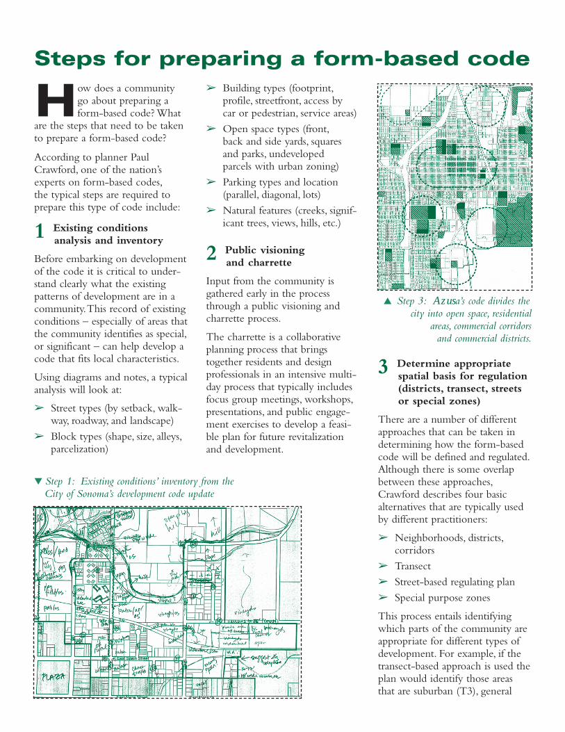
▲ Step 3: Azusa’s code divides thecity into open space, residential
areas, commercial corridors and commercial districts.

urban (T4), urban center (T5),urban core (T6) and special districtssuch as schools, civic centers orindustry.
4 Develop urban standards (streets, blocks, building placement, height, land uses, etc.)
The next step is to define andcode the urban standards for thedifferent parts of the communitymapped in Step 3. The results willbe a set of diagrams for each zonethat clearly establish standards forsome of the following key ingredi-
ents of an urban place: street andsidewalk widths, building placement,building height and profile, and, ifrelevant, location of on-site parking.
5 Develop architectural standards (building or frontage typologies, etc.)
The inventory conducted in Step1 and the public visioning andcharrette process in Step 2, help toidentify the different types ofbuildings and how they front thestreet to define the public realm.
The form-based code builds onthis information to define whattypes of buildings fit into differentparts of the community. The
form-based code for the City ofVentura, California, for example,identifies the following types ofbuildings as appropriate for differ-ent parts of the community: singlefamily, carriage house, duplex,triplex, quadplex, mansion apart-ment, bungalow court, townhouse,sideyard housing, live/work, court-yard, stacked flats, commercialblock, and blended development.
The code then lays out very clearlywhich types of buildings areappropriate in the different districtsfor different lot widths through atable on the left.
6 Allocate and illustrate standards
The final step in the process is toprepare the standards in a formatthat is graphic, well-illustrated, jar-gon-free, and easy to understand.
This format should include allinformation and regulation relevantto a particular district (street type,neighborhood, etc.) in one concisepiece. This avoids the confusionthat cross-referencing, scatteredrequirements, and obscure termscan introduce.
Form-based codes: Good vintage for wine country
■ Sonoma, California
One of California’s oldest cities and located in the scenic wine country, the city of Sonoma hadseen post-war suburbia grow into older neighborhoods built around its old pueblo that datesback to Spanish colonial times.This jumble of neighborhoods and building types represented a
significant challenge to those developing a new code.
Adopted in 2001, the new form-based code covers the entire city. To break the daunting task of a wholesalecode revision into more readily understood pieces, the city was divided into 13 planning areas in four cate-gories – residential, commercial district, commercial corridor and open space. Within each area, the existingsituation was inventoried and compared to the desired future state. This allows the code to recognize existing development while imposing a new regulatory framework on future development. Areas of specialconcern such as rural roads, the urban edge and creeks are highlighted, and subject to specified guidelines.
Code prepared by Crawford, Multari and Clark Associates
▼ Step 4: Form-based codes show where parking must be located.
▲ Step 5: A simple lot-width table shows how Ventura’s code regulates building profiles.

■ Petaluma, California
Ican’t tell if the SmartCode is aradical, green, left-wing docu-ment or a developer-friendly,
market based right-wing one,” aSanta Rosa Press-Democrat reporterwrote in April 2003.The viewunderscores the broad appeal ofform-based codes.
The City of Petaluma struggled forseven years to achieve consensuson a specific plan for a 400-acreredevelopment site adjacent to its downtown. Despite extensivepublic outreach, political battlescontinued between residents,developers and environmentalists.
The proposed zoning code wasfull of legalese and numbers and
did not assure the stake-holders that new devel-opment would mimicthe existing historicdowntown.
To move forward, thecity hired a consultantwho introduced thetransect SmartCode.This code focused lesson separating uses andmore on describing thebuilding forms thatwould realize the com-munity’s vision of apedestrian-oriented,mixed-use district.Residents have beenreassured by the clarityand relative simplicity of the new code, anddevelopers appreciate itsclear rules and expeditedpermitting process.
After only nine months of com-munity visioning and consensus-building, former adversaries agreedon the new form-based code,breaking a long-time logjam.
Zoning for consensusand revitalization
▼ Revitalizing Petaluma’s downtown:Code for street front types (below), thenew Boulevard Cinema (bottom left)
and new mixed-use development (left).
Code prepared by Fisher & Hall Urban Design
The Central Petaluma SpecificPlan, adopted in June 2003, hasjump-started the construction of a new, mixed-use theater district.

■ Hercules, California
The “Regulating Code,”adopted for the small cityof Hercules across the bay
from San Francisco in the summerof 2001, is similar to another pre-pared by the same firm for theCity of Winter Springs, in Florida.
Intended to foster smart growthdevelopment in newly createdtown centers, both codes havebeen extremely successful,immediately triggering develop-ment projects conforming to theprinciples and details embodied in the code.
The Hercules code covers fourdistricts in the central part oftown. It includes eight streettypes, though not all will appear in each zone. The use table is amercifully short three pages, with a half-page of footnotes. Fourtimes that number of pages aredevoted to façade details andarchitectural standards.
This architectural material featuresphotographs and drawings ofdesired and unwelcome features,signs, porches, trim and so on.These details precede the usetables in the code, consistent withform-based codes’ emphasis onbuilding form and the publicrealm.
One page is devoted to each streettype, detailing streetscape featuressuch as pavement width, curbs, on-street parking, landscaping, cornerradii, sidewalks, building setbacks,eaves, awnings and balconies.
This format allows the user toquickly access all the most relevantrequirements and standards for apiece of property, just by referenc-ing the street type that fronts theproperty.
Hercules’ new Regulating Codehas clearly been a success. Sinceits adoption, development hasflourished in the area it covers.Several traditional-appearing
residential projects have been built,with a total of 300 units, and construction is under way on thefirst phase of the main street areaof the Waterfront District.
That main street building includesfifteen 2,700-square-foot owner-ship units with commercial spaceon the ground floor and two-storytownhouse units above. The single-family projects include a numberof creatively designed duplex,triplex, and fourplex units thatblend in very well with the sur-rounding housing. Building stylesare varied.
The structures, landscaping, streetdesign, and even the street lampshave design details specified in thecode. This thorough approach tothe details can make all the differ-ence in the finished appearanceand appeal of a project.
Code prepared by Dover, Kohl & Partners
Code for anew towncenter
▲ Attractive new homes in Hercules look out onto the San Francisco Bay.

editing+design: dave davis
1414 K Street, Suite 600Sacramento, CA 95814-3966(916) 448-1198 ■ fax (916) 448-8246
www.lgc.org
This simple, illustrated page fortwo-laned avenues (right) inHercules covers pertinentstreetscape details as well asbuilding mass and placement.
ADDITIONALRESOURCES
Congress for New Urbanism:Codifying the New Urbanismwww.cnu.org
Form-based Codes Alliance:A newly formed alliance of leading practitionerswww.formbasedcodes.org
National Association ofRealtors® Smart Growth:Land Use, Zoning, andGrowth Managementwww.realtor.org/sg3.nsf
Online compendium of community-based urban designwww.charrettecenter.net
Dover, Kohl & Partners Town Planningwww.doverkohl.com
Duany Plater-Zyberk & Companywww.dpz.com/transect.htm
Fisher & Hall Urban Designwww.fisherandhall.com
Crawford Multari & Clarkwww.cmcaplans.com
Other Points to Consider
Large-scale revisions of zoning codes always have the potential forunanticipated problems, whether a form-based approach, or amore conventionally structured code built around smart growth
principles, is used. The need to monitor and revise these new codes afterthey are adopted must not be overlooked with any format. With form-based codes, these problems will likely surface when the underlying basisfor regulation is changed from a focus on uses within and around buildingsto a focus on the structures first.
Form-based codes require re-educating everyone in the community –elected and appointed officials, planners, engineers, developers and residents.This begins with a broad public participation effort as the code is developed,of course, but it must also continue after the code is adopted. Code modi-fications should be expected over time, and must be explained to everyoneinvolved. Some cities have hired an architect or urban designer to workwith builders and developers to help implement the code’s objectives.
This education – particularly of staff – will help reassure developers andthe public that application approvals will meet the code’s intent. If codereform streamlines the process in a way that eliminates hearing check-points, people must be confident that staff are trained to properly assesswhether proposed projects comply with detail requirements in the code.