for sale - farmers national sale ... • total of 29 fenced pastures using a six to ten day pasture...
TRANSCRIPT

Serving America’s Landowners Since 1929
FOR SALE
www.FarmersNational.com
Sellers may consider selling in three tractsconsisting of 1,442.15 acres, 1,587.15 acres, and 2,023.52 acres.
See insert with tract map for additional details
Real Estate Sales • Auctions • Farm and Ranch Management • Appraisals • Insurance • Consultation Oil and Gas Management • Forest Resource Management • National Hunting Leases • Lake Management • FNC Ag Stock
5,052.82+/- Acres Keya Paha County, Nebraska
700 cows year-round! 1,050 cows summer unit!
L-1500884
• Located on State Highway 183, eight miles north of Springview, Nebraska• 700 cows year-round, 29 fenced pastures, 1,050 cows summer unit• 1,000+/- acres of meadow• Excellent hunting opportunities plus stocked fishing ponds
For additional information, contact:Robert Litz, Listing AgentO’Neill, Nebraska(402) 336-3500 • (402) [email protected] • www.FarmersNational.com/RobertLitz
In 28 years of selling ranches, this has to be one of the finest offerings I have had the opportunity to represent!
Offered in Three Tracts
or as a Total Unit!

Land InformationLocationLocated eight miles north of Springview, Nebraska, along Highway 183. Approximately 44 miles southeast of Winner, South Dakota, or 30 miles northeast of Ainsworth, Nebraska.
Legal Available upon request.
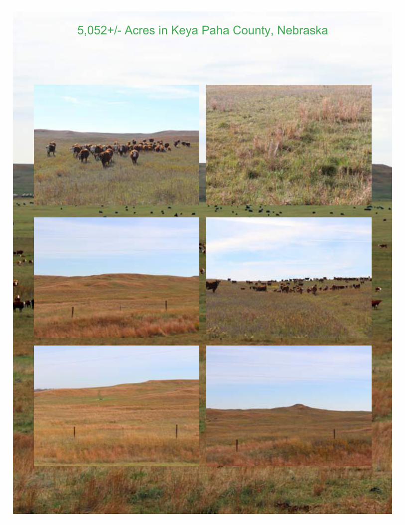
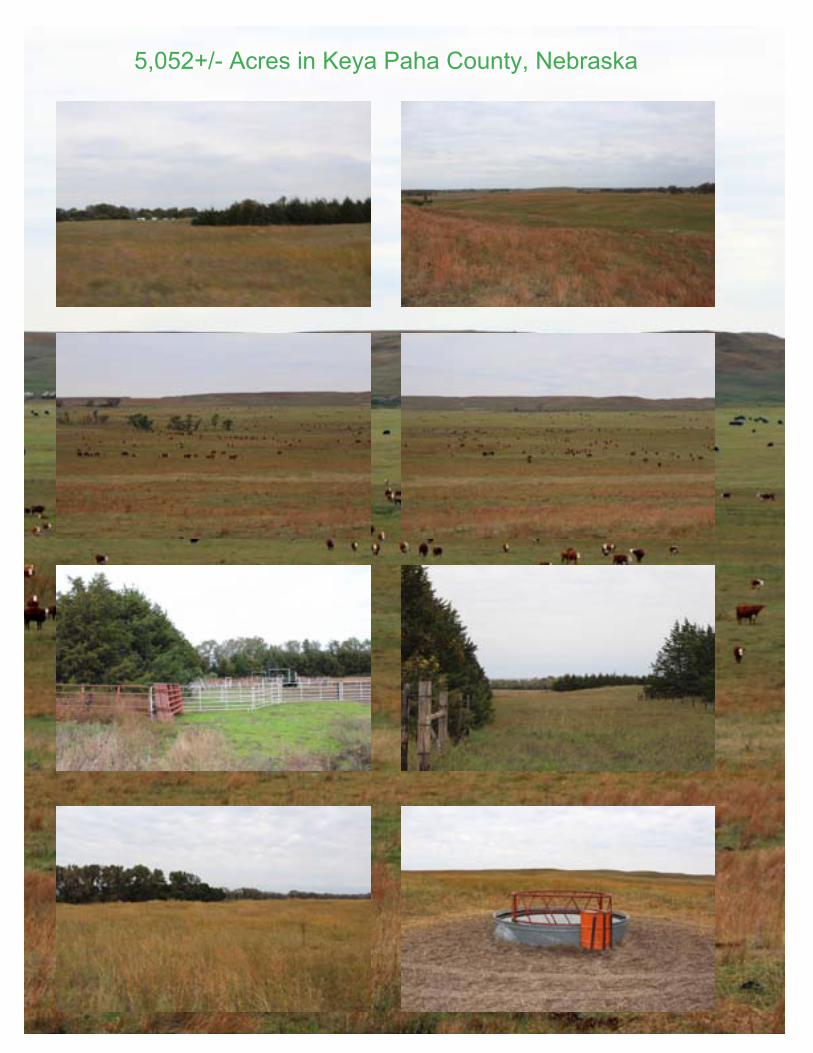
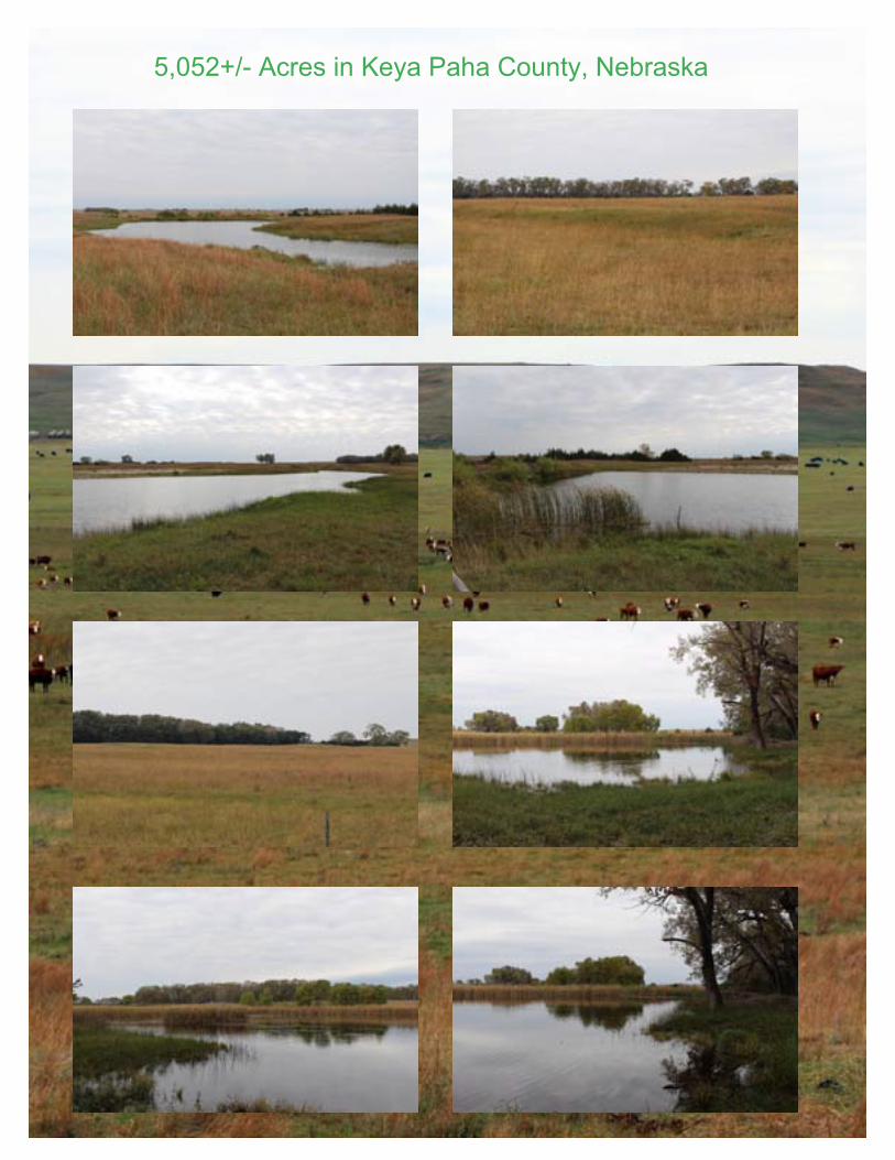
Land • Over 14 established shelterbelts• Fiveponds,onedugout,twoflowingcreeks• Eight wells servicing seven separate pipelines with 24 tanks• Older 1.5 story home, 48’ x 99 pole building and 36’ x 56’ pole shed• Total of 29 fenced pastures using a six to ten day pasture rotation• Nearly 10 miles of water pipeline serving the pastures from the seven wells • State Highway 183 frontage• Cool season and warm season hard grass• 1,000 +/- acres of meadow• Shelterbelts and rolling topography for calving• Grass carry-over at year end• Mule and Whitetail deer• Ranch is showing a 4.39% cap rate at asking price after taxes• Immediate possession upon closing• Most ponds are stocked with crappie, perch, and bass
2014 Taxes; $23,545.42 or $4.66 per acre
Price; $11,367,000
This ranch has been in the same family for 130 years. Highway access offers great potential for a pure breed operation with access/highway frontage/ show-casing any operation! Pure cattle country!
Offered in three tracts or as a total unit to meet any buyer’s needs!

5,052+/- Acres in Keya Paha County, Nebraska
5,052+/- Acres in Keya Paha County, Nebraska
5,052+/- Acres in Keya Paha County, Nebraska
5,052+/- Acres in Keya Paha County, Nebraska

5,052+/- Acres in Keya Paha County, Nebraska

Aerial Photo of Property
Information provided was obtained from sources deemed reliable, but the broker makes no guarantees as to its accuracy. All prospective buyers are urged to inspect the property, its title and to rely on their own conclusions. Seller reserves the right to refuse any or all offers submitted and may withdraw the property from offering without notice. Farmers National Company and its representatives are acting as agents for the seller.
Copyright:© 2013 National Geographic Society, i-cubed
Latitude: 42.9260°NLongitude: -99.7588°WImagery Source: USDA NAIP Soil Data Source: USDA NRCSBoundaries Are Approximate
KurzenbergerKeya Paha Co., NE
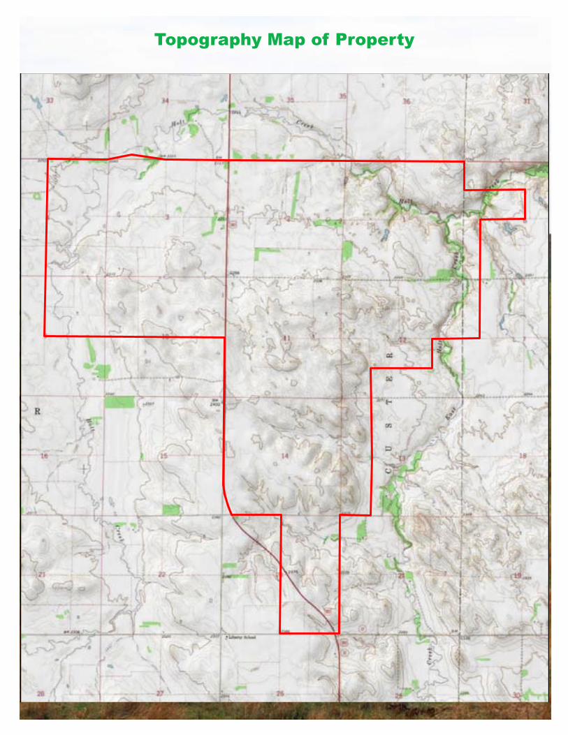
Topography Map of Property
4884
4827
4807
4807
3170
3214
4884
4807
4884
4807
4893
4485
2322
4827
8935
42484662 4892
4646 3225
9905
4884
4474
42484827
33414893
4807
4827
4475
4248
3313
3213
4827
6321
4662
3171
3170
4485
3261
4521
3213
4827
4892
3213
32134646
4646 3292
3214
46468945
3341
3213
4892
3260
4521
3179
4646
4248
3263
3340 90013291
4248
4521
4485
4646
4553
5285
4892
4646
3172
4248
4485
90019905
4646
3213
4248
4646
52814646
4662
3260
3341
3173
3213
4646
42484646
3313
4646
3213
4646
4248
3313
4646
4646
3214
4553
3213
4248
3177
2110
4662
4248
4646
5285
4248
63214248
3313
4892
8945
3313
4502
32604553
2110
4662
21109999
3213
9999
9999
3177
Sec. 10
Sec. 24
Sec. 12
Sec. 13
Sec. 22
Sec. 15
Sec. 03
Sec. 11
Sec. 23
Sec. 14
Sec. 02
Sec. 36Sec. 34
Sec. 19
Sec. 35
Sec. 18
Sec. 07Sec. 09
Sec. 16
Sec. 06
Sec. 27
Sec. 21
Sec. 25Sec. 26
Sec. 33 Sec. 31
Sec. 30Sec. 28
Sec. 01
Sec. 04
T34N R21W T34N R20W
T35N R21W T35N R20W
Latitude: 42.9260°NLongitude: -99.7588°WImagery Source: USDA NAIP Soil Data Source: USDA NRCSBoundaries Are Approximate
KurzenbergerKeya Paha Co., NE
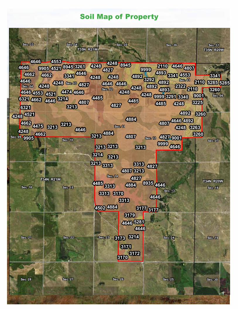
Soil Map of Property

Soil Map Chart
Latitude: 42.9260°NLongitude: -99.7588°WImagery Source: USDA NAIP Soil Data Source: USDA NRCSBoundaries Are Approximate
KurzenbergerKeya Paha Co., NE
MAP NON IRR IRRSYMBOL NAME LCC LCC SRPG ACRES
4884 Valentine-Longpine complex, rolling VIe 16 898.54807 Valentine fine sand, rolling VIe 16 753.94827 Valentine loamy fine sand, gently rolling VIe IVe 23 749.54646 Ipage loamy fine sand, 0 to 3 percent slopes IVe IVe 27 283.04248 Ord-Loup fine sandy loams, 0 to 1 percent slopes IIw IIw 33 255.53170 Holt fine sandy loam, 0 to 2 percent slopes IIIe IIIe 26 193.13214 Longpine-Duda complex, 3 to 15 percent slopes VIs 14 185.84485 Dunday loamy fine sand, 0 to 3 percent slopes IVe IIIe 30 164.14893 Valentine-Wewela loamy fine sands, 6 to 30 percent slopes VIe 26 163.63213 Longpine loamy fine sand, 3 to 30 percent slopes VIs 4 155.14892 Valentine-Wewela loamy fine sands, 3 to 6 percent slopes VIe IVe 27 134.54662 Loup fine sandy loam, 0 to 1 percent slpoes Vw 30 114.22322 Inavale fine sand, channeled, frequently flooded VIw 23 111.93341 Wewela fine sandy loam, 3 to 6 percent slopes IVe IVe 32 85.34521 Els fine sand, 0 to 3 percent slopes VIw IVw 23 71.68935 Simeon-Holt variant-Ronson complex, 6 to 17 percent slopes VIe 20 70.69905 Fluvaquents, sandy-Fluvaquents, loamy complex, frequently flooded VIIIw 3 69.63313 Ronson-Longpine fine sandy loams, 0 to 2 percent slopes IIIe IIIe 16 63.83225 Labu-Sansarc silty clays, 11 to 30 percent slopes VIe 7 62.64474 Duda loamy fine sand, 0 to 3 percent slopes IVe IVe 21 57.94475 Duda loamy fine sand, 3 to 6 percent slopes VIe IVe 20 39.84553 Elsmere loamy fine sand, 0 to 3 percent slopes IVw IVw 28 36.76321 Barney-Bolent complex, channeled, occasionally flooded VIw 23 34.33260 O'Neill fine sandy loam, 0 to 2 percent slopes IIIe IIIe 36 32.29001 Anselmo fine sandy loam, 0 to 1 percent slopes IIe IIe 56 26.78945 Simeon-Valentine loamy sands, 0 to 3 percent slopes VIs IVs 25 25.23171 Holt fine sandy loam, 2 to 6 percent slopes IIIe IIIe 25 24.73291 Paka-Mariaville loams, 2 to 6 percent slopes IIIe IIIe 7 23.43261 O'Neill fine sandy loam, 2 to 6 percent slopes IVe IVe 34 22.93179 Holt variant loamy fine sand, 3 to 6 percent slopes IVe IVe 38 19.85285 Vetal loam, 0 to 1 percent slopes IIc I 62 19.82110 Inavale loamy fine sand, occasionally flooded IVe IIIe 31 18.13292 Paka-Mariaville loams, 11 to 30 percent slopes VIe 20 16.23263 O'Neill fine sandy loam, 6 to 11 percent slopes VIe IVe 32 15.33340 Wewela fine sandy loam, 0 to 3 percent slopes IIIe IIIe 34 15.33172 Holt-Longpine fine sandy loams, 2 to 6 percent slopes IIIe IIIe 19 12.33177 Holt variant fine sandy loam, 3 to 6 percent slopes IIIe IIIe 42 11.75281 Vetal fine sandy loam, 0 to 3 percent slopes IIe IIe 55 10.33173 Holt-Longpine fine sandy loams, 6 to 11 percent slopes IVe IVe 16 9.59999 Water 0 7.54502 Dunday-Duda loamy fine sands, 0 to 3 percent slopes IVe IIIe 25 6.03178 Holt variant loamy fine sand, 0 to 3 percent slopes IIIe IIIe 40 1.1
TOTAL 21.4 5,073.0

www.FarmersNational.com
For Sale! 5,052.82+/- Acres, Keya Paha County, Nebraska
Property Location
Real Estate Sales • Auctions • Farm and Ranch Management • Appraisals • Insurance • Consultation Oil and Gas Management • Forest Resource Management • National Hunting Leases • Lake Management • FNC Ag Stock