for personal use only · results from handling and washability tests were analysed by a&b mylec...
TRANSCRIPT
Registered Office Unit 1B, 205-207 Johnston Street Fitzroy, VIC 3065 T +61 3 9191 0135 E [email protected] www.atrumcoal.com
Board of Directors Non-Exec Chairman Managing Director Non-Executive Director Non-Executive Director Non-Executive Director Company Secretary
C. Blixt M. Wang C. Fear G. Edwards J. Chisholm J. Stedwell
Key Projects Groundhog Elan Coal Bowron River
Ownership: 100% Ownership: 100% Ownership: 100%
PANORAMA NORTH PROJECT – 2017 COAL QUALITY RESULTS AND 2018 JV EXPLORATION PROGRAM
UPDATE
HIGHLIGHTS § Second drilling program at Panorama North in 2017 identifies additional
anthracite targets § Washability and coal quality data indicates multiple potentially economic
anthracite seams capable of producing several high value anthracite products
§ Panorama North JV has approved a budget of C$1.89M for the third-year 2018 JV exploration program
Atrum Coal Limited (“Atrum” or the “Company”) (ASX: ATU) and joint-venture partner Japan Oil, Gas and Metals National Corporation (“JOGMEC”) are pleased to provide an operational update for the Company’s Panorama North Anthracite Project (“Panorama North”), in British Columbia, Canada, following positive results from 2017 drilling as well as washability and coal quality testing. Atrum Managing Director Max Wang commented: “Panorama North coal quality testing and analysis results continue to increase the economic potential of multiple anthracite seams. With the approval of funding for the 2018 exploration program, Atrum aims to identify additional targets in 2018 through further drilling and testing, and potentially to complete a JORC Resource Estimate for the project.” The Company received additional encouraging coal quality testing results from borehole samples obtained at Panorama North in 2017. Intersected anthracite seams demonstrated the potential for Panorama North to produce high value anthracite products, building on findings from the 2016 drilling program. Refer to 27 March 2017 announcement, “Three New Anthracite Targets Identified At Panorama North Project” for further information regarding anthracite analysis and results from the 2016 program at Panorama North.
ASX Release
4 April 2018
For
per
sona
l use
onl
y

Atrum Coal Limited ACN 153 876 861 – Unit 1B, 205 – 207 Johnston St, Fitzroy, Vic, 3065 T +61 3 9191 0135 E [email protected] www.atrumcoal.com
Coal quality laboratory results from samples collected during the 2017 drilling program at Panorama North exhibited physical and chemical characteristics similar to Atrum’s nearby Groundhog Anthracite Project. Surface coal exposures were not analysed due to weathering effects on the coal. Atrum and JOGMEC have approved the third-year 2018 exploration program at Panorama North with a budget of C$1.89M. This is the remainder of the total $5M to be spent by JOGMEC as part of the three-year program in the original JV agreement. The 2018 program runs from 1 April 2018 to 31 March 2019. 2017 Exploration Program Panorama North is a highly prospective area southwest of Groundhog North (Figure 1). Exploration in 2017 at Panorama North aimed to further define coal seam distribution with widely-spaced boreholes (Figure 2). Diamond core drilling completed in five boreholes in 2017 provided additional confirmatory quality information to the four fully cored boreholes completed in 2016. Refer to 20 September 2017 announcement, “Atrum Coal – Panorama North 2017 Exploration Update” for further information regarding the 2017 exploration activities.
Figure 1: Panorama North Location
For
per
sona
l use
onl
y

Atrum Coal Limited ACN 153 876 861 – Unit 1B, 205 – 207 Johnston St, Fitzroy, Vic, 3065 T +61 3 9191 0135 E [email protected] www.atrumcoal.com
The 2017 drilling program was the second Farm-In Period of the Joint Exploration Agreement between Atrum and JOGMEC. Refer to 29 August 2016 announcement “Atrum Enters Into Joint Exploration Agreement with Japan Oil, Gas & Metals Corporation” for additional information regarding the Panorama North Joint Venture.
Figure 2: Panorama North drill hole locations
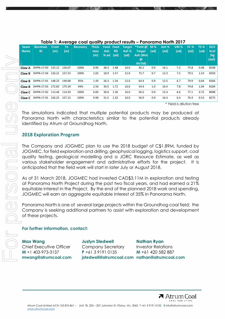
2017 Coal Quality Results Birtley Coal & Mineral Testing of Calgary performed detailed laboratory analyses on samples collected from Panorama North, which were representative of selected coal seams and their associated partings. A total of 224 core samples including 133 coal ply and 91 rock roof/floor samples were collected from the 2017 drilling program for coal quality analysis. An additional six rock samples were collected for geotechnical testing. All coal, rock, and geotechnical samples are being stored at Birtley Coal and Mineral Testing. Results from handling and washability tests were analysed by A&B Mylec Metallurgical Consultants in Rockhampton, Australia, and used to simulate potential washability of the coal seams. Partition curves were generated, and the results from these simulations are summarised in Table 1 below.
For
per
sona
l use
onl
y
Atrum Coal Limited ACN 153 876 861 – Unit 1B, 205 – 207 Johnston St, Fitzroy, Vic, 3065 T +61 3 9191 0135 E [email protected] www.atrumcoal.com
Table 1: Average coal quality product results – Panorama North 2017 Seam Name
Borehole ID
From (m)
To (m)
Recovery Thick- ness (m)
Feed Ash % ad
Feed RD
(ad)
Target Ash % (ad)
*Yield @ Target
Ash (Wet @
9%TM)
M % (ad)
Ash % (ad)
VM % (ad)
FC % (ad)
TS % (ad)
GCV kcal/kg
(daf)
Claw A DHPN-17-03 125.12 126.07 100% 0.95 38.3 1.48 16.0 46.2 0.9 16.1 7.2 75.8 0.48 8248
Claw B DHPN-17-04 126.21 127.23 100%
1.02 18.9 1.57 12.0 75.7 0.7 12.3 7.5 79.5 1.53 8350
Claw B DHPN-17-01 148.25 149.68 95% 1.43 26.3 1.34 12.0 64.4 0.9 12.5 6.7 79.9 0.64 8266
Claw B DHPN-17-03 172.83 175.39 94% 2.56 30.5 1.72 16.0 54.4 1.0 16.4 7.8 74.8 1.04 8184
Claw C DHPN-17-02 113.46 114.29 100% 0.83 30.6 1.36 16.0 56.5 0.9 15.4 6.6 77.1 0.72 8098
Claw C DHPN-17-01 156.25 157.15 100% 0.90 31.5 1.32 16.0 56.9 0.9 16.4 6.4 76.4 0.53 8275
* Yield is dilution free
The simulations indicated that multiple potential products may be produced at Panorama North with characteristics similar to the potential products already identified by Atrum at Groundhog North. 2018 Exploration Program The Company and JOGMEC plan to use the 2018 budget of C$1.89M, funded by JOGMEC, for field exploration and drilling, geophysical logging, logistics support, coal quality testing, geological modelling and a JORC Resource Estimate, as well as various stakeholder engagement and adimistrative efforts for the project. It is anticipated that the field work will start in later July or August 2018. As of 31 March 2018, JOGMEC had invested CAD$3.11M in exploration and testing at Panorama North Project during the past two fiscal years, and had earned a 21% equitable interest in the Project. By the end of the planned 2018 work and spending, JOGMEC will earn an aggregate equitable interest of 35% in Panorama North. Panorama North is one of several large projects within the Groundhog coal field; the Company is seeking additional partners to assist with exploration and development of these projects.
For further information, contact:
Max Wang Justyn Stedwell Nathan Ryan Chief Executive Officer Company Secretary Investor Relations M +1 403-973-3137 P +61 3 9191 0135 M +61 420 582 887 [email protected] [email protected] [email protected]
For
per
sona
l use
onl
y

Atrum Coal Limited ACN 153 876 861 – Unit 1B, 205 – 207 Johnston St, Fitzroy, Vic, 3065 T +61 3 9191 0135 E [email protected] www.atrumcoal.com
Competent Person Statement
The information in this document that relates to Exploration Results of the Panorama North project area is based on, and fairly represents, information and supporting documentation reviewed by Mr Shaun Tamplin, who is a Member of the Australasian Institute of Mining and Metallurgy and is a full-time employee of Tamplin Resources Pty Ltd. Mr Tamplin has read and understands the requirements of the 2012 Edition of the Australasian Code for Reporting of Exploration Results, Mineral Resources and Ore Reserves (JORC Code, 2012 Edition). Mr. Tamplin is a Competent Person as defined by the JORC Code, 2012 Edition, having twenty years’ experience that is relevant to the style of mineralisation and type of deposit described in this document.
For
per
sona
l use
onl
y

Atrum Coal Limited ACN 153 876 861 – Unit 1B, 205 – 207 Johnston St, Fitzroy, Vic, 3065 T +61 3 9191 0135 E [email protected] www.atrumcoal.com
JORC TABLE 1
SECTION 1 - SAMPLING TECHNIQUES AND DATA FOR 2017 COAL QUALITY
Criteria JORC Code explanation Commentary
Sampling techniques
Nature and quality of sampling (eg cut channels, random chips, or specific specialised industry standard measurement tools appropriate to the minerals under investigation, such as down hole gamma sondes, or handheld XRF instruments, etc). These examples should not be taken as limiting the broad meaning of sampling.
Include reference to measures taken to ensure sample representivity and the appropriate calibration of any measurement tools or systems used.
Aspects of the determination of mineralisation that are Material to the Public Report.
In cases where ‘industry standard’ work has been done this would be relatively simple (eg ‘reverse circulation drilling was used to obtain 1 m samples from which 3 kg was pulverised to produce a 30 g charge for fire assay’). In other cases more explanation may be required, such as where there is coarse gold that has inherent sampling problems. Unusual commodities or mineralisation types (eg submarine nodules) may warrant disclosure of detailed information.
For the 2017 Panorama North exploration program, all coal seams intersected were sampled. Coal plies were sampled discretely based on lithological characteristics and quality. All non-coal material and partings were sampled separately and noted in the lithological description. The immediate roof and floor samples were collected for geotechnical testing. Apart from one borecore (DHPN-17-04) all sampling was completed with geophysical logs to determine core and coal loss and allocate accordingly. The qualified and depth corrected samples were then transported to the laboratory via courier. Coal quality samples from the Atrum Coal Panorama North Drilling program were sent to Birtley Coal and Mineral Testing in Calgary, Canada. In total, 224 core samples were collected from the 2017 drilling program, of which 133 individual ply samples were analysed for raw coal quality and 25 rock roof/floor samples. An additional 6 rock samples were collected for geotechnical testing. Air dry moisture from the raw coal quality analysis of all coal samples, excluding roof rock and floor rock samples and in-seam partings, averages 1.28%, and ranges from 0.52% to 2.32%. Air dry ash averages at 27.52%, and ranges from 8.24% to 49.85%. Total sulphur on an air-dry basis averages 1.32% and ranges from 0.34% to 5.29%. The high sulphur values in some raw coal samples appear to correlate with pyrite nodules in the core. Identified seams which have potential to become economic targets were composited and analysed for clean coal quality, in representative working sections, which were generally full-seam analysis. From the initial ply samples, 10 composite samples were made to represent potential product intervals as well as to begin characterising the coal within the project area. Smaller samples were crushed to top size limit (12 mm) while larger coal samples had sufficient mass to conduct pretreatment and dry and wet sizing analysis. Comprehensive washability testing was carried out on composites. Subsequent analysis consisted of raw coal proximate, SE, TS, RD; and washability completed on likely working sections. The results were analysed by A&B Mylec Metallurgical Consultants in Rockhampton, Australia, and used in simulating potential washability of the coal seams. A comprehensive range of clean coal composite analyses was conducted on each selected product. The range of analysis included ash proximate, HGI, phosphorus in coal, as analysis, ash fusion temperatures, forms of sulphur and ultimate analysis. All samples for coal quality are based on cored holes only. All coal quality samples were prepared and analysed using Canadian and International Standard testing methodologies.
Drilling techniques
Drill type (eg core, reverse circulation, open-hole hammer, rotary air blast, auger, Bangka, sonic, etc) and details (eg core diameter, triple or standard tube, depth of diamond tails, face-sampling bit or other type, whether core is oriented and if so, by what method, etc).
Most boreholes are vertical but two boreholes were inclined, including one that was a redrill of another hole from the same drill pad. All holes have been drilled at a range of inclinations and directions in an attempt to intersect strata perpendicular to dip. All coal quality holes were fully cored using a HQ3 size core barrel producing a 61.1 mm core diameter.
For
per
sona
l use
onl
y

Atrum Coal Limited ACN 153 876 861 – Unit 1B, 205 – 207 Johnston St, Fitzroy, Vic, 3065 T +61 3 9191 0135 E [email protected] www.atrumcoal.com
Criteria JORC Code explanation Commentary
Triple tubing was used to try and maximize coal recovery.
Drill sample recovery
Method of recording and assessing core and chip sample recoveries and results assessed.
Measures taken to maximise sample recovery and ensure representative nature of the samples.
Whether a relationship exists between sample recovery and quality and whether sample bias may have occurred due to preferential loss/gain of fine/coarse material.
An assessment of core recovery was completed by comparing the recovered thickness measured during geological logging and by the driller, to geophysical picked thicknesses from the geophysical logs. Coal seam recoveries were typically greater than 80%. Observations suggest that core loss is concentrated on the more fragile coal bands, particularly when interbedded with claystone. Consequently, samples with losses tend to have higher ash results than those with high recovery. No statistics have been performed to test this observation.
Logging Whether core and chip samples have been geologically and geotechnically logged to a level of detail to support appropriate Coal Resource estimation, mining studies and metallurgical studies.
Whether logging is qualitative or quantitative in nature. Core (or costean, channel, etc) photography.
The total length and percentage of the relevant intersections logged.
All core was geologically logged, marked and photographed before sampling. Geological and geotechnical features were identified and logged. Cored holes have detailed lithological and geophysical logs. All core descriptions are encoded in a digital lithology database on a hole by hole basis. Coal seams correlated between holes with corrections to database made using lithological and geophysical characteristics. Drill holes have been geophysical logged with a minimum density, neutron, gamma and verticality unless operational difficulties prevented full (as in borehole DHPN-17-04) or partial logging of the drill hole. The calibration of the geophysical tools was conducted by the geophysical logging company, Century Wireline Services. The standard and level of detail is considered appropriate for exploration reporting and future mineral resource estimation, if appropriate. Total aggregate lengths of cored holes are 1244m in 2017 and 1235m in 2016.
Sub-sampling techniques and sample preparation
If core, whether cut or sawn and whether quarter, half or all core taken.
If non-core, whether riffled, tube sampled, rotary split, etc and whether sampled wet or dry.
For all sample types, the nature, quality and appropriateness of the sample preparation technique.
Quality control procedures adopted for all sub-sampling stages to maximise representivity of samples.
Measures taken to ensure that the sampling is representative of the in situ material collected, including for instance results for field duplicate/second-half sampling.
Whether sample sizes are appropriate to the grain size of the material being sampled.
All core samples were double bagged on site and transported to the Laboratory for testing. Birtley Coal & Minerals Testing comply with Canadian and International Standards for sample preparation and sub sampling. Large wash samples were pre-treated and dry sized before sample splitting and analysis. Proximate analysis was completed on a portion of the original sample. Raw analysis procedure keeps ½ of the sample as reserve. No geotechnical testing has been done to date.
Quality of assay data and laboratory tests
The nature, quality and appropriateness of the assaying and laboratory procedures used and whether the technique is considered partial or total.
For geophysical tools, spectrometers, handheld XRF instruments, etc, the parameters used in determining the analysis including instrument make and model, reading times, calibrations factors applied and their
Birtley Coal & Minerals Testing comply with the Canadian and International Standards for coal quality testing and as such conduct the verifications for coal quality analysis outlined in the standards. Coal quality results were verified upon receiving them. No adjustments have been made to the coal quality data.
For
per
sona
l use
onl
y

Atrum Coal Limited ACN 153 876 861 – Unit 1B, 205 – 207 Johnston St, Fitzroy, Vic, 3065 T +61 3 9191 0135 E [email protected] www.atrumcoal.com
Criteria JORC Code explanation Commentary
derivation, etc.
Nature of quality control procedures adopted (eg standards, blanks, duplicates, external laboratory checks) and whether acceptable levels of accuracy (ie lack of bias) and precision have been established.
The coal quality database is in Excel format. The resultant database appears to have a valid range of data and exhibits sound regression relationships such as ash-cv, ash-rd and washability –ash. Birtley Coal & Minerals adheres to ASTM and ISO preparation and testing specifications and has a Quality Control process in place. Birtley has participated in the CANSPEX Proficiency Testing Program since its inception and the test results are consistently in the preferred groupings. Their regular client base consists of all the major coal producers in western Canada as well as international clients.
Verification of sampling and assaying
The verification of significant intersections by either independent or alternative company personnel.
The use of twinned holes.
Documentation of primary data, data entry procedures, data verification, data storage (physical and electronic) protocols.
Discuss any adjustment to assay data.
Coal Quality results were verified by A&B Mylec Pty Ltd. No adjustments have been made to the Coal quality data. Coal intersections were verified by geophysical measurements obtained by wireline logging, carried out by an independent contractor, supported by digital photographs. Coal intersection depths and seam correlations have been validated by company personnel (Database Geologist).
Twinned holes are not used.
All available field records, lab reports, core photographs, survey data etc. are stored in electronic form on the Atrum network, and hard copy in borehole folders at the company’s Canadian offices.
Anomalous results are checked and reanalysed using their reserve sample as required.
The resultant database is cross referenced to ensure it has a valid range of data and exhibits sound regression relationships such as ash-cv, ash-rd and washability –ash.
Location of data points
Accuracy and quality of surveys used to locate drill holes (collar and down-hole surveys), trenches, mine workings and other locations used in Coal Resource estimation.
Specification of the grid system used.
Quality and adequacy of topographic control.
Survey of the boreholes for the Atrum Coal exploration program was completed by Atrum geologists with A Trimble GEO XH surveying drill holes to approximate <60 cm accuracy. All Data collected and reported in UTM co-ordinate system – NAD-83 The collar levels were also audited against high-resolution LiDAR generated topographic surface countours.
Data spacing and distribution
Data spacing for reporting of Exploration Results.
Whether the data spacing and distribution is sufficient to establish the degree of geological and quality continuity appropriate for the Coal Resource and Ore Reserve estimation procedure(s) and classifications applied.
Whether sample compositing has been applied.
All holes have been drilled at a range of inclinations and directions in an attempt to intersect strata perpendicular to dip. The Distance between drill holes generally ranges from 1600 to 3500 m. Data spacing is sufficient to confirm the prospectivity of the area, however, the data spacing is not currently sufficient to establish a degree of geological continuity. Where coal intersections have been sampled in multiple sections per seam, compositing of samples, on a length x RD basis, has been applied. The data spacing and distribution is considered by the Competent Person to be sufficient to establish the degree of geological and grade continuity appropriate for this exploration update. No Mineral Resource, Ore Reserves or Exploration Targets have been declared for the project.
Orientation of data in relation to
Whether the orientation of sampling achieves unbiased sampling of possible structures and the extent to which this is known, considering the deposit
Most boreholes are vertical but two boreholes were inclined, including one that was a redrill of another hole from the same
For
per
sona
l use
onl
y

Atrum Coal Limited ACN 153 876 861 – Unit 1B, 205 – 207 Johnston St, Fitzroy, Vic, 3065 T +61 3 9191 0135 E [email protected] www.atrumcoal.com
Criteria JORC Code explanation Commentary
geological structure
type.
If the relationship between the drilling orientation and the orientation of key mineralised structures is considered to have introduced a sampling bias, this should be assessed and reported if material.
drill pad. Drillholes were aligned to best intersect regional structures perpendicular to their orientation. Reported seam thicknesses are apparent thickness. Significant portions of each drillhole exhibit consistent relatively flat bedding. The orientation of data in relation to geological structure is not believed to have introduced any sampling bias, however, the structural understanding of the sub-surface is at a preliminary status.
Sample security The measures taken to ensure sample security. No special sample security measures were adopted on this project because the industry regards coal as a low value bulk commodity, the exploration samples for which do not require special or elaborate sample security measures. Samples have a unique sample number that is provided on the analysis. Each item of advice lists project name, borehole, top and base of sample and sample number. Sample security was ensured under a chain of custody between Atrum Coal personnel on site and the coal testing laboratories (Birtley). Reserves of samples drilled are stored and maintained at the laboratories for further testing if necessary.
Audits or reviews The results of any audits or reviews of sampling techniques and data.
Sampling was performed by Atrum Coal personnel. Birtley undertook internal audits and checks in line with the Canadian and International standards.
The coal quality database has been reviewed by A&B Mylec. The exploration data was validated by spot checks from the Competent Person, using reports, geophysical logs, tables and spreadsheets.
SECTION 2 - REPORTING OF EXPLORATION RESULTS
Criteria JORC Code explanation Commentary
Mineral tenement and land tenure status
Type, reference name/number, location and ownership including agreements or material issues with third parties such as joint ventures, partnerships, overriding royalties, native title interests, historical sites, wilderness or national park and environmental settings.
The security of the tenure held at the time of reporting along with any known impediments to obtaining a licence to operate in the area.
Coal tenures relate to the Panorama North project, which is 100% owned by Atrum Coal.
Table 2 lists coal licences of the Panorama North project.
The Panorama North project is a Joint Venture (JV) between Atrum Coal Panorama Inc. and Japan Oil, Gas and Metals National Corporation (JOGMEC). As of March 31st, 2018 JOGMEC will take over 21% ownership of each coal licence, with Atrum Coal Panorama Inc. holding the remaining 79% of coal licences subject to certain terms and conditions being met.
The project consists of 12 granted coal licences totalling 7,359 hectares
Security of tenure is not compromised and there is no known impediments.
The boreholes were drilled in Coal Licences 417526, 417525, 417084, and 418958.
Exploration done by other parties
Acknowledgment and appraisal of exploration by other parties.
Gulf Canada Resources Inc. conducted exploration programs in 1980 and 1981 at Panorama, consisting of helicopter-supported
For
per
sona
l use
onl
y

Atrum Coal Limited ACN 153 876 861 – Unit 1B, 205 – 207 Johnston St, Fitzroy, Vic, 3065 T +61 3 9191 0135 E [email protected] www.atrumcoal.com
Criteria JORC Code explanation Commentary
mapping at 1: 10,000 scale and hand-trenching. The hand-trenching was implemented to prove the thickness of coal seams and to collect coal quality samples. Coal surface exposures greater than 0.50 m were trenched. In total, 96 trenches were logged: 42 from 1980 and 54 from 1981. All coal seams with a trench thickness greater than 0.50 m were sampled for coal analyses. Coal quality analyses were carried out by Cyclone Engineering Sales Ltd. for the 1980 trench samples. Samples from both exploration programs underwent vitrinite reflectance analysis by David E. Pearson & Associates Ltd. in Victoria, B.C. The examined coals were concluded to be of anthracite grade (Gulf Canada Resources Inc., 1981). The trench data was utilized to assist in targeting exploration drill holes. The coal quality results from the trenching are not reported herein due to uncertainties regarding the adequacies of sampling techniques and the high likelihood that the surface samples have been weathered. Exploration drilling within and near the Panorama North project has been reviewed and evaluated for data purposes and relevance.
Geology Deposit type, geological setting and style of mineralisation.
The Panorama North project lies within the Bowser Basin, which is the largest contiguous basin in the Canadian Cordillera, developed because of tectonic compression and uplift of the Coast Mountains during the Upper Jurassic. It is apparent that the structure of the Groundhog Coalfield can range from benign to complicated in localised zones due to the two phases of deformation. In broad terms, Panorama’s structure is characterised by broad, gentle synclines spanning distances up to 4 km with tightly folded isolated zones on the syncline flanks. It is estimated that the tight folding occurs over narrow zones approximately 500 m to 700 m in width. Strata within these tightly folded zones features complex thrusting, blind thrusts and recumbent folding. Exploration targets within this structural regime are likely to occur in the flat lying synclines between thrusts, however, more complex small deposits of thicker fault accumulated anthracite may also exist within the folded zones. The dominant structural feature in the region is the NW/SE trending Biernes Synclinorium. This feature resulted from northeast-southwest compression during the first phase of deformation (“F1”). Thrusting related to the F1 deformation is more intense in the southern part of the Groundhog Coalfield than in the northern part. Generally, the thrusting is confined to isolated zones 500-700m in width. The second, less intense, phase of deformation (“F2”) resulted from NW/SE compression. The F2 deformation is superimposed on the broad, open type of F1 folding. The F2 imprint is visible in a series of plunge changes in the F1 folds in the order of up to 5°. F2 thrusts are generally flat lying and isolated to the hanging wall of drag folds. Displacement tends to be along bedding surfaces which makes their identification and modelling difficult to replicate. The F2 fold structures superimposed on the major F1 synclinorium vary in wave length from 100 m to 700 m and vary in amplitude up to 100 m.
Drill hole Information
A summary of all information material to the understanding of the exploration results including a tabulation of the following information for all Material drill holes:
easting and northing of the drill hole collar
All holes have been lithologically logged, with coal logs for all cored holes. See Table 3 for a summary of borehole data. All major seams are correlated between holes with a low level of confidence.
For
per
sona
l use
onl
y

Atrum Coal Limited ACN 153 876 861 – Unit 1B, 205 – 207 Johnston St, Fitzroy, Vic, 3065 T +61 3 9191 0135 E [email protected] www.atrumcoal.com
Criteria JORC Code explanation Commentary
elevation or RL (Reduced Level – elevation above sea level in metres) of the drill hole collar
dip and azimuth of the hole
down hole length and interception depth
hole length.
If the exclusion of this information is justified on the basis that the information is not Material and this exclusion does not detract from the understanding of the report, the Competent Person should clearly explain why this is the case.
See Table 4 for a summary of coal intersections. Table 5 summarises coal quality results for major intersections. All samples taken at a ply by ply level for RD and ash determination and then composited into working sections for subsequent working section analysis and clean coal composites. Core recovery is generally adequate; roof and floor dilution samples and analysis generally limited to ash and RD. Structural data contained in digital database; database updated with all exploration data, survey pickups and other relevant data. Coal quality data contained in Excel but linked to structural database by both roof and floor picks and seam name.
Data aggregation methods
In reporting Exploration Results, weighting averaging techniques, maximum and/or minimum quality truncations (eg cutting of high grades) and cut-off qualities are usually Material and should be stated.
Where aggregate intercepts incorporate short lengths of high quality results and longer lengths of low quality results, the procedure used for such aggregation should be stated and some typical examples of such aggregations should be shown in detail.
Coal intersections may have been sampled in multiple sections per seam, so compositing of density is aggregated by volume. Proximate analysis results, sulphur and washability are aggregated by mass. Clean coal results are aggregated by the sum product of yield and mass. These approaches are industry standards. Where quoted coal quality is for the full seam. Grade cut offs have not been applied to exploration results in the database.
Relationship between mineralisation widths and intercept lengths
These relationships are particularly important in the reporting of Exploration Results.
If the geometry of the mineralisation with respect to the drill hole angle is known, its nature should be reported.
If it is not known and only the down hole lengths are reported, there should be a clear statement to this effect (eg ‘down hole length, true width not known’).
Drillhole data limits the extent of geological knowledge regarding the horizontal extent of the coal seams. Drillholes were aligned to best intersect regional structures perpendicular to their orientation. Reported seam thicknesses are apparent thickness. Given the deposits steep seam dip there is a significant differential between apparent and true thickness in a vertical borehole. Many of the boreholes have been inclined in an attempt to intersect strata perpendicular to the strata dip.. A minority of intersections are at a high angle to the coal seam. Seam thicknesses have been corrected to geophysics.
Diagrams Appropriate maps and sections (with scales) and tabulations of intercepts should be included for any significant discovery being reported These should include, but not be limited to a plan view of drill hole collar locations and appropriate sectional views.
See Figures 1 to 3 and Tables 1 to Table 4
Balanced reporting
Where comprehensive reporting of all Exploration Results is not practicable, representative reporting of both low and high qualities and/or widths should be practiced to avoid misleading reporting of Exploration Results.
All available exploration data for the Panorama North project area has been considered, including referencing to historical data. There is no preferential reporting of results.
Data has been extensively cross referenced against raw records.
All coal quality data collated has been under the guidance of A&B Mylec Pty Ltd. Their scope has been to ensure the maintenance of acceptable levels of accuracy and precision in the reporting and process selection. They have also audited reported results and ensured that laboratory losses are allocated appropriately.
No information has been excluded whilst some outlying values may exist the average values are considered representative of the Project.
For
per
sona
l use
onl
y

Atrum Coal Limited ACN 153 876 861 – Unit 1B, 205 – 207 Johnston St, Fitzroy, Vic, 3065 T +61 3 9191 0135 E [email protected] www.atrumcoal.com
Criteria JORC Code explanation Commentary
Other substantive exploration data
Other exploration data, if meaningful and material, should be reported including (but not limited to): geological observations; geophysical survey results; geochemical survey results; bulk samples – size and method of treatment; metallurgical test results; bulk density, groundwater, geotechnical and rock characteristics; potential deleterious or contaminating substances.
No material potentially deleterious or contaminating substances have been identified other than those specified below. A sizable field mapping dataset exists across the Panorama tenements which has been utilized to develop and refine the structural framework of the geological interpretation. Aerial and topographic interpretation clearly demonstrate the regional geology of the deposit as it relates to the northwest-southeast striking strata, including westerly dipping thrust sheets. There is a substantial historical dataset of geological and field reports that supports and builds on the results detailed in this study. This data set was further enhanced by a 2017 geological mapping program conducted by Atrum over a two week period.
Further work The nature and scale of planned further work (eg tests for lateral extensions or depth extensions or large-scale step-out drilling).
Diagrams clearly highlighting the areas of possible extensions, including the main geological interpretations and future drilling areas, provided this information is not commercially sensitive.
Further work consisting of additional drilling and seismic survey is being evaluated. The Company is currently planning an additional drilling program aimed at testing the continuity of the coal across the most prospective areas of the Panorama North project area.
For
per
sona
l use
onl
y

Atrum Coal Limited ACN 153 876 861 – Unit 1B, 205 – 207 Johnston St, Fitzroy, Vic, 3065 T +61 3 9191 0135 E [email protected] www.atrumcoal.com
Panorama North Tenement Summary
Table 2: Tenement summary Tenure Number Owner
Percent Owned by Atrum Tenure Type
Area (ha)
Good to Date
418961 Atrum Coal Panorama Inc. 100% Coal Licence 71.00 08/09/2018 418958 Atrum Coal Panorama Inc. 100% Coal Licence 1345.00 08/09/2018 418957 Atrum Coal Panorama Inc. 100% Coal Licence 1415.00 08/09/2018 418953 Atrum Coal Panorama Inc. 100% Coal Licence 1346.00 08/09/2018 417084 Atrum Coal Panorama Inc. 100% Coal Licence 708.00 31/05/2018 417086 Atrum Coal Panorama Inc. 100% Coal Licence 142.00 31/05/2018 417292 Atrum Coal Panorama Inc. 100% Coal Licence 279.00 31/05/2018 417296 Atrum Coal Panorama Inc. 100% Coal Licence 71.00 31/05/2018 417299 Atrum Coal Panorama Inc. 100% Coal Licence 779.00 31/05/2018 417525 Atrum Coal Panorama Inc. 100% Coal Licence 425.00 31/05/2018 417526 Atrum Coal Panorama Inc. 100% Coal Licence 707.00 31/05/2018 417527 Atrum Coal Panorama Inc. 100% Coal Licence 71.00 31/05/2018
The Panorama North project is a Joint Venture (JV) between Atrum Coal Panorama Inc. and Japan Oil, Gas and Metals National Corporation (JOGMEC). As of March 31st, 2018 JOGMEC will take over 21% ownership of each coal licence, with Atrum Coal Panorama Inc. holding the remaining 79% of coal licences subject to certain terms and conditions being met.
Panorama 2017 Drilling Summary
Table 3: 2017 Panorama North drillhole details
Drillhole Easting Northing Elevation
(m) Dip Azimuth Total Depth
(m)
Diameter (mm)
Survey Lith- ology Log
Geo- physics
Log
Coal Quality
DHPN-17-01 529503.92 6302889.08 1532 -90 000 317.00 61.1 GPS Yes Yes Yes
DHPN-17-02 527295.76 6300409.17 1642 -90 000 219.50 61.1 GPS Yes Yes Yes
DHPN-17-02B 527295.76 6300409.17 1642 -80 020 16.50 61.1 GPS Yes Yes Yes
DHPN-17-03 528450.64 6301514.46 1598 -90 000 286.50 61.1 GPS Yes Yes Yes
DHPN-17-04 526983.26 6303870.08 1564 -70 040 156.00 61.1 GPS Yes No Yes
DHPN-17-05 530130.96 6299676.51 1583 -90 000 248.50 61.1 GPS Yes Yes Yes
Table 4: 2017 Drillhole coal intersection descriptions
Drillhole
Claw A Claw B Claw C Claw D Claw E Claw F Claw G
Top Depth
(m)
Thick- ness (m)
Top Depth
(m)
Thick- ness (m)
Top Depth
(m)
Thick- ness (m)
Top Depth
(m)
Thick- ness (m)
Top Depth
(m)
Thick- ness (m)
Top Depth
(m)
Thick- ness (m)
Top Depth
(m)
Thick- ness (m)
DHPN-16-01
55.32 1.81 82.14 1.22
114.91 2.34
DHPN-16-02A
DHPN-16-02B 138.96 1.02 151.35 0.62 160.27 1.05 190.92 1.11 199.54 0.49 207.39 0.84 210.80 0.20
DHPN-16-03
12.43 2.30 25.68 0.89 57.33 0.49 59.07 1.02 68.69 0.19 72.06 0.11
DHPN-16-04 120.88 0.70 143.08 2.11 158.70 0.79 202.16 1.11 205.02 0.50 212.04 0.53 213.80 0.77
DHPN-17-01 129.18 0.55 148.25 1.43 156.25 0.90 204.20 0.12 205.75 0.10
For
per
sona
l use
onl
y

Atrum Coal Limited ACN 153 876 861 – Unit 1B, 205 – 207 Johnston St, Fitzroy, Vic, 3065 T +61 3 9191 0135 E [email protected] www.atrumcoal.com
DHPN-17-02 60.21 0.78 101.01 0.97 113.46 0.83 146.26 0.28 161.04 0.34
DHPN-17-02B
DHPN-17-03
172.22 3.07 192.30 0.39
254.31 0.52
DHPN-17-04
126.21 1.02 150.71 1.41
DHPN-17-05
Scow A Scow B Scow C Scow D Scow E Scow F Scow G
Drillhole Top Depth
(m)
Thick- ness (m)
Top Depth
(m)
Thick- ness (m)
Top Depth
(m)
Thick- ness (m)
Top Depth
(m)
Thick- ness (m)
Top Depth
(m)
Thick- ness (m)
Top Depth
(m)
Thick- ness (m)
Top Depth
(m)
Thick- ness (m)
DHPN-16-01
DHPN-16-02A
DHPN-16-02B
DHPN-16-03 107.32 0.63 114.10 0.51 123.44 0.51
164.59 0.36 199.60 0.85 214.42 0.62
DHPN-16-04 233.14 0.89
252.87 0.17
DHPN-17-01 275.84 0.88 288.03 0.82 303.62 0.60
DHPN-17-02 182.20 0.66
DHPN-17-02B
DHPN-17-03
DHPN-17-04
DHPN-17-05
Thorn A Thorn B1 Thorn B2 Thorn C Thorn D
Drillhole Top Depth
(m)
Thick- ness (m)
Top Depth
(m)
Thick- ness (m)
Top Depth
(m)
Thick- ness (m)
Top Depth
(m)
Thick- ness (m)
Top Depth
(m)
Thick- ness (m)
DHPN-16-01
DHPN-16-02A
DHPN-16-02B
DHPN-16-03 249.13 0.45 266.15 0.36 268.67 0.30 280.57 0.10 317.39 0.36
DHPN-16-04
DHPN-17-01
DHPN-17-02
DHPN-17-02B
DHPN-17-03
For
per
sona
l use
onl
y

Registered Office Unit 1B, 205-207 Johnston Street Fitzroy, VIC 3065 T +61 3 9191 0135 E [email protected] www.atrumcoal.com
Board of Directors Non-Exec Chairman Managing Director Non-Executive Director Non-Executive Director Non-Executive Director Company Secretary
C. Blixt M. Wang C. Fear G. Edwards J. Chisholm J. Stedwell
Key Projects Groundhog Elan Coal Bowron River
Ownership: 100% Ownership: 100% Ownership: 100%
Table 5. Coal Quality Summary Borehole Info Raw Analysis Clean Coal Analysis
Borehole ID
Seam From To Thick (m)
Recovery %
Lab Core Size
Program Year
Mois %
(adb)
Ash %
(adb)
VM %
(adb)
FC % (adb)
Yield %
Ash %
Mois % (db)
Ash % (db)
VM % (db)
FC % (db)
CV kcal/kg (adb)
S % (adb)
Phos %
(db)
HGI (adb)
PN-17-03 Claw A 125.12 126.07 0.95 100 Birtley HQ 2017 1.2 29.9 7.0 62.0 46.2 16.0 0.9 16.1 7.2 75.8 6847 0.48 0.152 46 PN-17-01 Claw B 148.25 149.68 1.36 95.0 Birtley HQ 2017 0.9 25.1 6.3 67.7 64.4 12.0 0.9 12.5 6.7 79.9 7156 0.65 0.129 39 PN-17-03 Claw B 172.83 175.39 2.40 94.0 Birtley HQ 2017 1.7 30.4 6.3 61.6 54.4 16.0 1.0 16.4 7.8 74.8 6761 1.05 0.121 46 PN-17-04 Claw B 126.21 127.23 1.02 100 Birtley HQ 2017 1.3 18.9 10.1 69.8 75.7 12.0 0.7 12.3 7.5 79.5 7262 1.54 0.100 45 PN-16-01 Claw B 56.32 57.13 0.81 100 Birtley HQ 2016 1.3 25.7 8.1 64.9 53.1 10.3 0.8 10.2 6.0 83.0 7514 0.83 PN-16-01 Claw B 55.38 55.73 0.35 100 Birtley HQ 2016 1.7 39.5 5.3 53.5 38.7 19.4 1.0 19.2 5.7 74.1 6670 2.20 PN-17-01 Claw C 156.25 157.15 0.90 100 Birtley HQ 2017 1.2 44.1 6.9 47.8 56.9 16.0 0.9 16.4 6.4 76.4 6851 0.53 0.136 40 PN-17-02 Claw C 113.46 114.29 0.83 100 Birtley HQ 2017 1.7 29.7 9.3 59.3 56.5 16.0 0.9 15.4 6.6 77.1 6782 0.73 0.239 41 PN-16-01 Claw C 82.14 83.36 0.90 73.8 Birtley HQ 2016 1.2 39.3 7.0 52.5 44.7 18.7 1.0 18.9 6.0 74.1 6659 0.81 PN-16-02B Claw C 105.32 105.74 0.42 100 Birtley HQ 2016 0.7 19.8 8.8 70.7 64.2 10.0 1.0 10.2 7.5 81.3 7415 0.83 PN-16-03 Claw C 13.83 14.33 0.50 100 Birtley HQ 2016 0.9 32.4 8.1 58.7 59.5 14.9 0.9 15.1 5.5 78.5 7059 0.45 PN-16-01 Claw E 114.91 117.25 1.77 75.6 Birtley HQ 2016 0.9 39.6 5.9 53.7 38.9 14.3 1.1 14.9 6.4 77.6 6996 1.23 PN-16-04 Claw E 202.16 203.12 1.32 94.8 Birtley HQ 2016 1.0 25.2 9.1 64.7 63.3 11.3 0.9 11.5 5.8 81.8 7381 0.57 PN-16-02B Scow A 190.92 192.03 0.91 82.0 Birtley HQ 2016 1.0 42.4 6.5 50.1 39.9 19.8 1.3 19.5 6.6 72.7 6535 0.60 PN-16-03 Scow A 107.32 107.95 0.63 100 Birtley HQ 2016 1.0 20.8 6.1 72.1 66.2 8.0 0.7 8.2 5.4 85.7 7670 1.29 PN-16-02B Scow C 207.39 208.23 0.77 91.7 Birtley HQ 2016 0.8 33.1 8.5 57.6 51.1 9.6 0.8 9.5 6.1 83.6 7496 0.56 PN-16-03 Scow F 199.65 200.45 0.80 100 Birtley HQ 2016 1.1 26.1 5.7 67.1 53.9 9.5 0.7 9.2 4.5 85.6 7564 0.88
For
per
sona
l use
onl
y

Registered Office Unit 1B, 205-207 Johnston Street Fitzroy, VIC 3065 T +61 3 9191 0135 E [email protected] www.atrumcoal.com
Board of Directors Non-Exec Chairman Managing Director Non-Executive Director Non-Executive Director Non-Executive Director Company Secretary
C. Blixt M. Wang C. Fear G. Edwards J. Chisholm J. Stedwell
Key Projects Groundhog Elan Coal Bowron River
Ownership: 100% Ownership: 100% Ownership: 100%
Figure 3: Generalised stratigraphic log of the area explored at Panorama North
For
per
sona
l use
onl
y

Atrum Coal Limited ACN 153 876 861 – Unit 1B, 205 – 207 Johnston St, Fitzroy, Vic, 3065 T +61 3 9191 0135 E [email protected] www.atrumcoal.com
Table 6. 2017 drillhole coal seam mineable thickness and analytical procedure summary. Only correlated coal seams with analyses performed at time of this
release are provided. Seam DHPN-17-01 DHPN-17-02 DHPN-17-03 DHPN-17-04 DHPN-17-05
Seam Thickness (m) Claw A 0.37 0.61 0.95 Claw B 1.36 0.97 3.01 1.02 Claw C 0.90 0.83 0.39 1.23 Claw D 0.12 0.28 0.32 Claw E 0.34 0.52 Scow A 0.67 0.66 Scow B 0.82 Scow C 0.60
Apparent Relative Density Small Coal Washability Large Coal Washability
Table 7. Seam naming conventions Current Seam Nomenclature
Previous Seam Nomenclature
Claw A 99 Claw B A1 Claw C A3 Claw D A4 Claw E A5 Claw F A6 Claw G A7 Scow A B1 Scow B B2 Scow C B3 Scow E B4 Scow F B5 Scow G B6 Thorn A C1 Thorn B1 C2 Thorn B2 C3 Thorn C C4 Thorn D C5
For
per
sona
l use
onl
y