for personal use only - asx · the company has entered into a binding terms sheet with akm. the...
TRANSCRIPT

Quantum Resources Ltd. Level 17, 500 Collins Street, Melbourne, VIC, 3000. Phone: +61 3 9614 0600 Fax: + 61 3 9614 0550
QUANTUM RESOURCES LIMITED
(ASX: QUR)
ASX and Media Release
20 November 2017
FARM-IN AND JOINT VENTURE FOR MAJOR PORTFOLIO OF ALASKAN EXPLORATION PROJECTS
Highlights:
● Quantum takes option to farm-in to a strategic portfolio of diversifiedcommodity projects located in Alaska
● Immediate exposure to known Cobalt, Nickel, Zinc, Gold and Copper as well asREE prospects in an underexplored district
● Most projects have historical data with significant mineral anomalies identifiedin highly prospective geological terrains but little modern systematicexploration
● Initial focus on the Estelle gold project and the Farewell group multi-elementprospects, particularly the Chip-Loy massive-sulphide nickel, cobalt, coppertarget, both advanced exploration prospects where early resource definition ispossible
● Estelle project is a district scale gold, copper, and silver project. The project sitsadjacent to the multi-million ounce Whistler gold project and in the same assemblageof rocks that hosts Northern Dynasty’s giant Pebble copper-gold-molybdenum-silverdeposit
● Farewell project is made up of four advanced exploration project areas; Chip-Loy/Roberts (Nickel, Copper, Cobalt, Gold, Silver, PGE’s), Bowser Creek (Silver-Zinc-Lead), Windy Fork (REE’s), Ozzna Creek (Gold, Silver, Zinc, Copper, Lead)
● Appraisal activities has commenced on the substantial amount of historicalgeological data and results
● Alaska is a mining friendly jurisdiction and the 6th most attractive investmentdestination in 2015 Fraser Institute report
For
per
sona
l use
onl
y

Quantum Resources Ltd. Level 17, 500 Collins Street, Melbourne, VIC, 3000. Phone: +61 3 9614 0600 Fax: + 61 3 9614 0550
● Local team engaged to fast track both Thompson Bros. lithium project and
Alaskan project portfolio developments
● Subject to satisfactory due diligence Quantum will target fast-tracking exploration and development works
● Placement to raise approximately $1.9 million before costs to professional and
sophisticated investors bringing cash balance to approximate $2.7m (subject to shareholder approval) to advance the Thompson Bros. lithium project and complete due diligence on the Alaskan projects.
Option for Farm-In and Joint Venture The directors of Quantum Resources Limited (Quantum or Company) (ASX: QUR) are pleased to announce that the Company has entered into an option agreement to farm-in to five distinct exploration projects located in Alaska, with a total portfolio licence area of 192.3km2 and strong potential for gold, silver, zinc, nickel, copper, cobalt and rare earths (Projects) under a joint venture arrangement (Joint Venture) with AK Minerals Pty Ltd (AKM), an Australian proprietary company. AKM is the ultimate owner of the Projects through its Alaskan subsidiary, AK Custom Mining LLC (AKCM). AKM is an exploration company with an aggressive long term exploration program planned for testing of new frontiers for discovery, value creation and production. The proposed Joint Venture gives Quantum access to a large exploration portfolio with diversified mineral exposure in highly prospective geological terrains in Alaska, in line with its Manitoba Thompson Bros lithium project and North America focus. Further information in respect of the proposed Joint Venture and the Projects is set out below. Capital Raising The Company is also pleased to announce that it has received commitments from professional and sophisticated investor clients of Baker Young Stockbrokers and SA Capital Pty Ltd and other parties identified by the Company, none of whom are related parties of the Company, for a placement of 136,214,286 fully paid ordinary shares at an issue price of $0.014 (1.4 cents) per share, to raise approximately $1.9 million before costs (Placement). Each placement share is proposed to be issued together with a one for one free attaching listed option, ASX:QURO, with an exercise price of $0.0325 (3.25 cents) and expiring on 31 August 2020.
The Placement commitments are subject to the Company receiving shareholder approval for the ratification of previous share issues (resolutions 4 and 5) and for a new issue of shares (resolution 10) at its upcoming AGM scheduled for 30 November 2017. If the required approvals are received, the Company intends to issue the Placement shares as soon as practicable after the AGM. If the approvals are not received (either in part or in full) or the Company is not able to issue the Placement shares within the terms
For
per
sona
l use
onl
y

Quantum Resources Ltd. Level 17, 500 Collins Street, Melbourne, VIC, 3000. Phone: +61 3 9614 0600 Fax: + 61 3 9614 0550
of resolution 10, the Company will scale-back applications accordingly (at its discretion). The attaching options are proposed to be issued at a later date, subject to subsequent shareholder approval to be sought at a date to be determined. The Placement will increase the Company’s cash position to approximately $2.7 million, providing sufficient financial capacity for Quantum to accelerate its planned exploration programs, in particular its Thompson Bros. lithium project in Manitoba, Canada. AKM’s Project Portfolio The Projects range from more advanced exploration projects with ore grade drill intersections to brownfield tenements. The most advanced projects are the Estelle gold project, a district scale high tonnage, gold, copper, silver project, the Chip-Loy nickel, cobalt, copper project, the Bowser creek silver, zinc, lead project which the US government has spent in excess of $7m on this projects historically and Windy Fork REE project. Appraisal activities have already commenced at the projects to determine their exploration and economic potential. Proposed Farm-In and Joint Venture Terms The Company has entered into a binding terms sheet with AKM. The terms of the Option and the proposed Joint Venture are as follows: (a) Option – Quantum will pay AKM a non-refundable Option fee of $50,000. The Option
period is 3 months, however this can be extended at Quantum’s request for up to a further 3 months. During the Option period, QUR will undertake extensive due diligence investigations of AKM and the Projects. If Quantum proceeds to exercise the Option, it must pay an Option exercise fee to AKM of $105,000 (representing reimbursement of historic expenditure on the Projects by AKM).
(b) Stage 1 (30% interest) –Quantum will earn an initial 30% initial interest in a new entity
(Newco) to be interposed between AKM and AKCM through spending $300,000 on exploration over the first 12 months from the date of exercise of the Option. Funds spent by Quantum in undertaking its due diligence investigations will count towards Stage 1 expenditure. In addition, on exercise of the Option, AKM will have the right to appoint up to two directors to the board of Quantum.
(c) Stage 2 (51% interest) – Quantum will earn a further 21% interest in Newco through
spending an additional $1million on exploration over the first 2 years from the date of exercise of the Option. If Quantum does not satisfy the Stage 2 expenditure requirement in full, it must relinquish its 30% interest in Newco.
(d) Stage 3 (70% interest) – Quantum will acquire a further 19% interest in Newco through
spending an additional $2 million on exploration in years 3 and 4 from the date of the exercise of the Option. If Quantum does not satisfy its Stage 3 expenditure in full, it will maintain its 51% interest.
For
per
sona
l use
onl
y

Quantum Resources Ltd. Level 17, 500 Collins Street, Melbourne, VIC, 3000. Phone: +61 3 9614 0600 Fax: + 61 3 9614 0550
(e) Free Carry – Quantum will continue to fund the Projects through to completion of a
bankable feasibility study, at which point if AKM decides not to contribute proportionately, its interest in Newco will dilute by an industry standard formula, to a minimum 15% and a 2% net smelter royalty.
The parties intend to formalise the terms of the proposed Joint Venture under a formal farm-in and joint venture agreement to be negotiated and finalised prior to any exercise of the Option. Mr Avi Kimelman, Managing Director of the Company holds a relevant interest in approximately 22.5% of the issued shares in AKM. The Company sought guidance from ASX pursuant to Listing Rule 10.8 on the application of Listing Rule 10.1 in the circumstances of the proposed transaction. ASX has confirmed that Listing Rule 10.1 does not apply to the proposed transaction, provided that the farm-in and joint venture terms (and any formal agreement in respect of the transaction entered into by the parties) do not contain a right for the Company to acquire from AKM its interest in AKCM or the Projects, and are not subsequently varied to provide for such a right. Benefits of Alaska Alaska is a mining-friendly jurisdiction and 6th most attractive investment destination in 2015 Fraser Institute report. It's a vast state with few people and lots of wild remote wilderness. It's known as the last frontier. Gold was first found in the Kenai River back in 1848 by Russian explorers. Mining never took off until around 1870 when gold was found around the area of Juneau. Soon after that discovery gold was found in both the Fairbanks area and there was the world famous Nome gold rush. Today Alaska has the second most amount of active mines in the USA, second only to Nevada. It is estimated that there is close to 200 active mining operations in the state. Most of these operations are smaller placer operations along with other hard rock shows. There are however some very large mines run by major mining companies. Some of these mines are the largest deposits globally. Alaska has a substantial and rapidly expanding mining industry. It has a strong mining culture, encourage foreign investment in their mineral sector and has world-class infrastructure. The projects are located within 150km northwest of Anchorage, Alaska's biggest city, which is increasingly sustainable, and prosperous that provides all the essential services and a large labour force. F
or p
erso
nal u
se o
nly

Quantum Resources Ltd. Level 17, 500 Collins Street, Melbourne, VIC, 3000. Phone: +61 3 9614 0600 Fax: + 61 3 9614 0550
Figure 1: Location map of AKM's projects
Project portfolio:
Project Area (km2) AKM Interest Commodity Target
Estelle 112.02 100% District-scale Au, Ag, Cu
Bowser Creek 12.95 100% Polymetallic Ag, Zn, Pb, Cu
Chip Loy / Roberts 27.19 100% Ni, Cu, Co, Cu, Ag±Au massive sulphides
Windy Fork 16.83 100% REE (Ce, La, Y)
Ozzna Creek 23.31 100% Ag, Au, Cu, Pb, Zn, Mo
Table 1: AKM projects, land area and commodity targets ESTELLE GOLD PROJECT (District-scale Au, Ag, Cu) Highlights
● District-scale Gold-copper porphyry project - Chasing an elephant in elephant country ● Project located on Giant plutonic gold systems ● High-grade gold occurrences over the entire project area; a robust gold system. ● Historic exploration only scratched the surface ● Proposed gas pipeline passes by property and near the Beluga gas power station ● Adjacent to Gold mining inc. 6.3Moz Au, 28.7Moz Ag, 480kt Cu Whistler project
Source: http://www.goldmining.com/_resources/reports/Whistler-2016-Technical-Report.pdf and in the same assemblage of rocks that hosts Northern Dynasty’s giant Pebble copper-gold-molybdenum-silver deposit (70Moz Au, 3.4b lb Mo, 344Moz Ag) Source: https://www.northerndynastyminerals.com/pebble-project/reserves-resources/
● Multiple walk up drill targets to be targeted to define a resource under JORC code.
For
per
sona
l use
onl
y

Quantum Resources Ltd. Level 17, 500 Collins Street, Melbourne, VIC, 3000. Phone: +61 3 9614 0600 Fax: + 61 3 9614 0550
The Estelle Gold Project is comprised of one-hundred and seventy-three (173) unpatented mining claims located on State of Alaska public lands (Figure 2). There are multiple prospects within the project area; Oxide (Oxide Ridge, Oxide Valley, Oxide North and Oxide South); Stoney (Stoney, Tomahawk, Kid and Trundle); Mount Estelle (Mount Estelle, Shoeshine and Train); and Emerald (RPM and Revelation). The Estelle Gold project is located approximately 110 miles northwest of Anchorage and approximately 112 miles southeast of McGrath; within the Seward Meridian and partially within the Talkeetna A-6, Tyonek D8, and Lime Hills D-1 USGS 63,360 Quadrangles.
Figure 2: Estelle project location and prospects (refer to Appendix 3, Annexure 1 for schedule of mining claims) http://www.goldmining.com/_resources/reports/Whistler-2016-Technical-Report.pdf
For
per
sona
l use
onl
y

Quantum Resources Ltd. Level 17, 500 Collins Street, Melbourne, VIC, 3000. Phone: +61 3 9614 0600 Fax: + 61 3 9614 0550
GENERALISED GEOLOGY The rocks in the area of the Oxide prospects are Jurassic and Cretaceous marine sedimentary rocks that are intruded by the 65-66 Ma granodiorite of Mount Estelle (Reed and Nelson, 1980). The granodiorite at this prospect has a leucocratic equigranular phase and a porphyritic phase with potassium feldspar phenocrysts up to 10 mm in size (Cominco American Incorporated, unpublished report). As described by Cominco American, chalcopyrite, pyrrhotite, arsenopyrite, molybdenite and pyrite occur as joint coatings, in veins, and as disseminations adjacent to northwest-striking mineralized joint sets. The Stoney, Trundle, Kid and Tomahawk prospects are located on the northern side of Mt Stoney. These prospects are located on the Yentna trend of Late Cretaceous/early Tertiary composite plutons described by Reed and Nelson (1980). All other prospects are located within and adjacent to the Mount Estelle pluton (Reed and Elliott, 1970). In the central part of the pluton, a biotite-hornblende-quartz monzonite intrudes Mesozoic marine sedimentary rocks of the Kahiltna terrane. It is described as a high-grade, polymetallic vein occurrence located near a strong, circular magnetic high pointing to the possibility of nearby porphyry mineralization. Native gold occurs with chalcopyrite, pyrite, arsenopyrite, and pyrrhotite associated with sericite, carbonate and chlorite alteration in sheeted joints, stockwork veinlets, and circular structures that range from 1 inch to more than 15 feet in diameter (Millholland,1995; Crowe and others, 1991; Crowe and Millholland, 1990). These structures are in the felsic and intermediate phases of the pluton. Gold associated with pyrrhotite, chalcopyrite, pentlandite and molybdenite also occurs in ultramafic rocks on the south side of the pluton.
Figure 3: Schematic model of estimated paleo-positions of latest Cretaceous gold-bearing mineral deposits at ~70 Ma in southwestern Alaska from Graham et al. (2013)
For
per
sona
l use
onl
y

Quantum Resources Ltd. Level 17, 500 Collins Street, Melbourne, VIC, 3000. Phone: +61 3 9614 0600 Fax: + 61 3 9614 0550
FAREWELL TERRANE
The Farewell Terrane is comprised of four projects; Bowser Creek; Chip-Loy/Roberts; Windy Fork; and Ozzna Creek, all centered within a radius of approximately 10 miles. The projects are located between 60 and 80 miles southeast of McGrath and 148 to 160 miles northeast of Anchorage; within the Seward Meridian, McGrath A-2, A-3 and B-2 USGS 63,360 Quadrangles and wholly within the McGrath Mining District.
Figure 4: Farewell project location and prospects (refer to Appendix 3, Annexure 2 for
schedule of mining claims)
For
per
sona
l use
onl
y

Quantum Resources Ltd. Level 17, 500 Collins Street, Melbourne, VIC, 3000. Phone: +61 3 9614 0600 Fax: + 61 3 9614 0550
Chip-Loy/Roberts Project (Nickel, Copper, Cobalt, Gold, Silver, PGE’s) Highlights
● Chip-channel samples from the Chip-Loy deposit contain a number of historical disseminated and massive Ni, Co, Cu sulfide sampling (Smith and Albanese, 1985; Bundtzen, Roberts, and others, 1982)
● Drilling planned to understand the extent and expand on the known Massive sulphide Ni, Co, Cu mineralisation.
The Chip-Loy/Roberts prospect is comprised of forty-two (42) unpatented mining claims (Figure 7) located on State of Alaska public lands wholly within the McGrath A-3 Quadrangle. The prospects (Chip-Loy and Roberts) are described separately, although geophysical data suggests the Roberts prospect is part of a belt of similar deposits that includes the Chip-Loy prospect.
Figure 5: Chip-Loy/Roberts prospect showing mining claims over geology and topographic
imagery Chip-Loy (Nickel, Cobalt, Copper) The Chip-Loy massive sulphide Ni-Cu-Co prospect was first discovered and staked by prospectors Ed Chipp and Robert Loy in the early 1960s. Since then numerous geologists from industry and government have visited and sampled it. It is located adjacent to Straight Creek, one of the headwater tributaries of the Middle Fork of the Kuskokwim River. It consists of an irregular, steeply dipping layer of massive to disseminated, nickelian pyrrhotite accompanied by other sulfides in an elongate, composite, diabase intrusion. The diabase, which ranges from gabbro to diorite, has been described as a pipe in plan view or as a dike.
For
per
sona
l use
onl
y

Quantum Resources Ltd. Level 17, 500 Collins Street, Melbourne, VIC, 3000. Phone: +61 3 9614 0600 Fax: + 61 3 9614 0550
The intrusion trends in a northeast direction and cuts mid-Silurian Terra Cotta Mountains Sandstone, a formation of the Dillinger subterrane, a continental margin assemblage of Lower Paleozoic age and has been assign as early Tertiary age (Bundtzen 1999a).
Figure 6: Geologic sketch map of the Chip-Loy Ni-Cu-Co prospect – Herreid (1968)
Roberts (Nickel, Copper, Cobalt, Platinum Group Elements) The Roberts prospect is in a differentiated, mafic-ultramafic sill that cuts silty limestone and shale of the Late Cambrian to Early Ordovician, Lyman Hills Formation, the oldest facies of the Dillinger subterrane (Bundtzen, Harris, and Gilbert, 1997). The sill is undated, but believed to be correlative with Late Triassic feeders in the Tatina River Volcanics, a subdivision of the Middle Devonian to Lower Jurassic Mystic subterrane (Bundtzen, Harris, and Gilbert, 1997; T.K. Bundtzen and G.M. Laird, written communication,1998). The mineralization at the Roberts prospect is mainly disseminated and network-style sulfides with a notable content of platinum group elements (PGE) in the lower and middle part of the sill.
For
per
sona
l use
onl
y

Quantum Resources Ltd. Level 17, 500 Collins Street, Melbourne, VIC, 3000. Phone: +61 3 9614 0600 Fax: + 61 3 9614 0550
Windy Fork Project (REE’s) Highlights
● Cerium enriched, REE placer gravels concentrations occurs throughout large areas of the project area.
● Systematic surface sampling of the placer deposit was completed by Barker (1991) during 1988
● Target drilling of REE placer gravels to define a resource under JORC code ● Bulk test sampling and trial mining planned of REE placer gravels.
The Windy Fork prospect is comprised of twenty-six (26) unpatented mining claims (Figure 10) located on State of Alaska public lands wholly within the McGrath A-3 Quadrangle. The Windy Fork Placer occurrence is located at the confluence of the Windy Fork of the Kuskokwim River and two unnamed, north flowing tributaries draining the Windy Fork pluton (Gilbert and others, 1988). Systematic surface sampling of the placer deposit was completed by Barker (1991) during a cooperative strategic mineral assessment of the McGrath quadrangle with the Alaska Division of Geological and Geophysical Surveys.
Figure 7: Windy Fork prospect showing mining claims over geology and topographic imagery
The Windy Fork prospect is a significant accumulation of REE minerals, ilmenite, zircon, and other heavy minerals liberated from the peralkaline Windy Fork composite pluton and concentrated in a high energy glaciofluvial placer deposit (Solie, 1983; Gilbert and others, 1988; Barker, 1991; Bundtzen, Harris, and Gilbert, 1997). Although the Windy Fork pluton contains riebeckite granite, biotite granite, and pyroxene syenite phases; its average chemical composition is that of peralkaline granite (Solie, 1983). The Windy Fork pluton is radioactive and scintillometer readings taken along traverses across the intrusion range from 650-to-800 cps, about 3 times the average background for granitic rocks. High energy glaciofluvial gravels with significant heavy mineral concentrations have accumulated in an elliptical, one square kilometer area near the confluence of Windy Fork and two second order tributary streams that dissect the Windy Fork pluton (Gilbert and others, 1988). Stream bed and fan deposits contain abundant chevkinite, eudialyte, ilmenite, monazite,
For
per
sona
l use
onl
y

Quantum Resources Ltd. Level 17, 500 Collins Street, Melbourne, VIC, 3000. Phone: +61 3 9614 0600 Fax: + 61 3 9614 0550
tscheffkinite, and zircon and minor to trace allanite, cassiterite, and thorite (Barker, 1991). Natural streaks of black sand rich in magnetite and ilmenite are very common in bedload environments. Monazite and zircon are easily identified in the field.
Figure 8: Photos taken in 2017, Windy Fork cerium-enriched, REE placer gravels at surface Bowser Creek Project (Silver-Zinc-Lead) Highlights
● During a heavy metals investigation of the southern Alaska Range in 1967 a U.S. Geological Survey Team discovered occurrences of lead, zinc and silver of potential economic significance.
● The reported cost of this government project was $7 million, and the Bowser Creek exposures were considered to be the ‘find’ of the summer
● Multiple walk up drill targets to be targeted to define a resource under JORC code. The Bowser Creek prospect is comprised of twenty (20) unpatented mining claims (Figure 13) located on State of Alaska public lands wholly within the McGrath A-2 Quadrangle. There are three targeted prospects – Bowser Creek Headwaters; Bowser Creek Main and Bowser Creek Northeast, all located along Bowser Creek up to the headwaters. During a heavy metals investigation of the southern Alaska Range in 1967 a U.S. Geological Survey Team discovered occurrences of lead, zinc and silver of potential economic significance. The Bowser Creek prospects were subsequently discovered during regional geological mapping and mineral investigations conducted in the southern Alaska Range by the U.S. Geological Survey and published in Reed and Elliott (1968, C 559 and 596) and Reed and Lanphere (1972). The reported cost of this government project was $7 million, and the Bowser Creek exposures were considered to be the ‘find” of the summer. F
or p
erso
nal u
se o
nly

Quantum Resources Ltd. Level 17, 500 Collins Street, Melbourne, VIC, 3000. Phone: +61 3 9614 0600 Fax: + 61 3 9614 0550
Figure 9: Bowser Creek prospect showing mining claims over geology and topographic imagery
The Bowser Creek prospects consists of disseminated to massive, sulfide mineralization in discrete, northwest trending, steeply dipping, quartz-carbonate veins and vein breccias cutting quartz porphyry of the Bowser Creek composite pluton. The quartz porphyry phase, which has been radiometrically, dated 60.4 Ma; it intrudes the Early to mid-Paleozoic Dillinger subterrane (Bundtzen and others, 1988; Bundtzen, Harris, and Gilbert, 1997). A prospect map has been published by Bundtzen and others (1988). Sulfide minerals include massive sphalerite and pyrrhotite, with lesser amounts of galena, chalcopyrite, and arsenopyrite. Pyrrhotite and arsenopyrite clearly crosscut previously deposited galena, sphalerite, and pyrite.
For
per
sona
l use
onl
y

Quantum Resources Ltd. Level 17, 500 Collins Street, Melbourne, VIC, 3000. Phone: +61 3 9614 0600 Fax: + 61 3 9614 0550
Ozzna Creek Project (Gold, Silver, Zinc, Copper, Lead) Highlights
● The Ozzna creek prospect consists of base metal sulfide veins and replacement deposits within an extensive quartz-sericite-pyrite halo rimming a 450 meter wide, rugged, quartz monzonite breccia pipe, which forms the core of a distinctive, precipitous, 7,205-foot –high (2,197 m) peak.
● Historic data to be reviewed ● Drill testing to unlock a new base metals province.
The Ozzna Creek Project is comprised of thirty-six (36) unpatented mining claims (Figure 15) located on State of Alaska public lands wholly within the McGrath B-2 Quadrangle. There are several prospects within the project area whereby they form part of a widespread polymetallic mineral belt, the Farewell Mineral belt and were one of several in a block of claims, known collectively as the BMP project, prospected by International Tower Hill Mines, Ltd., (2008).
Figure 10: Ozzna Creek prospect showing mining claims over geology and topographic imagery The Ozzna Creek prospect is located on a west-flowing tributary of the Windy Fork of the Kuskokwim River. It consists of base metal sulfide veins and replacement deposits in an extensive quartz-sericite-pyrite halo rimming a 450-meter-wide, quartz monzonite breccia pipe. The pipe forms the core of a distinctive, precipitous, 7,205-foot -high peak. A biotite separate from the quartz monzonite pipe gave a K-Ar age of 58 Ma. (Solie and others, 1991). A pronounced magnetic high rims the edge of the breccia pipe (Rob Kell, written communication, 1983). (The magnetic anomaly that rims the quartz monzonite breccia pipe is similar to geophysical features found in porphyry copper systems throughout the North American Cordillera.)
For
per
sona
l use
onl
y

Quantum Resources Ltd. Level 17, 500 Collins Street, Melbourne, VIC, 3000. Phone: +61 3 9614 0600 Fax: + 61 3 9614 0550
Proposed Exploration Program
QUR Managing Director, Mr. Avi Kimelman said: “This is a fantastic opportunity and substantial milestone for Quantum. It represents a rare opportunity for the Company to capitalise on high quality exploration assets with excellent exposure to the surging commodity and battery minerals markets. The Joint venture will complement and diversify Quantum's exposure to the Thompson brothers Lithium Project in Manitoba, Canada, and positions the company as a significant minerals development player on the ASX with a North American focus. The Company has established a highly skilled and experienced Alaskan team to advance its exploration and development strategy for the projects, with one of the proposed director appointments ‘subject to successful due diligence’ to be Alaska and North America based to look over every aspect of the companies project exploration and development plans. The company is also pleased to announce that it has received commitments from a small number of professional and sophisticated long-term investors to raise the development capital required to fast track development of the Thompson bros lithium project portfolio and complete due diligence of the Alaska project portfolio” said Mr Kimelman.”
For
per
sona
l use
onl
y

Quantum Resources Ltd. Level 17, 500 Collins Street, Melbourne, VIC, 3000. Phone: +61 3 9614 0600 Fax: + 61 3 9614 0550
About Quantum Resources Limited (ASX:QUR): Quantum Resource Limited own the rights to earn up to 80% ownership interest of the Thompson Bros. Lithium Project from Ashburton Ventures Inc. by financing their commitments relating to their Option Agreement with Strider Resources Ltd. The Thompson Bros. Lithium Project, located in Manitoba, Canada contains a historical (NON-JORC COMPLIANT) resource estimate of 4,305,000 tonnes of 1.3% Li2O, open at depth and along strike. These estimates are historical estimates and are not reported in accordance with the JORC Code. A competent person has not done sufficient work to classify the historical estimates as mineral resources and/or reserves in accordance with the JORC Code. It is uncertain that following evaluation and/or further exploration work that the historical estimates will be able to be reported as mineral resources or ore reserves in accordance with the JORC Code. Competent Person Statement The information in this announcement that relates to Exploration Results is based on information compiled by Mr Denis F Walsh. Mr Walsh is a Professional Geoscientist" (B.Sc., P. Geo,) and is registered with the Professional Engineers and Geoscientists of Newfoundland and Labrador (PEGNL) (#3280). He has sufficient experience relevant to the style of mineralisation and type of deposit under consideration and to the activity which they are undertaking to qualify as a Competent Person as defined in the 2012 Edition of the Australasian Code for Reporting of Exploration Results, Mineral Resources and Ore Reserves (the “JORC Code”) and in accordance with National Instrument 43-101 – Standards of Disclosure for Mineral Projects of the Canadian Securities Administrators ("NI 43-101").
For
per
sona
l use
onl
y

Quantum Resources Ltd. Level 17, 500 Collins Street, Melbourne, VIC, 3000. Phone: +61 3 9614 0600 Fax: + 61 3 9614 0550
Appendix 1
Sources and References FAREWELL REFERENCES
Bundtzen, T.K., Harris, E.E., and Gilbert, W.G., 1997, Geologic Map of the eastern McGrath quadrangle, Alaska: Alaska Division of Geological and Geophysical Surveys Report of Investigations 97-14, 34 p., 1 sheet, scale 1:125,000.
Bundtzen, T.K., Kline, J.T., Smith, T.E., and Albanese, M.D., 1988, Geology of the McGrath A-2 quadrangle, Alaska: Alaska Division of Geological and Geophysical Surveys Professional Report 91, 18 p., 1sheet, scale 1:63,360.
Reed, B.L., and Elliott, R.L., 1968, Lead, zinc, and silver deposits at Bowser Creek area, McGrath A-2 quadrangle, Alaska: U.S. Geological Survey Circular 559, 17 p [http://pubs.er.usgs.gov/publication/cir559]
Bundtzen, T.K., Harris, E.E., and Gilbert, W.G., 1997, Geologic Map of the eastern McGrath quadrangle, Alaska: Alaska Division of Geological and Geophysical Surveys Report of Investigations 97-14, 34 p., 1 sheet, scale 1:125,000.
Bundtzen, T.K., Kline, J.T., Smith, T.E., and Albanese, M.D., 1988, Geology of the McGrath A-2 quadrangle, Alaska: Alaska Division of Geological and Geophysical Surveys Professional Report 91, 18 p., 1sheet, scale 1:63,360.
Cobb, E.H., 1972, Metallic mineral resources map of the McGrath quadrangle, Alaska: U.S. Geological Survey Miscellaneous Field Studies Map MF-379, 1 sheet, 1:250,000 scale. [http://pubs.er.usgs.gov/publication/mf379]
Cobb, E.H., 1976, Summary of references to mineral occurrences (other than mineral fuels and construction materials) in the Iliamna, Lake Clark, Lime Hills, and McGrath quadrangles, Alaska: U.S. Geological Survey Open-File Report 76-485, 101 p. [http://pubs.er.usgs.gov/publication/ofr76485]
Cobb, E.H., and Reed, B.L., 1981, Summaries of data on and lists of references to metallic and selected nonmetallic mineral occurrences in the Iliamna, Lake Clark, Lime Hills, and McGrath quadrangles, Alaska; Supplement to Open-File Report 76-485; Part A, Summaries to January 1, 1981: U.S. Geological Survey Open-File Report 81-1343-A, 25 p. [http://pubs.er.usgs.gov/publication/ofr811343A]
Reed, B.L. and Elliott, R.L., 1968, Geochemical anomalies and metalliferous deposits between Windy Fork and Post River, southern Alaska: U.S. Geological Survey Circular 596, 22 pages. [http://pubs.er.usgs.gov/publication/cir596]
Bundtzen, T.K., Harris, E.E., and Gilbert, W.G., 1997, Geologic Map of the eastern McGrath quadrangle, Alaska: Alaska Division of Geological and Geophysical Surveys Report of Investigations 97-14, 34 p., 1 sheet, scale 1:125,000.
Bundtzen, T.K., Kline, J.T., and Clough, J.G., 1982, Preliminary geology of the McGrath B-2 quadrangle, Alaska: Alaska Division of Geological and Geophysical Surveys Open-File report 149, 22 p., 1 sheet, scale 1:40,000.
International Tower Hills Mines, Ltd. Company Announcements, 2008.
Foley, J.Y., 1987, Reconnaissance strategic and critical mineral investigations in the McGrath A-3 and B-2 quadrangles, southwest Alaska: U.S. Bureau of Mines Field Report, 26 p.
For
per
sona
l use
onl
y

Quantum Resources Ltd. Level 17, 500 Collins Street, Melbourne, VIC, 3000. Phone: +61 3 9614 0600 Fax: + 61 3 9614 0550
Gilbert, W.G., Solie, D.N., and Kline, J.T., 1988, Geologic map of the McGrath A-3 quadrangle, Alaska: Alaska Division of Geological and Geophysical Surveys Professional Report 92, 2 sheets, scale 1:63,360.
Herreid, G.H., 1968, Geological and geochemical investigations southwest of Farewell, Alaska: Alaska Division of Mines and Geology Geologic Report 26, 24 p., 1 sheet, scale 1:75,000.
Nokleberg, W.J., Bundtzen, T.K., Berg, H.C., Brew, D.A., Grybeck, D.J., Robinson, M.S., Smith, T.E., and Yeend, W., 1987, Significant metalliferous lode deposits and placer districts of Alaska: U.S. Geological Survey Bulletin 1786, 104 p., 2 plates, scale 1:5,000,000. [http://pubs.er.usgs.gov/publication/b1786]
Smith, T.E., and Albanese, M.D., 1985, Preliminary prospect examinations in the McGrath A-2, A-3, and B-2 quadrangles, Alaska: Alaska Division of Geological and Geophysical Surveys Public Data File 85-54, 19 p.
Barker, J.C., 1991, Investigation of rare-earth elements and zirconium in the Windy Fork peralkaline pluton, west-central Alaska: U.S. Bureau of Mines field report, 36 p.
J. Kurtak, J. Hoppe, and R. Ellefson, Mineral Occurrence and Development Potential Report, Locatable and Salable MineralsBering Sea-Western Interior Resource Management Plan. U. S. Department of the Interior - Bureau of Land Management - BLM Alaska Technical Report 60, November 2010 [https://eplanning.blm.gov/epl-front-office/projects/lup/36665/53277/57969/Mineral_Occurence_and_Development_Potential_Report_for_BSWI_Locatable_&_Salable_Minerals_(not_Leaseables).pdf]
Bundtzen, T.K., Roberts, W.S., Smith, T., and Albanese, M.D., The Chip-Loy Fe-Ni-Cu deposit, McGrath A-3 Quadrangle, central Alaska. US Bureau of Mines 1985 [http://dggs.alaska.gov/webpubs/usbm/un/text/bundtzen_and_others_1985.pdf]
ESTELLE REFERENCES
Curtin, G.C., Karlson, R.C., O'Leary, R.M., Day, G.W., and McDanal, S.K., 1978, Geochemical and generalized geologic maps showing the distribution and abundance of gold and silver in the Talkeetna quadrangle, Alaska: U.S. Geological Survey Miscellaneous Field Studies Map MF-870-E, 2 sheets, scale 1:250,000. [http://pubs.er.usgs.gov/publication/mf870E]
Reed, B.L., and Elliott, R.L., 1970, Reconnaissance geologic map, analyses of bedrock and stream sediment samples, and an aeromagnetic map of parts of the southern Alaska Range: U.S. Geological Survey Open-file Report 70-271, 24 p., 4 sheets, scale 1:250,000. [http://pubs.er.usgs.gov/publication/ofr70271]
Reed, B.L., and Nelson, S.W., 1980, Geologic map of the Talkeetna quadrangle: U.S. Geological Survey Miscellaneous Investigations Map I-1174, 1 sheet, scale 1:250,000. [http://pubs.er.usgs.gov/publication/i1174]
Reed, B.L., Nelson, S.W., Curtin, G.C., and Singer, D.A., 1978, Mineral resources map of the Talkeetna quadrangle, Alaska: U.S. Geological Survey Miscellaneous Field Studies Map MF-870-D, 1 sheet, scale 1:250,000. [http://pubs.er.usgs.gov/publication/mf870D]
Crowe, D.E., and Millholland, M.A., 1990, High-grade gold mineralization associated with high salinity hydrothermal fluids, Mt. Estelle pluton, central Alaska Range [abs.]: Geological Society of America,
For
per
sona
l use
onl
y

Quantum Resources Ltd. Level 17, 500 Collins Street, Melbourne, VIC, 3000. Phone: +61 3 9614 0600 Fax: + 61 3 9614 0550
Abstracts with Programs, v. 22, p. A41.
Crowe, D.E., Millholland, M.A., and Brown, P.E., 1991, Precious and base metal mineralization associated with high-salinity hydrothermal fluids in the Mount Estelle pluton, south-central Alaska: Economic Geology, v. 86, p. 1103-1109.
Millholland, M.A., 1995, Geology and discovery at Mount Estelle: Newsletter of the Alaska Geological Society, v. 24, no. 8, p. 1.
International Tower Hill Mines Ltd announcement 18 Oct 2007, ITH further defines mineralization at South Estelle.
Millrock News Release 05 Feb 2009: MILLROCK ANNOUNCES PURCHASE OF 100% INTEREST IN ESTELLE GOLD CLAIMS, ALASKA.
Millrock News Release 03 Dec 2009: MILLROCK REPORTS CHIP SAMPLING RESULTS FROM ESTELLE PROJECT, ALASKA
Millrock News Release 04 May 2010: MILLROCK ANNOUNCES FINANCING AND AGREEMENT FOR EXPLORATION OF ESTELLE GOLD PROPERTY IN ALASKA
Millrock News Release 23 Sep 2010: MILLROCK SAMPLES 9.1 GRAMS PER TONNE GOLD OVER 27.4 METERS AT ESTELLE PROJECT, ALASKA
Millrock News Release 14 Feb 2011: MILLROCK ANNOUNCES PARTNER ELECTS TO PROCEED WITH FIRST OPTION AT ESTELLE PROJECT, ALASKA, AND APPROVAL OF US$3.4 MILLION 2011 PROGRAM AND BUDGET
Millrock News Release 01 Jun 2011: MILLROCK PROVIDES UPDATE ON ESTELLE GOLD PROJECT, ALASKA AND EARLY EXERCISE OF WARRANTS BY MAJOR COMPANY PARTNER
Millrock News Release 02 Aug 2011: MILLROCK COMMENCES DRILLING AT ESTELLE GOLD PROPERTY, ALASKA
Millrock News Release 13 Sep 2011: MILLROCK PROVIDES UPDATE OF EXPLORATION ACTIVITIES AND RESULTS
Millrock News Release 09 Nov 2011: MILLROCK INTERSECTS INTRUSION-RELATED GOLD SYSTEM AT ESTELLE PROJECT, ALASKA
International Tower Hill Mines Ltd Announcement 19 Jun 2007: ITH Signs Option Agreement to Earn Interest in New High-Grade Alaskan Gold Project
For
per
sona
l use
onl
y

Quantum Resources Ltd. Level 17, 500 Collins Street, Melbourne, VIC, 3000. Phone: +61 3 9614 0600 Fax: + 61 3 9614 0550
Appendix 2
JORC Code, 2012 Edition – Table 1 The following tables are provided to ensure compliance with the JORC Code (2012) requirements for the reporting of Exploration Results for the Estelle Project Section 1 Sampling Techniques and Data (Criteria in this section apply to all succeeding sections.) Criteria JORC Code explanation Commentary Sampling techniques
• Nature and quality of sampling (eg cut channels, random chips, or specific specialised industry standard measurement tools appropriate to the minerals under investigation, such as down hole gamma sondes, or handheld XRF instruments, etc). These examples should not be taken as limiting the broad meaning of sampling.
• Include reference to measures taken to ensure sample representivity and the appropriate calibration of any measurement tools or systems used.
• Aspects of the determination of mineralisation that are Material to the Public Report. In cases where ‘industry standard’ work has been done this would be relatively simple (eg ‘reverse circulation drilling was used to obtain 1 m samples from which 3 kg was pulverised to produce a 30 g charge for fire assay’). In other cases more explanation may be required, such as where there is coarse gold that has inherent sampling problems. Unusual commodities or mineralisation types (eg submarine nodules) may warrant disclosure of detailed information.
• It is believed by the nature of the data presented in the historic reports that the soil sampling, rock chip sampling and diamond drill core sampling have been taken using industry standard practices, however details of the methodology have largely not been documented in the majority of historic reports.
• Where referenced, soil and rock chip samples taken by Millrock Resources appear to have each been collected and placed in sealed bags up to 2.5 kg and delivered to ALS Chemex in Fairbanks or Anchorage, Alaska for analysis. Gold was analyzed by atomic absorption with a gravimetric finish. The samples were also analyzed for a suite of 41 elements by the ICP-MS method. A sample quality control/quality assurance program was conducted. The Company randomly inserted blank samples and standard samples with known gold content within the submitted chip samples and verified the results obtained.
• Where referenced, diamond drill core samples taken by Millrock Resources was reported to be split lengthwise at one metre lengths and half of the core was collected as a sample and placed in a sealed bag. All drill core samples were securely shipped to ALS Chemex Labs in Anchorage or Fairbanks, Alaska for preparation, with fire assay and multi-element ICP analyses done at ALS Chemex Labs facility in Reno, Nevada.
• ALS Chemex is an ISO 9001:2000 certified lab, and as such, has its own stringent quality control/quality assurance program.
Drilling techniques • Drill type (eg core, reverse circulation, open-hole hammer, rotary air blast, auger, Bangka, sonic, etc) and details (eg core diameter, triple or standard tube, depth of diamond tails, face-sampling bit or other type, whether core is oriented and if so, by what method, etc).
• Drilling technique used was diamond core. The diameter of the core (such as BQ ,NQ, or other) is unknown.
Drill sample recovery
• Whether core and chip samples have been geologically and geotechnically logged to a level of detail to support appropriate Mineral Resource estimation, mining studies and metallurgical studies.
• Whether logging is qualitative or quantitative in nature. Core (or costean, channel, etc) photography.
• The total length and percentage of the relevant intersections logged.
• Drill core sample recoveries were in one metre intervals.
• Where referenced by Millrock Resources, the core was split lengthwise with half the core being assayed.
• No relationship has been determined between sample recoveries and grade.
• Other methodologies have not largely been documented in the historic reports.
For
per
sona
l use
onl
y

Quantum Resources Ltd. Level 17, 500 Collins Street, Melbourne, VIC, 3000. Phone: +61 3 9614 0600 Fax: + 61 3 9614 0550
Logging • Whether core and chip samples have been geologically and geotechnically logged to a level of detail to support appropriate Mineral Resource estimation, mining studies and metallurgical studies.
• Whether logging is qualitative or quantitative in nature. Core (or costean, channel, etc) photography.
• The total length and percentage of the relevant intersections logged.
• Drill sample recoveries were in one metre intervals but there is no reference to any data pertaining to the hole being geologically logged.
• No core photography has been located.
Sub-sampling techniques and sample preparation
• If core, whether cut or sawn and whether quarter, half or all core taken.
• If non-core, whether riffled, tube sampled, rotary split, etc and whether sampled wet or dry.
• For all sample types, the nature, quality and appropriateness of the sample preparation technique.
• Quality control procedures adopted for all sub-sampling stages to maximise representivity of samples.
• Measures taken to ensure that the sampling is representative of the in situ material collected, including for instance results for field duplicate/second-half sampling.
• Whether sample sizes are appropriate to the grain size of the material being sampled.
• It is believed that industry standard practices have been used; however details of the methodology have largely not been documented in the historic reports. Where referenced, Millrock Resources split the drill core lengthwise at one metre intervals whereby half the sample was assayed.
Quality of assay data and laboratory tests
• The nature, quality and appropriateness of the assaying and laboratory procedures used and whether the technique is considered partial or total.
• For geophysical tools, spectrometers, handheld XRF instruments, etc, the parameters used in determining the analysis including instrument make and model, reading times, calibrations factors applied and their derivation, etc.
• Nature of quality control procedures adopted (eg standards, blanks, duplicates, external laboratory checks) and whether acceptable levels of accuracy (ie lack of bias) and precision have been established.
• Where reported, Millrock Resources employed ALS Chemex for assays; gold was analyzed by atomic absorption with a gravimetric finish. The samples were also analyzed for a suite of 41 elements by the ICP-MS method. A sample quality control/quality assurance program was conducted. The Company randomly inserted blank samples and standard samples with known gold content within the submitted chip samples and verified the results obtained. These assay methods are considered appropriate for the metals being investigated.
• The other historic explorers did not document details any additional QC procedures.
Verification of sampling and assaying
• The verification of significant intersections by either independent or alternative company personnel.
• The use of twinned holes. • Documentation of primary data, data
entry procedures, data verification, data storage (physical and electronic) protocols.
• Discuss any adjustment to assay data.
• Significant drill intersections reported have been sourced from company public announcements and historical reports.
• It is assumed that no adjustments were made to the reported assay data.
Location of data points
• Accuracy and quality of surveys used to locate drill holes (collar and down-hole surveys), trenches, mine workings and other locations used in Mineral Resource estimation.
• Specification of the grid system used. • Quality and adequacy of topographic
control.
• There is limited reference to the location of drill collars in the historical reports.
• The general location of drilling from photos has been identified utilising available software such as Google Earth.
• There is no reference to the grid system used. • The quality and adequacy of topographic control
is not known.
For
per
sona
l use
onl
y

Quantum Resources Ltd. Level 17, 500 Collins Street, Melbourne, VIC, 3000. Phone: +61 3 9614 0600 Fax: + 61 3 9614 0550
Data spacing and distribution
• Data spacing for reporting of Exploration Results.
• Whether the data spacing and distribution is sufficient to establish the degree of geological and grade continuity appropriate for the Mineral Resource and Ore Reserve estimation procedure(s) and classifications applied.
• Whether sample compositing has been applied.
• The nominal drill spacing is determined at the prospect level and drill hole coordinates have not been published in historical reports – except for general location of holes from aerial and ground photographs.
• Drill hole assay data is representative for continuity of mineralisation and grade to justify future exploration drilling programs to define mineral resource(s).
• There is no evidence of sample compositing within the historical data.
Orientation of data in relation to geological structure
• Whether the orientation of sampling achieves unbiased sampling of possible structures and the extent to which this is known, considering the deposit type.
• If the relationship between the drilling orientation and the orientation of key mineralised structures is considered to have introduced a sampling bias, this should be assessed and reported if material.
• The data presented in the historic reports appears to have been taken using industry standard practices, which aims to produce unbiased sampling.
Sample security • The measures taken to ensure sample security.
• Not documented in historic reporting. Assumption is that sample security measures were completed to acceptable industry standards.
Audits or reviews • The results of any audits or reviews of sampling techniques and data.
• Audits were not documented in historic reporting.
Section 2 Reporting of Exploration Results
Criteria JORC Code explanation Commentary Mineral tenement and land tenure status
• Type, reference name/number, location and ownership including agreements or material issues with third parties such as joint ventures, partnerships, overriding royalties, native title interests, historical sites, wilderness or national park and environmental settings.
• The security of the tenure held at the time of reporting along with any known impediments to obtaining a licence to operate in the area.
• The Estelle Project is comprised of one hundred and seventy-three (173) mining claims each comprising of 160 acres for approximately 27,680 acres.
• The mining claims are held in a wholly owned subsidiary of AK Minerals Pty Ltd, AK Custom Mining LLC – an Alaskan incorporated Limited Liability Company.
• Apart from details contained in this document, there are no joint ventures or other agreements or liens over the Estelle project or its mining claims.
• There are no Native Title interests in any of the Estelle claims and they are not located within any environmentally sensitive areas including National Parks, Conservation Reserves.
• The Company is not aware of any other impediments that would prevent an exploration or mining activity.
Exploration done by other parties
• Acknowledgment and appraisal of exploration by other parties.
• The Estelle Project has had previous exploration activities by Government agencies including the US Bureau of Mines, the State of Alaska, Cominco American Incorporated, Teck America Inc, International Tower Hill Mines, Hidefield Gold Plc and Millrock Resources Inc. The vast majority of the exploration was completed by Millrock Resources which included soil and rock chip assays and diamond core drilling.
Geology • Deposit type, geological setting and • The primary exploration target at the Estelle
For
per
sona
l use
onl
y

Quantum Resources Ltd. Level 17, 500 Collins Street, Melbourne, VIC, 3000. Phone: +61 3 9614 0600 Fax: + 61 3 9614 0550
style of mineralisation. Project is gold, silver and copper. • There are numerous styles of mineralisation
which is included in this document. Drill hole Information
• A summary of all information material to the understanding of the exploration results including a tabulation of the following information for all Material drill holes: o easting and northing of the drill
hole collar o elevation or RL (Reduced Level –
elevation above sea level in metres) of the drill hole collar
o dip and azimuth of the hole o down hole length and
interception depth o hole length.
• If the exclusion of this information is justified on the basis that the information is not Material and this exclusion does not detract from the understanding of the report, the Competent Person should clearly explain why this is the case.
• Drillhole information and downhole reporting has not been published in historical reports.
Data aggregation methods
• In reporting Exploration Results, weighting averaging techniques, maximum and/or minimum grade truncations (eg cutting of high grades) and cut-off grades are usually Material and should be stated.
• Where aggregate intercepts incorporate short lengths of high grade results and longer lengths of low grade results, the procedure used for such aggregation should be stated and some typical examples of such aggregations should be shown in detail.
• The assumptions used for any reporting of metal equivalent values should be clearly stated.
• Weighted averaging or cutting of grades has not been used in the reporting of the drilling results;
• All drill core samples are assumed to be assayed at 1m intervals.
• No metal equivalents have been used.
Relationship between mineralisation widths and intercept length
• These relationships are particularly important in the reporting of Exploration Results.
• If the geometry of the mineralisation with respect to the drill hole angle is known, its nature should be reported.
• If it is not known and only the down hole lengths are reported, there should be a clear statement to this effect (eg ‘down hole length, true width not known’).
• All drillhole intercepts are measured in downhole metres.
• While the drilling is believed to have intersected the mineralisation at an optimum angle, the exact relationship between true widths and downhole widths is not known and any bias is yet to be determined. Further exploration drilling will be required.
Diagrams • Appropriate maps and sections (with scales) and tabulations of intercepts should be included for any significant discovery being reported These should include, but not be limited to a plan view of drill hole collar locations and appropriate sectional views.
• Maps and appropriate plans, where available are included in the document.
Balanced reporting • Where comprehensive reporting of all Exploration Results is not practicable, representative reporting of both low and high grades and/or widths should be practiced to avoid misleading reporting of Exploration Results.
• Comprehensive reporting of all historic Exploration Results is not practicable due to the large amount of data present.
• Exhaustive analysis of all the data will occur as part of due diligence.
Other substantive exploration data
• Other exploration data, if meaningful and material, should be reported
• Substantive historical data is available in historical reports and will be reviewed, compiled
For
per
sona
l use
onl
y

Quantum Resources Ltd. Level 17, 500 Collins Street, Melbourne, VIC, 3000. Phone: +61 3 9614 0600 Fax: + 61 3 9614 0550
including (but not limited to): geological observations; geophysical survey results; geochemical survey results; bulk samples – size and method of treatment; metallurgical test results; bulk density, groundwater, geotechnical and rock characteristics; potential deleterious or contaminating substances.
and reported as part of due diligence.
Further work • The nature and scale of planned further work (eg tests for lateral extensions or depth extensions or large-scale step-out drilling).
• Diagrams clearly highlighting the areas of possible extensions, including the main geological interpretations and future drilling areas, provided this information is not commercially sensitive.
• As discussed in the document. Further exploration may be subject to successful completion of due diligence.
For
per
sona
l use
onl
y

Quantum Resources Ltd. Level 17, 500 Collins Street, Melbourne, VIC, 3000. Phone: +61 3 9614 0600 Fax: + 61 3 9614 0550
The following tables are provided to ensure compliance with the JORC Code (2012) requirements for the reporting of Exploration Results for the Farewell Projects
Section 1 Sampling Techniques and Data
(Criteria in this section apply to all succeeding sections.) Criteria JORC Code explanation Commentary Sampling techniques
• Nature and quality of sampling (eg cut channels, random chips, or specific specialised industry standard measurement tools appropriate to the minerals under investigation, such as down hole gamma sondes, or handheld XRF instruments, etc). These examples should not be taken as limiting the broad meaning of sampling.
• Include reference to measures taken to ensure sample representivity and the appropriate calibration of any measurement tools or systems used.
• Aspects of the determination of mineralisation that are Material to the Public Report. In cases where ‘industry standard’ work has been done this would be relatively simple (eg ‘reverse circulation drilling was used to obtain 1 m samples from which 3 kg was pulverised to produce a 30 g charge for fire assay’). In other cases more explanation may be required, such as where there is coarse gold that has inherent sampling problems. Unusual commodities or mineralisation types (eg submarine nodules) may warrant disclosure of detailed information.
• Rock chip sampling was carried out at the geologist discretion. Sampling reported may have been taken to test particular geological features therefore may not be representative of mineralisation at the particular project.
• The only historic drilling appears to have been done on the Roberts prospect using DD drilling.
• Historic reports have not documented lab preparation and sub sampling techniques.
Drilling techniques • Drill type (eg core, reverse circulation, open-hole hammer, rotary air blast, auger, Bangka, sonic, etc) and details (eg core diameter, triple or standard tube, depth of diamond tails, face-sampling bit or other type, whether core is oriented and if so, by what method, etc).
• The only historic drilling appears to have been done on the Roberts prospect using DD drilling.
Drill sample recovery
• Whether core and chip samples have been geologically and geotechnically logged to a level of detail to support appropriate Mineral Resource estimation, mining studies and metallurgical studies.
• Whether logging is qualitative or quantitative in nature. Core (or costean, channel, etc) photography.
• The total length and percentage of the relevant intersections logged.
• On the Roberts prospect, the method of recording and assessing core and chip sample recoveries have not been documented in the historical reports; no relationship has been determined between sample recoveries and grade; and other methodologies have not largely been documented in the historic reports.
• Other prospects have not been drilled.
Logging • Whether core and chip samples have been geologically and geotechnically logged to a level of detail to support appropriate Mineral Resource estimation, mining studies and metallurgical studies.
• Whether logging is qualitative or quantitative in nature. Core (or costean, channel, etc) photography.
• The total length and percentage of the relevant intersections logged.
• On the Roberts prospect, there is no reference in historical reports pertaining to the hole being geologically logged nor is there any core photography.
• Other prospects have not been drilled.
For
per
sona
l use
onl
y

Quantum Resources Ltd. Level 17, 500 Collins Street, Melbourne, VIC, 3000. Phone: +61 3 9614 0600 Fax: + 61 3 9614 0550
Sub-sampling techniques and sample preparation
• If core, whether cut or sawn and whether quarter, half or all core taken.
• If non-core, whether riffled, tube sampled, rotary split, etc and whether sampled wet or dry.
• For all sample types, the nature, quality and appropriateness of the sample preparation technique.
• Quality control procedures adopted for all sub-sampling stages to maximise representivity of samples.
• Measures taken to ensure that the sampling is representative of the in situ material collected, including for instance results for field duplicate/second-half sampling.
• Whether sample sizes are appropriate to the grain size of the material being sampled.
• On the Roberts prospect, it is believed that industry standard practices have been used; however details of the methodology or any other procedures have not been documented in the historic reports.
• Other prospects have not been drilled.
Quality of assay data and laboratory tests
• The nature, quality and appropriateness of the assaying and laboratory procedures used and whether the technique is considered partial or total.
• For geophysical tools, spectrometers, handheld XRF instruments, etc, the parameters used in determining the analysis including instrument make and model, reading times, calibrations factors applied and their derivation, etc.
• Nature of quality control procedures adopted (eg standards, blanks, duplicates, external laboratory checks) and whether acceptable levels of accuracy (ie lack of bias) and precision have been established.
• On the Roberts prospect, there is no reference in the historic reports pertaining to the assaying and laboratory procedures, nor any QA procedures.
• Other prospects have not been drilled.
Verification of sampling and assaying
• The verification of significant intersections by either independent or alternative company personnel.
• The use of twinned holes. • Documentation of primary data, data
entry procedures, data verification, data storage (physical and electronic) protocols.
• Discuss any adjustment to assay data.
• At the Roberts prospect, DD drill interceptions have been sourced from historical reports.
• It is assumed that no adjustments were made to the reported assay data.
• Other prospects have not been drilled.
Location of data points
• Accuracy and quality of surveys used to locate drill holes (collar and down-hole surveys), trenches, mine workings and other locations used in Mineral Resource estimation.
• Specification of the grid system used. • Quality and adequacy of topographic
control.
• At the Roberts prospect, there is no reference to the location of drill collars in the historical reports.
• The general location of drilling from photos has been identified utilising available software such as Google Earth.
• There is no reference to the grid system used. • The quality and adequacy of topographic control
is not known. • Other prospects have not been drilled.
Data spacing and distribution
• Data spacing for reporting of Exploration Results.
• Whether the data spacing and distribution is sufficient to establish the degree of geological and grade continuity appropriate for the Mineral Resource and Ore Reserve estimation procedure(s) and
• At the Roberts prospect, the nominal drill spacing appears to be been determined at the prospect level and drill hole coordinates have not been published in historical reports – except for general location of holes from photographs.
• Drill hole assay data available in the historic reports is representative of mineralisation and grade to justify future exploration drilling
For
per
sona
l use
onl
y

Quantum Resources Ltd. Level 17, 500 Collins Street, Melbourne, VIC, 3000. Phone: +61 3 9614 0600 Fax: + 61 3 9614 0550
classifications applied. • Whether sample compositing has
been applied.
programs to define mineral resource(s). • There is no evidence of sample compositing
within the historical data. • Other prospects have not been drilled.
Orientation of data in relation to geological structure
• Whether the orientation of sampling achieves unbiased sampling of possible structures and the extent to which this is known, considering the deposit type.
• If the relationship between the drilling orientation and the orientation of key mineralised structures is considered to have introduced a sampling bias, this should be assessed and reported if material.
• At the Roberts prospect, it is assumed from the data presented in the historic reports appears to have been taken using industry standard practices, which aims to produce unbiased sampling.
• Other prospects have not been drilled.
Sample security • The measures taken to ensure sample security.
• Sample security measures have not been documented. Assumption is that sample security measures were completed to acceptable industry standards.
Audits or reviews • The results of any audits or reviews of sampling techniques and data.
• Audits were not documented in historic reporting.
Section 2 Reporting of Exploration Results
Criteria JORC Code explanation Commentary Mineral tenement and land tenure status
• Type, reference name/number, location and ownership including agreements or material issues with third parties such as joint ventures, partnerships, overriding royalties, native title interests, historical sites, wilderness or national park and environmental settings.
• The security of the tenure held at the time of reporting along with any known impediments to obtaining a licence to operate in the area.
• The Farewell Projects are comprised (in total) of one hundred and twenty-four (124) mining claims each comprising of 160 acres for approximately 19,840 acres. Sizes of individual projects are reported in this document.
• The mining claims are held in a wholly owned subsidiary of AK Minerals Pty Ltd, AK Custom Mining LLC – an Alaskan incorporated Limited Liability Company.
• Apart from details contained in this document, there are no joint ventures or other agreements or liens over the Farewell projects or its mining claims.
• There are no Native Title interests in any of the Farewell claims and they are not located within any environmentally sensitive areas including National Parks, Conservation Reserves.
• The Company is not aware of any other impediments that would prevent an exploration or mining activity.
Exploration done by other parties
• Acknowledgment and appraisal of exploration by other parties.
• The Farewell Projects has had previous exploration activities by Government agencies including the US Bureau of Mines and the State of Alaska, Nycon Resources, Homestake Mining Co, International Tower Hill Mines Ltd and Anaconda Mining Company.
Geology • Deposit type, geological setting and style of mineralisation.
• There are multiple exploration targets at the Farewell Project that includes gold, silver, copper, cobalt, nickel, zinc, lead, PGE’s and REE’s.
• There are numerous styles of mineralisation mentioned in this document.
Drill hole Information
• A summary of all information material to the understanding of the exploration results including a tabulation of the following information for all Material drill holes:
• At the Roberts prospect, drillhole information and downhole reporting has not been published in historical reports.
• Other prospects have not been drilled.
For
per
sona
l use
onl
y

Quantum Resources Ltd. Level 17, 500 Collins Street, Melbourne, VIC, 3000. Phone: +61 3 9614 0600 Fax: + 61 3 9614 0550
o easting and northing of the drill hole collar
o elevation or RL (Reduced Level – elevation above sea level in metres) of the drill hole collar
o dip and azimuth of the hole o down hole length and
interception depth o hole length.
• If the exclusion of this information is justified on the basis that the information is not Material and this exclusion does not detract from the understanding of the report, the Competent Person should clearly explain why this is the case.
Data aggregation methods
• In reporting Exploration Results, weighting averaging techniques, maximum and/or minimum grade truncations (eg cutting of high grades) and cut-off grades are usually Material and should be stated.
• Where aggregate intercepts incorporate short lengths of high grade results and longer lengths of low grade results, the procedure used for such aggregation should be stated and some typical examples of such aggregations should be shown in detail.
• The assumptions used for any reporting of metal equivalent values should be clearly stated.
• At the Roberts prospect, weighted averaging, nor any other procedures and methods have not been documented in historical reports.
• No metal equivalents have been used. • Other prospects have not been drilled.
Relationship between mineralisation widths and intercept length
• These relationships are particularly important in the reporting of Exploration Results.
• If the geometry of the mineralisation with respect to the drill hole angle is known, its nature should be reported.
• If it is not known and only the down hole lengths are reported, there should be a clear statement to this effect (eg ‘down hole length, true width not known’).
• At the Roberts prospect, drilling is believed to have intersected the mineralisation at an optimum angle, the exact relationship between true widths and downhole widths is not known and any bias is yet to be determined. Further exploration drilling will be required.
• Other prospects have not been drilled.
Diagrams • Appropriate maps and sections (with scales) and tabulations of intercepts should be included for any significant discovery being reported These should include, but not be limited to a plan view of drill hole collar locations and appropriate sectional views.
• Maps and appropriate plans, where available are included in the document.
Balanced reporting • Where comprehensive reporting of all Exploration Results is not practicable, representative reporting of both low and high grades and/or widths should be practiced to avoid misleading reporting of Exploration Results.
• Comprehensive reporting of all historic Exploration Results is not practicable due to the large amount of data present.
• Analysis of the data will occur as part of due diligence.
Other substantive exploration data
• Other exploration data, if meaningful and material, should be reported including (but not limited to): geological observations; geophysical survey results; geochemical survey results; bulk samples – size and method of treatment; metallurgical test results; bulk density, groundwater, geotechnical and rock characteristics; potential deleterious or contaminating substances.
• Substantive historical data is available in historical reports at Appendix 1 which will be reviewed as part of the due diligence. F
or p
erso
nal u
se o
nly

Quantum Resources Ltd. Level 17, 500 Collins Street, Melbourne, VIC, 3000. Phone: +61 3 9614 0600 Fax: + 61 3 9614 0550
Further work • The nature and scale of planned further work (eg tests for lateral extensions or depth extensions or large-scale step-out drilling).
• Diagrams clearly highlighting the areas of possible extensions, including the main geological interpretations and future drilling areas, provided this information is not commercially sensitive.
• As discussed in the document. Further exploration may be subject to successful completion of due diligence.
For
per
sona
l use
onl
y

Quantum Resources Ltd. Level 17, 500 Collins Street, Melbourne, VIC, 3000. Phone: +61 3 9614 0600 Fax: + 61 3 9614 0550
Appendix 3
Annexure 1
Schedule of Mining Claims – Estelle Project
CLAIM
PROJECT ADL # NAME # Meridian Township Range Section 1/4 Recording District
ESTELLE 726071 OXIDE 1 Seward 22N 19W 18 NW 301 - Anchorage
ESTELLE 726072 OXIDE 2 Seward 22N 19W 7 SW 301 - Anchorage
ESTELLE 726073 OXIDE 3 Seward 22N 19W 7 NW 301 - Anchorage
ESTELLE 726074 OXIDE 4 Seward 22N 19W 6 SW 301 - Anchorage
ESTELLE 726075 OXIDE 5 Seward 22N 20W 1 SE 301 - Anchorage
ESTELLE 726076 OXIDE 6 Seward 22N 20W 12 NE 301 - Anchorage
ESTELLE 726077 OXIDE 7 Seward 22N 20W 12 SE 301 - Anchorage
ESTELLE 726078 OXIDE 8 Seward 22N 20W 13 NE 301 - Anchorage
ESTELLE 726079 OXIDE 9 Seward 22N 20W 12 SW 301 - Anchorage
ESTELLE 726080 OXIDE 10 Seward 22N 20W 12 NW 301 - Anchorage
ESTELLE 726081 OXIDE 11 Seward 22N 20W 1 SW 301 - Anchorage
ESTELLE 726082 OXIDE 12 Seward 22N 20W 2 SE 301 - Anchorage
ESTELLE 726083 OXIDE 13 Seward 22N 20W 11 NE 301 - Anchorage
ESTELLE 726084 OXIDE 14 Seward 22N 20W 11 SE 301 - Anchorage
ESTELLE 726085 OXIDE 15 Seward 22N 20W 11 SW 301 - Anchorage
ESTELLE 726086 OXIDE 16 Seward 22N 20W 11 NW 301 - Anchorage
ESTELLE 726087 OXIDE 17 Seward 22N 20W 10 NE 301 - Anchorage
ESTELLE 726088 OXIDE 18 Seward 22N 20W 10 SE 301 - Anchorage
ESTELLE 726089 OXIDE 19 Seward 22N 20W 15 NE 301 - Anchorage
ESTELLE 726090 OXIDE 20 Seward 22N 20W 15 NW 301 - Anchorage
ESTELLE 726091 OXIDE 21 Seward 22N 20W 15 SW 301 - Anchorage
ESTELLE 726092 OXIDE 22 Seward 22N 20W 15 SE 301 - Anchorage
ESTELLE 726093 OXIDE 23 Seward 22N 20W 16 SE 301 - Anchorage
ESTELLE 726094 OXIDE 24 Seward 22N 20W 16 NE 301 - Anchorage
ESTELLE 726095 OXIDE 25 Seward 22N 20W 9 SE 301 - Anchorage
ESTELLE 726096 OXIDE 26 Seward 22N 20W 10 SW 301 - Anchorage
ESTELLE 726097 OXIDE 27 Seward 22N 20W 10 NW 301 - Anchorage
ESTELLE 726098 OXIDE 28 Seward 22N 20W 9 NE 301 - Anchorage
ESTELLE 726099 OXIDE 29 Seward 22N 20W 2 SW 301 - Anchorage
ESTELLE 726100 OXIDE 30 Seward 22N 20W 3 SE 301 - Anchorage
ESTELLE 726101 OXIDE 31 Seward 22N 20W 3 SW 301 - Anchorage
ESTELLE 726102 OXIDE 32 Seward 22N 20W 4 SE 301 - Anchorage
ESTELLE 726103 STONEY 1 Seward 22N 20W 22 NE 301 - Anchorage
ESTELLE 726104 STONEY 2 Seward 22N 20W 22 SE 301 - Anchorage
For
per
sona
l use
onl
y

Quantum Resources Ltd. Level 17, 500 Collins Street, Melbourne, VIC, 3000. Phone: +61 3 9614 0600 Fax: + 61 3 9614 0550
CLAIM
PROJECT ADL # NAME # Meridian Township Range Section 1/4 Recording District
ESTELLE 726105 STONEY 3 Seward 22N 20W 27 NE 301 - Anchorage
ESTELLE 726106 STONEY 4 Seward 22N 20W 27 SE 301 - Anchorage
ESTELLE 726107 STONEY 5 Seward 22N 20W 34 NE 301 - Anchorage
ESTELLE 726108 STONEY 6 Seward 22N 20W 34 SE 301 - Anchorage
ESTELLE 726109 STONEY 7 Seward 21N 20W 3 NE 301 - Anchorage
ESTELLE 726110 STONEY 8 Seward 21N 20W 3 SE 301 - Anchorage
ESTELLE 726111 STONEY 9 Seward 21N 20W 10 NE 301 - Anchorage
ESTELLE 726112 STONEY 10 Seward 21N 20W 10 SE 301 - Anchorage
ESTELLE 726113 STONEY 11 Seward 21N 20W 15 NE 301 - Anchorage
ESTELLE 726114 STONEY 12 Seward 21N 20W 15 SE 301 - Anchorage
ESTELLE 726115 STONEY 13 Seward 21N 20W 22 NE 301 - Anchorage
ESTELLE 726116 STONEY 14 Seward 21N 20W 22 SE 301 - Anchorage
ESTELLE 726117 STONEY 15 Seward 21N 20W 27 NE 301 - Anchorage
ESTELLE 726118 STONEY 16 Seward 21N 20W 27 NW 301 - Anchorage
ESTELLE 726119 STONEY 17 Seward 21N 20W 22 SW 301 - Anchorage
ESTELLE 725949 STONEY 18 Seward 21N 20W 22 NW 411 - Mt McKinley
ESTELLE 725950 STONEY 19 Seward 21N 20W 15 SW 411 - Mt McKinley
ESTELLE 726120 STONEY 20 Seward 21N 20W 15 NW 301 - Anchorage
ESTELLE 726121 STONEY 21 Seward 21N 20W 10 SW 301 - Anchorage
ESTELLE 726122 STONEY 22 Seward 21N 20W 10 NW 301 - Anchorage
ESTELLE 726123 STONEY 23 Seward 21N 20W 3 SW 301 - Anchorage
ESTELLE 726124 STONEY 24 Seward 21N 20W 3 NW 301 - Anchorage
ESTELLE 726125 STONEY 25 Seward 22N 20W 34 SW 301 - Anchorage
ESTELLE 726126 STONEY 26 Seward 22N 20W 34 NW 301 - Anchorage
ESTELLE 726127 STONEY 27 Seward 22N 20W 27 SW 301 - Anchorage
ESTELLE 726128 STONEY 28 Seward 22N 20W 27 NW 301 - Anchorage
ESTELLE 726129 STONEY 29 Seward 22N 20W 22 SW 301 - Anchorage
ESTELLE 726130 STONEY 30 Seward 22N 20W 22 NW 301 - Anchorage
ESTELLE 726131 STONEY 31 Seward 21N 20W 28 NE 301 - Anchorage
ESTELLE 726132 STONEY 32 Seward 21N 20W 27 SW 301 - Anchorage
ESTELLE 726133 STONEY 33 Seward 21N 20W 28 SE 301 - Anchorage
ESTELLE 726134 STONEY 34 Seward 21N 20W 34 NW 301 - Anchorage
ESTELLE 726135 STONEY 35 Seward 21N 20W 33 NE 301 - Anchorage
ESTELLE 726136 STONEY 36 Seward 21N 20W 34 SW 301 - Anchorage
ESTELLE 726137 STONEY 37 Seward 21N 20W 33 SE 301 - Anchorage
ESTELLE 726138 STONEY 38 Seward 21N 20W 21 SE 301 - Anchorage
ESTELLE 725951 STONEY 39 Seward 21N 20W 21 NE 411 - Mt McKinley
ESTELLE 725952 STONEY 40 Seward 21N 20W 16 SE 411 - Mt McKinley
For
per
sona
l use
onl
y

Quantum Resources Ltd. Level 17, 500 Collins Street, Melbourne, VIC, 3000. Phone: +61 3 9614 0600 Fax: + 61 3 9614 0550
CLAIM
PROJECT ADL # NAME # Meridian Township Range Section 1/4 Recording District
ESTELLE 725953 STONEY 41 Seward 21N 20W 16 NE 411 - Mt McKinley
ESTELLE 725954 STONEY 42 Seward 21N 20W 9 SE 411 - Mt McKinley
ESTELLE 725955 STONEY 43 Seward 21N 20W 9 NE 411 - Mt McKinley
ESTELLE 726139 STONEY 44 Seward 21N 20W 4 SE 301 - Anchorage
ESTELLE 726140 STONEY 45 Seward 21N 20W 4 NE 301 - Anchorage
ESTELLE 726141 STONEY 46 Seward 22N 20W 33 SE 301 - Anchorage
ESTELLE 726142 STONEY 47 Seward 22N 20W 33 NE 301 - Anchorage
ESTELLE 726143 STONEY 48 Seward 22N 20W 28 SE 301 - Anchorage
ESTELLE 726144 STONEY 49 Seward 22N 20W 28 NE 301 - Anchorage
ESTELLE 726145 STONEY 50 Seward 22N 20W 21 SE 301 - Anchorage
ESTELLE 726146 STONEY 51 Seward 22N 20W 21 NE 301 - Anchorage
ESTELLE 726147 ESTELLE 1 Seward 20N 20W 3 NW 301 - Anchorage
ESTELLE 726148 ESTELLE 2 Seward 20N 20W 3 SW 301 - Anchorage
ESTELLE 726149 ESTELLE 3 Seward 20N 20W 10 NW 301 - Anchorage
ESTELLE 726150 ESTELLE 4 Seward 20N 20W 10 SW 301 - Anchorage
ESTELLE 726151 ESTELLE 5 Seward 20N 20W 15 NW 301 - Anchorage
ESTELLE 726152 ESTELLE 6 Seward 20N 20W 16 NE 301 - Anchorage
ESTELLE 726153 ESTELLE 7 Seward 20N 20W 9 SE 301 - Anchorage
ESTELLE 726154 ESTELLE 8 Seward 20N 20W 9 NE 301 - Anchorage
ESTELLE 726155 ESTELLE 9 Seward 20N 20W 4 SE 301 - Anchorage
ESTELLE 726156 ESTELLE 10 Seward 20N 20W 4 NE 301 - Anchorage
ESTELLE 726157 ESTELLE 11 Seward 20N 20W 4 NW 301 - Anchorage
ESTELLE 726158 ESTELLE 12 Seward 20N 20W 5 NE 301 - Anchorage
ESTELLE 725940 ESTELLE 13 Seward 20N 20W 5 SE 411 - Mt McKinley
ESTELLE 726159 ESTELLE 14 Seward 20N 20W 4 SW 301 - Anchorage
ESTELLE 726160 ESTELLE 15 Seward 20N 20W 9 NW 301 - Anchorage
ESTELLE 726161 ESTELLE 16 Seward 20N 20W 9 SW 301 - Anchorage
ESTELLE 726162 ESTELLE 17 Seward 20N 20W 16 NW 301 - Anchorage
ESTELLE 726163 ESTELLE 18 Seward 20N 20W 15 SW 301 - Anchorage
ESTELLE 726164 ESTELLE 19 Seward 20N 20W 16 SE 301 - Anchorage
ESTELLE 726165 ESTELLE 20 Seward 20N 20W 16 SW 301 - Anchorage
ESTELLE 726166 ESTELLE 21 Seward 20N 20W 17 SE 301 - Anchorage
ESTELLE 725941 ESTELLE 22 Seward 20N 20W 17 NE 411 - Mt McKinley
ESTELLE 725942 ESTELLE 23 Seward 20N 20W 8 SE 411 - Mt McKinley
ESTELLE 725943 ESTELLE 24 Seward 20N 20W 8 NE 411 - Mt McKinley
ESTELLE 726167 ESTELLE 25 Seward 20N 20W 5 NW 301 - Anchorage
ESTELLE 725944 ESTELLE 26 Seward 20N 20W 5 SW 411 - Mt McKinley
ESTELLE 725945 ESTELLE 27 Seward 20N 20W 8 NW 411 - Mt McKinley
For
per
sona
l use
onl
y
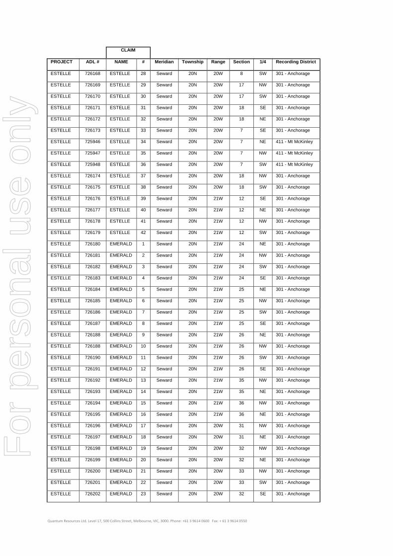
Quantum Resources Ltd. Level 17, 500 Collins Street, Melbourne, VIC, 3000. Phone: +61 3 9614 0600 Fax: + 61 3 9614 0550
CLAIM
PROJECT ADL # NAME # Meridian Township Range Section 1/4 Recording District
ESTELLE 726168 ESTELLE 28 Seward 20N 20W 8 SW 301 - Anchorage
ESTELLE 726169 ESTELLE 29 Seward 20N 20W 17 NW 301 - Anchorage
ESTELLE 726170 ESTELLE 30 Seward 20N 20W 17 SW 301 - Anchorage
ESTELLE 726171 ESTELLE 31 Seward 20N 20W 18 SE 301 - Anchorage
ESTELLE 726172 ESTELLE 32 Seward 20N 20W 18 NE 301 - Anchorage
ESTELLE 726173 ESTELLE 33 Seward 20N 20W 7 SE 301 - Anchorage
ESTELLE 725946 ESTELLE 34 Seward 20N 20W 7 NE 411 - Mt McKinley
ESTELLE 725947 ESTELLE 35 Seward 20N 20W 7 NW 411 - Mt McKinley
ESTELLE 725948 ESTELLE 36 Seward 20N 20W 7 SW 411 - Mt McKinley
ESTELLE 726174 ESTELLE 37 Seward 20N 20W 18 NW 301 - Anchorage
ESTELLE 726175 ESTELLE 38 Seward 20N 20W 18 SW 301 - Anchorage
ESTELLE 726176 ESTELLE 39 Seward 20N 21W 12 SE 301 - Anchorage
ESTELLE 726177 ESTELLE 40 Seward 20N 21W 12 NE 301 - Anchorage
ESTELLE 726178 ESTELLE 41 Seward 20N 21W 12 NW 301 - Anchorage
ESTELLE 726179 ESTELLE 42 Seward 20N 21W 12 SW 301 - Anchorage
ESTELLE 726180 EMERALD 1 Seward 20N 21W 24 NE 301 - Anchorage
ESTELLE 726181 EMERALD 2 Seward 20N 21W 24 NW 301 - Anchorage
ESTELLE 726182 EMERALD 3 Seward 20N 21W 24 SW 301 - Anchorage
ESTELLE 726183 EMERALD 4 Seward 20N 21W 24 SE 301 - Anchorage
ESTELLE 726184 EMERALD 5 Seward 20N 21W 25 NE 301 - Anchorage
ESTELLE 726185 EMERALD 6 Seward 20N 21W 25 NW 301 - Anchorage
ESTELLE 726186 EMERALD 7 Seward 20N 21W 25 SW 301 - Anchorage
ESTELLE 726187 EMERALD 8 Seward 20N 21W 25 SE 301 - Anchorage
ESTELLE 726188 EMERALD 9 Seward 20N 21W 26 NE 301 - Anchorage
ESTELLE 726188 EMERALD 10 Seward 20N 21W 26 NW 301 - Anchorage
ESTELLE 726190 EMERALD 11 Seward 20N 21W 26 SW 301 - Anchorage
ESTELLE 726191 EMERALD 12 Seward 20N 21W 26 SE 301 - Anchorage
ESTELLE 726192 EMERALD 13 Seward 20N 21W 35 NW 301 - Anchorage
ESTELLE 726193 EMERALD 14 Seward 20N 21W 35 NE 301 - Anchorage
ESTELLE 726194 EMERALD 15 Seward 20N 21W 36 NW 301 - Anchorage
ESTELLE 726195 EMERALD 16 Seward 20N 21W 36 NE 301 - Anchorage
ESTELLE 726196 EMERALD 17 Seward 20N 20W 31 NW 301 - Anchorage
ESTELLE 726197 EMERALD 18 Seward 20N 20W 31 NE 301 - Anchorage
ESTELLE 726198 EMERALD 19 Seward 20N 20W 32 NW 301 - Anchorage
ESTELLE 726199 EMERALD 20 Seward 20N 20W 32 NE 301 - Anchorage
ESTELLE 726200 EMERALD 21 Seward 20N 20W 33 NW 301 - Anchorage
ESTELLE 726201 EMERALD 22 Seward 20N 20W 33 SW 301 - Anchorage
ESTELLE 726202 EMERALD 23 Seward 20N 20W 32 SE 301 - Anchorage
For
per
sona
l use
onl
y

Quantum Resources Ltd. Level 17, 500 Collins Street, Melbourne, VIC, 3000. Phone: +61 3 9614 0600 Fax: + 61 3 9614 0550
CLAIM
PROJECT ADL # NAME # Meridian Township Range Section 1/4 Recording District
ESTELLE 726203 EMERALD 24 Seward 20N 20W 32 SW 301 - Anchorage
ESTELLE 726204 EMERALD 25 Seward 20N 20W 31 SE 301 - Anchorage
ESTELLE 726205 EMERALD 26 Seward 20N 20W 31 SW 301 - Anchorage
ESTELLE 726206 EMERALD 27 Seward 20N 21W 36 SE 301 - Anchorage
ESTELLE 726207 EMERALD 28 Seward 20N 21W 36 SW 301 - Anchorage
ESTELLE 726208 EMERALD 29 Seward 20N 21W 35 SE 301 - Anchorage
ESTELLE 726209 EMERALD 30 Seward 19N 20W 4 NW 301 - Anchorage
ESTELLE 726210 EMERALD 31 Seward 19N 20W 5 NE 301 - Anchorage
ESTELLE 726211 EMERALD 32 Seward 19N 20W 5 NW 301 - Anchorage
ESTELLE 726212 EMERALD 33 Seward 19N 20W 6 NE 301 - Anchorage
ESTELLE 726213 EMERALD 34 Seward 19N 20W 6 NW 301 - Anchorage
ESTELLE 726214 EMERALD 35 Seward 19N 21W 1 NE 301 - Anchorage
ESTELLE 726215 EMERALD 36 Seward 19N 21W 1 NW 301 - Anchorage
ESTELLE 726216 EMERALD 37 Seward 19N 21W 2 NE 301 - Anchorage
ESTELLE 725956 EMERALD 38 Seward 20N 21W 35 SW 411 - Mt McKinley
ESTELLE 725957 EMERALD 39 Seward 19N 21W 2 NW 411 - Mt McKinley
ESTELLE 725958 EMERALD 40 Seward 19N 21W 3 NE 411 - Mt McKinley
ESTELLE 725959 EMERALD 41 Seward 20N 21W 34 SE 411 - Mt McKinley
ESTELLE 725960 EMERALD 42 Seward 20N 21W 34 NE 411 - Mt McKinley
ESTELLE 725961 EMERALD 43 Seward 20N 21W 34 NW 411 - Mt McKinley
ESTELLE 725962 EMERALD 44 Seward 20N 21W 34 SW 411 - Mt McKinley
ESTELLE 725963 EMERALD 45 Seward 19N 21W 3 NW 411 - Mt McKinley
ESTELLE 725964 EMERALD 46 Seward 19N 21W 4 NE 411 - Mt McKinley
ESTELLE 725965 EMERALD 47 Seward 20N 21W 33 SE 411 - Mt McKinley
ESTELLE 725966 EMERALD 48 Seward 20N 21W 33 NE 411 - Mt McKinley
For
per
sona
l use
onl
y

Quantum Resources Ltd. Level 17, 500 Collins Street, Melbourne, VIC, 3000. Phone: +61 3 9614 0600 Fax: + 61 3 9614 0550
Annexure 2
Schedule of Mining Claims – Farewell Project
CLAIM
PROJECT ADL # NAME # Meridian Township Range Section 1/4 Recording District
FAREWELL 725967 ROB-CHIP 1 Seward 25N 28W 27 NW 403 - Kuskokwim
FAREWELL 725968 ROB-CHIP 2 Seward 25N 28W 27 SW 403 - Kuskokwim
FAREWELL 725969 ROB-CHIP 3 Seward 25N 28W 34 NW 403 - Kuskokwim
FAREWELL 725970 ROB-CHIP 4 Seward 25N 28W 34 SW 403 - Kuskokwim
FAREWELL 725971 ROB-CHIP 5 Seward 24N 28W 5 NW 403 - Kuskokwim
FAREWELL 725972 ROB-CHIP 6 Seward 24N 28W 5 SW 403 - Kuskokwim
FAREWELL 725973 ROB-CHIP 7 Seward 24N 28W 5 SE 403 - Kuskokwim
FAREWELL 725974 ROB-CHIP 8 Seward 24N 28W 5 NE 403 - Kuskokwim
FAREWELL 725975 ROB-CHIP 9 Seward 25N 28W 34 SE 403 - Kuskokwim
FAREWELL 725976 ROB-CHIP 10 Seward 25N 28W 34 NE 403 - Kuskokwim
FAREWELL 725977 ROB-CHIP 11 Seward 25N 28W 27 SE 403 - Kuskokwim
FAREWELL 725978 ROB-CHIP 12 Seward 25N 28W 27 NE 403 - Kuskokwim
FAREWELL 725979 ROB-CHIP 13 Seward 24N 28W 4 NW 403 - Kuskokwim
FAREWELL 725980 ROB-CHIP 14 Seward 24N 28W 4 SW 403 - Kuskokwim
FAREWELL 725981 ROB-CHIP 15 Seward 24N 28W 4 SE 403 - Kuskokwim
FAREWELL 725982 ROB-CHIP 16 Seward 24N 28W 4 NE 403 - Kuskokwim
FAREWELL 725983 ROB-CHIP 17 Seward 24N 28W 3 NW 403 - Kuskokwim
FAREWELL 725984 ROB-CHIP 18 Seward 24N 28W 3 SW 403 - Kuskokwim
FAREWELL 725985 ROB-CHIP 19 Seward 24N 28W 10 NW 403 - Kuskokwim
FAREWELL 725986 ROB-CHIP 20 Seward 24N 28W 10 SW 403 - Kuskokwim
FAREWELL 725987 ROB-CHIP 21 Seward 24N 28W 15 NW 403 - Kuskokwim
FAREWELL 725988 ROB-CHIP 22 Seward 24N 28W 15 SW 403 - Kuskokwim
FAREWELL 725989 ROB-CHIP 23 Seward 24N 28W 22 NW 403 - Kuskokwim
FAREWELL 725990 ROB-CHIP 24 Seward 24N 28W 22 NE 403 - Kuskokwim
FAREWELL 725991 ROB-CHIP 25 Seward 24N 28W 15 SE 403 - Kuskokwim
FAREWELL 725992 ROB-CHIP 26 Seward 24N 28W 15 NE 403 - Kuskokwim
FAREWELL 725993 ROB-CHIP 27 Seward 24N 28W 10 SE 403 - Kuskokwim
FAREWELL 725994 ROB-CHIP 28 Seward 24N 28W 10 NE 403 - Kuskokwim
FAREWELL 725995 ROB-CHIP 29 Seward 24N 28W 3 SE 403 - Kuskokwim
FAREWELL 725996 ROB-CHIP 30 Seward 24N 28W 3 NE 403 - Kuskokwim
FAREWELL 725997 ROB-CHIP 31 Seward 24N 28W 22 SW 403 - Kuskokwim
FAREWELL 725998 ROB-CHIP 32 Seward 24N 28W 22 SE 403 - Kuskokwim
FAREWELL 725999 ROB-CHIP 33 Seward 24N 28W 23 SW 403 - Kuskokwim
FAREWELL 726000 ROB-CHIP 34 Seward 24N 28W 23 SE 403 - Kuskokwim
FAREWELL 726001 ROB-CHIP 35 Seward 24N 28W 23 NE 403 - Kuskokwim
For
per
sona
l use
onl
y

Quantum Resources Ltd. Level 17, 500 Collins Street, Melbourne, VIC, 3000. Phone: +61 3 9614 0600 Fax: + 61 3 9614 0550
CLAIM
PROJECT ADL # NAME # Meridian Township Range Section 1/4 Recording District
FAREWELL 726002 ROB-CHIP 36 Seward 24N 28W 23 NW 403 - Kuskokwim
FAREWELL 726003 ROB-CHIP 37 Seward 24N 28W 14 SW 403 - Kuskokwim
FAREWELL 726004 ROB-CHIP 38 Seward 24N 28W 14 SE 403 - Kuskokwim
FAREWELL 726005 ROB-CHIP 39 Seward 24N 28W 14 NE 403 - Kuskokwim
FAREWELL 726006 ROB-CHIP 40 Seward 24N 28W 14 NW 403 - Kuskokwim
FAREWELL 726007 ROB-CHIP 41 Seward 25N 28W 22 SW 403 - Kuskokwim
FAREWELL 726008 ROB-CHIP 42 Seward 25N 28W 22 SE 403 - Kuskokwim
FAREWELL 725920 BOWSER 1 Seward 24N 24W 9 SE 411 - Mt McKinley
FAREWELL 725921 BOWSER 2 Seward 24N 24W 9 NE 411 - Mt McKinley
FAREWELL 725922 BOWSER 3 Seward 24N 24W 4 SE 411 - Mt McKinley
FAREWELL 725923 BOWSER 4 Seward 24N 24W 4 SW 411 - Mt McKinley
FAREWELL 725924 BOWSER 5 Seward 24N 24W 9 NW 411 - Mt McKinley
FAREWELL 725925 BOWSER 6 Seward 24N 24W 9 SW 411 - Mt McKinley
FAREWELL 725926 BOWSER 7 Seward 24N 24W 8 SE 411 - Mt McKinley
FAREWELL 725927 BOWSER 8 Seward 24N 24W 8 NE 411 - Mt McKinley
FAREWELL 725928 BOWSER 9 Seward 24N 24W 5 SE 411 - Mt McKinley
FAREWELL 725929 BOWSER 10 Seward 24N 24W 5 SW 411 - Mt McKinley
FAREWELL 725930 BOWSER 11 Seward 24N 24W 8 NW 411 - Mt McKinley
FAREWELL 725931 BOWSER 12 Seward 24N 24W 8 SW 411 - Mt McKinley
FAREWELL 725932 BOWSER 13 Seward 24N 24W 17 NW 411 - Mt McKinley
FAREWELL 725933 BOWSER 14 Seward 24N 24W 17 NE 411 - Mt McKinley
FAREWELL 725934 BOWSER 15 Seward 24N 24W 16 NW 411 - Mt McKinley
FAREWELL 725935 BOWSER 16 Seward 24N 24W 16 NE 411 - Mt McKinley
FAREWELL 725936 BOWSER 17 Seward 24N 24W 5 NW 411 - Mt McKinley
FAREWELL 725937 BOWSER 18 Seward 24N 24W 5 NE 411 - Mt McKinley
FAREWELL 725938 BOWSER 19 Seward 24N 24W 4 NW 411 - Mt McKinley
FAREWELL 725939 BOWSER 20 Seward 24N 24W 4 NE 411 - Mt McKinley
FAREWELL 726009 WINDY 1 Seward 23N 26W 21 NE 403 - Kuskokwim
FAREWELL 726010 WINDY 2 Seward 23N 26W 21 NW 403 - Kuskokwim
FAREWELL 726011 WINDY 3 Seward 23N 26W 20 NE 403 - Kuskokwim
FAREWELL 726012 WINDY 4 Seward 23N 26W 20 NW 403 - Kuskokwim
FAREWELL 726013 WINDY 5 Seward 23N 26W 20 SW 403 - Kuskokwim
FAREWELL 726014 WINDY 6 Seward 23N 26W 20 SE 403 - Kuskokwim
FAREWELL 726015 WINDY 7 Seward 23N 26W 21 SW 403 - Kuskokwim
FAREWELL 726016 WINDY 8 Seward 23N 26W 21 SE 403 - Kuskokwim
FAREWELL 726017 WINDY 9 Seward 23N 26W 28 NW 403 - Kuskokwim
FAREWELL 726018 WINDY 10 Seward 23N 26W 29 NE 403 - Kuskokwim
FAREWELL 726019 WINDY 11 Seward 23N 26W 29 NW 403 - Kuskokwim
For
per
sona
l use
onl
y

Quantum Resources Ltd. Level 17, 500 Collins Street, Melbourne, VIC, 3000. Phone: +61 3 9614 0600 Fax: + 61 3 9614 0550
CLAIM
PROJECT ADL # NAME # Meridian Township Range Section 1/4 Recording District
FAREWELL 726020 WINDY 12 Seward 23N 26W 29 SW 403 - Kuskokwim
FAREWELL 726021 WINDY 13 Seward 23N 26W 32 NW 403 - Kuskokwim
FAREWELL 726022 WINDY 14 Seward 23N 26W 27 NW 403 - Kuskokwim
FAREWELL 726023 WINDY 15 Seward 23N 26W 22 SW 403 - Kuskokwim
FAREWELL 726024 WINDY 16 Seward 23N 26W 32 NE 403 - Kuskokwim
FAREWELL 726025 WINDY 17 Seward 23N 26W 29 SE 403 - Kuskokwim
FAREWELL 726026 WINDY 18 Seward 23N 26W 28 SW 403 - Kuskokwim
FAREWELL 726027 WINDY 19 Seward 23N 26W 33 NW 403 - Kuskokwim
FAREWELL 726028 WINDY 20 Seward 23N 26W 33 NE 403 - Kuskokwim
FAREWELL 726029 WINDY 21 Seward 23N 26W 28 SE 403 - Kuskokwim
FAREWELL 726030 WINDY 22 Seward 23N 26W 28 NE 403 - Kuskokwim
FAREWELL 726031 WINDY 23 Seward 23N 26W 16 SW 403 - Kuskokwim
FAREWELL 726032 WINDY 24 Seward 23N 26W 17 SE 403 - Kuskokwim
FAREWELL 726033 WINDY 25 Seward 23N 26W 16 NW 403 - Kuskokwim
FAREWELL 726034 WINDY 26 Seward 23N 26W 17 NE 403 - Kuskokwim
FAREWELL 726035 OZZNA 1 Seward 26N 25W 32 SE 403 - Kuskokwim
FAREWELL 726036 OZZNA 2 Seward 26N 25W 33 SW 403 - Kuskokwim
FAREWELL 726037 OZZNA 3 Seward 26N 25W 33 SE 403 - Kuskokwim
FAREWELL 726038 OZZNA 4 Seward 26N 25W 34 SW 403 - Kuskokwim
FAREWELL 726039 OZZNA 5 Seward 26N 25W 34 SE 403 - Kuskokwim
FAREWELL 726040 OZZNA 6 Seward 26N 25W 34 NE 403 - Kuskokwim
FAREWELL 726041 OZZNA 7 Seward 26N 25W 34 NW 403 - Kuskokwim
FAREWELL 726042 OZZNA 8 Seward 26N 25W 33 NE 403 - Kuskokwim
FAREWELL 726043 OZZNA 9 Seward 26N 25W 33 NW 403 - Kuskokwim
FAREWELL 726044 OZZNA 10 Seward 26N 25W 32 NE 403 - Kuskokwim
FAREWELL 726045 OZZNA 11 Seward 26N 25W 27 SW 403 - Kuskokwim
FAREWELL 726046 OZZNA 12 Seward 26N 25W 27 SE 403 - Kuskokwim
FAREWELL 726047 OZZNA 13 Seward 26N 25W 27 NW 403 - Kuskokwim
FAREWELL 726048 OZZNA 14 Seward 26N 25W 27 NE 403 - Kuskokwim
FAREWELL 726049 OZZNA 15 Seward 26N 25W 26 NW 403 - Kuskokwim
FAREWELL 726050 OZZNA 16 Seward 26N 25W 26 NE 403 - Kuskokwim
FAREWELL 726051 OZZNA 17 Seward 26N 25W 25 NW 403 - Kuskokwim
FAREWELL 726052 OZZNA 18 Seward 26N 25W 25 NE 403 - Kuskokwim
FAREWELL 726053 OZZNA 19 Seward 26N 25W 24 SE 403 - Kuskokwim
FAREWELL 726054 OZZNA 20 Seward 26N 25W 24 SW 403 - Kuskokwim
FAREWELL 726055 OZZNA 21 Seward 26N 25W 24 NW 403 - Kuskokwim
FAREWELL 726056 OZZNA 22 Seward 26N 25W 24 NE 403 - Kuskokwim
FAREWELL 726057 OZZNA 23 Seward 26N 25W 13 SE 403 - Kuskokwim
For
per
sona
l use
onl
y

Quantum Resources Ltd. Level 17, 500 Collins Street, Melbourne, VIC, 3000. Phone: +61 3 9614 0600 Fax: + 61 3 9614 0550
CLAIM
PROJECT ADL # NAME # Meridian Township Range Section 1/4 Recording District
FAREWELL 726058 OZZNA 24 Seward 26N 25W 13 SW 403 - Kuskokwim
FAREWELL 726059 OZZNA 25 Seward 26N 25W 13 NW 403 - Kuskokwim
FAREWELL 726060 OZZNA 26 Seward 26N 25W 13 NE 403 - Kuskokwim
FAREWELL 726061 OZZNA 27 Seward 26N 25W 26 SW 403 - Kuskokwim
FAREWELL 726062 OZZNA 28 Seward 26N 25W 26 SE 403 - Kuskokwim
FAREWELL 726063 OZZNA 29 Seward 26N 25W 25 SW 403 - Kuskokwim
FAREWELL 726064 OZZNA 30 Seward 26N 25W 25 SE 403 - Kuskokwim
FAREWELL 726065 OZZNA 31 Seward 26N 25W 35 NW 403 - Kuskokwim
FAREWELL 726066 OZZNA 32 Seward 26N 25W 35 NE 403 - Kuskokwim
FAREWELL 726067 OZZNA 33 Seward 26N 25W 35 SW 403 - Kuskokwim
FAREWELL 726068 OZZNA 34 Seward 26N 25W 35 SE 403 - Kuskokwim
FAREWELL 726069 OZZNA 35 Seward 26N 25W 32 NW 403 - Kuskokwim
FAREWELL 726070 OZZNA 36 Seward 26N 25W 32 SW 403 - Kuskokwim
For
per
sona
l use
onl
y