florida university of - choctawhatchee basin alliance 5.pdf · preliminary investigation of the...
TRANSCRIPT

pr-4ic,54ND.5z5
UFL/COEL-98/010
CHARACTERISTICS OF COASTAL LAKE OUTLETSIN THE FLORIDA PANHANDLE
Hurricane Opal Beach Recovery Study: Task C
by
A. E. BrowderandR. G. Dean
I1'Iay, 1998
Submitted to:
Florida Department of Environmental ProtectionBureau of Beaches & Coastal Systems
UNIVERSITY OF
PRELIMINARY INVESTIGATION OF THE
Coastal & Oceanographic Engineering Department433 Weil Hall • P.O. Box 116590 • Gainesville, Florida 32611-6590
FLORIDA
Appendix V: Pros and Cons of Issues Identified by Statkeholders Regarding the Future Management of Walton County's Coastal Dune Lakes Page 186

Preliminary Investigation of the Characteristics of
Coastal Lake Outlets in the Florida Panhandle
Hurricane Opal Beach Recovery Study: Task C
Albert E. Browder
&Robert G. Dean
Coastal & Oceanographic Engineering Depaitinent
University of Florida
Gainesville, FL
May, 1998
1.0 INTRODUCTION
This report discusses the characteristics and conditions of several small outlets
associated with coastal lakes in the Panhandle region of Florida. Specifically, the small lakesin Walton, Bay, Gulf, and Franklin Counties that have intermittent communication with the
Gulf of Mexico are considered. These lake/Gulf connections are of interest for severalreasons. The first involves flood level control in the areas surrounding the lakes; the opening
to the Gulf provides a means of relieving high water/flood conditions around the lakes. The
second reason entails the stability and migration of the small outlet. In some areas, coastal
development has encroached upon the historic "sweep path" of the migrating outlets. Thequestion arises of how far the outlet may migrate in the future, and if and when humanintervention is appropriate.
Figure 1 shows the general locations of the coastal lake sites of interest in this study.Twenty-six sites were identified as having potential impacts from the migration of the smallchannels. Twelve sites lie in Walton County, all of which have an undeveloped connection
to the Gulf. Nine sites are in Bay County, many of which are stabilized by culvertsunderneath the coastal road. In these cases the sweep path, and occasionally the lake area,are somewhat limited in extent or are difficult to delineate. In some of the more developedareas, the lake has been replaced by development and the source of the intermittent outlet is
-1-
Appendix V: Pros and Cons of Issues Identified by Statkeholders Regarding the Future Management of Walton County's Coastal Dune Lakes Page 187

SA
NT
AR
OS
AO
KA
LOO
SA
HO
LME
S
WA
SH
ING
TO
N
JAC
KS
ON
GA
DS
DE
N
LIB
ER
TY
GU
LF
FR
AN
KL
IN^
^^
^
\0"
,N4
.n
AP
PR
OX
IMA
TE
SC
ALE
ti
0
10
30 m
iles
Figu
re 1
Loc
atio
n m
ap o
f Wal
ton,
Bay
, Gul
f, an
d Fr
ankl
in C
ount
ies
in th
e Fl
orid
a Pa
nhan
dle.
Wal
ton
Cou
nty
has
12 o
f the
26
site
s, B
ay C
ount
y ha
s ni
ne, G
ulf C
ount
y ha
s fo
ur, a
nd F
rank
lin C
ount
y ha
s on
e si
te in
the
stud
y.
12 s
ites
BA
Y
9 si
tes
CA
LHO
UN
LEO
N
WA
KU
LLA
Gu
lfo
fM
exi
co
1 si
te
FLO
RIDA
Appendix V: Pros and Cons of Issues Identified by Statkeholders Regarding the Future Management of Walton County's Coastal Dune Lakes Page 188

the direct runoff into the channel. The sites in this study were identified primarily fromCoastal Construction Control Line (CCCL) maps for the four counties. The CCCL maps are
produced by the Florida Department of Environmental Protection (FDEP). These maps
identify the location of the CCCL, which delineates the State's jurisdiction in coastal matters.
Construction seaward of these lines requires special permitting from FDEP. It is noted that
the CCCL in the vicinity of these coastal lake outlets has generally been diverted landward
of the historic sweep areas, reducing (but not eliminating) the threat of structural damage due
to migration of the outlets. However, development seaward of the CCCL does exist in manyof these areas, and the potential for damage still exists.
This report is divided into three sections. The first section describes the physical
characteristics of the sites. Important parameters include the size of the lakes, the distance
between the lake and the existing shoreline, the historic "sweep area" (the area affected by
all previous identifiable locations of the channels), and local rainfall amounts, among others.The second section attempts to describe the mechanisms by which the connection between
the lakes and the Gulf of Mexico is established. The third section discusses the migrationof the outlet channel due to the littoral forces along the shoreline. The third section also
describes the changes to several sites in Walton County resulting directly from the passageof Hurricane Opal in October, 1995.
In this report, the term outlet is used to describe the majority of the lake/Gulfconnections since the flow is generally from the lake out to the Gulf of Mexico, and onlyoccasionally is there tidal exchange between the two bodies. Few if any of these sites are
navigable, even by small boat. The terms inlet and outlet are occasionally usedinterchangeably, and in some instances the connections have historically been labeled inlets,such as Phillip's Inlet.
This investigation was performed for the Florida Department of EnvironmentalProtection (FDEP) Bureau of Beaches and Coastal Systems as a subtask of the ongoingmonitoring and evaluation of the impacts from Hurricane Opal.
Appendix V: Pros and Cons of Issues Identified by Statkeholders Regarding the Future Management of Walton County's Coastal Dune Lakes Page 189

EC)c
OZ
Emc
0z
Figure A-1 Laser swath survey contour maps of Morris Lake and Lake Stalworthin Walton Co., FL. Elevations in meters above National GeodeticVertical Datum. Survey Date - October 16-17, 1996.
3,358,300570,400
570,500
570,600
570,700Easting (m)
A-1
Appendix V: Pros and Cons of Issues Identified by Statkeholders Regarding the Future Management of Walton County's Coastal Dune Lakes Page 190

2.0 PHYSICAL CHARACTERISTICS
Figure 2 presents a schematic photograph of the problem of concern. In this figure,the lake is connected to the tidally-influenced ocean (or Gulf in this case) via one potential
outlet. This distinguishes the present problem from barrier island breach problems in that
the lake does not experience tidal fluctuations of any kind when the one outlet is closed, thus
excluding barrier island breaches (such as Navarre Pass in Escambia County), where thelagoon behind the barrier island is tidally influenced and has the potential for other outlets
for high water. In the present problem, the lake/Gulf outlet represents the only escape ofhigh water.
Figure 2
Schematic of coastal lake outlet.
-4-
Appendix V: Pros and Cons of Issues Identified by Statkeholders Regarding the Future Management of Walton County's Coastal Dune Lakes Page 191

Figure 2 also illustrates the basic physical parameters of interest in this problem. The
separation distance, D, represents the shortest distance from the main body of the lake to the
existing dune line-en--the shoreline. This value was determined from aerial photography,
considering the dune line as a consistent smooth curve between the dunelines to either sideof the affected area. Given the ephemeral nature of these sites, this estimation was deemed
sufficient for this discussion.
Similarly, the sweep distanc , S, )defined from aerial photography and survey data
as the length of shoreline which cai(be identified as being influenced by all previous
locations of the channel. This distance is determined from the extreme limits of theinterrupted dune or vegetation line. The area of the lake, AL, was digitized from recent aerial
photography of the area. In addition to the actual lake area, the area of runoff correspondingto each site is certainly a relevant parameter, as is groundwater inflow. Given the nature and
scope of this preliminary investigation, however, these additional areas were not determined.
One source of data for this study comes from Project LASER, conducted by the Civil
Engineering Department of the University of Florida (Carter et al., 1997). This project
entailed the collection of high resolution laser swath survey data along the Panhandleshoreline of Florida in October, 1996. This data set provides valuable information on thecondition of the Panhandle shoreline. The data set was used in the present study todetermine many of the physical characteristics mentioned above, and to obtain elevation data
unavailable from aerial photography.
Figure 3 presents an example from this dataset. This figure depicts the beach area
in the vicinity of Phillips Inlet on Lake Powell in Bay County is shown. The figure clearlyindicates the location of the channel at the time of the survey. ' Also evident in the figure arethe remnants of two previous channels to the gulf, both located east of the flowing channelin October, 1996. From this figure it is evident that approximately 3,000 feet of shorelineare impacted by the connection between Lake Powell and the Gulf of Mexico. Figure 3
clearly highlights the issue of channel migration. At the time of the laser swath survey, the
channel was nearly in its westernmost location. The location of the relict channels, and the
low, unvegetated nature of the beach to the east suggest that the channel may have once beennearly 3,000 feet to the east, very close to where structures have since been built (near R-1in Bay County). Appendix A contains plots of each of the lake-channel sites in Walton andBay Counties and from the laser swath survey.
The laser swath system employed does not provide sufficient surveyinformation of smooth water surfaces.
-5-
Appendix V: Pros and Cons of Issues Identified by Statkeholders Regarding the Future Management of Walton County's Coastal Dune Lakes Page 192

I
I
1596,600
596,800
597,000
597,200
Easting (m)
597,400
Ecs0z
Figure 3 Example of laser swath survey data showing contour plot of Phillips Inlet inwestern Bay County, FL. Survey date October 16-17, 1996. Elevations inmeters above National Geodetic Vertical Datum, 1929.
Table 1 presents the physical dimensions for all the sites in the study, as outlined in
Figure 2. As mentioned previously, many of the sites.have been stabilized by culverts andother coastal development, particularly in Bay County, where development has encroached
upon some of the lakes, leaving only a drainage ditch for runoff. Most of the unrestrictedcoastal lakes lie in Walton County.
From Table 1, the average sweep distance, S, is roughly 770 feet alongshore, and theaverage separation distance, D, between the lake and the dune line is 430 feet. In those areaswhere pipe outfalls have been installed, older aerial photography was used to determine theseparation distances. Many sites in Bay County consist of pipe outfalls issuing directly ontothe sandy beach seaward of buildings or dune/vegetation lines; these areas were assigned a
sweep distance of zero. In Walton County (including Phillips Inlet), where most of theunrestricted outlets are found, the average sweep distance is roughly 1,250 ft.
The lake areas associated with these outlets varies significantly. The largest, LakePowell at Phillips Inlet, is over 650 acres in area. Some of the other outlets have nodiscernable open lake area, these outlets drain marsh areas. For the uncontrolled outlets, atypical lake area is of the order of 10 to 150 acres.
-6-
Appendix V: Pros and Cons of Issues Identified by Statkeholders Regarding the Future Management of Walton County's Coastal Dune Lakes Page 193
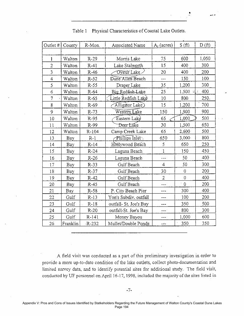
Table 1 Physical Characteristics of Coastal Lake Outlets.
Outlet # County R-Mon. Associated Name AT (acres) S (ft) D (ft)
1 Walton R-29 Morris Lake 75 600 1,050
2 Walton R-41 Lake Stalworth 15 400 300
3 Walton R-46 20 400 200ys er Lake;4 Walton R-52 Dune Allen Beach --- 150 100
5 Walton R-55 Draper Lake 35 1,200 300
6 Walton R-64 Big Redfi-sh-Lake 25 1,500
- .'
400
7 Walton R-65 (Little Redfish Lake 10 800 250.
8 Walton R-69 Alligator Lakes 15 1,200 700
9 Walton R-73 150 1,9.00 900Western Lake
10 Walton R-95 astern Lak - 65 1,000 500
11 Walton R-99 'lace 30 1,500 650
12 Walton R-104 Camp Creek Lake 65 2,600 500
13 Bay R-1 ((Pliillips Inlet , 650 3,000 800
14 Bay R-14 Hluwood Beach 5 650 250
15 Bay R-24 Laguna Beach 1 150 450
16 Bay R-26 Laguna Beach --- 50 400
17 Bay R-33 Gulf Beach 4 50 300
18 Bay R-37 Gulf Beach 30 0 200
19 Bay R-42 Gulf Beach 2 0 400
20 Bay R-45 Gulf Beach_
--- 0 200
21 Bay R-58 P. City Beach Pier --- 300 400
22 Gulf R-13 Yon's Subdiv. outfall --- 100 200
23 Gulf R-18 outfall- St. Joe's Bay --- 350 500
24 Gulf R-20 outfall-St. Joe's Bay --- 800 300
25 Gulf R-141 Money Bayou --- 1,000 600
26 Franklin R-232 Mullet/Double Ponds --- 350 350
A field visit was conducted as a part of this preliminary investigation in order to
provide a more up-to-date condition of the lake outlets, collect photo-documentation and
limited survey data, and to identify potential sites for additional study. The field visit,conducted by OF personnel on April 16-17, 1998, included the majority of the sites listed in
-7-
Appendix V: Pros and Cons of Issues Identified by Statkeholders Regarding the Future Management of Walton County's Coastal Dune Lakes Page 194

Table 12. At the time of the visit, conditions at several of the outlets were significantly
different than in the October, 1996, laser survey dataset. Figure 4 illustrates the change in
location of the thalweg of the outlet channel for Draper Lake, located near FDEP monument
R-55 in Walton County. At the time of the laser survey, the thalweg was located closer to
the center of the historic sweep area. By April, 1998, the channel had migrated westward
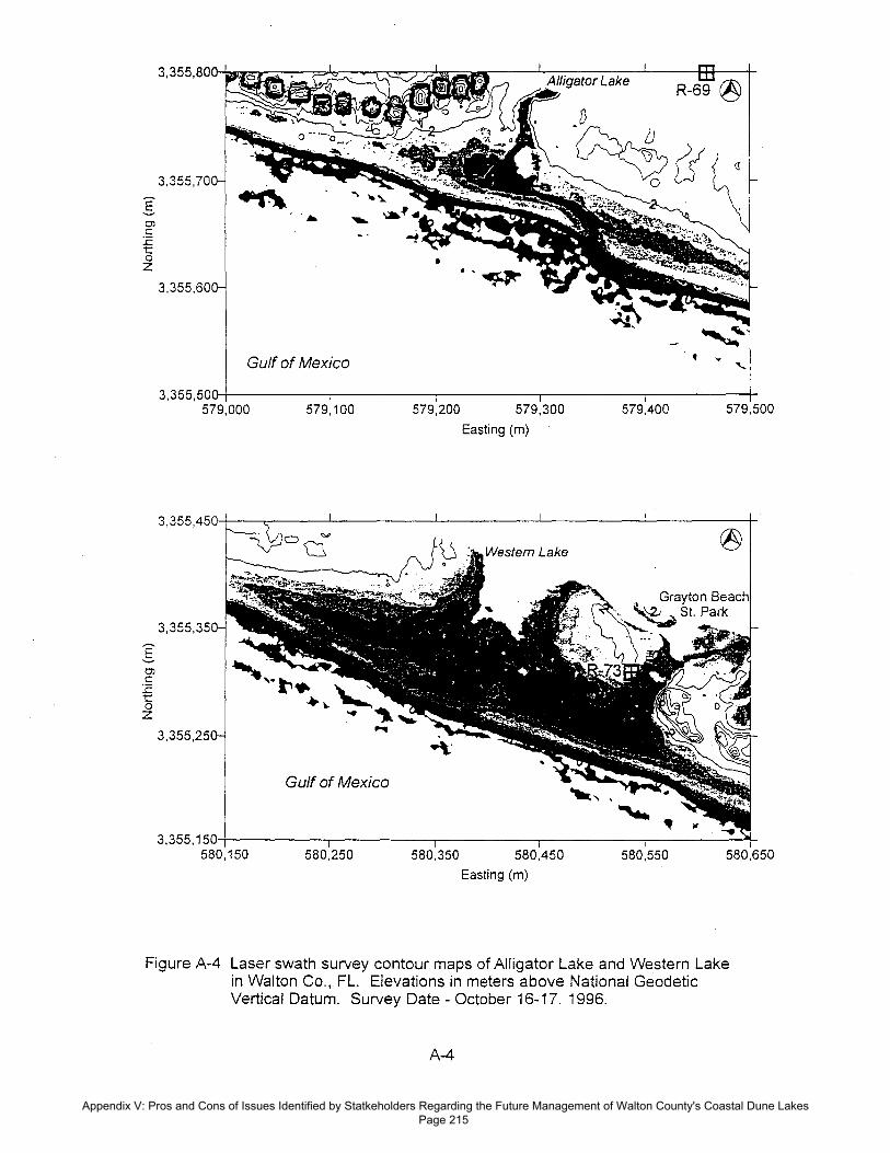
approximately 150 ft and was encroaching upon the steep dune embankment and its sandfencing to the west. Several other sites were observed to be in a similar condition, such as
Oyster Lake (Walton Co. R-46), Alligator Lake (Walton Co. R-69), and Eastern Lake
(Walton Co. R-95). Many other sites were observed to be in a noticeably westward location
(relative to previous aerials), but were not in the vicinity of structures.
The overall low elevation of the sweep areas was quite noticeable. Overwash
deposits, presumably from Hurricane Opal, were evident in many areas. Previous channellocations were also identified at many sites. Figure 5 presents an alongshore cross-sectiontaken from the laser data for Western Lake at Grayton Beach State Park, looking onshore
(elevation view). The cross-sectional profile indicates the present location of the channel,
roughly 440 ft west of monument R-73, and a relict channel less than 100 ft to the east. The
historic sweep path of this channel extends well beyond the longshore limits of this graph,
covering a distance of 1,900 ft alongshore.
Along many areas in Bay County, the lake outlets appeared to be outfalls
incorporated under the coastal road (U.S. Rte. 98-Alt) and buildings. These lake outlets do
not appear to be of the same concern as the unrestricted outlets in Walton County. One
concern, however, would be the maintenance of the outflow drain in the event the shoreline
is nourished. In many instances these outlets are directly fed by several drainage ditches
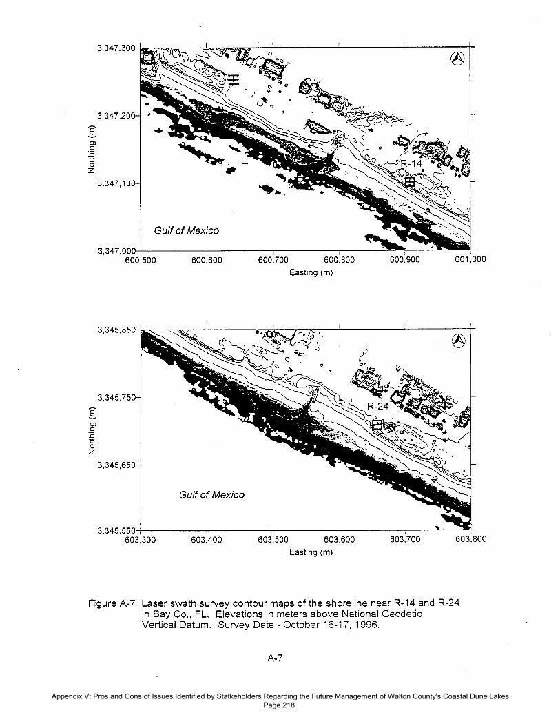
from both sides of the coastal road (e.g., R-14), or were recently mechanically opened tomaintain drainage requirements (e.g., R-26).
The four sites in Gulf County and the one site in Franklin County were documented.In Gulf County, the site at R-13 in Yon's subdivision was open and flowing to the east-southeast, although the longshore current at the time of observation was directed west-
northwest. The two adjacent sites, R-18 and R-20, are not in developed areas, and were bothclosed, although wave overwash over the accretion berm was witnessed. The outlet atMoney Bayou (Figure 6), east of Cape San Blas, was open and flowing. This site appears
zSome of the sites were difficult to access, requiring either 4WD vehiclesor permission to enter gated communities, neither of which was availableat the time of the visit.
-8-
Appendix V: Pros and Cons of Issues Identified by Statkeholders Regarding the Future Management of Walton County's Coastal Dune Lakes Page 195

Z Fig
ure
4 V
ari
atio
n in
the lo
catio
n o
f th
e thaiw
eg o
f th
e o
utle
t ch
annel f
or
Dra
per
lake
in W
alto
n C
ounty
, F
L.
Conto
ur
ele
vatio
ns
date
d O
ctober,
1996,
and a
re r
efe
rence
d to N
GV
D (
1929).
Photo
gra
ph d
ate
d F
ebru
ary
, 1969.
Appendix V: Pros and Cons of Issues Identified by Statkeholders Regarding the Future Management of Walton County's Coastal Dune Lakes Page 196

15
< WEST
EAST >
Existing ChannelLocation for
Western Lakeoutlet
10 -
0
1600 1200 800
horizontal distance (ft)400
0
previous channel location
Figure 5
Alongshore elevation view of the channel outlet at Western Lake (GraytonBeach St. Park). The profile indicates the location of a relict channel.
to be much larger than most of the other sites in this study, and is likely open for a greaterlength of time. The one site in Franklin County is located on Bald Point adjacent to
Ochlockonee Bay. This channel had recently closed after migrating slightly to the north.The channel did not appear to be a significant threat to the adjacent house to the south.
One observation made at many of the sites relates to the seemingly sudden changes
in direction of the outlet channels as they progress toward the Gulf. In several areas,
particularly in Walton County, a substantial accretion berm had formed. In areas where the
berm crest elevation was slightly lower, overwash occurred. It appeared that this point ofoverwash served to redirect the flow of the channel.
Figure 6 Ground view of Money Bayou (Gulf County R-141). At the time of fieldinspection(April 16, 1998, roughly mid-tide), the channel was open andflowing. The channel throat dimensions were approximately 30 to 40 feet inwidth, and roughly 4 feet in depth at the deepest point.
-10-
Appendix V: Pros and Cons of Issues Identified by Statkeholders Regarding the Future Management of Walton County's Coastal Dune Lakes Page 197

3.0 MECHANISMS FOR OUTLET OPENING
This section discusses the natural mechanisms by which the connections between the
coastal lakes and the Gulf of Mexico may form by natural processes. There are three
principal mechanisms: 1) the water level in the lake rises to an elevation higher than the
beach dune and simply overflows onto the beach, following the path of least resistance and
forming a distinct channel via scour, 2) the water level rises sufficiently to saturate the sand
between the lake and the Gulf, thus causing a condition in which the water can flow throughthe sand, destabilizing the sand and eventually creating a channel, and 3) erosion from thebeach side erodes the berm between the lake and the Gulf, and the berm breaches. Of the
three natural mechanisms listed, No.s 1 and 3 are fairly obvious means for water from the
lake to reach the gulf, and vice-versa. In all likelihood, some combination of all threecontribute to the natural opening of the channels 3 . At some of the sites, the channels areopened by mechanical means to alleviate flood conditions around the lakes.
Several investigators have studied the effects of tidal fluctuations, wave runup, andwave setup on the local watertable at the shoreline. In one of the first published works on
the subject, Grant (1948), described how the effect of watertable level influenced the erosion
or accretion of the beachface. He noted that water from the ocean side can percolate into
the beachface more easily than it can exit. Nielsen (1990a & b) presented a mathematical
description of the propagation of tidal waves into the watertable and presented field
measurements from beaches near Sydney, Australia.. Nielsen's results indicated that thewatertable follows the tide level at higher levels of the tide, but that the watertable does notfall as low as the tide level near low tide. Hence the mean watertable near the coast is
elevated above the still water condition. This also indicates that the watertable becomes
discontinuous at the beach face during lower stages of the tide, creating a seepage face onthe beach.
The location of the seepage face/discontinuity and its handling in models is stillsubject to much research. Baird and Horn (1996) presented a numerical model of theelevation of the watertable in sandy beaches. Turner et al. (1997) conducted fieldmeasurements in Australia near a coastal lake with an array of piezometers installed between
the lake and the shoreline to measure fluctuations in the watertable level. Turner's groupdocumented the effects of rainfall, tides, and waves on the local watertable. In Turner's
study, however, there was no open connection between the lake and the ocean.
Inspection of aerial photography since the 1940's shows no evidence ofshoreline erosion leading directly to a breach at the sites in thisinvestigation.
-11-
Appendix V: Pros and Cons of Issues Identified by Statkeholders Regarding the Future Management of Walton County's Coastal Dune Lakes Page 198

Figure 7 presents a simple profile schematic of the watertable between a coastal lake
and a tidally-influenced body of water (the Gulf), with waves. Here it is assumed that the
level in the lake is higher than the still water level of the Gulf. The picture illustrates the
hydraulic gradient that can exist across the berm between the lake and the Gulf The gradient
creates a flow of water through the sand in the direction of the gradient (Gulfward in Figure
7). The flow of water then exerts a force on the sand particles, changing the equilibrium of
the particles, particularly on the beachface (see inset, Figure 7). The seepage force exerted
on the particle can be determined from the hydraulic gradient via Darcy's Law (e.g.
Cedergren (1989), or Nielsen (1992)).
Of interest here is the balance between the effects of tides, waves, and increased
water levels, both in the lake and in the Gulf The effects of tides and wave setup and runupare to raise the local mean water surface (and watertable) near the beachface, actually
reducing the hydraulic gradient between the lake and the Gulf. At the same time, however,
the waves are exerting forces on the individual sand grains at the beachface. This creates a
situation in which the waves are both destabilizing the beach face and bringing in sand from
updrift. At some point, the hydraulic gradient that exists across the berm may sufficiently
reduce the downward force of the submerged weight of the sand grains, allowing the waveaction to more easily dislodge the sand particles, leading to increased flow Gulfward, and
ultimately the establishment of a channel between the two water bodies. Again, it is likelythat a combination of mechanisms contributes to the opening of the channels between these
coastal lakes and the Gulf of Mexico.
lake
Mean water surfacedue to tides, waves,
and lake level J
(INSETdisturbing force
*from waves(direction varies)
Figure 7 Schematic of watertable elevation across a sand berm between a coastal lakeand a tidally-influenced body of water.
-12-
Appendix V: Pros and Cons of Issues Identified by Statkeholders Regarding the Future Management of Walton County's Coastal Dune Lakes Page 199

Visser (1990) describes the process of breach growth through sand dikes. In a field
experiment, Visser's group investigated the behavior of a small, artificially-breached sandberm. This experiment was conducted on the southwest coast of The Netherlands, where the
investigators temporarily blocked a small tidal inlet to study breaching inward (the sea level
was higher than the lake level). Visser's group measured current velocities within the breach
and water levels of both bodies, and developed a simple mathematical model to describe the
sediment transport in the breach and the discharge rate through the breach. Wave action was
not a factor in the experiment. Visser (1995) further developed the application of varioussediment transport formulae to the problem of sand-dike breach erosion.
One of the most obvious factors, of course, is rainfall. The accumulation of rainfall
in the lakes increases the water levels and hence the watertable around the lake. Table 2
presents the average monthly rainfall for the area, taken from the National Weather Service
rainfall data for Defuniak Springs in Walton County and Panama City in Bay County. Thearea averages 65 to 66 inches of rain per year, with July and August being the rainiest
months. In 1997 and 1998, the State of Florida has been impacted by El Nino, which hasaltered the rainfall patterns in the area. Detailed rainfall amounts were obtained from the
Bay County Public Utilities Department for 1997 and 1998. These records do not indicate
a higher total rainfall for 1997, but the records do indicate higher rainfall levels in January,
February, and March of 1998. Prolonged rainfall contributes to increased lake levels and
keeps the channels open and flowing longer than usual. For example, since being opened
for flood control in July, 1997, Phillips Inlet has remained open as of the date of this writing.
Table 2 Average monthly rainfall in Bay and Walton Counties, FL.
Month Avg. Rainfall (in.) Month Avg. Rainfall (in.)
January 5.5 July 8.9
February 5.0 August 7.7
March 6.2 September 5.7
April 4.4 October 3.5
May 4.4 November 4.0
June 6.4 December 4.3* Compiled from rainfall data spanning 49 years from Defuniak Springs, FL,
and 25 years from Panama City, FL, National Weather Service.
-13-
Appendix V: Pros and Cons of Issues Identified by Statkeholders Regarding the Future Management of Walton County's Coastal Dune Lakes Page 200

4.0 BEHAVIOR OF THE OPEN OUTLET CHANNEL
Once the connection between the coastal lake and the Gulf is established, the question
then turns to stability and migration of a tidal or semi-tidal outlet. Of interest here is the rateand limits of migration and the time before closure once the channel is opened. At many ofthese sites, particularly in Walton County, the channels are unrestricted by structures(training walls, culverts, etc.). The channels are thus subject to the littoral forces on thebeach face, which serve to displace the channel location along the shoreline in the direction
of the littoral drift. The littoral drift will carry sand into the channel on the updrift side,
shoaling the channel. In order to maintain the same cross-sectional area in the channel to
maintain the flow rate, the channel will scour out the downdrift side of the channel. Hencethe channel will migrate downdrift.
Along Walton and Bay County shorelines, the net annual littoral drift is generally to
the west. An outlet that is able to stay open long enough in this area will generally migrate
to the west. Figure 3 presents the condition of Phillips Inlet in October, 1996. From this
picture it is evident that the channel has migrated from east to west, as the channel appears
to be in its westernmost position at that time. In July, 1997, the State Parks Department,
under permit from FDEP, opened a new channel for Phillips Inlet roughly 150 ft east of theCamp Helen Pier (see Figure 3). The western channel was closed mechanically. By April,1998, the new channel had migrated to the pier, a 150 ft migration in nine months.
This is not to imply that all these channels migrate to the west. Beginning along the
southeastern portion of the Bay County shoreline (in the vicinity of Mexico Beach), the net
drift direction reverses to the southeast directed toward St. Joseph Bay, hence the outlets in
Gulf County would have a tendency to migrate to the southeast (which is verified by aerial
photography). Additionally, at various times of the year the littoral drift is directed oppositeto the net drift direction, and any outlet that is open and flowing during this time willexperience pressure from the opposite direction due to the incoming waves.
For example, Figure 8 depicts the topography on the beach near Alligator Lake in
Walton County. At the time of this survey, the channel appears to be shifted to the east.This may indicate that there was a strong relict channel directed that way, or that the channelwas open primarily during easterly-directed littoral drift. It is also important to note that anyhard features (such as trees or structures) may redirect the flow and cause a tendency to flowin a certain direction, regardless of the prevalent littoral drift. Figure 9 provides anotherexample. The photo shows Navarre Pass in Escambia County. This photo indicates thatwhile the pass was open in 1965, the channel has meandered first to the east then to the westbefore closing just prior to the taking of the photo in September, 1965.
-14-
Appendix V: Pros and Cons of Issues Identified by Statkeholders Regarding the Future Management of Walton County's Coastal Dune Lakes Page 201

3,355,500
i i i579,000
579,100
579,200
579,300
579,400
579,500
Easting (m)
Figure 8 Contour plot of the beach topography in the vicinity of Alligator Lake inWalton County, FL. At the time of the survey, October, 1996, the channelwas directed to the east, and a small ebb delta had formed.
Figure 9 Oblique aerial photo of Navarre Pass in Escambia County, FL. The photoindicates that the channel has migrated both east and west during thechannel's lifetime. Photo data: September, 1965.
-15-
Appendix V: Pros and Cons of Issues Identified by Statkeholders Regarding the Future Management of Walton County's Coastal Dune Lakes Page 202

Another short term mechanism affecting the migration direction of these channels isthe accretion or erosion of the shoreline in general. During a field visit to the area on April
16-17, 1998, it was observed that a low accretion berm had formed along the shoreline
fronting many of the outlets. The uprush from the waves overtopped this berm and flowed
into the lake outlet channels. At some sites this flow appeared to dictate the new position
of the channel. Hence, any area of low elevation along the beach berm may serve to create
the new outlet location for the lake. This idea is supported by the laser data (Figure 8 andAppendix A) and aerial photography, where many outlets take sudden turns in direction,snaking their way to the Gulf.
The migration of the channel due to littoral forces also contributes to meandering of
the channel, similar to river meanders. This occurs when a river channel deposits sediment
on the inside of a bend in the river due to secondary flows across the channel. Eventually
the river will meander sufficiently to create an oxbow lake, breaching across the severe
meander. As applied to this investigation, the result would be the breaching of a newchannel with a more direct line to the Gulf.
At some point, the efficiency of the channel flow diminishes to the level where the
channel can no longer stay open, and the mouth of the channel is filled in with beach sand,
which may occur due to a strong "pulse" of longshore sediment transport which bridges the
channel and/or a period of drought. The relict channel that remains may become the site ofthe next opening, or, if a berm overwash channel forms or the time between openings is longenough or the rainfall is great enough, a new channel with a shorter distance between the
Gulf and the lake may form. The new channel will then be subject to the littoral drift and
will begin to migrate accordingly. Mehta (1985) documented this cycle for Phillips Inlet
over the course of 11 years. He concluded that shoaling of the channel at the mouth causes
the closure of the channel once it reaches a certain length. Mehta also documented the
relationship between the cross-sectional area of the channel and the monthly rainfall.
Bodge (1998), in the new Coastal Engineering Manual, describes the process of inletmigration followed by breaching at a new updrift location. Bodge writes that this process
at larger inlets may occur on time scales of 3 to 50 years. In the case of the small lake outletsof interest here, the time scales may be on the order of months to a few years. FitzGerald
(1988) in describing erosional-depositional processes associated with tidal inlets, discussesthe process of inlet migration and breaching as well. Fitzgerald's work mentions the role ofthe geologic makeup of the sediment in controlling the migration rate. Oertel (1988) alsodiscusses the dynamics of tidal-inlet migration, highlighting the changes in channel geometryand orientation that lead to the formation of spits from the updrift side of the channel. In
-16-
Appendix V: Pros and Cons of Issues Identified by Statkeholders Regarding the Future Management of Walton County's Coastal Dune Lakes Page 203

each of these cases, however, the focus is on deeper, tidal inlets that are always open during
the period of migration. In the present case, it is apparent that overwash plays a large role
in the fate of these small outlet channels. Very little literature exists that describe the
specific problem of interest here.
Table 1 lists the general dimensions of each of the sites, including the sweep distance
alongshore. One concern is that these channels may someday swing to an extreme location
either east or west, and threaten nearby structures. These structures are evident in Figures
3 and 8 as the rectangular areas of densely packed contour lines. While for the most part
these structures have been built on the margins of the sweep path, there is the possibility ofextreme migration and consequent structural damage. Extreme migration could be caused
by increased levels of rainfall over extended periods of time in combination with strong and
persistent longshore sediment transport, allowing the channel to stay open long enough to
migrate to a threatening position.
The hydraulic stability of a lake inlet/outlet is affected by several parameters. Some
of the parameters relevant to this discussion include, but are not limited to:
• Difference in elevation between water bodies. Obviously this is the driving
force of the flow through the channel.
• Length and cross-sectional area of the channel. The longer the channel, the
greater the friction involved, hence the channel is less hydraulically efficient
and more prone to closure. The cross sectional area is governed by the flow
rate between the two bodies, which is a time-dependent process.• Wave induced sediment transport characteristics in the area. The amount of
sand transported alongshore affects the migration rate of the outlet andultimately its potential for closure.
• Tidal range. In some instances there may be exchange of tidal watersbetween the bodies, carrying sand into the lake and potentially shoaling thechannel.
The first parameter mentioned, the elevation difference between water bodies, isrelated to the area of the lake (and its runoff area around it) and the amount of rainfall. Theflowrate through the these outlets is thus a time-dependent problem, governed predominantlyby rainfall, in which the channel may begin as a small trickle, slowly grow as the channelscours in response to the driving head difference, and then ultimately close as the drivinghead is diminished and the shoaling sand from the gulf side can no longer be cleared.
-17-
Appendix V: Pros and Cons of Issues Identified by Statkeholders Regarding the Future Management of Walton County's Coastal Dune Lakes Page 204

The length of the channel is a function of the physical separation distance between
the two bodies and the degree to which the channel has migrated under pressure from littoral
forces. Here again the time-dependence of the problem plays a significant role. The
combination of increased and prolonged rainfall with increased and prolonged littoral
pressure can extend the length of the channel. Table 1 presented . the sweep distances and
separation distance for each of the 26 sites involved in this study. The actual channel lengthin most cases lies somewhere between the sweep and separation distances. In the case ofMorris Lake, the channel length is actually longer than either of these, as the channelmeanders back and forth through heavy brush as it traverses the 1,050 ft distance between
the lake and the Gulf.
The cross-sectional area is related to the length of the channel and the driving head
difference between the two water bodies. To briefly characterize the determination of the
cross-sectional area, the problem is viewed from two distinct methods. The first methodtreats the channel as a tidal inlet that has to convey a certain tidal prism. Using the concepts
developed by O'Brien (1969) and refined by Jarrett (1976), a rough estimate of typical cross
sections can be determined. Jarrett suggested that the equilibrium cross-section of an
unjettied, natural tidal inlet can be found from the following empirical relationship:
Ac = 1.04x10⁻⁵
0 1 -0
(1)
where Ac is the mean cross-sectional area (in ft 2) of the channel and Q is the tidal prism (in
ft3 ). If a simple example is applied to this equation, say AL = 100 acres and the lake level
rises 6 inches, the resulting equilibrium cross-sectional area is 23 ft 2 . In comparison, a
channel 20 ft in width and 3 ft deep at its deepest point has a cross sectional area of
approximately 51 ft2 (for a trapezoidal channel). Many of the channels surveyed during theApril, 1998, field visit had dimensions on the order of 10 to 50 feet in width and depthsranging from 6 inches to over 3 feet. Mehta (1976) reports that small beach inlets (outletsin this case) have widths and depths in the range of 10 to 160 feet and 0.3 to 3.3 ft,
respectively. The appropriateness of applying this empirical relationship to the presentproblem may be somewhat suspect, but it does provide a good description of the relative
magnitude of the cross-sectional areas of the sites in this study as compared with some of the
navigable inlets around the state of Florida.
Alternatively, the flow problem could be viewed from an extremely simplifiedrepresentation of steady flow in a channel. Given typical values of channel cross-sections
-18-
Appendix V: Pros and Cons of Issues Identified by Statkeholders Regarding the Future Management of Walton County's Coastal Dune Lakes Page 205

(measured in the field) it may be possible to determine the necessary head difference (i.e.
rainfall amount) needed to keep that channel open and flowing. The additional pressure of
littoral material transported into the channel would increase the required head difference.
Again, it is recognized that the behavior of these outlet channels is time-dependent, however
simple anaylses such as this one may provide information on the limits of behavior of the
outlets.
The wave-induced sediment transport is a function of the wave-climate in the area.
Estimates of the net annual sediment transport in the Walton County area range from 17,000
m3/yr westerly (Balsillie, 1975) to 80,000 m 3 /yr (Stone et al.,1992). The tidal range has an
effect on channel stability as well. If the tidal range is large enough to force flow into thelake, this flow may assist in scouring the channel, or it may simply bring more sand into the ,
channel, hastening its closure. In the event there is no flow into the lake, the increased tide
level may still result in more sand being transported into the mouth of the channel. In this
area the tides are predominantly diurnal with a mean range of approximately 1.3 ft.
CCCL maps were compared to assess the impact of Hurricane Opal on these outlets.
New CCCL photographs were collected by FDEP immediately following the hurricane's
passage. In Walton County, CCCL maps exist for February, 1995, as well. In reference
primarily to the outlets in Walton County, the effect of the hurricane was to transport
substantial amounts of sand as overwash into the channels, in some cases closing the channel
altogether (e.g. Morris Lake). In general, however, most of the outlets reopened in a more
efficient (i.e., shorter channel length) position in response to the channel flooding with sand
and the increased rainfall. Some of the outlets were in their westernmost locations prior to
the hurricane's landfall, and reopened in positions well over 1,000 ft east of the pre-hurricanelocation (Camp Creek Lake and Deer Lake).
4 Hurricane Opal made landfall in the vicinity of the Okaloosa/SantaRosa Co. border on the evening of October 4, 1995.
-19-
Appendix V: Pros and Cons of Issues Identified by Statkeholders Regarding the Future Management of Walton County's Coastal Dune Lakes Page 206

5.0 CONCLUSIONS & RECOMMENDATIONS
A preliminary investigation of the characteristics of coastal lake outlets adjacent to
the Gulf of Mexico in the Florida Panhandle has been conducted. These outlets, located in
Walton, Bay, Gulf, and Franklin Counties, open intermittently, primarily in response toincreased rainfall. Once open, the channels migrate in response to the wave-induced littoral
drift in the area. The concern with these sites is that the water levels in the lakes may reachsuch elevations as to pose a flooding hazard, and that once open and flowing the outlets may
migrate far enough to pose a threat to developed areas adjacent to the channel. This report
has identified 26 sites in the aforementioned counties that could potentially have an impact
on the adjacent properties. The physical dimensions of each site have been documented.
The mechanisms involved in the opening of the connection between the lakes and the Gulf
are discussed. Parameters affecting outlet migration and stability have been presented.
Under conditions where flooding around the coastal lakes poses a problem, aconnection between the lake and the Gulf can be excavated, thus draining off the lake water
until the level reaches an acceptable value. This is in fact what is done at Western Lake in
Grayton Beach State Park and at Camp Helen at Phillips Inlet. The State of Florida and the
U.S. Army Corps of Engineers have issued temporary permits for the State Park System to
open the channels to control the lake levels. Once opened, the migration of the channel may
become an issue. In the event that the migration of one of these channels poses a threat toupland development, there are several options. These include the relocation of the channelaway from development or the closure of the channel altogether (assuming this results in an
acceptable lake level). The frequency of necessary channel opening or relocation at aparticular site is a function of many variables, as discussed herein.
The passage of Hurricane Opal resulted in the relocation of many of the unrestrictedoutlets (primarily in Walton County). Inspection of CCCL maps before and after thehurricane suggests that the hurricane caused a significant volume of sand to be transportedinto the mouths of the outlets, closing the pre-hurricane channels in many cases andreopening outlet channels in more efficient locations (i.e., shorter routes to the Gulf ofMexico); the accompanying rainfall appears to have kept many of the outlets open or nearly
open. It is noted that many of these outlets do not continuously communicate with the Gulfof Mexico, flowing only when significant rainfall or high wave conditions exist.
Further investigation into the mechanisms of natural channel opening and migrationis recommended in order to develop a probabilistic tool to predict the ultimate migration andlongevity of these lake/Gulf channels based on the combination of rainfall, longshore
-20-
Appendix V: Pros and Cons of Issues Identified by Statkeholders Regarding the Future Management of Walton County's Coastal Dune Lakes Page 207

transport characteristics, and site geometry. Such a tool would provide guidance as to thenecessity of future monitoring of these as well as other sites around the State, and wouldprovide guidance on the necessity of channel relocation or closure. Monitoring of the
behavior of these outlets would provide data necessary to develop such a tool. Detailed
measurements during an outlet opening (either natural or mechanical) would contribute
significantly to the existing body of knowledge regarding breach or channel openings. Given
the existence of permits to open some of the channels, the opportunity to obtain such data
is excellent. Measurements taken before and during the opening might include groundwater
level, lake and Gulf levels, current velocities in the channel, and cross-sectional area of thechannel over time. Monitoring of several sites over the period of a year would provide theopportunity to track the migration and maintenance of such channels, about which there islittle existing data.
Appendix V: Pros and Cons of Issues Identified by Statkeholders Regarding the Future Management of Walton County's Coastal Dune Lakes Page 208

6.0 REFERENCES & ADDITIONAL LITERATURE
Baird, Al, and Horn, D.P., 1996, "Monitoring and Modelling Groundwater Behavior in SandyBeaches," Journal of Coastal Research, V. 12(3), The Coastal Education and ResearchFoundation, Ft. Lauderdale, FL, pp 630-640.
Balsillie, J.H., 1975, "Analysis and Interpretation of LEO and Profile Data Along the Western
Panhandle Coast of Florida," CERC Technical Memorandum No. 49., U.S. Army Corps ofEngineers, Vicksburg, MS.
Bodge, K.R., 1998 (draft), "Sediment Management at Inlets/Harbors," Coastal Engineering Manual,
Part V, Chapter 6, Coastal Engineering Research Center, Vicksburg, MS.
Carter, W.E.; Shrestha, R.L.; Thompson, P.Y.; and Dean, R.G., "Project LASER, FINALREPORT," 1997, UF Department of Civil Engineering, Gainesville, FL.
Cedergren, H.R., 1989, "Seepage, Drainage, and Flow Nets, 3rd Ed." Wiley-IntersciencePublications, New York,NY., USA.
FitzGerald, D.M., 1988, "Shoreline Erosional-Depositional Processes Associated with, Tidal Inlets,"Lecture Notes on Coastal and Estuarine Studies," Hydrodynamics and Sediment Dynamicsof Tidal Inlets, D.G.Aubrey, L.Weishar (Eds.), Springer Verlag New York, Inc. New York,NY., pp 186-225.
Grant, U.S., 1948, "Influence of the Water Table on Beach Aggradation and Degradation," Journalof Marine Research v. VIII, 3, pp 655-660.
Gourlay, M.R., 1980, "Beaches: Profiles, Processes and Permeability," Proceedings of the 1 Th
International Conference on Coastal Engineering, Sidney, Australia, American Society ofCivil Engineers, New York, NY, USA, pp 1320-1339.
Gourlay, M.R., 1992, "Wave Set-up, Wave Run-up and Beach Water Table: Interaction BetweenSurfzone Hydraulics and Groundwater Hydraulics," Journal of Coastal Engineering, v. 17,Elsevier Science B.V., Amsterdam, The Netherlands, pp 93-144.
Jarrett, J.T., 1976, "Tidal Prism-Inlet Area Relationships," GITI Rpt. 3, U.S. Army CoastalEngineering Research Center, Vicksburg, MS.
Kang, H.Y., Nielsen, P., and Hanslow, D.J., 1994, "Watertable Overheight Due to WaveRunup on a Sandy Beach," Proceedings of the 24 th International Conference on CoastalEngineering, Kobe, Japan, American Society of Civil Engineers, New York, NY, USA, pp2115-2124.
-22-
Appendix V: Pros and Cons of Issues Identified by Statkeholders Regarding the Future Management of Walton County's Coastal Dune Lakes Page 209

Kang, H.Y., and Nielsen, P., 1996, "Watertable Dynamics in Coastal Areas," Proceedings
of the 25`h International Conference on Coastal Engineering, Orlando, FL, American
Society of Civil Engineers, New York, NY, USA, pp 4601-4612.
Mehta, A.J., 1985, "Phillips Inlet Channel Stability and Design Considerations," report submitted
to Environmental Protection Systems, Inc, Pensacola, FL.
Mehta, A.J., 1976, "Stability of Some New Zealand Coastal Inlets," New Zealand Journal
of Marine and Freshwater Research, Letter to Editor, Vol. 10, No. 4, pp 737-742.
Nielsen, P., 1990a, "Runup, Setup and the Coastal Watertable," Proceedings of the 22'd
International Conference on Coastal Engineering, Delft, The Netherlands, AmericanSociety of Civil Engineers, New York, NY, USA, pp 867-880.
Nielsen, P., 1992, "Coastal Bottom Boundary Layers and Sediment Transport," World Scientific
Press, Singapore.
Nielsen, P., 1990b, "Tidal Dynamics of the Water Table in Beaches," Water Resources Research,
v. 26, no. 9, The American Geophysical Union, Washington D.C., USA, pp 2127-2134.
Oertel, G.F., 1988, "Processes of Sediment Exchange Between Tidal Inlets, Ebb.Deltas, and Barrier
Islands,"Lecture Notes on Coastal and Estuarine Studies," Hydrodynamics and Sediment
Dynamics of Tidal Inlets, D.G.Aubrey, L.Weishar (Eds.), Springer Verlag New York, Inc.
New York, NY., pp. 297-318.
Stone, G.W., Stapor, F.W., May, J.P., and Morgan, J.P., 1992, "Multiple sediment sourcesand a cellular, non-integrated, longshore drift system: Northwest Florida and southeast
Alabama coast, USA," Marine Geology, v. 105, Elsevier Science B.V., Amsterdam, TheNetherlands, pp 141-154.
Todd, D.K., 1980, "Groundwater Hydrology," John Wiley & Sons, New York, N.Y., USA.
Turner, I.L., Coates, B.P., and Acworth, R.I., 1997, "Tides, Waves and the Super-elevation
of Ground-water at the Coast," Journal of Coastal Research, V. 13(1), The CoastalEducation and Research Foundation, Ft. Lauderdale, FL, pp 46-60.
Turner, I.L., 1995, "Simulating the Influence of Groundwater Seepage on Sediment Transported by
the Sweep of the Swash Zone Across Macro-tidal Beaches," Marine Geology, v. 125,
Elsevier Science B.V., Amsterdam, The Netherlands, pp 153-174.
Appendix V: Pros and Cons of Issues Identified by Statkeholders Regarding the Future Management of Walton County's Coastal Dune Lakes Page 210

Visser,P.J., Vrijling, J.K., and Verhagen, H.J., (1990) "A Field Experiment on Breach-Growth in
Sand-Dikes, " Proceedings of the 22"J International Conference on Coastal Engineering,
Delft, The Netherlands, American Society of Civil Engineers, New York, NY, USA, pp
2087-2100.
Visser, P.J. (1995) "Application of Sediment Transport Formulae to Sand-Dike Breach Erosion,"Communications on hydraulic and geotechnical engineering, Report No. 94-7, Delft
University of Technology, Delft, The Netherlands.
-24-
Appendix V: Pros and Cons of Issues Identified by Statkeholders Regarding the Future Management of Walton County's Coastal Dune Lakes Page 211

APPENDIX A
Contour Plots of Beach Elevationin the Vicinity of
Coastal Lake Outletsin Bay and Walton Counties, FL
Data Source: Project LASERLaser swath survey data
UF Civil Engineering Department
Appendix V: Pros and Cons of Issues Identified by Statkeholders Regarding the Future Management of Walton County's Coastal Dune Lakes Page 212

572,600
I
1
f
I574,200
574,300
574,400
574,500Easting (m)
Figure A-2 Laser swath survey contour maps of Oyster Lake and Dune Allen Beachin Walton Co., FL. Elevations in meters above National GeodeticVertical Datum. Survey Date - October 16-17, 1996.
A-2
Appendix V: Pros and Cons of Issues Identified by Statkeholders Regarding the Future Management of Walton County's Coastal Dune Lakes Page 213

575,400 575,500
E0,0
0z
577,800 577,900
578,000
Easting (m)
578,100 578,200
Figure A-3 Laser swath survey contour maps of Draper Lake and Big & Little RedfishLakes in Walton Co., FL. Elevations in meters above National GeodeticVertical Datum. Survey Date - October 16-17, 1996.
A-3
Appendix V: Pros and Cons of Issues Identified by Statkeholders Regarding the Future Management of Walton County's Coastal Dune Lakes Page 214
579,500
E
Figure A-4 Laser swath survey contour maps of Alligator Lake and Western Lakein Walton Co., FL. Elevations in meters above National GeodeticVertical Datum. Survey Date - October 16-17, 1996.
A-4
Appendix V: Pros and Cons of Issues Identified by Statkeholders Regarding the Future Management of Walton County's Coastal Dune Lakes Page 215

3,352,900586,500
586,600
586,700
586,800
586,900
Easting (m)
587,000
588,300
Figure A-5 Laser swath survey contour maps of Eastern Lake and Deer Lakein Walton Co., FL. Elevations in meters above National GeodeticVertical Datum. Survey Date - October 16-17, 1996.
A-5
Appendix V: Pros and Cons of Issues Identified by Statkeholders Regarding the Future Management of Walton County's Coastal Dune Lakes Page 216

Figure A-6 Laser swath survey contour maps of Camp Creek Lake in Walton Co.and Lake Powell (Phillips Inlet) in Bay Co., FL. Elevations in metersabove National Geodetic Vertical Datum.Survey Date - October 16-17, 1996.
A-6
Appendix V: Pros and Cons of Issues Identified by Statkeholders Regarding the Future Management of Walton County's Coastal Dune Lakes Page 217
E
o,c
0z
603,800
Emc_
0Z
Figure A-7 Laser swath survey contour maps of the shoreline near R-14 and R-24in Bay Co., FL. Elevations in meters above National GeodeticVertical Datum. Survey Date - October 16-17, 1996.
A-7
Appendix V: Pros and Cons of Issues Identified by Statkeholders Regarding the Future Management of Walton County's Coastal Dune Lakes Page 218

E
Figure A-8 Laser swath survey contour maps of the shoreline near R-26 and R-33in Bay Co., FL. Elevations in meters above National GeodeticVertical Datum. Survey Date - October 16-17, 1996.
A-8
Appendix V: Pros and Cons of Issues Identified by Statkeholders Regarding the Future Management of Walton County's Coastal Dune Lakes Page 219

EC,c
0z
Figure A-9 Laser swath survey contour maps of the shoreline near R-37 and R-42in Bay Co., FL. Elevations in meters above National GeodeticVertical Datum. Survey Date - October 16-17, 1996.
A-9
Appendix V: Pros and Cons of Issues Identified by Statkeholders Regarding the Future Management of Walton County's Coastal Dune Lakes Page 220

E
3,342,300609,100
609,200
609,300
609,400
609,500
609,600
Easting (m)
Figure A-10 Laser swath survey contour maps of the shoreline near R-45 and R-58in Bay Co., FL. Elevations in meters above National GeodeticVertical Datum. Survey Date - October 16-17, 1996.
A-10
Appendix V: Pros and Cons of Issues Identified by Statkeholders Regarding the Future Management of Walton County's Coastal Dune Lakes Page 221