flood mitigation and management in bangkok … · 1 กรุงเทพมหานคร flood...
TRANSCRIPT
1
กรงุเทพมหานคร
Flood Mitigation and Management in Bangkok Metropolitan Area
Flood Mitigation and Management in Bangkok Metropolitan Area
Present ByMr. Kriangkrai Phamornpol
Department of Drainage and SewerageBangkok Metropolitan Administration

Flood risk area (35,000 Km.2/22%)
Flood frequency every 3-5 yrs.
Irrigation Areas (16,000 Km. / 3 million people)
-+
Moderate to severe flood every 10 yrs. ( B.E.2538, 2545, 2549, 2553)
Basin area (159,000 Km.2 /24 million people
Urban areas along the River (1,800 Km.. /12 million people)
+- Rural agricultural areas.(17,000
Km. / 2 million people)
Chaophraya Basin flood risk map
Flood Mitigation and Management in Bangkok Metropolitan Area

Bangkok Noi canal
Chao Phraya River
Banglomphu canalSansamp canal
East
Cross Section of Bangkok, 2009
Outer Ring Rd.
Sukumvit Rd.
Sansamp eage
DikeDike King Dike
Phetkasam Rd.,Jarunsanitwong Rd.
Arunammarin Rd.
Maharat Rd. Ratchadumnone Rd.
Sriayutaya Rd.
Phetburee Rd.
Ramkhamhang Rd.
+1.40
+0.83+1.27 +1.60 +1.50
+0.78
+0.06+0.08
+0.30+0.00
Year 19951996200220072008200920102011
Max. Water Level+ 2.27 M.MSL.+ 2.14 M.MSL+ 2.10 M.MSL+ 2.22 M.MSL+ 2.17 M.MSL+ 1.85 M.MSL+ 2.10 M.MSL+ 2.53 M.MSL
West
Bangkok Cross Section
BMA
DIKE
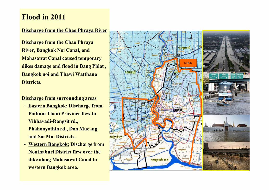
Flood in 2011Discharge from the Chao Phraya River
Discharge from the Chao Phraya River, Bangkok Noi Canal, and Mahasawat Canal caused temporary dikes damage and flood in Bang Phlat , Bangkok noi and Thawi WatthanaDistricts.
Discharge from surrounding areas- Eastern Bangkok; Discharge from
Pathum Thani Province flew to Vibhavadi-Rangsit rd., Phahonyothin rd., Don Mueangand Sai Mai Districts.
- Western Bangkok; Discharge from Nonthaburi District flew over the dike along Mahasawat Canal to western Bangkok area.

5
Flood situation map of Bangkok on 16 November 2011
Evacuation areasIntensive monitoringareasMonitoring areasRisk areas
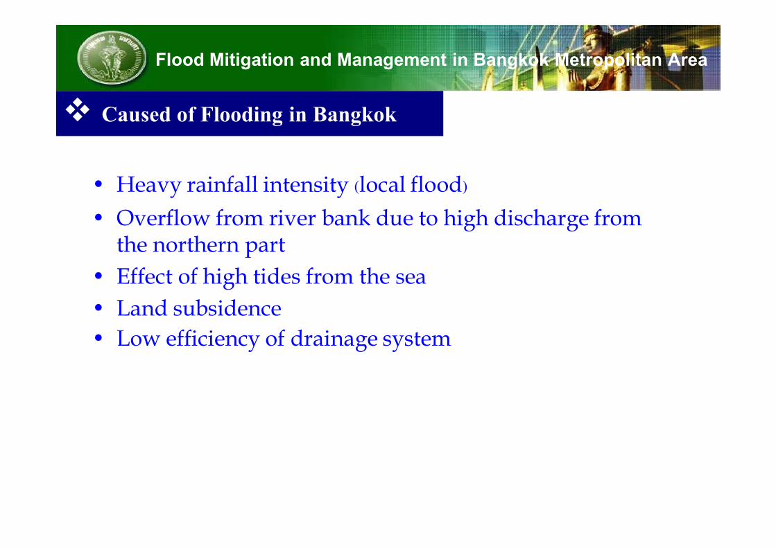
• Heavy rainfall intensity (local flood)
• Overflow from river bank due to high discharge from the northern part
• Effect of high tides from the sea
• Land subsidence
• Low efficiency of drainage system
Flood Mitigation and Management in Bangkok Metropolitan Area
Caused of Flooding in Bangkok

Heavy rainfall
The average annual rainfall in BMA is 1,500 mm. 88% of annual
rainfall extend during the south-west monsoon, May to October
which the heaviest occurs in September and October. The high intensity rainfall cannot drained effectively and causes localized flooding in some low areas and
main road. BMA drainage system capacity has been improved for 60 mm/hr of rainfall intensity.
Flood Mitigation and Management in Bangkok Metropolitan Area
Caused of Flooding in Bangkok
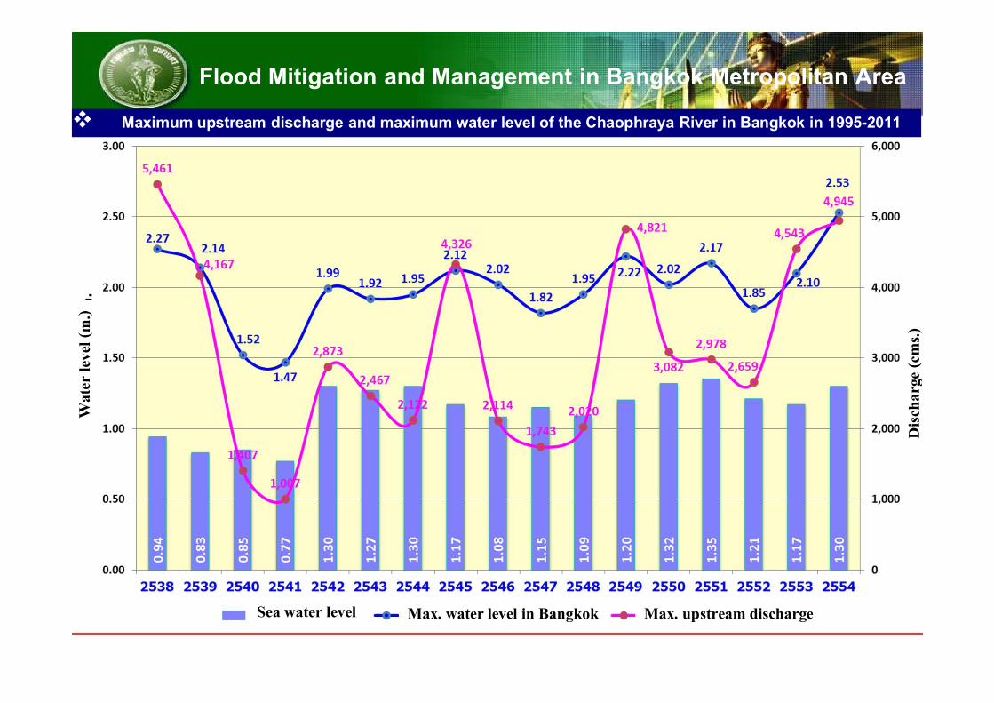
8Sea water level Max. water level in Bangkok Max. upstream discharge
Wat
er le
vel (
m.)
Disc
harg
e (cm
s.)
Flood Mitigation and Management in Bangkok Metropolitan Area Maximum upstream discharge and maximum water level of the Chaophraya River in Bangkok in 1995-2011
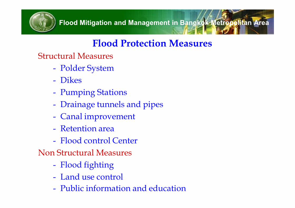
Flood Protection MeasuresStructural Measures
- Polder System
- Dikes
- Pumping Stations
- Drainage tunnels and pipes
- Canal improvement
- Retention area
- Flood control Center
Non Structural Measures
- Flood fighting
- Land use control
- Public information and education
Flood Mitigation and Management in Bangkok Metropolitan Area

2. Improvement of Drainage systems for rainfall
• Drainage system has been designed for rainfall intensity 60 mm./hr.
• Canals; 1,682 canals and 2,600 km.
• Pipe systems 6,400 km.
- Main roads have main drainage pipes length 1,640 km.
- Normal roads have secondary drainage pipes length 4,760 km.
• Pumping stations and water gates are 409 places. Total capacity is 1,638 cms.
• 7 tunnels which total length is 19 km. and total capacity is 155.50 cms.
• 25 storm water retention ponds in Bangkok area. Total volume is 12.88 million cm.
• Flood control center
Flood Mitigation and Management in Bangkok Metropolitan Area

Drainage Tunnels
BMA has implemented the drainage tunnels in case of where the drainage system are insufficient. The tunnels will drain the exceed storm water through the tunnels lying 15-22 m. under ground surface and pump out to the river by high capacity pumps. Now there are 7
drainage tunnels which 19 km long and 155 cms. of pumping capacity

Flood Control Center (FCC)
FCC was established in 1990, which utilize computer technology for systematic and management of operation of flood protection. The center is comprised of one master station which is located in DDS office and 69 remote terminal units (SCADA) scattered around Bangkok. The center has basic
functions in monitoring and collect of hydrological data (rainfall and water level) , facilities operation conditions, flood
damage situation and water quality data by using an on-line system. The various data are processing and transmit to the facilities operators and flood fighting team.

C Band Radar Movement of Rainfall from Radar
Pump & Gate operation Flood Detector

Cleansing of sewers Canal Dredging
Flood Fighters Movable Pumps

Improvement of Bangkok Flood Protection
Flood Mitigation and Management in Bangkok Metropolitan Area

1. Dredging the main drainage canals 1.5 billion baht
1.1 Bangkok budget for 460 canals, cost 417 million baht
1.2 Budget from Government for 401 canals, cost 1.17 billion baht
2. Increase efficiency of drainage systems, initiate warning system, and setting the Flow Meter in the main canals, cost 684 million baht
Flood Mitigation and Management in Bangkok Metropolitan Area
Short-term Plan (achieve within 3-6 months)
17

1. Repair flood walls along the Chao Phraya River, Bangkok Noi canal, and Mahasawat.
2. Elevate flood walls along the River and the canals
- Upstream, flood walls elevate from +3.00 m. to +3.50 m.
above MSL.
- Middle, flood walls elevate from +2.80 m. to +3.00 m. above
MSL.
- Downstream, flood walls elevate from +2.50 m. to +2.80 m.
above MSL.
3. Elevate dike at eastern part of Bangkok under His Majesty’s initiative (King’s dike) from +1.50-+2.90 to be +3.00 m. above MSL.
Flood Mitigation and Management in Bangkok Metropolitan Area
Mid-Term Plan (achieve within 1 year, year 2012)

The plan is constructing and elevating flood walls and dikes and develop
drainage systems in order to increase efficiency of flood protection for the
future. The plan has been set from 2013 to 2017 and costs 67.8 billion baht.
The activities consist of;
1. Strengthening and elevating flood walls along the Chao Phraya River,
Bangkok Noi canal, Mahasawat canal, and dikes at eastern part of Bangkok
under His Majesty’s initiative (King’s Dike)
2. Develop canal capacities to improve drainage efficiency by using the canals.
3. Develop drainage systems to increase the flow discharge to the Gulf of
Thailand (e.g., constructing 3 new drainage tunnels)
4. Develop retention ponds
5. Provide materials and equipments for flood protection
6. Develop flood control canter by improve of database of information systems
and warning systems
Long-Term Plan (achieve later than 1 year)
Flood Mitigation and Management in Bangkok Metropolitan Area

Bangkok Metropolitan Administration
Bamboo Type (Temporary)
Rock-Pile Embankment Type (Permanent)
Growing of Mangrove Tree
Coastal Erosion ProtectionBMA construct the bamboo barrier and
T-groins along the shoreline estimated 4.7 km and will grow mangrove tree to protect the shoreline and raise silt deposition on the coast. The schedule of construction project start from 2009 to 2016.
Thank youFor yourAttention
“Sawasdee”