flood fighting techniques workshop
TRANSCRIPT

FLOOD FIGHTING TECHNIQUES WORKSHOP
2018 Training Session

U.S. ARMY CORPS OF ENGINEERS KANSAS CITY DISTRICT
EMERGENCY MANAGEMENT BRANCH
635 Federal Building 601 E. 12TH Street, Room 115
Kansas City, Missouri 64106-2824
24-Hour Phone Number: 816-426-6320
Fax: 816-389-2036

FLOOD FIGHTING TECHNIQUES TABLE OF CONTENTS
SECTION 1 INTRODUCTION AND WELCOME SECTION 2 FEATURES OF FLOOD RISK MANAGEMENT (FRM)
PROJECTS & TERMINOLOGY SECTION 3 FRM PROJECT DESIGN FEATURES SECTION 4 OPERATION, MAINTENANCE, REQUIREMENTS, &
PROCEDURES SECTION 5 HIGH WATER EFFECTS ON FRM PROJECTS SECTION 6 SPONSOR FLOOD FIGHT PREPARATION/FLOOD
PATROL SECTION 7 DATA COLLECTION SECTION 8 WEATHER, RIVERS, & LAKES INFORMATION SECTION 9 FLOOD FIGHT ORGANIZATION SECTION 10 FLOOD FIGHT TECHNIQUES SECTION 11 FLOOD FIGHT/REHABILITATION ASSISTANCE (USACE)

1
217217217
200200200
255255255
000
163163163
131132122
2396553
110135120
1129256
62102130
1025648
130120111
237237237
8011927
252174.59
“The views, opinions and findings contained in this report are those of the authors(s) and should not be construed as an official Department of the Army position, policy or decision, unless so designated by other official documentation.”
Jud Kneuvean
Chief, Readiness and Contingency Operations
May 2018
FLOOD FIGHT TRAINING1
North Kansas City, MO
SCHEDULE OF INSTRUCTION0800 ‐ 0850
• Introduction and Welcome• Features of Flood Risk Management (FRM) Projects & Terminology• FRM Project Design Features
0850 – 0900 BREAK
0900 ‐ 0945
• Operation, Maintenance, Requirements, & Procedures• High Water Effects on FRM Projects• Sponsor Flood Fight Preparation/Flood Patrol• Data Collection
0945 ‐ 1000 BREAK
1000 ‐1040
• Weather, Rivers, & Lakes Information• Flood Fight Organization• Flood Fight Techniques• Flood Fight Assistance (USACE)
1040 ‐1050 BREAK
1050 ‐1130
• Levee Sponsor Brief1130 ‐ 1300
• Break for Lunch, Move to Field Training Location
2

2
AGENDA
• Introduction and Welcome
• Features of Flood Risk Management (FRM) Projects & Terminology
• FRM Project Design Features
• Operation, Maintenance, Requirements, & Procedures
• Develop a basic understanding of types of riverine FRM projects
• Identify FRM project design features
• Understand how FRM projects function
• Describe important aspects of levee operation and maintenance
Agenda:
Objectives:
3
FLOOD RISK MANAGEMENT (FRM) PROJECTS (RIVERINE)
All Require
Design ConstructionOperations & Maintenance
4
Levees and/or Floodwalls
Channel Improvements
Dams
3
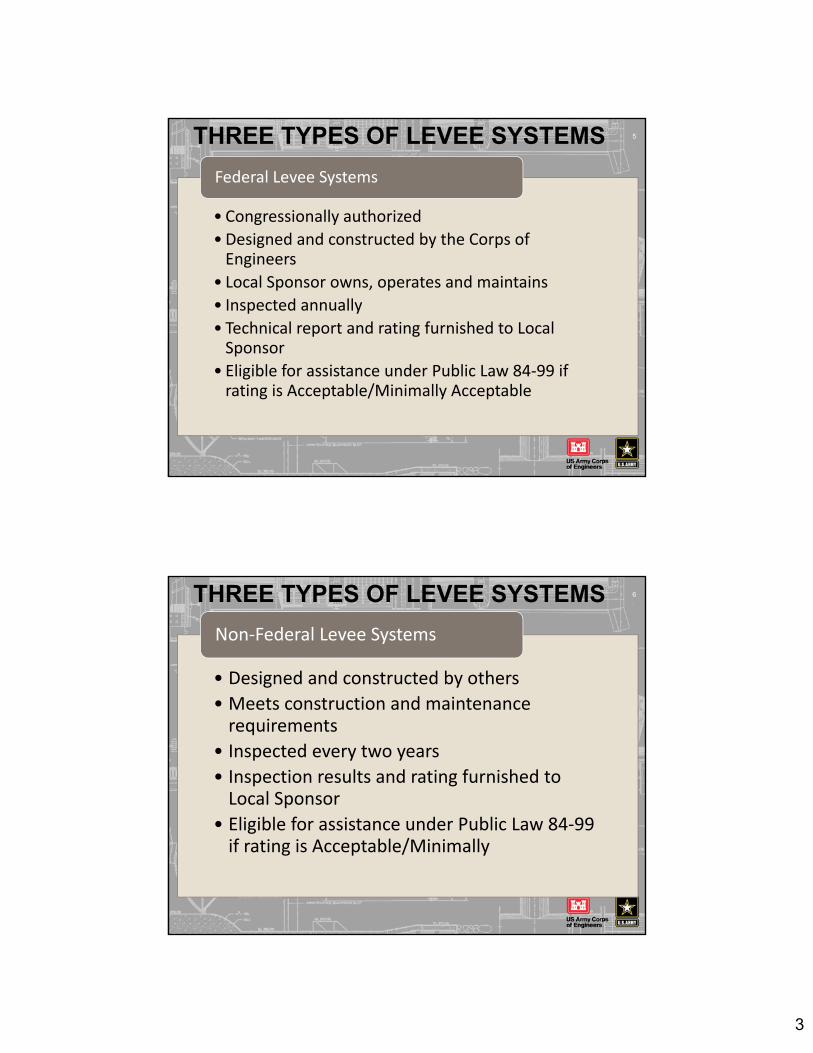
THREE TYPES OF LEVEE SYSTEMS 5
• Congressionally authorized
• Designed and constructed by the Corps of Engineers
• Local Sponsor owns, operates and maintains
• Inspected annually
• Technical report and rating furnished to Local Sponsor
• Eligible for assistance under Public Law 84‐99 if rating is Acceptable/Minimally Acceptable
Federal Levee Systems
THREE TYPES OF LEVEE SYSTEMS 6
• Designed and constructed by others
• Meets construction and maintenance requirements
• Inspected every two years
• Inspection results and rating furnished to Local Sponsor
• Eligible for assistance under Public Law 84‐99 if rating is Acceptable/Minimally
Non‐Federal Levee Systems

4
THREE TYPES OF LEVEE SYSTEMS 7
•Not inspected by the Corps of Engineers
• Not eligible for assistance under Public Law 84‐99
Other Levee Systems
FRM PROJECT DESIGN FEATURES 8
Basic Sections
Features Awareness During Flood Flight
Proposed FRM Project Alterations/Repairs &
General work near a FRM Project

5
BEDROCK
NATURAL BLANKET
RANDOMZONE
LEVEE CENTERLINERIVERWARD LANDWARD
IMPERVIOUSZONE
SLOPE PROTECTIONRIRRAP ON BEDDING ROCK
FOUNDATION SAND
Crest
Landside ToeRiverside
Toe
9FRM PROJECT DESIGN FEATURES
BEDROCK
NATURAL BLANKET
STABILITYBERM
STABILITYBERM
LEVEE CENTERLINE
RIVERWARD LANDWARD
FOUNDATION SAND
RANDOMZONE
IMPERVIOUSZONE
10FRM PROJECT DESIGN FEATURES
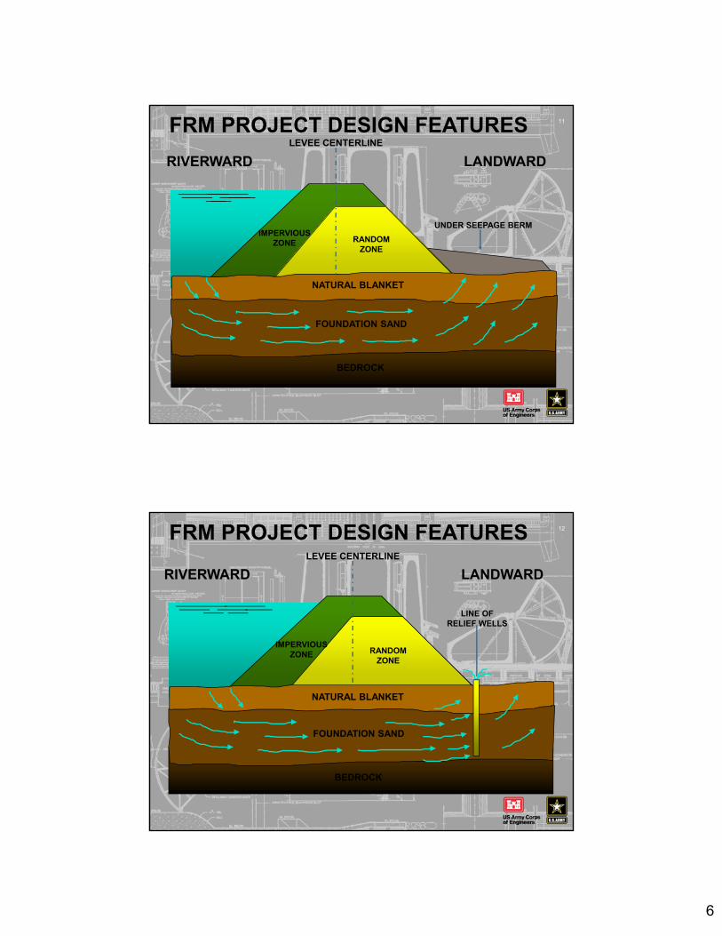
6
BEDROCK
NATURAL BLANKET
LEVEE CENTERLINE
RIVERWARD LANDWARD
FOUNDATION SAND
RANDOMZONE
IMPERVIOUSZONE
UNDER SEEPAGE BERM
11FRM PROJECT DESIGN FEATURES
BEDROCK
NATURAL BLANKET
LEVEE CENTERLINE
RIVERWARD LANDWARD
FOUNDATION SAND
RANDOMZONE
LINE OFRELIEF WELLS
IMPERVIOUSZONE
12FRM PROJECT DESIGN FEATURES

7
RIVERWARD
FLOODWALLCENTERLINE
HORIZONTALTOE DRAIN
LANDWARD
DISCHARGERISER
13FRM PROJECT DESIGN FEATURES
PROPOSED ALTERATIONS TO FRM PROJECTS
14
• Submit for Sponsor & USACE review to ensure the FRM Project integrity is maintained
• Submit all proposed work within the critical area generally 300’ riverward to 500’ landward (concerned with any work between the unit and the river/tributary/ditch)
• Title 33 (in O&M) requires District Engineer approval

8
PROPOSED ALTERATIONS TO FRM PROJECTS (CONT.)
15
Common alterations which may impact the FRM Project
Excavation of or fill onto blanket
Pipe through levee
Structures – riverward & land
Ponding area development
USACE GUIDANCE
Guidance can be found at: www.nwk.usace.army.mil/Missions/Engineering-Division/Geotechnical-Branch/Geotechnical-Design-and-Dam-Safety/
• Not intended to be the sole source for design; design should be in accordance with USACE criteria and acceptable industry standards
• Not intended to be used for construction plans and specifications
16
Guidance - For Work Proposed Near or Within a Federally Constructed FRM Project

9
USACE GUIDANCE
• It is intended to provide the reader with an appreciation of the flood control works features
• It is intended to be used as general guidance for design and acceptable construction practices
• Dynamic document subject to revisions--comments are welcomed
17
Guidance - For Work Proposed Near or Within a Federally Constructed FRM Project (cont.)
LEVEE FEATURES
LEVEE CROWN ROAD
18

10
19
LEVEE FEATURES
RIPRAP ON
RIVERSIDE LEVEE SLOPE
LANDSIDE SLOPE:
STABILITY BERM
20
LEVEE FEATURES
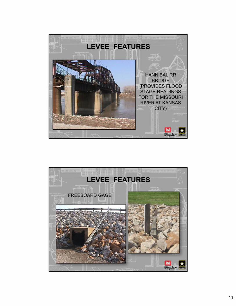
11
HANNIBAL RR BRIDGE
(PROVIDES FLOOD STAGE READINGS
FOR THE MISSOURI RIVER AT KANSAS
CITY)
21
LEVEE FEATURES
FREEBOARD GAGE
22
LEVEE FEATURES

12
23
DRAINAGE STRUCTURE OPERATING MECHANISM
LEVEE FEATURES
24
LEVEE FEATURES
DRAINAGE STRUCTURE: With
Baffles

13
25
LEVEE FEATURESDRAINAGE STRUCTURE:
Sluice Gates
DRAINAGE STRUCTURE:
Flap Gates
26
LEVEE FEATURES
SLOTTED PORTION FOR STOPLOGS
STOPLOG GAP FOR RAILROAD

14
STOPLOG GAP IN FLOODWALLBEING CLOSED
27
LEVEE FEATURES
STOPLOG GAP IN FLOODWALL CLOSED
SANDBAG GAP ON ROAD
28
LEVEE FEATURES

15
EMERGENCY SAND
STOCKPILEFOR
SANDBAGGING
29
LEVEE FEATURES
SANDBAG GAP BEING CLOSED
30
LEVEE FEATURES
SANDBAGFILLING CREW

16
“EBS” SANDBAG FILLING
MACHINE
31
LEVEE FEATURES
SANDBAG GAP IN FLOODWALL
32
LEVEE FEATURES

17
LEVEE FEATURES33
LANDSIDE OF FLOODWALL DECORATIVE FLOODWALL
FLOODWALL ROLLING GATE
TOE DRAIN RISER
LANDSIDE OF FLOODWALL
LEVEE FEATURES34

18
EXCAVATION LANDSIDE OF FLOODWALL
LEVEE FEATURES35
RIPRAP ON RIVERSIDE OF FLOODWALL
LEVEE FEATURES36

19
KNOWLEDGE CHECK
What is the difference between a Federal or non‐Federal levee system/FRM project?
What does it mean if we classify the FRM project as “Other?”
Does work in, over, or under a Federal FRM project need to be reviewed by USACE?
37
PUMPING PLANT
LEVEE FEATURES38
PUMPING PLANT PUMPS

20
LEVEE FEATURES39
FLOAT VALVE FOR RELIEF WELL
RELIEF WELL WITH TOP OPEN
LEVEE FEATURES40
PUMPING PLANTFOR RELIEF WELL
COLLECTOR SYSTEM
RELIEF WELL COLLECTOR
SYSTEM

21
41
LEVEE FEATURES
IMPROVED CHANNEL
UNIMPROVED CHANNEL
IMPROVED CHANNEL MEETS NATURAL CHANNEL
IMPROVED CHANNEL:CONCRETE WITH LOW
FLOW TROUGH
42
LEVEE FEATURES
IMPROVED CHANNEL:CONCRETE WITH
WEEP HOLE FLAPS

22
IMPROVED CHANNEL:BRUSH CREEK
43
LEVEE FEATURES
BREAK(10 MINUTES)
44

23
LEVEE MAINTENANCE & INSPECTIONS45
• Maintenance required by last inspection report
• Maintenance performed this reporting period
• Maintenance planned next reporting period
• Changes to segment/system since last inspection
• Problems/issues requiring the assistance of USACE
Pre-Inspection Form – Summary of…
LEVEE MAINTENANCE & INSPECTIONS
Flood Damage Reduction Segment/System Inspection Report
Categories
1. General Items
2. Levee Embankments
3. Floodwalls
4. Interior Drainage Systems
5. Pump Stations
6. Flood Damage Reduction Channels
46

24
LEVEE MAINTENANCE & INSPECTIONS
• Operations and Maintenance Manuals
• Emergency Supplies and Equipment
• Flood Preparedness and Training
47
1. General Items for All Flood Damage Reduction Segments/Systems
LEVEE MAINTENANCE & INSPECTIONS
2. Levee Embankments
•Unwanted vegetation growth
•Sod cover
•Encroachments
•Closure Structures (Stop Log, Earthen Closures, Gates, or Sandbag Closures)
•Slope Stability
•Erosion/ Bank Caving
•Settlement
•Depressions/Rutting
•Cracking
•Culverts/ Discharge Pipes
•Riprap Revetments & Bank Protection
•Revetments other than Riprap
•Underseepage Relief Wells/ Toe Drainage Systems
•Seepage
•Animal Control
48
*BOLD rated items are on 18 Critical Items list (Interim Eligibility Criteria)

25
LEVEE MAINTENANCE & INSPECTIONS
Levee Embankments - MAINTENANCE
• Promote and maintain growth of sod
• Exterminate burrowing animals and repair damages
• Provide for routine mowing of the levee
• Remove wild growth and drift deposits from the levee embankment and foreshore area
• Repair damage to riprap, grouted gutters, and slopes caused by erosion and other forces
49
LEVEE MAINTENANCE & INSPECTIONS
Levee Embankments – MAINTENANCE (cont.)
• Maintain access roads and ramps
• Remove trash, refuse, and other objectionable material from the levee crown, slopes, and foreshore
• Replace any surfacing material, which has been displaced, washed out, or removed
• Remove willows, weeds, and other vegetation from the stone slope protection
50

26
LEVEE MAINTENANCE & INSPECTIONS
Levee Embankments - INSPECTIONS
• No unusual settlement, sloughing, or material loss from the levee crown or levee cross section has taken place
• There is no caving or sliding of material on either side of the levee which might affect stability
• There is no evidence of seepage, saturated areas, or sand boils, and that runoff is not ponding along the levee toes
• Riprap has not been displaced, washed out, or removed
51
LEVEE MAINTENANCE & INSPECTIONS
Levee Embankments – INSPECTIONS (cont.)
• Nothing is being done to inhibit or discourage the development of sod, such as burning during inappropriate seasons
• Access roads are properly maintained and closed to the public where applicable
• No unauthorized traffic on levee crown
• No unauthorized construction occurring within “THE CRITICAL AREA” (300 ft riverward & 500 ft landward of centerline of levee)
52

27
LEVEE MAINTENANCE & INSPECTIONS
3. Floodwalls
• Unwanted vegetation Growth
• Encroachments
• Closure Structures
• Concrete Surfaces
• Tilting, Sliding or Settlement of Concrete Structures
• Foundation of Concrete Structures
• Monolith Joints
• Underseepage Relief Wells/ Toe Drainage Systems
• Seepage
53
*BOLD rated items are on 18 Critical Items list (Interim Eligibility Criteria)
LEVEE MAINTENANCE & INSPECTIONS54
4. Interior Drainage System
• Vegetation and Obstructions
• Encroachments
• Ponding Areas
• Fencing & Gates
• Concrete Surfaces
• Tilting, Sliding or Settlement of Concrete and Sheet Pile Structures
• Foundation of Concrete Structures
• Monolith Joints
• Culverts/ Discharge Pipes
• Sluice / Slide Gates
• Flap Gates/ Flap Valves/ Pinch Valves
• Trash Racks
• Other Metallic Items
• Riprap Revetments of Inlet/Discharge Areas
• Revetments other than Riprap
*BOLD rated items are on 18 Critical Items list (Interim Eligibility Criteria)

28
LEVEE MAINTENANCE & INSPECTIONS
Interior Drainage System – MAINTENANCE
Gates shall be examined and trial operated at intervals not to exceed 90 days and/or during and immediately after each flood event
• Pipes, gates, riprap, headwalls, and operating mechanisms are in good condition
• Fires are not being built in or near the structures • Inlet and outlet channels are open and clear of trash,
debris, sediment deposits, and tree growth
55
LEVEE MAINTENANCE & INSPECTIONS
Interior Drainage System – MAINTENANCE (cont.)
• Safety or stability of the structures is not endangered through erosion
• Gatewells are not plugged or damaged
• Damaged, broken or missing parts shall be repaired or replaced immediately
56

29
LEVEE MAINTENANCE & INSPECTIONS
Interior Drainage System – MAINTENANCE (cont.)
FLAP GATES• Inspected at least every 90 days for correct operation and proper seating
• Lubricate hinge bars and gate frame at least every 90 days or after each high river stage
• Remove silt and debris in order to provide free movement
• Inlet and outlet ditches are maintained to allow for proper drainage runoff
57
LEVEE MAINTENANCE & INSPECTIONS
Interior Drainage System – MAINTENANCE (cont.)
SLUICE GATES• Inspect and lubricate the operating stem
• Inspect sluice gate guides, guide brackets and gate wedges for wear and corrosion
• Once every five years, remove the operating stem cover, clean and lubricate the threaded portion of the operating stem
• Periodically operate the sluice gate to its fully opened and closed position slowly and carefully checking for misalignment or problems in operation
58

30
LEVEE MAINTENANCE & INSPECTIONS
5. Pump Stations•Pump Stations Operating, Maintenance, Training, & Inspection Records
•Pump Station Operations and Maintenance Equipment Manuals
•Safety Compliance
•Communications
•Plant Building
•Fencing and Gates
•Pumps
•Motors, Engines, Fans, Gear Reducers, Back Stop Devices, etc
•Sumps / Wet well
•Mechanical Operating Trash Rakes
•Non-Mechanical Trash Racks
59
*BOLD rated items are on 18 Critical Items list (Interim Eligibility Criteria)
60
LEVEE MAINTENANCE & INSPECTIONS
5. Pump Stations (cont.)•Fuel System for Pump Engines Power Source
•Electrical Systems
•Megger Testing on Pump Motors and Critical Power Cables
•Enclosures, Panels, Conduit and Ducts
•Intake and Discharge Pipelines
•Sluice/ Slide Gates
•Flap Gates/ Flap Valves/ Pinch Valves
•Cranes
•Other Metallic Items (Equipment, Ladders, Platform Anchors, etc.)

31
LEVEE MAINTENANCE & INSPECTIONS
6. Flood Risk Management Channels
•Vegetation and Obstructions
•Shoaling (sediment deposition)
•Encroachments
•Erosion
•Concrete Surfaces
•Tilting, Sliding or Settlement of Concrete Structures
•Foundation of Concrete Structures
•Slab and Monolith Joints
•Flap Gates/ Flap Valves/ Pinch Valves
•Riprap Revetments & Banks
•Revetments other than Riprap
61
LEVEE MAINTENANCE & INSPECTIONS
Flood Risk Management Channels – MAINTENANCE
• The channel is clear of debris, or tree growth
• The channel is not being restricted by the deposition of waste material, building of unauthorized structures, or other encroachments
• The capacity of the channel is not being reduced by the formation of shoals (sediment)
• No unusual bank erosion or sliding has occurred
• Riprap is in sound condition
62

32
KNOWLEDGE CHECK
Why is operating and maintaining an FRM project/levee system important?
When is the right time to identify issues that need to be corrected for an FRM project/levee system?
63
AGENDA
• High Water Effects on FRM Projects
• Sponsor Flood Fight Preparation/Flood Patrol
• Data Collection
• Weather, Rivers, & Lakes Information
• Identify effects of high water on FRM projects
• Summarize Roles and responsibilities for flood fighting
• Understand where to get weather and river forecast information
Agenda:
Objectives:
64

33
HIGH WATER EFFECTSON FLOOD CONTROL PROJECTS
Overtopping Sand Boils Seepage
Sloughing Wave Wash Erosion
65
RIVERWARD
LEVEE CENTERLINE
BEDROCK
NATURAL BLANKET
FOUNDATION SAND
RANDOMZONE
IMPERVIOUSZONE
66

34
LEVEE CENTERLINE
BEDROCK
NATURAL BLANKET
RIVERWARD LANDWARD
FOUNDATION SAND
RANDOMZONE
SAND BOIL
IMPERVIOUSZONE
67
RIVERSIDE LANDSIDE
SUBSIDENCE OF CROWN
SEEPAGE PATHPIPE UNDER LEVEE
SEEPAGE PATH
RIVERSIDESLOUGHING OF
SLOPE
LANDSIDE
FIG 1. - DEVELOPMENT OF PIPE UNDER LEVEE
FIG 2. - SLOUGHING OF LANDSLIDE SLOPE DUE TO RAVELLING AND
UNDERCUTTING OF TOE
FIG 3. -DEVELOPMENT OF SHEAR SLIDE
EFFECTS OF SANDBOILS ON LEVEE
SEEPAGE PATH
RIVERSIDELANDSIDE
SLIDING SURFACE
REDUCTION IN SHEARINGSTRENGTH IN THIS ZONE
68

35
BEDROCK
NATURAL BLANKET
LEVEE CENTERLINE
RIVERWARD LANDWARD
FOUNDATION SAND
RANDOMZONE
IMPERVIOUSZONE
PONDED SEEPAGE
69
BEDROCK
NATURAL BLANKET
LEVEE CENTERLINE
RIVERWARD LANDWARD
FOUNDATION SAND
RANDOMZONE
IMPERVIOUSZONE
SHALLOWSLIDE
70

36
BEDROCK
NATURAL BLANKET
LEVEE CENTERLINE
RIVERWARD LANDWARD
FOUNDATION SAND
RANDOMZONEIMPERVIOUS
ZONE
WAVE WASH
71
BEDROCK
NATURAL BLANKET
LEVEE CENTERLINE
LANDWARD
FOUNDATION SAND
RANDOMZONE
EROSION
IMPERVIOUSZONE
72

37
INITIAL FLOOD FIGHT PREPARATION
Review O&M Manual
requirements and ISOP
Implement the Alert Notification
Roster
Check serviceability and availability of emergency flood fighting equipment
Arrange for continuous
recording of gage readings
Determine field conditions of flap gates, drainage structures, and slope gages
73
LOCAL SPONSORS DUTIES AND RESPONSIBILITIES
INITIAL FLOOD FIGHT PREPARATION74
Sluice gates behind flap gates will not be closed unless the flap gate does not operate properly (Corps generally advises to close as most
sponsors will close anyway)
Closure of stoplogor sandbag gaps requires adequate time and advance
notice
Notify railroad company and others
Keep news media and public informed
Conduct preoperational
checks and services of all pumping
plants
LOCAL SPONSORS DUTIES AND RESPONSIBILITIES (cont.)

38
LEVEE PATROL’S DUTIES/RESPONSIBILITIES
75
LEVEE• Sand boils or unusual wet areas
• Look for slides or sloughs
• Look for wave wash or scouring of riverside embankment slope
• Look for low areas in the levee crown
• Record gage reading hourly (High Priority Item)
• Report any unusual condition
LEVEE PATROL’S DUTIES/RESPONSIBILITIES (CONT.)
76
FLOOD WALLS• Look for saturated areas or sand boils• Look for settlement of floodwall• Look for bank caving which may effect the stability
of the floodwall• Inspect toe drain risers• Inspect for possible leakage at the monolith joints• Record gage readings hourly (High Priority Item)• Report any unusual conditions

39
LEVEE PATROL’S DUTIES/RESPONSIBILITIES (CONT.)
77
PUMPING PLANTS• Qualified operator on duty• Operator should inspect, trial operate and place in
service all plant equipment• Periodically walk perimeter of pumping plant• Adequate ventilation is a must during prolonged
operation and high temperatures
DATA COLLECTION - PERFORMANCE78
Slope/Staff Gages
Read/Record Hourly
Indicates Remaining Freeboard
Used for Post Flood Assessments

40
DATA COLLECTION - PERFORMANCE79
Stoplog Gap
Toe Drain Riser
DATA COLLECTION - PERFORMANCE80
Unexplained
Riverward Scour
Slides/Sloughs

41
DATA COLLECTION - PERFORMANCE81
Sandboils
Identify, Monitor, Treat
DATA COLLECTION - PERFORMANCE82
Concentrated
Overtopping
Sheet Flow

42
DATA COLLECTION - PERFORMANCE83
BreachPrior to Overtop?
Overtopped?
KNOWLEDGE CHECK
Who is responsible for flood fight operations on a Federal/non‐Federal FRM project?
What are two reasons why collecting data on an FRM project is so important during a flood event?
84

43
BREAK(15 MINUTES)
85
WEATHER, RIVERS, AND LAKES INFORMATION
86

44
AVAILABILITY OF WEATHER, RIVERS, AND LAKES INFORMATION
The National Weather Service (NWS) and the Corps of Engineers are responsible for weather and river forecast
NATIONAL WEATHER SERVICE • Weather• River Forecasts• Precipitation
CORPS OF ENGINEERS • Projects• Pool Elevation
87
SOURCES OF WEATHER, RIVERS, AND LAKES INFORMATION
• National Weather Service Radio• Corps Water Management Section• Internet
National Weather Servicehttp://www.crh.noaa.gov/mbrfc/
Kansas City District Home Pagehttp://www.nwk.usace.army.mil/
• Corps of Engineers EOC
88

45
Click
“Water Management”
INTERNET ADDRESSES 89
http://www.nwk.usace.army.mil/
INTERNET ADDRESSES90
This Screen will link you to various pages and web sites; some of most useful include:
• Key Gages
• MRR Daily River Bulletin
• Other River and Lake Information:Missouri River Forecast Center
NWS Kansas River Forecasts

46
USE OF RIVER AND WEATHER DATA
• Actions Related to Key River Gages
• Provide Lead Time for Actions
• Documentation of High Water Event
91
AGENDA
Agenda:
• Flood Fight Organization
• Flood Fight Techniques
• Flood Fight/Rehabilitation Assistance (USACE)
Objectives:
• Understand basic flood fight organization
• Understand the basics of using sandbags during flood fight operations
• Describe process for requesting USACE flood fight assistance
92

47
ASSEMBLY AREA93
• Must Have Adequate Parking Spaces for Workers
• Transport Workers to Staging Area
• Considerations• Level of Effort• Community Size
• Urban• Rural
STAGING AREA94
• Crew Assignments
• Sandbag Filling
• Loading and Hauling Operations (for Work Site)
• Considerations• Location• Size of Area• Traffic flow• Duration of Event

48
STAGING AREA95
WORK SITE96
• Location where sandbags or other temporary measures are being placed/constructed
• Considerations• Access• Levee condition• Urban• Rural• Type of Work

49
WORK SITE97
SANDBAG OPERATIONS
Safety First
Use Proper Lifting Techniques (Bags are heavy)
Sandbags are treated to prevent deterioration
Always maintain eye contact with heavy equipment
Flood waters can be polluted
Wear adequate clothing (High Visibility if possible)
Gloves
98

50
HOW TO CONTROL SANDBOILS
•If at all possible construct on firm foundation.
•Construct to a height sufficient to create a head.
•The width of the base of the ring shall be at least 1 1/2 times the maximum height of the ring.
•Bags should be filled between 1/2 to 2/3 full of clay or sand.
•The bags should be placed with 1/3 overlap and be well mauled in place.
99
Construct a sandbag ring levee
Method to be used for ringing sand boils are:
RINGING SAND BOILS 100

51
SANDBAG LEVEE
Used to increase the height of an existing structure
Used where no protection exists
If height will exceed 4ft consider other options
Butt and overlap ends of each sandbag
Fold flaps under each bag (Kansas City District doesn’t recommend tying bags)
Stagger joint placement for subsequent rows
Compact each bag after placement by walking on it, and prior to adding next layer
101
SANDBAG LEVEE 102
See sandbag brochure in manual
52
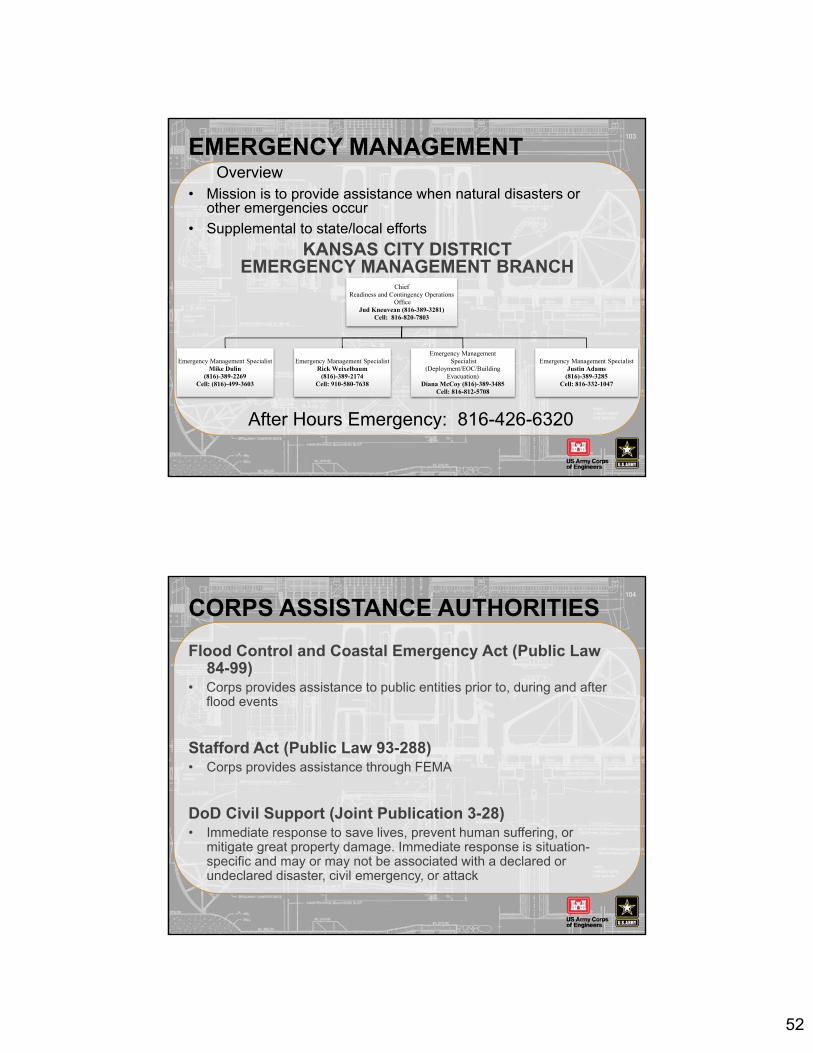
EMERGENCY MANAGEMENT
• Mission is to provide assistance when natural disasters or other emergencies occur
• Supplemental to state/local efforts
103
Overview
After Hours Emergency: 816-426-6320
KANSAS CITY DISTRICTEMERGENCY MANAGEMENT BRANCH
ChiefReadiness and Contingency Operations
OfficeJud Kneuvean (816-389-3281)
Cell: 816-820-7803
Emergency Management SpecialistMike Dulin
(816)-389-2269Cell: (816)-499-3603
Emergency Management SpecialistRick Weixelbaum
(816)-389-2174Cell: 910-580-7638
Emergency Management Specialist
(Deployment/EOC/Building Evacuation)
Diana McCoy (816)-389-3485Cell: 816-812-5708
Emergency Management SpecialistJustin Adams
(816)-389-3285Cell: 816-332-1047
CORPS ASSISTANCE AUTHORITIES
Flood Control and Coastal Emergency Act (Public Law 84-99)
• Corps provides assistance to public entities prior to, during and after flood events
Stafford Act (Public Law 93-288)• Corps provides assistance through FEMA
DoD Civil Support (Joint Publication 3-28)• Immediate response to save lives, prevent human suffering, or
mitigate great property damage. Immediate response is situation-specific and may or may not be associated with a declared or undeclared disaster, civil emergency, or attack
104

53
PUBLIC LAW 84-99
105
Flood Fight Training
Technical Assistance
Drought Assistance
1,049 Miles of Levee59 Federal Levee Systems84 Non-Federal Levee Systems5 Federal By Other Agency8 Channel Projects
All Hazards Preparedness
EOC Operations
Advance Measures
Recovery – Rehabilitation and Inspection Program
Direct Assistance
Contaminated WaterSection 6 – Sale of
USACE Water
DISASTER PREPAREDNESS
Emergency Management Organization
Planning
TrainingExercises
Supplies & Equipment
Levee Inspection Program
106
Prepare for immediate and effective response -
Preparedness Program includes:

54
DISASTER PREPAREDNESS
• Role of the Corps of Engineers is supplemental to state and local efforts during an emergency
• State and local governments are responsible for emergency preparedness, including stockpiling flood fight supplies and materials
• Provide flood fight training and technical assistance on request and/or as resources allow
Criteria for Assistance
107
• Participation in emergency seminars, training and exercises
• Inspection of FRM Projects that were either Federally constructed or participate in the Corps Rehabilitation and Inspection Program
• Technical assistance
Types of Assistance
ADVANCED MEASURES
• Imminent threat of unusual flooding
• Written request from the Governor
• Supplement state and local efforts
Criteria for Assistance
108
Emergency measures taken prior to a predictable, forecasted flood event to protect against loss of life or improved property
• Strengthening flood control structures
• Construction of temporary levees
• Channel clearance and dredging of federal projects
Types of Assistance

55
FLOOD RESPONSE• Emergency assistance to save lives and protect
property during a flood
• Supplement state and local efforts
• Terminates when emergency is over i.e., floodwaters recede to within top of bank
109
• State/Local entities must commit all available resources, including manpower, supplies and equipment
• State/Local entities must be prepared to replace in‐kind or pay for supplies utilized
Criteria for Assistance
FLOOD RESPONSE110
Type of Assistance
• Technical and Direct Assistance
• Equipment & Supplies
• Supplement Local Efforts
• Rescue Operations
• Furnish equipment and materials
• Technical advice and assistance, i.e., how to treat sandboils, etc… (People)
• Direct Assistance ‐ Temporary construction; temporary repairs to levees and other flood control works; pumping operations; rock placement; etc. (Goods/Services)
Includes, but is not limited to:

56
FLOOD FIGHT SUPPLIES111
FLOOD RESPONSE USACE TEAMS
15 Mobile Liaison Teams
2 person teams responsible for individual levee
systems
Typically made up of Operations and
Engineering personnel.
2 Technical Response Teams
5 person teams
Teams are composed of engineering
disciplines to address special situations during a flood fight
1 Aerial Reconnaissance
Team
Led by Operations and Emergency Management
112

57
FLOOD RESPONSE
1• Contact Local Emergency Management Office
2• Local EM contacts the State Emergency Management Office
3• The State Emergency Management Office contacts the Corps of Engineers
4• Strongly Recommend that you Contact the Corps directly at 816‐426‐6320 when working through this process
113
USACE assistance is supplemental to state and local efforts.
How to Obtain Help:
FLOOD RESPONSE
Help Us to Help You
•Notify the Corps Emergency Management Office when you engage in Flood Fight Activities (816‐426‐6320)
• Follow the directions in the O&M Manual regarding the operation of your unit during a flood
• Establish Levee Patrols and record gages on an hourly basis (Time, Location, and Stage)
• If you need Technical or Direct Flood Fight Assistance, Notify Us Immediately. DO NOT WAIT!
114

58
REHABILITATION ASSISTANCE
PL84‐99 provides authority to repair flood control structures damaged or destroyed by flood.
115
Rehabilitation Assistance is limited to the repair or restoration of a flood control project to the pre‐disaster condition.
REHABILITATION ASSISTANCE
• Active Status in Program (Acceptable or Minimally Acceptable Inspection Rating) in accordance with interim eligibility criteria
• Publicly Sponsored Project
• Non‐Federal are cost shared at 80% Federal and 20% Sponsor
• Federal Levees are repaired at 100% Federal Cost
Criteria for Assistance
116

59
REHABILITATION ASSISTANCE
• Public Sponsor must provide all lands, easements, right‐of‐way, and earthen borrow necessary to rehabilitate damaged FRM project
• Deficient or deferred project maintenance will be accomplished by or at the expense of the Sponsor
Criteria for Assistance cont.
117
REHABILITATION ASSISTANCE
1• Inspect Your FRM project for damages
2
• If you find damage and you believe the damage exceeds $15k, notify the Corps of Engineers in WRITING that you are requesting rehabilitation assistance
3• Sponsors have 30 days from the end of the event to request assistance
118
Request for Assistance Following a Flood Event
How to request rehabilitation assistance:

60
KNOWLEDGE CHECK
What are the three basic components for organizing a flood fight?
What are the two types of assistance that the Corps of Engineers can provide during a flood fight?
Does USACE provided flood assistance cost a public entity anything?
Can USACE ask that a sponsor pay back to the government for the cost of sandbags? How can that payment be made?
119
QUESTIONS???
120

61
BREAK(15 MINUTES)
121

BUILDING STRONG®
COE GUIDANCE On The Webhttp://www.nwk.usace.army.mil/Missions/EngineeringDivision/GeotechnicalBranch/GeotechnicalDesignandDamSafety.aspx

BUILDING STRONG®
Click
“Water Management”
INTERNET ADDRESSEShttp://www.nwk.usace.army.mil/

BUILDING STRONG®
INTERNET ADDRESSESThis Screen will link you to various pages and web sites; some of most useful include: Key GagesMRR Daily River BulletinOther River and Lake Information:Missouri River Forecast CenterNWS Kansas River Forecasts

Portland District P.O. Box 2946 Portland, OR 97208-2946 (503) 808-4400
Seattle District P.O. Box 3755 Seattle, WA 98124-3755 (206) 764-3406
Kansas City District 700 Federal Building, 601 East 12th Street Kansas City, MO 64106-2896 (816) 389-3282
Omaha District 215 North 17th Street Omaha, NE 68102-49978 ( 402) 221-4259
Walla Walla District 201 North 3rd Street Walla Walla, WA 99362-1876 (509) 527-7144
Printed on recycled paper 2004.
US Army Corps of Engineers Northwestern Division
The use of sandbags is a centuries old, tried and true method for flood fighting.
See procedures and safety tips inside on efficient bagging operations.

Sandbags: a steadfast tool for flood fighting ~ andbagging is one of the most versatile
of flood fighting tools and is a simple, . effective way to prevent or reduce flood water damage.
Although sandbags do not guarantee a watertight seal, they are a proven deterrent to costly water damage.
Sandbags have been used to: • prevent overtopping of levees. • direct a river's current flow to specific areas. • construct ring dikes around boils on levee
back slopes, levee toes or behind levees. • use as weight on back slopes of saturated
levees. • weigh down visquine and straw bales. • build buttresses on back slopes and the toes
of saturated levees. • reduce seepage at closure structures.
Read this brochure to learn proper filling and placement methods aimed at increasing productivity of sandbagging operations. Included are hints, safety tips and correct procedures which will minimize work-related injuries and strain and will maximize essential time.
THE FIRST LINE OF DEFENSE Sandbag construction is a centuries old
technique that has changed little. Bags are made from different materials including treated burlap and plastic. They measure approximately 14 inches wide and 24 inches long.
Sandbags filled one-half to two-thirds full should generally be left untied. Tied bags, filled slightly fuller, have specific purposes: filling holes, holding visquine or straw bales in place, or forming barriers backed by supportive planks or aluminum sheet piles.
If access to the flood site is limited to boat, tractor or helicopter, then pallets and forklifts may be needed to load and off-load sandbags.
2
Unused empty bags can be stockpiled for emergency and will be serviceable for years if kept dry and properly stored.
FILL MATERIALS Sand is by far the easiest material for filling
and shaping sandbags and becomes heavier when saturated from rain or moisture.
In emergencies, other materials such as silt, clay, gravel or a mixture of these may be used, but none work as well as sand.
When vehicle access is cut off to the flood site, and you have no other choice, use the back side of the levee or an adjacent field to find whatever material is available to fill sandbags.
Here are pros and cons on use of other materials:
• Silty soils get soft when wet and are more difficult to shape, and finer particles leak through the weave in the material.
• Clay materials are difficult to shape and to bag.
• Coarse-grained gravels are pervious and are also difficult to shape but can be used for redirecting the main stream flow while allowing seepage through bags.
ALTERNATIVES Other methods and remedies for flood fighting
are as follows: • Readily available, straw bales are an
economical alternative. They range in size from 18 inches high by 30 inches long to 4 by 4 by 8 foot long blocks. Secure the bales by driving 4 to 10 foot stakes (or rebar) through the straw into the levee top, and weight down with filled sandbags. Water swells the straw, making the bales heavier and watertight.
• Concrete Jersey Barriers or Ecology Blocks can be used to divert water and can be cost effective solutions.
• Plastic sheeting can be used effectively by placing sand along a fold.

CAUSES OF LEVEE FAILURE • Overtopping
• Downed trees on levee slope
• Gopher holes
• Seepage through pervious levee material
• Saturated levee embankments
• Seepage fallowing tree root paths
Flood Level Downed tree
CORRECT FILLING PROCEDURES Filling sandbags is normally a two or three
person operation. One member of the team, while crouching with feet apart and arms extended, should place the bottom of the empty bag on the ground.
The opening of the bag is folded outward about 1-1/2 inches to form a collar and held open to allow the second team member to empty a fully rounded No. 2 shovel of material into the open end of the bag.
Seepage
should rotate duties often to reduce job-specific muscle fatigue .
Untied bags should be filled approximately one-half to two-thirds full. Tied bags can be filled slightly more, but with enough room left at the top to tie the bag off properly.
Always use gloves to protect your hands during the filling operation. After handling treated bags, avoid contact with your eyes and mouth.
Don't hurry. Haste can result in undue spillage and added work. The third team member stockpiles or stacks the open sacks. The three team members
This two-member team uses correct positions for sandbag filling .
Dress appropriately and layer clothing. Safety goggles should be used on dry and windy days. Sandbag filling operations are done either near the actual placement site or at centrally located filling sites such as fire
3

stations, diking districts or sand pits. If the bags are filled at a distant location,
vehicle transportation and access to the flood site are primary planning considerations.
For large scale operations, a variety of specialized filling equipment - such as funnels on the back of dump trucks - is commercially available.
Such equipment is not always available during an emergency and may be best suited for a staging area where bags can be filled and then delivered to the site.
PROPER PLACEMENT Remove any debris from the areas where bags
are to be placed. Place the bags lengthwise and parallel to the direction of flow. Fill the low spots first before placing bags the full length of the area to be raised.
Start at approximately 1 foot landward from the river or levee's edge. Fold the open end of the bag under the filled portion. Folded end of bag should face upstream. Place succeeding
Veteran flood engineer Ernie Sabo demonstrates that the sandbag should be two-thirds full, folded at the top.
4
bags with the bottom of the bag tightly and partially overlapping the previous bag.
Offset adjacent rows or layers by one-half bag length to avoid continuous joints.
To eliminate voids and form a tight seal, compact and shape each bag by walking on it and
continue the
t1·. ~"< ~
:~·.,;..;.
) .!:~ ·;u>
A {ft ~h•}
·;·~ ' ' ,, --
"' ~
~ 5-
:. '
Place each succeeding bag tightly against and parially overlapping the
previous one. Compact and shape each bag by walking on it.
process as each layer is placed. This flattens the top of the bag and prevents
slippage between succeeding layers.
SINGLE STACK PLACEMENT
Sandbags stacked in a single row work well in flood areas where there is no streamflow velocity or danger from floating debris, such as logs and tree stumps, or from wave action which Single stack placement
could topple the bags. Although generally not recommended to be above
three courses or layers in height (approximately 1 foot), higher single stack placement can be effectively used as a barricade to protect structures from impending water damage as shown in the photo.

PYRAMID PLACEMENT METHOD Use pyramid placement to increase the height of
sandbag protection; however, use caution when rasing the levee height. Determine the height of the sandbag raise by using the best available forecasts of flood conditions.
An example: When the water level is currently 1 foot below the top of the levee and is predicted to rise 3 more feet, construct a 2-112 foot sandbag operation which includes one-half foot of height
as a safety factor. It's important to compact each bag in place by
walking on it, butting the ends of the sacks toe th er, maintaining a staggered joint placement and folding under all loose ends.
Watch for flooding elsewhere, and watch for boils on the landward side of the levee due to the increased water elevation.
TYPICAL PYRAMID SANDBAG PLACEMENT Bags Required Per 100 Linear Feet of Levee
Height of Bags Sandbag Levee Required
Vl b.O 1 foot 600* ro
..0 4 ft 2 feet 2100 "O I::
3 ft 3 feet 4500 ro Cl)
4 feet 7800 c..-. 0 2 ft
....., * Single width course I foot high ..c b.O 1 ft requires 300 bags per 100 linear feet.
·a:i ::c 0 ft
0 ft 2.5 ft 5 ft 7.5 ft 10 ft
1 ft Minimum
Width of Sandbag Pyramid Base
The pyramid placement method issued to increase the height of sandbag protection.
Use this rule of thumb in determining dimensions of the pyramid:
• 1 bag in length equals about 1 foot • 3 bags in width equals about 2-112 feet. • 3 bags in height equals about 1 foot.
Place the sandbags by laying an equal number of horizontal rows on the bottom as there are vertical layers.
It's important to compact each bag in place by walking on it, butting the ends of the sacks together, maintaining a staggered joint placement and folding under loose ends.
5

RINGING SAND BOILS
• Minimum 2 ft. radius from center of boil to edge of ring dike.
• Tie into levee if boil is near toe of levee
• Build half-moon shaped ring dike if boil is on levee slope.
RINGING SAND BOIL METHOD A sand boil is created by water seepage
through the levee foundation or embankment. When that seepage transports dirty water, the levee's integrity is threatened.
Corps employees demonstrate building a ring dike.
6
c::
~ u Q) Q)
> ~
TOP VIEW
SIDE VIEW
2 ft Minimum
It's generally not necessary to build a ring dike around a boil that is not transporting soils but monitor the boil for any change in condition.
Don't attempt to place sandbags directly on the boil. Pressure applied to plug the boil will cause water seeping through the levee to seek other avenues to follow and could cause levee failure.
As a minimum, there should be a 2 to 3 foot radius from the center of the boil to the inside edge of the ring dike. Take care to contain the entire area experiencing boils within the ring dike.
Build a spillway section in the dike so water runs out in a controlled manner. This diverts the overflow water away from the dike and reduces erosion on the levee slope. Once the spillway water runs clear, and is not transporting soils, then the ring dike is completed.

U.S. ARMY CORPS OF ENGINEERS The U.S. Army Corps of Engineers is the nation's
oldest engineering organization and one of its oldest military branches. It dates back to the Revolutionary War when, in 1775, George Washington appointed Col. Richard Gridley as Chief Engineer of the Continental Army.
The Corps' water resource program began in 1824 when Congress appropriated money for
SAFETY FIRST Tip# 1: Use proper lifting techniques to avoid injury and fatigue. Lift with your legs and bend at the knees to save your back.
Tip #2: Sandbags are treated to prevent deterioration when stored. Use work gloves and avoid contact with your eyes and mouth.
Tip #3: Stay in eye contact with heavy equipment operators and keep alert for truck backup alarms.
Tip#4: Flood waters can be polluted. Use rubber gloves and appropriate clothing if contact with water is unavoidable .
Tip#5: Wear adequate clothing in layers and watertight boots. Reflective material on outer clothing is essential for night work.
Tip#6: Rotate team members frequently to avoid fatigue.
Starting at the top, going clockwise: Watch for trucks and other heavy equipment
frequently at flood sites; boots, clothing and other items are necessary for flood fighting; and heavy
gloves are protection from treated burlap bags.
improving river navigation. In the following decade, the involvement in civil works mushroomed, including new roads, railroads and bridges, and assistance to local communities during flood disasters.
Annually Congress sets aside funds for disaster response flood work. This gives the Corps the ability
7
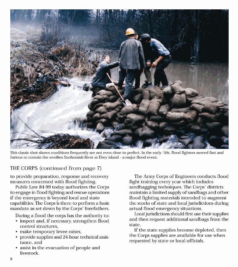
This classic shot shows conditions frequently are not even close to perfect. In the early '50s, flood fighters moved fast and furious to contain the swollen Snohomish River at Ebey island - a major flood event.
THE CORPS (continued from page 7)
to provide preparation, response and recovery measures concerned with flood fighting .
Public Law 84-99 today authorizes the Corps to engage in flood fighting and rescue operations if the emergency is beyond local and state capabilities. The Corps is there to perform a basic mandate as set down by the Corps' forefathers.
8
During a flood the corps has the authority to: • inspect and, if necessary, strengthen flood
control structures, • make temporary levee raises, • provide supplies and 24-hour technical assis
tance, and • assist in the evacuation of people and
livestock.
The Army Corps of Engineers conducts flood fight training every year which includes sandbagging techniques. The Corps' districts maintain a limited supply of sandbags and other flood fighting materials intended to augment the stocks of state and local jurisdictions during actual flood emergency situations.
Local jurisdictions should first use their supplies and then request additional sandbags from the state.
If the state supplies become depleted, then the Corps supplies are available for use when requested by state or local officials.

Eligibility For Corps of Engineers Assistance Be Active In The Corps of Engineers Rehabilitation and Inspection Program
Only those Flood Damage Reduction projects in an “Active” status at the time of a flood or storm event may receive rehabilitation assistance under the authority of PL84-99. An “Active” project must have met USACE criteria for entry into the Corps of Engineers Rehabilitation and Inspection Program (RIP), must currently participate in the RIP program, and must have received an Acceptable or Minimally Acceptable inspection rating on the last continuing eligibility inspection performed by the Corps of Engineers.
Be A Primary Levee A primary levee is a complete system, tied to high ground, designed for flood damage reduction and does not encroach on the flood plain.
Provide Required Minimum Level of Protection
Levee systems must provide a minimum 5-year level of protection for agriculture and a 10-year level of protection for urban area.
Have a Public Sponsor
A public sponsor is required for other than a public entity. The sponsor must be a public agency such as a legal subdivision of a State or State government, local unit government such as a county or city, a qualified Indian tribe or a state-chartered organization such as a levee board or district, drainage board or district. The sponsor will be required to co-sign any request for assistance.
Be Damaged By Flooding
The damages must exceed $15,000 (normal erosion is not eligible). Deliberate levee breaches will only be eligible for rehabilitation assistance if prior approval was received from the Corps of Engineers.
General The U.S. Army Corps of Engineers may provide assistance in the rehabilitation of flood damage reduction projects only when repairs are clearly beyond the normal physical and financial capabilities of the project sponsor. The established Corps of Engineers eligibility criteria identified below must also be met. Structures built for channel alignment, navigation, recreation, fish and wildlife, land reclamation drainage, or to protect against land erosion are not flood control works and, therefore, are not eligible for assistance.
Levee Rehabilitation Program
Eligibility Requirements Public Law 84-99 (33 U.S.C. 701n)
Flood Control and Coastal Emergencies
Union Township Overtop Levee Breach, 24July2010

L e v e e R e h a b i l i t a t i o n E l i g i b i l i t y R e q u i r e m e n t s | 2
Be Properly Maintained
A properly maintained levee has a good grass cover, other vegetation is removed (trees), grass mowed not grazed, animal burrows controlled, erosion repaired, supporting drainage structures maintained, level of protection maintained, and pass a biennial inspection.
Repairs Must Meet Economic Criteria
The rehabilitation project must protect items of value and have a favorable benefit-cost-ration. The annual benefit must exceed the total annualized cost.
Provide Traditional A-B-C’s
Corps policy requires the public sponsor to furnish the following items of cooperation and assurances (referred to as A-B-C’s) prior to undertaking any work: (1) provide without cost to the United States all lands, easements, and rights-of-way necessary; (2) hold and save the United States free from damages due to the work, exclusive of damages due to negligence of the United States or its contractor; (3) removal of any temporary emergency protective measure; (4) maintain and operate, in a manner satisfactory to the Chief of Engineers, the entire project after completion.
Cost Share Repairs
Rehabilitation projects for non-Federal flood damage reduction projects will be cost shared at 80 percent Federal and 20 percent non-Federal. The non-Federal share may be provided with work-in-kind, cash, or a combination of both. Federal flood damage reduction projects will be repaired at 100 percent Federal cost.
Levee Owner/Sponsor Applies
The levee owner or sponsor will call, write, or visit a Corps of Engineers field or District office and identify the areas that have been damaged.
Investigation of Damages A field investigation will be conducted by the Corps and will include an assessment of levee damage and acreage, crops and buildings involved. The sponsor will accompany the team as it identifies damages. The sponsor should provide proof of ownership or sponsorship authority. Necessary agreements will be signed.
Steps To Initiate Repairs After A Flood Following a flood event, the Corps of Engineers will issue a public notice stating that requests for assistance for rehabilitation work must be submitted within 30 days after the flood waters recede to bank full. Local interests should request a rehabilitation investigation from the Corps of Engineers as soon as possible after the flood damage occurs. The process is as follows:
Baltimore Bend Levee, July 2010
Baltimore Bend Levee, July 2010

L e v e e R e h a b i l i t a t i o n E l i g i b i l i t y R e q u i r e m e n t s | 3
Determination of Eligibility
The field report will be forwarded to the District Office where it will be reviewed. The Sponsor will be notified of the eligibility determination as soon as possible. Structures built for channel alignment, navigation, recreation, fish and wildlife, land reclamation, drainage diversion, or to protect against land or shoreline erosion or salt water intrusion are not considered flood damage reduction projects and are not eligible for rehabilitation assistance. Sediment removal from drainage ditches and debris removal are not eligible for rehabilitation assistance.
Forwarded for Approval and Funding Project approval is made at the Division Office level. The sponsor will be notified when the project has either been approved or disapproved. Funding to complete the engineering and design; and funding to construct the rehabilitation project is made immediately upon notification that the project has been approved. Rehabilitation under PL84-99 is subject to the availability of funding.
Cost Share Details Resolved If the local sponsor is providing cash for the 20% sponsor share, it must be received by the Corps prior to the contract being prepared. In-kind services must be accomplished before or during construction.
Start Contracting Procedures Award Contract, Start Construction
Returned to Owner for Maintenance
How Long Will It Take? It Depends On— When the Water Goes Down How Many Applications There Are How Extensive the Damages Are Availability of Contractors Availability of Funding Weather Conditions
How to Obtain Help If you would like to discuss the Corps of Engineers Flood Rehabilitation program, please contact the Kansas City District Emergency Management Office at 816-426-6320.

1
GLOSSARY OF TERMS
Acre-foot: An area of one acre covered with water to a depth of one foot. One acre-foot is equal to 43,560 cubic feet or 325,851 gallons. (1 cubic foot of water = 7.5 gallons)
Active: A status applied to FCW concerning participation in the Rehabilitation and Inspection Program under authority of PL 84-99. An Active project must have met USAGE criteria for entry and been entered into the RIP. Only Active projects may receive Rehabilitation Assistance to repair damages caused by a flood event or coastal storm. Aeolian Deposits: Wind deposited material such as dune sands and loess deposits.
Agricultural Levee: A levee that provides at least a 5-yearflood protection to predominantly agricultural areas or agribusinesses. (Can be Federal or non-Federal) Allowable Bearing Value (allowed soil pressure): The maximum press that can be permitted on foundation soil, giving consideration to all pertinent factors, with adequate safety against rupture of the soil mass or movement of the foundation of such magnitude that the structure is endangered. Allowable Pile Bearing Load: The maximum load that can be permitted on a pile with adequate safety against movement of such magnitude that the structure is endangered. Alluvium: Soil that has been transported in suspension by flowing water and subsequently deposited by sedimentation. Angle of Repose: Angle between the horizontal and the maximum slope that a soil assumes through natural processes. For dry granular soils the effect of the height of slope is negligible; for cohesive soils the effect of height of slope is so great that the angle of repose is meaningless. Anti-Seepage Collar: A projecting collar of concrete or other material built around the outside of a tunnel, pipe, or conduit, under an embankment dam or levee, to reduce the seepage potential along the outer surface of tunnel, pipe, or conduit. Appurtenance/Appurtenant Feature: The associated works of a dam other than the embankment or main impoundment structure, such as inlet and outlet works, spillways, tunnels, or powerplants; Ancillary features of a levee such as pump plants, gatewell structures, flap gates, etc. Aquifer: A water bearing formation that provides a ground-water reservoir.

2
Area of Influence of a Well: Area surrounding a well within which the piezometric surface has been lowered when the pumping has produced a maximum steady rate of flow. As-Built Drawings: Plans or drawings portraying the actual dimension and conditions of a dam, dike, or levee as it was built. Field conditions and material availability during construction often require changes from the original design drawings. Authorization: House and Senate Public Works Committee resolutions or specific legislation, which provides the legal basis for conduction studies or constructing projects. The money necessary for accomplishing the work is not a part of the authorization, but must come from an appropriation by Congress. Bank and Channel Stabilization: The process of preventing bank erosion and channel degradation. Base Course (Base): A layer of specified or selected material of planned thickness constructed on the subgrade or sub-base for the purpose of serving one or more functions such as distribution load, providing drainage, minimizing frost action, etc. Basin: Drainage area of a lake or stream as in; (1) River basin, (2) a naturally or an artificially enclosed harbor for small craft, etc. Beaching: The removal by wave action of a portion of the upstream (riverside) side of the embankment and the resultant deposition of this material further down the slope. Such deposition creates a very flat beach area. Bearing Capacity (of a pile): The load per pile required to produce a condition of failure. Bedrock (ledge): Rock of relatively great thickness and extent in its native location. Bentonite Clay: clay with a high content of the mineral montmorillonite, usually characterized by high swelling on wetting. Berm: A horizontal step or bench in the slope of an embankment. Blanket Drain: A drainage layer placed directly over the foundation material. Boil: A disturbance in the surface layer caused by water escaping under pressure from behind a water retaining structure such as a dam or a levee. The boil may be accompanied by deposition of soil particles (usually sand) in the form of a conical shaped mound (miniature volcano) around the area where the water escapes. Borrow Area: The area from which material for a constructed embankment is excavated.

3
Boulder: A rock fragment, usually rounded by weathering or abrasion, with an average dimension of 12-inches or more. Boulder Clay: A geological term used to designate glacial drift that has not been subjected to the sorting action of water, and therefore, contains particles from boulder to clay size. Breach: A break, gap, or opening in a dam that results in loss of embankment integrity and the uncontrolled discharge of impounded water; a break, gap, or eroded opening in a levee that results in loss of embankment integrity and flooding of protected area. A controlled breach is a constructed opening. Bulking: The increase in volume of a material due to manipulation. Rock bulks upon being excavated; damp sand bulks if loosely deposited, as by dumping, because the “apparent cohesion” prevents movement of the soil particles to form a reduced volume. Cavitation: Water on hydraulic structures where a high hydraulic gradient is present. Cavitation is caused by the abrupt change in direction and velocity of the water so the pressure at some points is reduced to the vapor pressure and a vapor pocket is created. These pockets collapse with great impact when they enter areas of higher pressure, producing very high impact pressures over small areas, which eventually cause pits and holes in the surface. Noises and vibrations may be evident during high flows. Channel: A general term for any natural or artificial facility for conveying water. Clay (Clay Soil): Fine-graded portion of soil that can be made to exhibit plasticity (putty-like properties) within a range of water contents, and which exhibits considerable strength when air-dry. The term has been used to designate the percentage finer than 0.002 mm (0.005 in some cases). It is strongly recommended that this usage be discontinued, since there is ample evidence that from an engineering standpoint the properties described in the above definition are many times more important. Clay Size: That portion of the soil finer than 0.002 mm or 0.005 mm in some cases. See discussion under clay. Cobble (Cobblestone): A rock fragment usually rounded or semi-rounded with an average dimension between 3 and 12 inches. Cohesionless Soil: A soil when unconfined has little or no strength when air-dried, and that has little or no cohesion when submerged. Cohesive Soil: A soil that when unconfined has considerable strength when air-dried, and that has significant cohesion when submerged. Compaction: The densification of a soil by means of mechanical manipulation.

4
Compaction Curve (proctor curve) (moisture-density curve): The curve showing the relationship between the dry unit weight (density) and the water content of a soil for a given compactive effort. Compaction Test (moisture-density test): A laboratory compacting procedure whereby a soil of known water content is placed in a specified manner into a mold of given dimensions, subjected to a compactive effort of controlled magnitude, and the resulting unit weight determined. The procedure is repeated for various water contents sufficient to establish a relation between water content and unit weight. Compressibility: Property of a soil pertaining to its susceptibility to decrease in volume when subjected to load. Compressive Strength (unconfined compressive strength): The load per unit area at which an unconfined prismatic or cylindrical specimen of soil will fail in a simple compression test. Consistency: The relative ease with which a soil can be deformed. Closure Structure: A structure built along low points of a levee or floodwall such as a street or railroad intersection to prevent floodwater from flooding the area protected by the levee or floodwall. Conduit: A closed channel to convey the discharge through, around, or under a levee. Confluence: The place where streams meet. Construction Joint: The interface between two successive placements of concrete where bonding, not permanent separation, is intended. Contraction Joint: A joint constructed such that shrinkage of the concrete would cause a crack. Core: A zone of material of low permeability, the purpose of which is to reduce the quantity of seepage through the levee. Corrosion: The chemical attack on a metal by its environment. Corrosion is a reaction in which metal is oxidized. Creep: Slow movement of rock debris or soil usually imperceptible except to observations of long duration. Critical Height: The maximum height at which a vertical or sloped bank of soil will stand unsupported under a given set of conditions.

5
Critical Slope: The maximum angle with the horizontal at which a sloped bank of soil will stand unsupported under a given set of conditions. Cutoff: A relatively impervious barrier of soil, concrete, or steel constructed either to minimize the flow of water through pervious or weathered zones of the foundation, or to direct flow around such zones. Cutoff Trench: The excavation later to be filled with impervious material so as to form the cutoff. Cutoff trench is sometimes used incorrectly to describe the cutoff itself.
C.F.S. (Cubic Feet per Second). Also cfs. The amount of flow passing a given point in a stream channel. One cubic foot per second is equivalent to approximately 7.5 gallons per second. Dam: A barrier constructed across a valley or a watercourse for impounding water, creating a reservoir, or for diverting the flow of water.
Deliberate Levee Cut. A deliberate cut made in a levee, with the intention of either protecting the integrity of the structure (or an adjacent structure) from actual or forecasted river stages, or reducing the overall anticipated damages expected to occur to the existing structure by the current flood event. See also Dewatering Levee Cut.
Dewatering Levee Cut. A deliberate cut in a levee used as an engineering/construction method to dewater the area behind the levee when pumping this contained water is not considered a feasible, timely, or economical alternative. A dewatering levee cut is a type of deliberate levee cut that is never eligible for PL 84-99 assistance. Draft: The vertical distance from the waterline to the bottom of a floating vessel. Distress: A condition of severe stress, strain, or deterioration, indicating possible or potential failure. Drainage Well or Relief Well: Vertical wells or boreholes landside of a levee to collect and control seepage through or under the levee to reduce water pressure. A line of such wells form a drainage curtain. Dredged Material: The material removed in excavating or dredging canals, navigation channels, drainage ditches and lakes.
Eligible Levee. A levee categorized as "active" in the RIP, for which USAGE can provide assistance under authority of PL 84-99 to repair damage caused by a flood event.
Emergency. A situation involving a natural or technological disaster that would result in an unacceptable hazard to human life, a significant loss of property, or significant economic hardship.

6
Emergency Assistance. All USACE activities that assist a non-Federal entity that use FCCE funding from Category 200, 300, 400, and/or 500.
Emergency Preparedness. All those activities and measures designed or undertaken to prepare for or minimize the effects of a hazard upon the civilian population, to deal with the immediate emergency conditions that would be created by the hazard, and to effectuate emergency repairs to, or the emergency restoration of, vital utilities and facilities destroyed or damaged by the hazard.
Failure: An incident resulting from the uncontrolled release of water from a levee, floodwall, or closure structure.
Federally Authorized Projects/Federal Projects. An FCW project built by USAGE that was authorized for construction by Congress or by USAGE continuing authorities (e.g., Section 205.)
Federal FCW/Federal Levee/Federal Dam. A Federally authorized FCW, levee, levee system, or dam project. FCW constructed by non-Federal interests, or other (non-USACE) Federal agencies, and incorporated into a Federal system by specific Congressional action (i.e., United States law) are also designated as Federal FCW's. Construction by, or previous rehabilitation or reconstruction of a non-Federal FCW by a Federal Agency (to include USAGE, FEMA, NRCS, and EDA) does not make the levee a Federal levee. Levees constructed under the authority of the Works Progress Administration are not Federal levees. Section 14 projects constructed under authority of PL 79-526 are not Federal FCW's.
Fines: Portion of soil finer than a No. 200 United States standard sieve.
Flood. Abnormally high water flows or water level that overtops the natural or artificial confining boundaries of a waterway. A general and temporary condition of partial or complete inundation of normally dry land areas from the overflow of river and/or tidal waters and/or the unusual accumulations of waters from any sources.
1% Flood: This is the same as a 100-year flood and is a flood, which has a 1% chance of occurrence in any year.
Flood Capacity: The flow carried by a stream or floodway at bank-full water level. The storage capacity of the flood pool at a reservoir.
Flood Risk Management (FRM) projects . Structures designed and constructed to have appreciable and dependable effects in preventing damages caused by irregular and unusual rises in water level. FRM projects may include levees, channels, floodwalls, dams, and Federally authorized and constructed hurricane or shore protective structures. Structures designed and constructed to protect against salt-water intrusion or tidal fluctuations, channel alignment, navigation, recreation, fish and wildlife, land reclamation, or to protect against land erosion are not considered to be FRM projects.
Flood Crest: The highest or peak elevation of the water level during a flood.

7
Flood Plain: A plain bordering a river subject to flooding. Flood Stage. The water surface elevation of a river, stream, or body of water, above which flooding and damages normally begin to occur, normally measured with respect to a specific reference gage. Flood stage is normally the level at which a river overflows its banks. Flood stage for any particular geographic area is unique to that geographic area. Floodwall: A wall, usually built of reinforced concrete, utilized to prevent flooding. Freeboard: (1) Vertical distance between the normal maximum level of the surface of the liquid in a conduit, reservoir, tank, canal, etc., and the top of the sides of the conduit, reservoir, canal, etc. (2) An allowance in protection above the design water surface level. Gabion: A hollow cage or basket, usually of heavy wire, filled with stones or rock and used as a revetment or other protective device to sustain a wall or channel. Gravity Drainage Outlets: (1) Outlets for gravity drains such as tiles, perforated conduits, etc., servicing an agricultural area and discharging into a drainage ditch. (2) Pipe, culvert, etc., used for dewatering ponded water by gravity. Grout: A thin cement or chemical mortar used to fill voids, fractures, or joints in masonry, rock, sand, gravel, and other materials. As a verb, it refers to filling voids with grout. Hardpan: Layer of extremely dense soil. Heave: Upward movement of soil caused by expansion or displacement resulting from phenomena such as: moisture absorption, removal of overburden, driving of piles, and frost action. Headwaters: (1) The upper reaches of a stream near its source. (2) The region where groundwater emerges to form a surface stream. (3) The reach of water upstream from a structure. Hydrostatic Pressure: The pressure in a liquid under static conditions; the product of the unit weight of the liquid and the difference in elevation between the given point and the free water elevation. Landslide (slide): The failure of a sloped bank of soil in which the movement of the soil mass takes place along a surface of sliding. Leakage: Uncontrolled loss of water by flow through a hole or crack; Left or Right Bank of River: The left-hand or right-hand bank of a stream when the observer faces downstream.

8
Levee: An embankment, generally constructed close to the banks of a stream, river, lake, or other body of water, intended to protect the landside from inundation or to confine the stream flow to its regular channel. Liquefaction: Is a phenomenon, which takes place in a mass of saturated soil during flow slides. It is caused by a substantial reduction in shear strength of soil after the peak shear strength has been reached. Mouth of River: The exit or point of discharge of a stream into another stream, lake, or ocean.
Non-Federal Levee/Non-Federal Project/Non-Federal FCW. A flood control work not authorized by Congress, or under other Federal agency authority. Works Progress Administration (WPA) projects are considered non-Federal FCW for the application of PL 84-99 authority. Nonstructural Alternative Project. A type of project, authorized by an amendment to PL 84-99 contained in WRDA 96 that, in lieu of a structural rehabilitation effort, allows for restoration of floodways, flood plains, and/or the reduction of future flood damages and associated FCW rehabilitation costs. Oxbow Lake: A lake formed in the meander of a stream, resulting from the abandonment of the meandering course due to the formation of a new channel course. Phreatic Surface: The upper surface of seepage in an embankment. All the soil below this surface will be saturated when the steady-state seepage condition has been reached. Pier: A structure, which extends from the shore out into the lake and serves primarily for mooring and landing of boats. Also, the term is sometimes used synonymously with jetty. Piping: Progressive erosion and removal of soil by concentrated seepage flows through a dam, dike, or levee, its foundation, or its abutments. As material is eroded, the area of the pipe increases and the quantity and velocity of flow increase; these changes in turn result in the erosion of more material. The process continues at a progressively faster rate. Dam failure can result if the piping cannot be brought under control. Piezometer: An instrument for measuring pressure head. Potential Drop: The difference in pressure head between two equipotential lines. Ponding Area: An area reserved for collecting excess runoff preparatory to being discharged whether by gravity or by pumping.

9
Pore Pressure: The internal cellular pressure of a fluid (air and/or water) within the voids of a mass of soil, rock, or concrete. Progressive Failure: Failure in which the ultimate shear resistance is progressively mobilized along the failure surface.
Public Sponsor. A public sponsor must be a public entity that is a legally constituted public body with full authority and capability to perform the terms of its agreement as the non-Federal partner of the Corps for a project, and able to pay damages, if necessary, in the event of its failure to perform. A public sponsor may be a State, county, city, town, Federally recognized Indian Tribe or tribal organization, Alaska Native Corporation, or any political subpart of a State or group of states that has the legal and financial authority and capability to provide the necessary cash contributions and lands, easements, rights-of-way, relocations, and borrow and dredged or excavated material disposal areas (LERRD's) necessary for the project. Quick Condition (quicksand): Condition in which water is flowing upward with sufficient velocity to reduce significantly the bearing capacity of the soil through a decrease in intergranular pressure. Radius of Influence of a Well: Distance from the center of the well to the closest point at which the piezometric surface is not lowered when pumping has produced the maximum steady rate of flow. Reach: A length, distance, or leg of a channel or other watercourse. Recurrence Interval: The average time interval between actual occurrence of a flood of a given magnitude.
Rehabilitation and Inspection Program (RIP). A component of the Civil Emergency Management Program concerned with the inspection and rehabilitation of FCW's.
Rehabilitation Assistance. Repair and restoration under authority of PL 84-99 of an Active FCW damaged in a flood event.
Rehabilitation Project. An action or series of actions focused of the repair of an Active flood control work to return the FCW's level of protection to its pre-flood/pre-storm level.
Repair and Rehabilitation. The terms "repair", "rehabilitation", or "repair and rehabilitation" mean the repairer rebuilding of a flood control structure, after the structure has been damaged by a flood, hurricane, or coastal storm, to the level of protection provided by the structure prior to the flood, hurricane, or coastal storm. The terms do not include improvements (betterments) to the structure, nor does "repair and rehabilitation" include any repair, reconstruction, or rehabilitation activities of a flood control structure, which, in the normal course of usage, has become structurally unsound and is no longer fit to provide the level of protection for which it was designed.

10
Revetment: (1) A facing of stone, concrete, sandbags, etc., to protect a bank of earth from erosion. (2) A retaining wall Riprap: A layer, facing, or protective mound of randomly placed stones to prevent erosion, scour, or sloughing of a structure or embankment. The stone used for this purpose is also called riprap. River Basin: A water resource basin is a portion of a water resource region defined by a hydrological boundary, which is usually the drainage area of one of the lesser streams in the region. Sandboil: The ejection of sand and water resulting from piping. Scarp: The nearly vertical, exposed earth surface created at the upper edge of a slide or a beached area.
Secondary Levee. A levee that is riverward of the main or principal levee. The level of protection of a secondary levee is always less than the level of protection provided by the main levee. Seepage: The slow percolation of water through or levee embankment, its foundation, or the abutment. A small amount of seepage will normally occur for any levee that retains water. Sediment/Silt: Soil particles and debris in an impoundment. Sediment Load: The total sediment composed of suspended load and bed load transported by a stream. The suspended load is composed of fine sediment transported in suspension while bed load is composed of relatively coarse material transported along or near the bottom. Slide: The movement of a mass of earth or tailings down a slope. Slope Protection: The protection of the embankment slope against wave action and erosion. Normally stone placed on riverside levee slope or on upstream face of a dam. Slough: The separation from the surrounding material and downhill movement of a small portion of the slope. Usually a slough refers to a shallow earth slide. Soil Stabilization: Chemical or mechanical treatment designed to increase or maintain the stability of a mass of soil or otherwise to improve its engineering properties. Spalling: Breaking (or erosion) of small fragments from the surface of concrete, masonry, or stone, under the action of weather, or abrasive forces. Stage: The elevation of the water surface above or below an arbitrary datum.

11
Standard Project Flood: A flood that may be expected from the most severe combination of meteorological and hydrological conditions that are reasonably characteristic of the geographical region involved, excluding extremely rare combinations. Stoplogs: Large logs, timbers, or steel/aluminum beams placed on top of each other with their sides held in guides on each side of a channel or conduit, to provide an inexpensive and easily handled means of closure. Structural Joint: A joint constructed where movement of part of a structure, due to temperature or moisture variations, settlement, or any other cause, would result in harmful displacement of adjoining structural components. Subgrade: The soil prepared and compacted to support a structure or a pavement system. Subsoil: (1) Soil below a subgrade or fill. (2) that part of a soil profile occurring below the horizon. Training Berm: A berm built to confine or guide the flow of water. Trashrack: A structure of metal or reinforced concrete bars located at the intake of a conduit inlet or waterway to prevent entrance of floating or submerged debris of a certain minimum size and larger. Tributary: A stream or other body of water that contributes its water to another stream or body of water.
Unusual Flooding. For use with Advance Measures, a subjective determination of the potential level of flooding that considers potential to approach an area's flood of record, a catastrophic level of flooding, or a greater than 50-year level of flooding. Uplift: The upward pressure in the pores of a material (internal cellular pressure) or on the base of a structure.
Urban areas. Cities, towns, or other incorporated or unincorporated political subdivisions of States that provide general local government for specific population concentrations, and occupy an essentially continuous area of developed land containing such structures as residences, public and commercial buildings, and industrial sites.
Urban Levee. A levee that provides a high degree of flood protection (10 year or greater) to a predominantly urban area. Vertical or Sloping Filter: A filter placed more or less vertically that extends longitudinally through an embankment to intercept seepage flows and prevent them from getting the soils from the embankment. Filter often had vertical or sloping drainage

12
zones and is normally connected to the blanket drain. It is sometimes called a chimney drain. Watershed: The whole surface drainage area that contributes water to a collecting river or lake. Weir: A type of spillway in which flow is constricted and caused to fall over a crest. Sometimes specially designed weirs are used to measure flow amounts. Types of weirs include broad-chested weir, ogee weir, and v-notch weir. Zoned Earthfill: An earthfill-type embankment, the cross-section of which is composed of zones of selected materials having different degrees of porosity, permeability, and density.