flint hills resources corpus christi llc west refinery ... · in support of west refinery domestic...
TRANSCRIPT


Cultural Resource Assessment
Flint Hills Resources Corpus Christi, LLC Corpus Christi, Texas
In Support of West Refinery Domestic Crude Project Permit Application
Prepared for Flint Hills Resources
February 2014
4700 West 77th Street Minneapolis, MN 55435-4803 Phone: (952) 832-2600 Fax: (952) 832-2601

i
Cultural Resource Assessment
Flint Hills Resources Corpus Christi, LLC Corpus Christi, Texas
In Support of West Refinery Domestic Crude Project Permit Application
February 2014
Table of Contents Executive Summary .................................................................................................................................... 3
Existing Site and Project Description ................................................................................................... 3 Identification of the Area of Potential Effect ........................................................................................ 4 Approach to the Cultural Resources Survey ......................................................................................... 5 Historic Properties ................................................................................................................................. 7 Potential for Effects to National Register Properties/Eligible Properties ............................................. 8 Conclusions ........................................................................................................................................... 9
1.0 Introduction .................................................................................................................................. 11
2.0 Statutory and Regulatory Overview .......................................................................................... 12
2.1 National Historic Preservation Act ........................................................................................... 12 2.2 Initial Agency Contacts ............................................................................................................. 12
3.0 Project Description ...................................................................................................................... 14
3.1 Project Purpose and Process ..................................................................................................... 14 3.2 Construction Information .......................................................................................................... 15
4.0 Determination of the Area of Potential Effect ........................................................................... 22
4.1 Step One: Identify a Preliminary Area of Potential Effect Based on Potential Direct Effects . 22 4.1.1 Ground Disturbance ..................................................................................................... 22
4.2 Step Two: Determine if Preliminary Area of Potential Effect Should be Expanded by Potential Indirect Effects .......................................................................................................................... 22 4.2.1 Air Quality ................................................................................................................... 23 4.2.2 Water Quality ............................................................................................................... 23 4.2.3 Noise ............................................................................................................................ 24 4.2.4 Lighting ........................................................................................................................ 24 4.2.5 Intrusion into Air Space (Height of Structures) ........................................................... 24 4.2.6 Visual Effects ............................................................................................................... 24
4.3 Step Three: Define the Final APE............................................................................................. 25 5.0 Approach to the Cultural Resources Survey ............................................................................. 26
6.0 Regional Context .......................................................................................................................... 28
ii
6.1 History of the West Refinery Site ............................................................................................. 28 6.2 Regional Environmental Background ....................................................................................... 28 6.3 Geological Background ............................................................................................................ 29 6.4 Soils .......................................................................................................................................... 30 6.5 Native American Tribes ............................................................................................................ 30
7.0 Resource Inventory for the APE ................................................................................................ 34
7.1 Overarching Standards .............................................................................................................. 34 7.1.1 Federal Regulation ....................................................................................................... 35 7.1.2 State Regulation ........................................................................................................... 36
7.2 Methodology for the Project ..................................................................................................... 37 7.2.1 Methodology for Industrial Portion of the Project ....................................................... 37
7.2.1.1 Archival Research ........................................................................................ 38 7.2.1.1.1 Texas Archaeological Sites (TAS) Atlas File Search ................ 38 7.2.1.1.2 Published Reports ...................................................................... 41
7.2.1.2 Survey Methods ........................................................................................... 42 7.2.2 Methodology for Parking Lot Area .............................................................................. 43
7.2.2.1 Archival Research ........................................................................................ 43 7.2.2.2 Survey Methods ........................................................................................... 43
7.2.2.2.1 Pedestrian Survey ...................................................................... 43 7.2.2.2.2 Shovel Tests ............................................................................... 44
7.3 Unanticipated Discoveries Plan ................................................................................................ 45 8.0 Effects of Action ........................................................................................................................... 47
9.0 Summary and Conclusion ........................................................................................................... 48
10.0 List of Preparers .......................................................................................................................... 49
11.0 References ..................................................................................................................................... 50
iii
List of Tables Table 1 Estimated Emissions of Prevention of Significant Deterioration (PSD) Air Pollutants for
the Flint Hills Resources West Refinery Project............................................................. 15 Table 2 Project Description Summary ........................................................................................ 17 Table 3 Summary of Soils within 3 Kilometers of the APE ........................................................ 30 Table 4 Summary of Texas Archaeological Sites Atlas File Search Results ................................ 39
List of Figures Figure 1 Project Location Figure 2 General Property Boundaries and Location of Proposed Parking Area Figure 3 Location of Project Construction Areas and New Sources Figure 4 Area of Potential Effect Figure 5 Archaeological Sites in the Texas Archaeological Sites Atlas Figure 6 NRHP Eligible and Potentially Eligible Sites within the APE

iv
List of Appendices Appendix A Project Description Appendix B Photographs of Modification Locations Appendix C Air Quality Analysis Appendix D Principal Investigators’ Resumes
List of Appendix C Tables Table C-1 Air Dispersion Modeling Results for Non-GHG Criteria Pollutants Beyond the
Preliminary Area of Potential Effect Table C-2 Estimated Potential One-hour Emissions of Speciated VOCs, Particulate Metals,
Ammonia and Polycyclic Aromatic Hydrocarbons (PAHs) for the West Refinery Project and Comparison of Maximum Modeled One-hour Air Concentration to Effects Screening Levels Beyond the Preliminary Area of Potential Effect
Table C-3 Estimated Potential Annual Emissions of Speciated VOCs, Particulate Metals, Ammonia, and Polycyclic Aromatic Hydrocarbons (PAHs) for the West Refinery Project and Comparison of Maximum Modeled Annual Air Concentration to Effects Screening Levels Beyond the Preliminary Area of Potential Effect
Table C-4 Comparison of Annual Particulate Metal Emissions Estimated for the West Refinery Project to Available Screening Emission Rates
Table C-5 Estimated Reduction in Overall Nitrogen Emissions Associated with the West Refinery Project
List of Appendix C Figures Figure C-1 Air Dispersion Modeling Grid Out to 3 Kilometers Figure C-2 Air Dispersion Modeling Grid Showing Near Field Receptors
1
Abbreviations and Acronyms
ACHP Advisory Council on Historic Preservation APE Area of Potential Effect B.P. Before Present CO carbon monoxide CO2e carbon dioxide equivalents CFR Code of Federal Regulation CRA Cultural Resource Assessment ESL Effects Screening Levels FHR Flint Hills Resources Corpus Christi, LLC GHG greenhouse gases HAP hazardous air pollutant H2S hydrogen sulfide LPG liquefied petroleum gas NHPA National Historic Properties Act NOX Nitrogen oxides NRHP National Register of Historic Properties NSR New Source Review NWI National Wetland Inventory PI Principle Investigator PSD Prevention of Significant Deterioration Region 6 USEPA; encompasses Arkansas, Louisiana, New Mexico, Oklahoma, Texas and 66
Tribes Sat Gas Saturates Gas SER Significant Emission Rate SHPO State Historic Preservation Office SIL Significant Impact Level for PSD Class II areas SIP State Implementation Plan SO2 sulfur dioxide TAS Texas Archeological Sites TCEQ Texas Commission on Environmental Quality THC Texas Historic Commission THS Texas Historical Sites USDA U.S. Department of Agriculture USEPA U.S. Environmental Protection Agency VOC volatile organic compound
2
Units ft feet hr hour km kilometer m meter mi mile tpy tons per year yr year
3
Executive Summary
Flint Hills Resources Corpus Christi, LLC (FHR) is proposing modifications to its West Refinery
(the Project) in Corpus Christi, Nueces County, Texas (Figure 1). The proposed modifications require
a permit under the U.S. Environmental Protection Agency (USEPA) Greenhouse Gas (GHG)
Prevention of Significant Deterioration (PSD) Program pursuant to the federal Clean Air Act.
Section 106 of the National Historic Preservation Act of 1966, as amended (NHPA), requires USEPA
to consult, as appropriate, with the State Historic Preservation Office (SHPO) to ensure that
USEPA’s issuance of the GHG PSD permit is not likely to jeopardize the continued existence of any
historic property protected by Section 106 of the NHPA. This Cultural Resource Assessment (CRA)
provides the information necessary to support USEPA’s obligations under Section 106 of the NHPA.
Existing Site and Project Description In 1981, the West Refinery was purchased from Sun Oil Company, and since 2002 it has operated
under the name of Flint Hills Resources. Today, the West Refinery has a capacity of about 230,000
barrels per day of crude oil and supplies fuels for major Texas markets such as San Antonio, Austin,
and the Dallas-Fort Worth area. In addition, the refinery produces various commodity chemicals that
are important building blocks for a myriad of household products (FHR 2013).
The West Refinery is located approximately 13 kilometers (km) (8 miles [mi]) northwest of
downtown Corpus Christi and is situated among developed industrial land uses associated with the
Port of Corpus Christi Inner Harbor. The Inner Harbor includes many large industrial developments,
dredge disposal areas, a railway system, and an industrial ship channel. The Interstate 37 highway
corridor is located 300 meters (m) (984 feet [ft]) south of the West Refinery with multiple residential
clusters located farther south of the highway corridor. Immediately to the north of the West Refinery
is the Viola Turning Basin, which is the westernmost end of the Inner Harbor. Just to the north of the
Viola Turning Basin are Nueces River and Nueces Bay, which serve as the border between Nueces
County, in which the Project is located, and San Patricio County. The Nueces Delta, immediately
north of the Nueces River in San Patricio County, is sparsely populated and undeveloped (Figure 1).
FHR proposes the Project to meet the objective of increasing the refinery’s domestic crude oil
processing capabilities. The Project would also modestly increase the total crude processing capacity
at the West Refinery. There are no external linear facilities associated with the Project (e.g., no
external pipelines or power lines). With the exception of a parking area to be constructed south of the
4
main refinery operations (Figure 2), the proposed modifications associated with the Project will
occur within the existing equipment, operations, and maintenance areas of the existing facility
(Figure 3). Extensive construction has previously taken place within the refinery, including the
construction of buildings and various facilities, and a network of underground utilities. The estimated
depth of previous soil disturbance within the refinery is 1 to 6 m (3 to 20 ft) below the ground
surface.
The Project—including construction of the new emission units, changes to existing emission units,
and emissions from upstream and downstream affected units—will not trigger federal PSD for any
non-GHG new source review-regulated pollutants. When considering just the Project emissions,
carbon monoxide (CO), particulate matter (PM), sulfur dioxide (SO2), and hydrogen sulfide (H2S)
emissions increases are below the PSD significance thresholds (i.e., the Project will not result in a
significant emissions increase for these pollutants). When considering contemporaneous increases
and decreases under the second step of the PSD applicability analysis, the Project will cause a net
emissions decrease for oxides of nitrogen (NOX), PM smaller than 10 microns (PM10), PM smaller
than 2.5 microns (PM2.5), and volatile organic compounds (VOC) emissions. In fact, the overall
Project will result in decreased emissions of non-GHG pollutants, with the exception of ammonia.
Therefore, non-GHG pollutants associated with construction of new emission units and changes to
existing emission units are subject only to Texas minor new source review (NSR) requirements.
Increases in GHG emissions are estimated at approximately 360,000 tons per year (tpy) of carbon
dioxide equivalents (CO2e) compared to the PSD significance threshold of 75,000 tpy. This increase
occurs as a result of construction of new sources and changes to or increased utilization of various
existing emission sources. For more information, refer to Appendix A for Affected Emission Unit
Descriptions.
Identification of the Area of Potential Effect Per Texas Historical Commission (THC) Section 106 compliance guidance, the Area of Potential
Effect (APE) is defined as “all areas of construction, demolition, and ground disturbance (direct
effects), and the broader surrounding area that might experience visual or other effects from the
Project (indirect effects).”
FHR identified the APE for the Project using the following step-wise approach.
First, FHR identified a Preliminary APE based on the potential direct effects of the Project. The
potential direct effects from the Project, for purposes of the historic properties/cultural resource

5
review, are limited to ground disturbance, which will occur within the area encompassing the
existing equipment, operations and maintenance activities footprint of the existing refinery and the
area associated with the new parking lot.
Second, FHR assessed the potential indirect effects from the Project. No indirect effects (i.e., air
quality, visual impacts, water intake or discharge, or noise) were identified relevant to the cultural
resources review. Specifically, the refinery is not within the viewshed (including within 3 kilometer
[1.9 mile] of the APE) of any above-surface historic properties/cultural resources. In addition,
because the Project structures and equipment are similar to existing structures and equipment, there
are no changes in views towards the refinery or from the refinery to other locations.
Third and finally, FHR determined the Final APE. FHR determined, in the absence of any potential
indirect effects outside the Preliminary APE, that the APE should not be expanded beyond the
Preliminary APE. The Final APE is therefore defined as follows: the area encompassing the existing
equipment, operations, and maintenance activities footprint of the existing refinery and the area
associated with the new parking lot (Figure 3).
Approach to the Cultural Resources Survey Cultural resource reviews, completed to fulfill the requirements of Section 106 of the NHPA, require
federal agencies to identify historic properties/cultural resources within the APE that may be affected
by their undertaking (Advisory Council on Historic Preservation (ACHP) general guidance; ACHP,
2009). These reviews typically include 1) the delineation of the APE to define the area in which to
look for historic properties/cultural resources; 2) a review of existing information on known and
potential historic properties/cultural resources within the APE; and 3) seeking information from local
agencies such as the SHPO/Tribal Historic Preservation Office (THPO). Pursuant to 36 CFR §
800.4(b)(1), federal agencies must take into account past planning, research and studies, and the
likely nature and location of historic properties/cultural resources within the APE. The federal
agencies must also consider local standards and guidelines for identifying historic properties/cultural
resources. The regulations note that a reasonable and good faith effort may consist of or include
background research, consultation, oral history, interviews, sample field investigation, and field
survey (ACHP 2007).
General guidance from the ACHP and the expectations and general guidance of the Texas SHPO
(THC) for investigating an existing industrial site are to rely on previous investigations in the area
and to account for the extent of underground utilities (e.g., pipelines, electrical lines). There are no
6
expectations or requirements by the ACHP or the Texas SHPO that cultural resources assessments
include ground verification of the entire APE. Professional judgments can be made with regard to the
extent of past disturbance, the expected future disturbance of the Project-related construction, and the
likelihood of finding cultural resources in the APE.
There has been extensive surface and below-ground disturbance in the refinery operations area of the
West Plant, Mid Plant and Main Plant (eastern part) areas of the FHR property (to install process
equipment and structures, concrete pads and pilings, roads, equipment laydown areas and utilities
(pipelines, electrical)) except for an area between the Mid Plant and the West Plant. This undisturbed
area was investigated in the early 1990s (Ricklis et al. 1995). Results from extensive trenching,
shovel tests, and soil borings indicate that archaeological deposits are present within a small portion
of this undisturbed area, just to the west of the Mid Plant area (Ricklis et al., 1995). One of the four
archaeological sites investigated by Ricklis et al. (1995) is included within the APE (Site 41NU276)
and is identified in the Texas Archaeological Sites (TAS) Atlas review as eligible for listing in the
National Register of Historic Places (NRHP). The TAS Atlas also identifies Sites NU60 and NU232
as being present in the APE. However, as discussed in more detail in Section 7.2.1.1, the proposed
Project will avoid these known areas of eligible or potentially eligible cultural resources within the
APE (Figure 5).
Based on the previous archaeological assessment (Ricklis et al. 1995), the past disturbance within the
refinery operations area, and other available information from the Texas SHPO for lands surrounding
the West Refinery, the collective professional judgment of the Principal Investigators (PIs) and the
Texas SHPO is that there is a low probability that there are additional NRHP-eligible resources
present within the refinery operations area (Mr. Daren Knowles communications with Texas SHPO
2012, 2013). Because of this low probability, it was determined that soil borings and/or shovel tests
were not feasible nor warranted for completion of the cultural resource assessment with respect to the
refinery operations area. A reconnaissance survey was determined to be adequate for this area in
order to confirm the presence of existing refinery structures and previous disturbances and comply
with the Texas SHPO requirements for a Section 106 review of lands within an active industrial
operation.
For the proposed parking area, the extent of previous below-ground disturbance (to a depth of about
3 feet) was uncertain. Therefore, the assessment for this proposed parking area included a
reconnaissance survey and shovel tests, in addition to the standard review of background information

7
for the general area and the review of available information from the Texas SHPO. Additional details
of the parking area investigation are provided in Section 7.2.2.
Overall, the cultural resources assessment conducted for the APE (including both the main refinery
operations area and the proposed parking area) is consistent with the practices and guidance of the
Texas SHPO and the ACHP (ACHP general guidance; ACHP, 2009) with regard to a good faith
effort to identify cultural resources. Additionally, FHR has conservatively included an
“Unanticipated Discovery Plan” in Section 7.3 of this report in order to account for any potential
post-review discoveries.
Historic Properties FHR used the services of the cultural resource management firm (CRM) of TRC Environmental
Corporation, LLC (TRC), to conduct the work required under Section 106 of the NHPA. The TRC
PIs, Robert A. Ricklis, Ph.D. and J. Michael Quigg, are qualified individuals who meet the Secretary
of the Interior’s qualification standards (Secretary of the Interior’s general guidance; USDOI 1983)
and have demonstrated familiarity with the range of potentially historic properties/cultural resources
that may be encountered, and their characteristics.
TRC’s methodology is consistent with the approach outlined in the prior section including the
standards set out by the ACHP and the Texas SHPO.
Recognizing that the APE includes the refinery and a separate nearby parking area, TRC completed
archival research for the Project. In December 2012, TRC completed a reconnaissance survey for the
refinery operations area. Additionally, for the parking lot area, shovel tests were completed in August
2013.
The cultural resources review concluded the following:
• Existing equipment, operations, and maintenance areas
o No standing historic structures within the APE (or within 3 km [1.9 mi] of the APE)
o No listed NRHP resources (historic properties/cultural resources) within the APE
o Reconnaissance survey confirms the Project is within disturbed industrial area
o Three archaeological sites within the refinery operations area have been identified as
“eligible” or “potentially eligible” for the NRHP (Sites NU60, NU232, NU276).
However, all construction, operations, and maintenance activities associated with the

8
Project are located at such a distance from these sites so as to avoid any potential
direct or indirect effects on them.
o Any unidentified NRHP-eligible resources (historic properties/cultural resources) that
may occur in the APE would be expected to retain minimal integrity due to prior
industrial development
• Parking lot area (located south of the main refinery operations)
o No standing historic structures within the parking lot area (or within 3 km [1.9 mi] of
the APE)
o No listed, eligible, or potentially eligible NRHP resources (historic properties/cultural
resources) within the parking lot area
o Shovel tests confirmed parking lot area previously disturbed by past agricultural,
residential, institutional, and utility land uses
o As a result of this previous disturbance, any potential unidentified cultural resources
(historic properties/cultural resources) that may occur in the parking lot portion of the
APE are likely to be so degraded in quality that they would not be eligible for listing
in the NRHP
Potential for Effects to National Register Properties/Eligible Properties It was confirmed that there are no listed NRHP sites or Districts, cemeteries, State Historical
Markers, shipwrecks, historic buildings, or structures within the APE. The assessment of potential
effects involved the consideration of potential direct or indirect effects relative to archaeological
deposits or subsurface archaeology (e.g., the three “eligible” or “potentially eligible” sites). Review
of the potential effects determined that the potential for effect is limited to the direct effects of the
Project (i.e., ground disturbance).
In general, it is recognized by the Texas SHPO that archaeological deposits in this area are limited to
the soil horizons of the Holocene Period which are located within the top 1 to 2 m (3 to 6 ft) of soil.
The West Refinery has already experienced extensive disturbance associated with the equipment,
operation, and maintenance of this industrial land as a refinery. Extensive construction has taken
place within the refinery, including the construction of buildings and various facilities, and a network
of underground utilities. For the parking lot area, the TRC PIs completed shovel tests to determine
the depth of soil disturbance. No archaeological materials were discovered during the investigations

9
of the parking lot area and the soil horizons were found to have been heavily disturbed by past
agricultural, residential, institutional and utility land uses. If archaeological deposits are present
within this area, the potential for the deposits to retain integrity necessary for listing on the NRHP is
low.
FHR coordinated with Texas SHPO on December 10, 2012, and May 7, 2013 (D. Knowles, personal
communications). FHR explained the Project, the historic properties/cultural resources records
review that had been completed to that point in time, and that the Project would avoid disturbance to
any known archaeological areas. Texas SHPO staff concluded the APE was an existing industrial
area and did not identify the need to schedule a meeting for further review of the Project or further
review of the potential for the Project to affect historic properties/cultural resources. On May 7,
2013, FHR contacted the Texas SHPO to identify the supplementary steps that had been taken to
support the conclusion of no effect to historic properties/cultural resources, specifically the site visit
and determination by Robert A. Ricklis, Ph.D., TRC PI, on December 12, 2012. At the conclusion of
both communications, Texas SHPO stated that the forthcoming CRA would meet their needs and
they would continue to be involved in the process, as needed. However, no additional information or
action (e.g., shovel tests) was required for their purposes.
The Project need for the parking lot had not been identified by FHR prior to the coordination with the
Texas SHPO. However, once identified, the need for shovel tests was determined by the TRC PIs and
directed for completion by FHR.
In the event that archaeological materials are encountered during the execution of the project, an
Unanticipated Discoveries Plan has been developed for this project (Section 7.3).
Conclusions The APE associated with the Project is limited to: (1) the area of direct effects within the facility
property boundary in which construction, operation, and maintenance will take place; and (2) the area
of direct effects within the parking lot area needed to support construction. There is no potential for
indirect effects requiring expansion of the APE.
USEPA’s action in issuing a GHG PSD permit to FHR for the Corpus Christi West Refinery
Domestic Crude Project in Nueces County, Texas will not affect any historic properties/cultural
resources for purposes of Section 106 of the NHPA. No listed NRHP sites or Districts, cemeteries,
State Historical Markers, shipwrecks, historic buildings, or structures occur within the APE. Three
NRHP-eligible or potentially eligible sites occur within the APE; however due to their distance from
10
the construction, operations, and maintenance activities associated with the Project, the sites will not
be affected by the proposed Project (Figure 6).
No shovel testing was conducted within the existing equipment, operations, and maintenance areas of
the refinery. This area has been heavily disturbed by the construction of buildings, facilities, and
underground utilities to an estimated depth of 1 to 6 m (3 to 20 ft) below the surface. Shovel testing
within the parking lot area confirmed that the parking lot property was heavily disturbed by past
agricultural, residential, institutional, and utility land uses and no archaeological materials were
discovered. As a result of the previous disturbance in the APE, any potential unidentified cultural
resources that may occur within the APE are likely to be so degraded in quality that they would not
be eligible for listing in the NRHP. However, in the unlikely event that archaeological materials are
encountered during the execution of the project, FHR has prepared an “Unanticipated Discoveries
Plan” for this project (Section 7.3).

11
1.0 Introduction
Flint Hills Resources Corpus Christi, LLC (FHR) is proposing modifications to its West Refinery
(the Project) in Corpus Christi, Nueces County, Texas. The West Refinery is located approximately
13 kilometers (km) (8 miles [mi]) northwest of downtown Corpus Christi at the far west end of the
Port of Corpus Christi Inner Harbor, an area primarily developed with industrial land uses associated
with the Inner Harbor (Figure 1).
Pursuant to Section 106 of the National Historic Properties Act (NHPA), this Cultural Resources
Assessment (CRA) has been prepared to determine whether the issuance of a greenhouse gas (GHG)
Prevention of Significant Deterioration (PSD) permit for the Project by U.S. Environmental
Protection Agency (USEPA) Region 6 may affect historic properties/cultural resources, and to
provide the information necessary to support USEPA’s obligations under Section 106 of the NHPA.
This CRA is based on the best available data and archaeological reports and the professional
judgment of the Principal Investigators (PIs), Robert A. Ricklis, Ph.D. and J. Michael Quigg, TRC
Environmental Corporation LLC (TRC), Austin, Texas (resumes in Appendix D). The methodology
for the background review and archaeological investigations was based on the archaeological survey
standards for Texas developed by the Texas Historical Commission (THC) and the Advisory Council
on Historic Preservation (ACHP) guidelines for meeting the reasonable and good faith identification
standards under Section 106 review.
Additional information about the Project is provided in the FHR West Refinery Endangered Species
Act – Biological Evaluation, and FHR West Refinery Essential Fish Habitat Assessment reports
(Barr 2014a; 2014b).
12
2.0 Statutory and Regulatory Overview
USEPA has approved the State of Texas’ State Implementation Plan (SIP) with respect to the
issuance of New Source Review (NSR)/PSD air permits for non-GHG emissions. However, Texas’
SIP does not include provisions for issuing GHG PSD permits, and USEPA has not delegated the
authority to Texas to issue such permits under 40 C.F.R. § 52.21. Consequently, USEPA is the
permitting authority in Texas for the issuance of GHG PSD permits.
FHR has applied for a GHG PSD permit from USEPA under 40 C.F.R. § 52.21. This federal air
quality permit would authorize GHG emissions associated with the construction and operation of the
Project. The Project will not trigger federal PSD for any non-GHG NSR-regulated pollutants.
2.1 National Historic Preservation Act NHPA Section 106 and its revised regulations, 36 C.F.R. Part 800, require USEPA to take into
account the effects of its actions (e.g., any action authorized, funded, or carried out by USEPA) on
historic properties, and to provide the Advisory Council on Historic Preservation a reasonable
opportunity to comment on those undertakings. Historic properties are defined in federal law as those
properties that are listed in, or meet the criteria for listing in, the National Register of Historic
Properties (NRHP). Compliance with Section 106 is typically carried out through consultation with
the State Historic Preservation Office (SHPO), and in the case of projects involving tribal lands, with
the tribal representative. In Texas, the SHPO is the THC. Although NHPA Section 106 does not
require that all historic properties/cultural resources be identified, the responsible federal agency
must make a reasonable and good faith effort to identify properties that may be considered eligible
for the NRHP.
This CRA has been prepared to determine whether the issuance of a GHG PSD permit for the Project
by USEPA Region 6 may affect historic properties/cultural resources and to provide the information
necessary to support USEPA’s obligations under NHPA Section 106.
2.2 Initial Agency Contacts FHR discussed the Project with the Texas SHPO on December 10, 2012, and most recently on May
7, 2013 (D. Knowles personal communication 2012, 2013). The Project need for the parking lot had
not been identified by FHR prior to this coordination with the Texas SHPO. During the December
2012 exchange, FHR explained the Project, the historic properties/cultural resources records review
that had been completed to that point in time, and that the Project would avoid disturbance to any

13
known archaeological areas. Texas SHPO staff concluded the Area of Potential Effect (APE) was an
existing industrial area and did not identify the need to schedule a meeting for further review of the
Project or further review of the potential for the Project to impact historic properties/cultural
resources. Texas SHPO did request that the past archaeological site evaluation (Ricklis et al. 1995)
be provided with the CRA. Texas SHPO staff indicated they will participate in the CRA process as
needed, including processing any additional information requests for the CRA.
An additional contact was made by FHR with the Texas SHPO on May 7, 2013. During this
communication, FHR identified the supplementary steps that had been taken to support the
conclusion of no effect to historic properties/cultural resources, specifically the site visit and
determination by Robert A. Ricklis, Ph.D., TRC PI, on December 12, 2012. Texas SHPO staff
indicated that the forthcoming CRA should meet their requirements and they would contact FHR
directly if supplemental information was needed.
The Project need for the parking lot to the south of the main refinery operations had not been
identified by FHR prior to this coordination with the Texas SHPO (Figure 2). However, once
identified, the need for shovel tests was determined by the TRC PIs and directed for completion by
FHR. No archaeological materials were discovered in this investigation.
14
3.0 Project Description
3.1 Project Purpose and Process FHR proposes to expand the West Refinery’s domestic crude oil processing capabilities and modestly
increase the total crude processing capacity by modifying existing equipment and adding new
equipment. Table 1 and Table 2 provide information about the Project. Appendix A presents the
Project details specific to the PSD permit. Project information from the GHG PSD Permit
Application and the non-GHG Permit Application is summarized as follows.
FHR is proposing to construct the following new emission units within the existing equipment,
operations and maintenance areas of the existing refinery.
• a new process unit called the Saturates Gas Plant No. 3, including equipment piping fugitive
components and a new hot oil heater that will be equipped with selective catalytic reduction
to reduce NOX emissions, and a catalyst bed to reduce carbon monoxide (CO) and volatile
organic compound (VOC) emissions
• a new cooling tower in the Mid-Plant area
• new equipment piping fugitive components in several existing process units
• two new internal floating roof tanks
FHR is proposing changes to existing emission units:
• changes to continuous catalytic reformers, hot oil heater, and the naphtha hydrotreater charge
heater
• changes to the Marine Terminal/marine vapor combustor
• changes to other existing emission units (see Appendix A)
Potential Project emissions are estimated by summing the emissions associated with the new units
and the changes to existing units. Potential PSD air pollutant emissions associated with the Project
are provided in Table 1.

15
Table 1 Estimated Emissions of Prevention of Significant Deterioration (PSD) Air Pollutants for the Flint Hills Resources West Refinery Project
Pollutant
Estimated Project
Emissions Increase (tpy)[1]
PSD Significant Emission
Rate (SER) /Threshold
(tpy)
Estimated Project
Emissions > Major
Source Threshold
Project Contemporaneous Emission Changes
after Netting Analysis[2]
(tpy)
“Net” Emissions
Exceed PSD Threshold?
NOx 61.83 40 YES - 228.33 [2] NO CO 65.37 100 NO -801.45 [3] n/a SO2 15.34 40 NO -156.36 [3] n/a PM 23.79 25 NO -15.42 [4] n/a
PM10 23.01 15 YES - 2.13 [2] NO PM2.5 22.41 10 YES - 4.28 [2] NO VOC 67.48 40 YES - 39.14 [2] NO H2S 0.76 10 NO -1.44 [3] n/a
GHGs (as CO2-equivalents)
~360,000 75,000 YES n/a YES
n/a = not applicable PSD = Prevention of Significant Deterioration [1] Bolded values indicate the Project-only estimated emissions increases exceed the PSD significant emission rate/threshold.
Emissions as estimated by WAID Environmental for the PSD permitting. Project emissions information obtained from Texas Environmental Quality (TCEQ) Form 2-F.
[2] WAID Environmental calculated contemporaneous emission increases/decreases for the PSD netting analysis for any PSD regulated pollutant showing an estimated significant increase. Netting analysis results are from Table 3-F in the TCEQ permit application for each pollutant.
[3] A PSD netting analysis was not required by the TCEQ for CO, SO2, or H2S because Project emissions increases of these pollutants were below the PSD significant emission rates. Therefore, for these pollutants the change in permit allowable emissions is provided.
[4] Although a PSD netting analysis was not required by the TCEQ for PM because the Project emissions increase for this pollutant is below the PSD significant emission rate, FHR has calculated the net change in PM emissions as a result of the Project along with contemporaneous emission increases/decreases.
3.2 Construction Information The West Refinery was purchased from Sun Oil Company in 1981; however, the refinery has been in
operation since the early 1950s. The West Refinery industrialized area is disturbed from past and
current construction activity that included the construction of buildings, facilities, and underground
utilities present within the industrial area. Similarly, the proposed parking lot area has been disturbed
by past agricultural, residential, institutional, and subsurface utility uses. Shovel tests excavated at
this site confirmed the disturbance.
Within the APE, the following activities will occur:
• construction of facilities within the existing refinery footprint
• modifications to equipment with no ground disturbance
• minimal land-shaping for the parking area surface
16
Photographs of the locations within the existing refinery area that will be affected by construction
and/or modifications are identified in Appendix B. The locations are provided in Figure 3.
Construction details for each Project element are provided in Table 2 below.

17
Table 2 Project Description Summary
Project Area (FHR Name) FHR Description of Previous Construction FHR Description of Proposed Construction
Reference to Photograph Conclusions
Potential Construction/New Sources
NHT Expansion
Existing process area, which is still in operation, which had subsurface soil disturbances. Currently the construction area is concrete and/or paved with roadbase and contains infrastructure and equipment. Minimum of 1 – 3 m (3 - 9 ft) of disturbance.
Installation of miscellaneous piping components and equipment; excavation to a depth of 1 - 3 m (3 - 9 ft). Construction will occur within the previously disturbed existing process area.
Appendix B: TRC Photograph 1
The referenced project location(s) occur within the existing equipment, operations, and maintenance area of the West Refinery, which constitutes and is recognized by the Texas SHPO as an industrial facility. The Project locations have experienced intensive subsurface disturbance associated with the industrial surface and subsurface development of the site. Archaeological deposits in this area are limited to the soil horizons located within the top 1 to 2 m (3 to 6 ft) of soil. The archival research and reconnaissance survey were completed by qualified PIs. It is concluded that no NRHP-eligible resources remain that could be affected by the Project.
Saturates Gas Plant No. 3 & New Power and RIE Building
Saturates Gas Plant No. 3 area was backfilled during the construction of the Mid Crude Unit. Previous depth of excavation unknown. Depth of backfill unknown. RIE Building area was backfilled and elevated 1.8 m (6 ft) above grade. In general, the area consists of roadbase and equipment.
Saturates Gas Plant No. 3: Construction of a new process area; Depth of pile installation average of 6 m (20 ft), with remaining excavation to depth of 1 - 3 m (3 - 9 ft). RIE Building: Construct a new building and foundation. The depth of excavation for the new building is approximately 1 - 3 m (3 - 9 ft).
Appendix B: TRC Photograph 2
New Cooling Tower Cells/CW Pumps
Area currently has below ground utility piping within the plot and on the perimeter of the area on the east and north portions. Additionally, there is an existing piping support rack with piles on the east portion of the area. In general, the area has historically been disturbed by industrial activity and consists of roadbase. Minimum of 1 – 3 m (3 - 9 ft) of disturbance.
Construction of Cooling Tower Cells, pumps and process heater; depth 1 – 3 m (3 - 9 ft).
Appendix B: TRC Photograph 3
NHT Storage Pumps
Existing process area, which is still in operation, which had previously had subsurface soil disturbances. Currently the construction area is concrete and/or paved with roadbase and contains infrastructure and equipment. Minimum of 1 – 3 m (3 - 9 ft) of disturbance.
Installation of new pumps. Installation of the new equipment will occur adjacent to existing pumps. Depth of excavation to depth of 1 - 3m (3 - 9 ft). Construction will occur within the previously disturbed existing process area.
Appendix B: TRC Photograph 4
Mid Crude Unit
Existing process area, which is still in operation, which had previously had subsurface soil disturbances. Currently the construction area is concrete and/or paved, with infrastructure. Minimum of 1 – 3 m (3 - 9 ft) of disturbance.
Installation of new equipment and piping; excavation to depth of 1 - 3 m (3 - 9 ft). Construction will occur within the previously disturbed existing process area.
Appendix B: TRC Photograph 5
New LPG Spheres
Truck loading facilities were previously located in the construction area but have since been demolished. Underground piping currently exists in the proposed construction area. In general, the area has been historically disturbed by industrial activity and consists of roadbase and equipment. Minimum of 1 – 3 m (3 - 9 ft) of disturbance.
Construction of new LPG Spheres. The new equipment will be built over the previously demolished truck loading facilities area. Average depth of pile installation 6 m (20 ft) for these areas.
Appendix B: TRC Photograph 6
18
Project Area (FHR Name) FHR Description of Previous Construction FHR Description of Proposed Construction
Reference to Photograph Conclusions
New Heavy Raffinate Tank
The area has been historically disturbed by industrial activity. Existing diked process area that has previously been disturbed. Previous excavations to construct past equipment in this area estimated to be approximately 1.2 - 1.5 m (4-5 ft) below original grade (based on visual observations). The equipment has since been demolished. In general, the area consists of roadbase.
Installation of a new tank and associated piping and equipment; excavation to an average depth of 1 - 3 m (3 - 9 ft). Construction will occur within the previously disturbed existing diked process area.
Appendix B: TRC Photograph 8
The referenced project location(s) occur within the existing equipment, operations and maintenance area of the West Refinery, which constitutes and is recognized by the Texas SHPO as an industrial facility. The Project locations have experienced extensive subsurface disturbance associated with the industrial surface and subsurface development of the site. Archaeological deposits in this area are limited to the soil horizons located within the top 1 to 2 m (3 to 6 ft) of soil. The archival research and reconnaissance survey were completed by qualified Principal Investigators. It is concluded that no NRHP-eligible resources remain that could be affected by the Project.
New C6 Sat Tank
The area has been historically disturbed by industrial activity. Existing diked process area that has previously been disturbed. Previous excavations to construct past equipment in this area estimated to be approximately 1.2 - 1.5 m (4 - 5 ft) below original grade (based on visual observations). The equipment has since been demolished. In general, the area consists of roadbase.
Installation of a new tank and associated piping and equipment; average depth of 1 - 3 m (3 - 9 ft). Construction will occur within the previously disturbed existing process area.
Appendix B: TRC Photograph 9
Motor Control Center (MCC)
Area has been historically disturbed by industrial activity including the existing process area. Currently in the construction area there is an existing truck loading facility, combustor, and a below ground sump that will be demolished. In general, the area consists of roadbase and infrastructure. Minimum of 1 - 3 m (3 - 9 ft) of disturbance.
Installation of a new MCC and the associated electrical infrastructure; excavation to an average depth of 1 - 3 m (3 - 9 ft). Construction will occur within the previously disturbed existing process area.
Appendix B: TRC Photograph 10
New Gasoline Booster Pump
The area has been historically disturbed by industrial activity. Currently the construction area is concrete and/or paved. In general, the area consists of roadbase and infrastructure. Minimum of 1 - 3 m (3 - 9 ft) of disturbance.
Installation of new pump and piping components. Installation will occur adjacent to existing equipment. Excavation to an average depth of 1 - 3 m (3 - 9 ft). Construction will occur within the previously disturbed existing process area.
Appendix B: TRC Photograph 11
New Butane Blending Pump
Existing process area that has previously been disturbed. Currently the construction area is concrete and/or paved. In general, the area consists of roadbase and infrastructure. Minimum of 1 - 3 m (3 - 9 ft) of disturbance.
Installation of new pump and piping components. Installation will occur adjacent to existing pumps; excavation to an average depth of 1 - 3 m (3 - 9 ft).
Appendix B: TRC Photograph 12
19
Project Area (FHR Name) FHR Description of Previous Construction FHR Description of Proposed Construction
Reference to Photograph Conclusions
NHT Laydown Area
This is an existing laydown area (i.e., staging area for equipment and materials) consisting of roadbase. Minimum of 1 - 3 m (3 - 9 ft) of disturbance.
The Project will use this existing laydown area but will not change it; there is no ground disturbance or excavation associated with the Project in this area.
Appendix B: (Whitenton [1] Photographs)
The referenced project location occurs within the existing equipment, operations and maintenance area of the West Refinery, which constitutes and is recognized by the Texas SHPO as an industrial facility. The Project locations have experienced extensive subsurface disturbance associated with the industrial surface and subsurface development of the site. Archaeological deposits in this area are limited to the soil horizons located within the top 1 to 2 m (3 to 6 ft) of soil. It is concluded that no NRHP-eligible resources remain that could be affected by the Project.
West Crude Unit
Existing process area, which is still in operation, which had previous subsurface soil disturbances. Currently the construction area is concrete and/or paved with roadbase and contains infrastructure and equipment. Minimum of 1 - 3 m (3 - 9 ft) of disturbance.
Installation miscellaneous piping components and equipment. Excavation to an average depth of 1 - 3m (3 - 9 ft). Construction will occur within existing process area.
Appendix B: (Whitenton [1] Photographs)
New Gasoline Blending Pumps
The area has been historically disturbed by industrial activity. The area includes existing tanks, diked process areas, pumps, pipe racks and other equipment that has resulted in previous disturbance. Previous excavations to construct past equipment in this area estimated to be approximately 1.2 - 1.5 m (4 - 5 ft) below original grade (based on visual observations). In general, the area consists of roadbase.
Installation of new pumps. Installation will occur adjacent to existing equipment. Excavation to an average depth of 1 - 3 m (3 - 9 ft). Construction will occur within the previously disturbed existing process area.
No Photographs
Mid Crude Laydown Area (North)
Area has been historically disturbed. Area currently used for parking and currently consists of roadbase. Minimum of 1 - 3 m (3 - 9 ft) of disturbance.
A gravel pad will be installed; adding berming. Area will provide Waste Management Unit to replace existing Waste Management Unit south of the Mid Crude Cooling Tower. No ground disturbance or excavation associated with the Project in this area.
Appendix B: (Whitenton [1] Photographs)
The proposed Mid Crude Laydown Area is near the area studied by Ricklis (1995). These past studies at the refinery and other sites in the Nueces Bay area (Carson et al. 1983; Ricklis 1988; Ricklis 1993, Ricklis 1995) make it clear that most, if not all, archaeological deposits would be found on the tops and slopes of topographic high points. As such, studies in the refinery deliberately excluded the area of the proposed Mid Crude Laydown Area because the topography associated with the archaeological deposits is limited to the area several hundred feet northwest of the Mid Crude Laydown Area. Consistent with the onsite and other reviews in the Nueces Bay area, it is concluded that no NRHP-eligible resources exist, or remain, in the area of the proposed Mid Crude Laydown Area that could be affected by the Project.

20
Project Area (FHR Name) FHR Description of Previous Construction FHR Description of Proposed Construction
Reference to Photograph Conclusions
Y Grade Booster Pumps (associated with LPG Spheres and Processing)
Existing process area that has been historically disturbed and consists of roadbase and equipment. Minimum of 1 - 3 m (3 - 9 ft) of disturbance.
Installation of new equipment and piping. Construction will occur within the previously disturbed existing process area. Depth of pile installation average of 6 m (20 ft), with remaining excavation to depth of 1 - 3 m (3 - 9 ft).
Appendix B: (Whitenton [1] Photographs)
The referenced project location occurs within the existing equipment, operations and maintenance area of the West Refinery, which constitutes and is recognized by the Texas SHPO as an industrial facility. The Project locations have experienced extensive subsurface disturbance associated with the industrial surface and subsurface development of the site. It is concluded that no NRHP-eligible resources remain that could be affected by the Project.
Pentane Storage Spheres
Previous excavations to construct past equipment in this area estimated to be approximately 1. 2 - 1.5 m (4 - 5 ft) below original grade (based on visual observations). The equipment has since been demolished. The area has been historically disturbed and consists of roadbase and infrastructure.
Construction will occur within the previously disturbed existing diked process area Depth of pile installation average of 6 m (20 ft), with remaining excavation to depth of 1 - 3 m (3 - 9 ft).
Appendix B: (Whitenton [1] Photographs)
UDEX
Area has experienced previous subsurface soil disturbances. Currently the construction area is concrete and/or paved with infrastructure. Minimum of 1 - 3 m (3 - 9 ft) of disturbance.
Installation of new equipment and piping. Construction will occur within the previously disturbed existing process area, which is still in operation. Excavation to an average depth of 1 - 3m (3 - 9 ft). Construction will occur within existing process area.
Appendix B: (Whitenton [1] Photographs)
Mid Crude Laydown Area (South)
Area has been historically disturbed. In general, area currently consists of roadbase and equipment.
The Project will use the area as a laydown area but will not change it; there is no ground disturbance or excavation associated with the Project in this area.
Appendix B: (Whitenton [1] Photographs)
Y Grade Pipeline Pumps (new location)
Existing process area that has previously been disturbed. The area was backfilled and elevated approximately 9.1 m (30 ft) above the original grade. The area currently consists of infrastructure and equipment.
Installation of new equipment and piping. Construction will occur in existing process area. The excavations for the proposed construction will be approximately 1 - 3 m (3 - 9 ft) in depth below the current grade.
Appendix B: (Whitenton [1] Photographs)
Interconnecting Pipe Racks (connect Mid Plant to West Plant)
Existing location of pipe rack. Disturbed by construction of existing pipe rack. In general, consists of roadbase and infrastructure. Minimum of 1 - 6 m (3 - 20 ft) of disturbance.
Installation of additional supports at or near the location of the current supports. Excavation to an average depth of 1 - 3 m (3 - 9 ft). Construction will occur within existing process area.
Appendix B: (Whitenton [1] Photographs)
Parking Area (within main refinery operations areas)
Area currently used for parking and currently consists of roadbase.
Parking to support construction activity will occur at this location. No ground disturbance or excavation.
Appendix B: (Whitenton [1] Photographs)
Area has and will continue to be used for parking for the Project. No effect to historic properties/cultural resources.

21
Project Area (FHR Name) FHR Description of Previous Construction FHR Description of Proposed Construction
Reference to Photograph Conclusions
Construction Management Area
Area currently used as the Waste Management Unit, an area used for the deposal of demolition materials (e.g., concrete). The area consists of roadbase. Minimum of 1 - 3 m (3 - 9 ft) of disturbance.
Waste Management Unit area will be closed and covered in a manner to support use of the site for construction complex/trailers associated with the construction phase of the Project.
Appendix B: (Whitenton [1] Photographs)
This referenced project location has been historically used as a disposal area for demolition materials. Area will be closed or covered prior to Project. The area is near the area studied by Warren 1992 and Ricklis 1995. These past studies at the refinery and other sites in the Nueces Bay area (Carson et al. 1983; Ricklis 1988; Ricklis 1993, Ricklis 1995) make it clear that most, if not all, archaeological deposits would be found on the tops and slopes of topographic high points. As such, studies in the refinery deliberately excluded the area of the proposed Construction Management Area because the topography associated with the archaeological deposits is limited to the area several hundred feet (equivalent of couple hundred meters) north of the Construction Management Area. Consistent with the onsite and other reviews in the Nueces Bay area, it is concluded that no NRHP-eligible resources exist, or remain, in the area of the proposed Construction Management Area that could be affected by the Project.
Parking Area (south of the main refinery operations area)
The aerial photo history of the site indicates possible past use as agricultural row crops, residential structures and most recently a school with parking areas, gymnasium and a running track. Surface soils consist of Victoria clay ("blackland soil") to a depth of about 0.9 m (3 ft). Currently, the site has patchy grass cover with some trees with remnant asphalt from the school parking area.
Parking to support construction activity will occur at this location. Minimal land-shaping will occur to provide parking surface.
Appendix B: (TRC Photographs)
Parking lot has experienced extensive subsurface disturbance associated with past agricultural, residential, institutional and subsurface utility use. The archival research, reconnaissance survey, and intensive investigation were completed by qualified PIs. It is concluded that no NRHP-eligible resources remain that could be affected by the Project.
[1] “Whitenton” refers to The Whitenton Group from San Marcos, Texas. The company name is abbreviated for use in this table.

22
4.0 Determination of the Area of Potential Effect
Per Section 106 compliance guidance from the THC, the APE is defined as “all areas of construction,
demolition, and ground disturbance (direct effects), and the broader surrounding area that might
experience visual or other effects from the Project (indirect effects).” FHR identified the APE for the
Project using the following step-wise approach.
4.1 Step One: Identify a Preliminary Area of Potential Effect Based on Potential Direct Effects
First, FHR established a Preliminary APE based on the potential direct effects of the Project. The
potential direct effects from the Project include the immediate potential effects of construction and
operation of the Project.
4.1.1 Ground Disturbance The locations of the majority of Project-related ground disturbance and construction activities are
within the existing equipment, operations, and maintenance footprint of the West Refinery
(Figure 3). There will also be some ground disturbance and construction activities associated with the
development of the proposed parking area (Figure 2) which is south of the main West Refinery
property. These areas of ground disturbance and construction activities are therefore included in the
Preliminary APE based on potential direct effects.
4.2 Step Two: Determine if Preliminary Area of Potential Effect Should be Expanded by Potential Indirect Effects
FHR assessed whether any potential indirect effects of the Project should cause the Preliminary APE
to be expanded. The area considered extends out to 3 km (1.9 mi) from the Preliminary APE. This is
a reasonable distance in which to assess potential indirect effects associated with the project because
maximum modeled impacts typically occur at the property boundary, and decrease relatively quickly
with distance from the property boundary. Additionally, for the current proposed Project, PSD
modeling results demonstrate compliance with the significant impact levels (SILs) at the property
boundary. No unusual circumstances are present that would suggest the boundary of the APE be
extended further. As set forth in more detail below, this boundary is more than adequate to capture
discernible potential indirect effects to cultural resources.
23
4.2.1 Air Quality The Project, together with other contemporaneous emissions changes at the site, will result in
decreases in emissions for all non-GHG PSD regulated pollutants (Table 1). Further, the Project will
not result in an increase of any non-PSD pollutant regulated by Texas, with the exception of
ammonia.1 Because the Project results in either decreases or insignificant increases for these
pollutants, the Project will not cause any potential indirect effects from ammonia or other non-GHG
pollutants.
Nevertheless, FHR prepared an air quality impacts assessment of the potential indirect effects of any
air pollutant for which the Project will result in an increase in allowable emissions at any unit. FHR
conducted this modeling in accordance with TCEQ minor NSR air quality modeling protocols. The
results of this air quality impacts assessment show that: (1) no Significant Impact Levels (SILs) for
PSD Class II areas were exceeded at any model receptors outside the Preliminary APE boundary; and
(2) there were no impacts to model receptors above Effects Screening Levels (ESLs) outside the
Preliminary APE boundary (Appendix C).
In addition, FHR conducted two qualitative air quality analyses with respect to hazardous air
pollutant (HAP) air emissions and the potential for nitrogen/sulfur deposition. These additional
analyses support the “no impact” conclusion as follows: (1) emissions from the Project are below
USEPA HAP screening levels; and (2) because there is an overall reduction in emissions of NO2 and
SO2 associated with the Project (Table 1), as well as an overall reduction in nitrogen emissions, there
are no effects on historic resources from nitrogen or sulfur emissions (Appendix C). Consequently,
based on the SIL and ESL modeling—as further supported by the qualitative HAP and nitrogen and
sulfur emissions/deposition analyses—the Preliminary APE was not expanded to account for air
quality-related indirect effects.
4.2.2 Water Quality No water quality impacts relevant to cultural resources are anticipated to result from the Project and
therefore, the Preliminary APE was not expanded to account for water quality-related indirect effects.
1 Ammonia, while not a criteria pollutant or HAP as defined in the Clean Air Act, is a pollutant of interest with regard to potential nitrogen deposition. A potential emissions increase in ammonia of 11.54 tons per year (tpy) was estimated for the Project (see Appendix C for more detail). However, even with this potential increase, overall decreases in NOX emissions will result in an overall net reduction in nitrogen emissions from the facility.
24
4.2.3 Noise Noise associated with Project construction activities will be temporary and facility process and
operation noise levels resulting from the Project will be unlikely to change the overall decibel level
associated with existing refinery operations. Noise will not present an indirect effect and therefore,
need not be considered in identifying the APE.
4.2.4 Lighting Lighting associated with the Project will be similar to other lighting at the existing refinery and is not
expected to be discernible from the baseline. Lighting will not present an indirect effect and
therefore, need not be considered in identifying the APE.
4.2.5 Intrusion into Air Space (Height of Structures) No historic standing structures were identified within 3 km (1.9 mi) from the APE as part of the
historic properties/cultural resources identification archival research. As a result, the construction
equipment and new structures associated with the Project will not present any indirect effects to
cultural resources, and therefore need not be considered in identifying the APE.
4.2.6 Visual Effects The West Refinery will remain an industrial area with new Project-related structures constructed
within and amidst the existing equipment, operations, and maintenance footprint of the West
Refinery. Within the footprint of the West Refinery there are a variety of structure heights, with
numerous tall structures, and Project-related structures will be similar to heights of existing
structures and consistent with the overall character of the refinery.
There are no historic properties (includes architectural structures) within 3 km (1.9 mi) of the Project.
Therefore, no visual effects to historic properties are associated with the Project.
From a general viewing perspective, because the Project is located within the larger industrialized
West Refinery area, the views towards the West Refinery will not change because of the Project.
Because of the relatively flat terrain, the views from the Project will also continue to be limited to the
surrounding industrial areas within the West Refinery. Archaeological sites that are eligible or
potentially eligible for the NRHP are viewable from limited areas within the West Refinery, however
the views towards these sites will not change. In addition, since the views from the eligible or
potentially eligible sites are towards industrial areas within the West Refinery and the Project related
structures will be consistent with the overall character of the refinery, these views will not change
due to this Project.
25
In summary, the Project will not result in any visual effects to cultural resources, and therefore do not
need to be considered in identifying the APE.
4.3 Step Three: Define the Final APE Based on the foregoing steps, FHR defines the Final APE as: (1) the area within the FHR property
boundary that is encompassed by the areas previously disturbed by the existing equipment,
operations, and maintenance areas of the refinery, and (2) the parking lot required to support Project-
related construction (Figure 4). The Final APE has been delineated based on areas where the Project
is estimated to have potential direct effects based on ground disturbance activities and general
construction. No indirect effects were identified to warrant extension of the APE.

26
5.0 Approach to the Cultural Resources Survey
Cultural resource reviews, completed to fulfill the requirements of NHPA Section 106, require
federal agencies to identify historic properties/cultural resources within the APE that may be affected
by their undertaking (ACHP general guidance; ACHP, 2009). These reviews typically include (1) the
delineation of the APE to define the area in which to look for historic properties/cultural resources;
(2) a review of existing information on known and potential historic properties/cultural resources
within the APE; and (3) seeking information from local agencies such as the Texas SHPO/Tribal
Historic Preservation Office (THPO). Pursuant to 36 CFR § 800.4(b)(1), federal agencies must take
into account past planning, research and studies, and the likely nature and location of historic
properties/cultural resources within the APE. The federal agency must also consider local standards
and guidelines for identifying historic properties/cultural resources. The regulations note that a
reasonable and good faith effort may consist of or include background research, consultation, oral
history, interviews, sample field investigation, and field survey (ACHP 2007).
General guidance from the ACHP and the expectations and general guidance of the Texas SHPO for
investigating an existing industrial site are to rely on previous investigations in the area and to
account for the extent of underground utilities (e.g., pipelines, electrical lines). There are no
expectations or requirements by the ACHP or the Texas SHPO that cultural resources assessments
include ground verification of the entire APE. Professional judgments can be made with regard to the
extent of past disturbance, the expected future disturbance of the Project-related construction and the
likelihood of finding cultural resources in the APE.
There has been extensive surface and below-ground disturbance in the refinery operations area of the
West Plant, Mid Plant and Main Plant (eastern part) areas of the FHR property (to install process
equipment and structures, concrete pads and pilings, roads, equipment laydown areas and utilities
(pipelines, electrical)) except for an area between the Mid Plant and the West Plant. This undisturbed
area was investigated in the early 1990s (Ricklis et al. 1995). Results from extensive trenching,
shovel tests, and soil borings indicate that NRHP-eligible resources are present within a small portion
of this undisturbed area, just to the west of the Mid Plant area (Ricklis et al., 1995). One of the four
archaeological sites investigated by Ricklis et al. (1995) was included within the APE (Site
41NU276) and is identified in the TAS Atlas review as eligible for listing in the NRHP. The TAS
Atlas also identifies Sites NU60 and NU232 as being present in the APE. However, as discussed in
27
more detail in Section 7.2.1.1, the proposed Project will avoid these known areas of eligible or
potentially eligible cultural resources within the APE (Figure 6).
Based on the previous archaeological assessment (Ricklis et al. 1995), the past disturbance within the
refinery operations area, and other available information from the Texas SHPO for lands surrounding
the West Refinery, the collective professional judgment of the TRC PIs and the Texas SHPO is that
there is a low probability that undiscovered, NRHP-eligible or potentially eligible resources are
present within the operations area of the West Refinery (Mr. Daren Knowles communications with
Texas SHPO 2012, 2013). Because of this low probability, it was determined that soil borings and/or
shovel tests inside the operations area of the West Refinery were neither feasible nor warranted for
completion of the cultural resource assessment. A reconnaissance survey was determined to be
adequate for this area in order to confirm the presence of existing refinery structures and previous
disturbances and comply with the Texas SHPO requirements for a Section 106 review of lands within
an active industrial operation.
For the proposed parking area, the extent of previous below-ground disturbance (to a depth of about
3 feet) was uncertain. Therefore, the assessment for this proposed parking area included a
reconnaissance survey and shovel tests, in addition to the standard review of background information
for the general area and the review of available information from the Texas SHPO. Additional details
of the parking area investigation are provided in Section 7.2.2.
Overall, the cultural resources assessment, conducted for the APE (including both the main refinery
operations area and the proposed parking area) is consistent with the practices and guidance of the
Texas SHPO and the ACHP (ACHP general guidance; ACHP 2009) with regard to a good faith effort
to identify cultural resources. Additionally, FHR has conservatively included an “Unanticipated
Discoveries Plan” in Section 7.3 of this report in order to account for any potential post-review
cultural resource discoveries.
The following report sections provide the details of the cultural resources review for the Project.

28
6.0 Regional Context
The following provides a summary of the information gathered and reviewed by the TRC PIs as part
of the Cultural Resource Assessment.
6.1 History of the West Refinery Site Koch Industries, Inc. purchased the West Refinery from Sun Oil Company in 1981, and the plant has
been owned and operated by Koch affiliates since that time. The plant has operated under the name
of Flint Hills Resources since 2002. Since 1952, there have been several major construction and
facility expansion projects at the refinery. Information about previous construction in and around the
proposed Project components is provided in Table 2 (see “Construction Area Description”).
6.2 Regional Environmental Background The Project is located within the Western Gulf Coast Plains ecoregion, which has a mild and humid
climate, with hot summers and mild winters. This ecoregion is characterized by flat coastal plains,
barrier islands, dunes, beaches, bays, estuaries, and tidal marshes (USEPA 2012; Griffith et al. 2007).
The land around the West Refinery is generally level terrain that is approximately 15 m (50 ft) above
mean sea level (USGS 2010). The APE has been previously altered by construction of the West
Refinery and past activities associated with the Port of Corpus Christi Inner Harbor (area west of
Corpus Christi Bay including the Inner Harbor Channel and the Viola Turning Basin). Activities in
the Inner Harbor have included the placement of dredged material.
The Viola Turning Basin, located immediately north (within about 100 m [330 ft]) of the APE, is the
western-most end of the Port of Corpus Christi Inner Harbor. The Inner Harbor is a man-made
feature constructed by the US Army Corp of Engineers. Construction began in 1925, and the Inner
Harbor opened to shipping in 1926. Over time, the Inner Harbor has been widened and deepened: it is
now dredged to a depth of about 14 m (45 ft). The Port of Corpus Christi is the fifth busiest port in
the United States, by tonnage, serving over 6,000 vessels in 2012 (Port of Corpus Christi 2013).
To the north, a thin strip of land separates the Inner Harbor from the Nueces River, which flows from
the northwest into Nueces Bay. The nearest reach of the Nueces River is approximately 300 m
(1000 ft) to the north of the FHR property boundary. The nearest portion of Nueces Bay is
approximately 1.4 km (0.9 mi) to the northeast of the APE. Nueces Bay then connects to Corpus
Christi Bay, a bay just east of the Gulf of Mexico.
29
The National Wetlands Inventory (NWI) mapping identified tidally–influenced, estuarine, emergent
wetlands located along the west side of Nueces Bay and the Nueces River Tidal Segment (TPWD
2000), which includes the reach of the Nueces River immediately north of the West Refinery.
The NWI mapping also identified palustrine, emergent wetlands associated with the Nueces River
delta. These brackish marshes are located 300 to 400 m (1,000 to 1,300 ft) north of the FHR property
boundary, on the north side of the Nueces River, and at Tule Lake which is approximately 1.4 km
(0.9 mi) to the east of the APE.
6.3 Geological Background The APE is situated along the margins of level upland terrain that overlooks the valley of the lower
Nueces River near its point of discharge into Nueces Bay. Geologically, these uplands are comprised
of clay, silty clay, and fine-sandy clay of the Beaumont Formation, a thick and massive fluvial-
deltaic deposit of Pleistocene age laid down when the sea level was at a higher elevation than current
conditions (Brown et al. 1976).
Immediately north of the APE is the Nueces River, which flows eastward across a floodplain
comprised largely of fluvial muds deposited during the Holocene geologic epoch of the last 10,000 to
12,000 years. Nueces and Corpus Christi Bays were formed during the early Holocene as rapid sea
level rise caused marine transgression that flooded the Nueces river valley, which had been downcut
during the late Pleistocene.
By 7,500 years before present (B.P.), sediment deposition in the more inland portions of Nueces Bay
had created extensive estuarine shallows where high rates of photosynthesis were conducive to the
emergence of a rich aquatic food chain that attracted prehistoric human occupation of the shoreline
for the purpose of exploiting estuarine mollusks, primarily oysters. Thin shell-midden strata
comprised of densely packed oyster shells have been found around the headward shorelines of
Nueces Bay at the base of middle-to-late Holocene cumulic soils that formed over the Beaumont
Formation clays (Ricklis 1993; Ricklis et al. 1995; Ricklis and Blum 1997).
Archaeological deposits in this area are limited to the soil horizons of the Holocene Period (11,700
BP to present). In the project area, these soils are located within the top 1 m (3 ft) of soil and overlay
Pleistocene deposits that predate human occupation of the area (Ricklis et al. 1995).
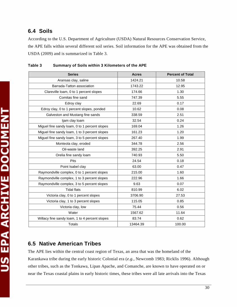
30
6.4 Soils According to the U.S. Department of Agriculture (USDA) Natural Resources Conservation Service,
the APE falls within several different soil series. Soil information for the APE was obtained from the
USDA (2009) and is summarized in Table 3.
Table 3 Summary of Soils within 3 Kilometers of the APE
Series Acres Percent of Total Aransas clay, saline 1424.21 10.58
Barrada-Tatton association 1743.22 12.95 Clareville loam, 0 to 1 percent slopes 174.66 1.30
Comitas fine sand 747.39 5.55 Edroy clay 22.69 0.17
Edroy clay, 0 to 1 percent slopes, ponded 10.62 0.08 Galveston and Mustang fine sands 338.59 2.51
Ijam clay loam 32.54 0.24 Miguel fine sandy loam, 0 to 1 percent slopes 169.04 1.26 Miguel fine sandy loam, 1 to 3 percent slopes 161.23 1.20 Miguel fine sandy loam, 3 to 5 percent slopes 267.40 1.99
Monteola clay, eroded 344.78 2.56 Oil-waste land 392.25 2.91
Orelia fine sandy loam 740.93 5.50 Pits 24.54 0.18
Point Isabel clay 63.00 0.47 Raymondville complex, 0 to 1 percent slopes 215.00 1.60 Raymondville complex, 1 to 3 percent slopes 222.96 1.66 Raymondville complex, 3 to 5 percent slopes 9.63 0.07
Tidal flats 810.99 6.02 Victoria clay, 0 to 1 percent slopes 3706.90 27.53 Victoria clay, 1 to 3 percent slopes 115.05 0.85
Victoria clay, low 75.44 0.56 Water 1567.62 11.64
Willacy fine sandy loam, 1 to 4 percent slopes 83.74 0.62 Totals 13464.39 100.00
6.5 Native American Tribes The APE lies within the central coast region of Texas, an area that was the homeland of the
Karankawa tribe during the early historic Colonial era (e.g., Newcomb 1983; Ricklis 1996). Although
other tribes, such as the Tonkawa, Lipan Apache, and Comanche, are known to have operated on or
near the Texas coastal plains in early historic times, these tribes were all late arrivals into the Texas

31
region, having moved southward from the Great Plains as horse-mounted hunter gatherers during the
17th and 18th centuries (Newcomb 1961; Campbell 1988). The Karankawa, who were the sole
known indigenous Native group that occupied the coastal shoreline zone between the Galveston Bay
area and Baffin Bay, lived within a narrow strip of territory that extended from the Gulf of Mexico
shoreline to approximately 40 km (25 mi) inland. This area included the prairie margins next to the
coastline. Thus, the Karankawa are the only Native American tribal group that can be inferred to be
represented by prehistoric archaeological materials within the central Texas coast region.
The Karankawa were an ethnically and linguistically distinct, non-agricultural, hunter-gatherer-fisher
people who subsisted through a combination of intensive fishing in the coastal bays and lagoons and
hunting of game, most importantly white-tailed deer and bison, that inhabited the terrestrial
environment of the coastal prairies. The Karankawa also gathered a wide range of plant foods that
were available along the shorelines, the moist floodplains of streams, as well as on the level prairies
between stream valleys.
The Late Prehistoric Rockport phase, dated to 1300 to 1700 A.D., and identifiable on the basis of an
artifact assemblage consisting of diagnostic lithic and ceramic artifact types, is recognized as the
archaeological expression of the indigenous Karankawa culture (see Ricklis 1996). Rockport phase
sites are abundantly documented in the Corpus Christi area, and published examples are reported
from around 4 km (2.5 mi) northwest of the FHR property (e.g., the McKinzie site, 41NU221
[Ricklis 1988] and the Allison site, 41NU185 [Carlson et al. 1982]). These findings show that the
FHR property is within the traditional homeland of the Karankawa.
During the Colonial period of the 18th Century and the first two decades of the 19th Century, the
Karankawa had an alternating peaceful and confrontational relationship with the Spanish missions
established on the coastal prairies of Texas (Ricklis 1996). The Karankawa were initially interested
in entering the mission of Espíritu Santo, established in 1722 on Garcitas Creek in Victoria County,
but relations between the Spanish personnel and the Karankawa took an abrupt turn for the worse in
1726, and the Karankawa abandoned the mission. A new mission for the Karankawa, Nuestra Señora
del Rosario, was established at Goliad in 1756 (Bolton 1915), which the tribe frequented and
occupied until its closing in 1806. The mission of Nuestra Señora del Refugio was also set up for the
Karankawa in 1795, and many of the Karakawas lived and worked there until its eventual closing in
1830. During the first three decades of the 19th Century, the Karankawa underwent a significant
degree of acculturation to Spanish Colonial lifeways, learning to herd cattle and weave cotton
blankets. Additionally, many of the Karankawa converted to Christianity (Ricklis 1996). However,

32
with the independence of Mexico and the demise of the Spanish empire in the New World after 1820,
the Karankawa homeland was thrown open to aggressive Mexican and Anglo-American settlement.
During the decades between 1820 and 1850, and especially after 1836 when Texas became
independent of Mexico, the incursion of American settlers and ranchers onto the Texas coastal
prairies resulted in the extirpation of the Karankawa. They were either driven south of the Rio
Grande into Mexico or were absorbed into the emerging ranching economy. By the 1850s, the
Karankawa tribe ceased to exist as a recognizable cultural and ethnic entity (Himmel 1999; Ricklis
1996).
A long sequence of pre-Karankawa human occupation has been documented for the central Texas
coastal region. Scattered surface finds of diagnostic stone dart points indicate the presence of early
peoples during Paleo-Indian times, 11,000 to 7,000 B.C. Following the Paleo-Indian period, a long
continuum of Archaic occupation has been documented and radiocarbon dated for the area of the
lower Nueces River valley and estuary of Nueces and Corpus Christi Bays (Ricklis 2004). Early
Archaic occupation, dated to 5500 to 4800 B.C. is marked by oyster-shell middens at sites in the
area, including Site 41NU266 on the presently undeveloped northwestern portion of the FHR
property (Ricklis et al. 1995). Middle Archaic sites are scattered along the lower Nueces River and
the northern shoreline of Nueces Bay. These sites, which are dated to 4000 to 2500 B.C. consist of
shell middens dominated by valves of the brackish-water clam (Rangia flexuosa), containing
chipped-stone dart points of the Bell, Tortugas, and Early Triangular types (see Turner et al. 2011 for
type definitions), scraping and cutting tools, perforated oyster shells (probable net weights), and
otoliths of marine fishes such as black drum (Pogonias cromis), redfish (Sciaenops ocellata),
speckled sea trout (Cynoscion nebulosis), and Atlantic croaker (Micropogon undulatus).
The Late Archaic period, 1000 BC–1000 A.D. saw the deposition of much larger and thicker shell
middens than during earlier millennia (Ricklis 2004). Along with a marked increase in the numbers
and varieties of artifacts found in archaeological contexts of this period, this change suggests a
growing coastal population. A dramatic increase in the densities of fish bones and otoliths on Late
Archaic sites indicates an intensification of fishing as an economic mainstay during this period, a
trend which was to continue into the Late Prehistoric Rockport phase that began 1250 to 1300 A.D.
Commonalities in artifact forms (esp. certain shell tool types and the use of natural asphaltum beach
tar for lining basketry and, later, ceramic containers) and settlement patterns (preferred campsite
locations plus patterns of seasonal occupation; see Ricklis 1992, 1996) between the Rockport phase
and the Late Archaic period strongly suggest that the Rockport phase (and by extension, Karankawa
culture) developed largely in situ from the regional Late Archaic culture.

33
With the dissolution of the Karankawa tribe by the 1850s, the long continuum of Native American
occupation of the Texas coastal zone came to an end. As this Native American group is extinct,
consultation with this tribe is not possible or warranted. There are no other known Native American
tribes that inhabited the APE, which is within the limits of what was the coastal-zone territory of the
Karankawa (see Ricklis 1996).
34
7.0 Resource Inventory for the APE
This section summarizes the review completed under Section 106. FHR used the services of the
cultural resource management firm (CRM) of TRC, to conduct the work required under NHPA
Section 106. The TRC PIs, Robert A. Ricklis, Ph.D. and J. Michael Quigg, are qualified individuals
who meet the Secretary of the Interior’s qualification standards (Secretary of the Interior’s general
guidance; USDOI, 1983) and have demonstrated familiarity with the range of potentially historic
properties/cultural resources that may be encountered, and their characteristics.
The three primary goals of the review were:
1. To locate and record historic properties occurring within the designated project area.
2. To provide a preliminary assessment regarding the potential of these properties for inclusion in
the NRHP.
3. To make recommendations for the treatment of these resources based on their NRHP
assessments.
For the entire APE, goal number 1 was accomplished by means of a review of documentation on file
at the THC online Texas Historical Sites Atlas (THS Atlas), Texas Archaeological Sites Atlas (TAS
Atlas) and reconnaissance survey. For the portion of the APE within the existing equipment,
operations, and maintenance areas, no additional survey (steps associated with goals 2 and 3) was
required. For the parking lot area, goal 2 was accomplished through intensive survey (shovel tests).
The shovel tests did not result in the identification of any cultural resources. Additionally, the shovel
tests revealed such extensive previous disturbance in the area that any cultural resources that may
have once been present in the area are unlikely to be eligible for listing on the NRHP. Based on these
findings, steps associated with goal 3 were not necessary for the parking lot area. The review process
and these conclusions are described in more detail below.
7.1 Overarching Standards As set out in Section 5.0 of this report, the cultural resources review was completed to fulfill the
requirements of NHPA Section 106. The appropriate standard of review, as required by both federal
and state regulation, is described below.

35
7.1.1 Federal Regulation ACHP regulations require that, in carrying out a cultural resources review, a reasonable and good
faith effort is made to identify cultural resources. ACHP’s guidance for meeting the reasonable and
good faith effort standard begins with the following (36 CFR Section 800.4):
• Determine and document the APE in order to define the area to review for historic properties
(cultural resources)
• Review existing information on known and potential historic properties (cultural resources)
within the APE
• Seek information from appropriate parties regarding the historic properties (cultural
resources) in the area
The ACHP considers the following factors in evaluating the adequacy of the historic properties
identification (cultural resources review) effort:
• Identification effort was reasonable Involves confirming the assessment was designed to identify eligible properties that may be
affected by the undertaking, without being excessive or inadequate. While, for some
circumstances it may be appropriate to identify all historic properties (cultural resources) in the
APE, the regulations do not require the identification of all properties. A reasonable identification
plan includes:
o Documentation of the horizontal and vertical extent of the APE that accounts for
direct and indirect effects
o Explanation of factors that inform the content and intensity of the plan (e.g., past
disturbance in area, magnitude and anticipated effects on historic properties (cultural
resources) that might exist in APE, etc.)
o Review of existing information on historic properties (cultural resources) in the APE,
including information about possible historic properties (cultural resources) not yet
identified
o Cognizance of applicable professional, state, tribal, and local laws, standards, and
guidelines
o Familiarity with the methodologies used in other historic property (cultural resource)
surveys for industrial and non-industrial sites in the area that have been effective in
terms of time and cost

36
o A clear description of the steps that will be taken during field investigations, analysis
of results, and in subsequent reporting and consultation, to determine the presence of
historic properties (cultural resources) within the APE
• Identification effort was carried out in good faith The assessment is deemed to be carried out in good faith when it meets the following criteria:
o Consultation was conducted with the appropriate entities (e.g., SHPO, THPO and
Indian Tribe or similar) with religious and culturally important historic properties
(cultural resources) within the APE
o Initiated in a timely manner allowing for the appropriate analysis and reporting, with
adequate time for review by the consulting parties
o Completed by a qualified individual or individuals who meet the Secretary of the
Interior’s qualification standards and have demonstrated familiarity with the range of
potentially historic properties (cultural resources) that may be encountered, and their
characteristics
o Acknowledges the special expertise possessed by Indian tribes and Native Hawaiian
organizations in assessing the eligibility of historic properties (cultural resources) that
may possess religions and cultural significance to them
o Is fully supported by adequate funding and other necessary resources
o Is not compromised by lack of integrity or omission, such as manipulating or ignoring
the evidence
Additionally, ACHP’s guidance for meeting the reasonable and good faith effort standard for the
identification of properties outlines what is not required to the meet the standard:
• SHPO/THPO approval is not required. SHPO/THPO is an adviser in the identification
process but they do not provide approval
• The identification of every historic property is not required
• Investigations outside of, or below, a properly documented APE are not required
• Ground verification of the entire APE is not required
7.1.2 State Regulation THC requirements incorporate NHPA Section 106. The State of Texas has additional archaeological
survey requirements. The details of the state requirements are identified in the following sections,
where applicable (e.g., methodologies for the intensive investigation for parking lot).
37
7.2 Methodology for the Project The limits of the ground disturbance associated with the Project are confined to the proposed Project
areas within the FHR property that includes the existing equipment, operations and maintenance
areas of the West Refinery and the parking lot area (Figure 3). These areas represent the APE
(approximately 920 acres) (Figure 4). There are no external facilities planned as part of the Project
(e.g., transmission lines, access roads, and pipelines).
The following sections outline the methodology TRC implemented for the cultural resources review.
For discussion purposes, the APE is addressed in two separate sections: the area contained within the
existing equipment, operations and maintenance areas of the West Refinery (the industrial portion),
and the parking lot area.
7.2.1 Methodology for Industrial Portion of the Project The following information describes the cultural resources review methodology applied to the
industrial portion of the APE (i.e., the area of the APE within the existing equipment, operations and
maintenance areas of the West Refinery). This review consisted of archival research and a
reconnaissance survey.
For the industrial portion of the Project within the main refinery operations area, FHR determined
that subsurface investigations were not necessary. The West Refinery is an existing industrial use
area that has previously experienced extensive disturbance, including development of the existing
refinery structures/infrastructure as well as placement of caliche, gravel, and asphalt roadbase. The
extent of disturbance is estimated to be within the range of disturbance that the Texas SHPO
associates with industrial sites [typically subsurface disturbance within the range of 1 to 6 meters (3
to 20 ft)]. Past investigations within and near the APE, reviewed by the Texas SHPO, demonstrate
that the Texas SHPO limits the archaeological deposits in this area to the soil horizons of the
Holocene Period (11,700 BP to present). In the project area, these soils are located within the top 1 m
(3 ft) of soil and overlay Pleistocene deposits that predate human occupation of the area (Ricklis et
al. 1995). Acknowledging that the Texas SHPO recognizes that subsurface investigations are not
practical or necessary (previous industrial disturbance coincides with the soil horizons known to
potentially contain archaeological deposits), no subsurface investigations were carried out by TRC.
Additionally, in light of the extensive subsurface infrastructure associated with industrial sites such
as refineries, the Texas SHPO recognizes the significant safety risk that would be associated with
subsurface investigations.
38
7.2.1.1 Archival Research
The methodology for the archival research was based on the archaeological survey standards for
Texas developed by THC (Texas Administrative Code, Rules of Practice and Procedure, Title 13,
Part 2, Chapter 26 Subpart B and Subpart C), the Council of Texas Archaeologists (CTA) Guidelines
for Cultural Resources Management Reports, and the ACHP guidelines for meeting the reasonable
and good faith identification standards for Section 106 review. Archival research included review of
the THS Atlas, TAS Atlas and published reports, as described below.
7.2.1.1.1 Texas Archaeological Sites (TAS) Atlas File Search
On behalf of FHR, TRC PIs completed a review of the TAS Atlas for the Project’s entire APE. In
fact, TRC reviewed an area broader than the APE, extending to a radius of 3 km (1.9 mi) from the
APE.
Within 3 km (1.9 mi) of the APE, 23 sites were identified using the TAS Atlas (THC 2012).These
sites are summarized in Table 4 with their locations provided on Figure 5. Sites are identified by a
trinomial record number which includes the numerical prefix “41,” which stands for the State of
Texas, the county abbreviation “NU” (for Nueces County), and the number assigned to each site. The
location of the historic nineteenth-century community of Nuecestown is also shown near the western
limits of Figure 5.
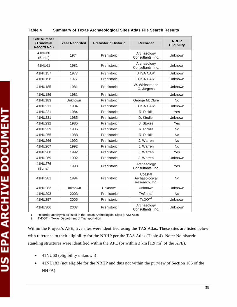
39
Table 4 Summary of Texas Archaeological Sites Atlas File Search Results
Site Number (Trinomial
Record No.) Year Recorded Prehistoric/Historic Recorder NRHP
Eligibility
41NU60 (Burial)
1974 Prehistoric Archaeology Consultants, Inc. Unknown
41NU61 1981 Prehistoric Archaeology Consultants, Inc. Unknown
41NU157 1977 Prehistoric UTSA CAR1 Unknown 41NU158 1977 Prehistoric UTSA CAR1 Unknown
41NU185 1981 Prehistoric W. Whitsett and C. Jurgens Unknown
41NU186 1981 Prehistoric Unknown 41NU183 Unknown Prehistoric George McClure No 41NU211 1984 Prehistoric UTSA CAR1 Unknown 41NU221 1984 Prehistoric R. Ricklis Yes 41NU231 1985 Prehistoric D. Kindler Unknown 41NU232 1985 Prehistoric J. Stokes Yes 41NU239 1986 Prehistoric R. Ricklis No 41NU255 1988 Prehistoric R. Ricklis No 41NU266 1992 Prehistoric J. Warren No 41NU267 1992 Prehistoric J. Warren No 41NU268 1992 Prehistoric J. Warren Yes 41NU269 1992 Prehistoric J. Warren Unknown 41NU276 (Burial)
1993 Prehistoric Archaeology Consultants, Inc. Yes
41NU281 1994 Prehistoric Coastal
Archaeological Research, Inc.
No
41NU283 Unknown Unknown Unknown Unknown 41NU293 2003 Prehistoric TAS Inc.1 No 41NU297 2005 Prehistoric TxDOT2 Unknown
41NU306 2007 Prehistoric Archaeology Consultants, Inc. Unknown
1 Recorder acronyms as listed in the Texas Archeological Sites (TAS) Atlas 2 TxDOT = Texas Department of Transportation
Within the Project’s APE, five sites were identified using the TAS Atlas. These sites are listed below
with reference to their eligibility for the NRHP per the TAS Atlas (Table 4). Note: No historic
standing structures were identified within the APE (or within 3 km [1.9 mi] of the APE).
• 41NU60 (eligibility unknown)
• 41NU183 (not eligible for the NRHP and thus not within the purview of Section 106 of the
NHPA)

40
• 41NU232 (eligible)
• 41NU 239 (not eligible for the NRHP and thus not within the purview of Section 106 of the
NHPA)
• 41NU276 (eligible)
Of these five sites, two sites were identified as not eligible for the NRHP. The following paragraphs
describe the potential for effects to the remaining three sites based on the TAS Atlas (THC 2012).
The locations of the three sites that are eligible or potentially eligible for the NRHP within the APE
are shown on Figure 6.
• 41NU60 (eligibility unknown)
Site 41NU60 has been identified within the APE as a site for which NRHP eligibility has not
been determined (i.e., for which additional information would be needed to determine
eligibility). Data on file with the TAS Atlas indicates that this site is now buried under
modern fill and covered by a roadway within the West Refinery property. The nearest
elements of the Project relative to site 41NU60 are at least 365 to 457 m (1,200 to 1,500 ft)
from the archaeological site. Due to the distance from the proposed activities, no effect is
anticipated to result from the Project.
• 41NU232 (eligible)
Site 41NU232 has been identified within the APE as a site eligible for the NRHP. The nearest
elements of the Project relative to site 41NU232 are greater than 457 m (1,500 ft) from the
archaeological site. Due to the distance from the proposed activities, no effect is anticipated
to result from the Project.
• 41NU276 (eligible)
Site 41NU276 has been identified within the APE as a site eligible for the NRHP. Site
41NU276 is located at the margin of the built-up area of the West Refinery (Figure 5), which
has been disturbed by machinery activity. The nearest elements of the Project relative to site
41NU276 are 152 to 305 m (500 to 1,000 ft) from the archaeological site. Due to the distance
from the proposed activities, no effect to site 41NU276 is anticipated to result from the
Project.
41
While these three sites were identified in the TAS Atlas review as eligible or potentially eligible for
listing in the NRHP, the proposed Project will have no effect on these sites due to their distance from
the proposed Project activities.
7.2.1.1.2 Published Reports
The following information was obtained from published reports on cultural resources, archaeological
surveys, and investigations at relevant sites conducted by professional archaeologists. The
information was considered as part of the analyses of the data retrieved from the TAS Atlas.
The APE is situated along an upland margin that is identified by an east-west trending series of low
hills and swales created by erosion of the valley wall along the southern edge of the Nueces River
floodplain. Numerous prehistoric archaeological sites have been recorded on the tops and upper
slopes of these hills (Figure 5). Subsurface archaeological excavations and reports have been
completed for six sites (41NU185, 41NU221, 41NU266, 41NU267, 41NU268, and 41NU276) (e.g.,
Carlson et al. 1982; Ricklis 1988; Ricklis et al. 1995).
Aboriginal occupation sites in the area are recognizable as dense accumulations of shells of various
estuarine bivalve species, most commonly oyster (Crassostrea virginica) and brackish-water clams
(Rangia flexuosa and Rangia cuneata). Testing at numerous sites in this area, as well as along the
northern shoreline of Nueces Bay (Ricklis 1993; Ricklis et al. 1995), has shown that Early Archaic
period (7500 to 6800 B.P.) strata and components are dominated by oyster, whereas Middle Archaic
(6000 to 4500 B.P.) components yield predominantly Rangia flexuosa, and deposits pertaining to the
Late Archaic (3000 to 1000 B.P.) and Late Prehistoric (after 1000 B.P.) are characterized
predominantly by Rangia cuneata. Artifacts are scarce in the Early Archaic components, consisting
for the most part only of scattered pieces of chert debitage (Ricklis 1993; Ricklis et al. 1995).
Components of this period consist of thin oyster-shell strata consistently resting at/near the bases of
the Holocene soil profiles (e.g., at sites 41SP136 and 41SP153 on the north shore of Nueces Bay and
sites 41NU281 and 41NU266 on the upland margins along the southern edge of the lower Nueces
River floodplain, with site 41NU266 on FHR property just west of the APE; see Figure 5).
Middle Archaic components have yielded a more diverse artifact assemblage that includes chipped-
stone dart points of types known to pertain to this time interval, chert-end scrapers, and a limited
range of shell tools (e.g., Ricklis 1988; Ricklis and Gunter 1986). The increased quantity and
diversity of tools left by Middle Archaic people suggests an increased intensity of shoreline
occupation during this period. This trend was maintained during the Late Archaic, though by Late

42
Prehistoric times the largest and most artifact-prolific sites representing the base camps of relatively
large aggregate groups were situated in more seaward shoreline settings (Ricklis 1996).
The sedimentological context of culturally relevant deposits is similar in all of these sites. Generally,
cultural components, which, as noted, are discrete strata of densely packed shells, have been found to
rest within slowly aggraded Holocene cumulic soils that have developed through eolian deposition of
clay, silt, and fine sand upon the substrate of the Pleistocene Beaumont clays. Commonly, Early
Archaic shell deposits rest at the base of these soils, directly upon the Beaumont surface, while
Middle Archaic and later deposits are found higher in the soil profiles. Typically, the profiles are 1 m
(3 ft) or less in thickness, so that the entire culture sequence is represented by materials found within
1 m (3 ft) or less of the modern ground surface.
In addition to the camp sites of the Archaic and Late Prehistoric periods, three prehistoric Native
American mortuary/cemetery sites are also known and recorded in the area. These include site
41NU178, a Late Prehistoric cemetery site located 5 to 6 km (3.1 to 3.7 mi) west-northwest of the
West Refinery area, and sites 41NU60 and 41NU276, located on FHR property. Site 41NU60 is
currently buried under fill and a road, while site 41NU276 has been heavily disturbed by machinery
activity and is at the margin of the built-up area of the West Refinery (Ricklis et al. 1995). Neither of
these sites coincides with the area of direct construction, operations, and maintenance of the Project.
7.2.1.2 Survey Methods
On December 21, 2012 TRC completed a reconnaissance survey of the industrial portion of the APE,
specifically the locations identified in Appendix B (corresponding with photographed locations).
Reconnaissance survey refers to a pedestrian or visual survey of a project area that does not include a
systematic methodology such as consistently spaced transects. The reconnaissance survey was
conducted to assess the potential for the industrial portion of the APE to include intact archaeological
deposits. The following conclusions were made based on the reconnaissance survey.
• Other than the sites identified in the archival research, it is unlikely that there are any other
cultural resources in the industrial portion of the APE eligible or potentially eligible for
listing on the NRHP. This area has been extensively developed and disturbed in the past. As a
result, any potential cultural resources once present in the area are unlikely to be of sufficient
quantity to quality as an “eligible” or “potentially eligible” cultural resource.
• Shovel tests were not deemed necessary for the industrial portion of the APE due to the
extensive previous disturbance associated with the West Refinery. This decision was based

43
on the presence of existing buildings, facilities, and underground utilities present within the
industrial site and the estimated soil disturbance depth of 1 to 6 m (3 to 20 ft) below the soil
surface. It is known that potential archaeological deposits in the area are limited to the
Holocene Period soil horizons, which are located within the top 1 m (3 ft) of soil (Ricklis et
al. 1995).
• THC has recognized the safety concern and risk associated with subsurface investigations on
industrial sites as a result of subsurface infrastructure associated with the industrial use.
ACHP guidelines for meeting the reasonable and good faith standards for identifying cultural
resources note that the regulations do not require the identification of all cultural resources. Based on
this information, the methods used during the review and investigation by TRC meet the standards
put forth by ACHP and THC. These methods ensure that a reasonable and good faith effort was made
to identify historic properties/cultural resources, including archaeological deposits, to the greatest
extent practicable.
7.2.2 Methodology for Parking Lot Area The following information outlines the methodology applied to the parking lot area of the APE,
which encompasses approximately 33 acres. The review was completed consistent with the
overarching regulatory standards summarized in Section 5.0.
7.2.2.1 Archival Research
The archival research referenced in Section 7.2.1.1 included the parking lot area.
7.2.2.2 Survey Methods
Since the parking lot is not contiguous with the previously disturbed West Refinery property (i.e., the
industrial portion of the APE) TRC’s survey approach to the parking lot area of the APE was
completed as follows.
7.2.2.2.1 Pedestrian Survey
TRC completed a pedestrian survey during the week of August 12 to 15th, 2013. TRC documented
that all surfaces of the parking lot area portion of the APE appeared to have been previously
extensively disturbed and altered in recent history, with low grass and mixed disturbed forbs
covering the site.
44
7.2.2.2.2 Shovel Tests
TRC recommended conducting shovel tests for the parking lot area of the APE because no prior
investigations had occurred.
The results of the shovel tests confirmed that the parking lot area was heavily disturbed by past
agricultural, residential, institutional and utility land uses. The shovel tests were completed at 1.06
shovel tests/acre. THC and the CTA standards and guidelines recommend a minimum of one shovel
test for every 2 acres (0.5 shovel tests/acres) for project areas ranging in size from 11 to 100 acres
(THC 2013). Based on these standards and guidelines, TRC exceeded the minimum shovel test
density requirement as put forth by THC and CTA.
In general, shovel tests were roughly 35 cm in diameter, and excavated to a depth of between 16 and
98 cm below ground surface (cmbs). All shovel tests were excavated to near 100 cmbs or until pre-
Holocene deposits or an impenetrable layer was encountered. In some locations, there was noted
disturbance such as disturbance from past agricultural activities or installation of buried utilities. In
these locations, shovel tests were excavated to just below the depth at which adjacent shovel tests
had encountered pre-Holocene deposits to ensure no intact deposits were left beneath the disturbed
area.
The maximum depth of the proposed impacts in the parking lot area is expected to be less than 100
cmbs. Soils differed throughout the parking lot area, but the majority of the soils consisted of hard to
extremely hard clay which was difficult to screen. In these cases, the hard, compacted clay was
crushed through the screens, and then picked through to inspect for cultural materials. A small
percentage of the parking lot area consisted of sandy or loamy soils which were screened more
easily. Shovel test data, including the size and depth of the hole, soil conditions, if soils were
screened, and any materials observed, was recorded on TRC shovel test forms.
No archaeological materials were discovered. As with the industrial area, it is possible that
archaeological deposits are present in areas not surveyed; however, the level of disturbance indicates
that the resources would not retain the necessary integrity for eligibility to the NRHP.
ACHP guidelines for meeting the reasonable and good faith standards for identifying historic
properties/cultural resources note that the regulations do not require the identification of all historic
properties/cultural resources. The methods used during this review and investigation meet the
standards put forth by ACHP and THC. These methods ensure that a reasonable and good faith effort
was made to identify historic properties/cultural resources to the greatest extent practicable.

45
7.3 Unanticipated Discoveries Plan Pursuant to the regulatory requirement of Section 106 of the NHPA, and its implementing regulation
36 CFR Part 800 (as amended), the following Unanticipated Discoveries Plan has been developed
identifying the procedures to follow in case of a post-Section 106 review cultural resource discovery.
The plan is in accordance with 36 CFR Part 800.13.
The purpose of this plan is to provide guidance to employees and contractors of FHR in the event
that cultural or archaeological materials are encountered during modifications to the West Refinery.
The plan has been developed so that FHR can:
• Ensure compliance with the applicable state and federal laws and regulations, including 36
CFR Part 800 (as amended) under Section 106 of the NHPA
• Convey to regulatory and review agencies the procedures that will be followed in the event of
an unanticipated discovery
• Provide project personnel with the procedures to be followed if an unanticipated discovery
occurs
Discovered cultural or archaeological materials could include human remains, prehistoric artifacts
(projectile points, stone tools, stone flakes, pottery, animal bones etc.), or historic artifacts (materials
suspected to be more than 50 years old). Archaeological materials could also include stained areas of
soil, charcoal, charred materials, and burned stone or bones. All discoveries of cultural or
archaeological materials are to be considered confidential in order to protect the integrity of the
materials. The media will not be contacted under any circumstances.
If human remains are discovered during project work, the following procedures will be followed:
• If any FHR employee, contractor, or subcontractor suspects that they have encountered any
human remains, all work adjacent to the discovery should cease. The FHR employee in
charge of the work is responsible for notifying the FHR Environmental Manager.
• The FHR Environmental Manager will determine the extent of the discovery and secure the
area to prohibit access. Access will be restricted to law enforcement personnel, THC staff,
and the FHR cultural resource consultant(s).
• The FHR Environmental Manager will immediately contact the Nueces County Sheriff’s
Department, the THC, and the FHR cultural resource consultant(s). Access will be restricted
to law enforcement personnel, THC staff, and the FHR cultural resource consultant(s).
46
• Nueces County Sheriff’s Department, the THC, and the FHR cultural resource consultant(s)
will work together to determine the ethnic origin or ancestry of the remains. If the remains
are determined to be of Native American ancestry, the THC will be consulted to determine
the appropriate Native American tribal contact(s).
If cultural or archaeological materials are discovered during project work, the following procedures
will be followed:
• If any FHR employee, contractor, or subcontractor suspects that they have encountered any
cultural or archaeological materials, all work adjacent to the discovery should cease. The
FHR employee in charge of the work is responsible for notifying the FHR Environmental
Manager.
• The FHR Environmental Manager will determine the extent of the discovery and secure the
area to prohibit access.
• The FHR Environmental Manager will arrange for a qualified archaeologist or cultural
resource specialist to evaluate the discovery. If the discovery is determined to be a potentially
NRHP-eligible resource, the THC will be consulted to assist in determination of the NRHP
eligibility of the discovery and procedures to avoid, minimize, or mitigate impacts.
Contacts: Texas Historical Commission 1511 Colorado Street Austin, TX 78101 Phone: 512.463.6100 Nueces County Sheriff’s Department 901 Leopard St #200 Corpus Christi, TX 78401 Phone: 361.887.2222
47
8.0 Effects of Action
Based on archival research, including data retrieved from the THS Atlas, TAS Atlas and review of
the information available in published reports on cultural resources, archaeological surveys, and site
investigations (e.g., pedestrian survey of the parking area), the TRC PIs’ (R. Ricklis and M. Quigg)
have provided a concise characterization of the cultural an d geoarchaeological nature of
archaeological sites that are situated within and around the APE.
As addressed in this CRA, there is no evidence of historic properties or structures that might pertain
to Colonial or post-Colonial era occupations. Included in this review was an inventory of any listed
NRHP or Districts, cemeteries, State Historical Markers, shipwrecks, historic buildings, or structures
within the APE. In summary, no historic properties or architectural resources (historic structures)
were identified within the APE or within 3 km (1.9 mi) of the APE.
Archival research identified three archaeological sites within the APE that are considered eligible or
potentially eligible for the NRHP. It is the TRC PIs’ professional conclusion that, due to their
distance from the construction, operations, and maintenance activities associated with the Project,
none of these sites will be directly affected by the Project. Additionally, as a result of extensive
previous ground disturbance throughout the APE, any potential unidentified archaeological deposits
are unlikely to be of sufficient quality to be eligible or potentially eligible for the NRHP and thus,
would not be within the purview of Section 106 of the NHPA.
Project-related operations and structures are similar to existing operations and structures and are
consistent with the overall character of the refinery. Local and regional traffic, noise, and viewshed
qualities will not change as a result of the Project. In addition, no indirect effects from air emissions
or wastewater discharges are expected to be associated with the Project. Therefore, no indirect effects
are expected to be associated with the Project.
In accordance with 36 C.F.R. § 800.4, FHR has made a reasonable and good faith effort to identify
historic properties/cultural resources within the APE and to assess if these properties will be affected
by the Project. FHR has determined that no historic properties or archaeological sites will be directly
or indirectly affected by the Project.
48
9.0 Summary and Conclusion
USEPA’s issuance of a GHG PSD permit for the West Refinery Domestic Crude Project will result in
no direct or indirect effects to any historic properties or archaeological sites for purposes of Section
106 of the NHPA.
10.0 List of Preparers
Barr Engineering Company
Courtnay Bot, Senior Environmental Scientist; B.S. Civil/Environmental Engineering,
Environmental Science and Geology
Cliff Twaroski, Senior Environmental Scientist, M.S. Forest Management
Josh Vosepjka, GIS Specialist
TRC Environmental Corporation
Robert Ricklis, TRC Environmental Corporation, Principal Investigator – CRA report contributions
Ph.D., Department of Geography, The University of Texas at Austin, 1990 (emphasis in historical
cultural ecology/human-ecological archaeology)
M. A., Department of Anthropology (Archaeology), The University of Texas at Austin, 1986
B. A., Anthropology (emphasis in Archaeology), The University of Wisconsin, Madison, 1970
Mike Quigg, TRC Environmental Corporation, Principal Investigator – CRA reference resource
compilation
M.A. Archaeology, The University of Calgary, 1973
B.A. Anthropology, University of Northern Colorado, 1971
11.0 References
NOTE: USEPA Region 6 staff is requiring that electronic copies of all references be provided to them as
part of the BE submittal and the Section 7 ESA consultation process. Therefore, to fulfill the
requirement of the ESA-BE review process and the Section 7 consultation, FHR and Barr
Engineering will be providing the following references to USEPA Region 6 with the expectation
that USEPA Region 6 will comply with all applicable copyright and intellectual property
protection requirements.
36 CFR 800 Protection of Historic Properties
ACHP (Advisory Council on Historic Preservation). Meeting the “Reasonable and Good Faith” Identification Standard in Section 106 Review [Internet]. Available at http://www.achp.gov/docs/reasonable_good_faith_identification.pdf
———.2009. Section 106 Archaeology Guidance. Available at: http://www.achp.gov/archguide
Barr (Barr Engineering Co.). 2013a. Endangered Species Act Biological Evaluation. Flint Hills Resources Corpus Christi, LLC. Corpus Christi Texas. In support of West Refinery Domestic Crude Project Permit Application.
———. 2013b. Essential Fish Habitat Assessment. Flint Hills Resources Corpus Christi, LLC. Corpus Christi Texas. In support of West Refinery Domestic Crude Project Permit Application.
Bolton HE. 1915.Texas in the Middle Eighteenth Century: Studies in Spanish Colonial History and Administration. Berkeley (CA): University of California Press.
Brown LF, Brewton JL, McGowen JH, Evans TJ, Fisher WL, and Groat DG. 1976. Environmental Geologic Atlas of the Texas Coast: Corpus Christi Area. Bureau of Economic Geology. The University of Texas at Austin.
Campbell TN. 1988. The Choahuiltecans and Their Neighbors. In The Indians of Southern Texas and Northern Mexico: Selected Writings of Thomas Nolan Campbell. Texas Archeological Research Laboratory, The University of Texas, Austin.
Carlson D, Steele G, and Bruno H. 1982. Archeological Investigations at the Allison Site (41NU185), Nueces County, Texas. Reports of Investigations No. 1, Archeological Research Laboratory, Texas A&M University. College Station, Texas.
Council of Texas Archaeologists. Guidelines for Cultural Resource Management Reports. Available at http://www.thc.state.tx.us/public/upload/CTAguidelines.pdf
FHR (Flint Hills Resources). 2013. FHR facilities, Texas Facts. Available at http://www.fhr.com/upload/FHRTexasFacts.pdf

Griffith GE, Bryce SA, Omernik JM, Rogers AC. 2007. Ecoregions of Texas [Internet]. [cited 2012 Oct]. Available from: ftp://ftp.epa.gov/wed/ecoregions/tx/TXeco_Jan08_v8_Cmprsd.pdf.
Himmel KF. 1999. The Conquest of the Karankawas and the Tonkawas, 1821-1859. Texas A&M University Press, College Station.
Newcomb WW Jr. 1961. The Indians of Texas: From Prehistoric to Modern Times. Austin (TX): University of Texas Press.
———. 1983. Karankawa. In: Handbook of North American Indians, Volume 10, Southwest, editedby A. Ortiz, pp. 359-367. Washington D. C.: Smithsonian Institution,
Port of Corpus Christi. 2013. The History of the Port of Corpus Christi:1926-2001 [Internet]. [cited 2013 Nov 13]. Available from: http://www.portofcorpuschristi.com/index.php/general-information-155/statistics/yearly-statistics
Ricklis RA. 1988. Archeological Investigations at the McKinzie Site (41NU221), Nueces County, Texas: Description and Contextual Interpretations. Bulletin of the Texas Archeological Society 58:1-76.
———. 1992. Aboriginal Karankawan Adaptation and Colonial Period Acculturation: Archeological and Ethnohistorical Evidence. Bulletin of the Texas Archeological Society 63:211-243.
———. 1993. A Model of Holocene Environmental and Human Adaptive Change on the Central Texas Coast: Geoarchaeological Investigations at White's Point, Nueces Bay, and Surrounding Area. Coastal Archaeological Studies, Inc., Corpus Christi.
———. 1996. The Karankawa Indians of Texas: An Ecological Study of Cultural Tradition and Change. University of Texas Press, Austin.
———. 2004. Prehistoric Occupation of the Central and Lower Texas Coast: A Regional Overview. In The Prehistory of Texas, edited by T. K. Perttula, editor, pp. 155-180. College Station (TX): Texas A&M University Press.
Ricklis RA and Gunter RR. 1986. Archaeological Investigations at the Means Site (41NU184), Nueces County, Texas. La Tierra 13(1):15-31.
Ricklis RA and. Blum MD. 1997. The Geoarchaeological Record of Holocene Sea Level Change and Human Occupation of the Texas Gulf Coast. Geoarchaeology 12(4):287-314.
Ricklis, RA, Blum MD, Durbin J, Goldberg P, Gryder D, and Jones J. 1995. Environmental and Human Adaptive Change on the Nueces Bay Shoreline: Phase I Archaeological Data Recovery at Koch Refining Company Middle Plant, Nueces County, Texas. Coastal Archaeological Research, Inc., Corpus Christi.
Texas Administrative Code Title 13 Part 2 Chapter 26 Rules of Practice and Procedure for the Antiquities Code of Texas.
Texas Historical Commission. 2012. Texas Archeological Sites Atlas and Texas Historic Sites Atlas [Internet]. [cited 2012 Dec 18 to 28]. Available from: http://nueces.thc.state.tx.us/

———. 2013. Archeological Survey Standards for Texas. In: Council of Texas Archeologists [Internet]. Available at http://counciloftexasarcheologists.org/wordpress/wp-content/uploads/surveystandards.pdf
TPWD (Texas Parks and Wildlife Department). 2000. Nueces River Tidal TNRCC segment 2101 [Internet]. Available from: http://www.tpwd.state.tx.us/publications/pwdpubs/pwd_rp_t3200_1059f/media/nueces_tidal.pdf
Thomas MA and Anderson JB. 1994. Sea-Level Controls on Facies Architecture of the Trinity/Sabine Incised-Valley System, Texas Continental Shelf. SEPM Special Publications No. 51, pp. 63-82.
Turner ES, Hester TR and McReynolds RL. 2011. Stone Artifacts of Texas Indians. Completely revised Third edition. London, New York: Taylor Trade Publishing.
USDA (U.S. Department of Agriculture), 2009. Web Soil Survey, Map – Farmland Classification (Spatial Data Updated 16 November 2004; Tabular Data Updated 26 October, 2009) [Online] http://websoilsurvey.nrcs.usda.gov/app/WebSoilSurvey.aspx. Accessed: October 2012.
USDOI (U.S. Department of the Interior). 1983. Secretary of the Interior’s Standards and Guidelines for Archaeology and Historic Preservation [Internet]. [Internet]. Available at http://www.cr.nps.gov/local-law/arch_stnds_0.htm
USEPA (U.S. Environmental Protection Agency). 2012. Level II Ecoregions of the Continental United States [Internet]. Available at: http://www.epa.gov/wed/pages/ecoregions/na_eco.htm#Level II.
USGS (U.S. Geological Survey). 2010. Annaville quadrangle, Texas (digital map). 1:24,000. 7.5 Minute Series. Washington D.C.: USGS, 2010. (obtained from: http://texashistory.unt.edu/ark:/67531/metapth209791/ : accessed September 09, 2013), University of North Texas Libraries, The Portal to Texas History, http://texashistory.unt.edu; crediting UNT Libraries Government Documents Department, Denton, Texas.) (map obtained online at: http://texashistory.unt.edu/ark:/67531/metapth209791/m1/1/?q=Annaville quadrangle)

Figures
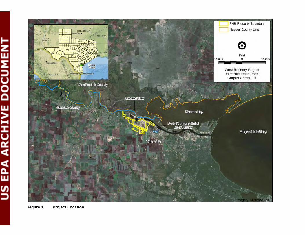
Figure 1 Project Location
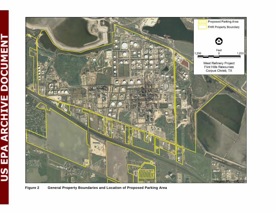
Figure 2 General Property Boundaries and Location of Proposed Parking Area
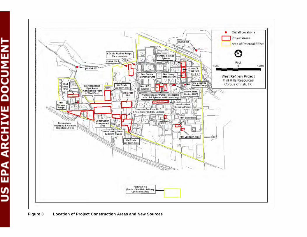
Figure 3 Location of Project Construction Areas and New Sources

Figure 4 Area of Potential Effect
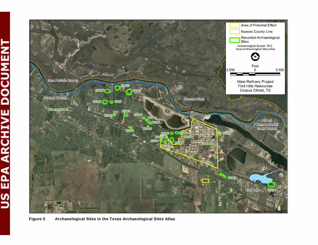
Figure 5 Archaeological Sites in the Texas Archaeological Sites Atlas

Figure 6 NRHP Eligible and Potentially Eligible Sites within the APE
Appendices

Appendix A
Project Description

A-1
Acronyms and Abbreviations API America Petroleum Institute
CCR continuous catalytic reformers
CO carbon monoxide
CO2e carbon dioxide equivalent
DDS distillate desulfurizer
DHT distillate hydrotreating unit
FCCU Fluid Catalytic Cracking Unit
FHR Flint Hills Resources Corpus Christi, LLC
GHG Greenhouse gases
GWP Global Warming Potential
GOHT Gas Oil Hydrotreating Unit
HHV High heating value
H2S Hydrogen sulfide
IFR Internal Floating Roof
LDAR Leak Detection and Repair
LPG Liquefied Petroleum Gas
MSS Maintenance Startup and Shutdown
NHT Naptha Hydrotreater
NOx Nitrogen oxides
NSR New Source Review
PM/PM10/PM2.5Particulate Matter / PM less than 10 microns in size / PM less than 2.5 microns in size
PSD Prevention of Significant Deterioration
Region 6 USEPA; encompasses Arkansas, Louisiana, New Mexico, Oklahoma, Texas and 66 Tribes
Sat Gas Saturates Gas
SCR Selective catalytic reduction
SO2 Sulfur dioxide
SRU Sulfur Recovery Unit
TCEQ Texas Commission on Environmental Quality
UDEX Universal Dow Extraction
USEPA U.S. Environmental Protection Agency
VOC Volatile organic compound
A-2
Units bbl barrels
dscf Dry standard cubic feet
ft feet
gr grain
hr hour
km kilometer
m meter
mi mile
MMBtu Million British Thermal Units
ppmv parts per million by volume
tpy tons per year
µg/m3 microgram per cubic meter
yr year

Project Description
FHR proposes to expand the West Refinery’s domestic crude oil processing capabilities and modestly
increase the total crude processing capacity with modifications to existing equipment and the
addition of new equipment. Information from the GHG PSD Permit Application and the Non-GHG
Permit Application is summarized as follows.
FHR is proposing to construct the following new emission units:
• A new process unit called the Saturates Gas (Sat Gas) Plant No. 3, including a new hot oil
heater and equipment piping fugitive components. The new hot oil heater will be equipped
with selective catalytic reduction (SCR) to reduce NOX emissions and a catalyst bed to
reduce CO and VOC emissions.
• A new cooling tower in the Mid-Plant area.
• New equipment piping fugitive components in several existing process units.
• Two new internal floating roof tanks.
FHR is proposing changes to existing emission units:
Changes to CCR Hot Oil Heater and NHT Charge Heater
• Increase in permitted firing duty of the CCR (Continuous Catalytic Reformers) Hot Oil
Heater.
• Installation of SCR on the CCR Hot Oil Heater and Naphta Hydrotreater (NHT) Charge
Heater to reduce NOX emissions from the heaters.
• A decrease in the maximum hourly SO2 allowable emission rate for the CCR Hot Oil Heater
and the NHT Charge Heater as a result of decreasing the maximum sulfur content in the fuel
gas from 10 grams (gr)/100 dry standard cubic feet (dscf) to 7.2 gr/100 scf based on fuel gas
sampling.
• A decrease in the CO allowable emission rates for the CCR Hot Oil Heater and the NHT
Charge Heater as a result of the new CO concentration limit of 50 parts per million by
volume (ppmv) (at 3% O2) in the exhaust.

Changes to Marine Terminal/Marine Vapor Combustor
• Increase in permitted annual loading rate of naphtha and gasoline into ships and barges at the
marine terminal.
• Incorporation of PBR Registration Nos. 103051 and 103706, which were associated with the
Marine Vapor Combustor (EPN VCS-1).
• Decrease in the annual benzene loading rate from 18,250,000 barrels (bbl)/year (yr) to
4,000,000 bbl/yr.
• A decrease in the permitted hourly loading rate of several of the materials loaded at the
marine terminal where emissions are controlled by the Marine Vapor Combustor.
• Removal of “Penexate” as an authorized material loaded at the marine terminal since this
material is no longer produced at the refinery.
• Revising the method for calculating the NOX and CO allowable emission limits for the
Marine Vapor Combustor to be based on the firing capacity of the Marine Vapor Combustor
rather than the heat content of the vapors routed to the combustor.
• Revising the method for calculating the hourly VOC emission rate from the Marine Vapor
Combustor based on the maximum emission rate from any one material rather than the
summation of multiple materials.
• A decrease in the fuel sulfur content of the natural gas combusted in the Marine Vapor
Combustor to more accurately reflect supplier specifications and sampling. The hourly sulfur
content is being decreased from 6 gr/100 scf to 5 gr/100 dscf based on supplier specifications,
and the annual sulfur content is being decreased from 10 gr/100 dscf to 0.5 gr/100 dscf based
on sampling.
• Revising the method for calculating crude oil emissions from the marine vapor combustor to
be based on AP-42, Equation 5.2-1 rather than AP-42, Equations 5.2-2 and 5.2-3.
• An increase in the control efficiency and a decrease in the NOX and CO emission factors at
the Marine Vapor Combustor based on recent stack test data.

• Inclusion, for the first time, of PM, PM10, PM2.5, and H2S emission rate limits applicable to
the Marine Vapor Combustor.
Changes to Other Existing Emission Units
• Implementation of annual flange/connector monitoring in some of the process units to reduce
VOC emissions.
• An increase in permitted throughputs for storage tanks and increase in true vapor pressures of
materials stored in some tanks.
• Inclusion, for the first time, of H2S emission rate limits applicable to crude oil storage tanks.
• Revising the calculation method for all pollutants for the API Separator Flare (EPN V-8)
based on the measured flow rate and composition of the vent gas stream routed to the flare
rather than the calculated (using AP-42 emission factors) stream flow rate and composition.
• Conversion of the current Gas Oil Hydrotreating Unit (GOHT) to a Distillate Hydrotreating
Unit (DHT).
• An increase in annual MSS (Maintenance, Startup, and Shutdown) emissions as a result of
new equipment being installed.
• Physical changes to the Sulfur Recovery Complex to reduce its processing rate. As part of
this, FHR is proposing to shutdown Sulfur Recovery Unit (SRU) No. 1.
• Operation of the Fluid Catalytic Cracking Unit (FCCU) Catalyst Regenerator in full burn to
reduce CO emissions.
• Treatment of the Mid-Plant fuel gas system to reduce the amount of sulfur in the fuel gas
prior to combustion in the heaters utilizing this fuel gas system, which would reduce SO2
emissions from heaters.
In addition, there will be increases in actual emissions for some emission units as a result of
increased utilization or debottlenecking.
There are no external linear facilities (e.g., pipelines, power lines, or rail lines) related to the Project.
Some new piping will be installed in an existing pipe rack that connects the West Crude Area with

the Mid-Plant Area. Raw materials will be delivered to the West Refinery, and products will be
distributed, using existing infrastructure. The Project is independent of any other projects that may be
under consideration along the Inner Harbor.
The following provides more detailed information about the Project and associated emission units
and process-related changes.
CCR/NHT Units
The Continuous Catalytic Regeneration (CCR) and Naphtha Hydrotreater (NHT) Units are existing
process units at the West Refinery currently authorized by Texas Commission on Environmental
Quality (TCEQ) Permit No. 8803A. FHR is proposing process changes in the CCR and NHT Units
that require an increase in the firing duty of the CCR Hot Oil Heater (39BA3901) from 90 Million
British Thermal Units (MMBtu)/hour (hr) (High Heating Value [HHV]) to 123.6 MMBtu/hr (HHV)
and the installation of new equipment piping components in the CCR and NHT Units. FHR is
installing a SCR system to reduce NOX emissions from the NHT Charge Heater (39BA3900) and the
CCR Hot Oil Heater. These two heaters share a common stack (EPN JJ-4), and the SCR system will
be installed after the emissions from the two heaters are combined.
FHR is reducing the CO allowable emission limit of the CCR Hot Oil Heater and NHT Charge
Heater based on 50 ppmv (at 3% O2) in the exhaust. FHR is reducing the hourly SO2 allowable
emission limit for both heaters as a result of decreasing the maximum sulfur content in the fuel gas
from 10 gr/100 dscf to 7.2 gr/100 scf based on fuel gas sampling. FHR is proposing a Leak Detection
and Repair (LDAR) program to reduce fugitive emissions of VOC from new equipment piping
components at these units. Last, FHR is proposing annual instrument monitoring for all new and
existing gas/vapor and light liquid flanges/connectors at these units.
General Process Description. The purpose of the NHT Unit is to remove sulfur, nitrogen and saturate
olefins catalytically from the naphtha feed to the CCR unit. Hydrotreating removes impurities from a
petroleum fraction by contacting the stream with hydrogen in the presence of a catalyst at high
temperatures and pressures. The CCR Unit converts naphtha to aromatics consisting primarily of
benzene, toluene, and xylene. Aromatics are produced by the dehydrogenation of naphthenes and
cyclization of paraffins. The dehydrogenation process also produces a hydrogen by-product. The
aromatic compounds are then separated and further processed in other units. Hydrogen is consumed
as fuel gas or used as feed to other units.

DHT Unit (Previously GOHT Unit)
The GOHT Unit is an existing unit at the West Refinery currently authorized by TCEQ Permit No.
8803A. FHR is converting the existing GOHT Unit to the DHT Unit. The Project will require
installation of new equipment piping components in the DHT Unit. There are no proposed physical
changes or changes in method of operation for the DHT Stripper Reboiler (37BA2). However, as a
result of this project, the reboiler could potentially run at a higher duty and experience an increase in
actual emissions of all pollutants except SO2 above past actual emissions. The increased actual
emissions will be below the currently authorized allowable emission rates. Therefore, FHR is not
proposing any increases in the current allowable emission rates.
FHR is proposing an LDAR program to reduce fugitive emissions of VOC from new equipment
piping components at the DHT Unit. FHR is proposing annual instrument monitoring for all new and
existing gas/vapor and light liquid flanges/connectors at the DHT Unit. FHR is also proposing an
emission reduction project that will reduce the sulfur content of the fuel gas prior to combustion in
the DHT Charge Heater (37BA1) and the DHT Stripper Reboiler (37BA2). Therefore, these two
heaters will see a reduction in actual SO2 emissions from past actual emission levels. FHR is
proposing to decrease the SO2 allowable emission limit for these two heaters to reflect the emission
reduction project.
General Process Description. The DHT Unit removes sulfur from a mixed distillate feed consisting of
naphtha, gas oil, light cycle oil, and diesel to produce a diesel fuel product meeting the EPA
requirements for sulfur content.
Mid Crude Unit
The Mid Crude Unit is an existing unit at the West Refinery currently authorized by TCEQ Permit
No. 8803A. The project will require the installation of new equipment piping components in the Mid
Crude Unit. FHR is not proposing any physical changes or changes in the method of operation for the
Mid Crude Charge Heater or the Mid Crude Vacuum Heater and, based on a process engineering
analysis, these emission units are not considered downstream or upstream sources affected by the
project.
FHR is proposing an LDAR program to reduce fugitive emissions of VOC from new equipment
piping components. FHR is proposing annual instrument monitoring for all new and existing
gas/vapor and light liquid flanges/connectors. FHR is also proposing an emission reduction project
which will reduce the sulfur content of the fuel gas prior to combustion in the Mid Crude Charge
Heater (42BA1) and the Mid Crude Vacuum Heater (42BA3). Therefore, these two emission units
will see a reduction in actual SO2 emissions from past actual emission levels. FHR is proposing to
decrease the SO2 allowable emission limit for these two emission units to reflect the emission
reduction project.
General Process Description. The Mid Crude separates crude oil into fractions by distillation and
steam stripping using the differences in boiling ranges to effect the separation. Distillate fractions
produced by the crude unit include light ends, naphtha, jet fuel, diesel fuel or No. 2 fuel oil, gas oil,
and residual oil. Pressures range from atmospheric to near full vacuum.
Saturates Gas Plant No. 3
FHR is proposing to construct a new Sat Gas Plant No. 3 Unit. The new unit will include the Sat Gas
Plant No. 3 Hot Oil Heater and new equipment piping components. FHR will install an SCR system
on the Sat Gas Plant No. 3 Hot Oil Heater to reduce NOX emissions and a catalyst bed to reduce CO
and VOC emissions. The hot oil heater will have a maximum fired duty of 450 MMBtu/hr (HHV).
FHR is proposing an LDAR program to reduce fugitive emissions of VOC from new equipment
piping components, including annual instrument monitoring for all new gas/vapor and light liquid
flanges/connectors.
General Process Description. The Sat Gas Plant No. 3 will operate to recover propane and heavier
hydrocarbons from a number of refinery streams and to fractionate the recovered hydrocarbons into
various product streams. Hydrocarbon recovery will be via absorption by a combination of internally
produced “lean oil” for propane recovery and by externally fed sponge oil(s) for heavy-ends
recovery.
The unit will produce a fuel gas that is lean in C3+ hydrocarbons, a propane liquid product, a
isobutene product, a normal butane product, a C5+ liquid product, a rich sponge oil return liquid and
a sour water waste stream. Each of these streams will be sent out of the unit for further treating, sales
or as feedstocks.
UDEX Unit
The Universal Dow Extraction (UDEX) Unit is an existing unit at the West Refinery currently
authorized by TCEQ Permit No. 8803A. The Project will require installation of new equipment
piping components in the UDEX Unit. FHR is proposing an LDAR program to reduce fugitive
emissions of VOC from new equipment piping components, including annual instrument monitoring
for all new gas/vapor and light liquid flanges/connectors.
General Process Description. The UDEX Unit removes aromatics from a feed stream composed of
toluene, mixed xylenes, benzene and heavy aromatics. The aromatics are removed from the feed
stream through using glycol and liquid-liquid extraction and exit the unit as extract product that is
further separated in downstream fractionation columns. The non-aromatics along with some
aromatics end up in the raffinate product stream.
West Crude
The West Crude Unit is an existing unit at the West Refinery currently authorized by TCEQ Permit
No. 8803A. The Project will require installation of new equipment piping components in the West
Crude Unit. FHR is proposing an LDAR program to reduce fugitive emissions of VOC from new
equipment piping components. FHR is also proposing annual instrument monitoring for all new and
existing gas/vapor and light liquid flanges/connectors.
General Process Description. The West Crude separates crude oil into fractions by distillation and
steam stripping using the differences in boiling ranges to affect the separation. Distillate fractions
produced by the crude unit include light ends, naphtha, jet fuel, diesel fuel or No. 2 fuel oil, gas oil,
and residual oil. Pressures range from atmospheric to near full vacuum.
Utilities
The utilities area at the West Refinery consists of four existing boilers. There are no proposed
physical changes or changes in method of operation to any of these boilers. However, as a result of
this project, there will be an increase in steam demand so the boilers could potentially run at a higher
duty and experience an increase in actual emissions above past actual emissions as a result of
increased utilization. The increased actual emissions will be below the currently authorized allowable
emission rates. Therefore, FHR is not proposing any increases in any of the boilers’ current permit
allowable emission rates or authorized maximum duty rates.
FHR is also proposing an emission reduction project that will reduce the sulfur content of the fuel
gas prior to combustion in the Mid Crude Boiler. Therefore, the Mid Crude Boiler will see a
reduction in actual SO2 emissions from past actual emission levels. FHR is proposing to decrease the
SO2 allowable emission limit for the boiler to reflect the emission reduction project. Lastly, FHR is
decreasing the CO allowable emission rate limit for the Mid Crude Boiler by updating the emission
factor to more accurately reflect emissions measured by the continuous emissions monitor.
General Process Description. The Boilers provide steam for use throughout several process units.
Marine Loading
As a part of the project, FHR is proposing to increase the permitted annual loading rate of naphtha
and gasoline into ships and barges at the marine terminal. Emissions resulting from these loading
operations are controlled by the Marine Vapor Combustor, which is authorized under TCEQ Permit
No. 6819A. FHR is not proposing any increases to the annual loading rates of other products loaded
at the marine terminal and controlled by the Marine Vapor Combustor. However, FHR is proposing
to decrease the hourly loading rates of several of the materials loaded at the marine terminal and
controlled by the Marine Vapor Combustor.
The Marine Vapor Combustor is considered a modified source for minor New Source Review (NSR)
purposes because of the proposed increase in the permitted annual naphtha and gasoline loading
rates. FHR is also:
• Increasing the control efficiency and decreasing the NOX and CO emission factors at the
Marine Vapor Combustor based on recent stack test data.
• Adding Light Straight Run, or Mixed Pentanes, as an authorized material as a result of
incorporating PBR Registration No. 103051.
• Incorporating PBR Registration No. 103706, which authorized an increase in the annual
gasoline loading rate from 1,900,000 bbl/yr to 4,000,000 bbl/yr (Note: this amendment
proposes to increase the gasoline loading rate to 6,935,000 bbl/yr).
• Decreasing the permitted annual benzene loading rate from 18,250,000 bbl/yr to 4,000,000
bbl/yr.
• Decreasing the permitted hourly loading rate of many of the materials controlled by the
Marine Vapor Combustor.
• Revising the method for calculating the NOX and CO allowable emission limits for the
Marine Vapor Combustor to be based on the firing capacity of the Marine Vapor Combustor
rather than the heat content of the vapors routed to the combustor.

• Revising the method for calculating the hourly VOC emission rate from the Marine Vapor
Combustor based on the maximum emission rate from any one material rather than the
summation of multiple materials.
• Decreasing the fuel sulfur content of the natural gas combusted in the Marine Vapor
Combustor to more accurately reflect supplier specifications and sampling. The hourly sulfur
content is being decreased from 6 gr/100 scf to 5 gr/100 dscf based on supplier specifications,
and the annual sulfur content is being decreased from 10 gr/100 dscf to 0.5 gr/100 dscf based
on sampling.
• Revising the method for calculating crude oil emissions from the marine vapor combustor to
be based on AP-42, Equation 5.2-1 rather than AP-42, Equations 5.2-2 and 5.2-3.
• Removing penexate as a material loaded at the marine terminal since the product is no longer
produced at the refinery.
The result of all of the above changes is an overall decrease in the annual NOX, CO, and VOC
allowable emissions.
FHR is also proposing for the first time PM, PM10, PM2.5, and H2S emission limits for the Marine
Vapor Combustor. The particulate matter and H2S emissions are not new emissions resulting from a
physical change or change in the method of operation, but are being estimated now consistent with
current TCEQ practices.
General Process Description. FHR’s West Refinery uses three docks (No. 8, 9, and 10) for marine
loading of both ships and barges. When loading toluene, benzene, xylene (all isomers), gasolines and
blend stocks, naphthas, cumene, pseudocumene, light straight run (mixed pentanes), and crude oil,
emissions are captured by a vacuum-assisted loading operation and routed to the Marine Vapor
Combustor (VCS-1) for control. The Marine Vapor Combustor is an enclosed flare with a minimum
VOC destruction efficiency of 99.5% based on stack testing. The Marine Vapor Combustor converts
H2S to SO2 at a minimum efficiency of 98%. The Marine Vapor Combustor uses natural gas as the
fuel to the burners of the combustor.
Tank Farm
FHR is proposing to construct two new internal floating roof (IFR) tanks and increase the throughput
for and/or change the vapor pressure of the materials stored in other existing tanks. FHR is also

proposing to establish grouped annual emission rate limits for some of the tanks while maintaining an
hourly emission rate limit for each individual tank in the group.
The two new IFR tanks will have capacities of 100,000 bbl and 75,000 bbl, respectively, and will
have internal floating roofs. The new IFR tanks will be equipped with a suspended floating roof to
minimize emissions from fittings and a primary and secondary seal to minimize emissions from rim
seals. These tanks will store materials with a true vapor pressure less than 10.9 psia.
Tanks 08FB108R1, 08FB109R, 40FB4012, and 40FB4013 are existing internal floating roof tanks
authorized to store materials with a true vapor pressure less than 10.9 psia. Tank 15FB507 is an
existing external floating roof tank authorized to store materials with a true vapor pressure less than
10.9 psia. Tank 40FB3041 is an existing fixed-roof tank authorized to store materials with an annual
true vapor pressure less than 0.02 psia and a maximum true vapor pressure less than 0.07 psia. There
are no physical changes or changes in method of operation proposed for storage tanks 08FB108R1,
08FB109R, 15FB507, 40FB3041, 40FB4012, and 40FB4013. However, as a result of this project, the
tanks will experience an increase in emissions of VOCs above past actual emissions. The increased
actual emissions will be below the currently authorized allowable emission rates. Therefore, for these
tanks, FHR is not proposing any increases in the current permit allowable emission rates.
Tanks 08FB137 and 08FB147 are existing internal floating roof tanks and Tank 08FB142 is an
existing external floating roof tank. All three tanks are authorized to store materials with a true vapor
pressure less than 10.9 psia. There are no physical changes or changes in the method of operation
proposed for storage tanks 08FB137, 08FB142, and 08FB147. However, as a result of this project,
the tanks will experience an increase in emissions of VOCs above past actual emissions. The
increased actual emissions will be below the currently authorized allowable emission rates.
Therefore, FHR is not proposing any increases in the current permit allowable VOC emission rates.
FHR is also proposing for the first time H2S emission limits for storage tanks 08FB137, 08FB142,
and 08FB147. The H2S emissions are not new emissions resulting from a physical change or change
in the method of operation, but are now being estimated consistent with TCEQ practices.
Tanks 11FB402 and 11FB403 are existing internal floating roof tanks and are authorized to store
materials with a true vapor pressure less than 10.9 psia. There are no physical changes or changes in
the method of operation proposed for storage tanks 11FB402 and 11FB403. However, as a result of
this project, the tanks will experience an increase in actual emissions of VOCs above past actual
emissions.

Tanks 11FB408, 11FB409, and 11FB410 are existing external floating roof tanks. FHR is proposing
to increase the currently permitted annual throughput for Tanks 11FB408, 11FB409, and 11FB410
and to decrease the currently permitted true vapor pressure of the materials stored in the tanks to 0.5
psia, which result in an overall decrease in allowable emission rates. FHR is also proposing an annual
grouped emission limit for these three tanks and an individual hourly emission limit for each of the
tanks. The tanks’ future potential emissions are based on the proposed allowable throughput and
vapor pressure.
Tank 15FB508 is an existing external floating roof tank, and Tank 15FB510 is an existing fixed-roof
tank. There are no physical changes or changes in the method of operation proposed for existing
storage tank 15FB508. FHR is proposing to decrease the true vapor pressure of the materials stored
in Tank 15FB508 to 0.5 psia. FHR is proposing to increase the currently permitted annual throughput
for Tank 15FB510 and increase the true vapor pressure of the materials stored in the tank to 0.5 psia,
which is higher than prior permit representations. Therefore, Tank 15FB510 is considered a modified
source for minor NSR purposes. FHR will be installing an internal floating roof in Tank 15FB510 as
part of a pollution control project separate from the project proposed in this application. FHR is also
proposing an annual grouped emission limit for these two tanks and an individual hourly emission
limit for each of the tanks. There is an overall decrease in emissions as a result of the pollution
control project and proposed changes for these tanks. Although there are no physical changes or
changes in the method of operation proposed for Tank 15FB508, the tank is considered modified for
minor NSR purposes because it is being included in a group with Tank 15FB510, which is considered
modified because of the increase in permitted throughput and vapor pressure. The tanks’ future
potential emissions are based on the proposed allowable throughput and vapor pressure.
Tanks 40FB3043 and 40FB3044 are existing fixed-roof tanks. FHR is proposing to increase the
currently permitted annual throughput for Tanks 40FB3043 and 40FB3044 and increase the true
vapor pressure of the materials stored in the tanks to 0.5 psia, which is higher than prior permit
representations. Because the annual throughput and true vapor pressure of the tanks will be
increasing above permitted rates as a result of this project, the tanks are considered modified sources
for minor NSR purposes. FHR will be installing an internal floating roof in both tanks as part of a
pollution control project separate from the project proposed as part of this application. FHR is also
proposing an annual grouped emission limit for these two tanks and an individual hourly emission
limit for each of the tanks. There is an overall decrease in emissions as a result of the pollution
control project and proposed changes for these tanks. The tanks’ future potential emissions are based
on the proposed allowable throughput and vapor pressure.

Tanks 40FB4010 and 40FB4011 are existing external floating roof tanks. FHR is proposing to
increase the currently authorized annual throughput for Tanks 40FB4010 and 40FB4011 and limit the
annual and hourly true vapor pressure of the materials stored in the tanks to 9 psia and 10.9 psia,
respectively. Because the permitted annual throughputs are increasing as a result of this project, these
tanks are considered modified sources for minor NSR purposes. FHR is also proposing an annual
grouped VOC emission limit for these tanks and an individual hourly VOC emission limit for each of
the tanks. There is an overall decrease in VOC emissions as a result of the proposed changes for
these tanks. The tanks’ future potential emissions are based on the proposed allowable throughput
and vapor pressure. FHR is also proposing for the first time H2S emission limits for storage tanks
40FB4010 and 40FB4011. The H2S emissions are not new emissions resulting from a physical
change or change in the method of operation, but are now being estimated consistent with TCEQ
practices. FHR is proposing an annual grouped H2S emission limit for these tanks and an individual
hourly H2S emission limit for each of the tanks.
Tanks 40FB4014 and 40FB4015 are existing fixed-roof tanks. FHR is proposing to increase the true
vapor pressure of the materials stored in Tanks 40FB4014 and 40FB4015 to 0.5 psia, which is higher
than prior permit representations. Therefore, these tanks are considered modified sources for minor
NSR purposes. FHR will be installing an internal floating roof in the tanks as part of a pollution
control project separate from the project proposed in this application. There is an overall decrease in
emissions as a result of the pollution control project and proposed changes for these tanks. The tanks’
future potential emissions are based on the proposed allowable vapor pressure.
Tanks 40FB4016 and 15FB509 are existing fixed-roof tanks. FHR is proposing to increase the true
vapor pressure of the materials stored in Tanks 40FB4016 and 15FB509 to 0.5 psia, which is higher
than prior permit representations. Therefore, these tanks are considered modified sources for minor
NSR purposes. FHR will be installing an internal floating roof in the tanks as part of a pollution
control project separate from the project proposed in this application. FHR also is proposing an
annual grouped emission limit for these tanks and an individual hourly emission limit for each of the
tanks. There is an overall decrease in emissions as a result of the pollution control projects and
proposed changes for these tanks. The tanks’ future potential emissions are based on the proposed
allowable vapor pressure.
FHR is proposing the installation of new equipment piping components (EPN F-TK-VOC) as part of
constructing two new storage tanks. FHR also is proposing the installation of new equipment piping
components (EPN F-GB) to upgrade the gasoline blending system. FHR is proposing an LDAR

program to reduce fugitive emissions of VOC from new equipment piping components. FHR also is
proposing annual instrument monitoring for all new and existing gas/vapor and light liquid
flanges/connectors associated with the gasoline blender system.
Cooling Towers
FHR is proposing to construct a new Mid Plant Cooling Tower No. 2 (44EF2) in the Mid Plant area.
The new Mid Plant Cooling Tower No. 2 will be equipped with a high efficiency drift eliminator that
will achieve a drift loss of 0.0005% or less. FHR is including proposed PM, PM10, and PM2.5
emission limits for the new Mid Plant Cooling Tower.
FHR will be installing a high efficiency drift eliminator on the existing Mid Plant Cooling Tower to
reduce particulate matter emissions as part of a pollution control project separate from the project
proposed as part of this application. The drift eliminator will achieve a drift loss of 0.0005% or less.
General Process Description. The West Refinery is provided cooling water from a number of cooling
towers throughout the refinery. The cooling towers are equipped with a TCEQ approved air-stripping
system as described in Appendix P of TCEQ’s Sampling and Procedure Manual. The cooling towers
are monitored monthly for VOC emissions.
Wastewater Treatment
There are no proposed physical changes or changes in the method of operation for the API Separator
Flare (EPN V-8). However, as a result of this project, the flare could potentially be used to control
more emissions from increased flow through the Monroe API Separator. Through this increased
utilization, the flare could see an increase in actual emissions above past actual emissions. The
increased actual emissions will be below the currently authorized allowable emission rates.
FHR is revising the calculation method for the potential to emit of all pollutants based on the flow
rate and composition of the vent gas stream.
General Process Description. The wastewater streams affected by this project enter the Monroe API
Separator where slop oil and sludge are removed and sent to storage. Emissions from the Monroe
API Separator are controlled by the API Separator Flare (EPN V-8). FHR operates a caustic scrubber
on the Monroe API Separator to reduce sulfur in the waste gas stream routed to the API Separator
Flare. The API Separator Flare meets the requirements of 40 C.F.R. 60.18 based on historical
performance tests and provides a minimum VOC destruction efficiency of 98% based on TCEQ
guidance.
Other Sources
FHR is not proposing any physical changes or changes in the method of operation for the FCCU CO
Boiler/Scrubber, LSG Hot Oil Heater (47BA1), the Metaxylene Hot Oil Heater (54BA1), the
distillate desulfurizer (DDS Charge Heater (56BA1), the DDS Fractionator Reboiler (56BA2),
equipment piping components in the FCCU Unit, or equipment piping components in the
Hydrocracker Unit that will increase emissions. There will, however, be emissions reductions at
these units. FHR will operate the FCCU catalyst regenerator at full burn which will reduce the annual
average CO concentration in the exhaust from the scrubber. FHR is reducing the annual CO
concentration limit in the exhaust gas from 250 ppmv, dry to 50 ppmv, dry. FHR is proposing an
emission reduction project that will reduce the sulfur content of the fuel gas prior to combustion in
the heaters. Therefore, the SO2 allowable emission limits are being reduced as a result of the
emission reduction project. FHR is proposing an emission reduction project for the existing
equipment piping components in the FCCU and Hydrocracker Units. Specifically, FHR will reduce
VOC emissions by committing to annual flange monitoring in these unit. There are no new
equipment piping components proposed for the FCCU and Hydrocracker Units.
As part of installing the SCR controls on some of the heaters, there will be new equipment piping
components in ammonia service. FHR is proposing an Audio, Visual, and Olfactory LDAR
monitoring program to reduce fugitive emissions of ammonia from these new equipment piping
components.
Planned Maintenance, Start-up, and Shutdown Emissions
FHR is proposing to authorize planned maintenance, start up, and shutdown (MSS) activities as
described below as a result of constructing the new Sat Gas Plant No. 3 Unit and new storage tanks.
General Process Description. Various maintenance activities have fugitive emissions associated with
them.
• Vessel and Equipment Openings after Decommissioning. Once equipment has been cleaned,
blinds for maintenance are installed. This requires opening the equipment to atmosphere
releasing any residual VOC to the atmosphere.

• Tank Landings and Degassing. MSS activities associated with tanks are landing the floating
roofs, degassing and cleaning for the purposes of product service changes, off-spec product
removal, and other tank maintenance. When a tank is cleaned, material in the tank is
removed. Diesel is introduced into the tank several times to absorb any remaining VOCs in
the tank. For tanks storing material with a TVP > 0.5 psia, the tank is degassed to a control
device while the diesel is being flushed into the tank. The diesel and any residual liquid are
then removed from the tank. Degassing continues until the VOC concentration in the tank is
below 10,000 ppmv. At that time, the tank is opened to vent any remaining VOCs.
• Frac Tanks. Frac tanks are utilized as temporary storage containers for refinery process and
chemical cleaning materials. Emissions are generated from filling and breathing loss. The
frac tanks are controlled by carbon canisters.
• PAN Emissions. Emissions are generated from residual hydrocarbons that remain in the
process equipment after decommissioning. Emissions are also generated from leaks that
occur during repair/replacement of components such as pumps, filters, valves, etc.
• Vacuum Truck Loading. Vacuum trucks are used to transfer materials from one container to
another and empty tanks and other vessels during maintenance activities. Vacuum trucks are
also used for blinding activities, pump maintenance, and dewatering crude tanks etc. Vacuum
truck emissions will be controlled by a carbon canister system, an engine, or a thermal
oxidizer. Consistent with prior TCEQ permitting actions, a VOC control efficiency of 98% is
used in the calculations.

Appendix B
Photographs of Modification Locations

B-1
Photograph Key (Source: TRC Environmental,
LLC.) Reference
No. Project Area
1 NHT Expansion
2
Saturates Gas Plant No. 3 &
New Power and RIE Building
3 New Cooling
Tower Cells/CW Pumps
4 NHT Storage Pumps
5 Mid Crude Unit
6 New LPG Spheres
7 Former project location
8 New Heavy Raffinate Tank
9 New C6 Sat Tank
10 Motor Control Center
11 New Gasoline Booster Pump
12 New Butane Blending Pump
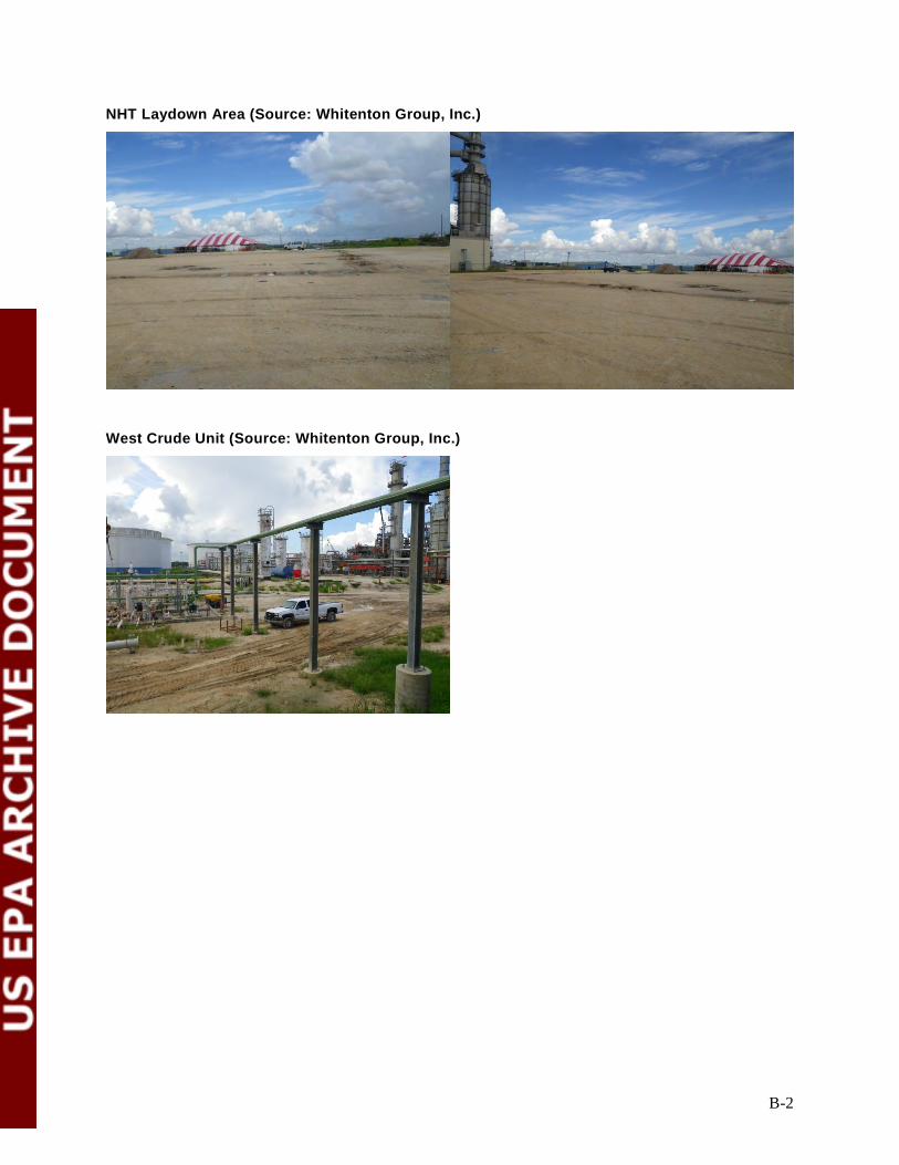
B-2
NHT Laydown Area (Source: Whitenton Group, Inc.)
West Crude Unit (Source: Whitenton Group, Inc.)

B-3
Mid Crude Laydown Area (north location) (Source: Whitenton Group, Inc.)
New LPG Spheres and Y Grade Booster Pumps (associated with LPG Spheres and Processing) (Source: Whitenton Group, Inc.)

B-4
Pentane Storage Spheres (Source: Whitenton Group, Inc.)
UDEX (Source: Whitenton Group, Inc.)

B-5
Mid Crude Laydown Area (south location) (Source: Whitenton Group, Inc.)

B-6
Y Grade Pipeline Pumps and Associated Equipment (new location) (Source: Whitenton Group, Inc.)
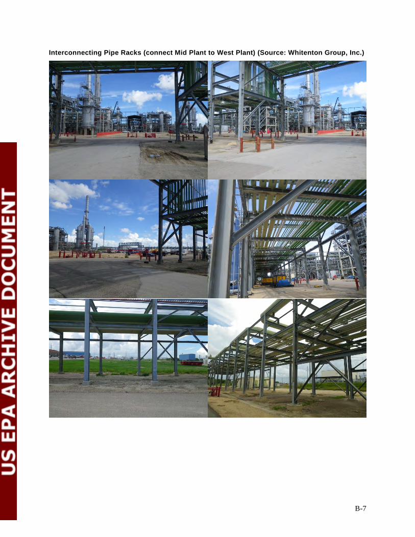
B-7
Interconnecting Pipe Racks (connect Mid Plant to West Plant) (Source: Whitenton Group, Inc.)
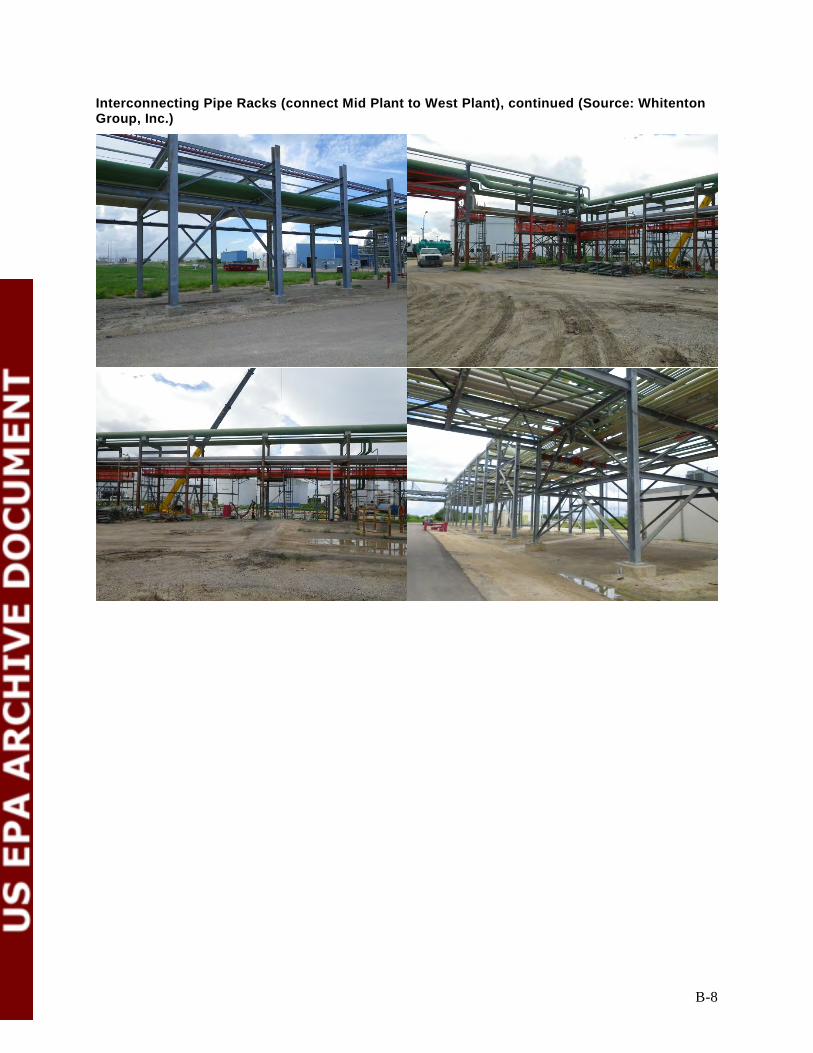
B-8
Interconnecting Pipe Racks (connect Mid Plant to West Plant), continued (Source: Whitenton Group, Inc.)
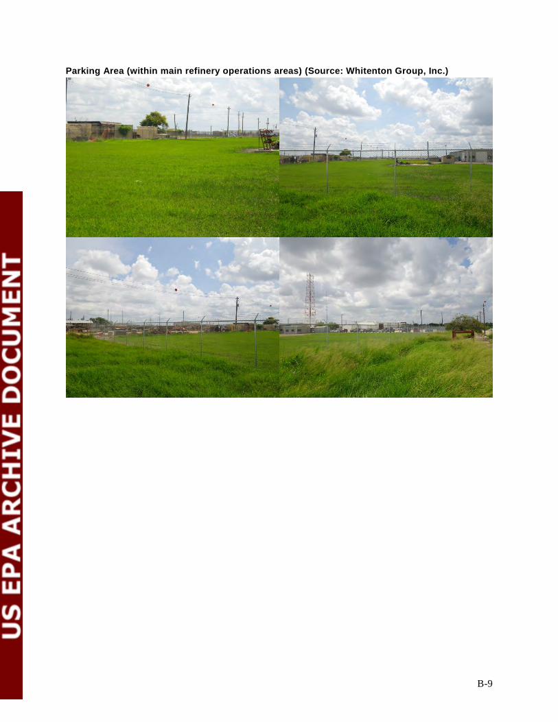
B-9
Parking Area (within main refinery operations areas) (Source: Whitenton Group, Inc.)

B-10
Construction Management Area (Source: Whitenton Group, Inc.)

B-11
Parking Area (south of the main refinery operations area (Source: TRC Environmental, LLC)
Appendix C
Air Quality Analysis

C-1
Air Quality Analysis
FHR has prepared an air quality impacts assessment of the potential indirect effects of any air
pollutant for which the Project will result in an increase in allowable emissions at any unit. FHR
conducted this modeling in accordance with Texas Commission on Environmental Quality minor
NSR air quality modeling protocols. The results of this air quality impacts assessment show that: (1)
no SILs were exceeded at any model receptors outside the Preliminary Area of Potential Effect
(APE) boundary; and (2) there were no impacts to model receptors above ESLs outside the
Preliminary APE boundary.
In addition, FHR conducted two qualitative air quality analyses with respect to HAP air emissions
and the potential for nitrogen/sulfur deposition. These additional analyses support the “no impact”
conclusion as follows: (1) emissions from the Project are below USEPA HAP screening levels; and
(2) because there is an overall reduction in emissions of NO2 and SO2 associated with the Project
there are no effects on historic properties from nitrogen or sulfur emissions. Consequently, based on
the SIL and ESL modeling—as further supported by the qualitative HAP analysis and nitrogen and
sulfur emissions/deposition analyses—the Preliminary APE was not expanded to account for air
quality-related indirect effects. Our detailed findings are set forth in the following subsections.
Air Dispersion Modeling for Non-GHG NSR-regulated Air Pollutants When considering only the Project emissions, emissions expected from the Project are below the
significance thresholds for CO, PM, SO2, and H2S emissions (i.e., the Project will not result in a
significant emissions increase for these pollutants) (Table 1). When considering contemporaneous
increases and decreases under the second step of the PSD applicability analysis, the Project will
cause a net emissions decrease for NOX, PM10, PM2.5, and VOC emissions. The Project will also
cause a net emissions decrease for PM. A comparison of permit allowable emissions (current to
future) identified a net reduction in allowable emissions for CO, SO2, and H2S. In fact, the overall
Project will result in decreased emissions of non-GHG pollutants, with the exception of ammonia.
Therefore, non-GHG pollutants associated with construction of new emission units and changes to
existing emission units are subject only to Texas minor NSR requirements.
FHR has prepared an air quality impacts assessment of the potential indirect effects of any air
pollutant for which the Project will result in an increase in allowable emissions at any unit. FHR
conducted this modeling in accordance with Texas Commission on Environmental Quality minor
NSR air quality modeling protocols. The air modeling included receptors out to a distance of 3 km

C-2
(1.9 mi) beyond the furthest extent of the facility property boundary (Figure C-1). A 25-m (82 ft)
receptor spacing was used out to a distance of at least 300 m (984 ft) from each emission source at
the facility. This was done to help ensure that each pollutant’s area of maximum impact (AOI) would
be captured by the dense receptor grid. Beyond this dense nearfield grid, receptor spacing was
increased to 100 m (328 ft) out to 1 km (0.6 mi), and to 500 m (1,604 ft) from 1 km (0.6 mi) out to
3 km (1.9 mi). Because the receptor spacing is based on the furthest extent of the West Refinery
property boundary (e.g., very western, southern and eastern extent of the boundary), some portions of
the grid extend out to about 6 km (3.7 mi) from the central part of the refinery where the Project
emission units will be constructed or modified (Figure C-1 and Figure C-2). Modeling results for
NO2, CO, SO2, PM10, and PM2.5 indicate that all modeled air concentrations are below the respective
SILs at and beyond the Preliminary APE boundary (Table C-1). USEPA uses SILs to determine
whether emission increases from a proposed project will have any more than de minimis impacts on
the consumption of PSD increments or attainment and maintenance with a NAAQS.2 Modeled
emissions impacts below the respective SIL are interpreted to mean that Project emissions will also
have insignificant effect per the USEPA definition and use of a SIL. These modeling results indicate
that estimated emissions from the Project have insignificant impacts according to USEPA policies
regarding SILs, outside the Preliminary APE. Modeled air concentrations declined with distance
from the Preliminary APE, meaning that air concentrations were well below the respective SIL at the
more distant locations on the receptor grid.
2 FHR followed the guidance in USEPA’s (2013) March 4, 2013, “Draft Guidance for PM2.5 Permit Modeling.”

C-3
Table C-1 Air Dispersion Modeling Results for Non-GHG Criteria Pollutants Beyond the Preliminary Area of Potential Effect
Pollutant Averaging
Time SIL[1]
(µg/m3)
Primary NAAQS (µg/m3)
Secondary NAAQS (µg/m3)
Maximum Modeled Impact (µg/m3)
Percentage of the SIL
(%) NO2 1-hr 7.5 188 None 0.9 12.1 NO2 Annual 1 100 100 0.14 14.4 CO 1-hr 2000 40000 None 5.22 0.26 CO 8-hr 500 10000 None 3.07 0.61 SO2 1-hr 7.8 196 None 0.12 1.6 SO2 3-hr 25 None 1300 0.10 0.42 PM10 24-hr 5 150 150 1.12 22.4 PM2.5 24-hr 1.2 15 15 1.12 93.4 PM2.5 Annual 0.3 35 35 0.10 33.3
NAAQS = National Ambient Air Quality Standard SIL = Significant Impact Level [1] Significant Impact Levels (SILs) per 40 C.F.R. §51.165(b)(2)
In addition to air dispersion modeling for criteria pollutants, FHR also conducted modeling for
speciated VOC emissions, particulate metal emissions, ammonia, and polycyclic aromatic
hydrocarbon (PAH) emissions associated with the Project. FHR compared those modeling results to
TCEQ’s acute and chronic ESLs. Results for the acute and chronic modeling are reported in
Table C-2 and Table C-3, respectively. ESLs are screening levels used in TCEQ’s air permitting
process to evaluate air dispersion modeling’s predicted impacts. They are used to evaluate the
potential for effects to occur as a result of exposure to concentrations of constituents in the air. ESLs
are based on data concerning health effects, the potential for odors to be a nuisance, and effects on
vegetation. They are not ambient air standards. If predicted airborne levels of a constituent do not
exceed the screening level, adverse health or welfare effects are not expected. If predicted ambient
levels of constituents in air exceed the screening levels, it does not necessarily indicate a problem but
rather triggers a review in more depth.
None of the maximum modeled acute (1-hour) (Table C-2) or chronic (Table C-3) air concentrations
exceed the respective ESLs at or beyond the boundary of the Preliminary APE. This provides
additional support that the Project will have no reasonably foreseeable potential effect beyond the
Preliminary APE.
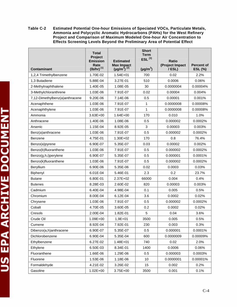
C-4
Table C-2 Estimated Potential One-hour Emissions of Speciated VOCs, Particulate Metals, Ammonia and Polycyclic Aromatic Hydrocarbons (PAHs) for the West Refinery Project and Comparison of Maximum Modeled One-hour Air Concentration to Effects Screening Levels Beyond the Preliminary Area of Potential Effect
Contaminant
Total Project
Emission Rate
(lb/hr) [1]
Estimated Max Impact (µg/m3) [2]
Short Term
ESL [3]
(µg/m3)
Ratio (Project Impact
/ ESL) Percent of
ESL (%) 1,2,4 Trimethylbenzene 1.70E-02 1.54E+01 700 0.02 2.2% 1,3 Butadiene 5.88E-04 3.27E-01 510 0.0006 0.06% 2-Methylnaphthalene 1.40E-05 1.08E-05 30 0.0000004 0.00004% 3-Methylchloranthrene 1.03E-06 7.91E-07 0.02 0.00004 0.004% 7,12-Dimethylbenz(a)anthracene 9.20E-06 7.14E-06 0.5 0.00001 0.001% Acenaphthene 1.03E-06 7.91E-07 1 0.0000008 0.00008% Acenaphthylene 1.03E-06 7.91E-07 1 0.0000008 0.00008% Ammonia 3.63E+00 1.64E+00 170 0.010 1.0% Anthracene 1.40E-06 1.08E-06 0.5 0.000002 0.0002% Arsenic 1.15E-04 8.92E-05 3 0.00003 0.003% Benz(a)anthracene 1.03E-06 7.91E-07 0.5 0.000002 0.0002% Benzene 4.75E-01 1.30E+02 170 0.8 76.4% Benzo(a)pyrene 6.90E-07 5.35E-07 0.03 0.00002 0.002% Benzo(b)fluoranthene 1.03E-06 7.91E-07 0.5 0.000002 0.0002% Benzo(g,h,i)perylene 6.90E-07 5.35E-07 0.5 0.000001 0.0001% Benzo(k)fluoranthene 1.03E-06 7.91E-07 0.5 0.000002 0.0002% Beryllium 6.90E-06 5.35E-06 0.02 0.0003 0.03% Biphenyl 6.01E-04 5.46E-01 2.3 0.2 23.7% Butane 6.80E-01 2.37E+02 66000 0.004 0.4% Butenes 8.28E-03 2.60E-02 820 0.00003 0.003% Cadmium 6.40E-04 4.98E-04 0.1 0.005 0.5% Chromium 8.00E-04 6.12E-04 3.6 0.0002 0.02% Chrysene 1.03E-06 7.91E-07 0.5 0.000002 0.0002% Cobalt 4.70E-05 3.60E-05 0.2 0.0002 0.02% Cresols 2.00E-04 1.82E-01 5 0.04 3.6% Crude Oil 1.09E+00 1,9E+01 3500 0.005 0.5% Cumene 8.92E-04 7.92E-01 230 0.003 0.3% Dibenzo(a,h)anthracene 6.90E-07 5.35E-07 0.5 0.000001 0.0001% Dichlorobenzene 6.90E-04 5.35E-04 600 0.0000009 0.00009% Ethylbenzene 6.27E-02 1.48E+01 740 0.02 2.0% Ethylene 6.50E-03 8.34E-01 1400 0.0006 0.06% Fluoranthene 1.66E-06 1.29E-06 0.5 0.000003 0.0003% Fluorene 1.53E-06 1.18E-06 10 0.0000001 0.00001% Formaldehyde 4.21E-02 3.26E-02 15 0.002 0.2% Gasoline 1.02E+00 3.75E+00 3500 0.001 0.1%

C-5
Contaminant
Total Project
Emission Rate
(lb/hr) [1]
Estimated Max Impact (µg/m3) [2]
Short Term
ESL [3]
(µg/m3)
Ratio (Project Impact
/ ESL) Percent of
ESL (%) Hexane 2.15E+00 1.56E+02 5300 0.03 2.9% Indeno(1,2,3-cd)pyrene 1.03E-06 7.91E-07 0.5 0.000002 0.0002% Isobutane 1.92E-01 6.04E-01 23000 0.00003 0.003% Isopentane 6.69E-02 2.10E-01 3800 0.00006 0.006% Manganese 2.16E-04 1.66E-04 2 0.00008 0.008% Mercury 1.41E-04 1.10E-04 0.25 0.0004 0.04% Naphtha 0.00E+00 0.00E+00 3500 0.0 0.0% Naphthalene 3.95E-03 3.28E+00 200 0.016 1.6% Nickel 1.21E-03 9.32E-04 0.33 0.003 0.3% Pentane 4.11E-02 1.29E-01 4100 0.00003 0.003% Petroleum Distillates 3.96E+00 1.40E+03 3500 0.4 40.1% Phenanathrene 9.80E-06 7.54E-06 0.5 0.00002 0.002% Phenol 0.00E+00 0.00E+00 44 0.0 0.0% Propane 4.53E-01 4.70E+01 No ESL - - Propylene 1.15E-01 7.37E+01 No ESL - - Pyrene 2.81E-06 2.18E-06 0.5 0.000004 0.0004% Selenium 1.40E-05 1.08E-05 2 0.000005 0.0005% Styrene 4.21E-03 3.82E+00 110 0.03 3.5% Toluene 1.59E-01 6.56E+01 3470 0.02 1.9% Xylene 1.60E-01 3.13E+01 350 0.09 8.9% [1] All emissions data is from the ESL modeling spreadsheet file provided by Waid Environmental to Barr Engineering on
October 30, 2013 and updates provided by Waid Environmental on January 28, 2014. Project emission rates (lb/hr) were calculated as the sum of each respective pollutant from each emission unit included in the air dispersion modeling (i.e., Project increases were modeled and did not account for offsets or overall reductions in VOC or particulate emissions).
[2] The “Estimated Max Impact” for each contaminant was obtained from Waid Environmental (calculation spreadsheet). Each “Estimated Max Impact” was determined as follows: • Each Project emission unit was modeled at a unit emission rate of 1 lb/hr. • The “Estimated Max Impact” air concentration at or beyond the boundary of preliminary action for each modeled
emission unit was identified in the air modeling output file and inserted into the calculation spreadsheet (this is a “unitized air concentration”; µg/m3 per lb/hr)
• Then, for each contaminant associated with an emission unit, the unitized air concentration is multiplied by the specific air contaminant emission rate (lb/hr) to derive an estimated air concentration for that contaminant from that emission unit.
• For each contaminant, the estimated air concentration from each emission unit are summed up to derive an overall estimated air
This approach assumes that each individual air concentration is occurring at the same location, when in actuality, the impacts (air concentrations) determined at a unit 1 lb/hr emission rate occurred at different locations because the emission units themselves are located at various places around the refinery. Therefore, this is a conservative approach to estimating contaminant air concentrations to compare to available ESLs.
[3] Effects Screening Levels from the Texas Commission on Environmental Quality as of February 2013. http://www.tceq.texas.gov/toxicology/esl/list_main.html

C-6
Table C-3 Estimated Potential Annual Emissions of Speciated VOCs, Particulate Metals, Ammonia, and Polycyclic Aromatic Hydrocarbons (PAHs) for the West Refinery Project and Comparison of Maximum Modeled Annual Air Concentration to Effects Screening Levels Beyond the Preliminary Area of Potential Effect
Contaminant
Project Emission
Rate (tpy) [1]
Estimated Max Impact (µg/m3) [2]
Long Term ESL[3]
(µg/m3)
Ratio (Project Impact /
ESL) Percent of
ESL (%) 1,2,4 Trimethylbenzene 7.43E-02 3.57E-02 125 0.0003 0.03% 1,3 Butadiene 2.65E-03 2.56E-03 9.9 0.0003 0.03% 2-Methylnaphthalene 6.00E-05 4.55E-07 3 0.0000002 0.00002% 3-Methylchloranthrene 4.47E-06 3.39E-08 0.002 0.00002 0.002% 7,12-Dimethylbenz(a)anthracene 4.07E-05 3.07E-07 0.05 0.00001 0.0006% Acenaphthene 4.47E-06 3.39E-08 0.1 0.0000003 0.00003% Acenaphthylene 4.47E-06 3.39E-08 0.1 0.0000003 0.00003% Ammonia 1.15E+01 5.00E-02 17 0.003 0.3% Anthracene 6.00E-06 4.55E-08 0.05 0.0000009 0.00009% Arsenic 5.00E-04 3.81E-06 0.067 0.0001 0.01% Benz(a)anthracene 4.47E-06 3.39E-08 0.05 0.0000007 0.00007% Benzene 1.57E+00 7.69E-01 4.5 0.2 17.1% Benzo(a)pyrene 3.05E-06 2.30E-08 0.003 0.00001 0.0008% Benzo(b)fluoranthene 4.47E-06 3.39E-08 0.05 0.0000007 0.00007% Benzo(g,h,i)perylene 3.05E-06 2.30E-08 0.05 0.0000005 0.00005% Benzo(k)fluoranthene 4.47E-06 3.39E-08 0.05 0.0000007 0.00007% Beryllium 3.05E-05 2.30E-07 0.002 0.0001 0.01% Biphenyl 2.63E-03 1.26E-03 1 0.001 0.1% Butane 3.03E+00 1.88E+00 7200 0.0003 0.03% Butenes 3.63E-02 3.33E-03 No ESL - - Cadmium 2.80E-03 2.12E-05 0.01 0.002 0.2% Chromium 3.56E-03 2.69E-05 0.041 0.0007 0.07% Chrysene 4.47E-06 3.39E-08 0.05 0.0000007 0.00007% Cobalt 2.04E-04 1.55E-06 0.02 0.00008 0.008% Cresols 8.78E-04 4.21E-04 10 0.00004 0.004% Crude Oil 4.78E+00 4.47E-01 350 0.001 0.1% Cumene 3.86E-03 1.84E-03 250 0.00001 0.0007% Dibenzo(a,h)anthracene 3.05E-06 2.30E-08 0.05 0.0000005 0.00005% Dichlorobenzene 3.05E-03 2.30E-05 60 0.0000004 0.00004% Ethylbenzene 7.48E-02 5.44E-02 570 0.0001 0.01% Ethylene 2.86E-02 8.43E-03 34 0.0002 0.02% Fluoranthene 7.30E-06 5.56E-08 0.05 0.000001 0.0001% Fluorene 6.80E-06 5.19E-08 1 0.0000001 0.00001% Formaldehyde 1.90E-01 1.43E-03 3.3 0.0004 0.04% Gasoline 5.03E+00 1.18E+00 350 0.003 0.3% Hexane 9.90E+00 1.27E+00 200 0.006 0.6% Indeno(1,2,3-cd)pyrene 4.47E-06 3.39E-08 0.05 0.0000007 0.00007%
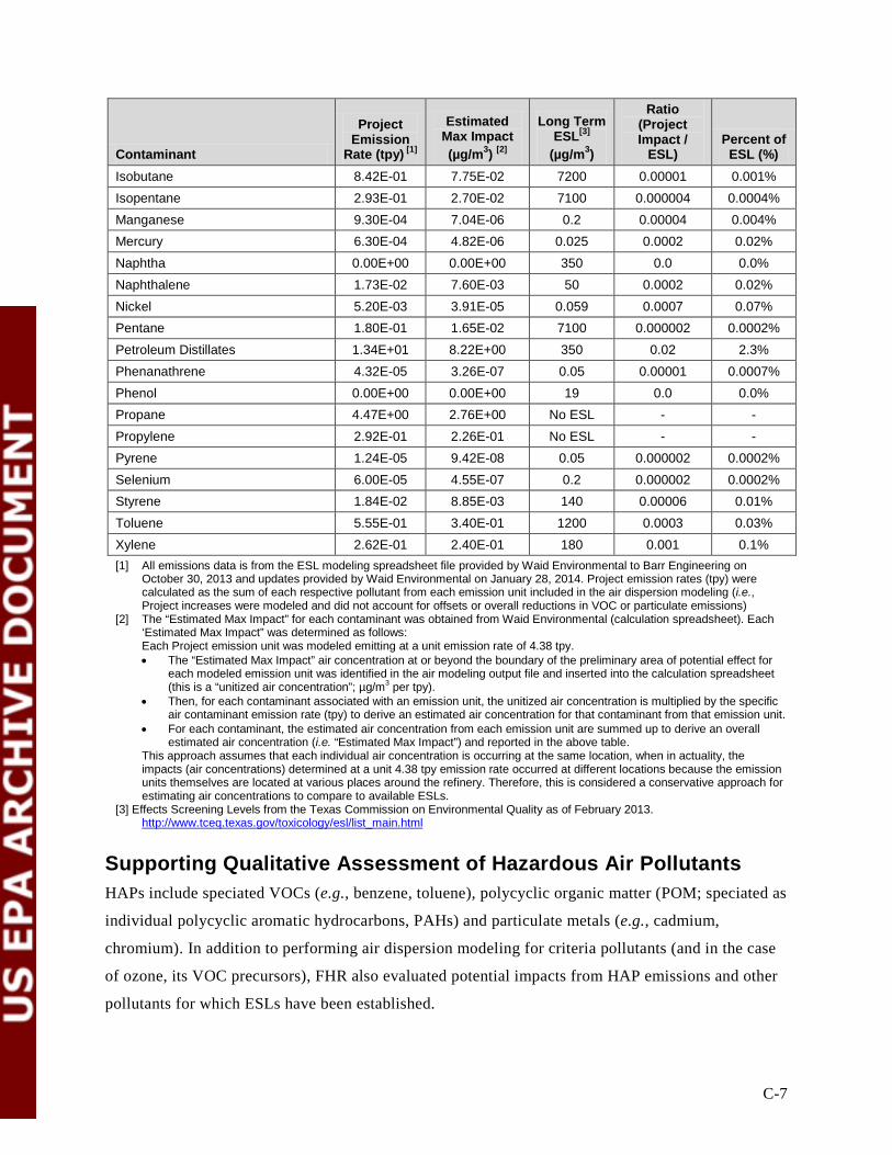
C-7
Contaminant
Project Emission
Rate (tpy) [1]
Estimated Max Impact (µg/m3) [2]
Long Term ESL[3]
(µg/m3)
Ratio (Project Impact /
ESL) Percent of
ESL (%) Isobutane 8.42E-01 7.75E-02 7200 0.00001 0.001% Isopentane 2.93E-01 2.70E-02 7100 0.000004 0.0004% Manganese 9.30E-04 7.04E-06 0.2 0.00004 0.004% Mercury 6.30E-04 4.82E-06 0.025 0.0002 0.02% Naphtha 0.00E+00 0.00E+00 350 0.0 0.0% Naphthalene 1.73E-02 7.60E-03 50 0.0002 0.02% Nickel 5.20E-03 3.91E-05 0.059 0.0007 0.07% Pentane 1.80E-01 1.65E-02 7100 0.000002 0.0002% Petroleum Distillates 1.34E+01 8.22E+00 350 0.02 2.3% Phenanathrene 4.32E-05 3.26E-07 0.05 0.00001 0.0007% Phenol 0.00E+00 0.00E+00 19 0.0 0.0% Propane 4.47E+00 2.76E+00 No ESL - - Propylene 2.92E-01 2.26E-01 No ESL - - Pyrene 1.24E-05 9.42E-08 0.05 0.000002 0.0002% Selenium 6.00E-05 4.55E-07 0.2 0.000002 0.0002% Styrene 1.84E-02 8.85E-03 140 0.00006 0.01% Toluene 5.55E-01 3.40E-01 1200 0.0003 0.03% Xylene 2.62E-01 2.40E-01 180 0.001 0.1% [1] All emissions data is from the ESL modeling spreadsheet file provided by Waid Environmental to Barr Engineering on
October 30, 2013 and updates provided by Waid Environmental on January 28, 2014. Project emission rates (tpy) were calculated as the sum of each respective pollutant from each emission unit included in the air dispersion modeling (i.e., Project increases were modeled and did not account for offsets or overall reductions in VOC or particulate emissions)
[2] The “Estimated Max Impact” for each contaminant was obtained from Waid Environmental (calculation spreadsheet). Each ‘Estimated Max Impact” was determined as follows: Each Project emission unit was modeled emitting at a unit emission rate of 4.38 tpy. • The “Estimated Max Impact” air concentration at or beyond the boundary of the preliminary area of potential effect for
each modeled emission unit was identified in the air modeling output file and inserted into the calculation spreadsheet (this is a “unitized air concentration”; µg/m3 per tpy).
• Then, for each contaminant associated with an emission unit, the unitized air concentration is multiplied by the specific air contaminant emission rate (tpy) to derive an estimated air concentration for that contaminant from that emission unit.
• For each contaminant, the estimated air concentration from each emission unit are summed up to derive an overall estimated air concentration (i.e. “Estimated Max Impact”) and reported in the above table.
This approach assumes that each individual air concentration is occurring at the same location, when in actuality, the impacts (air concentrations) determined at a unit 4.38 tpy emission rate occurred at different locations because the emission units themselves are located at various places around the refinery. Therefore, this is considered a conservative approach for estimating air concentrations to compare to available ESLs.
[3] Effects Screening Levels from the Texas Commission on Environmental Quality as of February 2013. http://www.tceq.texas.gov/toxicology/esl/list_main.html
Supporting Qualitative Assessment of Hazardous Air Pollutants HAPs include speciated VOCs (e.g., benzene, toluene), polycyclic organic matter (POM; speciated as
individual polycyclic aromatic hydrocarbons, PAHs) and particulate metals (e.g., cadmium,
chromium). In addition to performing air dispersion modeling for criteria pollutants (and in the case
of ozone, its VOC precursors), FHR also evaluated potential impacts from HAP emissions and other
pollutants for which ESLs have been established.
C-8
Volatile Organic Compounds (VOCs) and Polycyclic Aromatic Hydrocarbons (PAHs) Total VOC emissions associated with the Project are estimated to decrease by about 39 tpy (Cultural
Resources Assessment Table 1). Because VOCs tend to remain in air and generally do not deposit to
any great extent, and because of the overall net reduction in VOC emissions (Cultural Resources
Assessment Table 1), it is concluded that the Preliminary APE should not be expanded based on
potential indirect effects from these pollutants.
Additionally, Table C-2 (1-hour) and Table C-3 (annual) provide modeling results for speciated VOC
emissions, and polycyclic aromatic hydrocarbon (PAH) emissions associated with the Project
compared to the ESLs. The modeling included receptor locations at the Preliminary APE boundary
and out to 3 km (1.9 mi) from the property boundary. None of the modeled air concentrations exceed
the respective ESLs (Table C-2 and Table C-3). As identified by the TCEQ, a modeled air
concentration below a respective ESL indicates that no adverse impacts to health or welfare would be
expected. The ESL modeling results provide additional support for the conclusion that the
Preliminary APE should not be expanded based on potential indirect effects from these pollutants.
Particulate Matter (PM) and Particulate Metals Particulate emissions associated with the Project are primarily related to combustion sources. All
modeled particulate emission concentrations were below the SILs at and beyond the Preliminary APE
boundary (Table C-1). This SIL analysis not only demonstrates an overall de minimis impact to PM
air concentrations beyond the Preliminary APE, but by extension the SIL analysis also demonstrates
insignificant impact to soils and vegetation (USEPA, 1990. Section D.II.C.). PM metals for which
there are ESLs were also evaluated, and the summary information in Table C-2 (1-hour) and
Table C-3 (annual) indicate that modeled air concentrations are below the ESLs for these substances
at and beyond the Preliminary APE boundary.
In addition to these quantitative conclusions regarding the insignificant potential indirect effects from
particulate metals, FHR compared calculated annual particulate metal project emissions increases to
screening emission rates available from USEPA (1980). These USEPA screening rates were
developed to assist in the evaluation of whether annual emissions would be expected to cause
significant air quality impacts to soils, vegetation, and in some cases, fauna. The summary
information from Table C-4 indicates that Project emissions are below the lowest screening
emissions rates for those metals being compared.
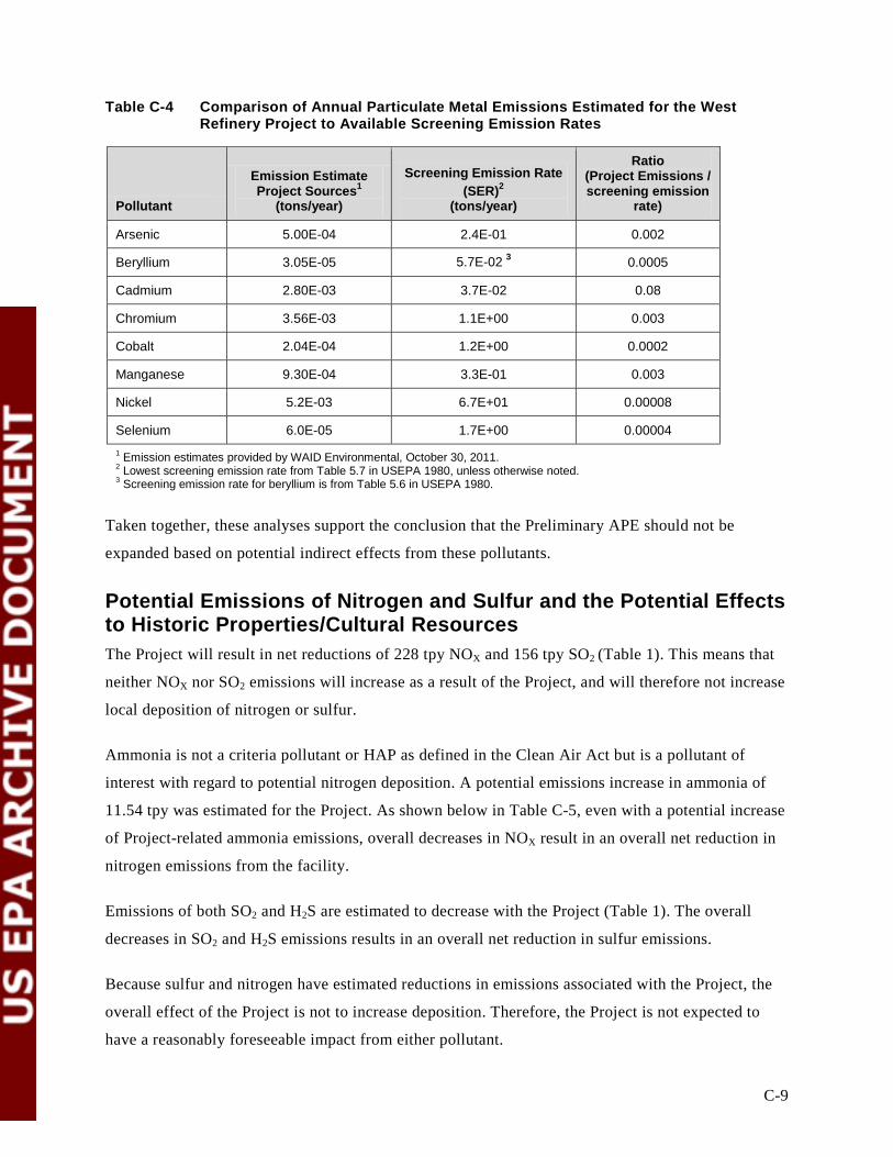
C-9
Table C-4 Comparison of Annual Particulate Metal Emissions Estimated for the West Refinery Project to Available Screening Emission Rates
Pollutant
Emission Estimate Project Sources1
(tons/year)
Screening Emission Rate (SER)2
(tons/year)
Ratio (Project Emissions / screening emission
rate)
Arsenic 5.00E-04 2.4E-01 0.002
Beryllium 3.05E-05 5.7E-02 3 0.0005
Cadmium 2.80E-03 3.7E-02 0.08
Chromium 3.56E-03 1.1E+00 0.003
Cobalt 2.04E-04 1.2E+00 0.0002
Manganese 9.30E-04 3.3E-01 0.003
Nickel 5.2E-03 6.7E+01 0.00008
Selenium 6.0E-05 1.7E+00 0.00004 1 Emission estimates provided by WAID Environmental, October 30, 2011. 2 Lowest screening emission rate from Table 5.7 in USEPA 1980, unless otherwise noted. 3 Screening emission rate for beryllium is from Table 5.6 in USEPA 1980.
Taken together, these analyses support the conclusion that the Preliminary APE should not be
expanded based on potential indirect effects from these pollutants.
Potential Emissions of Nitrogen and Sulfur and the Potential Effects to Historic Properties/Cultural Resources The Project will result in net reductions of 228 tpy NOX and 156 tpy SO2 (Table 1). This means that
neither NOX nor SO2 emissions will increase as a result of the Project, and will therefore not increase
local deposition of nitrogen or sulfur.
Ammonia is not a criteria pollutant or HAP as defined in the Clean Air Act but is a pollutant of
interest with regard to potential nitrogen deposition. A potential emissions increase in ammonia of
11.54 tpy was estimated for the Project. As shown below in Table C-5, even with a potential increase
of Project-related ammonia emissions, overall decreases in NOX result in an overall net reduction in
nitrogen emissions from the facility.
Emissions of both SO2 and H2S are estimated to decrease with the Project (Table 1). The overall
decreases in SO2 and H2S emissions results in an overall net reduction in sulfur emissions.
Because sulfur and nitrogen have estimated reductions in emissions associated with the Project, the
overall effect of the Project is not to increase deposition. Therefore, the Project is not expected to
have a reasonably foreseeable impact from either pollutant.
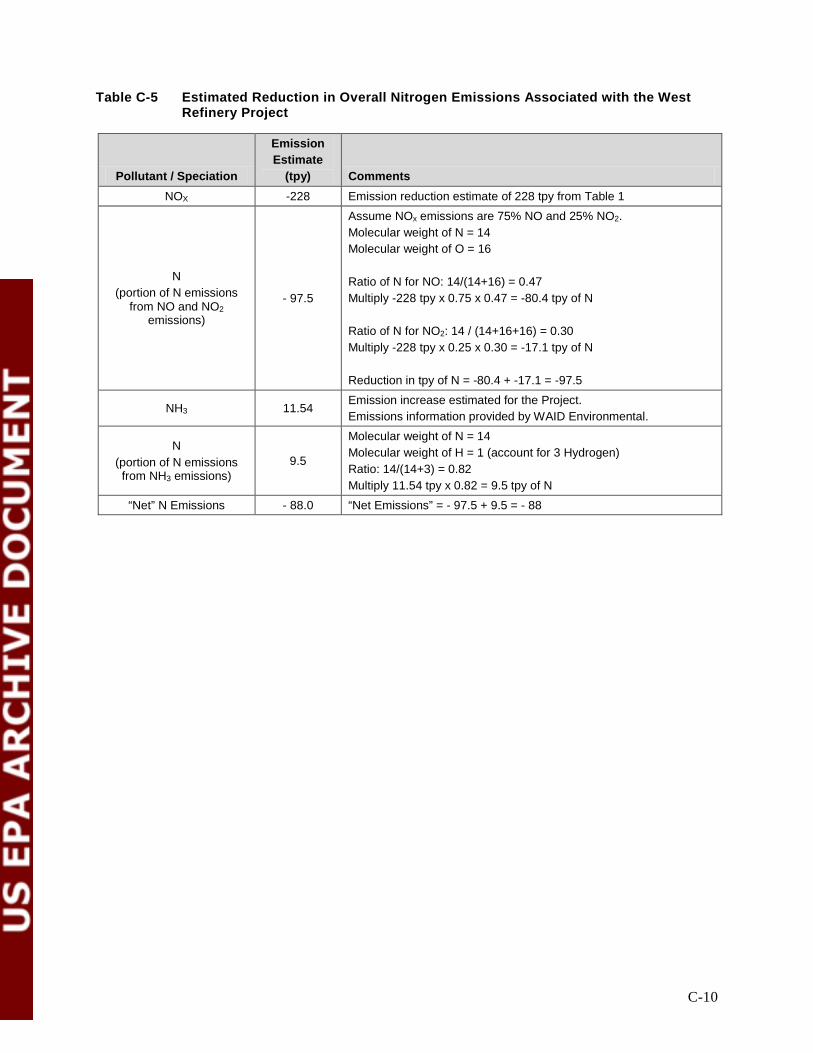
C-10
Table C-5 Estimated Reduction in Overall Nitrogen Emissions Associated with the West Refinery Project
Pollutant / Speciation
Emission Estimate
(tpy) Comments NOX -228 Emission reduction estimate of 228 tpy from Table 1
N (portion of N emissions
from NO and NO2 emissions)
- 97.5
Assume NOx emissions are 75% NO and 25% NO2. Molecular weight of N = 14 Molecular weight of O = 16 Ratio of N for NO: 14/(14+16) = 0.47 Multiply -228 tpy x 0.75 x 0.47 = -80.4 tpy of N Ratio of N for NO2: 14 / (14+16+16) = 0.30 Multiply -228 tpy x 0.25 x 0.30 = -17.1 tpy of N Reduction in tpy of N = -80.4 + -17.1 = -97.5
NH3 11.54 Emission increase estimated for the Project. Emissions information provided by WAID Environmental.
N (portion of N emissions from NH3 emissions)
9.5
Molecular weight of N = 14 Molecular weight of H = 1 (account for 3 Hydrogen) Ratio: 14/(14+3) = 0.82 Multiply 11.54 tpy x 0.82 = 9.5 tpy of N
“Net” N Emissions - 88.0 “Net Emissions” = - 97.5 + 9.5 = - 88

C-11
Figure C-1 Air Dispersion Modeling Grid Out to 3 Kilometers
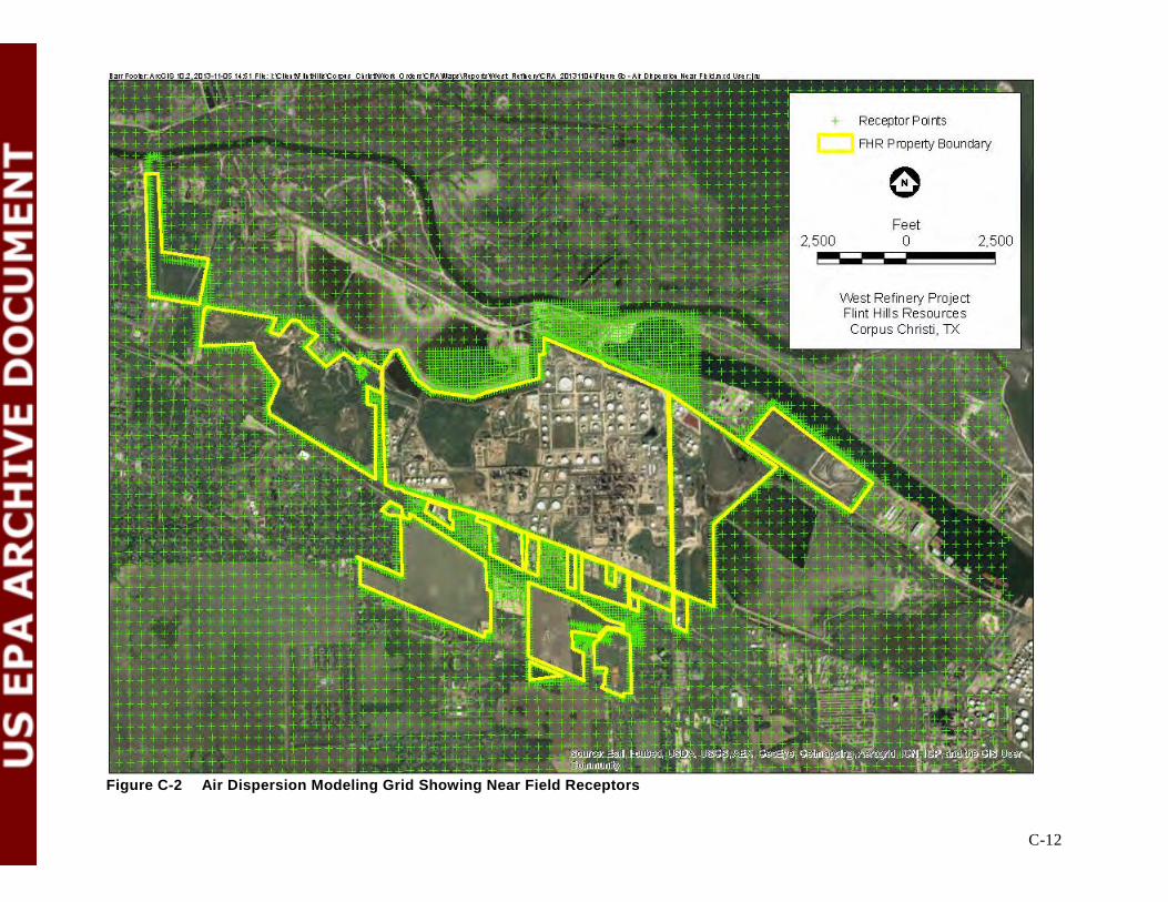
C-12
Figure C-2 Air Dispersion Modeling Grid Showing Near Field Receptors
C-13
References
USEPA (U.S. Environmental Protection Agency). 1980. A screening procedure for the impacts of air
pollution sources on plants, soils, and animals. Prepared by A.E. Smith and J.B. Levenson,
Argonne National Laboratory, Argonne, IL 60439; contract No. EPA-IGA-79-D-X0764.
Prepared for: U.S. Environmental Protection Agency, Office of Air Quality Planning and
Standards, Research Triangle Park, North Carolina. December 12, 1980. EPA 450/2-81-078.
———. 1990. New Source Review Workshop Manual. Prevention of Significant Deterioration and
Nonattainment Area Permitting. Draft. October 1990. 322 pp.
———. 2013a. Draft Guidance for PM2.5 Modeling. March 4, 2013. Available at
http://www.epa.gov/ttn/scram/guidance/guide/Draft_
Guidance_for_PM25_Permit_Modeling.pdf

Appendix D
Principal Investigators’ Resumes
D-1
11.1.1.1.1.1.1.1 Robert A. Ricklis, Ph.D.
Senior Archaeologist and Project Manager Dr. Ricklis has over 25 years of experience and progressive responsibility in environmental and cultural resources consulting. His qualifications include extensive hands-on planning, field investigation, permitting, cost estimating, and project management. Dr. Ricklis’ background includes extensive service to public and private-sector clientele including USACE, University of Texas, TxDOT, and Baker-Hughes/Western Geophysical. He currently serves in the capacity of a Senior Archaeologist for the nine-person Cultural and Natural Resources Division with responsibility as a principal investigator in the role of project management. EDUCATION Ph.D., Department of Geography, The University of Texas at Austin, 1990 (emphasis in historical cultural ecology/human-ecological archaeology) M. A., Department of Anthropology (Archaeology), The University of Texas at Austin, 1986 B. A., Anthropology (emphasis in Archaeology), The University of Wisconsin, Madison, 1970 AREAS OF EXPERTISE Dr. Robert Ricklis, Ph.D. has program management and technical experience in the following areas:
• All aspects of archaeological projects mandated by the National Historic Preservation Act, including archaeological field work, laboratory analyses and report writing, on numerous projects ranging in scales from survey through site testing and evaluation, to major data recovery excavations.
• Lithic Analysis • Texas Coastal Plains Archaeology • Coastal and Interior (alluvial, eolian, colluvial) Geoarchaeology • Human Ecological Method and Theory • Ceramic analyses • Spanish Colonial archival research • Burial excavation, analysis, including responding to issues of Native American
consultation (related to NAGPRA and Section 106 consultation issues)
POSITIONS/EMPLOYMENT HISTORY 2007-present Senior Archaeologist, TRC Environmental Corp. 505 East Huntland Drive,
Suite 250, Austin, Texas, 78752. Phone 512-329-6080; Fax 512-329-8750. E-Mail [email protected]
2000-2007 Senior Archaeologist and Branch Director, Coastal Environments, Inc. (Corpus
Christi Office), 525 S. Carancahua Street, Corpus Christi, Texas 78411. Phone: 361-584-4885; Fax 361-884-1844.
1992-2000 President and Cultural Resources Director, Coastal Archaeological Research, Inc.
Corpus Christi, Texas 78404. Phone: 361-883-1377; Fax: 361-882-3814. 1994-present: Research Fellow, Texas Archeological Research Laboratory, The University of
Texas at Austin.

D-2
1989-present: President, Coastal Archaeological Studies, Inc. (a non-profit research and educational 501c corporation), Corpus Christi, Texas 78404
1988-1992 Research Associate, Texas Archeological Research Laboratory, The University of
Texas at Austin. PROFESSIONAL AFFILIATIONS
• Society for American Archaeology • Association of American Geographers • Council of Texas Archeologists • Texas Archeological Society (Donors Fund Chairman 1997-1998) • Southern Texas Archaeological Association • New York State Archeological Association (Fellow)
REPRESENTATIVE PROJECTS 1988-1990: Principal Investigator, archaeological testing of a historic site for the City of Corpus Christi, Texas. Project Sponsor: The City of Corpus Christi Project Budget: $10,000.00 Project Description: The accidental discovery of historic artifacts at a location near downtown Corpus Christi necessitated testing to evaluate and assess possible historical significance. Hand excavations and mechanical testing were conducted, resulting in the identification and documentation of the remains of early commercial activities dating to the early Twentieth Century. A report was submitted to the City and the Texas Historical Commission. Ricklis, Robert A. 1989 Archaeological Testing at Site 41NU260, Corpus Christi, Texas. Mongraph report submitted to the City of Corpus Christi and the Texas Antiquities Committee. On file, Texas Antiquities Committee, Texas Historical Commission, Austin. 1992-1994: Principal Investigator, data recovery excavations at the Mitchell Ridge Site,
41GV66, Galveston, Texas. Project sponsor: The Woodlands Corporation, The Woodlands, Texas. Project budget: $250,000.00 Project description: For compliance under a permit from the U.S. Army Corps of Engineers, the
Woodlands Corporation was required to locate, excavate and analyze Native American burials located within their Pirates’ Cove development on Galveston Island. Our survey and testing revealed the presence of two Native American cemeteries, which we excavated in their entirety. The remains of 52 individuals were documented and subjected to detailed osteological analyses in the laboratory. On the basis of radiocarbon dating and the kinds of offerings placed in graves, it was determined that the burials had been interred between ca. A.D. 1300 and 1800. Burials dating to the eighteenth century were found to contain trade goods, probably obtained from the French traders who were operating in the Galveston Bay area between ca. 1720 and 1754, when they were pushed out by Spanish-Colonial forces from the south in New Spain (now Mexico). Thousands of glass beads, a mirror fragment, a brass bell and
D-3
tools of iron, combined with shell ornaments of Native manufacture, attested to the changes in material cultural experienced Galveston-area Native groups during the 1700s. The bioarchaeological analyses indicated a significant degree of genetic intermixing of Euroamerican Caucasian and Native American populations during this period.
Report: Ricklis, Robert A. (main author, editor and compiler) 1994 Aboriginal Life and Culture on the Upper Texas Coast: Archaeology of the Mitchell
Ridge Site (41GV66), Galveston Island. Coastal Archaeological Research, Inc., Corpus Christi.
1999: Principal Investigator, Archeological Testing at Site 41GD112, Goliad, Texas. Project Sponsor: Texas Department of Transportation Project Budget: $35,000.00 Project Description: As a result of new bridge construction along State Highway 183, TxDOT required archeological testing within the ROW where highway crosses the San Antonio River near Goliad, Texas. The archeological testing revealed the presence of intact features associated with the early (Spanish Colonila and early Texan) occupations of the community lf La Bahia. This work resulted in the recovery of Colonial and early post-Colonial artifacts and the remains of a jacal structure. The mapping and documentation of these features allowed TxDOT to define and protect an area of considerable historical/archeological significance. Ricklis, Robert A. 1999 Archeological Testing at 41GD112, La Villa de la Bahía, an Early Historic
Site in Goliad County, Texas. Texas Archeological Research Laboratory, The University of Texas at Austin. Under contract with the Texas Department of Transportation
2000-2010 Principal Investigator, Data Recovery excavations at the Buckeye Knoll Site (41VT98), Victoria County, Texas.
Project sponsor: U. S. Army Corps of Engineers, Galveston District
Project Budget: $2,000,000.00
Project description: Excavation (2000-01) of approximately 200 m3 of stratified Holocene sediments on a site located along the upland margin overlooking the lower Guadalupe River floodplain. Recovered significant data on regional culture chronology from Paleo-Indian times (ca. 8,000 B.C.) to the Late Prehistoric era (after ca. A.D. 800). Analysis of faunal-bone and shell, macrobotanical samples from flotation, and pollen analysis on radiocarbon dated floodplains sediment cores, provided new insights into long-term environmental and human-ecological changes. One part of the site contained a uniquely early prehistoric Native American cemetery that was extensively radiocarbon dated to the Texas Early Archaic period, ca. 7,000 years ago. Laboratory analysis showed that the peoples buried there were a healthy population, and had a diet based on a mix of inland and coastal-marine food resources. A total of 75 graves were identified here, containing the skeletal remains of at least 116 individuals. Artifacts buried with the

D-4
deceased indicate strong cultural ties to Archaic cultures of the central Mississippi valley and the greater Southeastern U.S.
Reports:
Ricklis, Robert A. (lead author and compiler)
2012 Archaeology and Bioarchaeology of the Buckeye Knoll Site (41VT98), Victoria County, Texas. Three-volume final report submitted to the Galveston District, U. S. Army Corps of Engineers. Coastal Environments, Inc., Baton Rouge and Corpus Christi.
Ricklis, Robert A. 2012 The Buckeye Knoll Archeological Site, Victoria County, Texas: New Evidence for Understanding Ancient Lifeways on the Texas Coastal Plain. A public-outreach report prepared for the U.S. Army Corps of Engineers, Galveston District. Coastal Environments, Inc., Corpus Christi, Texas. Ricklis, Robert A. 2011 New Perspectives on the Archaic of the Texas Coastal Plain: The Buckeye Knoll Site
on the Lower Guadalupe River near Victoria, Texas. Bulletin of the Texas Archeological Society 82:31-76.
1998-2000 Principal Investigator, Archaeological Investigations at Two Spanish Colonial
Mission Sites near Goliad, Texas. Project Sponsor: Coastal Archaeological Studies, Inc. Project Budget: $120,000.00 Project Description: Excavations at the Spanish Colonial missions of Espíritu Santo
and Nuestra Señora del Rosario resulted in the recovery of large samples of Eighteenth Century Indian artifacts (ceramics, lithics) as well as numerous ceramic, metal and glass artifacts imported by mission personnel from production centers in New Spain. Additionally, large samples of faunal bone, dominated by the remains of the missions’ domesticated cattle, were recovered and analyzed. At Rosario, the foundations/floors of previously unknown buildings were exposed, photographed and documented. Analysis of the artifacts and faunal bones provided new insights into economic activities at the missions as well as stylistic differences in the native ceramics that can be correlated with the distinct ethnic identities of the Indian groups who resided at each of these missions.
Reports: Ricklis, Robert A., Susan de France and Bruce M. Albert 2000 Archaeological Investigations at the Spanish Colonial Missions of Espíritu Santo and
Nuestra Señora del Rosario, Goliad Texas. Coastal Archaeological “Studies, Inc. Corpus Christi, Texas.
2008-2010 Principal Investigator, Data Recovery excavations at the McGloin Bluff Site
(41SP11), San Patricio County, Texas.
D-5
Project Sponsor: Port of Corpus Christi Authority. Project Budget: $386,000.00
Project Description: Excavation of approximately 200 m3 of coastal eolian sediments on a Late Prehistoric Karankawa fishing campsite, resulting in recovery of large samples of aboriginal artifacts of pottery, lithics and shell, plus thousands of faunal bones dominated by the remains of fish species such as black drum, redfish, and speckled sea trout. Comparative analyses of these materials and those previously recovered from other sites of this period (ca. A.D. 1300-1700) in the Coastal Bend region revealed a pattern of internal complexity within the prehistoric Karankawa fishing economy.
Report:
Ricklis, Robert A.
2010 Identifying Complexity in the Late Prehistoric Fishing Economy along the Middle Texas Coast: Data Recovery Excavations at the McGloin Bluff Site, 41SP11, San Patricio County, Texas. Report No. 163067, TRC Environmental Corporation. Austin.
D-6
11.1.1.1.1.1.1.2 J. Michael Quigg, M.A EDUCATION M.A. Archaeology, The University of Calgary: 1973.
B.A. Anthropology, University of Northern Colorado, 1971.
PROFESSONAL REGISTRATION AND CERTIFICATIONS
• Permitted to perform cultural resource investigations by the Bureau of Land Management
(BLM) in Texas, Oklahoma, Wyoming, Montana, and New Mexico.
• Member of Council of Texas Archeologists (CTA).
• Texas Department of Transportation pre-certification (No. 4265) for service 2.10.1, 2.11.1,
2.8.1 (archeological survey, historical and archival research, and mitigation).
EMPLOYMENT HISTORY
• Cultural Resource Project Manager/Principal Investigator, TRC Environmental
Corporation, 1990 to present.
• Staff Archaeologist, Texas Archaeological Research Laboratory, Austin, 1989-1990.
• Senior Staff Archaeologist, Co-Principal Investigator, Prewitt and Associates, Inc., Austin,
1987-1989.
• Staff Archaeologist, U.S. Forest Service, Clearwater National Forest, Idaho, 1987.
• Supervisory Archaeologist, Co-Principal Investigator, Historical Research Associates,
Missoula, Montana, 1985-1986.
• Vice-President, Secretary, Project Manager/Senior Archaeologist, Ethos Consultants, Ltd.,
Medicine Hat, Alberta, 1980-1985.
• Plains/Prairie Archaeologist, Archaeological Survey of Alberta, Alberta, 1975-1980.
• Seasonal Instructor and Private Consultant, Alberta, 1974-1975.
• Curator of Osteology Collection and Manager, University of Calgary, Alberta, 1973-1974.
• Contractor, Project Director, National Museum of Canada, Alberta, 1972, 1973.
• Field Director, World Heritage Site, Head-Smashed-In Buffalo Jump, Alberta, 1971.
• Field Director, Waterton National Park Archaeological Project, Alberta, 1971.
• Teaching Assistant, University of Calgary Field School, Indian Springs, 1970.
• Crew Chief, Waterton National Park Archaeological Project, Alberta, 1970.

D-7
EXPERIENCE Mr. Quigg has 40 years of archeological experience involved in all aspects of cultural resource
management (CRM) including private consulting, managing a cultural resource firm, directing CRM
programs, and government regulation. Mr. Quigg has managed and conducted over 60 individual
cultural resource projects for Government agencies, oil and gas firms, mining, highways,
transmission lines, water pipelines, and reservoir construction projects in Alberta, Montana,
Colorado, Texas, and New Mexico. As a project manager he completely understands the nature of
the complex cultural resource, problem areas, and works directly with clients to meet their specific
project needs in obtaining governmental approval to proceed. He understands research issues
and provides management plans to gather necessary data, structures data analyses, and writes
reports to explain and interpret the resource, to obtain necessary regulatory approval of the
documentation in timely and cost efficient manner. He provides direction and innovative ideas to
mitigate and manage cultural resources to the clients benefit while meeting government
regulations.
Cultural resource investigation are carried out under a variety of Federal and state laws,
regulations, and guidelines, such as the National Historic preservation Act (NHPA), the National
Environmental Policy Act (NEPA), Native American Graves Protection and Repatriation Act
(NAGPRA), Native American Free Exercise of Religion Act (NAFERA), Traditional Cultural
Properties (TCP), Army Regulation 200-4 Cultural Resource Management, Army Regulation 420-
40 Historic Preservation, Department of Defense Protection of Archeological Resources (32 CFR
229),. Mr. Quigg has worked directly with these legal requirements and native Americans on
particular sensitive projects. He has routinely completed archeological projects ranging from
small surveys to large multidisciplinary field investigations, including development of management
plans, popular brochures, and consultation.
TRC Environmental Corp. - 1990 to present
Principal/Co-Principal Investigator and project manager for the; BLM data recovery at Landis
Property in Potter County in 2008; data recovery at Long View site in Roberts County for TxDOT
in 2006; TxDOT 2007 data recovery at Gages Creek in Young County, BLM remedial testing in
2007 at four sites in West Amarillo Creek in Potter County, TxDOT 2006 data recovery project in
Austin at 41TV2161; 2006 site assessments at Gages Creek in Young County; the 2005
assessment of 41RB112 in Roberts County; 1999-2000 Otero Mesa data recovery for Fort Bliss;
the 1990 and 1996 Palo Duro Reservoir data recovery project (Sanders Site); Sulphur Springs

D-8
Draw and Red Lake Reservoir survey and assessment projects; Mitchell Reservoir data recovery,
Leon River Medicine Wheel ethnographic and archeological investigations; TxDOT data recovery
at the Lino site (41WB437) in 1998, the 2000-2001 TxDOT data recovery at the Boiler site
(41WB557); the 2002-2003 TxDOT Varga site (41ED28) mitigation; and data recovery at
41ZP364; and the Rush Site data recovery programs. He served as Project manager for large
area survey of Area F at Jewett Mine, 3 reservoir surveys, many small linear surveys, and
principal author for the reporting of the early Archaic site excavations (41TG307 & 309) on the
Concho River and the Late Archaic hearths at 41MI96 in Mills County. Duties included the
development and implementation of research designs, development of cost proposals, managing
project budgets, hiring and directing field crews and on site investigations, analyses of faunal
remains from 41HF128, 41TG346, and Palo Duro and Stacy Reservoir sites, ceramic and lithic
data sets, integrating and interacting with sub-consultants on their technical assistance to various
programs, report writing and compilation of all aspects of programs, and overall project
management from beginning to end including client liaison, accounting oversight, curation of
documents and artifacts.
Implemented interdisciplinary data analyses by technical experts including: geomorphology, stable
carbon and nitrogen isotope analyses of bison bones, burned rocks, and ceramic sherds,
macrobotanical analyses, phytolith studies, radiocarbon dating of burned rocks and ceramic
sherds, starch grain analysis on burned rocks, pottery, and stone tools, lipid residue analyses on
burned rocks and ceramic sherds, demagnetization analysis of burned rocks, diatom analysis, use
wear studies on stone tools, Rabdotus shell A/I ratios and dating to assess site and feature
context issues.
Archeological Data Recovery Projects
Mr. Quigg has managed and directed numerous data recovery/mitigation projects stemming from
the Section 106 of the NHPA, Section 404 of the Clean Water Act, and Section 110 and the
Antiquity Code of Texas (ACT). Mitigation projects have included a variety of site types such as
stone circles, deep stratified campsites, single component camps, bison kills and processing
centers, burned rock middens, and small burned rock features. Examples of major data recovery
project are as follows:
• Data Recovery at 41RB112, 2006, for Texas Department of Transportation, Texas Panhandle. Mr. Quigg served as Principle Investigator, Project Manager, and part time Field Director, on this 103-m3-multiple block excavation of .50+ cm deep deposit with two well-defined Plains Village period components (with pithouses) in the right-of-way of SH 70

D-9
for TxDOT. He directed this multidisciplinary data analyses and reporting phase. He also served as the principal author on the 2013, 2 volume technical report (1200 pages).
• Analysis and reporting of a 1999 TxDOT data recovery at 41MI96 in Mills County, TX. The 2012 TRC analysis included detailed lithic debitage, high-powered use-wear of lithic tools, a focus on the burned rocks from five intact burned rock features through radiocarbon dating, lipid residues and starch grain techniques. Maize starch grains were on four burned rocks and two edge-modified flakes. The burned rocks that yielded maize starch were radiocarbon dated to 980 B.P., currently the oldest maize in central Texas. Mr. Quigg served as the project manager and principal author of the 2013 technical report.
• Data Recovery at Three Prehistoric Sites at the Landis Property, Texas Panhandle, 2007 - 2010, for the Bureau of Land Management. Mr. Quigg served as Project Manager, Principal Investigator, Field Director for this intensive (451 m2) testing, excavation, analysis and reporting. The three open sites were of different ages, with different stratigraphy, and provided diverse cultural assemblages for hunter-gatherers. Multiple outreach programs were conducted on-site for local individuals and groups as well as development of the Texas Beyond History webpage for the site. The 2010 technical report was two volumes (ca. 1200 pages) that integrated interdisciplinary approaches that included 16 technical analyses. Mr. Quigg is an author or co-author on 3 peer-reviewed journal articles that have been published from the data gathered from the project.
• Data Recovery of Clear Creek Golf Course Site (41CV413) for US Army Fort Hood, Texas. Mr. Quigg completed the technical report in 2011 from the mitigation of a block of 20 m2 in a burned rock midden with central oven. The analysis included a large suite of stone tools, burned rocks, vertebrate remains in conjunction with radiocarbon dates, lipid residue, micro-wear, and macrobotanical analyses.
• Data Recovery at 41YN452 in 2007 for Texas Department of Transportation, in North Central Texas. Mr. Quigg served as Principle Investigator, Project Manager, and part time Field Director, on this 50.3-m3-multiple block excavation in 60 to 110 cm deep deposits that targeted a Late Archaic component in the right-of-way of FM 3109 for TxDOT. Mr. Quigg served as principal author on the 2012 two volume technical report (740 pages) integrated multiple technical analyses that provided great insight to human behaviors.
• Data Recovery at 41TV2161, 2006, for Texas Department of Transportation, Central Texas. Mr. Quigg served as Principle Investigator, Project Manager, and part time Field Director, on this 40-m3-block excavation of 2.0+ m deep cultural deposits in the right-of-way of SH 130 for TxDOT. The project is ongoing with data analysis and reporting to continue.
• Data Recovery at the Varga Site (41ED28), 2002-2003, for Texas Department of Transportation, Southwest Texas. Mr. Quigg served as Principle Investigator, Project Manager, and report author on this 104-m3-block excavation of a 1.2 m deep four-
D-10
component campsite in the right-of-way development. He oversaw a field crew of nine archeologists in the hand-excavations of two major blocks, and directed this multidisciplinary data analyses and reporting phase. He managed the contract and budget, and coordinated with the client and other technical scientists. Included the text development for an outreach exhibit for Texas Beyond History web page, and brochure on site investigations.
• Data Recovery at the Boiler Site (41WB557), 2000, for Texas Department of Transportation, South Texas. Mr. Quigg served as Principle Investigator, Project Manager, Field Director, and primary report author on this 142-m3-block excavation of 1.5 m deep cultural deposits in the right-of-way for the planned Texas Department of Transportation improvement. He directed a field crew of 12 archeologists in the hand-excavations of two major blocks, directed the multidisciplinary data analyses, wrote a 550 page technical report, managed the contract and budget, and coordinated with the client.
• Data Recovery at 41ZP364, 2000, for the Bureau of Land Management and International Boundary and Water Commission in South Texas. Mr. Quigg served as the Principal Investigator, Project Manager, and Field Director on this geoarcheological and archaeological investigation. The investigations included 21 backhoe trenches that guided the hand excavations of 48 m2 and two small block areas of 20 and 16 m2. He directed the subsequent laboratory work, analysis, and wrote most of the 350 page technical report that included multidisciplinary investigations.
• Prehistoric Site Testing and Data Recovery in the New Target Complex, Otero Mesa, in West Texas 1999, for U.S. Army, Fort Bliss. Mr. Quigg served as Principle Investigator and primary author for the testing of four sites potentially eligible for the NRHP and the data recovery for seven sites to mitigate the direct impact the proposed U.S. Air Force development as required under Section 106. This project included detailed excavation and field-documentation on some 63 burned rock features, coupled with an interdisciplinary laboratory approach that brought new insights to the understanding of small burned rock features. He was the primary author for the 650 page technical report for the Directorate of Environment, Conservation Division at Fort Bliss, Texas.
• Data Recovery at the Lino Site (41WB437): A Stratified Late Archaic Campsite in South Texas, 1998, for Texas Department of Transportation. Mr. Quigg served as the Project Manager, Field Director, and primary author on this 235-m2 mitigation required under Section 106. He directed the laboratory processing, supervised the data analysis, facilitated the interdisciplinary technical analyses, wrote most of the 450 page technical report, directed the report production, managed and controlled the project budget, and coordinated with regulators and the client.
• Data Recovery at the Sanders Site (41HF128): A Single Event Late Archaic Camp/Bison Processing Site, Palo Duro River Authority, 1997, Northwest Texas. Mr. Quigg served as the Project Manager and Field Director of the 115-m2 data recovery program under Section 404 of the Clean Water Act and NEPA. He coordinated all
D-11
laboratory analyses and interacted with professional from multiple disciplines to support the cultural interpretations. Mr. Quigg also conducted the detailed analyses of the faunal and tool analyses. He wrote the 220 page technical report incorporating all recovered data and addressed six major research issues.
• Data Recovery at the Rush Site, Colorado River Municipal Water District, 1993, Western Texas. Mr. Quigg was the Project Manager and Field Director for the emergency mitigation of 45 m2 necessary to comply with Section 404 of the Clear Waters Act for the client. He coordinated with the client, managed the budget, and conducted the stone tool, faunal and ceramic analyses, and interacted with numerous specialists to facilitate the integration of a multidisciplinary approach to the analysis and interpretations. He wrote the majority of the 200 page technical report and completed the project on time and in budget.
• Data Recovery and Geomorphologic Investigations, Palo Duro Reservoir, Palo Duro River Authority, 1991, Northwestern Texas. Mr. Quigg directed and field supervised the data recovery from two prehistoric campsites, a rock shelter, and a historic dugout during a three-month span with three separate crews that involved 20 personnel. He was responsible for client and government resource manager communications during the field and subsequent data analysis. He directed data analysis, conducted the faunal, ceramic, and stone tool analyses, coordinated with six technical subconsultants, integrated data sets, and wrote most of the 600 page technical report.
• Mitigation Excavation at Two Prehistoric Sites, Texas Department of Transportation, 1990, Central Texas. Mr. Quigg served as the Field Supervisor at Barton (41HY202) and Mustang Branch Sites (41HY209) under a Section 106 investigation clearing the right-of-way for new construction. He directly supervised 20 archeologists for six months in the excavation of two stratified camps, a lithic workshop, and a burned rock midden. The intensive excavations encompassed 330 m2 and involved a vast array of cultural materials. He oversaw and guided the faunal analysis.
• Mitigation of Large Multicomponent Tipi Ring Site (24TT83) and Buried Campsite (24CA194), U.S. Department of Energy, Western Area Power Administration, 1986, North-central Montana. Mr. Quigg served as co-Principal Investigator and Field Director for the intense data recovery program along a transmission corridor. He directed an archeological crew of 12 people over a two-month period that involved 380-m2 of excavation. Subsequently he coordinated the technical analyses, analyzed the lithic debitage, burned rocks, stone tools, faunal remains, and ceramic materials from the various components, and wrote the final comprehensive technical report.
• Crown Site (FhNa-86) Mitigation, Ethos Consultants Ltd., 1984, Saskatchewan Research Council, Central Saskatchewan. Mr. Quigg was the Field Director for this Middle Archaic to Late Prehistoric stratified site with nine separate components in three cultural units. He directly supervised the analyses of the various data sets including the

D-12
stone and bone tool assemblages, the lithic debitage, and ceramic analyses, and wrote the technical report that was submitted to the client.
• Lloyd Site (FhNa-35) Mitigation, Ethos Consultants Ltd., 1982, Saskatchewan Research Council, Central Saskatchewan. Mr. Quigg was the Field Director for this site excavation of a Late Prehistoric, single component, buried campsite. He directed the laboratory processing of various data sets that included 18,000 artifacts and conducted the faunal identification, supervised the stone tool analysis, and the lithic identification, and wrote the technical report for the client.
• Mitigation of EcPp-24 and EfPg-5, Ethos Consultants Ltd. 1982, Southwestern Alberta. Mr. Quigg served as Principal Investigator, Project Manager, and Field Supervisor for these two buried campsites in planned highway construction zones. He oversaw the laboratory processing, coordinated and communicated with the client, conducted the lithic and stone tool analysis and authored the final technical report.
• Mitigation of Ross Glen Stone Circle Site, Ethos Consultants Ltd., 1981, Southeastern Alberta. Mr. Quigg was the Principal Investigator, Project Manager, and Field Director of a large scale, 508 m2, and hand-excavation of a stone circle site. He directed the laboratory processing and stone tool and lithic debitage analysis, burned rock and feature analysis, and wrote the 200-page technical report with conclusions, interpretations, and management recommendations.
• Highway Salvage in the Crowsnest Pass, Lifeways of Canada Ltd., 1975, Southwestern Alberta. Mr. Quigg served as Field Director for this multiple site data recovery program along the planned expansion of highways in Crowsnest Pass. He directed a crew of 10 archaeologists, conducted the stone tool and lithic debitage analysis, completed the feature descriptions, and was primary author in the final technical report.
Archeological Site Assessment Projects
Mr. Quigg has managed and conducted numerous site testing and evaluation projects in Texas,
Alberta, and Montana. These projects ranged from evaluating single surface sites, deeply buried
campsites, bison kill sites, burned rock middens, medicine wheels, stone cairns, to multiple
component buried campsites. Information recovered was analyzed, interpreted, and used in the
development of site-specific and project related recommendations and determination of sites
eligibility for inclusion to the National Register of Historic Places under the Section 106. This
included the development of data recovery plans, project specific budgets, hiring staff, and
scheduling. A sample of projects Mr. Quigg has managed is listed below.
• West Amarillo Creek Remedial Testing at 41PT185, 41PT186, and 41PT245 for the BLM in Northwestern Texas in 2007. As Project Manager and Principal Investigator Mr. Quigg directed the basin wide geomorphic investigations (48 trenches), followed by the hand excavation of 48.0 m3 at selected locations at these

D-13
prehistoric sites. A status report, draft and final interim reports were authored by Mr. Quigg with subsequent analysis and reporting.
• Gages Creek Eligibility Assessment of 41YN450 and 41YN452, Texas Department of Transportation, 2006, North-central Texas. As Project Manager and Principle Investigator Mr. Quigg directed the National Register field assessment of these two prehistoric sites buried in the TxDOT right-of-way in Young County. Field assessment included hand excavations (6.5 m3) and mechanical trenching (n=7) in terrace deposits that documented buried cultural remains. He directed the preliminary data analysis and coauthored the interim report submitted to TxDOT. Site results and recommendations were presented to the client and government review agencies, who concurred with the recommendations.
• Survey and Eligibility Assessment of Two Prehistoric Sites at Boot Ranch, 2005, Central Texas. Mr. Quigg served as Principle Investigator and project manager. He oversaw the survey of 377 ac including 67 shovel tests, documentation of nine sites, the assessment of two sites including 15 units, 53 m in eight trenches, mapping of sites, and profiling. He coauthored the report that presented the data findings, recommendations. The report and recommendations were accepted by the Army Corps of Engineers.
• Eligibility Assessment of 41RB112, Texas Department of Transportation, 2005, Texas Panhandle. Mr. Quigg served as Principle Investigator and field director. He directed a 10 person crew in the hand excavations and profiling of this two part site. He authored the interim report that presented the data findings, recommendations, and a data recovery plan that included research questions and field approach to follow. The report and recommendations were accepted by the Texas Historical Commission.
• Eligibility Assessment of 41BL278, Texas Department of Transportation, 2004, Central Texas. Mr. Quigg served as Principle Investigator, project manager, and field director. He directed the hand-excavations on 10 units (4.1-m3), backhoe trenching, site mapping, exposure profiling, and oversaw the geoarcheological investigations. He coauthored the interim report that presented the data findings, recommendations. The report and recommendations were accepted by the Texas Historical Commission.
• Eligibility Assessment of 41MS69, Texas Department of Transportation, 2004, Central Texas. Mr. Quigg served as Principle Investigator, project manager, and field director. He directed the hand-excavations (8.9-m3), site mapping, and exposure profiling. He coauthored the interim report that presented the data findings, recommendations. The report and recommendations were accepted by the Texas Historical Commission.

D-14
• Eligibility Assessment of Three Prehistoric Sites (41LM49, 50 and 51) along FM 580W Over Lynch Creek, Texas Department of Transportation, 2004, Central Texas. Mr. Quigg served as Principle Investigator and field director. He directed the hand-excavations of 21 units (17.4-m3), trenching of deposits (n=5), mapping of sites, profiling, and oversaw the geoarcheological assessment. He coauthored the interim report that presented the data findings, recommendations, and a data recovery plan that included research questions and field approach to follow. The report and recommendations were accepted by the Texas Historical Commission.
• Eligibility Assessment of 41EP4439, Texas Department of Transportation, 2002, West Texas. Mr. Quigg served as Principle Investigator and oversaw the project that included 20 backhoe trenches, 20 manual units, and geoarcheological investigations. The final report that presented the data findings, recommendations. The report and recommendations were accepted by the Texas Historical Commission.
• Noodle Creek Eligibility Assessment, Texas Department of Transportation, 2002, North Texas. Mr. Quigg was Project Manager and directed the National Register field assessment of site 41JS102 in the highway right-of-way next to the Noodle Creek Bridge crossing in Jones County. Field assessment included hand excavations and mechanical trenching in terrace deposits that documented buried cultural remains. Subsequently, he directed the data analysis and report writing. Site results and recommendations were presented to the client and government review agencies, who concurred with the recommendations.
• USA #3 Assessment, TransTexas Oil And Gas Corp, 1997, South Texas. Mr. Quigg was Project Manager and Field Director of the assessment of two prehistoric sites (41ZP39 and 41ZP176) in a well pad and pipeline ROW development zone at Falcon Reservoir. The site file search was followed by shovel testing and unit excavations that documented the buried nature of two sites. Site results and recommendations were presented to the client and government review agencies. The investigations resulted from the Archeological Resource Protection Act.
• Pershing Field Assessment, Fort Sam Houston, 1997, Southern Texas. Mr. Quigg served as Project Manager and Filed Director of the archeological and geomorphologic assessment of 50 acres of undeveloped land on Fort Sam Houston. The natural terrace deposits were assessed through the excavation of 19 backhoe trenches to evaluate the potential for intact buried archeological remains. One prehistoric surface site was evaluated with shovel tests. The recovered data was assessed and recommendations were presented in a report coauthored by Mr. Quigg. The investigations were part of an Environmental Assessment document.
• Assessment of Leon River Medicine Wheel, U.S. Army at Fort Hood, 1993-1994, Central Texas. Mr. Quigg served as project manager and field director of seven archeologists in assessing the NRHP eligibility of this native religious site. He integrated geomorphology, geoarcheology, two geotechnical studies, and oral
D-15
interviews of native religious leaders with hand excavation data and detailed feature recording techniques to thoroughly document the size, extent, age, and nature of the stone features and associated artifacts within shallow sediments. Mr. Quigg conducted a literature search into the history and background of northern plains medicine wheel investigations and ethno-history, preformed specific data analyses, incorporated interdisciplinary technical analyses and results, and interpretations, and made recommendations for site protection and significance. He interacted with native religious leaders, archeologists, and government personnel in overall coordination of investigations and subsequent medicine wheel renewal ceremonies. Mr. Quigg also participated directly in the sacred reconstruction ceremonies and yearly renewals.
• Burned Rock Mound Chronometric Assessment, U.S. Army, Fort Hood, 1993, Central Texas. Mr. Quigg served as Field Director for the field evaluation of nine burned rock mounds (domed and annular middens) to assess their archeological potential and establish an absolute chronometric framework for this site type. After reviewing some 100 prehistoric sites with burned rock features, Mr. Quigg selected nine promising sites and led the recovery of datable materials through backhoe trenching and limited hand excavations, which subsequently yielded 53 radiocarbon assays. This allowed for the creation of a chronological framework of burned rock mounds at Fort Hood and helped evaluate Fort Hood mound features with respect to their NRHP eligibility.
• Mitchell Reservoir Testing, Colorado River Municipal Water District, 1992, Northern Texas. Mr. Quigg served as Principal Investigator and directed the day-to-day operation of the 32-m2 block excavations at 41MH49. He directed the laboratory operations and data analysis that included the integration of a number of technical analyses to support the interpretation. He wrote most of the final report and prepared the recommendations.
• Site Assessment at ANR Pipeline Crossing of Palo Duro Creek, 1992, North Texas. Mr. Quigg served as Project Manager and Field Director of an archeological and geomorphologic assessment of a river crossing in north Texas. Following a site file search, a foot traverse of the ROW was completed, and then six backhoe trenches were excavated and documented. The crossing was assessed, results evaluated, interpretations presented, and recommendations were made to the client.
• Site Evaluation, U.S. Army, Fort Hood, 1991-1992, Central Texas. Mr. Quigg served as Field Director and implemented the field evaluation program to assess individual prehistoric sites across the base. In conjunction with a project Geomorphologist, he evaluated over 500 prehistoric sites using numerous criteria, completed detailed evaluation forms, and made site specific recommendations.
• Evaluation of Stone Circle Site EaPg-3, Archeological Survey of Alberta, 1984, Southern Alberta. Mr. Quigg served as Principal Investigator and Field Supervisor
D-16
of the site assessment through detailed documentation of eight stone circles. The investigations included feature mapping, the weighing and recording the depths of rocks, excavation of 81 augur tests and screened matrix, the hand excavation of 10 test pits. Data was subsequently analyzed and a comprehensive technical 35-page report was completed. Recommendations for future investigations were presented to the government.
• Buried Prehistoric Campsite Evaluation, Alberta Transportation, 1981-1982, Alberta Foothills. Mr. Quigg formulated field strategies and analysis goals to evaluate two buried prehistoric campsites through the excavation of 120 m2. He integrated metric and descriptive analyses of over 1500 lithic artifacts, interpreted knapping technologies through refits studies, analyzed burned rocks, features, and conducted detailed faunal analysis, to place these events in time and space. He evaluated internal horizontal and vertical patterning to interpret human use of space, assess site integrity, and made recommendations for further work. He compiled and wrote the final 150 page technical report.
• Excavation and Analysis Strategies to Evaluate Buried Prehistoric Sites, Alberta Transportation, 1980-1981, Southern Alberta. Mr. Quigg devised excavation and analysis strategies to assess six shallowly buried prehistoric sites along multiple highway corridors. He served as Principal investigator and field director investigations that involved hand excavations by a six-person crew, managed the logistics and deployment of the crew, conducted data analysis, interpreted results, and reported the findings in a 200-page technical document. Mr. Quigg managed the overall project, and formulated the recommendations.
• Archeological, Ethnographic, and Historical Literature Review of Site Specific Data, State Historical Society of North Dakota, 1983-984, Montana, North Dakota, and Wyoming, United States and Alberta and Saskatchewan, Canada. Mr. Quigg served as Co-Principal Investigator and coordinator of a site-specific data review of stone circle site excavations from across the Northwestern Plains. This program included a review and synthesis of excavation methods, recording procedures, data analyses, data results, site and feature documentation strategies on stone circles and provided a detailed management plan and future direction concerning this specific site type.
Archeological Inventory/Survey Projects Mr. Quigg has completed roughly 60 cultural resource inventories throughout the Plains
states. These inventories ranged from small well pad and gravel pits to very large block
areas of 6,000 acres to 100 mile long linear ROWs requiring multiple crews. Inventories
were completed for government agencies, private industry, and individuals. Projects
involved foot surveys of development areas, shovel testing, inventories of historic and
prehistoric sites, completion of site forms, site and building sketch maps, analyzing cultural
D-17
materials, writing reports, and making site and project eligibility recommendations and
providing direction for future investigations. Listed below are a number of representative
inventory projects.
• NET Mexico Pipeline Project, Starr County, Texas, 2013. Mr. Quigg served as Principal Investigator, field director, and report author for this border crossing facility and drill pad. Supervised the excavation of two long backhoe trenches, documented the profiles, and excavated seven shovel tests.
• Intensive archeological survey of 7.8 ac of levee development by TxDOT in TPWD management area in Calhoun County, Texas, 2013. Managed client coordination, budget, fieldwork and authored the technical report for this wetland mitigation project.
• Indian Creek Bridge replacement along FM 981 in Collin County, Texas, 2013. Conducted intensive survey that included seven backhoe trenches and six shovel tests, documented trench profiles, and wrote interim report for TxDOT.
• Brushy Creek Reservoir Survey, City of Marlin, 2005, Texas. Mr. Quigg served as Principal Investigator and director a crew of six in surveying 1140 ac with 523 shovel tests for the City of Marlins proposed reservoir. Fifteen new sites and He co-authored the technical report, managed the budget, and coordinated with the client.
• Right-of-way Survey in four counties in central Texas, Texas Department of Transportation, 2006, North Central Texas. Mr. Quigg served as field director on two of the surveys. He co-authored the technical report, managed the budget, and coordinated with the client.
• Archeological Surveys in Central Texas, Texas Department of Transportation, 2006. Mr. Quigg served as Principal Investigator and field director on two surveys. He conducted the foot traverses, shovel tests, and monitored the backhoe trenching, co-authored the technical report, managed the budget, and coordinated with the client.
• Reconnaissance for FPL Energy’s Horse Hollow Wind Power Project, 2006. Mr. Quigg served as Principal Investigator and field director on this reconnaissance and chert sourcing project. He conducted the road and tower inspections, assessed impacts to area, collected natural chert samples for instrumental neutron activation analyses, authored the technical report, managed the budget, and coordinated with the client.
• Backhoe trenching to discovery buried cultural resources along FM 2214 for Texas Department of Transportation, 2005, North Central Texas. Mr. Quigg served as Principal Investigator and field director to investigate the alluvial deposits

D-18
for cultural remains through 11 backhoe trenches (76 m) and profiling. He authored the technical report that included the findings and recommendations. He managed the budget, and coordinated with the client. The Texas Historical Commission and the Army Corps of Engineers accepted the report.
• Sand Hill Energy Center, Travis County, Central Texas, 2002. Mr. Quigg served as Principal Investigator and Field Director on two projects related to the expansion of facilities at the City of Austin power plant. He also co-authored the technical reports and managed the budget, and coordinated with the client.
• Red Lake, Martin County, Southern Llano Estacado, 1993. Mr. Quigg served as Principal Investigator and Field Director during the inventory and site assessment for proposed 47 ha. Reservoir for the Colorado River Municipal Water District. He also co-authored the technical report and managed the budget, and coordinated with the client.
• Sulphur Springs Draw Reservoir: Geoarchaeological and Archaeological Investigations, Southern Llano Estacado, 1994. Mr. Quigg served as Principal Investigator and Field Director during the inventory and site assessment for proposed 435 ha. Sulphur Draw Reservoir for the Colorado River Municipal Water District. He also co-authored the technical report and managed the budget, and coordinated with the client.
• Texcor Property Assessment, Prewitt and Associates, Inc., 1988, West Texas. Mr. Quigg served as Field Archeologist for the reconnaissance of a proposed hazard waste site in Kinney County. He authored a letter report (No. 356) with recommendations to the client.
• Brooke Army Medical Center Assessment, Prewitt and Associates, Inc., 1988, South Texas. Mr. Quigg served as the Field Archeologist for the reconnaissance of development impact along Salado Creek in Fort San Houston. He wrote the report with the recommendations to the client.
• City of Robinson Water Plant, Prewitt and Associates, Inc., 1988, Central Texas. Mr. Quigg served as the Archeologist for the reconnaissance of a 153 m long pipeline corridor and 7.4 acres parcel around the intake structure. He authored an appendix that included methods, results, and provided recommendations to the client.
• Hidalgo County Drainage Ditch Realignments, Prewitt and Associates, Inc., 1988, South Texas. Mr. Quigg served as the Field Archeologist for the reconnaissance of proposed development of water drainage ditches. He coauthored the final report.
• Cultural Resource Inventory, Bureau of Indian Affairs, Northern Cheyenne Indian Reservation, 1986, Eastern Montana. Mr. Quigg Field Directed the inventory of 6,300 non-continuous acres, 200 miles of road corridors, and 85 springs.
D-19
He helped document 139 sites, created site typologies, analyzed site distribution by environmental attributes, projected settlement pattern distributions, and wrote the final report for the BIA.
• Class II Cultural Resource Inventory, Bureau of Land Management, Milk River Region, 1985, Northern Montana. Mr. Quigg field directed the inventory of 6,720 acres in the valley breaks of the Milk River Valley. He helped record over 200 sites encompassing 1,100 features including rock cairns, stone circles, lithic scatters, bison kills, and historic sites. He completed the data and site distribution analyses, coauthored the written documentation of the findings and interpretations for the BLM.
• An Historical Impact Assessment, Deadfish Water Diversion, Ethos Consultants Ltd. 1984, Southern Alberta. Mr. Quigg served as Project Manager and field director for the inventory and assessment of a 14.5 km ROW, documented in detail 12 prehistoric and one historic site through hand excavation of 102 m2 individual features, site mapping, and recorded weight and depth of feature rocks. He also wrote and produced a 167 page technical report with site specific and general project recommendations to the government regulators.
Preparation of Cultural Resource Operational Management Plan and Management Plans
• Palo Duro Reservoir, Operational Management Plan, Palo Duro River Authority, 1994, Hansford County, Texas. Mr. Quigg helped develop the first OMP to be accepted for a reservoir in Texas. He was the primary author and compiled necessary data to write the contents of a plan that allows for the management of the cultural resources in the vicinity of the reservoir under the Texas Antiquities Code.
• Archeological, Ethnographic, and Historical Literature Review of Site Specific Data, State Historical Society of North Dakota, 1983-984, Montana, North Dakota, and Wyoming, United States and Alberta and Saskatchewan, Canada. Mr. Quigg served as Co-Principal Investigator and coordinator of a site-specific data review of stone circle site excavations from across the Northwestern Plains. This program included a review and synthesis of excavation methods, recording procedures, data analyses, data results, site and feature documentation strategies on stone circles and provided a detailed management plan and future direction concerning this specific site type.
Preparation of Testing, Data Recovery Plans, and Research Designs
• Treatment Plan for Three Archeological Sites on the Landis Property near Amarillo, Texas. Mr. Quigg developed an in-depth plan for the Bureau of Land Management. The plan presented a research design including research issues and questions, detailed field work plan for three sites, presented various technical analyses, and reporting to address six stated research issues. The client and regulators approved the plan.
D-20
• Research Design for Sites 41WB556 and 41WB557, Texas Department of Transportation, 2000, South Texas. Mr. Quigg developed and wrote a data recovery plan for two buried, prehistoric sites to be impacted by highway development. The plan covered the field investigations, data analysis, reporting to address six stated research issues. The client and regulators approved the plan.
• Data Recovery Plan for 41ZP364, TransTexas Gas Corporation, 1997, South Texas. Mr. Quigg developed the data recovery plan was used to guide the field and laboratory investigations. It was prepared to comply with the 1997 MOA for Well Pad #1 signed by the Council, BLM, SHPO, and the client. The client and regulators approved the plan.
• Testing Plan for 41ZP39 and 41ZP176, TransTexas Gas Corporation, 1997, South Texas. Mr. Quigg developed the testing plan used to assess these sites in the direct impact areas for inclusion into the NRHP. It was intended that the results was have a finding of no effect for the limited impacts by the pipeline route. The client and regulators approved the plan.
• Testing of 41MT14 Sulphur Draw Reservoir, 1992, Colorado River Municipal Water District, Northwest Texas. Mr. Quigg developed the testing plan for a buried campsite in the dam axis of the proposed reservoir. The regulators approved the plan.
• Testing of 41MT21 Sulphur Draw Reservoir, 1992, Colorado River Municipal Water District, Northwest Texas. Mr. Quigg developed the testing plan for a buried campsite in the dam axis of the proposed reservoir. The regulators approved the plan.
Historical Investigations Mr. Quigg has managed, directed, and participated in historic site inventories, archival
documentation, and record searches for various projects across the Plains, often as
components of larger projects. These investigations have centered on documenting
standing structures and mine sites. He has directed the hand excavation of a historic
dugout and house foundation in Palo Duro Reservoir. He has documented various mining
structures in the Clearwater National Forest in Idaho and at Rock Lake Marias Pass,
Cabinet Mountain Wilderness, and Helmville East in Montana, and directed the records
search for the Mitchell Reservoir Project and Area F at Jewett Mine.
• Palo Duro Reservoir Historic Sites, Palo Duro River Authority, 1991, Northwestern Texas. Mr. Quigg directed and field supervised the data recovery from a historic dugout (41HF113) and historic rock foundation (41HF8). He directed data analysis and communicated with historic archeologist for a chapter of the final report.
D-21
• Zan’s Cabin, U.S. Forest Service, 1987, Northern Idaho. Mr. Quigg served as Archeologist and conducted the reconnaissance and documentation of the historic structure and pioneer mine prior to structure removal.
• Footrot Cabin Assessment, U.S. Forest Service, 1987, Northern Idaho. Mr. Quigg served as Archeologist and conducted the reconnaissance, documentation, and assessment of the historic structure.
Native American Consultation
Mr. Quigg has participated in a number of consultation processes with Native American
groups in Texas and Canada. He has served as Project Archeologist and interacted with a
number of Plains Tribes.
• The Leon Medicine Wheel, U.S. Army Fort Hood, 1996, Fort Hood, Texas. Mr. Quigg conducted interviews with the elders Mr. William Tallbull, Haman Wise, Floyd Youngman and Lee Lonebear of the Medicine Wheel Alliance, coordinated activities with the American Indian Resource, and Education Coalition of Texas, participated in spiritual cleansing ceremonies, was a participant in the actual reconstruction and rededication ceremony for the sacred wheel. Was Project Manager and primary author in the archeological and documentation of the medicine wheel and associated ceremonial events.
• Northern Cheyenne Reservation, Bureau of Indian Affairs, 1986, Eastern Montana. As Field Director of a large inventory across native lands and sites he interviewed a number of tribal members and leaders, in the location, markings, and dealings with sacred sites and how to protect these religious and sensitive sites. He was coauthor in the final report.
Technical Data Analyses Mr. Quigg has personally conducted numerous site specific and in-depth analyses on
various cultural materials and data sets including lithic debitage, ceramics, stone tools, bone
tools, burned rocks, and faunal assemblages. He has developed expertise in these data
sets and has formulated specific analysis to address specific research questions or issues
relating to specific topics. The structured analyses have permitted concentration of often-
limited resources on the most important data sets to address important questions.
• Ceramic Analyses: Mr. Quigg has performed metric and non-metric descriptions, analyzed data, and presented results in chapters of reports. He has formulated research designs and incorporated instrumental neutron activation, organic residue, stable carbon isotope, and petrographic analysis with the more descriptive analyses. Examples of ceramic analysis from excavated sites include the Long View

D-22
(41RB112), Rush site (41TG346) in western Texas, the Manyfingers site (DhPj-31) in southern Alberta, the Cory Ranch site in (24TT83) in central Montana, and the Otero Mesa sites in Fort Bliss in southern New Mexico and western Texas. He has conducted chemical analyses such as stable carbon and nitrogen isotope and lipid residue analysis on sherds to explore for foods being cooked in vessels. He has used sherds to obtain direct radiocarbon AMS dates.
• Faunal Analyses: Mr. Quigg has conducted element and animal identifications, isolated animal ages through tooth eruption and fusion rates, identified sex based on bone metric data, and conducted in-depth butchering analyses on assemblages from bison kills, processing centers, and campsites sites and bison processing areas in western and northern Texas, and southern Alberta and central Saskatchewan. Examples of faunal analyses include Long View (41RB112), Rush site (41TG346) in western Texas, three sites (41RN169, 41CC131, 41CN95) in O.H. Ivie Reservoir in central Texas, Clear creek Golf Course 41CV413 in central Texas, the Sanders site (41HF128) and other Palo Duro Reservoir sites in northwestern Texas, the Lloyd site (FhNa-35) and Crown site (FhNA-86) in central Saskatchewan, the Manyfingers site in southern Alberta, and S.S. Burmis in southwestern Alberta. These assemblages included hundreds of elements and generally a variety of species. Other smaller assemblages have been analyzed and reported upon such as those from Justiceburg Reservoir. Mr. Quigg maintains his own faunal comparative collected. He has conducted chemical analysis on animal bones such as stable carbon and nitrogen isotope to investigate the types of foods specific animals were eating and what changes in the diet have occurred over time.
• Lithic Analyses: Mr. Quigg has conducted raw material identifications and metric and non-metric descriptive analyses on lithic artifacts and debitage. These and other analyses have been conducted on specific sites from across broad regions of hunter and gathers including the Schmidt Quarry (24BW559) and the Lost Terrace Site (24CH68) in Montana, lithic tool and debitage analysis of sites in the Palo Duro Reservoir and Fort Hood, the stone tool and debitage analyses for three sites near Falcon Reservoir in southern Texas and the Lloyd (FhNa-35) and Crown site (FhNA-86) in central Saskatchewan, the stone tool analysis from the Rush site (41TG346), the Sanders site stone tool assemblages (41HF128) both in Texas, and many other lithic assemblages from across southern Alberta. Mr. Quigg maintains his own lithic reference collection from across two Canadian provinces, and four Plains states.
• Burned Rock Analyses: Mr. Quigg has been conducting burned rock analysis for many years at a variety of sites and has instigated a multiple disciplinary approach to help understand these poorly known waste products. He has employed the use of stable carbon and nitrogen isotope data, lipid residues, and starch grain analysis to help address the types of food resources that have been processed by the rocks. He has integrated rock size, weight data, and diatom data with specific context of features to address feature functions. He has also employed AMS radiocarbon dating of organic residues from burned rocks to determine the age of features.

D-23
Examples of these analyses include the Varga (41ED28), Lino site (41WB437), the Boiler site (41WB557) and 41ZP364 in southern Texas, and the Otero Mesa burned rock features in Fort Bliss.
Collection Management Mr. Quigg has managed, organized and sorted archeological collections, documents, and
photographs from Baniff, Japer, and Waterton National Parks in Canada stored at the
University of Calgary. He collected, processed and curated new faunal specimens for the
osteological comparative laboratory at the Department of Archaeological, University of
Calgary. Mr. Quigg also maintained, organized, and labeled a large collection of animal,
fish, and bird skeletons for continuous use by staff and students and for instructional
purposes. He performed osteological identifications for numerous individuals and groups
while at the University of Calgary. Mr. maintains his own personal non-human osteological
and lithic source comparative collections form the plains region.
SPECIALIZED TRAINING AND WORKSHOPS
• National Historic Preservation Act Section 106 Workshops • Identification and Management of Traditional Cultural Places by T. F. King • Managing Multiple Projects, Objectives, and Deadlines • Time Management Training • American Red Cross first aid and CPR Training • U.S. Department of Labor and Mine Safety and Health Administration Training
Teaching History
• Instructor, Continuing Education, University of Calgary, 1974, 1974-1975 Calgary, Alberta. Mr. Quigg planned the curriculum and taught two night undergraduate courses in southern Alberta/Plains archaeology.
• Instructor, Department of Archaeology, University of Calgary, 1974, Crowsnest Pass, Southwestern Alberta. Mr. Quigg planned the curriculum, directed field and laboratory efforts, and taught three undergraduate archaeological field courses to 20 students.
• Teaching Assistant/Field Director, Department of Archeological, University of Calgary, 1970, Waterton National Park, Southwestern Alberta. Mr. Quigg directed 27 students in field excavation techniques and taught techniques and data recovery methods at a complex stratified campsite during a 6-week archaeological field school at Indian Springs under the direction of Dr. Leslie B. Davis.
• Student Leader, Department of Anthropology, University of Northern Colorado, 1970, Sanora Mexico. Mr. Quigg assisted eight students in a 2-week long archaeological

D-24
reconnaissance and site documentation in northern Sanora under the direction of Dr. George Fay. He recorded open-air camps, shell middens, and rock art sites.
Organizations and Memberships Council of Texas Archeologist Texas Archeological Society Plains Anthropological Society Travis County Archeological Society Elected or Appointed Positions, and Honors
• Received Award for Excellence in Archaeology by the Texas Historical Commission, 2001.
• Chair, Governmental Affairs Committee, Council of Texas Archeologists, 1994-1995. • Member of the Board of Directors, Montana Archaeological Society, 1986. • Member of the Board of Directors of the Association of Consulting Archaeologists,
Alberta, 1981, 1982, and 1985. • Present, Association of Consulting Archaeologists, Alberta, 1983. • Member of the Board of Directors of Southeastern Alberta Archaeological Society,
Alberta, 1981-1984. • Vice President/Secretary, Ethos Consultants Ltd. 1981-1985. • Board of Directors, Big Brothers, Medicine Hat, Alberta. 1981-1985. • Honorary Research Associate, Department of Archaeology, University of Calgary,
Nov. 1973- Mar. 1975.
Publications and Presentations Available upon request