flexisurv v1.14 releasenotes - mine solutions€¦ · release notes flexisurv v1.14 24th may 2017...
TRANSCRIPT

vComp Pty Ltd (ABN 39 103 040 311) PO Box 7356 Cloisters Square Perth WA 6850 Telephone +618 9312 6158 Fax +618 9312 6158
Page 1 of 17
FlexiSurv V1.14
Release Notes
24th May 2017
Version Highlights
1. The process drive segment function has been updated to be more useful as and end of period function including creating a solid of the mining period.
2. A new 2D grid transformation function has been included that manages multiple grid coordinates and can transform both string and DTM files.
3. A new string mapper function as been implemented. The function allows you to get information from a variety of sources such as DXF files and then map it into your preferred string numbering system.
4. The laser offsets function can create left hand wall and right hand wall backsight offsets in addition to the centreline backsight offsets.
5. Survey memo now has a more accurate and faster drill hole extraction algorithm. Several minor issues addressed.
6. Level solids had problems with discarding appropriate points. Segment re-sequence now performed in 3D. There were issues with generating vertical solids like vent rises.
7. The resulting plot files are now automatically recalled into plot preview. Fixed overview plan problems.
8. Implemented tape (chain) survey functions specific to the southern African region.
9. Several Microsoft Windows 10 compatibility problems have been addressed.
Important: See notes on Surpac V6.7.4 incompatibility
Release Notes FlexiSurv V1.14 24th May 2017
Page 2 of 17
Recommendations The following versions of Surpac have been tested with FlexiSurv and appear to be stable;
• Surpac 6.3+ • Surpac 6.4+ • Surpac 6.5+ • Surpac 6.6+ • Surpac 6.7 à Surpac 6.7.3
It is not recommended to use Surpac V6.7.4. FlexiSurv functions that produce plotted output (DWG) files such as the survey memo and over/under break result in Surpac V6.7.4 crashing. These issues have been reported to DS Geovia are currently under investigation. Notification of the outcome will be reported as soon as possible.
Please note that FlexiSurv V1.12 and all previous versions will not function on the 64 bit versions of Surpac. FlexiSurv V1.13 / V1.14 are compatible with 64 bit versions of Surpac. Note that both 32 bit versions and 64 bit versions of Surpac with FlexiSurv can coexist on the same computer.
A number of compatibility issues with Windows 10 have been resolved. The Tcl twapi package distributed with Surpac contains a bug preventing it to load on Windows 10 when running the 64 bit version of Surpac V6.7+. This issue is detected and an endeavour to automatically correct it made. If FlexiSurv cannot fix the issue (due to administrator rights) you will be instructed to copy a file into the Surpac libraries directory.

Release Notes FlexiSurv V1.14 24th May 2017
Page 3 of 17
Version Details The following additions and enhancements are described in detailed sections below:
1. Process drive segment 2. 2D grid transformation 3. String mapper 4. LHW / RHW backsight laser offsets
A bug in the laser offsets function existed where a straight section of wall could be incorrectly interpreted as a curve. This generally only affected long straight sections consisting of few points. The Survey Memo function has a new algorithm to generate drill hole traces from the database. Currently this is only used for linear hole types. The new algorithm generates the holes traces using the depth, bearing, and dip values from the survey table in the database. Previously the xyz co-ordinates where calculated by Surpac and returned to FlexiMemo. The new algorithm is about 5 times faster than previous. Algorithms for curved and vertical holes will be investigated for the next version. The following issues with memos have also been addressed:
a. Left handed title blocks would not always be placed correctly. b. Memos with overview maps would not be positioned correctly if the
map had no plot grid. c. Memos would fail when run in new installation of Surpac / FlexiSurv
The level solids function would sometimes discard points it deemed as inappropriate. This has now been fixed so that all relevant points are included in the solid generation. Previously the segment re-sequencing used to order pillar segments on each outline string (floor, hip, backs, etc) could fail due to geometric shapes. The algorithm now works in 3D to eliminate this issue. The function also had some difficulty generating vertical solids like vent rises and escape ways which have been improved. The over/under break function will now automatically recall the resulting plot files into plot preview. Fixed a problem with the overview map not being position correctly. There was also potential for the map border to protrude into the title block details section. A number of functions have been included to assist with tape surveys in the southern African region. These are discussed in a separate document.

Release Notes FlexiSurv V1.14 24th May 2017
Page 4 of 17
Process Drive Segment The processes drive segment module has been overhauled to make it more useful as an end of period function. Inputs to the function are your drive solid and reference line to section along and an optional drive profile to compare design versus actual. Outputs include a solid of the selected period, note file containing information regarding drive dimensions, and plot files for each section. The section line should contain a start and end point for your period whether it is daily, weekly, or monthly. The reference line may also contain point’s in-between the start and end points. A section will be cut at each point encountered on the reference line in between the start and end inclusive.
Inputs include
1. Reference line with marker points
2. Drive solid
3. Optional drive profile

Release Notes FlexiSurv V1.14 24th May 2017
Page 5 of 17
Output: Cut Solid between start and end period points
Outputs: Note file of drive dimensions and plot of each section

Release Notes FlexiSurv V1.14 24th May 2017
Page 6 of 17
Input Parameters Drive segment reference line is the file containing the reference line consisting of marker points depicting the start and end of a period and other points to cut sections on Reference line string No is the string number of the actual reference line Surveyed (as built) solid is your drive solid to interrogate Select drive object by & Object No allows you the option to graphically select the drive solid or identify it by an object number

Release Notes FlexiSurv V1.14 24th May 2017
Page 7 of 17
Output Parameters Output file provides the base name for the output files such as the note file and plot files. Measure drive width at height from reference line a measurement of height is taken at the centre of the drive from the floor to backs (roof). This value elects the height from the floor at which to take a measurement of the drive width Create a solid of the drive segment & Object Select this option to create a validated closed solid of the drive segment from start to end point along the reference line. Create note file of drive dimensions Select to create a note file containing measurements of the actual drive dimensions. Create section plots Select to create a plot of each section taken along the reference line Plotting Parameters Include drive profile Select to have a drive profile included in the plot to show over and under break Drive profile Your drive profile string file. Note that position 0,0 of the profile is pressed onto the reference line. Profile offsets from reference line Adjust how the profile will be placed on the reference line. These values are adjustments from the profile origin at 0,0 Plot title you have 3 options for the title of your plots. Either a section number starting at 1, a chainage value from 0, or you can use text from a description field (dfield) in points on the reference line. To use a dfield insert text into the nominated dfield of the section points prior to running the function. Scale & Drawn by The plotting scale value and plot author.

Release Notes FlexiSurv V1.14 24th May 2017
Page 8 of 17
Sections Nominate the plotting entities and Surpac pen numbers to plot with. FlexiSurv provides a number of standard entities to use. Best entities to use for this plot are FLEXI PLAIN LINE and FLEXI DIMENSION. Title Block Standard FlexiSurv title block definition. The title block is drawn at the lower right of the sheet, specify its width and the pen number to draw with. You can include an optional company logo and must provide text for the company name and project.

Release Notes FlexiSurv V1.14 24th May 2017
Page 9 of 17
2D Grid Transformation The new 2D grid transformation function allows you to set up the know co-ordinates for each of your mining grids and have them stored for easy use. Once your grids are setup this function will easily transform string and DTM files from one grid to another. Options for output directories and/or file suffixes and prefixes can be specified.

Release Notes FlexiSurv V1.14 24th May 2017
Page 10 of 17
Grid Configuration Grid name is the name that you use to identify the grid. You can have any number of grids defined. Grid Points (Y1, X1, Y2, X2) are the 2 known points on the grid to use for the transformation. Take care these are entered correctly.

Release Notes FlexiSurv V1.14 24th May 2017
Page 11 of 17
Transformation Details Current grid determines the grid that the data is currently defined on. The associated 2 points defined for this grid will be used for the transformation New grid determines the grid that the data will be transformed to. The associated 2 points defined for this grid will be used for the transformation Transformation type the function can transform strings files or DTM files. When transforming DTM files the associated string files for the DTM are automatically transformed as well. Any Z adjustment allows you to apply a z adjustment to the transformed data. You can simply add a value (negatives allowed) to the current z value or multiply the current z by some value. Input Files Nominate the directory that the files to be transformed can be found. The file panel permits multiple selections of files by using the shift or control keys along with the mouse. Do not change values in the file name and file type fields. Output Files Optional file prefix allows you to insert some text to prefix the newly transformed files with. If left blank no file prefix will be used. Optional file suffix allows you to insert some text to suffix the newly transformed files with. If left blank no file suffix will be used. Output transformed files to nominates the directory (folder) to place the newly transformed files to. If you want to use the current folder enter a value of “./”.

Release Notes FlexiSurv V1.14 24th May 2017
Page 12 of 17
String Mapper The new string mapper function allows any number of ‘string maps’ to be setup which can be applied to data loaded in graphics. The function will sort the data and allocate it to specific string numbers. Uses for the function would be to sort information provided from non Surpac sources such as engineering design provided in DXF format or geology data provided in Datamine format. As the function works on data in a graphics layer, it can be applied to any information that can be loaded into Surpac including Surpac string files. The string maps you create are stored into the Custom directory under the main FlexiSurv folder or into the FlexiSurv share point directory if you use one. The files are stored as text and will have the extension “.map”. Note that there is a string mapper demo available of the demonstration menu. To access the String Mapper use the following option
If you have existing string maps you are presented with the select map form. You may setup several string maps for different purposes such as engineering designs, geology drill holes, arial survey data, etc.

Release Notes FlexiSurv V1.14 24th May 2017
Page 13 of 17
Select the string map that you wish to apply or select the new map option to create a string map. If you have no existing string maps then this form is skipped and you are shown the new string map form below.
New String Map Map name this is the name used to identify the mapping structure, ie “Design DXF” or “Drill Holes Map”. Generate map from current layer By selecting this option the basis of a map will be automatically created for you using the information in the current graphics layer. Key field for map Select the key field used to organise the map. This would usually be a description field that contains text used to sort the current data into different string numbers.

Release Notes FlexiSurv V1.14 24th May 2017
Page 14 of 17
Map name is the name of the selected map. You can change the name if you wish to create a new map from an existing map. String file is the name of the string file to save the newly mapped data to. Styles file is the Surpac styles file to associate with the newly created string file Key field is the field upon which the decisions are made. The value in the key field (ie d1) are matched against the key values in the table. When a match is found the data is allocated to the nominated string no.

Release Notes FlexiSurv V1.14 24th May 2017
Page 15 of 17
Include unmapped strings & Default string number If this is checked then any piece of data that cannot be matched against the key values is assigned to the default string number. Map by determines if the data is sorted by string or segment. If string is selected, then as soon as a match between the key field and key data is made that entire string is then mapped to the new string number. If segment is selected then each segment of the string is treated individually and assigned as per the matching criteria. This means that segments of the same string may be assigned to different string number in the new string file. String No is the string number to assign the data to when the key field matches the key value for this row in the table. Key value determines the text or number to match against. If the key field value (ie d1) matches this value then it will be assigned to the corresponding string number for this row in the table. Case if selected means that a full case sensitive search is made such that upper and lower case characters are significant. If this is unselected then upper and lower case characters are treated the same. Exact if select means that the value in the key field (ie d1) must match the key value exactly. As an example when exact is selected the text MINE DESIGN_FINAL CENTRELINES will only match with MINE DESIGN_FINAL CENTRELINES When exact is not selected MINE DESIGN_FINAL CENTRELINES will match anything like this MINE DESIGN_FINAL CENTRELINES MINE DESIGN_FINAL CENTRELINES_FINAL MINE DESIGN_FINAL CENTRELINES_FINAL CHAINAGE

Release Notes FlexiSurv V1.14 24th May 2017
Page 16 of 17
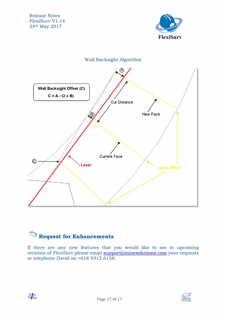
Laser Offsets Laser offsets interprets sections of the wall string as being either straight or curved. There was the possibility that straight sections could sometimes be incorrectly interpreted as a curve. This issue has been fixed. The last version of FlexiSurv introduced a backsight offset algorithm which is now termed centreline (CL) backsight offsets. A new algorithm to generate backsight offsets from the wall has been implemented. You need to nominate either the left hand wall (LHW) or the right hand wall (RHW). The nominated wall should have the tightest curve.
Create backsight offsets NO – no backsight offsets are generated
CL – centreline backsight algorithm LHW – wall algorithm using the left had wall RHW – wall algorithm using the right hand wall
Release Notes FlexiSurv V1.14 24th May 2017
Page 17 of 17
Wall Backsight Algorithm
Request for Enhancements If there are any new features that you would like to see in upcoming versions of FlexiSurv please email [email protected] your requests or telephone David on +618 9312 6158.