flavio c. ferrante drones in cadastral applications ... · the use of such systems is reserved for...
TRANSCRIPT

* Agenzia delle Entrate – Direzione centrale Catasto, Cartografia e Pubblicità immobiliare.
** DIST - Università degli Studi e Politecnico di Torino
*Flavio C. Ferrante**Gabriele Garnero
Drones in cadastral applications:possible uses
DOI: 10.14609/Ti_1_16_3e
Keywords: drones, APR, conservation of the Italian Cadastre, photogrammetry.
Abstract The considerable diffusion of technologies that use drones as the carriers that make it possibleto bring photogrammetric sensors to heights for the acquisition of territorial information is arousing interest
in a production sector, that of geotopographic information, which like other sectors, needs to find new
stimulus in order to renew itself.
The paper here proposed does not seek to analyse technical innovations of the sector, innovations allowed
by new and increasingly efficient aircraft, by new sensors, by increasingly high performance software and
more or less restrictive limitations imposed by the norms, all activities and regulations in rapid and, in some
respects, tumultuous innovation and subject to other and more specific detail.
The authors instead wish to propose a reflection on the actual possibilities, in the not too distant future, of
the transposition of these technologies within the sphere of cadastral activities, so as to allow the
economies and positive findings on photogrammetric measurement within the procedures of conservation
of the Italian Cadastre.
This work was drawn up within the framework of the activities of the CAT-APR Project, a scientific
collaboration between the Revenue Agency and the Dipartimento Interateneo di Scienze, Progetto e
Politiche del Territorio - Inter-university Department of Sciences, Project and Land Policies - (DIST) of the
Polytechnic and the University of Turin, which has as its object the testing of surveying methodologies
based on the use of remotely piloted aerial vehicles designed for possible use in the cadastral field.
45

FOREWARD
Article 1 of the Constitutive Law of the Cadastre, Law n. 3682 of 1 March 1886 (3rd Series) also knownas the Law of property tax equalisation, submitted by Senator Angelo Messedaglia (Figure 1) thisyear commemorating its 130th anniversary, defines the activities that must be provided as follows:“The State shall undertake, throughout the kingdom, the formation of a cadastre that has uniformgeometric particulates, founded on measurement and estimation, in order:
• to ascertain the real estate property and to keep their mutations into account• to equalise property tax.”
The following art. 3 thus specifies: “The surveying will be performed by experts delegated by theAdministration of the Cadastre, with methods that science will indicate as the most suitable to reconcilethe greater accuracy, economy and solicitude of the work”.
It was necessary, in addition to developing a suitable technical instrument for the new demands ofthe vast political and economic entity born with the unification of Italy, to seek to provide uniformprocedures for the application of the tax and the various units of measure, including monetary, usedby previous Cadastres.
Figure 1 Senator Angelo Messedaglia
In these regulatory provisions, one of the first important measures of the newborn kingdom of Italy,it is very clear right from its outset that the Cadastre, in its innermost essence, must keep track ofthe mutations which intervene on the territory, and that these activities should be carried out withthe instruments and the methods that technological advancement makes available at the time.
The notion of the Cadastre in fact considers, in addition to a constitutive part of the deeds and actsthat are defined as formation, that of updating, called conservation, which sets out the modalities forverification as well as introducing, in the particulate map and in the census records, the mutationsthat are involved in the particulate fabric and in the legal regime of the buildings. This conditionaccompanies the entire life of the Italian Cadastre and it has to be emphasised that the formation ofthe Cadastre took place from the outset in the perspective of its conservation.
Flavio Celestino Ferrante, Gabriele Garnero46

As a consequence, the technical bodies of the cadastral administration have always followed withinterest the technological and professional evolutions that have enabled first the formation (1886-1956) and subsequently the conservation of the cadastral bases.It should be remembered, in times that are relatively close, the circular memorandum 2/88 of thethen General Directorate of the Cadastre and Technical Revenue Services, having as its object thesimplification and standardisation of the detailed rules for the implementation of surveying and ofthe procedures for updating the cartography and of the corresponding cadastral archive, whichexpressed openness to the possibility of using electronic instruments within the Cadastreconservation procedures, and the instruction regarding the use of the GPS (Global Positioning System)methodology of 2003, that has permitted the use of modern satellite technology within the same.It is therefore a natural consequence that modern applications of drones in the determination of thecartographic information, as had already taken place since 1934 with the first photogrammetricapplications that will be mentioned as follows, should also arouse the interest of the administrationof the Cadastre, in view of possible uses within the various applications.The acquisition of photographic images from above, both with the traditional nadiral angle and withinteresting and promising applications relating to the images made with oblique angles, is considerednot only as a source of information in the procedures for the acquisition of the geometric dimensionwhich make it possible to operate on the basis of the cartographic databases for the purposes ofupdating and improving their own accuracy, but also for the creation of a database of images of thebuilt heritage, through which necessary procedures can be implemented for the future activities ofidentifying further constructions that have not yet been declared in the Cadastre and thoseassociated with the revision of property valuation, currently not on the agenda but still an argumentthat is always present in the list of activities to which attention should be paid.The objective of the considerations that follow is therefore to provide an answer to the question asto whether the procedures that use instruments carried by drones could be applied to the productionof the observations required in the cadastral applications in a positive way, i.e., if the technicallimitations and regulations are such as to allow, at least in the current state, a beneficial use.
LEGAL FRAMEWORK As defined in the current version of the normative reference, the recent revision of the ENACRegulation (Amendment 1 of 21 December 2015 to Edition 2 of 16 July 2015), with the term droneor, more specifically, with the abbreviation RPA (Remotely Piloted Aircraft) we mean a “an aerial vehiclewithout persons on board, not utilised for recreational purposes or for sports”.The normative definition therefore focuses not only on the absence of a pilot aboard, also commonfor non-professional and amusement applications, but also on the uses and the activities that areintended to be carried out through the definition of the so-called “specialised operations”, definedas the “activities that involve performing, with an RPA, a professional service with or without payment,such as for example: cinematic, television and photographic services, surveillance of the territory orof installations, environmental monitoring, agricultural uses, photogrammetry, advertising, training”,and therefore for purposes that are to some extent professional.In the previous statement the term RPA is used to define a remotely piloted aircraft, constituted of ahalf-plane without people on board and of the relative components necessary for the control andcommand (control station) by the remote pilot.The inclusion of the term aircraft also stresses that, regardless of the position of the pilot and/or ofthe flight crew, operations must comply with the rules and procedures in some way similar to thoseordinarily in force in aeronautics.
Drones in cadastral applications: possible uses 47

The use of such systems is reserved for pilots in possession of the recognition of the jurisdiction in
the state of validity, consisting of a “Pilot’scertificate” or a “Pilot’s License” for RPA, issued by ENAC
directly or through authorised personnel.
The Regulation then goes on to define the activity subject to use of the RPA which distinguish them
in critical and non-critical activities according to the following criteria (articles 9 and 10):
• “non-critical” specialised operations are those operations conducted in VLOS (Visual Line of Sight,i.e., operations carried out within a distance, both horizontal and vertical, such that the remotepilot is able to maintain continuous eye contact with the aerial vehicle, without the aid of tools toincrease the view, such as to allow him direct control of the vehicle to manage the flight, tomaintain separations and to avoid collisions) that do not involve flying over, even in the case offailures and malfunctions:– congested areas, gatherings of people, conurbations;– sensitive infrastructures.
• specialised critical operations are those operations that do not fall into, even only partially, whathas been previously defined.
For each type of activity and for each of the categories under which the vehicles are classified (with
operating weight at take-off greater than or less than 25 kg, the latter being further refined for
lightweight vehicles respectively with operating weight on take-off of less than 2 kg and less than
0.3 kg), the rules also define the modalities with which it is possible to perform shooting of photos
and videos and spenterest for the activities in question are the requirements relating to the overflying
of urban areas: clearly framed in the context of critical activities, the norm dictates a series of
precautionary requirements that, at this moment, in fact strongly limit the use of the RPAs in these
areas. The overflying of urban areas in VLOS conditions is allowed to the RPAs that demonstrate an
acceptable level of safety, which, according to art. 10, is deemed to be fulfilled when the RPA is
equipped with:
a) a primary system of command and control in which the software conforms to standards on aircraftreferred to the specific EUROCAE ED-12 at least at the level of project reliability D; alternativestandards may be accepted by ENAC wherever they meet the same objectives of reliability,
b) suitable systems to maintain control of operations in the event of loss of the data links or tomitigate their effects,
c) a system for the termination of the flight whose command is independent and dissimilar from thecommand and control system and that, if enabled, allows a moderate exposure to potentialdamage from impact.
DE-FACTO STATUSThe use of the drones is now consolidated for military use and it is increasing even for civil
applications: for example, in operations of prevention and intervention in fire emergencies, for non-
military security uses, for surveillance of energy and fluid transport lines, with the purpose of remote
sensing and research and, more in general, in all cases in which such systems would allow the
execution of missions that are “dull, dirty and dangerous”, often with lower costs compared to
conventional aircraft or ground inspections.
With regard to photogrammetric survey-type applications, is certainly not the presence of a pilot on
board or on the ground to make the difference compared to the type of product that can be obtained
Flavio Celestino Ferrante, Gabriele Garnero48

from the documentation operations: the aircraft, be it manned or unmanned aircraft, has the functionof transporting the camera and putting it in the most appropriate position for the carrying out of theaerial photography. Indeed, the significant availability of types of RPAs is only one of the elementsthat make it possible to use these instruments in a wide variety of applications in the sector. The real,and to a certain extent, still awaited explosion of the applications is based on its feasibility also inother innovative situations:
• on the one hand, the availability of high-performance sensors, with elevated geometric andradiometric resolutions, with limited weight and low cost, make it possible to embark theinstrumental load also on relatively inexpensive vehicles, therefore in fact opening the world ofphotogrammetry to numbers that are much more significant than in the past.The Italian photogrammetry market, prior to the situation of which we are speaking, wascharacterised by a very small number of aircraft operators, equipped with advanced vehicles andsensors, engaged in direct production serving a plurality of companies in the photogrammetricsector that operated in the various phases of the process that, after the shooting, leads to thefinal product (ground support, orientation of the shooting by aerial triangulation, restitution,editing, arrangement of orthoimages, etc.).The current situation instead reveals a glimpse of a situation in which, clearly for surveying ofmodest extension, the operator can, within his own studio, have everything necessary availableto him, starting precisely from the instruments of aerial photography, therefore offering thepossibility to open usage scenarios of the entire photogrammetric chain within professionalstudios or, however, with entrepreneurial entities that are certainly larger, able to operate onlimited extensions, but introducing all the potential that the photogrammetric technique allows;
• on the other hand, and in a fundamental way, the appearance and the improvement of softwaresystems capable of processing rapidly and efficiently the great amount of data that originatefrom the shooting.
Photogrammetry has always been a highly specialised discipline, with high costs for trainingvalid operators who became operational after years of learning on instrumentation that isexpensive and for that reason, not very widespread. The modern instruments operate primarilyon “almost” ordinary machines (even if, obviously, having high-quality hardware is an importantcondition for optimal professional use), allowing the training process to be considerablyreduced: the flow of operations is significantly guided, search operations of the tie pointsbetween the frames are performed practically without any intervention by the operator andwith a number of points that are far higher than those traditionally used (as Professor FriedrichAckermann of Stuttgart cheerfully stated, “redundancy substitutes intelligence”) and also thecollimation of the support points, operation that meant the long and boring “arrow tracking” ofthe frames, is today highly automated, leaving to the human operator the sole task of controland improvement in the collimation.
The engineering of the RPAs, already very advanced even on relatively cheap and popularinstruments, with specific tools that go from the operations for the preparation of the flight planand affixing of the orientation data on individual frames, allowing one to move in an almostautomatic manner to directly usable products. It therefore becomes fundamental to havespecialised training which allows one to dominate the photogrammetry process that is carriedout by the machines, and especially to critically validate the results produced at the end of thevarious phases (verification of the flight plan, of coverage and speed of shooting, evaluation of
Drones in cadastral applications: possible uses 49
residues downstream of the orientation operations, quality controls on point clouds, modelsand orthoimages), so as to validate the results obtained by the automatic methodologies,avoiding the dangerous acceptance of what is automatically returned.
A final consideration: the use of drones in the context of the techniques of photogrammetry surveyingis to all purposes and effects configured as an innovation process and not as a product, and thereforeall definitions, content, accuracies and the acquisition thresholds and testing traditionally adoptedmust in some way remain valid, since the new production techniques must be able to satisfy thetraditionally adopted requisites, with products that are largely comparable with traditional ones,enhancing only the peculiarities of use.
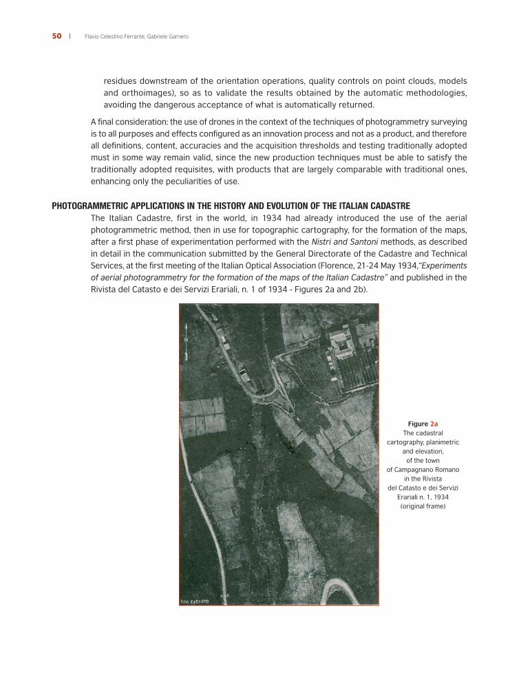
PHOTOGRAMMETRIC APPLICATIONS IN THE HISTORY AND EVOLUTION OF THE ITALIAN CADASTREThe Italian Cadastre, first in the world, in 1934 had already introduced the use of the aerialphotogrammetric method, then in use for topographic cartography, for the formation of the maps,after a first phase of experimentation performed with the Nistri and Santoni methods, as describedin detail in the communication submitted by the General Directorate of the Cadastre and TechnicalServices, at the first meeting of the Italian Optical Association (Florence, 21-24 May 1934,“Experimentsof aerial photogrammetry for the formation of the maps of the Italian Cadastre” and published in theRivista del Catasto e dei Servizi Erariali, n. 1 of 1934 - Figures 2a and 2b).
Figure 2aThe cadastral
cartography, planimetricand elevation,
of the townof Campagnano Romano
in the Rivistadel Catasto e dei Servizi
Erariali n. 1, 1934(original frame)
Flavio Celestino Ferrante, Gabriele Garnero50
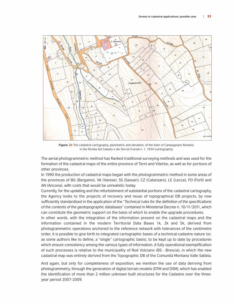
Figure 2b The cadastral cartography, planimetric and elevation, of the town of Campagnano Romanoin the Rivista del Catasto e dei Servizi Erariali n. 1, 1934 (cartography)
The aerial photogrammetric method has flanked traditional surveying methods and was used for theformation of the cadastral maps of the entire province of Terni and Viterbo, as well as for portions ofother provinces.In 1990 the production of cadastral maps began with the photogrammetric method in some areas ofthe provinces of BG (Bergamo), VA (Varese), SS (Sassari), CZ (Catanzaro), LE (Lecce), FO (Forlì) andAN (Ancona), with costs that would be unrealistic today.Currently, for the updating and the refurbishment of substantial portions of the cadastral cartography,the Agency looks to the projects of recovery and reuse of topographical DB projects, by nowsufficiently standardised in the application of the “Technical rules for the definition of the specificationsof the contents of the geotopographic databases” contained in Ministerial Decree n. 10/11/2011, whichcan constitute the geometric support on the basis of which to enable the upgrade procedures.In other words, with the integration of the information present on the cadastral maps and theinformation contained in the modern Territorial Data Bases 1k, 2k and 5k, derived fromphotogrammetric operations anchored to the reference network with tolerances of the centimetreorder, it is possible to give birth to integrated cartographic bases of a technical-cadastre nature (or,as some authors like to define, a “single” cartographic basis), to be kept up to date by procedureswhich ensure consistency among the various types of information. A fully operational exemplificationof such processes is relative to the municipality of Roé Volciano (BS - Brescia), in which the newcadastral map was entirely derived from the Topographic DB of the Comunità Montana Valle Sabbia.
And again, but only for completeness of exposition, we mention the use of data deriving fromphotogrammetry, through the generation of digital terrain models (DTM and DSM), which has enabledthe identification of more than 2 million unknown built structures for the Cadastre over the three-year period 2007-2009.
Drones in cadastral applications: possible uses 51

In the sphere of the territorial information available on the national territory, although outside the
domain of the Revenue Agency, it is appropriate to make reference to the orthoimages produced by
Agea (Agenzia per le Erogazioni in Agricoltura - Agency for Payments in Agriculture) in the context
of the controls envisioned by European Community regulations for the management of the assistance
granted in the framework of the CAP (Common Agricultural Policy). Agea in fact is responsible,
pursuant to Legislative Decree n. 99/2004, for coordinating and managing the SIAN - (Sistema
Informativo Agricolo Nazionale - National Agricultural Information System), in which the aerial
photogrammetric coverage of the entire national territory is envisioned with a three-year frequency
as well as the production of cultivation themes on a cadastral basis for the agricultural territory.
Legislative Decree 82/2005 (Code of Digital Administration) enshrines the principle of “reuse” of the
data generated by each Public Administration and the usability of the same, by means of suitable
agreements with other concerned administrations.
Starting from the year 2010, in order to optimise its aspects linked to the reutilisation of orthoimages,
the planning of programmes of recovery was amended, which are now on a regional basis rather
than a provincial one, opening the possibility for administrations to capture frames with resolution of
pixels on the ground of 20 cm instead of the 50 cm institutionally provided: this increase in resolution,
already implemented in various regions in the course of the three-year period 2014-2016, will lead
to concrete improvement in the possibilities of use of the photo-cartographic bases produced within
SIAN in the cadastral sphere.
In the more general framework of data sharing between Public Administrations, the cartographic
sector of the Cadastre is considering the opportunity to reprocess the intermediate data of AGEA
production for the realisation of precision orthoimages and, after the phase of experimentation, using
them to update the cadastral cartography, limited to particular classes of objects, such as roads,
water and buildings.
One can then certainly configure a generalised use of such photogrammetric shooting, with work-
flows specially configured to take account of the Land Register needs, with reference to current
normative forecasts (D.L. 78/2010, art. 19, paragraph 12) which establish, starting from 1 January
2011, that, on the basis of new information relating to technical-administrative reviews, by remote
surveying and on-site inspections, to initiate the constant monitoring of the territory by identifying,
in collaboration with the Municipalities, further buildings which are not declared in the Cadastre.
USE OF DRONES IN CADASTRAL APPLICATIONS
The aspects that are the object of this paper and that involve the use of drones in the context of
cadastral activities are not oriented to the production or updating of substantial portions of territory,
for which, at the time when the necessary and appropriate conditions of an economic nature and
opportunities of a political nature will be implemented, the praxis will be to use photogrammetric
procedures performed with instrumentation for shooting, aircraft and procedures that have entered
into the consolidated operating practices of the industry, which traditionally make use of the best of
what the technique makes available in terms of precision and reliability.
It is considered instead necessary to investigate the use of instruments with decidedly more modest
characteristics, which are in fact generally used today by equipment that is manageable and relatively
inexpensive, precisely like those fitted on the drones, to verify whether and under what conditions
their use may or may not be implemented, also through necessary revisions of the regulatory aspects,
so as to obtain employable results that are adapted to needs, such as for example, the remapping of
individual maps.
Flavio Celestino Ferrante, Gabriele Garnero52

The technical problems connected with the use of drones in cadastral applications are not very
different from the usual problems of use in applications of a technical nature, in which not only the
documentary or emotional appeal is significant, as in applications, even professional ones, but that
however do not require metric content.
The question which we believe deserves an explanation is the following: is it possible, with shooting
aircraft that can lift themselves from the ground for a few dozen metres, which have a limited payload
and therefore use cameras with modest characteristics, almost at an amateur level, to obtain
accuracies comparable with those required in the applications of traditional aerial photogrammetry
applications and cadastral ones in particular?
Figure 3 An esacopter in flight
The characteristics of the aircraft, the limitations of the flight altitudes, the problems connected with
the application of the regulations requiring direct vision in VLOS or, at most, EVLOS (Extended Visual
Line Of Sight, i.e., operations conducted in areas whose dimensions exceed the limits of the VLOS
conditions and for which the requirements of VLOS are satisfied with the use of alternative methods,
such as a series of operators in direct contact with the pilot) and, especially, the characteristics of
the accumulators on board, determine conditions for which the areas of recovery are generally rather
limited, i.e., to cover consistent areas there is the operational need for scheduling multiple missions.
The limits on flight altitude, currently fixed for operations in VLOS, at a maximum height of 150 m
AGL (Above Ground Level), together with the limited dimensions of the sensors of the cameras and
especially to the need for a large amount of coverage, in fact determine a high number of frames to
which traditional operators are not accustomed: also for rather limited extensions it is quite possible
to reach hundreds of frames, which however are processed with procedures with a very high degree
of automation in an acceptable amount of time.
Drones in cadastral applications: possible uses 53

It is not only the organisation of the shooting to constitute the critical phase, but rather thecharacteristics of the transportable cameras and, consequently, the characteristics of the frames.The photogrammetric cameras used in conventional operations are designed to ensure the mostevolved technology available from the point of view of metric precision and radiometric sensitivity,clearly including the elements for the determination of the positions and structures, the executionof the flight, etc.; all of this determines weights that are quite substantial, around 50-80 kg, in additionto the costs that are generically defined to be about one million euro. It is therefore evident that cameras of this kind cannot be used on the aircraft in question, which canat most carry, as characteristics of both of weight and price, models similar to amateur ones.A series of experimental work, carried out by the manufacturers, software developers, universitiesand research centres, now makes it possible to consider that even these cameras, as long as theyare properly calibrated and used according to strict procedures, can ensure accuracy compatiblewith the technical needs of cartographic productions.
Shown below are the most significant considerations:
• calibration procedures allow to model the distortions of the Dioptric lens system, and then takethem into account in the photogrammetric processes: for professional applications it is importantto make use of a camera that has been calibrated in a laboratory, determining, through specificprocedures, lens distortion parameters according to appropriate models; generally the Browndistortion model is adopted, which corrects the radial and tangential distortion. Clearly thecalibration procedures are related to a given position of the camera that, unlike photogrammetriccameras, is not a fixed focal point, but a variable one, and thus presents clearances between themachine body and the lens. Some manufacturers provide, precisely for improving thecorrespondence of the conditions of use with those stated on the certificate of calibration, thelocking of the hyperfocal focal distance with heat shrinkable film;
• the resolutions of the sensors, even if not comparable with professional ones, are in any casesignificant and however such a parameter is not critical because it is precisely according to theresolution of the sensor and of the expected size of the pixels on the ground, that the altitude ofthe flight is set, which then is determined so as to satisfy the characteristics required for theshoot;
• particular attention must be paid to the issues concerning dragging: in any photographiccamera the shutter opening should be instantaneous, but the need to allow the entry of asufficient amount of light, no matter how small the interval of time of opening of the shutter,combined with the motion of the aircraft, produces on the frame a “blurred” effect that isdefined as dragging. In the cameras that use film, the FMC device (Forward MotionCompensation) consisted in translating the flattening device in the direction of the movementof the plane with a speed which is suitably calculated so as to potentially offset this effect: forexample, in the Wild RC10 the maximum translation that the device could undergo was 640�m, therefore of the order of half a millimetre. Digital aerial photogrammetric cameras (e.g. Z/IImaging Digital Mapping Chamber (DMC) and the VexcelUltraCamD) resolve the problem not witha physical translation of the sensors, but with a particular electronic artifice called Time Delayand Integration (TDI). This method consists in sliding out loads from one row of the matrix sensorto the next according to the duration of the integration time required by the sensor, with asliding speed which is a function of the integration time of the sensor and of other geometricfactors.
Flavio Celestino Ferrante, Gabriele Garnero54

Drones in cadastral applications: possible uses 55
The cameras that are usually assembled on drones obviously do not have FMC/TDI devices: it is
true that they fly at lower speed, but they operate at much lower heights, which acts towards
increasing the phenomenon. For example the FlyGeo by FlyTop and the Bee by SenseFly have a
cruising speed equal to 36 km/h (10 m/s); with an integration time of 1/500”, the path followed
by the open shutter is about 2 cm, not particularly critical, but still in the order of magnitude of
the expected resolution for many realisations. To reduce these problems, besides using stabilised
cameras, there is an attempt to, at a constructional level, reduce the speed by changing the
avionic parameters in such a way as to reduce the stall speed (currently at 8 m/s) and in any case
in favour of the ENAC safety parameters, also using cameras with a more elevated shooting speed
(today until of 1/2000” but with some deterioration as regards the noise) and adopting the
expedient, especially for aircraft with limited wingspan, to switch off the engine at the time of
shooting, in order to reduce vibration.
EXPERIMENTAL RESULTS The widespread use of the apparatuses for photographic recording has opened the way for a variety
of applications of an experimental nature aimed at determining the optimal shooting characteristics,
the necessary resolutions on the various scales, the techniques to adopt for the preparation of the
flight plan and, clearly, the use modes of the post processing software.
Going beyond the scope of this paper is an analytical discussion on attainable precision, but some
general indications are provided, fruit of the experiments conducted:
• generally very positive for the achievement of good precision is the use of coverage at 75-80%,
both in the longitudinal and transversal direction: while the first may not be as detrimental
because the shots occur on the trajectory that the aircraft carries out and therefore there are no
operational consequences, if not the number of frames to be processed, the second instead has
considerable weight as regards the flight time, since it determines the number of the strips to
carry out in order to cover the area and is therefore directly connected with the cost of surveying,
with the number of sessions needed, with batteries available and therefore with the operating
parameters which allow the execution of the survey;
• even the number of guidance control points (GCP) used for the correct definition of the
parameters of each frame significantly affects the work operations, as the measurement
operations must often be conducted simultaneously with the shoot, since very often, to improve
the collimation thereof, signalling is carried out through signs fixed temporarily to the ground
whose position is detected, with GNSS techniques, simultaneously with the execution of the
photos taken. This fact can therefore represent an operative complication, and also in this case
criteria of economy are pushing for the reduction of the number of the GCPs which however have
a significant effect on the reduction of errors in general, and especially on the reduction in the
form of maximum deviation; in other words, the increase in the number of control points on the
ground leads to reduction of the maximum error;
• even if the experiments carried out on one’s own lead to a greater significance of the results, it
is considered opportune to indicate how much is generally shared in terms of obtainable precision
in this kind of activity, which can therefore be considered as entirely precautionary:
σ Horizontal ≅ 1.5-2 pixels
σ Vertical ≅ 4-5 pixels, at about 1/1000 of the relative flight altitude
Restricting the discussion only to planimetry, it is noticeable how even resolutions of 4-5 cm mayconservatively and usefully be adopted in cadastral applications;
• the photogrammetric processing closes generally with the predisposition of orthophotos to theappropriate scale, to be used as a basis for the subsequent processing. Pointed out here is alsothe weak link, i.e., the point on which the greatest care must be taken, significant as regards theaccuracy achieved by all the work, which is dependent on the correct processing of the DTM,obtained in general for photogrammetric autocorrelation.If, in the ordinary operations for the realisation of the orthoimages, the work required within theframework of the working group of IntesaGIS, now merged in the activities of the CISIS (Inter-regional Centre for Computer, Geographical and Statistical Systems) have defined thecharacteristics in terms of resolution and accuracy that must be possessed by the DTMs in orderto be correctly used for the preparation of orthophotos at a given scale, in activities typicallyperformed through the prepared chains with aerial photogrammetric images from drones thereare not such detailed specifics and therefore, if anything, the final product is verified, but it is notlikely that the operators are going to check the intermediate product of the DTM.It is considered that this practice should not only be recommended but also should be requiredand made compulsory in the event that the processing has to be employed in shooting with somekind of official character; in other words, there should be quality control operations establishedon the digital model obtained through visual examinations which allow, in primis, the identificationof areas in which the photogrammetric correlation may not have functioned properly, andtherefore enable a control system based on a sufficient number of control points determined onthe ground or, at least, with the stereoscopic observation of a certain number of pointsdetermined by an expert operator who verifies the outcome of automatic correlation with theuse of stereo apparatuses.
Flavio Celestino Ferrante, Gabriele Garnero56

CADASTRAL APPLICATIONS
As is known, the cadastral cartography is updated daily with automatic procedures and in real timewith regard to the classes of objects “Parcels” and “Buildings”, on the basis of acts of updatingpresented, at the request of the holders of rights in rem on the buildings, by the enabledprofessionals; by contrast, in many cases it is not updated, for some classes of objects related toviability “Roads” and hydrography “Waters”, because the public bodies that have made theinfrastructures in question, although required to present the relevant acts of updating, often do notcomply with these obligations (Figure 4).
It is quite obvious, especially in the areas of expansion of the cities where the urban transformationsthat occurred after the Second World War are consistent, that there is a need for the Cadastre toentirely remap some specific maps or portions of them.
In such cases the precision orthoimages, obtainable through illustrated technology, can constitute avalid instrument for the formation/updating of the cadastral cartography, limited to restricted areasof the territory; consequently, the cartographic sector of the Cadastre is considering the opportunityto use them, after the phase of experimentation, for these activities.
Figure 4 Cadastral cartography integrated with precision orthophotography - the Roman district of Primaporta(frames kindly granted by SIGEO S.r.l. - Rome)
Moreover, it is important to point out, that the current mapping system of the Cadastre is alreadyequipped to accommodate this new cartographic basis (precision orthophotography) and alreadyhas the features that are useful for updating, on line, cadastral cartography and the correspondingcadastral archive.
Drones in cadastral applications: possible uses 57

SOME CONSIDERATIONS AND CONCLUSIONSThe following considerations can be taken into account:
• in the applications of a professional nature, it is considered appropriate to emphasise thepossibility of 3D vision, today also made available in an economical manner with devices derivedfrom gaming. If photogrammetry was practically born with the use of instruments involving three-dimensional vision, obviously with analog devices, the high productivity of automatedautocorrelation tools can often lead to neglect this aid which, instead, can be of great help incontrolling, as has already been mentioned previously, the outcomes of the autocorrelationfunction;
• the provisions contained in the ENAC legislation at section II, art. 10 paragraph 6, which require,for use in inhabited areas, the obligatory use of a vehicle with a control system and software thatcomplies with EUROCAE ED-12 at least at the level of project reliability D or alternative standardspossibly accepted by ENAC, are rightly restrictive to ensure the safety of the people on theground, avoiding any kind of accident, even random ones and those that are not due to theinexperience of the pilot. This is because the current standard of Flight Control is not at theaeronautical level and does not guarantee minimum safety standards;
• it can be considered that in the future there will be the possibility of a development oftechnological tools necessary for the fulfilment of these requirements, since this provision is notdirected to individual producers of drones, today generally represented by companies with analmost handcrafted nature that are of limited size, but rather to manufacturers of Flight Control,with the intent of elevating the production standard to ensure flight safety. It is thereforeconceivable that, in the near future, there is the possibility of development of technological toolsnecessary for the fulfilment of the requirements laid down;
• currently, there is a growing use of devices capable of processing the GNSS observations in adifferential manner in order to improve the positioning of the filming centres. For the purposesof cartographic applications, there is not so much the need of an RTK system that, connectedwith the autopilot on board, allows the determination of the position of the filming centre duringthe phase of filming itself, but it is enough to have a system that, storing satellite observations,allows differential processing in post-processing, thereby improving the general precision andthus reducing the necessity of ground support points.
As shown, the Cadastre is interested in the use of the techniques of photogrammetric derivation,especially in the areas of urban expansion.
The technologies available today and the results of experimental tests conducted can be consideredappropriate for applications to update/remap cadastral cartography for restricted portions ofterritory.
Flavio Celestino Ferrante, Gabriele Garnero58

References
Cina A., Ferrante F., Piras M., Porporato C. (2012), La trasformazione dal Datum Catastale al Datum Roma 1940 e ETRF2000,Territorio Italia, n. 1/2012.
Di Filippo S., Catizzone A. (2009), “Un tesoro ritrovato dal rilievo alla rappresentazione”, Cangemi Editore.
Direzione Generale del Catasto e dei Servizi Tecnici (1934), comunicazione presentata alla prima riunione dell’Associazione Otticaitaliana (Firenze, 21-24 maggio 1934, “Esperimenti di fotogrammetria aerea per la formazione delle mappe del Catasto italiano”,Rivista del Catasto e dei Servizi Tecnici Erariali, n. 1, anno 1934.
Ferrante F. (2009), L’integrazione del catasto con Google Earth, Google Maps e Street-View, Territorio Informa, gennaio/marzo2009.
Ferrante F. (2009), Il nuovo sistema di aggiornamento del Catasto dei Terreni, Rivista dell’Agenzia del Territorio, n. 2/2009.
Ferrante F., Garnero G. (2013), Tecnologie e dati spaziali per una moderna governance del territorio. Strumenti a supporto dellariforma del Catasto. Territorio Italia n. 1/2013.
Garnero G., Cogoni A. (2012), Activity at low altitude photography in urban agglomerations of Sardinia and its architectural context,in Planning Support Tools: Policy Analysis, Implementation and Evaluation. Proceedings of the Seventh International Conference onInformatics and Urban and Regional Planning INPUT 2012, E-book ISBN code: 9788856875973, Franco Angeli, Milano.
Garnero G., Ferrante F. (2009), La valorizzazione delle mappe originali di impianto del catasto per la ricostruzione delle congruenzetopologiche tra fogli adiacenti, Atti della XIII Conferenza Nazionale ASITA, Bari, dicembre 2009.
Manyoky M., Theiler P., Steudler D., Eisenbeiss H. (2011), Unmanned aerial vehicle in cadastral applications, UAV-g 2011, Conferenceon Unmanned Aerial Vehicle in Geomatics, Zurich, Switzerland, International Archives of the Photogrammetry, Remote Sensingand Spatial Information Sciences, Vol. XXXVIII-1/C22.
Santarsiero D. (2015), Droni Per L’innovazione: sistemi UAV e RPV - Applicazioni Professionali dalla A alla Z, ed. MyGEO.
Volkmann W., Barnes G. (2014), Virtual Surveying: Mapping and Modeling Cadastral Boundaries Using Unmanned Aerial Systems(UAS), FIG Congress 2014 - Engaging the Challenges, Enhancing the Relevance, Kuala Lumpur, Malaysia 16-21 June 2014.
This work is licensed under a
Creative Commons Attribution - NonCommercial 3.0
Drones in cadastral applications: possible uses 59