fishing and boating access guide 2016 - … · you may refer to this link for laws pertaining to...
TRANSCRIPT

IDAHO
An angler’s guide to Idaho Department of Fish & Game managed fishing and boating access sites
idfg.idaho.gov
& fishing
boatingACCESS GUIDE

How to use this guide:Regional maps indicate locations of fishing and boating access sites. Facilities, activities and locations can be identified alphabetically.
General:To find a certain area, follow these signs until you reach your destination.
Look for signs like these:
Enjoy your stay and remember —
Litter In = Litter Out
HigHway Sign Route Sign Site Location Sign
2 GENERAL INFORMATION
Table of ContentsGeneral Information .........................................2
Panhandle Region ............................................6
Clearwater Region .........................................10
Southwest Region .......................................... 14
Magic Valley Region .....................................20
Southeast Region .......................................... 24
Upper Snake Region ....................................30
Salmon Region ................................................ 36
Panhandle
Clearwater
Southwest
Magic Valley
Southeast
Upper Snake
Salmon
Coeur d’Alene
Lewiston
McCall
Nampa
Jerome
Pocatello
Idaho Falls
Salmon
Denotes Regional O�ce

Idaho Department of Fish and Game208-334-3700 600 S. Walnut St., P.O. Box 25Boise, ID 83707
Regional Offices
Panhandle Region .................. 208-769-1414 2885 W. Kathleen Ave., Coeur d’Alene, ID 83815
Clearwater Region ................. 208-799-5010 3316 - 16th Street, Lewiston, ID 83501
Southwest Region ................. 208-465-8465 3101 S. Powerline Rd., Nampa, ID 83686
McCall Subregion ................... 208-634-8137 555 Deinhard Ln., McCall, ID 83638
Magic Valley Region .............. 208-324-4359 324 S. 417 E.; Suite #1, Jerome, ID 83338
Southeast Region ................... 208-232-4703 1345 Barton Rd., Pocatello, ID 83204
Upper Snake Region ............. 208-525-7290 4279 Commerce Circle, Idaho Falls, ID 83401
Salmon Region ........................ 208-756-2271 99 Hwy. 93 N., P.O. Box 1336, Salmon, ID 83467
Idaho Department of Fish and Game Offices are open 8 a.m. to 5 p.m. Monday through Friday except state holidays. Offices in the Panhandle and Clearwater regions are in the Pacific Time zone; all others are in the Mountain Time zone.
Idaho Relay Service (TDD) 1-800-377-3529
Internet: idfg.idaho.gov
To Receive Nonresident License Applications, Call Toll Free: 1-800-635-7820
If you buy a nonresident license this year, you will automatically receive an application form for the following year. Applications will be mailed in November.
To Buy a License, Tag or Permit:
• In person, go to any Idaho Fish and Game office or license vendor throughout the state.
• By credit card, within the United States call 1-800-554-8685. Outside the U.S., use the Internet or mail.
• On the Internet, go online to https://id.outdoorcentral.us/. A service fee is added for this transaction.
• Commercial licenses, duplicate tags, documents that require proof of disability, lifetime licenses, and bear baiting permits may be purchased only at Fish and Game offices.
Información Importante
Este libro incluye información importante acerca de las leyes de pesca de Idaho. Por favor, encuentra alguien que lee Inglés explicar la información en este libro para usted.
You may refer to this link for laws pertaining to this rule book:
Administrative Procedures Act:adminrules.idaho.gov
Please note: This booklet is based on information accurate at the time of printing, but access sites listed may have changed.
For the most up to date info, visit our website:idfg.idaho.gov/ifwis/fishingplanner
IDAHO FISHING & BOATING ACCESS GUIDE GENERAL INFORMATION3

Idaho is a land blessed with diverse outdoor opportunities.
It is a place where public access to rich wildlife and
fisheries resources is an important part of the outdoor
experience; a place where there is truly something for
everyone.
This brochure is designed to help you take advantage of
those opportunities. It will guide you to over 300 fishing
and boating access sites. Amenities and facilities are listed
for each site, and those sites accommodating persons with
disabilities are noted. Listings for the allowable and available
recreational uses are also found here. This brochure is
organized into seven regions covering the entire state.
To find a specific area, read the site description and look at
the regional map. As you travel to the area chosen, you’ll find
a sign along the road marking each site. If you need help
finding the site, call the closest regional office.
Idaho sportsmen have provided the funding to obtain and
manage many of these access sites through their purchase
of hunting and fishing licenses and tags. Other sites are
managed and maintained under cooperative agreements with
counties and other land management agencies. Funding
for the access program also comes from excise taxes paid
on hunting and fishing equipment and redistributed to
each state by the Federal Assistance program of the US Fish
and Wildlife Service. When using one of these sites, please
respect the property rights of adjacent private landowners,
and keep the sites clean by removing all litter. All of the
areas are pack it in, pack it out. These access areas are critical
resources for hunters, anglers and outdoor enthusiasts. As
Idaho grows, they will become even more important. If you
are hunting or fishing, don’t forget to pick up a copy of the
latest regulations.
We hope this publication will make it easier for you to
get outside and experience Idaho’s many recreational
opportunities. Enjoy yourself!Idaho Fish and Game adheres to all applicable state and federal laws and regulations related to dis-crimination on the basis of race, color, national origin, age, gender, disability or veteran’s status. If you feel you have been discriminated against in any program, activity, or facility of Idaho Fish and Game, or if you desire further information, please write to: Idaho Department of Fish and Game, P.O. Box 25, Boise, ID 83707 OR U.S. Fish and Wildlife Service, Division of Federal Assistance, Mailstop: MBSP-4020, 4401 N. Fairfax Drive, Arlington, VA 22203, Telephone: (703) 358-2156. This publication will be made available in alternative formats upon request. Please contact the Department of Fish and Game for assistance.
IDAHO FISHING & BOATING ACCESS GUIDE GENERAL INFORMATION4

CAMPING
Camping is allowed on many access areas but is limited to no more than 10 days within a 30 day period. More restrictive camping limits may be posted in some areas. Unattended vehicles are limited to no more than 48 hours.
CAMPFIRES
All fires must be attended or may be prohibited when fire danger is high. Signs will be posted if a fire closure is necessary.
VEHICLES
Use of motorized vehicles, including snowmobiles and all-terrain vehicles, is permitted only on designated roads. Operation of vehicles on established roads is prohibited when posted against such use.
FIREWORKS
The use of any form of fireworks or explosives on Fish and Game lands is strictly prohibited.
BOATING
Some areas have restrictions on the use of boat motors or floating devices. Be sure to consult current fishing rules.
To reduce disturbances to wildlife, provide for equitable
use of public access areas, and protect property owned
or controlled by Idaho Fish & Game, the following rules have
been established:
PETS
Dogs must be kept on a leash or under close control at all time except for bird dogs during hunting seasons.
The release or abandonment of domestic animals is prohibited.
HUNTING AND FISHING
Hunting and fishing are allowed on some management areas and access sites. However, because specific rules for these activities change from year to year, it is important to consult current hunting and fishing rules brochures.
Be careful not to discharge any firearm within or across posted “safety zones”.
ADA ACCESS
Facilities that comply with the Americans with Disabilities Act requirements for persons with disabilities are available in some areas.
(Not all sites listed in this brochure are owned or controlled by Idaho Fish and Game)
Other Sign Symbols You May Encounter
OFFICE/ QUESTIONS
INTERPRETIVE AREA
SHOOTING
WILDLIFE VIEWING
HATCHERY
RESTROOMS
PICNIC
IDAHO FISHING & BOATING ACCESS GUIDE GENERAL INFORMATION5

P
!P
!P
!P
!P
!P
P
P
PP
!P
P
P
P
P
!P
P
P
P
P
P
!P!P
P
P
P
P
P
P
P
P
P
P
P
!P
P
P
!P
!P
!P
P
X
X
X
X
X
X
XX
XX
X X
X
X
X
XX
XX
X
X
XX
WA
SH
IN
GT
ON
MO
NT
AN
A
C A N A D A
NFC
oeurdAlene
River
£¤95
MO
NT
AN
A
QR200
NF Coeur d
'Alene River
£¤95
£¤95
QR54
Kelso Lake
Chase Lake
Spirit Lake
Jewell Lake
Bonner Lake
Dawson Lake
Moyie River
Crystal Lake
Granite Lake
Garfield Bay
Freeman Lake
Denton Slough
Johnson Creek
Shepherd Lake
Cocolalla Lake
Sunnyside Park
McArthur Lake WMA
Pringle Park, East Hope
Hawkins Point - Pack River
Clark Fork Driftyard
Morton Slough
Hoodoo Creek
SandpointHope
Athol
Dover
Oldtown
Spirit Lake
Priest River
Moyie Springs
Bonners Ferry
Addie
Naples
ElmiraCoolin
Bayview
Moravia
Samuels
Colburn
Nordman
CabinetGranite
Eastport
Lakeview
Porthill
Cocolalla
Blanchard
LambCreek
PriestLake
Meadow Creek
Careywood
Glengary
Laclede
Granite
Talache
AlgomaMidas
Sagle
Clark Fork
Ponderay Kootenai
£¤95
QR1
QR41QR200
QR57
QR54
£¤2
£¤2 Lake Pend Oreille
PriestLake
Spirit Lake
UpperPriest Lake
CocolallaLake
McArthur Lake
BlanchardLake
Perkins Lake
Hidden Lake
Harrison Lake
Pries t R
iver
PackR
iver
Pend Oreille River
Kootenai River
B O N N E R
B O U N D A R Y
S H O S H O N E
South-east
Sout
hwes
t
MagicValley
Clearwater
Salmon
Upper Snake
Panhandle
In-StateLocation
C nty
Rd
34
6PANHANDLE REGION IDAHO FISHING & BOATING ACCESS GUIDE

The Panhandle Region has 5,414 miles of flowing water, numerous high mountain lakes, and 52
lowland lakes, reservoirs and ponds, of which 14 are Family Fishing waters.
SITE NAME APPROXIMATE LOCATION CAMPING RESTROOMS BOAT RAMP DOCK ADA FISHING ACCESS
BonneR Lake 4 mi e of moyie SpRingS (uS 2) - n SHoReLine no yeS yeS no no
cHaSe Lake 1.5 mi S of cooLin (SH 57) - w SHoReLine yeS yeS yeS yeS yeS
cLaRk foRk DRiftyaRD 3.5 mi nw of cLaRk foRk (SH 200) - e Bank yeS poRtaBLe yeS yeS yeS
cocoLaLLa Lake weStmonD (uS 95) - ne SHoReLine yeS aDa yeS yeS yeS
cRyStaL Lake 1.5 mi e of pRieSt RiveR (uS 2) - S SHoReLine no poRtaBLe no yeS yeS
DawSon Lake 2.5 mi w, 4 mi n of moyie SpRingS (uS 2) - aLL SHoReLine no yeS yeS yeS yeS
Denton SLougH 3 mi Se of Hope (SH 200) - Lake penD oReiLLe no poRtaBLe no no no
fReeman Lake 3 mi n of oLDtown (uS 2) - w SHoReLine yeS aDa yeS yeS yeS
gaRfieLD Bay 5 mi e of SagLe (uS 95) - Lake penD oReiLLe - w SHoReLine yeS aDa yeS yeS yeS
gRanite Lake 5 mi n of atHoL (uS 95) - n SHoReLine yeS poRtaBLe yeS yeS no
HawkinS point - pack RiveR 1 mi e of SunnySiDe (SH 200) - Lake penD oReiLLe - n SHoReLine no aDa yeS yeS no
HooDoo cReek 1/2 mi S of LacLeDe (uS 96) - penD oReiLLe RiveR - S Bank no no no no no
JeweLL Lake 3.5 mi Se of LacLeDe (uS 95) - Sw SHoReLine no poRtaBLe yeS yeS no
JoHnSon cReek 3 mi Sw of cLaRk foRk (SH 200) - cLaRk foRk RiveR - w Bank yeS aDa yeS yeS yeS
keLSo Lake 6 mi n of atHoL (uS 95) - n SHoReLine no aDa yeS yeS yeS
mcaRtHuR Lake wma 4 mi S of napLeS (uS 95) - n SHoReLine no yeS yeS yeS no
moRton SLougH 1 mi n, 6 mi w of weStmonD (uS 95) - penD oReiLLe R - S Bank yeS aDa yeS yeS yeS
moyie RiveR 3 mi S of e poRt (uS 95) - w Bank yeS yeS no no no
pRingLe paRk - eaSt Hope e Hope (SH 200) - Lake penD oReiLLe - e SHoReLine no aDa yeS yeS yeS
SHepHeRD Lake 1 mi Se of SagLe (uS 95) - e anD w SHoReLine yeS aDa yeS yeS yeS
SpiRit Lake SpiRit Lake (SH 41) - n SHoReLine no aDa yeS yeS yeS
SunnySiDe paRk 1/2 mi e of SunnySiDe (SH 200) - Lake penD oReiLLe - n SHoReLine no no yeS no no
PANHANDLE REGION 7IDAHO FISHING & BOATING ACCESS GUIDE

P
!P
P
!P
P
P
P
!P
PP
!P
!P
P
!P
P
!P
!P
!P
!P
P
P
P
P
P
P
P
!P
!P
P
P
P
P
P
!P
!P
!P
!P
!P
!P
!P
!P
!P
P
X
X
X
X
X
X
X
X
X
X
XX
X
X
X
X
X
X
NFCoeurd
Alen e River
QR41
QR54
£¤95
Litt leN
F
Coeur d'Alene River
£¤95
QR3
QR97
QR3
QR5
St Mar
ies River
St. Joe River
SF
Coeur d'Alen e River
WA
SH
IN
GT
ON
MO
NT
AN
A
Coeur d'Alene
Hayden
Rathdrum
Post Falls
Athol
Worley
Mullan
Tensed
Hauser
Osburn
Plummer
Wardner
Huetter
Wallace
Kellogg
Harrison
Pinehurst
Spirit Lake
Hayden Lake
Smelterville
Saint Maries
Dalton Gardens
GemLane
Avery
Burke
Calder
Chilco
Murray
Bayview
Garwood
Setters
Cataldo
Lakeview
Medimont
Parkline
Enaville
Kingston
Prichard
Rose Lake
Saint Joe
Silverton
State Line Village
Fernan Lake Village
§̈¦90
£¤95
QR60
QR54
QR41
QR58
QR5
QR97
QR53
QR53
QR4
QR3
§̈¦90
Coeur d'AleneLake
HaydenLake
Lake Pend OreilleSpirit Lake
Cave Lake
Hauser Lake
AndersonLake
KillarneyLake
BlackLake
UpperTwin Lake
LowerTwin Lake
Blue Lake
Cave Lake
BenewahLake
Chilco Lake
Bull RunLake
ThompsonLake
Rose Lake
S H O S H O N E
K O O T E N A I
B E N E W A H
B O N N E R
Mica Bay
Loffs Bay
Hauser Lake
Rockford Bay
Steamboat Ponds
Hayden Lake Sportsman Park
Round Lake - O'Gara Bay Road
CDA River - East of Rose Lake
Rose Lake - Sportsman Park
Rose Lake - Watson Road
Thompson Lake Outlet
Anderson Lake Outlet Lucky Friday Pond
St Maries River
Bull Run LakeDay Rock Pond
Twin Lakes
South-east
Sout
hwes
t
MagicValley
Clearwater
Salmon
Upper Snake
Panhandle
In-StateLocation
8PANHANDLE REGION IDAHO FISHING & BOATING ACCESS GUIDE

Outdoor enthusiasts will find dense forests and one of the greatest concentrations of lakes in the western states.
A few of the Idaho record fish taken in Panhandle waters include Kamloops rainbow trout, Bull Trout, Lake Trout, Kokanee, Northern Pike and Tiger Muskie.
SITE NAME APPROXIMATE LOCATION CAMPING RESTROOMS BOAT RAMP DOCK ADA FISHING ACCESS
anDeRSon Lake outLet 2 mi e of HaRRiSon (SH 97) - cDa RiveR wma - n SHoReLine no no yeS no no
BuLL Run Lake 1/4 mi S of RoSe Lake (SH 3) - w SHoReLine yeS no no no no
cDa RiveR - eaSt of RoSe Lake RoSe Lake (SH 3) - n Bank no poRtaBLe yeS no no
Day Rock ponD 3.4 mi n of waLLace on 9 miLe cReek RD - w SHoReLine no no no no no
HauSeR Lake HauSeR (SH 53) - S SHoReLine no aDa yeS yeS yeS
HayDen Lake SpoRtSman paRk 2 mi n, 6 mi e of HayDen (uS 95) - n SHoReLine no aDa yeS yeS yeS
LoffS Bay 5 mi n of RockfoRD Bay (uS 95) - cDa Lake - w SHoReLine no aDa yeS yeS yeS
Lucky fRiDay ponD 2 mi e of muLLan on LaRSon RD - n SHoReLine no no no no no
mica Bay 7 mi S of coeuR D’aLene (uS 95) - cDa Lake - w SHoReLine no aDa yeS yeS yeS
RockfoRD Bay 3 mi e of uS 95 on RockfoRD Bay RD - cDa Lake - w SHoRe no no yeS yeS no
RoSe Lake - SpoRtSman paRk 1 mi n of RoSe Lake (SH 3) - e SHoReLine yeS aDa yeS yeS yeS
RoSe Lake - watSon RoaD 1 mi n of RoSe Lake (SH 3) - e SHoReLine no aDa no yeS yeS
RounD Lake - o’gaRa Bay RoaD 6 mi S of HaRRiSon (SH 97) - e SHoReLine no aDa yeS no no
St maRieS RiveR 1 mi S of St. maRieS (SH 3) - e Bank yeS aDa yeS yeS no
SteamBoat ponDS 10 mi n of i-90 aLong tHe cDa RiveR no poRtaBLe no yeS yeS
tHompSon Lake outLet 3 mi e of HaRRiSon (SH 97) - cDa RiveR wma - e SHoReLine yeS poRtaBLe yeS no no
twin LakeS 6 mi S of SpiRit Lake (SH 41) - e SiDe of cHanneL no aDa yeS yeS yeS
PANHANDLE REGION 9IDAHO FISHING & BOATING ACCESS GUIDE

!P
!P
!P
!P
!P
!P
!P
!P
!P
P
!P
P
P
P
P
!P
!P
P
P
P
!P
P
P
!P
!P
!P
P
!P
P
P
P
P P
P
P
!P
P
!P
P
P
P
P
!P
!P
!P
X
X
XXX
X
XX
X XX
X
X
X
X
X
X
X
X
X
X
X
X
X
X
X
XX
X
XX
X
X
X
WA
SH
IN
GT
ON
S H O S H O N E
QR8
QR11
QR3
QR3
£¤95
I D A H O
£¤95
£¤95
Clearwater River
Lawyer C reek
SpringV
alleyR
d
SnakeR
iver
Powers Rd
Wah
aR
d
Lindsay Crk Rd
Deyo Reservoir
Zans
Greer
Lenore
Ahsahka
Longcamp
Mann Lake
Waha Lake
Gibbs EddyMcGill Spur
Cherry Lane
Beardy Gulch
Campbell Pond
Five-Mile Creek
Winchester Lake
Lower Hog Island
Upper Hog Island
Elk Creek Reservoir
Deer Creek Reservoir
Moose Creek Reservoir
Spring Valley Reservoir
North Fork Clearwater River
McKays Eddy - MyrtleClearwater Hatchery
Ahsahka Bridge
Lewiston
Moscow Troy
Peck
Lapwai
Bovill
Onaway
Pierce
Weippe
Kamiah
Reubens
Genesee
Orofino
Potlatch
Kendrick
Culdesac
Nezperce
Juliaetta
CraigmontWinchester
Waha
Joel
Greer
Jaype
Viola
Helmer
Vassar
Jacques
Harvard
Cameron
Glenwood
Woodland
Southwick
Princeton
Cavendish
Grangemont
Sweetwater
Headquarters
Riverside
Spalding
Ahsahka
Myrtle Lenore
Elk River
Deary
£¤95
£¤12
QR9
QR11
QR64
QR6
QR62
QR3
QR8
QR7
QR99
QR162
QR8
QR6 QR3
QR128
QR12
£¤12
DworshakReservoir
C L E A R W A T E R
L A T A H
L E W I S
N E Z P E R C E Clearw
ater River
Potlatc h River
Lolo C reek
Orofino Cre ek
Lapw
aiC
reek
North Fork Clearwater River
Big Canyon Creek
Palouse River
South-east
Sout
hwes
t
MagicValley
Clearwater
Salmon
Upper Snake
PanhandleIn-StateLocation
10CLEARWATER REGION IDAHO FISHING & BOATING ACCESS GUIDE

The Clearwater Region has 7,728 miles of flowing water, numerous high mountain lakes, and 18 lowland lakes, reservoirs and ponds,
of which 8 are Family Fishing waters.
SITE NAME APPROXIMATE LOCATION CAMPING RESTROOMS BOAT RAMP DOCK ADA FISHING ACCESS
aHSaHka 1 mi e of aHSaHka (SH 7) - cLeaRwateR RiveR - n Bank yeS aDa yeS no no
aHSaHka BRiDge aHSaHka (SH 7) - n foRk cLeaRwateR RiveR - n Bank no poRtaBLe no no yeS
BeaRDy guLcH 8 mi e of LewiSton (uS 95, mp 305) - cLeaRwateR RiveR - n Bank SeaSonaL poRtaBLe yeS no no
campBeLL ponD 17 mi e of oRofino (SH 11) yeS aDa yeS yeS no
cHeRRy Lane 1/2 mi w of cHeRRy Lane BRiDge (uS 12, mp 21) - cLeaRwateR R - S Bank yeS poRtaBLe yeS no no
cLeaRwateR HatcHeRy 3 mi w of oRofino (SH 7) - cLeaRwateR RiveR yeS poRtaBLe no no no
DeeR cReek ReSeRvoiR 12 mi n of pieRce (SH 11) no yeS yeS yeS yeS
Deyo ReSeRvoiR 3 mi w of weippe (SH 11) on ScHmiDt miLL RD yeS yeS yeS yeS yeS
eLk cReek ReSeRvoiR Se of eLk RiveR (SH 8) - aLL SHoReLine yeS yeS yeS yeS yeS
five-miLe cReek 3 mi e of gReeR (uS 12, mp 54.5) - cLeaRwateR RiveR - S Bank yeS yeS yeS no no
giBBS eDDy 1 mi e of aRRow BRiDge (uS 12, mp 16) - cLeaRwateR RiveR - S Bank yeS yeS yeS no no
gReeR gReeR BRiDge (SH 11, mp 51) - cLeaRwateR RiveR - ne Bank yeS yeS no no no
LenoRe LenoRe (uS 12, mp 27.5) - cLeaRwateR RiveR - n Bank yeS yeS yeS no no
Longcamp 5 mi nw of kamiaH (uS 12, mp 61) - cLeaRwateR RiveR - w Bank yeS poRtaBLe yeS no no
LoweR Hog iSLanD 7 mi e of LewiSton (uS 95) - cLeaRwateR RiveR - n Bank no poRtaBLe no no no
mann Lake 3 mi e of LewiSton yeS aDa yeS yeS yeS
mcgiLL SpuR 3 mi w of aHSaHka (SH 7) - cLeaRwateR RiveR - n Bank yeS no no no no
mckayS eDDy - myRtLe 3 mi e of aRRow BRiDge (uS 12) - cLeaRwateR RiveR - S Bank yeS aDa no no no
mooSe cReek ReSeRvoiR 2 mi w of BoviLLe (SH 3-8) yeS yeS yeS yeS yeS
noRtH foRk cLeaRwateR RiveR aHSaHka (SH 7) - n foRk cLeaRwateR RiveR - w Bank yeS yeS yeS no no
SpRing vaLLey ReSeRvoiR 4 mi n of tRoy (SH 8) - aLL SHoReLine yeS aDa yeS yeS yeS
uppeR Hog iSLanD 8 mi e of LewiSton (uS 95, mp 305) - cLeaRwateR RiveR - n Bank SeaSonaL yeS yeS no no
waHa Lake 10 mi S of LewiSton (county RD p2) yeS yeS yeS yeS yeS
wincHeSteR Lake wincHeSteR (uS 95) no yeS no yeS yeS
ZanS 1 mi w of gReeR (uS 12, mp 49.5) - cLeaRwateR RiveR - S Bank yeS poRtaBLe yeS no no
CLEARWATER REGION11
IDAHO FISHING & BOATING ACCESS GUIDE

!P
!P
!P
!P
!P
!P
!PP
P
P
P
P
P
!P
P
P
P
P
P
P
P
P
!P
!P
!P
X
X
X
X
X
X
X
X
X
X
X
X
X
X
£¤95
Mid dle Fork Cle a rw ater R
iver
Salmon River
Salmon River
QR13
£¤95
£¤95
OR
EG
ON
Tolo Lake Rd
Cot tonw
oo
d Creek
£¤12
South Fork Clearwate r RiverSnake River
Woo
dsid
eR
d
Soldiers Meadow Rd
Winchester Lake
Winchester
Wah a
Rd
Craigmont
Kooskia
Tolo Lake
Waha Lake
Long Gulch
Maynard Hole
Twin Bridges
Button Beach
Soldiers MeadowReservoir
Robinson Pond
Campbell Flat
Lightning Creek
Stites
Kamiah
Kooskia
Riggins
Nezperce
Ferdinand
Cottonwood
White Bird
Grangeville
Waha
Fenn
Golden
Lucile
Lowell
Glenwood
Harpster
Elk City
Orogrande
Clearwater
Greencreek
Mount Idaho
Keuterville
Syringa
£¤95
£¤12QR162
QR14
QR13
QR162
QR64
MooresLake
CrystalLake
FishLake
Lawyer Cree k
Selway River
Lo
chsa River
I D A H O
L E W I SN E ZP E R C E
South-east
Sout
hwes
t
MagicValley
Clearwater
Salmon
Upper Snake
Panhandle
In-StateLocation
12CLEARWATER REGION IDAHO FISHING & BOATING ACCESS GUIDE

Prevent the transport of nuisance species.Clean all recreational equipment.
www.ProtectYourWaters.net
When you leave a body of water:• Remove any visible mud, plants, fish or animals before
transporting equipment.
• Eliminate water from equipment before transporting.
• Clean and dry anything that comes into contact with water (boats, trailers, equipment, clothing, dogs, etc.).
• Never release plants, fish or animals into a body of water unless they came out of that body of water.
STOP AQUATICHITCHHIKERS!™
SITE NAME APPROXIMATE LOCATION CAMPING RESTROOMS BOAT RAMP DOCK ADA FISHING ACCESS
Button BeacH 2 mi n of kooSkia (uS 12, mp 72) - cLeaRwateR R - e Bank yeS poRtaBLe yeS no no
campBeLL fLat 23 mi n of RigginS (uS 95, mp 218) - SaLmon RiveR no poRtaBLe yeS no no
kooSkia kooSkia - n Bank yeS no no no no
LigHtning cReek 3 mi n of RigginS (uS 95, mp 198.7) - SaLmon RiveR yeS poRtaBLe yeS no no
Long guLcH 13 mi n of RigginS (uS 95, mp 211) - SaLmon RiveR yeS aDa yeS no yeS
maynaRD HoLe 14 mi n of RigginS (uS 95, mp 209.8) - SaLmon RiveR no poRtaBLe yeS no no
RoBinSon ponD 2 mi w fRom kamiaH (SH 162), tuRn on LawyeR ck RD 1/2 mi no no no no no
SoLDieRS meaDow ReSeRvoiR 10 mi Sw of wincHeSteR - foReSt/SoLDieR meaDow RD yeS aDa yeS yeS yeS
toLo Lake 6 mi w of gRangeviLLe no aDa yeS yeS no
twin BRiDgeS 2 mi n of SLate cReek (uS 95) - SaLmon RiveR - e Bank yeS aDa yeS no no
waHa Lake 10 mi S of LewiSton (county RD p2) yeS yeS yeS yeS yeS
wincHeSteR Lake wincHeSteR (uS 95) no yeS no yeS yeS
CLEARWATER REGION13
IDAHO FISHING & BOATING ACCESS GUIDE

!P
!P
!P
!P
!P
P
P
P
P
P
P
P
P
P
P
P
!P
P
P
P
P
P
!P
P
P
P
P
P
P
!P
!P
XX
X
X
X
XX
X
XX
X
X
X X
X
X
XX
X
XX
XX
X
Salmon River
£¤95
EF SFS
almon R iver
Littl eSalm
onR
iver
NF
Pay
ette
Rive
r
Litt
leW
eise
r Riv
er
Big
Willo
w CreekSquaw
Cree
k
£¤95
£¤95
QR55
NF
Rd
413
East For k Rd (NF Rd 412)
War
mLak
e Rd (NF Rd 22)
Sou thFo rk
Rd
(NF
Rd
474/674)
Lick Creek Rd (NF Rd 412)NF R d 340
Knob Hill Rd
Indi
anVa
lley
Rd
NF
Rd
002
Hornet CrkR
d
Boulder Hole
Northwest Passage Pond
Roberts
Fish LakeRowland Pond
Steck Park
Fall Creek
Rattlesnake
Trail Creek
Hazzard Creek
Brownlee Creek
Tripod Reservoir
Herrick Reservoir
Little Payette Lake
Horsethief Reservoir
C Ben Ross Reservoir
Paddock Valley Reservoir
Upper Bluff - Mile Post 190
Weiser
McCall
Midvale Cascade
Council Donnelly
Cambridge
New Meadows
Ola
Bear
Alpine
Cuprum
Warren
Pollock
Starkey
Meadows
WoodlandTamarack
Stibnite
Goodrich
Burgdorf
Big Creek
Cape Horn
Lake ForkFruitvale
Warm Lake
Yellow Pine
Smiths Ferry
Indian Valley
£¤95
QR55
QR21
QR71
CascadeReservoir
BrownleeReservoir
PayetteLake
DeadwoodReservoir
Crane CreekReservoir
Hells CanyonReservoir
OxbowReservoir
WarmLake
Lost ValleyReservoir
GooseLake
UpperPayette
Lake
BoxLake
GraniteLake
Manns CreekReservoir
BrundageReservoir
StanleyLake
Sage HenReservoir
LoonLake
SoulenReservoir
FairchildReservoir
RiordanLake
Bull TroutLake
Sheep Lake
CatonLake
Fish Lake
DeepLake
33 Lake
BlackLake
Corral CreekReservoir
EmeraldLake
BlackmareLake
BuckhornLake
SheepeaterLake
HazardLakes
Sou
thFo
rkSa
lmon
River
Mann
Creek
Big Creek
John
son
Cre
e k
Dea
dwoo
dR
iver
Mid
dle Fork
Salmon
River
Snake
Rive
r
Salmon River
Mid
dle
Fork
Pay
ette
Riv
er
Weis
er R
iver
V A L L E Y
A D A M S
I D A H O
W A S H I N G T O NC U S T E R
B O I S E
G e m
OR
EG
ON
South-east
Sout
hwes
t
MagicValley
Clearwater
Salmon
Upper Snake
Panhandle
In-StateLocation
14SOUTHWEST REGION IDAHO FISHING & BOATING ACCESS GUIDE

SITE NAME APPROXIMATE LOCATION CAMPING RESTROOMS BOAT RAMP DOCK ADA FISHING ACCESS
BouLDeR HoLe 16.5 mi S of RigginS (uS 95, mp 178.0) - LittLe SaLmon RiveR no yeS no no no
BRownLee cReek 18 mi nw of camBRiDge (SH 71) - BRownLee ReS. - e SHoReLine yeS poRtaBLe no no no
c Ben RoSS ReSeRvoiR 3 mi S of inDian vaLLey (uS 95) - nw SHoReLine no no yeS no no
faLL cReek 15 mi S of RigginS (uS 95, mp 179.8) - LittLe SaLmon RiveR no no no no no
fiSH Lake 7 mi w of mccaLL (fiSH Lake RD) yeS no yeS no no
HaZZaRD cReek 18 mi S of RigginS (uS 95, mp 176.5) - LittLe SaLmon RiveR yeS poRtaBLe no no no
HeRRick ReSeRvoiR 10 mi Se of caScaDe (SH 55) - w SHoReLine yeS yeS yeS no no
HoRSetHief ReSeRvoiR 9 mi e of caScaDe (SH 55) - aLL SHoReLine SeaSonaL aDa aDa yeS yeS
LittLe payette Lake 4 mi e of mccaLL (Lick cReek RD) - n SHoReLine no yeS yeS no no
noRtHweSt paSSage ponD 7 mi n of mccaLL on tHe payette R in ponDeRoSa State paRk yeS aDa no no no
paDDock vaLLey ReSeRvoiR 19 mi ne of payette (SH 55) - e SHoReLine yeS yeS yeS no no
RattLeSnake 10 mi S of RigginS (uS 95, mp 187.5) - LittLe SaLmon R - e Bank yeS no no no no
RoBeRtS 3 mi S of weiSeR (uS 95) - Snake RiveR - n Bank no poRtaBLe yeS no no
RowLanD ponD 5 mi e of mccaLL - e SiDe LittLe payette Lake no poRtaBLe no no no
Steck paRk 23 mi w of weiSeR (uS 95) - Snake R./BRownLee ReS. - e SiDe yeS aDa yeS yeS no
tRaiL cReek 17 mi S of RigginS (uS 95, mp 177.6) - LittLe SaLmon RiveR yeS poRtaBLe no no no
tRipoD ReSeRvoiR 2 mi w of SmitHS feRRy (SH 55) - aLL SHoReLine yeS yeS no yeS no
uppeR BLuff - miLe poSt 190 4.2 mi S of RigginS (uS 95, mp 190) - LittLe SaLmon RiveR yeS poRtaBLe no no no
The Southwest Region has 8,352 miles of flowing water, numerous high mountain lakes, and 28 lowland lakes,
reservoirs and ponds, of which 18 are urban ponds or Family Fishing waters.
SOUTHWEST REGION15
IDAHO FISHING & BOATING ACCESS GUIDE

P
!P
!P
!P
!P
P
!P
!P
P
!P
P
!P
P
!P
P
P
!P
P !P
P
P
P
_̂
!P
!P
P
!P
P
P
P
P
P
P
P
P
P
P
!P
P
P
!P
P
P P
P
!P
!P
!P
!P
!P
!P
!P
P
!P
!P
XX
X
XX
X
X
X
X
XX
XX
X
X X XXX
X
XX
X
X
XX
X
X
X
X
X
X
XX
X
X
X
X
X
XX
X
XXXX
X
X
X
X
XX
X
XXX
XX
Big
Willo
w Creek
Snake River
Can
yon Cre
ek
Snake River
Jord
an
CreekQR78
C a n y o nHubbardReservoir
Paye
tteRiver
SF Payette RiverQR52
Payette RiverQR52
QR55
Eagle Hatchery
QR21
£¤95
SnakeR
i ver
Boise River
Atlanta
Fifty-two Bridge
Falk Bridge
Dixie
Marsing
Airport
Map Rock
Takatori
Claytonia
Duff Lane
Lava Point
Immigration
Alder Creek
Noble Island
Midland Road
Sawyer Ponds
Trappers Flat
Blacks Bridge
Wilson Springs
Caldwell Ponds
Martin LandingStar Lane Pond
Bernards Landing
Plaza Road Bridge
Lowman Nature Pond
Emmett Airport Pond
Birding Island West
Birding Island North
Crane Falls - Cove Arm
Indian Creek Reservoir
Horseshoe Bend Mill Pond
Payette Greenbelt Pond
Old Fort Boise
Clarks Island
Walters Ferry
Lansing LaneBoise
Nampa
Meridian
Kuna
Payette
Mountain Home
Parma
Wilder
Crouch
Homedale
Idaho City
Grand View
PlacervilleHorseshoe
Bend
Pine
Banks
Sweet
Letha
Oreana
Lowman
Murphy
Gardena
Montour
Delamar
Hammett
Prairie
Granite
Atlanta
Bruneau
Reynolds
Rocky Bar
Hill City
King Hill
Riverside
Silver City
Centerville
Featherville
Garden Valley
New Centerville
Mayfield
Glenns Ferry
NewPlymouth
Middleton
Fruitland
Marsing
Notus
Melba
Star
Emmett
Eagle
Caldwell
§̈¦84 £¤20
£¤30
£¤20
QR78
QR67
QR21
QR51
QR16
QR69
QR78
QR44
QR55
QR55
QR45
QR52
£¤30
£¤20
£¤20
£¤95
§̈¦84
Lake Lowell
C J Strike Res.
Anderson RanchReservoir
ArrowrockReservoir
Lucky PeakReservoir
Little CamasReservoir
Black CanyonReservoir
Swan FallsReservoir
Mountain HomeReservoir
Succor CreekReservoir
Blair TrailReservoir
Bliss Res.
Alpine LakeBaron Lake
Pioneer Res.
Boise River
Indian Creek
Mores
Creek
SF BoiseRiver
Grimes Creek
NF Boise Riv er
MF Boise River
Big Willow
Creek
Camas Creek
Squ
awC
reek
Clover C
reek
E l m o r e
A d a
B o i s e
O w y h e e
G e m
P a y e t t eC u s t e r
OR
EG
ON
South-east
In-StateLocation
Sout
hwes
t
MagicValley
Clearwater
Salmon
Upper Snake
Panhandle
16SOUTHWEST REGION IDAHO FISHING & BOATING ACCESS GUIDE

SITE NAME APPROXIMATE LOCATION CAMPING RESTROOMS BOAT RAMP DOCK ADA FISHING ACCESS
aiRpoRt 4 mi Sw of miDDLeton (SH 44) - BoiSe RiveR - S Bank no no no no no
aLDeR cReek 1 mi S of gaRDen vaLLey (fS 24) - S foRk payette R - S Bank no no yeS no no
BeRnaRDS LanDing 6 mi w of waLteRS feRRy (SH 78) - Snake RiveR - S Bank no yeS yeS yeS no
BiRDing iSLanD noRtH 4 mi n of new pLymoutH (SH 52) - payette RiveR - n Bank no no no no no
BiRDing iSLanD weSt 3 mi nw of new pLymoutH (uS 30) - payette R wma - S Bank no no no no no
BLackS BRiDge 3 mi n of new pLymoutH (uS 30) - payette RiveR - S Bank no no yeS no no
caLDweLL ponDS 1 mi nw of caLDweLL (uS 20-26) no aDa no yeS yeS
cLaRkS iSLanD 4 mi Se of HomeDaLe (uS 95) - Snake RiveR - S Bank no no yeS no no
cLaytonia 2 mi nw of maRSing (SH 55) no no no no no
cRane faLLS - cove aRm 7 mi n of BRuneau (SH 51) - Snake RiveR - S Bank yeS yeS yeS yeS yeS
Dixie 4 mi Se of paRma (uS 95) - BoiSe RiveR - S Bank no no no no no
Duff Lane 1 mi Se of miDDLeton (SH 44) - BoiSe RiveR - n Bank no poRtaBLe no yeS yeS
eagLe HatcHeRy 3 mi Sw of eagLe (uS 20-26, SH 44) - BoiSe R - S cHanneL no no no no no
emmett aiRpoRt ponD 2 mi Sw of emmett (SH 52) no yeS no no no
faLk BRiDge 5 mi e of new pLymoutH (SH 52) - payette RiveR - S Bank no no yeS no no
fifty-two BRiDge 2 mi e of new pLymoutH (SH 52) - payette RiveR - n Bank no poRtaBLe yeS no no
HoRSeSHoe BenD miLL ponD 1 mi n of HoRSeSHoe BenD (SH 55) - payette R - S Bank no aDa yeS yeS yeS
immigRation 1 mi w of paRma (SH 18) - BoiSe RiveR - e Bank no no no no no
inDian cReek ReSeRvoiR 15 mi Se of BoiSe (i-84) no no yeS no no
LanSing Lane 2 mi Se of miDDLeton (SH 44) - BoiSe RiveR - n Bank no no no no no
Lava point 3 mi w of waLteRS feRRy (SH 45) - Snake RiveR - n Bank no no no no no
Lowman natuRe ponD 10 mi e of Lowman (SH 21) - S of payette RiveR no yeS no no yeS
map Rock 6 mi w of waLteRS feRRy (SH 45) - Snake RiveR - n Bank yeS yeS yeS no no
maRSing 4 mi Se of maRSing (SH 78) - Snake RiveR - w Bank no aDa yeS no no
maRtin LanDing 6 mi w of paRma (SH 18) - BoiSe R - Snake R - S Bank yeS aDa no no no
miDLanD RoaD 3 mi Se of miDDLeton (uS 20-26) - BoiSe RiveR - S Bank no no no no no
noBLe iSLanD 1 mi e of waLteRS feRRy (SH 45) - Snake RiveR - n Bank no no no no no
oLD foRt BoiSe 5 mi nw of paRma (uS 95) - HeaDquaRteRS no aDa yeS no no
payette gReenBeLt ponD 1/2 mi w of payette no poRtaBLe no no yeS
pLaZa RoaD BRiDge 3 mi ne of emmett (SH 52) - payette RiveR - e Bank no no no no no
SawyeR ponDS 2 mi Sw of emmett (SH 52) no aDa yeS yeS yeS
StaR Lane ponD 3 mi Sw of emmett (SH 52) no yeS no no no
*Sites continue on next page
SOUTHWEST REGION17
IDAHO FISHING & BOATING ACCESS GUIDE

SITE NAME APPROXIMATE LOCATION CAMPING RESTROOMS BOAT RAMP DOCK ADA FISHING ACCESS
takatoRi 2 mi w of paRma (SH 18) - BoiSe RiveR - n Bank no no no no no
tRappeRS fLat 10 mi w of waLteRS feRRy (SH 45) - Snake RiveR - n Bank yeS yeS yeS no no
waLteRS feRRy waLteRS feRRy BRiDge - Snake RiveR - S Bank no aDa yeS yeS yeS
wiLSon SpRingS 3 mi Se of nampa (SH 45) - wiLSon DRain no aDa no yeS yeS
What to do if you catch a tagged fish:
Contact IDFG with this information:• Tag number(s)
• Did the fish have two tags?
• What day you caught the fish
• What species it was
• Fish length
• Did you keep or release the fish?
• Did you keep the fish only because it was tagged?
• If you released the fish, did you leave the tags on it?
• What did you think of the quality of this fish?
• What did you think of the quality of your fishing experience the day you caught this fish?
• Your name, address and phone number
Report tags to: Tag.idaho.govHotline (toll free): 1-866-258-0338
18SOUTHWEST REGION IDAHO FISHING & BOATING ACCESS GUIDE

Ethical fishing is as much about common courtesy as it is about following the regulations. Anglers can improve the experience
shared by everyone by following these simple rules.
PLEASE DON’T LITTER. Pick up after yourself and others. Remember that discarded fishing line is litter too. Leave your fishing location cleaner than you found it.
DON’T CROWD OTHER ANGLERS.Be sure to leave enough space between your fishing area and other anglers to avoid line tangling and other conflicts. This is basic courtesy that should be observed by all anglers on all streams, rivers, lakes and reservoirs.
RAMP ETIQUETTE. Popular boat ramps can become crowded quickly on weekends, and the potential for conflicts can occur. Use the proper lanes for loading and unloading. If possible, load your boat before arriving so you can launch quickly and move your vehicle and trailer to clear space for the next group. Boat anglers should also be conscious of their boat’s wake, especially around anchored boats, docks and wading anglers.
ASK PERMISSION. Always ask first before entering private land and treat the property as if it was your own. Idaho’s trespass law is very clear. No person may enter private land to hunt, fish or trap without permission. if the land is either cultivated or posted with legible “no trespassing” signs.
Proper posting includes lettered signs or 100 square inches of fluorescent orange paint or an entire fluorescent orange metal fence post located every 660 feet around the property and at reasonable access points. In Idaho, a trespass conviction includes a mandatory one-year license revocation.
SOUTHWEST REGION19
IDAHO FISHING & BOATING ACCESS GUIDE

!P
!P
!P
!P!P
!P
!P
!P
!P
P
P
P
P
P
!P
P
P
P
!P
!P
P
X X XX
XXX
X
X
X
X
X
X
X
X
X
X
XX
X
X
SF Boise River
Deadm
anC
reek
Clover Creek
Lit tl
eW
ood
Rive
r
BigW
oodR
iver
Big Wood River
Little Wood River
£¤20
QR46
QR75
QR75
£¤93
£¤20
5 Mile Rd
Menard RdMor
mon
Res
ervo
irR
d
King Hill
Moonstone
Lava Point
Rock CreekCamas Creek
Gaver Lagoon
Carey Lake WMA
Preacher Bridge
Mormon Reservoir
Dog Creek Reservoir
Bear Tracks Williams
Thorn Creek Reservoir
Three Island Crossing
Little Camas Reservoir
Camas Prairie Kids PondSilver Creek West
Silver Creek East
Stanton Crossing
Sheep Bridge
Hailey
Bliss
Ketchum
Gooding
Dietrich
Bellevue
Shoshone
Richfield
Fairfield
Sun Valley
Pine
Corral
Rocky Bar
Hill City
King Hill
Featherville
Gannett
Picabo
Glenns Ferry
Carey
§̈¦84
£¤26
£¤30
QR75
QR46QR24
£¤93
£¤20Magic
Reservoir
Anderson RanchReservoir
Little WoodReservoir
PioneerReservoir
BrayLake
Blair TrailReservoir
KellyReservoir
CampbellReservoir
McHanReservoir
MorrowReservoir
Spring CreekReservoir
MaconLake
Camas Creek
Snake River
B L A I N E
C A M A S
E L M O R E
L I N C O L N
G O O D I N G
T W I NF A L L S
South-east
Sout
hwes
t
MagicValley
Clearwater
Salmon
Upper Snake
Panhandle
In-StateLocation
20MAGIC VALLEY REGION IDAHO FISHING & BOATING ACCESS GUIDE

The Magic Valley Region has 3,485 miles of flowing water, and 38 lowland lakes, reservoirs
and ponds, of which 11 are Family Fishing waters.
SITE NAME APPROXIMATE LOCATION CAMPING RESTROOMS BOAT RAMP DOCK ADA FISHING
ACCESS
BeaR tRackS wiLLiamS 8.5 mi ne of RicHfieLD (uS 26-93) - LittLe wooD RiveR no no no no no
camaS cReek 16.4 mi w of SH 75 on uS 20 - SoutH on macon fLat RD yeS no no no no
camaS pRaiRie kiDS ponD 1 mi e, 1/2 mi n of faiRfieLD, tHen 1/2 mi n (uS 20-26) no yeS no yeS no
caRey Lake wma 1 mi e of caRey (uS 20-26-93) no yeS yeS no no
Dog cReek ReSeRvoiR 8 mi nw of gooDing (SH 46) - S SHoReLine yeS yeS yeS yeS yeS
gaveR Lagoon 4 mi w of picaBo (uS 20) - Loving cReek yeS yeS no no yeS
king HiLL 5 mi ne of gLennS feRRy (i-84) - S Bank yeS yeS yeS no no
Lava point 18 mi nw of SHoSHone (uS 20-SH 75) - magic ReS. - w SHoReLine yeS yeS yeS yeS no
LittLe camaS ReSeRvoiR 25 mi ne of mountain Home (uS 20) - w SHoReLine yeS yeS yeS no no
moonStone 8 mi w of timmeRman Jct (uS 20-SH 75) - magic ReS. - n SHoRe yeS yeS yeS yeS no
moRmon ReSeRvoiR 4 mi S of faiRfieLD (uS 20) - n SHoReLine yeS yeS yeS yeS no
pReacHeR BRiDge 13 mi ne of RicHfieLD (uS 26-93) - LittLe wooD RiveR yeS no no no no
Rock cReek 5 mi w of timmeRman Jct (uS 20-SH 75) - magic ReSeRvoiR no no no no no
SHeep BRiDge 4 mi w of timmeRman Jct (uS 20-SH 75) - magic ReS. - Big wooD R no no no no no
SiLveR cReek eaSt 3 mi nw of picaBo (uS 20) yeS yeS no no no
SiLveR cReek weSt 3 mi w of picaBo (uS 20) yeS yeS no no no
Stanton cRoSSing 2 mi w of timmeRman Jct (uS 20-SH 75) - Big wooD RiveR yeS yeS no no no
tHoRn cReek ReSeRvoiR 23 mi ne of gooDing (SH 46) yeS yeS no no no
tHRee iSLanD cRoSSing 1 mi w of gLennS feRRy (i-84) - n Bank no no no no no
MAGIC VALLEY REGION21
IDAHO FISHING & BOATING ACCESS GUIDE

!P
!P
!P
!P
!P
!P
P
!P
!P
!P
!P
!P
!P
!P
P
!P
!P
!P
!P
P
!P
!P
!P
!P
!P
P
!P
!P !P
!P
!P
P
P
!P
P
P
P
P
X
X
X
X
X
X XXX
X
X
X
X
X
X
X
X
X
X
X
XX
XX
XXX
X
Clover Creek
N E V A D A U T A H
Raf
tRiv
e r
Salm
onFa
llsC
reek
Deep
Creek
£¤30Rock Creek
Lower SalmonFalls Reservoir
Upper SalmonFalls Reservoir
QR46
£¤93
£¤93
Snake River
Big Wood River
QR24
Snake River
1600 S Rd
Billingsley Creek South
Filer Ponds
ScottBordewick
Cedar Draw
Auger Falls
Bell Rapids
Minidoka Pond
Murtaugh Lake
Ponderosa Pond
Gifford Springs
Sublett Reservoir
Big Cottonwood WMA
Billingsley Creek North
Hagerman WMA - Oster Lakes
Niagara Springs WMA
Niagara Springs Peterson Island
Twin Falls
Rupert
Burley
Jerome
EdenBuhl
Malta
Declo
Filer
Bliss
Hansen
Albion
Oakley
Acequia
Gooding
Hazelton
Kimberly
Murtaugh
Dietrich
Minidoka
Shoshone
Hollister
Castleford
Elba
Almo
Bridge
Kimama
Marion
Sublett
Standrod
Rogerson
Raft River
Tuttle
Hagerman
Heyburn
Paul §̈¦86
§̈¦84
§̈¦84
£¤26
£¤93
£¤30
£¤30
QR24
QR77
QR25
QR75
QR50
QR27
QR74
QR25 QR25
QR79
QR81
£¤30
§̈¦84
Lake Walcott
Milner Lake
Salmon Falls Creek Reservoir
Cedar CreekReservoir
WilsonReservoir
Lower Goose Creek Reservoir
Deep CreekReservoir
StarLake
WilliamsReservoir
OwinzaButte Lake
Goo
seC
reek
Little Wood River
C
ed
ar Creek
Deep Cre ek
C A S S I AT W I N F A L L S
L I N C O L N
J E R O M E
P o w e rM I N I D O K A
G O O D I N G
B L A I N E
South-east
Sout
hwes
t
MagicValley
Clearwater
Salmon
Upper Snake
Panhandle
In-StateLocation
22MAGIC VALLEY REGION IDAHO FISHING & BOATING ACCESS GUIDE

SITE NAME APPROXIMATE LOCATION CAMPING RESTROOMS BOAT RAMP DOCK ADA FISHING ACCESS
augeR faLLS 6 mi S of JeRome (i-84) no no no no no
BeLL RapiDS 4 mi Sw of HageRman (uS 30) - Snake RiveR - e Bank no aDa yeS yeS yeS
Big cottonwooD wma 6 mi nw of oakLey - HeaDquaRteRS - e of Big cottonwooD cReek no no no no no
BiLLingSLey cReek noRtH 2 mi ne of HageRman (uS 30) no no yeS yeS yeS
BiLLingSLey cReek SoutH ne of HageRman 2650S/inDian SpRingS RD - Left onto S1050e 3/4 mi no aDa yeS yeS yeS
BoRDewick 6 mi n of BuHL (uS 30) - Snake RiveR - S Bank no no no no no
ceDaR DRaw 10 mi ne of BuHL (uS 30) - Snake RiveR - S Bank yeS yeS yeS no no
fiLeR ponDS fRom uS 30, 4.5 mi n of fiLeR on 2300e, tHen e on 4350n no aDa no no yeS
giffoRD SpRingS 20 mi w of ameRican faLLS (Lake cHanneL RD) yeS poRtaBLe yeS no no
HageRman wma - oSteR LakeS 3 mi Se of HageRman (uS 30) - RiLey cReek no aDa no yeS yeS
miniDoka ponD 5 mi e of HeyBuRn (i-84) no yeS no no no
muRtaugH Lake 2 mi S of muRtaugH (uS 30) yeS yeS yeS yeS no
niagaRa SpRingS 8 mi S of wenDeLL (i-84) - Snake RiveR - n Bank no yeS no no no
niagaRa SpRingS wma 7 mi S of wenDeLL (i-84) - HeaDquaRteRS - Snake RiveR - n Bank no yeS no no no
peteRSon iSLanD 3 mi nw of DecLo (SH 77) - Snake RiveR - S Bank no no no no no
ponDeRoSa ponD 1 mi n of BuRLey (i-84, SH 27) no no no no no
Scott 8 mi Sw of JeRome (i-84) - Snake RiveR - n Bank no no no no no
SuBLett ReSeRvoiR 16 mi e of maLta (i-84) - w SHoReLine yeS yeS no no no
This area holds natural marvels such as the mighty Snake River, Thousand Springs and Shoshone Falls.
The Big Wood River and Silver Creek are world renowned for blue-ribbon rainbow trout fishing.
MAGIC VALLEY REGION23
IDAHO FISHING & BOATING ACCESS GUIDE

!P
!P
P
!P
!P
!P
P
!P
!P
!P
!P
!P
!P
!P
!P
!P
!P
P
!P
!P
P
!P
P
P
!P
P
P
!P
P
P
P
P
P
!P
P
P
P
!P
!P
P
X
X
XX
X
X
X
X
XX
X
X
X
X
X
X
X
X
X
X
X
X
X
XX
XX
X
XX
X
X
X
X
X
X
X
X
X
X
X
X
X
XX
X
X
X
Portneuf River
Portn
euf R
iver
Blackfoot River
SFS
nake
River
Will ow
Creek
Snak
e River
Bla ck foot River
Bear Ri ver£¤30
§̈¦15
QR39
Kelly
Top
once
Rd
Ol d
Hw
y30
Gray's LakeR
d
We
stS
ide
Rd
Grace
Pingree
Pipeline
Riverton
Dike Lake
Rose Pond
PowerhouseCrane Creek
Mikes Place
Ferry Butte
Pebble Beach
Poison Creek
Firth Bridge
Shelley Park
Twin Bridges
Cherry Plant
McTucker PondSportsman Park
Portneuf-Lower
Portneuf-Upper
Hopkins Landing
Firth City Park
Springfield Lake
Grays Lake Outlet
Snake River Vista
Eagle Rock-Monument
Blackfoot River WMA
Crystal Springs Pond
Oregon Trail Crossing
Chesterfield Reservoir
Edson Fichter Nature Area
Twenty-four Mile Reservoir
American Falls Res. West Ramp
Mary Mine - Placer Mine
American Falls Hatchery
Blackfoot River Park
Porterville Bridge
Pocatello
IdahoFalls
Chubbuck
Iona
Irwin
Firth
Shelley
McCammon
Aberdeen
Atomic City
Soda Springs
Lava HotSprings
Bone
Lund
Henry
Wayan
Pingree
Lincoln
Rockford
Fort Hall
Springfield
Chesterfield
Grandview
Riverside
Sterling
Moreland
Portneuf
AmericanFalls
SwanValley
Basalt
Inkom
Blackfoot
Ammon
§̈¦86§̈¦15
§̈¦15
£¤20
£¤26
£¤91
£¤30
£¤26
£¤30
QR34
QR31
QR39
QR34
QR37
£¤91
£¤20
£¤26
American FallsReservoir
GraysLake
BlackfootReservoir
RirieReservoir
AlexanderReservoir
Little ValleyReservoir
SnakeR
iver
Ross Fork Snake River
Marsh
Creek
Big Lost River
Meadow Creek
Sand
Creek
B I N G H A M
C A R I B O U
P O W E R
B O N N E V I L L E
B U T T E
B A N N O C K
BL
AI
NE
B E A R L A K E
Upper Snake
South-east
Sout
hwes
t
MagicValley
Clearwater
Salmon
Panhandle
In-StateLocation
24SOUTHEAST REGION IDAHO FISHING & BOATING ACCESS GUIDE

The Southeast Region has 2,496 miles of flowing water, and 30 lowland lakes and reservoirs, of which 5 are Family Fishing waters.
SITE NAME APPROXIMATE LOCATION CAMPING RESTROOMS BOAT RAMP DOCK ADA FISHING ACCESS
ameRican faLLS HatcHeRy 1 mi w of am. faLLS (Lake cHanneL RD. SH 39) - Snake R - n Bank no no no no no
ameRican faLLS ReSeRvoiR weSt Ramp
2 mi n of ameRican faLLS (SH 39) no yeS yeS yeS no
BLackfoot RiveR paRk 10 mi n of SoDa SpRingS (SH 34) - BLackfoot RiveR RoaD SeaSonaL poRtaBLe no no no
BLackfoot RiveR wma 25 mi ne of SoDa SpRingS (SH 34) - BLackfoot RiveR RoaD no poRtaBLe no no no
cHeRRy pLant 3 mi w of BLackfoot (SH 39/tHomaS RD) - Snake R - w Bank no no yeS no no
cHeSteRfieLD ReSeRvoiR 14 mi n of BancRoft (cHeSteRfieLD RoaD) no yeS yeS yeS yeS
cRane cReek 13 mi S of pocateLLo (oLD HigHway 91) - poRtneuf RiveR no no no no no
cRyStaL SpRingS ponD 1 mi e anD 1.5 mi S of SpRingfieLD no yeS no yeS yeS
Dike Lake (BLackfoot ReSeRvoiR) 15 mi n of SoDa SpRingS (SH 34) - BLackfoot ReS. - S Bank yeS yeS yeS yeS no
eagLe Rock - monument 7 mi Sw of am. faLLS (eagLe Rock RD) - Snake RiveR - S Bank no no no no no
eDSon ficHteR natuRe aRea 1 mi S of pocateLLo (cHeyenne RD) - poRtneuf RiveR no poRtaBLe no yeS no
feRRy Butte 5 mi ne of pingRee (SH 39 oR SH 91) - Snake RiveR - w Bank no yeS yeS no no
fiRtH BRiDge 1 mi w of fiRtH (RiveR RoaD) - Snake RiveR - e Bank no poRtaBLe yeS no no
fiRtH city paRk 1 mi w of fiRtH (RooSeveLt St.) - Snake RiveR - e Bank no no no no no
gRayS Lake outLet 10 mi nw of gRayS Lake (uS 26) - e Bank yeS no no no no
HopkinS LanDing 24 mi n of SoDa SpRingS (SH 34) - BLackfoot ReS. - w Bank yeS poRtaBLe yeS no no
maRy mine - pLaceR mine 3 mi w of am. faLLS (Lake cHanneL RD. SH 39) - Snake R - n Bank no no no no no
mctuckeR ponD 4 mi Se of SpRingfieLD (SH 39) - Snake RiveR - n Bank yeS poRtaBLe no yeS no
mikeS pLace 9 mi n of Lava Hot SpRingS (BLaSeR Hwy) - poRtneuf RiveR no no no no no
oRegon tRaiL cRoSSing vaLDeZ StReet am. faLLS - Snake RiveR - S Bank yeS yeS yeS yeS yeS
peBBLe BeacH 8 mi nw of HenRy (n ReSeRvoiR RoaD) - BLackfoot ReS. - e Bank yeS poRtaBLe no no no
pingRee 6 mi S of pingRee (SH 39) - Snake RiveR - w Bank no no no no no
pipeLine 3 mi Sw of am. faLLS (eagLe Rock RD) - Snake RiveR - S Bank yeS yeS yeS yeS no
*Sites continue on next page
SOUTHEAST REGION25
IDAHO FISHING & BOATING ACCESS GUIDE

SITE NAME APPROXIMATE LOCATION CAMPING RESTROOMS BOAT RAMP DOCK ADA FISHING ACCESS
poiSon cReek 14 mi nw of HenRy (n ReSeRvoiR RoaD) - BLackfoot ReS. - e Bank yeS no yeS no no
poRteRviLLe BRiDge 3 mi n of BLackfoot (RoSe RoaD) - Snake RiveR - w Bank no yeS yeS no no
poRtneuf - LoweR 2 mi n of Lava Hot SpRingS (BLaSeR Hwy) - poRtneuf RiveR yeS yeS no no no
poRtneuf - uppeR 7 mi n of Lava Hot SpRingS (BLaSeR Hwy) - poRtneuf RiveR no no no no no
poweRHouSe 1 mi w of am. faLLS - Snake RiveR - n Bank no no no no no
RiveRton 10 mi Sw of BLackfoot (SH 91/RiveRton RD) - Snake R - e Bank no poRtaBLe yeS no no
RoSe ponD 4 mi nw of BLackfoot (RoSe RoaD) no poRtaBLe no no no
SHeLLey paRk 2 mi w of SHeLLey (weSt fiR RD) - Snake RiveR - e Bank no poRtaBLe yeS no no
Snake RiveR viSta 4 mi w of am. faLLS (Lake cHanneL RD SH 39) - Snake R - n Bank yeS yeS yeS yeS no
SpoRtSman paRk 3 mi e of aBeRDeen (e Boat Dock RD) - am. faLLS ReS. - w Bank yeS yeS yeS yeS no
SpRingfieLD Lake SpRingfieLD (SH 39) - n SHoReLine no yeS yeS yeS no
twenty-fouR miLe ReSeRvoiR 14 mi ne of BancRoft (cHeSteRfieLD RoaD) yeS no no no no
twin BRiDgeS 1 mi w of BLackfoot (SH 39) - Snake RiveR - e Bank no no yeS no no
Idaho record fish harvested in this region include the number one Cutthroat Trout, Idaho’s State Fish, taken at Bear Lake.
Idaho’s number one Rainbow-Cutthroat hybrid was caught in American Falls Reservoir, with the state record Rainbow Trout taken in the Snake River just above the reservoir.
26SOUTHEAST REGION IDAHO FISHING & BOATING ACCESS GUIDE

Visit your DMV office or renew online.
Whether fishing, hunting, hiking, boating, or simply viewing
wildlife from your own backyard, all Idahoans have the
opportunity to enjoy Idaho'srich wildlife diversity.
Each puEach purchase or renewal contributes a portion to Idaho's wildlife:
ConservationHabitat Improvements
EducationWildlife Publications
SOUTHEAST REGION27
IDAHO FISHING & BOATING ACCESS GUIDE

!P
!P
!P
!P
!P
!P
!P
!P
!P
!P
!P
!P
!P
!P
P
!P
P
PP
P
!P
P
P
!P
P
P
P
P
!P
P
P
P
!P
!P
P
!P
P
P
!P
P
P
P
!P
P
X
X
XX
XX
X
X
X
X
X
X
X
XX
X X
X
X
X
X
X
X
X
X
X
X
X
X
X
X
X
X
X
X
XX
XXX
X
XX
X
X
Portneuf River
£¤30
QR39
Ol d
Hw
y30
QR36
£¤91
Blackfoot River
Bear River
Bann
ock
Cre
ek
§̈¦15
£¤30 QR34
UTAH
NH
olbrook Rd
QR37
§̈¦86
Rockland
AmericanFalls
Blackfoot River ParkEdson Fichter Nature Area
Crane Creek
Mikes Place
Black Canyon
Montpelier WMA
Portneuf-Lower
Portneuf-Upper
Grace Hatchery
Lamont Reservoir
Winder Reservoir
Oxford Reservoir
Weston Reservoir
Foster Reservoir
Johnson Reservoir
Daniels Reservoir
Hawkins Reservoir
Crowther Reservoir
Twin Lakes Reservoir
Deep Creek Reservoir
East Fork Rock Creek
Treasureton ReservoirDevil Creek Reservoir
Pleasantview Reservoir
Oneida Narrows Reservoir
Glendale Reservoir
Condie Reservoir
Arimo
Paris
Oxford
Weston
Downey
McCammon
Franklin
Georgetown
Montpelier
Bloomington
SaintCharles
Lava HotSprings
Bern
Ovid
Arbon
Stone
Conda
Dingle
Nounan
Samaria
Whitney
Holbrook
Thatcher
Fish Haven
Bennington
Pleasantview
Mink Creek
Virginia
Portneuf
Swanlake
Pauline
Lund
Soda Springs
MaladCity
Bancroft
Preston
Clifton
Dayton
Grace
Inkom
§̈¦15
£¤30
£¤91
£¤89
QR34
QR36
QR40
QR34
QR36QR38
£¤89
§̈¦84
O N E I D A
C A R I B O U
P O W E R
B A N N O C K
B E A R L A K E
F R A N K L I N
BearLake
Mud Lake
OxfordSlough
AlexanderReservoir
StoneReservoir
MontpelierReservoir
Swan Lake
South-east
Upper Snake
Sout
hwes
t
MagicValley
Clearwater
Salmon
Panhandle
In-StateLocation
28SOUTHEAST REGION IDAHO FISHING & BOATING ACCESS GUIDE

SITE NAME APPROXIMATE LOCATION CAMPING RESTROOMS BOAT RAMP DOCK ADA FISHING ACCESS
BLack canyon 4 mi Sw of gRace (SH 34) - BeaR RiveR - e Bank no poRtaBLe no no no
BLackfoot RiveR paRk 10 mi n of SoDa SpRingS (SH 34) - BLackfoot R RD SeaSonaL poRtaBLe no no no
conDie ReSeRvoiR 8 mi n of pReSton (SH 34) yeS poRtaBLe yeS yeS no
cRane cReek 13 mi S of pocateLLo (oLD HigHway 91) - poRtneuf R no no no no no
cRowtHeR ReSeRvoiR in maLaD (4tH w) yeS poRtaBLe no no no
DanieLS ReSeRvoiR 15 mi nw of maLaD (w DanieLS RD) yeS yeS yeS no no
Deep cReek ReSeRvoiR 4 mi e of i-15 (weSton exit) - SH 36 yeS yeS yeS yeS no
DeviL cReek ReSeRvoiR 8 mi n of maLaD (i-15, DeviL cReek exit) yeS yeS yeS yeS no
eaSt foRk Rock cReek 6 mi e of RockLanD (centeR St.) yeS poRtaBLe no no no
eDSon ficHteR natuRe aRea 1 mi S of pocateLLo (cHeyenne RD) - poRtneuf R no poRtaBLe no yeS no
foSteR ReSeRvoiR 5 mi ne of pReSton (SH 34) no poRtaBLe yeS yeS no
gLenDaLe ReSeRvoiR 6 mi ne of pReSton (SH 34) yeS yeS yeS yeS no
gRace HatcHeRy 8 mi S of gRace (SH 34) no no no no no
HawkinS ReSeRvoiR 10 mi w of viRginia (HawkinS RD) yeS yeS yeS yeS no
JoHnSon ReSeRvoiR 3 mi e of pReSton (oneiDa St. in pReSton) yeS poRtaBLe yeS yeS no
Lamont ReSeRvoiR 3 miLeS e of pReSton (2200 eaSt) no poRtaBLe yeS yeS no
mikeS pLace 9 mi n of Lava Hot SpRingS (BLaSeR Hwy) - poRtneuf R no no no no no
montpeLieR wma 1 mi e of montpeLieR (uS 89) no no no no no
oneiDa naRRowS ReSeRvoiR 15 mi ne of pReSton (SH 36) yeS yeS yeS yeS no
oxfoRD ReSeRvoiR 1 mi n of oxfoRD (HigHway D1) no no no no no
pLeaSantview ReSeRvoiR 5 mi w of maLaD (HaRRiSon RD 2000 n) no poRtaBLe yeS no no
poRtneuf - LoweR 2 mi n of Lava Hot SpRingS (BLaSeR Hwy) - poRtneuf R yeS yeS no no no
poRtneuf - uppeR 7 mi n of Lava Hot SpRingS (BLaSeR Hwy) - poRtneuf R no no no no no
tReaSuReton ReSeRvoiR 11 mi n of pReSton (SH 34) no yeS yeS yeS yeS
twin LakeS ReSeRvoiR 4 mi w of SH 91 (twin LakeS RoaD) yeS yeS yeS yeS no
weSton ReSeRvoiR 13 mi e of i-15 (weSton exit) - SH 36 no poRtaBLe no no no
winDeR ReSeRvoiR 6 mi n of pReSton (SH 34) no poRtaBLe no no no
Ask First: to fish on private land!
SOUTHEAST REGION29
IDAHO FISHING & BOATING ACCESS GUIDE

!P
!P
!P
!P
!P
!P
!P
!P
!P
!P
!P
!P
P
!P
P
!P
!P
P
!P
!P
!P
P
!P
!P
!P
P
P
!P
P
P
P
!P
!P
!P
!P
!P
P
P
!P
P
P
P
X
XX
X
X
X
X
X
X X
X
X
X
X
X
X
X
X
XX
X
X
X
X
X
X
X
X
X
X
X
X
X
X
X
X
X
X
XX
X
X
X
X
X
XX
Will ow
Creek
£¤26
MO
NTA
NA
£¤26
QR33
Teton River
War
mR
iver
Mud Lake QR33QR33
W 400 N
W Buxton Rd
Bates Rd
W 600 S
49th Rd SE Sunnyside Rd
Bo n
eR
d
49th Rd S
6000
W
Horseshoe Bridge
Warm River ADA
Stone Bridge
Jump Off Canyon
Ora Bridge
Erickson Dugway Rd
E 3500 Rd S
Red Road Bridge
Fox Creek East
IdahoFalls
Rexburg
Iona
Teton
Irwin
RigbyRirie
Parker
Dubois
Victor
Roberts
Newdale
Shelley
Drummond
Warm River
Swan Valley
SaintAnthony
Felt
Small
Heise
CamasLamont
Lorenzo
Lincoln
Terreton
Sage Junction
Sugar City
Marysville
Thornton
Chester
Lewisville
Tetonia
Ashton
Driggs
Hamer
Menan
Ucon
Ammon
§̈¦15
§̈¦15
£¤20£¤26
£¤91
£¤20
QR33
QR32
QR22
QR43
QR48
QR47
QR31
£¤20
F R E M O N T
B O N N E V I L L E
T E T O N
J E F F E R S O N
C L A R K
M A D I S O N
B I N G H A MPalisades Res.
RirieReservoir
MarketLake
QuaylesLake
UpperPalisades
Lake
LemonLake
EginLakes
HorseshoeLake
Falls River
Dry Bed
Camas Cre
ek
SF Snake River
Sand
Creek
Willow CreekGrays Lake Outlet
Byington
Gem State
Fall River
Moody Creek
Chester Dam
Teton Creek
Warm Slough
Cache Bridge
Twin Bridges
Menan Buttes
Conant Valley
Gem State WHA
Rainey Bridge
Kepps Crossing
Fox Creek West
Harrops Bridge
Jim Moore Pond
West River Road
Palisades Creek
Trail Creek Pond
Ashton Reservoir
Sand Creek Ponds
Cartier Slough WMA
Mud Lake WMA- North Ramp
Mud Lake WMA- South Ramp
Beaver Dick
Rexburg Nature Park
Clowards Crossing
Market Lake WMA
Chester Wetland
Fun Farm Bridge
Vernon Bridge
Bates Bridge
Teton River
SnakeR
iv er
Dry Bed
Camas Cre
ek
Sand Creek
Will ow Creek
South-east
Upper Snake
Sout
hwes
t
MagicValley
Clearwater
Salmon
Panhandle
Sand
Creek
Rd
In-StateLocation
30UPPER SNAKE REGION IDAHO FISHING & BOATING ACCESS GUIDE

The Upper Snake Region has 3,287 miles of flowing water, and 18 lowland lakes, reservoirs and ponds, of which 10 are Family Fishing waters.
SITE NAME APPROXIMATE LOCATION CAMPING RESTROOMS BOAT RAMP DOCK ADA FISHING
ACCESS
aSHton ReSeRvoiR 3 mi n of aSHton (uS 20) - HenRyS foRk - n Bank no aDa yeS yeS yeS
BateS BRiDge 4 mi w of DRiggS (SH 33) - teton RiveR - e Bank no poRtaBLe yeS no no
BeaveR Dick 6 mi w of RexBuRg (SH 33) - HenRyS foRk - w Bank yeS aDa yeS yeS no
Byington 5 mi e of RiRie (uS 26) - S foRk Snake RiveR - S Bank no aDa yeS yeS no
cacHe BRiDge 9 mi nw of DRiggS (SH 33) - teton RiveR - w Bank no poRtaBLe yeS no no
caRtieR SLougH wma 6 mi w of RexBuRg (SH 33) - HenRyS foRk - w Bank no no no no no
cHeSteR Dam 3 mi nw of cHeSteR (uS 20) - HenRyS foRk - n Bank no yeS yeS no no
cHeSteR wetLanD 6 mi ne of St. antHony (uS 20) - HenRyS foRk - w Bank no poRtaBLe no no no
cLowaRDS cRoSSing 10 mi Se of iDaHo faLLS (uS 26) - wiLLow cReek - w Bank yeS no no no no
conant vaLLey 5 mi w of Swan vaLLey (uS 26) - S foRk Snake RiveR - S Bank no aDa yeS yeS no
faLL RiveR 1.5 mi n of cHeSteR (uS 20) no poRtaBLe no no no
fox cReek eaSt 5 mi nw of victoR (SH 33) - teton RiveR - e Bank no no no no no
fox cReek weSt 7 mi nw of DRiggS (SH 33) - teton RiveR - w Bank yeS yeS yeS no no
fun faRm BRiDge 3 mi n of St. antHony (uS 20) - HenRyS foRk - S Bank no aDa yeS no no
gem State 6 mi S of iDaHo faLLS (BuSineSS i-15) - Snake RiveR - w Bank no yeS no no no
gem State wHa 12 mi w (SH 33) tHen 6 mi S of RexBuRg no no no no no
HaRRopS BRiDge 4 mi w of tetonia (SH 33) - teton RiveR - e Bank no aDa yeS no no
HoRSeSHoe BRiDge 9 mi nw of DRiggS to cacHe BRiDge -1 mi n to oLD R/R tRack - foLLow to teton R no no no no no
Jim mooRe ponD 2 mi S of RoBeRtS (i-15) - S-w-n SHoReLineS onLy yeS aDa yeS yeS yeS
Jump off canyon 27 mi n (SH 20) fRom aSHton, tHen 1.3 mi w on Dam RD no aDa no no no
keppS cRoSSing 15 mi Se of iDaHo faLLS (uS 26) - wiLLow cReek - BotH BankS yeS no no no no
maRket Lake wma 2 mi n of RoBeRtS (i-15) - HeaDquaRteRS no no no no no
menan ButteS 9 mi w (SH 33), 6 mi S (twin Butte RD) of RexBuRg - Snake R no aDa yeS yeS no
*Sites continue on next page
UPPER SNAKE REGION31
IDAHO FISHING & BOATING ACCESS GUIDE

SITE NAME APPROXIMATE LOCATION CAMPING RESTROOMS BOAT RAMP DOCK ADA FISHING
ACCESS
mooDy cReek 9 mi S of newDaLe (SH 33) - e Bank no no no no no
muD Lake wma - noRtH Ramp 5 mi e of teRReton (SH 33) - tHen 7 mi nw yeS aDa yeS yeS yeS
muD Lake wma - SoutH Ramp 1 mi e of teRReton (SH 33) - tHen 1.5 mi n yeS aDa yeS yeS no
oRa BRiDge 2.5 mi w of aSHton (uS 20) - HenRyS foRk no poRtaBLe yeS no no
paLiSaDeS cReek 4 mi S of iRwin (uS 26) - S foRk Snake RiveR - n Bank yeS aDa yeS yeS yeS
Rainey BRiDge 12 mi nw of DRiggS (SH 33) - teton RiveR - BotH SiDeS yeS aDa yeS no no
ReD RoaD BRiDge 5 mi n of RexBuRg (SaLem Hwy) no aDa yeS no no
RexBuRg natuRe paRk RexBuRg, aDJacent to faiRgRounDS, weSt 5tH St no yeS no no yeS
SanD cReek ponDS 17 mi ne of St. antHony on SanD cReek RD yeS aDa yeS yeS yeS
Stone BRiDge 7 mi e (SH 47) fRom aSHton, tHen n foR ½ miLe on cnty RD - waRm R - n Bank
no aDa yeS no no
teton cReek 5 mi Sw of DRiggS (SH 33) - teton RiveR - w Bank yeS poRtaBLe yeS no no
tRaiL cReek ponD 3 mi e of victoR (SH 33) no aDa no no yeS
twin BRiDgeS 5 mi n of RiRie (RiRie-aRcHeR Hwy) - S foRk Snake RiveR - n Bank yeS aDa yeS yeS no
veRnon BRiDge 5 mi Sw of aSHton (uS 20) - HenRyS foRk no poRtaBLe yeS no no
waRm RiveR aDa 9 mi e (SH 47) fRom aSHton, tHen 0.2 mi e on waRm R campgRounD RD yeS aDa no no yeS
waRm SLougH 10 mi nw of RexBuRg - HenRyS foRk - nw Bank yeS aDa yeS yeS no
weSt RiveR RoaD 3 mi S of oSgooD (i-15, exit 128) - Snake RiveR no aDa yeS yeS yeS
Anglers come from far and wide to experience trout fishing in some of the most pristine waters in the United States
including Henry’s Lake, Henry’s Fork and South Fork of the Snake rivers.
32UPPER SNAKE REGION IDAHO FISHING & BOATING ACCESS GUIDE

Be on the lookout for Eurasian watermilfoil! A nasty invasive deadly plant that’s on Idaho’s “noxious weed list”
Eurasian Watermilfoil:• Interferes with water-based fun• Clogs boat and jet ski motors• Entangles fishing, swimming and
water skiing sites• Destroys habitat for waterfowl, fish
and other wildlife• Damages water quality• Impacts power generation and irrigation by clogging
dam trash racks and intake pipes• Provides stagnant water for breeding of mosquitos
You can prevent the spread of this noxious weed:• Clean boats, trailers and jet skis before entering and
after leaving the water.• Dispose of the weed by placing it into the nearest
trash receptacle.• The six areas that you need to clean are shown in the
drawing to the right.
What to do when you see this weed:• Do not pull it. You may simply spread this weed if you
pull it out of the water. A piece of this plant the size of a postage stamp can sprout and grow an infestation of weeds.
• Contact your local county weed superintendent listed under County Government in the phonebook.
ATTENTION BOATERS—WE NEED YOUR HELP!
aa a a
a
a
CLEAN YOUR BOAT, TRAILER & JET SKI!
Eurasian watermilfoil(Myriophyllum spicatum)
Information provided by
Sources for more information:Idaho State Department of Agriculture
Noxious Weed Program 332-8528.www.agri.idaho.gov.
Go to Plants & Insects, then to Noxious Weedswww.idahomilfoil.net
e-mail: [email protected]
UPPER SNAKE REGION33
IDAHO FISHING & BOATING ACCESS GUIDE

!P
P
P P
X
X
X
X
XXX
XX
X
X
X
X
War
mR
iver
Henry'sLake
MO
NT
AN
A
Bootjack Pass Rd
Hen
ry' s
Lake
Dr
Henry's ForkSnake
River
Henry's Lake - Frome Park
Henry's Lake South Shore
Buffalo ADAIsland ParkReservoir Island Park
McCrea
West End
Riverside
Mill Creek
Buttermilk
Box Canyon
Last Chance
Macks InnBig Springs
C L A R K
F R E M O N T
£¤20
!P
P
P
P
!P
P
P
X
X
X
X
X
X
X
XXX
X
Trail
Creek RdLittle
Lost HwyBig Lost River
£¤93Marinac
Kaufman
Rothwell
Stennett
Mackay Dam
Birch Creek
Little Lost River
Big Lost River - Lower
Big Lost River - Upper
Mackay Reservoir - Upper
Mackay Reservoir - Lower
Moore
Howe
Chilly
Leslie
Darlington
Mackay
£¤93
QR28
QR33
C U S T E R
B U T T E
L E M H I
C L A R K
B L A I N E
SummitReservoir
LittleLost River
Birch Creek
Pah
sim
eroi
Riv
er
Antelop e
Cre
ek Southeast
In-StateLocation
Southwest
Magic Valley
Clearwater
Upper Snake
Salmon
Panhandle
34UPPER SNAKE REGION IDAHO FISHING & BOATING ACCESS GUIDE

SITE NAME APPROXIMATE LOCATION CAMPING RESTROOMS BOAT RAMP DOCK ADA FISHING ACCESS
Big LoSt RiveR - LoweR 4 mi n of mackay (uS 93) - e Bank yeS aDa no no yeS
Big LoSt RiveR - uppeR 20 mi nw of mackay (uS 93) - tRaiL cReek RD - n Bank yeS no no no no
BiRcH cReek 27 mi nw of muD Lake - w SiDe of SH 28 at mp 44.1 yeS aDa no no no
Box canyon 27 mi n (SH 20) fRom aSHton, tHen 1.6 mi w on Dam RD no aDa yeS no no
BuffaLo aDa 27 mi n (SH 20) fRom aSHton yeS aDa no no yeS
ButteRmiLk fRom SH 20 - 2 mi w on kiLgoRe-yaLe RD, tHen 3 mi S on ButteRmiLk Loop RD
yeS aDa yeS no no
HenRyS Lake - fRome paRk 7 mi nw of vaLLey view (SH 87) yeS aDa yeS yeS yeS
HenRyS Lake - SoutH SHoRe
10 mi nw of mackS inn (uS 20) yeS poRtaBLe yeS no no
iSLanD paRk 27 mi n (SH 20) fRom aSHton, tHen 1.3 mi w on Dam RD no aDa yeS yeS no
kaufman 2.5 mi n of Lone pine (SH 28) - BotH BankS yeS aDa no no no
LaSt cHance 1 mi n of LaSt cHance (uS 20) on oLD Hwy - HenRyS foRk - e Bank no poRtaBLe yeS no no
LittLe LoSt RiveR 27 mi n of Howe (SH 33) on Summit cReek RD - BotH BankS yeS no no no no
mackay Dam 4 mi n of mackay (uS 93) - e Bank yeS aDa no no yeS
mackay ReSeRvoiR - LoweR 6 mi n of mackay (uS 93) - e SHoReLine yeS aDa yeS yeS no
mackay ReSeRvoiR - uppeR 7 mi n of mackay (uS 93) - e SHoReLine yeS yeS yeS no no
maRinac 1 mi S of mackay - Se coRneR of mine HiLL BRiDge on SmeLteR RD no no no no no
mccRea 29 mi n fRom aSHton (uS 20), tHen 2 mi w on kiLgoRe-yaLe RD yeS aDa yeS no no
miLL cReek 29 mi n (SH 20) of aSHton, 4 mi w on kiLgoRe-yaLe RD, 1.8 mi S on miLL cR RD
yeS aDa yeS yeS no
RiveRSiDe 16 mi n (SH 20) of aSHton yeS aDa yeS no no
RotHweLL 10 mi S mackay - weSt SiDe of uS 93 at mp 98.8 yeS no no no no
Stennett 8 mi S of mackay (uS 93) - w Bank no poRtaBLe no no no
weSt enD 18 mi n (SH 20) fRom aSHton, tHen 10 mi w gReen canyon RD yeS yeS yeS yeS no
This area is the stronghold of Idaho’s Yellowstone
cutthroat trout fishing.
UPPER SNAKE REGION35
IDAHO FISHING & BOATING ACCESS GUIDE

P
P
!P
P
!P
P
P
P
P
P
XX
X
XX
X
X
X
X
X
X
X
X
X
X
X
X
X
X
XXX
X
X
X
X
X
X
XXXXXX
XX
X
X
X
X
X
Salm
onRiver
£¤93QR28
£¤93
Salm
onR
iver
Lemhi River
CamasCree
k
MO
NT
AN
A
Lower Lemhi
Elk Bend
Red Rock
McFarland
North Fork
Tower Rock
Cottonwood
Lemhi Hole
Deer Gulch
Lime Creek
Hayden Pond
Island Park
Bobcat Gulch
Colston Creek
Carmen Bridge
Fourth Of July
Kids Creek Pond
Lemhi Power Site
Upper McKim Creek
Lemhi River South
Ellis Walking Easement
Waddington Creek
Lower McKim Creek
Cronks Canyon
Hayden Creek
Ellis North
Ellis South
Salmon
Leadore
Baker
Shoup
Carmen
Cobalt
Tendoy
North Fork
Lemhi
Ellis
£¤93
QR28 QR29
L E M H I
C U S T E R
WilliamsLake
Mill Lake
Bear Valley Lake
Panthe
r Cre
ek
Pahsimeroi River
South-east
Upper Snake
Sout
hwes
t
MagicValley
Clearwater
Salmon
Panhandle
In-StateLocation
36SALMON REGION IDAHO FISHING & BOATING ACCESS GUIDE

SITE NAME APPROXIMATE LOCATION CAMPING RESTROOMS BOAT RAMP DOCK ADA FISHING ACCESS
BoBcat guLcH 16 mi n of SaLmon (uS 93) - SaLmon RiveR - e Bank yeS aDa yeS no no
caRmen BRiDge 5 mi n of SaLmon (uS 93) - SaLmon RiveR - S Bank yeS aDa yeS no yeS
coLSton cReek 6 mi n of eLLiS (uS 93) - SaLmon RiveR - e Bank yeS aDa yeS no no
cottonwooD RecReation Site 10 mi n of cHaLLiS (uS 93) - SaLmon RiveR - e Bank yeS aDa yeS no no
cRonkS canyon 3 mi n of eLLiS (uS 93) - SaLmon RiveR - e Bank no no yeS no no
DeeR guLcH 1 mi n of eLLiS (uS 93) - SaLmon RiveR - w Bank yeS aDa yeS no yeS
eLk BenD 21 mi S of SaLmon (uS 93) - SaLmon RiveR - S Bank no no yeS no no
eLLiS noRtH eLLiS (uS 93) - SaLmon RiveR - S Bank yeS no no no no
eLLiS SoutH 1/2 mi S of eLLiS (uS 93) - SaLmon RiveR - S Bank yeS no no no no
eLLiS waLking eaSement eLLiS (uS 93) - SaLmon RiveR - n Bank no no no no no
fouRtH of JuLy 15 mi n of SaLmon (uS 93) - SaLmon RiveR - e Bank yeS aDa yeS no no
HayDen cReek 26 mi Se of SaLmon (SH 28) - LemHi RiveR - BotH BankS yeS aDa no no no
HayDen ponD 3 mi e of tenDoy (SH 28) - HayDen cReek - S Bank yeS yeS no yeS yeS
iSLanD paRk SaLmon city BRiDge (uS 93) - SaLmon RiveR iSLanD no aDa yeS no no
kiDS cReek ponD 1 mi S of SaLmon (uS 93) - kiDS cReek no aDa no yeS yeS
LemHi HoLe 1 mi n of SaLmon (uS 93) - SaLmon RiveR - w Bank yeS aDa no no no
LemHi poweR Site SaLmon city (maRgaRet StReet) - LemHi RiveR - S Bank no no no no no
LemHi RiveR SoutH 21 mi e of SaLmon (SH 28) - LemHi RiveR - BotH BankS yeS no no no no
Lime cReek 15 mi S of SaLmon (uS 93) - SaLmon RiveR - e Bank yeS no no no no
LoweR LemHi 4 mi e of SaLmon (LemHi RiveR BackRoaD) - LemHi RiveR - n Bank no no no no no
LoweR mckim cReek 12 mi n of eLLiS (uS 93) - SaLmon RiveR - e Bank yeS no no no no
mcfaRLanD RecReation Site 10 mi nw of LeaDoRe (SH 28) - LemHi RiveR - w Bank yeS aDa no no no
noRtH foRk 22 mi n of SaLmon (uS 93) at tHe viLLage at noRtH foRk - SaLmon R no aDa yeS no no
ReD Rock 10 mi n of SaLmon (uS 93) - SaLmon RiveR - e Bank yeS aDa yeS no no
toweR Rock RecReation Site 7 mi n of SaLmon (uS 93) - SaLmon RiveR - e Bank yeS aDa yeS no yeS
uppeR mckim cReek 11 mi n of eLLiS (uS 93) - SaLmon RiveR - e Bank yeS no yeS no no
waDDington cReek 10 mi S of SaLmon (uS 93) - SaLmon RiveR - e Bank yeS no yeS no no
SALMON REGION37
IDAHO FISHING & BOATING ACCESS GUIDE

!P
!P
!P
P
P
P
P
P
P
X
X
X
X
XX
X
X
X
X
XX
X
X
X
X
X
X
X
X
X
Salm
on River
QR75
£¤93
Salm
on
Ri ver
Jobe Ln
NF
Rd 080
Mill Creek Rd
Chal lis Crk R d
Garden Crk RdCuster Motor W
ay
Chilly
Tappan
Bayhorse
Dry Creek
Gold Creek
South Butte
Watts Bridge
Valley Creek
Sheep Bridge
Pennal Gulch
M-M (M BAR M)
Challis Bridge
South Butte Pond
Pahsimeroi River
Jimmy Smith Lake
Sawtooth Kids Pond
Blue Mountain Pond
Mosquito Flat Reservoir
Challis
May
Custer
Bonanza
Sunbeam
Obsidian
Stanley
Clayton£¤93
QR21
QR75
C U S T E R
L E M H IL E M H I
B O I S E B L A I N E
RedfishLake
YellowBelly Lake
StanleyLake
BaronLake
ImogeneLake
LittleRedfish
Lake
GoatLake
UpperCramer
Lake
SullivanLake
QuietLake
AlpineLake
Loon
Cre
ek
East
Fo
rkSalmon River
Big LostRiver
Pahsim
eroi River
SF Payette River
South-east
Upper Snake
Sout
hwes
t
MagicValley
Clearwater
Salmon
Panhandle
In-StateLocation
38SALMON REGION IDAHO FISHING & BOATING ACCESS GUIDE
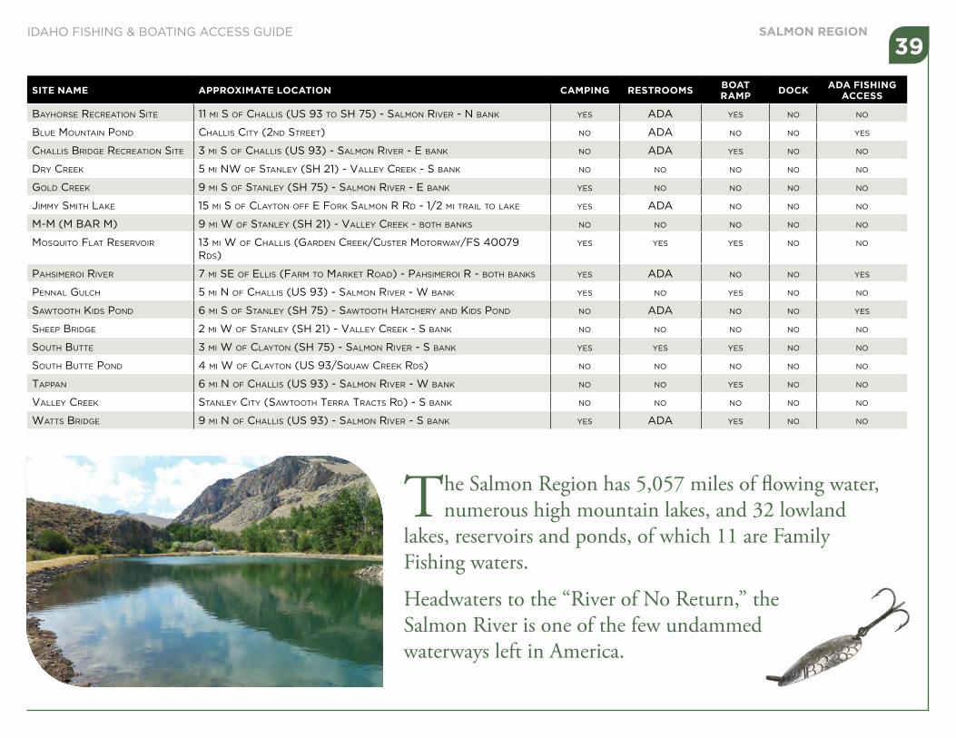
SITE NAME APPROXIMATE LOCATION CAMPING RESTROOMS BOAT RAMP DOCK ADA FISHING
ACCESS
BayHoRSe RecReation Site 11 mi S of cHaLLiS (uS 93 to SH 75) - SaLmon RiveR - n Bank yeS aDa yeS no no
BLue mountain ponD cHaLLiS city (2nD StReet) no aDa no no yeS
cHaLLiS BRiDge RecReation Site 3 mi S of cHaLLiS (uS 93) - SaLmon RiveR - e Bank no aDa yeS no no
DRy cReek 5 mi nw of StanLey (SH 21) - vaLLey cReek - S Bank no no no no no
goLD cReek 9 mi S of StanLey (SH 75) - SaLmon RiveR - e Bank yeS no no no no
Jimmy SmitH Lake 15 mi S of cLayton off e foRk SaLmon R RD - 1/2 mi tRaiL to Lake yeS aDa no no no
m-m (m BaR m) 9 mi w of StanLey (SH 21) - vaLLey cReek - BotH BankS no no no no no
moSquito fLat ReSeRvoiR 13 mi w of cHaLLiS (gaRDen cReek/cuSteR motoRway/fS 40079 RDS)
yeS yeS yeS no no
paHSimeRoi RiveR 7 mi Se of eLLiS (faRm to maRket RoaD) - paHSimeRoi R - BotH BankS yeS aDa no no yeS
pennaL guLcH 5 mi n of cHaLLiS (uS 93) - SaLmon RiveR - w Bank yeS no yeS no no
SawtootH kiDS ponD 6 mi S of StanLey (SH 75) - SawtootH HatcHeRy anD kiDS ponD no aDa no no yeS
SHeep BRiDge 2 mi w of StanLey (SH 21) - vaLLey cReek - S Bank no no no no no
SoutH Butte 3 mi w of cLayton (SH 75) - SaLmon RiveR - S Bank yeS yeS yeS no no
SoutH Butte ponD 4 mi w of cLayton (uS 93/Squaw cReek RDS) no no no no no
tappan 6 mi n of cHaLLiS (uS 93) - SaLmon RiveR - w Bank no no yeS no no
vaLLey cReek StanLey city (SawtootH teRRa tRactS RD) - S Bank no no no no no
wattS BRiDge 9 mi n of cHaLLiS (uS 93) - SaLmon RiveR - S Bank yeS aDa yeS no no
The Salmon Region has 5,057 miles of flowing water, numerous high mountain lakes, and 32 lowland
lakes, reservoirs and ponds, of which 11 are Family Fishing waters.
Headwaters to the “River of No Return,” the Salmon River is one of the few undammed waterways left in America.
SALMON REGION39
IDAHO FISHING & BOATING ACCESS GUIDE

Legal access site
Private property
Typical public road right of way - check with local road departments to determine right-of-way width.
Public Road
Public road right of way
stream
stream
Get out here
Public right of way
Dam or other objectobstructing stream
Get back in here
Private property
Public right of wayBELOW highwater mark
Permanent vegetation, e.g., shrubs, usually stop at the high-water mark.
Navigability And Public Access(Refer to Idaho Code 36-1601)
Navigable streams are defined as any stream which, in its natural high-water condition, will float logs or any other commercial or floatable commodity, or is capable of being navigated by oar or motor propelled small craft for pleasure or commercial purposes. Navigable streams are recognized as public transportation corridors, thus members of the public have the right to use the corridor, provided they enter and exit the corridor at a public right of way, and remain within the corridor. Many navigable streams flow through private property, thus it is important that anglers know their rights and responsibilities when fishing in navigable waters that flow through private property.
When fishing in navigable streams bordered by private property:
• You must stay within the normal high-water marks of the stream, unless you have landowner permission to get out on the bank, or have no other means of getting around an obstruction in the stream (such as a fence or diversion dam).
• When getting outside of the stream to go around an obstruction, take the shortest, most direct route around the obstruction to get back in the stream.
• Do not allow pets or children to trespass on adjacent private property, without landowner permission.
• You may enter and exit navigable streams at other public rights of way, such as county road bridges.
• ASK FIRST! Always get landowner permission before crossing private lands outside of a public right of way.
40IDAHO FISHING & BOATING ACCESS GUIDE

Idaho Gamefish SpeciesIllustrations by Joseph Tomelleri
Rainbow TroutBrook Trout
Yellowstone Cutthroat Trout
Westslope Cutthroat Trout
Brown Trout Bull Trout
Mountain Whitefish
Lake Trout
Steelhead
Chinook Salmon
Kokanee Salmon
Coho Salmon
41IDAHO FISHING & BOATING ACCESS GUIDE

Idaho Gamefish SpeciesIllustrations by Joseph Tomelleri
Largemouth Bass
Yellow Perch
Bluegill
Pumpkinseed
White Sturgeon
Tiger Muskie
Brown Bullhead
Channel Catfish
Walleye
Black Crappie
White Crappie
Smallmouth Bass
42IDAHO FISHING & BOATING ACCESS GUIDE

Looking for a new place to go fishing?
Idaho’s Fishing Planner is an interactive tool to explore and
plan your next fishing adventure.
• Anglers can use any combination of criteria to search by location, fish species, access, facilities, or type of fishing experience.
• Interactive maps of waters, plus information about stocking, game fish, and rules.
• See what river sections will open for salmon fishing, when they will close and more.
i d f g . i d a h o . g o v

IDAHO&
fishingboating
ACCESS GUIDE