fish and wildlife m e p (a p - northern water · 6/9/2017 · fish and wildlife mitigation and...
TRANSCRIPT

FISH AND WILDLIFE MITIGATION AND
ENHANCEMENT PLAN (APPLICANT PROPOSAL)
Prepared for:
The Colorado Parks and Wildlife Commission
in accordance with C.R.S. 37-60-122.2
Applicant:
Northern Water
acting by and through
Northern Integrated Supply Project
Water Activity Enterprise
Northern Colorado Water Conservancy District
June 9, 2017

NORTHERN INTEGRATED SUPPLY PROJECT
FISH AND WILDLIFE MITIGATION AND ENHANCEMENT PLAN
(APPLICANT PROPOSAL)
Prepared for: The Colorado Parks and Wildlife Commission
in accordance with C.R.S. 37-60-122.2
Applicant: Northern Water
acting by and through
Northern Integrated Supply Project Water Activity Enterprise
Northern Colorado Water Conservancy District
June 9, 2017

iii
CONTENTS
CONTENTS .................................................................................................................................................... iii
LIST OF TABLES ............................................................................................................................................. vi
LIST OF FIGURES ........................................................................................................................................... vii
EXECUTIVE SUMMARY .................................................................................................................................. 1
NORTHERN INTEGRATED SUPPLY PROJECT FISH AND WILDLIFE MITIGATION AND ENHANCEMENT PLAN 3
1.0 INTRODUCTION ............................................................................................................................. 3
2.0 NISP BACKGROUND....................................................................................................................... 4
2.1. Glade Reservoir Complex .......................................................................................................... 4
2.2. South Platte Water Conservation Project ................................................................................. 6
2.3. Water Supplies .......................................................................................................................... 6
2.4. Conveyance to NISP Participants .............................................................................................. 7
2.5. Estimated Project Cost .............................................................................................................. 9
2.6. Conservation ............................................................................................................................. 9
2.7. Supplemental Draft EIS Conceptual Mitigation Plan .............................................................. 11
2.8. Adaptive Management ........................................................................................................... 13
3.0 OTHER CONCURRENT OR RELATED ACTIVITIES .......................................................................... 15
3.1. Halligan and Seaman Water Supply Projects .......................................................................... 15
3.2. Poudre Runs Through It Flows Committee ............................................................................. 15
3.2.1. Flows ............................................................................................................................... 16
3.2.2. Funding............................................................................................................................ 17
3.2.3. Poudre River Forum ........................................................................................................ 17
3.3. City of Fort Collins Natural Resources Projects ....................................................................... 17
3.3.1. Poudre River Downtown Master Plan............................................................................. 17
3.3.2. Natural Areas Master Plan .............................................................................................. 17
3.3.3. Ecosystem Response Model............................................................................................ 18
3.3.4. Poudre River Health Assessment Framework ................................................................. 18
3.3.5. McMurry Natural Area Restoration Project .................................................................... 18
3.4. Poudre River Trail .................................................................................................................... 19
3.5. Cache La Poudre River at Greeley Flood Risk Mitigation and Ecosystem Restoration ........... 19
4.0 REGULATORY PROCESS ............................................................................................................... 21
4.1. Clean Water Act Section 404 Permit ....................................................................................... 21
4.2. National Environmental Policy Act Review ............................................................................. 21
4.3. Endangered Species Act .......................................................................................................... 22
4.4. Colorado Fish and Wildlife Mitigation Plan ............................................................................ 23

iv
4.4.1. Mitigation and Enhancement Plans ................................................................................ 23
4.4.2. Consultation, Coordination and Public Input .................................................................. 24
5.0 PROPOSED FISH AND WILDLIFE MITIGATION PLAN .................................................................... 26
5.1. NISP Project Area .................................................................................................................... 26
5.2. Avoidance and Minimization .................................................................................................. 28
5.2.1. Design Commitments ...................................................................................................... 28
5.2.1.1. NISP Configuration ...................................................................................................... 29
5.2.1.2. Poudre Valley Canal Diversion Structure (AG-04) ....................................................... 29
5.2.1.3. SPWCP Diversion Design (AG-07) ............................................................................... 31
5.2.1.4. Multi-Level Outlet Tower for Glade Reservoir Releases (WQ-01) .............................. 31
5.2.1.5. Glade Reservoir Release Structure (WQ-02)............................................................... 34
5.2.2. Operational Commitments ............................................................................................. 35
5.2.2.1. Avoid Munroe Canal Diversions (FW-01) .................................................................... 36
5.2.2.2. Curtail Diversions for Non-Consumptive Water Rights (FW-02) ................................ 36
5.2.2.3. Summer and Winter Diversion Curtailments (FW-03) ................................................ 38
5.2.2.4. Conveyance Refinement (FW-04) ............................................................................... 38
5.2.2.5. Poudre River Flow Augmentation Protection (FW-05) ............................................... 45
5.2.2.6. Peak Flow Operations Program (FW-08) .................................................................... 45
5.2.2.7. Temperature Mitigation (WQ-06) ............................................................................... 50
5.2.3. Construction BMP Commitments ................................................................................... 53
5.2.3.1. Noxious Weed Control Plan (NW-01) ......................................................................... 53
5.2.3.2. Migrating Birds and Raptors (TW-03, TW-04, TW-05) ................................................ 55
5.3. Compensatory Mitigation ....................................................................................................... 56
5.3.1. Aquatic Resource and Water Quality Mitigation ............................................................ 56
5.3.1.1. Stream Channel and Habitat Improvement Plan (AG-01) .......................................... 56
5.3.1.2. Channel and Habitat Improvements (AG-02) ............................................................. 57
5.3.1.3. Riparian Vegetation (RV-01, RV-02) ............................................................................ 60
5.3.1.4. Eaton Draw Water Quality Wetlands (WQ-03) ........................................................... 63
5.3.1.5. Streamflow and Water Quality Monitoring (WQ-04) ................................................. 65
5.3.1.6. Mercury Bioaccumulation Mitigation (WQ-07) .......................................................... 70
5.3.2. Terrestrial Wildlife Mitigation ......................................................................................... 71
5.3.2.1. U.S. Highway 287 Realignment Design for Wildlife Protection (TW-01) .................... 71
5.3.2.2. U.S. Highway 287 Realignment Big Game Movement Adaptive Management Program
(TW-02) ................................................................................................................ 74
5.3.2.3. Wildlife Habitat – Glade Reservoir Conservation Mitigation (TW-06)........................ 75
5.3.3. Special Status Species Mitigation .................................................................................... 77
5.3.3.1. Bald Eagle (SS-02)........................................................................................................ 77
5.3.3.2. Colorado Butterfly Plant (SS-03) ................................................................................. 79
5.3.3.3. Ute Ladies Tresses Orchid (SS-04) ............................................................................... 79
5.3.3.4. Platte River Target Species (SS-05) ............................................................................. 80
5.3.3.5. Black-footed Ferret (SS-06) ......................................................................................... 80

v
5.3.3.6. Black-tailed Prairie Dog (SS-07) .................................................................................. 80
5.3.3.7. Swift Fox (SS-08) ......................................................................................................... 81
5.3.3.8. Burrowing Owl (SS-09) ................................................................................................ 81
5.3.3.9. Other Riparian Species (SS-10) ................................................................................... 82
5.3.3.10. Bell’s Twinpod (SS-11) ................................................................................................. 82
5.3.3.11. Townsend’s Big-Eared Bat (SS-12) .............................................................................. 82
5.3.4. Recreation and Public Access Mitigation ........................................................................ 83
5.3.4.1. Glade Reservoir and State Land Hunting Access (RC-02) ........................................... 83
5.3.4.2. Mitani-Tokuyasu State Wildlife Area and Confluence Area (RC-04, RC-05) ............... 83
5.3.4.3. Glade Reservoir Poudre River Recreator Parking (RC-06) .......................................... 85
5.3.4.4. Glade Reservoir Visitor’s Center (RC-07) .................................................................... 85
5.4. Mitigation Costs and Schedule ................................................................................................ 85
6.0 PROPOSED FISH AND WILDLIFE ENHANCEMENT PLAN .............................................................. 89
6.1. Enhancement .......................................................................................................................... 89
6.1.1. Aquatic Resource Enhancement ..................................................................................... 89
6.1.1.1. Poudre River Adaptive Management Program (AG-03) ............................................. 90
6.1.1.2. Multi-Objective Diversion Structure Retrofits (AG-05) ............................................... 93
6.1.1.3. Galeton Reservoir Native Fish Rearing (AG-08) .......................................................... 98
6.1.1.4. Ramp Hansen Supply Canal Releases (FW-07)............................................................ 98
6.1.1.5. Coalition for the Poudre River Watershed (WQ-05) ................................................... 99
6.1.2. Terrestrial Resource Enhancement ............................................................................... 100
6.1.2.1. Wildlife Habitat – Glade Reservoir Conservation Enhancement (TW-07) ................ 101
6.1.3. Recreation and Public Access Enhancement ................................................................ 101
6.1.3.1. Glade Reservoir Fishery (AG-06) ............................................................................... 101
6.1.3.2. Glade Reservoir Recreation (RC-01) ......................................................................... 102
6.1.3.3. Glade Reservoir Recreation and Wildlife Adaptive Management Program (RC-03) 105
6.2. Enhancement Costs and Schedule ........................................................................................ 106
REFERENCES .............................................................................................................................................. 108
APPENDIX A – FISH AND WILDLIFE MITIGATION AND ENHANCEMENT PLAN SUMMARY TABLES............... 1

vi
LIST OF TABLES
Table 1. Estimated NISP Project Cost (2017 Dollars) ................................................................................... 9
Table 2. Approximate Demarcation of Resource Study Reaches of the Cache la Poudre ......................... 27
Table 3. Decreed and Stipulated Flow Commitments by NISP for Non-Consumptive Water Rights......... 38
Table 4. Monthly Poudre River Intake Diversions ...................................................................................... 39
Table 5. Summary of Key Flow Criteria and Metrics .................................................................................. 41
Table 6. Peak Flow Operations Program by Peak Flow Operational Year ................................................. 46
Table 7. Peak Flow Recurrence Intervals with Peak Flow Operations Program ........................................ 48
Table 8. Existing Acute and Chronic Temperature Standards for the Poudre River .................................. 52
Table 9. List of Potential Water Quality Monitoring Parameters for Initial Data Collection ..................... 69
Table 10. Summary of National Bald Eagle Management Guidelines (Activity Specific) (FHWA 2017) .... 78
Table 11. NISP Mitigation Plan Schedule and Cost Summary .................................................................... 87
Table 12. Glade Reservoir Cool Water Fishery Management Plan .......................................................... 102
Table 13. NISP Enhancement Plan Schedule and Cost Summary ............................................................ 107

vii
LIST OF FIGURES
Figure 1. NISP Infrastructure and Features .................................................................................................. 5
Figure 2. Annual Weighted Gallons Per Capita per Day of Combined NISP Participants (Harvey
Economics 2017) ............................................................................................................... 10
Figure 3. NISP Participant GPCD as Compared with Other Similar Colorado and Western U.S. Water
Providers (Harvey Economics 2017) ................................................................................. 11
Figure 4. Adaptive Management Cycle Adopted for NISP Fish and Wildlife Mitigation Plan (Tasmania
2016) ................................................................................................................................. 14
Figure 5. Line Diagram of Poudre River from Munroe Canal to Fossil Creek Reservoir Outlet (Northern
Water 1996) ...................................................................................................................... 28
Figure 6. Existing Poudre Valley Canal Diversion on Poudre River near Canyon Mouth ............................ 30
Figure 7. Glade Reservoir Release Point to Poudre River ........................................................................... 33
Figure 8. Multi-Level Outlet Tower at Carter Lake ..................................................................................... 34
Figure 9. Hansen Supply Canal Discharge Structure to Poudre River ........................................................ 35
Figure 10. Poudre River Fish Hatchery and Recreational Minimum Flow Points (CDM Smith 2014) ........ 37
Figure 11. NISP Conveyance Refinement – Regional Facilities .................................................................. 40
Figure 12. Shields Street - Conveyance Refinement Monthly Hydrologic Analysis ................................... 42
Figure 13. Lincoln Street Gage - Conveyance Refinement Monthly Hydrologic Analysis .......................... 43
Figure 14. Tier Classification Using CTP Model Run 3a2 (Current Conditions with NISP) ......................... 47
Figure 15. Poudre River at Canyon Gage Average Daily Peak Flow ........................................................... 48
Figure 16. Poudre River at Canyon Gage 3-Day Average Daily Peak Flow ................................................. 49
Figure 17. Poudre River Average Daily Peak Flow at Canyon, Lincoln Street and Greeley Gages ............. 49
Figure 18. CLAFTCCO (Canyon Gage, Upstream of Hansen Canal) Temperature Gage Maximum Weekly
Average Temperature Results Compared to Relevant Standards (Hydros 2014a) .......... 50
Figure 19. HSC-PRU (Below Hansen Canal) Temperature Gage Maximum Weekly Average Temperature
Results Compared to Relevant Standards (Hydros 2014a) ............................................... 51
Figure 20. Poudre Valley Canal Mitigation Reach ...................................................................................... 58
Figure 21. Watson Lake Mitigation Reach ................................................................................................. 59
Figure 22. Frank State Wildlife Area Proposed Mitigation Activities ......................................................... 62
Figure 23. Eastman Park Proposed Mitigation Activities ........................................................................... 63
Figure 24. Eaton Draw Constructed Wetlands General Location .............................................................. 65
Figure 25. Potential Water Quality Monitoring Sites for Initial Data Collection........................................ 68
Figure 26. Movement of Mule Deer, Moose, Elk and Pronghorn Through a Wildlife Underpass in Nugget
Canyon on U.S. Highway 30 west of Kemmerer, WY (Western EcoSystems 2011) .......... 72
Figure 27. Potential Location and Alternate Locations for Wildlife Underpass ......................................... 73
Figure 28. Habitat Conservation Area ........................................................................................................ 76
Figure 29. SPWCP Diversion Facilities (GEI 2006) and Mitani-Tokuyasu SWA ........................................... 84
Figure 30. Existing Watson Lake Fish Hatchery Diversion ......................................................................... 94
Figure 31. Existing Larimer-Weld Diversion Structure ............................................................................... 95
Figure 32. Existing Whitney Ditch Diversion Structure .............................................................................. 96
Figure 33. Existing B.H. Eaton Ditch Diversion Structure with Whitney Diversion in Background ............ 96

viii
Figure 34. Whitney and B.H. Eaton Diversions .......................................................................................... 97
Figure 35. CPRW Watershed Map (CPRW 2017) ..................................................................................... 100
Figure 36. Habitat Conservation Area Trail Buffer ................................................................................... 104
NORTHERN INTEGRATED SUPPLY PROJECT FISH AND WILDLIFE MITIGATION AND ENHANCEMENT PLAN (APPLICANT PROPOSAL)
1
EXECUTIVE SUMMARY
The Northern Colorado Water Conservancy District (Northern Water), acting by and through the
Northern Integrated Supply Project (NISP) Water Activity Enterprise), on behalf of 15 East Slope towns,
municipalities and rural domestic water providers (Participants), is pursuing NISP to provide 40,000 acre
feet of new, reliable water supplies. NISP would deliver water from the Cache la Poudre (Poudre) and
South Platte rivers to two new reservoirs, and deliver that water via pipelines and the Poudre River for
Participants’ use. The purpose of this Fish and Wildlife Mitigation and Enhancement Plan (FWMEP) is to
comply with the requirements of Colorado State law (C.R.S. 37-60-122.2), including the Procedural Rules
for the Wildlife Commission (Chapter 16), for NISP.
Northern Water is the applicant for a Clean Water Act Section 404 permit from the U.S. Army Corps of
Engineers (Corps) as part of federal regulatory compliance for NISP. In conjunction with that, the Corps
is required to comply with the National Environmental Policy Act (NEPA) by preparing a Final
Environmental Impact Statement (EIS) and with Section 404(b) (1) of the Clean Water Act. As part of the
404 permit process, a 401 water quality certification from the Colorado Department of Public Health
and Environment is also required and is being pursued.
The FWMEP includes both a Mitigation Plan, which mitigates fish and wildlife related impacts of NISP,
as well as an Enhancement Plan, which outlines fish and wildlife related environmental commitments
that go above and beyond direct mitigation of project effects. The Participants are committed to
comply with the mitigation measures developed as part of this FWMEP, as well as those identified in the
401 certification and the Corps’ 404 permit and associated Record of Decision. It is anticipated that the
compensatory mitigation measures developed through these processes will be incorporated into the
Record of Decision and 404 permit issued by the Corps as conditions of the permit. It is currently
envisioned that compliance with the Mitigation Plan portion of this FWMEP will be attached as permit
conditions by the Corps on the Record of Decision and 404 permit, while the Enhancement Plan portion
of this FWMEP will be covered under an Intergovernmental Agreement between Northern Water, on
behalf of the Participants, and Colorado Parks and Wildlife (CPW).
The goal of Northern Water and the Participants through this FWMEP is to mitigate the fish and wildlife
related environmental impacts identified in the Draft EIS (Corps 2008), Supplemental Draft EIS (Corps
2015) and subsequent investigations, and to improve the aquatic and riparian habitat of the Poudre
River, regional wildlife habitat, and regional recreational opportunities with measures identified in the
enhancement plan, while at the same time meeting the water supply needs of the Participants.
Effects on the Poudre and South Platte rivers primarily occur due to diversions and operations of the
proposed Glade Reservoir, a new 170,000 acre-foot reservoir located off-channel north of Ted’s Place
near the mouth of the Poudre Canyon, and operations of the South Platte Water Conservation Project
(SPWCP), which diverts water to a new reservoir located northeast of Greeley and exchanges this water
into Glade Reservoir through two existing irrigation systems. Fish and wildlife impacts from

NORTHERN INTEGRATED SUPPLY PROJECT FISH AND WILDLIFE MITIGATION AND ENHANCEMENT PLAN (APPLICANT PROPOSAL)
2
infrastructure construction and project operations primarily occur at and near the Glade Reservoir site,
which is adjacent to state lands that provide big game and small game hunting opportunities, and at the
SPWCP diversion site near the confluence of the Poudre and South Platte rivers, which is located on the
existing Mitani-Tokuyasu State Wildlife Area.
Key avoidance and minimization mitigation measures described in the Mitigation Plan include NISP
design commitments that avoid and minimize aquatic habitat and water quality effects; flow
commitments that result in establishment of a year-round base flow in the Poudre River at all points
upstream and through the City of Fort Collins (which currently experiences numerous “dry-up” points)
as well as bypassing diversions during selected peak flow events to avoid impacts that could result from
diversions of those peak flows; and construction best management practices that avoid and minimize
effects on wildlife and plant communities.
The compensatory mitigation portion of the Mitigation Plan includes development of a stream channel
and habitat improvement plan for the Poudre River; implementing stream channel, habitat, and riparian
vegetation improvements in certain reaches of the Poudre River; commitments to avoid diversions
when stream water temperatures approach or exceed standards that are designed to protect fish;
implementing wildlife protection measures into the design and construction of the U.S. Highway 287
realignment; conserving land around Glade Reservoir for wildlife habitat; protection of special status
wildlife species during and after construction; replacing existing recreation and public access facilities at
Glade Reservoir and the SPWCP forebay; and constructing new wetlands to improve water quality.
The proposed Enhancement Plan was developed in response to discussions with CPW staff, discussions
with other regional governmental and non-governmental agencies, and review of comments on the
Draft EIS and Supplemental Draft EIS. Key components of the Enhancement Plan include developing and
funding a recreational cool water fishery at Glade Reservoir, commitments to adaptive management
programs for the Poudre River and recreation surrounding Glade Reservoir, multi-objective diversion
structure retrofits at existing diversion structures on the Poudre River (i.e. installation of facilities that
allow fish passage and measure bypassed flow), protecting additional lands west of Glade Reservoir for
wildlife habitat, and participation in the Coalition for the Poudre River Watershed.
The total project cost for NISP, including costs for mitigation and enhancement commitments in this
plan and those required outside of this plan, is estimated at $857 million. The total estimated
capitalized costs of commitments in the Mitigation Plan are approximately $40.2 million, while total
estimated capitalized costs of commitments in the Enhancement Plan are approximately $12.8 million.
Capitalized costs are the sum of the capital cost plus any annual operations and maintenance costs
capitalized over the life of the commitment, or 50 years for those commitments that are perpetual. The
mitigation costs are exclusive of costs for other mitigation requirements that will be developed for and
required by the Final EIS, 401 certification, and 404 permit.

NORTHERN INTEGRATED SUPPLY PROJECT FISH AND WILDLIFE MITIGATION AND ENHANCEMENT PLAN (APPLICANT PROPOSAL)
3
NORTHERN INTEGRATED SUPPLY PROJECT FISH AND WILDLIFE MITIGATION AND ENHANCEMENT PLAN
1.0 INTRODUCTION
The Northern Integrated Supply Project (NISP) is a proposed water storage and distribution project
that will supply 15 Northern Front Range water providers (Participants) with 40,000 acre feet of new,
reliable water supplies. As proposed, NISP would consist of two new reservoirs; forebay reservoirs
and pumping plants to deliver water from the Cache la Poudre (Poudre) and South Platte rivers to the
reservoirs; pipelines to deliver water for exchange with irrigation companies and to deliver water to
water users; and improvements to existing canals that divert water from the Poudre River near the
canyon mouth west of Fort Collins. NISP is being managed by the Northern Colorado Water
Conservancy District (Northern Water) Northern Integrated Supply Project Water Activity Enterprise,
which is referred to as Northern Water throughout the remainder of this document. Northern Water is
the applicant for a Clean Water Act Section 404 permit from the U.S. Army Corps of Engineers (Corps) as
part of federal regulatory compliance for NISP.
The Participants are a group of rapidly growing communities and domestic water districts located
throughout Northern Water district boundaries, and include Central Weld County Water District,
Town of Dacono, Town of Eaton, Town of Erie, City of Evans, Town of Firestone, Fort Collins-Loveland
Water District, City of Fort Lupton, City of Fort Morgan, Town of Frederick, City of Lafayette, Left Hand
Water District, Morgan County Quality Water District, Town of Severance, and the Town of Windsor.
NISP would be constructed and owned by Northern Water. While Northern Water would retain
ownership and operational responsibility of NISP, the Participants would own a perpetual contractual
right to a defined portion of NISP facilities and a defined portion of the water diverted by NISP.
This Fish and Wildlife Mitigation and Enhancement Plan (FWMEP) was developed to satisfy the
requirements of Colorado Revised Statute (C.R.S.) 37-60-122.2 and outlines the actions that Participants
will implement to mitigate the impacts that NISP may have on fish and wildlife resources. The FWMEP
also addresses concerns regarding NISP impacts that were identified by Colorado Parks and Wildlife
(CPW) staff in a detailed review of the Draft Environmental Impact Statement (EIS, Corps 2008) and
Supplemental Draft EIS (Corps 2015) information. This FWMEP includes both a Mitigation Plan and an
Enhancement Plan. The Enhancement Plan addresses issues raised by CPW and other stakeholders
regarding the current condition of the aquatic environment on the Poudre River, and includes proposed
enhancement measures to enhance fish and wildlife resources over and above levels existing without
NISP.

NORTHERN INTEGRATED SUPPLY PROJECT FISH AND WILDLIFE MITIGATION AND ENHANCEMENT PLAN (APPLICANT PROPOSAL)
4
2.0 NISP BACKGROUND
The two primary components of NISP are the Glade Reservoir Complex and the South Platte Water
Conservation Project (SPWCP). Glade Reservoir would be a new off-channel reservoir, and is the
primary water supply reservoir from which all deliveries to the Participants would be made. Diversions
from the Poudre River into Glade Reservoir would be made via the existing Poudre Valley Canal
diversion structure and canal, a new forebay reservoir, and new pump station from the forebay
reservoir into Glade Reservoir. Conveyance to the Participants will be made from Glade Reservoir via a
Colorado-Big Thompson Project (C-BT) exchange, Poudre River intake, and pipelines.
The SPWCP would divert and store water from the South Platte River. Stored water would be delivered
to the existing Larimer and Weld Irrigation Company (Larimer-Weld) and the New Cache la Poudre
Irrigating Company (New Cache). NISP would then exchange and convey a like amount of water from the
diversion structures of these irrigation companies for storage in Glade Reservoir and/or delivery to the
Participants. SPWCP facilities would include a new off-channel reservoir, Galeton Reservoir; a new
diversion, forebay reservoir, and pump station just downstream of the confluence of the Poudre and
South Platte rivers; and pipelines from the pump station to Galeton Reservoir and from Galeton
Reservoir to the existing ditches.
Each of the project components is further described below and shown in Figure 1.
2.1. Glade Reservoir Complex
Glade Reservoir will be located northwest of Fort Collins near the intersection of U.S. Highway 287 and
State Highway 14. It will be 5 miles long, 250 feet deep and have the capacity to store 170,000 acre-feet
of water, slightly larger than the existing Horsetooth Reservoir. The reservoir surface area at full
capacity would be approximately 1,600 acres (2.5 square miles). The dam would be approximately 275
feet high, and be a zoned earth fill dam1. The dam would include a spillway structure, low level
inlet/outlet works, and a multi-level outlet tower.
The existing Poudre Valley Canal would convey NISP diversions from the Poudre River to the Glade
Reservoir Forebay. The existing diversion structure would be removed and replaced – additional
information on the Poudre Valley Canal diversion structure is contained in Section 5.2.1.2 as its design
features are part of the avoidance and minimization commitments of this plan. The capacity of the
diversion structure and approximately 10,800 feet (2.0 miles) of canal would be expanded by 1,200
cubic feet per second (cfs) to accommodate NISP diversions.
1 The description of dam height, reservoir depth and reservoir surface area are based on preliminary designs and subject to change.

NORTHERN INTEGRATED SUPPLY PROJECT FISH AND WILDLIFE MITIGATION AND ENHANCEMENT PLAN (APPLICANT PROPOSAL)
5
Figure 1. NISP Infrastructure and Features

NORTHERN INTEGRATED SUPPLY PROJECT FISH AND WILDLIFE MITIGATION AND ENHANCEMENT PLAN (APPLICANT PROPOSAL)
6
Diversions made through the Poudre Valley Canal would be delivered to the Glade forebay reservoir,
where they would then be pumped into Glade Reservoir itself. The forebay reservoir would have a
capacity of approximately 2,000 acre-feet, with a surface area of approximately 100 acres. The pump
station from the forebay reservoir would be approximately 30,000 horsepower, with a capacity of
approximately 1,200 cfs when reservoir storage levels are low to 800 cfs when reservoir storage levels
are high.
Because the reservoir would inundate a portion of the existing Poudre Valley Supply Canal (aka Munroe
Canal), facilities would be constructed to convey the canal through the reservoir through a buried
pipeline and tunnels.
The reservoir site is divided by U.S. Highway 287 that travels between Fort Collins and Wyoming.
Therefore, about seven miles of the highway will be relocated to the east. The relocated road will
primarily be aligned along an abandoned haul road for the former Holcim cement plant mining
operation. A “cut” will be required through the “hogback” geologic formation at the North End of the
alignment. The “cut alignment” was the alignment chosen by the Colorado Department of
Transportation (CDOT) as its preferred route. Northern Water is currently developing the preliminary
and final design of the roadway alignment, and is coordinating with CDOT staff.
2.2. South Platte Water Conservation Project
Galeton Reservoir will be located east of Ault and northeast of Greeley, just north of Highway 14. It will
store about 45,600 acre-feet of water at full capacity. The surface area at full capacity would be
approximately 1,700 acres, with a depth of 75 feet. Galeton Dam would be approximately 90 feet high
and be constructed of primarily on-site materials with imported filter/drain material and rip-rap. The
dam would include an inlet/outlet and a spillway.
The water to fill Galeton will be diverted from the South Platte River downstream from Greeley. A new
diversion structure would be located on the South Platte and would divert water into a forebay
reservoir. Water would be pumped from the forebay reservoir to Galeton Reservoir via a 15,000-
horsepower pump station and nearly 83,000 feet (15.7 miles) of mostly 70-inch pipe with a total
capacity of 200 cfs.
Water stored in Galeton Reservoir would be delivered to the Larimer-Weld and New Cache irrigation
companies in exchange for a portion of the Poudre River water they currently use. Pipelines from
Galeton Reservoir would be used to deliver water to each ditch system east of Highway 85 at a
maximum rate of 100 cfs each.
2.3. Water Supplies
Operations of NISP primarily rely upon 2 groups of associated water rights: the Grey Mountain water
rights and the SPWCP water rights. NISP has made numerous flow-related mitigation commitments
within the decrees associated with these water rights and/or as outlined in later sections of this
document to protect and improve aquatic and stream related environmental and recreational resources.

NORTHERN INTEGRATED SUPPLY PROJECT FISH AND WILDLIFE MITIGATION AND ENHANCEMENT PLAN (APPLICANT PROPOSAL)
7
Northern Water and the Cache la Poudre Water Users Association hold 1980 conditional storage rights
on the Poudre River for the Poudre Project, which includes 220,000 acre-feet for the Grey Mountain
Dam and Reservoir and a forebay reservoir. Northern Water owns a 7/8 interest in these water rights,
bringing its total ownership to 192,500 acre-feet. In 2006, Northern Water completed a change of water
rights to allow three alternate points of diversion on the Poudre River and storage in Glade Reservoir.
The water right allows up to 3,000 cfs of diversions from the Poudre River, although as explained above,
NISP would only utilize a maximum diversion of 1,200 cfs. The Grey Mountain water right would supply
approximately half of the total NISP yield.
The SPWCP water rights were originally filed in 1992, and amended in 1997 and 2003. These water
rights include direct flow and storage rights from the South Platte River, as well as exchanges on the
Poudre River from the Larimer-Weld and New Cache canals upstream to numerous points including the
Poudre Valley Canal. Unlike the Grey Mountain water right, which is limited to a single use, the SPWCP
water rights allow these water supplies to be used to extinction. The SPWCP would supply roughly half
of the total NISP yield.
2.4. Conveyance to NISP Participants
The Supplemental Draft EIS analyzed two options for conveyance of water from Glade Reservoir to the
Participants: the Reclamation Action Option, which would convey water to the Participants through an
exchange within C-BT; and the No Reclamation Action Option, which would convey water from Glade
Reservoir to the Participants via a pipeline generally following a foothills route (Corps 2015). Following
review of agency and public comment on the Supplemental Draft EIS, the Participants are proposing a
“refined conveyance” concept with the goal of keeping more flows in the Poudre River year-round. As
described in later sections of this document, the proposal avoids, minimizes and enhances the aquatic
environment while mitigating other environmental effects.
Under the refined conveyance concept, water would be delivered from Glade Reservoir to the
Participants through the following means:
• C-BT Exchange - Due to locations of their existing and projected future demands and water
supply infrastructure, some Participants require delivery of NISP yield from C-BT facilities to
effectuate deliveries to their water supply systems. A C-BT exchange volume of 10,000 acre-feet
per year would allow delivery for these participants, and would also fall within a volume that
could be reliably delivered from C-BT facilities. The C-BT exchange would work by delivering up
to 10,000 acre-feet per year of C-BT deliveries that are currently made to the Poudre River from
Glade Reservoir instead. In exchange, the NISP exchange participants would be delivered
10,000 acre-feet of water from C-BT facilities. This exchange would require a conveyance
contract and special use permit from the Bureau of Reclamation for this operation.
• Pipeline Deliveries (see Figure 11 in section 5.2.2.4) – The remaining Participants would be
delivered NISP water from Glade Reservoir via a pipeline. The main delivery pipeline is the
County Line pipeline, which generally follows the Larimer-Weld County Line and Weld County
NORTHERN INTEGRATED SUPPLY PROJECT FISH AND WILDLIFE MITIGATION AND ENHANCEMENT PLAN (APPLICANT PROPOSAL)
8
Road 13 south to the existing Southern Water Supply Pipeline just north of Highway 66.
Additional pumping will be required on the existing Southern Water Supply Pipeline to provide
for additional delivery capacity. Water would be delivered from Glade Reservoir to the County
Line Pipeline using two mechanisms:
o North Tier Pipeline – The North Tier Pipeline would deliver water directly from Glade
Reservoir to the County Line Pipeline. The North Tier Pipeline would be a 45-inch to 54-
inch diameter pipeline capable of conveying 81 to 106 cfs of water to the NISP
Participants, depending upon the need for redundancy. The need for redundancy will
be determined following additional analyses.
o Poudre River Intake and Pipeline - The Poudre River Intake would be located at the
Timnath Reservoir Inlet Canal diversion (or alternative location upstream of this point as
described in later sections of this document), and constructed to allow for 18 to 25 cfs,
or approximately 14,000 acre-feet annually, of NISP delivery. The Poudre River Intake
would have a diversion structure, sedimentation basin, and pump station (1,000 to
1,300 horsepower). Water would be delivered from the intake to the County Line
pipeline via the 32-inch diameter Poudre Intake Pipeline.
Northern Water desires that diversion of NISP water at or near the Timnath Inlet diversion be located
upstream of the City of Fort Collins Mulberry Water Reclamation Facility (MWRF) effluent discharge.
The MWRF is located north of Mulberry Street and west of Lemay Avenue. It has rated capacity of 6
million gallons per day (mgd), and is a 3-stage activated sludge process with UV disinfection. The MWRF
currently discharges treated effluent to the Poudre River upstream of Mulberry Street, or approximately
one mile upstream of the Timnath Inlet diversion. Location of NISP diversions upstream of MWRF
effluent discharge would avoid diversion of contaminants which may be present in MWRF effluent and
cannot be treated by conventional wastewater treatment processes (such as emerging contaminants).
Two options are proposed for diversion of water at the Poudre River Intake. Option A would divert
water from the Timnath Inlet near its existing diversion from the Poudre River, and pump NISP deliveries
into the new NISP pipeline. The existing MWRF effluent discharge would be relocated downstream of
NISP diversions. Option B would construct a new diversion and pump station from the Poudre River
upstream of the current MWRF. In conjunction with the City of Fort Collins, Northern Water is currently
analyzing these options. Option A is the preferred approach by Northern Water, as it would result in the
longest reach of river benefitting from the releases and utilizes an existing diversion location. However,
due to regulatory uncertainties associated with relocating the MWRF effluent discharge outfall,
Northern Water has requested that the Corps analyze and permit Option B.
The conveyance refinement delivery components and analyses (in particular the hydrologic benefits of
the Poudre River Diversion) are further described in later sections of this document, as this conveyance
mechanism comprises an important part of the Avoidance and Minimization portion of the NISP Fish and
Wildlife Mitigation Plan.

NORTHERN INTEGRATED SUPPLY PROJECT FISH AND WILDLIFE MITIGATION AND ENHANCEMENT PLAN (APPLICANT PROPOSAL)
9
2.5. Estimated Project Cost
The estimated cost to construct NISP (2017 dollars), including design, permitting, and construction
management, is $857 million (Table 1). Of this total, approximately $746 million is the cost for
construction of the Glade Reservoir complex and the SPWCP (sections 2.1 and 2.2). The remaining $111
million is for construction of the conveyance system, including the Poudre River Intake (see Section 2.4).
Mitigation costs shown in the table are for mitigation activities that are not already included in the
construction costs.
Table 1. Estimated NISP Project Cost (2017 Dollars)
Activity Glade Complex
($M) SPWCP
($M) Conveyance 2
($M) Total ($M)
Design/Permitting 1 $29 $12 $5 $46
Property/ROW $14 $4 $7 $25
Construction $460 $192 $99 $751
Mitigation and Enhancement 3 $20 $15 $0 $35
Total $523 $223 $111 $857
Notes: 1 Does not include cost of NEPA, 404 permit, 401 certification, FWMEP or pre-construction processes. 2 Does not include cost of Poudre River Intake or Pipeline. These costs are included in Glade Complex design. 3 Includes only the cost of mitigation and enhancement activities that are not already included in construction
costs. Mitigation and enhancement activities that are design elements are included in construction costs. Includes
mitigation activities that may be outside of the State FWMEP (e.g. 404 permit, NEPA, 401 certification). See
sections 5.4 and 6.2 for additional cost details regarding estimated mitigation and enhancement costs described in
this FWMEP.
2.6. Conservation
Similar to Colorado’s Water Plan for the State as a whole (CWCB 2015), water conservation for the
Participants is an important component to meeting their future water supply needs. Water
conservation measures are those programs that are consistently applied every year to reduce water
demands or to increase supplies. These measures are distinguished from drought restrictions that are
special, more severe measures that are implemented temporarily to avoid an imminent water shortage.
Water conservation is being practiced by all 15 NISP Participants. Thirteen of the 15 Participants have a
water conservation plan or water efficiency plan that has been reviewed and approved by the Colorado
Water Conservation Board, while the other two are developing those plans. Since 1988, NISP
Participants have reduced water use by approximately 22 percent, and trends continue to decrease
(Figure 2).

NORTHERN INTEGRATED SUPPLY PROJECT FISH AND WILDLIFE MITIGATION AND ENHANCEMENT PLAN (APPLICANT PROPOSAL)
10
Figure 2. Annual Weighted Gallons Per Capita per Day of Combined NISP Participants (Harvey Economics 2017)
A study completed by Harvey Economics in 2017 evaluated NISP Participant’s past, existing and future
water conservation programs and efforts, and concluded the following (Harvey Economics 2017):
All Participants have active conservation programs in place and each include a host of measures.
Conservation programs have been expanded and strengthened since 2004. Programs
emphasizing price signals appear to be emphasized by Participants. Conservation programs
appear to have had an effect in reducing water use among the Participants, although trend data
is limited. To the extent there is a NISP water use benchmark, water use patterns of the
Participants are not considered excessive. The relatively higher water using Participants are rural
water districts that serve large agribusinesses whose effects on water use patterns are magnified
by a relatively small population base. This finding suggests that a reasonable level of efficient
water use is being practiced by most Participants’ customers.
Data compiled by Harvey Economics shows that aggregated average per person water use for the
Participants is approximately 121 gallons per person per day, while the weighted average per person
water use is 126 gallons per person per day. This compares favorably to other similarly sized western
U.S. water providers (Figure 3; Harvey Economics 2017). The South Platte Basin Roundtable and the
Colorado Water Plan “recommends conservation programs that would reduce per-capita water use from
a baseline of 188 in 2010, to 146 gpcd [gallons per capita per day] by 2050” (CWCB 2015). As shown, the
Participants as a whole already meet the 2050 per capita water use goals set out by the Colorado Water
Plan.
0
20
40
60
80
100
120
140
160
180
200
20
00
20
01
20
02
20
03
20
04
20
05
20
06
20
07
20
08
20
09
20
10
20
11
20
12
20
13
20
14
20
15
NIS
P W
eig
hte
d A
vera
ge (
gpcd
)

NORTHERN INTEGRATED SUPPLY PROJECT FISH AND WILDLIFE MITIGATION AND ENHANCEMENT PLAN (APPLICANT PROPOSAL)
11
Figure 3. NISP Participant GPCD as Compared with Other Similar Colorado and Western U.S. Water Providers (Harvey Economics 2017)
Although the Participants will continue to implement conservation measures in the future, including
continuing those that are developed through Colorado Water Conservation Board water conservation
planning efforts, water conservation alone will not meet the Participants’ future demand. The
Participants require approximately 54,600 to 96,400 acre-feet of additional firm water supplies by 20602
(Corps 2015). NISP will provide 40,000 acre-feet of this water supply, or approximately 42 to 73 percent
of the additional demand. Filling the remaining gap in water supplies will likely be a combination of
additional conservation, other new water supplies and projects, and alternative transfer mechanisms.
2.7. Supplemental Draft EIS Conceptual Mitigation Plan
As previously described, the Supplemental Draft EIS (Corps 2015) presented a Conceptual Mitigation
Plan prepared by Northern Water (Northern Water 2015). This FWMEP builds upon and/or replaces
many of the aquatic life, terrestrial wildlife, and recreational components of the Conceptual Mitigation
Plan. In some cases, this FWMEP does not cover certain effects not related to aquatic life, terrestrial
wildlife, and recreation, and thus these measures are not described in this document or included in
summary tables in the appendices. The mitigation actions included in the Conceptual Mitigation Plan
but not covered or described in this FWMEP include:
Air Quality
• AQ-01 Air Quality and Emission Control Plan
2 Water demand projections were based on growth projections and assumed future water use patterns. The higher demand projection assumes the future water use patterns are similar to current water use patterns, while the lower demand projection assumes that future water use patterns for the Participants as a group will decline by approximately 5% per decade, or 25% by 2060. See Supplemental Draft EIS for a full description of demand projections in this document. Harvey Economics is currently updating these projections; updated values will be reflected in future versions of this FWMEP.
NIS
P A
vera
ge
Lew
isto
n
Gre
at
Falls
Ca
spe
r
Ch
eye
nn
e
Ft C
oll
ins-
Love
lan
d A
rea*
Bo
ise
Cit
y-N
am
pa
Are
a
Uta
h S
tud
y A
vera
ge
Pu
eb
lo
Po
cate
llo
Loga
n
0
50
100
150
200
250
300
350P
er
Cap
ita
Wit
hd
raw
ls (
gallo
ns)
* Data does not include NISP participants
NORTHERN INTEGRATED SUPPLY PROJECT FISH AND WILDLIFE MITIGATION AND ENHANCEMENT PLAN (APPLICANT PROPOSAL)
12
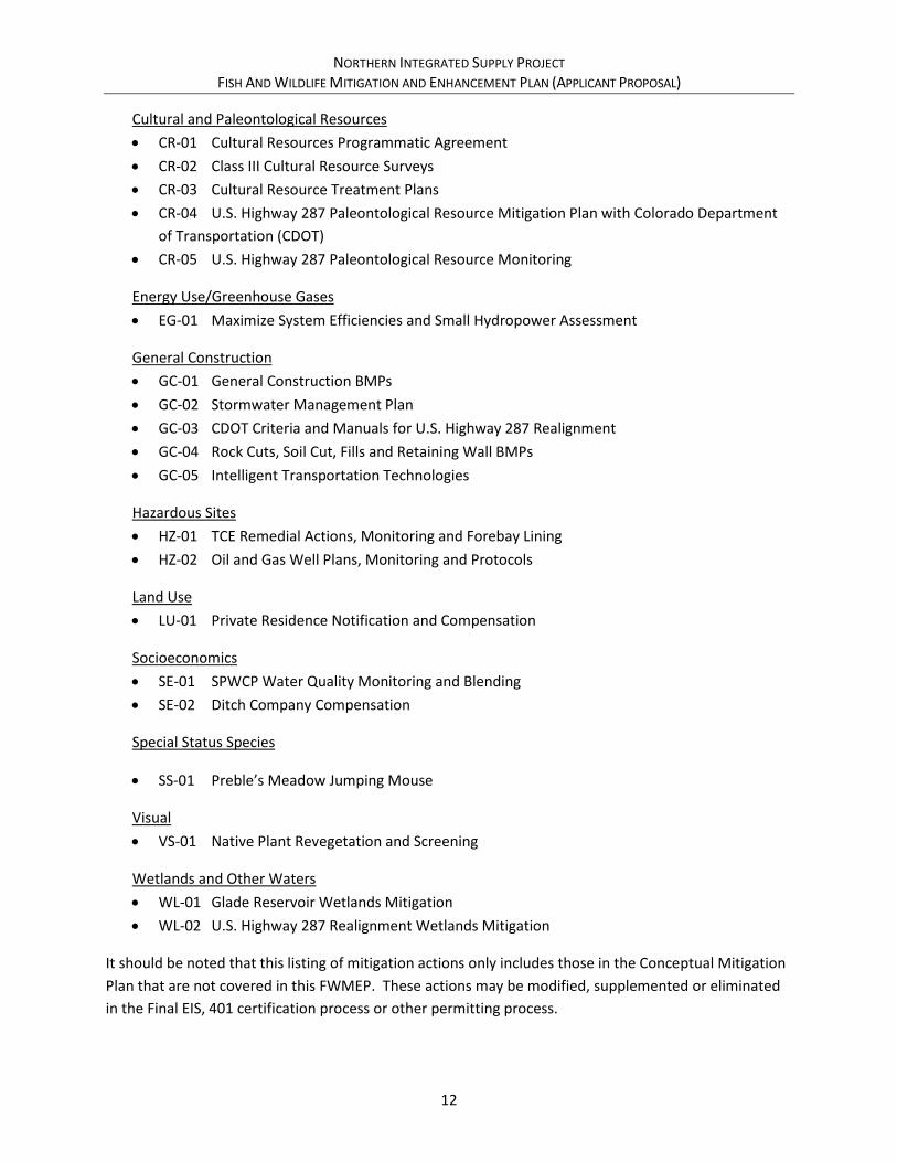
Cultural and Paleontological Resources
• CR-01 Cultural Resources Programmatic Agreement
• CR-02 Class III Cultural Resource Surveys
• CR-03 Cultural Resource Treatment Plans
• CR-04 U.S. Highway 287 Paleontological Resource Mitigation Plan with Colorado Department
of Transportation (CDOT)
• CR-05 U.S. Highway 287 Paleontological Resource Monitoring
Energy Use/Greenhouse Gases
• EG-01 Maximize System Efficiencies and Small Hydropower Assessment
General Construction
• GC-01 General Construction BMPs
• GC-02 Stormwater Management Plan
• GC-03 CDOT Criteria and Manuals for U.S. Highway 287 Realignment
• GC-04 Rock Cuts, Soil Cut, Fills and Retaining Wall BMPs
• GC-05 Intelligent Transportation Technologies
Hazardous Sites
• HZ-01 TCE Remedial Actions, Monitoring and Forebay Lining
• HZ-02 Oil and Gas Well Plans, Monitoring and Protocols
Land Use
• LU-01 Private Residence Notification and Compensation
Socioeconomics
• SE-01 SPWCP Water Quality Monitoring and Blending
• SE-02 Ditch Company Compensation
Special Status Species
• SS-01 Preble’s Meadow Jumping Mouse
Visual
• VS-01 Native Plant Revegetation and Screening
Wetlands and Other Waters
• WL-01 Glade Reservoir Wetlands Mitigation
• WL-02 U.S. Highway 287 Realignment Wetlands Mitigation
It should be noted that this listing of mitigation actions only includes those in the Conceptual Mitigation
Plan that are not covered in this FWMEP. These actions may be modified, supplemented or eliminated
in the Final EIS, 401 certification process or other permitting process.

NORTHERN INTEGRATED SUPPLY PROJECT FISH AND WILDLIFE MITIGATION AND ENHANCEMENT PLAN (APPLICANT PROPOSAL)
13
Additionally, for the reasons described, the following mitigation measures originally described in the
Conceptual Mitigation Plan related to fish and wildlife mitigation are no longer proposed:
Aquatic Life and Stream Morphology
• AG-09 Galeton Reservoir Fish Screening – This commitment was removed from final mitigation
plans because use of Galeton Reservoir for native fish rearing has not been formally committed
to, and because the technology does not currently exist to provide the level of screening
necessary to exclude the desired non-native predatory species from Galeton Reservoir.
Streamflow Commitments
• FW-06 Glade Reservoir Enlargement for Water Quality Commitments – This commitment was
removed from final mitigation plans because full curtailment of diversions during late summer
months would result in additional diversions during other months, and because of public
comment against this concept during the Supplemental Draft EIS on this mitigation
commitment.
2.8. Adaptive Management
Throughout the Draft EIS and Supplemental Draft EIS, analyses performed by resource specialists show
that the likely response of and changes to some resources associated with NISP are anticipated to be
within the historical range of changes that have occurred and continue to occur, making development of
a detailed and quantitative mitigation plan for some NISP effects difficult. Because of this, Northern
Water proposes that certain components of NISP mitigation and enhancement would most effectively
be guided and maximized by adaptive management programs. Such programs would be implemented
pursuant to the parameters outlined in later sections of this document.
Most adaptive management frameworks have four key components. “In the first phase, plans are
framed, based on existing knowledge, organizational goals, current technology, and existing inventories.
In phase two, on-the-ground actions are initiated. Phase three involves monitoring results of those
actions and, in phase four, results are evaluated. The cycle could then reinitiate, driven by emerging
knowledge and experience. Results could validate existing practices and policies or reveal the need for
alterations in the allocations, S&Gs [standards and guidelines], or both” (Stankey et al 2005).
For purposes of describing adaptive management plans proposed in this document, a hybrid approach is
used to describe and illustrate implementation of adaptive management actions (Figure 4; Tasmania
2016). This model generally contains the typical four phases of adaptive management described above.
However, it allows more flexibility and expediency in allowing adjustments in management actions
based on monitoring actions. Although this approach is used to describe the adaptive management
process for the purposes of this document, it is possible that adjustments in the process may be made as
the adaptive management processes are further defined and developed.
One of the key components of an adaptive management process is convening an adaptive management
committee that will guide the activities of each adaptive management program. For the adaptive
management programs described in this FWMEP, the adaptive management committee for each

NORTHERN INTEGRATED SUPPLY PROJECT FISH AND WILDLIFE MITIGATION AND ENHANCEMENT PLAN (APPLICANT PROPOSAL)
14
adaptive management program would operate within the bounds of the financial and resource
commitments for NISP-related adaptive management efforts. The adaptive management committees
would implement the adaptive management programs through the development of specific resource
management objectives and key desired outcomes for the adaptive management program,
development of joint scopes of work for activities directed by the adaptive management committee,
development and implementation of monitoring programs, evaluation of the effectiveness of adaptive
management program activities, and the adjustment of activities to better meet NISP mitigation and
enhancement goals. Additionally, Northern Water expects that the adaptive management committee
would seek additional funding outside of funding provided by NISP to better achieve the program goals.
Figure 4. Adaptive Management Cycle Adopted for NISP Fish and Wildlife Mitigation Plan (Tasmania 2016)

NORTHERN INTEGRATED SUPPLY PROJECT FISH AND WILDLIFE MITIGATION AND ENHANCEMENT PLAN (APPLICANT PROPOSAL)
15
3.0 OTHER CONCURRENT OR RELATED ACTIVITIES
Several other local and federal projects and processes are on-going within the NISP study area that
influenced development of the mitigation actions described in this FWMEP.
3.1. Halligan and Seaman Water Supply Projects
The City of Fort Collins is proposing to expand its existing Halligan Reservoir, located on the North Fork
Cache la Poudre River approximately 9 miles northwest of Livermore, from approximately 6,400 acre-
feet to approximately 14,525 acre feet to provide additional municipal and industrial water supply. The
City of Greeley is proposing to expand its existing Milton Seaman Reservoir, located on the North Fork
Cache la Poudre River approximately 4 miles northwest of Ted’s Place, from approximately 5,000 acre-
feet to approximately 53,000 acre feet to provide additional municipal and industrial water supply. In
order to fill and operate the additional storage space, the projects will have flow-related effects on the
Poudre River in similar reaches as NISP.
Fort Collins and Greeley are currently undergoing separate NEPA compliance efforts for these projects,
which will result in two separate Section 404 permits from the Corps, if permits are issued. The Corps is
the lead federal agency for both projects. The Draft EIS for the Halligan project is currently scheduled to
be released in late 2017, while the Draft EIS for the Seaman project is currently scheduled to be released
in 2018 (Corps 2017).
The Corps developed the Common Technical Platform to assist in the assessment of impacts associated
with NISP, the Halligan project, and the Seaman project. The Common Technical Platform developed
baseline study conditions for NEPA analyses by these projects, including hydrologic modeling,
geomorphology, aquatic, water quality, and riparian resources. Cumulative effects hydrologic model
runs (Future Conditions runs) and corresponding resource analyses consider operations of NISP, the
Halligan project, and the Seaman project, in addition to other reasonably foreseeable future actions.
Because the Draft EISs for the Halligan and Seaman projects have not yet been released, it is not known
at this time the location or significance of environmental effects or corresponding mitigation measures
that will be required to offset these effects. Northern Water is likely to develop and begin
implementation of mitigation activities sooner than these projects. Until more details are available on
the Halligan and Seaman projects, it is unknown exactly how mitigation activities will be coordinated
between the projects.
3.2. Poudre Runs Through It Flows Committee
The Poudre Runs Through It Study/Action Work Group is made up of about 25 citizen experts
representing diverse interests who were selected to study the Poudre River and formulate
cooperative actions based on what they learn. The group is organized and facilitated by the Colorado
Water Institute and Colorado State University. The group is trying to find broadly acceptable ways to
meet multiple objectives: to have both a working Poudre and a healthier Poudre. The group’s goal is
not to return the river to its pre-development condition, but rather to focus on areas for mutual gain

NORTHERN INTEGRATED SUPPLY PROJECT FISH AND WILDLIFE MITIGATION AND ENHANCEMENT PLAN (APPLICANT PROPOSAL)
16
without letting divisive issues inhibit thinking. The group has launched three initiatives towards these
goals that fall under the categories of Flows, Funding, and Forum (The Poudre Runs Through It 2014).
Northern Water actively participates in the group.
3.2.1. Flows
The Poudre Runs Through It group has investigated two distinct approaches to keep more water in the
Poudre River. The key to each is using the river, instead of canals or pipelines, as a conveyance to
move water from upstream to a downstream beneficial use, and moving that water in a way that
minimizes losses, does not interfere with water rights, can be administered under Colorado water law,
and is market driven.
Approach A: Instream Flow Designation – This approach involves requesting that the
Colorado Water Conservation Board secure instream flow water rights for a specific reach of
the Poudre River. Minimum flow designation is recognized by Colorado law, established by
the Colorado Water Conservation Board in conjunction with CPW, and water dedicated to
such a reach is administered within the state’s water right priority system. One potential
reach would be the Poudre River through Fort Collins. Water leased or otherwise acquired
upstream of Fort Collins could then be run through the designated instream flow reach,
applied to the beneficial use created by an instream flow right in the designated reach, and
used in turn by downstream agricultural or other users (The Poudre Runs Through It 2014).
The instream flow water right would be junior to all existing perfected and conditionally
decreed water rights on the river, including NISP water rights. However, it would provide the
mechanism for the lease and/or purchase of water rights to be dedicated for instream flow
purposes.
Approach B: Regional Conveyance Cooperation – This approach would involve the
cooperation and coordination of water users and stakeholders to modify operations with the
goal of leaving more water in the river during critical low-flow periods. For example, cities or
water districts that currently divert water from the Poudre River upstream from Fort Collins or
plan to do so in the future could, during certain times or under certain conditions, move all or
part of that water further downstream in the Poudre through Fort Collins and perhaps
Windsor before diverting it to other uses. Using the river as a conveyance could add water
back into a portion of the Poudre (The Poudre Runs Through It 2014b).
Both approaches would require replacement, retrofitting, enhancement, or construction of major
infrastructure at treatment plants, diversions, and head gates, as well as adding telemetered flow
measurement. Both would also require new cooperative agreements among water rights holders to
maximize the efficiency of the river for both working and healthy river goals.
Any approach to improving flows will involve considerable expense and therefore require public
support. The group has identified as a priority broadening public understanding of key water
management concepts (The Poudre Runs Through It 2014).

NORTHERN INTEGRATED SUPPLY PROJECT FISH AND WILDLIFE MITIGATION AND ENHANCEMENT PLAN (APPLICANT PROPOSAL)
17
3.2.2. Funding
Improvements being envisioned by the Poudre Runs Through It group will require funding for
implementation, including engineering and legal fees, retrofit of infrastructure, flow measurement,
extensive educational campaigns, and/or the lease or purchase of water rights. The Poudre Runs
Through It has undertaken an initiative to investigate how such funding could be generated, including
looking at models such as Larimer County’s Open Space Tax or the State of Colorado’s GOCO fund, and
others (The Poudre Runs Through It 2014).
3.2.3. Poudre River Forum
The Poudre Runs Through It has established an annual Poudre River Forum to bring together all the
communities that benefit from the Poudre to celebrate and cooperate. The Forum features
presentations and panels, think-tank topics, and other educational and community building activities.
The purpose of the forum is to convene diverse stakeholders and community to collaborate on
meeting the dual goals of a working river and healthy river (The Poudre Runs Through It 2014).
3.3. City of Fort Collins Natural Resources Projects
The City of Fort Collins has performed land use and environmental planning for the Poudre River
corridor for many years. Among the planning documents available are the Framework for
Environmental Action in 1992, Cache la Poudre River Master Plans, and Natural Areas Management
Plans in 2001 and 2011. A summary of these documents can be found in the Poudre River Downtown
Master Plan (Fort Collins 2014a). The more recent planning and analysis documents developed by the
City as they pertain to the Poudre River are summarized below. Additionally, one more recent project
completed by the City, the McMurray Natural Area Restoration Project, is described.
3.3.1. Poudre River Downtown Master Plan
The City of Fort Collins Poudre River Downtown Master Plan envisions nearly three miles of
sustainable river corridor (Shields Street to Mulberry Street) that provides habitat, recreation, and
flood mitigation benefits. This is a long-term plan consisting of numerous elements that will take
many years to complete. The plan integrates improvements to support many high-quality and safe
recreational experiences, better protection against flood damage, and restored habitat connectivity
for optimal river health and resiliency. Physical improvements, which support sustainable use of the
river corridor by the community, will allow people to continue to enjoy the Poudre River, but in a way
that supports a functioning ecosystem by providing connected habitat for fish, terrestrial wildlife,
trees, and plants, while also enhancing protection of the community during floods (Fort Collins
2014a).
3.3.2. Natural Areas Master Plan
Also in July 2014, the City of Fort Collins Natural Areas Department released a Natural Areas Master
Plan for public review. The City of Fort Collins has conserved several natural areas along the Poudre
River within and outside of the Fort Collins city limits, with properties ranging in size from 1 acre to

NORTHERN INTEGRATED SUPPLY PROJECT FISH AND WILDLIFE MITIGATION AND ENHANCEMENT PLAN (APPLICANT PROPOSAL)
18
more than 22,000 acres. Among the principles identified in the document is to maintain the
Department’s core focus on biologically significant lands, or lands that have the potential to
contribute to biological integrity and richness, and to acquire water in order to enhance and sustain
habitat, link it to appropriate lands (such as productive farmland), and to satisfy administrative
obligations. Lands along the Poudre River, in the Bellvue area, and in the adjoining foothills have
been identified as priority areas for conservation. Conservation goals of the Poudre River corridor
include sustaining and improving water flows, implementing restoration projects that connect the
river to its floodplain, creating rich wildlife habitat, improving aesthetics, and providing appropriate
recreational activities (Fort Collins 2014b).
3.3.3. Ecosystem Response Model
In 2011, the City of Fort Collins initiated the Ecosystem Response Model to help in understanding
Poudre River ecosystems from Overland Trail Road to Interstate 25. The Ecosystem Response Model
project has two overarching goals: to quantitatively inform a flow management scenario that most
closely helps the community vision of a healthy river, and to provide a coarse-scale evaluation of
future river conditions. The model contains a network of hydrologic and non-hydrologic drivers that
are related to ecosystem functions and river conditions, expressed with a probability of influence
(Fort Collins 2014c).
The Ecosystem Response Model and associated documentation were recently released (Fort Collins
2014d). Although an exhaustive review of the model and results were not performed by Northern
Water as part of this FWMEP, the City of Fort Collins did make a presentation of the model to
Northern Water staff, and staff has reviewed the model results in general. While Northern Water has
concerns with certain aspects of this model and its utility, information from the report was used to
inform the development of aspects of this FWMEP.
3.3.4. Poudre River Health Assessment Framework
The City of Fort Collins’ Natural Areas and Utilities departments are collaborating on an assessment
tool for supporting and sustaining the health of the Poudre River. The River Health Assessment
Framework articulates the City's vision for a healthy and resilient river by setting recommended
ranges and an A-F grading system for the key physical, chemical and biological indicators of the river.
The Framework will be used to create a Poudre River Report Card and the State of the River Report
(Fort Collins 2017), and to evaluate the river health impacts of internal and external projects (Fort
Collins 2015). Information from the River Health Assessment Framework was used to help develop
certain mitigation measures identified in this FWMEP, primarily flow-related aspects of conveyance
refinement (section 5.2.2.4).
3.3.5. McMurry Natural Area Restoration Project
In 2013, the City of Fort Collins began construction of the McMurry Natural Area Restoration Project.
The purpose of this project was to lower river banks to reconnect the river to its floodplain, promote
native cottonwood forests, create a variety of wetland habitats in the east pond, and enhance

NORTHERN INTEGRATED SUPPLY PROJECT FISH AND WILDLIFE MITIGATION AND ENHANCEMENT PLAN (APPLICANT PROPOSAL)
19
recreation with safe access to ponds, the river, and improved trails. The project physically lowered
the riverbank to permit higher flows to safely spill onto adjacent low-lying areas within the natural
areas. Additionally, the Josh Ames diversion structure was removed in order to permit fish passage,
reduce downstream “dry-up”, and improve river-based recreation (Fort Collins 2014d). The Josh
Ames Ditch water rights were transferred to the City of Fort Collins many years ago and delivered at
an alternate point of diversion, thus the ditch had already been abandoned.
3.4. Poudre River Trail
The Poudre River Trail Corridor, Inc. is a local non-profit organization that has managed a cooperative
effort with the City of Greeley, the Town of Windsor, and Weld County to develop the Poudre River
Trail. The Poudre River Trail is 21 miles of a well-maintained paved pathway for walking, cycling,
running, roller-blading, and more. The trail extends from Island Grove Regional Park in Greeley to
Colorado Highway 392 in Windsor where it connects to the paved trail in Larimer County's River
Bluff's Open Space. The Poudre River Trail Corridor Board was created by the City of Greeley, Weld
County, and the Town of Windsor via an intergovernmental agreement, and incorporated to its
current form in January of 1997. Funding is raised through grants from Great Outdoors Colorado,
Colorado State Trails, and North Front Range Metropolitan Planning Organization, with matching
contributions from local foundations, businesses, individuals, and governments. The Trail Board
continues to oversee maintenance and additional development (Poudre River Trail Corridor Inc. 2014).
In 2016, the Town of Windsor completed an updated Parks, Recreation, Trails and Open Lands Master
Plan Update (Windsor 2016). The Master Plan is a resource for the Windsor Parks, Recreation, and
Culture Department to provide direction for future development, programming, and services
decisions over the next 5-10 years. The document provides broad-based visioning to guide operations
and potential expansion of services as the Town of Windsor continues to build out. The plan identifies
the Poudre River corridor as a key area for greenway trails, natural areas, and river access for
recreational activities.
3.5. Cache La Poudre River at Greeley Flood Risk Mitigation and Ecosystem Restoration
The Cache la Poudre integrated feasibility study and environmental assessment includes both flood
risk management and ecosystem restoration. The project area is located along the Cache la Poudre
River near Greeley, in the northeastern part of Colorado, north of Denver. Most of the land
surrounding Greeley is used for agricultural purposes, and gravel mining occupies a sizable portion of
the floodplain. The project reach extends from the confluence of the Cache la Poudre and South Platte
rivers, 17 miles upstream along the Cache la Poudre River, through the northern corporate limits of
the City of Greeley.
Floodplain areas covering 8,400 acres in the 17-mile study reach were assessed to identify best
opportunities to restore riparian and wetland habitats benefitting migratory birds and other native
species. Screening and prioritization identified approximately 460 acres in nine areas spanning eight
miles. In these areas, opportunities were assessed for diverting river water or stormwater onto

NORTHERN INTEGRATED SUPPLY PROJECT FISH AND WILDLIFE MITIGATION AND ENHANCEMENT PLAN (APPLICANT PROPOSAL)
20
floodplain areas, excavating to restore river connections to oxbows or to restore meanders,
excavating into or near groundwater, seeding and planting, and removal of exotic vegetation.
Combinations of these were evaluated in each of the nine areas. One of the nine areas was eventually
screened out due to high real estate costs and potential for contaminated soils. Alternative plans
within each of the other eight areas were evaluated and compared to one another using the cost
effectiveness/incremental cost analysis technique. The resulting proposed plan consists of an
alternative at each of the eight areas, a total of approximately 446 acres. Within these total acres,
ecological improvement is accomplished by increasing riparian forest from 80 acres to 198 acres and
wetlands from 11 acres to 179 acres. It would reduce acres of ruderal rangeland, other agricultural
land, and disturbed areas an equivalent amount, approximately 286 acres. The plan calls for
excavation, grading, plantings, and seeding, at a first cost of $29.1 million, including real estate
interests.
Recreation related to the ecosystem restoration was evaluated and was found to be justified. The
proposed recreation plan involves features at five of the eight restoration areas. It would include
roughly seven miles of trails, ½-mile of wetland boardwalk, two trailheads with parking lots, shelters,
and signage, with a first cost of $771,000.
Greeley served as the cost-share sponsor of this study, and the City would be the cost-share sponsor
for implementation. The Corps has coordinated with Greeley throughout the study, and Greeley has
endorsed the proposed plan and indicated its intent to sponsor implementation of the project (Corps
2014).

NORTHERN INTEGRATED SUPPLY PROJECT FISH AND WILDLIFE MITIGATION AND ENHANCEMENT PLAN (APPLICANT PROPOSAL)
21
4.0 REGULATORY PROCESS
NISP is required to obtain numerous federal and state permits, licenses, and approvals. The primary
regulatory processes related to the C.R.S. 37-60-122.2 requirement for fish and wildlife mitigation are
described below.
4.1. Clean Water Act Section 404 Permit
Section 404 of the Clean Water Act regulates the discharge of dredged or fill material into waters of the
United States, including jurisdictional wetlands. Northern Water is the applicant for a permit under
Section 404 for construction and operation of the proposed NISP facilities. The U.S. Environmental
Protection Agency (EPA) and the Corps have articulated the policy and procedures to be used in the
determination of the type and level of mitigation necessary to demonstrate compliance with the Section
404(b)(1) Guidelines of the Clean Water Act in the Mitigation Rule (33 CFR Part 332). Among other
things, the Mitigation Rule states that “the district engineer will issue an individual section 404 permit
only upon a determination that the proposed discharge complies with applicable provisions of 40 CFR
Part 230, including those which require the permit applicant to take all appropriate and practicable
steps to avoid and minimize adverse impacts to waters of the United States. Practicable means available
and capable of being done after taking into consideration cost, existing technology, and logistics in light
of overall project purposes. Compensatory mitigation for unavoidable impacts may be required to
ensure that an activity requiring a section 404 permit complies with the Section 404(b)(1) Guidelines.”
4.2. National Environmental Policy Act Review
Based on a review of NISP, the Corps determined that NISP is likely to significantly affect the quality of
the human environment and therefore an EIS should be prepared. The Corps is the lead federal
agency for compliance with the National Environmental Policy Act (NEPA) and will use the EIS in
rendering a final permit decision.
A Draft EIS (dated April 2008, Corps 2008) and Supplemental Draft EIS (dated June 2015, Corps 2015)
have been prepared by the Corps in accordance with NEPA and applicable NEPA implementation
regulations (43 U.S.C. § 4321 et. seq.; 40 CFR 1500, as amended; 33 CFR 325, Appendices B and C). A
third-party consulting team led by ERO Resources Corporation (ERO), working under the direction of,
and in cooperation with, the Corps, assisted the Corps in data collection, effects analysis, and
document production in accordance with guidance from the Chief of Engineers regarding EIS
preparation. The third-party consulting team included, but was not limited to the following:
• ERO Resources – Project management, wetlands, wildlife, riparian vegetation, geology and
soils, hazardous materials, groundwater
• CDM Smith – Water Resources, Hydrologic Modeling, Hydrology
• Anderson Consulting - Geomorphology
• GEI Consulting Engineers and Scientists – Aquatic Resources, Water Quality
• Hydros Consulting – Water Quality

NORTHERN INTEGRATED SUPPLY PROJECT FISH AND WILDLIFE MITIGATION AND ENHANCEMENT PLAN (APPLICANT PROPOSAL)
22
• BBC Research and Consulting – Socioeconomics
The Corps requested that six agencies and one local government with statutory authority or special
expertise with an environmental issue participate in the EIS process as cooperating agencies (40 CFR
1501.6 and 1508.5): U.S. Bureau of Reclamation, U.S. Fish and Wildlife Service (Service), U.S.
Environmental Protection Agency, CDOT, Colorado Department of Natural Resources (which includes
CPW), Colorado Department of Public Health and Environment, and Larimer County. Reclamation is a
cooperating agency because Northern Water would need a Reclamation contract and special use
permit to facilitate water delivery to the Participants for one option under its Preferred Alternative.
Impacts identified in the Draft EIS (Corps 2008), Supplemental Draft EIS (Corps 2015), associated
technical analyses, and an updated flushing flow analysis (Anderson 2017) were used as the basis for
mitigation in this FWMEP. A Final EIS is expected to be published in late 2017 (Corps 2017). If impacts
to fish and wildlife are identified in the Final EIS that were not identified in the Draft EIS or Supplemental
Draft EIS, Northern Water will coordinate with CPW and other state agencies as required under the Fish
and Wildlife Coordination Act and will adjust the proposed mitigation as appropriate.
4.3. Endangered Species Act
Section 7(a)(2) of the Endangered Species Act requires that federal agencies consult with the Service to
ensure that effects of actions that the federal agencies authorize, fund, or carry out are not likely to
jeopardize the continued existence of listed species or adversely modify designated critical habitat.
During this consultation, the federal agency receives a biological opinion or concurrence letter
addressing the proposed action (Service 2014).
The Corps submitted a biological assessment to the Service for the NISP proposed action (alternative 2;
Corps 2007) and has consulted with the Service under Section 7. The Service issued a biological opinion
on NISP on October 5, 2007 (Service 2007a). The opinion concurs with the biological assessment that
NISP is “not likely to adversely affect” the Colorado butterfly plant (Gaura neomexicana ssp.
Coloradensis), the Ute ladies’-tresses orchid (Spiranthes diluvialis), and the black-footed ferret (Mustela
nigripes). The opinion requests that suitable habitat for the Colorado butterfly plant and the Ute ladies’-
tresses orchid be resurveyed prior to disturbance. The opinion concludes that the NISP proposed action
is not likely to jeopardize the continued existence of the threatened Preble’s meadow jumping mouse
(Zapus hunsonius preblei), because 1) permanent and temporary impacts to available habitat are not
likely to preclude recovery of the species; and 2) NISP would implement proposed compensatory
mitigation measures through enhancement of existing habitat and creation of new habitat below the
proposed Glade Reservoir. The opinion also authorizes incidental take and identifies reasonable and
prudent measures, terms and conditions, and reporting requirements for such take. Because Preble’s
meadow jumping mouse mitigation is performed under federal regulations, this mitigation is not further
described in this document (see Conceptual Mitigation Plan, Northern Water 2015).
The opinion also concurs with the assessment of effects on listed species that use the Platte River in
Nebraska, including the endangered whooping crane (Grus Americana), the interior least tern (Sternula
antillarum), the pallid sturgeon (Scaphirynchus albus), the piping plover (Charadrius melodus), and the

NORTHERN INTEGRATED SUPPLY PROJECT FISH AND WILDLIFE MITIGATION AND ENHANCEMENT PLAN (APPLICANT PROPOSAL)
23
western prairie fringed orchid (Platanthera praeclara). The opinion concludes that the NISP proposed
action is consistent with the Tier 1 Programmatic Biological Opinion on the Platte River Recovery
Implementation Program, and is not likely to jeopardize the continued existence of these federally listed
species and is not likely to destroy or adversely modify designated critical habitat for the whooping
crane. The opinion also addresses reasonable and prudent measures and terms and conditions in the
Tier 1 Programmatic Biological Opinion regarding incidental take, and conservation measures.
4.4. Colorado Fish and Wildlife Mitigation Plan
This FWMEP is prepared to satisfy the requirements of C.R.S. 37-60-122.2. The first portion of this
statute states:
(1)(a) The general assembly hereby recognizes the responsibility of the state for fish and wildlife
resources found in and around state waters which are affected by the construction, operation,
or maintenance of water diversion, delivery, or storage facilities. The general assembly hereby
declares that such fish and wildlife resources are a matter of state-wide concern and that
impacts on such resources should be mitigated by the project applicants in a reasonable
manner. It is the intent of the general assembly that fish and wildlife resources that are affected
by the construction, operation, or maintenance of water diversion, delivery, or storage facilities
should be mitigated to the extent, and in a manner, that is economically reasonable and
maintains a balance between the development of the state’s water resources and the
protection of the state’s fish and wildlife resources.
FWMEPs for water projects considered under C.R.S. 37-60-122.2 are to be developed by the project
applicant, working in cooperation with CPW staff, and submitted to the Colorado Parks and Wildlife
Commission (Commission). If the Commission and applicant agree on the mitigation plan, the
Commission forwards the mitigation plan to the Colorado Water Conservation Board for adoption as the
official state position on the mitigation actions required of the applicant.
4.4.1. Mitigation and Enhancement Plans
C.R.S. 37-60-122.2 makes a specific distinction between mitigation of impacts caused by the proposed
project, and enhancement of fish and wildlife resources over existing conditions. This distinction is
further defined in the Procedural Rules for the Commission (Chapter 16) and clarified in a memorandum
dated December 9, 2010 to the Director of the Colorado Division of Wildlife and the Commission from
the First Assistant Attorney General, Natural Resources and Environment Section. Accordingly, this
FWMEP includes both a Mitigation Plan that contains mitigation measures to address the direct impacts
that have been identified for the NISP, and an Enhancement Plan that addresses issues raised by CPW
and other stakeholders regarding the current condition of the aquatic environment on the Poudre River
and includes proposed enhancement measures to enhance fish and wildlife resources over and above
levels existing without NISP. Northern Water, as an applicant for one or more federal permits or
licenses, is required by C.R.S. 37-60-122.2 to submit a proposed mitigation plan, but submittal of an
enhancement plan is voluntary.

NORTHERN INTEGRATED SUPPLY PROJECT FISH AND WILDLIFE MITIGATION AND ENHANCEMENT PLAN (APPLICANT PROPOSAL)
24
4.4.2. Consultation, Coordination and Public Input
Northern Water consulted with CPW and the Service representatives during preparation of this Plan. In
addition, CPW and the Service reviewed and commented on the Supplemental Draft EIS and associated
documents prepared as part of the EIS process. These documents provide additional details on the
impacts of the alternatives evaluated in the Supplemental Draft EIS.
C.R.S. 37-60-122.2 requires CPW and Colorado Water Conservation Board review and input on
mitigation for fish and wildlife impacts resulting from a federally approved water project. The review
process is intended to provide a balanced review between fish and wildlife protection and water
development.3 Although the procedures for C.R.S. 37-60-122.2 do not require public review and input,
Northern Water and CPW have developed a process to allow for extensive public participation. To date,
the Corps (through the NEPA process), Northern Water, and CPW have provided and will continue to
provide the following public meetings and opportunities to solicit input on the potential impacts and
mitigation for NISP:
• Corps, NISP Public Scoping Meetings, September 20-22, 2004 – Description of alternatives
and receipt of comments on scope of EIS analyses
• Corps, NISP Draft EIS Public Comment Period, April 30 - September 13, 2008 – Receipt of
written comments on the Draft EIS
• Corps, NISP Draft EIS Public Hearings, June 17 (Fort Collins) and June 19 (Greeley), 2008 –
Receipt of oral and written comments on the Draft EIS
• Corps, NISP Supplemental Draft EIS Public Comment Period, June 19 - September 3, 2015 –
Receipt of written comments on the Supplemental Draft EIS
• Corps, NISP Supplemental Draft EIS Public Hearings, July 22 (Fort Collins) and 23 (Greeley),
2015 – Receipt of oral and written comments on the Supplemental Draft EIS
• Commission Meeting, May 4-5, 2017 (Grand Junction) – CPW staff presentation and
acceptance of Public Comment on the NISP
• Commission Meeting, June 8-9, 2017 (Pagosa Springs) – Northern Water presentation of
FWMEP Applicant Proposal to Commission (PLANNED)
• Northern Water, June 9, 2017 – Northern Water release of FWMEP Applicant Proposal to
public via Northern Water/NISP website (PLANNED)
• Northern Water Open House, June 27, 2017 (Fort Collins, Greeley) – Northern Water
presentation of FWMEP Applicant Proposal to the public and receipt of comment in open
house-style format (PLANNED)
• Commission Meeting, August 10-11, 2017 (Trinidad) – CPW staff comment to Commission
on FWMEP Applicant Proposal (PLANNED)
• Commission Meeting, September 7-8, 2017 (Steamboat Springs) – Commission action on
Final FWMEP (PLANNED)
3 See Testimony of Clyde Martz, Direction of the Department of Natural Resources, Senate Testimony HB 87-
1158, April 9, 1987.

NORTHERN INTEGRATED SUPPLY PROJECT FISH AND WILDLIFE MITIGATION AND ENHANCEMENT PLAN (APPLICANT PROPOSAL)
25
Input from these processes has been used to help prepare the draft plan and will be used to prepare the
final plan.
NORTHERN INTEGRATED SUPPLY PROJECT FISH AND WILDLIFE MITIGATION AND ENHANCEMENT PLAN (APPLICANT PROPOSAL)
26
5.0 PROPOSED FISH AND WILDLIFE MITIGATION PLAN
This section constitutes the proposed Mitigation Plan for fish and wildlife impacts that are expected to
be caused by NISP. Mitigation measures have been developed to address impacts identified in the Draft
and Supplemental Draft EIS. The mitigation measures are also intended to address concerns regarding
NISP impacts that were identified by CPW staff in a detailed review of the Draft EIS and Supplemental
Draft EIS technical analyses. Some mitigation measures also have an enhancement component, and if
so, the enhancement component is described for such measures. Impacts are based on a comparison of
the existing conditions scenario to the Preferred Alternative, which consists of a 170,000 AF Glade
Reservoir with the Poudre River Intake conveyance refinement as described in Section 2.0, and the
SPWCP. A detailed description of existing conditions and the analysis and identification of impacts are
included in the Draft EIS and Supplemental Draft EIS. Information analyzing the incremental impacts of
NISP in the Draft EIS (Corps 2008), Supplemental Draft EIS and associated Technical Reports (Corps
2015), and a subsequent Corps assessment of flushing flows on the Poudre River (Anderson 2017) was
used in the development of this FWMEP.
As previously described, the Supplemental Draft EIS (Corps 2015) presented a Conceptual Mitigation
Plan prepared by Northern Water (Northern Water 2015) that includes both mitigation and
enhancement. This Mitigation Plan portion of the FWMEP builds upon and/or replaces many of the
aquatic life, terrestrial wildlife, and recreational components of the Conceptual Mitigation Plan. The
mitigation measures described in this FWMEP use the same alpha-numerical measure number
convention as used in the Conceptual Mitigation Plan for those mitigation actions that are similar to or
directly replace mitigation measures described in the Conceptual Mitigation Plan. In some cases, as
noted in the text, new mitigation measures were developed through the FWMEP process (i.e. are not
described in the Conceptual Mitigation Plan) and were given new measure numbers.
Some mitigation measures described in this section involve providing funding to state agencies,
primarily CPW, to manage programs relating to this Mitigation Plan. This funding is proposed to be in
addition to funding already received by state agencies, and not to replace any source of funding.
Northern Water expects the agencies to continue seeking current funding sources and not rely on
funding from this Mitigation Plan to replace current funding.
Components of the FWMEP are summarized in the tables contained in Appendix A of this document.
Table A2 notes those environmental effects that are not covered under this FWMEP. The alpha-
numerical notations at the end of each mitigation item description correspond to the alpha-numeric
mitigation item numbers in Tables A1 and A2.
5.1. NISP Project Area
NISP would have site specific effects at proposed reservoir locations and along pipeline routes, and
hydrologic effects on the Poudre River downstream of the canyon mouth and the South Platte River
downstream of its confluence with the Poudre River. Additional effects would occur at Horsetooth
Reservoir and Carter Lake due to the proposed C-BT exchange.

NORTHERN INTEGRATED SUPPLY PROJECT FISH AND WILDLIFE MITIGATION AND ENHANCEMENT PLAN (APPLICANT PROPOSAL)
27
In general, the location of mitigation activities is developed as close as possible to the location at which
the effect occurs. For site specific mitigation activities, such as disturbance of a specific quantity of
wetlands at a construction site, the disturbance is mitigated on the same site if the site is amenable to
the activity. On-site, in the case of NISP, applies to land that is owned by Northern Water, such as land
at the reservoir sites. On-site mitigation provides assurance that the land can be acquired and the
mitigation fully implemented as conceptualized.
For NISP, most of the effects and associated mitigation activities occur in the river channels. These
effects are indirectly caused by a change in hydrology rather than directly by a construction activity.
Under this Mitigation Plan, environmental effects in one reach of river are generally mitigated in the
same reach of river. For instance, mitigation of riparian effects that occur in Segment E is generally
mitigated in Segment E. It should be noted that the resource specialists used differing reaches for
analyses tailored to the nature of each resource. A general summary of the reaches is presented in
Table 2, while a more detailed line diagram covering Segments A through D is presented in Figure 5.
For physical mitigation projects, especially those that involve habitat or channel improvements, reaches
in which a public entity owns land on either or both sides of the river channel were prioritized. This
results in a streamlined implementation process, and allows public access to these improvements in
most cases.
Table 2. Approximate Demarcation of Resource Study Reaches of the Cache la Poudre
General Area
Aquatic and Riparian
Vegetation Segment (1)
Geomorphic and Sediment
Transport Study Reach
Approximate Upstream Demarcation (1)
Data Delivery Mile (2)
Diversion or Water Feature Major Road/Landmark
La Porte A La Porte 5.12 Poudre Valley Canal
Canyon mouth
Fort Collins Upstream
B Fort Collins 1-4 13.92 Larimer & Weld Canal
Taft Hill Road
Fort Collins Downstream
C Fort Collins 5-6 18.71 Timnath Inlet Prospect Road/Spring Creek
Timnath D Timnath 27.81 New Cache la Poudre Ditch
Kechter Road (5 river miles downstream of I-25)
Windsor E Windsor 31.61 Whitney Ditch Weld County Road 17/7th Avenue (Windsor)
Greeley F Greeley (Upstream, Channelized, Downstream)
40.79 Jones Ditch Weld County Road 25/95th Avenue (Greeley)
(1) See Supplemental Draft EIS Aquatic Effects Report (GEI 2014), Riparian Vegetation Effects Report (ERO 2013) and other associated reports for detailed mapping and descriptions of these reaches.
(2) See Supplemental Draft EIS Geomorphology Effects Report (Anderson 2014) and other associated technical reports for detailed mapping and description of these reaches.
(3) Because reach definitions differ by resource, the specific upstream demarcation between reaches differs by resource. This table is an approximation only – see specific resource reports for exact demarcations.
(4) DDM = Data Delivery Mile; distance downstream of Munroe Canal diversion.

NORTHERN INTEGRATED SUPPLY PROJECT FISH AND WILDLIFE MITIGATION AND ENHANCEMENT PLAN (APPLICANT PROPOSAL)
28
Figure 5. Line Diagram of Poudre River from Munroe Canal to Fossil Creek Reservoir Outlet (Northern Water 1996)
5.2. Avoidance and Minimization
Throughout the development of NISP, from the initial NISP concepts through the conceptual designs
now being analyzed, Northern Water has incorporated design and operational components that are
intended to avoid and minimize environmental effects. These actions are a result of more than 30 years
of planning, and reflect the more recent conceptual design and analysis of the NISP alternatives,
including analyses performed during the Draft EIS and Supplemental Draft EIS. This section summarizes
aquatic life, terrestrial wildlife, and recreation related avoidance and minimization techniques.
5.2.1. Design Commitments
This section provides information on specific design features of NISP infrastructure that are proposed to
avoid or minimize environmental effects.

NORTHERN INTEGRATED SUPPLY PROJECT FISH AND WILDLIFE MITIGATION AND ENHANCEMENT PLAN (APPLICANT PROPOSAL)
29
5.2.1.1. NISP Configuration
The NISP and Glade Reservoir concepts have more than a 30-year history of evolution from their original
configuration to the configuration currently being proposed. Throughout this evolutionary period, NISP
has evolved based on changing public values regarding the environment. Two of the most significant
changes in the NISP/Glade Reservoir that avoid environmental effects are the movement of the
proposed reservoir from an on-channel reservoir site to an off-channel reservoir site, and the
elimination of a potential point-of-diversion that would have been upstream of the North Fork
confluence with the Poudre River.
Water development in the Poudre River Basin has been formally studied since the mid-1960’s when
Reclamation first considered formation of the Poudre Unit. In 1980, the Cache la Poudre Water Users
Association filed water rights for a proposed 220,000 acre-foot reservoir located on the Poudre River
channel at the Grey Mountain site, approximately 3 miles west of Ted’s Place in the Poudre Canyon. In
1985, Northern Water acquired a 7/8 share in the conditional water right. Since that time, Northern
Water has conducted and participated in many studies for storing unappropriated flows on the Poudre
River (MWH 2004), including a basin study conducted with the Colorado Water Resources & Power
Development Authority in 1987 (Harza) and extension of that study in 1990 (EBASCO, Harza, et al.).
Through these processes, Northern Water determined that an on-channel reservoir was not
environmentally or publicly acceptable, and moved its preferred alternative to its current location at
Glade Reservoir. Although not studied in detail, this change undeniably avoided and minimized many
environmental effects of the originally proposed reservoir. All on-channel reservoirs were eliminated
through the NISP screening process.
Another feature of NISP that has been informally studied by Northern Water is construction of a new
tunnel that would divert water from the Poudre River upstream of the confluence with the North Fork,
or diverting water into the reservoir using the existing Munroe Canal (section 5.2.2.1), which also diverts
water upstream of the confluence with the North Fork. Constructing a diversion tunnel could allow
conveyance of diverted streamflow to Glade Reservoir without pumping, while use of the Munroe Canal
could reduce pumping during lower reservoir elevations. These options were eliminated due to
environmental effects, partially because these options would dewater a reach of the Poudre River that is
a popular river recreation area.
5.2.1.2. Poudre Valley Canal Diversion Structure (AG-04)
As part of NISP construction, the existing Poudre Valley Canal diversion structure (Figure 6) would be
replaced with a structure to minimize effects on sediment transport by allowing diversion of excessive
sediment into the forebay, and to enhance fish passage and boater safety from existing conditions. The
existing structure consists of a concrete overflow weir in the Poudre River, a headgate structure with
three radial gates, a trash rack, and a gated sluiceway back to the river. The existing weir in the river is
in poor condition and the headgate structure leaks (MWH 2004).

NORTHERN INTEGRATED SUPPLY PROJECT FISH AND WILDLIFE MITIGATION AND ENHANCEMENT PLAN (APPLICANT PROPOSAL)
30
Figure 6. Existing Poudre Valley Canal Diversion on Poudre River near Canyon Mouth
The replacement structure would be a similar configuration to the existing structure, with the diversion
capacity of the structure increased to approximately 1,700 cfs (1,200 cfs for NISP diversions, and 500 cfs
for existing decreed water rights in the Poudre Valley Canal). Conceptual designs of the headgate
structure include a diversion structure with four 15-foot wide radial gates, trash rack, and gated
sluiceway (MWH 2004). The gates would be configured with vanes and floor elevations that allow
selective diversion of bed load and sediment that may be required as part of the geomorphology
adaptive management program (section 2.8).
The existing diversion weir in the Poudre River would be replaced with a weir that maintains similar
upstream water levels as the existing structure, but has been modified as a multi-objective diversion
structure. The diversion dam structure would contain fish passage capabilities (see Section 6.1.1.2 for
additional information on fish passage capabilities). Additionally, design of the diversion dam crest
would consider options for improved boater safety at the structure to reduce the possibility of boaters
becoming trapped in the “roller” that occurs downstream of the existing ogee crest. The new structure
would not materially increase the water surface elevation of the pool upstream of the structure, and
would enhance aquatic habitat connectivity upstream and downstream of the structure by allowing for
fish passage.
CPW staff will be consulted with and serve on a design review committee to ensure that the design
appropriately allows both fish passage and boater safety as described herein. The Poudre River adaptive
management committee would make recommendations on how the diversion is operated in terms of
the diversion of sediment from the Poudre River (section 6.1.1.1).

NORTHERN INTEGRATED SUPPLY PROJECT FISH AND WILDLIFE MITIGATION AND ENHANCEMENT PLAN (APPLICANT PROPOSAL)
31
5.2.1.3. SPWCP Diversion Design (AG-07)
The SPWCP would divert water from the South Platte River just downstream of its confluence with the
Poudre River. The diversion structure from the South Platte would consist of a new diversion dam
across the South Platte River and an intake located on the north river bank. The intake would divert
water into a 150-foot long concrete box flume or conduit that would convey water to the forebay
reservoir. This water would then be pumped into Galeton Reservoir via a pump station and pipelines.
The new diversion dam across the South Platte River would consist of a fixed concrete weir, weir
sections with Obermeyer crest gates at the main river channel, a radial gate section near the north river
bank, and short embankment sections at each end of the weir. The Obermeyer crest gates would allow
fish migration in the South Platte during most times of the year when the SPWCP is not diverting, or
when the flow in the river is high enough that the Obermeyer crest gates do not need to be raised to
provide adequate head for diversion. The SPWCP diversion structure would only nominally increase
upstream water depth, and the pool would be contained entirely within the existing channel and would
not affect wetlands.
Without avoidance and minimization actions, the diversion could entrain fish from the river and affect
the South Platte fish community. However, Northern Water has committed to work with CPW to design
and operate the diversion to minimize or avoid fish entrainment. The most common type of practice to
reduce fish entrainment at diversion structures is a positive barrier fish screen, which essentially consists
of a screening mesh that is sized to prevent entrainment of the target fish species while still allowing
adequate flow capacity through the structure. These structures are highly effective, but need to have
regular maintenance to clean trash, debris and sediment from the screens (Reclamation 2006).
Behavioral methods have also been studied and implemented on some structures. Behavioral methods
may include louvers to create turbulence, startle-response techniques such as lights (strobes), sound,
and electrical fields. However, these types of techniques have typically had considerably less than 100
percent fish exclusion efficiency (Reclamation 2006).
Ultimately, techniques will be incorporated into the diversion structure in coordination with CPW during
final design. The specific techniques depend on several factors that will not be known with certainty
until the design commences. CPW staff will be consulted with and serve on a design review committee
to ensure that the design appropriately allows both fish passage and boater safety as described herein.
5.2.1.4. Multi-Level Outlet Tower for Glade Reservoir Releases (WQ-01)
Glade Reservoir would be designed and constructed with a multi-level outlet tower that would allow
selective withdrawals from specific locations in the reservoir water column to tailor the water quality of
the releases from Glade Reservoir as they relate to the water quality in the Poudre River (Figure 7). To
the extent possible, release of flows from the reservoir back to the Poudre River as part of conveyance
refinement (see section 5.2.2.4) would be made from the hypolimnion in Glade Reservoir if such
releases would benefit water temperature downstream of the release point. These releases would not
only avoid and minimize increases in temperatures during certain times of the year due to NISP

NORTHERN INTEGRATED SUPPLY PROJECT FISH AND WILDLIFE MITIGATION AND ENHANCEMENT PLAN (APPLICANT PROPOSAL)
32
operations, but would improve stream temperatures from existing conditions, particularly during the
late spring, late summer and early fall months when stream temperatures currently approach or exceed
water quality standards that are protective of aquatic species. Releases from the multi-level outlet may
be managed to mitigate potential adverse impacts to the narrative temperature criteria and avoid
unseasonal cooling effects.
Northern Water recently completed a similar multi-level outlet tower at Carter Lake (Figure 8). This
tower was constructed as a redundant year-round outlet for municipal deliveries out of Carter Lake, and
to allow municipal deliveries to be drawn from multiple levels of Carter Lake. The exact configuration of
a multi-level outlet tower at Glade Reservoir, including gate spacing, screening requirements, and flow
requirements, will be determined after consultation with CPW and the Colorado Division of Water
Resources Dam Safety Branch.
As described in the Supplemental Draft EIS (Corps 2015), during initial fill of Glade Reservoir, water
quality conditions in the reservoir may be affected by the release of nutrients and organic matter in the
soil. Thus, during this period, water quality may be affected by high suspended solids, elevated nutrient
concentrations, and potentially high concentrations of algae. Northern Water will develop a reservoir
water quality management plan that will describe and monitor water quality conditions in the reservoir,
and outline how water will be released to the river using the multi-level outlet tower given ambient
conditions in the Poudre River, for both short-term (initial fill) and long-term operations.
Implementation of this avoidance technique would require establishment of real-time water quality
monitoring points in the Poudre River upstream and downstream of the discharge points into the river,
as well as monitoring of the discharge itself. The streamflow and water quality monitoring plan is
further described in Section 5.3.1.5.

NORTHERN INTEGRATED SUPPLY PROJECT FISH AND WILDLIFE MITIGATION AND ENHANCEMENT PLAN (APPLICANT PROPOSAL)
33
Figure 7. Glade Reservoir Release Point to Poudre River
GladeForebay
¬«14
£¤287
Pleasant Valley Pipeline(Existing)
GladeReservoir
NISP North Tier
Pipeline(Proposed)
Glade ReservoirPoudre River
Release Pipeline(Proposed)
Glade Reservoir
Poudre River Release Structure(Proposed)
Glade Reservoir
Multi-level Outlet Tower(Proposed)
Copyright:© 2013 National Geographic Society, i-cubed
0 0.5 10.25Miles
Ü

NORTHERN INTEGRATED SUPPLY PROJECT FISH AND WILDLIFE MITIGATION AND ENHANCEMENT PLAN (APPLICANT PROPOSAL)
34
Figure 8. Multi-Level Outlet Tower at Carter Lake
5.2.1.5. Glade Reservoir Release Structure (WQ-02)
The Glade Reservoir complex would incorporate two means of releasing water back to the Poudre River.
Low flow releases up to approximately 105 cfs, which would be the primary release from the reservoir,
would be made through a pipeline connected to a multi-level outlet structure (section 5.2.1.4) that
would convey water back to the Poudre near the mouth of the canyon, entering the Poudre River
approximately ¼ mile upstream of the County Road 29C intersection with Highway 14, or approximately
1 ¼ miles west of Ted’s Place (previously shown on Figure 7). Higher emergency flow releases, which
would rarely if ever occur, would be made directly into Owl Creek, which is tributary to the Poudre River
approximately ¾ miles southwest of Ted’s Place. The structures for releasing water from Glade Reservoir
to the Poudre River would be designed to aerate the water to increase the dissolved oxygen
concentration of the water discharged to the river. This will avoid effects on the Poudre River that may
otherwise occur by releasing water from lower parts of the reservoir column that may have lower
dissolved oxygen levels.
The ability to aerate and increase dissolved oxygen through the design of hydraulic structures has been
studied and known for quite some time, and study continues on how to better design hydraulic
structures to increase dissolved oxygen in water released from dams (Falvey and Ervine 1988; Wahl and
Young c1994). The California State Water Resources Control Board provides a list of best management
practices to improve dissolved oxygen levels in dam impoundments, tailwaters, and/or reservoirs
including the use of gated conduits, spillway modifications, reregulation and labyrinth weirs, pumping
and injection systems, and selective withdrawal (California 2014). Studies are also on-going that
investigate the influence of stepped chute slopes on dissolved oxygen content (Baylar et al. 2009).

NORTHERN INTEGRATED SUPPLY PROJECT FISH AND WILDLIFE MITIGATION AND ENHANCEMENT PLAN (APPLICANT PROPOSAL)
35
Currently, it is expected that both the low flow pipeline release and the high flow canal release would
incorporate a chute feature at their outfalls into the Poudre River that contain either baffles or steps to
increase dissolved oxygen and dissipate energy to prevent channel erosion, or contain in channel rock
structures that would serve the same purposes. Studies by Baylar et al. (2009) show that “stepped
cascade aerators are very efficient at oxygen transfer because of the strong turbulent mixing associated
with substantial air bubble entrainment” and the increasing channel slope of the chutes provides better
entrainment. A similar type of structure is contained at the terminus of the Hansen Supply Canal as it
conveys water from Horsetooth Reservoir and discharges into the Poudre River (Figure 9). If a baffle or
step structure is selected, it is likely that NISP structures would incorporate increased baffling or steps
beyond that designed for the Hansen Supply Canal chute structure.
Figure 9. Hansen Supply Canal Discharge Structure to Poudre River
5.2.2. Operational Commitments
This section provides information on operational commitments that Northern Water has made for NISP
through various mechanisms, including water rights decrees, the Conceptual Mitigation Plan, and this
FWMEP, that are proposed to avoid or minimize environmental effects.
For flow commitments described in this FWMEP, Northern Water is making these commitments to
mitigate, and in many cases enhance, the environment. Northern Water is working to ensure that all
flow commitments described herein are protected from a water rights perspective so that bypassed or
released flows remain in the river through the reaches described in this Mitigation Plan. If during actual
operations, administration of water rights on the river results in the flow commitments not reaching the
targeted flows or reaches (i.e. operations by others result in the bypassed or released flows not

NORTHERN INTEGRATED SUPPLY PROJECT FISH AND WILDLIFE MITIGATION AND ENHANCEMENT PLAN (APPLICANT PROPOSAL)
36
remaining in the river through the intended reach), Northern Water would cease operation of the flow
commitment and seek administrative and legal solutions to ensure that these operations would result in
the intended flows being met. Section 5.2.2.5 contains additional information on measures already
being undertaken to protect these flows.
5.2.2.1. Avoid Munroe Canal Diversions (FW-01)
The original Draft EIS (Corps 2008) considered using the Munroe Canal for two operations associated
with NISP. First, it was proposed that during certain situations, the Munroe Canal would serve as a
secondary diversion from the Poudre River to fill Glade Reservoir. Second, it was proposed that
deliveries could be made from Glade Reservoir to the Pleasant Valley Pipeline via the Munroe Canal to
Participants that are delivered treated water from the Soldier Canyon Filter Plant. This exchange would
have reduced flow in the Poudre River from the Munroe Canal diversion to the Glade Reservoir release
point.
Based on comments received on the Draft EIS, Northern Water is no longer proposing either of these
operations, and their effects are not included in the Supplemental Draft EIS (Corps 2015). The exchange
has been eliminated in the Supplemental Draft EIS analysis, and replaced with a new pipeline directly
from Glade Reservoir to the Pleasant Valley Pipeline (for Fort Collins-Loveland Water District) and a new
pipeline directly from Glade Reservoir to the Soldier Canyon Filter Plant (for Eaton, Severance and
Windsor). This avoids streamflow depletions in Poudre River streamflow between the Munroe Canal
diversion and the Glade Reservoir release point.
5.2.2.2. Curtail Diversions for Non-Consumptive Water Rights (FW-02)
Northern Water would make diversions to NISP under its Grey Mountain storage right and under
storage and exchange rights associated with the SPWCP. There are currently three water rights decreed
on the Poudre River for non-consumptive purposes: the Watson Fish Hatchery water right, Fort Collins
Boat Chute water right, and the Fort Collins Nature Center water right (Figure 10).
Based on its water right priority, exchange rights for the SPWCP are junior to these three non-
consumptive water rights. Additionally, through water rights stipulations, although the Grey Mountain
water right is senior to all three non-consumptive water rights, Northern Water has agreed to curtail in-
priority NISP diversions under the Grey Mountain storage right to the extent that these curtailments
would help satisfy the Watson Lake Fish Hatchery and Fort Collins Boat Chute water rights (Table 3).
These commitments are designed to avoid and minimize the effects of NISP operations during low-flow
conditions on the Poudre River at those locations, which in turn avoids and minimizes many potential
aquatic and water quality effects at those locations.
Further description and simulation of these curtailments is contained in the NISP Operations Plan Report
(CDM Smith 2014).
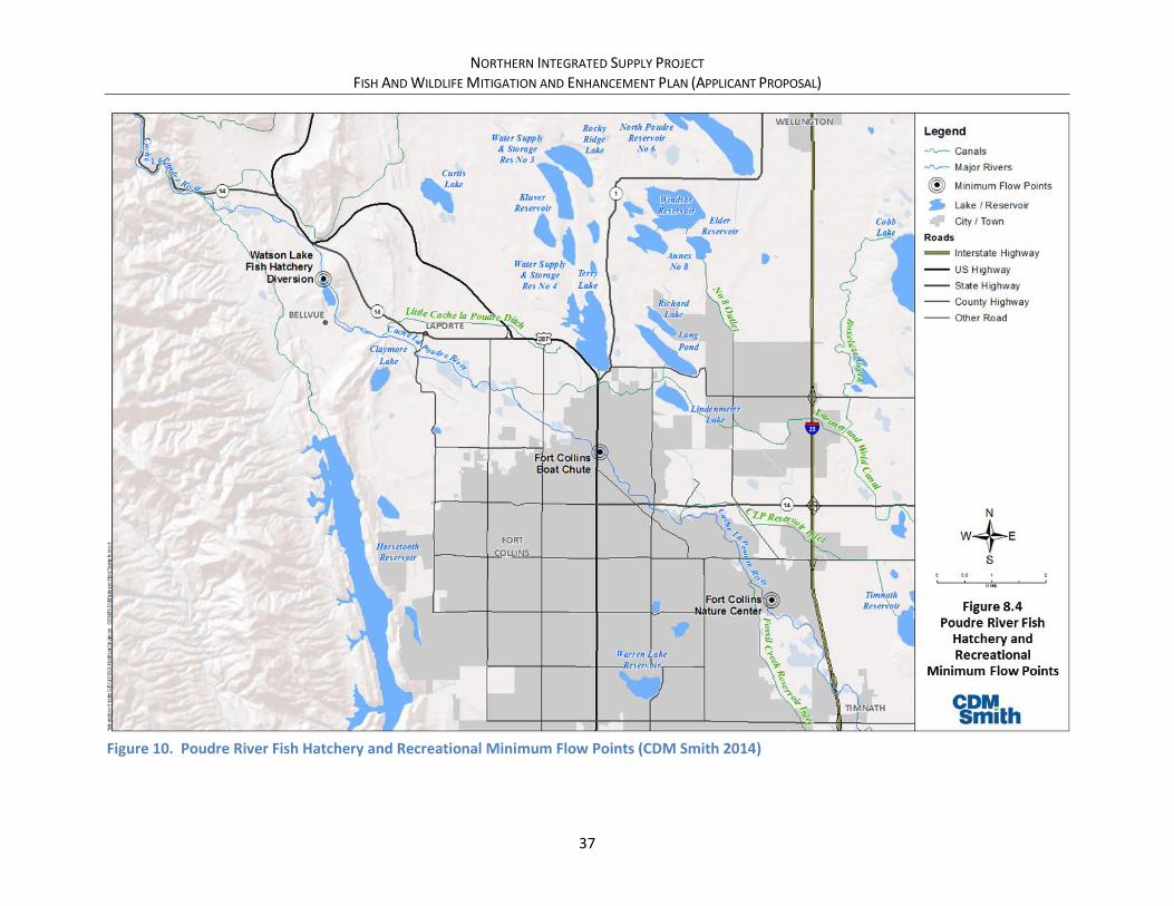
NORTHERN INTEGRATED SUPPLY PROJECT FISH AND WILDLIFE MITIGATION AND ENHANCEMENT PLAN (APPLICANT PROPOSAL)
37
Figure 10. Poudre River Fish Hatchery and Recreational Minimum Flow Points (CDM Smith 2014)

NORTHERN INTEGRATED SUPPLY PROJECT FISH AND WILDLIFE MITIGATION AND ENHANCEMENT PLAN (APPLICANT PROPOSAL)
38
Table 3. Decreed and Stipulated Flow Commitments by NISP for Non-Consumptive Water Rights
Water Right
NISP Flow Commitment (Summer/Winter, cfs)
Grey Mountain Water Right (1)
SPWCP Water Rights (2)
Watson Lake Fish Hatchery (3) 50/25 (Apr 15-Oct 14 / Oct 15-Apr 14)
50/25 (Apr 15-Oct 14 / Oct 15-Apr 14)
Fort Collins Boat Chute 30/5 (4) (May 1-Aug 31 / Sep 1-Apr 30)
Fort Collins Nature Center 50/25 (5) (Apr 15-Oct 14 / Oct 15-Apr 14)
50/25 (5) (Apr 15-Oct 14 / Oct 15-Apr 14)
(1) As decreed in 80CW355 and stipulated in Consolidated Case Nos. 85CW206, 85CW207, 85CW208, 85CW209, 85CW210, and 89CW122.
(2) As decreed in 92CW130.
(3) As measured immediately upstream of the Watson Lake Fish Hatchery diversion.
(4) All river flows between 5 cfs and 25 cfs to be shared equally between Fort Collins and the City of Thornton, and Fort Collins is entitled to no more than 15 cfs (September 1 - April 30).
(5) Fort Collins Nature Center flow requirements to be measured at the Boxelder Gage, and requires that the Fossil Creek inlet is operated according to Fossil Creek low flow operational procedures (see Supplemental Draft EIS for additional information).
5.2.2.3. Summer and Winter Diversion Curtailments (FW-03)
To further avoid effects of NISP operations during low-flow conditions at all locations on the Poudre
River affected by those operations, Northern Water would curtail NISP water rights operations on the
Poudre River as follows:
• Grey Mountain water right – Diversions would be curtailed to maintain an average daily flow of
50 cfs from April 16 to October 31, and 25 cfs from November 1 to April 15, at any gaging station
on the Poudre River below the Poudre Valley Canal.
• SPWCP water right – Exchanges would be curtailed to maintain an average daily flow of 50 cfs
from April 16 to October 31, and 25 cfs from November 1 to April 15, at any gaging station on
the Poudre River between the Poudre Valley Canal and the New Cache diversion.
The flow commitments would be made provided Northern Water can be assured that the passed water
would flow through the reaches described and not be diverted by junior appropriators. Additional
gaging stations that Northern Water commits to installing as part of this commitment are described in
section 5.3.1.5.
5.2.2.4. Conveyance Refinement (FW-04)
The Conceptual Mitigation Plan (Northern Water 2015) described a low flow augmentation release
program (FW-04) in which releases would be made from Glade Reservoir to maintain at least 10 cfs in
the Poudre River from the release point near the canyon mouth through Fort Collins from November
through March and September. Based on comments received on the Supplemental Draft EIS, this low
flow augmentation program has been replaced with the Conveyance Refinement Concept described in
this section.

NORTHERN INTEGRATED SUPPLY PROJECT FISH AND WILDLIFE MITIGATION AND ENHANCEMENT PLAN (APPLICANT PROPOSAL)
39
The Supplemental Draft EIS (Corps 2015) analyzed two options for conveyance of water from Glade
Reservoir to the Participants: the Reclamation Action Option, which would convey water to the
Participants through a C-BT exchange; and, the No Reclamation Action Option, which would convey
water from Glade Reservoir to the Participants via a pipeline generally following a foothills route.
Following review of agency and public comment on the Supplemental Draft EIS, the Participants are
proposing a refined conveyance concept with the goal of keeping more flows in the Poudre River year-
round (Figure 11). The refined conveyance approach is intended to avoid, minimize and enhance water
quality and the aquatic and riparian environments. Section 2.4 described the physical layout of the
conveyance refinement. This section summarizes the operational commitments and streamflow
benefits.
As described in Section 2.4, water would be released from Glade Reservoir to the Poudre River near the
existing C-BT Hansen Supply Canal delivery structure to the Poudre River near the mouth of the Poudre
Canyon (section 5.2.1.5). Releases would range from 18 cfs during the winter months to 25 cfs during
the summer months, or 14,350 acre-feet annually (Table 4). The Poudre River Intake would be located
at the Timnath Reservoir Inlet Canal diversion (or alternative location upstream of this point as
described in later sections of this document), and constructed to divert water released from Glade
Reservoir for delivery to the Participants.
Table 4. Monthly Poudre River Intake Diversions
Total NISP Delivery Poudre River Intake Diversion
Month (acre-feet) (cfs) (acre-feet) (cfs) % of Total
NISP Delivery
Nov 2,310 39 1,100 18 48%
Dec 2,310 38 1,100 18 48%
Jan 2,100 34 1,100 18 52%
Feb 1,890 33 1,050 18 56%
Mar 2,310 38 1,100 18 48%
Apr 3,360 56 1,100 18 33%
May 4,200 68 1,100 18 26%
Jun 5,250 88 1,200 20 23%
Jul 5,880 96 1,550 25 26%
Aug 4,830 79 1,550 25 32%
Sep 4,200 71 1,300 22 31%
Oct 3,360 55 1,100 18 33%
Total 42,000 14,350 34%
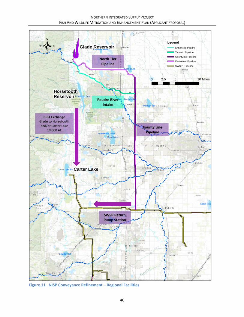
NORTHERN INTEGRATED SUPPLY PROJECT FISH AND WILDLIFE MITIGATION AND ENHANCEMENT PLAN (APPLICANT PROPOSAL)
40
Figure 11. NISP Conveyance Refinement – Regional Facilities
Service Layer Credits: Sources: Esri, HERE,DeLorme, Intermap, increment P Corp.,GEBCO, USGS, FAO, NPS, NRCAN,GeoBase, IGN, Kadaster NL, OrdnanceSurvey, Esri Japan, METI, Esri China (HongKong), swisstopo, MapmyIndia, ©OpenStreetMap contributors, and the GISUser Community
Boyd Lake
Horsetooth Res
Union Res
Carter Lake Res
Windsor Res
Cobb Lake
Timnath Res
Boulder Res
Horseshoe Lake
Douglass Lake
Milton Res
.
0 5 102.5 Miles
Horsetooth Reservoir
Carter Lake
Glade ReservoirLegend
Enhanced Poudre
Timnath Pipeline
Countyline Pipeline
East-West Pipeline
SWSP - Pipeline
C-BT Exchange Glade to Horsetooth and/or Carter Lake
10,000 AF
SWSP Return Pump Station
Poudre River Intake
North Tier Pipeline
County Line Pipeline

NORTHERN INTEGRATED SUPPLY PROJECT FISH AND WILDLIFE MITIGATION AND ENHANCEMENT PLAN (APPLICANT PROPOSAL)
41
Key flow metrics and targets from available studies, including weighted useable area curves (GEI 2013;
Nelson 1987) and information from the Fort Collins River Health Assessment Framework (Fort Collins
2015), were consulted and compared against hydrologic results from various flow configurations of the
conveyance refinement to design the conveyance refinement in manner that provides meaningful
beneficial impacts on Poudre River aquatic habitat. Consequently, the conveyance refinement provides
significant improvement in low-flow metrics. Most importantly for aquatic habitat and connectivity,
river dry-up points within the conveyance reach are eliminated; a flow equal to or greater than 20 cfs is
provided at the Lincoln Street Gage in 97 percent of days (with all locations in the conveyance
refinement reach exceeding the minimum proposed Poudre River Intake diversion rate of at least 18
cfs); average winter flows at the Lincoln Street gate are nearly doubled; and the target range of 25 to 35
cfs during the winter is met during 92 percent of the years (Table 9, Figure 12, Figure 13)4.
Table 5. Summary of Key Flow Criteria and Metrics
Row Source Criteria Measure Current
Conditions
With NISP (Supplemental
Draft EIS) Conveyance Refinement
1 WUA Curves; 1987 Nelson Study
Minimum flows in the range of 25-35 cfs at Lincoln St. Gage
Percent of Days with Flow >= 25 cfs at Lincoln St. Gage 48% 54% 82%
2 Percent of Years with Average Winter Flow >= 25 cfs at Lincoln St. Gage 27% 46% 92%
3
Fort Collins River Health Assessment Framework
No Dry-Up Points
Percent of Days with Flow >= 1 cfs below Larimer-Weld 64% 98% 100%
4 Daily average minimum streamflow of 20 cfs
Percent of Days with Flow >= 20 cfs at Lincoln Street Gage 52% 63% 97%
5 Percent of Winter Days with Flow >= 20 cfs at Lincoln St. Gage 30% 48% 96%
6 Winter daily average streamflow of 35 cfs
Average Winter Flow at Lincoln St. Gage (cfs) 26 cfs 33 cfs 46 cfs
7 Percent of Years with Average Winter Flow >= 35 cfs at Lincoln St. Gage 27% 27% 50%
8 Poudre Whitewater Park Website
100 cfs or less for a Beginner Playpark
Percent of Summer Days with >= 60 cfs at Lincoln St. Gage (minimum boatable at other Front Range parks) 67% 54% 72%
9 Percent of Summer Days with >= 100 cfs at Lincoln St. Gage 54% 39% 46%
Note: For purposes of this table: winter is Nov-Mar; summer is May-Aug. Bold Indicates metrics in which conveyance refinement value exceeds current conditions.
4 For purposes of illustrative hydrology in this document, the hydrologic analysis in the Supplemental Draft EIS was used. The Final EIS will contain a full description of the hydrologic effects of the conveyance refinement. The columns entitled “With NISP (SDEIS)” are results for Alternative 2 as proposed in the Supplemental Draft EIS.

NORTHERN INTEGRATED SUPPLY PROJECT FISH AND WILDLIFE MITIGATION AND ENHANCEMENT PLAN (APPLICANT PROPOSAL)
42
Figure 12. Shields Street - Conveyance Refinement Monthly Hydrologic Analysis
Current
Conditions
With NISP
(SDEIS)
Conveyance
Refinement
Overall Monthly Average (cfs)
Nov 13 28 44
Dec 14 20 32
Jan 18 22 35
Feb 16 24 36
Mar 25 28 40
Apr 71 28 40
May 458 335 353
Jun 880 680 700
Jul 214 182 207
Aug 70 50 75
Sep 1 9 22
Oct 36 36 54
Avg 151 120 136
Dry-Year Average (cfs)
Nov 1 12 23
Dec 3 11 21
Jan 6 17 29
Feb 9 18 30
Mar 9 17 28
Apr 5 11 21
May 206 144 162
Jun 287 195 215
Jul 66 65 90
Aug 46 47 72
Sep 1 6 23
Oct 30 30 48
Avg 56 48 64
Average-Year Average (cfs)
Nov 10 24 40
Dec 5 12 23
Jan 16 20 32
Feb 10 19 30
Mar 17 22 32
Apr 41 22 35
May 249 105 123
Jun 566 385 405
Jul 190 138 163
Aug 57 39 64
Sep 0 9 22
Oct 36 34 52
Avg 100 69 85
Wet-Year Average (cfs)
Nov 28 48 66
Dec 36 37 53
Jan 34 30 45
Feb 34 39 52
Mar 54 51 65
Apr 187 55 69
May 1069 920 938
Jun 2010 1670 1690
Jul 405 374 399
Aug 119 71 96
Sep 1 10 23
Oct 41 47 65
Avg 335 279 297
Bold Periods when Conveyance Refinement flow exceeds Current Conditions
Shields Street
0
50
100
150
200
250
300
350
400
450
500
Nov Dec Jan Feb Mar Apr May Jun Jul Aug Sep Oct
Stre
am f
low
(cf
s)
Overall Monthly Average
Current Conditions
With NISP (SDEIS)
Conveyance Refinement
0
50
100
150
200
250
300
350
400
450
500
Nov Dec Jan Feb Mar Apr May Jun Jul Aug Sep Oct
Stre
am f
low
(cfs
)
Dry-Year Average
Current Conditions
With NISP (SDEIS)
Conveyance Refinement
0
50
100
150
200
250
300
350
400
450
500
Nov Dec Jan Feb Mar Apr May Jun Jul Aug Sep Oct
Stre
am f
low
(cf
s)
Average-Year Average
Current Conditions
With NISP (SDEIS)
Conveyance Refinement
0
50
100
150
200
250
300
350
400
450
500
Nov Dec Jan Feb Mar Apr May Jun Jul Aug Sep Oct
Stre
am f
low
(cf
s)
Wet-Year Average
Current Conditions
With NISP (SDEIS)
Conveyance Refinement
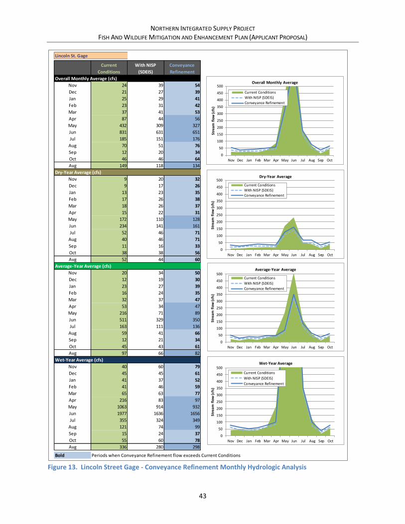
NORTHERN INTEGRATED SUPPLY PROJECT FISH AND WILDLIFE MITIGATION AND ENHANCEMENT PLAN (APPLICANT PROPOSAL)
43
Figure 13. Lincoln Street Gage - Conveyance Refinement Monthly Hydrologic Analysis
Current
Conditions
With NISP
(SDEIS)
Conveyance
Refinement
Overall Monthly Average (cfs)
Nov 24 39 54
Dec 21 27 39
Jan 25 29 41
Feb 23 31 42
Mar 37 41 53
Apr 87 44 56
May 432 309 327
Jun 831 631 651
Jul 185 151 176
Aug 70 51 76
Sep 12 20 34
Oct 46 46 64
Avg 149 118 134
Dry-Year Average (cfs)
Nov 9 20 32
Dec 9 17 26
Jan 13 23 35
Feb 17 26 38
Mar 18 26 37
Apr 15 22 31
May 172 110 128
Jun 234 141 161
Jul 52 46 71
Aug 40 46 71
Sep 11 16 33
Oct 38 38 56
Avg 52 44 60
Average-Year Average (cfs)
Nov 20 34 50
Dec 12 19 30
Jan 23 27 39
Feb 16 24 35
Mar 32 37 47
Apr 53 34 47
May 216 71 89
Jun 511 329 350
Jul 163 111 136
Aug 59 41 66
Sep 12 21 34
Oct 45 43 61
Avg 97 66 82
Wet-Year Average (cfs)
Nov 40 60 79
Dec 45 45 61
Jan 41 37 52
Feb 41 46 59
Mar 65 63 77
Apr 216 83 97
May 1063 914 932
Jun 1977 1636 1656
Jul 355 324 349
Aug 121 74 99
Sep 15 24 37
Oct 55 60 78
Avg 336 280 298
Bold Periods when Conveyance Refinement flow exceeds Current Conditions
Lincoln St. Gage
0
50
100
150
200
250
300
350
400
450
500
Nov Dec Jan Feb Mar Apr May Jun Jul Aug Sep Oct
Stre
am f
low
(cfs
)
Overall Monthly Average
Current Conditions
With NISP (SDEIS)
Conveyance Refinement
0
50
100
150
200
250
300
350
400
450
500
Nov Dec Jan Feb Mar Apr May Jun Jul Aug Sep Oct
Stre
am f
low
(cfs
)
Dry-Year Average
Current Conditions
With NISP (SDEIS)
Conveyance Refinement
0
50
100
150
200
250
300
350
400
450
500
Nov Dec Jan Feb Mar Apr May Jun Jul Aug Sep Oct
Stre
am f
low
(cfs
)
Average-Year Average
Current Conditions
With NISP (SDEIS)
Conveyance Refinement
0
50
100
150
200
250
300
350
400
450
500
Nov Dec Jan Feb Mar Apr May Jun Jul Aug Sep Oct
Stre
am f
low
(cfs
)
Wet-Year Average
Current Conditions
With NISP (SDEIS)
Conveyance Refinement

NORTHERN INTEGRATED SUPPLY PROJECT FISH AND WILDLIFE MITIGATION AND ENHANCEMENT PLAN (APPLICANT PROPOSAL)
44
The conveyance refinement was also developed to mitigate water quality effects described in the
Supplemental Draft EIS (Corps 2015), including temperature and other constituents. Water quality
modeling being conducted as part of the Final EIS will describe the effectiveness of this mitigation.
The following is noted regarding refined conveyance operations:
• Conveyance refinement operations within this document generally described Poudre River
Intake diversions as being released from Glade Reservoir. However, in some cases, to minimize
“double pumping” of water supplies (pumping from the Glade forebay into Glade Reservoir,
then pumping released water again at the Poudre River Intake), when SPWCP exchanges are
occurring or when the Grey Mountain water rights are in priority, water may be bypassed at
either the Poudre Valley Canal diversion (in the case of the Grey Mountain water rights) or the
Larimer-Weld diversion (in the case of Larimer-Weld SPWCP exchange), or exchanged from the
New Cache diversion directly to the Timnath Inlet diversion (in the case of New Cache SPWCP
exchanges). Initial analyses show that releases from Glade Reservoir would be made 2/3 of the
time, while bypasses or direct exchanges would be made approximately 1/3 of the time. These
operations all result in the same effects on the river. Northern Water is continuing to analyze
these operations.
• As previously described, source water quality, and the ability to treat any water delivered via
NISP facilities, is imperative to the Participants. If NISP deliveries cannot be treated by
Participant water treatment facilities, then the NISP deliveries cannot be used. As designed, it is
expected that diversions made through the Poudre River Intake will be treatable by Participant
water treatment plants during normal streamflow and watershed conditions. However, there
may be times when water quality within the river prevents diversions by the Poudre River
Intake. These times may include short durations during spring peak runoff when turbidity and
TOCs are high, storm events in the City of Fort Collins that result in significant urban runoff to
the Poudre River, runoff after wildfire events, chemical spills into the river, and other typical and
unforeseen events. Northern Water will install real time water quality monitoring equipment in
the Poudre River to ensure that the Poudre River Intake temporarily ceases diversions during
these times.
• As previously described, diversions at the Poudre River Intake, and through the refined
conveyance system as a whole, are demand driven. Diversions cannot be made through the
Poudre River Intake if there is insufficient demand from the Participants. Therefore, there may
individual days when the delivery rates cannot be reached, and deliveries to the Poudre River
Intake cannot be made. At full operations, this should not be the case per the design
methodologies described above, but could infrequently occur. However, during initial NISP
operations before full NISP demands are met, this may happen more frequently. An interim
delivery schedule for conveyance refinement will be developed and modified as NISP is brought
on line and delivery schedules change. The interim delivery schedule will be coordinated with
CPW and through the Adaptive Management Program (section 6.1.1.1).

NORTHERN INTEGRATED SUPPLY PROJECT FISH AND WILDLIFE MITIGATION AND ENHANCEMENT PLAN (APPLICANT PROPOSAL)
45
5.2.2.5. Poudre River Flow Augmentation Protection (FW-05)
Legal protection of flow augmentation on the Poudre through Fort Collins would be advantageous to
many of the flow commitments described in this plan. While presently, there are no existing abilities for
exchange within the river reach that NISP will enhance, protections against potential future exchanges
would provide additional certainty that the flow commitments will remain in the river for environmental
benefits. As previously described in Section 3.2, the Flows initiative of the Poudre Runs Through It
working group is discussing and investigating legal mechanisms to protect flow augmentation through
the City of Fort Collins, including a formal instream flow water right through the Colorado Water
Conservation Board. Northern Water is currently working with this group regarding these options.
Northern Water commits to continuing this dialog and supporting a legal mechanism for this protection
as long as the legal protection is not potentially injurious to water rights associated with C-BT, Windy
Gap, NISP, or other water rights held by Northern Water.
If the actions described above are unsuccessful, or are not ultimately configured in a manner that can be
used to protect the flow commitments described in this plan, Northern Water commits to pursuing
other legal options, as necessary, to protect flow commitments in this plan.
Additional streamflow measurement will be required to administer many of the streamflow
commitments in this plan. Additional streamflow measurement is proposed as part of the multi-
objective diversion structure retrofits (section 6.1.1.2) and as part of the streamflow and water quality
monitoring program (section 5.3.1.5).
5.2.2.6. Peak Flow Operations Program (FW-08)
The Supplemental Draft EIS concluded that NISP would have minor detectable changes in channel
morphology and sediment transport upstream of I-25 (Corps 2015). Several comments were received on
the Supplemental Draft EIS geomorphic analysis, including comments from CPW staff. Thus, the Corps
has conducted additional geomorphic analyses that will be included in the Final EIS. The technical
report prepared for the additional geomorphic analyses indicates that “based on the results of the
initiation of motion analysis, agency representatives agreed that the flows to flush coarse and very
coarse gravels, having a maximum flow magnitude of 2,800 cfs, would optimize benefit to aquatic
species in the study area. Similarly, a frequency of occurrence of 1.5 to 2 years was also noted by this
group as optimal for maintaining spawning habitat” (Anderson 2017). Discussions with CPW staff
confirmed those conclusions, and concluded that the most beneficial duration of a typical peak flow
operation would be approximately 72 hours.
Based on information in the Supplemental Draft EIS (Corps 2015), the additional geomorphic analyses,
guidelines provided by CPW staff, review of comments provided on the Supplemental Draft EIS, and
discussions with other organizations, Northern Water has developed a Peak Flow Operations Program
(Table 6) in which Northern Water’s operations during peak flow conditions would be contingent upon
general hydrologic conditions and NISP conditions. This program avoids and minimizes potential effects
of NISP operations on peak flows and flushing flows in the Poudre River.

NORTHERN INTEGRATED SUPPLY PROJECT FISH AND WILDLIFE MITIGATION AND ENHANCEMENT PLAN (APPLICANT PROPOSAL)
46
Table 6. Peak Flow Operations Program by Peak Flow Operational Year
Measure Tier 1 Tier 2 Tier 3
Trigger Conditions
Glade Storage Trigger > 130,000 ac-ft (76% of Capacity)
> 85,000 ac-ft (50% of capacity)
< 85,000 ac-ft
Water Supply Conditions Glade likely to fill based upon most recent Poudre Basin forecast
N/A N/A – Generally includes any year where Tier 1 and Tier 2 conditions are not met. Frequency Annual Peak flow did not reach
target flow in previous year and NISP diversions were not bypassed in previous year
Proposed Action
Curtailment Fully curtail NISP diversions
Curtail NISP diversions to meet target flow up to maximum curtailment volume
No obligation to curtail. Consider adaptive management
Target Flow N/A 2,800 cfs (average daily flow)
N/A
Maximum Curtailment Volume
N/A 1,800 ac-ft N/A
Location Canyon Gage Canyon Gage N/A
Duration 3 days Up to 3 days N/A
Other Terms/Conditions • Bypassed flow will not be diverted by another upstream or downstream water right.
• Bypassed flow does not contribute to downstream flooding. • Bypassed flow will not count against Glade Reservoir fill. • Adaptive management plan to include coordinated operations with other water
users, monitoring and adjustment (geomorphic, fish counts?).
In the spring of each year, Northern Water will classify the runoff year as either a Tier 1, Tier 2 or Tier 3
year based on May 1 storage contents in Glade Reservoir, water supply conditions (i.e. whether Glade is
likely to fill based on forecasted runoff), and whether target peak flows were reached in the previous
year and whether NISP bypassed flows in the previous year. NISP operations during peak flow
conditions would be dependent upon the tier classification for that year. For Tier 1 conditions, NISP
would curtail diversions for a period of 3 days (72 hours) regardless of the anticipated peak flow value
(assuming the other terms and conditions are met). For Tier 2 conditions, NISP would curtail diversions
for up to 3 days, at a volume not to exceed 1,800 acre-feet during those three days, to meet a target
flow of 2,800 cfs. The methods of curtailment to reach the 2,800 cfs target are flexible as long as the
1,800 acre-foot volumetric amount is not exceeded. Thus, the curtailment could last the entire 3 days at
a reduced rate, for 1 day at a higher rate, or vary hourly to provide more natural pulse flow conditions.
For Tier 3 conditions, NISP would not have an obligation to curtail, but could consider curtailment as
part of the Adaptive Management Program (see section 6.1.1.1), which generally states that Northern
Water would consider curtailment for peak flow purposes as long as NISP yield is not affected.

NORTHERN INTEGRATED SUPPLY PROJECT FISH AND WILDLIFE MITIGATION AND ENHANCEMENT PLAN (APPLICANT PROPOSAL)
47
Using Supplemental Draft EIS hydrology results (Corps 2015), Northern Water has analyzed potential
operations of the program. The first aspect of the analysis is the tier classification for each year. Using
the CTP hydrology results, and assuming that the likelihood of fill can be perfectly predicted,
approximately 43 percent of years would be classified as Tier 1, 20 percent classified as Tier 2, and 38
percent classified as Tier 3 (Figure 14). As expected, during extended wet periods, Tier 1 conditions can
persist for many consecutive years. Similarly, during extended dry periods, Tier 3 conditions can persist
for many consecutive years.
Figure 14. Tier Classification Using CTP Model Run 3a2 (Current Conditions with NISP)
Simulated peak flow operations show that the program would substantially improve peak flow
characteristics at the Canyon Gage (Colorado Division of Water Resources ID CLAFTCCO) from
unmitigated NISP operations. For the 2,800 cfs target flow at the Canyon Gage, the 1950-2005 CTP
modeling period shows a historical recurrence interval for the 1-day peak streamflow of 2.9 years. With
NISP in place and without the Peak Flow Operations Program, this increases to 8.1 years. With the Peak
Flow Operations Program in place, this decreases back down to 3.4 years (Table 7, Figure 15). Similarly,
for the 3-day peak flow (average daily flow for 3 consecutive days), the historical recurrence interval for
2,800 cfs target flow at the Canyon Gage is 3.6 years. With NISP in place and without the Peak Flow
Operations Program, this increases to 28.5 years. With the program in place, this decreases to 7.1 years
(Table 7, Figure 16). Note that this analysis does not include any adaptive management operations that
could potentially take place during some Tier 3 years and could potentially further enhance the
frequency of peak flow recurrence intervals.
Although the peak flow commitment only applies at the Canyon Gage, it will benefit all other reaches of
the Poudre River. Historically, during years with peak flows that exceed the 2,800 cfs target flow at the
0
0.1
0.2
0.3
0.4
0.5
0.6
0.7
0.8
0.9
1
0
20
40
60
80
100
120
140
160
180
19
50
19
55
19
60
19
65
19
70
19
75
19
80
19
85
19
90
19
95
20
00
20
05
Sto
rage
(ac
-ft)
Tho
usa
nd
s
Tier 1Tier 2Tier 3Tier 1 VolumeTier 2 VolumeGlade StorageGlade CapacityLikely to Fill

NORTHERN INTEGRATED SUPPLY PROJECT FISH AND WILDLIFE MITIGATION AND ENHANCEMENT PLAN (APPLICANT PROPOSAL)
48
Canyon Gage, peak flows are also high at downstream locations (Figure 17). Between 1975 and 2016
(years in which data for the Lincoln Street Gage is available), the average daily peak flow exceeded the
2,800 cfs target during 19 of the 42 years. During that same period, the average daily peak flow
exceeded 2,000 cfs during 14 of the 42 years at the Lincoln Street Gage (U.S. Geological Survey Station
ID 06752260, Cache La Poudre River at Fort Collins, CO), and during 16 of the 42 years at the Greeley
Gage. Although this indicates that there are typically (but not always) reductions in peak streamflows
downstream of the Canyon Gage, peak streamflows have historically remained high downstream of the
Canyon Gage, and would expect to continue following this pattern during the Peak Flow Operations
Program.
Table 7. Peak Flow Recurrence Intervals with Peak Flow Operations Program
Canyon Gage Flow
(cfs)
Recurrence Interval (years)
Observed With NISP With Peak Flow
Operation Program
1-day average flow of 2,800 cfs 2.9 8.1 3.4
3-day average flow of 2,800 cfs 3.6 28.5 7.1
Figure 15. Poudre River at Canyon Gage Average Daily Peak Flow
Target, 2800
19
50
19
52
19
54
19
56
19
58
19
60
19
62
19
64
19
66
19
68
19
70
19
72
19
74
19
76
19
78
19
80
19
82
19
84
19
86
19
88
19
90
19
92
19
94
19
96
19
98
20
00
20
02
20
04
-6
-5
-4
-3
-2
-1
0
1
0
1,000
2,000
3,000
4,000
5,000
6,000
7,000
19
50
19
52
19
54
19
56
19
58
19
60
19
62
19
64
19
66
19
68
19
70
19
72
19
74
19
76
19
78
19
80
19
82
19
84
19
86
19
88
19
90
19
92
19
94
19
96
19
98
20
00
20
02
20
04
Ave
rage
Dai
ly S
tre
amfl
ow
(cf
s)
1-day max Observed (cfs)1-day max NISP (cfs)1-day max w/Curtail (cfs)Tier 1Tier 2

NORTHERN INTEGRATED SUPPLY PROJECT FISH AND WILDLIFE MITIGATION AND ENHANCEMENT PLAN (APPLICANT PROPOSAL)
49
Figure 16. Poudre River at Canyon Gage 3-Day Average Daily Peak Flow
Figure 17. Poudre River Average Daily Peak Flow at Canyon, Lincoln Street and Greeley Gages
Northern Water will coordinate with the District 3 water commissioner, CPW, and other water users
based on the best available information to operate in a manner that peak flows meet the goals
described herein. However, given natural diurnal hydrologic variability, the actual streamflow and
duration may differ slightly from those described here. Northern Water would expect to coordinate
Target, 2800
19
50
19
52
19
54
19
56
19
58
19
60
19
62
19
64
19
66
19
68
19
70
19
72
19
74
19
76
19
78
19
80
19
82
19
84
19
86
19
88
19
90
19
92
19
94
19
96
19
98
20
00
20
02
20
04
-6
-5
-4
-3
-2
-1
0
1
0
1,000
2,000
3,000
4,000
5,000
6,000
7,000
19
50
19
52
19
54
19
56
19
58
19
60
19
62
19
64
19
66
19
68
19
70
19
72
19
74
19
76
19
78
19
80
19
82
19
84
19
86
19
88
19
90
19
92
19
94
19
96
19
98
20
00
20
02
20
04
Ave
rage
Dai
ly S
tre
amfl
ow
(cf
s)
3-day max Observed (cfs)3-day max NISP (cfs)3-day max w/Curtail (cfs)Tier 1Tier 2Tier 3
0
1,000
2,000
3,000
4,000
5,000
6,000
7,000
8,000
19
75
19
80
19
85
19
90
19
95
20
00
20
05
20
10
20
15
Pea
k D
ail
y St
rea
mfl
ow
(cfs
)
Canyon Gage
Lincoln St. Gage
Greeley Gage
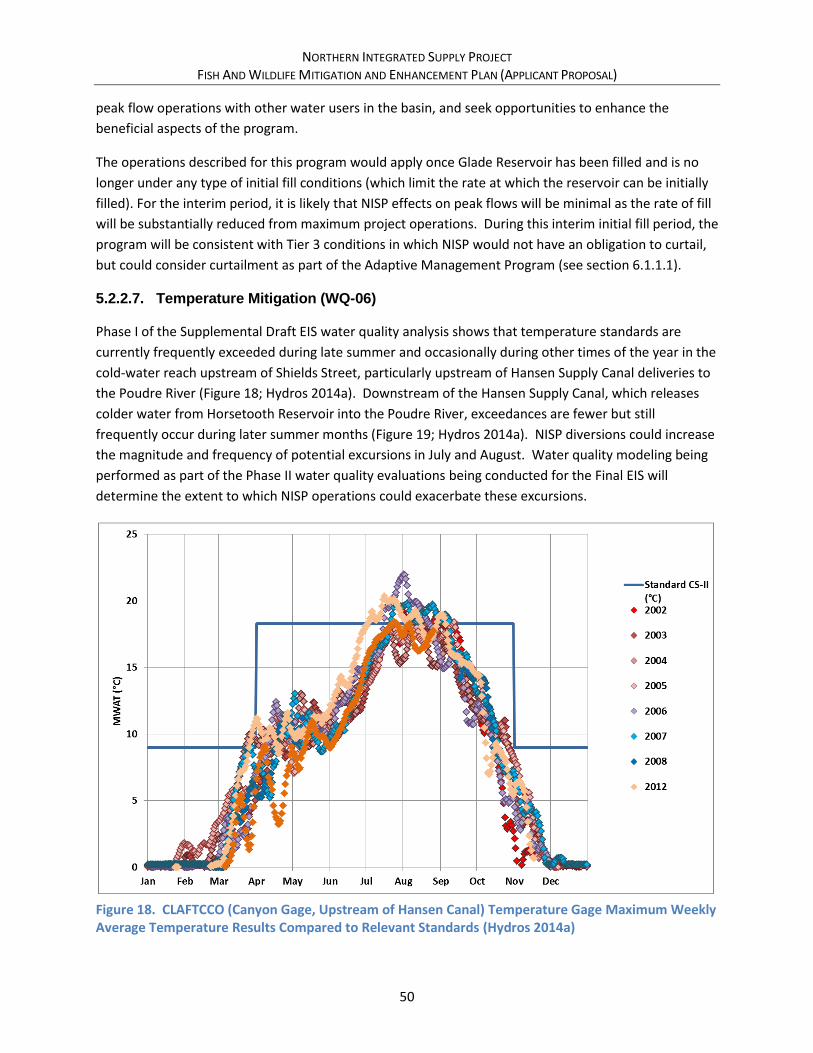
NORTHERN INTEGRATED SUPPLY PROJECT FISH AND WILDLIFE MITIGATION AND ENHANCEMENT PLAN (APPLICANT PROPOSAL)
50
peak flow operations with other water users in the basin, and seek opportunities to enhance the
beneficial aspects of the program.
The operations described for this program would apply once Glade Reservoir has been filled and is no
longer under any type of initial fill conditions (which limit the rate at which the reservoir can be initially
filled). For the interim period, it is likely that NISP effects on peak flows will be minimal as the rate of fill
will be substantially reduced from maximum project operations. During this interim initial fill period, the
program will be consistent with Tier 3 conditions in which NISP would not have an obligation to curtail,
but could consider curtailment as part of the Adaptive Management Program (see section 6.1.1.1).
5.2.2.7. Temperature Mitigation (WQ-06)
Phase I of the Supplemental Draft EIS water quality analysis shows that temperature standards are
currently frequently exceeded during late summer and occasionally during other times of the year in the
cold-water reach upstream of Shields Street, particularly upstream of Hansen Supply Canal deliveries to
the Poudre River (Figure 18; Hydros 2014a). Downstream of the Hansen Supply Canal, which releases
colder water from Horsetooth Reservoir into the Poudre River, exceedances are fewer but still
frequently occur during later summer months (Figure 19; Hydros 2014a). NISP diversions could increase
the magnitude and frequency of potential excursions in July and August. Water quality modeling being
performed as part of the Phase II water quality evaluations being conducted for the Final EIS will
determine the extent to which NISP operations could exacerbate these excursions.
Figure 18. CLAFTCCO (Canyon Gage, Upstream of Hansen Canal) Temperature Gage Maximum Weekly Average Temperature Results Compared to Relevant Standards (Hydros 2014a)

NORTHERN INTEGRATED SUPPLY PROJECT FISH AND WILDLIFE MITIGATION AND ENHANCEMENT PLAN (APPLICANT PROPOSAL)
51
Figure 19. HSC-PRU (Below Hansen Canal) Temperature Gage Maximum Weekly Average Temperature Results Compared to Relevant Standards (Hydros 2014a)
Northern Water has made several commitments within this plan to operate NISP in a manner that will
likely avoid or minimize adverse stream temperature impacts, and in some instances Northern Water’s
operation of NISP should benefit stream temperatures. These include avoiding diversions during critical
low flow periods (FW-01 Avoid Munroe Canal Diversions, Section 5.2.2.1; FW-02 Curtail Diversions for
Non-Consumptive Water Rights, section 5.2.2.2; FW-03 Summer and Winter Diversion Curtailments,
section 5.2.2.3); introducing cooler water into the river (FW-04 Conveyance Refinement, section
5.2.2.4); and performing mitigation activities that will mitigate temperature effects in critical reaches of
the river (Stream Channel and Habitat Improvement Plan, section 5.3.1.1; Channel and Habitat
Improvements, section 5.3.1.2; Poudre River Adaptive Management Program, section 6.1.1.1).
Despite these commitments, there remain times when diversions into NISP facilities may exacerbate an
existing temperature exceedance, or cause a temperature exceedance that may not otherwise occur.
Therefore, to further avoid and minimize effects of NISP operations on water temperature in the Poudre
River, Northern Water commits to the following protocols for operating NISP in manner that will not
exacerbate an existing temperature exceedance or cause a new temperature exceedance to occur in the
Poudre River:
• Monitoring Stations – To implement the actions described in this mitigation action,
Northern Water shall ensure that continuous real-time instantaneous temperature
monitoring continues at the Canyon Gage. Additionally, to assist in the adaptive
management process, Northern Water will install, operate and maintain continuous real-
time temperature-monitoring stations at each of the multi-objective diversion structure

NORTHERN INTEGRATED SUPPLY PROJECT FISH AND WILDLIFE MITIGATION AND ENHANCEMENT PLAN (APPLICANT PROPOSAL)
52
retrofits identified in section 6.1.1.2, at the Poudre Valley Canal Diversion Structure
identified in section 5.2.1.2, and at a site located between the existing Fossil Creek Reservoir
Inlet Ditch and the New Cache Canal diversion structure.
• Temperature Thresholds - For the purposes of this mitigation action, the threshold
temperatures will be the standards in place by the Colorado Water Quality Control Division
(Table 8). Northern Water is currently part of a workgroup that is investigating site specific
standards for transitional reaches of the Poudre River. If this workgroup concludes that
different standards are appropriate for the transitional reaches, the standards developed by
that workgroup will become the temperature thresholds for this mitigation. If standards
change in the future, Northern Water will evaluate whether these new standards can be
met without a loss in NISP yield. If Northern Water evaluations shown that the new
standards can be met without a loss in yield, the new standards shall become the
temperature thresholds. If the evaluation show that the new standards cannot be met
without a loss in yield, Northern Water will discuss options with CPW through the Poudre
River Adaptive Management Program.
Table 8. Existing Acute and Chronic Temperature Standards for the Poudre River
Segment Segment Descriptions Acute (◦C) Chronic (◦C)
10 Munroe Canal diversion to Shields Street
Apr – Oct 23.9
Nov – Mar 13.0
Apr - Oct 18.3
Nov – Mar 9.0
Note: The Canyon Gage is located within segment 10.
• Maximum Weekly Average Temperature (MWAT) Chronic Threshold Exceedances - For the
period after July 15th of each year, at such times as the Weekly Average Temperature (WAT)
comes within 0.3 C of the MWAT Chronic Threshold at the Canyon Gage, Northern Water
will initiate the Poudre River Adaptive Management process for temperature mitigation.
• Daily Maximum (DM) Acute Threshold Exceedances - At such times as the Daily Maximum
temperature is within 1◦C of the DM Acute Threshold at the Canyon Gage, Northern Water
will initiate the Poudre River Adaptive Management Process for Temperature Mitigation. In
the future, the 1 degree buffer may be altered, based on experience, to maintain
compliance with the DM Threshold.
• Poudre River Adaptive Management Process for Temperature Mitigation – Approaching or
exceeding the temperature thresholds at the Canyon Gage as described above will initiate
immediate discussions between Northern Water, CPW, and other Poudre River Adaptive
Management Program parties (section 6.1.1.1) to determine potential causes for
temperature exceedances. If these discussions conclude that NISP diversions may be
contributing to temperature exceedances, Northern Water will initiate actions under the
Poudre River Adaptive Management Program (section 6.1.1.1) to mitigate the contribution.
Management actions by NISP may include but are not limited to a reduction or curtailment

NORTHERN INTEGRATED SUPPLY PROJECT FISH AND WILDLIFE MITIGATION AND ENHANCEMENT PLAN (APPLICANT PROPOSAL)
53
of NISP diversions, or other changes in NISP operations that do not affect NISP yield or the
ability to make NISP deliveries to Participants.
• Limitations on Reduction or Curtailment of NISP Diversions - The temperature mitigation
measures identified above will be suspended in the event that and at such times as there is
no material causal relationship between NISP operations and any exceedance of the MWAT
Chronic threshold or DM Acute threshold at the monitoring stations identified above. For
the purposes of this paragraph a “material causal relationship” is defined as either an actual
measurable impact on temperature using readily available monitoring technology or a
modeled impact on temperature that is not insignificant and is based on a computer model
or studies accepted by the Colorado Division of Wildlife. Northern Water will cooperate with
future studies to determine what factors, other than flow changes, have effects on water
temperatures in the Poudre River.
Northern Water and CPW understand that additional temperature analyses are being conducted by the
Corps as part of the EIS Phase II water quality analyses. If these analyses show a more significant or
wider range of temperature effects than those described in the Supplemental Draft, Northern Water
and CPW will amend this FWMEP with appropriate measures to mitigate these effects.
5.2.3. Construction BMP Commitments
Large construction projects like NISP typically have a long list of Best Management Practices (BMPs) that
accompany Federal, State and local permitting activities. The following lists more significant BMPs
and/or those that are particular to NISP that are committed to as part of this FWMEP. Additional
construction BMPs are contained in the Conceptual Mitigation Plan and may be prescribed as part of
other future permitting activities.
5.2.3.1. Noxious Weed Control Plan (NW-01)
NISP will be responsible for avoiding and minimizing the spread of noxious5 or invasive weeds associated
with construction activities and water level fluctuations and exposed shorelines in Glade and Galeton
reservoirs. Prior to construction activities, a noxious and invasive weed control plan will be developed
for construction activities and general as required by local and state agencies. A separate specific
noxious and invasive weed control plan for Glade and Galeton reservoirs will submitted to CPW for
approval.
BMPs will be used to minimize the spread of noxious weeds (List A, B, and C species) at all areas where
spreading of noxious weeds might occur. Implementing these BMPs will minimize the dispersal of
noxious weeds and reduce the need for future weed control actions. The following BMPs will be
implemented with compensatory mitigation actions that involve land disturbance:
5 For the purposes of this plan, “noxious weeds” are those weeds listed in the Colorado Noxious Weed Act.
NORTHERN INTEGRATED SUPPLY PROJECT FISH AND WILDLIFE MITIGATION AND ENHANCEMENT PLAN (APPLICANT PROPOSAL)
54
• Major equipment (e.g., track equipment, rubber tire loaders, and backhoes) will be cleaned by
high pressure air or water spray before being delivered to the project area to avoid introducing
undesirable plants and noxious weeds.
• Topsoil containing any noxious weeds (List A, B, or C species) will not be used or otherwise will
be strictly managed to preclude the spread of seeds and noxious weed species.
• Fertilizer or other soil amendments will not be used unless recommended by a re-vegetation
specialist based on site-specific conditions. The use of fertilizers will be restricted because they
can promote noxious weeds and can be detrimental to the native species in the seed mix.
• Disturbed areas will be reclaimed as soon as practicable after completion of construction and
seeded with an appropriate native seed mix (certified as noxious weed-free).
• Certified weed-free mulch will be used for re-vegetation. Weed-free straw bales will be used for
sediment barriers.
• Locally or regionally available seed and mulch will be used when practicable.
• Domestic goats or sheep shall not be used for weed control purposes, or allowed to graze upon
any land owned, leased or managed by NISP.
The project area will be monitored to determine if noxious weeds have invaded. Any noxious weeds
found will be controlled as soon as practicable to prevent establishment.
Each disturbance of a vegetated upland will require the restoration and re-vegetation of the disturbance
according to established re-vegetation guidelines. The general re-vegetation requirements will be
described in the noxious and invasive weed control plan. Detailed, construction-level specifications that
follow these guidelines will be included in the construction plans for any activity that temporarily
disturbs upland vegetation and/or soil. These plans will be subject to review by CPW.
The re-vegetated sites at Glade and Galeton reservoirs will be monitored annually, during the growing
season. The first two years of monitoring will be qualitative to determine if re-vegetation is progressing.
Following the first two full growing seasons, monitoring at Glade and Galeton reservoirs will consist of
the following:
• A visual inspection to determine if the areas seeded have germinated and are becoming
established;
• A determination of the presence and distribution of bare areas6 greater than 400 square feet;
• A determination of the presence and distribution of noxious weeds comprising 10 percent or
more of the estimated vegetative ground cover or any area greater than 400 square feet
dominated by noxious weeds; and
• Photographic documentation of representative re-vegetated areas taken from fixed points for
year- to-year comparisons.
6 For the purposes of the qualitative monitoring, “bare areas” are defined as areas where seed has not germinated or on average there is less than one desirable plant per square foot.

NORTHERN INTEGRATED SUPPLY PROJECT FISH AND WILDLIFE MITIGATION AND ENHANCEMENT PLAN (APPLICANT PROPOSAL)
55
The presence of bare areas greater than 400 square feet at Glade or Galeton reservoirs will require
reseeding the bare areas per the re-vegetation guidelines. The presence of noxious weeds greater than
400 square feet will require weed control measures.
The noxious and invasive weed control plan for Glade and Galeton reservoirs will include success criteria
to measure compliance with the plan. CPW will be consulted to develop appropriate success criteria for
NISP. The success criteria for vegetation mitigation may include:
• Average ground cover is 90 percent or greater than the selected reference area;
• The relative cover of native species is 90 percent or greater than the reference area;
• Noxious weeds comprise less than 20 percent of the average estimated vegetated ground cover;
and
• No area greater than 800 square feet is dominated by noxious weeds.
5.2.3.2. Migrating Birds and Raptors (TW-03, TW-04, TW-05)
Northern Water will avoid, minimize and provide compensatory mitigation for migrating birds and
raptors in accordance with requirements under the Migratory Bird Treaty Act (MBTA). Where possible,
vegetation clearing would occur during the nonbreeding period, prior to construction. If active nests are
found during preconstruction surveys, they would be left undisturbed and “no-work” zones would be
established around the nests until the breeding season is over. The installation of nesting deterrents to
prevent nesting before April 1, and removal of these deterrents no more than 24 hours before initiation
of construction, is an acceptable alternative to prohibiting construction activity during the breeding
season. In cases where removal of a nest is necessary, a permit would be requested from the Service.
Nesting surveys would be conducted prior to the initiation of construction activities to identify migratory
bird nests in the construction right-of-way.
CPW developed recommended buffer zones and seasonal restrictions for new surface occupancy within
certain distances of nest sites of several raptor species. Surface occupancy is defined as human-
occupied buildings and other structures such as oil and gas wells, roads, railroad tracks, and trails. The
Service typically considers that implementation of the CPW buffers and seasonal restrictions fulfill
compliance requirements of MBTA for raptors.
A raptor nest survey would be conducted prior to construction to identify raptor nests in the vicinity of
construction activities. If an active raptor nest is found on-site, CPW recommended buffers and
seasonal restrictions for raptors would be established during construction to avoid nest abandonment.
If disturbance of raptor nests is unavoidable, mitigation measures could include the construction of
artificial nests in suitable habitat or enhancement of prey habitat. If raptor nests could be impacted by
construction activities, specific mitigation measures for impacts to nesting raptors would be developed
by Northern Water in coordination with CPW and the Service prior to construction.
If a take of migratory birds or raptors occurs incidentally or cannot be avoided, MBTA permits and
requirements will be followed.

NORTHERN INTEGRATED SUPPLY PROJECT FISH AND WILDLIFE MITIGATION AND ENHANCEMENT PLAN (APPLICANT PROPOSAL)
56
5.3. Compensatory Mitigation
As would be expected for a project with the scope of NISP, not all environmental effects can be avoided
or minimized. Therefore, compensatory mitigation is required to mitigate certain effects of NISP. This
section describes the development of compensatory mitigation plans for impacted resources.
5.3.1. Aquatic Resource and Water Quality Mitigation
NISP would affect several environmental resources that are connected to the Poudre River channel from
the Poudre Valley Canal diversion at the mouth of the canyon to its confluence with the South Platte
east of Greeley, including water quality, stream morphology, fish and aquatic life, riparian vegetation,
and wetlands. A series of improvements to the channel corridor are proposed as a comprehensive
mitigation strategy for mitigation of effects and improvements to the Poudre River channel.
Phase I of the water quality analysis shows that temperature standards are currently frequently
exceeded during late summer and occasionally during other times of the year in the cold-water reach
upstream of Shields Street (particularly upstream of Hansen Supply Canal deliveries to the Poudre
River), and states that NISP diversions could increase the magnitude and frequency of potential
excursions in July and August. Water quality modeling being performed as part of the Phase II water
quality evaluations will determine the extent to which NISP operations could exacerbate these
excursions.
To mitigate these potential effects, the Conceptual Mitigation Plan (Northern Water 2015) contained a
mitigation action item to evaluate the feasibility of enlarging Glade Reservoir, which would allow the
potential curtailment of late summer diversions. Based on agency and public comment received on the
Supplemental Draft EIS, Northern water is no longer considering enlargement of Glade Reservoir for this
purpose or any other purpose – the proposed Glade Reservoir capacity remains at 170,000 acre-feet.
Sections 5.2.2.4 and 5.2.2.7 of this document contain new avoidance and minimization measures to
address potential exacerbation of temperature excursions that may result from Glade Reservoir
diversions.
5.3.1.1. Stream Channel and Habitat Improvement Plan (AG-01)
Northern Water would provide funding to facilitate/assist in development of a stream channel and
habitat improvement plan for the Poudre River from the Poudre Valley Canal to its mouth at the South
Platte River. The stream channel and habitat improvement plan would provide compensatory
mitigation for Poudre River water related resources, including aquatic, stream morphology, water
quality, riparian, and special status species. The stream channel and habitat improvement plan will be
developed as part of the adaptive management program (see section 5.3.2.2) in cooperation with CPW,
City of Fort Collins, Town of Windsor, City of Greeley, and other parties, and incorporate the concepts
and projects being planned and implemented by those entities.
Goals of the stream channel and habitat improvement plan would include:

NORTHERN INTEGRATED SUPPLY PROJECT FISH AND WILDLIFE MITIGATION AND ENHANCEMENT PLAN (APPLICANT PROPOSAL)
57
• Collect additional data, perform a river corridor inventory, and document current conditions.
• Develop baseline geomorphic conditions for use in the Adaptive Management Plan.
• Develop a river-wide master plan and prioritization for maintaining and improving the following
river functions:
o Irrigation and municipal water supply diversions;
o Channel and overbank capacity and connectivity;
o Aquatic habitat and species;
o Riparian habitat and wildlife species;
o Flood risk to land and infrastructure;
o Recreation.
• Develop a long-term monitoring and maintenance plan.
• Ensure that a long-term funding and implementation group is in place to leverage funding
provided by NISP with other governmental or grant funding that may be available to perform
this type of work.
To the extent practical, the stream channel and habitat improvement plan would build upon data and
analyses conducted for the EIS.
NISP commits to spending up to $1.0 million to develop the stream channel habitat and improvement
plan. This funding is in addition to other commitments made in this FWMEP. Funding for
implementation of site specific stream channel and habitat improvements is described in separate
sections of this FWMEP, while funding of more general recommendations of the stream channel and
habitat improvement plan is described as part of the Poudre River Adaptive Management Program
(section 6.1.1.1).
5.3.1.2. Channel and Habitat Improvements (AG-02)
As part of compensatory mitigation for resource effects throughout the Poudre River, Northern Water
would implement improvements in the stream channel at two locations of slightly more than one mile
each in affected reaches of the Poudre River. Initially, Northern Water has identified the following
reaches for these improvements. These locations were selected based on their ability to provide multi-
objective mitigation and enhancement benefits, and because these reaches are at least partially publicly
accessible. The location and types of work that are funded by Northern Water would be verified with
the stream channel habitat improvement plan and adjusted as necessary to be consistent with the plan.
• Approximately 1.2 miles within a 2.1-mile reach of the Poudre between PVC and the Hansen
Supply Canal inflows (Figure 20)
• Approximately 1.2 miles of stream in the Watson Lake area (Figure 21)
Key components of a stream habitat improvement project would likely include constructing in-channel
structures made of natural materials to create riffles and pools with a defined low-flow channel which
would increase channel depth, especially during low-flows; reconnecting the channel to the floodplain
and old oxbows; encouraging regeneration of native vegetation; and, removing areas of non-native

NORTHERN INTEGRATED SUPPLY PROJECT FISH AND WILDLIFE MITIGATION AND ENHANCEMENT PLAN (APPLICANT PROPOSAL)
58
vegetation. Providing better connectivity throughout the river is one key aspect that would likely be
included in any plan to improve aquatic habitat. Improving connectivity through diversion structure
bypass facilities is discussed in Section 6.1.1.2.
Figure 20. Poudre Valley Canal Mitigation Reach
Poudre Valley Canal Diversion
Hansen Supply Canal Inflow
PVC to Hansen Channel & Habitat Improvement(2.1 miles; 1.2 miles of discontinuous improvements)
Glade ReservoirPoudre RiverRelease Pipeline
Source: Esri, DigitalGlobe, GeoEye, Earthstar Geographics, CNES/Airbus DS,
USDA, USGS, AEX, Getmapping, Aerogrid, IGN, IGP, swisstopo, and the GISUser Community
0 0.25 0.50.125Miles
Ü
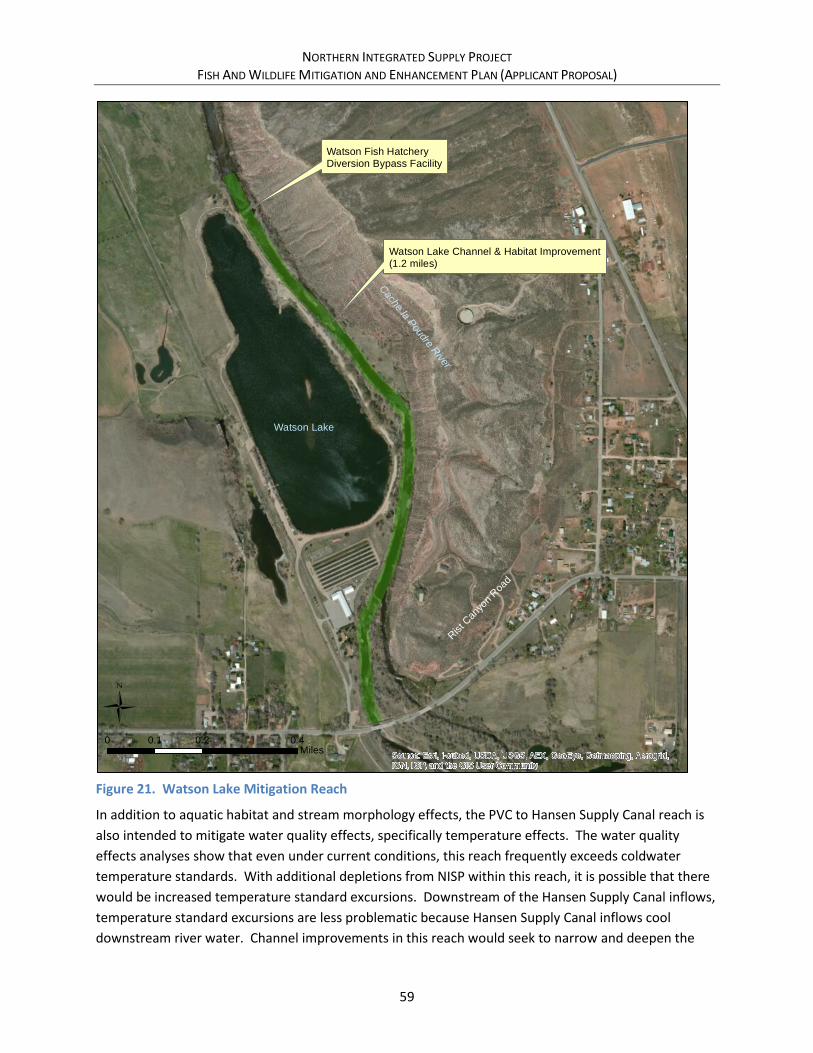
NORTHERN INTEGRATED SUPPLY PROJECT FISH AND WILDLIFE MITIGATION AND ENHANCEMENT PLAN (APPLICANT PROPOSAL)
59
Figure 21. Watson Lake Mitigation Reach
In addition to aquatic habitat and stream morphology effects, the PVC to Hansen Supply Canal reach is
also intended to mitigate water quality effects, specifically temperature effects. The water quality
effects analyses show that even under current conditions, this reach frequently exceeds coldwater
temperature standards. With additional depletions from NISP within this reach, it is possible that there
would be increased temperature standard excursions. Downstream of the Hansen Supply Canal inflows,
temperature standard excursions are less problematic because Hansen Supply Canal inflows cool
downstream river water. Channel improvements in this reach would seek to narrow and deepen the
Watson Lake Channel & Habitat Improvement(1.2 miles)
Watson Fish HatcheryDiversion Bypass Facility
Watson Lake
Rist C
anyo
n Roa
d
County R
oad 5
4G
Cache la P
oudre River
Source: Esri, i-cubed, USDA, USGS, AEX, GeoEye, Getmapping, Aerogrid,
IGN, IGP, and the GIS User Community
0 0.2 0.40.1Miles
Ü

NORTHERN INTEGRATED SUPPLY PROJECT FISH AND WILDLIFE MITIGATION AND ENHANCEMENT PLAN (APPLICANT PROPOSAL)
60
current channel to be more consistent with current and future low-flow conditions and increase riparian
vegetation, including larger plains cottonwoods that would shade the river channel. The effectiveness
of these proposed improvements to cool water temperature would be assessed during the detailed
water quality modeling.
5.3.1.3. Riparian Vegetation (RV-01, RV-02)
Improvements in existing riparian vegetation would be incorporated as part of the stream channel
habitat and improvement reaches that are described above. Additionally, Northern Water has identified
additional areas in which to improve existing riparian vegetation. Riparian vegetation improvements
would directly mitigate impacts on riparian vegetation resources, impacts of reduced peak flows, and
would also mitigate effects on water temperature in certain reaches. Areas under consideration include
the following:
• City of Fort Collins (10 acres)
• Frank State Wildlife Area (34 acres)
• Eastman Park Area (14 acres)
• Adjacent to all channel improvement reaches (54 acres)
Riparian vegetation mitigation through Fort Collins will be coordinated with current planning efforts by
the City, including its Poudre River Downtown Master Plan. The Poudre River Downtown Master Plan
includes much of the nearly 5-mile reach of Segment B, in which approximately 10 acres of riparian
vegetation may be affected by NISP. NISP would fund at least a compensatory amount of riparian
vegetation improvements within this reach. Locations in the Poudre River Downtown Master Plan that
may be candidates for riparian vegetation include improvements at the Gustav Swanson Natural Area, a
natural area east of Linden Street, and at a new 31-acre natural area north of the Mulberry Wastewater
Treatment Plant (Fort Collins 2014a).
The Frank State Wildlife Area is located along the Poudre River on the west side of the Town of Windsor
(Figure 22). This area has potential for expanding cottonwood woodlands, establishing riparian
wetlands, and reconnecting and enhancing the oxbow to provide aquatic habitat and sediment storage.
Non-native vegetation would also be removed. Two sites for potential riparian vegetation mitigation
have been identified. The primary site is located on the west edge of the site near the parking area. The
primary site currently is vegetated primarily by grassland, and is approximately 9 acres in size. The
secondary site is located farther east. This site is 25 acres, but already has some mature cottonwood.
The Frank State Wildlife area could be part of the stream enhancement mitigation for Segments E and F
that is discussed in Section 5.3.1.1. The river reach through this area is approximately 1.2 miles long;
only a portion of this reach, likely the west edge of the property along County Line Road adjacent to the
riparian mitigation sites, would be included in this project. One key aspect of a channel improvement
project conducted along with the riparian vegetation mitigation would be reconnecting the channel to
the floodplain to ensure adequate water is available to sustain cottonwood growth and addressing
channel capacity and providing opportunities for sediment storage.
NORTHERN INTEGRATED SUPPLY PROJECT FISH AND WILDLIFE MITIGATION AND ENHANCEMENT PLAN (APPLICANT PROPOSAL)
61
Eastman Park is located along the Poudre River on the south side of Windsor (Figure 23). As with the
Frank State Wildlife Area, this area has potential for expanding cottonwood woodlands and establishing
riparian wetlands, but may not have as much opportunity to reconnect oxbows. Approximately 14 acres
on the south side of the river have been identified for riparian mitigation improvements. Again, this
project could be part of the stream enhancement mitigation for Segments E and F that is discussed in
Section 5.3.1.1. This land is owned by the Town of Windsor. The river reach in this area is slightly less
than one mile in length, but only a portion of the reach would be rehabilitated as part of the Mitigation
Plan.
Northern Water has had initial conversations with the Town of Windsor regarding the applicability of
these proposed improvements with its long-term vision for the river corridor. The town is currently
updating planning in these areas and feels that the proposed improvements, particularly in the Eastman
Park area, are consistent with its overall vision for these corridors (Windsor 2016).
Opportunities for cottonwood regeneration would be incorporated into the approximately 2.4 miles of
stream channel and habitat improvement reaches described in section 5.3.1.1. To fully mitigate the 112
acres of affected riparian and woodland shrubland, approximately 54 acres of regeneration areas would
be developed, which results in an average developed riparian width along the improvement reaches of
roughly 185 feet. Opportunities would be sought to locate these regeneration areas along reaches that
would provide shading of the river channel to reduce water temperatures during low-flow summer time
conditions. Results of the Phase II water quality modeling will provide additional information on the
magnitude and timing of benefits that enhanced riparian areas, coupled with stream channel
enhancements that are discussed in other portions of this plan, would have on stream temperature.
In cottonwood regeneration areas, the final grades and hydrology would be conducive to the
establishment of a combination of cottonwood seedlings and planted trees. Cottonwood seedling areas
would consist of gravely and sandy soils saturated during the early portion of the growing season.
Surface water would be diverted to seedling areas until the root systems are developed enough to reach
the ground water table.

NORTHERN INTEGRATED SUPPLY PROJECT FISH AND WILDLIFE MITIGATION AND ENHANCEMENT PLAN (APPLICANT PROPOSAL)
62
Figure 22. Frank State Wildlife Area Proposed Mitigation Activities
Frank SWA - Secondary Riparian Mitigation Site (25 acres)
Frank SWA - Primary Riparian Mitigation Site (9 acres)
Whitney/BH Eaton Diversion Consolidationand Bypass Facility
No
rth
Co
un
ty L
ine
Ro
ad
Colorado Hwy 392
Windsor Area Channel and Habitat Improvements(1.1 miles, discontinuous improvements)
Whitney Diversion (Existing)
BH Eaton Diversion (Existing)
Cache la Poudre River
Source: Esri, i-cubed, USDA, USGS, AEX, GeoEye, Getmapping, Aerogrid,
IGN, IGP, and the GIS User Community
0 0.2 0.40.1Miles
Ü

NORTHERN INTEGRATED SUPPLY PROJECT FISH AND WILDLIFE MITIGATION AND ENHANCEMENT PLAN (APPLICANT PROPOSAL)
63
Figure 23. Eastman Park Proposed Mitigation Activities
5.3.1.4. Eaton Draw Water Quality Wetlands (WQ-03)
As expected in a typical transition from a mountain river to plains river system along the Front Range,
currently, water quality generally deteriorates in the Poudre River in a downstream direction. In
Segment 12, which is the Poudre River downstream of Boxelder Creek (generally downstream of I-25),
standard exceedances occur for total phosphorous, ammonia, total recoverable iron and dissolved
Diversion Consolidation (Whitney/BH Eaton)Bypass Structure (Whitney)
Riparian ImprovementsChannel Improvements
Eastman Park - Primary Riparian Mitigation Site (14 acres)
Eastman Park Channel and Habitat Improvements(Possibly Discontinuous)
Eastman Park Drive
7th
Str
ee
t
Cach
e la
Poudre
Riv
er
Source: Esri, i-cubed, USDA, USGS, AEX, GeoEye, Getmapping, Aerogrid,
IGN, IGP, and the GIS User Community
0 0.2 0.40.1Miles
Ü
NORTHERN INTEGRATED SUPPLY PROJECT FISH AND WILDLIFE MITIGATION AND ENHANCEMENT PLAN (APPLICANT PROPOSAL)
64
selenium. Data for the South Platte shows standards exceedances for many of the same water quality
parameters. The water quality effects analysis shows a minor to moderate effect of NISP on nutrients
and inorganics/metals within segment 12 and the South Platte due to reductions in streamflow.
Eaton Draw is a tributary to the Poudre River that generally parallels Highway 85 from the north and
conveys agricultural return flows and effluent from several treatment lagoons that discharge to the
draw. Although additional data is needed to show with certainty, it is thought that Eaton Draw
contributes loading to this reach. Because Eaton Draw is a point discharge into the Poudre River, it
offers an opportunity to provide a constructed wetland treatment area that could assist in reducing
loading to the Poudre River from Eaton Draw for certain constituents.
To mitigate potential impacts of NISP on water quality in the lower reaches of the Poudre River,
Northern Water would construct a wetland in Eaton Draw near the stream’s confluence with the Poudre
River near Greeley (Figure 26). Additional water quality and quantity data is required to properly size
the wetlands to provide meaningful levels of water quality constituent reductions in the wetlands
complex, but based on anecdotal data and information, it is estimated that the wetlands would be
approximately 10 acres. The wetlands would be located near the mouth of the draw, near “O” Street
and Highway 85 north of Greeley. The wetlands could be located on undeveloped land either west or
east of the Highway. The site is not located near major residential areas.
The wetlands would be designed and constructed to remove key water quality constituents from Eaton
Draw influent prior to this water being discharged into the Poudre River. Constructed wetlands are
typically very effective at removing sediments and solids, moderately effective at removing nutrients,
and good at removing total metals (Urban Drainage 2010). Excess nutrients, including nitrogen and
phosphorous, are deposited into wetlands and often absorbed by wetland soils and taken up by plants
and microorganisms (EPA 2004). However, phosphorous removal in wetlands is limited by plant uptake
(EPA 1999). Additional data collection and wetland design would be required to determine the expected
levels of phosphorous removal. Metals, including selenium, would be removed by the wetlands through
sedimentation. Design of the constructed wetland would account for this sedimentation by providing
the ability to periodically remove the sediment from the wetland.
The constructed wetland would be designed and maintained to control mosquito populations.
The Eaton Draw constructed wetland site would serve as the compensatory wetland for Galeton
Reservoir and Upper Galeton Reservoir. Additionally, this site could potentially serve as a wetlands
mitigation bank for other incidental wetlands disturbance that may occur during pipeline construction
(although currently, no permanent effects to wetlands from pipeline construction are anticipated).
Northern Water will finalize these aspects of the constructed wetlands through the Corps environmental
review and permitting processes.

NORTHERN INTEGRATED SUPPLY PROJECT FISH AND WILDLIFE MITIGATION AND ENHANCEMENT PLAN (APPLICANT PROPOSAL)
65
Figure 24. Eaton Draw Constructed Wetlands General Location
5.3.1.5. Streamflow and Water Quality Monitoring (WQ-04)
Implementation of several mitigation actions described in this plan would require development of a
more extensive streamflow and water quality monitoring network in the Poudre River Basin. Monitoring
would be required at low-flow points in the Poudre River from the canyon mouth to its confluence with
the South Platte River near Greeley, and at inflow and outflow points of NISP facilities, including Glade
Reservoir releases. The final monitoring plan will be coordinated with the Colorado Division of Water
Resources, CPW, and the Colorado Department of Public Health and the Environment through the
Cache la Poudre River
Eato
n D
raw
Eaton Draw Constructed Wetlands(10 acres; approximate size and location)
U.S 85 Bypass
O Street
U.S
. 85
Busin
ess R
oute
Eaton Draw
Ea
ton
Dra
w
Source: Esri, i-cubed, USDA, USGS, AEX, GeoEye, Getmapping, Aerogrid,
IGN, IGP, and the GIS User Community
0 0.2 0.40.1Miles
Ü
Alternative Locations

NORTHERN INTEGRATED SUPPLY PROJECT FISH AND WILDLIFE MITIGATION AND ENHANCEMENT PLAN (APPLICANT PROPOSAL)
66
section 401 certification process and this FWMEP. Northern Water would provide staffing and/or
funding for installation and operation of the monitoring network.
Operation of continuous real-time temperature sites associated with temperature mitigation
commitments is described in section 5.2.2.7.
Streamflow Monitoring
To provide additional data necessary to operate NISP and to meet the flow related commitments of this
FWMEP, Northern Water anticipates the need to install additional streamflow monitoring stations along
the Poudre River and as part of NISP facilities.
• Poudre River upstream of the North Fork – The Poudre River mainstem currently is not gaged
upstream of the Canyon Gage. The Colorado Division of Water Resources maintains a
streamflow gage on the North Fork below Seaman Reservoir (State ID no. CLANSECO). At
various times, the Poudre River mainstem has been gaged at several locations upstream of the
North Fork, including the Rustic Gage (CLARUSCO), the Log Cabin Gage (CLALOGCO), and the
Elkhorn Creek Gage (CLAELKCO). The Elkhorn Creek Gage is above the South Fork, while the
Rustic and Log Cabin gages are upstream of the South Fork. Additionally, several sites have
previously been gaged on the South Fork.
• Northern Water would work with the State of Colorado and other water users in the basin to
identify a gaging site, or group of gaging sites, that can be used to monitor streamflow and have
better predictive ability for streamflow that would occur at the Canyon Gage.
• Poudre River at Shields Street – A gaging station is needed downstream of the Larimer and Weld
diversion, as this location is often a dry-up point on the river. There is already water quality
monitoring performed at this site.
• NISP Operational Sites – A full range of gaging would be installed to operate NISP, including
stations that monitor Glade Reservoir and Galeton Reservoir stage and storage contents,
inflows, and releases. This operational data would be made publicly available.
In addition to these formal gaging station sites, the multi-objective diversion structure retrofits (section
6.1.1.2) would have streamflow measurement capabilities in the low-flow portion of the structure.
Northern Water’s field services program currently operates streamflow gaging stations in cooperation
several agencies including the Bureau of Reclamation, Colorado Division of Water Resources, and U.S.
Geological Survey. Northern Water would install and maintain these gaging stations, and incorporate
data into its water data storage system already developed and work in conjunction with the systems
operated by these agencies.
Water Quality Monitoring
Northern Water has implemented an extensive monitoring program on the Poudre River to provide
baseline water quality data. These water quality monitoring efforts would continue to be performed to
more fully characterize and understand the effects of NISP operations on Poudre River water quality

NORTHERN INTEGRATED SUPPLY PROJECT FISH AND WILDLIFE MITIGATION AND ENHANCEMENT PLAN (APPLICANT PROPOSAL)
67
before and after NISP components are built and implemented, and to meet the water quality
commitments of this FWMEP. Water quality monitoring would consist of an initial data collection effort,
and long-term water quality monitoring:
• Baseline Data Collection – Pre-NISP water quality data collection would focus on developing a
baseline water quality dataset to verify water quality modeling assumptions and results. The
water quality reports and modeling performed as part of the Final EIS, and State 401 water
quality certification process will determine the critical sites, constituents, and frequency of the
initial data collection effort. Data would be collected before NISP is operational, and for a
period of years after NISP is operational until water quality changes are validated.
• Long-Term Monitoring – The extent of long-term water quality monitoring would be based on
that required to meet the specific requirements of this FWMEP and the 401 certification, and
those constituents and sites that the initial data collection effort identifies as necessary to
monitor long-term water quality resulting from NISP operations.
• Mitigation Monitoring – This monitoring effort will be done to evaluate the effectiveness of
mitigation measures and would inform the adaptive management. Some monitoring may be
short term, once mitigation effectiveness is validated or long-term depending on the mitigation
measure evaluated.
Baseline data collection will continue to focus on the mainstem of the Poudre River, tributary inflows,
groundwater inflows, gravel pits, and agricultural point discharges to the Poudre River. Northern Water
currently conducts baseline monitoring at 17 sites that cover the previously mentioned focus areas
(Figure 25). Parameters monitored are included in Northern Water’s longitudinal analysis (Table 9). The
list of parameters sampled in the future will be informed by results from the Phase 2 water quality
modeling, and 401 certification requirements. The list may evolve through the adaptive management
process as well, including the possible reduction and/or removal of certain locations, parameters and
sampling frequencies as water quality conditions and effects become more defined.
As is standard practice, the measurement of field parameters would be conducted at each site during
each sampling event (temperature, dissolved oxygen, specific conductance, pH, and turbidity). Flow
would be measured at all surface water sites where a gage value is not available or where flow cannot
be computed based on other gages. The details of the final sites, parameter list, and frequency for the
initial data collection effort will be determined based on the analyses and modeling being conducted for
the Final EIS and State 401 water quality certification process.

NORTHERN INTEGRATED SUPPLY PROJECT FISH AND WILDLIFE MITIGATION AND ENHANCEMENT PLAN (APPLICANT PROPOSAL)
68
Figure 25. Potential Water Quality Monitoring Sites for Initial Data Collection

NORTHERN INTEGRATED SUPPLY PROJECT FISH AND WILDLIFE MITIGATION AND ENHANCEMENT PLAN (APPLICANT PROPOSAL)
69
Table 9. List of Potential Water Quality Monitoring Parameters for Initial Data Collection
Parameter Potential
Lab Method
Method Detection
Limit
Field Parameters
pH --
YSI 6600 or 6820 multi-parameter sonde
Temp (°C) --
Specific Conductance (µS/cm) --
D.O. (mg/L) --
Turbidity (ntu) --
Flow (cfs) -- Measured instantaneous, or flow gage
Water level (monitoring wells) --
General Parameters
Total Dissolved Solids (mg/L) High Sierra EPA 160.1 1
Total Suspended Solids (mg/L) High Sierra EPA 160.2 0.3
Hardness (mg/L as CaCO3) Huffman Calculated from Ca & Mg
E. Coli (#/100 mL)1 Industrial Laboratories
0/100 mL
Major Ions Calcium (mg/L) Huffman EPA 200.7 (ICP-AES) 0.003
Magnesium (mg/L) Huffman EPA 200.7 (ICP-AES) 0.001
Chloride (mg/L) Huffman EPA 300.1 (Ion-exchange chromatography)
0.03
Sulfate (mg/L) Huffman 0.03
Nutrients Total Phosphorus (mg/L) High Sierra EPA 365.3 0.001
Nitrate + Nitrite (mg/L) High Sierra EPA 353.1 modified 0.001
Ammonia (mg/L) High Sierra EPA 350.1 modified 0.001
Total Kjeldahl Nitrogen (TKN) (mg/L)
High Sierra EPA 351.2 modified 0.035
Metals Arsenic, dis (ug/L) Huffman EPA 200.8 (ICP-MS)
Copper, dis (µg/L) Huffman EPA 200.8 (ICP-MS) 0.03
Iron, dis (µg/L) Huffman EPA 200.8 (ICP-MS) 0.04
Iron, total recoverable (µg/L) Huffman EPA 200.8 (ICP-MS) 1.8
Manganese, dis (µg/L) Huffman EPA 200.8 (ICP-MS) 0.02
Manganese, total recoverable (µg/L)
Huffman EPA 200.8 (ICP-MS) 0.02
Selenium, dis (µg/L) Huffman EPA 200.8 (ICP-MS) 0.02
Zinc, dis (ug/L) Huffman EPA 200.8 (ICP-MS)
Notes: 1 Logistics of the time required to meet maximum holding times before lab testing may limit the locations and
frequency of E. Coli data collection.
Based on commitments in this plan, real-time temperature data would be required upstream and
downstream of NISP releases, both for the initial data collection effort and during long-term monitoring
(see section 5.2.2.7). Because the methods used to collect temperature data can also be used to collect
other field parameters (dissolved oxygen, turbidity, specific conductivity, and pH), it is likely that long-
term monitoring would include some of those constituents. Long-term water quality monitoring sites,
lab analyses, and frequency of sampling events for other parameters would be based on parameters in
the baseline data collection effort that show sensitivity to NISP operations. Monitoring of the

NORTHERN INTEGRATED SUPPLY PROJECT FISH AND WILDLIFE MITIGATION AND ENHANCEMENT PLAN (APPLICANT PROPOSAL)
70
effectiveness of mitigation measures will be designed on case-by-case basis depending on the location
and nature of the mitigation measure.
In addition to Poudre River and tributary sites, it is anticipated (although not required by this plan) that
water quality data will continue to be collected as part of Northern Water’s current baseline water
quality program in existing C-BT facilities, such as Carter Lake and Horsetooth Reservoir. Water quality
monitoring in new NISP facilities, such as Glade Reservoir, Galeton Reservoir, and NISP releases to the
Poudre River, would be incorporated into this long-term program. All water quality data would be
stored in Northern Water’s existing water quality databases. Dissemination and reporting would be
based on requirements in environmental permits issued for NISP.
5.3.1.6. Mercury Bioaccumulation Mitigation (WQ-07)
The Supplemental Draft EIS (Corps 2015) concluded that operations of Glade Reservoir are likely to
result in elevated levels of mercury in fish tissue similar to existing Front Range foothills reservoir such
as Carter Lake and Horsetooth Reservoir, both of which are listed as impaired for mercury on the State
303(d) listing (Hydros 2014b; Colorado Water Quality Control Commission 2016). The problem of
mercury in fish tissue is widespread in Colorado and has typically been addressed through monitoring
and posting of Fish Consumption Advisory signage, as appropriate. This type of approach, in addition to
supporting management actions that may be undertaken by CPW to manage mercury bioaccumulation,
will be undertaken at Glade Reservoir to avoid, minimize, and compensate for these effects.
Northern Water will work with CPW to support a program to monitor mercury in fish tissue in Glade
Reservoir and the Glade Reservoir Forebay. Field work to collect the fish will be performed as directed
by CPW, and the goal will be to obtain adequate representation of the important species as per the
CPW’s protocol. The sampling effort for Glade Reservoir will begin in the first field season after the
reservoir has filled and will continue annually until five years after NISP becomes fully operational. In
the event that there is impairment for mercury, the obligation for monitoring will be extended for an
additional five years or until mercury levels fall below the level of concern for three consecutive years.
CPW will attempt to manage bioaccumulation of mercury in fish tissue using a variety of techniques that
research has shown may be effective. These techniques include, but are not limited to, using smelt as a
key forage base for larger fish, elimination or minimization of crayfish as a forage base for larger fish,
and management of possession limits.
If the fish tissue analyses show that a Fish Consumption Advisory is required, Northern Water will work
with the Technical Advisory Team of the Colorado Fish Consumption Advisory Committee to provide
public education including the posting of signs with associated consumption advisories. The Technical
Advisory Team will determine design of the signs and the information to be included. Northern Water
will incur the costs of the signs and be responsible for proper posting of such signs.
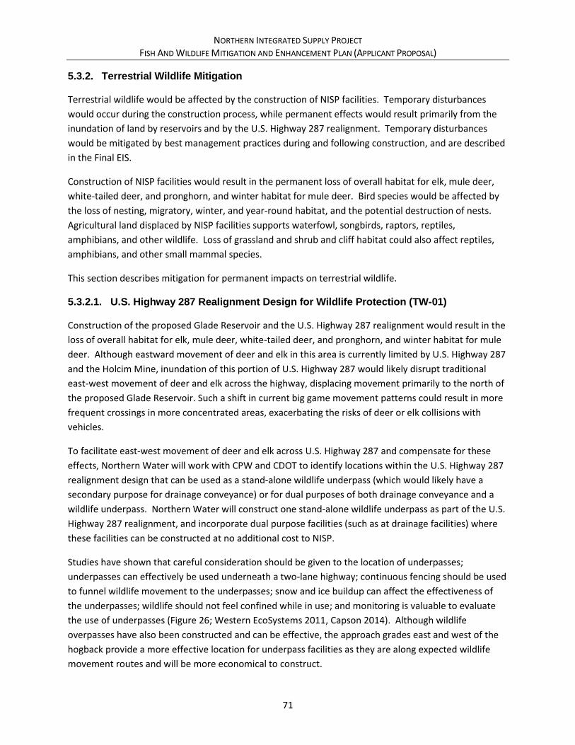
NORTHERN INTEGRATED SUPPLY PROJECT FISH AND WILDLIFE MITIGATION AND ENHANCEMENT PLAN (APPLICANT PROPOSAL)
71
5.3.2. Terrestrial Wildlife Mitigation
Terrestrial wildlife would be affected by the construction of NISP facilities. Temporary disturbances
would occur during the construction process, while permanent effects would result primarily from the
inundation of land by reservoirs and by the U.S. Highway 287 realignment. Temporary disturbances
would be mitigated by best management practices during and following construction, and are described
in the Final EIS.
Construction of NISP facilities would result in the permanent loss of overall habitat for elk, mule deer,
white-tailed deer, and pronghorn, and winter habitat for mule deer. Bird species would be affected by
the loss of nesting, migratory, winter, and year-round habitat, and the potential destruction of nests.
Agricultural land displaced by NISP facilities supports waterfowl, songbirds, raptors, reptiles,
amphibians, and other wildlife. Loss of grassland and shrub and cliff habitat could also affect reptiles,
amphibians, and other small mammal species.
This section describes mitigation for permanent impacts on terrestrial wildlife.
5.3.2.1. U.S. Highway 287 Realignment Design for Wildlife Protection (TW-01)
Construction of the proposed Glade Reservoir and the U.S. Highway 287 realignment would result in the
loss of overall habitat for elk, mule deer, white-tailed deer, and pronghorn, and winter habitat for mule
deer. Although eastward movement of deer and elk in this area is currently limited by U.S. Highway 287
and the Holcim Mine, inundation of this portion of U.S. Highway 287 would likely disrupt traditional
east-west movement of deer and elk across the highway, displacing movement primarily to the north of
the proposed Glade Reservoir. Such a shift in current big game movement patterns could result in more
frequent crossings in more concentrated areas, exacerbating the risks of deer or elk collisions with
vehicles.
To facilitate east-west movement of deer and elk across U.S. Highway 287 and compensate for these
effects, Northern Water will work with CPW and CDOT to identify locations within the U.S. Highway 287
realignment design that can be used as a stand-alone wildlife underpass (which would likely have a
secondary purpose for drainage conveyance) or for dual purposes of both drainage conveyance and a
wildlife underpass. Northern Water will construct one stand-alone wildlife underpass as part of the U.S.
Highway 287 realignment, and incorporate dual purpose facilities (such as at drainage facilities) where
these facilities can be constructed at no additional cost to NISP.
Studies have shown that careful consideration should be given to the location of underpasses;
underpasses can effectively be used underneath a two-lane highway; continuous fencing should be used
to funnel wildlife movement to the underpasses; snow and ice buildup can affect the effectiveness of
the underpasses; wildlife should not feel confined while in use; and monitoring is valuable to evaluate
the use of underpasses (Figure 26; Western EcoSystems 2011, Capson 2014). Although wildlife
overpasses have also been constructed and can be effective, the approach grades east and west of the
hogback provide a more effective location for underpass facilities as they are along expected wildlife
movement routes and will be more economical to construct.
NORTHERN INTEGRATED SUPPLY PROJECT FISH AND WILDLIFE MITIGATION AND ENHANCEMENT PLAN (APPLICANT PROPOSAL)
72
Figure 26. Movement of Mule Deer, Moose, Elk and Pronghorn Through a Wildlife Underpass in Nugget Canyon on U.S. Highway 30 west of Kemmerer, WY (Western EcoSystems 2011)
At this time, it is likely that the structure used to span Owl Creek just north of Glade Reservoir will be
designed as the stand-alone wildlife underpass. The underpass would be designed in coordination with
the CDOT and CPW, and would provide sufficient width and height to facilitate movements by big game
underneath the highway. During design of the U.S. Highway 287 realignment, Northern Water will
investigate other opportunities for economical dual-purpose facilities to accommodate wildlife
movement.
In conjunction with the actual wildlife underpass itself, Northern Water will install exclusion fencing at
the entrance and exits to the underpasses and culverts to guide wildlife movement towards these
locations. Northern Water will also install trail monitoring cameras at key sites around Glade Reservoir
and along the U.S. Highway 287 realignment corridor to collect data and monitor general big-game
movement patterns.
An adaptive management program for wildlife movement on the U.S. Highway 287 realignment has
been developed and is described in section 5.3.2.2.

NORTHERN INTEGRATED SUPPLY PROJECT FISH AND WILDLIFE MITIGATION AND ENHANCEMENT PLAN (APPLICANT PROPOSAL)
73
Figure 27. Potential Location and Alternate Locations for Wildlife Underpass
GladeForebay
Poudr
e Valle
y Can
al
Munroe Canal
¬«14
Owl Creek Span -Potential Big GameUnderpass
GladeReservoir
£¤287
y Canal
Mu
nroe
Ca
nal
U.S
. H
igh
wa
y 2
87
Re
ali
gn
me
nt
Other Potential Dual Purpose Locations to be Investigated
Copyright:© 2013 National Geographic Society, i-cubed
0 1 20.5Miles
Ü

NORTHERN INTEGRATED SUPPLY PROJECT FISH AND WILDLIFE MITIGATION AND ENHANCEMENT PLAN (APPLICANT PROPOSAL)
74
5.3.2.2. U.S. Highway 287 Realignment Big Game Movement Adaptive Management Program (TW-02)
Northern Water has proposed mitigation related to the big game habitat and big game roadkill along the
U.S. Highway 287 corridor (Sections 5.3.2.1 and 5.3.2.2). However, because it is not known for certainty
how both Glade Reservoir and the U.S. Highway 287 realignment will affect big game movement in the
area, an adaptive management program will be initiated to implement the currently proposed
compensatory mitigation actions, monitor the effects of those actions on wildlife movement and
roadkill, and modify the actions as necessary to facilitate movement.
The following describes components of the U.S. Highway 287 Realignment Big Game Movement
Adaptive Management Program using the framework and terminology described in section 2.8.
• Adaptive Management Parties: Northern Water, CPW, CDOT.
• Scope of Adaptive Management: U.S. Highway 287 realignment corridor; resources include big-
game, primarily focused on elk and mule deer.
• Management Objectives: Maintain and improve historical big-game movement patterns
around Glade Reservoir and protect the safety of U.S. Highway 287 traffic.
• Key Desired Outcomes: Reduce or eliminate big game-vehicle collisions and road-kill along the
U.S. Highway 287 realignment corridor to below 10 roadkills per year.
• Performance Indicators: Number of reported big-game road-kill along the U.S. Highway 287
realignment corridor. Big-game in the area of Glade Reservoir primarily consist of elk and mule
deer, but could also occasionally include pronghorn.
• Management Strategies and Actions: Initial strategies and actions considered are the
construction of big-game underpasses as they can be reasonably incorporated into the U.S.
Highway 287 realignment design, necessary fencing to funnel big-game towards these features,
and installation of trail monitoring cameras. Commitments are described in Section 5.3.2.1.
• Implementation Strategies and Actions: Strategies will be designed and constructed
concurrently with the design and construction of the U.S. Highway 287 realignment.
• Evaluation of Management Effectiveness (Monitoring): Northern Water will monitor road kills
for 10 years using Colorado Department of Transportation and Colorado State Patrol data. Trail
monitoring cameras will also be consulted to identify general movement patterns around the
reservoir and U.S. Highway 287 realignment corridor.
• Reporting of Findings and Recommendations of Evaluation: Northern Water will annually
provide a report to the parties. Using a 2-year average of road kill data, additional evaluations
will occur under the following circumstances:
- 10 roadkills per year: The parties agree to review data and meet to discuss options.
- 15 roadkills per year: The parties agree to discuss additional adaptive management
alternatives.
NORTHERN INTEGRATED SUPPLY PROJECT FISH AND WILDLIFE MITIGATION AND ENHANCEMENT PLAN (APPLICANT PROPOSAL)
75
• Adjustment of Management Actions and Arrangements: Potential alternatives to reduce road
kill and increase big game movement potential may include installing additional big game
fencing to funnel movement to existing underpasses, installing other types of devices to direct
big game movement, or retrofitting one or more drainage structures along the U.S. Highway 287
corridor with big game underpass capabilities.
• Review of Overall Program Management: At the conclusion of the initial 10-year monitoring
program, if roadkill data shows roadkill at less than the key desired outcomes, or if the parties
conclude that no additional actions are necessary, then this adaptive management program will
be concluded. If additional adaptive management alternatives are necessary and implemented,
then the adaptive management program will continue until the key desired outcomes are met,
or until the parties conclude that the adaptive management program is no longer required.
• NISP Budget: In addition to the other commitments made in this FWMEP, NISP commits to
spend the following to establish, develop and implement the adaptive management program:
- $10,000 per year for the first 10 years of NISP operations to fund data collection and
reporting. This does not include Northern Water staff time for coordination of the
program.
- $200,000 set aside in an escrow account to implement adaptive management actions.
5.3.2.3. Wildlife Habitat – Glade Reservoir Conservation Mitigation (TW-06)
Glade Reservoir and associated facilities will permanently affect approximately 1,880 acres of overall
range for both elk and mule deer. Perhaps more importantly, Glade Reservoir would permanently
displace approximately 124 acres of elk winter concentration area and 70 acres of mule deer winter
concentration area. Glade Reservoir is at the eastern edge of a resident elk population area where
individual elk can be found in any part of the area at any time of the year.
To compensate for the loss of overall and winter concentration area big game and other wildlife habitat
at Glade Reservoir and associated facilities, Northern Water would conserve land it already owns, as
well as land that will be purchased for reservoir inundation and temporary construction purposes, as a
wildlife habitat conservation area (Figure 28). The total compensatory mitigation area amounts to
approximately 1,080 acres, appraised at approximately $2.9 million.
As an enhancement to these lands, Northern Water commits to purchasing or otherwise conserving
approximately 300 additional acres immediately west of these lands for these same purposes (see
section 6.1.2.1). This would bring the total amount of habitat conservation area west of the reservoir to
approximately 1,380 acres. The estimated total appraised value of land included in the habitat
conservation area is approximately $3.7 million. Northern Water is currently discussing options with
CPW for permanently protecting this area, including conservation easements and deed restrictions.
In order to ensure that this land provides suitable big game and other wildlife habitat mitigation, trail
access to these parcels will be limited as described in section 6.1.3.2.

NORTHERN INTEGRATED SUPPLY PROJECT FISH AND WILDLIFE MITIGATION AND ENHANCEMENT PLAN (APPLICANT PROPOSAL)
76
Figure 28. Habitat Conservation Area U
.S. 287 Realignm
ent
U.S. 287 Realignment
Total Land Purchase/TradeIn Negotiation with State Land Board =
+/- 1,360 acres
Proposed Habitat Conservation Area
= +/- 1,380 acres
GladeReservoir
Copyright:© 2013 National Geographic Society, i-cubed, Esri, HERE, DeLorme,
MapmyIndia, © OpenStreetMap contributors, and the GIS user community
Northern Water NISP Property
State Land Board/State/CSU Property
Arapaho Roosevelt National Forest
Bureau of Land Management
In Negotiation - Additional for Habitat Mitigation
In Negotiation - Required for Glade Reservoir
Habitat Conservation Area
Mule Deer Winter Concentration Area
Elk Winter Concentration Area
Glade Reservoir Property
0 10.5Miles
Ü

NORTHERN INTEGRATED SUPPLY PROJECT FISH AND WILDLIFE MITIGATION AND ENHANCEMENT PLAN (APPLICANT PROPOSAL)
77
5.3.3. Special Status Species Mitigation
Northern Water has developed the following proposed mitigation activities associated with Special
Status Species (for all those other than Preble’s, which is addressed as part of the federal Section 7
consultation process as described in Section 4.3). Because both wetlands and Preble’s habitat
mitigation are covered under federal statutes with specific jurisdictional requirements, these mitigation
activities are not further covered under this State FWMEP. Additional details on wetlands and Preble’s
habitat mitigation are contained in the Conceptual Mitigation Plan, and will be further refined as part of
the Final EIS and Record of Decision.
5.3.3.1. Bald Eagle (SS-02)
The Draft EIS reported that an active bald eagle nest mapped by CPW was located on the Poudre River
on private land south of the Glade Reservoir study area across from the City of Greeley’s water filtration
plant (Corps 2008). The Supplemental Draft EIS reports that the original tree containing this nest fell
down in 2013, and a new replacement nest was constructed by eagles approximately ¾ of a mile west of
the original location, southwest of the proposed Glade Reservoir site in 2015 (Corps 2015). In addition,
bald eagle winter roost sites occur along the Poudre River south of the Glade Reservoir study area. Bald
eagles from the nest or roost sites may occasionally forage in the Glade Reservoir study area. To avoid
and minimize effects on bald eagles, Northern Water will follow requirements of the Bald and Golden
Eagle Protection Act (Eagle Act) and the Migratory Bird Treaty Act (MBTA) during and following
construction activities.
Bald eagles were removed from the endangered species list in August 2007 because their populations
recovered sufficiently. However, both bald eagles and golden eagles are protected by the Eagle Act and
MBTA. The Service has developed National Bald Eagle Management Guidelines to advise when and
under what circumstances the protective provisions of the Eagle Act may apply to activities (Service
2007b). A variety of human activities can potentially interfere with bald eagles, affecting their ability to
forage, nest, roost, breed, or raise young. Bald eagles are particularly sensitive to human activities
during the breeding season. The Guidelines are intended to help people minimize such impacts to bald
eagles, particularly where they may constitute a “disturbance” within the meaning of the Eagle Act
(Table 10).
Northern Water would perform future surveys for bald eagle nests and roosts. Because bald eagles may
select new nest or roost sites, potentially impacted areas would be reevaluated prior to construction for
the presence of bald eagle nest and roost sites within the CPW recommended disturbance buffers in
effect at that time.

NORTHERN INTEGRATED SUPPLY PROJECT FISH AND WILDLIFE MITIGATION AND ENHANCEMENT PLAN (APPLICANT PROPOSAL)
78
Table 10. Summary of National Bald Eagle Management Guidelines (Activity Specific) (FHWA 2017)
Permitted Activities Specific
Considerations Nest Site Visible Nest Site Not Visible Timing of Restriction
1. Buildings (½ acre or less) 2. Linear Construction (roads, utilities, trails) 3. Alteration of Wetlands 4. Water impoundment
No existing Similar activity within 1 mile
660 ft buffers recommended
330 ft or as close as existing tolerated activity of similar scope between 330 and 660 ft*
*clearing external construction and landscaping outside breeding season
Existing similar activity closer than 1 mile
660 ft or as close as existing tolerated activity of similar scope
330 ft or as close as existing tolerated activity of similar scope within 660 ft*
* clearing external construction and landscaping outside breeding season
1. Construction of 3+story building 2. Project footprint greater than ½ acre 3. Marina (6 or more boats)
No existing similar activity within 1 mile
660 ft buffers recommended
660 ft
Existing similar activity within 1 mile
660 ft or as close as existing tolerated activity of similar scope
330 ft or as close as existing tolerated activity of similar scope within 660 ft*
* clearing external construction and landscaping outside breeding season
Motorized Water Craft
330ft 330 ft During breeding season avoid concentrations and attempt to minimize trips except where eagles have demonstrated tolerance to such activities
Non-motorized recreation use (hiking, camping, trail use)
330ft ( or far enough not to be audible)
(far enough not to be audible)
Breeding particularly where eagles are unaccustomed to such activities
Helicopter or Aircraft
Except for biologist trained in survey techniques
1000 ft 1000 ft During breeding season except where eagles have demonstrated tolerance to such activities
Blasting or other loud intermittent noises
½ mile ½ mile Away from active nest unless greater tolerance to the activity (similar) has been demonstrated by eagles in that nesting area
Note: This table was developed by the Federal Highway Administration from information in the National Bald Eagle Management Guidelines (FHWA 2017).

NORTHERN INTEGRATED SUPPLY PROJECT FISH AND WILDLIFE MITIGATION AND ENHANCEMENT PLAN (APPLICANT PROPOSAL)
79
As part of implementing and enforcing the Eagle Act and MBTA, the Service monitors the health of bald
and golden eagle populations. In April 2016, the Service issued a report titled “Bald and Golden Eagles:
Status, trends, and estimation of sustainable take rates in the United States,” a compilation of the most
current research on the population status and trends of bald and golden eagles (Service 2016). The
report estimates population sizes, productivity, and survival rates; cumulative effects to local area
populations; and effects of unauthorized take of golden eagles. This report serves as the biological basis
for the Service’s regulatory management framework.
On December 14, 2016, the Service announced a final rule revising the regulations for permits for
incidental take of eagles and take of eagle nests. The Service analyzed various alternative management
options and rule revisions, including the final rule revisions, in a programmatic environmental impact
statement. Among other revisions, the final rule addresses criteria for eagle take permit issuance,
compensatory mitigation requirements, permit duration, and data standards for submitting permit
applications. If avoidance and minimization techniques are unsuccessful and a taking is necessary,
Northern Water will follow these permit and mitigation requirements for such taking, or other
applicable permit and mitigation requirements at the time of the taking.
5.3.3.2. Colorado Butterfly Plant (SS-03)
The Service concurred that surveys for Colorado butterfly plant would not be required for portions of
the Glade Reservoir; U.S. Highway 287 realignment; SPWCP forebay; and diversion study areas where no
suitable habitat was found. The Service has requested that suitable Colorado butterfly plant habitat in
the Glade Reservoir and U.S. Highway 287 realignment study areas be resurveyed for two years during
the Fort Collins blooming period. In addition, although no known populations of Colorado butterfly plant
occur in any of the study areas, prior to construction, Colorado butterfly plant habitat assessments
and/or final surveys will be conducted for potential habitat in the Poudre Valley Canal, SPWCP pipeline,
and Glade to Horsetooth pipeline study areas. If Colorado butterfly plant is found within the
construction footprint, specific conservation measures would be developed in coordination with the
Service. Conservation measures could include avoiding impacts by establishing a “no-work” zone or, in
the event of unavoidable impacts, protecting or enhancing adjacent or off-site habitat. Other mitigation
methods include reestablishing populations in areas with suitable habitat.
5.3.3.3. Ute Ladies Tresses Orchid (SS-04)
The Service concurred that surveys for Ute ladies tresses orchid would not be required for portions of
the Glade Reservoir; U.S. Highway 287 realignment; Glade to Horsetooth, Carter, and Cactus Hill
pipelines; SPWCP forebay; and diversion study areas where no suitable habitat was found. The Service
has requested that suitable Ute ladies tresses orchid habitat in the Glade Reservoir and U.S. Highway
287 realignment study areas be resurveyed for two years during the Fort Collins blooming period. In
addition, although no known populations of Ute ladies tresses orchid occur in any of the study areas,
prior to construction, Ute ladies tresses orchid habitat assessments and/or final surveys will be
conducted for potential habitat in the Poudre Valley Canal, SPWCP pipeline, and Glade to Horsetooth
pipeline study areas. If Ute ladies tresses orchid is found within the construction footprint, specific
NORTHERN INTEGRATED SUPPLY PROJECT FISH AND WILDLIFE MITIGATION AND ENHANCEMENT PLAN (APPLICANT PROPOSAL)
80
conservation measures would be developed in coordination with the Service. Conservation measures
could include avoiding impacts by establishing a “no-work” zone or, in the event of unavoidable impacts,
protecting or enhancing adjacent or off-site habitat.
5.3.3.4. Platte River Target Species (SS-05)
The Service has determined that historical and new depletions to the South Platte River Basin adversely
affect federally listed species and their designated critical habitat along the Platte River in central
Nebraska. These species are the American burying beetle, least tern, pallid sturgeon, piping plover,
Western prairie fringed orchid, and whooping crane, as well as the designated critical habitat for
whooping crane and piping plover.
To avoid and compensate for these effects, all NISP Participants will be members in good standing of the
South Platte Water Related Activities Program, Inc. The operation of Colorado’s Future Depletions Plan
under the Platte River Recovery Implementation Program would offset new depletions to the South
Platte River Basin associated with NISP and its effects to the target species, whooping crane critical
habitat, and other listed species in the central and lower Platte River addressed in the Platte River
Programmatic Biological Opinion.
5.3.3.5. Black-footed Ferret (SS-06)
The Service in coordination with Colorado Parks and Wildlife, block-cleared various areas of Colorado
(including all of Weld County and all of Larimer County in proximity to NISP facilities), after determining
that these areas no longer contain any wild, free-ranging black-footed ferrets. Block clearance means
that activities within these areas that result in the removal of black-tailed prairie dogs or their habitat
will no longer be required to meet the Service survey guidelines for black-footed ferrets, or undergo
consultation under section 7 of the ESA (Service 2009).
In recent years, CPW in conjunction with other local, state and federal agencies, has reintroduced black
footed ferrets into various habitats throughout the state (CPW 2015). None of the reintroduction
habitats are close to NISP facilities; the closest reintroduction habitat is the Soapstone Prairie in far
northern Larimer County. Although it is unlikely that these populations would migrate into NISP
construction areas, it is possible that migration from the reintroduction habitats could occur. Thus, to
avoid and minimize any potential effects to black-footed ferrets, Northern Water will consult with CPW
immediately prior to NISP construction to determine whether prairie dog colonies potentially impacted
during NISP construction may contain black footed ferrets. If requested by CPW, Northern Water will
survey prairie dog colonies for black-footed ferrets according to the protocol in effect at the time.
Northern Water will follow applicable mitigation requirements if black-footed ferrets are found.
5.3.3.6. Black-tailed Prairie Dog (SS-07)
Prairie dogs potentially impacted by construction of reservoir, pipelines, or other NISP facilities will be
removed prior to construction. Two options typically exist for prairie dog removal: relocation and
extermination. Controlling prairie dogs by removal and relocation requires a permit from the CPW.

NORTHERN INTEGRATED SUPPLY PROJECT FISH AND WILDLIFE MITIGATION AND ENHANCEMENT PLAN (APPLICANT PROPOSAL)
81
Prairie dogs cannot be moved to another county without the approval of the board of county
commissioners of that county.
Options for removing prairie dogs are summarized in order of preference, as follows:
• Relocation to a suitable on-site location.
• Relocation to an off-site location. This option may be suitable if greater than 25 animals are to
be removed and a suitable release site has been identified and approved by the CPW.
• Passive relocation, a nonlethal land management activity designed to encourage prairie dogs to
relocate to areas outside of the disturbance footprint. This option is most effective when only a
small area of a prairie dog colony would be impacted, such as for trail construction. It should
only be considered if sufficient suitable habitat is found adjacent to the area to be disturbed.
This option should not be considered if it could result in the colonization of lands not in the
project area, or if the impacted area is greater than a few acres.
• Live capture and donation to the Service’s black-footed ferret recovery program or an approved
raptor rehabilitation program as a food source. The services of a professional or qualified
volunteer organization should be retained to capture and transport the animals to the
designated location.
• Lethal control. Prairie dogs are euthanized in their burrows with the use of a chemical fumigant
or asphyxiant. This option should be used only as a last resort. Extermination should be
conducted by a professional prairie dog exterminator.
For the U.S. Highway 287 realignment, in areas where avoidance of prairie dog colonies is not possible,
CDOT guidelines for mitigating impacts would be followed, which include the identification of suitable
prairie dog relocation sites, as well as coordination with CPW on approved removal methods (CDOT
2005). To facilitate determining adequate mitigation measures, an assessment of habitat quality and
number of individual prairie dogs would be conducted for prairie dog colonies that would be directly
affected by NISP construction. Prairie dogs would only be removed in areas where they might be directly
affected, leaving them in the remainder of the construction ROW. In addition, some areas temporarily
disturbed during construction would likely be recolonized by prairie dogs.
5.3.3.7. Swift Fox (SS-08)
Preconstruction surveys for swift fox den sites within appropriate habitat at dam sites and along pipeline
corridors and proposed reservoir sites would be conducted based on protocols approved by CPW. If
active swift fox dens are found, CPW would be contacted to determine if conservation measures are
necessary and can be developed and implemented. Construction activities would not commence within
250 yards of active dens until after appropriate conservation measures have been developed and
implemented.
5.3.3.8. Burrowing Owl (SS-09)
Prairie dog colonies would be surveyed for burrowing owls prior to any work that would disturb them
between March 15 and October 31. Where burrowing owls are present, prairie dog removal would be
NORTHERN INTEGRATED SUPPLY PROJECT FISH AND WILDLIFE MITIGATION AND ENHANCEMENT PLAN (APPLICANT PROPOSAL)
82
scheduled to occur from November 1 to March 14. If burrowing owls are found within the construction
footprint, nests would be left undisturbed during construction. If burrowing owls are found during
preconstruction surveys, additional avoidance mitigation measures would be developed in coordination
with the CPW.
5.3.3.9. Other Riparian Species (SS-10)
Mitigation measures described in this document and the Conceptual Mitigation Plan for Preble’s
meadow jumping mouse, wetlands, riparian areas, and aquatic habitat, such as habitat reconstruction
and/or replacement, would also benefit the common gartersnake, northern leopard frog, smokey-eyed
brown butterfly, twospotted skipper, and American currant. Implementation of water quality mitigation
would also reduce potential impacts to these species.
5.3.3.10. Bell’s Twinpod (SS-11)
Bell’s twinpod would be impacted by the U.S. Highway 287 realignment. Recommended mitigation
measures for Bell’s twinpod include avoiding densely populated areas and large patches (density
categories 3 and 4) as much as possible. For areas with Bell’s twinpod that are unavoidably impacted,
populations would be reestablished as much as possible after construction. The following revegetation
measures would be used to reestablish this species in areas disturbed by construction:
• Establish Bell’s twinpod restoration areas in shale areas to be disturbed by construction.
• Prior to construction, harvest Bell’s twinpod seed during the appropriate season (mid to late
summer).
• During construction, do not grade Bell’s twinpod restoration areas to a uniform 3:1 or 4:1 slope.
Leave shelves of shale and uneven slopes similar to existing undisturbed outcrops.
• After construction, do not place topsoil on Bell’s twinpod restoration areas; leave the shale
substrate on the surface.
• Spread the harvested Bell’s twinpod seed either sparsely mixed with other associated native
species or by itself. Do not reseed these areas with the grass mix used on other revegetated
slopes because Bell’s twinpod only grows in sparsely vegetated areas.
5.3.3.11. Townsend’s Big-Eared Bat (SS-12)
The inundation by Glade Reservoir may approach a known roost site for the Townsend’s big-eared bat
(Corynorhinus townsendii), a State Species of Special Concern. The bat is quite sensitive to changes in
temperature and humidity within the hibernaculum and may arouse to move to a more favorable
location. Disturbance during hibernation can cause accidental arousal and depletion of energy stores,
preventing arousal in spring. Populations, especially in the nursery and hibernaculum, are highly
susceptible to disturbance.
Further ground surveys for additional roost sites will be conducted across the area to be inundated.
Northern Water will protect the entrance of the known cave and surrounding area, as well as any other

NORTHERN INTEGRATED SUPPLY PROJECT FISH AND WILDLIFE MITIGATION AND ENHANCEMENT PLAN (APPLICANT PROPOSAL)
83
roost sites found, during construction. Adaptive management approaches for protecting the cave from
human disturbance will be employed if needed. Any closure structure will not impede bat use.
5.3.4. Recreation and Public Access Mitigation
Recreation and public access mitigation activities describe those recreational commitments other than
flow-related commitments previously described in section 5.2.2. These commitments primarily apply to
recreation in and around Glade Reservoir. The overall goal of terrestrial wildlife, recreation, and public
access strategies at Glade Reservoir is to provide habitat for affected fish and terrestrial species, while
allowing the public to have reasonable and financially sustainable access for recreation throughout the
area. Sections are generally broken down into commitments for the fishery at Glade Reservoir, Glade
Reservoir recreation in general, and access and recreation surrounding Glade Reservoir. Commitments
are also described for mitigation at the existing Mitani-Tokuyasu State Wildlife Area east of Greeley.
5.3.4.1. Glade Reservoir and State Land Hunting Access (RC-02)
Public big game, small game, and waterfowl hunting provide recreational opportunities that are in
demand, but are becoming more limited on Colorado’s Front Range as large agricultural properties are
subdivided for suburban development or become open space. In addition, hunting is the primary tool to
manage deer, elk, bear, and lion populations to sustainable levels prescribed in CPW’s herd
management plans. A portion of the land that will be inundated by Glade Reservoir (approximately
1,635 acres) and lands immediately to the west are currently open to hunting as a State Trust Land in a
lease agreement between CPW and the State Land Board. CPW desires that the current level of hunting
access and opportunity be maintained on lands that are currently in the Poudre River State Trust Land.
Currently, in addition to access points along Highway 14 in the Poudre Canyon, the Poudre River State
Trust Land can be accessed via a parking area along the west side of U.S. Highway 287 approximately
three miles north of Teds Place. This parking area will be inundated by the reservoir. Northern Water
will relocate and reconstruct this parking area and walk-in access point at the far northwest side of the
Glade Reservoir high water mark. The parking area will be accessed off U.S. Highway 287, likely along an
existing ranch access road. The hunting access road and parking area will be separate and distinct from
roads, access gates, fee booths, and other infrastructure associated with recreation management at
Glade Reservoir (see section 6.1.3.2).
The hunting access road and parking area, along with the habitat conservation area on the west side of
the reservoir (see section 5.3.2.2), will be open to hunting from the beginning of the archery deer
season (typically beginning in late August) through the close of spring turkey season (in May). This
includes big game, small game, turkey, and waterfowl hunting seasons.
5.3.4.2. Mitani-Tokuyasu State Wildlife Area and Confluence Area (RC-04, RC-05)
The SPWCP diversion, forebay, and pump station will occupy much of the land that is currently leased by
CPW for the Mitani-Tokuyasu State Wildlife Area (Figure 29). This wildlife area generally offers walk-in
access for waterfowl, dove, and squirrel hunting, and recreational wildlife viewing primarily immediately

NORTHERN INTEGRATED SUPPLY PROJECT FISH AND WILDLIFE MITIGATION AND ENHANCEMENT PLAN (APPLICANT PROPOSAL)
84
adjacent to the South Platte and Poudre confluence. To mitigate impacts to the wildlife area, the
SPWCP pump station and forebay would be designed and operated as to continue allowing public access
to the South Platte River. Additionally, NISP would provide substitute facilities comparable to any
existing facilities that would be lost at the State Wildlife Area due to construction and operation of the
SPWCP. At this time, the only facilities known to need replacement are public parking and a portion of
the access road.
Figure 29. SPWCP Diversion Facilities (GEI 2006) and Mitani-Tokuyasu SWA
Northern Water and CPW have discussed the possibility of jointly pursuing purchase of additional
property in the area of the South Platte and the Poudre confluence to further mitigate effects at the
Mitani-Tokuyasu State Wildlife Area, as well as general impacts to wildlife habitat at Galeton Reservoir.
Northern Water will provide up to $500,000 to assist in purchasing this land. Additionally, Northern
Water will provide CPW assistance in securing this land, including pursuing additional funding
Mitani-Tokuyasu SWA
NORTHERN INTEGRATED SUPPLY PROJECT FISH AND WILDLIFE MITIGATION AND ENHANCEMENT PLAN (APPLICANT PROPOSAL)
85
opportunities and giving consideration to owning this additional land in fee-title for purposes of
mitigation, wildlife habitat, and public recreation.
5.3.4.3. Glade Reservoir Poudre River Recreator Parking (RC-06)
Discussions with and comments by commercial outfitters on the Poudre River indicate a desire to have
large scale parking available near the mouth of the Poudre Canyon to provide a meeting area for large
groups of people, primarily for those participating in non-commercial rafting trips and other recreational
activities, to carpool to those activities and relieve traffic congestion in the canyon.
Northern Water owns land in the area immediately north of Ted’s Place and south of the Glade
Reservoir Dam that could be used for this purpose. Although the exact layout of appurtenant facilities in
the Glade Reservoir complex, including access roads and parking areas, has not yet been finalized,
Northern Water would commit to constructing a parking area for this purpose. The parking area would
be located within ½ mile of Ted’s place to increase drive-by traffic at Ted’s Place businesses, with daily
parking allowed at a reduced rate from the fees being charged by the managing agency for recreational
access to Glade Reservoir and the forebay. The parking area would have a capacity of 100-200 cars.
5.3.4.4. Glade Reservoir Visitor’s Center (RC-07)
The Glade Reservoir Complex will serve as a gateway to natural resources and recreation in Northern
Colorado and the Poudre Canyon. Through the various permitting and mitigation requirements, several
agencies have expressed an interest in having a visitor’s center located at the Glade Reservoir Complex.
Additional agencies that have recreational facilities in the area and could benefit from a visitor’s center
at Glade Reservoir could include the U.S. Forest Service, City of Fort Collins, Poudre Heritage Alliance,
and others.
Through the Conceptual Mitigation Plan, Northern Water has committed to constructing a visitor’s
center at the Glade Reservoir complex. The visitor’s center would include displays and information on
NISP operations, regional geology, municipal and agricultural conservation, preserving irrigated lands,
and NISP environmental commitments. Northern Water will commit up to $940,000 for construction of
the visitor’s center to meet these environmental commitments, which could be used to construct a
4,000 to 6,000 square foot facility, without staffing. Ideally, the staffing and use of the visitor’s center
will be tied to recreational uses at Glade Reservoir. Thus, Northern Water will coordinate and pursue
funding from other partner agencies and outside funding sources (which could include but are not
limited to Great Outdoors Colorado and other Colorado Lottery funded programs) to jointly fund
construction of the facility and to provide full or part time staffing for this facility. The exact location
and layout of this facility will be determined during final design of the facility.
5.4. Mitigation Costs and Schedule
Estimated costs and schedule for the Mitigation Plan portion of this FWMEP are shown in Table 11.
Capitalized costs represent the sum of the capital cost for implementation, plus any annual operations
and maintenance costs capitalized over the life of the commitment, or 50 years for those commitments

NORTHERN INTEGRATED SUPPLY PROJECT FISH AND WILDLIFE MITIGATION AND ENHANCEMENT PLAN (APPLICANT PROPOSAL)
86
that are perpetual. As shown in the cost note column, cost types for the mitigation plan can be divided
into the following categories:
• Cost type “a” – These costs represent a financially-based mitigation commitment. In general,
Northern Water is either providing funding to or teaming with another group or organization to
perform the mitigation commitment. The cost amount shown is Northern Water’s maximum
financial commitment for this mitigation activity.
• Cost type “b” – These costs represent an outcome-based mitigation commitment. Northern
Water is committing to performing the activity as described, and the cost represents the
estimated cost for this performance. In general, these are construction activities. For cost type
“b” activities, Northern Water reserves the right to seek additional funding partners or sources
for the activity.
• Cost type “c” – These costs have not been quantified for a variety of reasons. Fox example,
these commitments may be primarily operational in nature without a clearly defined cost, or
may be part of standard construction activities that are not easily separable.
As previously presented (Table 1), total estimated costs to construct NISP are approximately $857
million. This includes approximately $35 million for mitigation and enhancement costs that are not
already included in the construction cost. Several of the larger mitigation commitments in Table 11 are
included in the construction cost, including conveyance refinement costs (FW-04, $24.52 million), the
U.S. Highway 287 big game underpass and fencing (TW-01, $0.5 million), Glade Reservoir multi-level
outlet tower (WQ-01, $1.0 million), and Glade Reservoir release structure aeration (WQ-02, $0.2
million). Additionally, Glade Reservoir conservation mitigation (TW-06, $2.92 million) is already included
in the property/ROW land acquisition cost. The total mitigation cost in Table 1 also includes costs for
mitigation commitments that are not included in this FWMEP. These mitigation activities were
previously described in the Conceptual Mitigation Plan and in section 2.7, and may be subject to change
as the other various permitting processes are complete.
The mitigation schedule (Table 11) will be contingent on the issuance of permits and licenses,
construction timetables, project completion, and the ability of the Northern Water to fill the reservoir.
The schedule provided in the table provides an approximate timetable based on these activities.

NORTHERN INTEGRATED SUPPLY PROJECT FISH AND WILDLIFE MITIGATION AND ENHANCEMENT PLAN (APPLICANT PROPOSAL)
87
Table 11. NISP Mitigation Plan Schedule and Cost Summary
Measure No. Mitigation Measure
Capitalized Cost 1
Cost Note 2 Schedule
Aquatic Life and Stream Morphology
AG-01 Stream Channel and Habitat Improvement Plan $1,000,000 a Prior to startup
AG-02 Stream Channel and Habitat Improvements $1,800,000 b
AG-04 Poudre Valley Canal Diversion Structure Reconstruction
$300,000 b
AG-07 SPWCP Diversion Construction $300,000 b Construction feature
Streamflow Commitments
FW-01 Avoid Munroe Canal Diversions 3 c Perpetual operational commitment FW-02 Curtail Diversions for Non-Consumptive Water
Rights
3 c
FW-03 Summer and Winter Diversion Curtailments 3 c
FW-04 Conveyance Refinement - Poudre River Intake $24,520,000 b
FW-05 Poudre River Flow Augmentation Program 3 c
FW-08 Peak Flow Mitigation 3 c
Noxious Weeds
NW-01 Noxious and Invasive Weed Control Plan 3 c Prior to construction
Recreation
RC-02 Glade Reservoir and State Land Hunting Access 3 c Prior to construction
RC-04 Mitani-Tokuyasu State Wildlife Area $50,000 b Construction feature
RC-05 Land Acquisition in Confluence Area $500,000 a Prior to construction
RC-06 Glade Reservoir Poudre River Recreator Parking $40,000 b Construction feature
RC-07 Glade Reservoir Visitor's Center $940,000 a
Riparian Vegetation
RV-01 Riparian Vegetation - Cottonwood Regeneration Areas
$130,000 b Prior to startup
RV-02 Riparian Vegetation - Channel Improvements $280,000 b
Special Status Species
SS-02 Bald Eagle 3 c Prior to and during construction
SS-03 Colorado Butterfly Plant 3 c
SS-04 Ute Ladies'-Tresses Orchid 3 c
SS-05 Platte River Target Species $1,550,000 b
SS-06 Black-Footed Ferret 3 c
SS-07 Black-Tailed Prairie Dog 3 c
SS-08 Swift Fox 3 c
SS-09 Burrowing Owl 3 c
SS-10 Other Riparian Species 3 c
SS-11 Bell's Twinpod 3 c
SS-12 Townsend's Big-Eared Bat 3 c
Terrestrial and Avian Wildlife
TW-01 U.S. Highway 287 - Big Game Underpass and Fencing 4
$500,000 b Construction feature
TW-02 U.S. Highway 287 - Big Game Movement Adaptive Management Plan
$280,000 a First 10 years after startup

NORTHERN INTEGRATED SUPPLY PROJECT FISH AND WILDLIFE MITIGATION AND ENHANCEMENT PLAN (APPLICANT PROPOSAL)
88
Measure No. Mitigation Measure
Capitalized Cost 1
Cost Note 2 Schedule
TW-03 Migrating Birds and Raptors - Surveys and No Work Zones
3 c Prior to and during construction
TW-04 Migrating Birds and Raptors - Vegetation Clearing 3 c
TW-05 Migrating Birds and Raptors - Buffer Zones 3 c
TW-06 Wildlife Habitat – Glade Reservoir Conservation Mitigation 5
$2,920,000 b Prior to startup
Water Quality
WQ-01 Glade Reservoir - Multi-Level Outlet Tower 4 $1,000,000 b Construction feature WQ-02 Glade Reservoir - Release Structure Aeration $200,000 b
WQ-03 Eaton Draw Water Quality Wetlands $1,340,000 b Prior to startup
WQ-04 Streamflow and Water Quality Monitoring 6 $2,310,000 b Perpetual operational commitment WQ-06 Stream Temperature Mitigation 6 3 c
WQ-07 Mercury Bioaccumulation Mitigation $220,000 a
Total $40,180,000
Notes: 1 Capitalized cost is the sum of the capital cost plus any annual operations and maintenance costs capitalized over
the life of the commitment, or 50 years for those commitments that are perpetual. 2 Cost Notes: a = cost is a firm not-to-exceed monetary commitment in this amount, see text for details.
b = approximate implementation or construction cost of this commitment.
c = implementation cost has not been quantified. 3 Implementation cost has not been quantified. 4 Cost includes only the portion of the total construction cost for the project component that is required to meet
the commitments in this plan. 5 Northern Water already owns or is in the process of acquiring this land for the purpose of reservoir construction
and inundation. Cost is calculated as the appraised value of the property. 6 Costs for stream temperature monitoring associated with WQ-06 are contained in the costs for WQ-04.

NORTHERN INTEGRATED SUPPLY PROJECT FISH AND WILDLIFE MITIGATION AND ENHANCEMENT PLAN (APPLICANT PROPOSAL)
89
6.0 PROPOSED FISH AND WILDLIFE ENHANCEMENT PLAN
This section constitutes the proposed NISP Enhancement Plan for fish and wildlife related resources in
the NISP study area. Enhancement measures were identified based on public comments received on the
Draft and Supplemental Draft EIS, discussions with CPW staff, and other discussions with stakeholders in
the study area. Enhancement go above and beyond mitigating direct environmental effects, and seek to
enhance existing conditions in the NISP study area.
As previously described, the Supplemental Draft EIS (Corps 2015) presented a Conceptual Mitigation
Plan prepared by Northern Water (Northern Water 2015) that includes both mitigation and
enhancement. This Enhancement Plan portion of this FWMEP builds upon and/or replaces many of the
aquatic life, terrestrial wildlife, and recreational components of the Conceptual Mitigation Plan. The
enhancement measures use the same alpha-numerical measure number convention as used in the
Conceptual Mitigation Plan for those enhancement actions that are similar to or directly replace
mitigation measures described in the Conceptual Mitigation Plan.
Some enhancement measures described in this section could result in providing funding to state
agencies, primarily CPW, to manage programs relating to this Enhancement plan. This funding is
proposed to be in addition to funding already received by state agencies, and not to replace any source
of funding. Northern Water expects the agencies to continue seeking current funding sources and not
rely on funding from this Enhancement Plan to replace current funding.
Enhancement components of the FWMEP are summarized in appendix Table A1 of this document, and
are highlighted in green. The alpha-numerical notations at the end of each mitigation item description
correspond to the alpha-numeric mitigation item numbers in Tables A1 and A2.
6.1. Enhancement
Enhancements include those fish and wildlife related environmental commitments that are above and
beyond avoiding, minimizing, or compensating for effects of NISP. These enhancement activities were
developed through review of comments on the Draft and Supplemental Draft EIS, through the FWMEP
process, through discussions with various governmental agencies and community organizations, and as
various opportunities presented themselves.
This section describes commitments that are solely related to fish and wildlife enhancement. In addition
to these measures, several of the compensatory mitigation commitments have an enhancement
component that is above and beyond what is required to mitigate an effect.
6.1.1. Aquatic Resource Enhancement
The Poudre River has been the focus of a large majority of the NISP comments. In the mitigation
component of this FWMEP, Northern Water has committed to several mitigation measures that not only
would avoid, minimize, or compensate for environmental effects on the Poudre River, but would also
enhance the Poudre River. These measures include:

NORTHERN INTEGRATED SUPPLY PROJECT FISH AND WILDLIFE MITIGATION AND ENHANCEMENT PLAN (APPLICANT PROPOSAL)
90
• AG-01 Stream Channel and Habitat Improvement Plan and AG-02 Stream Channel and Habitat
Improvements: enhanced channel restoration, aquatic habitat, riparian vegetation, riverine
special status species, temperature, and DO concentrations
• AG-04 Poudre Valley Canal Diversion Structure Reconstruction: enhanced Poudre River
connectivity for aquatic migration, enhanced boater safety
• FW-04 Conveyance Refinement - Poudre River Intake and FW-05 Poudre River Flow
Augmentation Program: enhancement of low flows in conveyance refinement reach.
• WQ-01 Glade Reservoir - Multi-Level Outlet Tower: enhancement of temperature and DO
(through introduction of cooler water) in Poudre River
• WQ-03 Eaton Draw Water Quality Wetlands: enhancement of WQ concentrations in Poudre
River near Greeley
In addition to these mitigation measures, the following additional enhancements to the channel
corridor, water operations, and the Poudre River watershed are proposed as a comprehensive
mitigation and enhancement strategy for the Poudre River channel.
6.1.1.1. Poudre River Adaptive Management Program (AG-03)
Throughout this FWMEP, and within the Conceptual Mitigation Plan, Northern Water has proposed
several actions to avoid, minimize, and mitigate effects of NISP on the Poudre River. However, because
the Poudre River is a dynamic system with many influences and impacts other than NISP, an adaptive
management program for the Poudre River is proposed to guide the actions of NISP mitigation efforts
on the Poudre River, as well as to coordinate these actions with other current and expected future
actions by others. This will serve to not only mitigate, but enhance the overall aquatic, geomorphic, and
riparian conditions on the river.
Northern Water and CPW will jointly lead the Poudre River Adaptive Management Program committee.
It is envisioned that Northern Water and CPW will develop an MOU which will describe, among other
items, other participants in the program, governance within the committee including decision making,
and the overall adaptive management program framework. As the lead agencies, Northern Water and
CPW would provide final concurrence on any actions to be implemented under the program.
The following describes anticipated components of the Poudre River Adaptive Management Plan using
the framework and terminology described in section 2.8. These components, and specific actions to be
implemented pursuant to the Poudre River Adaptive Management Plan, are all subject to and must
operate within the funding limitations and operational constraints identified later in this section.
• Adaptive Management Parties: Led by Northern Water and CPW; possible participants include
Larimer County, Weld County, cities along the river, environmental conservation organizations
and other groups (collectively, this parties are the adaptive management committee).
• Scope of Adaptive Management: Poudre River from the Poudre Valley Canal diversion to its
confluence with the South Platte east of Greeley; resources include stream geomorphology,
aquatic resources, water quality and riparian resources.

NORTHERN INTEGRATED SUPPLY PROJECT FISH AND WILDLIFE MITIGATION AND ENHANCEMENT PLAN (APPLICANT PROPOSAL)
91
• Management Objectives: Evaluate and make adjustments to mitigation and enhancement
measures described in this FWMEP to meet the goals of those mitigation and enhancement
measures; and, develop and implement other structural and/or physical measures in the Poudre
River that support enhancement of its ecological condition.
• Key Desired Outcomes: An ecologically healthy and resilient Poudre River corridor that naturally
sustains key resources given the “working aspects” of the Poudre River.
• Performance Indicators: Abundance and health of key resources as determined by and through
adaptive management committee.
• Management Strategies and Actions: The adaptive management committee would provide
recommendations to Northern Water in developing the stream channel habitat and
improvement plan (as described in Section 5.3.1.1) to identify mitigation actions for the Poudre
River to address aspects of stream geomorphology, aquatic resources, and riparian resources.
Implementation of mitigation actions identified in the plan would be conducted in stages. The
design and implementation of projects in later stages of the program may be adjusted through
the adaptive management program based on the performance of initial projects. Development
and implementation of the plan would require data collection, which has already begun through
the EIS process, and would continue by Northern Water through the duration of the program.
Mitigation and enhancement measures enacted through this program may include, but are not
limited to, the following:
- Accelerate establishment of channel forming by managing in-channel or riparian
vegetation;
- Place structures to direct sediment to selected aggradation zones;
- Install check structures or weirs to control the inundation of riparian vegetation;
- Make recommendations to Northern Water to operate the Poudre Valley Canal/NISP
diversion structure on the Poudre River to divert or not-divert excess sediment;
- Identify and install measures to reduce sediment inflow from point and non-point
sediment sources;
- Place measures such as rocks, boulders or other natural materials in areas subject to
bed and bank erosion;
- Dredge or otherwise remove sediment from the channel mechanically;
- Perform additional stream channel habitat improvement;
- Consider making space available in Glade Reservoir on an if-when basis for CPW or other
groups to store water for environmental purposes7;
- Make releases from Glade Reservoir consistent with the Conveyance Refinement
program identified in this document (section 5.2.2.4) to benefit aquatic habitat; and
- Conduct peak flow operations consistent with the Peak Flow Operations Program
described in section 5.2.2.6; and
- Discuss and implement temperature mitigation actions as described in section 5.2.2.7.
7 Subject to applicable environmental permitting.
NORTHERN INTEGRATED SUPPLY PROJECT FISH AND WILDLIFE MITIGATION AND ENHANCEMENT PLAN (APPLICANT PROPOSAL)
92
• Implementation Strategies and Actions: Northern Water would implement initial projects
identified by the program and agreed to through the program governance structure prior to
initial NISP diversions from the Poudre River.
• Evaluation of Management Effectiveness (Monitoring): The adaptive management committee
will use in-house expertise or hire outside consultants to perform annual monitoring required to
test the performance indicators.
• Reporting of Findings and Recommendations of Evaluation: The adaptive management
committee will develop reporting, on a frequency to be determined by the committee, to report
on the activities and results of these activities.
• Adjustment of Management Actions and Arrangements: The following set of conditions will
guide the program:
- Resources include stream geomorphology, aquatic resources, water quality and riparian
resources;
- Northern Water will consider NISP operational modifications only to the degree that
long-term NISP yield is not compromised and the operations fit within operations
allowed by the NISP Final EIS, Record of Decision, and NISP water rights;
- Decisions on whether long-term NISP yield may be compromised by a particular
operation and whether to implement a proposed operational modification would be
made solely by Northern Water;
- As several flow commitments described in this plan are based on full NISP buildout and
delivery commitments, Northern Water will develop and coordinate interim
commitments through the Adaptive Management committee;
- Northern Water would make funding available for the program in the amounts
described below to implement mitigation actions developed in the stream channel
habitat and improvement plan;
- Northern Water will seek additional funding from parties and/or outside sources to
implement actions that would mitigate effects beyond those incurred from NISP; and
- Funding and implementation of mitigation actions would take place throughout the
program geographical boundaries.
• Review of Overall Program Management: The Poudre River Adaptive Management Program
will run for a period of 20 years following the initiation of filling Glade Reservoir, 10 years
following full buildout operations (defined as the consistent delivery of full or nearly full NISP
yield to a majority of the NISP participants for a period of 5 years), or until the funds set aside
for the program are exhausted, whichever comes first.
• NISP Budget: In addition to the other commitments made in this FWMEP, NISP commits to
spend the following to establish, develop, and implement the adaptive management program.

NORTHERN INTEGRATED SUPPLY PROJECT FISH AND WILDLIFE MITIGATION AND ENHANCEMENT PLAN (APPLICANT PROPOSAL)
93
This funding is in addition to funding for other commitments described for other mitigation
commitments in this FWMEP:
- $50,000 per year for the first 20 years of NISP operations to fund data collection,
additional analysis and studies, and maintenance of the mitigation actions. This does
not include Northern Water staff time for coordination of the program. Northern Water
will solicit funding contributions from other adaptive management committee
participants to expand these efforts as needed.
- $5.0 million set aside in an escrow account to implement actions developed in the
stream channel habitat and improvement plan and adaptive management actions under
this plan. Of this amount, $1.0 million would be used for projects identified in the Fort
Collins Downtown Master Plan, or other planned activities by the City of Fort Collins on
the Poudre River within the affected reaches. These funds are separate from and in
addition to funding required for any other part of this FWMEP.
6.1.1.2. Multi-Objective Diversion Structure Retrofits (AG-05)
To further enhance the connectivity of the Poudre River for aquatic species and to maximize benefits of
low-flow releases, Northern Water would fully or partially fund retrofits of existing diversion structures
with multi-objective diversion structure facilities at four existing diversion structures along the Poudre
River. These locations were chosen because they are often dry-up points on the river, the locations are
strategic to connecting longer reaches of river and riparian habitat, and the locations are required to
administer provisions of the FWMEP. Locations for these structures include:
• Watson Fish Hatchery Diversion
• Terry Lake Diversion
• Larimer-Weld Diversion
• Whitney and B.H. Eaton Diversions
• Lake Canal Diversion (alternate, see below)
Multi-objective diversion structures maintain the existing primary function of the structure to provide
enough head in the river channel to make water diversions, while improving the function of the
structure to convey low flows through the structure and provide for fish passage. The structures will be
fitted with devices that monitor and count the use of the structures by fish. Details of the exact
methods for constructing and implementing the multi-objective diversion structures will be coordinated
with CPW, and will be further developed in planning completed as described in Section 5.3.1.1.
Conveyance and measurement of low flows at these structures is critical to meet the goals and
objectives of low flow commitments described in this FWMEP. Specifically, measurement of conveyance
refinement releases from Glade Reservoir (section 5.2.2.4) is required to ensure that these releases
remain in the river through the entire reach described for that program. Measurement of flows that are
less than or equal to the flows that result in diversion curtailment is required to administer the
provisions of the non-consumptive water right commitments (section 5.2.2.2) and summer and winter
diversion curtailment commitment (section 5.2.2.3). The low flow bypass structures would be

NORTHERN INTEGRATED SUPPLY PROJECT FISH AND WILDLIFE MITIGATION AND ENHANCEMENT PLAN (APPLICANT PROPOSAL)
94
constructed in a manner that allows measurement within the structure, either through a flume, weir, or
a rated section.
The existing diversion structures for the Watson Lake Fish Hatchery (Figure 30) and Larimer-Weld Canal
(Figure 31) incorporate traditional ogee crest diversion structures, while the Terry Lake Inlet
incorporates a stepped concrete drop structure. At the Watson Lake Fish Hatchery, retrofitting the
existing structure may require removal of a portion of the overflow crest for either a rock ramp or
traditional fish ladder design because the opposite bank from the actual diversion (right bank in the
photo) abuts a steep hill. Construction of the Watson Fish Hatchery and Terry Lake diversion bypass
structures would connect 5.5 miles of aquatic habitat between the Larimer County Canal diversion
structure near Ted’s Place and Overland Trail. The Larimer & Weld diversion lengthens an existing 2.5
mile reach of the river to nearly 3.0 miles, with additional work currently planned by the City of Fort
Collins lengthening that reach further. The Larimer-Weld diversion is currently scheduled for major
repair and replacement work. Northern water has been in contact with or is currently contacting the
ditch company to ensure that designs can accommodate multi-objective diversion structure facilities.
Figure 30. Existing Watson Lake Fish Hatchery Diversion

NORTHERN INTEGRATED SUPPLY PROJECT FISH AND WILDLIFE MITIGATION AND ENHANCEMENT PLAN (APPLICANT PROPOSAL)
95
Figure 31. Existing Larimer-Weld Diversion Structure
The Whitney (Figure 32) and B.H. Eaton (Figure 33) diversion structures are located on the Poudre River
in the southwest portion of Windsor approximately 800 feet apart (Figure 34). Both of these are typical
irrigation diversion structures that do not have fish or boat passage installed. The Poudre Runs Through
It group is currently investigating opportunities to address fish passage at these structures. The fish
passage structure would be designed to target passage primarily by smaller bodied native fish. This
bypass structure(s) would connect a 3.8 mile reach upstream to the New Cache diversion structure with
a 9.2 mile reach downstream to the Jones Ditch diversion structure, resulting in nearly 13 miles of
connected habitat on the Poudre in this area.
Northern Water has had initial meetings and discussions with the key members of the Poudre Runs
Through It working group regarding the project, and will continue to coordinate with the group.
Additionally, Northern Water has provided in-kind services to the project by performing topographic
surveying of the site. Due to timing of project implementation, it is possible that the project may be
fully developed and implemented before the NISP Record of Decision is issued. NISP would provide a
portion of the funding for the selected project, not to exceed $200,000 in in-kind services and capital
outlay, as long as the NEPA process and Record of Decision progress in a manner in which this project
would be considered as NISP mitigation.
Design of the diversion structure bypass facilities would be done to maximize the benefits of other flow
commitments described in this document. This would likely require reshaping the channel upstream
and downstream of the structure to create a defined low-flow channel in to and out of the bypass
facility. This improvement would contribute to mitigating the loss of aquatic habitat in the lower part of
the river due to changes in geomorphology in this part of the river.

NORTHERN INTEGRATED SUPPLY PROJECT FISH AND WILDLIFE MITIGATION AND ENHANCEMENT PLAN (APPLICANT PROPOSAL)
96
Figure 32. Existing Whitney Ditch Diversion Structure
Figure 33. Existing B.H. Eaton Ditch Diversion Structure with Whitney Diversion in Background

NORTHERN INTEGRATED SUPPLY PROJECT FISH AND WILDLIFE MITIGATION AND ENHANCEMENT PLAN (APPLICANT PROPOSAL)
97
Figure 34. Whitney and B.H. Eaton Diversions
Several organizations are currently investigating opportunities to provide fish passage facilities at
diversion structures on the Poudre River, some of which may be the same structures considered in this
Enhancement Plan. Northern Water will work with each of these groups to facilitate these retrofits,
including providing funding. If the retrofits are completed by the other groups without substantive
funding by Northern Water, or if retrofit of the chosen structures is not possible for other reasons,
Northern Water will find other substitute diversions structures on the Poudre River to perform these
retrofits that would allow these same goals to be met. The most likely substitute candidate at this time
is the Lake Canal diversion structure just upstream of College Avenue. However, other substitute
structures may be considered based upon which structures are not available for retrofit.
Whitney Diversion(Existing)
BH Eaton Diversion(Existing)
Whitney Diversion Structure: 1) Retrofit with multiobjctive bypass structure- and possibly -2) Add headgate structure for B.H. Eaton
B.H. Eaton Diversion Structure: 1) Remove and consolidate to upstream Whtiney location- or -2) Retrofit with multiobjective bypass structure
BH
Eaton D
itch
Whitney Ditch
Cache la Poudre River
Cache la Poudre River
B.H. Eaton Ditch:Extend to Whitney diversion if diversion consolidation is preferred alternative.
Source: Esri, i-cubed, USDA, USGS, AEX, GeoEye, Getmapping, Aerogrid,
IGN, IGP, and the GIS User Community
0 350 700175Feet
Ü

NORTHERN INTEGRATED SUPPLY PROJECT FISH AND WILDLIFE MITIGATION AND ENHANCEMENT PLAN (APPLICANT PROPOSAL)
98
Due to interest in installation of multi-objective diversion structure retrofits in the Poudre River as a
whole, it is possible that retrofits at one of the structures identified in this FWMEP may be progressed
by other groups to implementation faster than NISP can provide funding for through this FWMEP (as
final funding and implementation of the FWMEP will not begin until state and federal environmental
permit processes have completed). This would most likely occur with the Whitney/B.H. Eaton diversion
consolidation, as the multiple stakeholder group is already advancing this concept. Or, multi-objective
diversion structure retrofits at the identified structures may not be reasonably possible for other
reasons. In case this happens, to keep the total number of retrofit commitments the same, Northern
Water has identified the Lake Canal diversion structure as an alternate structure for retrofit. The Lake
Canal diversion structure is located on the Poudre River just upstream of the College Avenue bridge. A
retrofit at the Lake Canal diversion structure would provide additional streamflow measurement within
the Conveyance Refinement reach (see section 5.2.2.4), and improve aquatic habitat connectivity
through Fort Collins.
6.1.1.3. Galeton Reservoir Native Fish Rearing (AG-08)
As an enhancement to native fisheries, NISP would make Galeton Reservoir available to CPW for raising
native warmwater fish for reintroduction into the Poudre River or other locations. At this time, there
are no firm commitments as to whether Galeton Reservoir would be suitable for raising warmwater fish.
For instance, Galeton Reservoir may periodically go dry and there is no way to guarantee a permanent
water supply for raising native fish in the reservoir. Additionally, it is unknown whether, with current
technology, non-native predatory fish could be adequately screened from introduction into the
reservoir. If it is determined that Galeton Reservoir could be used for native fish rearing, Northern
Water commits to providing up to $100,000 to retrofit the reservoir for these purposes.
If fish rearing at Galeton is successful, reintroductions to the Poudre River would likely be done in
isolated off-channel habitats, such as backwater and floodplain pools, that give these species protection
from nonnative species that would eat or out-compete native fish. Over time, the native species may
escape from these areas and recolonize the Poudre River.
The Conceptual Mitigation Plan originally described a commitment to install appropriate screening at
the inlet and outlet of Galeton Reservoir and the SPWCP forebay pump station to prevent introduction
of non-native predatory species into the reservoir. However, it is unknown whether current technology
would adequately screen non-native predatory fish, or whether the reservoir will be used for native fish
rearing. Thus, this formal commitment has been removed from this FWMEP at this time. However, if
Galeton Reservoir is used for this purpose, Northern Water will coordinate with CPW on the design of
the fish screens.
6.1.1.4. Ramp Hansen Supply Canal Releases (FW-07)
Northern Water delivers C-BT water to irrigation water users in the Poudre River basin via Horsetooth
Reservoir releases via the Hansen Supply Canal to the Poudre River. This water is then diverted at the
irrigation water user’s river headgate. These operations are coordinated daily with the District 3 water

NORTHERN INTEGRATED SUPPLY PROJECT FISH AND WILDLIFE MITIGATION AND ENHANCEMENT PLAN (APPLICANT PROPOSAL)
99
commissioner to ensure that water released from C-BT facilities is diverted at the correct location and
time by the appropriate water user.
Occasionally, the timing of these operations can become inconsistent, resulting in dramatic swings in
water levels upstream and downstream of diversion structures over a very short time. For instance, if
water is delivered to the river and the water commissioner is not at the diversion structure at the exact
time that that pulse of water reaches the diversion structure, there can be a very short period where
high flows pass the diversion structure and then the water is nearly instantaneous reduced again as the
diversion structure gates are adjusted by the water commissioner to divert the correct amount of water.
These types of operations can be detrimental to fish, especially during spawning periods.
As an enhancement to operations in the Poudre River unrelated to NISP, Northern Water commits to
working with CPW and the District 3 water commissioner, and water users, to improve existing delivery
methods to minimize the effect of these operations on fish species. These improvements may include
providing “ramping” of deliveries on both the increasing and decreasing limbs of the delivery
hydrograph (over a period of minutes to hours), automating certain water user headgates to either be
remotely controlled or have automatically adjusting gates to account for these deliveries, and improving
communications between all parties.
6.1.1.5. Coalition for the Poudre River Watershed (WQ-05)
Several resources, including geomorphology and water quality, are dependent upon protecting and
controlling runoff in the upstream Poudre River watershed. The Coalition for the Poudre River
Watershed was formed as a 501 (c)(3) non-profit corporation in 2013 following the 2012 High Park Fire.
The overall mission is to “promote the improvement of the ecological health of the Poudre River
watershed through the collaboration of a broad range of stakeholders.” The short-term work program
of the CPRW focuses on post-fire management, while the long-range work program includes pre-fire
forest management within the watershed (Bassinger 2013). The watershed generally includes the entire
Poudre River watershed above the canyon mouth, including adjacent areas in Rist Canyon, the upper
Buckhorn area, and Laramie River watershed (Figure 35). The projected annual budget of the coalition is
$100,000. This amount is currently divided evenly between the City of Fort Collins, City of Greeley, and
Larimer County (Bassinger 2013).
In order to enhance the capability of the coalition to help protect source water quality for the Poudre
River watershed and NISP, Northern Water would begin contributing annually to support the coalition’s
annual operating budget. At this time, the exact contribution needed to provide this support is unclear.
However, Northern Water proposes to match the contribution provided by the other agencies by
contributing $35,000 annually, with adjustments allowed to account for inflationary increases.
If the Coalition for the Poudre River Watershed ceases to exist in the future, or changes its mission to be
substantially different than its current mission, Northern Water would contribute to a non-profit
organization with substantially the same mission as the current coalition. If that organization does not
exist at that time, Northern Water would work with other Poudre River Basin water suppliers to form
that organization to carry out the mission currently being implemented by the coalition.
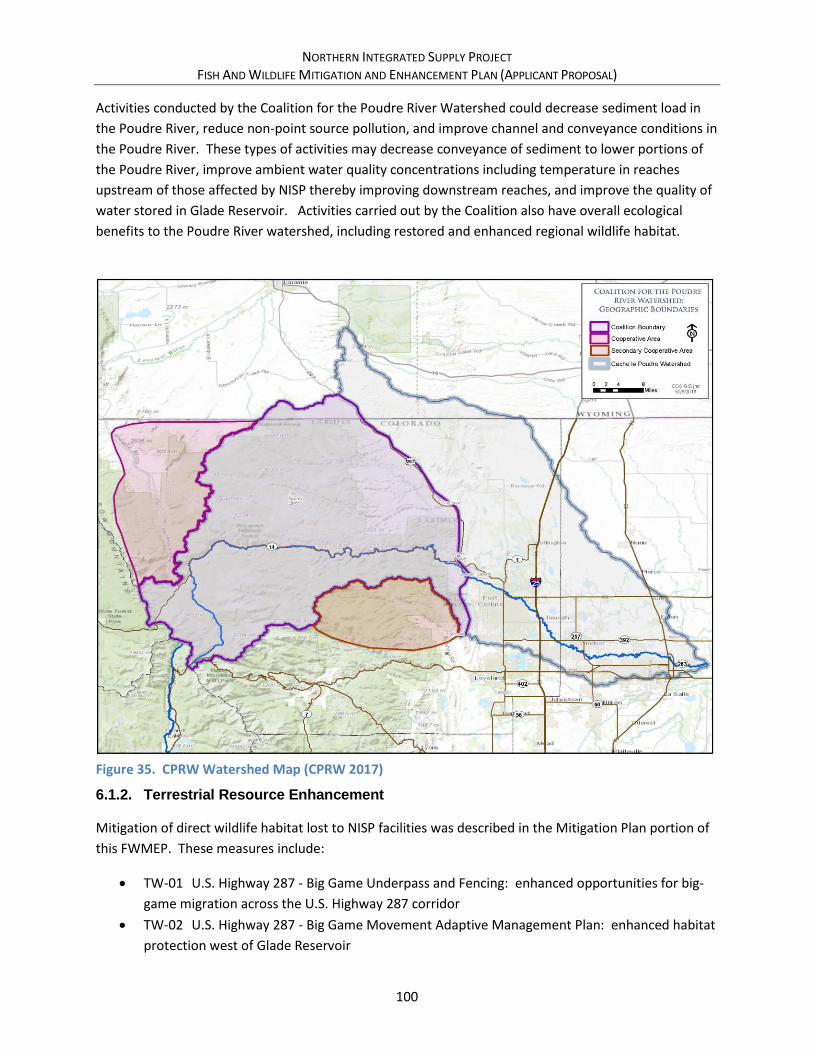
NORTHERN INTEGRATED SUPPLY PROJECT FISH AND WILDLIFE MITIGATION AND ENHANCEMENT PLAN (APPLICANT PROPOSAL)
100
Activities conducted by the Coalition for the Poudre River Watershed could decrease sediment load in
the Poudre River, reduce non-point source pollution, and improve channel and conveyance conditions in
the Poudre River. These types of activities may decrease conveyance of sediment to lower portions of
the Poudre River, improve ambient water quality concentrations including temperature in reaches
upstream of those affected by NISP thereby improving downstream reaches, and improve the quality of
water stored in Glade Reservoir. Activities carried out by the Coalition also have overall ecological
benefits to the Poudre River watershed, including restored and enhanced regional wildlife habitat.
Figure 35. CPRW Watershed Map (CPRW 2017)
6.1.2. Terrestrial Resource Enhancement
Mitigation of direct wildlife habitat lost to NISP facilities was described in the Mitigation Plan portion of
this FWMEP. These measures include:
• TW-01 U.S. Highway 287 - Big Game Underpass and Fencing: enhanced opportunities for big-
game migration across the U.S. Highway 287 corridor
• TW-02 U.S. Highway 287 - Big Game Movement Adaptive Management Plan: enhanced habitat
protection west of Glade Reservoir

NORTHERN INTEGRATED SUPPLY PROJECT FISH AND WILDLIFE MITIGATION AND ENHANCEMENT PLAN (APPLICANT PROPOSAL)
101
To further enhance these mitigation and other mitigation measures, the following additional
enhancements to wildlife habitat is proposed as a comprehensive mitigation and enhancement strategy
for lands west of Glade Reservoir.
6.1.2.1. Wildlife Habitat – Glade Reservoir Conservation Enhancement (TW-07)
As previously described in section 5.3.2.3, Glade Reservoir and associated facilities would permanently
affect overall range and winter concentration area for both elk and mule deer. Northern Water has
committed to conserving lands it already owns, or is in the process of purchasing, to mitigate these
effects. To further enhance the wildlife habitat conservation area around Glade Reservoir, Northern
Water commits to purchasing or otherwise conserving approximately 300 additional acres immediately
west of these lands (previously shown in Figure 28). The appraised value of the additional 300 acres is
approximately $810,000, which represents Northern Water’s maximum financial commitment to this
enhancement activity. If the actual purchase price of the property exceeds $810,000 (or $2,700 per
acre), Northern Water may reduce the number of acres purchased to so that the total purchase price
does not exceed $810,000. Northern Water is currently discussing options with CPW for permanently
protecting this area, including conservation easements and deed restrictions.
In addition to land purchased directly by Northern Water, Northern Water will work with partner
agencies including CPW to pursue funding for protection of additional land to the west and north of
Glade Reservoir for permanent habitat protection. Funding sources could include but are not limited to
Great Outdoors Colorado and other Colorado Lottery funded programs.
In order to ensure that this land provides suitable big game and other wildlife habitat enhancement, trail
access to these parcels will be limited as described in section 6.1.3.2.
6.1.3. Recreation and Public Access Enhancement
Glade Reservoir and the surrounding area present an opportunity to enhance regional recreational
amenities. The overall goal of terrestrial wildlife, recreation, and public access strategies at Glade
Reservoir is to provide habitat for affected fish and terrestrial species, while allowing the public to have
reasonable access for recreation. Most of the recreational commitments will be negotiated outside of
the scope of this FWMEP. However, those portions of the recreational commitments that would be
managed by CPW, including Glade Reservoir fishing and recreation access to land surrounding Glade
Reservoir, are discussed in this section.
6.1.3.1. Glade Reservoir Fishery (AG-06)
The Supplemental Draft EIS concluded that Glade Reservoir would be suitable to support both cold
water and cool water recreationally important fish species (Corps 2015, GEI 2015). Through
consultation with CPW, in which both cold water and cool water fishery options were discussed, it was
concluded for a variety of reasons that a coolwater fishery would be established and managed in Glade
Reservoir. The cool water fishery option is similar to the fisheries currently found at Carter Lake and

NORTHERN INTEGRATED SUPPLY PROJECT FISH AND WILDLIFE MITIGATION AND ENHANCEMENT PLAN (APPLICANT PROPOSAL)
102
Horsetooth Reservoir. An annual stocking plan was developed by CPW for maintenance of a cool water
fishery in the reservoir (Table 12).
Table 12. Glade Reservoir Cool Water Fishery Management Plan
Fish Stock Fish Species Annual
Number Stocked Density/Surface Area
(fish/acre)
WAL-0.3” Walleye (0.3-inch) 2,720,000 1600
WAL-1.2” Walleye (1.2-inch) 11,900 7
SMB-0.2” Smallmouth Bass (2-inch) 6,800 4
SXW-0.2” Saugeye (0.2-inch) 255,000 150
SXW-1.3” Saugeye (1.3-inch) 25,500 15
BCR-1” Black Crappie (1-inch) 51,000 30
BGL-1” Bluegill (1-inch) 51,000 30
RBT-10” Rainbow Trout (10-inch) 17,000 10
YPE-2” Yellow Perch (2-inch) 51,000 30
TGM-7” Tiger Muskie (7-inch) 1,700 1
Because fish hatchery production of the species described above is near capacity, implementation of the
fish stocking plan will require that current fish hatcheries be expanded to accommodate the production
rates. Northern Water will provide CPW $3.0 million to expand current facilities. It is likely that the
existing Wray and Chatfield hatcheries would be expanded to meet the needs of the stocking plan.
Additionally, Northern Water will provide $50,000 annually for annual expenses related to
implementation of the plan.
The Supplemental Draft EIS water quality analysis indicates that fish consumption advisories are likely at
Glade Reservoir due to the bioaccumulation of mercury in fish tissues (Corps 2015). Northern Water has
developed mitigation commitments to address potential mercury bioaccumulation (see section 5.3.1.6).
The Glade Reservoir forebay will be a separate fishery from that in Glade Reservoir. Due to its direct
connection to the Poudre River, the forebay may support a cold water fishery, with species similar to
those found in the Poudre River. The Glade Reservoir forebay fishery will be managed through the
adaptive management process (see section 6.1.3.3).
6.1.3.2. Glade Reservoir Recreation (RC-01)
Northern Water is currently investigating potential opportunities for management of recreational
facilities and activities at Glade Reservoir, including the Glade Reservoir forebay. As stated in the
Supplemental Draft EIS (Corps 2015) and the Conceptual Mitigation Plan (Northern Water 2015), it is
expected that recreational opportunities could be similar to those at Horsetooth Reservoir and Carter
Lake, and may include recreational shoreline and boat-based fishing, motorized boating on Glade
Reservoir, day use areas, and developed campgrounds. It should be noted, however, that due to site
constraints (steep rocky terrain with limited access) and other commitments in this plan, opportunities
for developed campgrounds immediately adjacent to the Glade Reservoir shoreline are very limited.

NORTHERN INTEGRATED SUPPLY PROJECT FISH AND WILDLIFE MITIGATION AND ENHANCEMENT PLAN (APPLICANT PROPOSAL)
103
Details of land and water based recreation at and surrounding Glade Reservoir will be contained in a
recreation plan developed in conjunction with the managing agency or agencies. Regardless of the plan
developed, public access to the Glade Reservoir Fishery (section 6.1.3.1) will be maintained. Physical
access to the reservoir facilities will most likely be from the south. Through the FWMEP, Northern
Water commits up to $200,000 to construct facilities dedicated to providing access to the Glade
Reservoir Fishery. This could be used for a variety of purposes, including parking, restroom facilities,
and boat launch facilities. Details of the use of these funds will be coordinated with CPW through the
Glade Reservoir Recreation and Wildlife Adaptive Management Program (section 6.1.3.3).
CPW has requested that recreational planning consider trail restrictions on the west side of the Glade
Reservoir, and consider allowing seasonal waterfowl hunting on Glade Reservoir. These two
commitments are further described below.
Trails on West Side of Glade Reservoir
Land surrounding Glade Reservoir, particularly on the west side of the reservoir, will also be conserved
as wildlife habitat (see section 5.3.2.2). CPW has found increasing evidence that non-consumptive forms
of recreation, including hiking, biking, dog walking, and cross country skiing (both on and off trails) may
negatively impact wildlife species especially during vulnerable times on winter range and in spring when
young are raised. Wildlife can be affected by recreation in a variety of ways, including direct and
indirect mortality, lowered productivity, reduced use of preferred habitat, and changes in behavior and
stress that in turn results in reduced survival or reproductive rates.
CPW has found that new trails may substantially increase human presence in areas previously much less
accessible, thereby reducing the effectiveness of wildlife habitat. Research studies have documented a
linear zone of impact to wildlife along trails. For birds, in studies on City of Boulder Open Space and
elsewhere, the zone of influence is up to 100 meters perpendicular to the trail and results in lower nest
success, general avoidance by many species, and an altered species composition. For ungulates,
including elk, deer, and pronghorn, the area of influence is 200 meters or more with animals avoiding
trail corridors and thus experiencing reduced available habitat. Off-trail use may have greater impacts
on wildlife because it is less predictable than on-trail use, furthering the reduction in habitat
effectiveness. Research has found that hikers accompanied by dogs and mountain bikes may have
greater impacts to wildlife than hikers or horseback riders.
Based on this information, CPW has recommended and Northern Water concurs that one single trail on
the west and north side of Glade Reservoir will be constructed within 50 meters of the high-water line to
allow fishing access open to foot travel only (Figure 36). Lands on the side of the trail opposite of the
reservoir will be closed to off-trail travel except for hunters actively hunting during an open season on
foot. Horses, llamas, and mules can be allowed to pack out harvested game but only from the northern
parking lot. Dogs are allowed as an aid to hunting small game or waterfowl. Northern Water will work
with CPW to install initial signage to explain trail use rules to the public, with additional signage and
potential fencing employed if required to aid trail use protocol.

NORTHERN INTEGRATED SUPPLY PROJECT FISH AND WILDLIFE MITIGATION AND ENHANCEMENT PLAN (APPLICANT PROPOSAL)
104
Figure 36. Habitat Conservation Area Trail Buffer
287 Realignment
GladeReservoir
Source: Esri, DigitalGlobe, GeoEye, Earthstar Geographics, CNES/Airbus DS,
USDA, USGS, AEX, Getmapping, Aerogrid, IGN, IGP, swisstopo, and the GISUser Community
Glade Western 50m Trail Buffer
Habitat Conservation Area
Habitat Conservation Area Trail Buffer
0 10.5Miles Ü
NORTHERN INTEGRATED SUPPLY PROJECT FISH AND WILDLIFE MITIGATION AND ENHANCEMENT PLAN (APPLICANT PROPOSAL)
105
Waterfowl hunting
CPW has identified the need for additional waterfowl hunting opportunities in Northeastern Colorado.
Currently, waterfowl hunting is not allowed on larger reservoirs in the area such as Horsetooth Reservoir
and Carter Lake. However, several lakes managed by CPW in the area, including Lon Hagler Reservoir,
Lonetree Reservoir, Boedecker Reservoir, and Boyd Lake, do allow waterfowl hunting. At these lakes,
waterfowl hunting activities have generally been able to coexist with other recreational activities on
park lands.
In order to meet the need for expanded waterfowl hunting opportunities in the region, Northern Water
agrees to work with CPW and the recreational managing agency or agencies to develop a plan for
allowing waterfowl hunting at certain locations in Glade Reservoir during waterfowl hunting seasons
(generally October through February). The exact locations and details of a waterfowl hunting season at
Glade Reservoir will be coordinated through the Glade Reservoir Recreation and Wildlife Adaptive
Management Program (section 6.1.3.3).
6.1.3.3. Glade Reservoir Recreation and Wildlife Adaptive Management Program (RC-03)
As described throughout this plan, several mitigation and enhancement strategies have been described
for recreation, fisheries, and wildlife habitat in and around Glade Reservoir. The overall goal of these
strategies is to provide habitat for affected fish and terrestrial species, while allowing the public to have
reasonable and financially sustainable access for recreation throughout the area. The strategies
identified in this plan have been developed based on the best scientific data and experience available
from CPW and other agencies. However, because this involves predicting how both wildlife and the
public will react to and interact at the facilities, an adaptive management program for these mitigation
actions is proposed to allow an adaptive management regime for these resources, as well as to
coordinate actions annually by the management parties involved.
The following describes components of the Glade Reservoir Recreation and Wildlife Adaptive
Management Program using the framework and terminology described in section 2.8.
• Adaptive Management Parties: Northern Water, CPW, and managing agency or agencies.
• Scope of Adaptive Management: Lands and facilities owned or managed by Northern Water,
CPW and managing agency or agencies within and adjacent to Glade Reservoir.
• Management Objectives: Provide habitat for affected wildlife species while allowing the public
to have reasonable access for recreation throughout the area.
• Key Desired Outcomes: Co-existence of recreators and wildlife on all managed properties.
• Performance Indicators: number of wildlife-person encounters; number of hunter-recreator
encounters; size and movement of elk herd; size and movement of deer herd; big-game hunter
success; waterfowl hunting success.

NORTHERN INTEGRATED SUPPLY PROJECT FISH AND WILDLIFE MITIGATION AND ENHANCEMENT PLAN (APPLICANT PROPOSAL)
106
• Management Strategies and Actions: The parties would converse annually on the effectiveness
of previous management strategies and actions, and plan new management strategies and
actions to meet the goals and needs of recreators, wildlife, and fisheries at the reservoir.
Mitigation and enhancement measures enacted through this program may include, but are not
limited to, the following:
- Consider establishing and managing fishing at the Glade Reservoir forebay.
- Installing additional signage or a continuous wildlife friendly fence to prevent off-trail
travel.
- Protection of the existing bat cave from human disturbance.
- Seasonal or permanent trail closures for specific uses or all uses.
- Trail expansion for specific uses or all uses.
• Implementation of Strategies and Actions: All parties would implement management
strategies determined by the parties on an annual basis.
• Evaluation of Management Effectiveness (Monitoring): To be determined.
• Reporting of Findings and Recommendations of Evaluation: To be determined.
• Adjustment of Management Actions and Arrangements: The following set of conditions will
guide the program:
- Resources include recreational land adjacent to the reservoir, and public land west of
the reservoir owned or managed by the parties involved;
- The parties involved will consider modifications to land access and trail patterns based
on data collection;
- Northern Water will assist other parties in seeking additional funding from parties
and/or outside sources to implement actions beyond those described in this plan.
• Review of Overall Program Management: The Glade Reservoir Recreation and Wildlife Adaptive
Management Program will run for a period of 20 years following the initiation of recreational
access to the lands west of Glade Reservoir.
• NISP Budget: Northern Water does not anticipate expending funds, except as needed for
administrative and personnel planning costs, for this adaptive management activity.
6.2. Enhancement Costs and Schedule
Estimated costs and schedule for the Enhancement Plan portion of this FWMEP are shown in Table 13.
Capitalized costs represent the sum of the capital cost for implementation, plus any annual operations
and maintenance costs capitalized over the life of the commitment, or 50 years for those commitments
that are perpetual. As with the mitigation plan, cost types for the enhancement plan can be divided into
the following categories:
• Cost type “a” – These costs represent a financially-based mitigation commitment. In general,
Northern Water is either providing funding to or teaming with another group or organization to

NORTHERN INTEGRATED SUPPLY PROJECT FISH AND WILDLIFE MITIGATION AND ENHANCEMENT PLAN (APPLICANT PROPOSAL)
107
perform the mitigation commitment. The cost amount shown is Northern Water’s maximum
financial commitment for this mitigation activity.
• Cost type “b” – These costs represent an outcome-based mitigation commitment. Northern
Water is committing to performing the activity as described, and the cost represents the
estimated cost for this performance. In general, these are construction activities. For cost type
“b” activities, Northern Water reserves the right to seek additional funding partners or sources
for the activity.
• Cost type “c” – These costs have not been quantified for a variety of reasons. Fox example,
these commitments may be primarily operational in nature without a clearly defined cost, or
may be part of standard construction activities that are not easily separable.
The Enhancement Plan schedule (Table 13) will be contingent on the issuance of permits and licenses,
construction timetables, project completion, and the ability of the Northern Water to fill the reservoir.
The schedule provided in the table provides an approximate timetable based on these activities.
Table 13. NISP Enhancement Plan Schedule and Cost Summary
Measure No. Enhancement Measure
Capitalized Cost 1
Cost Note 2 Scheduled Start
Aquatic Life and Stream Morphology
AG-03 Poudre River Adaptive Management Program $5,680,000 a First 20 years after startup
AG-05 Multi-Objective Diversion Structure Retrofits $1,200,000 b Prior to startup
AG-06 Glade Reservoir Fishery $4,070,000 a After startup
AG-08 Galeton Reservoir Native Fish Rearing $100,000 a Following startup
Streamflow Commitments
FW-07 Ramp Hansen Supply Canal Releases 3 c Perpetual operational commitment
Recreation
RC-01 Glade Reservoir Recreation $200,000 a Perpetual operational commitment
RC-03 Glade Reservoir Recreation and Wildlife Adaptive Management Plan
3 c First 20 years after startup
Terrestrial Wildlife
TW-07 Wildlife Habitat – Glade Reservoir Conservation Enhancement
$810,000 a Prior to startup
Water Quality
WQ-05 Coalition for the Poudre River Watershed $750,000 b Perpetual operational commitment
Total $12,810,000
Notes: 1 Capitalized cost is the sum of the capital cost plus any annual operations and maintenance costs capitalized over
the life of the commitment, or 50 years for those commitments that are perpetual. 2 Cost Notes: a = cost is a firm not-to-exceed monetary commitment in this amount, see text for details.
b = approximate implementation or construction cost of this commitment.
c = implementation cost has not been quantified. 3 Implementation cost has not been quantified.

NORTHERN INTEGRATED SUPPLY PROJECT FISH AND WILDLIFE MITIGATION AND ENHANCEMENT PLAN (APPLICANT PROPOSAL)
108
REFERENCES
Anderson Consulting Engineers, Inc. 2014. Northern Integrated Supply Project Supplemental Draft
Environmental Impact Statement Stream Morphology and Sediment Transport Cache La Poudre River
Mainstem Final Project Effects Report. Prepared for U. S. Army Corps of Engineers Omaha District.
Denver, CO. August 15. Available at: http://www.nwo.usace.army.mil/Missions/Regulatory-
Program/Colorado/EIS-NISP/
Anderson Consulting Engineers, Inc. 2017. Assessment of Flushing Flows on the Cache la Poudre River,
Northern Integrated Supply Project Final Environmental Impact Statement. Prepared for U.S. Army
Corps of Engineers Omaha District. March 9.
Bassinger, Suzanne. 2013. White paper, objective: Approve Larimer County funding support of the
non-profit Coalition for the Poudre River Watershed. Prepared for Larimer County Board of County
Commissioners. Larimer County Recovery Manager. August 27. Available at:
http://www.poudrewatershed.org/
Baylar, Ahmet, M. Emin Emiroglu, and Tamer Bagatur. 2009. Influence of Chute Slope on Oxygen
Content in Stepped Waterways. Gazi University Journal of Science, Ankara, Turkey. Available at:
http://www.gujs.gazi.edu.tr/index.php/GUJS/article/viewFile/159/87
California State Water Resources Control Board (California). 2014. Non-Point Sources Program
Encyclopedia, Section 5.1C – Stream Channel Modification – Dams and Levees, Operation and
Maintenance. Accessed August 6. Available at:
http://www.waterboards.ca.gov/water_issues/programs/nps/encyclopedia/5.1c_chnlmod_damopmntn
t.shtml
Capson, Eileen. 2014. Is the Wildlife Underpass Working? Project Needs Funding & Fencing. The Idaho
World (Boise County) as reprinted by Idaho Department of Transportation. December 3. Available at:
http://apps.itd.idaho.gov/Apps/MediaManagerMVC/NewsClipping.aspx/Preview/79806
CDM Smith. 2014a. Final Draft Report, Operations Plan Report, Northern Integrated Supply Project
Supplemental Draft Environmental Impact Statement. Prepared for the U.S. Army Corps of Engineers,
Omaha District, Denver Regulatory Office. August. Available at:
http://www.nwo.usace.army.mil/Missions/Regulatory-Program/Colorado/EIS-NISP/
CDOT – See Colorado Department of Transportation
Coalition for the Poudre River Watershed (CPRW). 2017. Watershed Boundary Map. Available at:
http://www.poudrewatershed.org/about-us/
Colorado Department of Transportation (CDOT). 2005. Impacted Black-tailed Prairie Dog Policy.
Memorandum. June 1.
NORTHERN INTEGRATED SUPPLY PROJECT FISH AND WILDLIFE MITIGATION AND ENHANCEMENT PLAN (APPLICANT PROPOSAL)
109
Colorado Parks and Wildlife (CPW). 2015. Black-footed Ferret Reintroduction Summary. December 28.
Available at: http://cpw.state.co.us/learn/Pages/CON-Ferret.aspx
Colorado Water Conservation Board (CWCB). 2015. Colorado’s Water Plan. Available at:
https://www.colorado.gov/pacific/cowaterplan/plan
Colorado Water Quality Control Commission. 2016. Regulation #93. Colorado’s Section 303(d) List of
Impaired Water and Monitoring and Evaluation List. 5 CCR 1002-93. November 30. Available at:
https://www.colorado.gov/pacific/sites/default/files/93_2016(11).pdf
Corps – See U.S. Army Corps of Engineers
CPRW – See Coalition for the Poudre River Watershed
CPW – See Colorado Parks and Wildlife
CWCB – See Colorado Water Conservation Board
EBASCO, Harza, et al. 1990. Cache la Poudre Basin Study Extension. Prepared for Colorado Water
Resources and Power Development Authority.
EPA – See U.S. Environmental Protection Agency
ERO Resources Corporation. 2013. Draft Northern Integrated Supply Project Supplemental Draft
Environmental Impact Statement Wetlands and Riparian Resources Effects Technical Report for the
Mainstem of the Cache la Poudre River. Prepared for U. S. Army Corps of Engineers Omaha District.
Denver, CO. January. Available at: http://www.nwo.usace.army.mil/Missions/Regulatory-
Program/Colorado/EIS-NISP/
Falvey, Henry T. and D. Alan Ervine. 1988. Aeration in Jets and High Velocity Flows. Proceedings of the
American Society of Civil Engineers International Symposium on Model-Prototype Correlation of
Hydraulic Structures, ed. Philip H. Burgi. August 9-11. Available at:
http://www.usbr.gov/pmts/hydraulics_lab/pubs/PAP/PAP-0527.pdf
Federal Highway Administration (FHWA). 2017. Environmental Review Toolkit, Summary of National
Bald Eagle Management Guidelines (Activity Specific) website. Accessed April 5. Available at:
https://www.environment.fhwa.dot.gov/ecosystems/laws_baldeagle_sum.asp
FHWA – See Federal Highway Administration
Fort Collins, City of. 2014a. Poudre River Downtown Master Plan – Draft. September 25. Available at:
http://www.fcgov.com/poudre-downtown/
Fort Collins, City of. 2014b. Natural Areas Master Plan – Draft for Public Review. Natural Areas
Department. July 31. Available at: http://www.fcgov.com/naturalareas/masterplan/index.php

NORTHERN INTEGRATED SUPPLY PROJECT FISH AND WILDLIFE MITIGATION AND ENHANCEMENT PLAN (APPLICANT PROPOSAL)
110
Fort Collins, City of. 2014c. Ecological Response Model – An Introduction. Accessed August 12.
Available at: http://www.fcgov.com/naturalareas/pdf/erm-handout.pdf
Fort Collins, City of. 2014d. An Ecological Response Model for the Cache la Poudre River through Fort
Collins. Ecological Response Modeling Team. December. http://www.fcgov.com/naturalareas/eco-
response.php
Fort Collins, City of. 2014e. McMurry Natural Area Restoration Project handout, and associated website
material. Accessed August 12. Available at: http://www.fcgov.com/riverprojects/
Fort Collins, City of. 2015. River Health Assessment Framework Cache la Poudre River. August 26.
Available at: http://www.fcgov.com/naturalareas/riverhealth.php
Fort Collins, City of. Webpage, State of the Poudre: A River Health Assessment and Report Card.
Accessed May 17. Available at: http://www.fcgov.com/poudrereportcard/
GEI Consultants, Inc. 2006. Northern Integrated Supply Project Technical Memorandum No. 2:
Preliminary Assessment of Galeton Dam and Reservoir and Associated Facilities. Prepared for Northern
Colorado Water Conservancy District. May 6.
GEI Consultants, Inc. 2013. Northern Integrated Supply Project and Halligan and Seaman Water Supply
Projects Environmental Impact Statements, Common Technical Platform Aquatic Biological Resources
Baseline Report for the Mainstem Cache la Poudre River and South Platte River. February. Available at:
http://www.nwo.usace.army.mil/Missions/Regulatory-Program/Colorado/EIS-NISP/
GEI Consultants, Inc. 2014. Draft Northern Integrated Supply Project Supplemental Draft Environmental
Impact Statement Aquatic Biological Resources Effects Technical Report. Prepared for U. S. Army Corps
of Engineers Omaha District. Denver, CO. December. Available at:
http://www.nwo.usace.army.mil/Missions/Regulatory-Program/Colorado/EIS-NISP/
GEI Consultants, Inc. 2015a. Draft Northern Integrated Supply Project Supplemental Draft
Environmental Impact Statement, Aquatic Biological Resources Effects Technical Report. March.
Available at: http://www.nwo.usace.army.mil/Missions/Regulatory-Program/Colorado/EIS-NISP/
Harvey Economics. 2017. Water Supplies and Demands for Participants in the Northern Integrated
Supply Project. Prepared for Northern Colorado Water Conservancy District and the Northern
Integrated Supply Project Participants. Denver, Colorado.
Harza Engineering Company and Consultants. 1987. Cache la Poudre Basin Water and Hydropower
Resources Management Study. Prepared for the Colorado Water Resources and Power Development
Authority.
Hydros Consulting. 2014a. Stream Temperature and Dissolved Oxygen Analysis for NISP Supplemental
Draft EIS Summary of Current Conditions and Qualitative Anticipated Effects of NISP Alternatives.
Prepared for ERO Resources, Inc. Prepared Christine Hawley, Dr. Jean Marie Boyer, P.E. Taylor Adams,

NORTHERN INTEGRATED SUPPLY PROJECT FISH AND WILDLIFE MITIGATION AND ENHANCEMENT PLAN (APPLICANT PROPOSAL)
111
Amanda Stone, and Lianne Daugherty. December 12. Available at:
http://www.nwo.usace.army.mil/Missions/Regulatory-Program/Colorado/EIS-NISP/
Hydros Consulting. 2014b. Technical Memorandum, subject: Reservoir Comparative Analysis for the
NISP SDEIS. Prepared for Mark DeHaven, ERO. Prepared by Jean Marie Boyer, PhD, PE, Taylor Adams,
and Christine Hawley. December 15. Available at:
http://www.nwo.usace.army.mil/Missions/Regulatory-Program/Colorado/EIS-NISP/
MWH. 2004. Northern Integrated Supply Project, Phase II Alternative Evaluation, Final Report.
Prepared for the Northern Colorado Water Conservancy District. January.
Nelson, Patrick C. 1987. Physical Microhabitat versus Streamflow Relationships in the Cache la Poudre
River, Fort Collins, Colorado. Poudre River Corridor Fishery Plan Phase I Final Report. November.
Northern Water. 1996. South Platte Water Conservation Project, Poudre River Operation and Exchange
Model Report. September.
Northern Water. 2015. Conceptual Mitigation Plan, Appendix F, Northern Integrated Supply Project,
Supplemental Draft Environmental Impact Statement. Prepared for U.S. Army Corps of Engineers,
Omaha District. Berthoud, CO. April 27. Available at:
http://www.northernwater.org/docs/NISP/NISPHome/Appendix_F_Mitigation_Plan.pdf
Poudre River Trail Corridor, Inc. 2014. Organizational website. Accessed August 26. Available at:
http://www.poudretrail.org/
Reclamation – See U.S. Department of the Interior, Bureau of Reclamation
Service – See U.S. Fish and Wildlife Service
Stankey, George H., Roger N. Clark and Bernard T. Bormann. 2005. Adaptive Management of Natural
Resources: Theory, Concepts and Management Institutions. United States Department of Agriculture,
Forest Service, Pacific Northwest Research Station. General Technical Report PNW-GTR-654. August.
Available at: https://www.fs.fed.us/pnw/pubs/pnw_gtr654.pdf
Tasmania Department of Primary Industries, Parks, Water and Environment. 2016. Tasmanian
Wilderness World Heritage Area (TWWHA) Management Plan. Hobart, Tasmania. Available at:
http://dpipwe.tas.gov.au/Documents/TWWHA_Management_Plan_2016.pdf
The Poudre Runs Through It. 2014. Progress Report, 2012-13 Accomplishments & 2013-14 Prospectus.
Accessed July 18. Available at:
http://cwi.colostate.edu/ThePoudreRunsThroughIt/files/PoudreRunsThruItProgressReport.pdf
U.S. Army Corps of Engineers (Corps). 2007. Northern Integrated Supply Project Environmental Impact
Statement Biological Assessment. Prepared by ERO Resources Corporation. August.

NORTHERN INTEGRATED SUPPLY PROJECT FISH AND WILDLIFE MITIGATION AND ENHANCEMENT PLAN (APPLICANT PROPOSAL)
112
U.S. Army Corps of Engineers (Corps). 2008. Northern Integrated Supply Project Draft Environmental
Impact Statement. April. Available at: http://www.nwo.usace.army.mil/Missions/Regulatory-
Program/Colorado/EIS-NISP/
U.S. Army Corps of Engineers (Corps). 2014. Cache la Poudre River at Greeley, Colorado Draft Feasibility
Report and Environmental Assessment. April. Available at:
http://cdm16021.contentdm.oclc.org/cdm/ref/collection/p16021coll7/id/763
U.S. Army Corps of Engineers (Corps). 2015. Northern Integrated Supply Project Supplemental Draft
Environmental Impact Statement. June. Available at:
http://www.nwo.usace.army.mil/Missions/Regulatory-Program/Colorado/EIS-NISP/
U.S. Army Corps of Engineers (Corps). 2017. Front Range Water Supply Report. Omaha District, Denver
Regulatory Office webpage. May 30.
U.S. Department of the Interior, Bureau of Reclamation (Reclamation). 2006. Fish Protection at Water
Diversions – A Guide for Planning and Designing Fish Exclusion Facilities. Water Resources Technical
Publication, Denver. April. Available
at:http://www.usbr.gov/pmts/hydraulics_lab/pubs/manuals/fishprotection/Fish%20Protection%20at%2
0Water%20Diversions.pdf
U.S. Environmental Protection Agency (EPA). 1999. Manual, Constructed Wetlands, Treatment of
Municipal Wastewaters. EPA/625/R-99/010. National Risk Management Research Laboratory, Office of
Research and Development. Cincinnati, Ohio. September. Available at:
http://water.epa.gov/type/wetlands/restore/upload/constructed-wetlands-design-manual.pdf
U.S. Environmental Protection Agency (EPA). 2004. Constructed Treatment Wetlands. Office of Water.
EPA 843-F-03-013. Available at:
http://water.epa.gov/type/wetlands/restore/upload/2004_09_20_wetlands_pdf_ConstructedW.pdf
U.S. Fish and Wildlife Service (Service). 2007. Letter to Chandler Peter, U.S Army Corps of Engineers
from Susan C. Linner, Colorado Field Supervisor, subject Northern Integrated Supply Project (NISP) –
Glade/Galeton Alternative (Project) (Corps File No. 200380509). October 5.
U.S. Fish and Wildlife Service (Service). 2007. National Bald Eagle Management Guidelines. May.
https://www.fws.gov/southdakotafieldoffice/NationalBaldEagleManagementGuidelines.pdf
U.S. Fish and Wildlife Service (Service). 2009. USFWS Block-cleared Areas for Black-Footed Ferret
Surveys in Colorado. September. Available at: https://www.fws.gov/mountain-
prairie/es/blackFootedFerret.php
U.S. Fish and Wildlife Service (Service). 2016. Bald and Golden Eagles, Population Demographics and
Estimation of Sustainable Take in the United States, 2016 Update. April 26. Available at:
https://www.fws.gov/migratorybirds/pdf/management/EagleRuleRevisions-StatusReport.pdf

NORTHERN INTEGRATED SUPPLY PROJECT FISH AND WILDLIFE MITIGATION AND ENHANCEMENT PLAN (APPLICANT PROPOSAL)
113
U.S. Fish and Wildlife Service (Service). 2014. ESA Basics 40 Years of Conserving Endangered Species.
Downloaded July 10. Available at: http://www.fws.gov/endangered/esa-library/pdf/ESA_basics.pdf
Urban Drainage and Flood Control District. 2010. Urban Storm Drainage Criteria Manual Volume 3,
Chapter 4 - Treatment BMPs. Denver, CO. November. Available at:
http://www.udfcd.org/downloads/down_critmanual_volIII.htm
Wahl, Tony L., and Doug Young. c1994. Dissolved Oxygen Enhancement on the Provo River. Hydraulic
Engineer, U.S. Bureau of Reclamation, Water Resources Research Laboratory and Fisheries Biologist, U.S.
Fish and Wildlife Service. Available at: http://www.usbr.gov/pmts/hydraulics_lab/pubs/PAP/PAP-
0658.pdf
Western EcoSystems Technology, Inc. 2011. Evaluation of Mule Deer Crossing Structures in Nugget
Canyon, Wyoming. Prepared for Wyoming Department of Transportation and U.S. Department of
Transportation Federal Highway Administration. FHWA-WY-11/02F. Laramie, WY. September.
Available at:
http://www.dot.state.wy.us/files/live/sites/wydot/files/shared/Planning/Research/RS01209_1102F.pdf
Windsor, Town of. 2016. Town of Windsor, Colorado Parks, Recreation, Culture Master Plan. Available
at: http://co-windsor2.civicplus.com/DocumentCenter/Home/View/866

NORTHERN INTEGRATED SUPPLY PROJECT FISH AND WILDLIFE MITIGATION AND ENHANCEMENT PLAN (APPLICANT PROPOSAL)
A1
APPENDIX A – FISH AND WILDLIFE MITIGATION AND ENHANCEMENT PLAN SUMMARY TABLES

NORTHERN INTEGRATED SUPPLY PROJECT
FISH AND WILDLIFE MITIGATION AND ENHANCEMENT PLAN
Mitigation Resources Involved
Measure
No.
Mitigation and/or
Enhancement MeasureDescription
Resource Considerations
(see Table A.2 for complete list of
mitigated effects; see text for description
of enhanced resources)
Avo
idan
ce
Minim
ization
Compensation
Enhan
cement1
Aquatic Life
Recreation
Riparian
Veg/Wetlan
ds
Special Status Species
Stream
Morphology
Terrestrial W
ildlife
Water Quality
Wetlan
ds
Other
Aquatic Life and Stream Morphology
AG‐01 Stream Channel and
Habitat Improvement Plan
Fund stream channel and habitat
improvement plan X X X X X X X X
AG‐02 Stream Channel and
Habitat Improvements
Construct stream channel improvements
(2.4 miles)
X X X X X X X
AG‐03 Poudre River Adaptive
Management Program
Implement and fund Poudre River Adaptive
Management Program in coordination with
other Poudre River stakeholders
Enhanced and accelerated channel
restoration, aquatic habitat, riparian
vegetation, riverine special status species,
temperature and DO concentrations
X X X X X X X
AG‐04 Poudre Valley Canal
Diversion Structure
Reconstruction
Reconstruct Poudre Valley Canal with
improvements in sediment diversion, fish
passage, and boating safety
Minimization of reduced sediment
transport capabilities; enhance Poudre
River connectivity for aquatic migration,
enhance boater safety
X X X X X
AG‐05 Multi‐Objective Diversion
Structure Retrofits
Construct multi‐objective diversion
structure retrofits that include fish passage,
low flow conveyance and flow monitoring
capabilities (4 sites)
Enhance Poudre River connectivity for
aquatic migration, monitor and administer
flow releasesX X X
AG‐06 Glade Reservoir Fishery Establish and maintain recreational cool
water fishery at Glade Resevoir
Enhance regional recreational opportunitiesX X X
Table A1. Mitigation and Enhancement Plan Summary Table ‐ By Mitigation Action Item
Compensation for accelerated degradation
of channel geomorphology, increased
flooding risk downstream of I‐25, reduced
Poudre River flows, reduced aquatic
habitat, reduced water availability for
riparian vegetation, reduced habitat for
riverine special status species, increased
water temperature and DO concentrations;
Enhanced and accelerated channel
restoration, aquatic habitat, riparian
vegetation, riverine special status species,
temperature and DO concentrations
A2

NORTHERN INTEGRATED SUPPLY PROJECT
FISH AND WILDLIFE MITIGATION AND ENHANCEMENT PLAN
Mitigation Resources Involved
Measure
No.
Mitigation and/or
Enhancement MeasureDescription
Resource Considerations
(see Table A.2 for complete list of
mitigated effects; see text for description
of enhanced resources)
Avo
idan
ce
Minim
ization
Compensation
Enhan
cement1
Aquatic Life
Recreation
Riparian
Veg/Wetlan
ds
Special Status Species
Stream
Morphology
Terrestrial W
ildlife
Water Quality
Wetlan
ds
Other
Table A1. Mitigation and Enhancement Plan Summary Table ‐ By Mitigation Action Item
AG‐07 SPWCP Diversion
Construction
Construct SPWCP diversion to avoid fish
entrainment and allow fish passage
Avoidance and minimization of entrainment
of fish in SPWCP diversion structure and
decreased fish migration past diversionX X X
AG‐08 Galeton Reservoir Native
Fish Rearing
Make Galeton Reservoir available to CPW
for raising native warmwater fish for
reintroduction
Compensation for reduced habitat
availability and quality for native
warmwater fish
X X
AG‐09 Galeton Reservoir Fish
ScreeningN/A2
Streamflow Commitments
FW‐01 Avoid Munroe Canal
Diversions
Avoid NISP‐related diversions through
Munroe Canal
Avoidance of reduced Poudre River flows,
reduced aquatic habitat, reduced river‐
based boating days, increased water quality
concentrations
X X X X X X
FW‐02 Curtail Diversions for Non‐
Consumptive Water Rights
Curtail NISP diversions for existing Poudre
River non‐consumptive water rights (5‐50
cfs), including those for Bellvue Fish
Hatchery at Watson Lake
X X X X X X X
FW‐03 Summer and Winter
Diversion Curtailments
Curtail diversions when flow is less than 50
cfs during the summer, and 25 cfs during
the winter
X X X X
FW‐04 Conveyance Refinement ‐
Poudre River Intake
Convey 18 cfs (winter) to 25 cfs (summer)
of deliveries to NISP participants by
releasing from Glade Reservoir to the
Poudre River, and rediverting at Timnath
Inlet
X X X X X X X
FW‐05 Poudre River Flow
Augmentation Program
Assist with securing Flow Augmentation
Protection for the Poudre River X X X X X X X
FW‐06 Glade Reservoir
Enlargement for Water
Quality Purposes
N/A2
Avoidance and minimization of reduced
Poudre River flows below Poudre Valley
Canal diversion, reduced aquatic habitat,
reduced water availability for riparian
vegetation, reduced habitat for riverine
special status species, increased water
quality concentrations and DO, reduced
river recreational value, nonuse value
impacts; enhancement of low flows in
conveyance refinement reach
A3

NORTHERN INTEGRATED SUPPLY PROJECT
FISH AND WILDLIFE MITIGATION AND ENHANCEMENT PLAN
Mitigation Resources Involved
Measure
No.
Mitigation and/or
Enhancement MeasureDescription
Resource Considerations
(see Table A.2 for complete list of
mitigated effects; see text for description
of enhanced resources)
Avo
idan
ce
Minim
ization
Compensation
Enhan
cement1
Aquatic Life
Recreation
Riparian
Veg/Wetlan
ds
Special Status Species
Stream
Morphology
Terrestrial W
ildlife
Water Quality
Wetlan
ds
Other
Table A1. Mitigation and Enhancement Plan Summary Table ‐ By Mitigation Action Item
FW‐07 Ramp Hansen Supply Canal
Releases
Work with CPW and water commissioner to
ramp Hansen Supply Canal releases
Enhancement of aquatic habitatX X X X
FW‐08 Peak Flow Operations
Program
Fully or partially reduce diversions to Glade
Resevoir during peak flow conditions in
certain years
Avoidance and minimization of reduced
sediment transport capability, reduced
aquatic habitatX X X X X
Noxious Weeds
NW‐01 Noxious and Invasive Weed
Control Plan
Develop and implement noxious weed
control plan during construction
Avoidance and minimization of potential
spread of noxious weeds during
construction activities.
X X X
Recreation
RC‐01 Glade Reservoir Recreation Allow Larimer County or other public
agency to manage recreation at Glade
Reservoir, develop management plan that
includes motorized boating, fishing and
camping
Enhanced regional recreational
opportunitiesX X X
RC‐02 Glade Reservoir and State
Land Hunting Access
Provide replacement access to State Trust
Lands near Glade Reservoir and allow
hunting access adjacent to Glade Reservoir
Compensation for inundation of existing
access to State Trust Lands west of Glade
Reservoir, reduced hunter access and game
harvest near Glade Reservoir
X X X X
RC‐03 Glade Reservoir Recreation
and Wildlife Adaptive
Management Plan
Provide habitat for affected wildlife species
while allowing the public to have
reasonable access for recreation
throughout the area
Enhanced regional recreational
opportunities X X X X
RC‐04 Mitani‐Tokuyasu State
Wildlife Area
Replace facilities at Mitani‐Tokuyasu State
Wildlife AreaX X X
RC‐05 Land Acquisition in
Confluence Area
Provide partial funding for land acquisition
in Poudre ‐ South Platte confluence area X X X
Compensation for loss of land and impact
on facilities at Mitani‐Tokuyasu State
Wildlife Area due to construction of SPWCP
infrastructure, wildlife impacts at Galeton
Reservoir
A4

NORTHERN INTEGRATED SUPPLY PROJECT
FISH AND WILDLIFE MITIGATION AND ENHANCEMENT PLAN
Mitigation Resources Involved
Measure
No.
Mitigation and/or
Enhancement MeasureDescription
Resource Considerations
(see Table A.2 for complete list of
mitigated effects; see text for description
of enhanced resources)
Avo
idan
ce
Minim
ization
Compensation
Enhan
cement1
Aquatic Life
Recreation
Riparian
Veg/Wetlan
ds
Special Status Species
Stream
Morphology
Terrestrial W
ildlife
Water Quality
Wetlan
ds
Other
Table A1. Mitigation and Enhancement Plan Summary Table ‐ By Mitigation Action Item
RC‐06 Glade Reservoir Poudre
River Recreator Parking
Construct parking lot at Glade Reservoir
complex for use by Poudre River recreators
Compensation for drive‐by traffic at Ted’s
Place; enhanced regional recreational
opportunities
X X X X
RC‐07 Glade Reservoir Visitor's
Center
Construct Visitor’s Center at Glade
Reservoir
Compensation for loss of prime farmland,
geologic construction disturbance, other
general minor environmental effectsX X X X X X X X X X
Riparian Vegetation
RV‐01 Riparian Vegetation ‐
Cottonwood Regeneration
Areas
Develop cottonwood regeneration areas in
3 specific reaches (58 acres) and adjacent to
channel and habitat improvement reaches
(2.4 miles)
Compensation for accelerated decline of
plains cottonwood, increased water
temperaturesX X X X
RV‐02 Riparian Vegetation ‐
Channel Improvements
Reconnect channel to floodplain in channel
and habitat improvement reaches, re‐
establish connection with backwater
sloughs in Windsor area
Compensation for adverse effects on plant
communities sensitive to alluvial
groundwater levelsX X X X X X
Special Status Species
SS‐01 Preble's N/A3
SS‐02 Bald Eagle Conduct surveys for bald eagles and nests;
take actions according to Bald Eagle and
Golden Eagle Protection Act and Migratory
Bird Treaty Act (MTBA)
Avoidance and minimization of, and
compensation for, potential effects to bald
eagleX X X X
SS‐03 Colorado Butterfly Plant Conduct surveys of Colorado butteryfly
plant for 2 years prior to construction,
implement conservation measures if
needed
Avoidance of and compensation for
potential effects to Colorado butterfly plant X X X
SS‐04 Ute Ladies'‐Tresses Orchid Conduct surveys for Ute ladies’‐tresses
orchid for 2 years prior to construction,
implement conservation measures if
needed
Avoidance of and compensation for
potential effects to Ute ladies’‐tresses
orchidX X X
A5
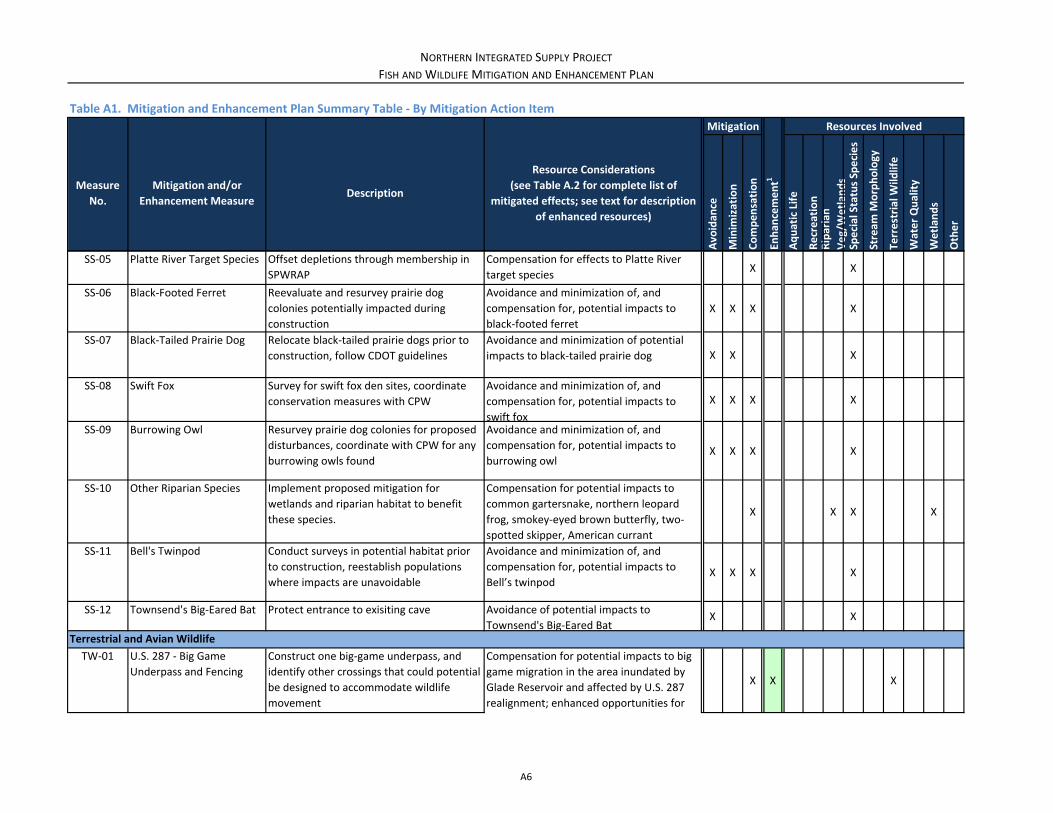
NORTHERN INTEGRATED SUPPLY PROJECT
FISH AND WILDLIFE MITIGATION AND ENHANCEMENT PLAN
Mitigation Resources Involved
Measure
No.
Mitigation and/or
Enhancement MeasureDescription
Resource Considerations
(see Table A.2 for complete list of
mitigated effects; see text for description
of enhanced resources)
Avo
idan
ce
Minim
ization
Compensation
Enhan
cement1
Aquatic Life
Recreation
Riparian
Veg/Wetlan
ds
Special Status Species
Stream
Morphology
Terrestrial W
ildlife
Water Quality
Wetlan
ds
Other
Table A1. Mitigation and Enhancement Plan Summary Table ‐ By Mitigation Action Item
SS‐05 Platte River Target Species Offset depletions through membership in
SPWRAP
Compensation for effects to Platte River
target speciesX X
SS‐06 Black‐Footed Ferret Reevaluate and resurvey prairie dog
colonies potentially impacted during
construction
Avoidance and minimization of, and
compensation for, potential impacts to
black‐footed ferret
X X X X
SS‐07 Black‐Tailed Prairie Dog Relocate black‐tailed prairie dogs prior to
construction, follow CDOT guidelines
Avoidance and minimization of potential
impacts to black‐tailed prairie dog X X X
SS‐08 Swift Fox Survey for swift fox den sites, coordinate
conservation measures with CPW
Avoidance and minimization of, and
compensation for, potential impacts to
swift fox
X X X X
SS‐09 Burrowing Owl Resurvey prairie dog colonies for proposed
disturbances, coordinate with CPW for any
burrowing owls found
Avoidance and minimization of, and
compensation for, potential impacts to
burrowing owlX X X X
SS‐10 Other Riparian Species Implement proposed mitigation for
wetlands and riparian habitat to benefit
these species.
Compensation for potential impacts to
common gartersnake, northern leopard
frog, smokey‐eyed brown butterfly, two‐
spotted skipper, American currant
X X X X
SS‐11 Bell's Twinpod Conduct surveys in potential habitat prior
to construction, reestablish populations
where impacts are unavoidable
Avoidance and minimization of, and
compensation for, potential impacts to
Bell’s twinpodX X X X
SS‐12 Townsend's Big‐Eared Bat Protect entrance to exisiting cave Avoidance of potential impacts to
Townsend's Big‐Eared BatX X
Terrestrial and Avian Wildlife
TW‐01 U.S. 287 ‐ Big Game
Underpass and Fencing
Construct one big‐game underpass, and
identify other crossings that could potential
be designed to accommodate wildlife
movement
X X X
Compensation for potential impacts to big
game migration in the area inundated by
Glade Reservoir and affected by U.S. 287
realignment; enhanced opportunities for
A6
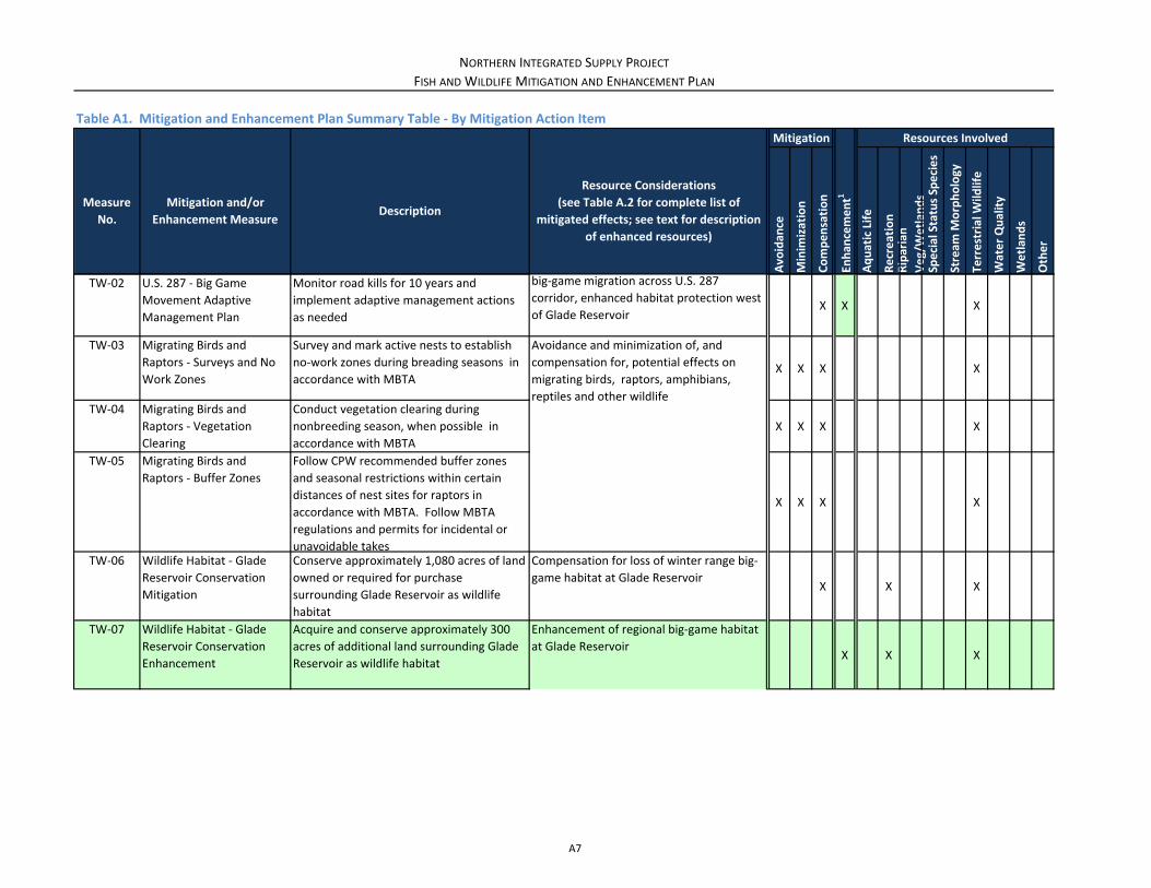
NORTHERN INTEGRATED SUPPLY PROJECT
FISH AND WILDLIFE MITIGATION AND ENHANCEMENT PLAN
Mitigation Resources Involved
Measure
No.
Mitigation and/or
Enhancement MeasureDescription
Resource Considerations
(see Table A.2 for complete list of
mitigated effects; see text for description
of enhanced resources)
Avo
idan
ce
Minim
ization
Compensation
Enhan
cement1
Aquatic Life
Recreation
Riparian
Veg/Wetlan
ds
Special Status Species
Stream
Morphology
Terrestrial W
ildlife
Water Quality
Wetlan
ds
Other
Table A1. Mitigation and Enhancement Plan Summary Table ‐ By Mitigation Action Item
TW‐02 U.S. 287 ‐ Big Game
Movement Adaptive
Management Plan
Monitor road kills for 10 years and
implement adaptive management actions
as neededX X X
TW‐03 Migrating Birds and
Raptors ‐ Surveys and No
Work Zones
Survey and mark active nests to establish
no‐work zones during breading seasons in
accordance with MBTAX X X X
TW‐04 Migrating Birds and
Raptors ‐ Vegetation
Clearing
Conduct vegetation clearing during
nonbreeding season, when possible in
accordance with MBTA
X X X X
TW‐05 Migrating Birds and
Raptors ‐ Buffer Zones
Follow CPW recommended buffer zones
and seasonal restrictions within certain
distances of nest sites for raptors in
accordance with MBTA. Follow MBTA
regulations and permits for incidental or
unavoidable takes
X X X X
TW‐06 Wildlife Habitat ‐ Glade
Reservoir Conservation
Mitigation
Conserve approximately 1,080 acres of land
owned or required for purchase
surrounding Glade Reservoir as wildlife
habitat
Compensation for loss of winter range big‐
game habitat at Glade ReservoirX X X
TW‐07 Wildlife Habitat ‐ Glade
Reservoir Conservation
Enhancement
Acquire and conserve approximately 300
acres of additional land surrounding Glade
Reservoir as wildlife habitat
Enhancement of regional big‐game habitat
at Glade ReservoirX X X
big‐game migration across U.S. 287
corridor, enhanced habitat protection west
of Glade Reservoir
Avoidance and minimization of, and
compensation for, potential effects on
migrating birds, raptors, amphibians,
reptiles and other wildlife
A7

NORTHERN INTEGRATED SUPPLY PROJECT
FISH AND WILDLIFE MITIGATION AND ENHANCEMENT PLAN
Mitigation Resources Involved
Measure
No.
Mitigation and/or
Enhancement MeasureDescription
Resource Considerations
(see Table A.2 for complete list of
mitigated effects; see text for description
of enhanced resources)
Avo
idan
ce
Minim
ization
Compensation
Enhan
cement1
Aquatic Life
Recreation
Riparian
Veg/Wetlan
ds
Special Status Species
Stream
Morphology
Terrestrial W
ildlife
Water Quality
Wetlan
ds
Other
Table A1. Mitigation and Enhancement Plan Summary Table ‐ By Mitigation Action Item
Water Quality
WQ‐01 Glade Reservoir ‐ Multi‐
Level Outlet Tower
Construct multi‐level outlet tower at Glade
Reservoir to convey Poudre River releasesX X X X X
WQ‐02 Glade Reservoir ‐ Release
Structure Aeration
Construct Glade Reservoir release
structures with baffling to provide aerationX X X
WQ‐03 Eaton Draw Water Quality
Wetlands
Construct approximately 10 acres of
wetlands in Eaton Draw to reduce ambient
water quality concentrations in Lower
Poudre River
Compensation for potential increased WQ
concentrations in Poudre River near
Greeley , increased sedimentation in lower
Poudre, direct impacts to 0.3 acres of
wetlands at Galeton Reservoir;
enhancement of WQ concentrations in
Poudre River near Greeley
X X X X
WQ‐04 Streamflow and Water
Quality Monitoring
Establish/enhance streamflow and water
quality monitoring network
Compensation for general water quality
effects, monitoring required to implement
provisions of this mitigation planX X X X X X
WQ‐05 Coalition for the Poudre
River Watershed
Provide funding and participate in Coalition
for the Poudre River Watershed
Enhancement of general water quality,
aquatics, vegetation, noxious weeds,
recreation, riparian resources
X X X X X X
WQ‐06 Stream Temperature
Mitigation
Reduce or curtail NISP diversions if and as
necessary to prevent new or exacerbated
temperature standard exceedances
Avoidance and minimzation of potential
increases in stream temperature, DO X X X X
Avoidance and minimization of potential
increases in temperature, DO, copper,
manganese, nutrients and selenium, and
other conservative constituents especially
during times of reduced flows;
enhancement of temperature and DO
(through introduction of cooler water) in
Poudre River
A8
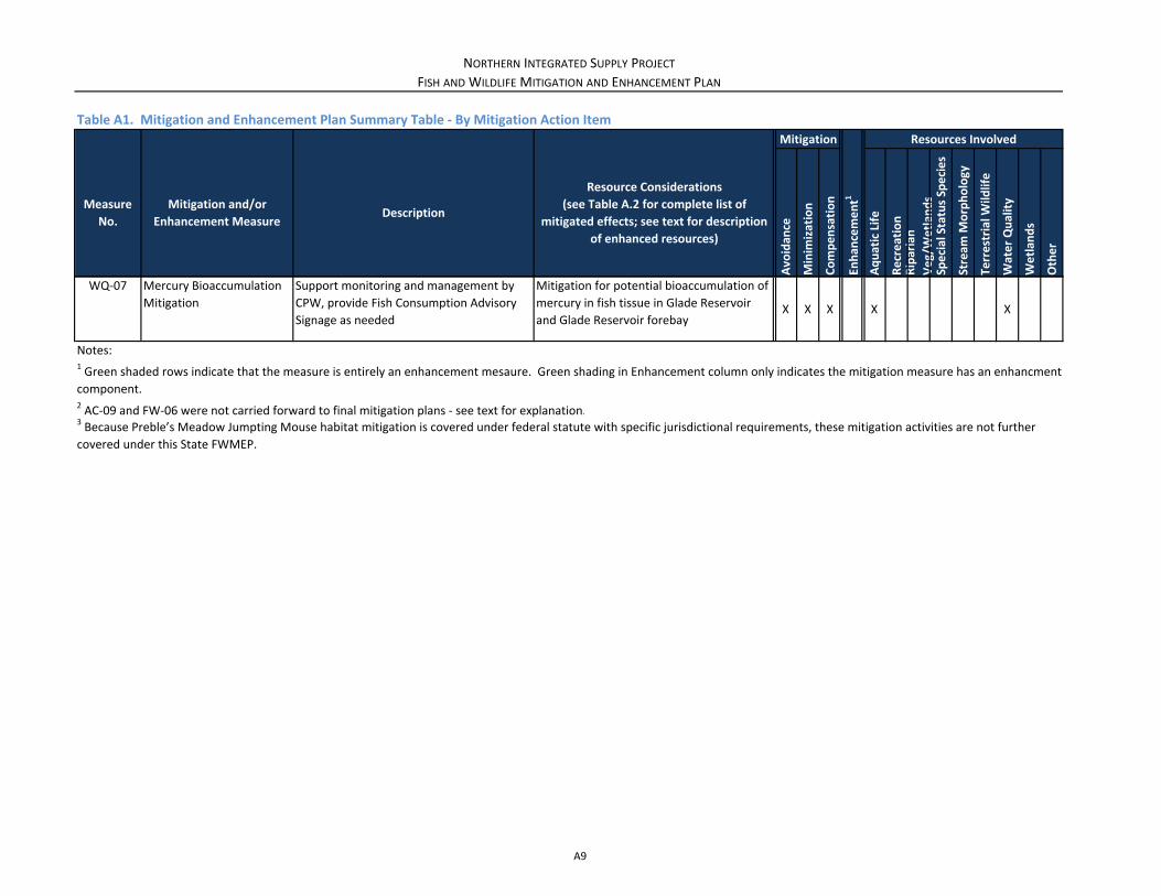
NORTHERN INTEGRATED SUPPLY PROJECT
FISH AND WILDLIFE MITIGATION AND ENHANCEMENT PLAN
Mitigation Resources Involved
Measure
No.
Mitigation and/or
Enhancement MeasureDescription
Resource Considerations
(see Table A.2 for complete list of
mitigated effects; see text for description
of enhanced resources)
Avo
idan
ce
Minim
ization
Compensation
Enhan
cement1
Aquatic Life
Recreation
Riparian
Veg/Wetlan
ds
Special Status Species
Stream
Morphology
Terrestrial W
ildlife
Water Quality
Wetlan
ds
Other
Table A1. Mitigation and Enhancement Plan Summary Table ‐ By Mitigation Action Item
WQ‐07 Mercury Bioaccumulation
Mitigation
Support monitoring and management by
CPW, provide Fish Consumption Advisory
Signage as needed
Mitigation for potential bioaccumulation of
mercury in fish tissue in Glade Reservoir
and Glade Reservoir forebayX X X X X
Notes:
3 Because Preble’s Meadow Jumpting Mouse habitat mitigation is covered under federal statute with specific jurisdictional requirements, these mitigation activities are not further
covered under this State FWMEP.
1 Green shaded rows indicate that the measure is entirely an enhancement mesaure. Green shading in Enhancement column only indicates the mitigation measure has an enhancment
component.2 AC‐09 and FW‐06 were not carried forward to final mitigation plans ‐ see text for explanation.
A9

NORTHERN INTEGRATED SUPPLY PROJECT
FISH AND WILDLIFE MITIGATION AND ENHANCEMENT PLAN
Row Resource
Summary of Effects
Alternative 2 (Proposed Action Glade and SPWCP – Reclamation Action Option) 2Mitigation
Measure No.
1 Surface Water
Poudre River
‐ Average diversion of 35,100 AFY at Poudre Valley Canal (Poudre Valley Canal) to Glade Reservoir.
‐ Flows in 1.48 mile river reach between Poudre Valley Canal and Hansen Supply Canal would be greater (average 8,200 AFY) than
No Reclamation Action Option.
FW‐01; FW‐02;
FW‐03; FW‐04;
FW‐05; FW‐08
2 Nutrients
Ammonia and total phosphorus increases may be measurable below WWTPs due to reduced river flows, may exceed standard at
some locations in Segment 12 of Poudre River and 1b on South Platte River (standards are exceeded under Current Conditions for
these nutrients).
WQ‐03; WQ‐04
3 Metals
Increases and decreases in metal concentrations due to flow changes may not be measurable. Medium chance of copper and
dissolved manganese standard exceedance in Segment 10 of Poudre River. Medium chance of exceeding total phosphorus
standard and a high potential for continued exceedance of selenium standard in Segment 11 of Poudre River. Iron, ammonia, total
phosphorus, and selenium concentrations currently exceed standards in Segment 12 of Poudre River and likely to remain above
standards. Iron, total phosphorus, and sulfate concentrations remain above standard in Segment 1b of South Platte River.
Ammonia and dissolved manganese have a medium chance of exceeding standard in Segment 1b of South Platte River.
FW‐03; WQ‐01;
WQ‐04; WQ‐07
4 Temperature
Adverse effects on stream temperature possible in sensitive reaches of Segment 10 and Segment 11 including key months of July
and August. Flow augmentation program would provide net benefit in parts of Segments 10 and 11 (from 0.37 miles upstream of
Larimer County Canal to Timnath Inlet headgate) in key months of March and September.
AG‐01; AG‐02;
FW‐04; WQ‐01;
WQ‐02; WQ‐04;
WQ‐06
5
Dissolved Oxygen Diversions at Poudre Valley Canal could exacerbate occasionally observed DO issues in July and August in Segment 11. Flow
augmentation would likely provide DO benefit November through April and in September. Aeration of releases from Glade
Reservoir should also help maintain DO concentrations within standards.
WQ‐02; WQ‐04
6 Crop Yield Elevated salinity and selenium concentrations in Galeton Reservoir releases to canals would result in decrease in crop yields where
water used for irrigation.
SE‐01; SE‐02
Larimer‐Weld and New Cache Canal
Surface Water
Surface Water Quality
Poudre and South Platte River Constituents
Table A2. Mitigation and Enhancement Plan Summary Table ‐ By SDEIS Resource Effect 1
A10

NORTHERN INTEGRATED SUPPLY PROJECT
FISH AND WILDLIFE MITIGATION AND ENHANCEMENT PLAN
Row Resource
Summary of Effects
Alternative 2 (Proposed Action Glade and SPWCP – Reclamation Action Option) 2Mitigation
Measure No.
Table A2. Mitigation and Enhancement Plan Summary Table ‐ By SDEIS Resource Effect 1
7
Change in flow regime Mean flow reduced 20‐30% mid‐April to mid‐July. Duration of flows at or above 1,000 cfs reduced 30‐35%.
2% flow reduced 10‐30%. 10‐year flood peak reduced up to 21%.
Laporte Reach: 1, 2, and 5% exceedance flows reduced 11‐26%. Lower flows (10 and 25% flows) reduced 16‐28%.
Fort Collins Reach: Winter low flows increased up to 35% from flow augmentation. 1, 2, and 5% flows reduced 13‐47%. Lower
flows (10 and 25% flows) reduced 12‐41%.
2‐year flood reduced 19‐36% in Fort Collins and upper Timnath reaches. 25‐year flood reduced up to 10% in Fort Collins.
Timnath, Windsor, Greeley Upstream, Greeley Channelized, and Greeley Reaches: Impact greatest on 5% exceedance flows,
reduced 25‐42%. Impact on floods up to 25‐year flood reasonably uniform, with 2, 10, and 25‐year flood peaks all reduced 16‐21%.
AG‐01; AG‐02;
FW‐08
8 Fining of surficial material
At 55% of cross sections duration of flows that flush river bed fines reduced 5‐50%. For remaining 45% of cross sections no flushing
or no change in duration of flushing flows.
Laporte Reach: 15 flushing events under Current Conditions lasting 132 days total reduced to 10 flushing events lasting 94 days total (26‐year period of record)
Fort Collins Reach: 23 flushing events under Current Conditions lasting 325 days total reduced to 16 flushing events lasting 222 days total (26‐year period of record)
Timnath, Windsor, Greeley Upstream, Greeley Channelized, and Greeley Reaches: 18 flushing events under Current Conditions lasting 292 days total for Windsor reach reduced to 19 flushing events lasting 218 days total (26‐year period of record)
AG‐01; AG‐02;
AG‐04; FW‐08
Channel Morphology and Sediment Transport
A11
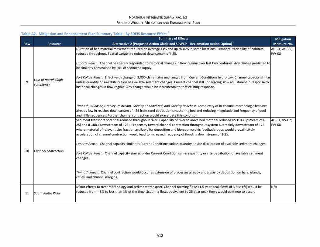
NORTHERN INTEGRATED SUPPLY PROJECT
FISH AND WILDLIFE MITIGATION AND ENHANCEMENT PLAN
Row Resource
Summary of Effects
Alternative 2 (Proposed Action Glade and SPWCP – Reclamation Action Option) 2Mitigation
Measure No.
Table A2. Mitigation and Enhancement Plan Summary Table ‐ By SDEIS Resource Effect 1
9Loss of morphologic complexity
Duration of bed material movement reduced on average 21% and up to 40% in some locations. Temporal variability of habitats
reduced throughout. Spatial variability reduced downstream of I‐25.
Laporte Reach: Channel has barely responded to historical changes in flow regime over last two centuries. Any change predicted to
be similarly constrained by lack of sediment supply.
Fort Collins Reach: Effective discharge of 2,000 cfs remains unchanged from Current Conditions hydrology. Channel capacity similar
unless quantity or size distribution of available sediment changes. Current channel still undergoing slow adjustment in response to
historical changes in flow regime. Any change would be incremental to that existing response.
Timnath, Windsor, Greeley Upstream, Greeley Channelized, and Greeley Reaches: Complexity of in‐channel morphologic features
already low in reaches downstream of I‐25 from sand deposition smothering bed and reducing magnitude and frequency of pool
and riffle sequences. Further channel contraction would exacerbate this condition.
AG‐01; AG‐02;
FW‐08
10 Channel contraction
Sediment transport potential reduced throughout river. Capability of river to move bed material reduced 12‐31% (upstream of I‐
25) and 8‐18% (downstream of I‐25). Propensity toward channel contraction throughout system but mainly downstream of I‐25
where material of relevant size fraction available for deposition and bio‐geomorphic feedback loops would prevail. Likely
acceleration of channel contraction would lead to increased frequency of flooding downstream of 1‐25.
Laporte Reach: Channel capacity similar to Current Conditions unless quantity or size distribution of available sediment changes.
Fort Collins Reach: Channel capacity similar under Current Conditions unless quantity or size distribution of available sediment
changes.
Timnath Reach: Channel contraction would occur as extension of processes already underway by deposition on bars, islands, riffles, and channel margins.
AG‐01; RV‐02;
FW‐08
11 South Platte River
Minor effects to river morphology and sediment transport. Channel‐forming flows (1.5‐year peak flows of 3,858 cfs) would be
reduced from ~ 3% to less than 1% of the time. Scouring flows equivalent to 25‐year peak flows would continue to occur.
N/A
A12

NORTHERN INTEGRATED SUPPLY PROJECT
FISH AND WILDLIFE MITIGATION AND ENHANCEMENT PLAN
Row Resource
Summary of Effects
Alternative 2 (Proposed Action Glade and SPWCP – Reclamation Action Option) 2Mitigation
Measure No.
Table A2. Mitigation and Enhancement Plan Summary Table ‐ By SDEIS Resource Effect 1
12 Ground Water
Minimal effects to ground water from reduced river flows and associated changes in river stage. Greatest changes would be within
50 feet of Poudre River. Minimal seepage from reservoir to alluvium could increase water availability to vegetation. No impacts on
ground water quality.
13 Geology
Disturbance from construction activities and excavation of sand, gravel, and bedrock for Glade Dam and Galeton Dam
embankments, foundation, and rip rap. Excavation and removal of Paleozoic and Mesozoic sedimentary rocks associated with the
U.S. 287 realignment. excavation of sand, gravel, and bedrock for Glade Dam and Galeton Dam embankments, foundation, and rip
rap.
Excavation and removal of Paleozoic and Mesozoic sedimentary rocks associated with the U.S. 287 realignment.
GC‐04; RC‐07
14Prime Farmland if Irrigated (acres lost)
686RC‐07
15Permanent impacts on all vegetation (acres)
3,895N/A
16
Permanent impacts on native plant communities (acres)
2,857N/A
17Irrigated agricultural lands dry up (acres)
0N/A
18 Noxious Weeds
Increased distribution and cover by noxious weeds due to construction disturbance. Periods of prolonged low water levels at Glade
and Galeton Reservoirs would allow for noxious weeds to colonize the drawdown area to construction disturbance. Periods of
prolonged low water levels at Glade and Galeton Reservoirs would allow for noxious weeds to colonize the drawdown area.
NW‐01
19Wetlands (permanent direct effects) (acres)
44WL‐01; WL‐02;
WQ‐03
20Wetlands (temporary direct effects) (acres)
8GC‐01
21
Wetlands from Irrigation Dry‐up (permanent indirect effects) (acres)
0N/A
Ground Water
Geology
Vegetation
Prime Farmland if Irrigated (acres lost)
Noxious Weeds
Wetlands and Other Waters
A13

NORTHERN INTEGRATED SUPPLY PROJECT
FISH AND WILDLIFE MITIGATION AND ENHANCEMENT PLAN
Row Resource
Summary of Effects
Alternative 2 (Proposed Action Glade and SPWCP – Reclamation Action Option) 2Mitigation
Measure No.
Table A2. Mitigation and Enhancement Plan Summary Table ‐ By SDEIS Resource Effect 1
22
Wetlands from Poudre Valley Canal lining (permanent indirect effects) (acres)
0
N/A
23
Wetlands from Poudre River flow changes (indirect effects) (acres)
9RV‐01; RV‐02
24Waters (permanent direct effects) (acres)
12GC‐01
25Waters (temporary direct effects) (acres)
3GC‐01
26
Riparian shrubland and woodland (permanent direct effects) (acres)
112 (inundation and construction)AG‐01; RV‐01
27
Riparian shrubland and woodland(temporary direct effects) (acres)
8AG‐01; RV‐01;
GC‐01
28 Permanent – 3,995
29 Temporary – 782
30 Permanent – 3,789
31 Temporary – 647
32Winter Range Permanent
Local Effect (%)16
33 Permanent – 228
34 Temporary – 173
35 Permanent – 70
36 Temporary – 152
37 Permanent – 2,057
38 Temporary – 582
Riparian Resources
Wildlife
Mule Deer
Overall Range (acres)
Winter Range (acres)
Severe Winter Range
(acres)
Winter Concentration Area
(acres)
White‐Tailed Deer
Overall Range (acres)
TW‐01; TW‐02;
TW‐06
RC‐05
A14

NORTHERN INTEGRATED SUPPLY PROJECT
FISH AND WILDLIFE MITIGATION AND ENHANCEMENT PLAN
Row Resource
Summary of Effects
Alternative 2 (Proposed Action Glade and SPWCP – Reclamation Action Option) 2Mitigation
Measure No.
Table A2. Mitigation and Enhancement Plan Summary Table ‐ By SDEIS Resource Effect 1
39 Permanent – 416
40 Temporary – 192
41Winter Range Permanent
Local Effect (%)8
42 Permanent – 421
43 Temporary – 203
44 Permanent – 2,256
45 Temporary – 335
46 Permanent – 2,256
47 Temporary – 295
48Winter Range Permanent
Local Effect (%)25
49 Permanent – 2,254
50 Temporary – 256
51 Permanent – 1,928
52 Temporary – 204
53Winter Concentration Area
Permanent Local Effect (%)31
54 Permanent – 2,043
55 Temporary – 386
56
57
58 Permanent – 186
59 Temporary – 101
60 Permanent – 2
61 Temporary – 8
62 Permanent – 124
63 Temporary – 75
64Winter Concentration Area
Permanent Local Effect (%)13
Winter Concentration Area
(acres)
Overall Range (acres)
Overall Range Permanent
Local Effect (%)18
Winter Range (acres)
Severe Winter Range
(acres)
Elk
Winter Range (acres)
Severe Winter Range
(acres)
Winter Concentration Area
(acres)
Overall Range (acres)
Pronghorn
Winter Range (acres)
Concentration Area (acres)
RC‐05
TW‐01; TW‐02;
TW‐06
A15

NORTHERN INTEGRATED SUPPLY PROJECT
FISH AND WILDLIFE MITIGATION AND ENHANCEMENT PLAN
Row Resource
Summary of Effects
Alternative 2 (Proposed Action Glade and SPWCP – Reclamation Action Option) 2Mitigation
Measure No.
Table A2. Mitigation and Enhancement Plan Summary Table ‐ By SDEIS Resource Effect 1
65
Migratory birds and raptors, amphibians and reptiles, and other wildlife (acres)
Loss of 44 acres of wetlands, 12 acres of aquatic habitat, 537 acres of shrublands, 29 acres of riparian woodlands, and 2,929 acres
of grassland habitat.
Mortality and nest destruction could occur during construction.
Temporary impacts include disturbance of vegetation and increased noise and human presence.
Reductions in streamflows on Poudre and South Platte Rivers not anticipated to cause loss of riparian and/or wetland habitat. 9
acres of wetland habitat along banks could experience change in species composition.
TW‐03; TW‐04;
TW‐05
66 Segment A
Fish: Minor adverse impact to adult trout due to reduced runoff flows, negligible impacts to other species/life stages
Macroinvertebrates: Minor adverse impact with changes in species composition due to reduced peak flows
Periphyton and Plants: Minor adverse impact with increases in filamentous green algae due to reduced peak flows
AG‐01; AG‐02;
AG‐04; FW‐02;
FW‐03; FW‐04;
FW‐08
67 Segment B
Fish: Minor to moderate beneficial impact to most species of fish with augmented low flows
Macroinvertebrates: Beneficial impact to abundance, minor adverse impact with changes in species composition due to reduced
peak flows
Periphyton and Plants: Minor adverse impact with increases in filamentous green algae due to reduced peak flows
AG‐01; FW‐03;
FW‐04; FW‐05;
RV‐01; RV‐02;
FW‐08
68 Segment C
Fish: Negligible impact to most species, moderate adverse impact to trout with reduced runoff flows and higher temperatures
Macroinvertebrates: Minor adverse impact with changes in species composition due to reduced peak flows
Periphyton and Plants: Minor adverse impact with increases in filamentous green algae due to reduced peak flows
AG‐01; FW‐02;
FW‐03; FW‐08
69 Segment D
Fish: Minor adverse impact for some species with reductions in runoff flows, negligible impact for others
Macroinvertebrates: Minor adverse impact with changes in species composition due to reduced peak flows
Periphyton and Plants: Minor adverse impact with increases in filamentous green algae due to reduced peak flows
AG‐01; FW‐03;
RV‐01; RV‐02;
FW‐08
Migratory birds and raptors, amphibians and reptiles, and other wildlife
Aquatic Biological Resources
Poudre River Fish, Macroinvertebrates, Periphyton, and Plants
A16

NORTHERN INTEGRATED SUPPLY PROJECT
FISH AND WILDLIFE MITIGATION AND ENHANCEMENT PLAN
Row Resource
Summary of Effects
Alternative 2 (Proposed Action Glade and SPWCP – Reclamation Action Option) 2Mitigation
Measure No.
Table A2. Mitigation and Enhancement Plan Summary Table ‐ By SDEIS Resource Effect 1
70 Segment E
Fish: Minor adverse impact for most species with reduced runoff flows
Macroinvertebrates: Minor adverse impact with changes in species composition due to reduced peak flows
Periphyton and Plants: Minor adverse impact with increases in filamentous green algae due to reduced peak flows
AG‐01; FW‐03;
FW‐08
71 Segment F
Fish: Minor adverse impact for most species with reduced runoff flows
Macroinvertebrates: Minor adverse impact with changes in species composition due to reduced peak flows
Periphyton and Plants: Minor adverse impact with increases in filamentous green algae due to reduced peak flows
AG‐01; FW‐03;
FW‐08
72 Negligible AG‐07
73Preble’s meadow jumping mouse
Permanent loss of 53 acres of known Preble’s habitat. Temporary disturbance to 24 acres of Preble’s habitat. Potential disturbance
of Preble’s behavior due to increased noise and human presence and physical harm to individual Preble’s from construction
machinery and future recreational activities at Glade. Changes in flows in Poudre River unlikely to affect Preble’s habitat.
SS‐01
74 Bald eagle
Permanent impacts of 21 acres and temporary impacts of 13 acres of winter concentration area. Less than 1 acre of nest buffer
permanently affected and 8 acres temporarily affected. Pipeline construction impacts could result in nest abandonment or
decreased nesting success if conducted during sensitive breeding and nesting periods. Glade Reservoir could provide additional
summer foraging habitat, especially if stocked with fish. Galeton Reservoir could provide additional summer foraging habitat.
SS‐02
75Colorado butterfly plant (CBP)
No effect. No known populations occur in study area and is unlikely to occur in study area. Changes in flows in Poudre River
unlikely to affect CBP.
SS‐03
76Ute ladies’‐tresses orchid (ULTO)
No effect. None found during surveys of study area. No known populations occur in study areas and is unlikely to occur in SPWCP
pipeline study area. Glade to Horsetooth pipeline route less than 1 mile from currently known populations of ULTO. Prior to
construction, ULTO habitat assessments and/or final surveys would be conducted for potentially impacted suitable habitat not
previously evaluated. Changes in flows in Poudre River unlikely to affect ULTO.
SS‐04
77Black‐tailed prairie dog and burrowing owl
Permanent impacts on 367 acres of prairie dog habitat, mostly from construction of Galeton Reservoir. SS‐07; SS‐09
78 Swift fox Permanent impacts on 1,928 acres of overall swift fox range (0.3 to 1.0 home ranges/pair). SS‐08
Special Status Species
South Platte River Fish, Macroinvertebrates, Periphyton, and Plants
A17

NORTHERN INTEGRATED SUPPLY PROJECT
FISH AND WILDLIFE MITIGATION AND ENHANCEMENT PLAN
Row Resource
Summary of Effects
Alternative 2 (Proposed Action Glade and SPWCP – Reclamation Action Option) 2Mitigation
Measure No.
Table A2. Mitigation and Enhancement Plan Summary Table ‐ By SDEIS Resource Effect 1
79Common gartersnake and northern leopard frog
Permanent loss of 44 acres of wetland habitat, 11 acres of aquatic habitat, and 28 acres of riparian woodland habitat (gartersnake
only). Temporary impacts on 8 acres of wetland habitat, 3 acres of aquatic habitat, and 8 acres of riparian woodland (gartersnake
only).
SS‐10
80
Smokey‐eyed brown butterfly, two‐spotted skipper, and American currant
No effect. SS‐10
81 Bell’s twinpod Permanent loss of 29 acres and temporary impacts on 45 acres from western realignment of U.S. 287. SS‐11
82Brassy minnow and common shiner
No effect N/A
83 Iowa darter Negligible except Segment B, which would be moderate beneficial FW‐03; FW‐04
84Boating (kayaking and canoeing)
If Glade is managed for recreation, new flat water boating opportunities would exist, a major beneficial effect.
No public access planned at Galeton Reservoir.
Poudre River Segment A: Negligible effects.
Poudre River Segment B: Moderate to major effects with 3 to 7 fewer boating days per month (total of 19 fewer days over May‐
August period) based on target flows of 150 cfs or greater.
Poudre River Segments C, D, E, and F: No effects.
FW‐02; FW‐03;
FW‐04; RC‐06;
FW‐08
85 Fishing
If Glade is managed for recreation, would provide a new fishery, a major beneficial effect.
No public access planned at Galeton Reservoir.
Poudre River Segment A: Reductions in habitat for brown and rainbow trout would be a minor adverse effect on fishing.
Poudre River Segment B: Augmented winter flows would result in minor beneficial effects on recreational fishing.
Poudre River Segments C, D, E, and F: Negligible effects.
AG‐02; FW‐02;
FW‐03; FW‐04;
RC‐06; FW‐08
Recreation Resources
A18

NORTHERN INTEGRATED SUPPLY PROJECT
FISH AND WILDLIFE MITIGATION AND ENHANCEMENT PLAN
Row Resource
Summary of Effects
Alternative 2 (Proposed Action Glade and SPWCP – Reclamation Action Option) 2Mitigation
Measure No.
Table A2. Mitigation and Enhancement Plan Summary Table ‐ By SDEIS Resource Effect 1
86 Hunting
Loss of 340 acres of Poudre River State Trust Land, which is managed for hunting and fishing by CPW. Construction of Glade
Reservoir may improve habitat, therefore improving hunting opportunities.
Loss of 21 acres of Mitani‐Tokuyasu SWA. Mule deer and white‐tailed deer winter range may be affected at SPWCP forebay, thus
affecting nearby big game hunting.
Pronghorn winter and severe winter range and mule deer winter range affected at Galeton Reservoir and may have an effect on
nearby big game hunting. Construction of Galeton Reservoir may improve waterfowl habitat in area, which may improve nearby
hunting opportunities.
RC‐02; RC‐04;
RC‐05
87Other Recreational Activities
Construction of Glade to Horsetooth pipeline would temporarily disrupt dispersed recreational uses along its alignment.
Reductions in flows on Poudre River not expected to affect aesthetic qualities of riparian habitat of Poudre River, Poudre River
Trail, or natural areas.
Construction of Galeton Reservoir may improve habitat in area, which may improve nearby wildlife viewing or photography
opportunities.
Construction of SPWCP pipelines is not expected to affect recreation resources.
N/A
88 Cultural Resources
2 known cultural resources and an estimated 35 NRHP eligible sites affected by construction of Glade Dam and Reservoir and
associated facilities or would be inundated by reservoir.
7 known cultural resources and 7 unrecorded cultural resources would be affected by western realignment of U.S. 287. Of the
known cultural sites, 3 of these are eligible sites, 1 is not eligible, and 3 have not been assessed.
15 known cultural resources occur within areas that would be disturbed by construction of Galeton Dam and Reservoir and
associated facilities or would be inundated by reservoir. Of these 15 sites, 13 have not had an official determination and may be
eligible for listing in NRHP and two are not eligible.
CR‐01; CR‐02;
CR‐03
Cultural Resources
A19

NORTHERN INTEGRATED SUPPLY PROJECT
FISH AND WILDLIFE MITIGATION AND ENHANCEMENT PLAN
Row Resource
Summary of Effects
Alternative 2 (Proposed Action Glade and SPWCP – Reclamation Action Option) 2Mitigation
Measure No.
Table A2. Mitigation and Enhancement Plan Summary Table ‐ By SDEIS Resource Effect 1
89Paleontological Resources ‐ U.S. 287
Adverse impacts on subsurface fossils in areas underlain by Class 5 geologic units (Morrison Formation). Adverse impacts on
potentially substantial vertebrate, invertebrate, plant, and trace fossils possible in Class 3 geologic units (Niobrara Formation,
Benton Group, Dakota Group, Undivided Jelm, and Sundance Formations). Adverse impacts on potentially substantial vertebrate,
invertebrate, plant, and trace fossils unlikely but possible in Class 2 geologic units (Lykins Formation). Adverse impacts consist of
destruction of fossils by breakage and crushing during construction‐related ground disturbance.
CR‐04; CR‐05
90Aesthetics and Visual Resources
Change in landscape from terrestrial to open water for Glade and Galeton Reservoirs. Reservoir dams would change current visual
character of sites.
One‐third of Mitani‐Tokuyasu SWA would be replaced by Galeton forebay resulting in substantial reduction in scenic quality.
Realignment of U.S. 287 would create contrast in scenic quality elements where it cuts through hogback formation.
VS‐01
91 Traffic Volumes
Existing traffic patterns not expected to change so reduced traffic volumes along SH 14 between Overland Trail and Ted’s Place. If
recreation provided at Glade Reservoir minor seasonal fluctuations in vehicle volumes can be anticipated. reduced traffic volumes
along SH 14 between Overland Trail and Ted’s Place.
If recreation provided at Glade Reservoir minor seasonal fluctuations in vehicle volumes can be anticipated.
GC‐03
92 Existing Roadways
7‐mile portion of U.S. 287 relocated. New alignment 2.3 miles shorter. Location of Galeton Reservoir would not infringe on or
disturb any existing roadways. 2.3 miles shorter. Location of Galeton Reservoir would not infringe on or disturb any existing
roadways.
GC‐05
93 Current Travel Patterns
New U.S. 287 alignment would be about 2.3 miles shorter.
Access to Bonner Spring Ranch Road may be affected by realignment and new access would be provided. Pipeline construction
would potentially temporarily disrupt some transportation, depending upon alignment.
GC‐01; GC‐03
94 Site AccessConstruction of Galeton Reservoir would require extension an existing roadway or construction of a private drive for purposes of
accessing and maintaining facility.
GC‐01
Paleontological Resources
Aesthetics and Visual Resources
Traffic and Transportation
A20
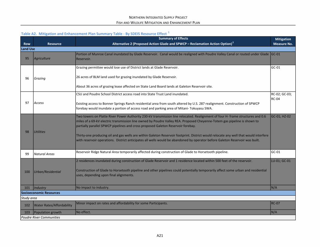
NORTHERN INTEGRATED SUPPLY PROJECT
FISH AND WILDLIFE MITIGATION AND ENHANCEMENT PLAN
Row Resource
Summary of Effects
Alternative 2 (Proposed Action Glade and SPWCP – Reclamation Action Option) 2Mitigation
Measure No.
Table A2. Mitigation and Enhancement Plan Summary Table ‐ By SDEIS Resource Effect 1
95 AgriculturePortion of Munroe Canal inundated by Glade Reservoir. Canal would be realigned with Poudre Valley Canal or routed under Glade
Reservoir.
GC‐01
96 Grazing
Grazing permittee would lose use of District lands at Glade Reservoir.
26 acres of BLM land used for grazing inundated by Glade Reservoir.
About 36 acres of grazing lease affected on State Land Board lands at Galeton Reservoir site.
GC‐01
97 Access
CSU and Poudre School District access road into State Trust Land inundated.
Existing access to Bonner Springs Ranch residential area from south altered by U.S. 287 realignment. Construction of SPWCP
forebay would inundate a portion of access road and parking area of Mitani‐ Tokuyasu SWA.
RC‐02; GC‐03;
RC‐04
98 Utilities
Two towers on Platte River Power Authority 230‐kV transmission line relocated. Realignment of four H‐ frame structures and 0.6
miles of a 69‐kV electric transmission line owned by Poudre Valley REA. Proposed Cheyenne‐Totem gas pipeline is shown to
partially parallel SPWCP pipelines and cross proposed Galeton Reservoir forebay.
Thirty‐one producing oil and gas wells are within Galeton Reservoir footprint. District would relocate any well that would interfere
with reservoir operations. District anticipates all wells would be abandoned by operator before Galeton Reservoir was built.
GC‐01; HZ‐02
99 Natural Areas Reservoir Ridge Natural Area temporarily affected during construction of Glade to Horsetooth pipeline. GC‐01
100 Urban/Residential
2 residences inundated during construction of Glade Reservoir and 1 residence located within 500 feet of the reservoir.
Construction of Glade to Horsetooth pipeline and other pipelines could potentially temporarily affect some urban and residential
uses, depending upon final alignments.
LU‐01; GC‐01
101 Industry No impact to industry. N/A
102 Water Rates/Affordability Minor impact on rates and affordability for some Participants. RC‐07
103 Population growth No effect. N/A
Study area
Poudre River Communities
Land Use
Socioeconomic Resources
A21

NORTHERN INTEGRATED SUPPLY PROJECT
FISH AND WILDLIFE MITIGATION AND ENHANCEMENT PLAN
Row Resource
Summary of Effects
Alternative 2 (Proposed Action Glade and SPWCP – Reclamation Action Option) 2Mitigation
Measure No.
Table A2. Mitigation and Enhancement Plan Summary Table ‐ By SDEIS Resource Effect 1
104 Recreation Resources Major impact on boating recreational value in Fort Collins. Moderate impact on recreational value of Poudre River Trail in Fort
Collins. No effect on fishing recreation values.
FW‐02; FW‐03;
FW‐04
105 Property Values No effect in Fort Collins. Potential minor effects downstream of I‐25 due to changes in flood risks. AG‐01
106Water/Wastewater
Treatment CostsNo effect. N/A
107Other Socioeconomic
Effects
Likely no additional effect on Fort Collins economy/economic development. Potential major impact on nonuse values associated
with Poudre River for Fort Collins residents.
FW‐03; FW‐04
108Regional Recreation
ResourcesMajor benefit from recreation at Glade Reservoir. N/A
109Irrigated Agriculture‐
Related Economy
No effect under average conditions. Minor effect under potential worst‐case conditions due to increased salinity associated with
the SPWCP ditch exchange.
SE‐02
110 Road Relocation EffectsModerate to major impact on gasoline station and campground at Ted’s Place. No net effect on value of residential properties. RC‐06
111 Construction EffectsConstruction stimulus paid for by regional residents over future years. No net effect. N/A
112Agricultural‐related
economy
Estimated annual impact on agricultural‐related economic output in the study area of approximately $34 million and an estimated
reduction in agriculture‐ related employment of about 291 jobs associated with growth onto agricultural lands and their conversion
to municipal uses.
N/A
113 Hazardous Sites
Proposed Glade Reservoir forebay located near Atlas “E” Missile Site 13 and known TCE plume associated with missile site.
Currently no detectable TCE within footprint of proposed forebay. Soil containing TCE not expected within proposed footprint of
forebay. As contaminant mass continues to naturally attenuate TCE plume will continue to decrease in size.
HZ‐01
114 NoiseIncreased noise associated with reservoir and pipeline construction and realignment of U.S. 287 would occur in localized areas
temporarily.
GC‐01
115 Air Quality Same as Alternative 1. AQ‐01; GC‐01
Broader Study Area
Hazardous Sites
Noise
Air Quality
A22
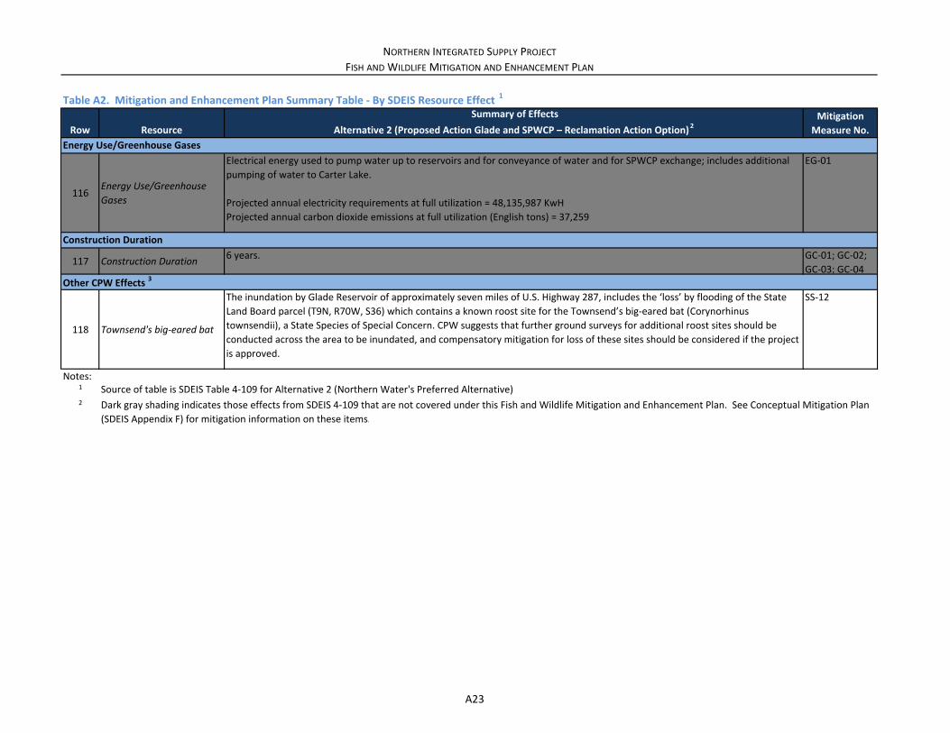
NORTHERN INTEGRATED SUPPLY PROJECT
FISH AND WILDLIFE MITIGATION AND ENHANCEMENT PLAN
Row Resource
Summary of Effects
Alternative 2 (Proposed Action Glade and SPWCP – Reclamation Action Option) 2Mitigation
Measure No.
Table A2. Mitigation and Enhancement Plan Summary Table ‐ By SDEIS Resource Effect 1
116Energy Use/Greenhouse Gases
Electrical energy used to pump water up to reservoirs and for conveyance of water and for SPWCP exchange; includes additional
pumping of water to Carter Lake.
Projected annual electricity requirements at full utilization = 48,135,987 KwH
Projected annual carbon dioxide emissions at full utilization (English tons) = 37,259
EG‐01
117 Construction Duration 6 years. GC‐01; GC‐02;
GC‐03; GC‐04
118 Townsend's big‐eared bat
The inundation by Glade Reservoir of approximately seven miles of U.S. Highway 287, includes the ‘loss’ by flooding of the State
Land Board parcel (T9N, R70W, S36) which contains a known roost site for the Townsend’s big‐eared bat (Corynorhinus
townsendii), a State Species of Special Concern. CPW suggests that further ground surveys for additional roost sites should be
conducted across the area to be inundated, and compensatory mitigation for loss of these sites should be considered if the project
is approved.
SS‐12
Notes:1
2 Dark gray shading indicates those effects from SDEIS 4‐109 that are not covered under this Fish and Wildlife Mitigation and Enhancement Plan. See Conceptual Mitigation Plan
(SDEIS Appendix F) for mitigation information on these items.
Source of table is SDEIS Table 4‐109 for Alternative 2 (Northern Water's Preferred Alternative)
Other CPW Effects 3
Energy Use/Greenhouse Gases
Construction Duration
A23