fire behavior analysis
TRANSCRIPT

A1
Fire Behavior Analysis Fire activity began to escalate in northern California on June 21, 2008 when a major lightning event affected the Northern California Geographic Coordination Area (North Ops). The July 22, 2008 National Situation Report identified 602 new fires in northern California. Throughout the remainder of June and into July fire activity remained heavy in northern California. The Siskiyou Complex on the Klamath National Forest came under the leadership of a Type II Incident Management Team on June 23, 2008. Between this date and the staffing of the Panther Fire, the forest managed a variety of other large fires including the Gould Fire, No Man‘s Fire and the Bear Wallow Complex. These fires were all located on the Happy Camp/Oak Knoll Ranger District of the forest. Fire danger indices for the Northwest Predictive Services Area (PSA) showed that ERCs were tracking near the 90th percentile most of July, while 1000-hour fuels moistures were above the 10th percentile, but were well below historic averages for this time of year.
Figure 1. Energy Release Component and 1000-hour fuel moisture trends for the Northwestern Predictive Services Area. The Northwest PSA is representative of the Panther fire area. Information obtained from the Pocket Card for the western portion of the Klamath National Forest, including the Panther fire area, identified local thresholds for potential increasing fire activity as:
Temperature 85°F or greater
Relative humidity 20% or less
Twenty-foot winds greater than 4mph and
One-thousand hour fuel moistures less than 15% The 1000-hour fuel moisture and 20-foot winds exceeded these thresholds on the Panther Fire.

A1
Fire History The area surrounding the Panther Fire last burned in 1987 during the Happy Complex. No other significant fire activity had occurred in the vicinity of the Panther Fire since that date. District personnel stated that the surface fuels consisted of high loadings of large size-class down woody material associated with mortality from the Happy Complex.
Fuel Models The fire area was dominated by three fuel models, TU-5 (Very High Load, Dry Climate Timber Shrub); TL-3 (Moderate Load Conifer Litter) and SH-4 (Low Load Humid Climate Timber Shrub). Based on the FARSITE landscape file for the Happy Camp Ranger District, the canopy cover was consistent across the fire area at 57% to 59%. Canopy base height (CBH) ranged between are 1 and 3 feet (0.3 and 0.8 meters).
Dead Fuel Moisture
The 1-hour dead fuel moisture on the southern aspect of the fire varied little during the early days of the incident due to smoky conditions in the fire area limiting solar heating. Calculated 1-hour fuel moisture values were as low as 6 % and as high as 14%.
The 10-hour fuel moisture was determined from the Sawyers Bar Remote Automated Weather Station (RAWS) located approximately 25 air miles southeast of the fire and approximately 1,000‘ lower. Sawyers Bar was determined by North Ops Predictive Services personnel to be the most representative fixed RAWS site in the fire area. The average 10-hour fuel moisture for the time period July 21 through July 26 was 5.4% and ranged between 4.3% and 6.1%
The 100-hour fuel moisture was also determined from the Sawyers Bar RAWS and averaged 7.5%. These fuel moistures ranged between 6.9% and 8.3%. The 1000-hour fuel moisture sampled on July 16 from the Oak Knoll/Happy Camp sample site was 4%.
Live Fuel Moisture
Live fuel moistures were sampled on July 16 from the Oak Knoll/Happy Camp sample site. Species sampled were Buckbrush and Manzanita. Table 1 shows the sampling results.
Table 1. Live fuel moistures – Old Knoll – July 16, 2008
Old Buckbrush New Buckbrush Old Manzanita New Manzanita
114% 97% No information 109%
A1
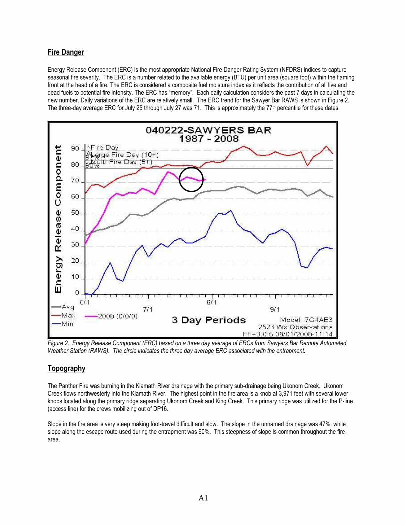
Fire Danger Energy Release Component (ERC) is the most appropriate National Fire Danger Rating System (NFDRS) indices to capture seasonal fire severity. The ERC is a number related to the available energy (BTU) per unit area (square foot) within the flaming front at the head of a fire. The ERC is considered a composite fuel moisture index as it reflects the contribution of all live and dead fuels to potential fire intensity. The ERC has ―memory‖. Each daily calculation considers the past 7 days in calculating the new number. Daily variations of the ERC are relatively small. The ERC trend for the Sawyer Bar RAWS is shown in Figure 2. The three-day average ERC for July 25 through July 27 was 71. This is approximately the 77th percentile for these dates.
Figure 2. Energy Release Component (ERC) based on a three day average of ERCs from Sawyers Bar Remote Automated Weather Station (RAWS). The circle indicates the three day average ERC associated with the entrapment.
Topography The Panther Fire was burning in the Klamath River drainage with the primary sub-drainage being Ukonom Creek. Ukonom Creek flows northwesterly into the Klamath River. The highest point in the fire area is a knob at 3,971 feet with several lower knobs located along the primary ridge separating Ukonom Creek and King Creek. This primary ridge was utilized for the P-line (access line) for the crews mobilizing out of DP16. Slope in the fire area is very steep making foot-travel difficult and slow. The slope in the unnamed drainage was 47%, while slope along the escape route used during the entrapment was 60%. This steepness of slope is common throughout the fire area.

A1
The fire was burning on predominately a southern aspect above Ukonom Creek approximately four air miles east of the Klamath River. The fire started south of the primary ridge separating Ukonom Creek and King Creek. There are a series of north-south oriented ridges bisecting the fire area, terminating in Ukonom Creek. Five unnamed drainages are oriented north-south in the fire area. An unnamed drainage on the east flank of the fire had been identified by the crews assigned to the Panther Fire as a point of potential slope reversal. A lookout was established to monitor fire activity in this drainage on July 26.
Fire Behavior Background - The fire began at 0021 PDT on July 22 due to a lightning strike north of Ukonom Creek. The point of origin was below the primary ridge and the fire had primarily been spreading in backing orientation for four days, until July 26. As the fire spread, a finger on the southeast corner crossed an unnamed drainage sometime during the evening of July 25 or early morning July 26. The location where the fire crossed the unnamed drainage was recorded with a hand-held GPS by a smokejumper that had been functioning as a line scout on the incident. This point is approximately 1,200‘ below the ridgeline saddle where the entrapment occurred. The slope over the 1,200‘ distance was calculated at 47%. The fire which had crossed the drainage was not visible from the primary ridge (P-line) or to the lookout established by the type 2 IA crew due to the smoky conditions. However, the lookout reported being able to hear an increase in fire activity beginning near 1200 hours on July 26. The lookout also reported seeing three columns breaching the smoke layer approximately 1400 hours. The lookout interpreted these three columns as an indication of increasing fire activity and reported this activity to his supervisor. Point Source Fire Spread - A point source fire spread projection was made using the using the 1500 weather taken by the Hotshot crew (dry bulb 74°F, relative humidity 32%, southwest winds, 1 to 3 mph). The origin of this projection was the location where the fire had crossed the unnamed drainage. Outputs from the projection are in Table 2.
Table 2. Point Source Behave Plus Outputs – July 26, 1400 hours
Fuel Model Rate of Spread (Chs/hr)
Rate of Spread (feet/min)
Flame Length (feet)
Fireline Intensity (BTU‘s/ft/sec)
TU5 5.2 – 8.2 5.7 – 9.0 5.6 – 6.9 239 – 378
SH4 8.3 – 14.8 9.1 – 16.3 3.2 – 4.2 73 - 130
Assuming the fire spread primarily as a surface fire in the unnamed drainage, the projection indicates that the fire would have reached the entrapment site in 73 minutes. Using the 1400 PDT report of increasing fire activity from the lookout as a start time for the fire run, the flaming front would have reached the saddle area at approximately 1513 PDT. This roughly coincides with the reported time of the entrapment.
Crown Fire Evaluation – Using information derived from the Happy Camp Ranger District FARSITE landscape file, NEXUS
2.0 was used to evaluate the crown fire potential. No information concerning foliar moisture was available and it was set at 100% in the model. Table 3 summarizes important outputs from NEXUS.
Table 3. NEXUS Crown Fire Potential for July 26
NEXUS Panther Crown Fire Evaluation
Torching Index
Crowning Index
Critical Fireline Intensity
(BTU/ft/s)
Critical Flame Length (feet)
Critical Spread Rate for Active Crown
Fire (Chs/hr)
0 17.5 43 2.5 52.6

A1
The Torching Index in NEXUS is the 20-foot wind speed at which passive crown fire is possible. The model output of zero for July 26 indicates that passive crowning was to be anticipated. Both the Critical Fireline Intensity and Critical Flame Length thresholds for development of passive crown fire were exceeded in the model. These outputs support the observed fact that group torching and a short duration crown fire occurred on the fire ground in the unnamed drainage and at the deployment site. The Crown Fire Index represents the 20-foot wind speed at which active crown fire is possible. This index was not exceeded in the model. Coupled with the fact that the output from NEXUS indicates that the Critical Rate of Spread for Active Crown Fire was not achieved on the fire ground, a continuous active crown fire would not be expected given the modeled environmental conditions. A field evaluation indicated that a crown fire did occur in the unnamed drainage beginning near the point where the fire crossed the unnamed drainage, upslope to the saddle. The crown fire event was limited in scope to the drainage itself, as areas on either flank of the drainage retained significant portions of their canopy. Consumption on the north side of the entrapment location was moderate, with the canopy being retained and brush species retaining many of their leaves. The level of consumption continued to decrease as the fire reoriented into backing alignment after the crown fire run up the unnamed drainage. Figure 3.

A1
Figure 3. Looking upslope from below the saddle and the deployment site. Surface fuels and heavier dead and down material mostly consumed, however note the retained overstory vegetation at the skyline, indicating that the crown fire did not sustain itself after exiting the drainage.
FlamMap - A FlamMap simulation was used in attempts to document the fire activity at the entrapment site. FlamMap is a fire
behavior mapping and analysis program that computes potential fire behavior characteristics over a FARSITE landscape for constant weather and fuel moisture conditions. Resolution of the landscape file used for the analysis was 30 x 30 meters. The FlamMap simulation projected a surface fire at the deployment site; however passive crown fire activity was modeled within 100 feet of the deployment site and active crown fire was modeled within 400 feet of the location. The model classified surface fire flame lengths at the deployment site as 4 feet or less, with modeled flame lengths of greater than 20 feet within 100 feet of the deployment site. See Figures 4 and 5.

A1
Figure 4. Modeled flame lengths determined from FlamMap for the general fire area.
Figure 5. Modeled crown fire potential from FlamMap for the general fire area.
A1
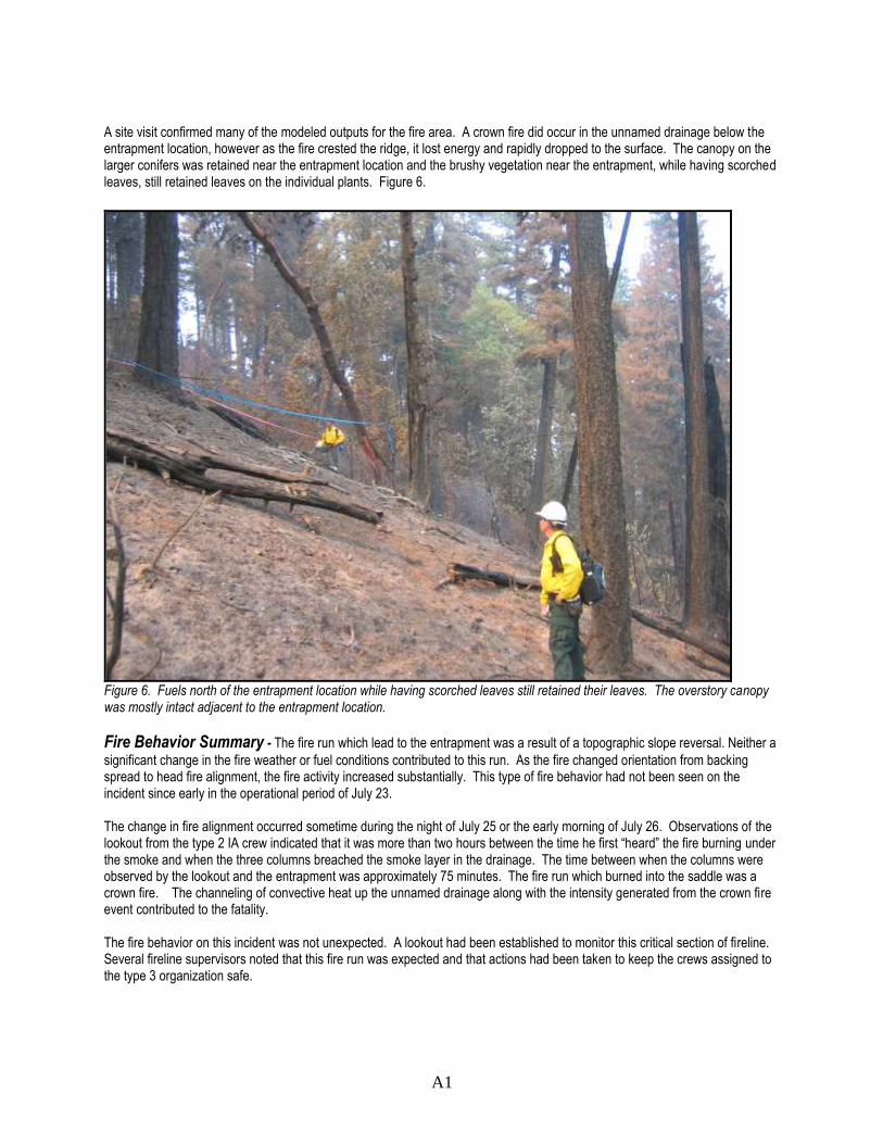
A site visit confirmed many of the modeled outputs for the fire area. A crown fire did occur in the unnamed drainage below the entrapment location, however as the fire crested the ridge, it lost energy and rapidly dropped to the surface. The canopy on the larger conifers was retained near the entrapment location and the brushy vegetation near the entrapment, while having scorched leaves, still retained leaves on the individual plants. Figure 6.
Figure 6. Fuels north of the entrapment location while having scorched leaves still retained their leaves. The overstory canopy was mostly intact adjacent to the entrapment location.
Fire Behavior Summary - The fire run which lead to the entrapment was a result of a topographic slope reversal. Neither a
significant change in the fire weather or fuel conditions contributed to this run. As the fire changed orientation from backing spread to head fire alignment, the fire activity increased substantially. This type of fire behavior had not been seen on the incident since early in the operational period of July 23. The change in fire alignment occurred sometime during the night of July 25 or the early morning of July 26. Observations of the lookout from the type 2 IA crew indicated that it was more than two hours between the time he first ―heard‖ the fire burning under the smoke and when the three columns breached the smoke layer in the drainage. The time between when the columns were observed by the lookout and the entrapment was approximately 75 minutes. The fire run which burned into the saddle was a crown fire. The channeling of convective heat up the unnamed drainage along with the intensity generated from the crown fire event contributed to the fatality. The fire behavior on this incident was not unexpected. A lookout had been established to monitor this critical section of fireline. Several fireline supervisors noted that this fire run was expected and that actions had been taken to keep the crews assigned to the type 3 organization safe.

A2
Personal Protective Equipment Analysis This report is based on witness statements, photographs, examination of the entrapment site, and the examination of the equipment found at the entrapment site. Due to fire activity of the Panther Fire, the fire shelter was recovered and inspected on August 14. The clothing and the fire shelter were further examined on October 6 and 7 at the Washington State Patrol – Forensic Laboratory Services in Seattle by a Forest Service Missoula Technology and Development equipment specialist and two Washington State Patrol forensic scientists.
Deployment Site This site was exposed to high intensity, long duration radiant heat and flame contact. The firefighter was found fully inside the fire shelter in the face down position; feet were in the downhill end of the shelter. The site was a small clearing (15 to 20 feet diameter) completely surrounded by brush, down fuels, and timber. Two handtools were found at the site with the wood handles of the tools completely consumed. Two line gear packs found below the site were consumed except for noncombustible metal items.
Fire Shelter DIVS 1: New Generation Fire Shelter, Revision D Manufacturer: Unknown, label presumably burned away Outer shell – Delamination of the aluminum foil and silica cloth occurred throughout the outer shell of the shelter. Much of the foil (95%) of the outer shell of the fire shelter had burned away. The majority of the remaining aluminum foil was located on the left side of the shelter at the uphill end. The silica cloth at the downhill end was brittle due to the long duration of heat – there was an 8-inch tear in the downhill end. The silica cloth remained intact in the other sections of the shell. Inner shell – Delamination of the aluminum foil and fiberglass cloth occurred throughout the inner shell of the shelter. Most of the foil at the downhill end of the shelter burned away, while most of the foil remained at the uphill end. The fiberglass cloth was brittle in an area (6 by 20 inches) at the downhill end while at the midsection and uphill end of the shelter the fiberglass was still intact. Floor – Delamination of the aluminum foil to the silica cloth occurred throughout much of the shelter floor. Most of the foil at the downhill end was burned away. Due to the long duration of heat, the silica cloth at the downhill end was brittle; the right foot area had a 10-inch tear, the left foot area had a 3-inch tear. The foil remained laminated to the cloth in areas that were covered by the firefighter; under the midsection, elbows, and head. Seams – All seams remained intact, the aluminum foil remained in the area of most seams. Shake handles – A small (1/4 by 2 inch) charred piece of the left shake handle remained. There were no remains of the right shake handle. PVC Bag – Not found at site, presumed burned. DIVS 2: New Generation Fire Shelter, Revision D Manufacturer: (NEED FURTHER EXAMINATION) The shelter showed no structural damage. DIVS 2 reported no difficulty in tearing open the shelter PVC bag or shaking the shelter open. The fire shelter was found next to the 14N05 road where DIVS 2 was picked up by the ICT3 trainee in his truck.
Personal Protective Equipment (PPE) Required PPE – Flame-resistant pants and shirt, hardhat, gloves, and boots DIVS 1: Shirt – GSA, Manufacturer: Terry Manufacturing Co. Inc. Material: 98 percent Aramid, 2 percent Carbon Core, color – yellow Date of Manufacture: Label not fully legible, mid-1990s Size: X-Large Manufactured compliant and certified to NFPA 1977, 1993 edition

A2
Condition: The shirt was intact. The material of the back of shirt was stiff and charred except where tucked into pants. There was more char on the left side than the right. There was what appeared to be melted nylon webbing from the radio harness on left side. There was no char underneath the radio harness webbing. The char pattern on the sleeves appeared as if the elbows were bent with hands near the face. Front of shirt showed much stiffness and char on the left side. It was mostly yellow with some stiffness and char on the right. Pants – Manufacturer: Barrier Wear, Inc. Material: Label not fully legible, it appears to be Kevlar/Nomex (Aramid) blend, rip-stop weave, color – dark green Date of Manufacturer: Label not fully legible Size: L/32 Manufactured compliant and certified to NFPA 1977, 2005 edition Condition: The right lower pants leg is burned away. Back of pants legs showed extensive char with some areas burned away. The front of the left pants leg and lower torso was green where the material was in contact with the ground, dye sublimation and char showed where the material was not in contact with the ground. The material under the belt was green. Gloves – Manufacturer: Wells Lamont Material: 100 percent cowhide leather Size: Large Condition: Both gloves were cut, apparently to remove. Leather showed no signs of heat; they were still soft and pliable. Hard Hat – Manufacturer: Mine Safety Appliances Co. Style: Wildland T, full brim, color – red Material: Polycarbonate Condition: Softened and partially melted, then hardened Boots – Logger style Manufacturer: Unknown Condition: Only the left boot was recovered. Medial half of boot was burned away, remaining leather was charred and stiff. Undergarments Undershirt: none recovered. Briefs: 100 percent cotton Socks: Only one recovered, appeared to be wool DIVS 2: PPE showed no signs of heat or damage.
Conclusions The fire was too hot and the duration of heat was too long for the fire shelter to provide sufficient protection. The fire shelter was exposed to more heat at the downhill (foot) end. Based on the condition of the materials, the temperatures were lower inside the shelter than outside. Temperatures appeared to be lowest near the breathing level of the firefighter. Material – Conditions and Corresponding Temperatures:
Silica cloth – Brittle Estimated 2,000 degrees F
Fiberglass – Brittle 1,350 to 1,610 degrees F
Aluminum Foil – Melt 1,220 degrees F
Aramid Cloth – Char 824 degree F
Aramid Cloth– Stiff/Brittle 710 degrees F
Foil/Shelter Cloth Bond – Delamination 500 degrees F
Aramid Cloth Dye – Sublimation 400 degrees F
Hardhat Polycarbonate – Softens 325 degrees F

A3
Weather Summary Background: The Panther Fire was ignited by a nocturnal lightning event (strike was at 00:21 PDT on July 22) in a
thunderstorm associated with the passage of a weak low pressure trough across northern CA. There were just brief showers with the thunderstorm cells, with .07‖ at nearby Somes Bar RAWS. It is not known how much precipitation came with the Panther lightning, but it was very likely a similarly small amount. Initial discovery of the fire was delayed until July 23rd due to the pervasive layer of smoke throughout western Siskiyou County caused by other large wildfires that had been ongoing since June 20-21st. Following the trough passage, larger-scale high pressure slowly expanded into northwest CA from the south in the mid to later part of the week.
July climatology for the western Klamath NF: The weather in summer typically follows well defined 24-hr cycles,
being driven mainly by the effects of differential solar heating on the varying aspects as the day progresses. On sunny days in July, the Klamath River canyon typically has peak temperatures in the upper 90s, and can exceed 110°F in stronger heat waves. Normal diurnal temperature variations range from over 40 degrees in canyon bottoms (e.g. max 97°F and min 56°F at Sawyers Bar on the Salmon River) to about 20 degrees on ridge tops. On the mountain slopes, SE to SW facing aspects can be 5 to 10 degrees warmer than the north-facing (coolest) aspects. Late-July relative humidity minimums are in the 17-22% range in this area, but can vary from the upper single digits to over 30%. At nighttime there is a typically a much bigger humidity difference between ridge tops and canyon bottoms than exists during the heat of the day. Corresponding to the large diurnal temperature swings in canyon bottoms are large relative humidity variations. Midslope locations (such as the Panther Fire site) are often fairly mild at night relative to the cooler air in the drainage below. Midsummer is the time of year when the jet stream is well to the north and significant Pacific frontal systems are least likely to occur in California. Within the deep canyons of the western Klamath NF, the local up canyon afternoon winds are channeled according to how drainages are oriented. On the high slopes and ridge tops gradient winds are more easily felt, due to less block-age and friction. However, over this higher terrain there can also be significant eddying and turbulence on the lee side of the ridge tops. On the intermediate slopes, such as where the Panther Fire was, winds are commonly lighter than in the canyon bottoms or high ridge tops. These mid-slope winds typically favor light upslope in the morning and then become a bit stronger and flow more up the intermediate sized drainages in the afternoons. They also feel a small gradient wind component if sufficiently exposed to the direction of that wind. Peak daily gusts usually occur between 1600-1900 PDT in late July.
Inversions: No description of western Klamath NF climatology is complete without talking about inversions. Strictly
speaking, an inversion is when temperature increases with height, but any stable layer that holds smoke in layers, with little rise, is often generically referred to as a ‗smoke inversion‘ by fire personnel. This situation often exists from canyon bottom up to around mid-slope (the thermal belt) during the later night to early or mid morning hours. Night and morning inversions are a way of life in Klamath River country, tending to strengthen and last longer as you transition past midsummer and toward fall. During widespread fire events within the northwest mountains of California, there are periodic accumulations of general area drift smoke, as well as local thick pockets near active fires. Sometimes this can make inversions last well into the afternoon, and as late summer is reached (with its decreasing day length and lower sun angle) that situation becomes even more likely.
Terrain description: The Panther Fire site is in rugged mountains between the Klamath River and the western flank of the
Marble Mountain Wilderness. This is very steep terrain, often having 3000-4000 ft elevation differences between the drainage bottom and local main ridge tops. The main drainage was Ukonom Creek, which lies southwest of the Panther fire, flowing from SE to NW before joining the Klamath River.

A3
Figure 1. California and Nevada Smoke and Air Council (CANSAC) surface wind map for July 23 to July 25, 2008. The approximate location of the Panther Fire is represented by the red triangle.
Weather on July 23-25th: The governing larger-scale weather pattern showed no significant changes over northern
California during this three-day period. There was a moderate (for summertime) southwesterly flow aloft over far northwest California, being in the boundary region separating low pressure in the northeast Pacific from strong high pressure over the southwestern United States. The lower atmospheric gradient winds were light NW to NE at night (typically felt just on the area‘s higher slopes). In the afternoon, winds would transition to become WSW to NW 5-10 mph, Figure 1. There was a typical mid summer coastal marine layer of 1000-1500‘ in depth, though coastal fog was not necessarily widespread and continuous each day.
Weather on July 26th: The large-scale governing pattern remained unchanged. In the Saturday morning forecasts,
National Weather Service forecasters for this area were calling for an increase in afternoon winds relative to previous days, as well as a little warmer and drier conditions than they had previously called for in forecasts issued Friday. Just about all fire personnel interviewed seemed to have been made well aware of this on Saturday, and were heads up for a change toward possibly more critical fire weather. Several said they either felt the winds a little earlier on Saturday, or the afternoon gusts did seem a little more frequent and stronger, or both. Sea-level pressure gradients from Arcata to Redding were about 4 millibars, which is no tighter than average, and perhaps a bit weaker.

A3
Role of weather on fire activity: It is felt that the fire run which lead to the entrapment was the result of the fire finally
positioning itself in a place favorable to make a run up to the ridge top, rather than any significant change in weather. The slight wind increases and earlier onset of winds observed on the 26th likely aided the uphill fire run in the mid-afternoon, but even with the same winds as the day before, the run probably would have occurred, though perhaps just a little later in the day. Regarding lower atmospheric stability, forecast indices on the 26th (such as those used to help predict thunderstorms) showed that the air mass would remain marginally stable in western Siskiyou County throughout the afternoon, which seems to have verified correctly. In the case of the Panther fire, the heat of the fire itself may have been the greatest source of local instability. So while weather played a role in the entrapment, it wasn‘t the primary factor. A synopsis of belt-weather kit data over these four days are shown below, Table 1. A list of all weather observations is shown in Table 2. There is little temperature or wind change between July 23 and July 25, but a drying trend was in place. On July 26, the only observation that included gusts shows ‗sustained gusts 10 mph‘. This was taken at the time fire activity was observed to be picking up (around 1430 PDT).
Date Maximum Temp (°F)
Minimum Relative Humidity (%)
Afternoon Winds (Direction and Speed, mph)
Wind Gusts (mph)
7/23 77 39 Upslope to SW, 1-3 NA
7/24 77 32 Upslope, SW & NW, 1-3 NA
7/25 80 26 Upslope, SW & W, 1-3 4-6
7/26 77 29 Upslope, 1-3 10
Table 1. Synopsis of on-site weather readings
Note – Some degree of smoke was in place throughout the incident. A variation from light to heavy smoke conditions can alone have greater effects on temperature and relative humidity than subtle air mass changes might, due to the effects of shading by that smoke. The minor cooling and relative humidity increase on July 25 compared to July 26 might be due to the generally greater smoke amount present that day.

A3
Date/ Time
Observer Group
Loca. / elev aspect/ time
Sky/ smoke observation
T DRY
TWET
RH
Wind Direc
Wind Speed
Remarks
7/23 Smoke- jumpers
NA / NA NA/1600 PDT
Not stated (vrbl smoke)
77 60 39% Upslope 1-3 mph
Precise location not noted
7/23 ― ―
NA / NA NA / 1900
Not stated (vrbl smoke)
72 58 44% Upslope 1-3 Precise location not noted
7/23 ― ―
NA / NA NA / 1900
Not stated (vrbl smoke)
70 51 51% Upslope 1-3 Precise location not noted
7/24
American River HS
Ridgetop/3200 South/ 1200
Not stated (vrbl smoke)
70 59 53% South 1-2 Dew Point – 52 Site – timber canopy & brush
7/24
― ―
Ridgetop/3200 South/ 1300
Not stated (vrbl smoke)
74 61 48% Varying Upsl/ N
1-2 Dew Point – 53 timber canopy & brush
7/24
― ―
Ridgetop/3200 South/ 1400
Not stated (vrbl smoke)
77 58 32% Upslope to NW
1-2 Dew Point – 45 timber canopy & brush
7/24
― ―
Ridgetop/3200 South/ 1500
Not stated (vrbl smoke)
75 60 42% Upslope to NW
1-2 Dew Point – 51 timber canopy & brush
7/24
― ―
Ridgetop/3200 South/ 1600
Not stated (vrbl smoke)
75 60 42% Upslope to NW
1-2 Dew Point – 51 timber canopy & brush
7/24
― ―
Ridgetop/3200 South/ 1700
Not stated (vrbl smoke)
74 59 42% South
1-3 Dew Point – 49 timber canopy & brush
7/24
― ―
Ridgetop/3200 South/ 1800
Not stated (vrbl smoke)
72 59 47% South 1-3 Dew Point – 51 timber canopy & brush
7/24
― ―
Ridgetop/3200 South/ 1900
Not stated (vrbl smoke)
70 59 53% South 1-2 Dew Point – 52 timber canopy & brush
7/25
Smoke- jumpers
NA / NA NA/ 1300 PDT
Not stated (vrbl smoke)
72 58 45% Calm 0 Gusts to 3 mph
7/25
― ―
NA / NA NA / 1400
Not stated (vrbl smoke)
76 60 41% NA NA Gusts to 4 mph
7/25
American River HS
Slope / 3400‘ North / 1000
Not stated (vrbl smoke)
64 60 80% Calm Dew Point - 58 timber canopy & brush
7/25
― ―
Slope / 3400‘ North / 1100
Not stated (vrbl smoke)
65 56 58% Calm Dew Point – 50 timber canopy & brush
7/25
― ―
Slope / 3400‘ North / 1200
Not stated (vrbl smoke)
67 57 55% Upslope to NW
1-2 Dew Point – 50 timber canopy & brush
7/25
Happy Camp IA
Slope / 3600‘ West / 1100
Not stated (vrbl smoke)
60 57 79% Upslope 0-1 Timber
7/25
― ―
Slope / 3600‘ West / 1200
Not stated (vrbl smoke)
70 58 49% Upslope 0-1 Timber
7/25
― ―
Slope / 3600‘ West / 1400
Not stated (vrbl smoke)
78 59 32% SW 1-3 Gusts 4-5 mph Timber
7/25
― ―
Slope / 3600‘ West / 1500
Not stated (vrbl smoke)
80 58 26% W 1-3 Gusts 4-6 mph Timber
7/26
American River HS
Ridge / 3400‘ Saddle/ 0800
Not stated (vrbl smoke)
56 50 67 Calm 0 Dew Point – 45 timber canopy & brush
7/26
Ridge / 3400‘ Saddle/ 0900
Not stated (vrbl smoke)
60 51 55 Upslope to south
1-2 Dew Point – 44 timber canopy & brush
7/26
― ―
Ridge / 3400‘ Saddle/ 1000
Not stated (vrbl smoke)
61 51 51 Upslope to south
1-2 Dew Point – 43 timber canopy & brush
7/26
― ―
Ridge / 3400‘ Saddle/ 1100
Not stated (vrbl smoke)
64 52 45 Upslope NW
1-2 Dew Point – 42 timber canopy & brush
7/26
― ―
Ridge / 3400‘ Saddle/ 1200
Not stated (vrbl smoke)
68 53 37 Upslope NW
1-2 Dew Point – 41 timber canopy & brush
7/26
― ―
Ridge / 3400‘ Saddle/ 1300
Not stated (vrbl smoke)
73 55 31 Upslope to south
1-2 Dew Point – 41 timber canopy & brush
7/26
― ―
Ridge / 3400‘ Saddle/ 1400
Not stated (vrbl smoke)
74 55 29 Upslope to south
1-2 Dew Point – 40 timber canopy & brush
7/26
― ―
Ridge / 3400‘ Saddle/ 1500
Not stated (vrbl smoke)
74 56 32 Upslope N
1-2 Dew Point – 42 timber canopy & brush
Smoke-jumpers
NA / NA NA/ 1430 PDT
Not stated (vrbl smoke)
NA
NA
NA
Up-slope?
NA
sustained gusts to 10 mph
7/26
Happy Camp IA
Ridge / 3800‘ South / 1400
Not stated (vrbl smoke)
77 63 47 SW 1-3 timber canopy & brush
Figure 2. All onsite weather observations from the Panther Fire, July 2

A4
Expanded Narrative Dry lightning passed through the Happy Camp area and started the Panther Fire on July 22 at approximately 0021 hours. The actual discovery of the Panther fire occurred on the morning of July 23 when it was observed on an infrared map of the area. The local Fire Management Officer (FMO) assigned initial attack resources to the reported fire. This included the Assistant Fire Management Officer (AFMO) who was assigned as the Incident Commander Type 4 (ICT4) and a 10 person module of the local Type 2IA crew. The ICT4 and the 10 person module left Happy Camp to recon the area on the IR map and verify the existence of the fire. All of these individuals were from the area and were very familiar with local strategies, tactics and mitigations. The ICT4 was able to verify the fire and its location when the inversion broke and allowed the smoke to be visible. The Ukonom Mountain Lookout confirmed the fire‘s location at the same time, and reported five separate smoke columns in the immediate area fire. The Siskiyou Complex Air Attack flew over the fire and reported a single fire with an estimated size of 50 acres. The ICT4 ordered additional resources including four Type 1 air tankers, helicopter support, Smokejumpers and four Type 1 or IHC crews. The ICT4 had an initial strategic objective to keep the fire as small as possible. He implemented tactics to attempt to create an anchor point at the bottom left corner of the fire and stop the fires advancement to the west by constructing fire line up the left flank. Total initial attack resources committed during the first burn period included the following:
10 smokejumpers
1 Interagency Hotshot Crew (IHC)—last day of availability
1 Local T2IA (augmented to full Crew)
4 T1 Air tankers
Helicopters shared from the Siskiyou Complex Heavy helicopters were used to keep the fire in check on the Southwest corner and across the bottom of the fire. The hand crews were not able to reach the bottom of the fire to create an anchor point due to fire behavior concerns. As a result, the crews anchored in mid-flank, spreading along the left flank and working towards one another. The T2IA crew was lowest on the flank with the IHC in the middle and the Smokejumpers highest working towards the ridge top. The air tankers were used to put retardant across the ridge top and partway down the right flank. Retardant was also used below the crews on the left flank. The fire made a short duration crown fire run up the right flank that ran to the ridge top and stopped at the retardant line. This fire run created good safety zones inside the fire perimeter that allowed the Incident Commander to consider tactical actions on the right flank on July 25 and 26. The FMO ordered an Incident Commander Type 3 (ICT3) and notified the ICT4 at 1530 hours. This represented the first recognition of the fires increasing complexity and is the transition point from initial

A4
attack to extended attack1. Word was also passed to the ICT4 that a replacement Type 1 crew might be assigned the next day, but was later notified that the Type 1 crew would not be coming. The ICT4 responded that ―There was no getting around this fire without at least one Type 1 crew‖. He also requested that the general weather forecast be read the following morning. The IHC left the fire at approximately 2145 hours to return to Happy Camp. They were released the following morning for mandatory days off. All other personnel remained assigned to the fire and were off the fire line and at Drop Point 15 (DP-15) by 2200 hours. July 24 The official transfer of command from the ICT4 to the ICT3 occurred at 0900 hours. The ICT4 was then assigned as trainee to the incoming ICT3. Several additional resources and miscellaneous overhead also arrived at this time including: two task force leaders (TFLD), a replacement IHC (mid-morning arrival), a Strike Team Leader, Crew (STCR) with trainee supervising three Type 2 (T2) crews. Additionally, a dozer arrived supervised by a Strike Team Leader, Dozer (STDZ). These assigned resources represented what staffing capability was available, but did not equal the ICT4‘s initial resource request of four Type 1 crews. All resources from the day before and newly arrived resources met the incoming ICT3 and ICT3 (t) (Trainee) at 0900 hours. The resources were briefed and assigned as follows:
TFLD‘s assigned to scout respective flanks for assignment as Divisions on the following day
T2IA crew: Continue downhill line construction on left flank.
Smokejumper module: Finish uphill line construction on left flank and continue across the ridge top to the east.
T2 crew A, T2 crew K and T2 crew O: Construct/improve P-line, construct indirect line from Drop Point 16 (DP-16) to the first knob to the west.
Dozer: Open 14N05 road from DP-16 to west.
Type 1 crew: Late arrival -- assigned to left flank line construction with the T2IA crew.
1 Extended Attack transitions occur when initial attack forces cannot contain the fire and there is no estimate of
containment within the first 24 hours.

A4
""
""
d
â
!
Helispot, Camp & Jump Spot
Trail used by Smokejumpers
DP-16
Personnel Line
First KnobGO
OD B
LACK
Escape Route
High Knob
Right Flank
Left Flank
0 0.50.25
Miles
1:12,000
One smokejumper scouted the fire perimeter and used a GPS unit to measure the fire‘s size. This mission revealed that the fire had grown to approximately 170 acres. The fire had tripled in size from the original estimate from the Siskiyou Complex Air Attack on the previous day. The Smokejumper reported heavy fuels with several large logs burning in the Southwest corner of the fire. The fire spread was described as slowly backing downhill with isolated pockets of torching occurring in the heavier pockets of brush. He described two fingers of black that were backing into the unnamed drainage below the saddle on the right flank. The upper finger had minimal heat and had stopped in the rocks. The lower finger was located low on the right flank with fire actively backing towards the drainage bottom. The Smokejumper‘s assessment was that the fire would stay put through the rest of the burn period. Fire line construction on the left flank continued with slow progress. Crews were still unable to create an anchor point in the bottom left corner of the fire. The ICT3 reported that ―There was limited success with line construction on the west side and no anchor point was established on the bottom of the fire.‖ All resources were off the fire by 2000 hours and at DP-15 for the night.

A4
July 25 The morning briefing occurred at 0700 hours. Weather was included in the briefing was from a spot weather forecast. Temperature: 90-94. Relative Humidity: 23-28. Winds: upslope, up drainage, 2-3 mph becoming northwest 3-5 mph in the afternoon. Division breaks were identified and the fire was split into two divisions; Division E on the right flank and Division Z on the left flank. TFLD‘s had been assigned the previous day and knew the assigned resources hazards and mitigations they faced. Assignments given to resources were as follows: Division E
Type 1 crew: Continue line construction down left flank.
T2IA crew: Continue line construction down left flank.
T2 Crew O: Hold upper part of Division. Division Z
Smokejumpers: Complete line across top and start down right flank. Short squad to scout and watch Southeast corner.
T2 Crew K: Hold upper part of Division.
T2 Crew A: Improve p-line from east knob (first knob west of DP-16) to Saddle.
Dozer: Finish road improvement on 14N05 road west of DP-16.
""
""
d
â
!
Helispot, Camp & Jump Spot
Trail used by Smokejumpers
GO
OD B
LACK
Trail used by Smokejumpers
Indirect Line
First KnobGO
OD B
LACKEscape Route
High Knob
DP-16
)(
)(Div E
Div Z
Area of
Concern
UN
NA
MED
D
RA
INA
GE
0 0.50.25
Miles
1:12,000
The short squad of Smokejumpers continued their attempts to establish an anchor point at the bottom of Division Z and to check the fire‘s spread into the unnamed drainage paralleling the east flank.

A4
The lower of the two fingers had continued to back towards the bottom of the unnamed drainage over night. The smokejumpers constructed a temporary fire line—a check line from the fire‘s edge. This check line extended from the bottom finger and tied into a small creek in the bottom of the unnamed drainage. They recognized that this location was a critical holding point. If the fire became fully established on both sides of the unnamed drainage, then it would be in alignment with the slope and aspect, creating the opportunity for the fire to run up the drainage through the saddle on the ridge. This run had the potential to compromise the entire right flank of the fire. Increased fire behavior forced the constructed hand line in Division E to become more indirect. Helicopter bucket drops were used across the bottom and especially at the corners of each flank to keep fire activity in check until the inversion reestablished and fire activity abated. Line construction on all parts of the fire was minimal on this day (July 25) and resources were still unable to establish any anchor points at the bottom of the fire. The ICT3 and Trainee departed the fire area to prepare an Incident Action Plan (IAP) and brief the FMO at Happy Camp. They notified Divisions E and Z of their departure and left instructions to complete the shift and ensure that all personnel made it back to the camp site at DP-15 no later than 2130 hours. The ICT3 and Trainee completed an IAP and validated their plans with the FMO. They also discussed the need to transition command to a higher level organization. These discussions resulted in the decision to transition the fire into the Siskiyou Complex. The official transfer of command was scheduled to take place at 0600 hours on July 27. The ICT3 and Trainee discussed tactics for the following day on their return trip from Happy Camp to DP-15. They recognized that there had been limited success during the previous three days towards containment of the fire. They came up with a new plan for the following day. ―In talking it over with the Trainee, we decided that without an anchor on the bottom, any kind of direct line starting from the top of the fire to the bottom wasn‘t going to work. So the plan for the third day [from Type 3 transition day, July 26], the day of the entrapment, was to scout the fire. Get to the bottom of it—anchor it to the bottom and we were hoping to be able to go both east and west and come up the flanks.‖ (ICT3). The ICT3 and Trainee arrived at DP-15 at approximately 2200 hours.

A4
July 26, Saturday—Accident Day
At 0600 hours the Trainee conducted the morning briefing. The briefing included basic fire line safety and informed the crews that Siskiyou Complex would be sending people over to scout the fire. During the briefing, the ICT3 and Trainee discussed forecast weather conditions and changing the tactical approach to the fire for the day. They intended to hike down through the black to get to the bottom of the fire and create an anchor point. From there, they intended to initiate fire line construction up through Division Z. The morning briefing emphasized the change in the weather forecast compared to previous days. The days forecast called for lower relative humidity and increasing afternoon winds—6 to 12 MPH with gusts to 20 MPH from the west. This forecast represented a significant change to the weather observed over the previous three days. The Trainee realized the forecast wind change—if realized, would have a significant and adverse effect on fire behavior. The Trainee directed the IHC Superintendent (Supt.) to scout the right flank of the fire to validate the plan relative to how much the fire had moved overnight. This reconnaissance of the fire revealed that the fire had crossed the unnamed drainage and become fully established on both sides. The ICT3 and Trainee recognized the potential for the fire to make a crown fire run similar to that seen during initial attack on the first day. The Trainee recognized and discussed the danger of having people on the indirect line above the fire with the crews. This information, coupled with the weather forecast, caused the Trainee to abandon his initial plan of going direct, which had been discussed at the morning briefing. Personnel assignments were made to reflect this change and crews started to engage on their new assignments at approximately 1030 hours. Planned mitigations included early identification of changes in fire behavior and early activation of escape routes.
Smokejumpers: Staged on the top of the high knob (Division Break on the ridge top).
DIVS E and DIVS Z: Assess opportunities on their respective divisions.
IHC and T2IA crew: Convert the P-line on the ridge to indirect hand line from DP-16 up to the high knob at the top of the fire.
o T2IA crew: Continue indirect fire line from where to T2 crew had ended on the previous day at the first knob east of DP-16 into the saddle.
o IHC: Construct fire line from the saddle up to the fires edge just below the high knob near the division break.
Two Division Group Supervisors (DIVS 1&2) had arrived at Siskiyou Complex, Orleans Base Camp the previous evening and were on their first day of this fire assignment. They met the Branch Director (Branch) at the Siskiyou Complex morning briefing and were assigned to the Panther Fire as Division Group Supervisors. Their assignment from Branch was to scout the Panther Fire to orient themselves to the terrain, fuels, staffing and critical existing concerns. The intent was to prepare a strategy for the following day when command was transferred to Siskiyou Complex.

A4
At 0930 hours, DIVS 1&2 met the local District FMO along the 15N17Y road while on their drive to the Panther Fire. During this impromptu briefing, the FMO pulled out a map of the District and provided information about fire history, steep terrain, and the fire behavior common to the Klamath National Forest. The FMO expected the fire to increase in size and advised DIVS 1&2 that the fire would likely cross Ukonom Creek. This briefing included general safety issues, the crew‘s work and their successes and the likely inability of the14N05 road to hold the fire if the winds increased. The briefing took approximately 40 minutes. DIVS 1&2 arrived on the Panther Fire at Drop Point 16 (DP-16). Each was driving their own vehicle at approximately 1000 hours. The Trainee provided a thorough in briefing regarding events from initial attack through the present. He covered the lack of progress, the inability to establish an anchor point on the bottom of the fire and the fact that they were forced to construct indirect fire line. He also voiced his concern about the fire making a run up the right flank through Division Z. This concern was based on the information gleaned from the reconnaissance and the morning‘s forecasted weather. An IAP was provided to both DIVS 1&2 as well. This briefing also emphasized the difficulty the terrain posed to line construction and the difficult travel through the heavy fuels. The Trainee also indicated that the three T2 crews did not have the experience to effectively build fire line due to lack of familiarity with the terrain and fuel type. The Dozer was also not effective in this terrain and was only used to widen the 14N05 road and in support of the T2 crews building line well in advance of the predicted growth of the fire. The crews and equipment available to the Panther Fire appeared, on paper, to be much more capable than they actually were. ―…only two crews were able to get on the fire. The other three from the East were not able.‖ (DIVS 2). Branch from the Siskiyou Complex arrived at the Panther Fire after the first briefing. The Trainee gave essentially the same briefing again for the benefit of Branch. DIVS 1&2 remained and listened to this briefing as well. During this briefing, the fire activity increased with a ―poof through the inversion‖ being reported by a lookout from the T2IA crew. This increase in fire activity was enough to cause the IHC and T2IA crews to disengage from the indirect line and pull back to DP-16. The crews arrived back at DP-16 while the Trainee was still conducting his briefing with Branch and DIVS 1&2. DIVS 1&2 wanted to initiate their scouting mission at the conclusion of the in briefing. The Trainee recommended that DIVS 1&2 only scout the 14N05 road rather than go on the fire line due to the uncertainty associated with existing fire behavior. The Trainee and ICT3 both reported that the warning, not to go on the line was clearly communicated. However, DIVS 2 stated that this was not understood to be a warning. Crews were waiting at DP-16 pending a change in condition. DIVS 1&2 departed DP-16 and scouted the 14N05 road. The Trainee and ICT3 departed DP-16 between 1230 and 1300 hours to complete some logistics missions at DP-15.

A4
The IHC and T2IA crews reengaged on the indirect fire line while DIVS 1&2 scouted the 14N05 road to its end. The T2IA crew started work widening the P-line from where the T2 crew had stopped the previous day, just below the first knob west of DP-16. Their intent was to continue the indirect fire line into the saddle. The IHC hiked down the 14N05 road to a point just below the saddle where they had constructed an escape route extending from the road to the saddle. They also intended to convert the p-line into indirect fire line on the ridge. DIVS 1&2 met the IHC on the 14N05 road as the crew was hiking toward the escape route. DIVS 1&2 had a brief discussion with the Supt. which ended with DIVS 2 saying, ―We‘ll tie in with you on the line‖. The fact that the crews were reengaging led DIVS 1&2 to assume the fire line was safe for them to continue their scouting mission. This assumption is support by DIVS 2 statement, ―But they had reengaged all of the resources back on the line and so it seemed like a natural thing for us to do, was to go out and assess the crews and see what is going on.‖ DIVS 1&2 then drove back to DP-16 and at approximately 1400 hours, they started to hike the indirect line (P-line) that connected DP-16 to the saddle and ultimately led to the high knob at the division break. Based on their briefing, DIVS 1&2 understood that the division break was a safety zone with ―good black‖. At 1415 hours, DIVS 1&2 met with the Saw Boss from the T2IA crew. They conversed with crew members in order to understand the mood and capability of the personnel they were assigned to supervise the next day. At nearly the same time the T2IA lookout warned the IHC on the assigned tactical frequency of ―increased fire activity below the indirect line‖. The Saw Boss told DIVS 1&2 that his own crew was ordered to withdraw. DIVS 1&2 continued along the indirect line towards the saddle and the IHC location. The T2IA lookout made another call to the IHC at approximately 1430 hours reporting ―increased fire behavior and that the column was breaking through the inversion.‖ This information was a clear indication to the personnel assigned to Panther Fire of increasing fire activity and the need to disengage. It also was a reflection of what the crews had been concerned about during the morning briefing. Crew‘s supervisors then made the determination to withdraw from the fire line. DIVS 2 stated during his post accident interview, he heard the radio transmissions, but did not perceive them to be warnings. From his perspective there was no reason to discontinue their reconnaissance. Upon hearing the transmissions from the lookout, the Trainee made radio contact with DIVS 1 and asked his position. DIVS 1 reported that he and DIVS 2 were on the indirect line close to the IHC in the saddle. This came as a surprise to the Trainee and ICT3, as they assumed DIVS 1&2 were only scouting the 14N05 road. Meanwhile, the Supt. verified the reports of increased fire activity. He determined the report was correct. He also heard the radio transmission between DIVS 1 and the Trainee stating they were with his crew. The Supt. radioed his crew that fire activity had increased below their position and the crew was to prepare to disengage.

A4
At approximately 1500 hours, DIVS 1&2 met the Supt. in the saddle. The Supt. was pulling his crew together and directing them to leave the indirect line, move down the escape route to the 14N05 road and then back to DP-16. DIVS 1&2 listened to the Supt. brief his crew about the fire activity. DIVS 2 asked how far it was to the black (Division Break, high knob). The Supt. replied ―Two to three-hundred yards through a thick piece of ground.‖ DIVS 2 then stated, ―We are going to go to the next knob, to the black, to the safety zone there.‖ DIVS 1&2 then departed the saddle heading west. (Supt., DIVS 2). The Supt. ―…walked along [the] ridge to the east to look for opportunities to pick up the fire after it slopped the ridge.‖ As the Supt. returned to the saddle he looked for DIVS 1&2, then followed his crew down the escape route to DP-16. In his statement the Supt. indicated the fire hit the ridge between 1510 and 1515 hours. ―The fire hit the ridge all across the ridgeline [from] a half mile west of DP-16 to the west [of the saddle] another 200 yards against the hard black just short of the 3971 elevation knob‖ (Division Break). He also stated, ―I witnessed extreme fire behavior with flame lengths exceeding 100 ft‖. Having never been west of the saddle, DIVS 1&2 could only estimate the time needed to reach the safety zone at the Division Break. DIVS 1&2 recognized that fire conditions had changed and their position was in jeopardy. ―Up or down?‖ DIVS2 asked. DIVS 1 responded, ―Down‖. They rapidly started retracing their route down the indirect line toward the saddle. Their intent was to use the same escape route that the IHC used to get to the 14N05 road. DIVS 1 radioed to the Trainee, ―We are getting out of harm‘s way.‖ By the time they reached a point where they could see the saddle, the fire was already well established and their escape route was cut off. They then reversed direction again moving up the indirect line. Their intent was now to reach the ―good black‖ at the Division Break. DIVS 1 was in the lead at this time and saw a small opening in the brush. He led DIVS 2 into the opening and stated ―We need to deploy! We need to deploy!‖. (DIVS 2). DIVS 1&2 dumped their packs and started to deploy their fire shelters. DIVS 1&2 raked the ground to prepare the site for deployment. While shaking his fire shelter open, DIVS 2 reassessed of his surroundings. He concluded that a shelter could not survive deployment based the fuels surrounding the deployment site and the fire behavior that he saw. He immediately said, ―We need to go down the hill! The shelters won‘t work here! We need to go down the hill! We won‘t survive with deployment!‖ Finally he said, ―Follow me! I am going down the hill!‖ DIVS 1 did not respond. DIVS 2 balled up his shelter under his arm and ran down the hill. DIVS 1 had deployed his shelter and did not follow. DIVS 2‘s escape was difficult. He had to navigate the steep slope through very heavy brush and around emerging spot fires on his way to the 14N05 road below. He stated that there were times that he could not touch the ground; instead he was suspended in the heavy brush. The Trainee drove down the 14N05 road as the fire made its run through the saddle. He was watching to see if the fire was going to spot across the road and compromise the escape of the firefighters. The Trainee was aware that the DIVS 1&2 had been on the fire line and was concerned about their exact location. As the Trainee drove past the escape route at 1520 hours, he encountered DIVS 2 on the road.

A4
Struck by the unexpected location of DIVS 2, he angrily expressed his discontent. Then DIVS 2 told him ―We have bigger problems, DIVS 1 is deployed on the ridge.‖ They looked for DIVS 1 hoping to find him on the road as they proceeded back to DP-16. Within seven minutes, the Trainee called Air Attack and ordered air support to cool down the area they presumed to be the deployment site. Air Attack initiated water drops from the Division Break down to the saddle with seven helicopters. The Supt. notified his Assistant Superintendent (Asst.) that DIVS 1 was missing. The Asst. was at the Division break with the Smokejumpers. They developed a plan to initiate a grid search to try and locate DIVS 1. At 1542 hours, the rescuers were forced to pull back due to the extreme heat of the fire and by requests from Air Attack to clear area for bucket drops.
""
""
d
G
â
!
Helispot, Camp & Jump Spot
Trail used by Smokejumpers
DP-16
)(
)(DIVS 2 Location
DIVS 1 Location
!(
First Knob
Escape Route
High Knob
Div E
Div Z
UN
NA
ME
D
DR
AIN
AG
E
Indirect Line
GO
OD
B
LACK
0 0.50.25
Miles
1:12,000
Air Attack reported at 1642 hours that he thinks that he sees something. DIVS Z requested that Air Attack stop bucket drops for the rescue party to resume search and rescue. At 1650 hours the rescuers located a deployed shelter and informed the ICT3 and Trainee that DIVS 1 did not survive the deployment. The Trainee immediately notified the FMO of the shelter deployment and fatality. The Trainee directed all fire personnel to Independence Bridge at 1650 hours. All personnel were staged at Independence Bridge by 1845 hours.

A5
10 pages of Appendix 5 (A-5)
Autopsy withheld in entirety
Pursuant to FOIA Exemption 6 & 7(C)