fire and invasive plants special feature fire, plant invasions · pdf filefire and invasive...
TRANSCRIPT
Fire and Invasive Plants Special Feature
Fire, Plant Invasions, and Erosion Events on Western RangelandsFrederick B. Pierson,1 C. Jason Williams,2 Stuart P. Hardegree,3 Mark A. Weltz,4
Jeffry J. Stone,5 and Patrick E. Clark6
Authors are 1Research Leader and Supervisory Research Hydrologist, 2Hydrologist, 3Plant Physiologist, and 6Rangeland Scientist, USDA–AgriculturalResearch Service, Northwest Watershed Research Center, Boise, ID 83712, USA; 4Research Rangeland Management Specialist, USDA–Agricultural
Research Service, Exotic and Invasive Weeds Research Unit, Reno, NV 89512, USA; and 5Research Hydrologist, USDA–Agricultural Research Service,Southwest Watershed Research Center, Tucson, AZ 85719, USA.
Abstract
Millions of hectares of rangeland in the western United States have been invaded by annual and woody plants that have increased therole of wildland fire. Altered fire regimes pose significant implications for runoff and erosion. In this paper we synthesize what isknown about fire impacts on rangeland hydrology and erosion, and how that knowledge advances understanding of hydrologic risksassociated with landscape scale plant community transitions and altered fire regimes. The increased role of wildland fire on westernrangeland exposes landscapes to amplified runoff and erosion over short- and long-term windows of time and increases the risk ofdamage to soil and water resources, property, and human lives during extreme events. Amplified runoff and erosion postfire are afunction of storm characteristics and fire-induced changes in site conditions (i.e., ground cover, soil water repellency, aggregatestability, and surface roughness) that define site susceptibility. We suggest that overall postfire hydrologic vulnerability be consideredin a probabilistic framework that predicts hydrologic response for a range of potential storms and site susceptibilities and thatidentifies the hydrologic response magnitudes at which damage to values-at-risk are likely to occur. We identify key knowledge gapsthat limit advancement of predictive technologies to address the increased role of wildland fire across rangeland landscapes. Ourreview of literature suggests quantifying interactions of varying rainfall intensity and key measures of site susceptibility, temporalvariability in strength/influence of soil water repellency, and spatial scaling of postfire runoff and erosion remain paramount areas forfuture research to address hydrologic effects associated with the increased role of wildland fire on western rangelands.
Resumen
Millones de hectareas de pastizales en el oeste de Estados Unidos han sido invadidos por plantas arbustivas y anuales que hanaumentado la funcion de los incendios forestales. La modificacion de los regımenes de fuego implica cambios significativos parael escurrimiento y la erosion. En este documento resumimos lo que se conoce sobre los impactos de fuego sobre hidrologıa y laerosion en pastizales, y como ese conocimiento nos ayuda a comprender mejor los riesgos hidrologicos asociados con latransicion en la comunidad de plantas y con el cambio en los regımenes de fuego. El aumento en la incidencia de los incendiosforestales en los pastizales occidentales expone al paisaje a un aumento en el escurrimiento sobre un periodo a corto y largoplazo y a un incremento en el riesgo de dano a los recursos del suelo, agua, bienes y vidas humanas durante eventos extremos.Un aumento en el escurrimiento y la erosion despues del fuego estan en funcion de los cambios inducidos por el fuego en lascaracterısticas del sitio (es decir la cubierta del suelo, repelencia del agua del suelo, estabilidad de los agregados, y la rugosidadde la superficie) que definen la susceptibilidad del sitio. Sugerimos que se considere en general la vulnerabilidad hidrologica delsitio despues del fuego en un marco probabilıstico que prediga la respuesta hidrologica para un rango de posibles tormentas y lasusceptibilidad del sitio y que identifique la magnitud de respuesta hidrologica donde los danos a los valores en riesgo son masprobables. Identificamos los espacios claves del conocimiento que limitan el desarrollo de las tecnicas predictivas para afrontarel papel en aumento de los incendios forestales a traves de los paisajes de pastizales. Nuestra revision de literatura sugierecuantificar las interacciones de diferentes intensidades de precipitacion y las principales medidas de susceptibilidad del sitio, lavariabilidad temporal en la fuerza/influencia de la repelencia del agua del suelo y la escala espacial del escurrimiento y erosiondespues del fuego siguen siendo areas primordiales para la investigacion en el futuro para concentrarse en los efectoshidrologicos asociados con el creciente papel de los incendios forestales en los pastizales occidentales.
Key Words: cheatgrass, grass–fire cycle, pinyon–juniper, sagebrush steppe, soil loss
INTRODUCTION
Altered fire regimes associated with plant community transi-tions in the Great Basin, United States, have significantimplications on rangeland runoff and soil loss. Larger expansesof Great Basin rangelands are burning each year due to plantcommunity transitions, and, in many cases, are reburning
The US Dept of Agriculture (USDA) is an equal opportunity provider and employer.
This is Contribution Number 39 of the Sagebrush Steppe Treatment Evaluation Project
(SageSTEP), funded by the US Joint Fire Science Program.
Correspondence: Frederick B. Pierson, Research Leader and Supervisory Research Hydrologist,
USDA–Agricultural Research Service, Northwest Watershed Research Center, 800 Park Blvd,
Plaza IV, Suite 105, Boise, ID 83712, USA. Email: [email protected]
Manuscript received 14 October 2009; manuscript accepted 23 June 2011.
Rangeland Ecol Manage 64:439–449 | September 2011 | DOI: 10.2111/REM-D-09-00147.1
RANGELAND ECOLOGY & MANAGEMENT 64(5) September 2011 439

over shorter time intervals (Whisenant 1990; D’Antonio andVitousek 1992; Knapp 1996; Miller and Tausch 2001; Brookset al. 2004; Keane et al. 2008). Frequent and extensive firesincrease the spatial susceptibility of these landscapes toaccelerated runoff and erosion. Greater temporal exposuredue to repeated burning increases potential long-term soil lossfrom frequently occurring low-return interval storms (1- to10-yr events) and increases the likelihood that vulnerableconditions will prevail during less frequent, more damagingintense rainfall events. Numerous reports in the literaturedocument flood events following intense rainfall on largerangeland and forest burns that have resulted in loss of humanlife and extensive damage to natural resources, property, andcity infrastructures (for example see Craddock 1946; Cannonet al. 2001; Moody and Martin 2001; Pierson et al. 2002;Klade 2006; Cannon et al. 2011). Mitigating postfire impactson these values-at-risk is particularly concerning along the ever-expanding wildland-urban interface (Stockmann et al. 2010).
Burned Area Emergency Response teams and resourcemanagers in the western United States are challenged withevaluating fire effects on ecosystems and assessing potentialhazards to values-at-risk. Postfire risk assessments include cost–benefit analyses of mitigation treatments. Treatment expendi-tures and implementation hinge on the value of the resourcesat risk and whether damage to respective values-at-risk willoccur without mitigation (Calkin et al. 2007). The capability ofpostfire assessments to accurately evaluate risk and appropriatemitigation dollars is strongly dependent on advancement inunderstanding of fire effects on ecosystems. Annual expendi-tures on wildfire suppression and postfire mitigation are afunction of risk assessment and fire activity. Billions of dollarsare spent each year in the United States for wildfire suppression,and millions are spent annually on postfire mitigation (GeneralAccounting Office 2003; Stockmann et al. 2010). The costs oflarge wildland fires in the United States can exceed $20 millionper day (Running 2006).
The increasing role of wildfire on Great Basin rangelandsand the potential costs associated with fire management andmitigation require advancement in the understanding of fireeffects and development of risk assessment strategies. Riskimplies some degree of uncertainty and potential damage tosomething of value (Kaplan and Garrick 1981). A hazard isthe mechanism for or source of danger. Conceptually, riskthen is the likelihood of a particular hazard occurring andgenerating damage, and that risk can be mitigated bysafeguards. The first order safeguard for mitigating any riskis becoming aware of the risk and identifying what you knowand do not know about it (Kaplan and Garrick 1981). It is inthis vein that we seek to increase awareness of the hydro-logic risks associated with the increased role of fire in theGreat Basin. The primary purposes of this paper are 1) tosummarize what is currently known about fire effects onrangeland runoff and erosion, and 2) to frame that knowledgein a conceptual model for advancing understanding of thehydrologic risks associated with invasive weeds and alteredfire cycles in the Great Basin. Although our geographic focusis the Great Basin, we propose the general concepts may beextrapolated across western rangelands where plant commu-nity transitions have increased the role of wildfire on slopingterrain.
PLANT COMMUNITY TRANSITIONS ANDALTERED FIRE REGIMES
Cheatgrass Invasion and the Grass–Fire CycleCheatgrass invasion of western rangelands (Fig. 1) has alteredthe floristic and fuels structure of Great Basin sagebrush steppe(Young and Evans 1978; Whisenant 1990; Peters and Bunting1994; Knapp 1996; West 2000; Brooks and Pyke 2001; Brookset al. 2004). Cheatgrass was introduced into North Americathrough grain contamination in 1889 (Mack 1981) and waswell established on western rangelands by the 1920s. Thespecies is now the major plant constituent on 4 to 7 million ofthe 18 million ha of sagebrush steppe in the Great Basin (Knapp1996; West 2000). Shrubs and bunchgrasses on historic GreatBasin sagebrush steppe sites were spaced (Fig. 2A) with bareareas and a sparse, discontinuous horizontal fuel bed inbetween plants (Brooks and Pyke 2001; Rice et al. 2008).Cheatgrass primarily invaded these open spaces, resulting in acontinuous horizontal fuel structure (Fig. 2B; Whisenant 1990;Knapp 1996; Brooks and Pyke 2001; Brooks et al. 2004;Brooks 2008).
The continuous horizontal fuel structure of cheatgrass-invaded shrubland promotes more frequent and larger-scalewildland fires than reported for historical sagebrush steppe(Whisenant 1990; Peters and Bunting 1994; D’Antonio 2000;Brooks and Pyke 2001; Brooks et al. 2004; Keane et al. 2008).Historical fires were highly variable in size and severity,
Figure 1. Map showing approximate risk (over next 30 yr) ofcheatgrass invasion within the spatial extent of the Great Basin (,52million ha) of the western United States. Data coverages and risk maps(Wisdom et al. 2003) were obtained from the US Geological SurveySagebrush and Grassland Ecosystem Map Assessment Project database(SAGEMAP 2010).
440 Rangeland Ecology & Management

and large severe fires were infrequent (100–150 yr). Smallfires burned approximately every 20–40 yr (Houston 1973)and created a mosaic of perennial grass-dominated andshrub-dominated patches (Fig. 2A) that retarded fire spread.
Current fire return intervals on many cheatgrass infested areasare 3–10 yr (Whisenant 1990; Brooks and Pyke 2001; Brookset al. 2004). Great Basin rangelands with substantial cheatgrasscoverage are 10 to 500 times more likely to burn than pristinesagebrush-bunchgrass communities (Hull 1965), and fire risk isnear 100% where cheatgrass coverage approaches 50% (Linket al. 2006).
Shorter fire-free periods and larger-scale fires result incheatgrass dominated systems and promote a reoccurringgrass–fire cycle (Young and Evans 1975, 1978; Whisenant1990; D’Antonio and Vitousek 1992; Knapp 1996; Brooksand Pyke 2001; Brooks et al. 2004). Cheatgrass is a prolificseed producer (Young et al. 1969; Humphrey and Schupp2001; Hempy-Mayer and Pyke 2008) and readily establishesfollowing disturbance (Steward and Hull 1949; Young andEvans 1978; Mack 1981; Knapp 1996; West and Yorks2002). The species has high autumn germination rates andgenerates greater root growth during winter than nativebunchgrasses (Hull 1963; Harris 1967, 1977; Link et al.1990; Svejcar 1990; Aguirre and Johnson 1991; Nasri andDoescher 1995; Arredondo and Johnson 1998; Arredondoet al. 1998; Duke and Caldwell 2001). The greater seedlingvigor and reproduction potential causes a decline in speciesrichness and evenness with increased cheatgrass coverage(Mack 1981; Brooks and Pyke 2001). The postfire environ-ment in many cases contains nearly 100% canopy cover ofcheatgrass (Fig. 2C), particularly where frequently reoccur-ring fires precede wet years (Young et al. 1987; Billings 1994;Knapp 1996; West and Yorks 2002). Cheatgrass plantsgenerally mature and die earlier than perennial grass species,thus lengthening the annual burn window (Keeley 2000;Keane et al. 2008; Rice et al. 2008). Low decomposition ratesin the Great Basin also facilitate retention of dry, senescedplants in the interspaces (Knapp 1996). The recurring cycle offuel accumulation, frequent burning, and postfire annual-weed dominance has been referred to as the alien grass–firecycle (D’Antonio and Vitousek 1992; Brooks and Pyke 2001;Brooks et al. 2004).
Pinyon and Juniper Woodland Infill and ExpansionRecent infilling of trees in persistent woodlands and woodedshrublands of the Great Basin has increased the risk ofoccurrence of large, high-severity fires (Fig. 3; Tausch 1999;West 1999; Miller and Tausch 2001; Tausch and Hood 2007;Keane et al. 2008). The density and distribution of nativepinyon (Pinus spp.) and juniper (Juniperus spp.) woodlandshave increased 10-fold across the Great Basin and ColoradoPlateau in the last 130 yr (Miller and Tausch 2001). Thesespecies now occur on 30 to 40 million hectares in the westernUnited States and have formed expansive wooded shrublands(see Romme et al. 2009) in the Great Basin following 150–600% increases in occurrence on historical shrub steppe(Cottam and Stewart 1940; Gedney et al. 1999; West 1999;Tausch and Hood 2007; Miller et al. 2008). Historical fires inpersistent woodlands were commonly high-severity, standreplacement burns that occurred in intervals of several hundredyears or more (Baker and Shinneman 2004; Romme et al.2009). Longer modern fire seasons and high fuel densities onpersistent woodlands suggest much of the Great Basin
Figure 2. Sagebrush steppe in good ecological condition (A), withcheatgrass (Bromus tectorum L.) dominated interspaces (B), andfollowing conversion to cheatgrass monoculture (C). Photographs 2Aand 2C provided courtesy of Mike Pellant, Great Basin RestorationInitiative Coordinator, Bureau of Land Management, Boise, Idaho.Photograph 2B by authors.
64(5) September 2011 441

woodland expanse is poised for large, stand replacing wildfire(Keane et al. 2008; Romme et al. 2009). Increasing trends inlarge fires and area burned indeed have been reported overmuch of the pinyon–juniper range. Tree infill on modernwoodlands has increased heavy fuel densities (Fig. 3A) acrossthese landscapes, leading Miller and Tausch (2001) to suggestthe representative area of closed woodland stands and thesubsequent frequency of crown fires will increase substantiallyover the next 40+ yr. The role of fire is also expected to increaseon densely stocked wooded shrublands where grass, shrub, andtree cover create ladder fuels (Tausch 1999; Miller and Tausch2001; Miller et al. 2008; Romme et al. 2009). Ladder fuels(Fig. 3B) facilitate rapidly spreading, high-intensity and severeground–surface–crown fires (Fig. 3C) that consume as much as100% of overstory and understory cover. Cheatgrass invasioninto persistent woodlands and wooded shrublands (Fig. 3D)has further increased the horizontal fuel structure and risk oflarge-scale fires on many sites within the Great Basin (Youngand Evans 1978; Billings 1994; Tausch 1999; Miller et al.2008).
FIRE EFFECTS ON RANGELANDHYDROLOGY AND EROSION
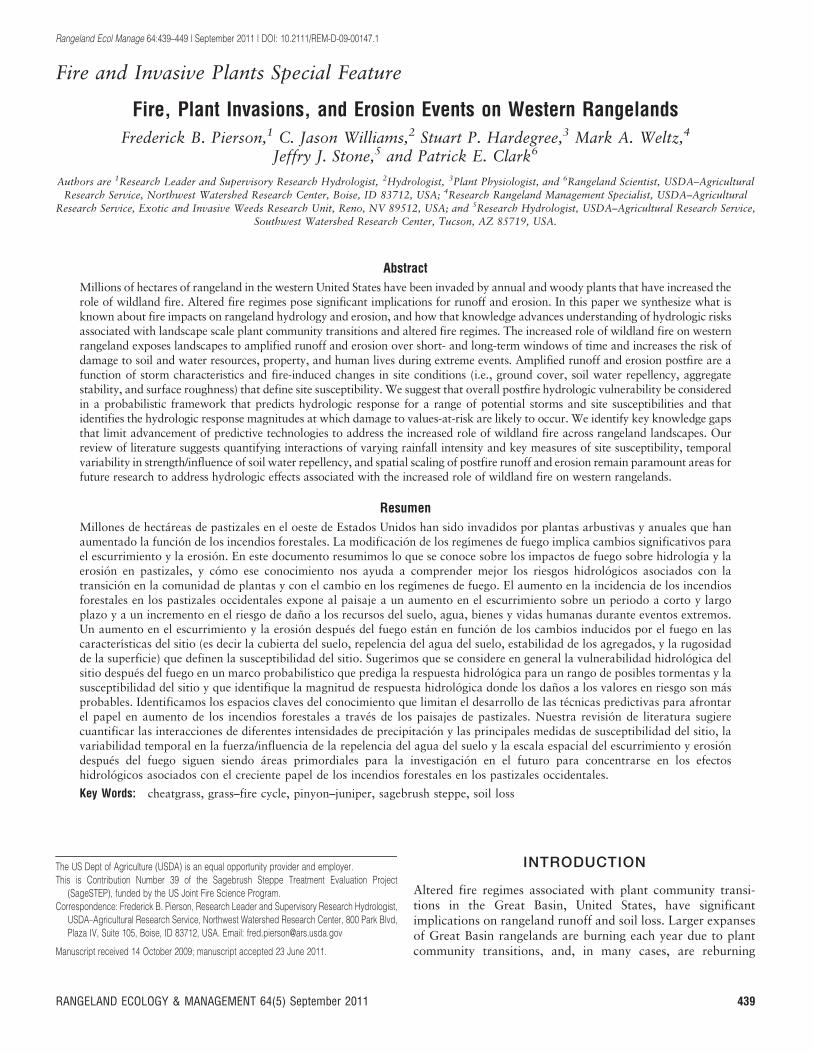
Hydrologic response (runoff and erosion) for a given storm is afunction of the rainfall intensity and the resisting forces at ornear the ground surface. We can conceptualize these resistingforces as defining the site susceptibility to a given rainfallintensity (Fig. 4). Susceptibility is a function of ground cover(or bare ground), surface roughness, aggregate stability, soilstructure, soil water repellency, and hillslope angle. Fire affectshydrologic response by reducing the resistance and therebyincreasing the susceptibility of the soil surface to runoff anderosion. Fire-induced increases in susceptibility coincide withshifts in prevailing hydrologic processes that dictate runoffand erosion rates (Fig. 4; Pierson et al. 2009). Most of theknowledge of fire impacts on rangeland hydrology is derivedfrom rainfall simulation studies (Table 1) on hillslopes in thesemi-arid sagebrush steppe (Pierson et al. 2001, 2002, 2008a,2008b, 2009) and xeric forests (Benavides-Solorio and Mac-Donald 2001, 2002; Johansen et al. 2001) and studies of flood
Figure 3. Juniper woodland with dense canopy structure (A), with ladder fuels (B), following high-severity wildfire (C), and after postfire cheatgrassinvasion (D). Photographs by authors.
442 Rangeland Ecology & Management
events following intense rainfall on recently burned landscapes(see Craddock 1946; Cannon et al. 1998, 2001; Meyer et al.2001; Moody and Martin 2001; Pierson et al. 2002; Klade 2006;Cannon et al. 2011). Here, we summarize what is known byreviewing fire impacts on runoff and erosion processes at thepoint to small-plot (, 2 m2), large-plot/patch (10–30 m2), andhillslope to landscape (multiple watersheds) scales and examininglongevity of fire effects on hydrologic and erosional processes.
Point to Small-Plot Scale EffectsThe magnitude of fire-induced increases in runoff and erosiondepends on rainfall intensity, the degree of fire-induced changesin site susceptibility, and topography (Fig. 4). Rainsplash andsheetflow (see Kinnell 2005) are the dominant postfirehydrologic and erosion processes over point to small-plotscales. The primary resisting agents at this scale are canopyand ground cover, surface roughness, and soil stability. Fireremoval of canopy and ground cover increases the wateravailable at the soil surface through decreased interception,surface water storage, and infiltration. A fire-induced increasein bare ground reduces surface roughness, promotes rapidrunoff generation, and diminishes the surface protectionagainst soil detachment and entrainment by raindrop impactand sheetflow (Table 1; Benavides-Solorio and MacDonald2001, 2002; Pierson et al. 2001, 2002, 2008a, 2008b, 2009).The overall effect on runoff generation is amplified wherestrongly water repellent soils persist postfire (Table 1) or waterrepellency is induced by burning (see DeBano et al. 1998). Soilloss is governed by the degree of soil surface protection, soilerodibility, and the amount of runoff (Pierson et al. 2008a,
2009). A fire-induced increase in runoff and erosion iscommonly much greater for shrub coppice areas (areasunderneath shrub canopies) than interspaces (areas betweenshrub canopies), and fire effects are generally higher for erosionthan those for runoff (Table 1). Runoff and erosion mayincrease by a factor of 3 to more than 10, respectively, forshrub coppices (Table 1). Fire effects on interspace runoff anderosion may be negligible where prefire ground cover was low(Pierson et al. 2001, 2008a, 2009); however, increases byfactors of 2 to 40, respectively, can occur where interspacevegetation is removed by fire (Pierson et al. 2002).
Large-Plot Scale EffectsPostfire runoff and erosion at the large-plot or patch scale (10sof m2) are primarily related to the degree of canopy/groundcover removal, the relative homogeny of surface soil condi-tions, and the formation of concentrated flow paths. Greaterwater availability following burning (less interception/storage),decreased infiltration, and reduction of surface obstructionsallow water to form deeper, concentrated flow paths withgreater flow velocity, erosive energy, and sediment transportcapacity than are produced by smaller-scale rainsplash andsheetflow processes (Moffet et al. 2007; Pierson et al. 2009; Al-Hamdan et al. 2011). Concentrated flow is enhanced on steep(Cannon et al. 1998, 2001; Meyer et al. 2001) or convergent(Benavides-Solorio and MacDonald 2005) slopes, and whereoverland flow is exacerbated by water repellent soils (Shakesbyand Doerr 2006). A sharp increase in concentrated flowvelocity and erosion are generally observed where ground coveris reduced below 40–50% (. 50% bare ground; Pierson et al.
Figure 4. Conceptional hydrologic response (runoff and erosion responses) for varying site susceptibility and rainfall intensity. The different greyscale curves represent responses for different rainfall intensities across a range of site susceptibility. Site susceptibility (x axis) is defined by thesurface conditions (shown in smaller font below the x axis title) that influence runoff and erosion response. Symbols illustrate direction increase (+)or decrease (2) in respective variable. Hydrologic response increases exponentially as ground cover, roughness, aggregate stability, and soilstructure decrease and bare ground and soil water repellency increase. Responses are amplified with increasing hillslope angle. Rainsplash andsheetflow processes dominate on gentle portions of the response curves where conditions are hydrologically stable (unburned state); concentratedflow dominates where curves steepen and conditions become hydrologically unstable (burned state). The transition zone occurs where decreasedsurface protection or increased water availability faciliate concentrated flow initiation. Hydrologic responses are generally greater with increasingrainfall intensity. Potential values-at-risk for varying magnitudes of hydrologic response are shown to illustrate potential consequences of respectiverunoff and erosion events. Fire affects hydrologic response by increasing susceptibility (decreasing hydrologic stability) and causing an inherent shiftin hydrologic process dominance. Large fires result in extensive, high susceptibility, and repeated landscape-scale burning over short time windows(3–10 yr) ensure repeated exposure of highly susceptibile conditions, increasing likelihood for damage to natural resources, property, and human life.
64(5) September 2011 443

Tabl
e1.
Site
char
acte
rist
ics,
runo
ffco
effic
ient
s,an
dse
dim
enty
ield
from
rain
fall
sim
ulat
ions
(60
min
exce
ptw
here
note
d)on
unbu
rned
(unb
)an
dhi
gh-
(hig
h),m
oder
ate-
(mod
),an
dlo
w-s
ever
itybu
rned
sem
i-ar
idra
ngel
ands
(Pie
rson
etal
.20
01,
2002
,20
08a,
2009
)an
dfo
rest
s(B
enav
ides
-Sol
orio
and
Mac
Don
ald
2001
,20
02;
Joha
nsen
etal
.20
01).
Stu
dyM
icro
site
Bur
nse
veri
tyP
lot
size
(m2)
Slo
pe(%
)
Tim
epo
stfir
e(m
o)
Rai
nfal
lin
tens
ity(m
m?h2
1)
WD
PT
(s)1
Bul
kde
nsity
(g?cm
23)2
Soi
lw
ater
cont
ent
(%)2
Bar
eso
il(%
)C
anop
yco
ver
(%)
Gro
und
cove
r(%
)
Live
plan
tbi
omas
s(k
g?ha
21)
Litt
erbi
omas
s(k
g?ha
21)
Sur
face
roug
hnes
s(m
m)
Run
off
coef
ficie
nt(%
)3
Sed
imen
tyi
eld
(g?m
22)
Pie
rson
etal
.
2002
4
Cop
pice
Unb
0.5
35–6
012
67—
1.21
,14
788
9332
519
1437
218
112
Mod
0.5
35–6
012
67—
1.28
,5
9711
334
111
312
3430
Hig
h0.
535
–60
1267
—1.
21,
598
132
744
7412
3722
Inte
rspa
ceU
nb0.
535
–60
1267
—1.
35,
1489
1812
519
172
118
244
Mod
0.5
35–6
012
67—
1.30
,5
9516
552
021
212
2612
Hig
h0.
535
–60
1267
—1.
30,
599
51
134
6110
4914
8
Pie
rson
etal
.
2001
,20
08a
Cop
pice
Unb
0.5
30–4
01
8520
00.
937
110
099
——
—30
12
Hig
h0.
530
–40
185
102
1.22
199
11
——
—37
41
Inte
rspa
ceU
nb0.
530
–40
185
220
0.94
56
7494
——
—49
24
Hig
h0.
530
–40
185
971.
211
994
1—
——
3021
Pie
rson
etal
.
2009
Cop
pice
Unb
0.5
35–5
01
8528
61.
057
284
98—
—34
3917
Mod
-Hig
h0.
535
–50
185
261
1.09
342
1058
——
1176
183
Inte
rspa
ceU
nb0.
535
–50
185
110
1.21
325
3175
——
1863
195
Mod
-Hig
h0.
535
–50
185
117
1.17
484
016
——
1155
705
—U
nb32
.535
–50
185
—1.
072
2457
7612
125
951
721
48
—M
od-H
igh
32.5
35–5
01
8520
81.
134
760
24—
808
1127
988
Ben
avid
es-S
olor
io
and
Mac
Don
ald
2001
,20
025
—Lo
w-U
nb1.
020
–25
1–3
7965
—2
1—
99—
——
5580
—M
od1.
020
–35
1–3
7950
—2
12—
88—
——
5817
9
—H
igh
1.0
20–4
51–
379
60—
277
—23
——
—66
128
0
Joha
nsen
etal
.
2001
6
—U
nb32
.55
360
——
,5
4852
——
4.2
2336
—H
igh
32.5
73
60—
—,
574
26—
—5.
145
912
1W
ater
drop
pene
trat
ion
time
(WD
PT)
isan
indi
cato
rof
stre
ngth
ofso
ilw
ater
repe
llenc
yas
follo
ws:
,5
sw
etta
ble;
5–60
ssl
ight
lyre
pelle
nt;
60–6
00st
rong
lyre
pelle
nt(B
isdo
met
al.
1993
).2M
easu
red
near
the
soil
surf
ace
(,4
cmde
pth)
.3R
unof
fco
effic
ient
iseq
ual
tocu
mul
ativ
eru
noff
divi
ded
bycu
mul
ativ
era
infa
llap
plie
d.V
alue
ism
ultip
lied
by10
0to
obta
inpe
rcen
t.4D
ata
pres
ente
dfr
omso
uth-
faci
ngsl
opes
sole
ly.
5D
ata
pres
ente
dfo
rB
obca
tFi
reon
ly.
6R
ainf
all
appl
ied
for
60m
inun
der
dry
cond
ition
s,fo
llow
edby
24-h
hiat
us,
30m
inof
rain
fall,
30-m
inhi
atus
,an
d30
min
rain
fall.
Tota
lra
inap
plie
dw
as12
0m
m.
444 Rangeland Ecology & Management

2008a, 2009). Very few studies have quantified postfire runoffand erosion at the large-plot scale. Studies by Pierson et al.(2009) and Johansen et al. (2001) suggest large-plot scalerunoff may increase more than sixfold and erosion 25- to 125-fold following burning (Table 1).
Hillslope to Landscape Scales EffectsSmall- to large-plot scale fire effects on rangeland hydrologyaggregated across a landscape can result in flash flooding,mudslides, and/or debris flows where intensive rain falls overextensive or contiguous burned areas. These events typicallyform by runoff-triggered erosion and progressive sedimentbulking of the flow as it travels downslope (Cannon et al.2001). Large erosion events have received only minor attentionin literature on rangelands, but historical accounts demonstratethe danger that these events pose to downstream resources andcommunities (Cannon et al. 1998, 2001; Moody and Martin2001; Pierson et al. 2002; Klade 2006). For example, wildfiresfueled by cheatgrass burned extensive areas of rangeland andxeric forest along the Boise Front, near Boise, Idaho, in 1959(3 640 ha) and 1996 (6 000 ha). An intense, convectiverainstorm 2 wk after fires in 1959 resulted in widespreadflooding and mud-flows that caused extensive (. $3.0 millionat current US dollar value) damage to property and infrastruc-ture (Klade 2006). Similarly, a short-duration, high-intensitystorm 1 yr following the 1996 Eighth Street Fire floodedportions of Boise and inundated the flooded areas withsediment (Pierson et al. 2002; Table 1). The flooding in 1997was driven by intense rainfall on bare (90–100% bare ground),water repellent soils with reduced water storage capacity andlow surface roughness. Most of the rainfall falling on the south-facing slopes ran off, forming concentrated flow networks(Pierson et al. 2002). Fire suppression and mitigation costsassociated with the 1996 Eighth Street Fire exceeded $4million. In another case, a prolonged rain-on-snow event in1996 near Boise produced extensive debris flows from a7-yr-old xeric-forest fire site (1989 Lowman Fire) along theSouth Fork Payette River. A single event in one watersheddischarged 14 600 m3 of soil at a flow velocity of at least12 m ? s21 (Meyer et al. 2001). Erosion from the multiple debrisflows that occurred generated soil loss equivalent to severalthousand years of nonfire associated erosion (low erosion rates)based on historical records (Meyer et al. 2001).
Landscape-scale flooding from burned areas has also beenreported from other western US rangeland and forest settingsalong the wildland-urban interface (Craddock 1946; Agnewet al. 1997; Cannon et al. 1998, 2001; Elliot and Parker 2001;Moody and Martin 2001). In 1945, flooding following intenserainfall over a 1-yr-old 300+ ha cheatgrass burn site causednearly $500 000 (. $6 million at current US dollar value) indamage to property in Salt Lake City, Utah (Craddock 1946).Adjacent rangelands in stable condition generated minor runoffand erosion from the same precipitation event. Similarly,runoff-triggered debris-flow events 2 mo following the SouthCanyon Fire near Glenwood Springs, Colorado, inundated a 13to 14 ha area with approximately 70 000 m3 of soil from anetwork of 15 stream channels (Cannon et al. 1998, 2001). Thefire burned approximately 800 ha on steeply (30–70%) slopinghillslopes with cover of pinyon–juniper and mountain shrubs.
Cannon et al. (2001) identified 84 debris flow initiations at thesite following a torrential rainstorm (intensity not reported)event. The debris flows engulfed 30 vehicles traveling on aflow-intersected highway and forced two people into theColorado River. In another study, Moody and Martin (2001)described hydrologic response to a 100-yr rainfall stormfollowing the 4 690 ha Buffalo Creek Fire in steep, forestedwatersheds of the Colorado Front Range near Denver,Colorado. More than 60% of the burn was high severity.Two months postfire, a high-intensity (90 mm ? h21, 1 h)rainstorm caused flash flooding that killed two people (Agnewet al. 1997); unburned hillslopes adjacent to the fire generatedvery little surface runoff (Elliott and Parker 2001). Hillslopeerosion following the Buffalo Creek Fire increased 150- to 240-fold. Approximately 1 101 000 m3 of sediment was generatedfrom interrill, rill, and in-channel processes during the firstsummer after the fire (Moody and Martin 2001). Postfirerunoff events from the Buffalo Creek burned area dischargedenough sediment into the Strontia Springs Reservoir to reducestorage capacity by one-third (Agnew et al. 1997; Moody andMartin 2001). The examples from the Boise Front Range(Meyer et al. 2001; Pierson et al. 2002; Klade 2006), Salt LakeCity (Craddock 1946), Glenwood Springs (Cannon et al. 1998,2001), and Denver (Moody and Martin 2001) areas presentedhere demonstrate the potential hydrologic responses to high-intensity rainfall following large-scale alteration of vegetationand ground surface characteristics.
Longevity of Effects Across Spatial ScalesThe longevity of fire effects differ for runoff versus erosion andlikely depend on how long the respective community requiresto re-establish prefire ground cover and soil characteristics.Rainfall simulation experiments on sagebrush landscapesindicate postfire runoff rates return to prefire levels withinone to two growing seasons or when ground cover returns to40% (Pierson et al. 2001, 2002, 2008a, 2009). Pierson et al.(2008a, 2009) and Johansen et al. (2001) found postfire plot-scale erosion returns to prefire levels within two to threegrowing seasons or when ground cover approaches 50–60%.An examination of hillslope scale erosion from burned xericforests suggests annual soil loss from natural rainfall events onsloping terrain can be as much as 60 Mg ? ha21 the first yearfollowing fire and generally returns to less than 0.5 Mg ? ha21
within 3 yr (see Spigel and Robichaud 2007; Robichaud et al.2008). Annual erosion from unburned xeric forests is generallynegligible (Robichaud et al. 2008; Larsen et al. 2009). Theselongevity estimates and cover thresholds likely are good relativeindicators of hydrologic and erosional recovery with respect tocommonly occurring storms; however, recovery relative toextreme events likely requires litter depths and soil conditionsthat may take 4 to more than 10 growing seasons to developdepending on climate and cover recruitment rates (Robichaudet al. 2000; Shakesby and Doerr 2006; Robichaud 2009).Furthermore, surface soil transported to and remaining insideslopes and hillslope hollows postfire may serve as a sourcefor downstream sediment pulses during subsequent highintensity storm and channel flushing events (Cannon et al.2001; Meyer and Pierce 2003; Pierce et al. 2004; Moody andMartin 2009). For example, Meyer et al. (2001) estimated a
64(5) September 2011 445
residual 4 000 m3 of soil remaining from a postfire debris flowevent continued to contribute sediment to an adjacent river 4 yrfollowing the original event.
HYDROLOGIC RISKS OF INCREASINGWILDLAND FIRE
Figure 4 presents a conceptual model from which we canelaborate on what is known about the potential hydrologiceffects of an increased role of fire on western rangelands and toidentify critical knowledge gaps relative to future advance-ments. Literature has established postfire hydrologic response isa function of rainfall intensity (Benavides-Solorio and Mac-Donald 2005; Spigel and Robichaud 2007) and site suscepti-bility (Table 1), and that storm-specific hydrologic responseincreases exponentially where high site susceptibility promotesunstable hydrologic conditions and a requisite shift inhydrologic process dominance (Fig. 4; Cannon et al. 2001;Pierson et al. 2009). Shifts from infrequent and small tofrequent, large burned areas increase the likelihood thatconvective storms moving through a region will encounterhigh site susceptibilities over landscape scales, potentiallyresulting in extensive soil loss, offsite flooding, and damageto values-at-risk. For example, recurring wildfires overcheatgrass dominated rangelands (Whisenant 1990; Brookset al. 2004; Keane et al. 2008) ensure large tracks of land willexist in a hydrologically unstable state repeatedly on 5-yr to10-yr cycles, increasing periodic high site susceptibility overshort- and long-term time steps. These sites are subjected toinfrequent short-term high soil losses from high intensitystorms and long-term soil loss associated with frequentlyoccurring low-intensity storms on highly susceptible condi-tions. Losses of biologically important surface soils is partic-ularly critical given soil formation rates in the Great Basin(Harden 1990; Harden et al. 1991), especially where large firesare followed by drought years with minimal plant recruitment.The rates of soil loss are alarming given individual stormerosion estimates from plot-scale studies (Table 1) andpotential first year postfire hillslope erosion rates of 60 to100 Mg ? ha21 ? yr21 (see Robichaud et al. 2008). The increasedthreats to values-at-risk are even more concerning for westernurban centers adjacent to steeply sloping cheatgrass infestedrangelands (Pierson et al. 2002; Klade 2006) and denselystocked woodlands (Cannon et al. 1998, 2001). The likelihoodof resource and property damaging flooding events is increasingin these areas due to the increased susceptibility over short- andlong-term temporal windows.
Mitigation of hydrologic risks associated with an increasedrole of fire on western rangelands can be advanced bypredictive technologies that answer three basic questions (seeKaplan and Garrick 1981): 1) what can happen, 2) how likelyis the scenario to occur, and 3) if the scenario occurs, what arethe consequences? The first question refers to a magnitude ofhydrologic response for a given site susceptibility and stormoccurrence. The second question refers to the likelihood orprobability of the respective site susceptibility and stormco-occurring. The third question addresses the potentialdamage to resources-at-risk. Recent advances in understandingand quantification of fire effects across small-plot to hillslope
scales provide an initial point for populating fire effects modelsin a probabilistic framework that incorporates combinedprobabilities of site susceptibility, storm occurrence, andmagnitude of hydrologic response (i.e., Robichaud et al.2007; Cannon et al. 2010). Of course, application of suchmodels to mitigation of damage to values-at-risk also requiresknowledge of the storm and/or runoff magnitudes required tocause damage to the respective resource/property (for example,see Cannon et al. 2008, 2011). Essentially, the hydrologicresponse curves shown in Figure 4 can be thought of as a familyof risk curves (see Kaplan and Garrick 1981) for specifiedstorms over a range of site susceptibilities. Damage toresources-at-risk is predicated on the magnitude of overallhydrologic response.
The presented qualitative model (Fig. 4) illustrates thegeneral hydrologic and erosional relationships that are affectedby ongoing plant community transitions and altered fireregimes in the Great Basin, but population of the model anddevelopment of predictive technologies are confounded byseveral key knowledge gaps. First, we are still learning how thevariables that define site susceptibility (Fig. 4) across spatialscales interact to influence hydrologic response. Plot scalestudies (Table 1; Robichaud et al. 2000; Moffet et al. 2007;Al-Hamdan et al. 2011) have identified and quantified theprimary driving and resisting forces that dictate postfirehydrologic and erosional responses. In many cases, however,plot-scale studies sought to reduce experimental variabilityby focusing on a few primary independent variables (i.e., bareground or ground cover) while isolating or fixing othervariables like hillslope angle or rainfall intensity to constantvalues. For example, data for populating risk curves depicted inFigure 4 are extremely limited with respect to different rainfallintensities. Other variables like soil water repellency maystrongly influence runoff generation from burned soils, but theeffect may vary significantly in space and time (Doerr et al.2000; Woods et al. 2007; Pierson et al. 2008b, 2009).Quantification of such temporal fluctuations and overallvariable interactions is absent from most rangeland hydrologymodels. Advancements in predictive technologies have beenmade (i.e., Robichaud et al. 2007; Nearing et al. 2011), butrangeland models largely remain focused at the hillslope scalegiven the plot-scales at which data are available. Scalinglimitations inhibit linkages of plot- and hillslope-scale respons-es to off-site impacts on values-at-risk. Even with limitationsidentified here, recent advancements offer insight into keymeasures needed to address hydrologic impacts associated withthe increasing role of fire on Great Basin rangelands. Wesuggest quantifying interactions of storm magnitude and keymeasures that define site susceptibility, the spatial and temporalvariability in effects of driving and resisting forces, and spatialscaling of postfire runoff and erosion remain paramount areasfor future research.
IMPLICATIONS
The role of fire is escalating across western rangelands, andnatural resources, city infrastructures, and lives are at risk.Elevated short- and long-term soil losses from westernrangelands are likely to occur with more frequent fire-induced
446 Rangeland Ecology & Management
changes in site susceptibility over landscape scales. Damages toproperty and the risks to human life are also likely to increasewhere fire activity is intensified along the wildland-urbaninterface. Modern and historical reports demonstrate progres-sive sediment bulking of fire-induced increases in runoff anderosion from small- to large-plot scales can result in propertydamaging and life-taking landscape-scale flooding and erosionevents. Such accounts are well documented across the westernUnited States following large wildland fires adjacent to urbancenters. Research from plot-to-hillslope scale studies provides afoundation for advancing understanding of effects of increasedwildland fire activity on rangeland runoff and erosion anddevelopment of predictive technologies. Studies over a rangeof vegetation types, spatial and temporal scales, and burnconditions have established that ground cover, surface soilconditions/properties, soil water repellency, and hillslope topo-graphy define site susceptibility to postfire runoff and erosion.Postfire runoff and erosion are a function of rainfall intensityand site susceptibility, and the magnitude of postfire hydrologicresponse dictates potential damage to resources at risk. Postfirehydrologic response can be predicted by combining probabil-ities of susceptibility and storm occurrences. The likelihood ofresource damage can be determined by linking storm responsemagnitudes with requisite damages to values-at-risk. Develop-ment of predictive technologies to address these issues wouldenhance postfire mitigation efforts and potentially reducepostfire expenditures aimed at preventing soil loss, flooding,and destruction of property.
Current knowledge remains wanting in several key areas thatwould advance quantitative model development. A majordeficiency in current knowledge is in the interactions betweenhydrologic variables (i.e., soil moisture, water repellency, andinfiltration) in complex field scenarios (i.e., spatially variablesurface conditions and/or rainfall intensity). The literature isalso strongly biased to a few plant communities (i.e., semi-aridgrasslands and shrub-steppe, xeric ponderosa pine forests).Postfire runoff and erosion data are extremely limited for otherfire-vulnerable plant communities where high-intensity, mon-soonal precipitation events are common (i.e., Chihuahuan,Mojave, and Sonoran hot deserts). Current rangeland hydrol-ogy models remain largely unvalidated for watershed scalesand extreme events. Risks of extreme events are expected toincrease in coming decades based on projections of the greaterrole of wildfire and expectations of more intense precipitationregimes in the western United States. As the role of firecontinues to increase on western rangelands, we suggest it isparamount that risk management research begins to integratecurrent knowledge into probabilistic terms and seek to advanceour understanding and modeling of interacting controls onpostfire hydrologic response across relevant spatial, temporal,and climatic scales.
LITERATURE CITED
AGNEW, W., R. E. LABN, AND M. V. HARDING. 1997. Buffalo Creek, Colorado, fire and
flood of 1996. Land and Water 41:27–29.
AGUIRRE, L., AND D. A. JOHNSON. 1991. Influence of temperature and cheatgrass
competition on seedling development of two bunchgrasses. Journal of Range
Management 44:347–354.
AL-HAMDAN, O. Z., F. B. PIERSON, M. A. NEARING, J. J. STONE, C. J. WILLIAMS,P. R. KORMOS, J. BOLL, AND M. A. WELTZ. 2011. Characteristics of concentratedflow hydraulics for rangeland ecosystems: implications for hydrologicmodeling. Earth Surface Processes and Landforms. (in review).
ARREDONDO, J. T., AND D. A. JOHNSON. 1998. Clipping effects on root architectureand morphology of 3 range grasses. Journal of Range Management 51:207–213.
ARREDONDO, J. T., T. A. JONES, AND D. A. JOHNSON. 1998. Seedling growth ofIntermountain perennial and weedy annual grasses. Journal of RangeManagement 51:584–589.
BAKER, W. L., AND D. J. SHINNEMAN. 2004. Fire and restoration of pinyon-juniperwoodlands in the western United States: a review. Forest Ecology andManagement 189:1–21.
BENAVIDES-SOLORIO, J. D. D., AND L. H. MACDONALD. 2001. Post-fire runoff and erosionfrom simulated rainfall on small plots, Colorado Front Range. HydrologicalProcesses 15:2931–2952.
BENAVIDES-SOLORIO, J. D. D., AND L. H. MACDONALD. 2002. Erratum: post-fire runoffand erosion from simulated rainfall on small plots, Colorado Front Range.Hydrological Processes 16:1131–1133.
BENAVIDES-SOLORIO, J. D. D., AND L. H. MACDONALD. 2005. Measurement andprediction of post-fire erosion at the hillslope scale, Colorado Front Range.International Journal of Wildland Fire 14:457–474.
BILLINGS, W. D. 1994. Ecological impacts of cheatgrass and resultant fire onecosystems in the western Great Basin. In: S. B. Monsen and S. G. Kitchen[COMPS.]. Proceedings: Ecology and Management of Annual Rangelands; 18–22 May 1992, Boise, ID, USA. Ogden, UT, USA: US Department of Agriculture,Forest Service, Intermountain Research Station, General Technical Report,INT-GTR-313. p. 22–30.
BISDOM, E. B. A., L. W. DEKKER, AND J. F. T. SCHOUTE. 1993. Water repellency of sievefractions from sandy soils and relationships with organic material and soilstructure. Geoderma 56:105–118.
BROOKS, M. L. 2008. Plant invasions and fire regimes. In: K. Zouhar, J. K. Smith,S. Sutherland, and M. L. Brooks [EDS.]. Wildland fire in ecosystems: fireand nonnative invasive plants. Fort Collins, CO, USA: US Department ofAgriculture, Forest Service, Rocky Mountain Research Station, GeneralTechnical Report, RMRS-GTR-42, Volume 6. p. 33–45.
BROOKS, M. L., C. M. D’ANTONIO, D. M. RICHARDSON, J. B. GRACE, J. E. KEELEY,J. M. DITOMASO, R. J. HOBBS, M. PELLANT, AND D. PYKE. 2004. Effects of invasivealien plants on fire regimes. BioScience 54:677–688.
BROOKS, M. L., AND D. A. PYKE. 2001. Invasive plants and fire in the deserts of NorthAmerica. In: K. E. M. Galley and T. P. Wilson [EDS.]. Proceedings of theInvasive Species Workshop: The Role of Fire in the Control and Spread ofInvasive Species. Fire Conference 2000: The First National Congress on FireEcology, Prevention, and Management. Tallahassee, FL, USA: Tall TimbersResearch Station, Miscellaneous Publication Number 11. p. 1–14.
CALKIN, D. E., K. D. HYDE, P. R. ROBICHAUD, J. G. JONES, L. E. ASHMUN, AND D. LOEFFLER.2007. Assessing post-fire values-at-risk with a new calculation tool. Fort Collins,CO, USA: US Department of Agriculture, Forest Service, RMRS-GTR-205. 32 p.
CANNON, S. H., E. M. BOLDT, J. L. LABER, J. W. KEAN, AND D. M. STANLEY. 2011. Rainfallintensity-duration thresholds for postfire debris-flow emergency-responseplanning. Natural Hazards. DOI: 10.1007/s11069-011-9747-2.
CANNON, S. H., J. E. GARTNER, M. G. RUPERT, J. A. MICHAEL, A. H. REA, AND C. PARRETT.2010. Predicting the probability and volume of postwildfire debris flows in theintermountain western United States. Geological Society of America Bulletin122:127–144. DOI:10.1130/B26459.1
CANNON, S. H., J. E. GARTNER, R. C. WILSON, J. C. BOWERS, AND J. L. LABER. 2008.Storm rainfall conditions for floods and debris flows from recently burnedareas in southwestern Colorado and southern California. Geomorphology96:250–269.
CANNON, S. H., R. M. KIRKHAM, AND M. PARISE. 2001. Wildfire-related debris-flowinitiation processes, Storm King Mountain, Colorado. Geomorphology39:171–188.
CANNON, S. H., P. S. POWERS, AND W. Z. SAVAGE. 1998. Fire related hyperconcentratedand debris flows on Storm King Mountain, Glenwood Springs, Colorado, USA.Environmental Geology 35:210–218.
64(5) September 2011 447

COTTAM, W. P., AND G. STEWART. 1940. Plant succession as result of grazing and ofmeadow desiccation by erosion since settlement in 1862. Journal of Forestry38:613–626.
CRADDOCK, G. W. 1946. Salt Lake City flood, 1945. Proceedings of Utah Academy ofSciences, Arts, and Letters 23:51–61.
D’ANTONIO, C. M. 2000. Fire, plant invasions, and global changes. In: H. A. Mooneyand R. J. Hobbs [EDS.]. Invasive species in a changing world. Washington, DC,USA: Island Press. p. 65–93.
D’ANTONIO, C. M., AND P. M. VITOUSEK. 1992. Biological invasions by exotic grasses,the grass/fire cycle, and global change. Annual Review of Ecology andSystematics 23:63–87.
DEBANO, L. F., D. G. NEARY, AND P. F. FFOLLIOTT. 1998. Fire’s effects on ecosystems.New York, NY, USA: John Wiley and Sons, Inc. 352 p.
DOERR, S. H., R. A. SHAKESBY, AND R. P. D. WALSH. 2000. Soil water repellency, itscharacteristics, causes and hydro-geomorphical consequences. Earth SystemScience Reviews 51:33–65.
DUKE, S. E., AND M. M. CALDWELL. 2001. Nitrogen acquisition from different spatialdistributions by six Great Basin plant species. Western North AmericanNaturalist 61:93–102.
ELLIOTT, J. G., AND R. S. PARKER. 2001. Developing a post-fire flood chronology andrecurrence probability from alluvial stratigraphy in the Buffalo Creekwatershed, Colorado, USA. Hydrological Processes 15:3039–3051.
GEDNEY, D. R., D. L. AZUMA, C. L. BOLSINGER, AND N. MCKAY. 1999. Western juniper ineastern Oregon. Portland, OR, USA: US Department of Agriculture, ForestService, NW-GTR-464. 53 p.
GENERAL ACCOUNTING OFFICE. 2003. Wildland fires: better information needed oneffectiveness of emergence stabilization and rehabilitation treatments.Washington, DC, USA: US General Accounting Office, Report GAO-03-430.
HARDEN, J. W. 1990. Soil development on stable landforms and implications forlandscape studies. Geomorphology 3:391–398.
HARDEN, J. W., E. M. TAYLOR, C. HILL, R. K. MARK, L. D. MCFADDEN, M. C. REHEIS,J. M. SOWERS, AND S. G. WELLS. 1991. Rates of soil development from foursoil chronosequences in the southern Great Basin. Quaternary Research 35:383–399.
HARRIS, G. A. 1967. Some competitive relationships between Agropyron spicatumand Bromus tectorum. Ecological Monographs 37:89–111.
HARRIS, G. A. 1977. Root phenology as a factor of competition among grassseedlings. Journal of Range Management 30:172–177.
HEMPY-MAYER, K., AND D. A. PYKE. 2008. Defoliation effects on Bromus tectorumseed production: implications for grazing. Rangeland Ecology & Management61:116–123.
HOUSTON, D. B. 1973. Wildfires in northern Yellowstone National Park. Ecology54:1111–1117.
HULL, A. C. 1963. Competition and water requirements of cheatgrass andwheatgrasses in the greenhouse. Journal of Range Management 16:199–204.
HULL, A. C. 1965. Cheatgrass: a persistent homesteader. In: Proceedings:Cheatgrass Symposium; 27–30 July 1965; Vale, OR, USA. Portland, OR, USA:US Department of Interior, Bureau of Land Management. p. 20–26.
HUMPHREY, L. D., AND E. W. SCHUPP. 2001. Seed banks of Bromus tectorum-dominated communities in the Great Basin. Western North AmericanNaturalist 61:85–92.
JOHANSEN, M. P., T. E. HAKONSON, AND D. D. BRESHEARS. 2001. Post-fire runoff anderosion from rainfall simulation: contrasting forests with shrublands andgrasslands. Hydrological Processes 15:2953–2965.
KAPLAN, S., AND B. J. GARRICK. 1981. On the quantitative definition of risk. RiskAnalysis 1:11–27.
KEANE, R. E., J. K. AGEE, P. FULE, J. E. KEELEY, C. KEY, S. G. KITCHEN, R. MILLER, AND
L. A. SCHULTE. 2008. Ecological effects of large fires on US landscapes: benefitor catastrophe? International Journal of Wildland Fire 17:696–712.
KEELEY, J. E. 2000. Chaparral. In: M. G. Barbour and W. D. Billings [EDS.]. NorthAmerican terrestrial vegetation. New York, NY, USA: Cambridge UniversityPress. p. 201–251.
KINNELL, P. I. A. 2005. Raindrop-impact-induced erosion processes and prediction:a review. Hydrological Processes 19:2815–2844.
KLADE, R. J. 2006. Building a research legacy: the Intermountain Station 1911–1997. Fort Collins, CO, USA: US Department of Agriculture, Forest Service,RMRS-GTR-184. 259 p.
KNAPP, P. A. 1996. Cheatgrass (Bromus tectorum L.) dominance in the Great Basindesert. Global Environmental Change 6:37–52.
LARSEN, I. J., L. H. MACDONALD, E. BROWN, D. ROUGH, AND M. J. WELSH. 2009. Causesof post-fire runoff and erosion: water repellency, cover, or soil sealing. SoilScience Society of America Journal 73:1393–1407.
LINK, S. A., G. W. GEE, AND J. F. DOWNS. 1990. The effect of water stress onphenological and ecophysiological characteristics of cheatgrass and Sand-berg’s bluegrass. Journal of Range Management 43:506–513.
LINK, S. O., C. W. KEELER, R. W. HILL, AND E. HAGEN. 2006. Bromus tectorum covermapping and fire risk. International Journal of Wildland Fire 15:113–119.
MACk, R. N. 1981. Invasion of Bromus tectorum L. into western North America: anecological chronicle. Agro-Ecosystems 7:145–165.
MEYER, G. A., AND J. L. PIERCE. 2003. Climatic controls on fire-induced sedimentpulses in Yellowstone National Park and central Idaho: a long-termperspective. Forest Ecology and Management 178:89–104.
MEYER, G. A., J. L. PIERCE, S. H. WOOD, AND A. J. T. JULL. 2001. Fire, storms, anderosional events in the Idaho batholiths. Hydrological Processes15:3025–3038.
MILLER, R. F., AND R. J. TAUSCH. 2001. The role of fire in juniper and pinyonwoodlands: a descriptive analysis. In: K. E. M. Galley and T. P. Wilson [EDS.],Proceedings of the Invasive Species Workshop: The Role of Fire in the Controland Spread of Invasive Species. Fire Conference 2000: The First NationalCongress on Fire Ecology, Prevention, and Management. 27 November–1December 2000; Tallahassee, FL, USA: Tall Timbers Research Station,Miscellaneous Publication No. 11. 15–30.
MILLER, R. F., R. J. TAUSCH, E. D. MCARTHUR, D. J. JOHNSON, AND S. C. SANDERSON.2008. Age structure and expansion of pinyon-juniper woodlands: a regionalperspective in the Intermountain West. Fort Collins, CO, USA: US Departmentof Agriculture, Forest Service, Rocky Mountain Research Station, RMRS-RP-69. 15 p.
MOFFET, C. A., F. B. PIERSON, P. R. ROBICHAUD, K. E. SPAETH, AND S. P. HARDEGREE. 2007.Modeling soil erosion on steep sagebrush rangeland before and afterprescribed fire. Catena 71:218–228.
MOODY, J. A., AND D. A. MARTIN. 2001. Initial hydrologic and geomorphic responsefollowing a wildfire in the Colorado Front Range. Earth Surface Processes andLandforms 26:1049–1070.
MOODY, J. A., AND D. A. MARTIN. 2009. Synthesis of sediment yields after wildlandfire in different rainfall regimes in the western United States. InternationalJournal of Wildland Fire 18:96–115.
NASRI, M., AND P. S. DOESCHER. 1995. Effect of temperature on growth of cheatgrassand Idaho fescue. Journal of Range Management 48:406–409.
NEARING, M. A., H. WEI, J. J. STONE, F. B. PIERSON, K. E. SPAETH, M. A. WELTZ,D. C. FLANAGAN, AND M. HERNANDEZ. 2011. A rangeland hydrology and erosionmodel. Transactions of the American Society of Agricultural and BiologicalEngineers 54:901–908.
PETERS, E. F., AND S. C. BUNTING. 1994. Fire conditions pre- and post-occurrence ofannual grasses on the Snake River Plain. In: S. B. Monsen and S. G. Kitchen[EDS.]. Proceedings: Ecology and Management of Annual Rangelands. Ogden,UT, USA: US Department of Agriculture, Forest Service, General TechnicalReport, INT-GTR-313. p. 31–36.
PIERCE, J. L., G. A. MEYER, AND A. J. T. JULL. 2004. Fire-induced erosion andmillennial-scale climate change in northern ponderosa pine forests. Nature432:87–90.
PIERSON, F. B., D. H. CARLSON, AND K. E. SPAETH. 2002. Impacts of wildfire on soilhydrological properties of steep sagebrush-steppe rangeland. InternationalJournal of Wildland Fire 11:145–151.
PIERSON, F. B., C. A. MOFFET, C. J. WILLIAMS, S. P. HARDEGREE, AND P. E. CLARK. 2009.Prescribed-fire effects on rill and interrill runoff and erosion in a mountai-nous sagebrush landscape. Earth Surface Processes and Landforms 34:193–203.
PIERSON, F. B., P. R. ROBICHAUD, C. A. MOFFET, K. E. SPAETH, S. P. HARDEGREE, P. E. CLARK,AND C. J. WILLIAMS. 2008a. Fire effects on rangeland hydrology and erosion
448 Rangeland Ecology & Management

in a steep sagebrush-dominated landscape. Hydrological Processes 22:2916–2929.
PIERSON, F. B., P. R. ROBICHAUD, C. A. MOFFET, K. E. SPAETH, C. J. WILLIAMS,S. P. HARDEGREE, AND P. E. CLARK. 2008b. Soil water repellency and infiltration incoarse-textured soils of burned and unburned sagebrush ecosystems. Catena74:98–108.
PIERSON, F. B., P. R. ROBICHAUD, AND K. E. SPAETH. 2001. Spatial and temporal effectsof wildfire on the hydrology of a steep rangeland watershed. HydrologicalProcesses 15:2905–2916.
RICE, P. M., G. R. MCPHERSON, AND L. J. REW. 2008. Fire and nonnative invasiveplants in the Interior West Bioregion. In: K. Zouhar, J. K. Smith, S. Sutherland,and M. L. Brooks [EDS.]. Wildland fire in ecosystems: fire and nonnativeinvasive plants. Fort Collins, CO, USA: US Department of Agriculture, ForestService, Rocky Mountain Research Station, General Technical Report, RMRS-GTR-42, Volume 6. p. 141–171.
ROBICHAUD, P. R. 2009. Post-fire stabilization and rehabilitation. In: A. Cerda andP. R. Robichaud [EDS.]. Fire effects on soils and restoration strategies,Volume 5 of Series: Land Reconstruction and Management. Enfield, NH, USA:Science Publishers. p. 299–320.
ROBICHAUD, P. R., J. L. BEYERS, AND D. G. NEARY. 2000. Evaluating the effectiveness ofpost-fire rehabilitation treatments. Fort Collins, CO, USA: US Department ofAgriculture, Forest Service, RMRS-GTR-63. 85 p.
ROBICHAUD, P. R., W. J. ELLIOT, F. B. PIERSON, D. E. HALL, AND C. A. MOFFET. 2007.Predicting postfire erosion and mitigation effectiveness with a web-basedprobabilistic erosion model. Catena 71:229–241.
ROBICHAUD, P. R., F. B. PIERSON, R. E. BROWN, AND J. W. WAGENBRENNER. 2008.Measuring effectiveness of three post-fire hillslope erosion barrier treatments,western Montana, USA. Hydrological Processes 22:159–170.
ROMME, W. H., C. D. ALLEN, J. D. BAILEY, W. L. BAKER, B. T. BESTELMEYER, P. M. BROWN,K. S. EISENHART, M. L. FLOYD, D. W. HUFFMAN, B. F. JACOBS, R. F. MILLER,E. H. MULDAVIN, T. W. SWETNAM, R. J. TAUSCH, AND P. J. WEISBERG. 2009. Historicaland modern disturbance regimes, stand structures, and landscape dynamicsin pinon-juniper vegetation of the western United States. Rangeland Ecology &Management 62:203–222.
RUNNING, S. W. 2006. Is global warming causing more, larger wildfires? Science313:927–928.
SAGEMAP. 2010. SAGEMAP database, sagebrush assessment project, US GeologicalSurvey. Available at: http://sagemap.wr.usgs.gov/SagebrushAssessment.aspx.Accessed 3 November 2010.
SHAKESBY, R. A., AND S. H. DOERR. 2006. Wildfire as a hydrological andgeomorphological agent. Earth-Science Reviews 74:269–307.
SPIGEL, K. M., AND P. R. ROBICHAUD. 2007. First year postfire erosion rates inBitterroot National Forest, Montana. Hydrological Processes 21:989–997.
STEWARD, G., AND A. C. HULL. 1949. Cheatgrass (Bromus tectorum L.): an ecologicintruder in southern Idaho. Ecology 30:58–74.
STOCKMANN, K., J. BURCHFIELD, D. CALKIN, AND T. VENN. 2010. Guiding preventativewildland fire mitigation policy and decisions with an economic modelingsystem. Forest Policy and Economics 12:147–154.
SVEJCAR, T. 1990. Root length, leaf area, and biomass of crested wheatgrass and
cheatgrass seedlings. Journal of Range Management 43:446–448.
TAUSCH, R. J. 1999. Historic pinyon and juniper woodland development. In:
S. B. Monsen and R. Stevens [COMPS.]. 1999. Proceedings: Ecology and
Management of Pinyon–Juniper Communities within the Interior West; 15–18
September 1997; Provo, UT, USA. Ogden, UT, USA: US Department of
Agriculture, Forest Service, Rocky Mountain Research Station, RMRS-P-9.
p. 12–19.
TAUSCH, R. J., AND S. HOOD. 2007. Pinyon/juniper woodlands. In: S. M. Hood and
M. Miller [EDS.]. Fire ecology and management of the major ecosystems of
southern Utah. Fort Collins, CO, USA: US Department of Agriculture, Forest
Service, Rocky Mountain Research Station, RMRS-GTR-202. p. 57–71.
WEST, N. E. 1999. Juniper-pinyon savannas and woodlands of western North
America. In: R. C. Anderson, J. S. Fralish, and J. M. Baskin [EDS.]. Savannas,
barrens, and rock outcrop plant communities of North America. London,
England: Cambridge University Press. p. 288–308.
WEST, N. E . 2000. Synecology and disturbance regimes of sagebrush steppe
ecosystems. In: P. G. Entwistle, A. M. DeBolt, J. H. Kaltenecker, and K.
Steenhof [COMPS.]. Sagebrush Steppe Ecosystems Symposium: Proceedings;
21–23 June 1999; Boise, ID, USA: US Department of the Interior, Bureau of
Land Management, Boise State Office, Publication Number BLM/ID/PT-
001001+1150. p. 15–26.
WEST, N. E., AND T. P. YORKS. 2002. Vegetation responses following wildfire on
grazed and ungrazed sagebrush semi-desert. Journal of Range Management
38:131–134.
WHISENANT, S. G. 1990. Changing fire frequencies on Idaho’s Snake River plains:
ecological and management implications. In: E. D. McArthur, E. M. Romney,
S. D. Smith, and P. T. Tueller [COMPS.]. Proceedings: Symposium on Cheat-
grass Invasion, Shrub Die-Off, and Other Aspects of Shrub Biology and
Management. Ogden, UT, USA: US Department of Agriculture, Forest
Service, Intermountain Research Station, General Technical Report, INT-276.
p. 4–10.
WISDOM, M. J., M. M. ROWLAND, L. H. SURING, L. SCHUECK, C. WOLFF MEINKE, B. C. WALES,
AND S. T. KNICK. 2003. Procedures for regional assessment of habitats for
species of conservation concern in the sagebrush ecosystem. LaGrande, OR,
USA: US Department of Agriculture, Forest Service, Pacific Northwest
Research Station, March 2003 Report, Version 1. 153 p.
WOODS, S. W., A. BIRKAS, AND R. AHL. 2007. Spatial variability of soil hydrophobicity
after wildfires in Montana and Colorado. Geomorphology 86:465–479.
YOUNG, J. A., AND R. A. EVANS. 1975. Germinability of seed reserves in a big
sagebrush community. Weed Science 23:358–364.
YOUNG, J. A., AND R. A. EVANS. 1978. Population dynamics after wildfires in
sagebrush grasslands. Journal of Range Management 31:283–289.
YOUNG, J. A., R. A. EVANS, AND R. E. ECKERT. 1969. Population dynamics of downy
brome. Weed Science 17:20–26.
YOUNG, J. A., R. A. EVANS, R. E. ECKERT, AND K. L. BURGESS. 1987. Cheatgrass.
Rangelands 9:266–270.
64(5) September 2011 449