finding of no significant impact (fonsi) supplemental
TRANSCRIPT

DEPARTMENT OF THE ARMY U.S. ARMY CORPS OF ENGINEERS, NEW ORLEANS DISTRICT
7400 LEAKE AVE NEW ORLEANS, LA 70118-3651
Regional Planning and Environment Division South Environmental Planning Branch
FINDING OF NO SIGNIFICANT IMPACT (FONSI)
SUPPLEMENTAL ENVIRONMENTAL ASSESSMENT (SEA) #498A
WEST BANK AND VICINITY HURRICANE PROTECTION PROJECT
IMPLEMENTATION OF PREVIOUSLY AUTHORIZED MITIGATION PLANS ST. CHARLES, LOUISIANA
Description of Recommended Plan: The U.S. Army Corps of Engineers, New Orleans District (CEMVN), has prepared this Supplemental Environmental Assessment (SEA) #498A, incorporated by reference herein, to evaluate alternatives that would modify the previously authorized mitigation plan. The recommended plan would enhance and re-establish bottomland hardwood (BLH) and swamp habitat adjacent to the Salvador Wildlife Management Area which has been named the St. Charles Acquisition Area (STC). Acquisition, preservation and management would remain as described in SEA #498. This mitigation plan was formulated and documented in three feasibility reports/environmental impact statements (FR/EISs) issued in 1986, 1994, and 1996. Details regarding these FR/EISs are contained in SEA #498 (2012) and SEA #498A, which are incorporated by reference herein. The recommended plan would modify the previously developed and approved mitigation plan to enhance and re-establish swamp and BLH habitat due to changes at the STC site. The recommended plan would achieve the same amount of mitigation but requires additional actions due to changes in conditions at the mitigation site. Since the release of SEA #498 in 2012, there has been obvious tree mortality. This mortality seems to have been induced by increased inundation over time due to a new pumping station and the existing berm impeding sheet-flow. Therefore, modifications to the plan are required for the STC mitigation site to achieve adequate mitigation. The goal of the recommended plan is to improve hydrology across the 1,321 acre site and re-establish approximately 74 acres of BLH and swamp tree species native to southern Louisiana. Actions to restore the hydrology of the mitigation site and maintain the prescribed habitat for mitigation includes constructing twelve 100 foot cuts in the existing berm at 500 feet intervals to improve the sheet-flow of water. To address the current loss of trees, approximately 74 acres of BLH and swamp species would be planted in areas described

in section 2.3 of SEA #498A. Acquisition, preservation and management would remain as described in SEA #498. Factors Considered in Determination: This office has assessed the impacts of the recommended plan and the no action alternative on relevant resources, including: 1) wetlands, 2) aquatic resources/fisheries, 3) wildlife, 4) threatened, endangered, and other protected species, 5) air quality, 6) water quality, 7) noise, 8) cultural resources, 9) recreational resources, 10) aesthetics, 11) hazardous, toxic and radioactive waste, and 12) hydraulics and hydrology. No significant adverse impacts were identified for any of the relevant resources. No impacts were identified that would require additional compensatory mitigation. By letter dated June 24, 2020, the U.S. Fish and Wildlife Service determined that the proposed minor modification will not require a supplemental Fish and Wildlife Coordination Act Report. A Coastal Zone Consistency Determination was received from LDNR, OCM on June 29, 2020 (C20110476 Mod 02). A Water Quality Certificate was received from LDEQ on May 21, 2020 (WQC 200519-01/AI 101235/CER 20200004). A Clean Water Act 404(b)(1) evaluation was released for public review concurrent with the SEA #498A, No comments on the 404(b)(1) were received and it was signed on August 4, 2020. Concurrence with a recommendation of no effect on historic properties was received from the SHPO on April 15, 2020, and the Muscogee (Creek) Nation on March 19, 2020. The risk of encountering HTRW is low. The recommended plan does not affect any threatened or endangered species as none are present in the area. Environmental Design Commitments. The following commitments are an integral part of the recommended plan: 1) If the recommended plan is changed significantly or is not implemented within one year, the New Orleans District will coordinate with the U.S. Fish and Wildlife Service to ensure that the recommended plan would not affect any Federally-listed threatened or endangered species, or their habitat. 2) In coordination with USFWS, a qualified biologist would inspect the proposed worksite for the presence of undocumented nests during the nesting seasons and/or prior to construction. To minimize disturbance to colonies containing nesting waterbirds (if present), all activity occurring within 1,000 feet of a rookery would be restricted to the non-nesting period. To minimize disturbance to nesting eagles (if present), the guidelines found in SEA #498A, Appendix D would be followed during construction. 3) Preparation of a Stormwater Pollution Prevention Plan (SWPPP) is required prior to construction. 4) Inadvertent Discovery and Unexpected Effects: If during the course of work, archaeological artifacts (prehistoric or historic) are discovered or unexpected effects to historic properties, including architecture, architectural elements, and/or archaeology, are

identified, the contractor shall stop work in the general vicinity of the discovery or unexpected effect and take all reasonable measures to avoid or minimize harm to the artifacts(s) or affected property. The contractor will ensure that the discovery is secured and stabilized, as necessary, and access to the area is restricted. The contractor will inform CEMVN. Furthermore, if during the course of work, Native American artifacts or human remains are encountered CEMVN will immediately contact Tribes. The contractor would not proceed with work until CEMVN completes consultation with the Louisiana SHPO, Tribes, and others, as appropriate. 5) Louisiana Unmarked Human Burial Sites Preservation Act: If human bone or unmarked grave(s) are present within the Work area, compliance with the Louisiana Unmarked Human Burial Sites Preservation Act (R.S. 8:671 et seq.) is required. The contractor shall notify the law enforcement agency of the jurisdiction where the remains are located within twenty-four hours of the discovery. The contractor shall also notify CEMVN and the Louisiana Division of Archaeology within seventy-two hours of the discovery. Discoveries of unmarked graves, burials, human remains, or items of cultural patrimony on Federal or Tribal lands shall be subject to the Native American Graves Protection and Repatriation Act (NAGPRA) (25 U.S.C. §3001-3013, 18 U.S.C. § 1170) and the Archaeological Resources Protection Act of 1979 (ARPA)(16 U.S.C. §470aa – 470mm). Tribes will be contacted as soon as possible in the event Native American artifacts or human remains are encountered. Public Involvement. The recommended plan has been coordinated with appropriate Federal, state, and local agencies and businesses, organizations, and individuals through release of SEA #498A on July 8, 2020 for 15-day review and comment. The draft SEA and a draft FONSI was provided to the resource agencies for review. SEA #498A is attached hereto and made a part of this FONSI. Five (5) comments were received during the 15-day public comment period: Two data request comments from the general public Two comments were received from State resource agencies:
• Louisiana Department of Wildlife and Fisheries commented on Best Management Practices for a Storm Water Pollution Prevention Plan (SWPPP) for the recommended plan, and mentioned caution to consider Live Oak forest habitat.
• Louisiana Department of Forestry called to concur with the recommended plan. One four part comment was received in a letter from St. Charles Parish;
• two comments regarding Rights of Way to be routed through Lafourche Basin Levee District,
• one comment regarding the recent history of degraded habitat at the site before installation of the Willowridge pump station, and
• one comment regarding the effect of the recommended plan on the existing permit for the Willowridge pump station.

The comments received and the Corp’s responses are enclosed in Appendix I of the SEA #498A. All comments received from local, state and federal agencies have been addressed. Decision. The recommended plan would satisfy CEMVN requirements to mitigate for impacts related to the West Bank and Vicinity Project as authorized prior to Hurricane Katrina. This office has assessed the potential environmental impacts of the recommended plan and the “no action” alternatives. Based on this assessment, which is attached hereto and made a part hereof, a review of the comments made on SEA #498A, and the implementation of the environmental design commitments listed above, a determination has been made that the recommended plan would have no significant impact on the human environment and is the environmentally preferable plan. Based on the above-described evaluation and coordination, the proposed action in SEA #498A is the Recommended Plan for implementation. The plan is justified and complies with relevant environmental statutes. All practicable means to avoid and minimize environmental harm with respect to the recommended plan have been incorporated. It is in the public interest to implement the Recommended Plan. 08 September 2020 ____________________ Date Stephen F. Murphy COL, EN Commanding

SUPPLEMENTAL ENVIRONMENTAL ASSESSMENT
WEST BANK & VICINITY
HURRICANE PROTECTION PROJECT IMPLEMENTATION OF PREVIOUSLY AUTHORIZED MITIGATION PLANS
ST. CHARLES, LOUISIANA
SEA #498A
U.S. Army Corps of Engineers Mississippi Valley Division
Regional Planning and Environment Division South New Orleans District
August 2020

Lead Agency United States Army Corps of Engineers Mississippi Valley Division New Orleans District Regional Planning and Environmental Division, South FOR INFORMATION CONTACT Daimia Jackson United States Army Corps of Engineers New Orleans District 7400 Leake Avenue New Orleans, LA 70118 (504) 862-2446 [email protected] PUBLIC COMMENT PERIOD The public comment period for this document began on July 8, 2020 and ended on July 23, 2020. Written comments on this document were submitted through the project website https://www.mvn.usace.army.mil/Missions/Environmental/NEPA-Compliance-Documents/Project-Pages/Mitigation/, or by mail, email, or phone to the following addressee: Eric Tomasovic United States Army Corps of Engineers New Orleans District 7400 Leake Avenue New Orleans, LA 70118 Email: [email protected]

Contents
1 INTRODUCTION .................................................................................................................. 5
1.1 Proposed Action .......................................................................................................... 5
1.2 Purpose and Need for the Proposed Action ........................................................ 5
1.3 Authority for the Proposed Action ......................................................................... 6
1.4 Prior NEPA Reports .................................................................................................... 6
1.5 Public Concerns .......................................................................................................... 6
2 ALTERNATIVE FORMULATION ...................................................................................... 7
2.1 Other Alternatives Eliminated From Further Consideration ............................ 7
2.2 No Action Alternative Description .......................................................................... 7
2.3 Proposed Action (TSP) Description ....................................................................... 7
3 AFFECTED ENVIRONMENT............................................................................................. 9
3.1 Environmental Setting ............................................................................................... 9
3.1.1 Description of the Watershed ............................................................................. 10
3.1.2 Climate ................................................................................................................... 10
3.1.3 Geology .................................................................................................................. 11
3.1.4 Sea Level Rise and Climate Change ................................................................ 11
3.2 Relevant Resources .................................................................................................. 12
3.2.1 Wetlands ................................................................................................................ 12
3.2.2 Aquatic Resources/Fisheries .............................................................................. 13
3.2.3 Wildlife .................................................................................................................... 13
3.2.4 Threatened, Endangered, and other Protected Species ............................... 14
3.2.5 Air Quality .............................................................................................................. 14
3.2.6 Water Quality ........................................................................................................ 15
3.2.7 Noise ...................................................................................................................... 15
3.2.8 Cultural Resources............................................................................................... 16
3.2.9 Recreational Resources ...................................................................................... 17
3.2.10 Aesthetics .......................................................................................................... 17
3.2.11 Hazardous, Toxic, and Radioactive Waste .................................................. 17
3.2.12 Hydrology ........................................................................................................... 18
4 ENVIRONMENTAL CONSEQUENCES......................................................................... 18
4.1 Wetlands ...................................................................................................................... 19

4.2 Aquatic Resources/Fisheries ................................................................................. 19
4.3 Wildlife .......................................................................................................................... 19
4.4 Threatened and Endangered and other Protected Species. .......................... 20
4.5 Air Quality .................................................................................................................... 21
4.6 Water Quality .............................................................................................................. 21
4.7 Noise ............................................................................................................................. 22
4.8 Cultural Resources ................................................................................................... 22
4.9 Recreational Resources .......................................................................................... 23
4.10 Aesthetics ................................................................................................................ 23
4.11 Hazardous, Toxic, and Radioactive Waste ..................................................... 23
4.12 Hydrology ................................................................................................................ 24
5 MITIGATION ....................................................................................................................... 24
6 COORDINATION AND PUBLIC INVOLVEMENT ....................................................... 26
7 COMPLIANCE WITH ENVIRONMENTAL LAWS AND REGULATIONS ............... 26
8 CONCLUSION AND RECOMMENDATIONS ............................................................... 30
9 LIST OF PREPARERS ..................................................................................................... 31
10 REFERENCES ................................................................................................................ 31
TABLES
Table 1: Equipment Listing ............................................................................................. 9 Table 2: Listed species found in St. Charles Parish, LA. ............................................. 14 Table 3: Relevant Resources and their impact status, both adverse and beneficial .... 18 APPENDICES Appendix A: Figures Appendix B: Relevant Resources and Their Institutional Importance Appendix C: Planting Plan, Success Criteria and Monitoring Plan Appendix D: National Bald Eagle Management Guidelines Appendix E: Agency Coordination Appendix F: SEA #498 Appendix G: 404(b)(1) Appendix H: H&H Report Appendix I: Public Comments

1 INTRODUCTION
1.1 Proposed Action
The proposed action would modify the St. Charles Mitigation plan discussed in accordance with Supplemental Environmental Assessment #498 (SEA #498). In SEA #498 the proposed action for mitigation at the St. Charles (STC) site was:
“…the STC site would include preserving through acquisition alone approximately 1,211 acres of existing cypress Swamp/BLH [bottomland hardwood], while an additional 90.9 acres would be preserved through active management activities after acquisition. Management construction activities would include selective tree removal and tree girdling and/or injection to enhance snag numbers, as well as planting with desirable species in selected areas. Additionally approximately 12.8 acres of BLH dry species would be planted in areas previously cleared for roads as part of the Willowridge subdivision, Phase 6... A total of 1,321 acres would be acquired at the STC site.” (USACE 2012)
The STC project was approved and authorized with a Finding of No Significant Impact (FONSI) on July 13, 2012. SEA #498 is herein incorporated by reference and can be found in Appendix F. The new proposed action would modify the previously developed and approved mitigation plan to enhance, and re-establish swamp and BLH habitat due to changes at the STC site. The proposed action would achieve the same amount of mitigation but requires additional actions due to changes in conditions at the mitigation site. Since the release of SEA #498 (2012) there has been obvious tree mortality. This mortality seems to have been induced by increased inundation over time due to a new pumping station and the existing berm impeding water exchange. Therefore, modifications to the plan are required for the STC mitigation site to achieve mitigation. The goal of the proposed action is to improve hydrology, and re-establish approximately 74 acres of BLH and swamp tree species native to southern Louisiana. Actions to restore the hydrology of the mitigation site and maintain the prescribed habitat for mitigation includes, constructing twelve 100 foot cuts in the existing berm at 500 feet intervals to improve the exchange of water. Additionally, to address the current loss of trees, approximately 74 acres of BLH and swamp species would be planted in areas described in section 2.3 and in Figure 3 of Appendix A. Acquisition, preservation and management would remain as described in SEA #498.
1.2 Purpose and Need for the Proposed Action
The purpose of the proposed action is to restore the exchange of water within the wetlands by constructing berm cuts and to plant approximately 74 acres of BLH and swamp species to re-establish BLH and swamp species lost to mortality. These actions

would satisfy the mitigation requirements related to the West Bank and Vicinity Project as authorized prior to Hurricane Katrina. Mitigation requirements, plans, and designs were originally defined in the three FR/FEIS for the West Bank and Vicinity, New Orleans, Louisiana Hurricane Protection Project and in SEA #498 (2012). Changes in the environment since the release of SEA #498 have necessitated a reassessment of the mitigation plan at the St. Charles site. This SEA supplements SEA #498 (USACE 2012).
1.3 Authority for the Proposed Action
Authority for the mitigation of environmental impacts caused by water resources projects is provided to the Secretary of the Army by the WRDA 1986 Section 906, as amended, along with other statutes, including NEPA, Clean Water Act (CWA), and Fish & Wildlife Coordination Act. Additionally, mitigation features are project features of construction projects, which here is WBV, that generate mitigation requirements. Therefore, the mitigation features are governed by the WBV project authorities and associated PPA, under which the project is being executed. For full discussion of original project authorities, please see section 1.3 of SEA #498 which is incorporated by reference.
1.4 Prior NEPA Reports
A number of studies and reports on water resources development in the proposed project area have been prepared by the USACE, other Federal, state, and local agencies, research institutes, and individuals. A comprehensive list of pertinent studies, reports, and projects are listed in Section 1.4 of SEA #498. USACE. 2012. West Bank and Vicinity Hurricane Protection Project, Implementation of Previously Authorized Mitigation Plans, St. Charles and Jefferson Parishes, Louisiana, SEA #498.
1.5 Public Concerns
The public is concerned about bottomland hardwood (BLH) and swamp loss, and anthropogenic development (i.e., sprawl) in the vicinity of the project. These concerns have been discussed in detail by researchers, non-governmental organizations (NGO), local outreach groups, and the press. The public realizes the importance of the mitigation area to compensate damage that cannot be reduced or avoided when constructing civil works. The public also recognizes the importance of BLH and swamps, not only for their habitat value to the animals within them, but for their ability to cleanse water, and form a buffer against storm surge and strong winds.

2 ALTERNATIVE FORMULATION
2.1 Other Alternatives Eliminated From Further Consideration Four action alternatives to the proposed action were considered. The initial list of alternatives was screened based on inability to meet project purpose and need, planning constraints, technical feasibility, and likelihood for implementation. The alternatives screened out initially are:
1. Culverts installed along the berm were screened out due to the lack of performance of the normal exchange of water across a healthy BLH/swamp forest. Culverts would cause channels and streams to form whereas BLH and swamp require a shallow and broad exchange of water to keep a majority of the soil moist. Therefore installation of culverts will not meet the purpose of the project.
2. Complete removal of the berm was screened out due to the cost of soil disposal. The improvement of water exchange with complete removal was minimal in comparison with the Tentatively Selected Plan (TSP).
3. Multiple smaller cuts were screened out after hydrologic modeling showed minimal restoration of water exchange across the BLH forest in comparison with the TSP.
4. Addition of an earthen deflection berm within the property to deflect water toward the selected water flow improvement (berm cuts and culverts) to reduce the inflow from the pumping station. Hydrologic evaluation indicated that deflection would not be effective because low water velocity and low volume and would cause pooling in the area.
2.2 No Action Alternative Description In the No-Action Alternative, or Future without Project (FWOP), the proposed action would not be constructed. The previously approved plan of preservation and management would likely not be successful as inundation would continue to change the habitat from BLH and swamp to swamp and marsh, respectively. This would not satisfy the required mitigation authorized in SEA #498.
2.3 Proposed Action Description The proposed action, or tentatively selected plan (TSP), would modify previously developed mitigation plans to enhance and re-establish swamp and BLH habitat at the St. Charles site. Since the release of SEA #498 (2012), there has been obvious tree mortality within the mitigation area. This mortality seems to have been induced by inundation caused by time, a new pumping station, and the existing berm. Therefore, modifications to the plan are required for the STC mitigation site to achieve mitigation. The goal of the proposed action is to improve hydrology by constructing cuts in the berm, and re-establishing approximately 74 acres of BLH and swamp species native to southern Louisiana.

Clearing The existing berm is currently forested and includes a two-track path on the crown. The footprint of the berm must be cleared of woody vegetation prior to excavation of the cuts. Some trees on the western side of the berm may need to be trimmed; if so it should be done by a certified arborist. The debris from the vegetation clearing shall be chipped and sidecast onto mitigation property to the east to a depth not to exceed 6 inches. Disposal of stumps and large tree trunks is at the discretion of the contractor with options to get a slash pile burn permit, dispose offsite at an authorized disposal site, and/or completely submerge the stumps into the ditch to the east of the existing berm. Excavation of Cuts The berm is approximately 7,000 feet in length and 4 ft. high and prevents water from draining from the mitigation site. Twelve 100 foot cuts would be made in the existing berm at 500 foot intervals. The berm would be excavated to match the elevations found in the existing forested area, which is an elevation of approximately (-) 1.5 NAVD88. Cuts would be excavated to a bottom length of 100 feet. The ends of each cut must be graded to the existing elevation of the berm to retain access for recreational vehicles. The bottom of the cuts will be covered with an aggregate base so the two-track path on the crown of the berm can continue to serve recreationalists. The berm was originally constructed from borrow material immediately adjacent to the north/east side of the berm, creating a shallow ditch. The material from the cuts in the berm will be disposed of on-site, first filling the ditch, then by spreading the material to a distance reachable by the equipment, and not to exceed the elevation of the bottom of the cuts. The excavated material would be smoothed to maintain water exchange across the area. Should there be excess excavated material, it should be disposed of off-site at a properly licensed facility for the material. The contractor should construct cuts in a manner to assure that complete water interchange is afforded between the cut and existing swamp upon completion of excavation and installation of crushed stone. The equipment for the excavation and crushed stone placement would use the existing berm footprint to traverse the site to reduce damage to the surrounding environment. Corps’ engineers estimate that 3,000 cubic yards of material will be removed from the berm in twelve 100 foot cuts. Tree Planting and Invasive Species Treatment The current tree mortality would be compensated by planting approximately 74 acres of BLH and swamp species in appropriate locations within the mitigation site (see Figure 5 in Appendix A). BLH species (e.g., Green Ash, Overcup Oak, and Bald Cypress) and swamp species (Bald Cypress and Tupelo Gum) would be planted in accordance with the planting plan located in Appendix C. The planting would be accomplished by using hand planting techniques. ATVs might be used for access as the soils may not support larger vehicles without damaging the environment. The success of the plantings would be evaluated in accordance with the monitoring plan located in Appendix C. After construction, and before planting, the area to be planted would be treated with herbicide to reduce invasive and nuisance species. This would likely be a hack and squirt process as the area is currently forested and aerial application would impact the existing vegetation.

Staging Area The construction team would stage materials, equipment and vehicles to the east of the pump station (Figures 4 and 6 in Appendix A). No supplies or equipment would be stored on the existing levee. The construction contractor and tree planters would utilize the same staging area. The staging area has two segments: a 20 foot by 400 foot area would be designated between the pump station access road eastward to the protected side toe of the existing hurricane protection levee, and a 20 foot by 40 foot area between the pump station and the pump station access road. The area would be returned to its existing condition following construction. Access A temporary “earthen bridge” would be constructed across the outflow channel to allow passage of equipment and personnel from the protected side of the levee to the existing berm during construction. Temporary culverts would be placed to maintain outflow from the pump station and an “earthen bridge” would be placed atop the culverts to allow vehicles and equipment to cross the outflow (Figure 4 in Appendix A). This temporary bridge will only be present during the clearing and excavation, but not during the planting. The area would be returned to its existing condition following construction. Access to the southern planting area would be from the staging area, around the retention pond to the west side of the pump station, and would utilize the existing berm access behind the sheet pile wall (Figure 6 in Appendix A). Access to the northern planting area would be from one of two paths and the planting crew would use either: the levee top from the entrance near Lafayette Drive to the connection of Cypress Drive and the levee, or from the staging area to enter Lafayette Drive turning left to Willowridge Drive then right onto Cypress Drive to the gate at the levee. Both approaches would utilize the existing two-track that proceeds down the levee and into the wooded lot to access the planting area. The area would be returned to its existing condition following construction.
Table 1: Equipment Listing
Equipment Type Approximate Duration
Small Track Excavator 21 weeks
Georgia Concrete Buggy 21 weeks
Skid Steer 21 weeks
Large/medium Wood Chipper 15 weeks
Side-by-side Polaris Cart 21 weeks
Chain Saws 15 weeks
Lowboy Semi-truck 6 weeks
3 AFFECTED ENVIRONMENT
3.1 Environmental Setting The proposed project area is located in St. Charles Parish in southeastern Louisiana. The proposed mitigation site is within the north-central portion of the Mississippi River deltaic

plain. Depositional environments in the area are related to the St. Bernard Delta which was active in this area approximately 4000 years ago. Dominant physiographic features in the area include Bayous Couba and Bardeaux, Lakes Cataouatche and Salvador, and marsh.
3.1.1 Description of the Watershed The Barataria Basin is an irregularly shaped area bounded on each side by a distributary ridge formed by the present and a former channel of the Mississippi River. A chain of barrier islands separates the basin from the Gulf of Mexico. In the northern half of the basin, which is segregated by the Gulf Intracoastal Waterway (GIWW), several large lakes occupy the sump position approximately half-way between the ridges. The southern half of the basin consists of tidally influenced marshes connected to a large bay system behind the barrier islands. The basin contains 152,120 acres of swamp, 173,320 acres of fresh marsh, 59,490 acres of intermediate marsh, 102,720 acres of brackish marsh, and 133,600 acres of saline marsh. Within the Barataria Basin, wetland loss rates averaged nearly 5,700 acres per year between 1974 and 1990. During this period, the highest rates of loss occurred in the Grande Cheniere and Bay Regions. Wetland loss within the Barataria Basin is attributed to the combination of natural erosional processes of sea-level rise, subsidence, winds, tides, currents, and herbivory, and the human activities of channelization, levee construction, and development. Freshwater and sediment input to the Barataria Basin was virtually eliminated by the erection of flood protection levees along the Mississippi River and the closure of Bayou Lafourche at Donaldsonville; therefore, the only significant source of fresh water for the basin is rainfall. Only a small amount of riverine input, designed to mimic a natural crevasse, is introduced into the basin's wetlands through the recently completed siphons at Naomi and West Pointe a la Hache. This lack of fresh water, and the loss of the accompanying sediments, nutrients, and hydrologic influence, forms the most critical problem of the Barataria Basin. (CWPPRA 2020)
3.1.2 Climate The climate in the project area is humid, subtropical with a strong maritime character. Warm, moist southeasterly winds from the Gulf of Mexico prevail throughout most of the year, with occasional cool, dry fronts dominated by northeast high pressure systems. The influx of cold air occurs less frequently in autumn and only rarely in summer. Tropical storms and hurricanes are likely to affect the area 3 out of every 10 years, with severe storm damage approximately once every 2 or 3 decades. The majority of these occur between early June and November. The largest recent hurricanes were Katrina and Rita in 2005 which caused damage in the project area. Hurricanes Gustav and Ike in 2008, and more recently, Isaac in 2012, caused additional damage in the project area. Summer thunderstorms are common, and tornadoes strike occasionally. Average annual temperature in the area is 67°F, with mean monthly temperatures ranging from 82°F in

August to 52°F in January. Average annual precipitation is 57.0 inches, varying from a monthly average of 7.5 inches in July, to an average of 3.5 inches in October. (http://www.srcc.lsu.edu/).
3.1.3 Geology The Mississippi River Delta complex was formed by river deposits between 700 and 7,400 years ago. The Natural Resources Conservation Service (NRCS) classifies soils within the proposed project area as typically peat, mucks, and clays mixed with organic matter, and silts derived from river deposits. The soil composition is subject to change as floodwaters and storm surges deposit new sediments. They are composed predominantly by Balize and Larose soil types. These soils are classified as continuously flooded deep, poorly drained and permeable mineral clays and mucky clays. Marsh and swamp deposits are found in the vicinity of the river from New Orleans to the Heads of Passes at the Gulf of Mexico. Marsh deposits are primarily organic, consisting of 60 percent or more by volume of peat and other organic material with the remainder being a composition of various types of clays. Total organic thickness is normally 10 feet, with variances less than one foot. Inland swamp deposits are composed of approximately 70 percent clay and 30 percent peat and organic materials. The percentage of sand and sandy silts increases with proximity to the open waters of the Gulf of Mexico. (USACE 1974)
3.1.4 Sea Level Rise and Climate Change ER 1100-2-8162 states potential relative sea level change must be considered in every USACE coastal activity as far inland as the extent of estimated tidal influence. Relative sea-level rise (RSLR) was measured and determined during the preparation of SEA #498. A RSLR rate of 7.0 mm/year was determined for the project area. Relative sea-level rise rates at any given location within the Basin can vary widely, both higher or lower, depending on many natural and anthropogenic factors (Penland et al. 2002). A rise in sea level would enable saltwater to penetrate farther inland and upstream in rivers, bays, wetlands, and aquifers, which would be harmful to some aquatic plants and animals, and would threaten human uses of water. Increased salinity has already been cited as a contributing factor for converting cypress swamps in Louisiana to open lakes. The 2014 USACE Climate and Resiliency Policy Statement states the “USACE shall continue to consider potential climate change impacts when undertaking long-term planning, setting priorities, and making decisions affecting its resources, programs, policies, and operations.” Extreme changes in climate (temperature, rain, evaporation, and wind) could result in conditions that cannot support the types of habitat re-established, enhanced, and/or preserved, reducing the effectiveness of the mitigation plan. Extreme climate change could essentially eliminate the benefits of vegetative plantings and hydrological enhancement, if the change resulted in tree mortality. The monitoring plan (Appendix C) for this project would monitor the success of any vegetative plantings and includes provisions for replanting if mortalities become such that meeting the required success criteria is in jeopardy.

3.2 Relevant Resources This section contains a description of relevant resources that could be impacted by the proposed project. The important resources described are those recognized by laws, executive orders, regulations, and other standards of National, state, or regional agencies and organizations; technical or scientific agencies, groups, or individuals; and the general public. Appendix B provides summary information of the institutional, technical, and public importance of these resources. A wide selection of resources were initially considered and determined not to be affected by the project—mainly due to the remote and uninhabited nature of the project area and general lack of significant populated areas in the vicinity. Socioeconomic resources, including land use, population, transportation, oil and gas, environmental justice, environmental health and safety, community cohesion, desirable community growth, tax revenues, property values, public facilities and services, business activity and employment, and displacement of people, would not be affected by the proposed project. The objectives of Executive Order 11988 (Floodplain Management) were considered; however, CEMVN has determined that floodplain impacts, if any, from the proposed action would be mainly positive (i.e., improving the adjacent flood plain and associated habitats, and thus, maintaining their natural and beneficial values). No prime or unique farmlands, as defined and protected by the Farmland Protection Policy Act, would be affected by the proposed project. No portion of the project area has been designated a Louisiana Natural and Scenic River; therefore, a Scenic Rivers permit is not warranted. With no navigable waters in or near the project area, a Section 10 consultation is not required. There is no Essential Fish Habitat (EFH) within or directly connected to the project’s area of effect. The above mentioned resources will not be discussed in this SEA. The following relevant resources are discussed in this report: wetlands; aquatic resources/fisheries; wildlife; threatened, endangered and other protected species; water quality; noise; air quality; Hazardous, Toxic, and Radioactive Waste (HTRW); cultural resources; recreational resources; visual resources (aesthetics); and hydrology.
3.2.1 Wetlands BLH are alluvial-forested wetlands and are found at higher ground elevations than surrounding swamp habitats and are therefore inundated less frequently. More information can be found at http://water.epa.gov/type/wetlands/bottomland.cfm (USEPA, 2006). They are occasionally flooded, which builds up the alluvial soils. In Louisiana the productivity of BLH depends on a reliable wet-dry cycle. The rains come to the Mississippi delta’s hardwoods in the late winter and early spring. The rest of the year the forests are drier with the moisture and nutrients to encourage healthy growth. BLH grow best when nature follows this regime. If there is a change to the regime, the trees become stressed, and their productivity falters. With an increase of water input without an increase in drainage, the environment becomes more wet. The wet environment stresses BLH species (e.g. Overcup Oak, Green Ash, Red Maple) and are replaced by swamp species (e.g. Bald Cypress, Tupelo Gum) or an opportunistic invasive species.

Swamps are characterized by saturated soils during the growing season and standing water during certain times of the year. The highly organic soils of swamps form a thick, black, nutrient-rich environment for the growth of water-tolerant trees such as Bald Cypress (Taxodium spp.) and Tupelo Gum (Nyssa aquatica) which are the dominant swamp species at the STC site. More information can be found at https://www.epa.gov/wetlands/classification-and-types-wetlands#swamps. The swamp environment at the STC site is dependent on the canopy species (e.g. Bald Cypress, Tupelo Gum) which support and protect the understory foliage and wildlife. The loss of this woody vegetation is causing a shift to freshwater marsh species (e.g. cattail, duckweed, cutgrass), although continued loss could allow invasive species to become established. The current condition of the project area, which was to be preserved through acquisition of approximately 1,321 acres of existing BLH and swamp, is in a successional state of conversion into swamp and marsh, respectively, due to an increase in retained water and increased inflow from a pumping station built after the mitigation site was chosen and authorized. (USACE 2012) The adjacent property (to the west) consists of BLH and swamp, intermixed in a similar fashion to the mitigation site, but is maintaining its canopy and species composition as it is not impounded. The re-introduction of flow through the construction of berm cuts to the area would enhance the nutrient and moisture cycle to both areas.
3.2.2 Aquatic Resources/Fisheries The swamp areas at the STC site provide productive habitat for a wide range of fisheries species including bass, bream, crappie, catfish, fresh water drum, garfish, bowfin, and numerous minnows. Plankton communities serve an important role in the coastal waters of Louisiana. Phytoplankton is the primary producer in the water column, and forms the base of the food web. Zooplankton provides the link between the phytoplankton and intermediate level consumers such as aquatic invertebrates, larval fish, and smaller forage fish species. Within swamp, aquatic and wetland invertebrates are critical components of the food web. Of these, benthic macroinvertebrates tend to dominate deep-water swamp invertebrate communities. Characteristic species include crayfish, clams, worms, snails, freshwater shrimp, midges, amphipods, and various immature insects. There are no aquatic resources or fisheries in the BLH areas of the STC site.
3.2.3 Wildlife Numerous wildlife resources are located within the project area. Many migratory waterfowl such as mallard, teal, wood ducks, and coot utilize the swamp for feeding and resting areas. The largest concentrations of waterfowl typically occur during the winter months. In addition to waterfowl, a wide range of wading birds including egrets, herons, ibis, and other common birds such as boat tailed grackle, rail, gallinule, snipe, and red-winged blackbird are residents of the swamp. Other animals that utilize or are dependent on wetland habitats within the site include deer, rabbit, squirrel, alligator, nutria, muskrat,

raccoon, mink, opossum, otter, and various other reptiles and amphibians. Both bald eagles and ospreys have been sighted in the area.
3.2.4 Threatened, Endangered, and other Protected Species Based on a parish search conducted on the US Fish and Wildlife Service (USFWS) endangered species website (http://www.fws.gov/endangered) on April 7, 2020, there are five Threatened and Endangered (T&E) species listed in St. Charles Parish (Table 2). Based on a site specific search conducted on the USFWS website (https://ecos.fws.gov/ipac/location) on April 7, 2020, only the West Indian manatee has the potential of being found near the project site. The habitat types present at the project site are not conducive to supporting any of the T&E species within St. Charles Parish, including the West Indian manatee.
Table 2: Listed species found in St. Charles Parish, LA.
Species Desired Habitat Type
**Whooping crane (Grus Americana) Shallow wetlands and prairies
Gulf sturgeon (Acipenser oxyrinchus desotoi) Open water
Pallid sturgeon (Scaphirhynchus albus) Open water
West Indian Manatee (Trichechus manatus) Open water
Gopher tortoise (Gopherus polyphemus) Longleaf pine forests, sandy soils **This is a non-essential population which is considered “threatened”. However, the ESA’s Section 7 consultation regulations do not apply.
Historically, there have been several bald eagle nest sites and bald eagle sightings in the wetland complex surrounding the St. Charles project area. The bald eagle was officially removed from the List of Endangered and Threatened Species on August 8, 2007. However, the bald eagle is protected under the Bald and Golden Eagle Protection Act (BGEPA), and the Migratory Bird Treaty Act ((MBTA) 40 Stat. 755, as amended; 16 U.S.C. 703 et seq.). In southeastern Louisiana parishes, eagles typically nest in mature trees (e.g., bald cypress, sycamore, willow, etc.) near fresh to intermediate marshes or open water from the months of October through mid-May. The project area is also located in an area where colonial nesting waterbirds may be present. Colonial nesting waterbirds are protected under the Migratory Bird Treaty Act ((MBTA) 40 Stat. 755, as amended; 16 U.S.C. 703 et seq.). Colonial nesting waterbirds are generally considered all species of herons, egrets, night herons, ibis, roseate spoonbill, anhinga and cormorants. These birds typically nest and forage in wetlands and open water areas from the months of March through August. However, on December 16, 2019, CEMVN biologists conducted a site visit and determined that there was no indication of nesting birds within 1,000 feet of the proposed berm cuts.
3.2.5 Air Quality The Clean Air Act General Conformity Rule requires a conformity review be performed when a Federal action generates air pollutants in a region that has been designated a

non-attainment or maintenance area for a NAAQS. The conformity rule was established to ensure Federal actions do not hamper local pollution control. St. Charles is in attainment (USEPA 2020) for the designated priority pollutants so no detailed conformity review for the proposed action is required. The STC site is undeveloped but is just south of populated areas.
3.2.6 Water Quality Surface waters near the site consist of bayous, ponds, wetlands, and canals. Many of the inputs are sources of pollution that degrade water quality. These sources include urban, commercial, industrial, and agricultural inputs. The types of pollutants include ammonia, nutrients, pathogen indicators (fecal coliform), metals, oil and grease, and turbidity. Freshwater swamps such as those within the study area have been observed to be both sources and sinks of nutrients, particularly nitrogen. (USACE 2012)
3.2.7 Noise The Noise Control Act of 1972 both regulates and promotes an environment for all Americans free from noise that jeopardizes their health or welfare. The Occupational Safety and Health Standards (29 CFR, part 1910) set standards regarding protection against the effects of noise exposure. Noise levels exceeding sound pressure levels are technically significant because noise can negatively affect the physiological or psychological well-being of an individual (Kryter, 1994). These effects can range from annoyance to adverse physiological responses, including permanent or temporary loss of hearing, and other types of disturbance to humans and animals, including disruption of colonial nesting birds. Noise is publicly significant because of the public's concern for the potential annoyance and adverse effects of noise on humans and wildlife. Noise is generally described as unwanted sound, which can be based either on objective effects (hearing loss, damage to structures, etc.) or subjective judgments (such as community annoyance). Sound is usually represented on a logarithmic scale with a unit called the decibel (dB). Sound on the decibel scale is referred to as sound level. The low threshold of human hearing is approximately 0 dB, and the threshold of discomfort or pain is around 120 dB. Noise levels are computed over a 24-hour period and adjusted for nighttime annoyances to produce the day-night average sound level (DNL). DNL is the community noise metric recommended by EPA and has been adopted by most Federal agencies (USEPA 1974). A DNL of 65 weighted decibels (dBA) is the level most commonly used for noise planning purposes and represents a compromise between community impact and the need for activities like construction. Areas exposed to a DNL above 65 dBA are generally not considered suitable for residential use. A DNL of 55 dBA was identified by EPA as a level below which there is no adverse impact (USEPA 1974). Loud noise sources common to the site are all terrain vehicles (ATVs), gun fire, people’s voices, and traffic on local streets (subdivision) and state highways.

3.2.8 Cultural Resources The consideration of impacts to historic and cultural resources is mandated under Section 101(b)4 of the NEPA as implemented by 40 CFR, Parts 1501-1508. Under NEPA, Federal agencies are required to assess whether proposed actions have the potential to significantly affect the human environment. Additionally, Section 106 of the National Historic Preservation Act (NHPA), as amended (54 U.S.C. § 300101 et seq.), requires Federal agencies to take into account their effects on historic properties and provide the Advisory Council on Historic Preservation (ACHP) an opportunity to comment. The goal of the Section 106 process is to identify and avoid, minimize, or mitigate adverse effects on historic properties. Historic properties are defined as any prehistoric or historic districts, sites, buildings, structures, or objects included in, or eligible for inclusion in, the National Register of Historic Properties (NRHP). Section 106 has four basic and sequential steps: 1) establish the undertaking and area of potential effects (APE), 2) identify and evaluate historic properties, 3) assess effects to historic properties, and 4) resolve any adverse effects. The federal agency must consult with the appropriate State Historic Preservation Officers (SHPO), Tribal Historic Preservation Officers (THPO) and/or tribal officials, state and local officials, non-federal sponsors/applicants, and any other consulting parties in identifying historic properties, assessing effects, and resolving adverse effects, and provide for public involvement. Additionally, it is the policy of the federal government to consult with Indian Tribal Governments on a Government-to-Government basis as required in Executive Order (EO) 13175. Background and literature review was conducted by CEMVN staff in January and February 2020. A review of the NRHP database, the Louisiana Division of Archaeology Louisiana Cultural Resources Map, historic map research, and a review of cultural resources survey reports were analyzed to determine the presence or absence of built resources within the area of potential effects (APE). Background research identified four previously completed cultural resources investigations that examined areas within one mile of the proposed APE. The four reports on file with the LA SHPO are: 22-0491 (McIntire 1979), 22-1615 (Jones et al. 1994), 22-2854 (Shuman 2006), and 22-3763 (Rawls et al. 2011). No previously recorded built resources were identified within or adjacent to the current APE. For 22-0491 in 1979, no cultural resources were identified as a result of the proposed Shell pipeline route survey effort and no further investigation of the survey project was recommended (McIntire 1979). In 1994, a cultural resources survey (22-1615) was conducted by Earth Search, Inc. (ESI) for the Davis Pond Freshwater Diversion Project on behalf of the USACE, CEMVN (Jones et al. 1994). Four sites were identified during survey; only prehistoric Site 16SC76 is located within 1.0 mi of the proposed APE. Site 16SC76 was recommended not eligible for the NRHP due to disturbance and lack of research potential. In 2011, ESI conducted a Phase I cultural resources survey (22-3763) of a proposed three mile hurricane storm survey protection levee in St. Charles Parish, Louisiana, on behalf of GCR and Associates, Inc. and the St. Charles Parish Public Works Department (Rawls et al. 2011). Approximately 80 acres (32.4 ha) were surveyed. No

cultural resources were identified as a result of the survey effort and no further investigation of the survey project was recommended. In 2006, Malcolm Shuman of Surveys Unlimited Research Associates, Inc. (SURA, Inc.) conducted a Phase I cultural resources survey (22-2854) of a proposed hurricane protection levee in St. Charles Parish, Louisiana, on behalf of Shread-Kuyrkendall and Associates, Inc. (Shuman 2006). The proposed hurricane protection levee construction servitude included the majority of the current APE. The 250 ft. wide survey was conducted along a 4.1 mile servitude from west of the Willowridge Estates subdivision to the Willowdale Pump Station at the southeast end of the Willowdale Country Club. The methodology during this investigation included literature search, pedestrian survey, and shovel testing. A total of 227 shovel tests were excavated. No cultural resources were identified within the project boundaries and no further investigation of the survey project was recommended. The St. Charles BLH/Swamp Mitigation Project is located south of the Willowridge Estates circa (circa 1990) and Willowdale (circa 1972) subdivisions in Luling, Louisiana (NETR 1965, 1972, 1992). The Willowridge Levee and the Willowridge Pump Station are located directly south of the Willowridge Estates subdivision property boundaries. Both of these features were completed circa 2015-2017 as part of the St. Charles Parish West Bank Hurricane Protection Levee project. The staging area located adjacent to the pump station was not subject to survey, but had previously been disturbed by the construction of the pump station in circa 2015-2017.
3.2.9 Recreational Resources The project is adjacent to the Salvador Wetland Management Area. The project area is swamp with no recreational development, although the area is utilized by hunters.
3.2.10 Aesthetics The only aesthetic features are structures in the area that are in the residential community located adjacent to, and to the north of the project site.
3.2.11 Hazardous, Toxic, and Radioactive Waste The USACE is obligated under Engineer Regulation 1165-2-132 to assume responsibility for the reasonable identification and evaluation of all Hazardous, Toxic, and Radioactive Waste (HTRW) contamination within the vicinity of the proposed action. ER 1165-2132 identifies our HTRW policy to avoid the use of project funds for HTRW removal and remediation activities. Costs for necessary special handling or remediation of wastes (e.g., Resource Conservation and Recovery Act, 42 U.S.C. 6901 et seq. (RCRA) regulated), pollutants and other contaminants, which are not regulated under the Comprehensive Environmental Response, Compensation, and Liability Act, 42 U.S.C. 9601 et seq. (CERCLA), will be treated as project costs if the requirement is the result of a validly promulgated Federal, state or local regulation.

An ASTM E 1527-05 Phase I Hazardous, Toxic, or Radioactive Waste Environmental Site Assessment (ESA), entitled “West Bank and Vicinity Mitigation Areas, St. Charles Parish, Louisiana” (HTRW-11-17) was completed on August 26, 2011. An update to the Phase I ESA was completed on May 14, 2020. A copy of the updated Phase I ESA is maintained on file at MVN. Neither the Phase I ESA nor the subsequent Phase I ESA Update identified any Recognized Environmental Conditions (RECs). Three dry and plugged oil/gas wells were noted near the project vicinity; however, they should not have any negative effects on the proposed project. There is a low probability that HTRW would affect the proposed project, personnel working on the project, members of the public, or the environment in the project area.
3.2.12 Hydrology Major water bodies in the Basin include the Mississippi River, Bayou Lafourche, Bayou Verret, Lake Salvador, Lac des Allemands, and Lake Cataouatche. Inflow sources consist of tributary flows, Davis pond diversion, direct rainfall on the lakes, and storm water that is pumped from the west bank of the New Orleans urban area. The outflows consist of the net flow to the Gulf of Mexico and evaporation from lakes’ surfaces. Surface waters at the site consist of bayous, ponds, and wetlands. The inputs are rainfall and the Willowridge pumping station. These sources include urban, and agricultural (golf course) inputs through the Willowridge pumping station. The hydraulics and hydrology model indicates existing conditions allow a flow of 1.5 cubic feet per second through existing breaks through the berm after the maximum input for the model (pump + precipitation). It takes approximately 30 days to drain the excess water from the site under the maximum model run. For Hydraulic model assumptions and results, see Appendix H: H&H Report.
4 ENVIRONMENTAL CONSEQUENCES Table 3 presents a summary of relevant resources in the proposed project area that would or would not be impacted by the project. Table 3: Relevant Resources and their impact status, both adverse and beneficial
Important Resource Impacted Not Impacted
Wetlands X
Aquatic Resources/Fisheries X
Wildlife X
Threatened, Endangered and Protected Species X
Air Quality X
Water Quality X
Noise X
Cultural Resources X
Recreational Resources X
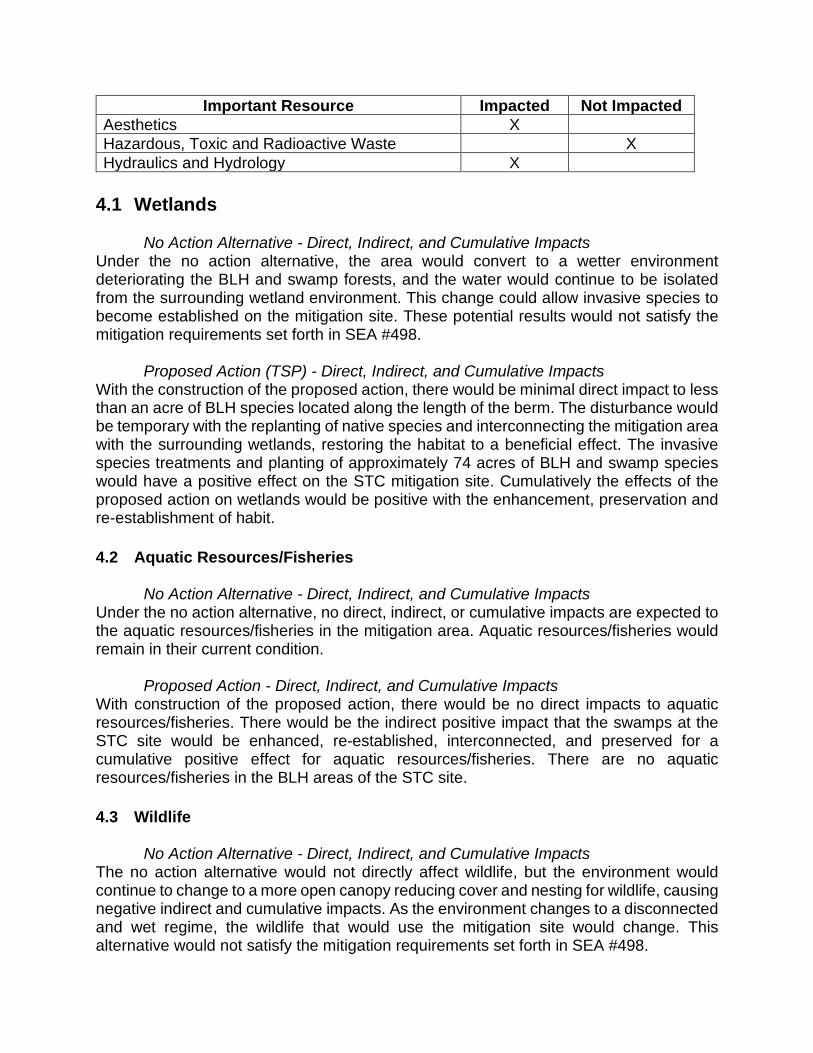
Important Resource Impacted Not Impacted
Aesthetics X
Hazardous, Toxic and Radioactive Waste X
Hydraulics and Hydrology X
4.1 Wetlands No Action Alternative - Direct, Indirect, and Cumulative Impacts Under the no action alternative, the area would convert to a wetter environment deteriorating the BLH and swamp forests, and the water would continue to be isolated from the surrounding wetland environment. This change could allow invasive species to become established on the mitigation site. These potential results would not satisfy the mitigation requirements set forth in SEA #498. Proposed Action (TSP) - Direct, Indirect, and Cumulative Impacts With the construction of the proposed action, there would be minimal direct impact to less than an acre of BLH species located along the length of the berm. The disturbance would be temporary with the replanting of native species and interconnecting the mitigation area with the surrounding wetlands, restoring the habitat to a beneficial effect. The invasive species treatments and planting of approximately 74 acres of BLH and swamp species would have a positive effect on the STC mitigation site. Cumulatively the effects of the proposed action on wetlands would be positive with the enhancement, preservation and re-establishment of habit.
4.2 Aquatic Resources/Fisheries No Action Alternative - Direct, Indirect, and Cumulative Impacts Under the no action alternative, no direct, indirect, or cumulative impacts are expected to the aquatic resources/fisheries in the mitigation area. Aquatic resources/fisheries would remain in their current condition. Proposed Action - Direct, Indirect, and Cumulative Impacts With construction of the proposed action, there would be no direct impacts to aquatic resources/fisheries. There would be the indirect positive impact that the swamps at the STC site would be enhanced, re-established, interconnected, and preserved for a cumulative positive effect for aquatic resources/fisheries. There are no aquatic resources/fisheries in the BLH areas of the STC site.
4.3 Wildlife No Action Alternative - Direct, Indirect, and Cumulative Impacts The no action alternative would not directly affect wildlife, but the environment would continue to change to a more open canopy reducing cover and nesting for wildlife, causing negative indirect and cumulative impacts. As the environment changes to a disconnected and wet regime, the wildlife that would use the mitigation site would change. This alternative would not satisfy the mitigation requirements set forth in SEA #498.

Proposed Action - Direct, Indirect, and Cumulative Impacts With construction of the proposed action, indirect benefits to wildlife would result from the preservation, re-establishment and enhancement of approximately 1,321 acres of BLH and swamp habitat. Construction activities would cause temporary direct impacts such as removal of all non-native trees and smaller trees on parts of the berm, noise, and vibration that could disturb wildlife in and near the project. These animals would temporarily avoid portions of the project area during the construction period but would likely return after construction is completed. Cumulatively the effects of the proposed action on wildlife would be positive with the enhancement, preservation and re-establishment of habitat.
4.4 Threatened and Endangered and other Protected Species. No Action Alternative - Direct, Indirect and Cumulative There are no Threatened and Endangered (T&E) species or critical habitat within, or in the immediate vicinity of, the proposed project area and therefore there would be no direct, indirect or cumulative impacts to T&E species under the no action alternative. Indirect impacts to bald eagles and colonial nesting waterbirds would be the continued loss of potential nesting and roosting opportunities due to tree mortality in the project area. This would contribute cumulatively to the habitat loss already being experienced by these species. Proposed Action - Direct, Indirect and Cumulative There are no T&E species or critical habitat within, or in the immediate vicinity of the proposed project area and therefore there would be no direct, indirect or cumulative impacts to T&E species. CEMVN has made a “no effect” determination under the Endangered Species Act (ESA). No consultation under the ESA would be required for the proposed action. No known eagle’s nests or waterbird colonies exist within 1,000 feet of the proposed project activities. However, in coordination with USFWS, a qualified biologist would inspect the proposed worksite for the presence of undocumented nests during the nesting seasons and/or prior to construction. Through careful design of the berm reduction, timing of construction and the implementation of best management practices, direct adverse impacts to nesting bald eagles and/or waterbird nesting colonies would be avoided. Additionally, to minimize disturbance to colonies containing nesting waterbirds (if present), all activity occurring within 1,000 feet of a rookery would be restricted to the non-nesting period. To minimize disturbance to nesting eagles (if present), the guidelines found in Appendix D would be followed during construction. The planting of approximately 74 acres of swamp and BLH species would indirectly benefit eagles and waterbirds by providing additional opportunities for nesting and roosting in the future. This project, when added to other past, present, and reasonably foreseeable ecosystem restoration and mitigation projects, would help lessen the loss of habitats utilized by protected species.

4.5 Air Quality No Action Alternative - Direct, Indirect, and Cumulative Impacts Under the no action alternative, potential direct and indirect air quality impacts associated with the construction and operation of the mitigation project would not occur. Air quality would not be predicted to change from existing conditions and therefore would have no change cumulatively on air quality. Proposed Action - Direct, Indirect, and Cumulative Impacts Direct impacts to air quality would include emissions from the operation of construction equipment that would be used to put cuts into the berm and to treat the invasive species. Emissions from this construction equipment would occur throughout the approximately 180 calendar day construction period. These direct impacts would be anticipated to be localized and temporary. During and after construction, however, air quality would continue to be in attainment of pollutant standards set by NAAQS. The indirect effects to air quality would be related to the emissions from the transportation of personnel, construction materials, and equipment to the work site on a daily or routine basis until construction of the project is complete to the extent those emissions go beyond the project area. Cumulatively, the effects would be temporary and would not affect NAAQS attainment. The cumulative effects to air quality would be the combined emissions from constructing the proposed action, when added to other regional emission sources. Those sources would include vehicles utilizing the local roads and highways. It is not expected that there would be a significant change in air quality cumulatively due to this project.
4.6 Water Quality No Action Alternative - Direct, Indirect, and Cumulative Impacts Under the no action alternative, there would be no changes in impacts to this resource. Without implementation of the proposed action, water quality would not be predicted to change from existing conditions. Point source and nonpoint source pollution inputs would continue to impact and degrade water quality. There would be no cumulative impacts to water quality from implementation of this alternative. Proposed Action - Direct, Indirect, and Cumulative Impacts Suspended sediments transported in runoff from the project site may temporarily degrade surface water quality to a limited degree during initial mitigation activities (berm construction, clearing of invasive plants, etc.). This impact would be minimized through the use of appropriate best management practices - containing the impact to the project footprint. The exchange of the water across the BLH habitat would result in some positive indirect impacts because of wetlands’ capacity to act as sinks (reservoir that accumulates and stores) for nutrients, thus improving local water quality. No negative cumulative effects to water quality would be anticipated from construction of the proposed project.

4.7 Noise No Action Alternative - Direct, Indirect, and Cumulative Impacts Under the no action alternative, there would be no change in the existing impacts due to sound levels. Birds and other animals would continue to be flushed when ATVs approach, and noise comes from the subdivision and highways. Proposed Action - Direct, Indirect, and Cumulative Impacts With construction of the proposed action, there would be a temporary increase in noise levels during construction and maintenance activities. This project would move its equipment through a neighborhood, but the construction area is shielded from the neighborhood by trees and a large infrastructure levee. Typical construction equipment (Table 1) that would be used on this project produce noise ranging from 75 decibels (dBA) to 100 dBA measured at 100 ft. Sound levels dissipate quickly with distance and screens. The proposed mitigation features are beyond 1,000 feet of a subdivision at the STC site. Off-site areas could experience higher than ambient noise levels during initial mitigation activities (e.g., construction of berms and surface water management features). Wildlife and fish would be directly and indirectly impacted and would vacate the vicinity during construction due to noise and vibration. Once construction is complete, the wildlife and fish would likely return to the vicinity. There should be no long term cumulative impacts from the noise and vibration.
4.8 Cultural Resources No Action Alternative - Direct, Indirect, and Cumulative Impacts Without implementation of the proposed action, conditions within the existing environment would remain largely the same as present; therefore, there would be “No Effect” to historic properties. Proposed Action - Direct, Indirect, and Cumulative Impacts No impacts to historic properties, cultural resources, or tribal resources would occur as a result of implementing the proposed action. CEMVN consulted with the LA SHPO in a letter on March 9, 2020, and consulted with the Alabama-Coushatta Tribe of Texas (ACTT), the Chitimacha Tribe of Louisiana (CTL), the Choctaw Nation of Oklahoma (CNO), the Coushatta Tribe of Louisiana (CT), the Jena Band of Choctaw Indians (JBCI), the Mississippi Band of Choctaw Indians (MBCI), the Muscogee (Creek) Nation (MCN), the Seminole Nation of Oklahoma (SNO), and the Tunica-Biloxi Tribe of Louisiana (TBTL) via letter on March 17, 2020, with a determination of “No Historic Properties Affected” for the proposed undertaking. SHPO concurred with this determination on April 15, 2020. The MCN provided concurrence with this determination via email dated March 19, 2020. No other comments were received. In accordance with 36 CFR 800.4 (d)(1)(i), CEMVN has fulfilled its consultation responsibilities.

4.9 Recreational Resources No Action Alternative - Direct, Indirect, and Cumulative Impacts Without implementation of the proposed action, the conditions within the recreational environment, such as for hunting, would continue as they have in the past and would be dictated by the natural land use patterns and processes that have dominated the area in the past. Direct, indirect, and cumulative impacts would be negligible. Proposed Action - Direct, Indirect, and Cumulative Impacts Direct impacts to recreation would be the interruption of hunting activities during construction. There would be the potential for recreation opportunities such as hunting, hiking, wildlife viewing, and bird watching with the change of land status from private to public if the local sponsor designates the area for public use.
4.10 Aesthetics No Action Alternative - Direct, Indirect, and Cumulative Impacts With the no action alternative, the proposed project area and its landscapes would remain on their current trajectory. Future changes to the local environment would be dictated by future maintenance and land use practices. The most likely scenario would be that the landscapes would evolve according to natural processes, such as continued tree mortality, over time. Proposed Action - Direct, Indirect, and Cumulative Impacts With the proposed action, there are no foreseen, long term, direct, indirect, or cumulative impacts to Aesthetic (visual) Resources at or near the proposed project area. The scenic character and visual quality of the proposed project area have not been recognized by any national or state designation. Although the proposed project area is remote, there is a residential community located adjacent to, and to the north of the project site that may be disturbed temporarily during construction due to the presence of construction equipment. It is expected that the area would return to pre-construction conditions soon after completion of the project.
4.11 Hazardous, Toxic, and Radioactive Waste A Phase I Environmental Site Assessment (ESA) for the West Bank and Vicinity Mitigation Area, near Luling, St. Charles Parish, Louisiana, was prepared by USACE-MVN personnel on 26 August 2011. The Assessment Team performed a Phase I ESA of the proposed mitigation site, in St. Charles Parish, Louisiana, in conformance with the scope and limitations of ASTM E 1527. This assessment revealed no evidence of recognized environmental conditions (RECs) that would affect the project. On May 13, 2020 personnel from USACE-MVN conducted an additional data base search of the proposed mitigation area to investigate a modification in SEA #498, mainly the addition of the clearing and excavation of portions of the existing two-track road to lower the road surface, allowing laminar flow across the area, and restoring the BLH qualities

of the site. Three dry and plugged oil/gas wells were noted in the vicinity of the proposed clearing and excavation; however, they are not located within the footprint of the proposed work and are not expected to affect the project. Aerial photographs and topographic maps were reviewed. The proposed mitigation area is still undeveloped and no signs of unusual items of concern were noted. Based on the results of the original ESA Phase I and this update, the probability of encountering HTRW during the course of this project is low. No further evaluation of HTRW is recommended at this time for the West Bank and Vicinity Mitigation Area.
4.12 Hydrology No Action Alternative - Direct, Indirect, and Cumulative Impacts Under the no action alternative, there would be no changes in impacts to this resource. The STC site would remain inundated for extended periods (30+ days) after rainfall and pumping from the pump station would continue. Proposed Action - Direct, Indirect, and Cumulative Impacts The hydraulics and hydrology modeling indicated the duration to return to average water elevation (Appendix H). Using the maximum inputs (pump + precipitation), the proposed action would reduce the inundation time by 10+ days. The reduced time of inundation would have a positive impact on the BLH forest and swamp habitats. The re-introduction of flow to the area would enhance the nutrient and moisture cycles to the mitigation site and the adjacent property having positive indirect and cumulative effects.
5 MITIGATION The appropriate application of mitigation is to formulate an alternative that first avoids, then minimizes, and lastly, compensates for unavoidable adverse impacts. Formulation for this mitigation plan was completed in SEA #498. This SEA evaluation indicates there would be minimal/insignificant adverse impacts to resources due to construction that would be offset by the beneficial mitigation being performed. The proposed modifications to the mitigation project which consists of BLH and swamp enhancement, and re-establishment west of the Davis Pond guide levee and adjacent to the Salvador Wetland Management Area (WMA), St. Charles Parish mitigate for pre-Katrina impacts from the construction of the West Bank and Vicinity Hurricane Protection Project (WBV). This document serves as the mitigation plan required by 33 CFR 332.4(c) and 40 CFR 230.92.4(c). The twelve components of a compensatory mitigation plan are located in various sections of this document
Components Description
1. Objectives The three original WBV EIS, SEA #498; SEA #498A section 1.1
2. Site Selection The three original WBV EIS; SEA #498 sections 1.2, 2.2

3. Site Protection Instrument
The land was acquired in fee, excluding oil and gas with restrictions on the use of the surface. The non-Federal sponsor would be responsible for operation, maintenance, repair, rehabilitation, and replacement of the mitigation site in perpetuity.
4. Baseline Information SEA #498A section 3 5. Determination of Credits The three original WBV EIS and SEA #498 section 1.6.
6. Mitigation Work Plan
SEA #498A section 2.3 and Appendix C: “Planting Plan, “Success Criteria and Monitoring Plan”. Coordination with the Interagency Team (including USFWS, NMFS, and LDWF) and the Sponsor has and will continue to occur in the development of the mitigation plan.
7. Maintenance Plan
Maintenance for this project would entail invasive and nuisance species control, maintaining the cuts in the berm to the design elevation, and keeping the cuts in the berm clear of debris; the maintenance plan will be further outlined in the OMRR&R Manual to be developed at a later date.
8. Performance Standards
Appendix C
9. Monitoring Requirements Appendix C
10. Long-Term Management Plan
CEMVN is responsible for this mitigation project for the duration of the construction phase and until initial success criteria are met, to verify mitigation success and to complete project features if necessary. The non-Federal sponsor shall be responsible for OMRR&R of functional portions of work as they are completed. The non-Federal sponsor shall be responsible for maintaining the mitigation site in perpetuity.
11. Adaptive Management Plan
In the event reports in component 9 (Appendix C) submitted to CEMVN reveal that any success criteria have not been met during OMRR&R phase, the non-Federal sponsor, or its assigns, after consultation with CEMVN and other appropriate agencies, would take all necessary measures to modify management practices in order to achieve these criteria in the future.
If the results of the monitoring program support the need for physical modifications to the project, CEMVN would determine and implement the appropriate corrections subject to availability of funds and relevant cost-sharing requirements and in accordance with current authority and budgetary and other guidance, including the potential to consider implementing corrective measures under separate authority.
If high mortality is apparent within the mitigation site, CEMVN or its assigns would take appropriate actions to address the causes of mortality and replace all dead trees in accordance with cost sharing applicable to the project and subject to the availability of funds.

12. Financial Assurances
Financial assurances are required to ensure that the compensatory mitigation project would be successful. In this case the WBV Project Cooperation Agreement between the CPRA of Louisiana and the Federal Government provides the required financial assurance for this mitigation project. In the event that the non-Federal sponsor fails to perform, the CEMVN has the right to complete, operate, maintain, repair, rehabilitate or replace any project feature, including mitigation features, but such action would not relieve CPRA of its responsibility to meet its obligations and would not preclude the US from pursuing any remedy at law or equity to ensure CPRA’s performance.
6 COORDINATION AND PUBLIC INVOLVEMENT A Public Notice for SEA #498A was published in the New Orleans Advocate for 15 days beginning July 8, 2020 and ending July 23, 2020. Preparation of this SEA and FONSI was coordinated with appropriate Congressional, Federal, state, and local interests, as well as environmental groups and other interested parties. The following agencies, as well as other interested parties, have received copies of this draft SEA: U.S. Department of the Interior, Fish and Wildlife Service
U.S. Environmental Protection Agency, Region VI
U.S. Department of Commerce, National Marine Fisheries Service
U.S. Natural Resources Conservation Service, State Conservationist
Governor's Executive Assistant for Coastal Activities
Louisiana Department of Wildlife and Fisheries
Louisiana Department of Natural Resources, Coastal Management Division
Louisiana Department of Natural Resources, Coastal Restoration Division
Louisiana Department of Environmental Quality, PER-REGC
Louisiana Department of Environmental Quality, EP-SIP
Louisiana State Historic Preservation Officer
7 COMPLIANCE WITH ENVIRONMENTAL LAWS AND REGULATIONS There are many Federal and state laws pertaining to the enhancement, management and protection of the environment. Federal projects must comply with environmental laws, regulations, policies, rules and guidance. Compliance with laws was accomplished upon

the conclusion of a 15-day public and agency review of this SEA #498A and associated Finding of No Significant Impact. Clean Air Act of 1972 The Clean Air Act (CAA) sets goals and standards for the quality and purity of air. It requires the Environmental Protection Agency to set National Ambient Air Quality Standards (NAAQS) for pollutants considered harmful to public health and the environment. The Project Area is in St. Charles Parish, which is currently in attainment of NAAQS. The Louisiana Department of Environmental Quality is not required by the CAA and Louisiana Administrative Code, Title 33 to grant a general conformity determination. Clean Water Act of 1972 – Section 401 and Section 404 The Clean Water Act (CWA) sets and maintains goals and standards for water quality and purity. Section 401 requires a Water Quality Certification from the Louisiana Department of Environmental Quality (LDEQ) that a proposed project does not violate established effluent limitations and water quality standards. Clean Water Act of 1972 Water Quality Certification application was submitted May 15, 2020 and can be found in Appendix E. On May 21, 2020, Louisiana Department of Environmental Quality issued WQC 200519-01, AI Number 101235, activity CER20200004 for the proposed project. Requirements under the Clean Water Act of 1972, Section 401 have been met. (Appendix E) As required by Section 404(b)(1) of the Clean Water Act (CWA), an evaluation to assess the short- and long-term impacts associated with the discharge of dredged and fill materials into waters of the United States resulting from this Project has been completed. Section 404(b)(1) public notice was mailed out for public review comment period concurrent with this SEA beginning July 8, 2020 and ending July 23, 2020. No comments were received on the 404(b)(1) and it was signed on August 4, 2020. (Appendix G) Coastal Zone Management Act of 1972 The Coastal Zone Management Act (CZMA) requires that "each federal agency conducting or supporting activities directly affecting the coastal zone shall conduct or support those activities in a manner which is, to the maximum extent practicable, consistent with approved state management programs." In accordance with Section 307, a Consistency Determination was prepared for the proposed Project and was coordinated with the Louisiana Department of Natural Resources (LADNR) in a letter dated May 5, 2020. A Coastal Zone Consistency Determination was received on June 29, 2020 (C20110476 Mod 02). (Appendix E) Endangered Species Act of 1973 The Endangered Species Act (“ESA”) is designed to protect and recover threatened and endangered (“T&E”) species of fish, wildlife and plants. Based on a parish search conducted on the US Fish and Wildlife Service (USFWS) endangered species website (http://www.fws.gov/endangered) on April 7, 2020, there are five Threatened and Endangered (T&E) species listed in St. Charles Parish. Based on a site specific search conducted on the USFWS website (https://ecos.fws.gov/ipac/location) on April 7, 2020,

only the West Indian manatee has the potential of being found near the project site. There are no T&E species or critical habitat within, or in the immediate vicinity of, the proposed project area and therefore the CEMVN has made a “no effect” determination under the Endangered Species Act (ESA). No consultation under the ESA would be required for the proposed action. Fish and Wildlife Coordination Act of 1934 The Fish and Wildlife Coordination Act (“FWCA”) provides authority for the USFWS involvement in evaluating impacts to fish and wildlife from proposed water resource development projects. It requires that fish and wildlife resources receive equal consideration to other project features. It requires Federal agencies that construct, license or permit water resource development projects to first consult with the USFWS, NMFS and state resource agencies regarding the impacts on fish and wildlife resources and measures to mitigate these impacts. Section 2(b) requires the USFWS to produce a Coordination Act Report (“FWCAR”) that details existing fish and wildlife resources in a project area, potential impacts due to a proposed project and recommendations for a project. The Service has determined in a June 24, 2020 letter that the proposed minor modification will not require a supplemental Fish and Wildlife Coordination Act Report. The Service has previously provided comments on the subject mitigation plan in letters dated April 29, 2011, June 6, 2011, September 9, 2011, October 7, 2011, October 19, 2011, November 21, 2011, May 16, 2012 and May 28, 2020. Those documents adequately address the Service's position regarding the proposed modification and the Service has no additional comments and concurs with the actions in SEA #498A without further comment. (Appendix E) Hazardous, Toxic, and Radioactive Waste The discharge of dredged material into waters of the United States is regulated under the Clean Water Act (CWA). In the absence of a known Hazardous, Toxic, and Radioactive Waste (HTRW) concern, the proposed action would not qualify for an HTRW investigation. Engineer Regulation (ER 1165-2-132) provides that in the Planning, Engineering and Design Phase that, for proposed project in which the potential for HTRW problems has not been considered, an HTRW initial assessment, as appropriate for a reconnaissance study, should be conducted as a first priority. If the initial assessment indicates the potential for HTRW, testing, as warranted and analysis similar to a feasibility study should be conducted prior to proceeding with the project design. The NFS will be responsible for planning and accomplishing any HTRW response measures, and will not receive credit for the costs incurred. Aerial photographs and topographic maps were reviewed. The proposed mitigation area is still undeveloped and no signs of unusual items of concern were noted. Based on the results of the original ESA Phase I and this update, the probability of encountering HTRW during the course of this project is low.
An ASTM E 1527-05 Phase I Hazardous, Toxic, or Radioactive Waste Environmental Site Assessment (ESA), entitled “West Bank and Vicinity Mitigation Areas, St. Charles Parish, Louisiana” (HTRW-11-17) was completed on August 26, 2011. An update to the Phase I ESA was completed on May 14, 2020. A copy of the updated Phase I ESA is maintained on file at MVN. Neither the Phase I ESA nor the subsequent Phase I ESA Update identified any Recognized Environmental Conditions (RECs). Three dry and plugged oil/gas wells were noted near the project vicinity; however, they should not have any negative effects on the proposed project. There is a low probability that HTRW would affect the proposed project, personnel working on the project, members of the public, or the environment in the project area. No further evaluation of HTRW is recommended at this time for the West Bank and Vicinity Mitigation Area. Migratory Bird Treaty Act The Migratory Bird Treaty Act of 1918 (MBTA) is the domestic law that affirms, or implements, the United States' commitment to four international conventions with Canada, Japan, Mexico, and Russia for the protection of shared migratory bird resources. The MBTA governs the taking, killing, possessing, transporting, and importing of migratory birds, their eggs, parts, and nests. The project area is located in an area where colonial nesting waterbirds may be present, although no nesting is currently apparent so MVN finds that implementation of the proposed actions would have no effect on colonial nesting waterbirds. Colonial nesting waterbirds are generally considered all species of herons, egrets, night herons, ibis, roseate spoonbill, anhinga and cormorants. To minimize disturbance to colonies containing nesting waterbirds (if present) all activity occurring within 1,000 feet of a rookery would be restricted to the non-nesting period. Bald and Golden Eagle Protection Act The bald eagle was removed from the List of Endangered and Threatened Species in August 2007 but continues to be protected under the Bald and Golden Eagle Protection Act (BGEPA) and the Migratory Bird Treaty Act of 1918, as amended (MBTA). During nesting season, construction must take place outside of USFWS/LDWF buffer zones. A Corps Biologist and USFWS Biologist would survey for nesting eagles prior to the start of construction. To minimize disturbance to nesting eagles (if present), the guidelines found in Appendix D would be followed during construction. National Historic Preservation Act of 1966 Section 106 of the National Historic Preservation Act of 1966, as amended, requires Federal agencies to take into account the effects of their undertakings on historic properties and afford the Advisory Council on Historic Preservation a reasonable opportunity to comment on such undertakings. The procedures in 36 CFR Part 800 define how Federal agencies meet these statutory responsibilities. The Section 106 process seeks to accommodate historic preservation concerns with the needs of Federal undertakings through consultation among the agency official and other parties with an interest in the effects of the undertaking on historic properties, including the State Historic Preservation Officer (SHPO) or Tribal Historic Preservation Officer (THPO) and any Tribe that attaches religious or cultural significance to historic properties that may be affected by an undertaking. The goal of consultation is to identify historic properties potentially
affected by the undertaking, assess its effects and seek ways to avoid, minimize or mitigate any adverse effects on historic properties. Consultation pursuant to Section 106 has been completed and a finding of no historic properties affected, was coordinated for the original Project goals as presented in SEA #498, with a letter dated March 9, 2020 to the SHPO, and a response dated April 15, 2020 (Appendix E). In a letter dated April 15, 2020, SHPO concurred that the actions of this Supplemental EA are determined as having no additional potential to cause effect to any potential cultural resources. Tribal Consultation NEPA, Section 106 of the National Historic Preservation Act, EO 13175 (Consultation and Coordination with Indian Tribal Governments), the American Indian Religious Freedom Act, and related statutes and policies have a consultation component. In accordance with CEMVN’s responsibilities under NEPA, Section 106, and EO 13175, CEMVN offered the following federally-recognized Indian Tribes the opportunity to review and comment on the potential of the proposed action to significantly affect protected tribal resources, tribal rights, or Indian lands: Alabama-Coushatta Tribe of Texas, Caddo Nation of Oklahoma, Chitimacha Tribe of Louisiana, Choctaw Nation of Oklahoma, Coushatta Tribe of Louisiana, Jena Band of Choctaw Indians, Mississippi Band of Choctaw Indians, Seminole Nation of Oklahoma, Seminole Tribe of Florida, and Tunica-Biloxi Tribe of Louisiana. On March 17, 2020, letters were mailed to the tribal leaders requesting input regarding the proposed action. The Muscogee (Creek) Nation concurred with the determination of “no adverse effect to historic property” on March 19, 2020. The 30 day consultation period ended on April 15, 2020 and no other comments were received.
8 CONCLUSION AND RECOMMENDATIONS The proposed action would restore the hydrology at the STC mitigation site, returning the water regime to a water exchange indicative of BLH and swamp habitats, maintaining the required habitat for the mitigation. The tree losses will be re-established by planting approximately 74 acres of BLH and swamp species on the site. With the TSP the previously authorized WBV compensatory mitigation requirements would be satisfied. With this proposed action wetlands, wildlife, recreation, and water quality are expected to incur minimum and temporary adverse impacts during activities, and experience beneficial impacts indirectly and cumulatively due to the improved habitat. Air quality, noise, and aesthetics would be temporarily adversely impacted during construction activities with no indirect or cumulative effects, as the area would return to pre-construction conditions soon after completion of the project. There would be beneficial impacts to aquatic resources/fisheries, other protected species, and hydraulics and hydrology due to the project’s improved habitat and access. Threatened and Endangered species are not present in the area and would not be impacted, although site surveys would still be conducted. There would be no impact to cultural resources by the proposed action. The probability of encountering HTRW in the WBV Mitigation Areas is very low. Based on the following criteria: engineering effectiveness, economic efficiency, and environmental and social acceptability, the TSP provides the required mitigation, is cost

effective, and has a shorter construction duration than the other alternatives. The no action alternative would not provide the needed mitigation authorized in SEA #498 in 2012. This office has assessed the environmental impacts of the proposed action and has determined that the proposed action would have no significant adverse impacts on the human and natural environment.
8.1 Recommended Decision Recommend approval of the TSP which fulfills the previously authorized WBV compensatory mitigation requirements.
9 LIST OF PREPARERS SEA #498A, and the associated FONSI were prepared by Eric Tomasovic, Biologist, U.S. Army Corps of Engineers, New Orleans District; Regional Planning and Environment Division South, MVN-PDN-CEP; 7400 Leake Avenue; New Orleans, Louisiana 70118.
Title/Topic Team Member
Senior Environmental Manager Team Lead
Tammy Gilmore, CEMVN
Environmental Manager, Lead Eric Tomasovic, CEMVN
Senior Project Manager Darrel Broussard, CEMVN
Project Manager Daimia Jackson, CEMVN
Cultural Resources Jill Enerson, CEMVN
Recreation and Aesthetics Jack Milazzo, CEMVN
HTRW Joe Musso, CEMVN
Water Quality and Coastal Zone Mgt. Mike Morris, CEMVN
404(b)(1) Application Eric Glisch, CEMVN
10 REFERENCES Burk and Associates. 1977. Potential Preservation and Restoration Areas in the Louisiana Wetlands. Prepared for the Louisiana State Planning Office, Coastal Resources Program. Costanza, R., S. Farber, and J. Maxwell. 1989. Valuation and management of wetland ecosystems. Ecological Economics (1) 335-361. Coastal Wetlands Planning, Protection and Restoration Act (CWPPRA). 2020. Barataria Basin. (https://lacoast.gov/new/About/Basins.aspx) Gosselink, J.G. 1984. The ecology of delta marshes of coastal Louisiana: a community profile. U.S. Fish and Wildlife Service. FWS/OBS-84/09, 134 pp. Jones, K. R., Franks, H. A., and Kidder, T. R.

1994 Cultural Resources Survey and Testing for Davis Pond Freshwater Diversion, St. Charles Parish, Louisiana. Earth Search, Inc. for the U.S. Army Corps of Engineers, New Orleans District. Report No. 22-1615, on file with the Louisiana Division of Archaeology. Kryter, K. D. (1994). The handbook of hearing and the effects of noise: Physiology, psychology, and public health. Academic Press. MacDonald, P.O., W.E. Frayer, and J.K. Clauser. 1979. Documentation, chronology, and future projections of bottomland hardwood habitat loss in the Lower Mississippi Alluvial Plain. U.S. Dept. of Interior, Fish and Wildlife Service. 2 vols., 428 p. McIntire, William G. 1979 Cultural Resource Survey Shell’s Proposed Pipeline from Clovelly Oil and Gas Field to Norco, Louisiana. William G. McIntire for Shell Oil. Report No. 22-0491, on file with the Louisiana Division of Archaeology Mitsch, W.J. and J. G. Gosselink. 2000. Wetlands, third edition. John Wiley & Sons, Inc., 920 pp. NETR Online (NETR) Var. Historic aerials, USGS maps. Accessed online February 2020 at https://www.historicaerials.com/viewer Penland, S., Williams, S.J., Britsch, L.D., and Beall, A.D. 2002. Geologic Classification of Coastal Land Loss Between 1932 and 1990 in the Mississippi River Delta Plain, Southeastern Louisiana. Transactions of the Gulf Coast Association of Geological Societies, 52:799-807. Rawls, John, Dan Brown, Tegan Hanson, and Rhonda L. Smith. 2011 Negative Findings Report for the Phase I Survey, Ellington Plantation III, West Bank Protection Levee, St. Charles Parish, Louisiana. Earth Search, Inc. for GCR and Associates, Inc. and the St. Charles Parish Public Works Department. Report No. 22-3763, on file with the Louisiana Division of Archaeology. Reidy, M.M., T.A. Campbell, and D.G. Hewitt. 2008. The Journal of Wildlife Management. (http://www.aphis.usda.gov/wildlife_damage/nwrc/publications/08pubs/campbell083.pdf) Vol. 72(4) p. 1012-1018. Shuman 2006 Cultural Resources Survey of the Proposed Servitude for a Hurricane Protection Levee, Luling, St. Charles Parish, Louisiana. Surveys Unlimited Research Associates, Inc. for Shread-Kuyrkendall and Associates, Inc. Report No. 22-2854, on file with the Louisiana Division of Archaeology. USACE. 2012. Supplemental Environmental Assessment, SEA #498, West Bank and Vicinity Hurricane Protection Project, Implementation of Previously Authorized Mitigation Plans.

USEPA. 1974. “Information on Levels of Environmental Noise Requisite to Protect Public Health and Welfare with and Adequate Margin of Safety” (https://nepis.epa.gov/Exe/ZyPDF.cgi/2000L3LN.PDF?Dockey=2000L3LN.PDF) USEPA. 2006. “EPA > Wetlands > Wetland Types > Bottomland Hardwoods.” Accessed 19 July, 2007 from http://www.epa.gov/owow/wetlands/types/bottomland.html USEPA. 2020. Nonattainment for Each County by Year (Green Book). Online resource at: https://www3.epa.gov/airquality/greenbook/ancl.html USGS Eco-Region Map, Daigle, J.J., Griffith, G.E., Omernik, J.M., Faulkner, P.L., McCulloh, R.P., Handley, L.R., Smith, L.M., and Chapman, S.S., 2006, Ecoregions of Louisiana color poster with map, descriptive text, summary tables, and photographs): Reston, Virginia.