final feasibility report national waterway-41, region vi
TRANSCRIPT

Final Feasibility Report
National Waterway-41,
Region VI - Ghataprabha River
Chicksangam to Malali (111.76km)
SURVEY PERIOD: 10 FEB 2016 – 25 MAR 2016
Prepared for:
Inland Waterways Authority of India
(Ministry of Shipping, Govt. of India)
A-13, Sector – 1, NOIDA
Distt. Gautam Budh Nagar,
Uttar Pradesh – 201 301
Document Distribution
Date Revision Distribution Hard Copy Soft Copy
25 Nov 2016 Rev – 0 INLAND WATERWAYS
AUTHORITY OF INDIA 01 01
09 May 2017 Rev – 1.0 INLAND WATERWAYS
AUTHORITY OF INDIA 01 01
17 Oct 2017 Rev – 1.1 INLAND WATERWAYS
AUTHORITY OF INDIA 04 04
23 Nov 2017 Rev – 1.2 INLAND WATERWAYS
AUTHORITY OF INDIA 01 01
22 Oct 2018 Rev – 1.3 INLAND WATERWAYS
AUTHORITY OF INDIA 04 04
Volume - I
IWAI, Region VI, Ghataprabha River Final Feasibility Report Page i
ACKNOWLEDGEMENT
IIC Technologies Ltd. expresses its sincere gratitude to IWAI for awarding the
work of carrying out detailed hydrographic surveys in the New National
Waterways in NW-41 in Region VI – Ghataprabha River from Confluence of
Krishna River at Chicksangam to Malali.
We would like to use this opportunity to pen down our profound gratitude and
appreciations to Shri Pravir Pandey, IA&AS, Chairman IWAI for spending
their valuable time and guidance for completing this Project. IIC Technologies
Ltd. would also like to thank, Shri Alok Ranjan, ICAS, Member (Finance), Shri
Shashi Bhushan Shukla, Member (Traffic), Shri S.K. Gangwar, Member
(Technical) for their valuable support during the execution of project.
IIC Technologies Ltd, wishes to express their gratitude to Capt. Ashish Arya,
Hydrographic Chief IWAI, Cdr. P.K. Srivastava ex-Hydrographic Chief and
Shri SVK Reddy, Chief Engineer-I for their guidance and inspiration for this
project. IIC Technologies Ltd, would also like to thank Sh. Rajiv Singhal, A.H.S.,
IWAI for his invaluable support and suggestions provided throughout the survey
period. IIC Technologies Ltd, is pleased to place on records its sincere thanks to
other staff and officers of IWAI for their excellent support and cooperation
throughout the survey period.
IWAI, Region VI, Ghataprabha River Final Feasibility Report Page ii
CONTENTS
1 Introduction........................................................................................................................ 3
1.1 Background................................................................................................................... 3
1.2 Tributaries of Ghataprabha River ................................................................................. 4
1.3 State/ District through which River passes ................................................................... 4
1.4 Maps ............................................................................................................................. 5
1.4.1 Full course of the waterway...................................................................................... 5
1.4.2 Course of the waterway under study ........................................................................ 5
1.5 Scope of work ............................................................................................................... 6
2 Methodology Adopted to undertake Study ........................................................................ 7
2.1 Recce ............................................................................................................................ 7
2.2 Survey Resources and Methodology ............................................................................ 7
2.2.1 Survey Launch .......................................................................................................... 7
2.2.2 Survey Equipment .................................................................................................... 8
2.2.3 Topographic Survey ................................................................................................. 8
2.2.4 Bathymetric Survey and Survey Launch .................................................................. 9
2.2.5 Calibration ................................................................................................................ 9
2.3 Description of Bench Marks (B.M.) Reference Level .................................................. 9
2.4 Tidal Influence Zone and tidal variation .................................................................... 10
2.5 Methodology to fix Chart Datum / Sounding Datum ................................................. 11
2.5.1 Sounding Datum ..................................................................................................... 11
2.5.2 Datum Calculation .................................................................................................. 11
2.6 Average of 06 years minimum Water Levels used ..................................................... 13
2.7 Transfer of Sounding Datum ...................................................................................... 14
2.8 Table indicating tidal variation at different observation points .................................. 15
2.9 Salient features of Dam, Barrages, Barrage ............................................................... 15
2.9.1 Salient features of Bannidinni Barrage ................................................................... 15
2.9.2 Salient features of Yadahalli Barrage ..................................................................... 15
2.9.3 Salient features of Kaladgi Barrage ........................................................................ 16
2.9.4 Salient features of Katarki Barrage ........................................................................ 16
2.9.5 Salient Features of Alagundi Barrage ..................................................................... 17
2.9.6 Salient Features of Machakanur Barrage ................................................................ 17
2.9.7 Salient Features of Jambgi Barrage ........................................................................ 18

IWAI, Region VI, Ghataprabha River Final Feasibility Report Page iii
2.9.8 Salient Features of Bidri Barrage ........................................................................... 19
2.9.9 Salient Features of Marakatti Barrage .................................................................... 19
2.9.10 Salient Features of Ingalagi Barrage .................................................................. 20
2.9.11 Salient Features of Jeeragal Barrage .................................................................. 20
2.9.12 Salient Features of Mudhol Barrage ................................................................... 21
2.9.13 Salient Features of Jaliber Barrage ..................................................................... 21
2.9.14 Salient Features of Malali Barrage ..................................................................... 22
2.10 Erected IWAI Benchmark Pillars ........................................................................... 22
2.11 Chart Datum / Sounding Datum and Reductions Details ....................................... 23
2.12 HFL values of Bridges/Cross Structures ................................................................ 23
2.13 Graph: Sounding Datum and HFL vs Chainage ..................................................... 24
2.14 Average Bed Slope ................................................................................................. 26
2.15 Details of Dam, Barrages, Weirs, Anicut, etc. ....................................................... 27
2.16 Details of Locks ...................................................................................................... 28
2.17 Details of Aqueducts .............................................................................................. 28
2.18 Details of existing Bridges and Crossings over waterway ..................................... 29
2.19 Details of other Cross structures, pipe-lines, underwater cables ............................ 29
2.20 Details High Tension Lines / Electric lines / Tele-communication lines. .............. 29
2.21 Current Meter and Discharge details ...................................................................... 30
2.22 Water Samples ........................................................................................................ 30
3 Description of waterway .................................................................................................. 31
3.1 Sub-Stretch-01: Chicksangam to Veerapur (Chainage 0.0km to 30.0km) ................. 31
3.2 Sub-Stretch 02: Veerapur to Sharadal (Chainage 30.0km to 60.0km) ....................... 35
3.3 Sub Stretch 03: Sharadal to Chinchakhandi (Chainage 60.0km to 90.0km) .............. 39
3.4 Sub-Stretch 04: Chinchakhandi to Malali (Chainage 90.0km to 111.76km).............. 42
3.5 Other aspects of waterway .......................................................................................... 45
3.5.1 Details of Irrigation Canals and Outlets ................................................................. 45
3.5.2 Irrigation/Drinking water ........................................................................................ 45
3.5.3 Crops ...................................................................................................................... 46
3.5.4 Industries ................................................................................................................ 46
3.5.5 Important cities/towns ............................................................................................ 47
3.5.6 Road Network ......................................................................................................... 47
3.5.7 Railway Network .................................................................................................... 48

IWAI, Region VI, Ghataprabha River Final Feasibility Report Page iv
3.5.8 Land Use ................................................................................................................. 49
3.5.9 Construction Material ............................................................................................. 49
3.5.10 Conditions of banks ............................................................................................ 49
3.5.11 Jetties and Terminals .......................................................................................... 49
3.5.12 Cargo Movement ................................................................................................ 50
3.5.13 Passenger Ferry Services .................................................................................... 50
3.5.14 Historic importance ............................................................................................ 50
3.5.15 Tourism .............................................................................................................. 50
4 Terminals ......................................................................................................................... 51
4.1 Details of Terminal survey carried out ....................................................................... 51
5 Fairway development ....................................................................................................... 51
5.1 Fairway Dimensions ................................................................................................... 51
5.2 Calculation of Dredging Quantity .............................................................................. 51
6 Conclusion ....................................................................................................................... 55
6.1 Description of Waterways .......................................................................................... 55
6.2 Methods for making waterway feasible ...................................................................... 56
6.3 Modifications/ improvement measures ...................................................................... 56
6.4 Recommendation ........................................................................................................ 57
7 Details of Annexures ....................................................................................................... 58
Annexure-1 Source and type of data collected from various agencies....................................59
Annexure-2 Stretch wise data of Observed Depths to Reduced Depths..................................61
Annexure-3 Min./Max. Depth, Length of Shoal per km-wise for Different Classification in
the Designed Dredging Channel..............................................................................................63
Annexure-4 Water Level Details.............................................................................................76
Annexure-5 Survey Dates........................................................................................................78
Annexure-6 Details of Bank Protection...................................................................................80
Annexure-7 Details of Riverside Features...............................................................................82
Annexure-8 Horizontal and Vertical control...........................................................................85
Annexure-9 Equipment Photographs.......................................................................................89
Annexure-10 Bench Mark Pillar Forms...................................................................................91
Annexure-11 Levelling Data..................................................................................................114
Annexure-12 Current Meter Observation and Discharge Calculation...................................227
Annexure-13 Water Sample Analysis....................................................................................229
IWAI, Region VI, Ghataprabha River Final Feasibility Report Page v
Annexure-14 Calibration Certificates....................................................................................231
Annexure-15 Survey Chart Scheming Index and chart details..............................................234
Annexure-16 Field Photographs............................................................................................238
Figure 1 - Locations around Ghataprabha River ........................................................................ 3
Figure 2 - Tributaries of total Ghataprabha River ...................................................................... 4
Figure 3 - Full Course of Ghataprabha River ............................................................................ 5
Figure 4 - Course of Ghataprabha River .................................................................................... 6
Figure 5 - Spot leveling by DGPS ............................................................................................. 9
Figure 6 - PWD Benchmark upon Chinchakhandi Bridge, referred to GTP-03 ...................... 10
Figure 7 - Sounding Datum and HFL vs Chainage .................................................................. 26
Figure 8 - Stretch-1 Chicksangam to Veerapur ....................................................................... 31
Figure 9 - Temple at confluence of Krishna (0.0 km chianage) .............................................. 32
Figure 10 - Under construction Barrage at Herkal Village (16.85 km chainage) .................... 33
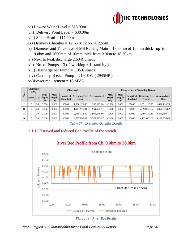
Figure 11 - River Bed Profile ................................................................................................... 34
Figure 12 - Stretch-2 Veerapur to Sharadal ............................................................................. 35
Figure 13 - Yadahalli Bridge (38.7 km chianage) ................................................................... 37
Figure 14 - River Bed Profile ................................................................................................... 38
Figure 15 - Stretch-3 Sharadal to Chinchakhandi .................................................................... 39
Figure 16 - River Bed Profile ................................................................................................... 41
Figure 17 - Stretch-4 Chinchakhandi to Malali ....................................................................... 42
Figure 18 - Chinchakhandi Bridge (91.06 km chainage) ......................................................... 43
Figure 19 - Mudhol Bridge (99.56 km chainage) .................................................................... 44
Figure 20 - River Bed Profile ................................................................................................... 45
Figure 21 - Road Network ....................................................................................................... 48
Figure 22 - Railway Stations .................................................................................................... 49
Figure 23 - Pattadakal Temple ................................................................................................. 50
Figure 24 - Fairway Channel Dimensions 50m X 2m ............................................................. 51
Table 1 - State wise waterway ................................................................................................... 5
Table 2 - Survey Equipment Used ............................................................................................. 8
Table 3 - Accepted Station coordinates (WGS-84) ................................................................. 10
Table 4 - Established CD for Stretch-wise............................................................................... 12
Table 5 - Mudhol CWC gauge details form 2000-2006 .......................................................... 13
Table 6 - Bagalkot CWC guage details from 1994-2000 ......................................................... 14
Table 7 - Salient Features of Bannidinni Barrage .................................................................... 15
Table 8 - Yadahalli barrage details .......................................................................................... 16
Table 9 - Kaladgi Barrage details ............................................................................................ 16
Table 10 - Katarki Barrage details ........................................................................................... 17

IWAI, Region VI, Ghataprabha River Final Feasibility Report Page vi
Table 11 - Alagundi Barrage Details ....................................................................................... 17
Table 12 - Machaknur Barrage Details .................................................................................... 18
Table 13 - Jambgi Barrage Details ........................................................................................... 18
Table 14 - Bidri Barrage Details .............................................................................................. 19
Table 15 - Marakatti Barrage Details ....................................................................................... 19
Table 16 - Ingalagi Barrage Details ......................................................................................... 20
Table 17 - Jeragal Barrage Details ........................................................................................... 20
Table 18 - Mudhol Barrage Details ......................................................................................... 21
Table 19 - Jaliber Barrage Details ........................................................................................... 21
Table 20 - Malali Barrage Details ............................................................................................ 22
Table 21 - Accepted Benchmark coordinates w. r. t CD ......................................................... 23
Table 22 - HFL values of Bridges/Cross Structures ................................................................ 24
Table 23 - Average Bed Slope ................................................................................................. 26
Table 24 - Cross Structures w.r.t. MSL ................................................................................... 28
Table 25 - Bridges crossing over waterway ............................................................................. 29
Table 26 - High Tension Lines ................................................................................................ 30
Table 27 - Dredging Quantity Details ...................................................................................... 34
Table 28 - Dredging Quantity Details ...................................................................................... 37
Table 29 - Dredging Quantity Details ...................................................................................... 41
Table 30 - Dredging Quantity Details ...................................................................................... 44
Table 31 - Stretch wise Class I Dredge Volumes .................................................................... 52
Table 32 - Stretch wise Class II Dredge Volumes ................................................................... 53
Table 33 - Stretch wise Class III Dredge Volumes .................................................................. 54
Table 34 - Stretch wise Class IV Dredge Volumes ................................................................. 55
IWAI, Region VI, Ghataprabha River Final Feasibility Report Page vii
List of Abbreviations
CD Chart Datum
SD Sounding Datum
DGPS Differential Global Positioning Systems
GTP Ghataprabha
ETS Electronic Total Station
GPS Global Positioning Systems
LBM Local Bench Mark
MSL Mean Sea Level
RL Reference Level
SD Sounding Datum
SBAS Satellite-Based Augmentation System
TBC Trimble Business Center
LIS Lift Irrigation Scheme
CWC Central Water Commission
KJBNL Krishna Jal Bhagya Nigam Limited
MI Minor Irrigation
NH National Highway
SH State Highway
KPTCL Karnataka Power Transmission Corporation Limited
IWAI, Region VI, Ghataprabha River Final Feasibility Report Page 1
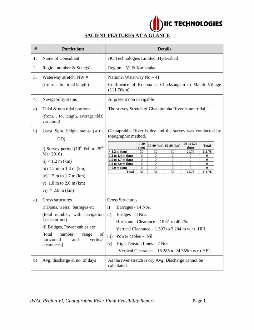
SALIENT FEATURES AT A GLANCE
# Particulars Details
1. Name of Consultant IIC Technologies Limited, Hyderabad
2. Region number & State(s) Region – VI & Karnataka
3. Waterway stretch, NW #
(from…. to; total length)
National Waterway No – 41
Confluence of Krishna at Chicksangam to Malali Village
(111.76km)
4. Navigability status At present non navigable
a) Tidal & non tidal portions
(from… to, length, average tidal
variation)
The survey Stretch of Ghataprabha River is non-tidal.
b) Least Spot Height status (w.r.t.
CD)
i) Survey period (10th Feb to 25
th
Mar 2016)
ii) < 1.2 m (km)
iii) 1.2 m to 1.4 m (km)
iv) 1.5 m to 1.7 m (km)
v) 1.8 m to 2.0 m (km)
vi) > 2.0 m (km)
Ghataprabha River is dry and the survey was conducted by
topographic method.
0-30
(km) 30-60 (km) 60-90 (km)
90-111.76
(km) Total
< 1.2 m (km) 30 30 30 21.76 111.76
1.2 to 1.4 m (km) 0 0 0 0 0
1.5 to 1.7 m (km) 0 0 0 0 0
1.8 to 2.0 m (km) 0 0 0 0 0
> 2.0 m (km) 0 0 0 0 0
Total 30 30 30 21.76 111.76
c) Cross structures
i) Dams, weirs, barrages etc
(total number; with navigation
Locks or not)
ii) Bridges, Power cables etc
[total number; range of
horizontal and vertical
clearances]
Cross Structures
i) Barrages - 14 Nos.
ii) Bridges – 3 Nos.
Horizontal Clearance – 10.81 to 40.25m
Vertical Clearance – 1.597 to 7.204 m w.r.t. HFL
iii) Power cables – Nil
iv) High Tension Lines – 7 Nos
Vertical Clearance – 16.285 to 24.355m w.r.t HFL
d) Avg. discharge & no. of days As the river stretch is dry Avg. Discharge cannot be
calculated.
IWAI, Region VI, Ghataprabha River Final Feasibility Report Page 2
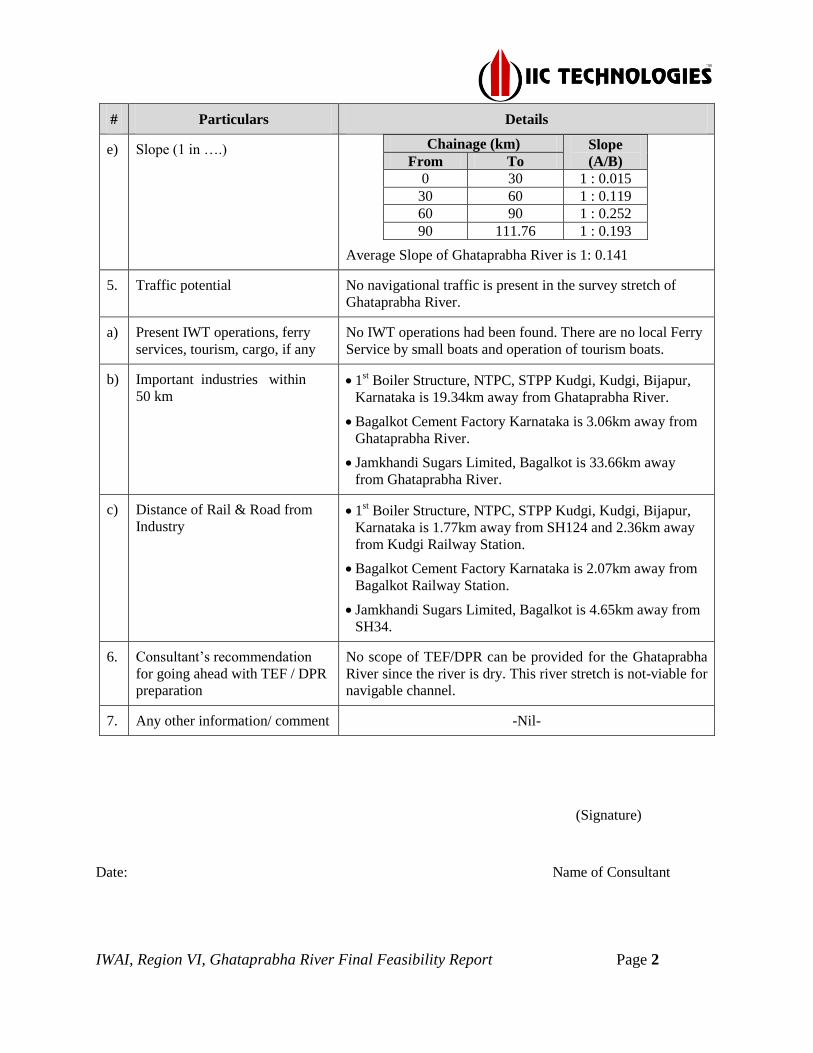
# Particulars Details
e) Slope (1 in ….) Chainage (km) Slope
(A/B) From To 0 30 1 : 0.015
30 60 1 : 0.119 60 90 1 : 0.252 90 111.76 1 : 0.193
Average Slope of Ghataprabha River is 1: 0.141
5. Traffic potential No navigational traffic is present in the survey stretch of
Ghataprabha River.
a) Present IWT operations, ferry
services, tourism, cargo, if any
No IWT operations had been found. There are no local Ferry
Service by small boats and operation of tourism boats.
b) Important industries within
50 km 1st
Boiler Structure, NTPC, STPP Kudgi, Kudgi, Bijapur,
Karnataka is 19.34km away from Ghataprabha River.
Bagalkot Cement Factory Karnataka is 3.06km away from
Ghataprabha River.
Jamkhandi Sugars Limited, Bagalkot is 33.66km away
from Ghataprabha River.
c) Distance of Rail & Road from
Industry 1st
Boiler Structure, NTPC, STPP Kudgi, Kudgi, Bijapur,
Karnataka is 1.77km away from SH124 and 2.36km away
from Kudgi Railway Station.
Bagalkot Cement Factory Karnataka is 2.07km away from
Bagalkot Railway Station.
Jamkhandi Sugars Limited, Bagalkot is 4.65km away from
SH34.
6. Consultant’s recommendation
for going ahead with TEF / DPR
preparation
No scope of TEF/DPR can be provided for the Ghataprabha
River since the river is dry. This river stretch is not-viable for
navigable channel.
7. Any other information/ comment -Nil-
(Signature)
Date: Name of Consultant
IWAI, Region VI, Ghataprabha River Final Feasibility Report Page 3
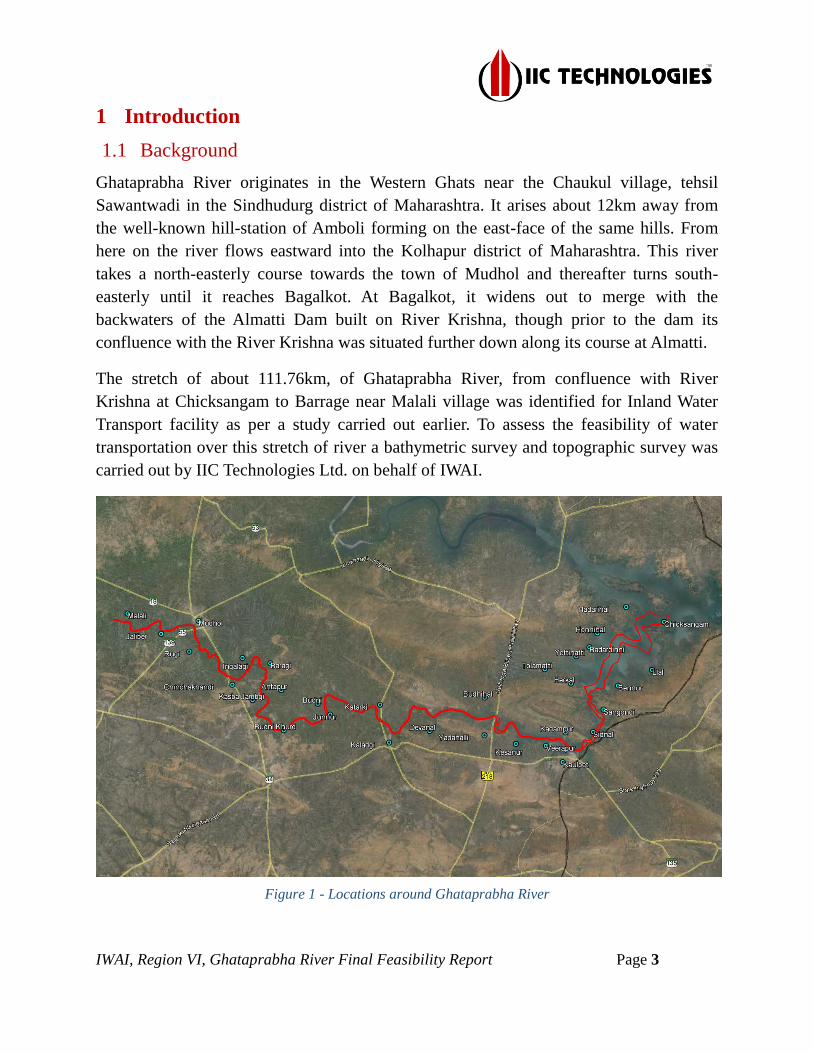
1 Introduction
1.1 Background
Ghataprabha River originates in the Western Ghats near the Chaukul village, tehsil
Sawantwadi in the Sindhudurg district of Maharashtra. It arises about 12km away from
the well-known hill-station of Amboli forming on the east-face of the same hills. From
here on the river flows eastward into the Kolhapur district of Maharashtra. This river
takes a north-easterly course towards the town of Mudhol and thereafter turns south-
easterly until it reaches Bagalkot. At Bagalkot, it widens out to merge with the
backwaters of the Almatti Dam built on River Krishna, though prior to the dam its
confluence with the River Krishna was situated further down along its course at Almatti.
The stretch of about 111.76km, of Ghataprabha River, from confluence with River
Krishna at Chicksangam to Barrage near Malali village was identified for Inland Water
Transport facility as per a study carried out earlier. To assess the feasibility of water
transportation over this stretch of river a bathymetric survey and topographic survey was
carried out by IIC Technologies Ltd. on behalf of IWAI.
Figure 1 - Locations around Ghataprabha River

IWAI, Region VI, Ghataprabha River Final Feasibility Report Page 4
1.2 Tributaries of Ghataprabha River
Near Amboli, Maharashtra, Ghataprabha River forming at the east-face of the same hills
which give birth to the Hiranyakeshi River, one of its important tributaries. From here on,
the river flows eastward into the Kolhapur district of Maharashtra forming the
Phatakwadi Lake, an artificial water body created by damming the river. The river ends
its short course within Maharashtra near the town Daddi, Belgaum district of Karnataka
which is also the site where the river Tamiraparani drains into it.
This river is then joined by the Hiranyakeshi River, its most important left-bank tributary.
It then runs through sandstone hills near Gokak before running over a cliff to form
the Gokak Falls. Less than a kilometer from the falls, the Markandeya River, a right-bank
tributary joins. So Hiranyakeshi and Markandeya are two tributaries of Ghataprabha
River.
Figure 2 - Tributaries of total Ghataprabha River
1.3 State/ District through which river passes
The Ghataprabha River is a major river in South India and flows through Karnataka state.

IWAI, Region VI, Ghataprabha River Final Feasibility Report Page 5
State Chainage (km)
Length (km) From To
Karnataka 0 111.76 111.76
Table 1 - State wise waterway
1.4 Maps
1.4.1 Full course of the waterway
The map displaying the state boundary with road and rail network for the course of water way is
represented as below:-
Figure 3 - Full Course of Ghataprabha River
1.4.2 Course of the waterway under study
The map displaying the state boundary with road and rail network for the course of water way is
represented as below:
IWAI, Region VI, Ghataprabha River Final Feasibility Report Page 6
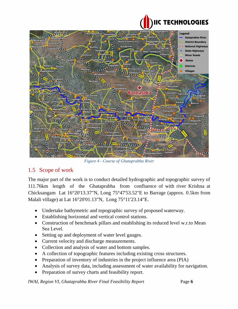
Figure 4 - Course of Ghataprabha River
1.5 Scope of work
The major part of the work is to conduct detailed hydrographic and topographic survey of
111.76km length of the Ghataprabha from confluence of with river Krishna at
Chicksangam Lat 16°20'13.37"N, Long 75°47'53.52"E to Barrage (approx. 0.5km from
Malali village) at Lat 16°20'01.13"N, Long 75°11'23.14"E.
Undertake bathymetric and topographic survey of proposed waterway.
Establishing horizontal and vertical control stations.
Construction of benchmark pillars and establishing its reduced level w.r.to Mean
Sea Level.
Setting up and deployment of water level gauges.
Current velocity and discharge measurements.
Collection and analysis of water and bottom samples.
A collection of topographic features including existing cross structures.
Preparation of inventory of industries in the project influence area (PIA)
Analysis of survey data, including assessment of water availability for navigation.
Preparation of survey charts and feasibility report.
IWAI, Region VI, Ghataprabha River Final Feasibility Report Page 7
2 Methodology Adopted to undertake Study
2.1 Recce
Advance recce of the survey area was undertaken in early 05th Feb 2016 by a detach
survey party. The detach survey party recovered the GTS Benchmark at Kaladgi, GTS
Benchmark upon Chinchakhandi Bridge established by PWD. And gauge at Ranjanagi
Village, Mudhol, and gauge at Bagalkot which is located 3km towards the northeast of
Bagalkot which is being established by CWC. The recce was started from a Malali
village, Bagalkot Dist. in Karnataka till the Sangam of Ghataprabha and Krishna River at
a village near Chicksangam. Stretch was examined at four places (Barrage near Malali
village, Mudhol, Bagalkot and Confluence of Krishna River at Chicksangam).
The upper portion of Ghataprabha River, which contains small rocky patches and the
survey stretch, is maximum dry in nature and availability of water is negligible. This
causes the practical inability to use any type of boat for sounding in this area.
The downstream of the river was being observed that it’s been widened and though the
water was present, it was insufficient to carry bathymetric survey, which being led us to
carry the survey in the topographic method. Mobilization commenced in earnest on 10th
Feb 2016 and was completed on 25th Mar 2016.
The following observation has been made.
The survey area is 111.76km, from the barrage at Malali Village towards
downstream.
River width varied between 100m to 300m.
The work of Topography is also very much time consuming and not feasible due
to rocks and cliffs on both the banks.
2.2 Survey Resources and Methodology
The actual survey was commenced on 10th
Feb and completed on 25th
Mar 2016. The
survey was undertaken on a scale of 1:10,000, with a survey line spacing kept at 100 m
and plotted on UTM Projection at Zone 43N as directed in the contract specification.
2.2.1 Survey Launch
The bathymetric survey was unable to conduct due to the unavailability of sufficient
navigable water in the river stretch.
IWAI, Region VI, Ghataprabha River Final Feasibility Report Page 8
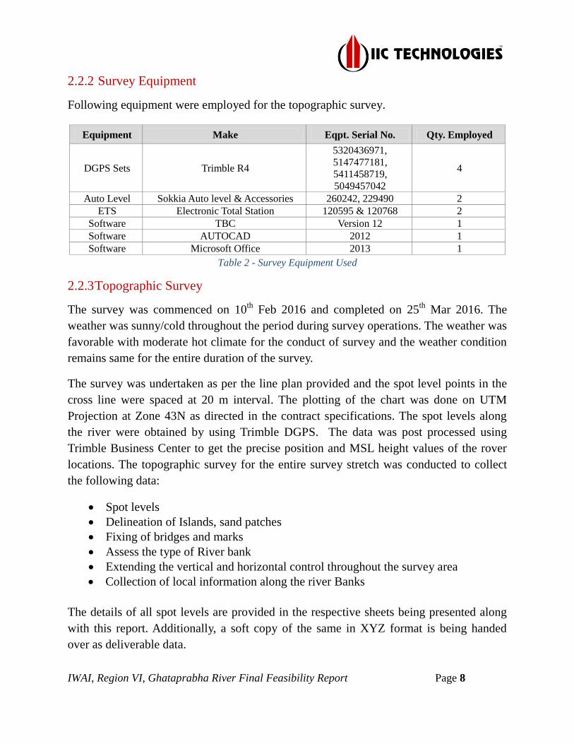
2.2.2 Survey Equipment
Following equipment were employed for the topographic survey.
Equipment Make Eqpt. Serial No. Qty. Employed
DGPS Sets Trimble R4
5320436971,
5147477181,
5411458719,
5049457042
4
Auto Level Sokkia Auto level & Accessories 260242, 229490 2
ETS Electronic Total Station 120595 & 120768 2
Software TBC Version 12 1
Software AUTOCAD 2012 1
Software Microsoft Office 2013 1
Table 2 - Survey Equipment Used
2.2.3 Topographic Survey
The survey was commenced on 10th
Feb 2016 and completed on 25th
Mar 2016. The
weather was sunny/cold throughout the period during survey operations. The weather was
favorable with moderate hot climate for the conduct of survey and the weather condition
remains same for the entire duration of the survey.
The survey was undertaken as per the line plan provided and the spot level points in the
cross line were spaced at 20 m interval. The plotting of the chart was done on UTM
Projection at Zone 43N as directed in the contract specifications. The spot levels along
the river were obtained by using Trimble DGPS. The data was post processed using
Trimble Business Center to get the precise position and MSL height values of the rover
locations. The topographic survey for the entire survey stretch was conducted to collect
the following data:
Spot levels
Delineation of Islands, sand patches
Fixing of bridges and marks
Assess the type of River bank
Extending the vertical and horizontal control throughout the survey area
Collection of local information along the river Banks
The details of all spot levels are provided in the respective sheets being presented along
with this report. Additionally, a soft copy of the same in XYZ format is being handed
over as deliverable data.
IWAI, Region VI, Ghataprabha River Final Feasibility Report Page 9
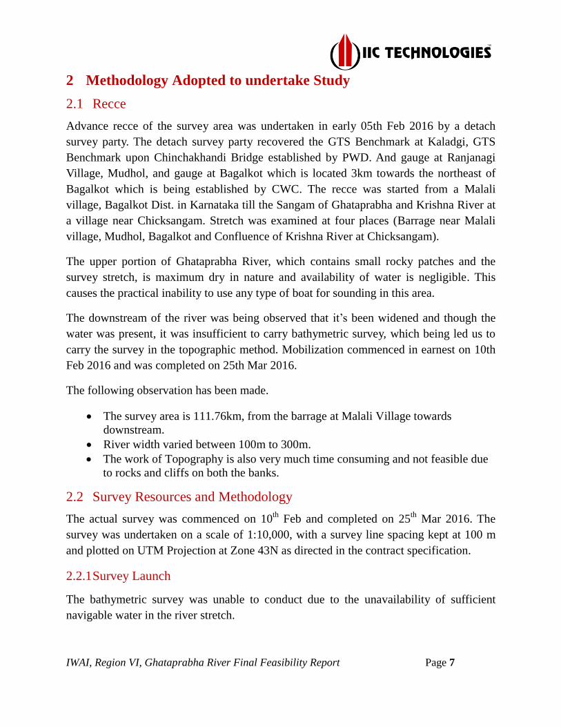
Figure 5 - Spot leveling by DGPS
2.2.4 Bathymetric Survey and Survey Launch
The bathymetric survey by survey launch for the Ghataprabha River was not able to be
conducted due to non-availability of sufficient water depth throughout the river.
2.2.5 Calibration
The equipment used for the survey was calibrated by the equipment supplier. The
equipment calibration certificates are placed at Annexure-14 to this report.
2.3 Description of Bench Marks (B.M.) Reference Level
The GTS station near to the Kaladgi was recovered and the value of 536.10m above MSL
was collected from Asst. Engineer, PWD Bagalkot. The PWD Chinchakhandi GTS
(530.296m MSL) provided by Assistant Engineer, PWD, Bagalkot, Karnataka,
Kaladgi station was used as the initial reference for vertical control and the Reference
Level value of the same was transferred IWAI-BM-GTP-06 and IWAI-BM-GTP-07
through Auto Level (optical leveling method).
The station was used as cross verification of MSL values of the initial reference. The
vertical control and the Reference Level vale of the same were transferred through Auto
Level. The leveling data for establishing the reference level for the newly constructed
benchmark pillars are placed at Annexure –10 to this report. The final accepted WGS 84
coordinates and details of station & IWAI Benchmark established during the conduct of
the survey are as follows:

IWAI, Region VI, Ghataprabha River Final Feasibility Report Page 10
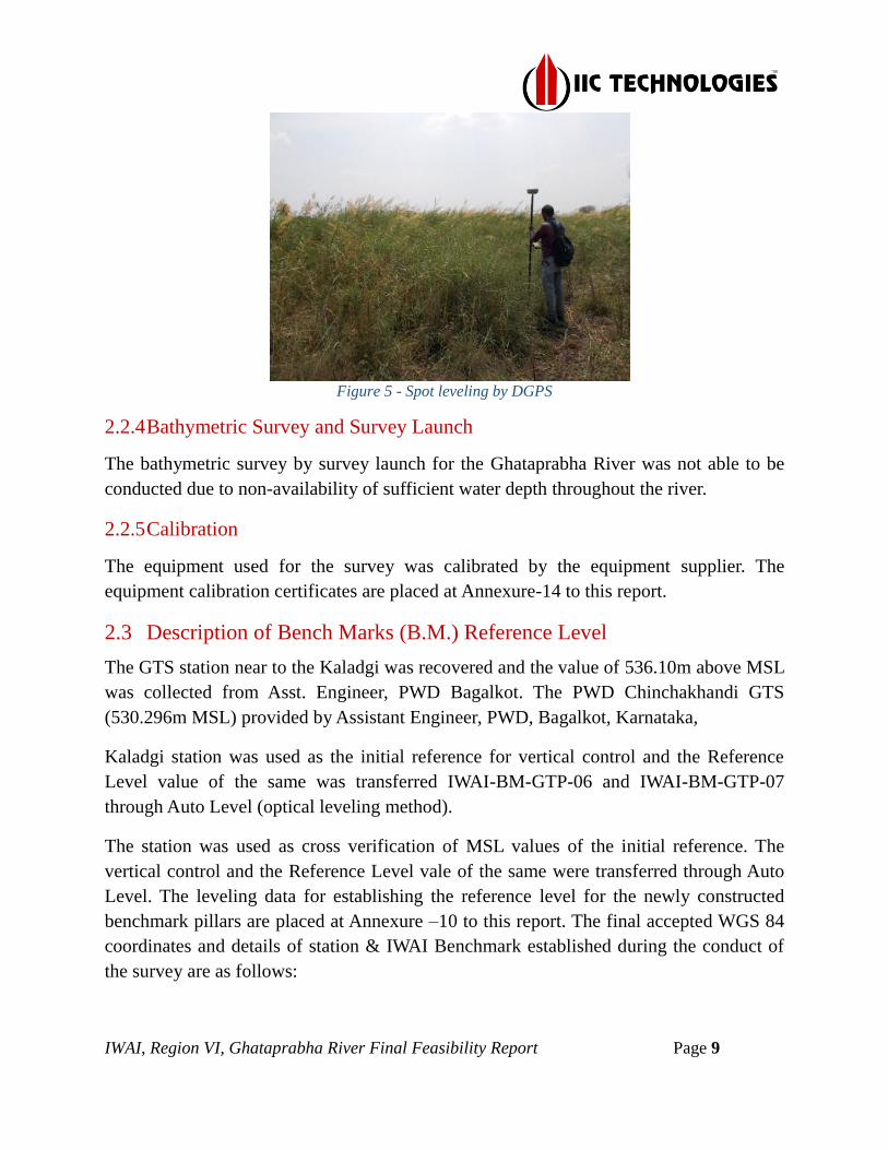
Figure 6 - PWD Benchmark upon Chinchakhandi Bridge, referred to GTP-03
Sl.N
o. Station
Chainage
(km) Latitude Longitude
Ht.
above
MSL
(m)
Source/ Type
1 IWAI BM GTP01 111.91 16°19'57.0375"N 75°11'17.7769"E 529.113 Online
Processed
2 IWAI BM GTP02 101.63 16°19'37.0022"N 75°15'50.7605"E 530.773 BL Processed
3 IWAI BM GTP03 90.97 16°16'26.5031"N 75°19'12.0430"E 525.852 BL Processed
4 IWAI BM GTP04 81.02 16°15'18.9257"N 75°21'20.1311"E 522.802 BL Processed
5 IWAI BM GTP05 70.64 16°13'43.6214"N 75°24'7.5995"E 524.179 BL Processed
6 IWAI BM GTP06 60.89 16°14'14.0042"N 75°27'32.8230"E 521.674 BL Processed
7 IWAI BM GTP07 51.11 16°13'48.4392"N 75°31'21.3265"E 520.309 BL Processed
8 IWAI BM GTP08 41.09 16°13'43.3104"N 75°35'48.9635"E 518.378 BL Processed
9 IWAI BM GTP09 28.75 16°12'14.0051"N 75°40'50.7808"E 519.693 BL Processed
10 IWAI BM GTP10 18.56 16°14'30.7246"N 75°43'57.2871"E 526.34 BL Processed
11 IWAI BM GTP11 12.17 16°16'14.4317"N 75°46'25.0470"E 519.472 BL Processed
12 PWD BM KALADGI 54.17 16°12'4.6351"N 75°29'38.7000"E 536.100 BL Processed
Table 3 - Accepted Station coordinates (WGS-84)
The details of horizontal and vertical control established and methodology followed for
the conduct of the survey are placed at Annexure-8.
2.4 Tidal Influence Zone and tidal variation
The survey stretch of Ghataprabha River is non-tidal water body and no influence of tidal
force was observed throughout the survey period.

IWAI, Region VI, Ghataprabha River Final Feasibility Report Page 11
2.5 Methodology to fix Chart Datum / Sounding Datum
The Ghataprabha River is of 111.76km stretch which is between Chicksangam to Malali.
There are many other various barrages present in the survey stretch of the Ghataprabha
River. The water depth by an average of 0.1m to 0.2m is available near the barrages. The
water level is recoded as dry (dead level) in the records held by the dam authorities.
2.5.1 Sounding Datum
The Ghataprabha River is to 111.76km stretch between Chicksangam to Malali. The entire
River stretch is divided into per-km stretches and the least MSL value obtained during the
conduct of a topographic survey for the stretch is considered as Chart Datum for the
Dredging Volume calculations.
2.5.2 Datum Calculation
The datum for calculation of dredge volume needs to be adopted as per the gradient of the
river and the average water level of the river. The datum for calculation of dredge volume
was accepted as the least spot height in the per-km stretch for the entire river. The newly
established sounding datum is established by assuming the least value of the spot height
for every 01km of the river stretch.
Km
Stretch
Least Level
w.r.t MSL Established CD
Km
Stretch
Least Level w.r.t
MSL
Established
CD
0 - 1 506.135 506.135
60 - 61 510.23 510.23
1 - 2 506.014 506.014
61 - 62 510.228 510.228
2 - 3 506.125 506.125
62 - 63 510.236 510.236
3 - 4 506.012 506.012
63 - 64 510.235 510.235
4 - 5 506.011 506.011
64 - 64.6 510.248 510.248
5 - 6 506.135 506.135
64.6 - 65 511.345 511.345
6 - 7 506.014 506.014
65 - 66 510.263 510.263
7 - 8 506.011 506.011
66 - 67 510.292 510.292
8 - 9 506.012 506.012
67 - 68 510.826 510.826
9 - 10 506.125 506.125
68 - 69 511.156 511.156
10 - 11 506.014 506.014
69 - 70 511.818 511.818
11 - 12 506.142 506.142
70 - 70.6 512.444 512.444
12 - 13 506.146 506.146
70.6 - 71 514.875 514.875
13 - 14 506.159 506.159
71 - 72 512.602 512.602
14 - 15 506.213 506.213
72 - 73 513.163 513.163
15 - 16 506.183 506.183
73 - 74 513.136 513.136
16 - 17 506.145 506.145
74 - 75 513.156 513.156
17 - 18 506.192 506.192
75 - 76 513.156 513.156
18 - 19 506.204 506.204
76 - 76.9 513.153 513.153
19 - 20 506.214 506.214
76.9 - 77 513.136 513.136
20 - 21 506.238 506.238
77 - 78 513.23 513.23
21 - 22 506.265 506.265
78 - 79 513.236 513.236
22 - 23 506.304 506.304
79 - 79.8 513.248 513.248
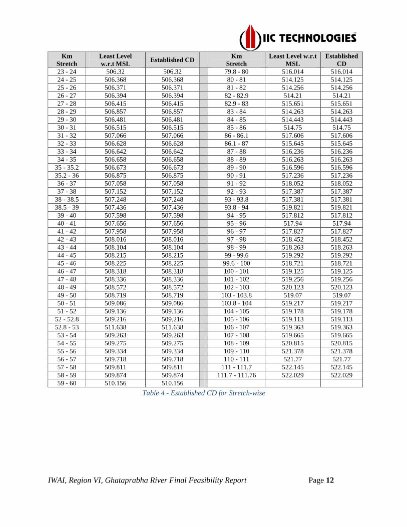
IWAI, Region VI, Ghataprabha River Final Feasibility Report Page 12
Km
Stretch
Least Level
w.r.t MSL Established CD
Km
Stretch
Least Level w.r.t
MSL
Established
CD
23 - 24 506.32 506.32
79.8 - 80 516.014 516.014
24 - 25 506.368 506.368
80 - 81 514.125 514.125
25 - 26 506.371 506.371
81 - 82 514.256 514.256
26 - 27 506.394 506.394
82 - 82.9 514.21 514.21
27 - 28 506.415 506.415
82.9 - 83 515.651 515.651
28 - 29 506.857 506.857
83 - 84 514.263 514.263
29 - 30 506.481 506.481
84 - 85 514.443 514.443
30 - 31 506.515 506.515
85 - 86 514.75 514.75
31 - 32 507.066 507.066
86 - 86.1 517.606 517.606
32 - 33 506.628 506.628
86.1 - 87 515.645 515.645
33 - 34 506.642 506.642
87 - 88 516.236 516.236
34 - 35 506.658 506.658
88 - 89 516.263 516.263
35 - 35.2 506.673 506.673
89 - 90 516.596 516.596
35.2 - 36 506.875 506.875
90 - 91 517.236 517.236
36 - 37 507.058 507.058
91 - 92 518.052 518.052
37 - 38 507.152 507.152
92 - 93 517.387 517.387
38 - 38.5 507.248 507.248
93 - 93.8 517.381 517.381
38.5 - 39 507.436 507.436
93.8 - 94 519.821 519.821
39 - 40 507.598 507.598
94 - 95 517.812 517.812
40 - 41 507.656 507.656
95 - 96 517.94 517.94
41 - 42 507.958 507.958
96 - 97 517.827 517.827
42 - 43 508.016 508.016
97 - 98 518.452 518.452
43 - 44 508.104 508.104
98 - 99 518.263 518.263
44 - 45 508.215 508.215
99 - 99.6 519.292 519.292
45 - 46 508.225 508.225
99.6 - 100 518.721 518.721
46 - 47 508.318 508.318
100 - 101 519.125 519.125
47 - 48 508.336 508.336
101 - 102 519.256 519.256
48 - 49 508.572 508.572
102 - 103 520.123 520.123
49 - 50 508.719 508.719
103 - 103.8 519.07 519.07
50 - 51 509.086 509.086
103.8 - 104 519.217 519.217
51 - 52 509.136 509.136
104 - 105 519.178 519.178
52 - 52.8 509.216 509.216
105 - 106 519.113 519.113
52.8 - 53 511.638 511.638
106 - 107 519.363 519.363
53 - 54 509.263 509.263
107 - 108 519.665 519.665
54 - 55 509.275 509.275
108 - 109 520.815 520.815
55 - 56 509.334 509.334
109 - 110 521.378 521.378
56 - 57 509.718 509.718
110 - 111 521.77 521.77
57 - 58 509.811 509.811
111 - 111.7 522.145 522.145
58 - 59 509.874 509.874 111.7 - 111.76 522.029 522.029
59 - 60 510.156 510.156
Table 4 - Established CD for Stretch-wise
IWAI, Region VI, Ghataprabha River Final Feasibility Report Page 13
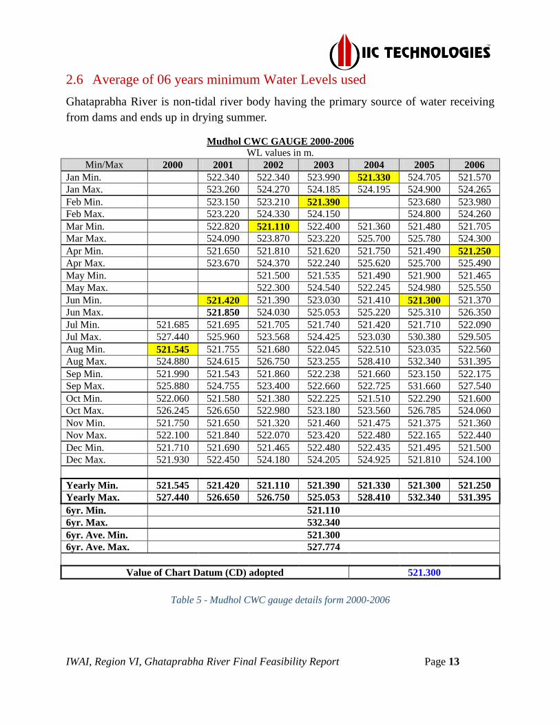
2.6 Average of 06 years minimum Water Levels used
Ghataprabha River is non-tidal river body having the primary source of water receiving
from dams and ends up in drying summer.
Mudhol CWC GAUGE 2000-2006 WL values in m.
Min/Max 2000 2001 2002 2003 2004 2005 2006
Jan Min. 522.340 522.340 523.990 521.330 524.705 521.570 Jan Max. 523.260 524.270 524.185 524.195 524.900 524.265
Feb Min. 523.150 523.210 521.390 523.680 523.980 Feb Max. 523.220 524.330 524.150 524.800 524.260
Mar Min. 522.820 521.110 522.400 521.360 521.480 521.705 Mar Max. 524.090 523.870 523.220 525.700 525.780 524.300
Apr Min. 521.650 521.810 521.620 521.750 521.490 521.250 Apr Max. 523.670 524.370 522.240 525.620 525.700 525.490 May Min. 521.500 521.535 521.490 521.900 521.465 May Max. 522.300 524.540 522.245 524.980 525.550
Jun Min. 521.420 521.390 523.030 521.410 521.300 521.370 Jun Max. 521.850 524.030 525.053 525.220 525.310 526.350
Jul Min. 521.685 521.695 521.705 521.740 521.420 521.710 522.090 Jul Max. 527.440 525.960 523.568 524.425 523.030 530.380 529.505 Aug Min. 521.545 521.755 521.680 522.045 522.510 523.035 522.560 Aug Max. 524.880 524.615 526.750 523.255 528.410 532.340 531.395
Sep Min. 521.990 521.543 521.860 522.238 521.660 523.150 522.175 Sep Max. 525.880 524.755 523.400 522.660 522.725 531.660 527.540
Oct Min. 522.060 521.580 521.380 522.225 521.510 522.290 521.600 Oct Max. 526.245 526.650 522.980 523.180 523.560 526.785 524.060 Nov Min. 521.750 521.650 521.320 521.460 521.475 521.375 521.360 Nov Max. 522.100 521.840 522.070 523.420 522.480 522.165 522.440
Dec Min. 521.710 521.690 521.465 522.480 522.435 521.495 521.500 Dec Max. 521.930 522.450 524.180 524.205 524.925 521.810 524.100
Yearly Min. 521.545 521.420 521.110 521.390 521.330 521.300 521.250 Yearly Max. 527.440 526.650 526.750 525.053 528.410 532.340 531.395
6yr. Min. 521.110 6yr. Max. 532.340
6yr. Ave. Min. 521.300 6yr. Ave. Max. 527.774
Value of Chart Datum (CD) adopted 521.300
Table 5 - Mudhol CWC gauge details form 2000-2006

IWAI, Region VI, Ghataprabha River Final Feasibility Report Page 14
Bagalkot CWC GAUGE 1994-2000
WL values in m. Min/Max 1994 1995 1996 1997 1998 1999 2000
Jan Min. 507.897 507.857 507.942 507.727 507.697 507.985 508.162 Jan Max. 508.127 508.367 508.017 508.162 508.027 508.187 509.177 Feb Min. 507.837 507.757 507.297 507.872 507.787 507.907 508.057 Feb Max. 508.037 508.027 507.967 507.997 507.897 508.215 508.167
Mar Min. 506.967 507.167 506.882 507.247 507.057 507.602 507.477 Mar Max. 507.867 507.947 507.587 508.177 507.867 508.027 508.057
Apr Min. 506.787 506.887 506.927 506.417 506.972 507.047 Apr Max. 506.967 508.287 507.202 507.047 507.717 507.657
May Min. 506.647 507.027 507.727 506.917 506.847 506.867 506.917 May Max. 508.002 508.187 507.812 507.992 507.247 508.227 507.987
Jun Min. 507.672 506.877 507.457 506.762 506.842 507.717 507.282 Jun Max. 509.037 508.637 509.322 508.957 509.267 511.817 508.322
Jul Min. 508.782 507.377 507.712 509.432 507.827 509.697 507.977 Jul Max. 512.942 509.697 510.102 512.792 512.247 514.077 512.597
Aug Min. 508.627 507.677 508.082 510.877 510.137 509.787 508.567 Aug Max. 510.767 509.002 510.057 514.777 511.667 513.707 514.257 Sep Min. 508.055 507.927 508.137 508.347 509.820 508.897 514.187 Sep Max. 511.257 509.387 509.647 513.657 511.267 510.072 516.187
Oct Min. 508.127 508.057 508.162 507.947 509.847 510.112 Oct Max. 509.027 509.397 510.807 509.627 511.827 511.827
Nov Min. 507.937 507.957 508.137 508.097 508.267 509.532 Nov Max. 508.467 508.667 508.527 509.057 509.737 510.207 Dec Min. 507.667 507.912 508.047 507.947 508.137 509.187 Dec Max. 507.967 508.157 508.187 508.527 508.267 509.527
Yearly Min. 506.647 506.877 506.882 506.762 506.417 506.867 506.917 Yearly Max. 512.942 509.697 510.807 514.777 512.247 514.077 516.187
6yr. Min. 506.417 6yr. Max. 516.187
6yr. Ave. Min. 506.787 6yr. Ave. Max. 512.425
Value of Chart Datum (CD) adopted 506.787
Table 6 - Bagalkot CWC guage details from 1994-2000
2.7 Transfer of Sounding Datum
The Ghataprabha River is non-tidal river and lowest MSL level of per km stretch is
considered as the datum value for the computing sounding datum at different stretches
since the river is dry.

IWAI, Region VI, Ghataprabha River Final Feasibility Report Page 15
2.8 Table indicating tidal variation at different observation points
The survey stretch of Ghataprabha River is non-tidal river and the river dries fully during
the summer season.
2.9 Salient features of Dam, Barrages, Barrage
The details of Dams, Barrages were collected during the conduct of surveys and the
details are as follows:
2.9.1 Salient Features of Bannidinni Barrage
Salient Features of Bannidinni Barrage
1 River / Basin Ghataprabha
2 Latitude 16°13'16.63"N
3 Longitude 75°37'51.27"E
4 District Bagalkot
5 Location Bannidinni Village
6 No. of gates 14
7 Length 103m
8 Width 7.500m
Table 7 - Salient Features of Bannidinni Barrage
2.9.2 Salient Features of Yadahalli Barrage
Salient Features of Yadahalli Broken Barrage
1 River / Basin Ghataprabha / Krishna
2 Latitude 16°13'51.33"N
3 Longitude 75°37'9.60"E
4 District Bagalkot
5 Location Yadahalli village
6 No. of Deck 73
7 Length 483 m
8 Width 12.586

IWAI, Region VI, Ghataprabha River Final Feasibility Report Page 16
Salient Features of Yadahalli Broken Barrage
Table 8 - Yadahalli Barrage details
2.9.3 Salient Features of Kaladgi Barrage
Salient Features of Kaladgi Barrage
1 River / Basin Ghataprabha
2 Latitude 16°13'5.27"N
3 Longitude 75°30'43.98"E
4 District Bagalkot
5 Location Kaladgi village
6 No. of Lock 14
7 Length 194m
8 Width 8.45m
Table 9 - Kaladgi Barrage details
2.9.4 Salient features of Katarki Barrage
Salient Features of Katarki Barrage
1 River / Basin Ghataprabha/Krishna
2 Latitude 16°13'36.94"N
3 Longitude 75°29'26.84"E
4 District Bagalkot
5 Location Katarki Village

IWAI, Region VI, Ghataprabha River Final Feasibility Report Page 17
Salient Features of Katarki Barrage
6 No. of Deck 73
7 Length of Barrage 200m.
8 Total Ayacut (Acre) 360 Ha.
9 Water Utilization (TMC) N-A
Table 10 - Katarki Barrage details
2.9.5 Salient Features of Alagundi Barrage
Salient Features of Alagundi Barrage
1 River / Basin Ghataprabha
2 Latitude 16°15'13.41"N
3 Longitude 75°25'47.36"E
4 District Bagalkot
5 Location Alagundi village
6 No. of Gates 14
7 Length of Barrage 113.7m
8 Width 6.31m
Table 11 - Alagundi Barrage Details
2.9.6 Salient Features of Machakanur Barrage
Salient Features of Machakanur Barrage
1 River / Basin Ghataprabha
2 Latitude 16°13'46.00"N

IWAI, Region VI, Ghataprabha River Final Feasibility Report Page 18
Salient Features of Machakanur Barrage
3 Longitude 75°24'7.92"E
4 District Bagalkot
5 Location Kasba-jambgi village
6 No. of Deck 20
7 Length of Barrage 105.01
8 Width 7.01
9 Total Ayacut (Acres) 2.36Ha
10 Water utilization (TMC) N-A-
Table 12 - Machaknur Barrage Details
2.9.7 Salient Features of Jambgi Barrage
Salient Features of Jambgi Barrage
1 River / Basin Ghataprabha
2 Latitude 16°13'49.59"N
3 Longitude 75°21'17.56"E
4 District Bagalkot
5 Location Kasba-jambgi village
6 No. of Deck 25
7 Length of Barrage 63.82
8 Width of Barrage 5.02m
9 Total Ayacut (Acres) 0.98ha
10 Water utilization (TMC) N/A
Table 13 - Jambgi Barrage Details

IWAI, Region VI, Ghataprabha River Final Feasibility Report Page 19
2.9.8 Salient Features of Bidri Barrage
Salient Features of Bidri Barrage
1 River / Basin Ghataprabha
2 Latitude 16°14'58.06"N
3 Longitude 75°21'50.74"E
4 District Bagalkot
5 Location Bidri village
6 No. of Deck 11
7 Length of Barrage 89.2m
8 Width 5.23m
9 Total Ayacut (Acres) 1.23ha
10 Water utilization (TMC) N/A
Table 14 - Bidri Barrage Details
2.9.9 Salient Features of Marakatti Barrage
Salient Features of Marakatti Barrage
1 River / Basin Ghataprabha
2 Latitude 16°16'15.31"N
3 Longitude 75°21'39.84"E
4 District Bagalkot
5 Location Baragi village
6 No. of Deck 17
7 Length of Barrage 107.2m
8 Width 5.63m
9 Total Ayacut (Acres) 0.65ha
10 Water utilization (TMC) N-A
Table 15 - Marakatti Barrage Details

IWAI, Region VI, Ghataprabha River Final Feasibility Report Page 20
2.9.10 Salient Features of Ingalagi Barrage
Salient Features of Ingalagi Barrage
1 River / Basin Ghataprabha
2 Latitude 16°17'39.84"N
3 Longitude 75°21'2.82"E
4 District Bagalkot
5 Location Ingalagi village
6 No. of Deck 32
7 Length of Barrage 164.27m
8 Width 5.36m
9 Total Ayacut (Acres) 1.36ha
10 Water utilization (TMC) N-A
Table 16 - Ingalagi Barrage Details
2.9.11 Salient Features of Jeeragal Barrage
Salient Features of Jeeragal Barrage
1 River / Basin Ghataprabha
2 Latitude 16°17'34.68"N
3 Longitude 75°18'27.21"E
4 District Bagalkot
5 Location Mudhol Taluk
6 No. of Deck 17
7 Length of Barrage 85.5
8 Width 6.34
9 Total Ayacut (Acres) 1.52ha
10 Water utilization (TMC) N/A
Table 17 - Jeragal Barrage Details

IWAI, Region VI, Ghataprabha River Final Feasibility Report Page 21
2.9.12 Salient Features of Mudhol Barrage
Salient Features of Mudhol Barrage
1 River / Basin Ghataprabha
2 Latitude 16°19'30.68"N
3 Longitude 75°16'51.77"E
4 District Bagalkot
5 Location Mudhol village
6 No. of Deck 20
7 Length of Barrage 87.2m
8 Width 2.42m
9 Total Ayacut (Acres) 3.21ha
10 Water utilization (TMC) N-A
Table 18 - Mudhol Barrage Details
2.9.13 Salient Features of Jaliber Barrage
Salient Features of Jaliber Barrage
1 River / Basin Ghataprabha
2 Latitude 16°19'19.19"N
3 Longitude 75°14'41.18"E
4 District Bagalkot
5 Location Jaliber village
6 No. of Deck 34
7 Length of Barrage 91.44m
8 Width 4.64m
9 Total Ayacut (Acres) 2.36Ha
Table 19 - Jaliber Barrage Details

IWAI, Region VI, Ghataprabha River Final Feasibility Report Page 22
2.9.14 Salient Features of Malali Barrage
Salient Features of Malali Barrage
1 River / Basin Ghataprabha
2 Latitude 16°20'0.82"N
3 Longitude 75°11'23.31"E
4 District Bagalkot
5 Location Nagaral village
6 No. of Deck 6
7 Length of Barrage 37.3m
8 Width 2.98m
9 Total Ayacut (Acres) 1.56Ha
Table 20 - Malali Barrage Details
2.10 Erected IWAI Benchmark Pillars
New bench Mark Pillars were constructed as per specification at suitable locations as
specified in the contract. The extension of horizontal control was made by the baseline
processing of 06 hourly DGPS observations carried out with the nearest reference station.
The value of these benchmarks w.r.t. MSL was obtained by auto leveling from the PWD
Chinchakhandi GTS (530.296m MSL) provided by Assistant Engineer, PWD, Bagalkot,
Karnataka, PWD Kaladgi GTS (536.100m MSL).
The final accepted co-ordinates and reduced level (R.L) values of these Bench Marks and
other station established for setting up of reference DGPS base stations are as below:
Sl.
No Station
Chainage
(km) Location
Latitude (N)
Longitude (E)
Easting (E)
Northing (N)
Height
above
MSL
(m)
CD
w.r.t.
MSL
(m)
BM
Height
w.r.t.
CD (m)
1 IWAI BM GTP01 111.91 Malali 16°19'57.0375"N
75°11'17.7769"E
520109.8288
1805725.688 529.113 522.029 7.084
2 IWAI BM GTP02 101.63 Jaliber 16°19'37.0022"N
75°15'50.7605"E
528210.1676
1805119.045 530.773 519.256 11.517
3 IWAI BM GTP03 90.97 Chinchakhandi 16°16'26.5031"N
75°19'12.0430"E
534191.6774
1799274.042 525.852 517.236 8.616
4 IWAI BM GTP04 81.02 Jambgi 16°15'18.9257"N
75°21'20.1311"E
537996.8743
1797203.839 522.802 514.199 8.603

IWAI, Region VI, Ghataprabha River Final Feasibility Report Page 23
Sl.
No Station
Chainage
(km) Location
Latitude (N)
Longitude (E)
Easting (E)
Northing (N)
Height
above
MSL
(m)
CD
w.r.t.
MSL
(m)
BM
Height
w.r.t.
CD (m)
5 IWAI BM GTP05 70.64 Machakanur 16°13'43.6214"N
75°24'7.5995"E
542973.4882
1794284.57 524.179 512.602 11.577
6 IWAI BM GTP06 60.89 Kaladgi 16°14'14.0042"N
75°27'32.8230"E
549063.7726
1795230.962 521.674 510.23 11.444
7 IWAI BM GTP07 51.11 Hiresansi 16°13'48.4392"N
75°31'21.3265"E
555849.0137
1794461.65 520.309 509.136 11.173
8 IWAI BM GTP08 41.09 Chabbi 16°13'43.3104"N
75°35'48.9635"E
563794.7672
1794325.747 518.378 507.956 10.422
9 IWAI BM GTP09 28.75 Veerapur 16°12'14.0051"N
75°40'50.7808"E
572764.0474
1791609.434 519.693 506.481 13.212
10 IWAI BM GTP10 18.56 Sangondi 16°14'30.7246"N
75°43'57.2871"E
578286.6867
1795829.749 526.34 506.214 20.126
11 IWAI BM GTP11 12.17 Siraguppi 16°16'14.4317"N
75°46'25.0470"E
582661.0473
1799032.727 519.472 506.142 13.330
Table 21 - Accepted Benchmark coordinates w. r. t CD
2.11 Chart Datum / Sounding Datum and Reductions Details
Due to unavailability of water in Ghataprabha River, the spot leveling by topographic
method was attempted for the entire survey stretch of Ghataprabha River. The least MSL
level for the per-kilometer stretch was obtained as the established Chart Datum. The
details of topo level converted as depth for volume calculation are forwarded as soft copy
along with the report.
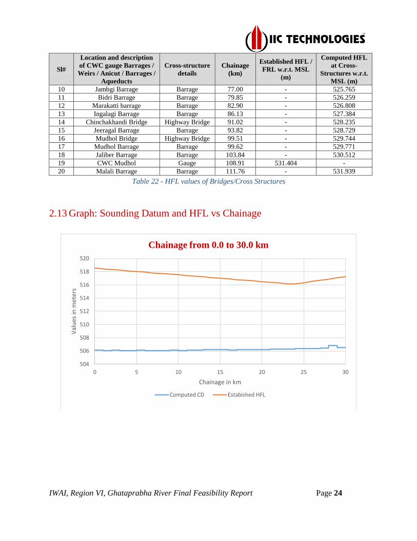
2.12 HFL values of Bridges/Cross Structures
The established HFL value of 519.600m, 516.187m, 531.404m w.r.t MSL for the CWC
Gauges of Almatti Dam, Bagalkot and Mudhol was provided by Asst. Eng. Minor
Irrigation Department, Bagalkot. The HFL value for the remaining survey stretch is
computed for the Ghataprabha River. The details of established and computed HFL
values for the entire stretch are as follows:
Sl#
Location and description
of CWC gauge Barrages /
Weirs / Anicut / Barrages /
Aqueducts
Cross-structure
details
Chainage
(km)
Established HFL /
FRL w.r.t. MSL
(m)
Computed HFL
at Cross-
Structures w.r.t.
MSL (m)
A B C D E
1 Almatti Dam Dam -8.23 519.600 -
2 CWC Bagalkot Gauge 23.24 516.187 -
3 Bannidinni Barrage Barrage 35.25 - 518.356
4 Yadahalli barrage Barrage 38.59 - 518.932
5 Yadahalli Bridge Highway Bridge 38.74 - 518.960
6 Kaladgi Barrage Barrage 52.82 - 521.457
7 Katarki Barrage Barrage 56.04 - 522.033
8 Alagundi Barrage Barrage 64.69 - 523.570
9 Machakanur Barrage Barrage 70.63 - 524.640
IWAI, Region VI, Ghataprabha River Final Feasibility Report Page 24
Sl#
Location and description
of CWC gauge Barrages /
Weirs / Anicut / Barrages /
Aqueducts
Cross-structure
details
Chainage
(km)
Established HFL /
FRL w.r.t. MSL
(m)
Computed HFL
at Cross-
Structures w.r.t.
MSL (m)
10 Jambgi Barrage Barrage 77.00 - 525.765
11 Bidri Barrage Barrage 79.85 - 526.259
12 Marakatti barrage Barrage 82.90 - 526.808
13 Ingalagi Barrage Barrage 86.13 - 527.384
14 Chinchakhandi Bridge Highway Bridge 91.02 - 528.235
15 Jeeragal Barrage Barrage 93.82 - 528.729
16 Mudhol Bridge Highway Bridge 99.51 - 529.744
17 Mudhol Barrage Barrage 99.62 - 529.771
18 Jaliber Barrage Barrage 103.84 - 530.512
19 CWC Mudhol Gauge 108.91 531.404 -
20 Malali Barrage Barrage 111.76 - 531.939
Table 22 - HFL values of Bridges/Cross Structures
2.13 Graph: Sounding Datum and HFL vs Chainage
504
506
508
510
512
514
516
518
520
0 5 10 15 20 25 30
Val
ues
in m
eter
s
Chainage in km
Chainage from 0.0 to 30.0 km
Computed CD Estabished HFL
IWAI, Region VI, Ghataprabha River Final Feasibility Report Page 25
504
506
508
510
512
514
516
518
520
522
524
30 35 40 45 50 55 60
Val
ues
in m
eter
s
Chainage in km
Chainage from 30.0 to 60.0 km
Computed CD Estabished HFL
508
510
512
514
516
518
520
522
524
526
528
530
60 65 70 75 80 85 90
Val
ues
in m
eter
s
Chainage in km
Chainage from 60.0 to 90.0 km
Computed CD Estabished HFL
Alagundi Barrage Machakanur
Bidri
Barrage
Ingalagi
Barrage
Bannidinni-Barrage Yadahalli Barrage
Kaladgi Barrage Katarki Barrage

IWAI, Region VI, Ghataprabha River Final Feasibility Report Page 26
Figure 7 - Sounding Datum and HFL vs Chainage
2.14 Average Bed Slope
The average bed slope of Ghataprabha River is as follows:
Reach and River-bed Level (RBL) River-bed
Level Change
(m) ()
Distance
(km) (B) Slope (A/B)
From To
Ch. 0 - RBL_506.251 Ch. 30 - RBL_506.686 0.435 30 1 : 0.015 Ch. 30 - RBL_506.686 Ch. 60 - RBL_510.263 3.577 30 1 : 0.119 Ch. 60 - RBL_510.263 Ch. 90 - RBL_517.825 7.562 30 1 : 0.252 Ch. 90 - RBL_517.825 Ch. 111.76 - RBL_522.029 4.204 21.76 1 : 0.193
Table 23 - Average Bed Slope
516
518
520
522
524
526
528
530
532
534
90 92 94 96 98 100 102 104 106 108 110 112
Val
ues
in m
eter
s
Chainage in km
Chainage from 90.0 to 111.76 km
Computed CD Estabished HFL
Jeeragal Barrage
Mudhol Barrage Jaliber Barrage Malali Barrage
504
508
512
516
520
524
0 20 40 60 80 100 120
Bed
Lev
el i
n M
eter
s w
.r.t
. M
SL
Chainage in km
River bed level v/s Chainage of Ghataprabha
River
Bed Level in …

IWAI, Region VI, Ghataprabha River Final Feasibility Report Page 27
2.15 Details of Dam, Barrages, Weirs, Anicut, etc.
Sl
No
Structure
Name
Ch
ain
ag
e (k
m)
Location
Position
(Lat Long)
Position
(UTM)
Len
gth
(m
)
Wid
th (
m)
Height
w.r.t.
HFL
(m)
Present
Condition Left Bank Left Bank
Right Bank Right Bank
01 Bannidinni
Barrage 35.25
Bannidinni
Village
Left Bank:
16°13'13.8471"N
75°37'55.1122"E
Left Bank: 567542.571
1793431.610 103 7.5 0.456 Operational
Right Bank:
16°13'17.1566"N
75°37'50.2092"E
Right Bank: 567396.695
1793532.858
02 Yadahalli
barrage 38.59
Yadahalli
village
Left Bank:
16°13'48.5488"N
75°37'8.5956"E
Left Bank: 566158.340
1794493.726 483 12.586 5.735 Operational
Right Bank:
16°13'53.8652"N
75°37'10.9895"E
Right Bank: 566228.914
1794657.305
03 Kaladgi
Barrage 52.82 Kaladgi village
Left Bank:
16°13'4.5385"N
75°30'45.3909"E
Left Bank:
554785.578
1793109.980 194 8.45 0.622 Operational
Right Bank:
16°13'5.5462"N
75°30'43.0585"E
Right Bank:
554716.255
1793140.771
04 Katarki
Barrage 56.04 Katarki Village
Left Bank:
16°13'33.3400"N
75°29'25.8800"E
Left Bank:
552422.908
1793989.215 200 9.02 8.418 Operational
Right Bank:
16°13'39.4100"N
75°29'27.8200"E
Right Bank:
552480.055
1794175.871
05 Alagundi
Barrage 64.69 Alagundi village
Left Bank:
16°15'10.6200"N
75°25'48.9300"E
Left Bank:
545976.021
1796963.940 113.7 6.31 0.632 Operational
Right Bank:
16°15'15.5700"N
75°25'46.3500"E
Right Bank:
545899.120
1797115.882
06 Machakanur
Barrage 70.63
Kasba-jambgi
village
Left Bank:
16°13'43.7010"N
75°24'7.9795"E
Left Bank: 542984.764
1794287.038 105.01 7.01 1.746 Operational
Right Bank:
16°13'47.1728"N
75°24'8.0684"E
Right Bank: 542987.194
1794393.723
07 Jambgi
Barrage 77.00
Kasba-jambgi
village
Left Bank:
16°13'48.2711"N
75°21'17.4101"E
Left Bank: 537920.934
1794418.116 63.82 5.02 2.132 Operational
Right Bank:
16°13'50.5456"N
75°21'17.4997"E
Right Bank: 537923.473
1794488.010
08 Bidri Barrage 79.85 Bidri village
Left Bank:
16°14'58.0782"N
75°21'50.2267"E
Left Bank: 538891.321
1796564.818 89.2 5.23 2.844 Operational
Right Bank:
16°14'57.8769"N
75°21'52.5298"E
Right Bank: 538959.696
1796558.754
09 Marakatti
barrage 82.90 Baragi village
Left Bank:
16°16'15.4855"N
75°21'39.0637"E
Left Bank: 538555.773
1798942.764 107.2 5.63 1.797 Operational

IWAI, Region VI, Ghataprabha River Final Feasibility Report Page 28
Sl
No
Structure
Name
Ch
ain
ag
e (k
m)
Location
Position
(Lat Long)
Position
(UTM)
Len
gth
(m
)
Wid
th (
m)
Height
w.r.t.
HFL
(m)
Present
Condition Left Bank Left Bank
Right Bank Right Bank
Right Bank:
16°16'14.3476"N
75°21'42.0655"E
Right Bank: 538644.928
1798907.957
10 Ingalagi
Barrage 86.13 Ingalagi village
Left Bank:
16°17'37.4826"N
75°21'1.6294"E
Left Bank: 537440.403
1801460.400 164.27 5.36 4.869 Operational
Right Bank:
16°17'42.3821"N
75°21'3.9112"E
Right Bank: 537507.860
1801611.066
11 Jeeragal
Barrage 93.82
Zunjarakopp
Left Bank:
16°17'34.3400"N
75°18'25.7600"E
Left Bank: 532814.892
1801356.388 85.5 6.34 2.092 Operational
Right Bank:
16°17'34.9500"N
75°18'28.6500"E
Right Bank: 532900.629
1801375.261
12 Mudhol
Barrage 99.62 Mudhol village
Left Bank:
16°19'30.2200"N
75°16'50.5700"E
Left Bank: 529985.084
1804913.017 87.2 2.42 0.169 Operational
Right Bank:
16°19'31.0900"N
75°16'53.5300"E
Right Bank: 530072.875
1804939.871
13 Jaliber
Barrage 103.84 Jaliber Village
Left Bank:
16°19'17.9400"N
75°14'40.5600"E
Left Bank: 526127.929
1804530.714 91.44 4.64 2.635 Operational
Right Bank:
16°19'21.2800"N
75°14'41.8400"E
Right Bank: 526165.786
1804633.389
14 Malali
Barrage 111.76
Channal Old
Village
Left Bank:
16°20'0.2396"N
75°11'23.5803"E
Left Bank: 520281.926
1805824.239 37.3 2.98 4.258 Operational
Right Bank:
16°20'1.5120"N
75°11'23.1356"E
Right Bank: 520268.695
1805863.324
Table 24 - Cross Structures w.r.t. MSL
2.16 Details of Locks
No Locks are present in the survey stretch of Ghataprabha River.
2.17 Details of Aqueducts
No Aqueducts are present in the survey stretch of Ghataprabha River.
IWAI, Region VI, Ghataprabha River Final Feasibility Report Page 29
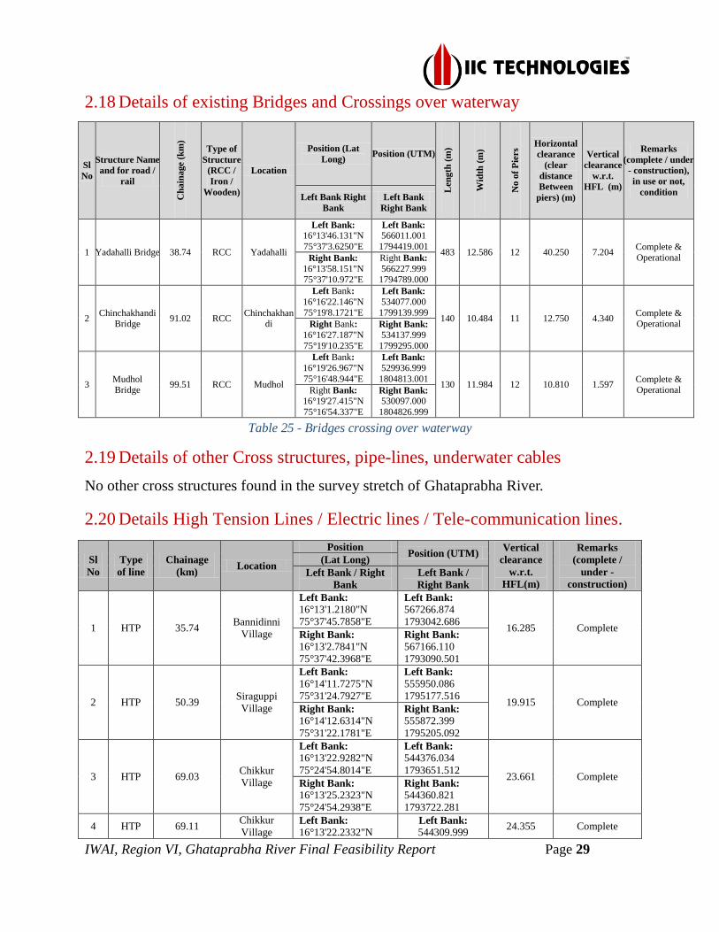
2.18 Details of existing Bridges and Crossings over waterway
Sl
No
Structure Name
and for road /
rail C
ha
inage (
km
)
Type of
Structure
(RCC /
Iron /
Wooden)
Location
Position (Lat
Long) Position (UTM)
Len
gth
(m
)
Wid
th (
m)
No
of
Pie
rs
Horizontal
clearance
(clear
distance
Between
piers) (m)
Vertical
clearance
w.r.t.
HFL (m)
Remarks
(complete / under
- construction),
in use or not,
condition Left Bank Right
Bank
Left Bank
Right Bank
1 Yadahalli Bridge 38.74 RCC Yadahalli
Left Bank:
16°13'46.131"N
75°37'3.6250"E
Left Bank:
566011.001
1794419.001 483 12.586 12 40.250 7.204
Complete &
Operational Right Bank:
16°13'58.151"N 75°37'10.972"E
Right Bank:
566227.999 1794789.000
2 Chinchakhandi
Bridge 91.02 RCC
Chinchakhandi
Left Bank:
16°16'22.146"N
75°19'8.1721"E
Left Bank:
534077.000
1799139.999 140 10.484 11 12.750 4.340
Complete & Operational Right Bank:
16°16'27.187"N
75°19'10.235"E
Right Bank: 534137.999
1799295.000
3 Mudhol Bridge
99.51 RCC Mudhol
Left Bank:
16°19'26.967"N
75°16'48.944"E
Left Bank:
529936.999
1804813.001 130 11.984 12 10.810 1.597
Complete & Operational Right Bank:
16°19'27.415"N
75°16'54.337"E
Right Bank: 530097.000
1804826.999
Table 25 - Bridges crossing over waterway
2.19 Details of other Cross structures, pipe-lines, underwater cables
No other cross structures found in the survey stretch of Ghataprabha River.
2.20 Details High Tension Lines / Electric lines / Tele-communication lines.
Sl
No
Type
of line
Chainage
(km) Location
Position Position (UTM)
Vertical
clearance
w.r.t.
HFL(m)
Remarks
(complete /
under -
construction)
(Lat Long)
Left Bank / Right
Bank
Left Bank /
Right Bank
1 HTP 35.74 Bannidinni
Village
Left Bank: 16°13'1.2180"N
75°37'45.7858"E
Left Bank: 567266.874
1793042.686 16.285 Complete
Right Bank: 16°13'2.7841"N
75°37'42.3968"E
Right Bank: 567166.110
1793090.501
2 HTP 50.39 Siraguppi
Village
Left Bank: 16°14'11.7275"N
75°31'24.7927"E
Left Bank: 555950.086
1795177.516 19.915 Complete
Right Bank: 16°14'12.6314"N
75°31'22.1781"E
Right Bank: 555872.399
1795205.092
3 HTP 69.03 Chikkur
Village
Left Bank: 16°13'22.9282"N
75°24'54.8014"E
Left Bank: 544376.034
1793651.512 23.661 Complete
Right Bank: 16°13'25.2323"N
75°24'54.2938"E
Right Bank: 544360.821
1793722.281
4 HTP 69.11 Chikkur
Village Left Bank: 16°13'22.2332"N
Left Bank: 544309.999
24.355 Complete

IWAI, Region VI, Ghataprabha River Final Feasibility Report Page 30
Sl
No
Type
of line
Chainage
(km) Location
Position Position (UTM)
Vertical
clearance
w.r.t.
HFL(m)
Remarks
(complete /
under -
construction)
(Lat Long)
Left Bank / Right
Bank
Left Bank /
Right Bank
75°24'52.5756"E 1793630.023
Right Bank: 16°13'26.3400"N
75°24'51.2600"E
Right Bank: 544270.687
1793756.136
5 HTP 80.32
Kasba
Jambgi
Village
Left Bank: 16°15'7.2463"N
75°21'40.2796"E
Left Bank: 538595.562
1796846.008 21.532 Complete
Right Bank: 16°15'8.8090"N
75°21'40.8452"E
Right Bank: 538612.266
1796894.055
6 HTP 85.46 Baragi
Village
Left Bank: 16°17'23.7820"N
75°21'14.4805"E
Left Bank: 537822.509
1801040.072 20.186 Complete
Right Bank: 16°17'24.2408"N
75°21'16.2661"E
Right Bank: 537875.476
1801054.261
7 HTP 107.02 Uttur Village
Left Bank: 16°19'23.0736"N
75°13'34.3069"E
Left Bank: 524161.886
1804686.186 19.383 Complete
Right Bank: 16°19'27.4140"N
75°13'33.5749"E
Right Bank: 524140.019
1804819.531
Table 26 - High Tension Lines
2.21 Current Meter and Discharge Details
Current meter observation is not done in Ghataprabha River due to non-availability of
water.
2.22 Water Samples
Water Samples were not collected in Ghataprabha River due to non-availability of water.

IWAI, Region VI, Ghataprabha River Final Feasibility Report Page 31
3 Description of Waterway
The waterway of Ghataprabha River within survey limits can be broadly divided into four
stretches in accordance with the gradient of the river. The details are as follows:
3.1 Sub-Stretch-01: Chicksangam to Veerapur (Chainage 0.0km to 30.0km)
Figure 8 - Stretch-1 Chicksangam to Veerapur
• Bathymetry Survey a) No bathymetric survey is conducted due to the unavailability of water
• Topographic Survey b) 30km of the length of the stretch for which the topographic survey has been
carried out.
This stretch is between 0 to 30.0km chainage of Chicksangam to Veerapur Village. This
stretch forms the upstream portion of the Chicksangam Temple, which is the confluence
point of Ghataprabha and Krishna River. Basically it’s a Holy place where people usually
take bath.

IWAI, Region VI, Ghataprabha River Final Feasibility Report Page 32
Figure 9 - Temple at confluence of Krishna (0.0 km chianage)
Chicksangam is a small Village/hamlet in the Bilagi Taluk in Bagalkot District of
Karnataka State, India. It comes under Chicksangam Panchayath. It belongs to Belgaum
Division. It is located 25km towards north from District Bagalkot.
Chikkmuramatti, Chick Hodlur, Muttatti, Mangur, Godihal are the nearby villages to
Chicksangam. Chicksangam is surrounded by Bagalkot Taluk towards south, Basavana
Bagewadi Taluk towards north, Muddebihal Taluk towards east, and Hungund Taluk
towards south. Muddebihal, Bijapur, Mudhol, Talikota are the nearby cities to
Chicksangam.
Konamatti, Honiyaal, Girisagar Veerapure, Sindangi, Kadampur, Andamuranal,
Yankanchi Sangondi, are the nearby villages around this stretch. Near to the Girisagar the
river is being merged with Krishna basin. The river is being widened a lot of width of
31km approx., at this region.
Veerapur village is a big village found in this stretch, which is located in Bagalkot Tehsil
of Bagalkot district in Karnataka, India. It is situated 3.7km away from sub-district
Bagalkot.
Sitimani Railway Station, Jadrama Kunti Railway Station are the very nearby railway
stations upon this stretch. Bagalkot Railway Station (near to Bagalkot), Mugalolli
Railway Station (near to Bagalkot) are the railway stations reachable from nearby towns.
However, Hubli Junction Railway Station is major railway station 145km near to this
stretch. During the survey as per the discussion with the local inhabitants the river stretch
acquires water in Monsoon season and availability of water is up to winter. Once summer
starts the river became quite dry.

IWAI, Region VI, Ghataprabha River Final Feasibility Report Page 33
There are no major industry found in this stretch. Basically, people depend upon the
cultivation of Beans, Bajra, Grapes, peanuts, the river water is being useful for cultivation
of the above.
During survey it was being observed that LIS/ Barrage were constructed near to Herkal
village. As per discussion with the site engineer the following details are being archived
and mentioned below.
Accordingly, the proposal for Construction of Herkal (South) Lift Irrigation Scheme from
Ghataprabha River near Herkal village, Bagalkot District was prepared. The Lift
Irrigation Scheme proposed was for the irrigating available area between GRBC and
MLBC of 10745 Ha and filling up of 8 tanks viz., Kalasakoppa tank, Anwal tank,
Kainkatti tank, Saganur tank, Malagi tank, Kerur tank, Jammanakatti tank and Katageri
tank covering an area of 1375 Ha. The estimated cost of the proposal was ₹30000.00
Lakhs.
Figure 10 - Under construction Barrage at Herkal Village (16.85 km chainage)
As per the suggestions of MD, KBJNL, Bengaluru, now the scheme is proposed for
irrigating available area between GRBC and MLBC of 6000 Ha and filling up of 8 tanks
viz., Kalasakoppa tank, Anwal tank, Kainkatti tank, Saganur tank, Malagi tank, Kerur
tank, Jammanakatti tank and Katageri tank. The total area considered under the scheme is
6000 Ha is utilizing 1.326 TMC of water. The Salient feature to be adopted of the same
one is being mentioned below.
i) Required Discharge , Q = 3.031 Cumecs
ii) Required Discharge for 8 Tanks, Q = 1.086 Cumecs
iii) Total Discharge, Q = 4.117 Cumecs
iv) Length of Intake canal = 1700m
v) Total Length of Raising Main up to DC = 18200m
IWAI, Region VI, Ghataprabha River Final Feasibility Report Page 34
vi) Lowest Water Level = 513.00m
vii) Delivery Point Level = 630.00m
viii) Static Head = 117.00m
ix) Delivery Chamber = 12.65 X 12.65 X 2.55m
x) Diameter and Thickness of MS Raising Main = 1800mm of 10 mm thick up to
9.0km and 1650mm of 10mm thick from 9.0km to 18.20km.
xi) Next to Peak discharge 2.604Cumecs
xii) No. of Pumps = 3 ( 2 working + 1 stand by )
xiii) Discharge per Pump = 1.35 Cumecs
xiv) Capacity of each Pump = 2194KW ( 2945HP )
xv) Power requirement = 10 MVA
Cla
ss
Chainage
(km) Observed Reduced w.r.t. Sounding Datum
From To
Min.
depth
(m)
Max.
depth
(m)
Length of
Shoal (m)
Dredging Qty.
(cu.m.)
Accumulated
Qty.
Min.
Depth
(m)
Max.
Depth
(m)
Length of
Shoal (m)
Dredging Qty.
(cu.m.)
Accumulated
Qty.
I 0 30 0.000 0.000 30000 1,288,123.60 1,288,123.60 -0.300 0.000 30000 1,621,110.75 1,621,110.75
II 0 30 0.000 0.000 30000 1,961,975.91 1,961,975.91 -0.300 0.000 30000 2,390,015.82 2,390,015.82
III 0 30 0.000 0.000 30000 2,965,178.80 2,965,178.80 -0.300 0.000 30000 3,496,350.11 3,496,350.11
IV 0 30 0.000 0.000 30000 3,577,895.07 3,577,895.07 -0.300 0.000 30000 4,132,620.06 4,132,620.06
Table 27 - Dredging Quantity Details
3.1.1 Observed and reduced Bed Profile of the stretch
Figure 11 - River Bed Profile
-0.500
-0.400
-0.300
-0.200
-0.100
0.000
0.100
0.200
0.300
0.00 5.00 10.00 15.00 20.00 25.00 30.00
Val
ues
in M
eter
s
Chainage in km
River Bed Profile from Ch. 0.0km to 30.0km
Dredging Observed Dredging Reduced
Chart Datum is at Zero
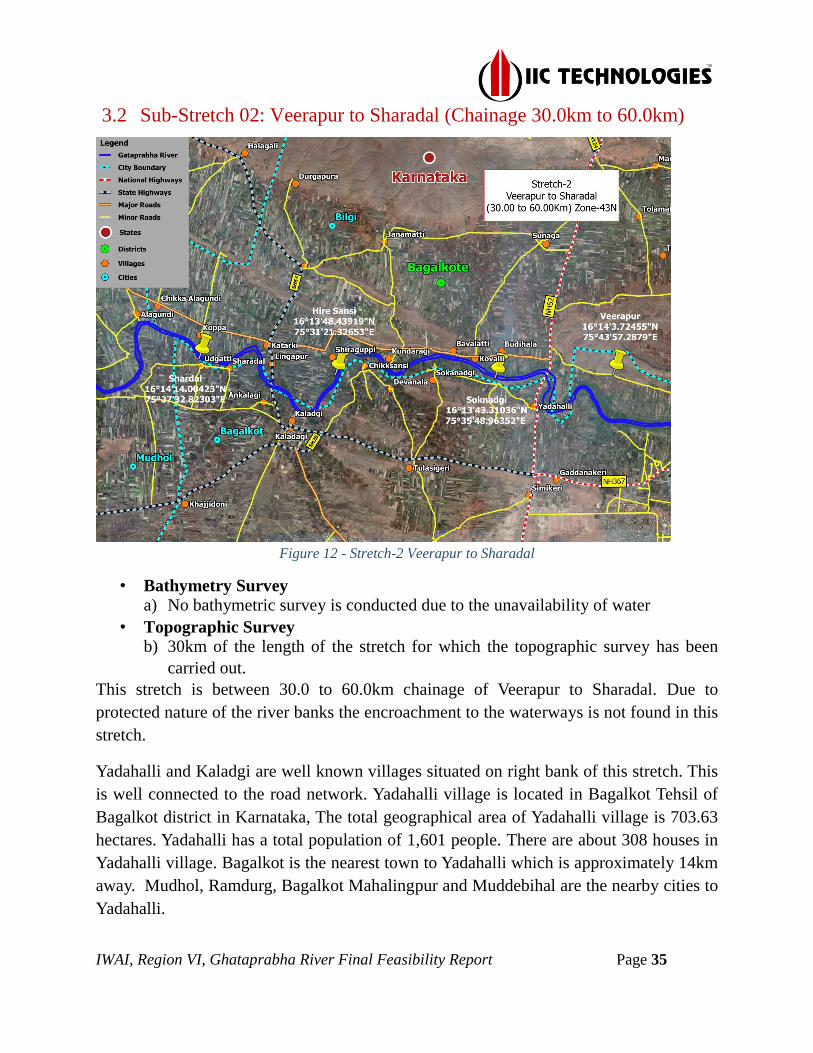
IWAI, Region VI, Ghataprabha River Final Feasibility Report Page 35
3.2 Sub-Stretch 02: Veerapur to Sharadal (Chainage 30.0km to 60.0km)
Figure 12 - Stretch-2 Veerapur to Sharadal
• Bathymetry Survey a) No bathymetric survey is conducted due to the unavailability of water
• Topographic Survey b) 30km of the length of the stretch for which the topographic survey has been
carried out.
This stretch is between 30.0 to 60.0km chainage of Veerapur to Sharadal. Due to
protected nature of the river banks the encroachment to the waterways is not found in this
stretch.
Yadahalli and Kaladgi are well known villages situated on right bank of this stretch. This
is well connected to the road network. Yadahalli village is located in Bagalkot Tehsil of
Bagalkot district in Karnataka, The total geographical area of Yadahalli village is 703.63
hectares. Yadahalli has a total population of 1,601 people. There are about 308 houses in
Yadahalli village. Bagalkot is the nearest town to Yadahalli which is approximately 14km
away. Mudhol, Ramdurg, Bagalkot Mahalingpur and Muddebihal are the nearby cities to
Yadahalli.

IWAI, Region VI, Ghataprabha River Final Feasibility Report Page 36
Kaladgi is a small Village/hamlet in the Bagalkot Taluk in Bagalkot District of Karnataka
State, India. It comes under Kaladgi Panchayat. It belongs to Belgaum Division. It is
located 22km towards west from District Bagalkot. The Kaladgi gram Panchayat area is
bounded on the north by the banks of the Ghataprabha River, to the east is the Chikka-
Shellikeri gram Panchayat area, to the south is the Yandageri village area of Badami
Taluka, and to the west is the Khajidoni gram Panchayat area. Kaladgi is famous for
fruits like Pomegranates, Sapota and Grapes, etc. These fruits are exported all over India
as well abroad.
Kaladgi has very well-known temple called Sri Gurulingeswara Matha. Sri.
Chandrashekhara Swamiji is current guru/Swamiji of this temple. Also in this place is a
fine temple of Basavanna, built out of famous Shellikeri Blackstone. This is 15km away
from this stretch.
This Stretch is well connected by Karnataka State Highway 20. The National Highway
218 (India) passing through Bagalkot (Gaddangiri Cross) connects at about 12km and
another National Highway 13 (India) passing through Bagalkot (Ilkal, Hunagund)
connect at 50km. The nearest Railway station is Bagalkot. All these modes of transports
connect Kaladgi to Hubli, Bijapur, Raichur and Belgaum by road and connect Kaladgi to
Gadag and Bijapur by train.
The Hire Sansi village is located in Bagalkot Tehsil of Bagalkot district in Karnataka. It is
situated 20km away from Bagalkot, which is both districts & sub-district headquarter of
the Hire Sansi village. Bagalkot is the nearest town to Hire-Sansi which is approximately
20km away.
Muranal, Kesanur, Annadinni, Yadahalli, Sokanadgi, Devnal, Hiresansi, Chick Sansi,
Ankalagi, Shardadal are nearby villages which is present right bank of this stretch and all
are being well connected to the road as well Bagalkot is the nearest railway station.
Katarki, Lingapur, Siraguppi, Kundargai, Venkatpura, Kovalli, Bdhiaah, Kadalpatti are
the nearest villages of left of the river which are situated to the left bank of this stretch is
also being well connected to the road network.
In this stretch, near Bannidinni village which is situated left bank of this stretch a barrage
is being constructed, named Bannidinni barrage. This is small barrage and also as per the
local villagers only monsoon time its operational it is being used by farmers by their own
lift. There are 4 nos. of Barrages named as Bannidinni barrage, Yadahalli Barrage,

IWAI, Region VI, Ghataprabha River Final Feasibility Report Page 37
Kaladgi barrage, Katarki barrage. Also near to Yadahalli a Highway Bridge is being
constructed upon NH218 which is well connected to Gulbarga and Bijapur.
Figure 13 - Yadahalli Bridge (38.7 km chianage)
The entire stretch is fully dry and bathy survey could not able to carried out.
Cla
ss
Chainage
(km) Observed Reduced w.r.t. Sounding Datum
From To
Min.
depth
(m)
Max.
depth
(m)
Length of
Shoal (m)
Dredging Qty.
(cu.m.)
Accumulated
Qty.
Min.
Depth
(m)
Max.
Depth
(m)
Length of
Shoal (m)
Dredging Qty.
(cu.m.)
Accumulated
Qty.
I
30 35.2 0.000 0.000 5200 223,136.91 1,511,260.51 -0.300 0.000 5200 281,576.65 1,902,687.40
35.2 38.5 0.000 0.000 3300 140,739.38 1,651,999.89 -0.300 0.000 3300 176,330.03 2,079,017.43
38.5 52.8 0.000 0.000 14300 614,280.59 2,266,280.48 -0.300 0.000 14300 773,681.25 2,852,698.68
52.8 56 0.000 0.000 3200 137,029.96 2,403,310.44 -0.300 0.000 3200 169,810.90 3,022,509.58
56 60 0.000 0.000 4000 171,375.76 2,574,686.20 -0.300 0.000 4000 212,930.19 3,235,439.77
II
30 35.2 0.000 0.000 5200 339,880.50 2,301,856.41 -0.300 0.000 5200 415,932.74 2,805,948.56
35.2 38.5 0.000 0.000 3300 214,373.34 2,516,229.75 -0.300 0.000 3300 260,830.15 3,066,778.71
38.5 52.8 0.000 0.000 14300 935,622.30 3,451,852.05 -0.300 0.000 14300 1,143,078.52 4,209,857.23
52.8 56 0.000 0.000 3200 208,710.50 3,660,562.55 -0.300 0.000 3200 251,542.74 4,461,399.97
56 60 0.000 0.000 4000 261,034.97 3,921,597.52 -0.300 0.000 4000 315,488.10 4,776,888.07
III
30 35.2 0.000 0.000 5200 513,691.39 3,478,870.19 -0.300 0.000 5200 609,188.19 4,105,538.30
35.2 38.5 0.000 0.000 3300 324,001.55 3,802,871.74 -0.300 0.000 3300 382,546.38 4,488,084.68
38.5 52.8 0.000 0.000 14300 1,414,047.43 5,216,919.17 -0.300 0.000 14300 1,674,512.62 6,162,597.30
52.8 56 0.000 0.000 3200 315,447.90 5,532,367.07 -0.300 0.000 3200 369,677.03 6,532,274.33
56 60 0.000 0.000 4000 394,517.55 5,926,884.62 -0.300 0.000 4000 463,398.53 6,995,672.86
IV
30 35.2 0.000 0.000 5200 619,839.65 4,197,734.72 -0.300 0.000 5200 719,854.46 4,852,474.52
35.2 38.5 0.000 0.000 3300 390,950.48 4,588,685.20 -0.300 0.000 3300 452,336.72 5,304,811.24
38.5 52.8 0.000 0.000 14300 1,706,221.61 6,294,906.81 -0.300 0.000 14300 1,979,025.25 7,283,836.49
52.8 56 0.000 0.000 3200 380,629.90 6,675,536.71 -0.300 0.000 3200 437,545.11 7,721,381.60
56 60 0.000 0.000 4000 476,037.47 7,151,574.18 -0.300 0.000 4000 548,316.81 8,269,698.41
Table 28 - Dredging Quantity Details

IWAI, Region VI, Ghataprabha River Final Feasibility Report Page 38
3.2.1 Observed and reduced Bed Profile of the stretch
Figure 14 - River Bed Profile
-0.400
-0.300
-0.200
-0.100
0.000
0.100
30.00 35.00 40.00 45.00 50.00 55.00 60.00
Val
ues
in M
eter
s
Chainage in km
River Bed Profile from Ch. 30.0km to 60.0km
Dredging Observed Dredging Reduced
Chart Datum is at Zero
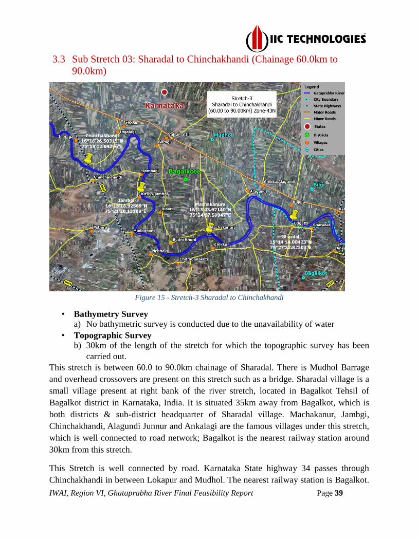
IWAI, Region VI, Ghataprabha River Final Feasibility Report Page 39
3.3 Sub Stretch 03: Sharadal to Chinchakhandi (Chainage 60.0km to
90.0km)
Figure 15 - Stretch-3 Sharadal to Chinchakhandi
• Bathymetry Survey a) No bathymetric survey is conducted due to the unavailability of water
• Topographic Survey b) 30km of the length of the stretch for which the topographic survey has been
carried out.
This stretch is between 60.0 to 90.0km chainage of Sharadal. There is Mudhol Barrage
and overhead crossovers are present on this stretch such as a bridge. Sharadal village is a
small village present at right bank of the river stretch, located in Bagalkot Tehsil of
Bagalkot district in Karnataka, India. It is situated 35km away from Bagalkot, which is
both districts & sub-district headquarter of Sharadal village. Machakanur, Jambgi,
Chinchakhandi, Alagundi Junnur and Ankalagi are the famous villages under this stretch,
which is well connected to road network; Bagalkot is the nearest railway station around
30km from this stretch.
This Stretch is well connected by road. Karnataka State highway 34 passes through
Chinchakhandi in between Lokapur and Mudhol. The nearest railway station is Bagalkot.

IWAI, Region VI, Ghataprabha River Final Feasibility Report Page 40
All these modes of transports connect to Hubli, Bijapur, Raichur and Belgaum by road.
Dharwar railway station is the major railway station situated at a distance of 111.76km. In
this stretch Chinchakhandi village is located in Mudhol Tehsil of Bagalkot district in
Karnataka, India. It is situated 8km away from Mudhol and 52km away from district
Bagalkot.
The total geographical area of the village is 1049.71 hectares Mudhol is the nearest town
to Chinchakhandi
Uddayati, Chikkur, Budhinaal, Timmapur, Hebbal, Kasba Jambgi, Bidri are the villages
present of the right bank of this stretch. Jeeragal, Ingalagi, Baragi, Marakatti, Anantapur,
Machakanur, Budri, Alagundi, Kopper are the villages present in between 5 km on the
left bank of the river stretch. All these villages are being well connected by road. Though
there is no rail network throughout this stretch Bagalkot is the nearest railway station.
The both sides of the river bank are fully cultivated area. Bajra, Sugarcane, Beans are the
three mostly cultivated crops in this stretch.
During the survey, we found 6 Barrages named as Jeeragal, Ingalagi, Marakatti,
Machakanur, Bidri, and Alagundi. Surrounded near to the barrage is fully dry. As per the
local people, the water from these barrages are used by farmers during the monsoon
season.
The entire stretch is fully dry so Bathy Survey could not able to carry out.
Cla
ss
Chainage
(km) Observed Reduced w.r.t. Sounding Datum
From To
Min.
depth
(m)
Max.
depth
(m)
Length of
Shoal (m)
Dredging Qty.
(cu.m.)
Accumulated
Qty.
Min.
Depth
(m)
Max.
Depth
(m)
Length of
Shoal (m)
Dredging Qty.
(cu.m.)
Accumulated
Qty.
I
60 64.6 0.000 0.000 4600 197,692.82 2,772,379.02 -0.300 0.000 4600 248,976.37 3,484,416.14
64.6 70.6 0.000 0.000 6000 257,626.73 3,030,005.75 -0.300 0.000 6000 322,002.63 3,806,418.77
70.6 77 0.000 0.000 6400 275,234.42 3,305,240.17 -0.300 0.000 6400 349,274.20 4,155,692.97
77 79.8 0.000 0.000 2800 119,493.33 3,424,733.50 -0.300 0.000 2800 152,020.53 4,307,713.50
79.8 82.9 0.000 0.000 3100 132,445.54 3,557,179.04 -0.300 0.000 3100 168,638.09 4,476,351.59
82.9 86.1 0.000 0.000 3200 135,594.65 3,692,773.69 -0.300 0.000 3200 172,593.54 4,648,945.13
86.1 90 0.000 0.000 3900 167,043.11 3,859,816.80 -0.300 0.000 3900 213,032.55 4,861,977.68
II
60 64.6 0.000 0.000 4600 301,115.00 4,222,712.52 -0.300 0.000 4600 368,180.72 5,145,068.79
64.6 70.6 0.000 0.000 6000 392,408.19 4,615,120.71 -0.300 0.000 6000 476,360.95 5,621,429.74
70.6 77 0.000 0.000 6400 419,217.44 5,034,338.15 -0.300 0.000 6400 515,197.96 6,136,627.70
77 79.8 0.000 0.000 2800 181,999.51 5,216,337.66 -0.300 0.000 2800 224,096.92 6,360,724.62
79.8 82.9 0.000 0.000 3100 201,730.65 5,418,068.31 -0.300 0.000 3100 248,521.76 6,609,246.38
82.9 86.1 0.000 0.000 3200 206,515.23 5,624,583.54 -0.300 0.000 3200 254,082.76 6,863,329.14
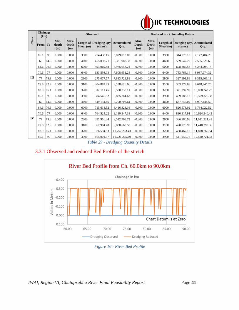
IWAI, Region VI, Ghataprabha River Final Feasibility Report Page 41
Cla
ss
Chainage
(km) Observed Reduced w.r.t. Sounding Datum
From To
Min.
depth
(m)
Max.
depth
(m)
Length of
Shoal (m)
Dredging Qty.
(cu.m.)
Accumulated
Qty.
Min.
Depth
(m)
Max.
Depth
(m)
Length of
Shoal (m)
Dredging Qty.
(cu.m.)
Accumulated
Qty.
86.1 90 0.000 0.000 3900 254,430.15 5,879,013.69 -0.300 0.000 3900 314,075.15 7,177,404.29
III
60 64.6 0.000 0.000 4600 455,098.71 6,381,983.33 -0.300 0.000 4600 539,647.79 7,535,320.65
64.6 70.6 0.000 0.000 6000 593,069.88 6,975,053.21 -0.300 0.000 6000 698,887.53 8,234,208.18
70.6 77 0.000 0.000 6400 633,598.03 7,608,651.24 -0.300 0.000 6400 753,766.14 8,987,974.32
77 79.8 0.000 0.000 2800 275,077.57 7,883,728.81 -0.300 0.000 2800 327,691.86 9,315,666.18
79.8 82.9 0.000 0.000 3100 304,897.85 8,188,626.66 -0.300 0.000 3100 363,279.08 9,678,945.26
82.9 86.1 0.000 0.000 3200 312,111.45 8,500,738.11 -0.300 0.000 3200 371,297.99 10,050,243.25
86.1 90 0.000 0.000 3900 384,546.52 8,885,284.63 -0.300 0.000 3900 459,083.13 10,509,326.38
IV
60 64.6 0.000 0.000 4600 549,134.46 7,700,708.64 -0.300 0.000 4600 637,746.09 8,907,444.50
64.6 70.6 0.000 0.000 6000 715,614.52 8,416,323.16 -0.300 0.000 6000 826,578.02 9,734,022.52
70.6 77 0.000 0.000 6400 764,524.22 9,180,847.38 -0.300 0.000 6400 890,317.91 10,624,340.43
77 79.8 0.000 0.000 2800 331,916.34 9,512,763.72 -0.300 0.000 2800 386,980.98 11,011,321.41
79.8 82.9 0.000 0.000 3100 367,904.78 9,880,668.50 -0.300 0.000 3100 428,976.95 11,440,298.36
82.9 86.1 0.000 0.000 3200 376,594.93 10,257,263.43 -0.300 0.000 3200 438,467.18 11,878,765.54
86.1 90 0.000 0.000 3900 464,001.97 10,721,265.40 -0.300 0.000 3900 541,955.78 12,420,721.32
Table 29 - Dredging Quantity Details
3.3.1 Observed and reduced Bed Profile of the stretch
Figure 16 - River Bed Profile
-0.400
-0.300
-0.200
-0.100
0.000
0.100
60.00 65.00 70.00 75.00 80.00 85.00 90.00
Val
ues
in M
eter
s
Chainage in km
River Bed Profile from Ch. 60.0km to 90.0km
Dredging Observed Dredging Reduced
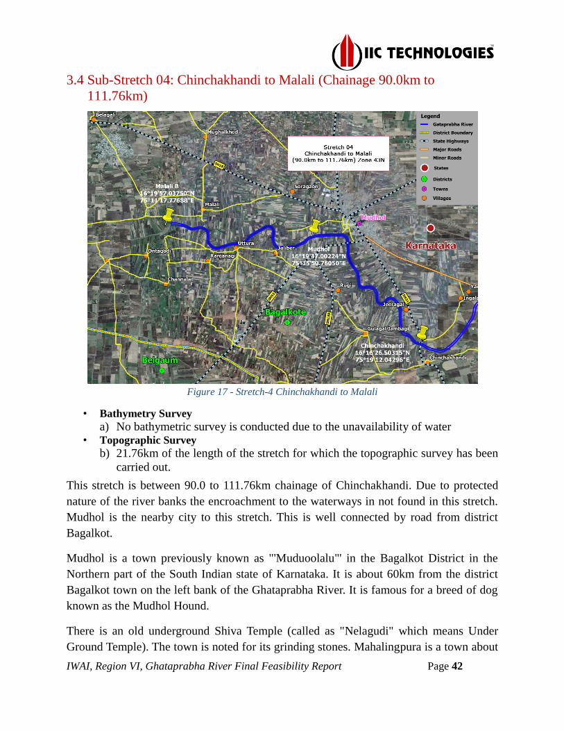
IWAI, Region VI, Ghataprabha River Final Feasibility Report Page 42
3.4 Sub-Stretch 04: Chinchakhandi to Malali (Chainage 90.0km to
111.76km)
Figure 17 - Stretch-4 Chinchakhandi to Malali
• Bathymetry Survey
a) No bathymetric survey is conducted due to the unavailability of water • Topographic Survey
b) 21.76km of the length of the stretch for which the topographic survey has been
carried out.
This stretch is between 90.0 to 111.76km chainage of Chinchakhandi. Due to protected
nature of the river banks the encroachment to the waterways in not found in this stretch.
Mudhol is the nearby city to this stretch. This is well connected by road from district
Bagalkot.
Mudhol is a town previously known as "'Muduoolalu"' in the Bagalkot District in the
Northern part of the South Indian state of Karnataka. It is about 60km from the district
Bagalkot town on the left bank of the Ghataprabha River. It is famous for a breed of dog
known as the Mudhol Hound.
There is an old underground Shiva Temple (called as "Nelagudi" which means Under
Ground Temple). The town is noted for its grinding stones. Mahalingpura is a town about

IWAI, Region VI, Ghataprabha River Final Feasibility Report Page 43
19km to the northwest of Mudhol. Its earlier name, Naragatti, was subsequently renamed
Mahalingpura in honour of Sant Mahalingeshwara.
There is no railway station near to Mudhol in less than 10km. Bagalkot Railway Station
(near to Bagalkot), Mugalolli Halt Railway Station (near to Bagalkot) are the Railway
stations reachable from nearby towns. However Sangli Railway Station is a major
railway station 105km near to Mudhol.
The upstream and downstream of stretch is filled with rocks. The hydro survey could not
be undertaken due to non-availability of sufficient depths. No navigation is possible due
to the non-availability of sufficient navigable water.
Gulagal, Rugi, Jaliber, Uttur, Ranjanagi, Channal old are the villages present right bank
of the river stretch and well connected to road networks. Nagaral, Malali, Mugalkhod,
Soragaon, Mudhol and Malapur are the village’s present left bank of the river stretch. All
the villages are connected to the well road network and though there is no rail network
Bagalkot is the nearest railway station near to this stretch approx. Distance of 70km.
Mudhol Jaliber and Malali are three barrages present in this stretch. This is used by
farmers for their irrigation purposes. During monsoon is it is own lift by farmers, is
noticed from the local villagers.
Sugarcane and Bajra is being found and cultivated by local people, on the both sides of
the banks in this stretch. Though Mudhol is a famous place so no industries is being
available near to the stretch. A Bridge is constructed by PWD Karnataka upon this
stretch. The Bridge is constructed upon Ghataprabha on State Highway Number 34,
which is connected in between Bagalkot and Belgavi.
Figure 18 - Chinchakhandi Bridge (91.06 km chainage)
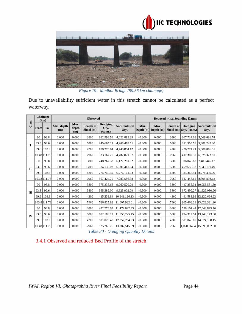
IWAI, Region VI, Ghataprabha River Final Feasibility Report Page 44
Figure 19 - Mudhol Bridge (99.56 km chainage)
Due to unavailability sufficient water in this stretch cannot be calculated as a perfect
waterway.
Cla
ss
Chainage
(km) Observed Reduced w.r.t. Sounding Datum
From To Min. depth
(m)
Max.
depth
(m)
Length of
Shoal (m)
Dredging
Qty.
(cu.m.)
Accumulated
Qty.
Min.
Depth (m)
Max.
Depth (m)
Length of
Shoal (m)
Dredging
Qty. (cu.m.)
Accumulated
Qty.
I
90 93.8 0.000 0.000 3800 162,996.59 4,022,813.39 -0.300 0.000 3800 207,714.06 5,069,691.74
93.8 99.6 0.000 0.000 5800 245,665.12 4,268,478.51 -0.300 0.000 5800 311,553.56 5,381,245.30
99.6 103.8 0.000 0.000 4200 180,375.61 4,448,854.12 -0.300 0.000 4200 226,771.21 5,608,016.51
103.8 111.76 0.000 0.000 7960 333,167.25 4,782,021.37 -0.300 0.000 7960 417,307.30 6,025,323.81
II
90 93.8 0.000 0.000 3800 248,267.33 6,127,281.02 -0.300 0.000 3800 306,040.88 7,483,445.17
93.8 99.6 0.000 0.000 5800 374,132.02 6,501,413.04 -0.300 0.000 5800 459,656.32 7,943,101.49
99.6 103.8 0.000 0.000 4200 274,748.59 6,776,161.63 -0.300 0.000 4200 335,348.51 8,278,450.00
103.8 111.76 0.000 0.000 7960 507,424.75 7,283,586.38 -0.300 0.000 7960 617,448.62 8,895,898.62
III
90 93.8 0.000 0.000 3800 375,235.66 9,260,520.29 -0.300 0.000 3800 447,255.31 10,956,581.69
93.8 99.6 0.000 0.000 5800 565,382.00 9,825,902.29 -0.300 0.000 5800 672,499.27 11,629,080.96
99.6 103.8 0.000 0.000 4200 415,233.84 10,241,136.13 -0.300 0.000 4200 491,583.96 12,120,664.92
103.8 111.76 0.000 0.000 7960 766,825.88 11,007,962.01 -0.300 0.000 7960 905,666.28 13,026,331.20
IV
90 93.8 0.000 0.000 3800 452,776.93 11,174,042.33 -0.300 0.000 3800 528,104.44 12,948,825.76
93.8 99.6 0.000 0.000 5800 682,183.12 11,856,225.45 -0.300 0.000 5800 794,317.54 13,743,143.30
99.6 103.8 0.000 0.000 4200 501,029.48 12,357,254.93 -0.300 0.000 4200 581,046.85 14,324,190.15
103.8 111.76 0.000 0.000 7960 925,260.76 13,282,515.69 -0.300 0.000 7960 1,070,862.45 15,395,052.60
Table 30 - Dredging Quantity Details
3.4.1 Observed and reduced Bed Profile of the stretch
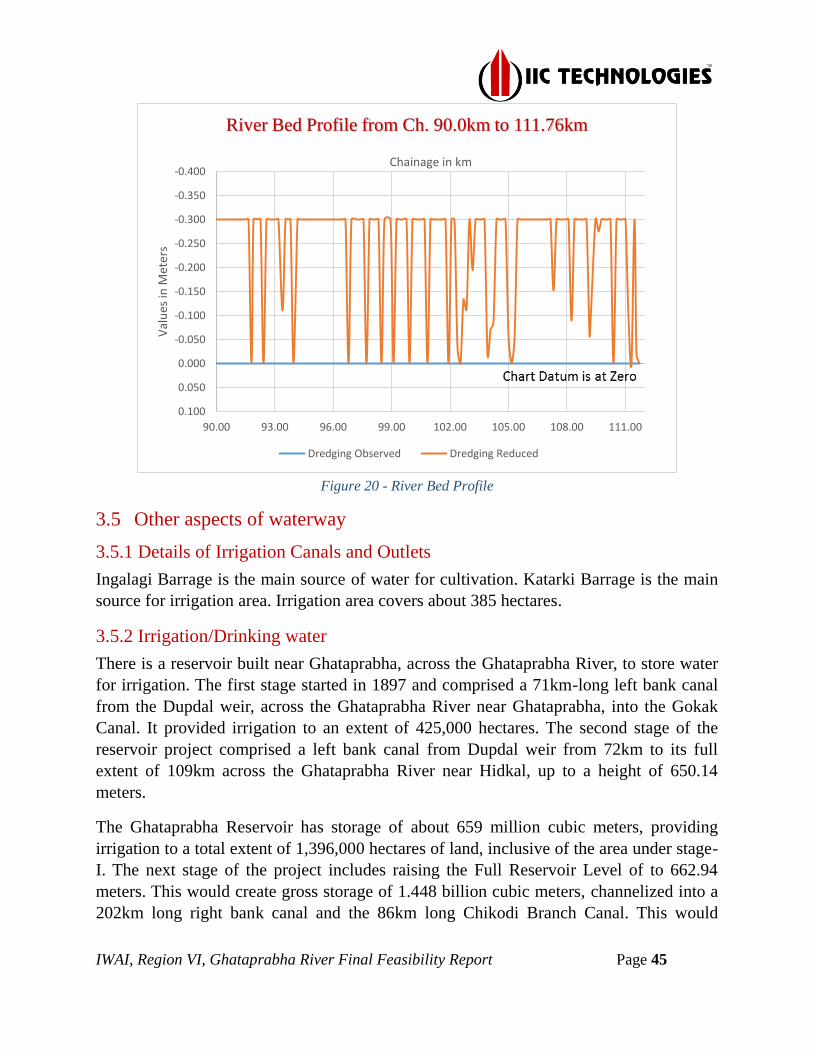
IWAI, Region VI, Ghataprabha River Final Feasibility Report Page 45
Figure 20 - River Bed Profile
3.5 Other aspects of waterway
3.5.1 Details of Irrigation Canals and Outlets
Ingalagi Barrage is the main source of water for cultivation. Katarki Barrage is the main
source for irrigation area. Irrigation area covers about 385 hectares.
3.5.2 Irrigation/Drinking water
There is a reservoir built near Ghataprabha, across the Ghataprabha River, to store water
for irrigation. The first stage started in 1897 and comprised a 71km-long left bank canal
from the Dupdal weir, across the Ghataprabha River near Ghataprabha, into the Gokak
Canal. It provided irrigation to an extent of 425,000 hectares. The second stage of the
reservoir project comprised a left bank canal from Dupdal weir from 72km to its full
extent of 109km across the Ghataprabha River near Hidkal, up to a height of 650.14
meters.
The Ghataprabha Reservoir has storage of about 659 million cubic meters, providing
irrigation to a total extent of 1,396,000 hectares of land, inclusive of the area under stage-
I. The next stage of the project includes raising the Full Reservoir Level of to 662.94
meters. This would create gross storage of 1.448 billion cubic meters, channelized into a
202km long right bank canal and the 86km long Chikodi Branch Canal. This would
-0.400
-0.350
-0.300
-0.250
-0.200
-0.150
-0.100
-0.050
0.000
0.050
0.100
90.00 93.00 96.00 99.00 102.00 105.00 108.00 111.00
Val
ues
in M
eter
s Chainage in km
River Bed Profile from Ch. 90.0km to 111.76km
Dredging Observed Dredging Reduced

IWAI, Region VI, Ghataprabha River Final Feasibility Report Page 46
irrigate 191,386 hectares of land and bring the total area under the project to 3,310,000
hectares.
3.5.3 Crops
Agriculture is the main occupation of the people in the district. The geographical area is
658777ha and the newly sown area is 469783ha which us 71.3 of the geographic area.
The major crops grown area Jowar, Maize, Wheat, Bajra, sugarcane, sunflower, pulses,
and groundnut. Net irrigated area is 212872 ha which constitutes 45.3% of the newly
sown area and the remaining 54.7 of the rain fed.
Out of the net irrigated area, nearly 60% are through surface water resources and the
remaining 40% through groundwater. A major dam has been built across the Krishna at
Almatti in Basavanna Bagewadi Taluk of Bijapur district, which provides irrigation
facility of Karnataka, Telangana, and Andhra Pradesh. Thus the Krishna the Malaprabha
and the Ghataprabha canal systems cater to the irrigation needs in parts of Mudhol,
Jamkhandi, Bilgi, and Badami taluks of the district.
3.5.4 Industries
Bagalkot is the main hub for cement, agriculture, sugar, silk and handloom industries. It
is one of the two handloom units (the other is Dharwad) in India from where woven khadi
is obtained and transported to Karnataka Khadi Gramodyoga Samyukta Sangha, based in
Hubli, which is the only licensed flag production and supply unit in India. Many new
industries are planning to begin in Bagalkot.
IWAI, Region VI, Ghataprabha River Final Feasibility Report Page 47
A new cement industry had been registered and are waiting for the permission to
commissioning. There are other small-scale industries like Cement Pipe Industry which
produce cement pipes, Bangle Industries, which produce bangles, Match Stick Industries,
Agarbatti Industries and Plastic Bag Industries etc. in Bagalkot. On the outskirts of
Bagalkot city, there are many small-scale industries set up. These come under the
Vidyagiri area of Bagalkot city, which is the latest extension of the city. Small-scale
industries like Ceramic Tile Industry, tyre industry, Stone Cutting and polishing Industry,
Milk Dairy etc. are running successfully.
At Gaddanakeri there are many limestone industries and brick industries. The limestone
industries produces lime for whitewash and painting. The brick industries produce bricks
required for the construction of houses. There are local oil industries and oil refineries
which produce oil from groundnuts, sunflower, sesame, orientale, cotton etc.
3.5.5 Important cities/towns
The Major town situated near to Ghataprabha River is Mudhol on the starting chainage
and Bagalkot at the end chainage. The areas are well connected by road and public
transport system in the cities.
3.5.6 Road Network
3.5.6.1 National Highway
The National Highway no 161 (old number NH 218) from Hubli to Bidar via Bijapur,
Jewargi, Gulbarga, Humnabad passes through Bagalkot.
3.5.6.2 State Highway
The state highway passing through Bagalkot connects NH 169 (formerly called NH-13)
running from Solapur to Mangalore at about 40 km from Bagalkot near Almatti dam. It is
connected to Belgaum by road and connected to Hubli. World class State Highway
Belgaum to Raichur passes through Bagalkot.
3.5.6.3 Major District Roads
Gulbarga and Yadgir districts had a good road network. A map with major road network
is shown below:

IWAI, Region VI, Ghataprabha River Final Feasibility Report Page 48
Figure 21 - Road Network
3.5.7 Railway Network
Bagalkot is connected by a broad gauge railway line (Gadag-Hotgi line) to Bijapur of the
South Western Railway (SWR) towards the north and to Gadag junction on the South
Western Railway towards the south. Bagalkot is connected with direct trains to Bijapur,
Solapur, Gadag, Dharwad, Bellary, Mysore, Bengaluru, Hubli, Hyderabad, Mumbai and
Ahmedabad. Bagalkot is under South Western Railway (SWR)
The nearest major airports to Bagalkot are the Belgaum Airport which is 121kms and the
Dabolim Airport in Goa which is 218km from Bagalkot.

IWAI, Region VI, Ghataprabha River Final Feasibility Report Page 49
Figure 22 - Railway Stations
3.5.8 Land Use
In Bagalkot District, the land use is divided into Forest area, Cultivation area and Net
area Shown.
Geographical area – 658.9 ha
Cultivable area – 2.0 ha
Forest area – 81.1 ha
Land under nonagricultural use – 28.80 ha
Permanent pastures – 3.4 ha
Cultivable wasteland – 2.2 ha
Barren and uncultivable land – 24.8ha
3.5.9 Construction Material
The Bagalkot district is having a cluster of cement industries and limestone. The distinct
stone is popularly known as "Malakheda Stone".
3.5.10 Conditions of banks
Bank is somehow protected along the river details is being attached on Annexure-6.
3.5.11 Jetties and Terminals
Lack of the jetties and Terminals along the river.
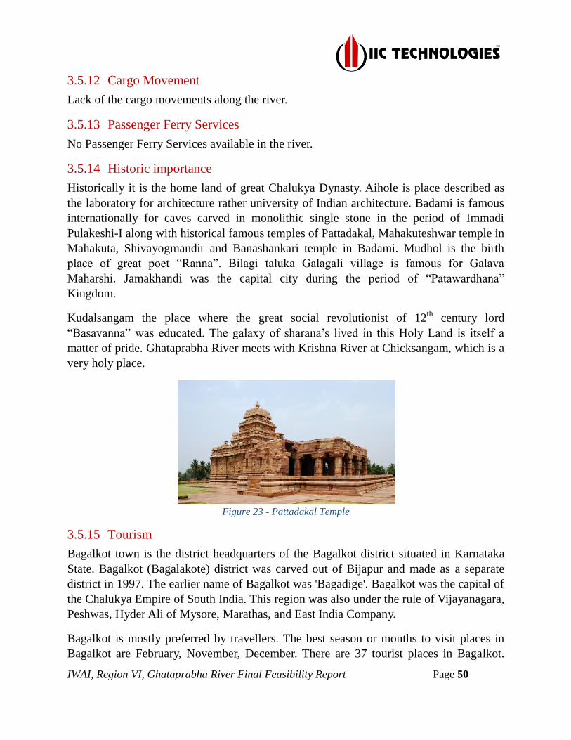
IWAI, Region VI, Ghataprabha River Final Feasibility Report Page 50
3.5.12 Cargo Movement
Lack of the cargo movements along the river.
3.5.13 Passenger Ferry Services
No Passenger Ferry Services available in the river.
3.5.14 Historic importance
Historically it is the home land of great Chalukya Dynasty. Aihole is place described as
the laboratory for architecture rather university of Indian architecture. Badami is famous
internationally for caves carved in monolithic single stone in the period of Immadi
Pulakeshi-I along with historical famous temples of Pattadakal, Mahakuteshwar temple in
Mahakuta, Shivayogmandir and Banashankari temple in Badami. Mudhol is the birth
place of great poet “Ranna”. Bilagi taluka Galagali village is famous for Galava
Maharshi. Jamakhandi was the capital city during the period of “Patawardhana”
Kingdom.
Kudalsangam the place where the great social revolutionist of 12th
century lord
“Basavanna” was educated. The galaxy of sharana’s lived in this Holy Land is itself a
matter of pride. Ghataprabha River meets with Krishna River at Chicksangam, which is a
very holy place.
Figure 23 - Pattadakal Temple
3.5.15 Tourism
Bagalkot town is the district headquarters of the Bagalkot district situated in Karnataka
State. Bagalkot (Bagalakote) district was carved out of Bijapur and made as a separate
district in 1997. The earlier name of Bagalkot was 'Bagadige'. Bagalkot was the capital of
the Chalukya Empire of South India. This region was also under the rule of Vijayanagara,
Peshwas, Hyder Ali of Mysore, Marathas, and East India Company.
Bagalkot is mostly preferred by travellers. The best season or months to visit places in
Bagalkot are February, November, December. There are 37 tourist places in Bagalkot.

IWAI, Region VI, Ghataprabha River Final Feasibility Report Page 51
The main attraction here is Aihole, Badami, and Pattadakallu which are known for their
historical monuments and temples.
Annual tourist footfalls in Bagalkot district is nearly 35 laks per year (2014 tourist data).
Thus, the average tourist footfalls in each tourist destination will be 5 lakhs.
Chicksangam as well as the Giri sagar is the tourism place, where people called that to
wash away their faultiness at the merging point of Ghataprabha and Krishna.
4 Terminals
4.1 Details of terminal survey carried out
In this River, stretch could not find any adequate proposed terminal, due to the
unavailability of water in this stretch.
5 Fairway Development
5.1 Fairway Dimensions
As per the specification of the survey, dredging quantity was required to be estimated for
a channel dimension of 50m x 2m with Side slope of 1:5, along with the deepest route.
Figure 24 - Fairway Channel Dimensions 50m X 2m
5.2 Calculation of Dredging Quantity
The dredge volume calculations were accomplished using the HYPACK dredge volume
computation utility. A channel profile of the dimensions mentioned at para 2.3.9 in the
RFP. For clarity and ease of calculations, the complete channel profile was divided into
segments of 1km each (enclosed at Annexure 3). The Tin v/s Channel with Hypack
Standard algorithm was used to calculate the dredge volume in each segment. The stretch
wise summary of the dredge volume is as follows:
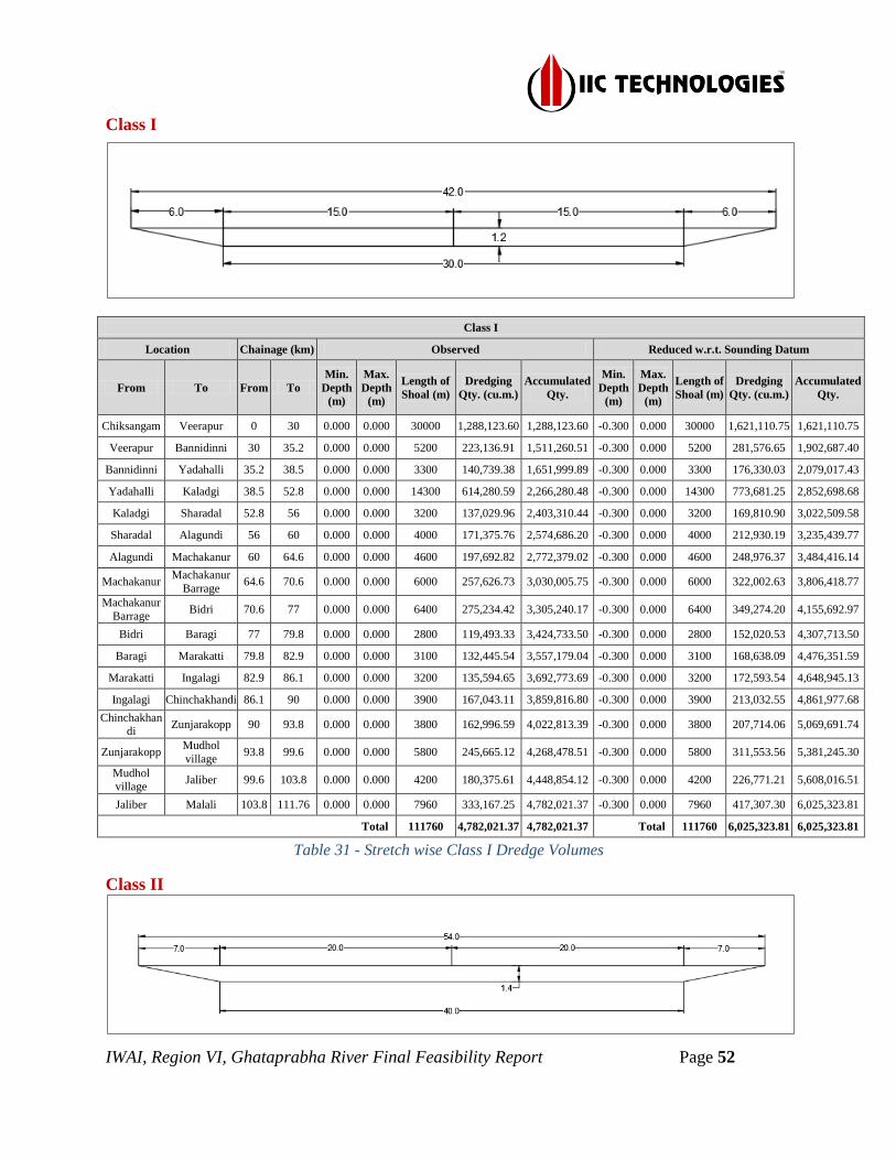
IWAI, Region VI, Ghataprabha River Final Feasibility Report Page 52
Class I
Class I
Location Chainage (km) Observed Reduced w.r.t. Sounding Datum
From To From To
Min.
Depth
(m)
Max.
Depth
(m)
Length of
Shoal (m)
Dredging
Qty. (cu.m.)
Accumulated
Qty.
Min.
Depth
(m)
Max.
Depth
(m)
Length of
Shoal (m)
Dredging
Qty. (cu.m.)
Accumulated
Qty.
Chiksangam Veerapur 0 30 0.000 0.000 30000 1,288,123.60 1,288,123.60 -0.300 0.000 30000 1,621,110.75 1,621,110.75
Veerapur Bannidinni 30 35.2 0.000 0.000 5200 223,136.91 1,511,260.51 -0.300 0.000 5200 281,576.65 1,902,687.40
Bannidinni Yadahalli 35.2 38.5 0.000 0.000 3300 140,739.38 1,651,999.89 -0.300 0.000 3300 176,330.03 2,079,017.43
Yadahalli Kaladgi 38.5 52.8 0.000 0.000 14300 614,280.59 2,266,280.48 -0.300 0.000 14300 773,681.25 2,852,698.68
Kaladgi Sharadal 52.8 56 0.000 0.000 3200 137,029.96 2,403,310.44 -0.300 0.000 3200 169,810.90 3,022,509.58
Sharadal Alagundi 56 60 0.000 0.000 4000 171,375.76 2,574,686.20 -0.300 0.000 4000 212,930.19 3,235,439.77
Alagundi Machakanur 60 64.6 0.000 0.000 4600 197,692.82 2,772,379.02 -0.300 0.000 4600 248,976.37 3,484,416.14
Machakanur Machakanur
Barrage 64.6 70.6 0.000 0.000 6000 257,626.73 3,030,005.75 -0.300 0.000 6000 322,002.63 3,806,418.77
Machakanur
Barrage Bidri 70.6 77 0.000 0.000 6400 275,234.42 3,305,240.17 -0.300 0.000 6400 349,274.20 4,155,692.97
Bidri Baragi 77 79.8 0.000 0.000 2800 119,493.33 3,424,733.50 -0.300 0.000 2800 152,020.53 4,307,713.50
Baragi Marakatti 79.8 82.9 0.000 0.000 3100 132,445.54 3,557,179.04 -0.300 0.000 3100 168,638.09 4,476,351.59
Marakatti Ingalagi 82.9 86.1 0.000 0.000 3200 135,594.65 3,692,773.69 -0.300 0.000 3200 172,593.54 4,648,945.13
Ingalagi Chinchakhandi 86.1 90 0.000 0.000 3900 167,043.11 3,859,816.80 -0.300 0.000 3900 213,032.55 4,861,977.68
Chinchakhandi
Zunjarakopp 90 93.8 0.000 0.000 3800 162,996.59 4,022,813.39 -0.300 0.000 3800 207,714.06 5,069,691.74
Zunjarakopp Mudhol
village 93.8 99.6 0.000 0.000 5800 245,665.12 4,268,478.51 -0.300 0.000 5800 311,553.56 5,381,245.30
Mudhol village
Jaliber 99.6 103.8 0.000 0.000 4200 180,375.61 4,448,854.12 -0.300 0.000 4200 226,771.21 5,608,016.51
Jaliber Malali 103.8 111.76 0.000 0.000 7960 333,167.25 4,782,021.37 -0.300 0.000 7960 417,307.30 6,025,323.81
Total 111760 4,782,021.37 4,782,021.37 Total 111760 6,025,323.81 6,025,323.81
Table 31 - Stretch wise Class I Dredge Volumes
Class II

IWAI, Region VI, Ghataprabha River Final Feasibility Report Page 53
Class II
Location Chainage
(km) Observed Reduced w.r.t. Sounding Datum
From To From To
Min.
Depth
(m)
Max.
Depth
(m)
Length
of
Shoal
(m)
Dredging
Qty. (cu.m.)
Accumulated
Qty.
Min.
Depth
(m)
Max.
Depth
(m)
Length
of
Shoal
(m)
Dredging
Qty. (cu.m.)
Accumulated
Qty.
Chiksangam Veerapur 0 30 0.000 0.000 30000 1,961,975.91 1,961,975.91 -0.300 0.000 30000 2,390,015.82 2,390,015.82
Veerapur Bannidinni 30 35.2 0.000 0.000 5200 339,880.50 2,301,856.41 -0.300 0.000 5200 415,932.74 2,805,948.56
Bannidinni Yadahalli 35.2 38.5 0.000 0.000 3300 214,373.34 2,516,229.75 -0.300 0.000 3300 260,830.15 3,066,778.71
Yadahalli Kaladgi 38.5 52.8 0.000 0.000 14300 935,622.30 3,451,852.05 -0.300 0.000 14300 1,143,078.52 4,209,857.23
Kaladgi Sharadal 52.8 56 0.000 0.000 3200 208,710.50 3,660,562.55 -0.300 0.000 3200 251,542.74 4,461,399.97
Sharadal Alagundi 56 60 0.000 0.000 4000 261,034.97 3,921,597.52 -0.300 0.000 4000 315,488.10 4,776,888.07
Alagundi Machakanur 60 64.6 0.000 0.000 4600 301,115.00 4,222,712.52 -0.300 0.000 4600 368,180.72 5,145,068.79
Machakanur Machakanur
Barrage 64.6 70.6 0.000 0.000 6000 392,408.19 4,615,120.71 -0.300 0.000 6000 476,360.95 5,621,429.74
Machakanur
Barrage Bidri 70.6 77 0.000 0.000 6400 419,217.44 5,034,338.15 -0.300 0.000 6400 515,197.96 6,136,627.70
Bidri Baragi 77 79.8 0.000 0.000 2800 181,999.51 5,216,337.66 -0.300 0.000 2800 224,096.92 6,360,724.62
Baragi Marakatti 79.8 82.9 0.000 0.000 3100 201,730.65 5,418,068.31 -0.300 0.000 3100 248,521.76 6,609,246.38
Marakatti Ingalagi 82.9 86.1 0.000 0.000 3200 206,515.23 5,624,583.54 -0.300 0.000 3200 254,082.76 6,863,329.14
Ingalagi Chinchakhandi 86.1 90 0.000 0.000 3900 254,430.15 5,879,013.69 -0.300 0.000 3900 314,075.15 7,177,404.29
Chinchakhandi Zunjarakopp 90 93.8 0.000 0.000 3800 248,267.33 6,127,281.02 -0.300 0.000 3800 306,040.88 7,483,445.17
Zunjarakopp Mudhol village 93.8 99.6 0.000 0.000 5800 374,132.02 6,501,413.04 -0.300 0.000 5800 459,656.32 7,943,101.49
Mudhol village Jaliber 99.6 103.8 0.000 0.000 4200 274,748.59 6,776,161.63 -0.300 0.000 4200 335,348.51 8,278,450.00
Jaliber Malali 103.8 111.76 0.000 0.000 7960 507,424.75 7,283,586.38 -0.300 0.000 7960 617,448.62 8,895,898.62
Total 111760 7,283,586.38 7,283,586.38 Total 111760 8,895,898.62 8,895,898.62
Table 32 - Stretch wise Class II Dredge Volumes
Class III
Class III
Location Chainage (km) Observed Reduced w.r.t. Sounding Datum
From To From To
Min.
Depth
(m)
Max.
Depth
(m)
Length
of
Shoal
(m)
Dredging
Qty. (cu.m.)
Accumulated
Qty.
Min.
Depth
(m)
Max.
Depth
(m)
Length
of Shoal
(m)
Dredging
Qty. (cu.m.)
Accumulated
Qty.
Chiksangam Veerapur 0 30 0.000 0.000 30000 2,965,178.80 2,965,178.80 -0.300 0.000 30000 3,496,350.11 3,496,350.11
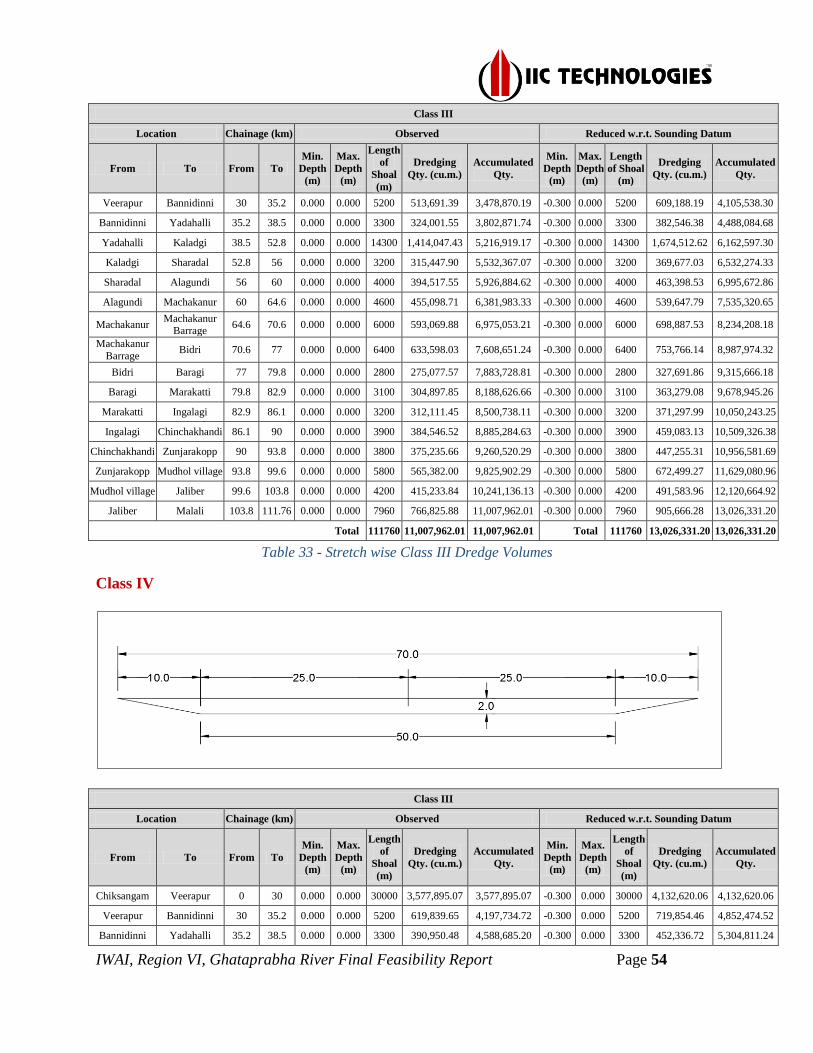
IWAI, Region VI, Ghataprabha River Final Feasibility Report Page 54
Class III
Location Chainage (km) Observed Reduced w.r.t. Sounding Datum
From To From To
Min.
Depth
(m)
Max.
Depth
(m)
Length
of
Shoal
(m)
Dredging
Qty. (cu.m.)
Accumulated
Qty.
Min.
Depth
(m)
Max.
Depth
(m)
Length
of Shoal
(m)
Dredging
Qty. (cu.m.)
Accumulated
Qty.
Veerapur Bannidinni 30 35.2 0.000 0.000 5200 513,691.39 3,478,870.19 -0.300 0.000 5200 609,188.19 4,105,538.30
Bannidinni Yadahalli 35.2 38.5 0.000 0.000 3300 324,001.55 3,802,871.74 -0.300 0.000 3300 382,546.38 4,488,084.68
Yadahalli Kaladgi 38.5 52.8 0.000 0.000 14300 1,414,047.43 5,216,919.17 -0.300 0.000 14300 1,674,512.62 6,162,597.30
Kaladgi Sharadal 52.8 56 0.000 0.000 3200 315,447.90 5,532,367.07 -0.300 0.000 3200 369,677.03 6,532,274.33
Sharadal Alagundi 56 60 0.000 0.000 4000 394,517.55 5,926,884.62 -0.300 0.000 4000 463,398.53 6,995,672.86
Alagundi Machakanur 60 64.6 0.000 0.000 4600 455,098.71 6,381,983.33 -0.300 0.000 4600 539,647.79 7,535,320.65
Machakanur Machakanur
Barrage 64.6 70.6 0.000 0.000 6000 593,069.88 6,975,053.21 -0.300 0.000 6000 698,887.53 8,234,208.18
Machakanur
Barrage Bidri 70.6 77 0.000 0.000 6400 633,598.03 7,608,651.24 -0.300 0.000 6400 753,766.14 8,987,974.32
Bidri Baragi 77 79.8 0.000 0.000 2800 275,077.57 7,883,728.81 -0.300 0.000 2800 327,691.86 9,315,666.18
Baragi Marakatti 79.8 82.9 0.000 0.000 3100 304,897.85 8,188,626.66 -0.300 0.000 3100 363,279.08 9,678,945.26
Marakatti Ingalagi 82.9 86.1 0.000 0.000 3200 312,111.45 8,500,738.11 -0.300 0.000 3200 371,297.99 10,050,243.25
Ingalagi Chinchakhandi 86.1 90 0.000 0.000 3900 384,546.52 8,885,284.63 -0.300 0.000 3900 459,083.13 10,509,326.38
Chinchakhandi Zunjarakopp 90 93.8 0.000 0.000 3800 375,235.66 9,260,520.29 -0.300 0.000 3800 447,255.31 10,956,581.69
Zunjarakopp Mudhol village 93.8 99.6 0.000 0.000 5800 565,382.00 9,825,902.29 -0.300 0.000 5800 672,499.27 11,629,080.96
Mudhol village Jaliber 99.6 103.8 0.000 0.000 4200 415,233.84 10,241,136.13 -0.300 0.000 4200 491,583.96 12,120,664.92
Jaliber Malali 103.8 111.76 0.000 0.000 7960 766,825.88 11,007,962.01 -0.300 0.000 7960 905,666.28 13,026,331.20
Total 111760 11,007,962.01 11,007,962.01 Total 111760 13,026,331.20 13,026,331.20
Table 33 - Stretch wise Class III Dredge Volumes
Class IV
Class III
Location Chainage (km) Observed Reduced w.r.t. Sounding Datum
From To From To
Min.
Depth
(m)
Max.
Depth
(m)
Length
of
Shoal
(m)
Dredging
Qty. (cu.m.)
Accumulated
Qty.
Min.
Depth
(m)
Max.
Depth
(m)
Length
of
Shoal
(m)
Dredging
Qty. (cu.m.)
Accumulated
Qty.
Chiksangam Veerapur 0 30 0.000 0.000 30000 3,577,895.07 3,577,895.07 -0.300 0.000 30000 4,132,620.06 4,132,620.06
Veerapur Bannidinni 30 35.2 0.000 0.000 5200 619,839.65 4,197,734.72 -0.300 0.000 5200 719,854.46 4,852,474.52
Bannidinni Yadahalli 35.2 38.5 0.000 0.000 3300 390,950.48 4,588,685.20 -0.300 0.000 3300 452,336.72 5,304,811.24

IWAI, Region VI, Ghataprabha River Final Feasibility Report Page 55
Class III
Location Chainage (km) Observed Reduced w.r.t. Sounding Datum
From To From To
Min.
Depth
(m)
Max.
Depth
(m)
Length
of
Shoal
(m)
Dredging
Qty. (cu.m.)
Accumulated
Qty.
Min.
Depth
(m)
Max.
Depth
(m)
Length
of
Shoal
(m)
Dredging
Qty. (cu.m.)
Accumulated
Qty.
Yadahalli Kaladgi 38.5 52.8 0.000 0.000 14300 1,706,221.61 6,294,906.81 -0.300 0.000 14300 1,979,025.25 7,283,836.49
Kaladgi Sharadal 52.8 56 0.000 0.000 3200 380,629.90 6,675,536.71 -0.300 0.000 3200 437,545.11 7,721,381.60
Sharadal Alagundi 56 60 0.000 0.000 4000 476,037.47 7,151,574.18 -0.300 0.000 4000 548,316.81 8,269,698.41
Alagundi Machakanur 60 64.6 0.000 0.000 4600 549,134.46 7,700,708.64 -0.300 0.000 4600 637,746.09 8,907,444.50
Machakanur Machakanur
Barrage 64.6 70.6 0.000 0.000 6000 715,614.52 8,416,323.16 -0.300 0.000 6000 826,578.02 9,734,022.52
Machakanur
Barrage Bidri 70.6 77 0.000 0.000 6400 764,524.22 9,180,847.38 -0.300 0.000 6400 890,317.91 10,624,340.43
Bidri Baragi 77 79.8 0.000 0.000 2800 331,916.34 9,512,763.72 -0.300 0.000 2800 386,980.98 11,011,321.41
Baragi Marakatti 79.8 82.9 0.000 0.000 3100 367,904.78 9,880,668.50 -0.300 0.000 3100 428,976.95 11,440,298.36
Marakatti Ingalagi 82.9 86.1 0.000 0.000 3200 376,594.93 10,257,263.43 -0.300 0.000 3200 438,467.18 11,878,765.54
Ingalagi Chinchakhandi 86.1 90 0.000 0.000 3900 464,001.97 10,721,265.40 -0.300 0.000 3900 541,955.78 12,420,721.32
Chinchakhandi Zunjarakopp 90 93.8 0.000 0.000 3800 452,776.93 11,174,042.33 -0.300 0.000 3800 528,104.44 12,948,825.76
Zunjarakopp Mudhol village 93.8 99.6 0.000 0.000 5800 682,183.12 11,856,225.45 -0.300 0.000 5800 794,317.54 13,743,143.30
Mudhol village Jaliber 99.6 103.8 0.000 0.000 4200 501,029.48 12,357,254.93 -0.300 0.000 4200 581,046.85 14,324,190.15
Jaliber Malali 103.8 111.76 0.000 0.000 7960 925,260.76 13,282,515.69 -0.300 0.000 7960 1,070,862.45 15,395,052.60
Total 111760 13,282,515.69 13,282,515.69 Total 111760 15,395,052.60 15,395,052.60
Table 34 - Stretch wise Class IV Dredge Volumes
6 Conclusion
The aim is to undertake bathymetric survey, topographic survey, collection of data on
cargo movement, industry survey, tourism facilities etc. in the project area; prepare
detailed hydrographic survey charts, topographic survey charts, and feasibility report.
6.1 Description of Waterways
The surveyed stretch of Ghataprabha River is 111.76km in length and is not being
explored for any navigational possibility. This survey stretch starts from the Chicksangam
to Malali. The stretch wise minimum and maximum width range, average width and
average slope of the waterway are as below:-
Sl.
No.
Location Chaiange
(km)
Width Range
of the
waterway Average
Width
Average
Slope in
(m/km) From To From To Min Max
1 Chiksangam Veerapur 0 30 79.83 1737 646.17 1 : 0.015
2 Veerapur Sharadal 30 60 20.43 380.90 134.84 1 : 0.119
3 Sharadal Chinchakhandi 60 90 97.48 231.91 112.04 1 : 0.252
4 Chinchakhandi Malali 90 111.76 96.52 159.20 104.77 1 : 0.193
Table 32 - Stretch wise Average width and slope of waterway

IWAI, Region VI, Ghataprabha River Final Feasibility Report Page 56
6.2 Methods for making waterway feasible
The waterway may be developed as a Class IV navigational river by carrying out capital
dredging to achieve the navigability. The class-wise details of reduced dredging
quantities of the waterways are as tabulated below:-
Reduced w.r.t. CD Dredging Values
Cla
ss
0 – 30
(km)
30 – 60.0
(km)
60.0– 90.0
(km)
90.0 – 111.76
(km) Total
I 1,621,110.75 1,614,329.02 1,626,537.91 1,163,346.13 6,025,323.81
II 2,390,015.82 2,386,872.25 2,400,516.22 1,718,494.33 8,895,898.62
III 3,496,350.11 3,499,322.75 3,513,653.52 2,517,004.82 13,026,331.20
IV 4,132,620.06 4,137,078.35 4,151,022.91 2,974,331.28 15,395,052.60
Table 33 - Class-wise Reduced Dredging quantity
Due to the continuous gradient of the river and the water level will not be available
during the summer season the navigation aspect will not be fulfilled throughout the year.
The barrage with navigational lock is required to maintain the minimum depth required
for navigation and regulate the water level in the river. No cargo movement or passenger
movement is envisaged through this river. The class-wise details of reduced depth at
different stretches of the waterways are as tabulated below:-
Sl.
No.
Chaiange
(km) < 1.2 1.2 - 1.4 1.5 - 1.7 1.8 - 2.0 > 2.0
From To
Availability
of Depth
(km)
% of
availabili
ty
Availabilit
y of Depth
(km)
% of
availabili
ty
Availa
bility of
Depth
(km)
% of
availabil
ity
Availabili
ty of
Depth
(km)
% of
availabili
ty
Availabili
ty of
Depth
(km)
% of
availabili
ty
1 0 30 30 100% 0 0 % 0 0 % 0 0 % 0 0 %
2 30 60 30 100% 0 0 % 0 0 % 0 0 % 0 0 %
3 60 90 30 100% 0 0 % 0 0 % 0 0 % 0 0 %
4 90 111.76 21.76 100% 0 0 % 0 0 % 0 0 % 0 0 %
Total 111.76 100% 0 0 % 0 0 % 0 0 % 0 0 %
Table 34 – Class-wise availability of reduced depth of the waterway
6.3 Modifications/ improvement measures
Improvement measures for design and depth improvement are required for the first phase
of the development. River banks being not prominent and no signs of erosion of river
banks are found in the entire stretch of Ghataprabha River. The limitation for
improvement of navigational aspects includes the gradient of the river, non-availability of
the water throughout the period and the presence of various Barrages. In view of this, the

IWAI, Region VI, Ghataprabha River Final Feasibility Report Page 57
survey stretch of Ghataprabha is not viable for development for inland navigational
channel. The class-wise modification details of cross structure and high tension line
clearance are as tabulated below:-
Bridges Clearances less than Class High Tension lines Clearances less than Class
Class Horizontal Vertical Horizontal Vertical
I 2 1
0 01 II 2 2
III 3 2
IV 3 3
Table 35 - Bridges and HTL Clearances less than Class no.
6.4 Recommendation
There is no major scope for a navigational aspect of the waterway due to its geographic
condition and non-availability of water throughout the region. The river banks are well
connected with the road network and major distribution of settlements are there near to
Bagalkot and Mudhol cities. The road is a near parallel on both sides throughout the river
stretch. On discussion with the Assistant engineers of KBJNL, Karnataka, no scope for
the future development of the river was recommended for navigational purpose. There are
no major industries present in the area. No scope for the future development of the river
was recommended for navigational purpose and the survey Stretch is not-viable for
developing as navigable channel.
The purpose of the survey was for assessing the river stretch from Chicksangam to Malali
for the development of water transport facilities in the new National Waterway (NW-41).
All conspicuous objects within and in the vicinity of the survey area have been fixed. The
deliverable sheets contain mean sea level values of elevation information, important
landmarks with the state of the river banks. The survey is considered complete in all
respects.

IWAI, Region VI, Ghataprabha River Final Feasibility Report Page 58
7 Details of Annexures
Annexure-1 Source and type of data collected from various agencies..........................................59
Annexure-2 Stretch wise data of Observed Depths to Reduced Depths........................................61
Annexure-3 Min./Max. Depth, Length of Shoal per km-wise for Different Classification in the
Designed Dredging Channel..........................................................................................................63
Annexure-4 Water Level Details...................................................................................................76
Annexure-5 Survey Dates..............................................................................................................78
Annexure-6 Details of Bank Protection.........................................................................................80
Annexure-7 Details of Riverside Features.....................................................................................82
Annexure-8 Horizontal and Vertical control.................................................................................85
Annexure-9 Equipment Photographs.............................................................................................89
Annexure-10 Bench Mark Pillar Forms.........................................................................................91
Annexure-11 Levelling Data........................................................................................................114
Annexure-12 Current Meter Observation and Discharge Calculation.........................................227
Annexure-13 Water Sample Analysis..........................................................................................229
Annexure-14 Calibration Certificates..........................................................................................231
Annexure-15 Survey Chart Scheming Index and chart details....................................................234
Annexure-16 Field Photographs..................................................................................................238
Volume - II