Download - Wild Life Conservation Plan
Scanned by CamScanner
1
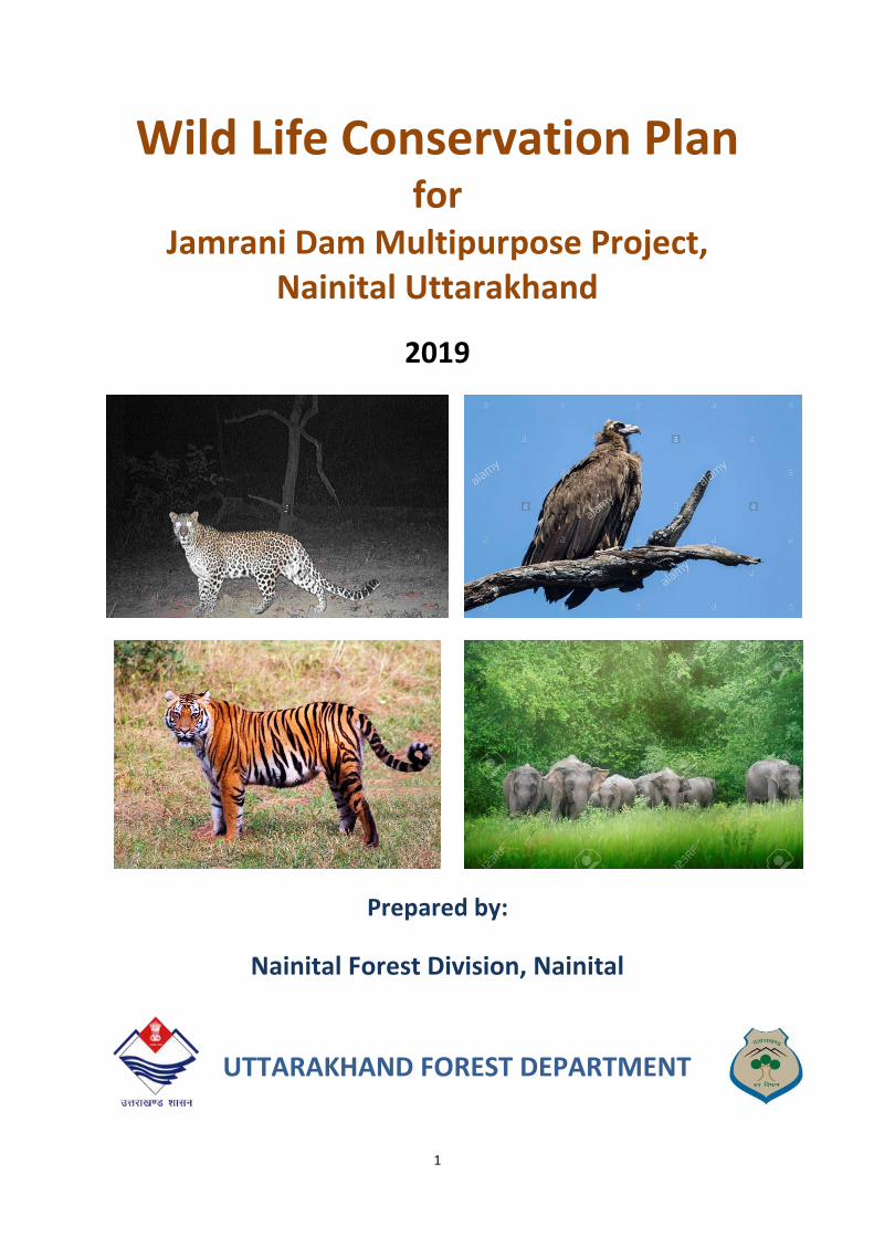
Wild Life Conservation Plan for
Jamrani Dam Multipurpose Project,
Nainital Uttarakhand
2019
Prepared by:
Nainital Forest Division, Nainital
UTTARAKHAND FOREST DEPARTMENT
2
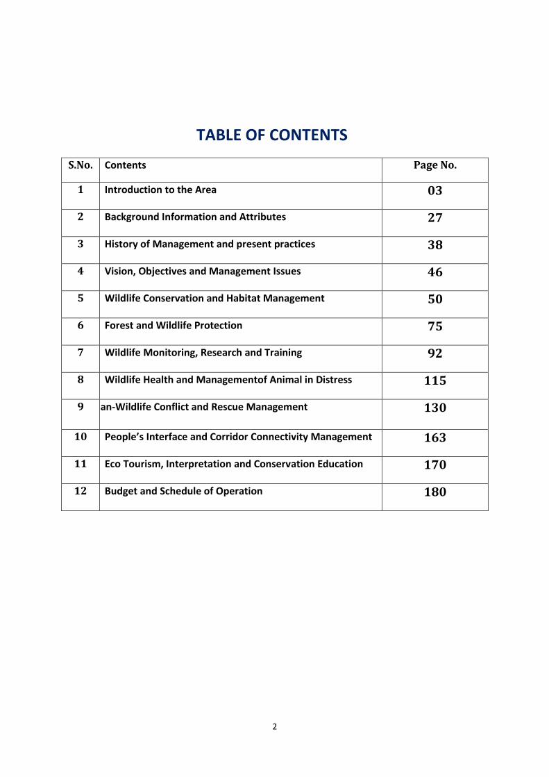
TABLE OF CONTENTS
S.No. Contents Page No.
1 Introduction to the Area 03
2 Background Information and Attributes 27
3 History of Management and present practices 38
4 Vision, Objectives and Management Issues 46
5 Wildlife Conservation and Habitat Management 50
6 Forest and Wildlife Protection 75
7 Wildlife Monitoring, Research and Training 92
8 Wildlife Health and Managementof Animal in Distress 115
9 Human-Wildlife Conflict and Rescue Management 130
10 People’s Interface and Corridor Connectivity Management 163
11 Eco Tourism, Interpretation and Conservation Education 170
12 Budget and Schedule of Operation 180
3
Chapter-1
Introduction to the Area
1.1 GENERAL
Uttarakhand is endowed with huge water power potential in its holy and mighty
rivers spanning the length and breadth of the region. The main resources for generating
electricity are by utilizing the hydro potential available along the river drops besides the use
of fossil fuel. Presently the ratio of thermal generation and Hydro-electric generation in
Uttarakhand Power grid is quite disproportionate.
The total hydro power potential in Uttarakhand as per preliminary estimate has been
assessed around 16500 MW out of which only 1300 MW approximately has been harnessed
so far which constitutes hardly 8 % of the available potential. A number of schemes on
which work was started and infrastructure fully created, had to be stopped half way on
account of financial constraints.
Hydro power project commissioned in Uttarakhand
With the expertise of construction of hydroelectric projects by Irrigation
Department, following projects have been successfully commissioned in Uttarakhand
Table.1: Commissioned Hydropower project of Govt. of Uttarakhand
S. No. Project Installed capacity( MW)
1 Chhibro 240
2 Khodri 120
3 Dhakrani 33.75
4 Dhalipur 51
5 Kulhal 30
6 Maneri Bhali Stage-I 90
7 Maneri Bhali Stage-II 304
8 Chilla 144
9 Pathari 20
10 Kalagarh 198
11 Khatima 41
The Dhauliganga & Bambas HEP by NHPC have been commissioned.
Projects Under Construction
The following projects were initially investigated and framed by Irrigation
Department. Infrastructure works were also executed by Irrigation Department and
thereafter these projects were transferred to Public Sector undertaking or private sector
due to paucity of funds on the part of the Government.
4
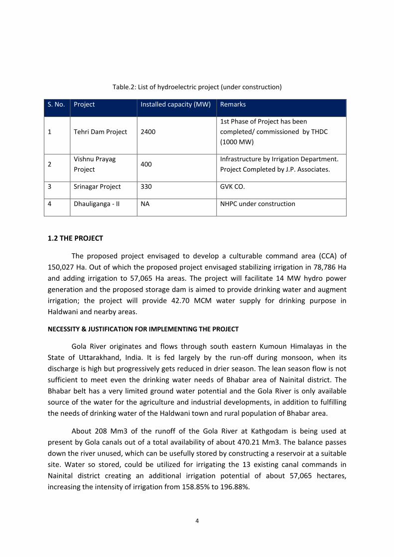
Table.2: List of hydroelectric project (under construction)
S. No. Project Installed capacity (MW) Remarks
1 Tehri Dam Project 2400
1st Phase of Project has been
completed/ commissioned by THDC
(1000 MW)
2 Vishnu Prayag
Project 400
Infrastructure by Irrigation Department.
Project Completed by J.P. Associates.
3 Srinagar Project 330 GVK CO.
4 Dhauliganga - II NA NHPC under construction
1.2 THE PROJECT
The proposed project envisaged to develop a culturable command area (CCA) of
150,027 Ha. Out of which the proposed project envisaged stabilizing irrigation in 78,786 Ha
and adding irrigation to 57,065 Ha areas. The project will facilitate 14 MW hydro power
generation and the proposed storage dam is aimed to provide drinking water and augment
irrigation; the project will provide 42.70 MCM water supply for drinking purpose in
Haldwani and nearby areas.
NECESSITY & JUSTIFICATION FOR IMPLEMENTING THE PROJECT
Gola River originates and flows through south eastern Kumoun Himalayas in the
State of Uttarakhand, India. It is fed largely by the run-off during monsoon, when its
discharge is high but progressively gets reduced in drier season. The lean season flow is not
sufficient to meet even the drinking water needs of Bhabar area of Nainital district. The
Bhabar belt has a very limited ground water potential and the Gola River is only available
source of the water for the agriculture and industrial developments, in addition to fulfilling
the needs of drinking water of the Haldwani town and rural population of Bhabar area.
About 208 Mm3 of the runoff of the Gola River at Kathgodam is being used at
present by Gola canals out of a total availability of about 470.21 Mm3. The balance passes
down the river unused, which can be usefully stored by constructing a reservoir at a suitable
site. Water so stored, could be utilized for irrigating the 13 existing canal commands in
Nainital district creating an additional irrigation potential of about 57,065 hectares,
increasing the intensity of irrigation from 158.85% to 196.88%.
5
Other Benefits
Irrigation Benefits: Additional irrigational potential created due to the project is
60,600 ha increasing the intensity of irrigation from 158.85% to 196.88%.
Drinking water supply to Haldwani –Kathgodam twin cities and Bhabar areas,
approximately 117MLD water will be supplied from this project for year 2051. (annually add
42.70 Mm3)
An indirect benefit will be creation of potential for generation of 14 MW power from
Jamrani Project. Govt. has already fixed priority and incentive for industry to induce
development of backward area near to country’s borders.
The Jamrani Dam project will have 4.52 sq.km. Water spread at full pond level
exposing its expansive potential of large scale pisciculture.
With the construction of Jamrani Dam, industry and market centers will develop
leading to more employment and improvement in the living standard of the local people.
1.3 LOCATION AND APPROACH
The Jamrani dam is located across Gola River near Jamrani village, which is 10 km
upstream of Gola Barrage at Kathgodam (Haldwani) in Nainital district in northwestern
region of Uttarakhand. The location of the Jamrani Dam Project is shown in Figure. The
latitude and longitude of the dam site are 29016’15” N and 79037’ E respectively. The dam
and all appurtenant of the Project are located in the foot hills of Himalayas entirely within
state boundary of Uttarakhand.
Kathgodam is Northern-East Railway terminus station connected by broad gauge
railway link with Delhi, Moradabad, Bareilly, Rampur and Lucknow. Kathgodam is located on
NH-109, Delhi – Nainital highway (previously known as NH-87). The site is approachable by 7
kms metaled road up to Amritpur and by 9 kms long non-metaled road bifurcating from
Amritpur.
The Gola River, which flows towards south southwest downstream of its confluence
with Kalsa River, takes a right angled turn at Haidakhan towards west northwest. The width
of the river bed is in the order of 80-100 m in the areas adjacent to dam axis and further
upstream up to Panota. The width of the river bed in the upper reaches of the reservoir
range from 200-500 m. The river meanders sluggishly through the river bed material,
changing its course within the river bed every year during flood. The valley slopes in general
have moderately steep angle of the order 400 – 600. The nalas joining the Gola River are of
the first and second order in nature. The average gradient of the river is 14 m/km.
The proposed dam is 130.6m high above the river bed level and will have a gross
storage capacity of 208.6 x 10⁶ cubic meters at the full reservoir level that is 762.00 m. An
6
ogee type spillway has been composed in the center of a dam for spilling the high flood
discharge over the spillway. Water for irrigation is proposed to be released from an outlet
provided in the body of the dam itself. The releases from the outlet will carried to the
barrage at Kathgodam through Gola River & picked up in the Golawar & Golapar canals that
feed into the canal systems.
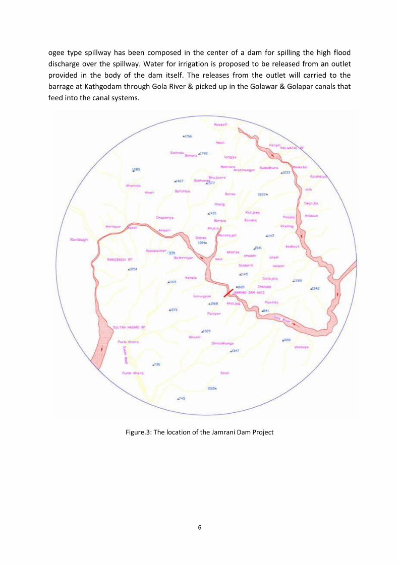
Figure.3: The location of the Jamrani Dam Project
7
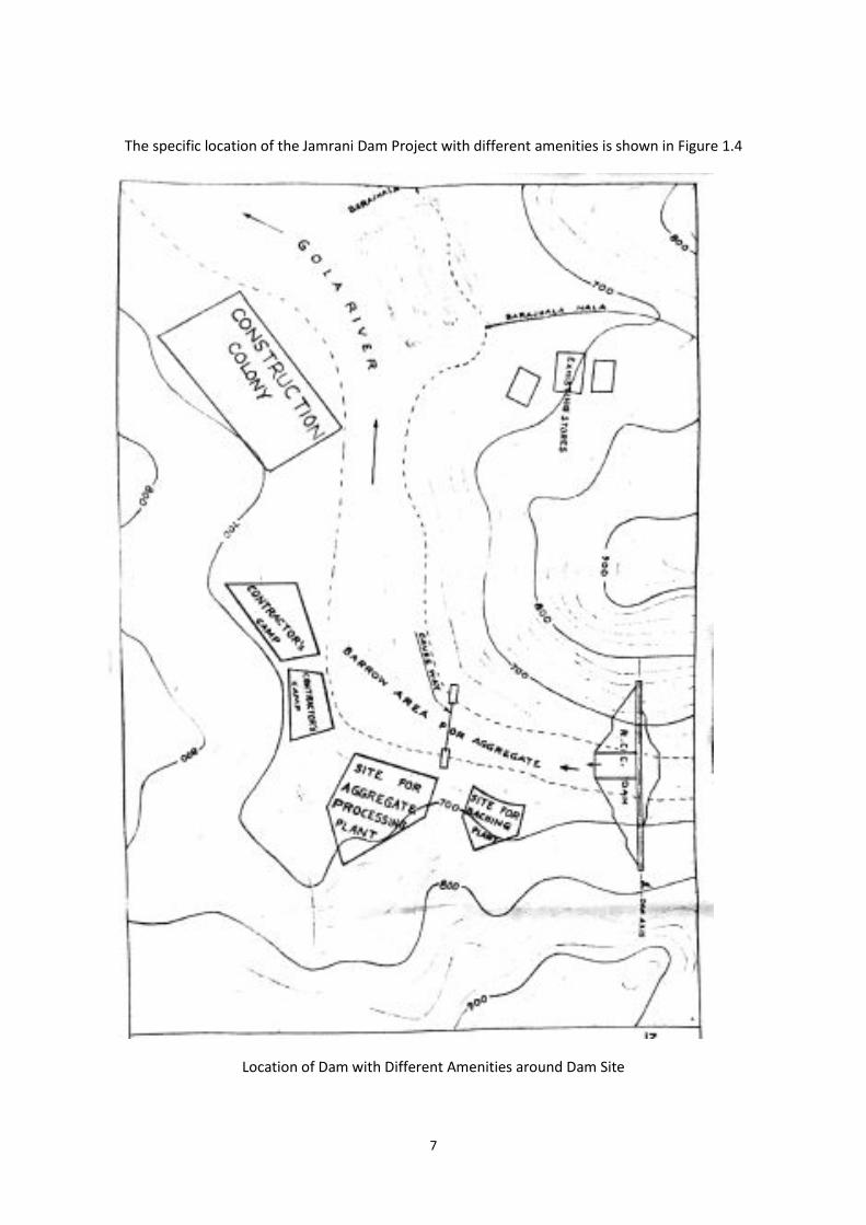
The specific location of the Jamrani Dam Project with different amenities is shown in Figure 1.4
Location of Dam with Different Amenities around Dam Site
8
1.4 WATER AVAILABILITY
The water releases from Jamrani Dam, as mentioned in the DPR have been adopted for the
power generation.
The total water availability data at dam site at the time of approval in 1975 was assessed on
the basis of 16 years’ data (1958-1975) observed at Kathgodam weir. 75% dependable flow at Gola
River and at Barrage site was assessed as 352.65 Mm3 and 470.2 Mm3 respectively.
Total water availability was reviewed in 1989, based on observed values for the period 1948
to 1987, i.e. 39 years at Kathgodam Barrage site. The 75% dependable flow at Gola River and at
Barrage site was assessed as 300 Mm3 and 500 Mm3 respectively. This has been explained in a
separate volume of Hydrology and was accepted by CWC.
At present (in latest DPR) it has been revised based on data obtained for a period 57 years
(1948 -2005) and 75% dependable flow at Gola River and at Barrage site was assessed as 282 Mm3
and 470 Mm3 respectively1.
1.5 CROP WATER REQUIREMENT
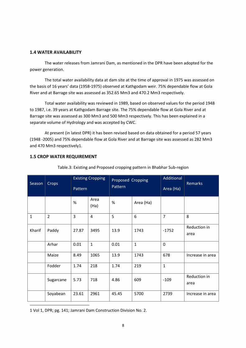
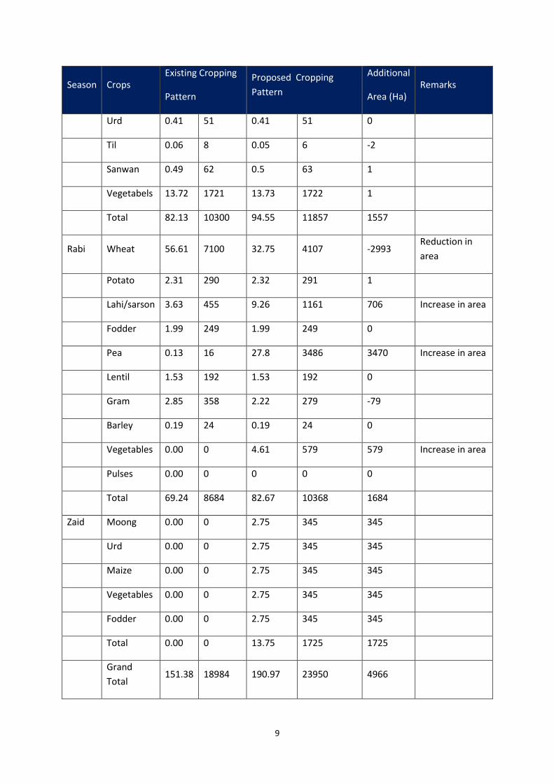
Table.3: Existing and Proposed cropping pattern in Bhabhar Sub-region
Season Crops
Existing Cropping
Pattern
Proposed Cropping
Pattern
Additional
Area (Ha)
Remarks
% Area
(Ha) % Area (Ha)
1 2 3 4 5 6 7 8
Kharif Paddy 27.87 3495 13.9 1743 -1752 Reduction in
area
Arhar 0.01 1 0.01 1 0
Maize 8.49 1065 13.9 1743 678 Increase in area
Fodder 1.74 218 1.74 219 1
Sugarcane 5.73 718 4.86 609 -109 Reduction in
area
Soyabean 23.61 2961 45.45 5700 2739 Increase in area
1 Vol 1, DPR; pg. 141; Jamrani Dam Construction Division No. 2.
9
Season Crops
Existing Cropping
Pattern
Proposed Cropping
Pattern
Additional
Area (Ha)
Remarks
Urd 0.41 51 0.41 51 0
Til 0.06 8 0.05 6 -2
Sanwan 0.49 62 0.5 63 1
Vegetabels 13.72 1721 13.73 1722 1
Total 82.13 10300 94.55 11857 1557
Rabi Wheat 56.61 7100 32.75 4107 -2993 Reduction in
area
Potato 2.31 290 2.32 291 1
Lahi/sarson 3.63 455 9.26 1161 706 Increase in area
Fodder 1.99 249 1.99 249 0
Pea 0.13 16 27.8 3486 3470 Increase in area
Lentil 1.53 192 1.53 192 0
Gram 2.85 358 2.22 279 -79
Barley 0.19 24 0.19 24 0
Vegetables 0.00 0 4.61 579 579 Increase in area
Pulses 0.00 0 0 0 0
Total 69.24 8684 82.67 10368 1684
Zaid Moong 0.00 0 2.75 345 345
Urd 0.00 0 2.75 345 345
Maize 0.00 0 2.75 345 345
Vegetables 0.00 0 2.75 345 345
Fodder 0.00 0 2.75 345 345
Total 0.00 0 13.75 1725 1725
Grand
Total 151.38 18984 190.97 23950 4966
10
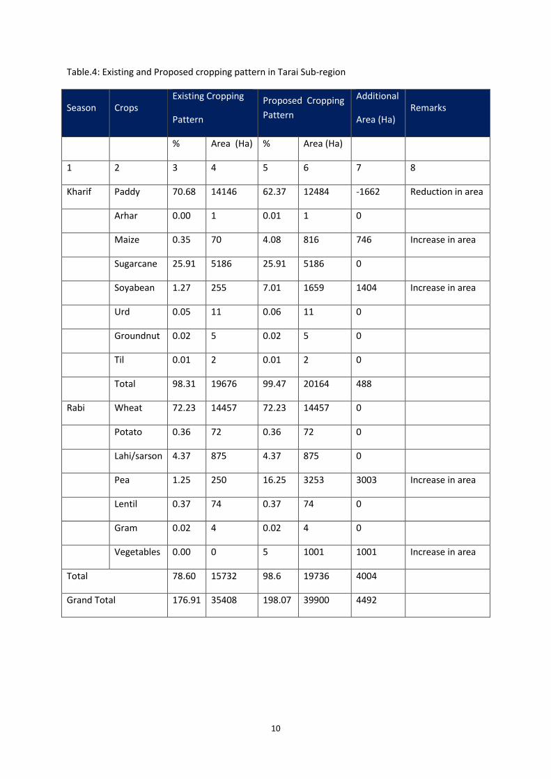
Table.4: Existing and Proposed cropping pattern in Tarai Sub-region
Season Crops
Existing Cropping
Pattern
Proposed Cropping
Pattern
Additional
Area (Ha)
Remarks
% Area (Ha) % Area (Ha)
1 2 3 4 5 6 7 8
Kharif Paddy 70.68 14146 62.37 12484 -1662 Reduction in area
Arhar 0.00 1 0.01 1 0
Maize 0.35 70 4.08 816 746 Increase in area
Sugarcane 25.91 5186 25.91 5186 0
Soyabean 1.27 255 7.01 1659 1404 Increase in area
Urd 0.05 11 0.06 11 0
Groundnut 0.02 5 0.02 5 0
Til 0.01 2 0.01 2 0
Total 98.31 19676 99.47 20164 488
Rabi Wheat 72.23 14457 72.23 14457 0
Potato 0.36 72 0.36 72 0
Lahi/sarson 4.37 875 4.37 875 0
Pea 1.25 250 16.25 3253 3003 Increase in area
Lentil 0.37 74 0.37 74 0
Gram 0.02 4 0.02 4 0
Vegetables 0.00 0 5 1001 1001 Increase in area
Total 78.60 15732 98.6 19736 4004
Grand Total 176.91 35408 198.07 39900 4492
11
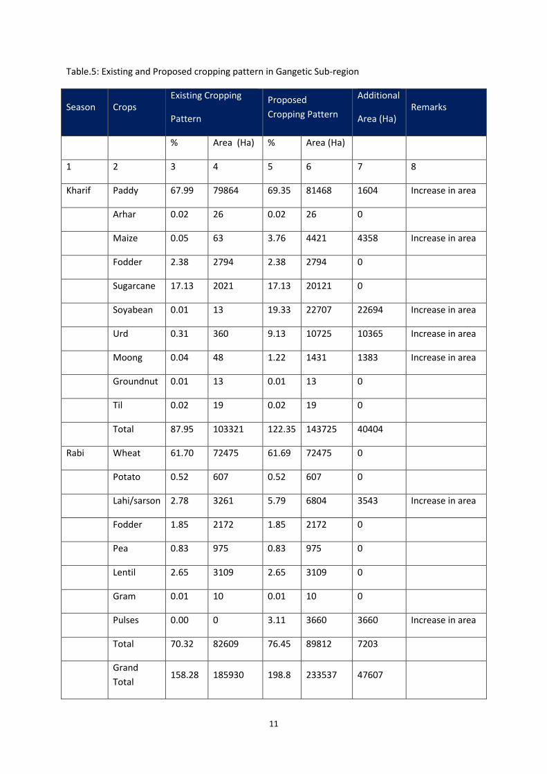
Table.5: Existing and Proposed cropping pattern in Gangetic Sub-region
Season Crops
Existing Cropping
Pattern
Proposed
Cropping Pattern
Additional
Area (Ha)
Remarks
% Area (Ha) % Area (Ha)
1 2 3 4 5 6 7 8
Kharif Paddy 67.99 79864 69.35 81468 1604 Increase in area
Arhar 0.02 26 0.02 26 0
Maize 0.05 63 3.76 4421 4358 Increase in area
Fodder 2.38 2794 2.38 2794 0
Sugarcane 17.13 2021 17.13 20121 0
Soyabean 0.01 13 19.33 22707 22694 Increase in area
Urd 0.31 360 9.13 10725 10365 Increase in area
Moong 0.04 48 1.22 1431 1383 Increase in area
Groundnut 0.01 13 0.01 13 0
Til 0.02 19 0.02 19 0
Total 87.95 103321 122.35 143725 40404
Rabi Wheat 61.70 72475 61.69 72475 0
Potato 0.52 607 0.52 607 0
Lahi/sarson 2.78 3261 5.79 6804 3543 Increase in area
Fodder 1.85 2172 1.85 2172 0
Pea 0.83 975 0.83 975 0
Lentil 2.65 3109 2.65 3109 0
Gram 0.01 10 0.01 10 0
Pulses 0.00 0 3.11 3660 3660 Increase in area
Total 70.32 82609 76.45 89812 7203
Grand
Total 158.28 185930 198.8 233537 47607
12
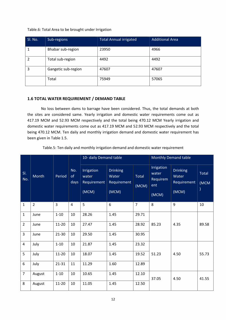
Table.6: Total Area to be brought under Irrigation
Sl. No. Sub-regions Total Annual irrigated Additional Area
1 Bhabar sub-region 23950 4966
2 Total sub-region 4492 4492
3 Gangetic sub-region 47607 47607
Total 75949 57065
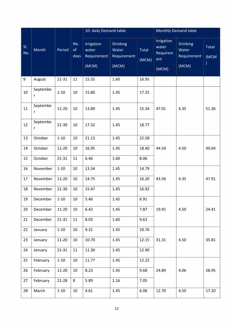
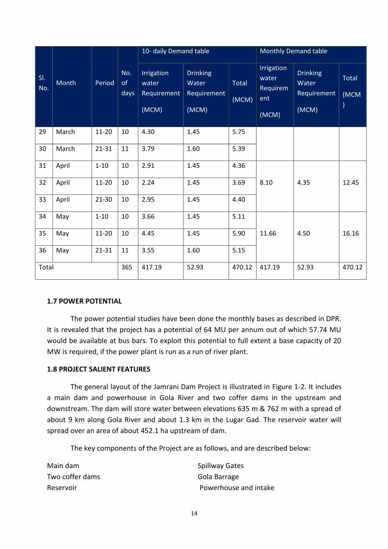
1.6 TOTAL WATER REQUIREMENT / DEMAND TABLE
No loss between dams to barrage have been considered. Thus, the total demands at both
the sites are considered same. Yearly irrigation and domestic water requirements come out as
417.19 MCM and 52.93 MCM respectively and the total being 470.12 MCM Yearly irrigation and
domestic water requirements come out as 417.19 MCM and 52.93 MCM respectively and the total
being 470.12 MCM. Ten daily and monthly irrigation demand and domestic water requirement has
been given in Table 1.5.
Table.5: Ten daily and monthly irrigation demand and domestic water requirement
Sl.
No. Month Period
No.
of
days
10- daily Demand table Monthly Demand table
Irrigation
water
Requirement
(MCM)
Drinking
Water
Requirement
(MCM)
Total
(MCM)
Irrigation
water
Requirem
ent
(MCM)
Drinking
Water
Requirement
(MCM)
Total
(MCM
)
1 2 3 4 5 6 7 8 9 10
1 June 1-10 10 28.26 1.45 29.71
85.23 4.35 89.58 2 June 11-20 10 27.47 1.45 28.92
3 June 21-30 10 29.50 1.45 30.95
4 July 1-10 10 21.87 1.45 23.32
51.23 4.50 55.73 5 July 11-20 10 18.07 1.45 19.52
6 July 21-31 11 11.29 1.60 12.89
7 August 1-10 10 10.65 1.45 12.10
37.05 4.50 41.55
8 August 11-20 10 11.05 1.45 12.50
13
Sl.
No. Month Period
No.
of
days
10- daily Demand table Monthly Demand table
Irrigation
water
Requirement
(MCM)
Drinking
Water
Requirement
(MCM)
Total
(MCM)
Irrigation
water
Requirem
ent
(MCM)
Drinking
Water
Requirement
(MCM)
Total
(MCM
)
9 August 21-31 11 15.35 1.60 16.95
10 Septembe
r 1-10 10 15.80 1.45 17.25
47.01 4.35 51.36 11 Septembe
r 11-20 10 13.89 1.45 15.34
12 Septembe
r 21-30 10 17.32 1.45 18.77
13 October 1-10 10 21.13 1.45 22.58
44.54 4.50 49.04 14 October 11-20 10 16.95 1.45 18.40
15 October 21-31 11 6.46 1.60 8.06
16 November 1-10 10 13.34 1.45 14.79
43.56 4.35 47.91 17 November 11-20 10 14.75 1.45 16.20
18 November 21-30 10 15.47 1.45 16.92
19 December 1-10 10 5.46 1.45 6.91
19.91 4.50 24.41 20 December 11-20 10 6.42 1.45 7.87
21 December 21-31 11 8.03 1.60 9.63
22 January 1-10 10 9.31 1.45 10.76
31.31 4.50 35.81 23 January 11-20 10 10.70 1.45 12.15
24 January 21-31 11 11.30 1.45 12.90
25 February 1-10 10 11.77 1.45 12.22
24.89 4.06 28.95 26 February 11-20 10 8.23 1.45 9.68
27 February 21-28 8 5.89 1.16 7.05
28 March 1-10 10 4.61 1.45 6.06 12.70 4.50 17.20
14
Sl.
No. Month Period
No.
of
days
10- daily Demand table Monthly Demand table
Irrigation
water
Requirement
(MCM)
Drinking
Water
Requirement
(MCM)
Total
(MCM)
Irrigation
water
Requirem
ent
(MCM)
Drinking
Water
Requirement
(MCM)
Total
(MCM
)
29 March 11-20 10 4.30 1.45 5.75
30 March 21-31 11 3.79 1.60 5.39
31 April 1-10 10 2.91 1.45 4.36
8.10 4.35 12.45 32 April 11-20 10 2.24 1.45 3.69
33 April 21-30 10 2.95 1.45 4.40
34 May 1-10 10 3.66 1.45 5.11
11.66 4.50 16.16 35 May 11-20 10 4.45 1.45 5.90
36 May 21-31 11 3.55 1.60 5.15
Total 365 417.19 52.93 470.12 417.19 52.93 470.12
1.7 POWER POTENTIAL
The power potential studies have been done the monthly bases as described in DPR.
It is revealed that the project has a potential of 64 MU per annum out of which 57.74 MU
would be available at bus bars. To exploit this potential to full extent a base capacity of 20
MW is required, if the power plant is run as a run of river plant.
1.8 PROJECT SALIENT FEATURES
The general layout of the Jamrani Dam Project is illustrated in Figure 1-2. It includes
a main dam and powerhouse in Gola River and two coffer dams in the upstream and
downstream. The dam will store water between elevations 635 m & 762 m with a spread of
about 9 km along Gola River and about 1.3 km in the Lugar Gad. The reservoir water will
spread over an area of about 452.1 ha upstream of dam.
The key components of the Project are as follows, and are described below:
Main dam
Two coffer dams
Reservoir
Spillway Gates
Gola Barrage
Powerhouse and intake
15
Diversion Components
Diversion duct/tunnel
Transmission lines
Switchyard
Other facilities including site access roads and project control and Maintenance
facilities
Temporary construction-related project components.
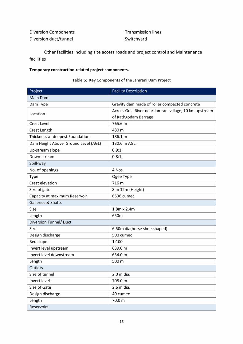
Table.6: Key Components of the Jamrani Dam Project
Project Facility Description
Main Dam
Dam Type Gravity dam made of roller compacted concrete
Location Across Gola River near Jamrani village, 10 km upstream
of Kathgodam Barrage
Crest Level 765.6 m
Crest Length 480 m
Thickness at deepest Foundation 186.1 m
Dam Height Above Ground Level (AGL) 130.6 m AGL
Up-stream slope 0.9:1
Down-stream 0.8:1
Spill-way
No. of openings 4 Nos.
Type Ogee Type
Crest elevation 716 m
Size of gate 8 m 12m (Height)
Capacity at maximum Reservoir 6536 cumec.
Galleries & Shafts
Size 1.8m x 2.4m
Length 650m
Diversion Tunnel/ Duct
Size 6.50m dia(horse shoe shaped)
Design discharge 500 cumec
Bed slope 1:100
Invert level upstream 639.0 m
Invert level downstream 634.0 m
Length 500 m
Outlets
Size of tunnel 2.0 m dia.
Invert level 708.0 m.
Size of Gate 2.6 m dia.
Design discharge 40 cumec
Length 70.0 m
Reservoirs
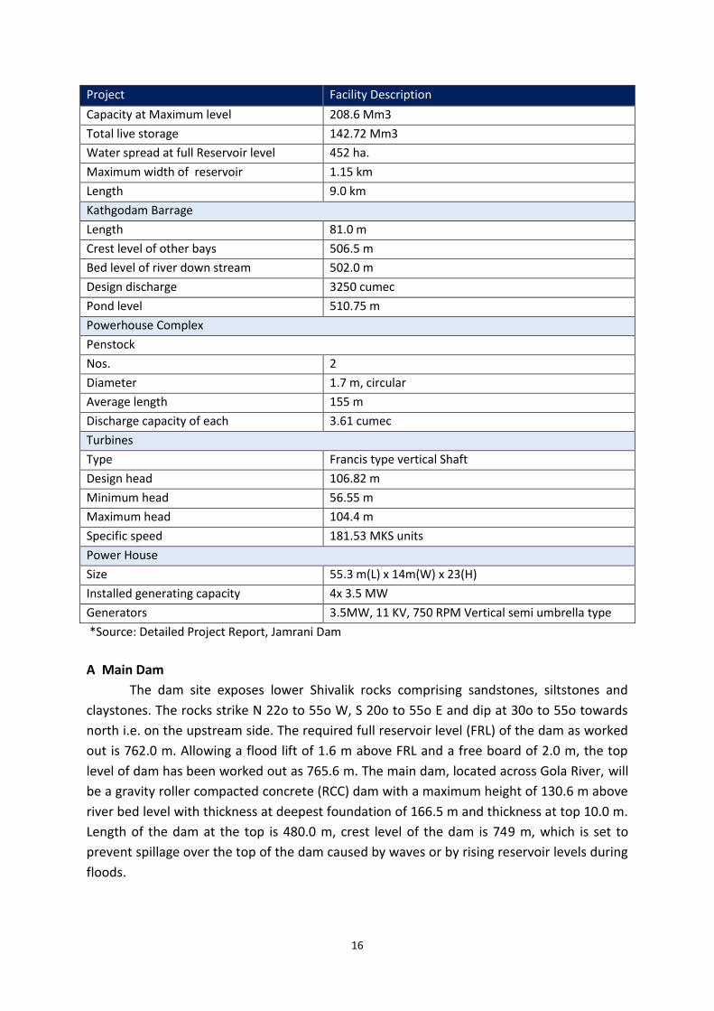
16
Project Facility Description
Capacity at Maximum level 208.6 Mm3
Total live storage 142.72 Mm3
Water spread at full Reservoir level 452 ha.
Maximum width of reservoir 1.15 km
Length 9.0 km
Kathgodam Barrage
Length 81.0 m
Crest level of other bays 506.5 m
Bed level of river down stream 502.0 m
Design discharge 3250 cumec
Pond level 510.75 m
Powerhouse Complex
Penstock
Nos. 2
Diameter 1.7 m, circular
Average length 155 m
Discharge capacity of each 3.61 cumec
Turbines
Type Francis type vertical Shaft
Design head 106.82 m
Minimum head 56.55 m
Maximum head 104.4 m
Specific speed 181.53 MKS units
Power House
Size 55.3 m(L) x 14m(W) x 23(H)
Installed generating capacity 4x 3.5 MW
Generators 3.5MW, 11 KV, 750 RPM Vertical semi umbrella type
*Source: Detailed Project Report, Jamrani Dam
A Main Dam
The dam site exposes lower Shivalik rocks comprising sandstones, siltstones and
claystones. The rocks strike N 22o to 55o W, S 20o to 55o E and dip at 30o to 55o towards
north i.e. on the upstream side. The required full reservoir level (FRL) of the dam as worked
out is 762.0 m. Allowing a flood lift of 1.6 m above FRL and a free board of 2.0 m, the top
level of dam has been worked out as 765.6 m. The main dam, located across Gola River, will
be a gravity roller compacted concrete (RCC) dam with a maximum height of 130.6 m above
river bed level with thickness at deepest foundation of 166.5 m and thickness at top 10.0 m.
Length of the dam at the top is 480.0 m, crest level of the dam is 749 m, which is set to
prevent spillage over the top of the dam caused by waves or by rising reservoir levels during
floods.
17
The water intake will be located along one of the main dam’s diversion outlets and
will be used to release water below the dam during reservoir impoundment and when the
powerhouse is not operational (eg. maintenance, emergency outages) and to facilitate
closure of the diversion reach at the end of the construction phase. Similar to the spillway,
the water intake structure will utilize a radial gate that will be operated to control water
releases below the dam. A drainage curtain will run 4 m behind the entire upstream face of
the dam to avoid water pressure build up within the dam and to capture any water seepage.
B Coffer Dams
In addition to the main dam, two coffer dams will be provided at upstream &
downstream points. The upstream coffer dam will be located on upstream from the
proposed dam to divert the design discharge into the diversion duct. Height of upstream
coffer dam will be 15 m with top width 6 m. upstream coffer dam shall be rockfill type with
clay core. Upstream slope of 1.4:1 and downstream slope of 1.4:1 will be provided.
Foundation grouting will be done to check seepage.
Downstream coffer will be constructed of earth and rock fill just upstream of the
outlet of duct to check diversion design flood of 500 m3/sec towards the dam. The height of
coffer dam at downstream will be kept 7m above river bed level with top width of 7 m and
upstream and downstream slopes as 1.4:1 and 1.4:1 respectively.
C Reservoir
The dam will impound a reservoir that will have a capacity at maximum reservoir of
208.6 Mm3 and live storage of 142.72 Mm3 at full reservoir level of 762.00 m. The reservoir
will have a water spread area of approximately 4.52 ha. extending 9.0 km upstream of Gola
River and 1.30 km in the Lugar Gad. Maximum difference of cumulative inflow and
cumulative outflow comes as 168.38 Mm3, which is required live storage capacity of the
reservoir. Flood routing over the spillway & under sluice has been done for the possible
maximum flood of 6536 cumec and 2036 cumec respectively. Design flood has been
assumed to impinge at FRL i.e. 762 m. Routed flood works out as 3630 cumec with a flood
lift of 1.6 m, at spillway crest level of 716.00 m. The reservoir is completely sheltered
between the valleys so higher wind velocities are not expected. As per IS:6512, a free board
against wave action may be taken as 1.5 times the wave height subject to a minimum of 0.9
m. This gives a value of 1.4 m for free board against wave action above HFL.
D Gola (Kathgodam) Barrage
Gola barrage, the main diversion work, consists of a barrage across river Gola near
Kathgodam town at 120 m downstream of old weir. The main barrage consists of 6 bays,
11.50 m wide each. Two end bays known as under-sluice bays are separated by 3 m wide
divide walls. The other bays are separated by 2 m wide piers. The works are designed for a
flood discharge of 3250 cumec but the free board has been provided for a discharge of 4250
cumec. The total length of barrage is 81m. The gate size is 11.5 m x 4.50 m. Golawar and
Golapar canals, take off from the head regulators provided on the either side of the barrage

18
and join their old alignments. The capacity of these heads at design pond level of 510.75 is
29.75 cumec and 4.4 cumec respectively.
1.9 Power Intake
The power intake will consist of three concrete intake structures and penstocks fixed
on the downstream face of the dam, conveying the water from the dam to the powerhouse.
The three penstocks will follow the slope of the downstream face of the dam down to the
powerhouse roughly 125 m.
1.10 Penstocks
Three unit penstocks of diameter 2.0m and average length of 125m shall be taken
from the reservoir to feed individual machine. One control gate shall be provided at the
inlet of each penstock.
1.11 Power Generation
Although power generation had been mentioned as one of the byproduct of the
project. The powerhouse will be an indoor facility made of concrete located along the bank
of the river, approximately 150 m downstream from the main dam. The dimensions of this
power house including transformer deck building will be approx. 90 m long by 30 m wide.
The powerhouse will contain 4 3.5 MW vertical shaft Francis-type turbines with a maximum
power generation capacity of 14 MW. The turbines will be coupled directly to generators.
Three-phase power transformers will be used to transform the power from the generators
to the 11 KV transmission lines. The connection between the generators and the main
transformers will be made by bus bars. These transformers will be located on an outdoor
platform at the switchyard, located on the left bank downstream of the powerhouse.
1.12 Design Head
The operating head varies from 56.55 to 104.4 m. The weighted average head has been
calculated from the operation chart. The value of weighted average head is between 68.4 and 75.05
m. ideally the design head should also be nearest to the weighted average head. But as the
operating range of Francis turbine is 120% to 65% of the design head, design head of the turbine
needs to be kept as 87 m to cover entire range of operational head.
1.13 Size of Power Station
The main dimensions of the power station machine hall, extension, control and
administrative blocks etc. comes to 86.5m x 15m.
1.14 Switchyard
The 132 kV switchyard shall have three incoming bays, one bus-coupler and two outgoing
132 kV feeders to connect the nearest 132 KV grid substation at Haldwani.
1.15 Transmission Lines and Substation Connections
The power output from Jamrani Dam project will be linked to a substation in the
downstream direction, which will be finally connected to 33/66 KV grid.
19
1.16 Ancillary Facilities
The ancillary project facilities include site access roads and the support facilities (e.g.
maintenance and/or control rooms) for the key project components.
1.17 Site Access Roads
To access the site during project construction and operation, it will be necessary to upgrade
the existing road network from Kathgodam to Amritpur. Upgrading of the existing road from
Amritpur to project site of a distance of 9 km, include improvement (ie paving & widening within
RoW) of the road. The width of the new and upgraded roads has not yet been determined.
However, for the purposes of the impact assessment RoW is assumed to be 10 m, with
carriage way of 7.5 m width (single lane, both ways); with 1.125 m wide unpaved shoulder on both
sides.
1.18 Support Facilities
Support facilities for all key project components will be included within the key structures.
For example, construction of utilities, buildings, telephone and telecommunication arrangements
and the maintenance and control rooms for the various dam structures will be provided.
1.19 Temporary Construction-Related Project Components
Various temporary components of the project include temporary worker camps, contractors
lay-down areas, quarry areas, and borrow pits (1 nos.), cofferdams (2 nos.), and the diversion
channel (1 nos.). These components will enable the:
(1) Borrow Pits – Pits where materials, typically gravel and sand, are collected for use in
other areas. In this case, it applies to upstream locations where gravel and sand are
collected for use in the dams.
(2) Cofferdam – A structure, in this case a concrete sheet pile, which prevents water from
entering a normally flooded area to allow construction on a dry surface (normally used in
streams and rivers). Section below summarizes the features of the temporary project
components.
1.20 Worker Camps and Contractor Lay-Down Areas
The main construction worker camp will be located near Jamrani village near the project
site. The exact area to be occupied by the camp and the number of workers it will be required to
house are not yet defined. However, the number of required workers can be expected to reach
between 750-1000, depending on the technology used for construction.
Contractor lay-down areas will be located adjacent to the main dam sites. These will be re-
vegetated upon completion of the construction activities. The exact area of land that they will
occupy, and the measures to be taken to manage potable water, wastewater, and solid waste will be
defined later on.
The contractor will be responsible for the safe water supply to the construction labours, as
well as for providing hygienic conditions for disposal of sewage. The labours will be provided with
mobile toilet facility fitted with septic tank facility. Proper medical facility will be given to these
laborers.
20
1.21 Quarries and Borrow Pits
In excess of 2 million tons of concrete aggregates, rockfill material, and crushed filter zone
materials will be used in the construction of the dams. This material will be obtained from quarries
along the dam site. Locations for quarrying have been identified in DPR. Sand and additional material
will be collected from borrow pits in the riverbed. Specific locations for the quarries and borrow pits
have not been identified, and their size, in terms of hectarage or depth, is not yet specified.
However, as far as possible the quarries and borrow pits will be within the inundation area of the
reservoir to minimize impacts. The details of construction material requirement are provided in Sec.
2.8.
1.22 Diversion Channel and Cofferdams
A diversion channel and two cofferdams will isolate the main dam and powerhouse.
The diversion channel will maintain flows between up and downstream of the project during
construction. The diversion channel will begin at the toe of the bank and will extend
approximately 300 m around the main dam area with a concrete wall along the channel-side
edge beginning at elevation 110 NGL and ending at 106 NGL (Figure 2.3). The channel will be
of concrete and have three, 10 m by 10 m openings that will eventually be incorporated into
the main dam. Two of these will be filled completely, and the third will be partially filled to
become the bottom outlet. Cofferdams are temporary concrete or rockfill structures that
are used to divert and dry out the river channel and allow construction of the permanent
project facilities. The project will require three main cofferdams: upstream of the main dam,
downstream of the main dam, and just upstream of the powerhouse.
Diversion Channel – An artificial streambed constructed to allow a water body to flow
around a given area, rather than through it, so that construction activities can occur.
The upstream cofferdam will be located approximately 100 m upstream of the main
dam site and will divert water into the diversion channel after the construction of main dam.
The upstream cofferdam will be 235 m long with a crest height of 15 m. One smaller
cofferdam will be constructed further upstream to divert water into the diversion channel
during construction of the upstream cofferdam, in the first dry season. The downstream
cofferdam will be located 150 m downstream of the main dam with a crest level of 7 m. The
powerhouse cofferdam will protect the powerhouse excavation area during construction of
the main dam and diversion canal and will have a crest height of 106 m. After construction
of the downstream cofferdam, the powerhouse cofferdam will no longer be used.
21
1.23 PROJECT OPERATIONS
As decided by the Board of consultants for Jamrani Dam Project, a roller compacted
concrete dam is to be constructed across Gola river. The Jamrani Dam Project is designed
for stabilizing and augmenting irrigation in existing 23 systems in the Bhabar and Tarai area
in Udham Singh Nagar, Rampur and Bareilly districts. The water stored in the reservoir is
proposed to be utilized for drinking in Kathgodam-Haldwani twin towns and adjoining rural
Bhabhar area of Nainital district. In addition to irrigation and domestic water supply
benefits, it is also proposed to generate about 30 MW of power at dam site.
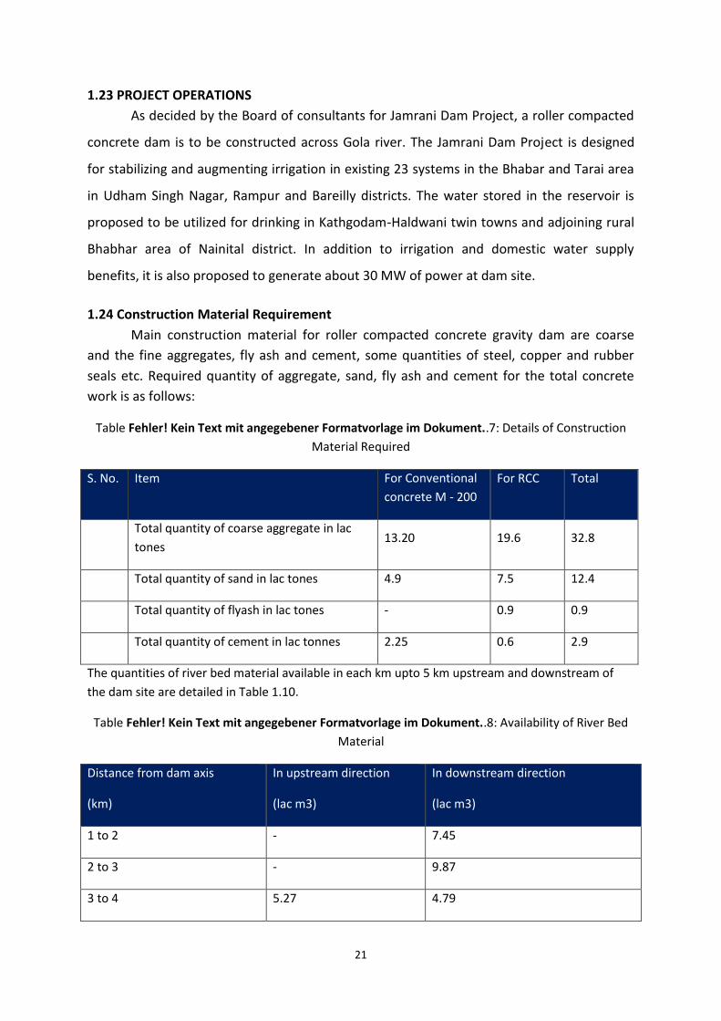
1.24 Construction Material Requirement
Main construction material for roller compacted concrete gravity dam are coarse
and the fine aggregates, fly ash and cement, some quantities of steel, copper and rubber
seals etc. Required quantity of aggregate, sand, fly ash and cement for the total concrete
work is as follows:
Table Fehler! Kein Text mit angegebener Formatvorlage im Dokument..7: Details of Construction
Material Required
S. No. Item For Conventional
concrete M - 200
For RCC Total
Total quantity of coarse aggregate in lac
tones 13.20 19.6 32.8
Total quantity of sand in lac tones 4.9 7.5 12.4
Total quantity of flyash in lac tones - 0.9 0.9
Total quantity of cement in lac tonnes 2.25 0.6 2.9
The quantities of river bed material available in each km upto 5 km upstream and downstream of
the dam site are detailed in Table 1.10.
Table Fehler! Kein Text mit angegebener Formatvorlage im Dokument..8: Availability of River Bed
Material
Distance from dam axis
(km)
In upstream direction
(lac m3)
In downstream direction
(lac m3)
1 to 2 - 7.45
2 to 3 - 9.87
3 to 4 5.27 4.79
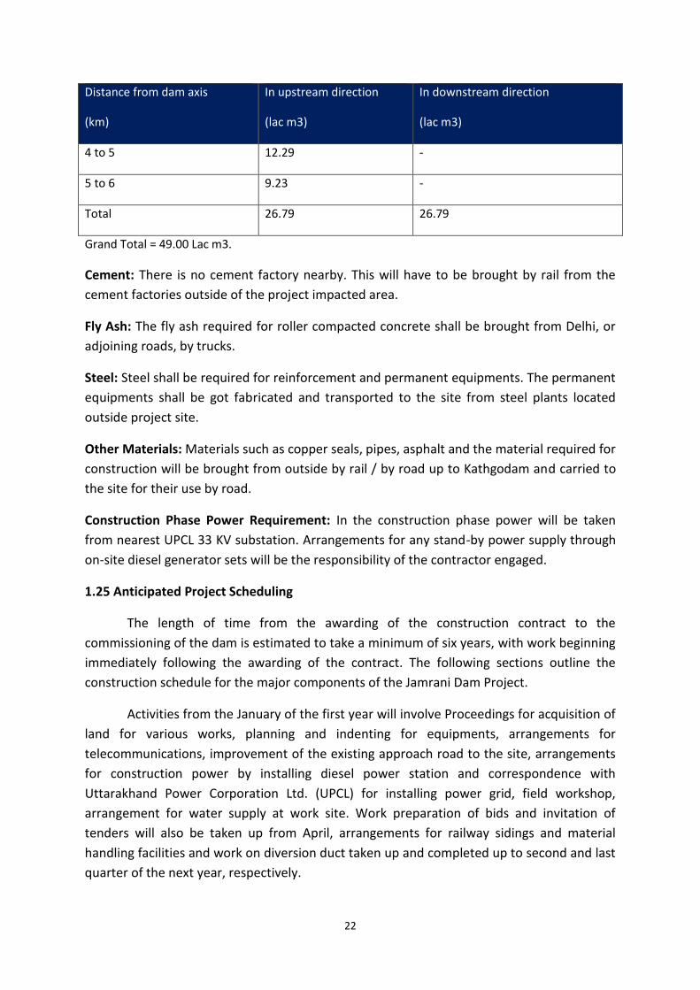
22
Distance from dam axis
(km)
In upstream direction
(lac m3)
In downstream direction
(lac m3)
4 to 5 12.29 -
5 to 6 9.23 -
Total 26.79 26.79
Grand Total = 49.00 Lac m3.
Cement: There is no cement factory nearby. This will have to be brought by rail from the
cement factories outside of the project impacted area.
Fly Ash: The fly ash required for roller compacted concrete shall be brought from Delhi, or
adjoining roads, by trucks.
Steel: Steel shall be required for reinforcement and permanent equipments. The permanent
equipments shall be got fabricated and transported to the site from steel plants located
outside project site.
Other Materials: Materials such as copper seals, pipes, asphalt and the material required for
construction will be brought from outside by rail / by road up to Kathgodam and carried to
the site for their use by road.
Construction Phase Power Requirement: In the construction phase power will be taken
from nearest UPCL 33 KV substation. Arrangements for any stand-by power supply through
on-site diesel generator sets will be the responsibility of the contractor engaged.
1.25 Anticipated Project Scheduling
The length of time from the awarding of the construction contract to the
commissioning of the dam is estimated to take a minimum of six years, with work beginning
immediately following the awarding of the contract. The following sections outline the
construction schedule for the major components of the Jamrani Dam Project.
Activities from the January of the first year will involve Proceedings for acquisition of
land for various works, planning and indenting for equipments, arrangements for
telecommunications, improvement of the existing approach road to the site, arrangements
for construction power by installing diesel power station and correspondence with
Uttarakhand Power Corporation Ltd. (UPCL) for installing power grid, field workshop,
arrangement for water supply at work site. Work preparation of bids and invitation of
tenders will also be taken up from April, arrangements for railway sidings and material
handling facilities and work on diversion duct taken up and completed up to second and last
quarter of the next year, respectively.
23
From January of second year erection of processing and crushing plant, batching,
stacking of construction material and mixing plant and construction of approach roads shall
be taken up. After the finalization of bids and the completion of processing and crushing
plant, grouting of the foundation, mass constructing of the dam and spillway shall be taken
up from the January of the third year and shall continue up to the end of the sixth year.
Work on irrigation outlet which in the form of a duct in the body of the dam shall be taken
up side by side with mass concreting and completed by the fifth year.
Fabrication of spillway gates shall be started simultaneously from the third quarter
of the fifth year and will be completed by the sixth year.
1.26 PROJECT COST
Total cost of the project has been worked out in detail by project proponent, Jamrani Dam
Construction Division. Abstract of cost is given as below.
Cost of unit I works (i.e. main dam and its appurtenant works) = 203370.17 lacs
Cost of unit II works (i.e. Distribution works) = 55039.42 lacs
Total cost = 258409.59 lacs
Say Rs. 2584.10 crores.
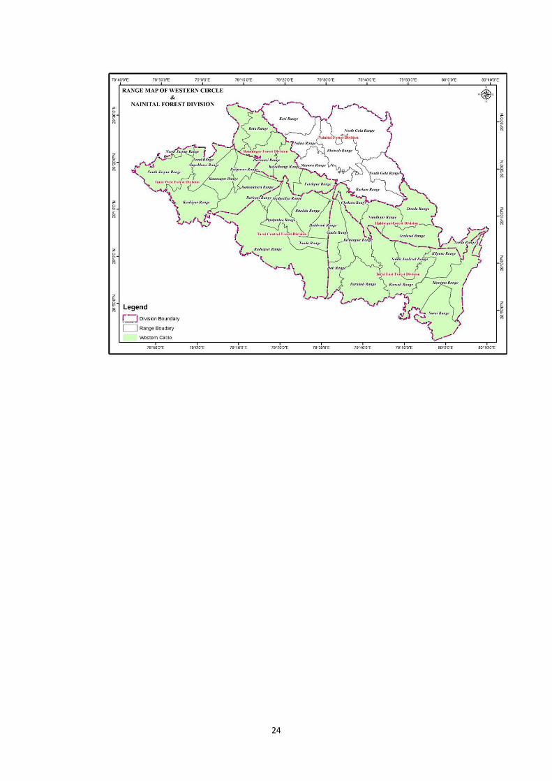
1.27 Project Area Landscape for Wildlife Conservation Plan under Jamrani
Dam Project–
The project area landscape consists of areas of following Forest Divisions:-
1. Nainital Forest Division- 60114.57 Ha.
2. Tarai East Forest Division- 82429.92 Ha.
3. Haldwani Forest Division- 59578.80 Ha.
4. Ramnagar Forest Division- 48736.90 Ha.
5. Tarai Central Forest Division- 40496.97 Ha
6. Tarai West Forest Dision- 34806.62 Ha.
24
25
In North it has Nainital Forest Division. In east it borders with reserve forest areas of
Haldwani and Terai East Forest Divisions, which further makes border with Nepal. In south,
it has Reserve Forest areas of Haldwani and Terai East Divisions as well as Tarai Central
Forest Division. In West, it has Reserve Forest areas of Ramnagar Forest Division. Tarai West
Forest Division, Ramnagar is important because of its strategic location in Shivalik Wildlife
Landscape, and therefore included in the project area.
1.28 Statement of Significance
All the above area falls in the Tarai-Bhabar region of the Shiwaliks. It is one of the
world’s most magnificent landscapes with amazing faunal and floral biodiversity. This is a
part of the larger landscape called Tarai Arc Landscape or TAL which is flanked by River
Yamuna in India towards the west to River Sharda in the east.
TAL is representative of Tarai-Duar Savana Eco-region, flanking the Himalayas in the
southern slopes. It is last remnant of this eco-region. The whole TAL areas is now recognized
as an important biodiversity zone and contains 13 protected areas in the whole landscape.
In Uttarakhand, starting at the western limit is Rajaji National Park, home to both tigers and
elephants followed by Corbett National in the middle and no protected area in the eastern
Uttarakhand.
TAL has two physiographic regions – Tarai and Bhabhar. Tarai can be described as
flat land with fine soil having very shallow water table while Bhabhar can be described as
hilly area with coarse soils and boulders making it extremely porous, and hence having a
deeper water table. The bhabhar area in the western limits is dominated by Sal (Shorea
robusta) forests while Tarai has characteristic tall grasslands and swampy forests
interspersed with Sal forests.
Among the mega-fauna found in this region, the important ones are tigers,
elephants, one-horned rhinoceros, leopards, sloth bears, swamp deer and numerous
herbivores. The diverse fauna of this area enjoys equally diverse floral diversity. The
diversity can be estimated considering the fact that the area has twenty seven types and
sub-types of Champion and Seth classified forests. This biodiversity rich area also supports
over 3 million people, half of which are below poverty line.
The Shivalik Bhabar Tract of Gola river is one of the most important forest area in
the whole Shiwalik landscape of country on account of two reasons. Firstly, even without
having status of a Protected Area, this landscape still support a viable "breeding population"
of flagship species like tiger and elephant. Secondly, It connects Corbett and Rajaji landscape
on West with Pilibhit-Dudhwa along with Terai area of Nepal in East. Further, Whole of
Nandhaur Wildlife Landscapeis part of Shiwalik Elephant Reserve, which is very important
26
landscape for conservation of Mega species like elephant in its western most landscape
under Shiwalik-Bhabar-Terai Tract.
As per Biogeographic classification by Rodgers and Panwar (1984), the Project Area
forms a part of the Gangetic Plain Biogeographic Zone and Upper /Gangetic Plain
Biogeographic Province. It corresponds to the Shiwalik Biogeographic Subdivision.
The Project Area Landscape forms a important part Terai Arc Landscape, which
supports population of the Asian Elephant (Elephas maximus). Further, as it also provide a
connectivity with elephant landscape in Terai area of Nepal and Uttar Pradesh, conservation
in Nandhaur Wildlife Landscapeis critical to the long term survival of this elephant
population.
Project Area Landscape today holds the sustainable breeding population of the Tiger
(Panthera tigris) in the area. The region is thus one of the last remaining landscape, which
hold a potentially viable population of this critically endangered species. Project Area
Landscape plays a very important role in gene flow between Western most limits of tiger
towards Rajaji National Park and Terai landscape of Uttar Pradesh and Nepal.
Several endangered species such as the Striped Hyena, Himalyan Black Bear, Sloth
Bear, Leopard Cat, Goral, Serow, Mahasheer etc have a significant presence in the region.
Along with, several identified and unidentified elements of biodiversity such as grasses,
mosses, lichens, fungi, insects, etc. are also represented in this region. The area is also
reportedly home to about 230 species of resident and migratory birds. This bird diversity is
no less than the avian diversity in Rajaji National Park and Corbett Tiger Reserve.
There are threats to biodiversity due to fragmentation of habitats in recent decades.
The Project Area Landscape not only helps in strengthening Wildlife corridors but also put
forward its stake for playing an important role while establishing this tract as home for
viable breeding populations of many species which are important and critical for biodiversity
conversation in the Shiwalik Terai biogeography sub-division.
The Project Area Landscape also plays a vital role in the maintenance of the soil and
water regime of region. As part of the catchment of Gaula River, it augments ground water
resources and prevents excessive flooding and erosion of valuable topsoil. It also performs a
host of other ecological functions less clearly understood but nevertheless vital to the
continued existence and well being of humanity. Project Area Landscape is also an
important repository of the natural heritage of Uttarakhand
This area is quite rich in floral diversity also. Majestic Sal Forest of this area has also
been a surprise for many scientists as the growing stock of Sal in certain areas is more than
600 cubic m per ha with one of the best regeneration status.
27
Chapter - 2
Background Information and Attributes
2.1 Topographycal Boundary Descriptions
The boundaries of the proposed project are delineated as per the boundaries of the six main
forest divisions i.e. Nainital, Tarai East, Tarai Central, Tarai West, Haldwani and Ramnagar Forest
Dvision.
2.2.2 Soils
Due to wide variations in topography, intensity of erosion, parent material and other factors,
the soils show wide variations in many characteristic, especially texture, depth, stoniness, colour,
drainage, moisture status, organic matter content and cation exchange capacity.
2.3 Topography
The most apparent feature that sets Project Area Landscape apart from other sites in the
shiwalik bhabar region (encompassing forests from the Yamuna River up to the Sharda River), is that
the project region is predominantly mountainous. The topography here differs from other tiger
occupying regions in the landscape in various ways. For example, Ramnagar Forest Division have
larger flatland areas within them, in the form of broad valleys and plains abutting the mountains.
Narrower valleys bound by hills, by contrast, characterizes Nandhaur.
Tigers are known to hold territories in mountainous areas and temperate forests (Corbett
1944, Wang and Macdonald 2009), but appear to achieve their highest densities in areas
Where the terrain is hiily to mildly undulating and vegetation communities are a
heterogeneous mix of woodland and grassland. In project area, where the mountains are steeper
and grassy river-valleys are largely absent, our prediction is that tigers have and can occur at lower
densities than elsewhere in the shivalik-bhabar region.
The steep terrain may impose a limit on the growth of tiger populations within the Project
Area Landscape. More specifically, areas defined primarily by steep terrain and lacking prominent
valleys and grasslands may constitute somewhat inferior habitat. Data from camera trap and
occupancy surveys also suggest that tigers may well align their home ranges along prominent
topographical features - most notably along river valleys. These offer terrain that is easily negotiable
in an area that is predominantly mountainous. Drainages also attract prey - both because as they
offer relatively easy travel paths in the non-monsoon period and serve as water source.
Broadly, there are three distinct types of terrains in Project Area Landscape;
a. The northern and eastern slopes of the Shiwaliks.
b. The southern slopes of the Shiwaliks
c. The outer Himalayan Hills on the western bank of the Gola river
28
2.3.1 Northern and Eastern slopes of the Shiwaliks
In the upper portions, the northern and western slopes of the shiwaliks are very steep and
rugged, but lower down, the gradient is quite easy. These are cut up by a large number of short,
shallow, dry and boulder streams, the raus, which descend from the upper slopes and carry their
discharge a short way down into the project areas various rivers. Many of these raus form a natural
boundaries of blocks and compartments. A large number of raus rise in the Shiwalik belt and
discharge themselves into the Gola River. Most of the raus rising in the Shivalik belt are dry during
greater part of the year but become raging torrents during the monsoon, carrying large volumes of
boulders and loose shingle down their beds.
2.3.2 Southern slopes of the Shiwaliks
The terrain is fragile, and the physiography changes frequently. The rugged and
undulating terrain is characteristic of the area. Steep slopes are very few in these hills, and areas
with gentle slopes are also there. The main Shiwalik ridge strikes and southeast to westerly
direction, gradually losing height towards the east, and like a toothed knife formed of several small
ridges arising from the main ridge. In between these small ridges, small valleys and nullahs are
formed.
All raus of the hilly and foothill regions ultimately drain into the Gola River through circular
and zigzag routes.
2.4 Climate
The climate of the Project Area Landscape is similar to that of the plains areas of
Uttarakhand, and moderate conditions are prevalent due to their Proximity to the Himalaya. The
climate varies from subtropical in the plains to temperate in the higher reaches. The nights are very
cold, with much frost and dew, and usually winter rains occur in 7 to 10 days during December and
January. The frost is severe from mid- December to mid- February.
With the beginning of March, the frost and fog disappear, but dew is observed well into
April. The hot weather sets in with the end of March and continues until the break of monsoon.
Sometimes, temperatures as high as 460c in the shade are recorded in the months of May and June,
particularly on the southern slopes of the Shialiks. During the month of March a hot wind blows
along the southern slops of shiwaliks. The air is very dry, with suspended dust giving rise to a thick
haze that is interrupted by occasional thunderstorms and a few showers of rain, which reduce the
tempreture appreciably. Sudden stroms also occur during the month of May.
The monsoon generally breaks in the second half of June, being generally preceded by pre
monsoon showers or Chhoti barsat, and from this time until the end of September, the atmosphere
remains humid due to the rains. During this period, the tempreture drops, except during the breaks
in the monsoon. The monsoon, which may sometimes persist even in to October, is followed by a
short period of bright and clear weather.
29
2.4.1 Temperature and Rainfall
The temperature as recorded in the Pantnagar observatory over the last decade varies from
2.8oc in January to 37oc in May.
2.4.2 Drainage and Water
The Gola River is a major perennial source of water. In Project Area Landscape there are
several small perennial water streem. They provide very good habitads for birds and large number of
migratory birds in winter. After winter, most of the raus dry up and only a few natural water sources
provide water to the animals. The limited number of waterbodies witnesses stiff competition
between wild animals and Goth-Khatta livestock in southern boundary and other stray cattle that
enter the Project Area Landscape in search of food and water during the stressful summer months.
2.5 Biodiversity and its Status
2.5.1 Bio-geographic Classification
According to the latest Bio geographic classification by Rodgers and Panwar, project area
falls within the Gangetic plains Biogeographic zone and upper Gangetic plains province. Most of the
Project Area Landscape falls within the Shivaliks Biogeographic subdivision of this province.
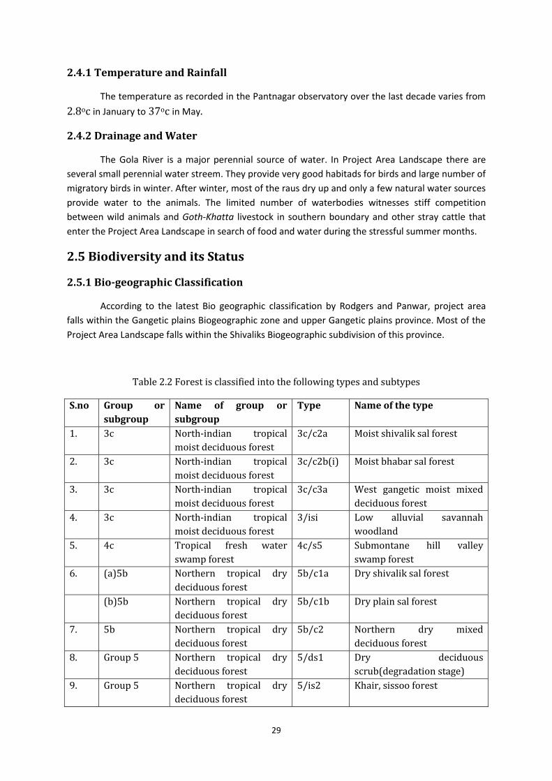
Table 2.2 Forest is classified into the following types and subtypes
S.no Group or
subgroup
Name of group or
subgroup
Type Name of the type
1. 3c North-indian tropical
moist deciduous forest
3c/c2a Moist shivalik sal forest
2. 3c North-indian tropical
moist deciduous forest
3c/c2b(i) Moist bhabar sal forest
3. 3c North-indian tropical
moist deciduous forest
3c/c3a West gangetic moist mixed
deciduous forest
4. 3c North-indian tropical
moist deciduous forest
3/isi Low alluvial savannah
woodland
5. 4c Tropical fresh water
swamp forest
4c/s5 Submontane hill valley
swamp forest
6. (a)5b Northern tropical dry
deciduous forest
5b/c1a Dry shivalik sal forest
(b)5b Northern tropical dry
deciduous forest
5b/c1b Dry plain sal forest
7. 5b Northern tropical dry
deciduous forest
5b/c2 Northern dry mixed
deciduous forest
8. Group 5 Northern tropical dry
deciduous forest
5/ds1 Dry deciduous
scrub(degradation stage)
9. Group 5 Northern tropical dry
deciduous forest
5/is2 Khair, sissoo forest
30
(b)group 5 Northern dry deciduous
forest
5/e5 Northern dry deciduous
forest
10. Group 9 Subtropical forest 9c/1 Subtropical chir pine forest
2.5.2 Classification of Forests/ Flora
Proposed Project Area Landscape presents a rich and diverse forest ecosystem. A general
survey of the forests reveals some important plant associations such as the Shorea-Mallotus-Adina
community, Shorea-Tetminalia-Bridelia community, Dalbergia-Acacia community and Syzygium-
Phoebe-Drypetes community. The tropical forest ecosystems of the project area landscape have
many unique characteristics that have high scientific significance. Based on the physiognomy and
floristic composition, the permanent vegetation of the project area may be classified broadly under
the northern tropical moist deciduous forest and can be grouped into the following six types:
a. Sal forest
b. Mixed forest
c. Riverine forest
d. Scrubland
e. Grassland (Savannah)
f. Subtropical pine forest
2.5.2.1 Sal Forest
This occupies the major part of the project area and is of two types, namely the tropical
moist deciduous and tropical dry deciduous types. The tropical moist deciduous typoe is
represented by the dominant tree species, Shorea robusta, which forms pure tracts. The
common associates of the sal forest are Terminalia alata, Anogeissus latifolia, Adina cordifolia,
Terminalia bellirica, Lannea coromandelica, Cassia fistula, Bridelia retusa, Lagerstroemia
parvilflora, Schleichera oleosa, Semecarpus anacardium, Buchanania lanzan, Careya arborea,
Mallotus philippensis, etc. The middlestorey consists chiefly of species such as Aegle marmelos,
Ehretia laevis, Emblica officinalis, Cassia fistula, Syzygium cumini, Holarrhena pubescens
H.antidysenterica, Diospyros spp., Kydia calycina and Bauhinia variegata. The forest
undergrowth is composed of Ardisia solanacea, Flemingia strobilifera, F. chappar, Carissa opaca,
Callicarpa macrophylla, Murraya koenigii, Colebrookea oppositifolia, Glycosmis pentaphylla,
Clerodendrum viscosum, Adhatoda zeylanica, Pogostemon benghalense, Desmodium gangetium,
D.pulchellum, Woodfordia fruticosa, Indigofera cassioides, Leea crispa etc.
The ground flora consists of Adenostemama lavenia, Curculigo orchioides, Uraria picta, U.
lagopus, Acrocephalus indicus, Blumea aromatic, Ageratum conyzoides, Cyperus spp., Polygounum
spp., Sida spp., Aerva sanguninolenta, Solanum nigrum, Vernonia cinerea, Ajuga bracteosa,
Hemigraphis hirta, Hackelochloa granularis, Oplismenus compositus, O. burmannii, Cyrtococcum
patens, Hibiscus lobatus, Crotalariaspectabilis, Siegesbeckia orientalis, Urena lobata,Cynoglosum
lanceolatum,Biophytum sensitivum, etc., Hiptage benghalensis, Clematis gouriana, Vallaris
solanacea, Capparis zeylanica, Tinospora cordifolia,Aspidospteris wallichii, Porana paniculata,
Smilax spp., Bauhinia vahlii, Ventilago denticulata, Ziziphusoenoplia, Puerariatuberosa, Milletia
extensa,
31
Abrus precatorius, Ichnocarpus frutescens, Celastrus paniculatus, Ampelocissus latifolia,
Cissampelos pariera, Butea parviflora, Dioscorea belophylla, D. bulbifera, Coccinia grandis,
Cryptolepis buchanani, Combretum roxburghii (C. decandrum), Scindapsus officinalis, etc.
2.5.2.2 Mixed forest
The common species found in these forests are Anogeissus latifolia, Albizia procera, A.
lebbek, Boehmeria rugulosa, Lannea coromandelica, Bombax ceiba etc. The middle storey
consists of trees such as Acacia catechu, Hymenodycton orixense (H. excelsum), Mitragyna
parvifolia, Aegle marmelos, Garuga pinnata, Erythrina suberosa, Casearia tomentosa, Emblica
officinalis, Bridelia retusa, Gmelina arborea, Kydia calycina, Litsea glutinosa, Trewia nudiflora,
Ehretia laevis, Cassia fistula, Sterculia villosa, Ziziphus zylopyra, Z. mauritiana, Butea
monosperma, etc.
The common shrubs of these forests are Carissa opaca, Adhatoda zeylanica, Colebrookea
oppositifolia, Leea crispa, Murraya koenigii, Calotropis procera, Clerodendrum viscosum,
Woodfordia fruticosa, etc. Common grasses of these forests are Heteropogon contortus,
Chrysopogon fulvus, Oplismenus compositus, Setaria glauca, Imperata cylindrica etc. Climbers
such as Ampelocissus latifolia, Tinospora cordifolia, Cissampelos pariera, Ventilago denticulata
and Inchnocarpus frutescens are also found.
2.5.2.3 Riverine Forest
The vegetation occurring in low-lying waterlogged areas, along nullahs, riverbeds and
streambeds, develops into a riverine forest. This type consists of irregular vegetation of mainly
evergreen species, which are able to withstand the wetness of the occupied sites. The common
tree species of these forests are Syzygium cumini, Ficus racemosa, F. semicordata, Bischofia
javanica, Trewia nudiflora, Pterospermum acerifolium, Albizia procera, Toona ciliata, A rattan
Calamus tenuis also found here. The under-storey consists of Diospyros exsculpta, Phoebe
lanceolata, Persea gamblei, Salix tetrasperma, Maclura cochinchinensis, (Cudrania javanica) etc.
The undergrowth consists of Ardisia solanacea, Acronychia peddunculata, Desmodium caudatum
(D. labernifolium), and grass Vetiveria zizanioides and many fern species. Some common herbs
are Eclipta alba, Centella asiatica, Corchorus spp., Bupleurum hamiltonii, Youngia japonica, Mazus
pumilus, Lindenbergia indica, Rungia pectinata and Hemigraphis hirta. The common climbers are
Vallaris solanacea, Combretum roxburghii (C.decandrum) etc. The vegetation along river streams
and nullahs consists of species such as Trewia nudiflora, Syzygium cumini, Dalbergia sissoo,
Orthanthera viminea, Xylosma longifolium, Adhatoda zeylanica and Gonostegia pentandra
(Pouzolzia pentandra).
2.5.2.4 Scrub Forests
These forests represent a degradation stage of dry deciduous forests. Which are formed
as a result of adverse biotic factors such as overgrazing, lopping, felling and fires. The main tree
species found in scrub forests are Aegle marmelos, Lannea coromandelica, Sapium insigne,
Erythrina suberosa, Cassia fistula, Flacourtia indica, Ziziphus mauritiana, Z. xylopyra, etc. The
common shrubs are Nyctanthes arbor-tristis, Woodfordia fruticosa, Lantana camara, Carissa
opaca, Xeromphis spinosa (Randia spinosa), Murraya koenigii, Colebrookea oppositifolia,
Adhatoda zeylanica, Zizyphus oenoplia, etc.
32
2.5.2.5 Savannah (Grassland)
The savannahs do not represent a climax stage in the region but have developed only
due to disturbance of the natural flora. Grasses such as Themeda arundinacea, T. villosa, Apluda
mutica, Desmostachya bipinnata, Phragmites karka, Cympopogon flexuousus, Digitaria spp.,
Eragrostis japonica, E. tennella, Eulaliopsis binata, Heteropogon contortus, Setaria spp., and
Vetiveria zizanioides characterize the grasslands. The grasslands are interspersed with some
trees and shrubs such as Butea monosperma, Bombax ceiba, Acacia catechu, Dalbergia sissoo,
Mitragyna parvifolia, Syzygium cumini, Calotropis procera, Helicteres isora, Carissa opaca,
Ziziphus xylopyra and Woodfordia fruticosa. The common bamboo species Dendrocalamus
strictus forms gregarious patches at many places in the sanctuary. The association of the Acacia-
Dalbergia community occurs mainly in the form of pure patches in some parts of the region. The
undergrowth of this type is thin and consists of species such as Lantana camara, Adhatoda
zeylanica, Murraya koenigii, Ziziphus spp., Clerodendrum viscosum, Cassia tora and C. occidentalis.
2.5.2.6 Subtropical pine forest
This type of forest occurs along with the dry deciduous mixed forest and sal forest. The
extent of this forest type is very small, chir (Pinus roxburghii) occurs on the higher slopes of the
Shivaliks, mixed with stunted sal forests. The other associates of this pine are Anogeissus
latifolia, Terminalia alata, Buchanania lanzan, Terminalia bellirica, Stereospermum suaveolens,
Ougeinia oojeinensis, Grewia elastica, Nyctanthes arbor-tristis, Mallotus philippensis etc. The
undergrowth is generally poor, consisting mainly of Carissa opaca, Ziziphus sp., Colebrookea
oppositifolia, etc. The common grasses are Eulaliopsis binata, Chrysopogon fulvus, Heteropogon
contortus, etc.
2.5.3 Faunal Diversity
Project area Landscape is an interesting animal habitat because of its location at the
meeting point of the lesser himalayan foothills and the beginning of the vast indo-genetic plains
and having viable breeding population of Tiger. The region also has a large population of
elephants and leopards also. A very brief account of various faunal species found in project area
is given as below;
1. Among the herbivores, the Chital or Spotted Deer (Axis axis) is the most common
species, occurring widely throughout the flatter terrain of the sanctuary.
2. The Barking Deer (Mujtiacus muntjak) is common in forest areas with ample ground
cover.
3. The Sambar (Rusa unicolor) is widespread in the Project Area Landscape especially in
the more densely forested areas and on the gentler slopes of the shiwalik hills.
4. The Goral (Nemorhaedus goral) is found in considerable numbers in the Project Area
Landscape, occupying a specialized niche in the relatively bare rocky slopes at the top of
the shiwalik ridges and hills.
5. The Wild Pig (Sus scrofa) is fairly common in the Project Area Landscape, and it
frequently raids the cultivated crops in fields on the mainly villages on regions northern
boundary.
33
6. The Asian Elephant (Elephas maximus) is one of the most important wild animal in
Project Area Landscape provides a very good habitat for elephant and further connects
habitat to terai forests of Uttar Pradesh and Nepal.
7. Amongst the major carnivores in the region, the Royal Bengal Tiger (Panthera tigris
tigris) and Leopard (Panthera pardus) take pride of place.
8. The lesser carnivores are represented by the Jungle Cat (Felis chaus), Leopard Cat (Felis
bengalensis) and Small Indian civet (Viverricula indica).
9. The Himalayan Yellow-throated Marten (Martes flavigula) is a member of the
mustelid(weasel) family. It plays an important role in keeping a check on the
populations of smaller rodents, birds, and even chital by preying on their fawns.
10. Both Sloth Bear (Melursus ursinus) and Asiatic Black Bear (Ursus thibetanus) occur in
the region.
11. The Indian Pangolin (Manis crassicaudata) is an important mammal among the smaller
animals of the region. Fire is a major threat to this animal as it kills the animal by
burning it and by depriving it of food by destroying termite colonies in the forest.
12. In recent surveys, presence of Striped Hyena is also confirmed in some areas of project
area.
13. The reptiles are represented in the region by a number of snakes including the Python
(Python molurus), King Cobra (Ophiophagus hannah), Common Krait (Bungarus
caeruleus), and Spectacled Cobra (Naja naja). The Indian Monitor Lizard (Varanus
bengalensis) is also common.
14. Many big-sized mahasheer can easily be spotted in pools of Gola River. There are many
such pools, where Mahasheers breeds in region.
15. There are over 230 bird species in the Project Area Landscape. Varieties of
waterfowl are found on the Gola River, including ducks, cormorants, egrets, plovers, and
herons.
2.6 Species-specific habitats and key areas
Project area Landscape has plenty of habitats such as caves, crags, cliffs, overhangs,
dens, burrown, and tree hollows. Wild animals, birds, insects and plants use these
features.
1. Caves
There are many caves present in different blocks and compartments of Project
area Landscape and are utilized by roosting bats.
2. Cliffs
Steep cliffs formed by water and wind erosion in the shiwalik ridges are important
natural features in the sanctuary that provide nesting sites for birds such as owls,
eagles, bee-eaters and mynas, and even snakes. Cliffs also provide a special
microclimate for threatened plant species.
34
3. Overhangs
Overhangs, though not exactly caves create a special microclimate that caters to
the needs of a large number of plants and smaller life forms that enrich the biodiversity
of the region.
4. Burrows
Further, burrows reveal many interesting facts about the smaller life forms of
the sanctuary. Keeping notes of their use, disuse, or abandonment will inform the
sanctuary manager about many subtle changes that may be occurring in the ecology of
the Project Area Landcape.
5. Tree hollows
Tree hollows constitute an important wildlife habitat in the Project Area
Landcape.Many birds such as hornbills, owls, parakeets and woodpeckers, along with
smaller mammals such as bats, squirrels and other rodents, make use of tree hollows to
breed and roost.
2.7 Species of conservation importance
As the shivaliks lie between the himalaya and the upper gangetic plains, they
have floral elements belonging to both these bio-geographic regions. The following
endangered plant species found in project area are of immense conservation value.
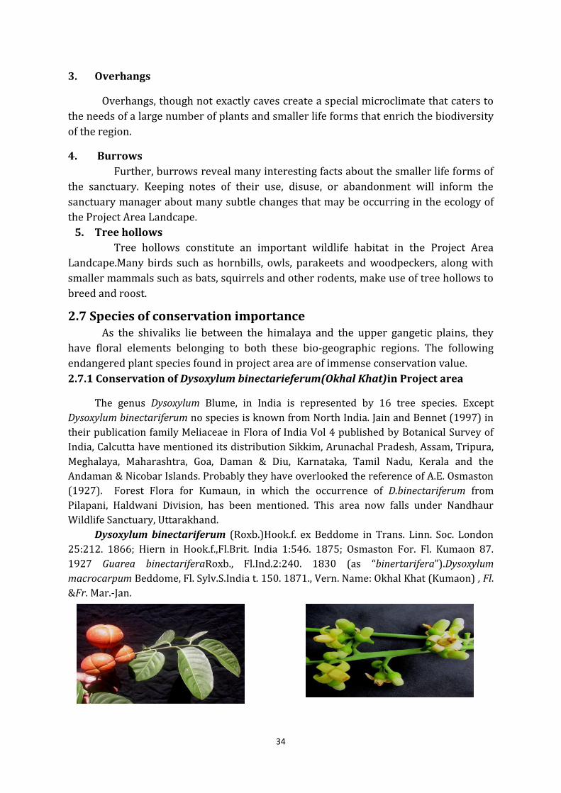
2.7.1 Conservation of Dysoxylum binectarieferum(Okhal Khat)in Project area
The genus Dysoxylum Blume, in India is represented by 16 tree species. Except
Dysoxylum binectariferum no species is known from North India. Jain and Bennet (1997) in
their publication family Meliaceae in Flora of India Vol 4 published by Botanical Survey of
India, Calcutta have mentioned its distribution Sikkim, Arunachal Pradesh, Assam, Tripura,
Meghalaya, Maharashtra, Goa, Daman & Diu, Karnataka, Tamil Nadu, Kerala and the
Andaman & Nicobar Islands. Probably they have overlooked the reference of A.E. Osmaston
(1927). Forest Flora for Kumaun, in which the occurrence of D.binectariferum from
Pilapani, Haldwani Division, has been mentioned. This area now falls under Nandhaur
Wildlife Sanctuary, Uttarakhand.
Dysoxylum binectariferum (Roxb.)Hook.f. ex Beddome in Trans. Linn. Soc. London
25:212. 1866; Hiern in Hook.f.,Fl.Brit. India 1:546. 1875; Osmaston For. Fl. Kumaon 87.
1927 Guarea binectariferaRoxb., Fl.Ind.2:240. 1830 (as “binertarifera”).Dysoxylum
macrocarpum Beddome, Fl. Sylv.S.India t. 150. 1871., Vern. Name: Okhal Khat (Kumaon) , Fl.
&Fr. Mar.-Jan.
35
Evergreen tree, 30 m tall; young parts and inflorescences minutely
pubescent.Leaves 30-75 cm long; leaflets 6-8, cuneate at base, entire or obscurely
dentate along margins, acuminate at apex, 7-17 x 3-8 cm, thinly coriaceous, glabrous,
dark green above, pale beneath; petiolules to 1 cm long. Panicles 20-30 cm long.Flowers
shortly pedicellate, 4-merous, 3-5 mm long, pale-white.Calyx cup-shaped, entire or
obscurely 5-lobed, about half as long as petals.Petals 4, velvety.Staminal tube mealy, 4-
angled, terminating in 8 obscurely 2-fid teeth; anthers 8, included.Disk exceeding ovary,
glabrous inside, puberulous outside, 8-toothed.Ovary hairy; style 4-angled; stigma
capitates.Capsules obovoid, 2.5-3 cm across, 4-locular, 4-seeded, pale-yellow turning
orange; seeds shining, purple with a large yellow hilum and white aril.During a recent
survey in Nandhaur Wildlife Sanctuary H.B. Naithani, Retd. Scientist from Forest
Research Institute Dehradun, trees of Dysoxylum binectariferum were located at region,
where it is locally called Okhal kat. It is very interesting that this tree has very wide
distribution in India. However, in North India it has restricted distribution in the region
of Uttarakhand. It is an interesting fact is obscurity that this tree has been in existence in
Kumaon in past its herbarium specimens were collected as early as 1922, 1923, 1925
and 1954 by Sir H.G. Champion, A.E. Osmaston and S.K. Seth, but curiously enough, its
record of occurrence from this region has all along been overlooked in recent literature.
After Seth’s collection in 1954 no effort has taken to collected its specimens to deposit
in the herbarium of Forest Research Institute, Dehradun and Botanical Survey of India
Northern Circle, Dehradun. Also this tree has no place in the working Plan.
This handsome tree is often introduced in the gardens for its beautiful foliage
and orange red fruits. Forest Research Institute, Dehra Dun has its five trees in Botanical
Garden and Arboretum. Its timber is used for building constructions, boxes, canoes and
turnery; also suitable for match boxes and splints, cigar-boxes, and ply wood. Bark
contain tannin (10-15%).
2.7.2 Conservation of a monotypic, endemic tree, Indopiptadenia oudhensis
(Genthi) in and around project area
Genus Piptadenia was described by Bentham in Hook .J. Bot. IV. 334.1841, with
type species Piptadenia pterosperma Benth. Later Bentham and Hooker (1862) placed it
under genera No. 376 mentioning about 30 species under Piptadenia. From India
Brandis (1874) described single species Piptadenia oudhensis. Many species included
under Piptadenia have been reclassified by Brenan (1955) and are now considered as
eight separate genera. These are Piptadenia Benth. (Sensu stricto) from America and
Australia; Adenanthera Speg.from tropical America; Goldmania Rose ex Micheli from
America, Mexico and Australia; Newtonia Baill.from tropical Africa, America and
Australia; Pityrocarpa (Benth.) Britton & Rose from Central America and Australia and
three more genera described by Brenan (1955) for the first time i.e. Indopiptadenia
from India, Monoschisma from America and Australia and Piptadenisatrum from tropical
Africa. According to Brenan (1955) monotypic Indopiptadenia differs from Piptadenia in
having elongated seeds, the glandular petiole, the glandular rachis, the conjugate leaves,
36
the corolla lobes being free to their base and distribution confined to India only.
According to Brazier (1958) the presence of narrow predominantly bi-and triseriate
rays and absence of septate fibres serve to distinguish Indopiptadenia from all other
species except those of Piptadenia (Sensu stricto).
Brenan (1955) transferred Piptadenia oudhensis Brandis, under Indopiptadenia
and proposed a name Indopiptadenia oudhensis (Brandis) Brenan (Mimosaceae). Mr.
Richard Thomson discovered the Taxon in the Oudh forests under the base of hills in
Gonda Division (Brandis, 1874). A study by H.B. Naithani, D.P. Nautiyal and Ranjana
Negi of Botany Division, Forest Research Institute, Dehradun shows that this
monotypic endemic species is so far known from Bahraich, Gonda, Balrampur and
Gorakhpur, in Uttar Pradesh and Champawat Forest Division, Kumaon Hills of
Uttarakhand and Sub Himalayan tracts of Western Nepal i.e banks of Gandak river. In
Uttar Pradesh this is commonly known by the name of Genti, Gainti while in Nepal this is
known by the name of Hathi Paula.
Biswas and Chandra (1997) reported Indopiptadenia oudhensis as endangered
throughout the region of its occurrence. Prakash et al. (2009) stated that based on the
population size, distribution pattern, regeneration rate and surveys this species is
critically endangered. According to Kashyap (2009) this species is a good fodder for
wildlife and cattle. As it is lopped for fodder thus, is the main cause of its depletion from
the forest of Uttar Pradesh. Singh (2010) while studying the population of
Indopiptadenia oudhensis in Sohelwa Wildlife Forest Division, Balrampur, Uttar Pradesh
suggested that collective efforts of the foresters and scientists should be made in order
to save the plant species from becoming extinct. Thus Gazette Notification, 15thApril,
2009, New Delhi, 5.0.998 (E). in exercise of powers conferred by section 38 of the
Biological Diversity Act, 2002 (18 of 2003), the Central Government in consultation with
theGovernment of Uttar Pradesh, notified Indopiptadenia oudhensis which is on the
verge of extinction, prohibit and regulate the collection there of no plant as notified
shall be collected in live or dead condition by any person except for purposes viz.
scientific research, herbarium and museum of scientific and academic institutions,
propagation and any other scientific investigation, with the approval of the concerned
state Biodiversity Board. It has been included under Threatened species of Uttarakhand
(Naithani and Rakesh Shah (2012). To facilitate the identification of this rare monotypic
tree a description is provided.
Indopiptadenia oudhensis (Brandis) Brenan in Kew Bull.1955: 173. 1955.
Piptadenia oudhensis Brandis, For. Fl. NWC India 168.1874; Brandis, Indian trees 261.
1906; Baker in Fl. Brit. India 2: 289. 1878; Duthie, Fl. Upp.Gang.Plains and of the
Adjacent Siwalik and Sub – Himalyan tracts 1: 283.1960 ; Osmasten, For. Fl. Kumaon
193. 1927; P.C. Kanjilal.For.Fl. Uttar Pradesh 285.1966.Its local names areGenti, Gainti,
Hathi Paula, Sajan.Distribution of this species is Uttarakhand, Uttar Pradesh in India,
Western Nepal. Planted in Botanical Garden of Forest Research Institute, Dehradun and
Gandhi’s Samadhi at Rajghat, New Delhi (Pradip, 2006).
37
A small to middle sized tree, with drooping branchlets; branches armed, with
large compressed conical prickles. Bark greyish or reddish-brown, rough, exfoliating in
flat woody scales. Blaze red, fibrous.Leaves alternate, bipinnate; rachis 2.5-10 cm long
bearing flat circular glands at the junction of the pinnae; pinnae opposite, 1-3 pairs, 1.5-
6 cm long, each bearing one pair of opposite leaflet, the pair resembling as Bauhinia leaf
cleft to the base; leaflets 5-9 x 2.5-7.5 cm, obliquely sub-orbicular or rhomboid, entire,
sub-coriaceous, glabrous, veins prominent on both surfaces, forming loops within the
margin; petiolules 3 mm long. Flowers 3-5 mm long, greenish-yellow, in dense cylindric
shortly pedunculate spikes 2.5-8 cm long, solitary or arranged on an axillary rachis 2.5-
10 cm long. Calyx cup shaped with minute teeth. Petals nearly free, oblong, acute, much
longer than calyx. Stamens 10, exceeding the petals; anther with apical glands.Ovary
stalked; ovules many; style filiform. Pods 20-30 cm long, slightly curved to straight,
twists, linear, margins not constricted, rounded to apex. Seeds 11-16, brown, oblong to
elliptic, flattened.
38
Chapter – 3
History of Management and present practices
3.1 General History of the Forests
The tracts constituting areas of Nainital, Ramnagar, Tarai East and Tarai Central Forest
Division formed part of domains of Rajahas of Kumaon in past. From time immemorial, the
ruling powers had derived revenue from forests by imposing dues on forest produce exports.
With the defeat of Rajahasof Kumaon at the hands of Gorkhas and subsequent defeat of the later
by British in 1816, these forests came to be managed under British Rule. For the first three
years of British Rule, the forest dues were leased out with the transit on merchandise.
Subsequently, Mr. Trail, Commissioner of Kumaon was authorised to lease out the forest
dues to ZamindarsofParganas in which collecting depots were situated. The dues were styled
according to the principal item assessed in each case, such as Kath-bans for timber and bamboo,
Kath-mahals for Katha, and Ghee-kar for Ghee. This system proved highly profitable both to
lessees and exploiters. For several decades Sal forests were heavily overworked and more
accessible portions were depleted of any timber of value, yet the average annual revenue for the
whole of Kumaon forests from 1818 to 1928 was only Rs. 3652/-. Mr. Trail issued a
proclamation prohibiting the cutting of Sal on Thaplas or flats adjoining the lower ranges, along
the whole extent of Bhabar, so that these areas, which may be looked upon as the first forest
reserves in Kumaon, were excluded from leases of forest produce. Elsewhere however, reckless
felling and exploitation continued and no attempt at any system of forest conservancy was
made.
In the middle of 19th century, added impetus was given to uncontrolled exploitation by
ever increasing demand for Sal railway sleepers. Further, the ignorant ‘get-rich-quick’ speculators, who felled far more timber than could be exported by them. The forests,
particularly the more accessible areas, were so over felled that for several years after the forests
were taken over, the energies of forest officers were chiefly directed towards extracting the
timber left over in forest un-extracted by contractors.
Major Ramsay, Commissioner of Kumaon, realizing the seriousness of position, took
prompt and energetic steps to stop further denudation of forests. His reports of 1861,
describing the depleted condition of forests led to closure of such felling. Further, Conservancy
under special protective establishment, led to his appointment as Conservator of Forests in
addition to his duties. He promptly abolished farming leases and fire conservancy was initiated.
Indiscriminate felling was stopped, by introducing system of marking of trees for felling.
Existing forest roads were improved and some new roads were constructed to open up
inaccessible forest area. Grazing was regulated and cultivation of areas in valuable Sal forests
was discouraged. Finally, forests officers were appointed to look after the newly constituted
estate. The immediate result was greatly enhanced forest revenue and there was surplus of
nearly 7 lakh rupees over a period of nine years from 1859 to 1868. Thus, as a result of
application of some business methods and control, the profit from forest wealth was largely
diverted from pockets of private speculators to government treasury.
In 1868, Forests of Kumaon were placed under the control of officers of Forest
department. Major Pearson being the first Conservator of Forests. Nine years later, these were
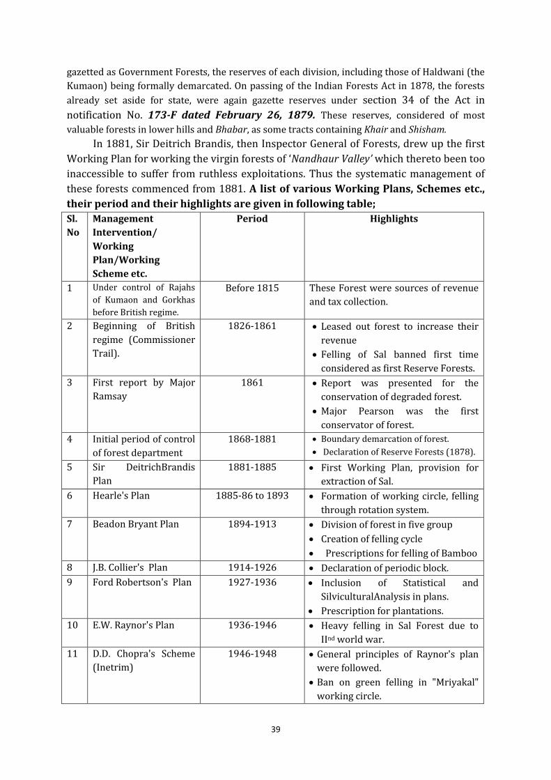
39
gazetted as Government Forests, the reserves of each division, including those of Haldwani (the
Kumaon) being formally demarcated. On passing of the Indian Forests Act in 1878, the forests
already set aside for state, were again gazette reserves under section 34 of the Act in
notification No. 173-F dated February 26, 1879. These reserves, considered of most
valuable forests in lower hills and Bhabar, as some tracts containing Khair and Shisham.
In 1881, Sir Deitrich Brandis, then Inspector General of Forests, drew up the first
Working Plan for working the virgin forests of ‘Nandhaur Valley’ which thereto been too
inaccessible to suffer from ruthless exploitations. Thus the systematic management of
these forests commenced from 1881. A list of various Working Plans, Schemes etc.,
their period and their highlights are given in following table;
Sl.
No
Management
Intervention/
Working
Plan/Working
Scheme etc.
Period Highlights
1 Under control of Rajahs
of Kumaon and Gorkhas
before British regime.
Before 1815 These Forest were sources of revenue
and tax collection.
2 Beginning of British
regime (Commissioner
Trail).
1826-1861 Leased out forest to increase their
revenue
Felling of Sal banned first time
considered as first Reserve Forests.
3 First report by Major
Ramsay
1861 Report was presented for the
conservation of degraded forest.
Major Pearson was the first
conservator of forest.
4 Initial period of control
of forest department
1868-1881 Boundary demarcation of forest.
Declaration of Reserve Forests (1878).
5 Sir DeitrichBrandis
Plan
1881-1885 First Working Plan, provision for
extraction of Sal.
6 Hearle's Plan 1885-86 to 1893 Formation of working circle, felling
through rotation system.
7 Beadon Bryant Plan 1894-1913 Division of forest in five group
Creation of felling cycle
Prescriptions for felling of Bamboo
8 J.B. Collier's Plan 1914-1926 Declaration of periodic block.
9 Ford Robertson's Plan 1927-1936 Inclusion of Statistical and
SilviculturalAnalysis in plans.
Prescription for plantations.
10 E.W. Raynor's Plan 1936-1946 Heavy felling in Sal Forest due to
IInd world war.
11 D.D. Chopra's Scheme
(Inetrim)
1946-1948 General principles of Raynor's plan
were followed.
Ban on green felling in "Mriyakal"
working circle.
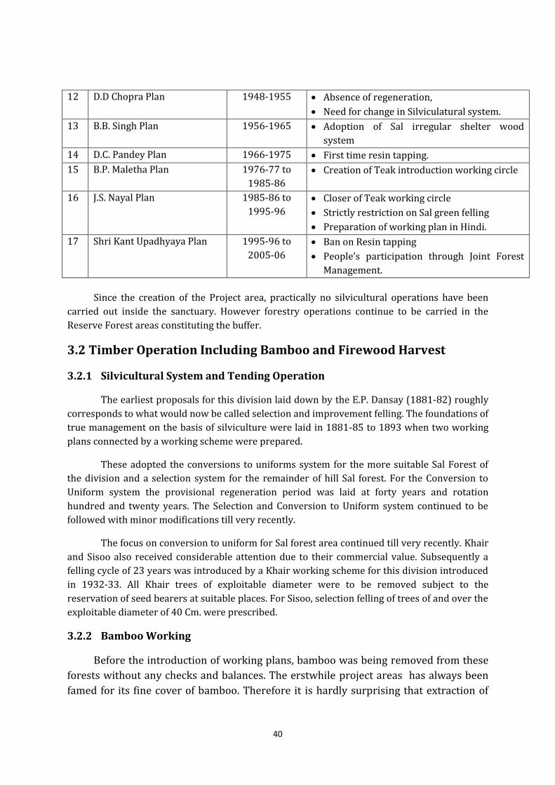
40
12 D.D Chopra Plan 1948-1955 Absence of regeneration,
Need for change in Silviculatural system.
13 B.B. Singh Plan 1956-1965 Adoption of Sal irregular shelter wood
system
14 D.C. Pandey Plan 1966-1975 First time resin tapping.
15 B.P. Maletha Plan 1976-77 to
1985-86
Creation of Teak introduction working circle
16 J.S. Nayal Plan 1985-86 to
1995-96
Closer of Teak working circle
Strictly restriction on Sal green felling
Preparation of working plan in Hindi.
17 Shri Kant Upadhyaya Plan 1995-96 to
2005-06
Ban on Resin tapping
People’s participation through Joint Forest
Management.
Since the creation of the Project area, practically no silvicultural operations have been
carried out inside the sanctuary. However forestry operations continue to be carried in the
Reserve Forest areas constituting the buffer.
3.2 Timber Operation Including Bamboo and Firewood Harvest
3.2.1 Silvicultural System and Tending Operation
The earliest proposals for this division laid down by the E.P. Dansay (1881-82) roughly
corresponds to what would now be called selection and improvement felling. The foundations of
true management on the basis of silviculture were laid in 1881-85 to 1893 when two working
plans connected by a working scheme were prepared.
These adopted the conversions to uniforms system for the more suitable Sal Forest of
the division and a selection system for the remainder of hill Sal forest. For the Conversion to
Uniform system the provisional regeneration period was laid at forty years and rotation
hundred and twenty years. The Selection and Conversion to Uniform system continued to be
followed with minor modifications till very recently.
The focus on conversion to uniform for Sal forest area continued till very recently. Khair
and Sisoo also received considerable attention due to their commercial value. Subsequently a
felling cycle of 23 years was introduced by a Khair working scheme for this division introduced
in 1932-33. All Khair trees of exploitable diameter were to be removed subject to the
reservation of seed bearers at suitable places. For Sisoo, selection felling of trees of and over the
exploitable diameter of 40 Cm. were prescribed.
3.2.2 Bamboo Working
Before the introduction of working plans, bamboo was being removed from these
forests without any checks and balances. The erstwhile project areas has always been
famed for its fine cover of bamboo. Therefore it is hardly surprising that extraction of
41
bamboo was being carried out a fairly large scale. Beadon Bryant first laid down rules
for harvest of bamboo in 1894-1913, as follows;
(i) Opening blocks for two years and closing them for one year.
(ii) Prohibiting removal of current year shoots.
(iii) Retention of one third of the old culms.
(iv) This rule was soon abandoned since it was impossible to enforce in the field.
"Low cutting rules"
From 1912-13 removal of flowering culms until the seed had been shed and removal of
rhizomes after digging out the ground were prohibited. The use of sharp instruments was
insisted upon also it was laid down that the culms would be cut a minimum height of 15-30 cm.
above the root except in very congested culms, where largest possible height was permissible
for cutting. As a response to over cutting the working cycle was progressively lengthened to
four years till 1918. After 1918, the system of sale changed from monopoly royalty to lump sum,
a transition affecting both revenue and outturn. In the event of gregarious flowering, the
affected area could be cut of turn.
3.2.3 Firewood, Harvest and Collection
According to the rules and regulations relating to the exercise of rights and concession
of local communities as laid down in various Government Orders, there was no restriction on
the removal of fallen wood for fuel for bona fide domestic use except when required
commercially.
As such the fuel needs of most people living around the sanctuary and its peripheral
buffer Reserve Forests have been legally met from these forest areas only. In addition, fuel wood
recovered from forests during working operations were also removed and sold commercially to
meet the requirements of brick kilns, other small-scale industries and domestic households in
the nearby townships. Since the creation of U.P. Forest Corporation (U.P.F.C.) in 1982-83 all
exploitation of major forest produce. The U.P.F.C., now Uttarakhand Forest Development
Corporation, which is working mainly in areas outside the Nandhaur Sanctuary, has been
removing firewood as part of its operation from areas under Working Plan felling.
3.3 Non-Wood Forest Produce (N.W.F.P) Collection Gum, Honey, Wax, Grass, Boulders and sand are main NWFPs of Project Area
Landcape. Other important N.W.F.P. include honey leaves of Bauhinia vahlii and medicinal herbs
and shrubs (excluding prohibited species). In the past these NWFPs exploited heavily in past on
account of demand by local people and small or mid level contractors. Though the extraction
has not been on highly commercial level, but it had impact on biodiversity and food availability
of wild animals.
42
3.4 Forest Protection
3.4.1 Hunting
The forest of this area has always enjoyed tremendous reputation as one of the best
areas for hunting, while having many shooting blocks demarcated in division in past. Various
acts had been enforced by successive Government to enforce the protection and management of
Nainital, Tarai East, Tarai Central and Ramnagar Forest Division. These included the Indian
forest Act. 1878 and 1927, the Wild Elephants Preservation Act, 1879 and The Wild Birds and
Animals Protection Act, 1912.
Under the prevalent acts, rules regulating hunting, shooting, fishing were being enforced
in these areas. These were extremely popular amongst sports persons. The species bagged
included Tiger, Leopard, Sambar, Kakar ( barking deer), Chital ( Spotted deer), Wild Pig, Mugger
and Python. The area was also renowned for its Mahasheer fishing.With the awakening of a new
era in conservation in the 1970s and enactment of the Wild Life (Protection) Act, 1972, hunting
was slowly but surely on the way out. Since the year 1982 there was a complete ban on hunting
in the erstwhile state of Uttar Pradesh.
3.4.2 Domestic Livestock Grazing
Local residents enjoy limited grazing rights in various divisions such as Nainital, Tarai
East, Tarai Central and Ramnagar Forest Division. The concessions for grazing were granted
vide notification No. 955/exv dated 6/11/25.
Grazing rights are expressed as a maximum number of buffaloes, cows, sheep and goats,
allowed to be grazed by specified villages. Remotely spaced villages sparsely use cattle grazing.
Grazing is an issue mainly in forests directly adjoining villages and especially along the southern
boundarywhere cattle from project area is occasionally brought in for grazing.
The Goth-Khattas are constant disturbance to the wildlife and its habitat. However since
several years the seasonal migration is limited to local movement from within the project area
to its peripheral areas.
3.4.3 Insect Attacks and Pathological Problems
The most important insect pest in these forests is the "Sal Borer Beetle", Hoplocerambyx
spinicornis. Its attack is normally mild but during favorable conditions strikes in an epidemic
form and causes severe damage to Sal trees. Very severe attacks of this beetle were noticed from
1924-28 when about fifteen thousand trees were affected. After minor outbreaks in 1940-41
and 1950-51 the borer affected nearly five thousand trees in 1953-54. The beetle has also
caused some damage in the early nineties. The most common and important fungus is Fomes
caryopltylli, which is the cause of heart-sot in Sal. The root, which is brownish in colour is
known to attack trees of all sizes but is seen to favor mature and over matured trees, which have
been suppressed at one time, or the other. When the heartwood has sufficiently decayed the
fungus emerges through the sapwood into the bark in the form of punk knots. The bark in the
eye region is gradually shed off. Affecting trees may show slight swelling of the stem in the
43
region where heart sot is most active and may also show development of epicormic branches on
them.
3.4.4 Fire
Fire can be defined as an exothermic chemical reaction between available fuel and
atmospheric oxygen. It is an important management concern in Nainital, Tarai East, Tarai
Central and Ramnagar Forest Division. Fires of anthropomorphic origin are a common problem
during the summer. During this period, humidity is low, along with high day temperatures. This
is also the time when the forest floor is covered with a thick carpet of leaf litter. Thus, the three
angles of the ‘Fire Triangle’ i.e. Low humidity, High temperature and High combustible matter,
are completed leading to conditions ideal for the outbreak and spread of wild fires. Usually, the
fires are ground fires with damage confined to the under-storey. There is a broad cyclic pattern
where the quantum of fires is greatly enhanced every four to five years.The fires have wide
ranging adverse ecological, economic and social impacts. These may include;
(i) Loss of Biodiversity and extinction of plants and animals.
(ii) Loss of natural regeneration and reduction in forest cover.
(iii) Destruction of wildlife habitats and depletion of species
(iv) Loss of soil productivity and increased erosion
(v) Degradation of the water catchment areas
(vi) Change in micro.-climate leading the unhealthy conditions
(vii) Loss of employment opportunities
(viii) Health problems
(ix) Indirect effect on agricultural production
In the regional context, fire management refers to the art and science of prevention and
management of wild fires so as to limit their adverse environmental, social, political and
economic impacts with due consideration to local land use practices and traditions.
3.5 Special Works of Improvement undertaken in Past
3.5.1 Roads and Bridges
Project areas had a very good network of forest roads in past connecting even
inaccessible areas of division, but in recent past owing to restriction on commercial felling and
lack of funds some important roads connecting remote areas are not motor able. In 1948, motor
roads connected all the Forest Bunglows. The majority of export roads in Bhabar were available
by 1950s. Many bridges making these roads motorable in fair weather season support all such
roads.
3.6 Wildlife Management and Protection
The Protection and management of the in areas of Project Area Landcape is as old as
scientific intervention of these forests. In order to protect from wanton destruction, various
enactment and laws were implemented in past such as, Indian Forest Act, 1878 and 1927, The
Wild Elephant Preservation Act, 1879, and the Wild Birds and Animal Protection Act, 1912 and
1934. Further, the Wild Life (Protection) Act 1972 became the umbrella Act or Law for wild Life
Protection and Management of Wild Life and Wild Animals.
44
If we go in past or pre independence era, after Second World War, outlook somewhat
changed and there was a general tendency to indulge in illicit shooting. The territorial staff was
too meager to apprehend the offenders and to bring them to books, with the result that the
shooting laws and rules could not be strictly enforced and the faunal population steeply
declined. To save this situation and extinction of some of the animals, the Indian Wild Life Board
was constituted 1972 and a similar Board was constituted at state level also. On the
recommendation of the board, a separate Wild Life Organization was formed in the state of UP.
Wild Life Wardens, Wild life Guards and other ranks were appointed in different regions. Prior
to 1972 Act, there were rules for shooting and fishing in the state of UP. Shooting was regulated
by prohibiting their shooting during the breeding period, by fixing a bag limit for each species
and declaring certain species as protected so as to prevent their extinction. These rules are
given in detail in Forest Manual.
The forests of project area had been quite rich in past also, owing to the there were
many shooting blocks during the days of allowed hunting.There used to be keen demand for
shooting permits in division due to extreme popularity for game.
An analysis of shooting permits and animals hunted during 1949-50 to 1964-65 reveal
that as many as 89 (Eighty Nine) tigers were hunted during this span of fifteen years. The
records also shows that wild dog was also being hunted during the game permits. Other
important and favorite animals of game, hunted were Leopard, Martens, Porcupine, Sambar,
Swamp deer, Barking deer, Spotted deer, Hog deer etc. Though there was a complete ban on
hunting after enactment of Wildlife (Protection) Act, 1972, there is lack of resources in division
to take up activities of protection with required vigor.
3.7 Summary of Impacts of Past Management Practices on Project areas-
The impact of the management practices over a long period on the forests that constitute
the present day project areas can be summarized as follows;
1. Initial leasing out of forest during the era of Rajahs and Gorkhas and in initial phase of
British control, main emphasis was given to leasing of these areas for extraction of all
kinds of Forest Produce led to heavy extraction of resources.
2. Most of the silvicultural practices followed during initial phase of scientific management
of areas, were aimed at Conversion to Uniform to ensure the production of large
volumes of timber of the desired quality and size to facilitate transport and marketing.
3. Later when scientific management forest started during the era of Foresters like Sir D
Brandis, all silvicultural system and practices mainly prescribed for management of Sal,
therefore other species were not given importance, which led to forestry crop of mainly
sal. But in hilly areas, species composition was still broad, which supported Wildlife due
to diversity.
4. In 20th centaury, there was large-scale extraction of timber, where major species was
again Sal. This was the time, when there was lots of damage caused to wildlife on
account of more demand for Game hunting and habitat loss and destruction due to
exploitation of forests.
45
5. After independence, forests were still seen as source of revenue and further lots of
forestland was diverted for agriculture during 1950s, when major emphasis was given
to food grain. “Grow More Food Programme “ was one such initiative of government,
which though intended to provide sufficient food grain for country, but due to reckless
conversion of forestland, there were large patches, which ultimately could not be
converted into agriculture and turned into fallow land, leading to large-scale habitat loss
of wild animals.
6. In 1960s more and more importance was given to commercial aspects of forestry as
provided in policy of that era (National Forest Policy, 1952). Due to that very large tract
of natural forests, mainly Sal was converted into commercial plantations of Teak,
Eucalyptus etc. This led to not only conversion of Sal forest, which was more close to
natural forest, into Plantations, but also mindless introduction of teak in Bhabar and
Shiwalik areas led to large scale erosion. Further, as teak does not allow shrub, grass and
herb species to grow under its canopy, which led to loss food and shelter to wild
animals. This was a major management intervention, mainly in Bhabar and Shiwalik
Forests, which led to large-scale habitat loss.
7. Game hunting continued after independence, which was more crucial in areas, where
shooting blocks were identified.
8. Even after enactment of Wild Life (Protection) Act, 1972, though game hunting was
prohibited, but large-scale conversion of Natural and Sal Forest continued.
9. Felling under irregular shelter wood system under working plans still continued, the
subsidiary operation in these forests discontinued after creation of Forest Development
Corporation and silvicultural activities prescribed under working plan were not
followed fully due to lack of funds. One positive impact of this was that, this led to a
situation, where more and more Sal forest started growing naturally and composition of
associate species also started increasing.
10. Though above situation led to growth of forests in its natural stages, but at the same
time some unwanted species like Lantana encroached in these open areas during last
three to four decades, it became menace. It led to Large-scale habitat loss for wild
animals. Similarly, large areas have come under Adhatoda, Sida and Parthenium.
11. During, the days of large scale plantation activities, some labourers, known as Gothiyas
etc. which was brought to these areas for short period, later started keeping domestic
animals for milk and stated staying in forests permanently. The presence of Goth-
Khattas in Project Area Landcape has not only destroyed the wildlife habitat but also led
to a situation of Human-Animal Conflict. Heavy lopping by the Goth-Khattas, conditions
conducive for the spread of weeds such as Lantana and other non-palatable species have
been created in the Sanctuary.
12. During past decade, these forests have been managed with biodiversity conservation as
central theme, but lack of funds and human resource had been key to overall Species
Survival Management in Project Area Landcape.
46
Chapter-4
Vision, Objectives and Management Issues
4.1Vision for the Future
To preserve the unique floral and faunal diversity by practicing the principles of scientific
management and inclusive wildlife protection.
4.2 Objectives of Management
1. To conserve the biodiversity at landscape level in project area ecosystem by maintaining
all the ecological processes and functions.
2. To conserve and maintain the ecologically viable population and ‘gene pool’ of endangered
and threatened species with tiger as flagship species.
3. To act as major conservation unit within areas, while providing optimal habitat conditions
for Asian Elephant (Elephus Maximus).
4. To maintain the ecological continuity of the areas by promoting habitat management,
compatible forestry practices in divisions of the project area to protect and maintain
various corridors within various areas in general for Asian elephant and other wildlife
species.
5. To reduce the negative impact of local people and communities on the biodiversity of the
areas and adjoining areas, namely by;
(i) Expediting the rehabilitation, management of communities living in Terai and
Bhabar forest areas in southern periphery of Project Area Landcape through
government initiatives and regulating their activities so that it does have any
negative impact on conservation effort taken.
(ii) Regulating and managing fuelwood, fodder and other NWFP from adjoining areas
in consonance with conservation goals.
6. To develop a protection strategy so as to strengthen internal protection plan and
intelligence network against Wildlife crime by;
(i) Developing and improving network of forest chowkies, while providing sufficient
manpower and supporting infrastucture such as arms, communication facilities
and field equipments etc.
(ii) Devising and implementing a “Patrol Plan”which part of overall “Security Plan”so
as to monitor extensively remote areas of sanctuary and adjoining forest.
(iii) Developing and maintaining better communication facilities such as Roads,
wireless network etc. while maintaining old abandoned roads and better
connectivity through wireless system.
7. To regulate tourism for eliciting public support by;
(i) Developing a tourism plan, which imposes minimum pressure on Wild animals and
other attributes of various areas.
47
(ii) Demarcating tourism zones and suggest further for a study finding out carrying
capacity, mainly in areas outside legal boundaries of various areas.
(iii) Managing tourism, while following the basic principles of eco tourism and legal
provisions under various laws and rules applicable in forest areas.
8. To improve and strengthen the staff amenities and training through capacity building.
9. To reduce Human –Animal Interaction in sorrunding areas by;
(i) Providing better and improved habitat to wild animals in various areas by
managing weed such as Lantana, removing exotic timber species such as teak.
(ii) Creating a Physical boundary between Forest and villages by constructing Animal
proof walls, trenches, fencing and other scientific techniques etc. so as to minimize
conflict.
10. To promote and develop management oriented research and monitoring programmes.
4.3 Major Issues for Future Management
While defining the strategies and activities in form of prescriptions, it is very important to
analyze various problems w.r.t to their extent, to achieve the objectives as envisaged above. These
problems can be further categorized and arranged in order of importance for fulfilling a certain
objective, on the basis of the ranking.
4.3.1 Boundaries
(i) Though the legal boundaries of Nainital, Tarai East, Tarai Central , Tarai West and
Ramnagar Forest Division comprises mainly of forest blocks, which do not have, direct
interface with human population or villages, but ecological extension and spread of the
areas is surrounded by many villages where the conflict situation is quite significant,
from management point of view.
(ii) There are forest settlement around southern boundary of Project Area Landcape in form of
Goth-Katha and Gujjar hamlets. There are possibilities of Human-Animal interaction,
which sometimes lead to conflict.
(iii) There are certain activities, which are in total conflict with basic ethics of Wildlife or
biodiversity conservation.
(iv) The northern boundary of various areas is surrounded by many villages where there have
been many instances of cattle kill by mainly leopard and crop damage by wild Pig.
(v) The internal boundaries are presently divided on the basis of past management.Part of the
legal entity is required to be brought under the same management and administrative
unit.
4.3.2 Protection
(i) At present, there is no formalized protection and patrolling Protocol implemented in
various areas. Further, the protection plan requires a special design, whereby temporal
and spatial aspect of patrolling has to be adopted.
48
(ii) Present staffing is done on the basis of territorial division. The multifarious activities like
tourism, protection and eco development require more staff than the sanctioned staff
strength.
(iii) The chowkies, forest camps and stations are not well distributed throughout, especially in
mid ridge and northern part of the project area ladscape.
(iv) Though the quantum of livestock grazing has not a serious level but there is always a
threat of disease spread in wild animals especially due to movement of non-milking
livestock in large number from hills to plain areas of Uttarakhand and Uttar Pradesh.
(v) Well organized hunting effort by certain communities, who are always well equipped with
their hunting dogs to stay in forest for many days, has posed a serious protection threat
for staff in past, a well planned strategy is required to be adopted with detailed
protection plan.
4.3.3 Habitat Management
(i) Exotic species, mainly Teak and Eucalyptus has covered a substantial part of
Project Area Landcape. This has led to habitat in large tracts unsuitable for wild
animals.
(ii) The weeds especially the Lantana has infested a substantial area of the natural
forest. This may lead to habitat destruction further if it is not managed
scientifically.
(iii) There are many grasslands and flood banks of river and other streams planted
with tree species including exotics, which are to be removed. Such flood banks
are important habitats, which will be seasonally available to wild animals with
lots of palatable grasses.
4.3.4 Visitors Management
(i) As presently there is nearly no tourist pressure, but it is expected to increase in
coming years, therefore it is important to plan from beginning about, Zonation for
tourism, Carrying capacity of these zones,
(ii) There are certain religious places just on the fringes of various areas, such as Surya
Devi Temple, Kalichaur Temple, Purna Giri Temple, Reetha Sahib, Byan Dhura,
Jharkhandi Mahadev Temple etc. As these are situated in equally rich forest areas
and have very good movement of important wild animals like Elephant, Tiger and
Leopard etc. Therfore a proper strategy and regulation is required for entry, stay
and other activities of such visitors.
(iii) Waste disposal both from these religious places is also a serious threat to the
conservation.
4.3.5 Socio economic Interface
(i) Some of the communities such as Gujars and Goth-Khatha inhabitants are still
dependent on forests inside the Project Area Landcape for livelihood through
grazing, fuel wood and NWFP collection.
(ii) Local people in northern fringe villages are also dependent on forest resources for
various NWFPs as they have been using these forest products in past unabated.
49
4.3.6 Organization
(i) In current administrative set up responsibilities and jurisdictions of forest guard,
the area of beat is required to be rationalized.
(ii) Additional posts are required to be created for management of Tourism and
wildlife veterinary health care etc.
4.3.7 Budget
(i) The funds made available in a financial year are not enough for the prescribed
activities in the Project Area Landcape.
(ii) Further, the lack of timely flow of the budget disrupts continuity of many ongoing
activities.
4.3.8 Research and Monitoring
(i) The management oriented research is required to be carried out in Project Area
Landcape w.r.t;
(a) Population dynamics of elephant in and surrounding landscape. i.e. Areas
between Gola and Sharda Rivers.
(b) Zonation and Carrying Capacity for tourism.
(c) Occupancy Mapping and Habitat use by Tiger and its Co Predators in
Landscape.
(ii) In Wildlife research set up of national level, it is mainly the legally notified
Protected Area, which draw attention of researchers. Moreover, remoteness and
access within the project areas will also act as challenge for the research
activities.
4.3.9 Developmental planning Interface
(i) Exessive Mining in river is very detrimental to conservation effort in Project Area
Landcape.
(ii) The setting up of Industrial Development Estate by SIDCUL, just on fringes of Terai East
Forest Division in Sitarganj, has created a development center, which will further
activate more human activities leading to semi urban conditions due to settlement of
labour force in and around fringe villages. This type of uncontrolled growth may lead
to any catastrophic impact on the important Shiwalik-Bhabar ecosystem in this region
of whole Landscape.
50
Chapter-5
Wildlife Conservation and Habitat Management
5.1 Basis of Proposals
India’s National Wildlife Action Plan (NWAP) for the period 2017-2031 focuses on
preservation of genetic diversity and sustainable development. The NWAP has five
components, 17 themes, 103 conservation actions and 250 projects. The five
components are – strengthening and promoting the integrated management of wildlife
and their habitats; adaptation to climate change and promoting integrated sustainable
management of aquatic biodiversity in India; promoting eco-tourism, nature education
and participatory management; strengthening wildlife research and monitoring of
development of human resources in wildlife conservation and enabling policies and
resources for conservation of wildlife in India. The Plan will help to mainstream wildlife
conservation in development planning processes.
Therefore, habitat management at micro and Landscape level is very crucial while
planning for newly constituted Protected Areas. This is also critical to inter-link PAs
with effective wildlife corridors to provide for genetic continuity and prevention of
insular wild animal populations. Land use policies in keeping with the objectives of
biodiversity conservation are vital in Whole of Gola-Nandhaur-Sharda Landscape. This
Wildlife Landscape holds enormous potential for conserving the tiger and a host of
other species.
Therefore the biodiversity conservation by maintaining the natural systems
intact and protecting the wildlife areas from habitat deterioration is very important
component of the wildlife management.
5.2 Present Status of Wildlife Habitats
The Terai-bhabar belt harbors a diverse assemblage of ungulate species due to the
heterogeneity in available habitats. However, habitat loss, fragmentation and hunting
have resulted in many species such as hog deer, swamp deer and four horned antelope
becoming locally extinct in many parts of the Project Area Landscape. The Project Area
Landscape falls primarily within the bhabar and Shiwalik belt. The habitat within this
region is comprised of narrow valleys bounded by steep rugged hills. Dominant
vegetation communities comprises of Sal (Shorea robusta) and associates, mixed
deciduous forests along drainages and water courses, tracts of scrub forest dominated
by Dalbergia, Acacia and Zizyphus species.
In the higher reaches, there are stands of Chir Pine (Pinus roxburghii), Banj Oak
(Quercus leucotrichophora) and associated temperate species. The understory in the
entire area is shrub dominated.
51
These habitats are especially suited for prey species such as Sambar (Rusa
unicolor), Goral (Naemorhedus goral) and Serow (Capricornis thar). Species such as
Chital (Axis axis) occur in low densities in this area due to the small and patchy nature of
grassland habitats, which are largely restricted to riverbanks. Tall grasslands may have
existed historically in the southern boundary of Project Area Landscape (Terai East
Forest division, Tarai Central Forest Division) supporting populations of species such as
Hog Deer (Hyelaphus porcinus) and Swamp Deer (Rus duvauceli). Other species of wild
prey such as Wild boar (Sus scrofa), Nilgai (Boselaphus tragocamelus) and Common
langur (Semnopithecus entellus) are also found in this area. These species are known to
be tolerant to anthropogenic disturbances and are frequently distributed in proximity
to cultivation.
The forest that constitutes the Project Area Landscape has historically been
subjected to high degrees of exploitation and manipulation of tree cover for timber
production, commercial extraction of bamboo and bhabar grass. This ultimately led to
replacement of native forests with plantations of exotic species such as Teak,
Eucalyptus and Ailanthus such plantations of teak were carried out in bhabar and riverine
tracts of various, which are otherwise also not suitable for these species. This led to high degree of
erosion in bhabar areas and encroachment by woodland in riverine grasslands.Further, due to
high levelof biotic pressure on these forests through lopping by the Van Gujjars, cattle
grazing by the Goth – khatta settlers and other people living close to the Project Area
Landscape. The situation has been aggravated by the spread of obnoxious invasive
weeds such as Lantana and Parthenium. Even some local unpalatable species such as
Sida cordifolia, Adhatoda vasica, Cannabis sativa, Desmodium triangulare, Colebrookia
oppositifolia, Cassiatora, Trewia nudiflora and Holoptelea integrifolia have spread over
large parts of the forest, rendering the forest unfavorable for wildlife,thereby
considerably reducing the effective area available for Wildlife in Project Area
Landscape
5.3 Species Specific Habitat Management
Though general guidelines are being prescribed for habitat management in this
chapter, but it’s further very important to understand the specific habitat
requirements by different species. Therefore, specific habitats need assessment and
prescriptions for achieving species-specific habitat management in Project Area
Landscape.
Elephants, Chital, Sambar, Goral, Barking Deer and Wild boar are the major
herbivores in the Project Area Landscape and barring elephants (except young ones
on certain occasions), they are the main prey species of tigers and leopards.Each of
these herbivore has its own habitat requirement.Chital is the deer species of open
grasslands, while; Sambar prefers the forested hill slopes, while goral is mainly found
in precipitous hill slopes. One or two management recommendations will not meet the
52
needs of all of them.However,taking care of the open grassland will not only cater to
the needs of Chitals alone but also will benefit other smaller birds and animals such as
partridges, quails, and hares.
Similarly,in the case of the flora,some species of trees,shrubs,herbs, and creepers
also need to be given some level of protection and management intervention to
preserve their population so that ecosystem is protected as a whole.It has therefore
been decided to recommend management interventions for representative animals
of particular habitat types and for the preservation and protection of some trees and
plants.
(i) Bengal Tiger(Panthera tigris tigris)
According to Tiger Estimation carried out in Western Circle of Uttarakhand, there
are 119 unique tigers recorded in this area. Though there has not a regular or modern
scientific monitoring for estimation of tiger before 2013, when Forest Department and
WWF-India jointly conducted a monitoring “Study on Status of Tiger, Leopard and
Prey in various areas-Baseline estimates from sub-Himalyan Nandhaur region of
Uttarakhand India “ for the first time. During this study, results from the occupancy
analysis showed that for a wide-ranging species, tigers used a small proportion of the
sampled cells (45%) in the study area. Occupancy modeling resulted in a marginal
increase in the estimate of proportion of area used by tigers. Detection probability for
tiger signs in the area was not very high (52%). This highlights the importance of
accounting for detection biases while assessing the distribution status of rare and
elusive species like tigers. Detection probabilities for tigers were estimated to be higher
along rau(river beds) as compared to forest trails and were negatively influenced by
poor quality substratum. Proportion of village/ non-forest areas in a grid had a strong
negative impact on tiger habitat use while terrain ruggedness favorably influenced
habitat use by tigers. These two variables act in combination and restrict habitat use by
tigers to a very narrow strip in the center of the study area.
The extremely hilly northern reaches of the study area comprising of parts of
Project Area Landscape are dotted with villages. The low-lying southern boundary
ofthe study area too faced high anthropogenic pressures from growing villages and
settlements in Terai-East forest division (Semwal 2005). Consequently, the project area
presented the most suitable habitat for tigers in the study area, followed by parts of
Kilpura range of Terai-East FD.
There has not been any comprehensive monitoring w.r.t tiger, carried out even
under All India Tiger and Co Predator Estimation in 2006 and 2010. But based on past
estimations on sign survey basis, above mentioned study and All India Estimation
exercise-2014 conducted by forest department on its own for the first time, Nandhaur
Wildlife Sanctuary along with adjoining areas of Haldwani and Terai East Forest
division, this landscape is home to more than 30-40 Bengal tigers at present and act as
53
specific “Breeding population”. However, the major tiger population of the Sanctuary is
confined to the Nandhaur, Jaulasal, Dogadi, Danda and Sharda Ranges. But Signs of Tiger
presence are found in Chakhata, Kishanpur, Kilpura, Khatima and Surai range also. So
this area also needs measures w.r.t Habitat Management. Therefore,in the Nandhaur
Wildlife Landscape area,extensive and intensive habitat improvement measures for the
recovery of the tiger prey population in the key Ranges of Nandhaur, Jaulasal, Danda,
Dogadi, Sharda, Ransali,Kishanpur,Kilpura,Khatima and Surai and its buffer shall be
undertaken. Further, habitat improvement measures on the river and along the
Nandhour-Danda and Kalauniya River Valleys should be taken up.
As per, “Study on Status of Tiger, Leopard and Prey in Nandhaur Valley-
Baseline estimates from sub-Himalyan Nandhaur region of Uttarakhand India “
conducted in 2013 for facilitating the recovery of populations of tigers and other large
mammals inthe area, the following key measures need immediate attention and
implementation.
(i) Increased emphasis on patrolling and law enforcement to curb poaching.
(ii) Active restoration efforts to prevent the further denudation of wildlife corridors.
(iii) Reduction of anthropogenic pressures in key wildlife habitats, particularly in
Terai East Forest Division.
(iv) Scaled up monitoring of tigers and prey species on an annual basis to gain an
understanding of population trends and habitat influence of species occurrence
and abundance.
(v) Including bonafide local communitiesin conservation initiatives through
livelihood-support programs, livestock- depredation ex-gratia schemes,
education and their participation in conservation and community based
tourism initiatives.
(vi) Coordination between government agencies (Forest Department, Police, Animal
Husbandry and Veterinary, District Administration, Education, Health, etc.),
NGOs and research organizations to implement conservation programs.
(vii) Extending these efforts to proximate regions in the TAL of India and Nepal to
enhance the impact of conservation programs.
(ii) Leopard or Panther (Panthera pardus )
The leopard is another co predator of tiger in these forests, especially southern
boundary. The size of the male is on an average about 2.15 meters and that of the female
about 1.85 meters or so. Ordinarily the weight of the male is 52 kg. and that of the
female about 39 kg. but specimens in this tract are usually heavier and larger.
It is a sleek shorthaired animal with a fulvous or bright fulvous coat marked with
small close-set block rosettes. (On account of these round shapes, it is also referred as
‘Goldaar’ in some old scientific literature, which later on changed to ‘Guldaar’ with
passage of time). Leopard is not restricted to forests or heavy covers like tigers. Being
54
more tolerant of the sun they are able to live and thrive almost anywhere and are very
frequently seen in and around forests bordering villages, Goth-Khathas, and Gujjar
Deras. In the forests panthers usually prey on cattle, deer, langoors, porcupines and
sometimes even on birds and reptiles. In the vicinity of human settlements they prey on
domestic animals, sheep, goats, ponies, donkies and quite commonly on dogs. The
panther's habits bring it into far more frequent contact with man than the tiger, which
perhaps accounts for its greater cunningness. The leopard breed all the year round and
produce two to four cubs in a litter.
Based on “Study on Status of Tiger, Leopard and Prey in Nandhaur Valley-
Baseline estimates from sub-HimalyanNandhaur region of Uttarakhand India “
conducted in 2013, Leopard were estimated to use nearly 90% of the sampled cells.
Leopard habitat use was negatively influenced by proportion of village/ non-forest
areas in the cell and positively by the availability of large and medium sized prey. In
terms of topography leopards used cells, which have a uniform slope i.e. either
extremely hilly or flat terrain. These habitats were typically situated along the
peripheries of the study area, which experience intense anthropogenic disturbance.
Leopards in general are known to be more tolerant of habitat degradation than tigers
(Ramakrishnanet al. 1999). Also because of the reduction in interference competition in
suitable habitats with small tiger populations, leopard densities tend to be high
(Hariharet al. 2011). This probably explains the high proportion of cells used by
leopards in the study area.
(iii) Asian Elephant(Elephas maximus)
Being mega herbivores, elephants consume large quantities food, and since they
occur in herds, the large requirement of food and water forces the elephants to move
over long distances to fulfill their nutritional needs. Elephants depend on a wide range
of trees, shrubs, and grasses to meet their daily nutritional requirements. Therefore,
basic things should be done to improve the habitat in the project areas to cater to the
needs of elephants. Experience has shown that straying of elephant herds outside the
forests area has reduced in areas where habitat improvement interventions have been
made. Habitat improvement for elephants would be incomplete without undertaking
bamboo plantations, but efforts to undertake bamboo plantations have failed in the
past as the elephants and other herbivores tend to browse on the seedlings as soon as
they are planted. The best way to ensure the survival of bamboo seedlings would be to
plant the bamboo seedlings inside a dense Lantana covered area. Sometimes Lantana
bushes may act as a very effective protective crop for the young bamboo seedlings, but
it shall be treated as a reason or excuse for not removing lantana for habitat
management. But certain areas suitable for bamboo having lantana may be taken up
for bamboo plantations in initial years and lantana eradication in subsequent years.
The model is very site specific and should be tried only when there is possibility of
managing such areas, at least for 6-7 years.The area selected for a bamboo plantation
should be moist with good drainage. The sides of a nullah or small rau are a good
55
choice. Care should be taken to dig the planting pits at places that are difficult for
elephants to reach or approach. Not more than 500 seedlings should be planted per
hectare. The bamboo seedlings should be at 2-3 years old at the time of planting.
(iv) Sambar(Rusa unicolor)
The Sambar is the largest deer in the Indian subcontinent. Sambar in India attains
the largest size, and the recorded weights of hunted stags come close to 340 kilograms.
On an average, a stag can easily weigh 225 kg and a doe 180 kg. Well-grown antlers
usually measure around 90 centimeters, but record lengths of about 1.25 m have also
been documented.Unlike the Cheetal, the Sambar prefers to browse rather than graze,
therefore prefers wood lands with moderate to high densities of trees, bushes, and
shrubs, and generally seems to avoid forests with high canopies and sparse ground
cover. Although Sambar are considered to be animals of woodlands and forested
undulating and hill slopes, over the years, they have frequently been observed making
forages into the grasslands,well away from their preferred habitat in the Project Area
Landscape
Any or all habitat improvement measures taken up for elephants will
automatically benefit the Sambar; yet, certain measures are recommended here to
specifically cater to the needs of the Sambars,in the project area Landscape:
(i) Removal of Lantana from all over the Sambar habitat should be taken up as a
priority in areas where the recovery of the Sambar population is important for
tiger conservation. Removal of Lantana should be done in a phased manner so
that it can be used as a nurse/protection crop for bamboo plantations as
recommended else where in this plan.
(ii) Repeated fires cause extensive damage to Sambar habitat in Project Area
Landscape
(iii) Efforts should be made to stop forest fires in these areas. This can be achieved by
maintaining the extensive network of fire-lines. Detailed recommendations for the
maintenance of fire-lines have been given in the section on controlling forest fires
in the Project Area Landscape. It suffices to mention here that the fire-lines need to
be maintained by keeping them clear of any tree, bush or shrub growth and
undertaking light burning of any accumulated in flammable material or grasses.
Plantations of tree species such as Aonla, Harrar and Bahera and bamboos should
be taken up in the foothills.
(iv) Protection and maintenance of wallowing pools for Sambar should be taken up as
an integral part of habitat management for Sambar.
Sambar has co-evolved as the favourite prey of the tiger for at least twelve
thousand years. Wildlife biologist Dr. A. J. T. Johnsingh always claims that in the hilly
and undulating terrain especially, Project Area Landscape, ‘sambar conservation is
tiger conservation’. Sambar is biologically, behaviourally and ecologically adapted to
be the best prey of tiger. Habitat overlap with tiger, its size, preferred foods are some of
56
the reasons, which substantiate the above statement. Further, sambar wallow points are
also very integral part of sambar habitat and these wallow sites must be protected and
maintained as a part of habitat management for sambar.
(v) Chital (Axis axis)
Chital is found in mainly flat land forested and grass land areas in the Project Area
Landscape. It is found in most ranges of Project Area Landscape but its relative
abundance varies from area to area, depending on the habitat. Large herds can be seen
all along the southern boundary of the project area Landscape,whereas the herd size is
comparatively smaller in valley areas.
The distribution of the Chital in various Project Area Landscape is largely confined
to the grasslands and valleys area. The Chital are second only to the Nilgai in straying
out and entering agricultural fields on the periphery of the Tarai East, Tarai Central and
Ramnagar Forest Division of Project Area Landscape and causing a lot of damage to the
field agricultural crops.They also prefer to spend the night out in the open fields to
avoid predation by the carnivores. This tendency of Chital renders them very vulnerable
to poaching. Being an animal of the grassland, Chitals automatically benefit from the
grassland management measures taken up for over all improvement of wildlife habitats
in the Project Area Landscape. Cheetal is mainly a species of grassland, but also foud in
woodland and Edge areas along with other species like Common langurs
(Semnopithecus entellus) making a typical association commonly known as “Chital-
Langur Association”, where Langurs drops fruits and leaf from tree, while chital helps
langur by giving alarm of any predator species like Tiger or Leopard. Yet certain things
need to be done to increase the population of this important prey species of the tiger
and leopard in the various Project Area Landscape. The following are some of the
interventions that need to be taken up:
(i) Removal of weeds such as Lantana (Lantana camara) unpalatable
exotic like Kat-Sagoan(Haplophragma adenophyllum) and unpalatable
native species such as Bansa(Adhato davasica) and Clerodendron viscosum
from the grasslands of the Project Area Landscape.
(ii) Removal and control of seasonal weeds such as Gajar Ghas (Parthenium
hysterophorus), Banar (Cassia tora) and Sida cordifolia.
(iii) Extension of grasslands by the removal of plantations of Teak, Eucalyptus,
Ailanthus, Kat-Sagoan etc.
(iv) Burning grasslands in a chessboard pattern in alternate years to promote the
growth of grasses.
(v) Chitals like to feed on Ber (Zizyphus fruit) lying on the forest floor. The
regeneration of Ber trees is on the decline. Further, during any activity of
habitat management no ber trees shall be removed.
57
(vi) Wild Boar (Sus scrofa)
The importance of the Wild Boar as an agent for inducement of regeneration of
trees and other important food plants is perhaps greater than its importance as a
preferred prey species of tigers;it stands next only to the Sambar as tiger’s favorite
prey.The utility of the Wildboar as an initiator of new growth in the forest is
primarily based on what appears to human eyes as its destructive way of finding
food. In its search for food such as roots, shoots, earthworms and insects, the
Wildboar digs, plough sand turns the soil, thereby making it ready for germination
and the growth of new plants that provide sustenance to a host of insects, birds and
animals. Contrary to the general perception that the Wild boar can survive in any
forest, they seem to favour only certain areas/ habitats in forests.
Further, it is observed that the presence of moist grasslands with Doob(Cynodon
dactylon) grass is common species in habitats of tiger. Doobgrass serves as the
mainstay of the pigs during the lean period, during which they survive by feeding on
the roots of this grass. It can therefore be surmised that increasing the area and
maintenance of moist Doob grasslands is necessary for maintaining a healthy
population of Wild boar. It is recommended that the invasion of woodlands into the
moist grasslands should not only be stopped but should also be reverted by removal of
trees, and other species, which are mainly exotics. Wild boar also depends a lot on the
tubers of different climbers and other plants.It is therefore recommended that the
regeneration of such climbers and tuberous plants be promoted by collection and
sowing of seeds.Wallowing in mud is also important for pigs.Therefore, wallowing sites
as mentioned for sambar, should be protected.
(vii) Himalyan Black Bear (Ursus thibetanus) and Sloth Bear (Melursus ursinus)
The Project Area Landscape is home to both the Himalyan Black Bear and Sloth
Bear, and has very good records from al ranges with very good sightings in Project Area
Landscape. As for management intervention for bears, only long term measures, such as
planting fruit trees and strict protection against poaching should be ensured. Studies
need to be undertaken to identify the factors that limit the bear population in Project
Area Landscape. Further, measures should be taken to protect the habitat and species,
for development and improvement of Bear habitat. The Areas that are undertaken for
felling in and around Project Area Landscape, the fruit trees shall not be felled.
(viii) Striped Hyena (Hyaena hyaena)
The hyena, locally known as Lakarbagha, is dog-like in build with dorsal crest of
long hair, sharply defined from the rest of the coat distinguishes this animals. The
colour varies from cream bull or tawny to the grey or dirty white of the harsh scanty
summer coat transverse stripes on body and limbs are usually well defined but less so
in the winter coat. The average length of the male is about 1.5-meter and height about
58
90 cm. The average male is 38.5 kg, while that the female 28.5 kg or so. The hyena
doesn’t inhabit dense forest and generally remain in open country in the
neighborhood of habitation dwelling in holes dug in Ravines. They feed largely on
carrion and occasionally prey on sheep, Goats, Calves and stray dogs and also clear up
the remains of 'kills' of tigers and panthers. They set to possess remarkable power of
scent but have indifferent sight hearing. Little in known about its mating habits the
young usually born in hot weather and the litter consist of 2-4. Further, all locations,
of Hyena should be protected, to maintain its healthy population in project area. The
“Study on Status of Tiger, Leopard and Prey in Nandhaur Valley-Baseline
estimates from sub-HimalyanNandhaur region of Uttarakhand India “ conducted
in 2013, also confirms the presence of Striped Hyena in Sanctuary. But, to know actual
status of striped hyena in various Project Area Landscape, a detailed study is required
to be conducted.
(ix) Goral (Naemorhedus goral)
Locally known as ghural or ghurad, it stands 65 to 70 cm high at shoulders,
weighs 25 to 30 kg. Its horns are about 13cm in length. It is stocky goat like animal
having coarse hairs, forming a small crest on the neck. The general colour is yellowish
grey. The horns are short and insignificant. They diverge slightly, curve backwards
and are marked with rings or ridges for greater parts of their length. The cliffs of big
river gorges are its favourite haunts and it keeps entirely to inner areas in Project
Area Landscape. This animal is frequently seen in various areas of project areas and
nearby forests. It is mainly found feeding on rugged, grassy, hillsides or rocky and
precipitous ground usually in mornings and evenings. Therefore, any kind of forestry
operation shall not be taken up in such slopes and habitats.
(x) Serow (Capricornis thar)
This goat antelope stands about a meter high at shoulders and tips the scale
about 90kgms. The horns are about 25cm long and 15 cm in girth. It inhabits the
thickly wooded hill forests and is rather limited in number in Hilly tracts of Project
Area Landscape. The mating season is in autumn and young ones are born, generally
one kid at a birth in May and June. It is mainly found in northern side of Project Area
Landscape.
5.4 Strategies and Activities
5.4.1 Management of Lantana
It has already been mentioned in the past and this chapter that over a period of
time many weeds have colonized the areas of the natural species. The most important is
Lantana camara, which has colonized the areas even in remote areas. Lantana is a genus
with about 150 species of perennial flowering plants placed in the family Verbenaceae.
These plants are native to tropical regions of the Americas and Africa but exist as an
59
introduced species in India. The genus includes both herbaceous plants and shrubs
growing to 0.5-2m(1.6-6.6ft) tall. Their common names are 'Shrub
Verbenas'and'Lantanas'. The generic name originates from Latin, referring to the
unrelated Viburnum lantana.
The spread of Lantana is aided by the characteristics of their leaves, which are
somewhat poisonous to most animals, while their fruit is a delicacy for many birds,
which distribute the seeds. Lantana camara is listed amongst the worst weeds in the
world.This weed is posing serious problems in the Project Area Landscape as it chokes
all other vegetation and becomes the dominantspecies. Lantana camara is one of the top
ten invasive species of weed in the world. Some of the important effects of Lantana
camara are as under:
(i) Change soil microhabitat
(ii) Prevents natural succession & promote its own regeneration and secondary
invasion.
(iii) Readily invades disturbed sites and communities.
(iv) Tolerant to occasional fire.
(v) Toxic to domestic cattle and human.
(vi) Non-tolerant to dry soils/ water logging and low temp. ( < 5 0 )
5.4.1.1 Cut Rootstock Method
The technique of Lantana removal is developed by Dr.C.R.Babu of Delhi University
has given better results compared with manyof the techniques tried earlier. Because of
the inherent limitations of all the available control methods, the scientists at the Centre
decided to work out a simple, cost effective, innovative physical (manual) method of
removal of Lantana without or with least disturbance to the soil, removal of coppicing
zone of the clump, and prevention of sprouting of branches from uprooted plants. Based
on the critical evaluation of biological and ecological attributes involved in the
invasiveness of Lantana and the responses of these traits to the control methods
employed, the scientists devised a method known as ‘Cut Rootstock Method’ to control
Lantana.
As the name indicates, it involves simply cutting the taproot below the coppicing
zone and keeping the uprooted plants upside down. The steps involved in the cut
rootstock method are illustrated below;
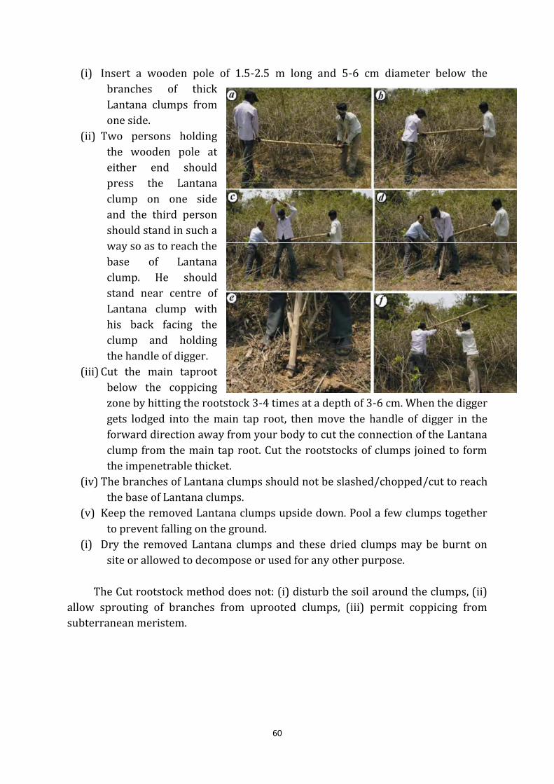
60
(i) Insert a wooden pole of 1.5-2.5 m long and 5-6 cm diameter below the
branches of thick
Lantana clumps from
one side.
(ii) Two persons holding
the wooden pole at
either end should
press the Lantana
clump on one side
and the third person
should stand in such a
way so as to reach the
base of Lantana
clump. He should
stand near centre of
Lantana clump with
his back facing the
clump and holding
the handle of digger.
(iii) Cut the main taproot
below the coppicing
zone by hitting the rootstock 3-4 times at a depth of 3-6 cm. When the digger
gets lodged into the main tap root, then move the handle of digger in the
forward direction away from your body to cut the connection of the Lantana
clump from the main tap root. Cut the rootstocks of clumps joined to form
the impenetrable thicket.
(iv) The branches of Lantana clumps should not be slashed/chopped/cut to reach
the base of Lantana clumps.
(v) Keep the removed Lantana clumps upside down. Pool a few clumps together
to prevent falling on the ground.
(i) Dry the removed Lantana clumps and these dried clumps may be burnt on
site or allowed to decompose or used for any other purpose.
The Cut rootstock method does not: (i) disturb the soil around the clumps, (ii)
allow sprouting of branches from uprooted clumps, (iii) permit coppicing from
subterranean meristem.
61
5.4.1.2 Planning of controlling Lantana in Project Area Landscape
(i) At a single site small areas of less than 50 ha should be taken to reomve it
completely but bigger plots may also be taken, while diving the area the area
into sub plots of lesser area for better management.
(ii) If the site is a hill and has slopes, removal of Lantana should be started from
hilltops, then slopes and then to the base of the hill or valley. If the site is a plain
area, find out the gradient using surface drainage channels and starts removal
of Lantana from the micro watershed and then proceed to the riverbed. If there
are perching trees, start removal of Lantana beneath the perching trees and
then remove from all along surface drainage channels and riverbeds.
(iii) The best season for Lantana removal is summer season but before monsoon,
when a Lantana clump bears no or few fruits but has mostly flowers.
(iv) After removal, the site should be restored to grassland by planting root slips of
native grasses and or broadcast of cow dung-soil (2:1) pellets containing seeds
of native grasses. In case if the area has to be restored to a forest, early
colonizers of woody species should be planted followed by late colonizers and
then underwood species.
(v) Uproot the seedlings of Lantana by hand after removing the clumps. Planting of
native clump forming palatable species mainly grasses. Grass slips are
immediately planted in the area from where the Lantana has been removed.
(vi) Some of the major grass species are Apluda mutica (Chadi), Chrysopogon fulvus
(Godiya), Dichanthium annulatum, Arundinella bengalensis (Naltura) etc. Other
grass species, which can be planted, are Veteveria zizanoides, Chloris barbata,
Cynodon dactylon, Hetropogon contortus, Eulaliopsis binata, Saccharum
spontaneum, Saccharum munja, and Sorghum helepens. Further there are some
legumes such as Desmodium tryfolium, Indegofera lenaefolea, Flamingia
bracteata, Crotoleria Spp., Desmodium gangitiam that can be very suitable for
such areas.
(vii) This is done to suppress the Lantana seedlings that germinate from the seeds
that may be lying on the forest floor. Lantana seeds are known to be viable for
more than 60 years.
(viii) Continuous surveillance should be carried out for Lantana where Lantana has
been eradicated and their removal by uprooting.
(ix) The area for lantana removal should be identified and demarked in advance.
Care should be taken to create vast stretch of eradication area, which has to be
developed into grassland to meet the growing demand of the herbivores.
Further, suitable condition should be created to encourage regeneration of
valuable species of Trees. Grasslands should be given top priority for
eradication of lantana and other unpalatable weeds every year. Before
commencement of work, the density of lantana/weeds should be ascertained
and the concerned Range Officer under the guidance of the respective SDOs
should prepare Site Specific Plan for final approval by DFO.
62
(x) The plot should be maintained at least for five years. The Divisional Forest
Officer may select areas under infestation by lantana every year based on the
basis of criterion mentioned above and keep such areas in Annual Plan of
Operation for working, while maintaining a register for monitoring of such
areas.
(xi) For management of Lantana in next ten years of plan period, it is proposed that
every year an area of 300-400 ha be taken in different ranges. The DFO can
decide, Area to be taken, based on the resources available and feasibility of
work. This may increase depending on availability of funds, but for maintaining
the quality of work to be carried out, it should be judiciously distributed in
different ranges by DFO.
(xii) A proper record keeping has to be done while doing removal of lantana/weed
preferably following format along with the compartment history;
Sl. No. Particular of the Area
Area
in Ha.
Years of Working
(Mention the year wise work on area in
Ha. and corresponding expenditure)
Range Block Compt GPS 1stYr 2ndYr 3rdYr 4thYr 5thYr
5.4.2 Reclamation of habitat by removal of weeds and other non-palatable
Species.
Extensive areas in the Project Area Landscape have been taken over by a dense
crop of weeds such as Lantana, Sida, and Adathoda and exotics such as Haplophragma
adenophyllum, reducing the extent of effective habitat available for wildlife. As
mentioned elsewhere in this document, the effective area of the Project Area Landscape
available for the wild animals is actually less than its notified area as extensive areas has
been occupied by weeds and other non-palatable native species. Therefore certain
species are required to be removed/ managed as per the general and specific
prescriptions below;
(i) The weeds should be uprooted from the designated plot.
(ii) The grazing should be totally banned in that area.
(iii) Other human activities are also suggested to be restricted in such areas.
(iv) The tourism activities shall not be carried out in such areas least for a year after
eradication.
5.4.2.1 Bansa (Adhatoda vasica)
Some naturally occurring unpalatable species such as Bansa have spread over
large areas of the Project Area Landscape and in some areas, the impact more than that
of Lantana infestation. Large areas have been taken over by Bansa in almost all ranges
of the Project Area Landscape and in places the density is so high that it effectively
63
reduces the habitat available for the wildlife. Area sunder this species can only be
reclaimed by physically uprooting the plants soon after the monsoon rains are over.
This is labour intensive as the plant is deep rooted, with a very strong root system.The
following must beconsidered for reclamation of Bansa infested areas in the Project Area
Landscape:
(i) The species should be removed by uprooting the whole plant.
(ii) Ideally, the plant should be uprooted in December, provided the winter
rains have softened the earth. However, if that is not possible, it should be
uprooted soon after the monsoon.
(iii) The site should be revisited for consecutive three years after treatment to
remove the seedlings that may have germinated from remnant seeds.
(iv) The treated area should be given vegetative cover by planting grass slips
and other useful shrubs to discourage Bansa from taking over it again.
(v) The Divisional Forest Officer may select areas under infestation by Bansa
every year based on its extent and keep such areas in Annual Plan of Operation
for working, while maintaining a register for monitoring of such areas.
5.4.2.2 Parthenium o r Gajar Ghaas
Parthenium is another species that has damaged the native grasslands and other
habitats of the Project Area Landscape. It is an annual weed that completely covers
some of the important grasslands of the Project Area Landscape during the monsoon,
there by damaging grasses and other native vegetation.
The weed dies off after the monsoon, but the landscape becomes bare and almost
devoid of any vegetative cover after this. The bestway to control this weed is to allow the
grasses and other native species to establish them by cutting parthenium as low as
possible just before it flowers. Apart from the severe impact on the growth of native
grass, herbs and shrubs,the spread of Parthenium is also likely to have a highly adverse
impact on ground living birds, amphibians and other smaller animals due to its nature
of forming a thick mat of vegetation on the forest floor.
Parthenium is spread all over the Project Area Landscape. The Divisional Forest
Officer may select areas under infestation by Parthenium every year based on its extent
and keep such areas in Annual Plan of Operation for working, while maintaining a
register for monitoring of such areas.
5.4.2.3 Banaar (Cassia tora)
Banar is one native species that has emerged as an important weed in the project
area of Wildlife Landscape. It rapidly takes over blank areas created by the removal of
weeds such as Lantana. Being a non-nodular leguminous plant, it does not fix nitrogen
in its roots and therefore, its growth only deprives the soil of its fertility. Its infestation is
quite severe in areas suffering from cattle grazing or rehabilitated sites. It results in the
64
suppression of native grasses and other vegetation, thereby causing widespread
deterioration of grassland as a habitat for deer and other herbivores. Thebest way to
control this weed is to allow the grasses and other native species to establish
themselves by cutting Casia tora from the base just before the plant begins to flower in
the month of August- September. The Divisional Forest Officer may select areas under
infestation by Banar every year based on its extent and keep such areas in Annual Plan
of Operation for working, while maintaining a register for monitoring of such areas.
5.4.2.4 Bala (Sida cordifolia)
Bala is other unpalatable native species, which is causing rapid deterioration of the
habitat in the Project Area Landscape. The spread of this species in many areas the
Project Area Landscape effectively suppresses the grasses and other native species that
are the main stay in terms of the food resources of the herbivores of the Project Area
Landscape. The best way to control this weed is to allow the grasses and other native
species to establish them by cutting it close to the ground just before it flowers and
seeds are formed.The Divisional Forest Officer may select areas under infestation by
Bala every year based on its extent and keep such areas in Annual Plan of Operation for
working, while maintaining a register for monitoring of such areas.
5.4.2.5 Bhang(Cannabis sativa)
The spread of this weed in some pockets of the Project Area Landscape is a cause
of concern for the department as it is not only unpalatable and thus of no use for the
wildlife but also attracts people for its misuse in remote areas of the Project Area
Landscape, posing a security concern also. The best way to control this weed is to allow
the grassesand other native species to establish them by uprooting the Bhang before
seed fall.The Divisional Forest Officer may select areas under infestation by Bhaang
every year based on its extent and keep such areas in Annual Plan of Operation for
working, while maintaining a register for monitoring of such areas.
5.4.2.6 Kala Bansa/Ban Tulsi (Pogostemon benghalens)
Kala Bansa ,or Ban Tulsi,is a native plant that is favoured by the bees, butterflies
and other insects but isof little use for the herbivorous wildlife of the Project Area
Landscape. It comes up gregariously, suppressing the other palatable herbs, shrubs, and
grasses. It is found that, the spread of Kala Bansa starts from altitudes, where Lantana
infestation stops, but in certain areas, Lantana and Kala Bansa spread side by side. this
plant just before it flowers must stop further spread of this species.The Divisional
Forest Officer may select areas under infestation by Kala Bansa every year based on its
extent and keep such areas in Annual Plan of Operation for working, while maintaining
a register for monitoring of such areas.
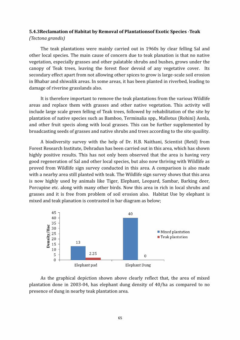
65
5.4.3Reclamation of Habitat by Removal of Plantationsof Exotic Species -Teak
(Tectona grandis)
The teak plantations were mainly carried out in 1960s by clear felling Sal and
other local species. The main cause of concern due to teak planation is that no native
vegetation, especially grasses and other palatable shrubs and bushes, grows under the
canopy of Teak trees, leaving the forest floor devoid of any vegetative cover. Its
secondary effect apart from not allowing other spices to grow is large-scale soil erosion
in Bhabar and shiwalik areas. In some areas, it has been planted in riverbed, leading to
damage of riverine grasslands also.
It is therefore important to remove the teak plantations from the various Wildlife
areas and replace them with grasses and other native vegetation. This activity will
include large scale green felling of Teak trees, followed by rehabilitation of the site by
plantation of native species such as Bamboo, Terminalia spp., Mallotus (Rohini) Aonla,
and other fruit specis along with local grasses. This can be further supplemented by
broadcasting seeds of grasses and native shrubs and trees according to the site quuility.
A biodiversity survey with the help of Dr. H.B. Naithani, Scientist (Retd) from
Forest Research Institute, Dehradun has been carried out in this area, which has shown
highly positive results. This has not only been observed that the area is having very
good regeneration of Sal and other local species, but also now thriving with Wildlife as
proved from Wildlife sign survey conducted in this area. A comparison is also made
with a nearby area still planted with teak. The Wildlife sign survey shows that this area
is now highly used by animals like Tiger, Elephant, Leopard, Sambar, Barking deer,
Porcupine etc. along with many other birds. Now this area in rich in local shrubs and
grasses and it is free from problem of soil erosion also. Habitat Use by elephant is
mixed and teak planation is contrasted in bar diagram as below;
As the graphical depiction shown above clearly reflect that, the area of mixed
plantation done in 2003-04, has elephant dung density of 40/ha as compared to no
presence of dung in nearby teak plantation area.
66
Further the changes in floral diversity that were found in study are briefed as
below;
(i) Eleven trees and a bamboo species making a total diversity of 1190 trees ha-1, in
which bamboo Dendrocalamus strictus (Lathi bans) (290 culms ha-1), exhibited
maximum density. Among trees Tectona grandis (250 trees ha-1) and Mallotus
philippensis (240 trees ha-1) have exhibited maximum density. The lower
density (10 trees ha-1) has been recorded respectively. Bridelia retusa (Ekdana),
Emblica officinalis (Anwala), Schleichera oleosa(Kusum), Cordia dichotoma
(Lasora) and Syzygium cuminii(Jamun).
(ii) Fifteen shrubby species have been recorded in this site with highest density for
Clerodendrum viscosum (5667 individuals ha-1), followed by Mallotus
philippensis (2444 individuals ha-1), Murraya koenigii (Karipatta) (211
individuals ha-1) and Tectona grandis (111 individuals ha-1). While minimum
density was reported by Ichnocarpus frutescens, Lantana camara, Casearia
graveolens and Casearia tomentosa (111 individuals ha-1 each).
(iii) Among grasses Chloris dolichostachya has shown highest (56000 individuals ha-
1), followed by Oplismenus composites (29000 individuals ha-1) and Cyrtococcum
patens (7000 individuals ha-1).
(iv) Twenty herb species have been recorded in the site with highest density of
Ageratum conyzoides(85000 individuals ha-1) followed by Ichnocarpus
frutescens(23000 individuals ha-1), Cissampelo spariera(16000 individuals ha-1),
Urena lobata(13000 individuals ha-1) and Rungia pectinata(12000 individuals
ha-1). While minimum represented by Pogostemon benghalensis, Schleichera
oleosa, Elephanto pusscaber, Barleria cristata, Vallarisso lanacea, Aerva
sanguinolenta, Sida cordata and Putranjiva roxburghii(1000 individuals ha-1
each).
(v) Two pterodophyte recorded are Adiantum incisum(15000 individuals ha-1) and
Ophioglossum vulgatum(5000 individuals ha-1).
(vi) Dominance and ecological success of a species is expressed as a single value in
terms of Importance Value Index (I.V.I). This index utilizes three parameters
viz., relative frequency, relative density and relative dominance or basal area.
High I.V.I of a species indicate its high regeneration capacity and greater
ecological amplitude. Among the species Tectona grandis showed highest I.V.I
(85.62), followed by Mallotus philippensis(54.04), Ehretia laevis(48.34) and
Dendrocalamus strictus(45.76). Minimum I.V.I (3.01) recorded by Syzygium
cumuni(Jamun).
(vii) Over all the density all trees in a ha-1 area is increased 1190 trees. While where
teak was not removed was 910 trees ha-1. Due to the removal of teak
vegetational changes have been found in this site. First introduced bamboo.
Dendrocalamus strictus(Lathi bans) has shown maximum density in the area,
which has been further reflected in presence of elephant signs.
(viii) The density of teak has been reduced upto (250 trees ha-1). The density of
Mallotus philippensis has increased from 140 trees ha-1 to 240 trees ha-1.
67
(ix) Under shrub the density of teak is also much reduced from 1333 to 111
individuals ha-1 and density of Clerodendrum viscosum is increased.
(x) Grasses those are very important to the herbivore, here after removal of teak the
density of all the grasses species has increased.
Presently, large area is under teak planation, which can be taken up in next ten years for
removal and replanting with local tree species and grasses. Certain areas, which are on riverbanks
and previously were grassland, should not be planted with tree species. Presently, most of the
Protected Area Managers and Foresters in country have an apprehension in removal of these
plantation due to supreme court order regarding “No removal of dead, diseased, dying or
wind fallen trees, drift wood and grasses etc. from any national park or game sanctuaries” in IA 548 under T.N. GODAVARMAN THIRUMULKPAD Vs UNION OF INDIA & ORS,
dated, 14.02.2000
But, the Supreme Court on 25-11-2005 has further clarified that the activities
that are carried out for habitat improvement are allowed. But, this should be carried out
after seeking a detailed/ comprehensive plan approved from Chief Wild Life Warden for
such removal and managing the habitat. Therefore all the areas with these plantations
should be divided in to plots of around 10-30 ha (for intensive management) and the
felling operation supplemented with following activities should be carried;
(i) Small plot size should be taken for intensive working and the monitoring.
(ii) The areas should be planted with the native tree species, Bamboos and grasses, if
needed.
(iii) In Sal areas, Sal should be allowed and assisted for natural regeneration.
(iv) The areas should be protected from fire.
(v) No grazing is allowed in such areas.
(vi) The tourism activities should also be restricted in the felling areas.
5.4.4 Habitat improvement by Plantations of native species
5.4.4.1 Bamboo Plantations
In past the bamboo forest used to flourish in project area Landscape, but after the
open areas felled with teak plantations and other suitable areas in weed eradication
sites be taken up for bamboo plantation and following procedure is being prescribed for
this activity;
(i) Bamboo plantation can be raised either by broadcasting seeds or by planting
seedlings raised innur series. Seedlings raised in nurseries do not survive well
in the wild due to grazing and uprooting by herbivores and elephants and
damage to the root system caused by porcupines and termites. Bamboo seeds
should be broadcasted soon after the pre-monsoons howers so that the seeds
can strike roots before the monsoon so that the heavy shower does not wash
the seed away. Exotic species of bamboo shall not be raised in the Project area
Landscape.
68
(ii) If seedlings raised in nurseries are to be used for plantations, the seedlings
must two to three years old before they are planted in the field so that the
plants have well sized rhizomes.
(iii) Bamboo plantations should be protected against forest fire and grazing.
(iv) Dense Lantana bushes can be used as a nurse crop for both planted bamboo
seedlings and for broadcast bamboo seeds.
(v) If necessary, temporary chain-link fencing/ or power fencing could be used for
protection of bamboo plantation.
5.4.4.2 Fodder and Fruit Trees
Leaves of fodder trees dropped by monkeys constitute an important food source
for Chital, Sambar, Barking Deer and other herbivores and some birds and bats.The
natural regeneration of fodder trees in the forest should be allowed and assisted,
supplemented with plantations of fodder spices in teak felled areas, weed eradicated areas
and other areas found suitable by divisional Forest Officer. Planting the seedlings in large
polythene gunny bags and maintaining them in nurseries for two to three years can raise tall seedlings
of fodder trees.The plants can also be planted deep inside Lantana bushes and the Lantana
should only be removed after the seedlings have established themselves.
Fruit trees should be raised in the Project Area Landscape by adopting the same
method prescribed for fodder trees. As a general principle each year during the plan
period at least 1000 fruit plant suitable for birds, herbivores and other animals etc.
should be planted.
5.4.5 Management of Grasslands
Project Area Landscape does not have very big grassland, but definitely there are
grasslands formed by deposition on riverbanks, which as very favourable habitats for
herbivores, especially elephants. Management requires restoring the diversity and
productivity of a degraded grassland by mean of active protection from over grazing,
fire & eradication of weeds.
However, there is immense scope for the creation and enrichment of grasslands in
most areas of the Project Area Landscape. Creation and enrichment of grasslands should
be taken upon banks along raus or in areas where the grassland has been damaged by
overgrazing or fire by planting grass slips. Further all areas with Lantana removal, weed
and teak removal should also be taken up for grassland developments.
The lowland grasslands of the Siwalik region are dominated by Saccharum
spontaneum and Veteveria zizanioides. Other important associated species in the region
are: Imperata cylindrica, Desmostachya bipinnata, Phragmites karka, Typha elephantine
Leucas cephalotes, Colebrokea oppositifolia, Cyperus kyllingia, Ziziphus mauritiana, Cassia
tora, Flemingia macrophylla, Bombax ceiba, Acacia catechu, Parthenium hirsute and
Argemone maxicana.
69
5.4.5.1 Riverbank Grassland
Saccharum spontaneum, Saccharum banglense and Imperata cylindrica community
primarily dominate grasslands along the flood plains of rivers and the streams draining
through the Project Area Landscape. Sacchraum spontaneum, Imperata cyclindrica and
Saccharum banglense associations dominate the grasslands. The waterlogged areas are
dominated by Typha elephantina and Phragmites karka species. There is a severe
problem of Lanatana camara invasion in these grasslands. So, adaptive management is
very important to protect these remnant patches of grasslands in the Project Area
Landscape. The ungulates species found are spotted deer, sambar, serow, hispid hare
and elephants. The floods, fire, harvesting and grazing are the natural phenomena,
which are maintaining the grasslands. In some areas there are pure dominant patches of
Imperata cylindrica, which are maintained predominantly by cattle grazing in some
areas. Therefore livestock grazing shall be totally prohibited in such grasslands.
At present, these grasslands have mostly vanished due to Teak Plantations and
infestation of weeds like Lantana, Parthenium, Casiatora etc. Further, deposition of sand
and boulders should not be disturbed by carrying out spur or other engineering
structures, as it will further hamper the natural succession of this riverine forests. On
contrary, plantations of local grass species should carry out a vegetative treatment of
these riverbank grasslands, after removal of teak and other weeds spreading in these
areas.
The grasslands found in Project Area Landscape and adjoining areas require
immediate attention. The grassland patches in area should be protected and there
should be a restoration plan for all the remnants patches in Project Area Landscape.
The grasslands in Macchali Van area are having signs of hispid hare, which is the
western most limit of this species.
5.4.5.2 Hill (Flat/Slope) Grasslands
There are natural depressions in hilltops in Nandhaur, Jhaulsal and Dogari and
Sharda , Kishanpur, Kilpura,Khatima and Surai ranges. These depressions have seasonal
water body which dries during peak summer seasons during months of April and May.
Saccharum narenga and Desmostachya bipinnata community characterize these water
bodies. There is an urgent need of maintaining the water in these grassland patches
during peak summer season by bringing gravity water from upstream areas. These
grasslands are unique feature of Bhabar and there should be minimum disturbance and
no concrete structure (waterhole/watch tower) shall be constructed near these
features.
These are the lifeline for ungulates species occupying the hilltops and bhabhar
tracts. There are extensive grasslands along the slopes of the Shiwalik formation and
70
they play an important role for the survival of Gorals, elephants and Sambar who make
intensive use of the grassland during different parts of the year. Further, there are many
fire lines having width even upto 100 feet on top of ridge act as very big grassland and
providing a very good habitat for herbivore species. The deterioration of hill grasslands
happens because offollowing reasons;
(i) Improper management of hill fire lines, which leads to invasion of woodland;
(ii) Preponderance of over- mature grass.
(iii) Repeated fire. Light winter burning and physical removal of woody growth is
prescribed for the management of hill grasslands.
Further, there are small patches of grasslands on the slopes and ridges, which are
dominated by Apludamutica, and Eulalopsis bippinata species. These are prime habitat
for Goral and Serow. Light burning before the fire season also helps in creation and
maintenance of hill grasslands but this must be done with precaution as fire can escape
and spread to large area in no time in hilly terrain. Further, all fire lines should be
cleared from woodland, as there is no prohibition of Hon’ Supreme court, as it has been
allowed by its order of 2005, already mentioned in this document.
5.4.6 Water Management
5.4.6.1 Introduction
Lower Himalyas in north and Bhabar foothills in south bind most of the area of
Project Area Landscape. Gola, Bhakda, Nandhaur, Jaulasal and Kalaunia are major
Rivers/ streams fulfilling most of the requirement of water for wild animals. There are
many other small rivers, which provide water during the monsoon, bur are dried up in
winter and summers. Many times, the general understanding is to create more and
more water sources in Wildlife areas for animals. However, at thesame time, it should
also be remembered that the water crisis is an important natural population control
measure in this fragile ecosystem.Creating more water sources, may lead to a typical behavior
in animal, whereby there movement is restricted in certain area and which further may lead to
steep rise in local increase in population. Under such modified habitats, of situation the animals are
most susceptible to any kind of disease outbreak.Many a times, developing new water sources
may involve some risk. As per basic principles enumerated in Manual of Wildlife
Techniques for India, edited by J.B. Sale and K. Berkmuller.,WII & FAO it may lead to
following negative impacts on natural ecosystem;
(i) Withdrawal of water, particularly ground water, may alter natural processes of
water cycling and lead to significant changes in ecosystems.
(ii) Water sources in the southern boundary of the sanctuary may bring domestic
stock into contact with wildlife, increasing the chance of disease transmission.
(iii) Excessive water development in arid zones can raise animal populations to levels
incompatible with food availability, leading to habitat degradation.
71
(iv) Endemic and rare plant species may be adversely affected, therefore avoid water
development in areas where these are present.
(v) Water development might trigger erosion on steep lands and fragile soils.
While the high temperature and extreme dryness in Shiwalik and Bhabar areas
during summer have resulted in very rich floral biodiversity in Project Area Landscape.
A scarcity of drinking water for the animals proves tobe an important factor for limiting
the population of wild animals. Where additional water is needed, it is often easier and
cheaper to facilitate access to natural sources, like, a high ground water table, a spring
emerging from a sheer rock face, or a source which is normally occupied by livestock,
than to install a totally artificial water supply.
Therefore, water availability should be just enough to sustain the animals and
retain them within the forest area. Depending on the conditions, water can be arranged
by adopting the following measures;
(i) Artificial water holes
(ii) Digging temporary ponds on the rau beds or diverting water to improve
biodiversity of palatable species.
(iii) Impounding water on rau beds by building weirs with removable barriers.
(iv) Fetching and filling water in waterholes
(v) Drawing water from permanent wells with the help of
solar pumps
5.4.6.2 Artificial Waterhole
Selection of site for the development of the water hole is one of the most
important decisions to be taken by the management. First of all it should not be near
river/ stream or any other water source. As per Manual of wildlife techniques for India,
edited by J.B. Sale and K. Berkmuller.,WII & FAO while deciding the site of an artificial
waterhole following criterion should be kept in mind;
(i) Sites should be chosen near habitat edges (ecotones) where species from
different habitats congregate.
(ii) The site should have shade trees and tall shrub or grass escape cover nearby.
(iii) Such sites will be avoided which are likely to be disturbed frequently, e.g. by
livestock, tourists or traffic.
(iv) Waterholes should look natural. It should be given an irregular shape and
slightly sloping edges. Locally available stone can be used.
(v) For the benefit of tourists, who are allowed to observe wildlife from a vehicle
track, the site should be laid far enough away, say 25 m, to prevent speeding
vehicles from scaring the animals.
72
(vi) For timid species, earth bank should be built between the track and water hole to
shield animals from approaching vehicles. Tourists can view animals by
peeping over the top of the bank.
(vii) The approach should be clear to avoid sudden encounters of the staffwith
animals, especially elephants.
5.4.6.4 Management of water holes
Following measures has to be taken for managing the existing waterholes.
(i) Location of water holes should be depicted clearly in the beat map.
(ii) Regular cleaning should be ensured.
(iii) Feeder channels, underground pipes should be maintained regularly.
(iv) Care should be taken to replenish water in the dry season.
(v) The embankment should be developed in such a manner that the animal should
get adequate cover while approaching the waterhole.
(vi) The water sample should be sending for pathological examination in the month
of November and April.
(vii) The water in the water hole should not stagnate.There should be a continuous
flow of water into and out of the waterhole.
(viii) Hides or watchtowers should not be built close to the waterholes because such
structures are liable to disturb the animals and create unnecessary stress apart
from the fact that the possibility of poachers taking advantage of such
structures to kill wild animals cannot be ruled out.
(ix) PIP should be laid down to monitor the number and type of wildlife using the
water source.
(x) If possible, camera traps (without flash) can be laid to monitor tigers.
(xi) Jungle trails leading to the waterhole should be checked for snares, gin traps,
poison baits etc.
(xii) Care must be taken to avoid removal of lantana or any other weeds close to the
water hole.
(xiii) Tourists’ vehicles should not be allowed to disturb wild animals particularly the
tigers at the waterholes.
73
5.5 General Prescriptions for Wildlife Habitat Management
Regulated lopping shall be allowed in Project Area Landscape.
Sal (Shorearobusta).
Semal (Bombaxceiba).
Tun (Cedrelatoona).
Kusum (Schleicheraoleosay.)
Sandan (Ougeiniadalbergioides).
Shisham (Dalbergiasissoo).
Bijasal (Pterocarpusmarsupium).
Amaltas (Cassia fistula).
Khair (Acacia catechu).
Sain (Terminaliatomentosa).
Bahera (Terminaliabelerica).
Harra (Terminaliachebuta).
Bakli (AnogeissusIatifolia).
Jamun (Sygygiumcuminii).
Dhauri (Lagerstroemia parviflora).
Haldu (Adina cordifolia).
Tendu (Diospyrostomentosa).
Bhillour (Trewianudiflora].
Rohini (Mallotusphilippinensis).
Bargad (Ficusbengalcnsis).
Pilkhan (Ficusinfectoria).
Pipal (Ficusreligiosa).
Khabar (Ficuscordifolia).
Genthi (Boehmeriarugulosa).
Bans (Dendrocalamusstrictus).
(i) Very limited planting activities may be taken up to meet needs of wildlife. Under
no circumstances exotic species are to be taken up for planting in any area.
Habitat enrichment plantation of species such as bamboo, Ficus, narkul, patera
and other local species etc. shall be taken up in patches on priority basis.
74
(ii) The existence of extensive bamboo forests in most parts of this Landscape used
to be the all-important factor in making these forests an ideal habitat for
elephants and other animals. Recovery of bamboo groves in this Landscape is
important for the overall wellbeing of the Project Area Landscape.
(iii) As per the provisions of section 29 of the Wild Life (Protection) Act, 1972, ‘No
person shall destroy, exploit or remove any Wildlife including forest produce
from a Sanctuary or destroy or damage or divert the habitat of any wild animal
by any Act whatsoever or divert, stop or enhance the flow of water into or
outside the Sanctuary’. Though under section 33(d) of the Act, Chief Wild Life
Warden may allow livestock grazing in Sanctaury for management, but as per
theorder of Supreme court order In I.A. 548 in W.P.(C) No.202/1995 under
T.N. Godavarman Thirumulkpad Vs. Union of India & others, dated,
14.02.2000 the Hon’ble Supreme Court restrained all the states from ordering
the removal of dead, diseased, dying or wind-fallen trees, drift wood and
grasses etc. from any national park or game sanctuary. Therefore, these orders
shall be followed by managing the Wildlife habitat in Project Area Landscape.
75
Chapter-6
Forest and Wildlife Protection
6.1 Backgrounds and Summary of Threats to Wildlife
Project Area Landscape has a distinct wildlife conservation value due to its rich
biodiversity, spectacular faunal variety and impeccable track record of protection and
conservation. It is one of the very few habitats throughout the world where the royal
Bengal Tiger and the Asiatic Elephant are not only safe but are flourishing. On northern
& southern side habitations are interspersed with forest areas. Southern part usually
forms boundary with Villages and is most vulnerable area of this landscape. Large
number of medium& small streams pass through this area from north to south
providing passage for humans and wild animals both ways. It makes the area very
sensitive to illegal activities and animal conflict. Illegal hunting has been and continues
to be a great threat to the Wildlife of these areas. It is estimated that highly vulnerable
species like the tiger and elephant remain under considerable threat from poachers due
to the spiraling demand for their derivatives in the international market. In addition
communities based at the periphery occasionally indulge in hunting for the pot.
Wild carnivores such as tiger and leopard sometimes cause loss of human life
and property (e.g.cattle) along the periphery of the Project Area Landscape. But, in this
region, there are negligible cases where, villagers have retaliated by poisoning the
carcass.
The Project Area Landscape holds a Goth-Khatta population, which has been
traditionally using these areas since the last fifty to sixty years or so. Of late, their
population and the population of their domestic cattle have been constantly increasing.
Their activities are causing greater and greater stress on these sensitive areas and it is
increasingly being seen that wild mammals are less abundant in areas inhabited by
Goth-Khatta. Presently a situation has arrived where perhaps the tiger, elephant and the
Goth-Khatta can no longer coexist. It is of the highest concern that a relocation strategy
be implemented in order to facilitate the shifting of Goth-Khatta's from fringe areas to
other areas.
The southern boundary of Project Area Landscape is quite close to inter-state
boundary with Uttar Pradesh. Unique topography having steep peaks, valleys, and
gentle slopes of bhabhar& plains of terai make patrolling a very tough job. Further,
dense ground cover, which restricts visibility to very few meters during patrol and
healthy population of Tigers, leopards, elephants & other wild animals, makes it more
susceptible.
Given these serious threats, it is imperative to invest most urgently in
strengthening law enforcement in the region. This would involve supplementing the
76
existing law enforcement efforts in the site through adding adequate number of well-
quipped and well-staffed anti-poaching camps to secure this extremely rugged habitat,
training and equipping the staff, implementing more vigorous patrolling protocol and
developing systematic information network in the surrounding communities. It is also
critical to initiate some socio-economic studies to understand the status and
motivations of these communities. Armed with this knowledge, suitable community
engagement programmes need to be initiated which should be designed to specifically
address the issues raised by the community members towards providing alternatives to
such hunting practices.
A joint study carried out by Forest Department and WWF-India titled “Study on
Status of Tiger, Leopard and Prey in Nandhaur Valley-Baseline estimates from sub-
HimalyanNandhaur region of Uttarakhand India” also reports protection concern
and emphasizes following principles to be embodied in protection setup;
a. Infrastructural needs of Project Area Landscape terms of camp infrastructure,
staffing, training and patrolling capacity.
b. Distribution and coverage of anti-poaching patrolling by mapping the location of
existing camps and patrol routes. Trails used by Mann et al. (2013) for carrying
out occupancy surveys could be used for the purpose.
c. The potential of implementing SMART patrolling system in these areas, which
would include training the staff in GPS and map reading, patrol and patrolling
tactics, patrol planning, intelligence gathering, anti-poaching operation, use of
SMART patrolling tools, legislation and reporting on patrolling activities.
Further, National Wildlife Action Plan (2002-2016) as released on January 21, 2002
at the XXI meeting of the Indian Board for Wildlife envisages following action in this
regard;
a. Reorganise forest staff into viable units and arm them with sophisticated weapons
and other equipment to combat poaching and illicit trade effectively. This includes
better and faster communication facilities.
b. The forestry / wildlife personnel must have a status on par with the police in the
use of weapons and other equipment to enable them to combat poaching and illicit
trade effectively.
c. State / UTs to provide all needed training assistance in their respective forest and
wildlife circles for an effective disposal of wildlife related cases through special
courts and public prosecutors especially assigned for the purpose.
d. Provide for ‘Secret Funds’ to assist the state governments for intelligence
gathering in cases of illegal trade and seizures of wildlife species and their
products.
77
6.2 Threat Assessment: Offences related to Illicit felling, Poaching
and Encroachment etc.
6.2.1 Illicit Felling
Project Area Landscape are known for its richness w.r.t valuable species like Sal
(Shorea robusta) and Shisham(Dalbergia sissoo) since British period when scientific
forestry started in India. Further, after independence during the days of commercial
planation, which started during early 1960s, large areas of Haldwani Forest Division
came under monoculture of Teak (Tectona gradis). The forest that constitutes the
present day Project Area Landscape has always been vulnerable to illicit felling. All the
ranges of the Project Area Landscape are vulnerable to illicit felling.
6.2.2 Poaching
National Wildlife Action Plan (2002-2016) as released on January 21, 2002 at
the XXI meeting of the Indian Board for Wildlife has considered poaching as a serious
threat to Wildlife in India. In this regard, the Action Plan describes the situation as
below;
“Poaching and illegal trade in wild animals and plants and their parts and products
has emerged as one of the most serious threats to wildlife in the country. If not controlled
effectively, it has the potential to substantially nullify achievements in other fields of
wildlife conservation. It may even result in extinction of some plants and animals and
substantial decline in the wild prey populations leading to crop raiding by wild ungulates,
increased incidences of livestock predation and sometimes loss of human life by carnivores.
This has alienated the communities in several locations and they tend to resort to revenge
killings and sometimes connive with poachers. Man-animal conflict situations require
urgent amelioration to avoid these becoming a source of retaliatory action against the
animals in question by the affected people, and later foci of illegal trade in animals parts
and products. This trend has to be reversed. Although some efforts have been made for
better coordination between wildlife managers and law and order enforcement agencies,
yet prevention of wildlife crime remains a priority area in wildlife conservation and
related law enforcement.
India, a signatory to CITES, is obliged to take all necessary steps to implement the
provisions of the treaty to ban international commercial trade in Appendix-I species of
plants and animals and regulate trade in Appendix-II and III species.
Requisite information and database on wildlife offences is scanty. Resultantly, there
is little scope to devise suitable strategies to combat it effectively. Wildlife crime detection
and follow-up is conducted in an ad hoc manner by most enforcement agencies due to lack
of investigation skills and infrastructure.
78
Large number of court cases dealing with wildlife crime continue to remain
pending over long periods. Even the cases that get decided do little to deter offenders, as
punishment awarded is often meager. Slow rate of conviction in court proceedings leads to
the accused getting easy exemption from appearances, thus prolonging the evidence stage.
Insufficient or badly presented evidence often coupled with non-availability of witnesses,
frivolous appeals and interim orders stall most cases at trial courts. There is urgent need
to provide adequate professional skills in prosecution matters related to wildlife offences
for the frontline staff.
Wildlife forensics as a science and tool for wildlife crime prevention and control
needs to be fostered.
Commercially valuable animals and plants are more vulnerable to poaching and
smuggling. Some examples are poaching of tiger, elephant, leopard, rhino, bear, musk
deer, snakes, turtles and their eggs, monitor lizards, mongoose, jackals, pangolins, otters,
several fish and marine invertebrates, butterflies, birds like pheasants, EdiblenestSwiftlet
and plants like orchids.
Some regions, specially international borders of India are vulnerable to illegal
trade in wildlife. Lucrative prices offered for wild animal skins, bones, ivory, musk, bear
bile and other wildlife products as well as endangered species of butterfly, birds and plant
products has significantly enhanced the pecuniary gains of illegal trade. This has led to the
growth of a large number of mafia like operations, which the present staff and
infrastructure find difficult to counter. The Judiciary and the Police also do not have the
desired sensitivity to appreciate the need for timely apprehension and disposal of cases
relating to wildlife offences. A number of such cases pending in courts remain untried for
several years. The Subramanian Committee and the High Court Committee have made
certain relevant recommendations in this regard, and efforts are on at the centre and state
to implement these. Media has of late started taking welcome interest in wildlife issues for
a well-researched and responsible coverage.”
Considering above-mentioned aspects, Poaching of wildlife is a major threat in the
Project Area Landscape. As a forest division, the area was mainly managed on the
principles of a territorial forest division. This area could never get an attention w.r.t
Wildlife protection, which got further aggravated by inaccessible conditions, less staff
and resources for enforcement. More recently, cases of illegal tiger poaching by
organized poaching gangs has come to the light (Mann et al. 2013), which poses a very
serious threat to this small and relatively isolated population, particularly given its
proximity to the porous Nepal border.
6.2.3 Encroachment
Project Area Landscape are very much prone to encroachment problem. As far as
Wildlife area is concerned, a proper survey and demarcation exercise should be
completed in couple of years with the help of modern equipment like GPS, Total Station
etc. and boundary pillars should be erected on boundary of sanctuary as well division.
79
Elephant proof wall constructed on boundary of Division i.e. Reserve Forest and
Revenue land is very helpful in protecting crop and human life from wild animals on one
hand and protection of forest areas from encroachment and accidental killing of animals
on other hand, when they stray out in agricultural field.
6.2.4 Illicit Fishing
The whole stretch in upstream of Gola River is vulnerable for illicit fishing. As the
rivers are famous for Mahaseer fish, it has been a challenge to conserve this fish. Though
there were not much illicit fishing reported from the area, but the extensive
watercourse is a potential rout for poachers to sneak in to reserve. Regular patrolling,
Continuous monitoring and non-disturbance with pools in river, is the only and best
way to protect the Mahasheer in river.
6.3 Strategies and Development of Protection Infrastructure
A good network of forest roads, bridle paths, fire-lines, anti- poaching camps,
Chowkies, watch towers, and vehicles plays an important role in management and
protection of a Protected Area against threats such as poaching, forest fires and
encroachment. Project Area Landscape had a good network of fire-lines,forest roads and
bridle paths due extensive working in forests, even when, most of the terrain
undulating, but it was not maintained in past. Therefore, this further requires some
improvement, maintenance, and extension. Similarly, there are Forest Chowkies and
anti-poaching camps, which require further strengthening to facilitate the safe stay of
staff deep in side the forest when they go on long- distance patrolling. National Tiger
Conservation Authority vide its F.No. 15-31/2012-NTCA has issued comprehensive
guidelines for tiger conservation and tourism as provided under section 38 O(1) (c)
of Wild Life (Protection) Act, 1972, whereby in para 7.1, it has mentioned certain
managerial interventions for Consolidating and strengthening the “source”
population of tiger and its prey in tiger reserves, protected areas and tiger
bearing forests as follows;
(i) Protection, anti poaching operations and intelligence networking;
(ii) Strengthening of infrastructure within tiger reserves;
(iii) Creation of inviolate space through relocation;
(iv) Capacity building of frontline staff, local people and officers and strengthening of
training centres and training in related fields, including enforcement,
intelligence networking, tourism activities, etc.
Further, measures to be taken for improvement, maintenance, and extension of
the infrastructural support against forest and wildlife offences are described as below;
6.3.1 Development of Network of Chowkies and Anti Poaching Camps (APC)
Forest Management in Project Area Landscape, started way back during British
period. The main activity was to manage these forests on principles of exploitation
mainly for commercial use. The spread and location of Forest Chowkies and forest
80
camps is mainly concentrated on exit points on southern periphery, on forest
roadsides on main routes and northern periphery near villages. These chowkies and
camps are not sufficient, in present context of protection and management of forest on
the basis of principles of Wildlife protection.
In addition to Anti Poaching Camps, small machanscan also be built for shelter
during the night and when planninganambush. Further, to regulate tourism and entry of
people in Sanctuary area barrier/ Chowkies at various ranges of Nainital, Tarai East,
Tarai Central and Ramnagar Forest Division has been proposed.
6.3.2 Forest Roads and Bridle paths
Project Area Landscape had very good network of forest roads, since beginning of
scientific forest management. These roads were main mode of communition for forest
managers. On the other hand, these roads played a very important role in extraction of
timber. Further, the forest roads in various Forest Division are still the only mode of
communication for many villages on northern and southern periphery.
After, 1980s when the extraction of timber reduced, many other forest roads as
mentioned below, were left abandoned as far as their maintenance is concerned on
account of lack of fund availability. But, these forest roads were always important for
management and protection of forest and Wildlife. Now, when the status of the area has
been enhanced to next level of protection, these forest roads and bridle paths becomes
more important. As per my experience as Divisional Forest Officer for three years
(2002-2005) and presently as Conservator of Forests, Western Circle, thinking of
Wildlife protection without regular maintenance of these forest roads mentioned below
is just not possible. These forest roads were quite suitable for plying car also, that is the
reason, major roads were also known as “Car Road” and some of the senior forest
officers, proudly mention that, they used to travel on these forest roads comfortably,
even 25 years before.
In present context, these roads are extremely important for rapid and safe
movement of staff inside the forest, both for patrolling and for access to remote areas to
fight forest fires, etc. The area has a wide network of roads connecting various points.
All these roads should be further strengthened by construction of Causeways, Retaining
wall, Breast wall, small bridges etc. A detailed survey of an Iron Bridge (or other
suitable technology) shall be carried out with the help of PWD/ CPWD/ BRO or any
other specialized agency and can be constructed on the basis of design approved by
Competent Authority.
6.3.2 Wireless Communication
Various Chowkies or stations in Project Area Landscape are also connected by a
wireless system and share a common network with Kumaon Zone of Uttarakhand
81
Forest Department. Fixed stations are presently established at Nainital, Tarai East, Tarai
Central and Ramnagar Forest Division.
As the handsets are not enough and all field staff personnel should have a wireless
handset. Wireless sets are also provided on all light-motor vehicles presently with the
Division. Further, new Chowkies, which are being proposed, shall preferably have base
station powered by solar energy. The wireless network has proved to be very important
communication link. However it is required to equip field staff to the level of forest-
guards with hand held sets and to provide each chowki/barrier with fixed sets to
optimize efficiency.
6.3.3 Vehicles
Motor vehicles and motor cycles play an important role in protecting the
Project Area Landscape against poaching, illicit felling and other forest offences. All
vehicles must be maintained in good condition. Considering the terrain and the
distances involved, the number of vehicles presently available is just not adequate. New
four Wheel Drive vehicles need to be provided at each range headquarters to maximize
the effectiveness of field staff.
6.4 Patrolling Plan
Project Area Landscape being very vulnerable because of above factors, it has to
be eye watched with regular and intense patrolling. Frontline staff should undergo
daily, weekly and long range patrolling. For effective and intense patrolling following
patrol formats are currently being proposed;
6.4.1 Patrolling levels
1) Beat patrol plan
(i) Sensitive zone have to be identified in every beat. Grasslands, streams, approach
roads –batias, villages in vicinity & their past record, presence of water
bodies, presence of tiger–leopards & their prey base, presence of other major
fauna and status of man-animal conflict are some of the points to be
considered while deciding sensitive zones.
(ii) 4-6 patrol routes are designed based on above information.Routes should cover
important streams, chaurs, ridges, saddles, batias, fire lines, waterholes and
conflict prone areas etc.
(iii) Patrol units should be formed consisting Beat Forest guard as leader & 2-3 local
staff. This party will scan the identified routes.
(iv) Patrol party attempts to cover each route in a full week.
(v) Track logs of patrolling should be recorded with help of GPS. A field book will be
maintained to keep record of all-important activities/sightings.
82
2) Range level and Special Patrol
Festival like Holi, Deepawali, Christmas & New Year and period before monsoon
& after monsoon is very sensitive from poaching point of view, so special attention is
required during these days. Range level and Special Patrol is being proposed to counter
ill- intentions of the poachers in the area.
(i) It shall be conducted during Range level and specially on festivals of Holi,
Deepawali, Christmas, New Year and before & after monsoon.
(ii) Range officer will monitor day-to-day activity of this patrolling. Dy Ranger or
senior forester will lead the patrol.
(iii) Special Patrols in Project Area Landscape, which is mainly infested with poacher
community problem, has to be conducted. This area has to be thoroughly
scanned by a group of 15-20 armed staff regularly so that a fear of presence is
developed in the mind of these intruders. This has to be continued for 3-4 years,
till the network of forest roads, bridle paths and chowkies is established in the
area.
(iv) Track logs of patrolling should be recorded with help of GPS. A field book will be
maintained to keep record of all-important activities/sightings.
3) Long Range Patrol
(i) It will be conducted once in a month in each sub division. Depending upon the
requirement & expense of division, it can extend covering whole division in a
single patrol.
(ii) Party will consist of 6-7 members, Dy ranger /forester leads the party. They shall
be equipped with firearms, wireless, GPS, torch, camera etc.
(iii) Party will be briefed by SDO/RO before moving. Objectives, topography,
resources, possible routes, course of action and other important aspects will be
covered in the briefing.
(iv) Patrol party will cover deep, in-accessible core areas during patrol and stay
inside the forest area for 5 to 6 days.
(v) 70-80 kms of interior forest area will be thoroughly scanned during patrol.
(vi) Track logs of patrolling should be recorded with help of GPS. A field book will be
maintained to keep record of all important activities/sightings.
4) Inter Division Patrol
(i) It shall be carried out along the boundary of adjoining divisions & states,
whatever applicable.
83
(ii) Division level, Range level & beat level coordination established with adjoining
divisions, ranges & beats. RO’s lead the efforts in field and division level
coordination is done by DFO/SDO.
(iii) Conducted specially during sensitive months of the year.
(iv) Other preparations/actions are same as in other patrols
Patrolling is major activity for conservation/protection of forest & wildlife. The
staff spends most of their energy in patrolling. Regular and intense patrolling is done in
the same territory (beats) week after week making it quite monotonous. It drains them
physically & mentally. In spite of regular and intense patrolling, total & fool proof
scanning is not possible. Because of shiwalik topography, dense vegetative cover & less
porosity, one never knows which area is still unscanned.
GPS technology is now being used to help frontline staff in patrolling. This helps
in identifying details of the areas covered by a patrolling. Patrol Frequency, intensity
&duration and also information on unscanned areas, with help of GPS unit. Proper and
effective scanning can be done in larger areas with lesser physical activity. For those,
who are interested in technology, it makes patrolling a bit interesting too. Several field
staff & daily wagers workers have learnt its use. Following are the benefits of using GPS
in patrolling –
(i) Authentic record/documentation of scanning exercise is available.
(ii) Provides guidance to demarcate next petrol route, if main stations are pre-
recorded.
(iii) If 3-4 patrol sessions of a beat can be merged, left over area can easily be seen in
combined merged map.
(iv) It is a good monitoring tool. Distance-travelled, routes followed, area covered,
speed, date & time etc. This Information gives wildlife managers’ a good
monitoring tool.
Limited device memory & accuracy level are some of the limitations of GPS. Use of
Google earth helps to some extent here. Track logs are viewed in a map having
topographic/geographic details. We know the topographic view of patrol tracks and
topography the un scanned area. We get 3D ground and Arial views. This further helps
in planning next patrol route. 3D GIS MAPS, Compatible with GPS unit & software, will
help this exercise further.
6.4.2 Patrol Mechanism
1) Basic requirements
(i) Field staff shall be properly equipped with proper field gear such as GPS,
cameras, Tents, torch, water bottles, solar lights and all other important
equipment.
84
(ii) Field staff trained in use of GPS, recording stations, saving & deleting track logs
of patrol and trip computer reading.
(iii) Briefing at start and debriefing in end.
(iv) Track logs of patrol recorded, important stations/sightings /events recorded as
waypoints. Field book recording shall be done.
(v) After each patrol, GPS units & field book is collected at SDO Office and data
downloaded with help of map source.
2) Processing of data
(i) Waypoint Nos. is given Names, waypoints are categorized, and track logs/active
logs are renamed and merged.
(ii) Merging data of all beats forms range master copy of each patrol.
(iii) Track logs viewed in Google Earth to view the topography of patrol operation.
(iv) Information is than used to identify area, which is left, and topography of that
area. Future patrol routes are designed accordingly.
6.4.3 Review of patrolling data
1) In patrolling
After each major patrolling exercise, processed maps of patrol tracks are shown to
staff concerned. Scanned and un scanned area of each beat is viewed and discussed with
them. It helps in understanding the process. They are encouraged to create a new track
log in still to be scanned area during next patrol. Process makes it interesting and gives
proper results. New track logs are being recorded with every patrolling exercise.
2) In monitoring
At managerial level, we can easily assess the level, frequency, intensity and
seriousness of patrolling exercise. Further, we can easily identify the un-scanned area
with help of software. This helps in designing new patrol routes.
3) In Animal Occupancy and movement pattern
During each patrol, staff records animal sightings and their indirect signs of
occupancy. Software’s provide categorization of waypoints recorded. With this feature
we can easily track periodic movement, presence & absence of
tigers/leopards/elephants/bears etc. in a particular area. Recording fire lines & water
bodies during patrolling helps in fire management planning.
85
6.5 Forest Fire Protection
Project Area Landscape is highly vulnerable to forest fires. It’s tough, undulating
terrain further makes it more difficult to control and manage forest fire. The difficult
terrain formed of highly undulating hills and deep valleys. It remains a great challenge
to control fire in such areas. Grasslands remain highly vulnerable for forest fire along
with Sal forest (fire season coincides with leaf fall of Sal). Exposed northern and
southern boundaries remain vulnerable from intentional fire caused by villagers. Scanty
to no rainfall during the long dry spell in the summer season in particular year add to
vulnerability of forest. Sometimes, cooperation from the locals is also not adequate.
Most of the times there are budget constraint to prevent and mitigate forest Fire.
6.5.1 Strategy for fire protection
Summer fire in the Project Area Landscape is of common occurrence, which
restricts in the boundary of the core areas. Due to extreme hilly terrain, the forest fire,
aided by high winds during summer, spreads very swiftly sweeping large areas in very
short time.
For mitigation of adverse impact of un-controlled forest fire, numbers of
precautionary measures were taken successfully. Based on the past management
practices the following line of action with an objective of reducing the probability and
impact of such forest fires in Division area is recommended;
(i) A detailed 'Fire Protection Plan' should be prepared annually taking into the
account of the previous year’s shortcomings and should be approved by the
relevant authority.
(ii) Using fire watchtowers, Forest staff and villagers, should ensure timely detection
of forest fire. A fire reporting telephone number should be arranged and the
number should be made public so that people can inform about fire incidents.
(iii) A centralized fire control room should be set up under the direct supervision of
the respective SDOs.
(iv) Adequate number of fire-watchers (two watchers per Forest Guard) will be
maintained during the fire season from 15th of February till the break of
monsoon. There should be additional provision of extra fire watches in the
event of serious dry spell.
(v) All fire lines shall be cleared every year.
(vi) Roads used by public as well as tourists will be regularly cleaned to remove
inflammable material.
(vii) Floating crew centres should be established according to the prescription of the
forest fire sensitivity study. A Forester & 5 to 6 other members equipped with
86
fire fighting equipment’s should manage a crew station. The number of crew
stations should remain flexible to facilitate maximum utilization during the fire
season. These crew stations should be under direct supervision of the
respective Range Officers.
(viii) Wireless network should remain operational round the clock to facilitate
exchange of information from field to headquarters & vice-versa. Fire
watchtowers should be regularly maintained.
Identification and categorization of fire prone area like Ultra sensitive, Very
sensitive and Sensitive has to be carried out annually. This parameter of sensitiveness
has a tendency to change from time to time. Proper ground-truthing has to be carried
out annually which has to be incorporated in the fire protection plan.
Further, All existing fire lines shall be cleared from inflammable material along
with grass as well as any herbaceous growth. Burning of these fire lines has to be done
once during the winter and again after the leaf fall (about the end of March) under very
controlled conditions. Presently, most of the Protected Area Managers and foresters in country
have an apprehension in removal of leaf litter and clearing of fire lines for forest fire
protection, due to supreme court order, which provides for “No removal of dead,
diseased, dying or wind fallen trees, drift wood and grasses etc. from any national park or
game sanctuaries” in IA 548 under T.N. GODAVARMAN THIRUMULKPAD Vs UNION OF
INDIA & ORS, dated, 14.02.2000
But further the Supreme Court on 25-11-2005 has clarified that the activities that
are carried out for habitat improvement are allowed. Presently, all forest fire lines with
different widths are not maintained and cleared properly.
6.5.2 Legal Enforcement
Unlike the other forest offences the forest fire is not taken very seriously in
department and the offenders are seldom arrested. Even if offender is caught the
offence is compounded. The matter related to fire should be pursued in the courts as
per the legal provisions.
Central as well as State Governments, have made several legislations to
control and manage fires in forest areas. Section 26 (1), Sec.79 of Indian Forest Act
1927, Section 30 of the Wildlife (Protection) Act 1972 and Sec. 435 of Indian Penal Code
1860 etc. have relevant provisions to control and protect the forests from fire and
provide severe punishments to fire offenders.
6.5.3 Annual Fire Plan
The fire season starts with 15th February and ends with advent of monsoon. Forest
fire management works starts from November/December to prevent occurrence of fire
in the summer season. It is a common knowledge that forest fire is induced by
87
anthropogenic interferences. Sometimes it is intentional and at times accidental. Some
of the common sources of fire in Project Area Landscape are listed below:
(i) Fire spreading from adjoining forest areas or agricultural fields.
(ii) Deliberate fires to promote growth of grass for illegal grazing.
(iii) To avenge the punitive action taken by forest staff.
(iv) Fires caused by negligence on the part of illegal entrants in to the forest araes for
collecting fire wood or grass or even defecating.
(v) Illegal honey collectors set sometimes Fire.
(vi) There are certain religious places in areas mentioned elsewhere in plan
document. There are all possibilities that, the visitor may set on forest fire due
to negligence. During some religious ceremonies held in these places or
nearby villages, close to the Project Area Landscape may also lead to forest fire.
(vii) Fires may also start by negligently thrown cigarette butts/beedis on the forest
roads and nearby highways.
Though no major fire incidents has been occurred due to extremely cautious field
staff and rigorous implementation of the 'fire plan'. The best practice to save forest from
fire is the identification of causes followed by meticulous planning of prevention and
remedial measures to be taken in case of forest fire breaks out. While the detail about
the management of forest fire has been given in the annual 'comprehensive fire plan',
while incorporating following issues;
(i) Objective of management and control of forest fires.
(ii) Comprehensive report on the incidences of fire in the previous season.
(iii) Identification and listing of fire-sensitive zones based on analysis of previous
incidences of fire.
(iv) List of lesson(s) learnt from a detailed analysis of the comprehensive report. The
analysis should consider points such as the following:
a. Causes of forest fire.
b. Comments on the prevailing conditions in the forest that promoted the
spread of the fire.
c. Assessment of the effectiveness of preventive and protection measures,
and problems encountered by the field staff in controlling the forest
fire.
(v) Proposals for the number and locations of fire crew stations and the command
area of each crew station.
(vi) Detailed instructions for fire management and control for the next fire season.
(vii) Budget requirement for implementation of the Fire Management Plan.
88
6.6 Additional Guidelines for strengthening Protection setup and
overall infrastructure
6.6.1 Development of Informer Network
During past three decades the Poaching has become a well-organized activity and
there are certain groups/ people who involve in such actitivities have also developed
new techniques. They have also developed a very secretive network at the same time.
Therefore, development of informer network is equally important to protection of any
Wildlife rich area. National Tiger Conservation Authority has has also emphasized the
importance of this aspect under Generic guidelines for preparation of Security Plan
issued in 2009. A careful selection should be done for posting of personnel in the
sensitive areas of the PA as these are the persons on whom the mantle of security of
such areas vests. They will also inspire confidence in people who want to provide
information.
The motivation of persons providing intelligence information could be varied and
needs to be treated accordingly. Usually, such persons respond best to contact with one
person. This sometimes becomes a challenge in our systems where length of an
individual’s tenure at a station may be limited. Sometimes the person providing the
information chooses to remain anonymous and establishes contact on his own choice
randomly. On several occasions such anonymous tip offs can be extremely valuable.
Also, persons with a past history of indulging in poaching can also be motivated to turn
informers. In order to receive good information, the following must be ensured;
(i) The address/ Telephone contact numbers on which such information can be
provided must be widely publicised and monitored regularly. This should be
regularly verified by random checks by senior officers.
(ii) All information received must be screened and acted upon without delay.
(iii) Identity of the informer must be concealed if so desired by him.
(iv) Resources must be available readily to buy the information/ provide reward
whenever required.
(v) A covert watch should be kept on the activities of known poachers and their key
accomplices. If found missing from their normal place of residence, an alarm
should be raised.
(vi) Local Liquor vendors and individuals supplying homemade liquor in villages and
fringe settlements should be monitored regularly.
(vii) Outlets for pesticide sales need to be monitored periodically.
(viii) For any kind of undercover operations, disbursement of advances must be
generally discouraged as it has the potential to actually encourage poaching in
certain situations.
(ix) Individuals and NGOs running undercover operations in and around a TR should
89
be encouraged to keep atleast one link in the official enforcement hierarchy
broadly informed of their role.
(x) Such NGOs also, have to be monitored because many times give advances to
villagers or individuals, which rather has the potential to actually encourage
poaching. Such activities are basically “abetment”, which is treated as offence
under the provisions of the Wild Life (Protection) Act, 1972. Legal action must
be taken against such NGOs under Act.
(xi) Information from intelligence sources must be regularly checked, cross checked
and ultimately acted upon within reasonable time, to have any meaningful
impact.
6.6.2 Establishing a Criminal Profile Directory
At division level recods must be maintained w.r.t persons with a history of
poaching and/or wildlife trade in their locality. This will include details about physical
appearance, identification marks/signs, employment, family, key associates, criminal
history, convictions if any, pending cases etc. Sudden and long absences of such persons
from their normal place of stay must be investigated. Sudden acquisition of movable and
immovable assets must also be investigated for possible sources of such transactions.
Photographic dossiers can be very useful in investigation. Maintenance of crime
dossiers at the State level is very important. These dossiers can be collated with other
states on a need base. As various areas is located near international borders, such
dossiers should have information about poachers from both sides of the border who are
known to be active in the area. In every case, the link of old crime to new offenders and
old offenders to new crime should be regularly analysed.
Further, Wild Life Crime Control Beuro (WCCB) has also developed a database of
wildlife offender, which should be accessed to see the potential offenders. The Profile
Directory at division level should be shared with Chief wild Life Warden and Wild Life
Crime Control Beuro (WCCB).
6.6.3 Maintenance of Firearms
Several Protected Areas provide official weapons such as rifles, double barrel
guns, pistols and revolvers to field staff for discharge of their official duties in the
protection of forests and wildlife. In many states, the use of such firearms is codified,
clearly laying down conditions of use of such arms while in many other states; the use of
such arms is under the general umbrella of “self defence”. In Project Area Landscape
the firearms shall be procured and supplied to the level of Forest Guards.
In the forest, cartridges are perishable commodities as they are exposed to the
elements of nature all the time. As such, they must not be stored for long but should be
fired occasionally to test the working conditions of the guns. All weapons in the field
must be well oiled and cleaned regularly. Gun oil and cleaning rods etc. should be made
available at all Patrolling Camps. Divisional Forest Officer and Sub-Divisional Forest
90
Officers must make it a point to check the general state of weapons with their field staff
while on tour. Further, following guidelines must be followed w.r.t maintenance of
firearms;
(i) All field staff should be made to undergo firing practice atleast once a year at a
regular firing range. Such an exercise can be easily carried out with support of
the local police or Army unit to examine the general state of being of the
weaponry.
(ii) All weapons should also be test-fired atleast once or twice a year.
(iii) All official firearms must be issued to well recognise entities, i.e. at any point of
time it should be possible to ascertain the person who is in custody of a
particular weapon.
(iv) Cartridges issued should be accounted for and empties returned to store.
(v) A single firearm must never be carried in the field, as it is liable to be targeted by
miscreants. Guns are best sent out atleast in pairs.
(vi) While walking, guns should be carried with the barrel pointing skywards or
down and never at chest level pointing ahead or backwards. Improper
handeling of gun could lead to the butt being damaged or dirt, water etc.
entering the barrel and damaging it.
(vii) In humid areas, it is advisable to plug the mouth of the barrel with a piece of
cotton or cloth.
6.6.4 Media Management
Wildlife crimes attract a lot of media attention. If not handled properly, forest
authorities often face undue criticism. Efforts should be made to provide fair and
accurate information to the media, without any attempt to hide or distort facts. A
statement/press release should be made available, giving details of the incident for
providing information to the media and public. If considered necessary, a Press
Conference may also be organised. Only the authorised officer should talk to the media
and sweeping statements should be avoided. The Media personnel, generally, shall not
be taken into forest while taking into account other operational exigencies. Further,
media is also performing its role in reporting such instances and if they are not
provided the information, they may resort to reporting unverified and inaccurate
versions of the incident, which can do greater damage.
6.6.5 General Guidelines
These activities/ works or guidelines mentioned below, shall be maintained for
whole plan period, therefore no specific schedule of operation is given here. Further, It
shall be decided by Divisional Forest Officer that which activity/ work is necessary for
management of project area and such activities shall be made part of Annual Plan of
Operation or may be demanded on the basis of requirements and urgency.
91
(i) Deployment of antipoaching squads.
(ii) Establishing and maintenance of existing patrolling camps/chowkiesand
deployment of camp labourers for patrolling.
(iii) Organising vehicular patrolling by constituting squads, comprising of field staff,
labourers and police or ex-army personnel or homeguards etc. with wireless
handset and paraphernalia for apprehending offenders, apart from prescribing a
patrolling calendar for the squad.
(iv) Establishing and maintenance of wireless network.
(v) Organising surprise raids jointly with the local police in railway stations, local
trains, bus stops, buses, catchers and taking special site-specific protection
measures during monsoon as ‘Operation Monsoon’ – considering the terrain and
accessibility of Protected Areas.
(vi) Deployment of ex-army personnel and home guards.
(vii) Close coordination with Police and other enforcement agencies like
ShashatraSeemaBal (SSB), Border Security Force (BSF), Central Reserve
Protection Force (CRPF), Railway Protection Force (RPF), Indo- Tibetan Border
Police (ITBP) etc. for combating poaching and illegal trafficking.
(viii) Deployment of local work force for patrolling, surveillance of water holes,
manning barriers.
(ix) Procurement of arms and ammunition and Chemical and Physical capture
equipments.
(x) Procurement/maintenance of elephant squads. (At least two camps)
(xi) Rewards to informers.
(xii) Legal support for defending court cases.
(xiii) Procurement field gear, night vision device, binocular and other items for
patrolling and monitoring.
(xiv) Providing free ration to patrolling teams and frontline staff.
(xv) Civil Works (staff quarters, family hostels, office improvement, patrolling camp,
house keeping buildings).
(xvi) Maintenance, creation and up gradation of road network, bridges and bridle
paths as mentioned in this chapter.
(xvii) Maintenance and creation of wireless tower.
(xviii) Maintenance and creation of fire lines, firebreaks and fire watch tower.
(xix) Maintenance and creation of, small dams, anicuts, earthen ponds.
(xx) Procurement and maintenance of vehicles (Gypsy, Jeep, Truck, Tractor, All
Terrain Vehicle and Earth Mover Machines).
(xxi) Procurement of hardware, software / Geographical Information System (GIS),
satellite imageries, compass, Map digitization facility, range finder, Global
Positioning System
(xxii) Procurement of camera traps and other equipment for animal monitoring.
(xxiii) Monitoring system for Tigers’ Intensive Protection and Ecological Status such as
M-STrIPES or locally developed monitoring system and E-surveillance etc.
92
Chapter 7
Wildlife Monitoring, Research and Training
7.1 Wildlife Monitoring
There are many historical reference of faunal richness of this landscape bound
by the Gola-Nandhaur-Ladhya and Sharda rivers, which, presently is mainly dominated
by Wildlife Landscape. The various river valley, lying at the core of this landscape,
receives mention in several accounts for its plentiful game and fish. This hilly
bhabartract once supported significant populations of tigers and leopards owing to
plentiful prey such as sambar(Rus unicolor), chital (Axis axis) goral (Nemorhaedus goral)
and barking deer (Muntiacus muntjak). Besides these species the area is also reported to
harbor populations of threatened species like the Asian elephant (Elephas maximus), the
mainland serow (Capricornis thar), and the Asiatic black bear (Ursus thibetanus) and
Sloth Bear (IUCN, 2011). Alongside its mammalian fauna the region hosts a rich
diversity of bird species comprising of Himalayan endemics and vagrants from Nepal.
On account of the fact that main emphasis of forest department in this region
was mainly concentrated on scientific management of timber species and very less or
negligible importance had been given to Wildlife monitoring or estimation. In past,
following drawbacks have been observed w.r.t Wildlife monitoring/ Estimation;
i) No regular Wildlife monitoring, on account of the fact that main object of
management was floral diversity.
ii) Methods used in past, were not used with complete scientific process and
analysis.
iii) Staff was not fully technically equipped with monitoring techniques.
iv) As this area was not in category of a Protected Area, scientific institutions have
not given much research priorities. But still, this area has always supported a
viable and breeding and sustainable population of major species like Tiger,
Leopard, Elephant, Sambar and all other faunal species.
7.2 Proposals for Wildlife Monitoring and Estimation
As discussed in above paras Wildlife monitoring or estimation is a very important
aspect for management of a Protected Area. It becomes more relevant and important,
especially for a newly constituted Protected Area and the Landscape, where very less
data is available on this subject. On account of above facts, a three-stage/ layer
monitoring protocol is proposed for estimation of Wildlife in Nainital, Tarai East, Tarai
Central and Ramnagar Forest DivisionWildlife Landscape, which is mentioned as below;
(i) Protocol based on monitoring of tiger and other species under Daily/ Range
level/ Long term Patrols.
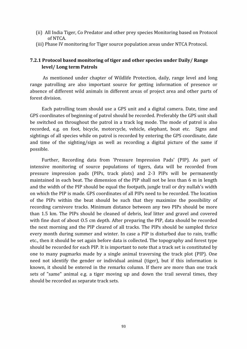
93
(ii) All India Tiger, Co Predator and other prey species Monitoring based on Protocol
of NTCA.
(iii) Phase IV monitoring for Tiger source population areas under NTCA Protocol.
7.2.1 Protocol based monitoring of tiger and other species under Daily/ Range
level/ Long term Patrols
As mentioned under chapter of Wildlife Protection, daily, range level and long
range patrolling are also important source for getting information of presence or
absence of different wild animals in different areas of project area and other parts of
forest division.
Each patrolling team should use a GPS unit and a digital camera. Date, time and
GPS coordinates of beginning of patrol should be recorded. Preferably the GPS unit shall
be switched on throughout the patrol in a track log mode. The mode of patrol is also
recorded, e.g. on foot, bicycle, motorcycle, vehicle, elephant, boat etc. Signs and
sightings of all species while on patrol is recorded by entering the GPS coordinate, date
and time of the sighting/sign as well as recording a digital picture of the same if
possible.
Further, Recording data from 'Pressure Impression Pads' (PIP). As part of
intensive monitoring of source populations of tigers, data will be recorded from
pressure impression pads (PIPs, track plots) and 2-3 PIPs will be permanently
maintained in each beat. The dimension of the PIP shall not be less than 6 m in length
and the width of the PIP should be equal the footpath, jungle trail or dry nullah's width
on which the PIP is made. GPS coordinates of all PIPs need to be recorded. The location
of the PIPs within the beat should be such that they maximize the possibility of
recording carnivore tracks. Minimum distance between any two PIPs should be more
than 1.5 km. The PIPs should be cleaned of debris, leaf litter and gravel and covered
with fine dust of about O.5 cm depth. After preparing the PIP, data should be recorded
the next morning and the PIP cleared of all tracks. The PIPs should be sampled thrice
every month during summer and winter. In case a PIP is disturbed due to rain, traffic
etc., then it should be set again before data is collected. The topography and forest type
should be recorded for each PIP. It is important to note that a track set is constituted by
one to many pugmarks made by a single animal traversing the track plot (PIP). One
need not identify the gender or individual animal (tiger), but if this information is
known, it should be entered in the remarks column. If there are more than one track
sets of "same" animal e.g. a tiger moving up and down the trail several times, they
should be recorded as separate track sets.
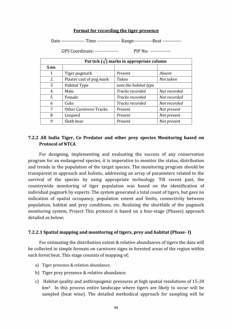
94
Format for recording the tiger presence
Date --------------- Time --------------- Range------------Beat ------------
GPS Coordinate: --------------- PIP No: -------------
Put tick (√) marks in appropriate column
S.no.
1 Tiger pugmark Present Absent
2 Plaster cast of pug mark Taken Not taken
3 Habitat Type note the habitat type
4 Male Tracks recorded Not recorded
5 Female Tracks recorded Not recorded
6 Cubs Tracks recorded Not recorded
7 Other Carnivore Tracks Present Not present
8 Leopard Present Not present
9 Sloth bear Present Not present
7.2.2 All India Tiger, Co Predator and other prey species Monitoring based on
Protocol of NTCA
For designing, implementing and evaluating the success of any conservation
program for an endangered species, it is imperative to monitor the status, distribution
and trends in the population of the target species. The monitoring program should be
transparent in approach and holistic, addressing an array of parameters related to the
survival of the species by using appropriate technology. Till recent past, the
countrywide monitoring of tiger population was based on the identification of
individual pugmark by experts. The system generated a total count of tigers, but gave no
indication of spatial occupancy, population extent and limits, connectivity between
population, habitat and prey conditions, etc. Realizing the shortfalls of the pugmark
monitoring system, Project This protocol is based on a four-stage (Phases) approach
detailed as below;
7.2.2.1 Spatial mapping and monitoring of tigers, prey and habitat (Phase- I)
For estimating the distribution extent & relative abundances of tigers the data will
be collected in simple formats on carnivore signs in forested areas of the region within
each forest beat. This stage consists of mapping of;
a) Tiger presence & relation abundance.
b) Tiger prey presence & relative abundance.
c) Habitat quality and anthropogenic pressures at high spatial resolutions of 15-20
km2. In this process entire landscape where tigers are likely to occur will be
sampled (beat wise). The detailed methodical approach for sampling will be
95
done as per the guidelines and procedures available from National Tiger
Conservation Authority (NTCA).
d) It will be easy to collect, as it will not require high level of precision on the part of
the field staff.
(i) Tiger, Leopard and Other Carnivore Sign Survey
To obtain data on the presence, absence and intensity of use of a beat by tigers and
other carnivores, one shall quantify the relative abundance of tiger, leopard and
carnivore signs in an area. The following procedure needs to be followed for data
collection:
a) A beat will be considered as a sampling unit and areas within the beat that have
the maximum potential for tiger occupancy will be intensively searched.
b) Since tigers & leopards have a tendency of using dirt roads, trails, foot paths,
river beds and nullahas, these landscape features within the beat need to be
searched and marked for identification. The staff/persons who know the terrain
and habitat features of the beat should conduct the search for tiger sign.
c) Three to five separate searches (in different compartments within the beat
and/or at different times 1-5 days interval) and each search covering about 4-6
km distance in areas having the best potential for tiger presence. It is important
to record the distance covered and the time spent during each search separately
(in the data sheet-1) and accurately. If the time spent resting or in other
activities while conducting the search, this duration should be reported
separately. It is mandatory that GPS coordinate of the beginning point of each
search path should be recorded. For monitoring of, GPS track logs should be
prepared.
d) The total minimum distance covered while searching for tiger and other
carnivore sign should be 15 km per beat.
e) Tiger & leopard signs should be classified into the following categories 1)
Pugmark trails, 2) Scats (Old: dry with hair and bones visible; Fresh: dry but
intact with shiny surface; Very Fresh: soft, moist and smelly, 3) Scrapes, 4) Scent
marks (spray, rolling), 5) Rake marks on trunks, 6) Actual sighting, 7) Roaring
(vocalization).
f) A brief description of the topography and forest type is to be recorded for each
sign.
g) In case of pugmark trails, each trail set should be considered as one sign (not
each pugmark as one sign). In case tiger (or other carnivore) continues to walk
along a dirt road for a long distance (say 1 km), then this should be considered as
one sign, and a comment recorded in the remarks section of the data regarding
distance covered by a pugmark trail of a single tiger.
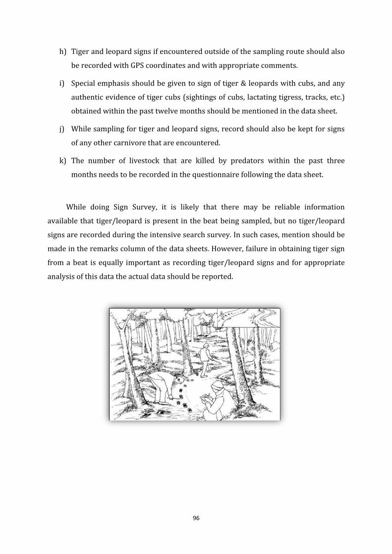
96
h) Tiger and leopard signs if encountered outside of the sampling route should also
be recorded with GPS coordinates and with appropriate comments.
i) Special emphasis should be given to sign of tiger & leopards with cubs, and any
authentic evidence of tiger cubs (sightings of cubs, lactating tigress, tracks, etc.)
obtained within the past twelve months should be mentioned in the data sheet.
j) While sampling for tiger and leopard signs, record should also be kept for signs
of any other carnivore that are encountered.
k) The number of livestock that are killed by predators within the past three
months needs to be recorded in the questionnaire following the data sheet.
While doing Sign Survey, it is likely that there may be reliable information
available that tiger/leopard is present in the beat being sampled, but no tiger/leopard
signs are recorded during the intensive search survey. In such cases, mention should be
made in the remarks column of the data sheets. However, failure in obtaining tiger sign
from a beat is equally important as recording tiger/leopard signs and for appropriate
analysis of this data the actual data should be reported.
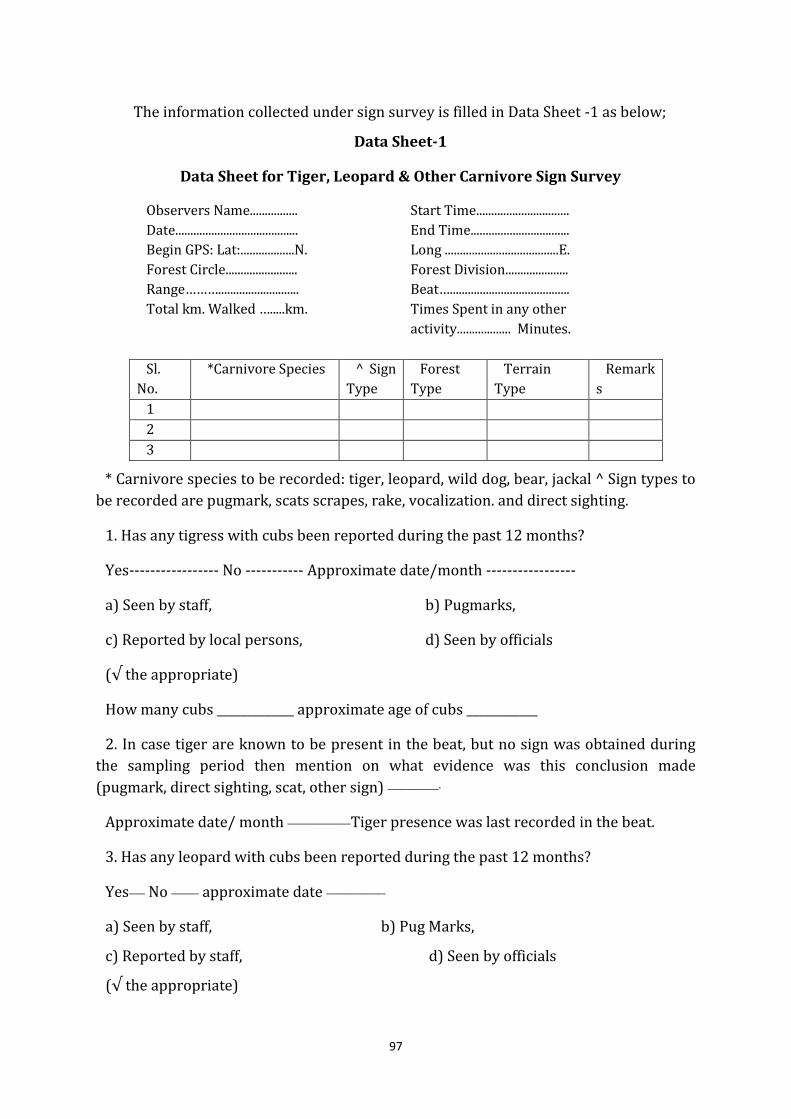
97
The information collected under sign survey is filled in Data Sheet -1 as below;
Data Sheet-1
Data Sheet for Tiger, Leopard & Other Carnivore Sign Survey
Observers Name................ Start Time...............................
Date......................................... End Time.................................
Begin GPS: Lat:..................N. Long ......................................E.
Forest Circle........................ Forest Division.....................
Range………........................... Beat…........................................ Total km. Walked ….....km. Times Spent in any other
activity.................. Minutes.
Sl.
No.
*Carnivore Species ^ Sign
Type
Forest
Type
Terrain
Type
Remark
s
1
2
3
* Carnivore species to be recorded: tiger, leopard, wild dog, bear, jackal ^ Sign types to
be recorded are pugmark, scats scrapes, rake, vocalization. and direct sighting.
1. Has any tigress with cubs been reported during the past 12 months?
Yes----------------- No ----------- Approximate date/month -----------------
a) Seen by staff, b) Pugmarks,
c) Reported by local persons, d) Seen by officials (√ the appropriate)
How many cubs _____________ approximate age of cubs ____________
2. In case tiger are known to be present in the beat, but no sign was obtained during
the sampling period then mention on what evidence was this conclusion made
(pugmark, direct sighting, scat, other sign) _____________.
Approximate date/ month ________________Tiger presence was last recorded in the beat.
3. Has any leopard with cubs been reported during the past 12 months?
Yes____ No _______ approximate date _______________
a) Seen by staff, b) Pug Marks,
c) Reported by staff, d) Seen by officials (√ the appropriate)
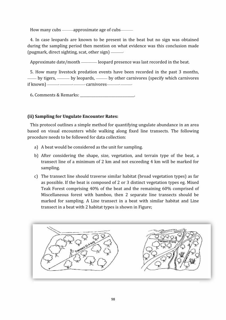
98
How many cubs __________approximate age of cubs___________
4. In case leopards are known to be present in the beat but no sign was obtained
during the sampling period then mention on what evidence was this conclusion made
(pugmark, direct sighting, scat, other sign) ___________.
Approximate date/month ______________ leopard presence was last recorded in the beat.
5. How many livestock predation events have been recorded in the past 3 months, ________ by tigers, ___________ by leopards, __________ by other carnivores (specify which carnivores
if known) __________, ___________, __________. carnivores___________, __________.
6. Comments & Remarks: ________________________________.
(ii) Sampling for Ungulate Encounter Rates:
This protocol outlines a simple method for quantifying ungulate abundance in an area
based on visual encounters while walking along fixed line transects. The following
procedure needs to be followed for data collection:
a) A beat would be considered as the unit for sampling.
b) After considering the shape, size, vegetation, and terrain type of the beat, a
transect line of a minimum of 2 km and not exceeding 4 km will be marked for
sampling.
c) The transect line should traverse similar habitat (broad vegetation types) as far
as possible. If the beat is composed of 2 or 3 distinct vegetation types eg. Mixed
Teak Forest comprising 40% of the beat and the remaining 60% comprised of
Miscellaneous forest with bamboo, then 2 separate line transects should be
marked for sampling. A Line transect in a beat with similar habitat and Line
transect in a beat with 2 habitat types is shown in Figure;
99
d) As shown in figure, the line transect within a beat may be broken up into 2 or
more segments so that each segment has a minimum length of 2 km and
traverses similar habitat.
e) Care should be taken that a line transect is not located near a busy road nor
should it run parallel to a river or other features of the landscape which may bias
sighting of ungulates.
f) For each transect the point of beginning and end point coordinates (Latitude and
Longitude) should be recorded by a GPS.
g) The broad forest type and terrain type that the transect traverses needs to be
recorded.
h) Each transect should be walked by 1 -2 persons during the early morning hours
(6:30 am to 8:30 am). Care should be taken that a well acquainted person should
be included who has the expertise to identify wildlife from a distance.
i) A record should be kept of all mammals and peafowl seen during the walk in the
prescribed format (see data sheet). For each animal sighting the following needs
to be recorded: 1) sighting number, 2) time of the sighting, 3) species (eg.
sambar, chital, wild pig, peafowl, langur, etc.) 4) group size - number of animals
of the same species in the group sighted, it is important to try to count the
number of animals in the group as accurately as possible. Animals are considered
to belong to two different groups if the closest animals from the two groups are
separated by a distance of over 30 m. 5) forest and terrain type where the
animals were seen.
j) If possible the number of young (fawns/calves less than 1 year of age) seen in
the group should also be recorded.
k) A broad habitat category (vegetation and terrain type) needs to be recorded for
each sighting (for example Sl.No. 5, 12 chital (10 adults and 2 young) were seen
at 6:40 am, in mixed teak forest, gently undulating terrain).
l) Each line transect needs to be walked at least on three different mornings for
estimating ungulate encounter rates, during the country wide monotoring done
every four years.
100
Data Sheet - 2
Encounter Rate on Line Transects
Observer Name: ..............Start Time: ...............Date..................End Time: .......................
ID no. of Line Transect: .................... Total Length: ……...………Km
Forest Circle: .........Forest Division:.............Range: ................... Beat: ..............
Transect Forest Type: ........................ Transect Terrain Type: ...............
Weather condition: Cloudy/Clear sky
Beginning GPS Lat : ....................N; Long : ……....…E
End GPS Lat : .................... N; Long : ................E
S.no Time Species* Total Number
(Adults & Young) Young
Forest
Type
Terrain
Type Remarks
1.
2.
3.
TheSpecies that need to be recorded on
the transect are chital, sambhar, nilgai, barking
deer, wild boar, langur, peafowl, hare, cattle (live
stock), and any other mammalian species seen.
(iii) Sampling for Vegetation, Human Disturbance and Ungulate Pellets
To quantify the habitat parameters and determine relative abundance of ungulates
sampling will be done along the same line transect on which ungulate encounter rates
were estimated. For economy of time and effort it would be possible to first sample the
line transect during early morning hours for ungulate encounter rate and then while
returning along the same line, sample for vegetation , human disturbance and also for
ungulate pellets. Sampling for vegetation, ungulate dung, human disturbance and
ungulate pellets will be done only once on a transect.
a) Again a beat will be the sampling unit, and sampling will be done along the
established line transect.
b) The beginning and end point coordinates of the line transect need to be recorded
using a GPS unit.
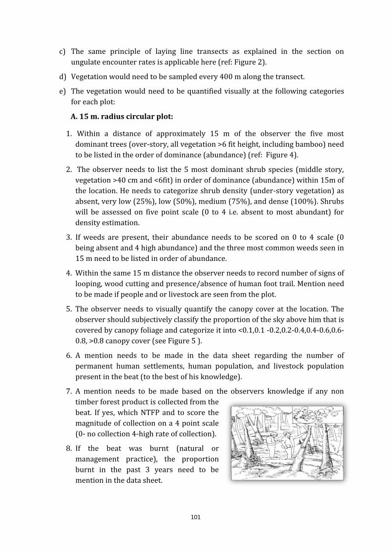
101
c) The same principle of laying line transects as explained in the section on
ungulate encounter rates is applicable here (ref: Figure 2).
d) Vegetation would need to be sampled every 400 m along the transect.
e) The vegetation would need to be quantified visually at the following categories
for each plot:
A. 15 m. radius circular plot:
1. Within a distance of approximately 15 m of the observer the five most
dominant trees (over-story, all vegetation >6 fit height, including bamboo) need
to be listed in the order of dominance (abundance) (ref: Figure 4).
2. The observer needs to list the 5 most dominant shrub species (middle story,
vegetation >40 cm and <6fit) in order of dominance (abundance) within 15m of
the location. He needs to categorize shrub density (under-story vegetation) as
absent, very low (25%), low (50%), medium (75%), and dense (100%). Shrubs
will be assessed on five point scale (0 to 4 i.e. absent to most abundant) for
density estimation.
3. If weeds are present, their abundance needs to be scored on 0 to 4 scale (0
being absent and 4 high abundance) and the three most common weeds seen in
15 m need to be listed in order of abundance.
4. Within the same 15 m distance the observer needs to record number of signs of
looping, wood cutting and presence/absence of human foot trail. Mention need
to be made if people and or livestock are seen from the plot.
5. The observer needs to visually quantify the canopy cover at the location. The
observer should subjectively classify the proportion of the sky above him that is
covered by canopy foliage and categorize it into <0.1,0.1 -0.2,0.2-0.4,0.4-0.6,0.6-
0.8, >0.8 canopy cover (see Figure 5 ).
6. A mention needs to be made in the data sheet regarding the number of
permanent human settlements, human population, and livestock population
present in the beat (to the best of his knowledge).
7. A mention needs to be made based on the observers knowledge if any non
timber forest product is collected from the
beat. If yes, which NTFP and to score the
magnitude of collection on a 4 point scale
(0- no collection 4-high rate of collection).
8. If the beat was burnt (natural or
management practice), the proportion
burnt in the past 3 years need to be
mention in the data sheet.
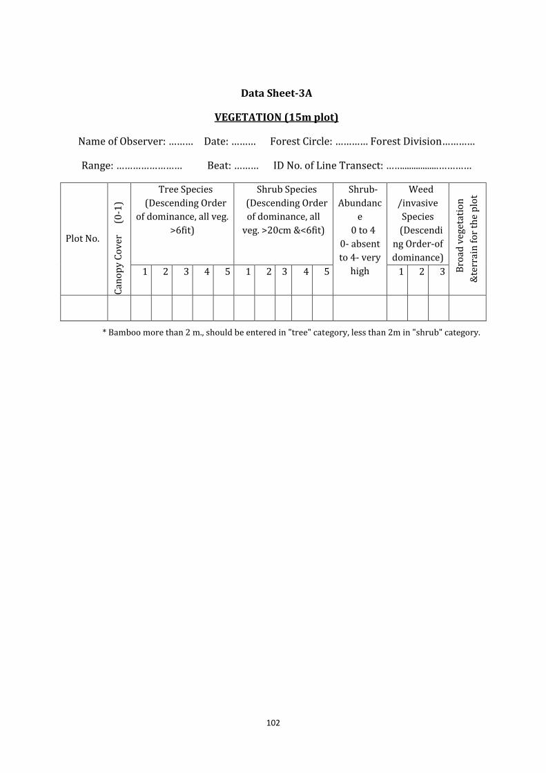
102
Data Sheet-3A
VEGETATION (15m plot) Name of Observer: ……… Date: ……… Forest Circle: ………… Forest Division………… Range: …………………… Beat: ……… ID No. of Line Transect: ……................…………
Plot No.
Ca
no
py
Co
ve
r
(0
-1)
Tree Species
(Descending Order
of dominance, all veg.
>6fit)
Shrub Species
(Descending Order
of dominance, all
veg. >20cm &<6fit)
Shrub-
Abundanc
e
0 to 4
0- absent
to 4- very
high
Weed
/invasive
Species
(Descendi
ng Order-of
dominance)
Bro
ad
ve
ge
tati
on
&te
rra
in f
or
the
plo
t
1 2 3 4 5 1 2 3 4 5 1 2 3
* Bamboo more than 2 m., should be entered in "tree" category, less than 2m in "shrub" category.
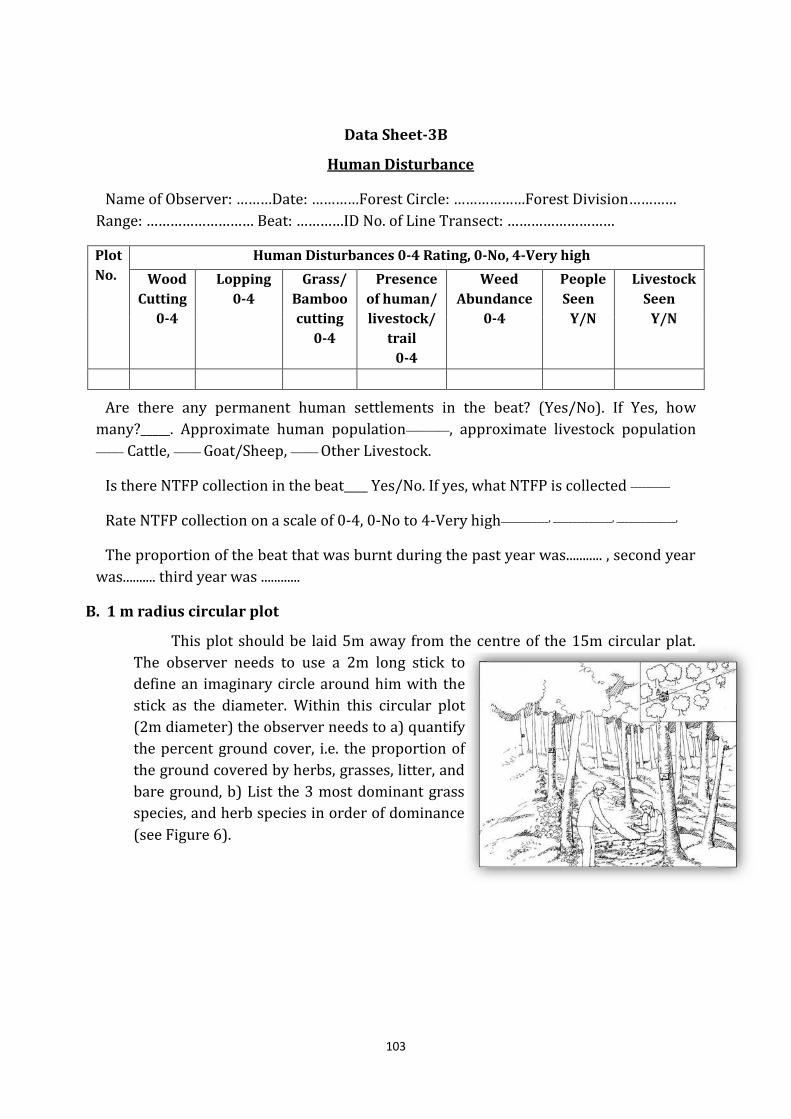
103
Data Sheet-3B
Human Disturbance Name of Observer: ………Date: …………Forest Circle: ………………Forest Division………… Range: ……………………… Beat: …………ID No. of Line Transect: ………………………
Plot
No.
Human Disturbances 0-4 Rating, 0-No, 4-Very high
Wood
Cutting
0-4
Lopping
0-4
Grass/
Bamboo
cutting
0-4
Presence
of human/
livestock/
trail
0-4
Weed
Abundance
0-4
People
Seen
Y/N
Livestock
Seen
Y/N
Are there any permanent human settlements in the beat? (Yes/No). If Yes, how
many?_____. Approximate human population___________, approximate livestock population _______ Cattle, _______ Goat/Sheep, _______ Other Livestock.
Is there NTFP collection in the beat____ Yes/No. If yes, what NTFP is collected __________
Rate NTFP collection on a scale of 0-4, 0-No to 4-Very high____________, _______________, _______________,
The proportion of the beat that was burnt during the past year was........... , second year
was.......... third year was ............
B. 1 m radius circular plot
This plot should be laid 5m away from the centre of the 15m circular plat.
The observer needs to use a 2m long stick to
define an imaginary circle around him with the
stick as the diameter. Within this circular plot
(2m diameter) the observer needs to a) quantify
the percent ground cover, i.e. the proportion of
the ground covered by herbs, grasses, litter, and
bare ground, b) List the 3 most dominant grass
species, and herb species in order of dominance
(see Figure 6).
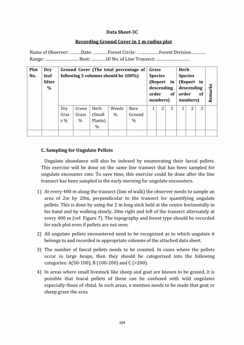
104
Data Sheet-3C
Recording Ground Cover in 1 m radius plot Name of Observer: ………Date: …………Forest Circle: ………………Forest Division………… Range: ……………………… Beat: …………ID No. of Line Transect: ………………………
Plot
No.
Dry
leaf
litter
%
Ground Cover (The total percentage of
following 5 columns should be 100%)
Grass
Species
(Report in
descending
order of
numbers)
Herb
Species
(Report in
descending
order of
numbers) Re
ma
rks
Dry
Gras
s %
Green
Grass
%
Herb
(Small
Plants)
%
Weeds
%
Bare
Ground
%
1
2
3 1
2 3
C. Sampling for Ungulate Pellets
Ungulate abundance will also be indexed by enumerating their faecal pellets.
This exercise will be done on the same line transect that has been sampled for
ungulate encounter rate. To save time, this exercise could be done after the line
transect has been sampled in the early morning for ungulate encounters.
1) At every 400 m along the transect (line of walk) the observer needs to sample an
area of 2m by 20m, perpendicular to the transect for quantifying ungulate
pellets. This is done by using the 2 m long stick held at the centre horizontally in
his hand and by walking slowly, 20m right and left of the transect alternately at
every 400 m (ref: Figure 7). The topography and forest type should be recorded
for each plot even if pellets are not seen.
2) All ungulate pellets encountered need to be recognized as to which ungulate it
belongs to and recorded in appropriate columns of the attached data sheet.
3) The number of faecal pellets needs to be counted. In cases where the pellets
occur in large heaps, then they should be categorized into the following
categories: A(50-100), B (100-200) and C (>200).
4) In areas where small livestock like sheep and goat are known to be grazed, it is
possible that feacal pellets of these can be confused with wild ungulates
especially those of chital. In such areas, a mention needs to be made that goat or
sheep graze the area.
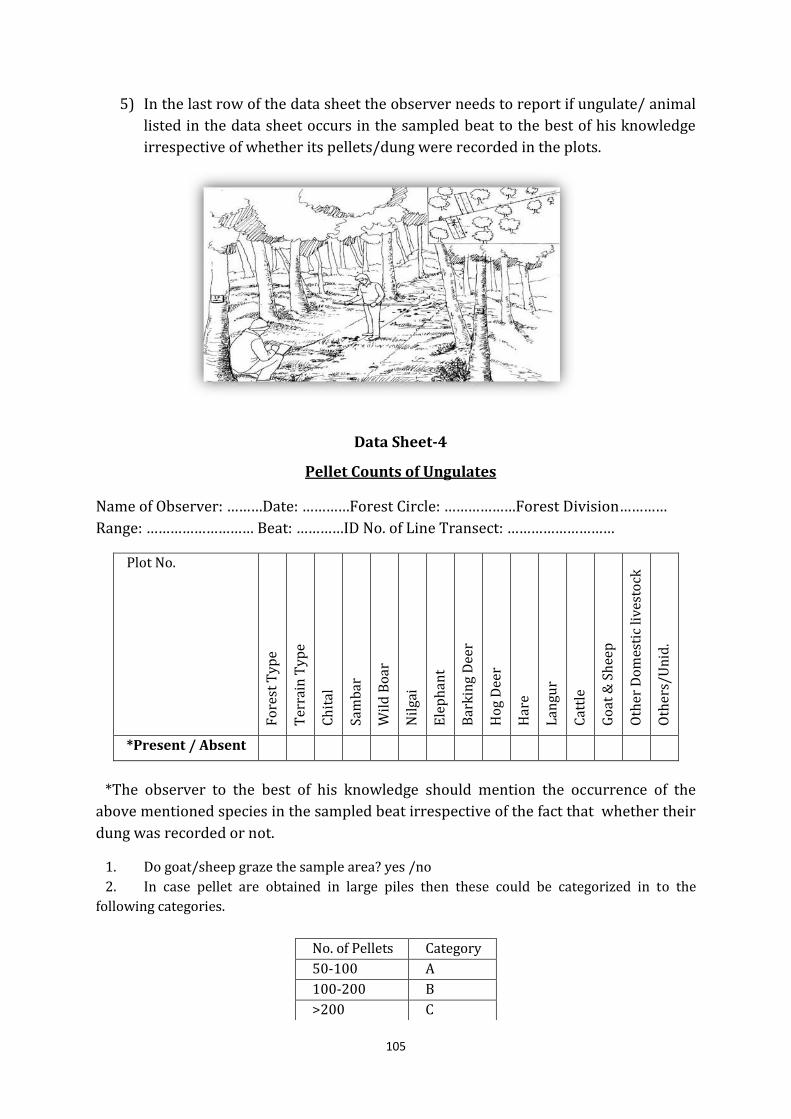
105
5) In the last row of the data sheet the observer needs to report if ungulate/ animal
listed in the data sheet occurs in the sampled beat to the best of his knowledge
irrespective of whether its pellets/dung were recorded in the plots.
Data Sheet-4
Pellet Counts of Ungulates Name of Observer: ………Date: …………Forest Circle: ………………Forest Division………… Range: ……………………… Beat: …………ID No. of Line Transect: ………………………
Plot No.
Fo
rest
Ty
pe
Te
rra
in T
yp
e
Ch
ita
l
Sa
mb
ar
Wil
d B
oa
r
Nil
ga
i
Ele
ph
an
t
Ba
rkin
g D
ee
r
Ho
g D
ee
r
Ha
re
La
ng
ur
Ca
ttle
Go
at
& S
he
ep
Oth
er
Do
me
stic
liv
est
ock
Oth
ers
/U
nid
.
*Present / Absent
*The observer to the best of his knowledge should mention the occurrence of the
above mentioned species in the sampled beat irrespective of the fact that whether their
dung was recorded or not.
1. Do goat/sheep graze the sample area? yes /no
2. In case pellet are obtained in large piles then these could be categorized in to the
following categories.
No. of Pellets Category
50-100 A
100-200 B
>200 C
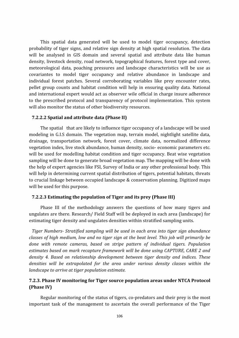
106
This spatial data generated will be used to model tiger occupancy, detection
probability of tiger signs, and relative sign density at high spatial resolution. The data
will be analysed in GIS domain and several spatial and attribute data like human
density, livestock density, road network, topographical features, forest type and cover,
meteorological data, poaching pressures and landscape characteristics will be use as
covariantes to model tiger occupancy and relative abundance in landscape and
individual forest patches. Several corroborating variables like prey encounter rates,
pellet group counts and habitat condition will help in ensuring quality data. National
and international expert would act as observer wile official in charge insure adherence
to the prescribed protocol and transparency of protocol implementation. This system
will also monitor the status of other biodiversity resources.
7.2.2.2 Spatial and attribute data (Phase II)
The spatial that are likely to influence tiger occupancy of a landscape will be used
modeling in G.I.S domain. The vegetation map, terrain model, nightlight satellite data,
drainage, transportation network, forest cover, climate data, normalized difference
vegetation index, live stock abundance, human density, socio- economic parameters etc.
will be used for modelling habitat condition and tiger occupancy. Beat wise vegetation
sampling will be done to generate broad vegetation map. The mapping will be done with
the help of expert agencies like FSI, Survey of India or any other professional body. This
will help in determining current spatial distribution of tigers, potential habitats, threats
to crucial linkage between occupied landscape & conservation planning. Digitized maps
will be used for this purpose.
7.2.2.3 Estimating the population of Tiger and its prey (Phase III)
Phase III of the methodology answers the questions of how many tigers and
ungulates are there. Research/ Field Staff will be deployed in each area (landscape) for
estimating tiger density and ungulates densities within stratified sampling units.
Tiger Numbers- Stratified sampling will be used in each area into tiger sign abundance
classes of high medium, low and no tiger sign at the beat level. This job will primarily be
done with remote cameras, based on stripe pattern of individual tigers. Population
estimates based on mark recapture framework will be done using CAPTURE, CARE 2 and
density 4. Based on relationship development between tiger density and indices. These
densities will be extrapolated for the area under various density classes within the
landscape to arrive at tiger population estimate.
7.2.3. Phase IV monitoring for Tiger source population areas under NTCA Protocol
(Phase IV)
Regular monitoring of the status of tigers, co-predators and their prey is the most
important task of the management to ascertain the overall performance of the Tiger
107
Reserves and areas having source population of tiger. The Tiger Task Force constituted
by the National Board for Wildlife (2005) has endorsed the revised methodology
propounded by the erstwhile Project Tiger Directorate (now the National tiger
Conservation Authority- NTCA) and the Wildlife Institute of India for country-level
estimation/monitoring of tiger/prey status and its habitat. This includes intensive
yearly monitoring of tiger source populations in TRs and protected areas in each tiger
landscape complex (Phase-Iv), and maintenance of a centralized photo- database of
tigers at NTCA; routine management-oriented monitoring and survey design for
spatially explicit mark-recapture study.
The NTCA, after much deliberation, prescribed the minimum standards for Phase IV
protocols, which is as follows:
a) Camera trap density one pair per 4-5 sq km
b) Minimum trap nights of 1000 per 100 sq km. (i.e. 25 pairs of cameras in 100 sq
km for 40 days)
c) Minimum area coverage of 400 sq. km.
d) Closure period of 40-60 days.
e) Minimum of 20 spatial replicates of line transects each of a minimum of 2 km.
length (for entire reserve)
f) Entire division or Landscape between Gaula and Sharda needs to be sampled.
Whole of the division/ Landscape will be covered in two samples (taking nearly
half of the division/ Landscape area each time). Further, if the data of initial sign
survey reveal that the tiger presence is in nearly or less than 400 Km2, then only
one sample can be taken. Camera trapping done successively, within the closure
period of 60 days.
Staff of Nainital, Tarai East, Tarai Central, Tarai West and Ramnagar Forest
Division/ other divisions in Project Area Landscape will carry out the Phase-IV
monitoring. The annual exercise will aim at obtaining tiger population size for the
entire region using spatially-explicit capture recapture framework and obtaining
prey population size using line transect sampling. The camera traps deployed as
per the survey design and should be left open for a period of 40-60 days. The tiger
population size may then be estimated over the entire tiger reserve using mark-
recapture methodology. The analysis of data needs to be done in collaboration with
technical experts conversant with spatially explicit capture-recapture
process/analysis.
The period of leaving the camera traps open (closure period) is important
owing to the fundamental assumption of "population closure" (no
deaths/births/immigrations/ emigrations in the population). Leaving the cameras
open for longer duration may lead to over estimation. The format for summary
record of camera captures and the basics of mark recapture process using camera
traps are provided. The analysis of capture data between years (using open
population models) should also be done in collaboration with technical experts.
108
For obtaining prey densities, line transects must be systematically placed with
a random start according to the survey design and implemented in program
distance. The line transect data should be analysed using the "distance" software
for prey density. The analysis of the data needs to be done in collaboration with a
technical expert conversant with the distance sampling analysis. The standard
format for collecting line transects data to facilitate analysis using "distance"
software and the basics of distance sampling using line transects are to be used.
7.2.4 Monitoring of carnivores and other nocturnal animals with the help of
camera traps:
The Monitoring of carnivores and other nocturnal animals with the help of camera
traps has become very popular in the recent days mainly for assessing the following
parameters;
(i) Population estimation
(ii) Relative abundance
(iii) Identification of individuals
(iv) Identification of Sex
The camera trapping can yield very good information on animals that are
nocturnal, elusive and rare apart from giving reliable information on their density
estimates mainly for patterned species such as tigers, panthers etc (Karanth, 1995).
Certain species are very shy and secretive or mainly active at night so it is very difficult
to verify their presence but they could be captured by camera trap method. For carrying
out the exercise generally two types of the cameras are used i.e. active or passive
cameras. In active systems animal has to activate the trigger of the camera by
obstructing the IR emitted from the camera. On the other hand the temperature of the
animal, which passes across it, triggers passive camera. The Camera trap units can be
placed on small poles that were dug in the ground. On some occasions the camera can
be fixed to tree that are on the sides of paths and offer good angle to capture to capture
the passing animals. A general procedurefor the camera Trapping is given below;
(i) The selected sample area is divided into grids of 1 x1 km to 2x2 km areas with
equal probability of capture in any study grids but camera placement is done at
best location for leopard and other carnivore species to be captured i.e. where
animal density is more.
(ii) In each study area 4-6 forests road or trails can be selected (each 10-20km long)
as trapping lines traversing the sampled area. On each trap line, at least 12-15-
camera trap points 0.8- 2.0 km apart are established.
(iii) The Camera trap points can be selected based on clues such as presence of
earlier sign (scats, scrapes, scent deposits, tracks) and intersection of trails.
(iv) All points can be marked on maps using a GPS unit. Date, time and location of
109
each photographic ‘capture’ of individual is also noted.
(v) The camera trap is placed for optimum number of the days i.e. the number of
days when no of animals trapping start saturating but camera should be
checked every day.
(vi) The photographs with distorted perspective or with lacked clarity should not be
used for identification and only clear photographs be considered for software
capture to know about population estimation.
(vii) Tiger can be identified from photographs by comparing stripe pattern, leopard
and chital from spot marking (Karanth, 1995.)
7.3 Wildlife Research in Project Area Landscape
National Wildlife Action Plan envisages Wildlife research as tools for a better
understanding of nature, its functions and to enable optimum or sustainable utilisation
of its resources, as well as to evaluate the conservation status of species and habitats
and the extent of impact of conservation endeavours undertaken. Such understanding
will also help reduce man-animals conflicts. There is a marked deficiency in baseline
biological data and on information we need to manage and monitor Protected Areas. We
know little about the impact of human activities on wildlife habitats, or about the full
range of benefits that flow from biodiversity-rich old growth, natural forests and
ecosystems. While we know, for instance, that forests help to maintain the water
regime, no studies are in place to quantify the lean season flows of water out of
protected areas. Not much is known about techniques, which could inter alia help
restore, at a very minimal cost, degraded habitats, whose run-off are sedimenting
reservoirs of most large dams, rivers and other wetlands.
Decisions to exploit resources in PAs are often based on expediency rather than
hard data and this sometimes results in permanent damage to fragile ecosystems.
Experimental research on alternatives to resources from the wild habitats is vital. There
is need to establish benchmarks for measuring diversity and to monitor the status of
indicator / flagship / threatened species of flora and fauna and their breeding biology.
Applied research is also needed to help overcome specific management problems in
protected areas. Multi-disciplinary integrated research encompassing scientific and
socio-economic aspects related to PA management needs to be encouraged.
Research for making use of ethnic knowledge in wildlife conservation and
management as well as in applied research to obtain IPRs (Intellectual Property Rights)
capable of benefiting the local communities and country should receive special
attention. Further, being a very new Protected Area there is very little or practically no
research data available with department, which can be used as management tool.
Therefore, a more field and management oriented research is required to be developed
in Project Area Landscape. Following issues/ aspects listed below are very relevant and
important research topics to be taken up in project area and adjoining landscape;
110
(i) Distribution, habitat use and mapping of extent of major Wildlife species such as
tiger, leopard and prey base in Nainital, Tarai East, Tarai Central and Ramnagar
Forest Division Landscape.
(ii) Study of floral diversity in Project Area Landscape with impact of exotic species
on habitat of faunal species and future management solutions to recovery of
habitat in landscape.
(iii) Limits of distribution, Population structure, seasonal and annual movements of
elephants in project area Landscape.
(iv) Crucial corridor connectivity for movement of elephants and mitigation
measures required while carrying out developmental activities such as
widening of roads etc.
(v) Biology, Distribution, population growth, migration, breeding, of the fishes
especially Mahasheer and their future conservation in the gaula and other
Rivers.
(vi) Extent, area mapping, of weeds, their specific management techniques for weed
and impact of this on Wildlife habitat.
(vii) Impact on grassland composition; grassland ecology; effect of cool and hot
burning on forest protection and ecology; study of the extent, nature, sources
and management of fires; assessment of fire protection and fire monitoring
system in Project Area Landscape
(viii) Assessment of seasonal, annual and cumulative predation and crop depredation
by wild animal and other causes of Human- Animal Conflict with site and
species-specific management solutions for mitigating the conflict.
(ix) Carrying Capacity for tourism activity in Tourism Zones in project area and
adjoining forest areas.
(x) Impact of forest settlements such as Gujjars, Goth-Khathas etc. on Wildlife
habitat and identification of crucial habitats required to be free from
disturbances for free movements of faunal species in Landscape.
7.4 Training in Wildlife management
The ever-increasing human population is mounting pressure on natural resources
including forests and wildlife since evolution. At the time, it is of paramount importance
to conserve and sustain the Wildlife for the existence of mankind. Though it is very
difficult to envisage co existence of man and animal in present socio economic human
controlled environment, but exclusive domain of Wildlife can be maintained by
minimizing the human interference in these natural ecosystems. Following aspects have
to be taken into account while designing a training module on Wildlife management at
division level;
111
(i) Familiarize forest personnel with latest concepts in Wildlife Management.
(ii) Develop competence in Wildlife Management Techniques.
(iii) Have an exposure on Conservation Policies; Legislations; and
Mechanism/Procedures of ‘enforcement’
(iv) Understand integration of ‘livelihood and cultural interests’ of local population in
Wildlife Management Strategies.
(v) Have first-hand experience of using latest scientific methods, tools and
techniques available in Wildlife management.
7.4.1 Training module for forest personnel on Wildlife Management
The training will provide the field oriented practical inputs to the forest personnel
on Wildlife management on one hand and at the same time it will help to improve
knowledge and skills in Wildlife management. Major course content, which are relevant
for forest personnel including frontline staff are explained as below;
1. Overview of Wildlife and Protected Area (PA) Management
(i) Overview’ of the Wildlife and PA Management.
(ii) Describe the PA Network.
(iii) Explain various concepts of Wildlife management.
(iv) Describe the 'Species-based Conservation Approaches'.
(v) Define 'Protected Areas and Landscape Management'.
2. Habitat Management
(i) Define the 'Management of Special Habitats'
(ii) Explain the 'management of vegetation including invasive species'
(iii) Describe ways of the 'management of water resources'
(iv) Describe importance of 'Habitat management in Non Protected Areas'
3. Wildlife Laws in India
(i) Describe the Wildlife Laws
(ii) State the 'International Conventions and Legal Obligations
(iii) Describe the Salient Features of Wildlife (Protection) Act, 1972
(iv) Explain 'Critical Wildlife Habitats' under provisions of Forest Right Acts, 2006
4. Prosecution of Wildlife Offences
(i) Describe the ways and means of 'Wildlife Crime Detection'
(ii) State legal procedures of prevention of Wildlife Crime
(iii) Explain the procedure in 'Prosecution and Trials in a Court of Law'
(iv) Describe the 'duties and powers of Forest Officers' related to prosecution of Wildlife
Offences.
(v) Describe relevant Case Laws.
112
5. Human-Animal Conflict Mitigation
(i) Describe steps involved in managing problem animal (tracking and tranquillizing.
(ii) Explain ways of man-management, namely, crowd and public
(iii) Describe ways of doing the inter-departmental coordination e.g. with Revenue and
Police.
(iv) State the guidelines to handle conflict situation (Man Animal conflict).
6. Managing animal in distress
(i) Identify circumstances of animal in distress.
(ii) State issues involved in 'veterinary care' of captive animal
(iii) Describe the provisions of 'Protocol for Managing Animals in Distress'
(iv) Describe guidelines of 'Central Zoo Authority' to handle animals in distress
7. Eco-Tourism/Interpretation
(i) Define 'tourism' and 'eco-tourism' in Wildlife Areas
(ii) Describe the procedure of management of tourism
(iii) Define the parameters of carrying capacity of tourism in PAs
(iv) Describe the guidelines and legal provisions of tourism management in PAs
(v) State steps in spreading 'Conservation education'
(vi) State 'interpretation facilities'
(vii) Describe architectural and aesthetic view point in interpretation facility in PAs
9. Eco Development and Interface Issues
(i) Explain the concept of 'eco-development'.
(ii) Identify stakeholders in eco-development
(iii) Describe the concept of 'micro-level planning'.
(iv) Explain the concept of livelihood based group formation.
(v) Describe ways and means of livelihood of fringe populations.
10. Wildlife Population Monitoring
(i) Use the basic census techniques for mega faunal techniques
(ii) Explain the Tiger, Co Predator and Prey Estimation Protocol of NTCA.
(iii) Give an Overview of censuring lesser taxa.
(iv) Display 'Rapid Assessment Techniques'.
11. Modern Techniques of Wildlife Management
(i) Use GIS as used in Wildlife Conservation
(ii) Explain Satellite Telemetry
(iii) Identify Sensor Networks for Wildlife
113
7.4.1 Training module for frontline staff on Wildlife Management
Though the general topics of training on Wildlife management are relevant to
frontline line staff also but there are certain basic topics which are more important for
frontline staff may be made part of two day refresher courses. Every frontline staff shall
undergo at least two such 2-3 day refresher courses in a year. Divisional Forest Officer,
while including these refresher courses in Annual Plan of Operation, shall also prepare
an annual calendar. A Model module of a frontline refresher course on Wildlife
management is mentioned below;
1. Forest and Wildlife Protection
(i) Various patrolling formats.
(ii) Patrolling techniques.
(iii) Night patrolling and ambush.
(iv) Observations during patrolling.
(v) Data collection and sample collection.
2. Habitat Management
(i) Define the 'Management of Special Habitats'
(ii) Explain the 'management of vegetation including invasive species'
(iii) Describe ways of the 'management of water resources'
(iv) Describe importance of 'Habitat management in Non Protected Areas
3. Wildlife monitoring and Equipment’s Used
(i) Need and its importance.
(ii) Various protocols –tiger monitoring, elephant census, vulture watch, ungulate
count etc. and their methods.
(iii) Tools and equipment required and their effective use.
(iv) GPS, camera traps, compass, rangefinders, night vision etc. – familiarity and field
uses.
4. Wildlife Crime Detection and Investigation
(i) Detection of offence, cordoning off the spot,
(ii) Search of the spot, collecting evidences,
(iii) Detecting possible cause of death,
(iv) Establishing forward and backward linkages.
(v) Postmortem and Panchnama guidelines.
114
5. Laws of forests and Wildlife
(i) Relevance and Meaning of definitions under Wildlife related Laws. Offence
Clauses, investigation and penalty clauses.
(ii) Preliminary Offence Report (H-2 case registration), seizure report & memo,
sealing seized property, property mark, nazri- naksa , arrest memo etc.
(iii) Explain the procedure in 'Prosecution and Trials in a Court of Law'
(iv) Describe the 'duties and powers of Forest Officers' related to prosecution of
Wildlife Offences.
(v) Describe relevant Case Laws.
6. Weapons/ Arms trainings
(i) Weapons familiarity Precautions while moving with Arms in Forests.
(ii) Parts of the weapon,
(iii) Dismantling of detachable parts,
(iv) Maintenance and their reassembling, about ammunition.
7. Physical and Chemical Capture of Wild Animals
(i) Identify circumstances of animal in distress.
(ii) State issues involved in 'veterinary care' of captive animal
(iii) Describe the provisions of 'Protocol for Managing Animals in Distress'.
(iv) Type of guns and components, range, target animals, anesthetics used, doses for
animals, caging, transportation & release. Type of cages.
(v) Describe guidelines of 'Central Zoo Authority' to handle animals in distress.
8. Fire control and Management
(i) Causes of fire loss due to it, fire mapping,
(ii) Preventive measures,
(iii) Emergency Rescue during forest fires
(iv) Protective measures and protocols issued by department.
115
Chapter 8
Wildlife Health and Managementof Animal in Distress
8.1 Wildlife Diseases
The main diseases occurring animals are Foot and Mouth Disease (FMD),
Lyptospirosis, Rabies, Brucellosis, and Anthrax etc. Also ecto and endo parasitic
diseases, tuberculosis, protozoan parasitic diseases are noticed. Further, the occurrence
of epizootic diseases among wild animals has been one of the factors responsible for the
decline of many wildlife populations (Khera, S.S.). These diseases have assumed
significance because of their direct effect on wildlife populations, and the possibility of
disease transmission to cattle and human beings. Some of the common wildlife diseases
are discussed below;
1. Tuberculosis (TB) (bacterial)
It is a very chronic, contagious disease, which cannot be diagnosed at earlier
stages due to the prolonged spore incubation; in an advanced stage the disease
manifests in extreme loss of body weight, which is difficult to asses in free living wild
animals.
Tuberclein test: For diagnosis, the restrained animals are injected with 0.1ml.
oftuberclein in the middle of the cervical region. A diffused odematous swelling with a
hot feeling after 72 hours is a positive indication of TB.
Other method: (Necropsy): After necropsy of the dead animal, leisions are noticed in
the lungs of the animal sufferings from TB; these are nodular in nature with white pus.
Slides of the smear from the diseased animal, fixed over heat and stained with ‘acid fast’, appear as reddish dots in a bluish background.
2. Pasteurellosis (bactrial)
This is acutely secptiscemic (toxic) in nature, and usually affects cervids and
bovids. Elephants and rhinos are also susceptible to this disease, which has a course of 2
to 3 days. The infection occurs through the respiratory tract.
Diagnosis: The blood collected from the spleen or liver should be sent to the laboratory
on ice (using a sterilised plastic bag inside a thermos). Blood smears are prepared and
fixed in methanol (avoiding heat). This disease causes mortality of young animals, and is
often confused with anthrax or rinderpest.
Treatment: Streptomycin should be by intramuscular or through drinking water (10 to
5mg./lb body weight); potatoes and other edible tubers can also used for medication, by
keeping the drug in a cavity scooped in them.
3. Anthrax (bacterial)
This is an acute sceptiscemic disease, which causes death within a few hours. The
symptoms are evident from the orifices. The carcasses of the dead animals should not
116
be opened, as the disease is highly contagious and fatal to human beings. Blood should
be taken from the ear vein, or the earpiece should be cut and sent to the laboratory.
4. Black Quarter (BQ) (Bacterial):
The disease is characterised by its sudden onset with high fever, lameness with
inflamed swellings of thick musculature. Smears from the swellings are examined to
confirm the disease, which is treated with penicillin.
The drug of choice is penicillin. If the animals are in captivity, a 5 to 10 ml dose can
give (for large animals) intramuscularly.
There is a vaccine (recommended for domestic animals) which can be
administered intramuscularly; the 'in contact' healthy animals should be medicated and
vaccinated with the 'anthrax spore vaccine’ (1ml dose). Slides can be prepared from
blood, obtained from the ear vein, collected in a sterilised, wax sealed on ice. This
disease, coupled with another unidentified ailment, was responsible for large-scale
mortalities of rhinos in Kaziranga (Lahan&Sonewal, 1973).
5. Botulism (Bacterial)
The disease causes paralysis (fatal) due to toxins in birds and ungulates. It is
common in grazing areas having decayed carcasses. There is a progressive weakness of
muscles resulting in paralysis. There is specific anti-toxic serum, which is useful for
treatment in the early stages.
6. Brucellosis (Bacterial)
It is common in livestock and may be communicable to wild ungulates frequenting
village pastures. Human beings are also susceptible to the disease, which results in
abortion once during the six to nine months of gestation. The cultural examination of
placenta is done to confirm the disease, which is usually treated with streptomycin and
chloramphenicol.
7. Haemorrhagic septicemia (HS) (Bacterial)
It is an acute bacterial disease in ungulates and is prevalent in livestock. The
outbreak occurs soon after the monsoon and under stressful conditions. The disease is
characterised by high temperatures with a swellings the tongue and throat with
respiratory disease. Confirmation is usually done thought blood smears of oedematous
fluid and the treatment is done using sulpha drugs.
8. Foot and Mouth Disease (viral):
It is the one of the most important disease (besides rinderpest), rampant among
the bovids and cervids including domestic cattle. The disease involves the foot and
mouth; "vesicles" appear in the mouth, and on the coronary band foot sores are seen,
resulting in lameness of the animals, coupled with froth from the mouth. Several viruses
act as causative agents for this disease. Samples like hair, mouth discharge and vesicles
can be collected from ailing animals in 50% glycerine saline and the laboratory.
117
The course of the disease is about two weeks; sudden deaths have been recorded
in young ones because of heart failure. Some times, this disease may be confused with
acute septicemia; it can also occur along with other disease like anthrax. The disease has
caused considerable mortality in gaur populations (Ali 1935). The persistence of FMD
viral infection in certain wildlife species may play an important role in the epidemiology
of this disease (McDiarmid, 1975; Khera, S.S.Singh, 1982).
9. Rinderpest (Viral)
The course of this disease is short, resulting in large-scale mortality of young and
adults, which may be confused with pasteurellosis. The body temperature is around
107ºC. Samples of the spleen, blood, liver and intestine should be collected in 50%
buffered glycerin saline solution, or in plastic bags kept over ice. For histopathological
examination, the tissues (apart from blood samples) should be collected in 10%
formalin.
There is no treatment for this disease; vaccines can be done in captivity (using a
dose of 1ml.) subcutaneously. Tissue culture vaccines are available for domestic cattle.
The disease spreads from the infected domestic cattle, and has caused considerable
mortality in the barasingha population at the Kanha National Park, M.P. (Schaller,
1967). It has devastated a large segment of four gaur populations in the last fifty years
(Burton, 1953; Khera S.S.). Apart from bovines, more than fifty other spices can
contract this disease (viz. nilgai, sambar, spotted deer, four horned antelope and the
like)(Gupta and Verma, 1949; Khera, S.S.).
10. Rabies (Viral)
The causative agent is the same in human being and animals. Infection always
occurs through bites. More than 40 animals are known to be rabies positive, including
small rodents, bats and mongoose. Furious symptoms occur, which are typical. There is
an uncontrollable unconsciousness in the animal, which fails to recognize similar
objects. The animal has a profound biting tendency, but death occurs in a clam way.
There is no treatment for this disease; prophylactics are present for humans. ‘Hydrophobia’ is characteristic. Prophylactic vaccination has been recommended for
fields. Rabies is dangerous to livestock and humans (Shah and jaswal, 1976). It has been
reported in mongoose and ground squirrels also (greval, 1933; Greval and Nicholas,
1940). Apart from domestic dogs, wild dogs, jackals, wolves and foxes can also transmit
this disease (Singh, 1980). In the tiger, this disease was recorded by Burton in 1950.
Some rabies positive wild animals:
Dogs … 89.8%
Jackal … 4.9%
Mongoose … 0.197%
Cats … 0.245%
Hyaena … 0.036%
Badger … 0.004%
118
Wolf … 0.1%
Panther … 0.029%
Tiger … 0.024%
Fox … 0.021%
Bear … 0.007%
11. Canine Distemper (Viral)
The disease is air borne and highly contagious. It has a worldwide distribution,
affecting carnivores. Canine distemper is characterized by high fever, respiratory
distress, haemorrhagic diarrhea and dehydration leading to death. The incubation
period is variable and symptoms range from sudden death to sub-acute cases. The
animal becomes dull with rise in temperature. There is no anti-viral drug against
distemper; only broad antibiotics are used to prevent secondary bacterial infection.
National Tiger Conservation Authority vide its letter No 15-38/2010-NTCA, dated June
14, 2013 has issued advisory, while mentioning preventive measure against canine
Distemper in big cats as follows;
(i) Vaccination of stray cattle, cats and dogs living around tiger reserve should be
done on the basis of a regular basis (The vaccination of cattle in surrounding
areas is otherwise also provided for National Parks and Sanctuaries under the
Wildlife (Protection) Act, 1972)
(ii) Incidents of wild animals showing abnormal behavior, as above, must be
reported immediately.
(iii) Tissues of dead animals (Brain issue for CDV) should be collected for
pathological analysis.
(iv) Facilities of deep fridge for storing samples should be ensured in each tiger
reserve. (This facility is equally important for other Protected Areas and should
be maintained in NandhaurWildlife Sanctuary).
(v) Record of each sample collected and their analysis should be maintained.
(vi) Periodic checking of water quality in tiger reserves (pre and post monsoon)
along with their chemical analysis should be undertaken. (This should be
followed in project areas also periodically)
12. Feline Panleucopenia (Viral)
The disease is caused by a DNA virus, which may survive for long. It is also known
as feline infection enteritis, and has a worldwide distribution. All fields are susceptible
to this disease, and the field signs include depression, high temperature, diarrhea and
death. The treatment is primarily supportive involving transfusion of blood, electrolytes
and parenteral fluids with broad-spectrum antibiotics.
13. Feline Enteritis:
This occurs in fields. The disease is characterized by loose motions with
bloodstain and mucous, followed by high temperature. The animal, in the initial stage,
119
should be screened for parasitic infestations (to eliminate the possibility as the
symptoms are similar).
Vitamins and minerals should be supplied with food for captive animals.
Medication is always recommended with feed, and regular deworming should be
carried out before the onset of the monsoons in captive animals.
14. Protozoan disease
A. Trypnosomiasis: This disease is prevalent in horses, rats, rabbits, buffalos, elephants,
camels, wild dogs, rhinos and fields. Mortality among tigers has been reported on
account of this disease at the Mysore Zoo. The fields’ signs include fever, dullness, and
swellings of limbs, lower abdomen, and limb glands with the animal becoming
progressively weaker. Blood smears should be stained with Geimsa or Leishman’s stain
and observed under low power. Beranyl is used for treatment. The disease is treated
with Qunapyraminesulphate (Antrycide) subcutaneously.
B. Coccidiosis: This is characterized by diarrhea (at the bloody); there will be no change
in body temperature, provided the animals are free from secondary infections.
The history of the wildlife disease in whole of India and particular situational
conditions in and around Project area Wildlife Landscape suggest that wild animals
prone to disease due to following reasons;
(i) As Nainital, Tarai East, Tarai Central and Ramnagar Forest Division Wildlife
Landscape has many villages on fringes and domestic cattle grazing is quite
common in these forests areas. The wild animals are very much susceptible to
diseases such as FMD, Enthrax and Pasturelosis etc.
(ii) As mentioned previously, there are many religious places some inside and some
on periphery of various Wildlife Landscape. On account of large gathering of
devotees on certain occasion’s lots of garbage is generated in these places. This
garbage may lead to health hazard for animals, especially herbivore animals.
Though elephants being a hindgut fermenter are not much affected by this but a
calf or any other animals are susceptible to the diseases due to this garbage.
(iii) The Grazing pressure is there from the adjoining villages and other settlement of
Goth-Kathas and Gujjars. These animals compete for food with wild animals and
also spread contagious diseases such as FMD.
(iv) Sometimes many non-milking cattle pass though Nandhaur Wildlife Landscape
and adjoining forests to different parts of plains in Uttar Pradesh and Terai
areas of Uttarakhand. Most of these animals are carriers of many diseases.
120
8.2. Strategies and Activities
8.2.1 Preventive Measures
(i) The cattle grazing area should not extend into the good wildlife areas and
should be restricted to the fringe areas only.
(ii) There should not be artificial water hole in the cattle grazing area as it can
very well be the source of the contamination leading to the diseases in wild
animals.
(iii) Regular Health camps should be organized in and around Project Area
Landscape with the help of the veterinary department of state, mainly against
FMD.
(iv) The plastic and other non-degradable material etc. shall not be left in forest
especially in religious places in and around Project Area Landscape
(v) The cattle movement from Hills through the forest areas Project Area Landscape
should be restricted and should be monitored along with the revenue and
veterinary department.
8.2.2 Disease Outbreak Management
A. Problem Identification
(i) The Diagnosis of the disease is required to done from a qualified laboratory. (
Veterinary College Pantnagar)
(ii) The field investigation should be conducted to determine extent of problem
(Species, Number, Geographic area involved, Climate etc.)
(iii) Advise of the specialist should be taken to identify special Biological, Political
or Physical considerations associated with the problems.
B. Identification of Needs
(i) Sources of additional personnel to help during disease emergencies should be
identified.
(ii) Availability of equipments and supplies for disease control operations should
be ensured.
(iii) Special needs
a. Burning permits
b. Lodging and meal facilities for workers
c. Ability to capture Wildlife for sampling, immunization or other needs.
C. Activities inside the Project area and Reserve Forest
To find the type of diseases, environmental factors responsible for it, species of
wild animal affected, and monitoring the cause of mortality to following activities are
suggested;
121
(i) Close affected area for a period of two months for all the activities including
tourism.
(ii) Identify the special work areas for performing diseases control activities.
(iii) Initiate the process of keeping the area of Sanctuary clean and burning of all
carcasses. Incase of infectious disease like TB, anthrax, rinderpest, FMD and
pasteurellosis, the carcasses should be invariably burnt; carrion feeders should
not be allowed top feed on the infected carcass.
(iv) Chemical treatment of land and water shall be done immediately. The area
should be preferably disinfected with 0.5% solution of carbolic acid or formalin.
Veterinary evaluation becomes essential both for individual animals as well as
populations.
(v) Removal of contaminated vegetation and purification of water.
D. Activities outside the Wildlife region.
(i) The area of Sanctuary is kept under surveillance for 10-15 days to see that
epidemic does not enter the Reserve Forest area of Division.
(ii) Special vaccination program of cattle in villages around the Sanctuary shall be
taken up. Further, as per section 33A of the Wild Life (Protection) Act, 1972, “the Chief Wild Life Warden shall take such measures in such manner as may be
prescribed, for immunisation against communicable diseases of the livestock
kept in or within five kilometres of a Sanctuary”. No person shall take, or
cause to be taken or graze, any livestock in a Sanctuary without getting it
immunized.
(iii) Help from Veterinary Hospital outside the Sanctuary is sought for vaccination
program.
E. Precaution to be taken during the disease outbreak
(i) Monitoring of daily and seasonal movement of wild animal inside Reserve
Forest should be done.
(ii) Migration pattern of wild animal outside the Reserve Forest should be studied.
(iii) The record of past history of diseases should be considered.
8.2.3 Sample collection for diagnose of diseases
1) Diseases that can be diagnosed from materials in different preservatives
(Zoonotic Diseases Are Underlined)
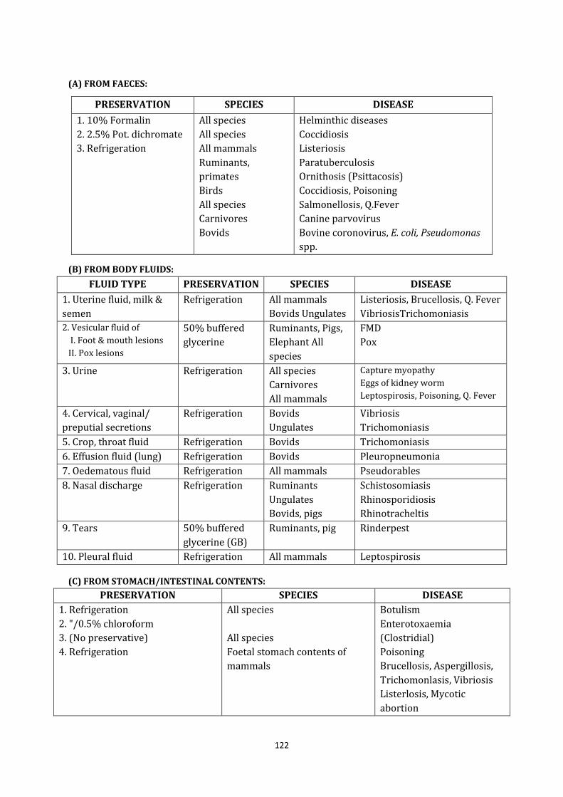
122
(A) FROM FAECES:
PRESERVATION SPECIES DISEASE
1. 10% Formalin
2. 2.5% Pot. dichromate
3. Refrigeration
All species
All species
All mammals
Ruminants,
primates
Birds
All species
Carnivores
Bovids
Helminthic diseases
Coccidiosis
Listeriosis
Paratuberculosis
Ornithosis (Psittacosis)
Coccidiosis, Poisoning
Salmonellosis, Q.Fever
Canine parvovirus
Bovine coronovirus, E. coli, Pseudomonas
spp.
(B) FROM BODY FLUIDS:
FLUID TYPE PRESERVATION SPECIES DISEASE
1. Uterine fluid, milk &
semen
Refrigeration All mammals
Bovids Ungulates
Listeriosis, Brucellosis, Q. Fever
VibriosisTrichomoniasis
2. Vesicular fluid of
I. Foot & mouth lesions
II. Pox lesions
50% buffered
glycerine
Ruminants, Pigs,
Elephant All
species
FMD
Pox
3. Urine Refrigeration All species
Carnivores
All mammals
Capture myopathy
Eggs of kidney worm
Leptospirosis, Poisoning, Q. Fever
4. Cervical, vaginal/
preputial secretions
Refrigeration Bovids
Ungulates
Vibriosis
Trichomoniasis
5. Crop, throat fluid Refrigeration Bovids Trichomoniasis
6. Effusion fluid (lung) Refrigeration Bovids Pleuropneumonia
7. Oedematous fluid Refrigeration All mammals Pseudorables
8. Nasal discharge Refrigeration Ruminants
Ungulates
Bovids, pigs
Schistosomiasis
Rhinosporidiosis
Rhinotracheltis
9. Tears 50% buffered
glycerine (GB)
Ruminants, pig Rinderpest
10. Pleural fluid Refrigeration All mammals Leptospirosis
(C) FROM STOMACH/INTESTINAL CONTENTS:
PRESERVATION SPECIES DISEASE
1. Refrigeration
2. "/0.5% chloroform
3. (No preservative)
4. Refrigeration
All species
All species
Foetal stomach contents of
mammals
Botulism
Enterotoxaemia
(Clostridial)
Poisoning
Brucellosis, Aspergillosis,
Trichomonlasis, Vibriosis
Listerlosis, Mycotic
abortion
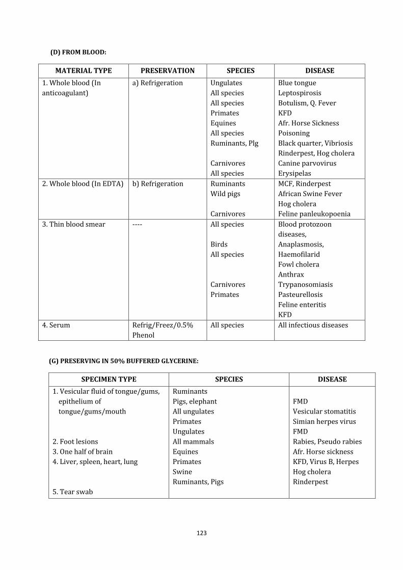
123
(D) FROM BLOOD:
MATERIAL TYPE PRESERVATION SPECIES DISEASE
1. Whole blood (In
anticoagulant)
a) Refrigeration Ungulates
All species
All species
Primates
Equines
All species
Ruminants, Plg
Carnivores
All species
Blue tongue
Leptospirosis
Botulism, Q. Fever
KFD
Afr. Horse Sickness
Poisoning
Black quarter, Vibriosis
Rinderpest, Hog cholera
Canine parvovirus
Erysipelas
2. Whole blood (In EDTA) b) Refrigeration Ruminants
Wild pigs
Carnivores
MCF, Rinderpest
African Swine Fever
Hog cholera
Feline panleukopoenia
3. Thin blood smear ---- All species
Birds
All species
Carnivores
Primates
Blood protozoon
diseases,
Anaplasmosis,
Haemofilarid
Fowl cholera
Anthrax
Trypanosomiasis
Pasteurellosis
Feline enteritis
KFD
4. Serum Refrig/Freez/0.5%
Phenol
All species All infectious diseases
(G) PRESERVING IN 50% BUFFERED GLYCERINE:
SPECIMEN TYPE SPECIES DISEASE
1. Vesicular fluid of tongue/gums,
epithelium of
tongue/gums/mouth
2. Foot lesions
3. One half of brain
4. Liver, spleen, heart, lung
5. Tear swab
Ruminants
Pigs, elephant
All ungulates
Primates
Ungulates
All mammals
Equines
Primates
Swine
Ruminants, Pigs
FMD
Vesicular stomatitis
Simian herpes virus
FMD
Rabies, Pseudo rabies
Afr. Horse sickness
KFD, Virus B, Herpes
Hog cholera
Rinderpest
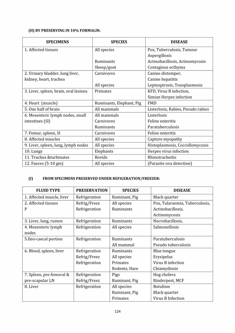
124
(H) BY PRESERVING IN 10% FORMALIN:
SPECIMENS SPECIES DISEASE
1. Affected tissues All species
Ruminants
Sheep/goat
Pox, Tuberculosis, Tumour
Aspergillosis
Actinobacillosis, Actinomycosis
Contagious ecthyma
2. Urinary bladder, lung liver,
kidney, heart, trachea
Carnivores
All species
Canine distemper,
Canine hepatitis
Leptospirosis, Toxoplasmosis
3. Liver, spleen, brain, oral lesions Primates KFD, Virus B infection,
Simian Herpes infection
4. Heart (muscle) Ruminants, Elephant, Pig FMD
5. One half of brain All mammals Listerlosis, Rabies, Pseudo rabies
6. Mesenteric lymph nodes, small
intestines (Sl)
All mammals
Carnivores
Ruminants
Listerlosis
Feline enteritis
Paratuberculosis
7. Femur, spleen, Sl Carnivores Feline enteritis
8. Affected muscles All species Capture myopathy
9. Liver, spleen, lung, lymph nodes All species Histoplasmosis, Coccidlomycosis
10. Lungs Elephants Herpes virus infection
11. Trachea &turbinates Bovids Rhinotracheitis
12. Faeces (5-10 gm) All species (Parasite ova detection)
(I) FROM SPECIMENS PRESERVED UNDER REFIGERATION/FREEZER:
FLUID TYPE PRESERVATION SPECIES DISEASE
1. Affected muscle, liver Refrigeration Ruminant, Pig Black quarter
2. Affected tissues
P
Refrig/Freez
Refrigeration
All species
Ruminants
Pox, Tularaemia, Tuberculosis,
Actinobacillosis,
Actinomycosis
3. Liver, lung, rumen Refrigeration Ruminants Nocrobacillosis,
4. Mesenteric lymph
nodes
Refrigeration All species Salmonellosis
5.Ileo-caecal portion Refrigeration Ruminants
All mammal
Paratuberculosis
Pseudo tuberculosis
6. Blood, spleen, liver Refrigeration
Refrig/Freez
Refrigeration
Ruminants
All species
Primates
Rodents, Hare
Blue tongue
Erysipelas
Virus B infection
Chiamydiosis
7. Spleen, pre-femoral &
pre-scapular LN
Refrigeration
Refrig/Freez
Pigs
Ruminant, Pig
Hog cholera
Rinderpest, MCF
8. Liver Refrigeration All species
Ruminant, Pig
Primates
Botulism
Black quarter
Virus B Infection
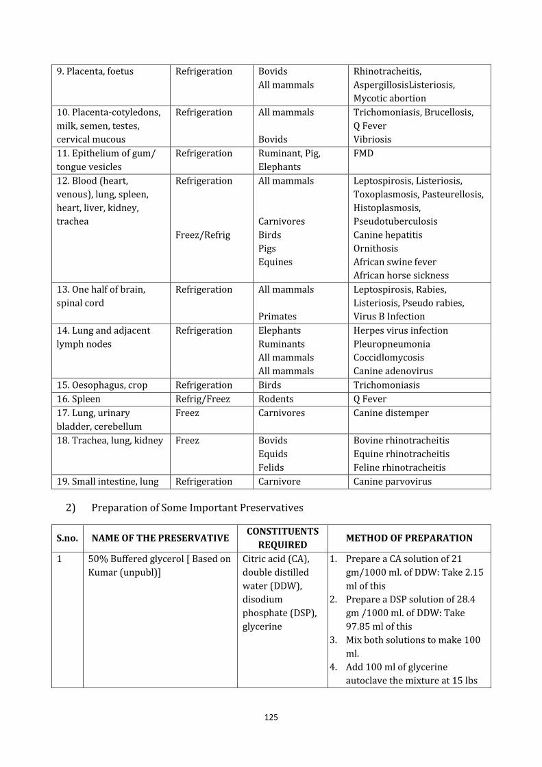
125
9. Placenta, foetus Refrigeration Bovids
All mammals
Rhinotracheitis,
AspergillosisListeriosis,
Mycotic abortion
10. Placenta-cotyledons,
milk, semen, testes,
cervical mucous
Refrigeration All mammals
Bovids
Trichomoniasis, Brucellosis,
Q Fever
Vibriosis
11. Epithelium of gum/
tongue vesicles
Refrigeration Ruminant, Pig,
Elephants
FMD
12. Blood (heart,
venous), lung, spleen,
heart, liver, kidney,
trachea
Refrigeration
Freez/Refrig
All mammals
Carnivores
Birds
Pigs
Equines
Leptospirosis, Listeriosis,
Toxoplasmosis, Pasteurellosis,
Histoplasmosis,
Pseudotuberculosis
Canine hepatitis
Ornithosis
African swine fever
African horse sickness
13. One half of brain,
spinal cord
Refrigeration All mammals
Primates
Leptospirosis, Rabies,
Listeriosis, Pseudo rabies,
Virus B Infection
14. Lung and adjacent
lymph nodes
Refrigeration Elephants
Ruminants
All mammals
All mammals
Herpes virus infection
Pleuropneumonia
Coccidlomycosis
Canine adenovirus
15. Oesophagus, crop Refrigeration Birds Trichomoniasis
16. Spleen Refrig/Freez Rodents Q Fever
17. Lung, urinary
bladder, cerebellum
Freez Carnivores Canine distemper
18. Trachea, lung, kidney Freez Bovids
Equids
Felids
Bovine rhinotracheitis
Equine rhinotracheitis
Feline rhinotracheitis
19. Small intestine, lung Refrigeration Carnivore Canine parvovirus
2) Preparation of Some Important Preservatives
S.no. NAME OF THE PRESERVATIVE CONSTITUENTS
REQUIRED METHOD OF PREPARATION
1 50% Buffered glycerol [ Based on
Kumar (unpubl)]
Citric acid (CA),
double distilled
water (DDW),
disodium
phosphate (DSP),
glycerine
1. Prepare a CA solution of 21
gm/1000 ml. of DDW: Take 2.15
ml of this
2. Prepare a DSP solution of 28.4
gm /1000 ml. of DDW: Take
97.85 ml of this
3. Mix both solutions to make 100
ml.
4. Add 100 ml of glycerine
autoclave the mixture at 15 lbs
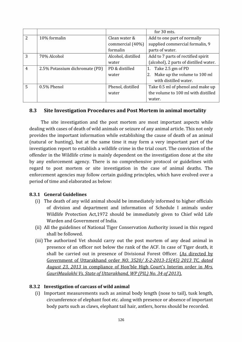
126
for 30 mts.
2 10% formalin Clean water &
commercial (40%)
formalin
Add to one part of normally
supplied commercial formalin, 9
parts of water.
3 70% Alcohol Alcohol, distilled
water
Add to 7 parts of rectified spirit
(alcohol), 2 parts of distilled water.
4 2.5% Potassium dichromate (PD) PD & distilled
water
1. Take 2.5 gm of PD
2. Make up the volume to 100 ml
with distilled water.
5 0.5% Phenol Phenol, distilled
water
Take 0.5 ml of phenol and make up
the volume to 100 ml with distilled
water.
8.3 Site Investigation Procedures and Post Mortem in animal mortality
The site investigation and the post mortem are most important aspects while
dealing with cases of death of wild animals or seizure of any animal article. This not only
provides the important information while establishing the cause of death of an animal
(natural or hunting), but at the same time it may form a very important part of the
investigation report to establish a wildlife crime in the trial court. The conviction of the
offender in the Wildlife crime is mainly dependent on the investigation done at the site
by any enforcement agency. There is no comprehensive protocol or guidelines with
regard to post mortem or site investigation in the case of animal deaths. The
enforcement agencies may follow certain guiding principles, which have evolved over a
period of time and elaborated as below:
8.3.1 General Guidelines
(i) The death of any wild animal should be immediately informed to higher officials
of division and department and information of Schedule I animals under
Wildlife Protection Act,1972 should be immediately given to Chief wild Life
Warden and Government of India.
(ii) All the guidelines of National Tiger Conservation Authority issued in this regard
shall be followed.
(iii) The authorized Vet should carry out the post mortem of any dead animal in
presence of an officer not below the rank of the ACF. In case of Tiger death, it
shall be carried out in presence of Divisional Forest Officer. (As directed by
Government of Uttarakhand order NO. 3520/ X-2-2013-15(45) 2013 TC, dated
August 23, 2013 in compliance of Hon’ble High Court’s Interim order in Mrs.
GauriMaulakhi Vs. State of Uttarakhand, WP (PIL) No. 34 of 2013).
8.3.2 Investigation of carcass of wild animal
(i) Important measurements such as animal body length (nose to tail), tusk length,
circumference of elephant foot etc. along with presence or absence of important
body parts such as claws, elephant tail hair, antlers, horns should be recorded.
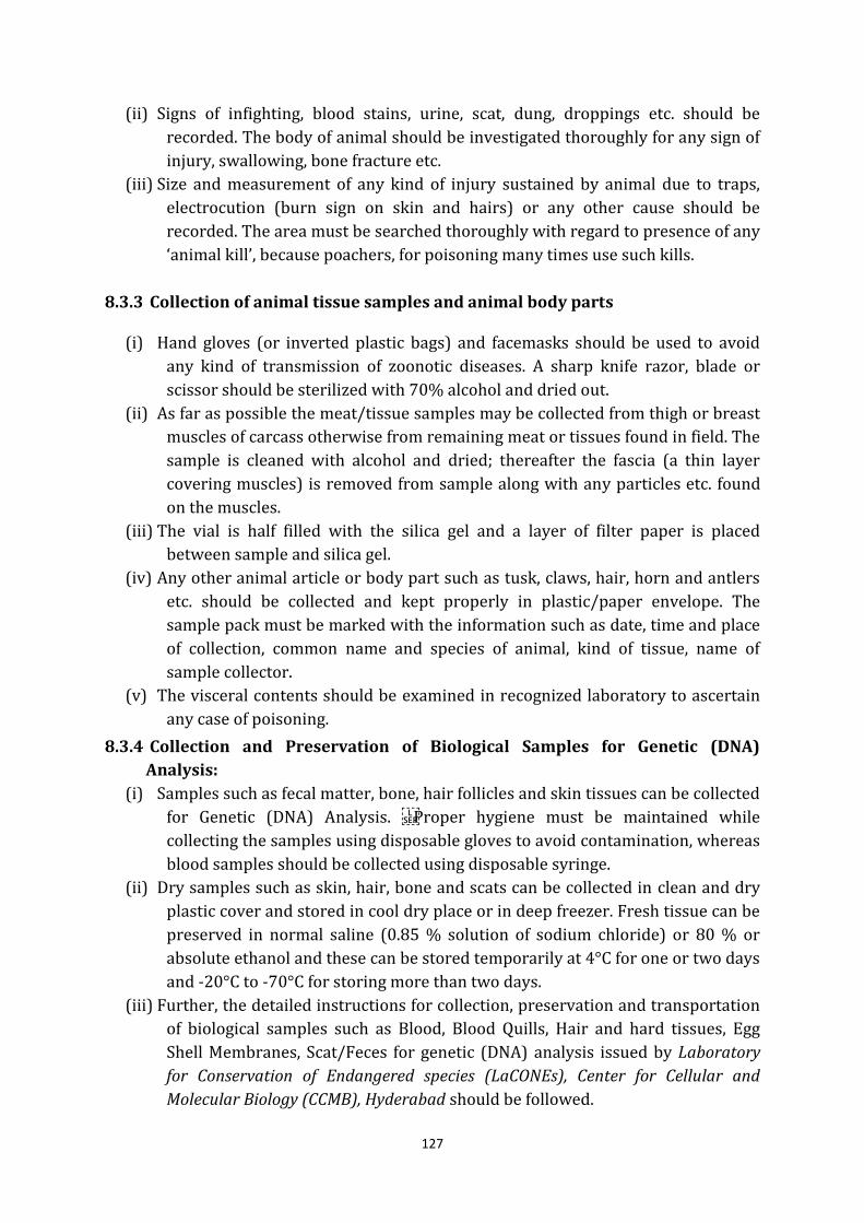
127
(ii) Signs of infighting, blood stains, urine, scat, dung, droppings etc. should be
recorded. The body of animal should be investigated thoroughly for any sign of
injury, swallowing, bone fracture etc.
(iii) Size and measurement of any kind of injury sustained by animal due to traps,
electrocution (burn sign on skin and hairs) or any other cause should be
recorded. The area must be searched thoroughly with regard to presence of any ‘animal kill’, because poachers, for poisoning many times use such kills.
8.3.3 Collection of animal tissue samples and animal body parts
(i) Hand gloves (or inverted plastic bags) and facemasks should be used to avoid
any kind of transmission of zoonotic diseases. A sharp knife razor, blade or
scissor should be sterilized with 70% alcohol and dried out.
(ii) As far as possible the meat/tissue samples may be collected from thigh or breast
muscles of carcass otherwise from remaining meat or tissues found in field. The
sample is cleaned with alcohol and dried; thereafter the fascia (a thin layer
covering muscles) is removed from sample along with any particles etc. found
on the muscles.
(iii) The vial is half filled with the silica gel and a layer of filter paper is placed
between sample and silica gel.
(iv) Any other animal article or body part such as tusk, claws, hair, horn and antlers
etc. should be collected and kept properly in plastic/paper envelope. The
sample pack must be marked with the information such as date, time and place
of collection, common name and species of animal, kind of tissue, name of
sample collector.
(v) The visceral contents should be examined in recognized laboratory to ascertain
any case of poisoning.
8.3.4 Collection and Preservation of Biological Samples for Genetic (DNA)
Analysis:
(i) Samples such as fecal matter, bone, hair follicles and skin tissues can be collected
for Genetic (DNA) Analysis. Proper hygiene must be maintained while
collecting the samples using disposable gloves to avoid contamination, whereas
blood samples should be collected using disposable syringe.
(ii) Dry samples such as skin, hair, bone and scats can be collected in clean and dry
plastic cover and stored in cool dry place or in deep freezer. Fresh tissue can be
preserved in normal saline (0.85 % solution of sodium chloride) or 80 % or
absolute ethanol and these can be stored temporarily at 4°C for one or two days
and -20°C to -70°C for storing more than two days.
(iii) Further, the detailed instructions for collection, preservation and transportation
of biological samples such as Blood, Blood Quills, Hair and hard tissues, Egg
Shell Membranes, Scat/Feces for genetic (DNA) analysis issued by Laboratory
for Conservation of Endangered species (LaCONEs), Center for Cellular and
Molecular Biology (CCMB), Hyderabad should be followed.
128
8.3.5 Post-mortem of wild animals
(i) Before performing the post-mortem on carcass of wild animal, it is very
important to do the investigation of site and animal body as per the instructions
elaborated above. In most of the cases there is always a time lag between
animal death and its detection; therefore on account of purification and
degeneration of body of the wild animal, it becomes very difficult to diagnose
cause of death through post-mortem.
(ii) The post-mortem on carcass of wild animal must be done by a recognized
Veterinarian and the report must include details regarding History of death,
External and internal examinations (body cavities, respiratory system, Hepatic
system, circulatory system, digestive system, urogenital organs, head etc.),
summary of major findings, specimens collected for laboratory diagnosis,
provisional diagnosis and remarks etc.
(iii) Member Secretary, National Tiger Conservation Authority has issued certain
instruction regarding “record of post mortem examination, collection of
laboratory specimen and diagnosed diseases from material vide letter No. 1-
9/93-PT dated. 21.07.2007.”
8.3.6 Standard Operating Procedure (SOP) for disposing Tiger/ leopard carcass/
body parts.
National Tiger conservation Authority vide its letter No. No. 15-37/2012-NTCA
dated 18 March 2013 to ensure that the carcass/ body parts of tiger/ leopard are
disposed of in a transparent manner to prevent any pilferage for illegal market. This
Standard Operating Procedure (SOP) provides the basic, minimum steps which are
required to be taken at the field level (tiger reserve or elsewhere) for disposing of
tiger/leopard carcass/ body parts where carcass is available or the body parts have
been seized. After ensuring the complete incineration of the carcass, a ‘Panchnama’ (Memo) on disposal of the carcass, duly signed by the PM Team and officer incharge
shall be prepared and send a final report to the CWLW under intimation to the NTCA
with supporting photographs/ documents.
8.4 Infrastructure for Veterinary Care and Rescue operation
8.4.1 Placement of Veterinary Personnel
A Veterinary Officer shall be posted in Nainital Zoo & Haldwani Zoo of Project
Area Landscape on deputation/ on contract/ as permanent staff of forest department.
He should be a very well trained person and if he is taken on deputation, then stay in
department at least for five years. This Veterinary Officer will perform the following
functions:
(i) Monitoring the health of grazing cattle and arrange for vaccination in the fringe
villages.

129
(ii) Liaison with other veterinary institutions like Department of Animal Husbandry,
Veterinary College and other institution.
(iii) Participating in eco development activities to address grazing problem.
(iv) Any other duty assigned by an authorized forest officer.
8.4.2 Wildlife Rescue and Veterinary laboratory
Animal rescue team at Nainital Zoo & Haldwani Zoo will be a spear head team
constituted of five members headed by Veterinary Officer to perform the functions like
rescue of diseased and distressed animals, wild animals held in due to distress the
rescue team will consist of following personnel
(1) VO -1
(2) DR/Forester -1
(3) Forest guard - 1
(4) Lab Technician -1
(5) Helper -2
The present infrastructure and equipments available for chemical restraint and
handling of wild animals would be suitably upgraded. Regular supply of new drug and
phasing out of expired drug would be ensured in view of the exigencies involved in such
cases. Skill about the handling and use of such equipments, drugs would be infused into
prospective personnel by way of trainings and also enlightened experience under field
experts. Other infrastructure like fabrication of transportation, treatment cages and also
their suitable location would be done.
130
Chapter 9
Human-Wildlife Conflict and Rescue Management
In Wildlife Management, it is often necessary to capture including birds alive.
Animal capture could be for treatment of sick or distressed animal,
removal/displacement of a problem animal etc. When we plan for capture of animal, it
should be based on knowledge of the species, ecology and behavior (favoured habitat
etc.), diurnal pattern of activity, sensitivity to disturbance and handling. Further, the
plan should take all precaution for ensuring minimizing the physical and psychological
trauma and the animal back to normal conditions as soon as possible. This animal
capture could be live or chemical depending on the situation. But any kind of capture
falls in the category of hunting as defined in section 2 read with section 9 of the Wild
Life (Protection) Act, 1972. Further, the provisions under section 11 of the Wild Life
(Protection) Act, 1972 which allows hunting are elaborated as below:
(i) When the animal listed in Schedule-I has become dangerous to human life or is
disabled or diseased beyond recovery. (Can be permitted only by Chief Wild
Life Warden). However, no such order can be passed unless the CWLW is
satisfied that such an animal cannot be captured, tranquilised or translocated.
(ii) In respect of the animals of Schedule II, III, or IV, in addition to the above
circumstances, and in situations where the animal or group of animals in a
specified area has become dangerous to property, standing crops, or any land.
(Can be permitted by CWLW or an authorised officer).
(iii) When the wild animal has been killed or wounded in defense of the person
concerned or any other person.
9.1 Backgrounds and Threat Assessment
There are many fringe villages in and around the Project Area Landscape. Villages
mainly suffer from various animals such as Elephant, Wild Boar, Blue Bull/ Neelgai and
Leopard etc.
9.2 Human-Leopard Conflict Management
Leopards are a highly adaptable species that live in and around many human- dominated,
agricultural landscapes. Research indicates that even in high human density areas, attacks on
humans and domestic animals in most cases can be kept to very low levels. The goodwill and
trust of people especially in rural areas are vital to dealing with crisis situations arising out of
loss of life and livestock by leopards in rural areas. The Forest department is the first to face the
heat of the public reactions and requires the goodwill and confidence of the rural community
much more than any other government department.
Incidences of leopards ‘straying’ into settlements causing human casualties, and the
retaliatory killing of leopards by the public have been on the rise. The efficacy of capture and
131
translocation of leopards from conflict areas as a mitigation measure is increasingly being
questioned. This has necessitated the need for having broad policy guidelines and management
options to effectively deal with this gradually intensifying problem in a diversity of human-
dominated landscapes across the country.
After careful consideration of the inputs received from a variety of stakeholders, in 2011,
Ministry of Environment and Forest issued framework guidelines that are suggested for
managing the human- leopard conflict situations in areas where leopards coexist among high
densities of humans. These guidelines provide a framework not only to address the conflict after
its occurrence, but also to minimize such conflicts through adoption of necessary pro-active
measures. Some relevant provisions and excerpts of these guidelines are discussed as below;
1. Awareness Generation and involvement of people
2. Teamwork in tackling Conflict
3. Establishment of Emergency Response Mechanism
a. Management of Crowd
b. Management of Animal
c. Capture and handling of trapped animal
d. Release or translocation of Captured Leopard
e. Transportation of Captured animal
f. Monitoring of Tran located Leopards
g. Avoidable Rescue of Leopards
4. Helping rural people better protect their livestock – a confidence building
measure
a. Expeditious and effective delivery of ex-gratia
5. Collection of information on leopard conflict
6. Dealing with man-eater leopards
9.2.1 Awareness Generation and involvement of people
Modern practices in wildlife conservation call for involvement of all stakeholders
in the planning and implementation of conflict mitigation measures to muster greater
support and cooperation from people.
The overall aim should focus on a participatory approach, ensuring support of
local communities and other stakeholders for conservation and management of wildlife.
Awareness programmes should target the people sharing space with leopards, in
human dominated landscapes like sugarcane fields, tea gardens, fruit orchards, etc., and
also the local communities living in forest dominated landscapes, especially in the hilly
States of Uttarakhand, Himachal Pradesh and Jammu and Kashmir.
Sensitizing the media about the nuances of the problem of human-wildlife conflict
in general and leopard depredation in particular should be an essential part of the
awareness strategy. Media should contribute to diffusing the tense situation
surrounding conflict with objective reporting aimed at highlighting the measures to
mitigate conflict. Reporting mainly aggressive encounters with leopards can erode local
people’s tolerance and worsen the situation by forcing the Forest Department to
132
unnecessarily trap the wild animal due to public pressure. Salient points important in
Awareness generation are;
(i) Leopards often take up residence in croplands and tea gardens.
(ii) They are not usually inclined to attack people; on the contrary, they avoid
people.
(iii) Wild carnivores may attack in self-defence, and, therefore, it is advisable to avoid
provoking them.
(iv) Mere sighting of a leopard in the vicinity of human habitations does not
necessarily mean that the animal has strayed from a forest and needs to be
captured.
(v) Arbitrary removal of leopards could lead to increased conflict. Another leopard
will soon occupy the space vacated by a captured animal.
(vi) The focus should be on long-term solutions. These include better sanitation
measures including proper garbage disposal in villages and towns so that feral
pig and dog populations are kept under check, and do not attract wild
carnivores. Providing proper toilet facilities in rural areas would go a long way
in reducing incidences of accidental encounters with leopards.
(vii) Farmers should be made aware that livestock sheds should be strong, robust and
leopard proof.
9.2.2 Teamwork in tackling Conflict
Efforts should be made to involve all departments, wings and agencies of the
government to use a well coordinated mitigation approach which is scientific, field-
tested and practical, and inter-alia, capable of dealing with emergencies related to
attacks by leopards.
In this regard, it is vital to involve the Police and Revenue Departments, as they
are crucial for maintaining law and order in the face of extreme public reactions. Proper
training of police and local administrative staff, and constitution of a Primary Response
(PR) Team, along with awareness campaigns are essential ingredients of a successful
conflict mitigation strategy.
PRIMARY RESPONSE TEAM
These teams may comprise of paid or volunteer members from the local
communities, who are trained to respond immediately to a conflict situation. Their
primary aim should be to control the crowd and secure the area until the next level of
help arrives. In the hills, where the terrain is difficult, and where houses are scattered in
a forest landscape, an Emergency Response (ER) team may take time to reach the
conflict site. The establishment of a Primary Response (PR) team is important to ensure
crowd control before the ER team reaches the spot.
133
9.2.3 Establishment of Emergency Response Mechanism
Immediate response is crucial to manage all conflict situations. A trained
Emergency Response (ER) team consisting of an officer not below the rank of Assistant
Conservator of Forests, one qualified veterinarian, and a minimum of five trained
support staff may be formed in the identified conflict area. The Forest Division should
have a well-trained operational ER team. Each ER team should be equipped with
chemical capture equipment, drugs, appropriate cages, etc. and should wear specially
designed uniforms so that they are easily identifiable during the operation. They should
also have specially designed baffle boards for protection. The protocol for Emergency
Response should be periodically rehearsed and reviewed to incorporate corrective
measures to make it more efficient.
Establishing such well-advertised ER teams that respond effectively and quickly to
conflict situations will help diffuse the usual public outrage and retaliation that
invariably follows such conflicts. It will also harness the goodwill of local communities.
In the long term, the efficient working of the ER teams will prevent escalation and
spread of conflict. It will also prevent the situation from going out of control with people
taking the law in their own hands.
a. Management of Crowd
(i) Crowd management is crucial to any successful animal rescue operation. The
ER team, more often than not, is obstructed and hindered in its activities by
furious mobs, making it difficult to discharge its responsibilities.
(ii) Support and cooperation of the police and civil administration should be
ensured in advance to facilitate effective crowd control and to discourage
formation of crowds.
(iii) The area should be cordoned off with barricades, and the public alerted
through a public address system. Regular updates should be made available
to the administration and local public.
(iv) There should be an ambulance kept ready to take care of any medical
emergencies
9.2.4 Management of Animal
The objective should be to give the animal enough space and opportunity to return
to its habitat, and situation-specific rescue measures should be followed. The best method
of dealing with a wild cat, in the absence of attacks on humans, is not to intervene.
Following steps are prescribed to deal with different situations.
a. Unconfined or Open Area
(i) Open situations could mean a barren land, grassland, street, thicket, crop field
with standing crop or woodland, with the leopard being either up on a tree or
on the ground.
134
(ii) If the animal is in an open area surrounded by people, all attempts should be
made to keep the crowd and local people from approaching near the animal,and
the animal should be allowed to escape under the cover of darkness.
(iii) Drug immobilization should be avoided in situations where the animal is in the
open, even if the target presents itself in an appropriate position, since a darted
animal in the open can retaliate injuring people.
(iv) To trap the animal, a suitably designed lightweight trap that minimizes injury to
the animal, should be used.
b. Semi-confined
(i) If the animal is confined in a dry well or trench, a ladder let down into the well
will allow the animal to escape in the night.
(ii) Here too, the public must be kept away from the site, and the rescue team should
monitor the situation until the animal escapes.
c. Animal Confined in a Closed Area
. If the animal is confined in a closed area, for example in a house, garage, under a
culvert, or caught in a snare, etc., the surrounding entrance and exits should be
made secure to ensure no injury to the public.
. If the area is adjoining a forested area, the animal should be allowed to escape in
the night, but if it is in a high human density area it should be tranquilized.
9.2.5 Capture and handling of Trapped Animal
Captured leopards should not be put on display after capture. Such unintended
forced close contact with humans may alter the behaviour of captured animals with
highly adverse consequences following their release. Ideally, such leopards should be
kept in covered cages. Only healthy fit individuals should be returned to the wild.
Following advice may be followed scrupulously while handling captured or
trapped wild animals;
(i) All captured animals, irrespective of the method used to capture
(chemical/trapping), should be chemically restrained for evaluation of its
condition for prognosis and suitability for release.
(ii) While confined, the animal can be micro-chipped, scanned (if already micro-
chipped), treated, and various morphometric parameters recorded.
(iii) If the animal is to be released back in the wild in a few days, it should be
housed in a suitable transit facility with minimum exposure to humans.
(iv) If the animal is to be placed in captivity, the life time care facility to house the
animal should meet the standards prescribed by the Central Zoo Authority.
(v) If an animal kept in captivity is intended to be released, thorough investigation
of its fitness, and evaluation of its response to humans should be conducted
before releasing it into the wild.
(vi) If the animal has been kept for more than a month in captivity, it should not be
released back into the wild.
135
(vii) If the animal is injured beyond recovery or permanently disabled, euthanasia is
recommended as the best option. Even if the exceptional decision for euthanasia
has been arrived at, the animal must be chemically restrained.
(viii) NSAIDs (Non-Steroid Anti Inflammatory Drugs) should never be used for
treatment of the animal as these are contraindicated in felids. Long acting
antibiotics should be used for sustained therapeutic effects even after release.
9.2.6 Release or Translocation of Captured Animal
(i) The decision to capture an animal should be the last option. It is very important
that human intervention is restricted to the minimum to avoid future conflict. If
the captured leopard is to be released, it should be in the immediate vicinity of
capture, i.e., within animal’s home range.
(ii) Leopards are highly adaptable animals, and exhibit amazing homing instincts. A
translocated leopard trying to navigate to its home territory through a dense
human landscape may lead to increased incidences of conflicts rather than
reducing the same. Therefore, it is best to avoid translocation.
9.2.7 Transportation of Captured Leopard
Captured animals often get injured or stressed during transportation. Stress could
be detrimental to the health of the animal, which coupled with excessive exposure to
humans may adversely alter its behaviour towards humans after release.
The animal once captured should be kept and transported in a stress free
environment, insulated from the public. It is important that humans are not allowed to
come close to the caged animal, and that the cage is also completely covered with
tarpaulin or other appropriate material.
Tranquilized/captured animals must be transported in the trap itself (if suitable)
or in a separate transportation cage. Care should be taken to avoid crowded places, and
the animal’s health condition frequently checked during transit.
9.2.8 Monitoring of Translocated Leopard
The success of translocation or release of leopard has to be measured and
evaluated against appropriate post-release monitoring protocols. Translocation very
often leads to the transfer of conflict to another unaffected site. Individual identity of all
the released animals should be monitored by marking them with microchips and ear
tags or colour coded collars before release. Radio collars should be put on a sub-set of
released animals to monitor post-release movements and survival. Scientists and
experts must be involved in such radio-tracking programmes.
136
9.2.9 Avoidable Rescue of Leopards
A cub without its mother usually does not need “rescue” as the mother leaves the
cubs when she goes hunting. Equally, cubs released without its mother have poor
survival probabilities. If cubs are found alone, a watch must be kept for their mother
without disturbing them. Cubs are not to be “released”, but only require “reuniting” with
their mother. Reuniting should be attempted immediately in the night in the same area,
from where they were picked up. A suitable camera trap placed overnight near the ‘reunion site’ would facilitate the confirmation of the reunion.
Cubs that are hand-reared in captivity have a negligible possibility of future
release back to the wild. Lifetime care is the only suitable option for such cubs, since
their release in the wild even after a long-term rehabilitation process may only worsen
the already existing conflict situation.
9.2.9.1 Helping rural people better protect their livestock–a confidence
building measure
(i) Subsidy should be provided for simple but sturdy and leopard-proof livestock
sheds.
(ii) Vaccination camps for livestock could also be organized in collaboration with the
Animal Husbandry Department.
(iii) Possibility of initiating state sponsored insurance schemes for livestock also
needs to be explored.
9.2.9.2 Expeditious and effective delivery of ex-gratia
Immediate response to loss of life, livestock, and property caused by leopards will
help calm people. This will prevent violent reactions towards the problem animal in
particular and wildlife in general. Payment of ex-gratia should be made fast and hassle
free. The possibility of initiating self-financed insurance schemes should be explored.
(i) In case of attack on humans, it is recommended that senior level officers
immediately visit the site. A vehicle should be provided to take the victim to the
nearest medical facility. The ex-gratia payment should be made immediately.
(ii) In case of attacks on livestock, ex-gratia amount should be provided within a
week. The complaint should be made at the Gram Panchayat office, and the
Forest Guard should visit the site immediately. The protocol should be verified
by Forest Guard and Gram Sevak. Extra travel and phone allowance should be
provided to the Forest Guard to enable him to effectively discharge this
responsibility without delay. Veterinary certificate and photographic evidence
should not be made compulsory requirements for disbursement of ex-gratia
amount. The amount should be dispatched through a bank demand draft.
137
(iii) The use of an ‘sms’ based updating system to inform the victim or his relatives
about the status of his/her claim, and also to receive complaints should be
explored.
(iv) It is extremely important that the animal is allowed to feed off the livestock it has
killed. After inspection by the forest Guard and the Gram Sevak, the carcass
should be taken to a nearby-secluded area, the same evening. If a leopard is
deprived of its kill, it will make more kills, inflicting more losses on the farmers.
Also, it is possible that after being deprived of its kills repeatedly, the animal
may become desperate, increasing the intensity of conflict. This aspect also
needs to be explained to the villagers.
(v) Bi-yearly meetings should be held where local MLA, panchayat heads, revenue,
veterinary, health and forest department officials should discuss the problem of
human-wildlife conflict, and how effectively it is being managed. Such meetings
could also review the existing practice and options of mitigation with a view to
making these more effective and people friendly. The above exercise should
involve trained wildlife biologists and other experts.
9.2.9.3 Collection of information on leopard conflict
Management of a species should be based on systematic long-term data.
Information on conflict incidences should be collected systematically in an appropriate
format to aid decision-making. Long term research, focused on estimating the
population and abundance of leopards in high conflict areas, should be taken up on
priority. Identification of conflict prone areas, with data on conflict intensity, nature of
conflict, and trends, must be collected for better preparation and pre-emption.
9.2.9.4 Dealing with leopards which have become dangerous to human life
Attacks by leopards, which have become dangerous to human life, are deliberate with an
intention to kill, and usually result in death, e.g., child being lifted from the precincts of the
house, and attacks on people sleeping inside the house. In such cases, every attempt must be
made to identify the correct animal, and trap the animal as per the guidance outlined.
Immediately after the first attack by such identified leopard, orders from the Chief Wildlife
Wardens should be obtained to eliminate the problem animal with the help of shooters. Trap
cages should be installed to capture the man-eater. This is especially crucial when such attacks
occur in highly populated landscapes. Animals trapped after deliberate attacks on humans
should never be released back into the wild. Humanely euthanizing such animals should be the
preferred option.
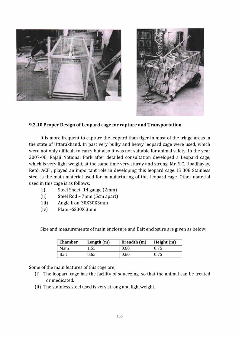
138
9.2.10 Proper Design of Leopard cage for capture and Transportation
It is more frequent to capture the leopard than tiger in most of the fringe areas in
the state of Uttarakhand. In past very bulky and heavy leopard cage were used, which
were not only difficult to carry but also it was not suitable for animal safety. In the year
2007-08, Rajaji National Park after detailed consultation developed a Leopard cage,
which is very light weight, at the same time very sturdy and strong. Mr. S.C. Upadhayay,
Retd. ACF , played an important role in developing this leopard cage. IS 308 Stainless
steel is the main material used for manufacturing of this leopard cage. Other material
used in this cage is as follows;
(i) Steel Sheet- 14 gauge (2mm)
(ii) Steel Rod – 7mm (5cm apart)
(iii) Angle Iron-30X30X3mm
(iv) Plate –SS30X 3mm
Size and measurements of main enclosure and Bait enclosure are given as below;
Chamber Length (m) Breadth (m) Height (m)
Main 1.55 0.60 0.75
Bait 0.65 0.60 0.75
Some of the main features of this cage are;
(i) The leopard cage has the facility of squeezing, so that the animal can be treated
or medicated.
(ii) The stainless steel used is very strong and lightweight.
139
(iii) The cage can be used to move on scoter wheels and can be attached to moving
jeep; it can further be carried with the help of ropes and bamboo rods,
especially in hilly terrain.
(iv) The material used to manufacture does not harm the animal.
9.3 Management of Human-Tiger Conflict
There are several circumstances under which human beings are attacked accidently by
tigers and panthers and may as a result die, but these cases are to be considered only as
accidental killings. Such circumstances include.
(i) Approach by man to an area when a tigress is sheltering her cubs.
(ii) Approach accidentally to a sleeping tiger/tigress specially by grass cutters,
wood collectors, etc.
(iii) A bent-in posture by man when a tiger takes him to be an animal and attacks.
In such cases, the tiger/tigress do not eat the dead person in the first case, but it
may start eating the dead body if the tiger/tigress come across such accidents more
than once. If the tigress is with cubs and is confined to a limited area with shortage of
natural prey, she is more prone to eat the dead body. The mere fat that the dead body
has been eaten does not prove that the animal is a man-eater. Similarly, the fact that a
particular animal has killed more than one human being also does not prove it to be a
man –eater. The circumstances under which the animal killed the human being have to
be examined in detail to arrive at any conclusion.
General preventive and Control Measures, which should be followed are as below;
9.3.1 Preventive Measures
(i) Keeping track of cattle depredation by carnivores through wireless on a daily
basis, and ensuring timely compensation to affected people.
(ii) Monitoring movement of wild carnivores near human habitations through “impression pads” created near water points and other sensitive areas, and
maintaining a record of such village level monitoring in the Gram Sabha /
Panchayat / EDC.
(iii) Alerting / sensitizing local people appropriately, including safe disposal of
livestock carcass and other garbage, to prevent habituation of wild carnivores
like panther from frequenting and subsequently becoming resident in the
area.
(iv) Ensuring active, ecologically sustainable, integrated development for the
benefit of local people living in the area, based on village specific micro plans
with reciprocal commitments through village level committees (Eco-
Development Committees).
140
9.3.2 Control Measures
(i) Deployment of tracking squads comprising of frontline staff and experienced
local people, and plotting day-to-day movement of the aberrant wild
carnivore (preferably using GPS in the GIS domain).
(ii) Deployment of a “watch team” for patrolling the affected village area during
night, involving the EDC/ Panchayat, while using simple repelling techniques
like crackers, light, etc.
(iii) Deployment of elephant squads, if available.
(iv) Deployment of local workforce to prevent local people from trespassing the
affected area.
(v) Using camera traps / impression pads for collecting field evidences relating
to the wild carnivore for arriving at an inference.
(vi) Constituting an advisory committee comprising of field staff, experienced
trackers and NGOs for obtaining advice relating to identity / sex of the
aberrant wild carnivore causing depredation, especially for ascertaining its
sex, age, physical deformity and other related parameters.
(vii) In case of recurring human depredation in quick succession, use of dummies
with a bent posture inside trap cages for trapping the aberrant animal (such
traps, with inbuilt mechanism for automatic closure after animal entry,
should be placed at several sensitive areas).
(viii) In collaboration with the Revenue Authorities, alerting local people for
taking necessary precautions, apart from deploying squads to prevent people
from trespassing the affected areas.
9.3.3 Proper Design of Tiger Cage for capture and Transportation
All tigers must be provided space to lie comfortably but not turn around. There
must be 10cm clearance around the animal when standing in normal position. The
height of the container should allow animal to erect with its head extended and length
must permit it to lie in prone position. Plywood/ fiberglass or equivalent material
should be mounted on a solid wood or metal bolted/ screwed frame. Plywood would
give a strong and smooth interior. Floor should be slated over a liquid proof tray (splash
proof) to collect the excreta. The roof must be solid with ventilation openings. The door
should be made of steel welded mesh or strong iron bars, with bars being spaced such
that the animal cannot pass its leg in between them. The front should also be provided
with a sliding wooden shutter with ventilation holes or should be slated. Basic design
allows free flow of air through both ends of the container, but the design must be such
that the tiger cannot reach out to injure attendants. Use of a double door design on each
end allows for a barred end gate, which provides containment for the animals.Schematic
view of a typical shipping crate (U.S. Dep. Agric., 1980), follows standards of The
International Animal Transport Association (IATA) and adopted by National Tiger
Conservation Authority;
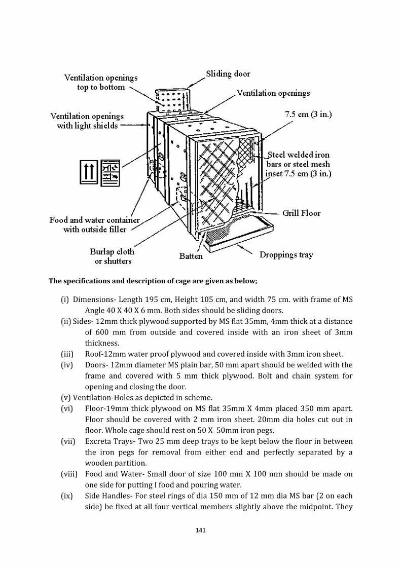
141
The specifications and description of cage are given as below;
(i) Dimensions- Length 195 cm, Height 105 cm, and width 75 cm. with frame of MS
Angle 40 X 40 X 6 mm. Both sides should be sliding doors.
(ii) Sides- 12mm thick plywood supported by MS flat 35mm, 4mm thick at a distance
of 600 mm from outside and covered inside with an iron sheet of 3mm
thickness.
(iii) Roof-12mm water proof plywood and covered inside with 3mm iron sheet.
(iv) Doors- 12mm diameter MS plain bar, 50 mm apart should be welded with the
frame and covered with 5 mm thick plywood. Bolt and chain system for
opening and closing the door.
(v) Ventilation-Holes as depicted in scheme.
(vi) Floor-19mm thick plywood on MS flat 35mm X 4mm placed 350 mm apart.
Floor should be covered with 2 mm iron sheet. 20mm dia holes cut out in
floor. Whole cage should rest on 50 X 50mm iron pegs.
(vii) Excreta Trays- Two 25 mm deep trays to be kept below the floor in between
the iron pegs for removal from either end and perfectly separated by a
wooden partition.
(viii) Food and Water- Small door of size 100 mm X 100 mm should be made on
one side for putting I food and pouring water.
(ix) Side Handles- For steel rings of dia 150 mm of 12 mm dia MS bar (2 on each
side) be fixed at all four vertical members slightly above the midpoint. They
142
are dual purpose- for lifting by crane as well as for trying with another cage
while shifting.
9.4 Human Elephant Conflict
From historical times, the elephant has been a significant part of culture and life in
India. People have domesticated and used elephants for various purposes, killed them
for sport or to protect property and lives, and worshipped them as religious icons.
Human-elephant conflict is implicit in many of these interactions and yet it was only
with the turn of the nineteenth century that the conflict between the two species had
acquired perilous proportions.
Factors such as dwindling forest habitats and large-scale sport hunting during the
British Raj have dramatically reduced elephant range and numbers and today, they are
only found in the northeastern, northwestern, eastern and southern parts of the
country. The remarkable technological progress of the 20th century and enormous rise
in human populations have led to increasing human habitations, reduction of forest
cover and the extensive conversion of forest land to large swathes of agricultural fields.
Although their numbers have reduced, elephants still require large areas to move
around in for food and shelter, and this brings them into greater contact with people
living beside forest areas, leading sometimes to crop raiding, injury or death to humans
and other form of conflict
9.4.1 Preventive Measures
Some of the preventive measures that can be taken up for reducing this conflict are
listed as below;
(i) Improvement and extension of the elephant/wildlife habitat within the
Project Area Landscape to discourage the outward movement of elephant
(ii) Reduce the biotic pressure on the Project Area Landscape forest to enhance
the availability of food and water to the wild animals.
(iii) Creating awareness among the people regarding elephant behavior and
need for their conservation.
(iv) Strengthening the wildlife corridors of the Project Area Landscape to
facilitate the smooth movement of elephants and other animals Control
Measures
Further Area specific control measures that are required in Project Area Landscape
are detailed as below;
(i) Elephant-proof stonework wall
All along the Division (at Boundary of Forest and Village/ habitations) building
elephant-proof stonework wall will help to Restrict/ stopelephantsandother
animalsfromenteringthevillages.
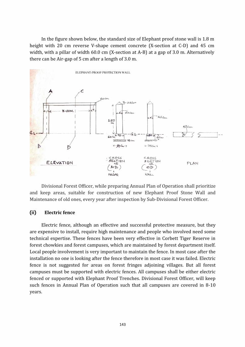
143
In the figure shown below, the standard size of Elephant proof stone wall is 1.8 m
height with 20 cm reverse V-shape cement concrete (X-section at C-D) and 45 cm
width, with a pillar of width 60.0 cm (X-section at A-B) at a gap of 3.0 m. Alternatively
there can be Air-gap of 5 cm after a length of 3.0 m.
Divisional Forest Officer, while preparing Annual Plan of Operation shall prioritize
and keep areas, suitable for construction of new Elephant Proof Stone Wall and
Maintenance of old ones, every year after inspection by Sub-Divisional Forest Officer.
(ii) Electric fence
Electric fence, although an effective and successful protective measure, but they
are expensive to install, require high maintenance and people who involved need some
technical expertise. These fences have been very effective in Corbett Tiger Reserve in
forest chowkies and forest campuses, which are maintained by forest department itself.
Local people involvement is very important to maintain the fence. In most case after the
installation no one is looking after the fence therefore in most case it was failed. Electric
fence is not suggested for areas on forest fringes adjoining villages. But all forest
campuses must be supported with electric fences. All campuses shall be either electric
fenced or supported with Elephant Proof Trenches. Divisional Forest Officer, will keep
such fences in Annual Plan of Operation such that all campuses are covered in 8-10
years.
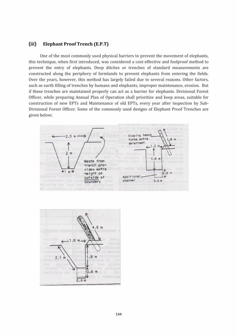
144
(iii) Elephant Proof Trench (E.P.T)
One of the most commonly used physical barriers to prevent the movement of elephants,
this technique, when first introduced, was considered a cost-effective and foolproof method to
prevent the entry of elephants. Deep ditches or trenches of standard measurements are
constructed along the periphery of farmlands to prevent elephants from entering the fields.
Over the years, however, this method has largely failed due to several reasons. Other factors,
such as earth filling of trenches by humans and elephants, improper maintenance, erosion. But
if these trenches are maintained properly can act as a barrier for elephants. Divisional Forest
Officer, while preparing Annual Plan of Operation shall prioritize and keep areas, suitable for
construction of new EPTs and Maintenance of old EPTs, every year after inspection by Sub-
Divisional Forest Officer. Some of the commonly used designs of Elephant Proof Trenches are
given below;
145
(iv) Alternative Agricultural Practices
There are certain deterrent cropping pattern which have been tried else where
other states and neighboring countries such as growing chilli and tobacco to keep
elephants out of fields; changing farming practices - making farms easier to defend;
growing crops that elephants don't like; education; and improving oil palm plantation
practices in Malaysia and Indonesia. These alternatives agricultural practices may be
tried on trial basis in interested villages, but shall be replicated only after proper
impact studies.
9.4.2 General and common practices to reduce elephant problem
(i) Traditional crop protection measures that involve chasing elephants away from
crop fields or habitations by creating loud noises through shouting, beating
drums and bursting fire crackers, burning fires or using powerful search lights
and torches.
(ii) Early warning communication systems, such as trip wire alarm systems, satellite
tracking and informant networks, whereby people receive prior information
about the movements of elephants.
(iii) Human-elephant conflict mitigation squads (Elephant Driving Squads),
consisting of village youths and trained elephants (kumkies) that are stationed
at strategic locations to drive back wild elephants from crop fields and human
habitations. Further, certain sounds recorded have also been tried in certain
areas of division successfully, but this type of technique shall not be used
continuously in a particular area, other animal, especially carnivores may also
be attracted by such calls.
(iv) Bee keeping in affected areas outside Sanctuary may be done on trial with an
objective to drive away elephants.
(v) Planting buffer/unpalatable crops to make certain areas and crop fields
unappealing to elephants;
(vi) Elephant drives, whereby large groups of elephants are driven away from the
conflict area into safer zones.
(vii) Timely disposal of ex gratia cases, in which monetary compensation is paid to
victims of elephant conflict in order to reduce the economic losses borne by
them due either to crop depredation or the injury or loss of human life.
9.5 Human Wild Boar Conflict Management
The wild boar (Susscrofa) is one of the most widely distributed large mammals. It
has always been associated itself with man, and successfully utilises the human altered
landscape (Fadeev 1975, Erkinaro et al. 1982). Being a resilient and fast breeding
146
animal, it is capable of expanding and establishing its population in new areas (Erkinaro
et al. 1982, Ahmed 1991).
Agricultural crop depredation by wild pigs is a major problem in many parts of
India. Wild pigs raid crops and utilises the agro-ecosystem for food resource and
shelter. The wild pigs notoriety as a crop pest is universal (Tisdell 1982). Presently the
wild pig populations are fragmented and relatively isolated all over. Some of these
isolated populations became locally overabundant and depend upon agricultural crops
especially in and around protected areas (PAs) or managed forests (MFs) - village
interface areas for a major part of their food requirement.
In a study on “Human–Wild Pig Conflict in Selected States in India and Mitigation
Strategies” carried out by N.P.S. Chauhan, Kuldeep S. Barwal, Devender kumar of
Wildlife Institute of India, Dehradun, shows that in Uttarakhand, damage to madua crop
by wild pigs was highest (38%), followed by damage to cholai and katu (30%), maize
(29%), sugarcane (25%) and pulses (23%). Pigs least affected wheat and barley crops.
This study further shows that maximum human casualty took place in two periods in
daytime i.e. 8 am to 12 pm and 4pm to 8pm.
9.5.1 Preventive measures
People should remain alert and vigilant while moving in forests and crop fields
especially at the time when wild pigs are active. Use of local protective methods, co-
operative guarding of matured crops is necessary. Wire fences with white, flying,
flashing ribbons or plastic strips that produce scaring sounds and other frightening
devices should be used in and around crop fields. Use of pig-proof barriers for crop
protection and elimination or population control strategies in affected areas also needs
to be carried out. Villagers should avoid cultivating crops, which are highly susceptible
to damage near forests, and should try changing cropping patterns by growing other
cash crops.
Further, Education and awareness programs on the ecology and behaviour of wild
pigs and on mitigation strategies should be initiated for villagers in affected areas. In the
fragmented and degraded forest areas, habitat protection should to be carried out to
sustain the existing wild pig population.
9.5.2 Control Measures
Permission for hunting of Wild Pig and Neelgai/ Blue Bull/ Van Rozunder section
11(1) (b) of Wildlife (Protection) Act 1972 has been delegated to field level officer, such
animals shall be captured and rehabilitated to forest area.
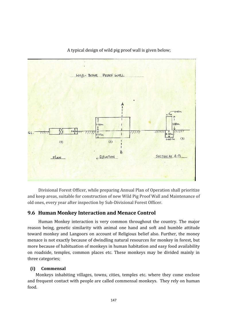
147
A typical design of wild pig proof wall is given below;
Divisional Forest Officer, while preparing Annual Plan of Operation shall prioritize
and keep areas, suitable for construction of new Wild Pig Proof Wall and Maintenance of
old ones, every year after inspection by Sub-Divisional Forest Officer.
9.6 Human Monkey Interaction and Menace Control
Human Monkey interaction is very common throughout the country. The major
reason being, genetic similarity with animal one hand and soft and humble attitude
toward monkey and Langoors on account of Religious belief also. Further, the money
menace is not exactly because of dwindling natural resources for monkey in forest, but
more because of habituation of monkeys in human habitation and easy food availability
on roadside, temples, common places etc. These monkeys may be divided mainly in
three categories;
(i) Commensal
Monkeys inhabiting villages, towns, cities, temples etc. where they come enclose
and frequent contact with people are called commensal monkeys. They rely on human
food.
148
(ii) Semi commensal
Monkeys, which have some human contact not regularly such as on roadsides,
parklands, canal banks etc. are called semi commensals. They rely partly on human
food.
(iii) Non commensal
Monkeys, which are living in forest areas and rely on wild food, are called non-
commensals.
The strategy for controlling the monkey problem should be based on two-pronged
approach i.e.
9.6.1 Preventive Measures
1. Certain basic behavior/ attitude which should be followed include;
(i) Do not make direct eye contact with monkeys.
(ii) Do not cross the path between a mother and her infant.
(iii) Do not irritate or tease the monkeys. Leave them alone and they will leave
you alone.
(iv) Be light footed while passing through a monkey group i.e. Do not run.
(v) Do not go near a dead or wounded monkey.
(vi) Do not feed monkeys. If anybody found feeding monkey, necessary legal
action shall be initiated.
(vii) Do not get scared if a monkey makes a ‘Kho-Kho’ noise as normally it is a
bluff. Ignore the monkey and walk away calmly.
(viii) Presence of big dogs in premises shall make monkeys leave the area.
(ix) An injured monkey should be helped when monkey group is not close by.
Forest department or the local Animal Welfare Societies.
9.6.2 Control Measures
(i) Permission for capture the monkey under section 11(1) (b) of Wildlife
(Protection) Act 1972 has been delegated to field level officer, such animals
shall be captured and rehabilitated to forest area. (The relevant orders issued
by Chief Wild Life Warden vide its letter No. 1328/6-6 dated 4 December 2014
is provided in the Annexures). It very important to note that all the Monkey
enclosure constructed are as per Central Zoo Authority and are dully
sanctioned by relevant authorities including CZA.
(ii) Further, seriously problem animal shall be captured and sterilized (both male
and female) and later on rehabilitated to forest/ natural habitat.
149
(iii) The animals should be kept in enclosures duly approved by Central Zoo
Authority from the point of size, material etc.
9.7 Chemical Capture of Wild Animals
The use of chemicals (poison on an arrow head or in food) for capturing wild
animals for food is well known from antedated historical records. However, using
chemicals developed safe immobilization of animals by using chemicals about five
decades ago that presumably corresponds to the discovery of inhalation anesthetics
(ether and chloroforms) for the purpose of veterinary and human medicines.
The first drug ever used through projectile and syringe to immobilize wild animal
was a paralyzing drug of succinylcholine or gallemine group – a blocker at the neuro-
muscular junction causing brief muscle paralysis. However, certain disadvantages like
an abrupt recovery from muscle paralysis and a low safety margin of the drug, coupled
with a lack of a suitable antidote precluded this drug for subsequent uses.
In 1960, while relocating a hundred (square lipped) rhinoceros from Hulhluwe
and Umfolozi Game Reserve in Africa, Dr. Harthoon used narcotics in combination with
tranquilizers (i.e. Hyoscine and Promazine ). The wide safety margin of the drug
compensated for weight and species variables. The advent of morphine based drugs
with an admixture of suitable tranquilizer made chemical immobilization more safe and
easy. To date, besides morphine, several other safe drugs along with an improved
delivery system are known that have enhanced the application of chemical restraint in
capturing wildlife for several purpose.
9.7.1 Need for Chemical Restraint of Wild Animals
Chemical restraint includes any method that primarily uses a chemical agent or
drug for restricting animals freedom i.e. walking, running, and aggressiveness. The state
of restraint can vary from immobilization (arresting movement), tranquilization
(calming) to anaesthetization (complete loss consciousness). The drug delivery may be
from simple, oral or by hand held injection to complicated, by remotely projected
syringes or darts as are used in many wild animal chemical capture techniques.
There is no single immobilization system that is universally applicable. A large
array of chemical agents are available for immobilization that have their own effects
and limitations and must be used with proper understanding of what they can do and
what they can not, prior, training, and the presence of an experienced person with
preferably veterinary knowledge, is an essential prerequisite for capturing animals with
drugs. Chemical restraint methods are used for the following purposes;
(i) Capture of problematic animals or animals in distress;
(ii) Veterinary care of wild and captive animals;
150
(iii) Population building and control; e.g. translocation, reintroduction, hormonal
implant and sterilization.
(iv) Research studies; e.g., radio-collaring and surgical implant; and
(v) Drug experimentation.
The advantages of chemical restraint over other traditional methods of restraint
are that:
(i) It can be used in various situations’ (ii) It enables capture of carefully selected individuals;
(iii) It enables selection of the time of capture; and
(iv) The equipment is easy to carry and shift from one place to another in the field.
Chemical restraint may have the following disadvantages that, however, can be
minimized or eliminated by careful observance of precautions:
(i) Occasional equipment failure: e.g., faulty charges or any other equipment fault;
(ii) Operator error;
(iii) Occasional undesirable side-effects of drug because of unknown physiological
status of animal;
(iv) Drug induction delay due to oblique hitting of the dart and subsequent
unsuccessful location of the animal;
(v) Animals injury due to dart delivery on the wrong site or due to the use of more
than the required charge for the particular distance;
(vi) Cannot be used for capturing animals on a large scale.
Chemical capture is quite safe if accomplished by trained and experienced
personal. It is very difficult to generalize what percentage of immobilization mortalities
should be taken as the standard hazard for the chemical restraint technique. Occasional
mortalities can occur due to unanticipated reasons such as internal infection and
injuries of the anima, capture myopathy (muscle degeneration) or unusual conditions,
which should be condoned and accepted as part of chemical restraints. Efforts, of
course, should always be to minimize immobilization causalities by paying attention to
the basic considerations, careful search plan for the darted animal, and post capture
care. It is mandatory to report and carry out detailed post-mortem investigation of
immobilization casualty to establish the reasons for the failure. Chemical restraint is not
the only method available for animal capture. The choice of method will depend upon;
(i) Other efficient restraint methods existing for the species;
(ii) Safety provided to the targeted species;
(iii) Human safety from animal and drug; and
(iv) How much attention can be provided to the animal captured after restraint.
151
In a few circumstances and for certain species, mechanical (or physical) capture is
better suited than chemical capture, while in some others, especially when dealing with
free ranging wild animals, a combination of physical and chemical captures will give
better results. The decision whether to use physical, chemical or a combination of the
both would be based on the skill of the handler, the facilities available and the physical
and psychological state of the animal to be restrained. Available literature and
experienced personnel should be consulted when in doubt.
9.7.2 Important aspects to be considered while deciding for chemical restraint
Wild animals can be approached within their flight or from safe distance in case of
aggressive animals. Crossing the limit of the safe distance in case of aggressive and
ferocious animals can be dangerous. Habitat disturbance factors and vegetation cover
have direct bearing on the flight distances for animals. However, use of a vehicle,
elephant, hideout, vantage points or camouflage can facilitate approaching the animal.
Smaller animals need to be closer as compared to the large animals for they have a
smaller darting area. Any deviation from the target site may injure the animal badly..
The type of forest cover, available road network, terrain, behavior of animal
(coming to a saltlick or water-point) are factors that would help select the mode of
approach. In the tall terai grasslands, riding elephants could be the only choice. On the
other hand, in dense vegetation, following an elephant on foot will be more profitable.
For such tracking, however, knowledge of bush-craft and wind direction is a must.
Elusive animals can be chemically restrained on lures from a hideout or platform on
tree. Further, following basics should be considered while deciding the chemical
restraint;
(i) Purpose of capture should be ecologically, socially, ethically, and technically
justified.
(ii) Type of terrain--areas with dense cover, steep slopes, large water-bodies nearby
(for terrestrial animals) should be avoided. A complete understanding of the
terrain is essential.
(iii) Type of animal—whether aggressive, powerful, potentially dangerous to
operator, with young to defend or prone to stress—should be assessed.
Territorial, behavioural (heat, rut and musth), hierarchical and health status of
animal should be known.
(iv) Emaciated, sick or old animals should not be captured or restrained. Such
animals have a very unpredictable drug response. However, for management
purpose, such animals can be restrained once the limitations of drug response
are ascertained.
(v) The selected animal or partially immobilized animal should not be chased or
otherwise excited. Excited animal may fight against normal dosage rates, and if
the dosage is increased, the animal could die.
152
(vi) High (<35o C) and low (> 10o C) temperature regimes are not ideal, for the animal
may suffer from temperature stresses. The drug effect may further cause an
increase in body temperature (hyperthermia or hypothermia). Suitable
temperature regime for immobilization can be obtained by selecting different
time period in different seasons.
(vii) Safety of the handler from a dangerous animal and narcotic drugs should be
ensured. No operation with morphine drugs should be performed without a
human antidote (Narcan) kept ready for use by accompanying person(s) fully
aware of the accidental procedure.
(viii) Safety drugs to meet emergency situation in case of captured animals should
always be taken to the field.
(ix) Sufficient daylight for searching for the darted animal should always be ensured.
For instance, in northern India where daylight during winters is short,
immobilization should not, normally be carried out later than 1400 hrs.
(x) Stay with the immobilized animal till it ha completely recovered from the effect
and is able to take care of itself accidently falling or becoming an easy victim to
predation.
9.7.3 Drugs for Chemical Restraint
There are several chemical agents or ‘drugs’ available for restraint of animals.
Each drug works in different manner and is more suited to some species in purpose and
response than the others. The time required for a drug to have an effect depends upon
the factors such as the injection site route of administration, absorption rate,
physiological state of the animal, and concentration of the drug. However, there are
several other variables that cn impair the drug effect due to variations in species of
animal, age, sex, temperature regimes in seasons and time of the day animal
temperament and emotional state and its physical and physiological conditions.
Response of the drug to these different variables may often make chemical
immobilization unpredictable.
There is no single agent which can be termed ideal and that is universally suited to
all animal species. However, within the frame of our present knowledge for any drug to
be considered ideal should have the following advantages;
(i) Wide safety margin
(ii) Effectiveness is as many genera as possible
(iii) Allow retention of righting reflexes
(iv) Non-interference with respiration or temperature regulation
(v) Have minimum side-effects
(vi) Require a small dosage (<5ml)
(vii) Have fast absorption and rapid action
153
(viii) Have a specific antidote, allowing quick reversal of drugged condition
(ix) Not hazardous to operators
(x) Easily available and not restricted by legislation
(xi) Reasonable cost
Agents that are used for chemical capture can be classified into two board
categories; Paralyzing and Centrally acting drugs. Paralyzing drugs are also known as
neuromuscular blockers because they act where the motor nerve connects with the
muscle at the neuromuscular junction or muscle end plates and prevent the muscle
from functioning. By blocking, transmission between motor nerves and muscle, these
drugs paralysis an animal. Some common examples are: succinylcholine (Sucostrain and
Anectine) and Gallemine (Flexedil).
Neuro-muscular blockers have a narrow safety margin and may cause death by
paralyzing the diaphragm and intercostal muscle leading to stoppage of breathing.
Unless, one is familiar with artificial or oxygen resuscitation methods, these drugs
should not be used. Animals paralysed by these drugs awake, are fully aware of their
environment, receive all impulses but cannot react and are thus subject to great stress.
Due to this low safety margin and the risk involved, these drugs are unsuitable for field
application.
Centrally acting drugs or central nervous System (CNS) depressants/
Chemical agents, entirely or predominantly, have an effect on the central nervous
system of brain. The effect of these drugs ranges from calming (tranquilization),
depression (sedation), loss of pain (analgesia), a trance-like or psychotic state
(hypnosis), and complete loss of consciousness (anesthesia). A great deal of overlap
occurs among the groups and in many ways such classification does not stand
demarcated. For example, Diazepam in small dosage acts as a tranquilizer, in a little
higher dosage it acts as sedative and in a large dosage as an anesthetic (although not
recommended for this purpose). The scope of this classification is therefore restricted
to knowing the overall effect and response of the drug.
Centrally acting drugs elicit responses such as tranquilization, sedation, narcosis,
analgesia, and dissociation. In chemical restraint, drugs are often combined to achieve a
synergistic action either to reduce the drug volume or to have better control over
animal response, or both.
(i) Tranquilizers
These drugs produce a marked calming effect, loss of aggression and get fully
immobilized with tranquilizers, and can be aroused by giving pain or by being
disturbed. Tranquilizers are often used to induce a reduced reaction to stimuli in the
animals, without having to immobilize them; e.g., in transporting animals, where the use
of a tranquilizers will help gaining control over an animal excitement and keep them
calm. They are sometimes used in combination with narcotics or dissociative to reduce
154
the initial excitement due to the drug effect and increase the potency of that drug. E.g
Diazepam (Valium, Tranimal).
(ii) Sedatives
Sedation is a term borrowed from human medicine. Under the influence of a
sedative, an animal will remain in a condition of sleep-like trance. Drugs of this class
cause CNS depression, loss of coordination and sleep in appropriate dosages. Very high
dosage may lead to death due to respiration and cardiac depression. E.g. Xylazine
(Rompun)
(iii) Narcotics and Analgesics
The drugs of this class are morphine and morphine derivatives. Narcotics are
powerful painkillers or analgesics. In small dosages, morphine acts as a tranquilizer but
large dosages cause CNS depression and anesthesia. Respiration and cardiac depression
are very important narcotic effects to guard against in sick, stressed or excited animals.
A narcotic drug combined with a tranquilizer has an synergistic action and is commonly
used to reduce the side-effects of the morphine group of drugs. The effect of narcotics
can be reversal agent that acts on the binding sites in the brain. E.gMetophone
(Halothane)
(iv) Dissociative
It commonly used for effects generated by drugs like Ketamine and Phencyclidine.
An animal under dissociative influence usually remains conscious but largely indifferent
to stimuli. It is incapable of walking, its eyes remain open and swallowing reflexes are
partially maintained. It is also combined with tranquilizers. E.g. Ketamine hydrochloride
( Ketaset, ketanest)
(v) Hellabrunn mixture (HBN) – mixture of ketamine and xylazine
In recent decades, drug combinations are also being used for immobilization of
wild animals. One such promising combination is the addition of Xylazine hydrochloride
or rompum to ketamine in a specific ratio of 500mg to 400 mg respectively. This is
known as Hellabrunn Mixture (HBN) and was first developed and tested in
Hellabrunn Animal Sanctuary, Munich. The combination is effective on a wide range of
species and less hazardous to the operator.
When used together, Xylazine and ketamine exhibit a very marked synergistic
effect. This represents a major benefit as it reduces the otherwise prohibitively large
volume of ketamine required for use on large animals. In addition Xylazine provides the
advantage of a tranquilizer as well as enhance the pain killing and muscle relaxing
qualities of ketamine.
155
Preparation: HBN is a mixture of ketamine and Xylazine in a ratio of 400 mg; 500
mg respectively. To prepare this mixture, 4 ml of 100mg/ml ketamine is mixed in 500
mg of Xylazine powder. Each ml of the combined drug contains 100mg ketamine and
125 mg Xylazine. The drug volume requirement is as per the species (see chapter 5 and
6). This combination is quite stable if preserved properly. The effect can be adjusted
altered, regulating the volume of ketamine hydrochloride.
Indications: HBM is very suitable and a safe drug for most ungulate species. In
carnivores also it works well except that occasionally it increases their body
temperature due to the increased action of Rompun. The induction time varies from 7-
10 minutes, with anaesthetic effects prolonging for 45-50 minutes and complete
recovery in 1-2 hours.
Administration: In wild animals, HBN can be routed through intra-muscular
injection. No long term or immediate side-effect have been reported with its use.
Salivation and muscle relaxation are due to individual drug effect of ketamine and
Xylazine respectively. Further, general dosage ( by volume and by composition) of HBM
for tiger and leopard is given below in table;
9.7.4 Equipment’s used for Chemical Restraint
Drug immobilization or darting is now a widely used ‘Capture method’, particularly appropriate for large or dangerous species. Although, most of the drugs and
equipment are still required to be imported but, it is being increasingly used in
India.Prior training and the presence of an experienced parson.preferably with
veterinary knowledge, are essential.
As with all forms of capture, occasional animal fatalities (up to 10%) are
experienced but can largely be avoided by careful observance of precautions.
Advantages
(i) Compared to mechanical capture methods, immobilization causes little
disturbance to the animal fear, shock and physical damage are practically
eliminated.
(ii) Ti enables the capture of carefully selected individuals.
(iii) Time of capture can also be selected.
(iv) Equipment is very portable, enabling rapid shifts of field location.
Disadvantages
(i) As with all drug use, undesirable side effects are possible.
(ii) Due to drug induction delay, darted animal is occasionally lost.
(iii) Procurement of drugs and equipment from overseas can be tedious and
expensive.
(iv) Danger to human operator if certain drug used carelessly.
156
There are two essential items of immobilization equipment: the projector
blowpipe, rifle, pistol-and the projectile-dart or flying syringe, of which the needle is a
vital component. For successful capture, selection of appropriate equipment and
familiarity with its use are essential. Target practice, involving anticipated dart sizes
and shooting range, are a must before embarking on any capture operation.
9.7.4.1 Blowpipe
This is the simplest type of dart projector, consisting of a straight pvc or aluminum
pipe 1 to 2m in length and 8.0 to 10.0mm in diameter. It propels a small plastic dart
over distances of up to 10m and is mainly used of thin-skinned animals in enclosures.
After placing the blowpipe is held to the mouth and pointed steadily toward the target
area of the animal’s anatomy. After taking a deep breath, a rapid blow is made to propel
the dart.
The blowpipe is entirely silent in operation, causing minimum disturbance to non-
target members of a group of animals. It has no operating costs, apart from occasional
replacement of dart components.
9.7.4.2 “Blow-gun” rifle
This equipment (teleinject) consists of a blowpipe fitted onto a gunstock which
has a compression chamber pressurized via rubber tubing connected to a tyre foot
pump (inflator). Compressed air is released into the barrel to propel the dart by pulling
a trigger- a mechanism similar to an air gun. The instrument is fitted with a sight and
propels a lightweight plastic dart with fair accuracy up to about 30m. Air pressure
imparted may be varied according to syringe size and target distance and is read on a
pressure gauge attached to the inflator.
This simple, lightweight propulsion system has greater range and accuracy than
the blowpipe and is ideal for zoo animals or thin-skinned species in the wilds, providing
one can get within the desired range. However, the small syringe capacity is a serious
limitation, added to which their lightness makes these darts subject to cross winds.
9.7.4.3 Powder Charged Rifles
This lightweight 32 calibre (13mnm) rifle (“Dist-Inject” or “Cap-chur”) propels
darts up to 15ml capacity to a range of over 50m by means of an explosive charge,
similar to a .22 blank cartridge. Charges are available in a variety of strengths
depending on dart weight and target distance. Some brands of rifle (“Dist-Inject”) also
have an adjustable rear sight which enables very accurate shooting.
An aluminum dart is assembled according to requirements (drag volume and
needle size) and may be used much time. Ready prepared disposable plastic darts are
also available.
157
A pistol is available for short ranges (up to 20m) with the same kind of dart and is
useful for zoo enclosures or administering a ‘top-up’ to an under dosed but
approachable animal in the wild.
Its accuracy, shooting range and variety of dart types and sizes impart great
flexibility to the powder rifle and it is the most widely used darting system in India at
the present time, the Swi9ss made “Dist-Inject” equipment being particularly popular.
9.7.4.4 Reusable plastic darts
The blowpipe and blow-gun fire a reusable lightweight plastic dart, available in
sizes between 1 and 3.5 ml capacity. The drug loaded into the front chamber of the dart
from a hyperdermic syringe and an appropriate needle then attached. The needle
opening is at the side and covered with a tight fitting plastic sleeve, which prevents loss
of the drug when the dart is pressurized. This is achieved by introducing compressed air
or an inert gas into the rear chamber of the dart, behind the plunger. The flight or
stabilizer is then attached.
After firing, as the needle penetrates the animal’s skin the sleeve is pushed
backwards, allowing the drug to exit from the side hole into the sub dermal tissues.
9.7.4.5 Disposable plastic darts
Ready prepared plastic darts with a fixed needle and explosive cap to activate the
plunger are available for powder charged rifles, in sizes varying between 1 and 3.5ml
these convenient, lightweight darts have to be loaded via the needle using a narrow
canula attached to a hyper dermic syringe. They cannot be re-used. Due to their
lightness these darts are less liable to cause tissue injury on impact but are more subject
to wind deflection than heavier metal darts. A maximum volume of only 3.5ml is a
further limitation in many operations.
9.7.4.6 Metal darts
To assemble one of these darts an aluminum syringe barrel is selected in
accordance with required drug volume (ranging from 1 to 15ml) a greased rubber
plunger, fitted with an impact sensitive explosive charge, is placed inside the barrel
towards the rear end. A flight stabilizer is screwed in behind it. After loading the drug, a
needle is screwed into the front of the barrel. A little Vaseline smeared over the needle
hole(s) prevents accidental seepage of the drug.
After loading the prepared dart into the rifle a cylindrical steel cartridge holder is
placed in the breech behind it.
9.7.5 Planning Chemical Restraint Operation
All chemical restraint operation requires a great deal of careful planning,
preparation and organization. The selection of proper equipment and drugs, target
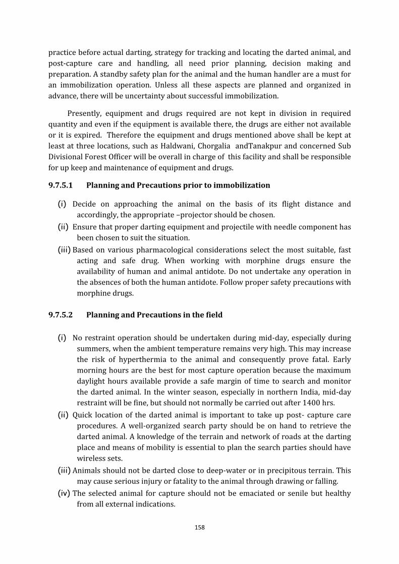
158
practice before actual darting, strategy for tracking and locating the darted animal, and
post-capture care and handling, all need prior planning, decision making and
preparation. A standby safety plan for the animal and the human handler are a must for
an immobilization operation. Unless all these aspects are planned and organized in
advance, there will be uncertainty about successful immobilization.
Presently, equipment and drugs required are not kept in division in required
quantity and even if the equipment is available there, the drugs are either not available
or it is expired. Therefore the equipment and drugs mentioned above shall be kept at
least at three locations, such as Haldwani, Chorgalia andTanakpur and concerned Sub
Divisional Forest Officer will be overall in charge of this facility and shall be responsible
for up keep and maintenance of equipment and drugs.
9.7.5.1 Planning and Precautions prior to immobilization
(i) Decide on approaching the animal on the basis of its flight distance and
accordingly, the appropriate –projector should be chosen.
(ii) Ensure that proper darting equipment and projectile with needle component has
been chosen to suit the situation.
(iii) Based on various pharmacological considerations select the most suitable, fast
acting and safe drug. When working with morphine drugs ensure the
availability of human and animal antidote. Do not undertake any operation in
the absences of both the human antidote. Follow proper safety precautions with
morphine drugs.
9.7.5.2 Planning and Precautions in the field
(i) No restraint operation should be undertaken during mid-day, especially during
summers, when the ambient temperature remains very high. This may increase
the risk of hyperthermia to the animal and consequently prove fatal. Early
morning hours are the best for most capture operation because the maximum
daylight hours available provide a safe margin of time to search and monitor
the darted animal. In the winter season, especially in northern India, mid-day
restraint will be fine, but should not normally be carried out after 1400 hrs.
(ii) Quick location of the darted animal is important to take up post- capture care
procedures. A well-organized search party should be on hand to retrieve the
darted animal. A knowledge of the terrain and network of roads at the darting
place and means of mobility is essential to plan the search parties should have
wireless sets.
(iii) Animals should not be darted close to deep-water or in precipitous terrain. This
may cause serious injury or fatality to the animal through drawing or falling.
(iv) The selected animal for capture should not be emaciated or senile but healthy
from all external indications.
159
(v) As far as possible, pregnant and lactating females should not be selected for
capture. Drug effect and stress may induce abortion of the developing fetus.
However, this condition is sometimes difficult to determine in some animals
even in the advanced stage.
(vi) No animal should be chased or excited before or after darting. This may lead to
either retarded induction or partial effect or may jeopardize the life of the
animal in extreme cases.
(vii) Always take a straight and broadside shot at the target site (muscular part) of
the animal. The target path should be free from all hindrance such as grass
blades or blushes, which are likely to deflect the dart.
9.7.5.3 Planning and Precautions after darting
(i) Once the animal is darted, remain quite. Keep the animal in sight and allow the
drug to take its effect. Any excitement may cause the animal to take flight,
which will make it difficult to locate the animal again.
(ii) Wait until the drug has taken its full effect to bring the animal down. This may
vary from 5-20 minutes. Depending on the drug used.
(iii) Premature handling or noise may excite the animal to take fight, animal may
struggle to escape and in the process get injured. Approach the animal only
when iy is settled and drug is judged to be complete. Tes the recumbent animal
by prodding it lightly with a stick from the rear.
9.7.6 Chemical Capture of Ungulates
Drug capture is ideal for large ungulates such as Sambar and Neelgai, but may be
used in absence of appropriate methods for species down to size of cheetal. In the wild
powder charged rifle, which is more accurate over the longer ranges usually, involved
with these species, is the best choice. The Dist Inject 60N rifle, with adjustable rear
sight. A blowpipe may be used for small captive enclosures. For smaller species like
cheetal, physical capture is better option. If it is required to be chemically immobilized
then; pre assembled plastic dart should be used. A blowgun is ideal for such animals
with 16-28 mm needle.
Drugs mentioned with suitable composition are used for immobilizing ungulates;
Species Drug Dosage
Volume Composition
Neelgai Immobilon 3-4 ml Etorphine+
+Acepromazine
7.35-9.80 mg
30-40 mg
Sambar Immobilon 2 ml Etorphine+
+Acepromazine
4.9- 7.35 mg
20-30 mg
Chital Hellabrunn Mixture 1.25-1.5 ml Ketamine
+Xylazine
125-150 mg
156-188 mg
Rompun (10% Solution) 2-2.5 ml Xylazine 63-100 mg
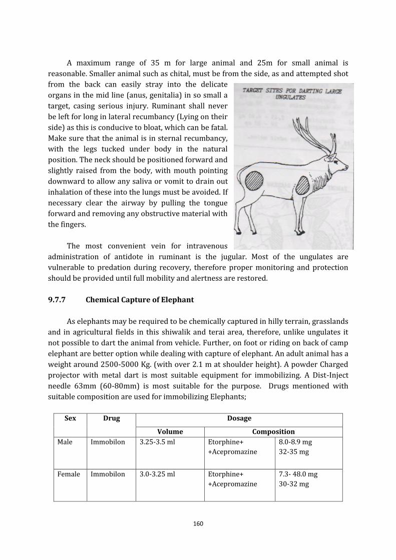
160
A maximum range of 35 m for large animal and 25m for small animal is
reasonable. Smaller animal such as chital, must be from the side, as and attempted shot
from the back can easily stray into the delicate
organs in the mid line (anus, genitalia) in so small a
target, casing serious injury. Ruminant shall never
be left for long in lateral recumbancy (Lying on their
side) as this is conducive to bloat, which can be fatal.
Make sure that the animal is in sternal recumbancy,
with the legs tucked under body in the natural
position. The neck should be positioned forward and
slightly raised from the body, with mouth pointing
downward to allow any saliva or vomit to drain out
inhalation of these into the lungs must be avoided. If
necessary clear the airway by pulling the tongue
forward and removing any obstructive material with
the fingers.
The most convenient vein for intravenous
administration of antidote in ruminant is the jugular. Most of the ungulates are
vulnerable to predation during recovery, therefore proper monitoring and protection
should be provided until full mobility and alertness are restored.
9.7.7 Chemical Capture of Elephant
As elephants may be required to be chemically captured in hilly terrain, grasslands
and in agricultural fields in this shiwalik and terai area, therefore, unlike ungulates it
not possible to dart the animal from vehicle. Further, on foot or riding on back of camp
elephant are better option while dealing with capture of elephant. An adult animal has a
weight around 2500-5000 Kg. (with over 2.1 m at shoulder height). A powder Charged
projector with metal dart is most suitable equipment for immobilizing. A Dist-Inject
needle 63mm (60-80mm) is most suitable for the purpose. Drugs mentioned with
suitable composition are used for immobilizing Elephants;
Sex Drug Dosage
Volume Composition
Male Immobilon 3.25-3.5 ml Etorphine+
+Acepromazine
8.0-8.9 mg
32-35 mg
Female Immobilon 3.0-3.25 ml Etorphine+
+Acepromazine
7.3- 48.0 mg
30-32 mg
161
The first indication of successful immobilization is slowing of elephant’s pace
within few hundred meters. The animal comes down within 20-40 mins concurrent
with relaxation of penis in the males. Search for immobilized elephant should be
planned carefully as it is likely to travel some distance before attaining a state of
recumbancy. A partially immobilized animal may charge suddenly when alarmed.
Elephhants generally fall onto their sides,
when they are immobilized and may safely be
left in such lateral recumbancy for several hours.
Under no circumstances should the animal be
left in sternal recumbancy for more than 20
minutes, it causes improper ventilation, which
further lead to build up of fluid in the lungs
which may cause sudden death of animal.
Elephants can be handeled and transported with
a large intra-muscular dosage (upto 500 mg) of
Rompun or Xylazine in a sedated state. This may
be required while shifting the animal from the darting site to other. After reversal of
immobilon with Revivon 200mg Rompun may be administered at time, upto a total
1000mg to maintain a tractable state in which the elephant is able to walk on its on
without aggression and in a manner as directed.
Revivon is fast acting antidoteand before administration it should be ensured that
all humans are moved back to safe distance. Normallly within 5-15 mins of intravenous
administration administration of antidote, the animal is able to stand on its legs.
9.7.8 Chemical Capture of Carnivores
The tiger and leopard are solitary animals may be found in deep dense forest, open
grassland or even confined in building, when it is required to be immobilized. Male tiger
has a weight of around 180-230 kg, while female weighs around 145 kg. A male leopard
weighs around 90 kg while a female weighs around 50 kg. Being a thin-skinned animal
the cat family animals are darted generally using blow-gun (Tele Inject or Dan Inject).
Hellabrunn Mixture (HBM) mixture with additional Ketamine or some variant of
Ketamine/ Xylazine combination is mostly used for felids.
General Drug Dosages for Tiger and Leopard
Species Drug Dosage
Volume Composition
Tiger Hellarunn
+ Ketamine
2 ml
+3.0 - 5.0 ml
Ketamine
+ Xylazine
500 - 700 mg
250 mg
Leopard 1. Hellarunn
+ Ketamine
3.0 - 1.0 ml
+ 1.5 ml
Ketamine
+ Xylazine
180 - 250 mg
37.5 - 125 mg
Or 2. Ketamine 4 ml Ketamine 400 mg
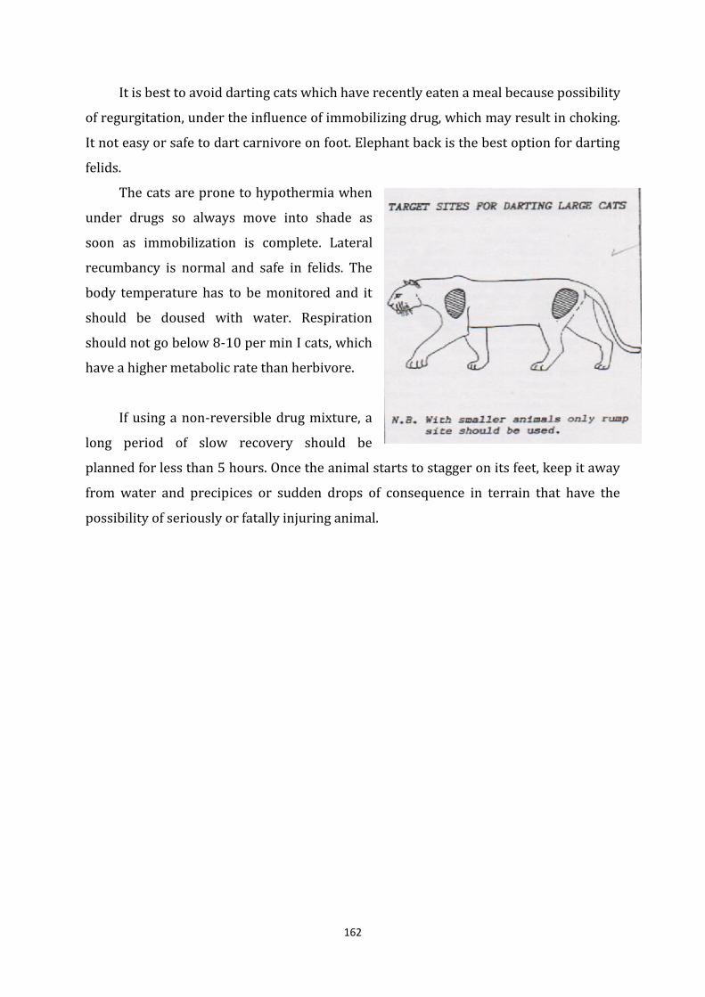
162
It is best to avoid darting cats which have recently eaten a meal because possibility
of regurgitation, under the influence of immobilizing drug, which may result in choking.
It not easy or safe to dart carnivore on foot. Elephant back is the best option for darting
felids.
The cats are prone to hypothermia when
under drugs so always move into shade as
soon as immobilization is complete. Lateral
recumbancy is normal and safe in felids. The
body temperature has to be monitored and it
should be doused with water. Respiration
should not go below 8-10 per min I cats, which
have a higher metabolic rate than herbivore.
If using a non-reversible drug mixture, a
long period of slow recovery should be
planned for less than 5 hours. Once the animal starts to stagger on its feet, keep it away
from water and precipices or sudden drops of consequence in terrain that have the
possibility of seriously or fatally injuring animal.
163
Chapter 10
People’s Interface and Corridor Connectivity Management
10.1 People’ s Interface
Villages in and around Project Area Landscape are mainly dependent on on
agriculture, animal husbandry, daily wages work. Major agricultural crops are wheat,
Rice, maize, pulses, Ginger, turmeric etc. Villages situated on southern boundary have
also started growing Sugarcane also in recent decades. Further, these villages are highly
dependent on adjoining forests and parts of Project Area Landscape for collection of
grass, fodder, and firewood, lopping and grazing of cattle place tremendous biotic
pressures on the forest.
10.1.1 Fringe Area Village Dependency
It is very difficult to control the menace of these illicit activities, if not downright
impossible, as the villagers have no other alternative. Under the circumstances, it is
important to involve the villagers in eco-development activities in order to reduce the
biotic pressures on the forest of the Project Area Landscape.
This dependency on forests is historical and can not removed by a single
programme or effort but ecologically sustainable economic development of villagers
living in close proximity with forests with the objective of reducing biotic pressure on
the forests. The Divisions of the Project Area Landscape shall take up Eco development
Activities in immediately effected villages on pilot basis as per guidelines of State/
Central government and extend programme on the basis of results of evaluation after
five years of plan period.
10.1.2 Strategies to deal with resource dependency of local people
Based on various aspects of resource dependency of fringe area villages, a logical
framework is prepared to finally reach the strategies and activities which are required
to be carried out to deal with “resource dependency of local people”.
OVI MOV Assumption
Go
al
To reduce
dependency of people
on Project Area
Landscape for fuel
wood, fodder and
grazing
-Habitat
Improvement
-Improved
regeneration status
-Improved sighting of
animals
-Offence detected
-Piles/dung
survey of area
for finding
change in
wildlife use.
-Regeneration
survey
-Census report
-Offence register
Demand for fuel wood,
fodder and grazing will
increase in future due
to population growth
164
Ob
jec
tiv
es
-To provide
alternative
jobs/works
- To provide
alternatives to fuel
wood, fodder and
grazing
- Income
-Employment
-
- House
hold survey
- House
hold survey
- Records
-Active participation of
all those engaged in
fuel wood, fodder
collection and grazing.
-Adequate fund
available
-Policy in place
Ou
tpu
t
-Alternate jobs/works
provided
- Alternatives given
-Number of job
provided
-Number of training
organized
-Fund allotment
-
-Income improved.
- Records
- Records
- Records
- Records
- Survey
-Active participation of
all concerned including
line departments.
-Policy in place
-Fund is available
Ac
tiv
itie
s
-Distribution of
subsidized LPG
connection, .
-Awareness
programmes.
-
Seminars/workshop/
meeting with
concerned
department
(Agriculture,
veterinary, rural
employment)
-Training for capacity
building
- Number of LPGs
distributed
-Number of
programmes
organized.
- Number of
workshop organized
-Number of people
trained
- Reports
(Receipts)
- Reports
- Reports
- Reports
(Attendance
Register)
- Reports
(Training
Register)
The beneficiary will be
able to use the LPG in
future. The other
departments will also
cooperate actively.
Further, comprehensive guidelines for tiger conservation and tourism issued
by National Tiger Conservation Authority vide its F.No. 15-31/2012-NTCA as provided
under section 38 O(1) (c) of Wild Life (Protection) Act, 1972, has mentioned certain
managerial interventions for habitat connectivity by providing following support to
people in fringe areas;
(i) Actively providing incentives to local people for the eco-system services and
corridor values provided by them by not degrading the forest (payment for eco-
system services).
(ii) Incentives to local people for taking up plantations and protecting natural
rootstocks besides preventing free grazing.
(iii) Encouraging stall feeding of cattle and fostering marketing of dairy products.
(iv) Providing subsidized gas connection to local people for reducing their
dependency on forest towards fuel wood collection.
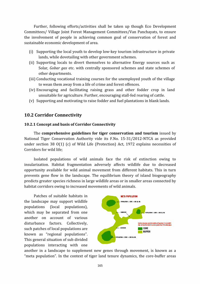
165
Further, following efforts/activities shall be taken up though Eco Development
Committees/ Village Joint Forest Management Committees/Van Panchayats, to ensure
the involvement of people in achieving common goal of conservation of forest and
sustainable economic development of area.
(i) Supporting the local youth to develop low-key tourism infrastructure in private
lands, while dovetailing with other government schemes.
(ii) Supporting locals to divert themselves to alternative Energy sources such as
Solar, Gobar gas etc. with centrally sponsored schemes and state schemes of
other departments.
(iii) Conducting vocational training courses for the unemployed youth of the village
to wean them away from a life of crime and forest offences.
(iv) Encouraging and facilitating raising grass and other fodder crop in land
unsuitable for agriculture. Further, encouraging stall-fed rearing of cattle.
(v) Supporting and motivating to raise fodder and fuel plantations in blank lands.
10.2 Corridor Connectivity
10.2.1 Concept and basis of Corridor Connectivity
The comprehensive guidelines for tiger conservation and tourism issued by
National Tiger Conservation Authority vide its F.No. 15-31/2012-NTCA as provided
under section 38 O(1) (c) of Wild Life (Protection) Act, 1972 explains necessities of
Corridors for wild life;
Isolated populations of wild animals face the risk of extinction owing to
insularization. Habitat fragmentation adversely affects wildlife due to decreased
opportunity available for wild animal movement from different habitats. This in turn
prevents gene flow in the landscape. The equilibrium theory of island biogeography
predicts greater species richness in large wildlife areas or in smaller areas connected by
habitat corridors owing to increased movements of wild animals.
Patches of suitable habitats in
the landscape may support wildlife
populations (local populations),
which may be separated from one
another on account of various
disturbance factors. Collectively,
such patches of local populations are
known as “regional populations”.
This general situation of sub divided
populations interacting with one
another in a landscape to supplement new genes through movement, is known as a “meta population”. In the context of tiger land tenure dynamics, the core-buffer areas
166
conform to the “island- mainland” or “core satellite” form of Meta population model. The
core area of a tiger reserve provides a source of colonizers for the surrounding local
populations of different sizes and varying degrees of isolation. The core area may not
readily experience extinction owing to the protection inputs for maintaining its
inviolate nature. However, the surrounding isolated patches in the buffer area may
suffer from local extinction if wildlife concerns are not mainstreamed in the area.
Therefore, a Meta population management approach is required for the buffer zone as
well as corridors to facilitate;
(i) Supplementing declining local tiger populations.
(ii) Facilitating re-colonization in habitat patches through restorative management
providing opportunity to tiger for colonizing new areas through patches of
habitats (stepping stones) between isolated populations.
10.2.2 Relevance of Corridor Connectivity in Project Area Landscape
The loss of connectivity between habitat patches can have severely deleterious
impacts on large carnivore populations. These are manifest in population declines and
local extinction for some species (Crooks 2002), and reduced genetic heterozygosity on
account of genetic isolation (Dixon et al. 2007, Sharma et al. 2009). Although the
Nandhaur region represents a large patch of tiger habitat (nearly 1500 km2 in area), it
is reported to be tenuously connected with other tiger occupied forests. Most likely, this
lack of connectedness has had a bearing on Nandhaur’s carnivore population, in stark
contrast to the intact Rajaji - Corbett - Ramnagar forest block (see Hariharet al. 2012).
On the Basis of photographic evidence, of the movement of tigers, the functionality
of corridors in Nandhaur region can very well be said as operative. Surveys in the
Boom- Bramhadev corridor along the Sharda river (which marks the India - Nepal
border) suggested that the Nandhaur region is well connected with the Bramhadev
forests and that a few kilometers upstream from the town of Tanakpur, animals may be
able to pass unimpeded by man-made obstructions. However, the northward ingression
of residences and farmland from Tanakpur along the west bank of the Sharda has
reportedly affected an elephant corridor.
Further, as per “Study on Staus of Tiger, Leopard and Prey in Nandhaur
Valley-Baseline estimates from sub-HimalyanNandhaur region” as referred
elsewhere also in the plan, found that, boulder mining is restricted to the Sharda
riverbed downstream of the Tanakpur barrage. An expansion of this activity upstream
of the barrage into other rausuch as Kiroda and Kalonianala willbe a severe
infringement on the habitat of tigers, leopards, bears, elephants and other wild
mammals which frequently use these drainages. There is no reliable information
available on the status of mammals in the Bramhadev forests, which are connected to
the Shuklaphanta Wildlife Reserve in Nepal, but it is unlikely that the region has a large
resident tiger population at present.
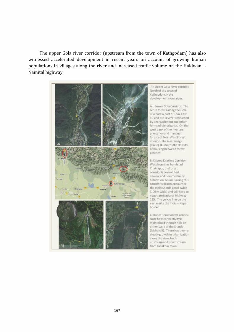
167
The upper Gola river corridor (upstream from the town of Kathgodam) has also
witnessed accelerated development in recent years on account of growing human
populations in villages along the river and increased traffic volume on the Haldwani -
Nainital highway.
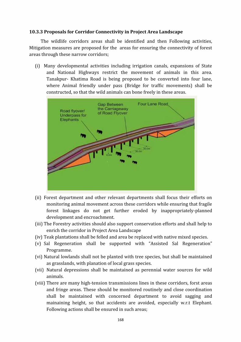
168
10.3.3 Proposals for Corridor Connectivity in Project Area Landscape
The wildlife corridors areas shall be identified and then Following activities,
Mitigation measures are proposed for the areas for ensuring the connectivity of forest
areas through these narrow corridors;
(i) Many developmental activities including irrigation canals, expansions of State
and National Highways restrict the movement of animals in this area.
Tanakpur- Khatima Road is being proposed to be converted into four lane,
where Animal friendly under pass (Bridge for traffic movements) shall be
constructed, so that the wild animals can bone freely in these areas.
(ii) Forest department and other relevant departments shall focus their efforts on
monitoring animal movement across these corridors while ensuring that fragile
forest linkages do not get further eroded by inappropriately-planned
development and encroachment.
(iii) The Forestry activities should also support conservation efforts and shall help to
enrich the corridor in Project Area Landscape
(iv) Teak plantations shall be felled and area be replaced with native mixed species.
(v) Sal Regeneration shall be supported with “Assisted Sal Regeneration”
Programme.
(vi) Natural lowlands shall not be planted with tree species, but shall be maintained
as grasslands, with planation of local grass species.
(vii) Natural depressions shall be maintained as perennial water sources for wild
animals.
(viii) There are many high-tension transmissions lines in these corridors, forst areas
and fringe areas. These should be monitored routinely and close coordination
shall be maintained with concerned department to avoid sagging and
mainaining height, so that accidents are avoided, especially w.r.t Elephant.
Following actions shall be ensured in such areas;
169
(a) Aerial Bunch Conductor (ABC) shall be used in such areas to avoid
accedents.
(b) As per rule 77 of Indian Electricity Rules, 1956 regarding clearance above
the ground of the lowest conductor provides that “ No conductor of overhead
line, including service lines, erected across a street shall at any part thereof be
at a height of less than 5.5 metres(for low and medium voltage lines) and 6.1
metres(for high voltage lines) “, which shall be strictly followed. In case of
violation action must be taken under under relevant provisins of the
Wildlife (Protection) Act, 1972, Indian Electricity Rules, 1956 and any other
legal provision as apllicable.
(ix) Physical barrier shall be created between forest and agricultural fields in form of
Elephant proof Stonewall, Trenches etc.
(x) Human access in forest areas shall be restricted and monitored to avoid human
animal conflict.
(xi) Concerned Divisional Forest Officer shall take all measure to improve Wildlife
habitat and take all other steps for Wildlife conservation and mitigate Human-
Animal Conflict, mentioned elsewhere in this plan.
170
Chapter 11
Eco Tourism, Interpretation and Conservation Education
11.1 Conceptual Background
The IUCN Eco-tourism Programme defines ‘Eco-tourism’ as “Environmentally
responsible travel and visitation to relatively undisturbed natural areas in order to enjoy
and appreciate nature, that promotes conservation, has low visitor impact and provides
for beneficially active Socio economic involvement of local population”.
Though Project Area Landscape fulfills all required conditions for heavy tourism
activity on account of its situation.But, presently Private Tourism infrastructure need to
be developed on the basis of sustainable and responsible tourism principles, therefore,
it is important to start a regulated tourism in the Project Area Landscape.The National
Wildlife Action Plan (NWAP), puts a caution and advocates only regulated and low
impact tourism, which must be used as a vital conservation tool for gaining public
support for wildlife conservation.
11.2 Objectives
The special objects of tourism in Project Area Landscape are stated asbelow:
(i) To create awareness and elicit public support for wildlife and biodiversity
conservation in Shiwalik-Terai-Bhabar Landscape.
(ii) To practice controlled and limited eco-tourism with a view to use it as a
potential tool for managing the area to achieve the goals of conservation.
(iii) To encourage local people to take up eco-tourism as a long-term conservation
measure for achieving sustainable economic benefits from the area
(iv) To provide informed and rich wilderness experience and knowledge to visitors,
especially the youths, by enabling them to view its multifarious attributes.
(v) To develop and facilitate the enjoyment of visitors in natural surrounding by
maintaining the limited wildlife viewing and related facilities on the area
permitted for eco-tourism.
171
(vi) To develop interpretive programmes and equip the interpretation centre in the
area with a view to make the nature education and wildlife viewing effective
and meaningful for visitors, nature lovers and students coming to the area.
(vi) To organize various outreach programmes to attract visitors, nature lovers,
students and local people for a visit and enjoyment of the rich attributers in the
area and spread the message of conservation.
11.3 The Strategies and Activities for Tourism Management
11.3.1 Legal Provision and Regulation of Tourism
It is the Chief Wild Life Warden may, who may grant to any person a permit to
enter in a Protected Areas of the Project Area Landscape for purposes of tourism under
section 28 (1) the Wild Life (Protection ) Act, 1972. A permit to enter in a Sanctuary
shall be issued subject to such conditions and on payment of such fee, as may be
prescribed.
Further, As per section 33 of the Wild Life (Protection) Act, 1972, no construction
of commercial tourist lodges; hotels, zoos and safari parks shall be undertaken inside a
Sanctuary except with the prior approval of the National Board.
11.3.1.1 Guidelines for forest department to regulate tourism in
NandhaurWildlife Sanctuary
Further, along with provisions of Wild Life (protection) Act, 1972, National
Wildlife Action Plan, following general guidelines shall be followed for regulation of
tourism activities in Sanctuary and Division;
(i) A person with a valid permit issued under section 28(1) (d) of Wild Life
(Protection) Act, 1972 would be allowed to enter into designated Tourism Zone
for specified duration/ time after payment of such fees as prescribed. All
conditions and direction given while, allowing a permit for tourism by CWLW/
Authorized Officer, shall be followed. Any infringement shall be considered as
violation of section 28(2) of Wild Life (protection) Act, 1972.
(ii) No staff shall be engaged in tourism activity, which is having territorial or other
forestry responsibility assigned to him or her.
(iii) A separate unit, preferably headed by an officer of the rank of Forest Range
Officer shall be constituted to regulate tourism activities in Project Area
Landscape
(iv) Monitor, Regulate and control tourist flow in Project Area Landscape by using
certain modern technologies such as CCTV cameras, GPS, GIS etc.
(v) Management of habitat or its manipulation to inflate animal abundance for
tourism purposes shall not be practiced within tourism areas.
172
(vi) Uttarakhand Government or Department will not be liable to any damage caused
to a person and/or any property etc. upon entering into boundaries of PA’s/
Division for tourism.
(vii) All Vehicles entering PA’s / Division for tourism activity shall follow standards/
conditions/ Guidelines laid down by Chief Wild Life Warden/ Forest
department.
(viii) No person shall be allowed to organise political meeting, conference, Public
gathering etc. in PA’s. This restriction shall not be applicable to Trainings,
Workshops and meeting etc. related to Forest and Wildlife Management
organized by forest department.
(ix) Visitor entry shall be regulated as per the seasons/ duration as fixed by CWLW/
Competent Authority.
(x) Further, the entry in Reserve Forest (Including Sanctuary) shall be regulated as
per Rules Governing Temporary Use of roads under control of Forest
Department, Uttar Pradesh (GO. No. 7273/ XI Va-70 (41)/1962 dated
25.03.1969.
(xi) Keeping in view prevailing water level in various rivers, weather & forest road
conditions, the competent authorities can suspend/stop entry.
(xii) There shall be a complete ban on burying, burning or otherwise disposing non-
biodegradable or toxic waste in and around the PA’s / Division.
11.3.1.2 Guidelines to be followed by Tourists.
(i) Carrying of firearms of any kind is not permitted within the Sanctuary or
tourism Zone.
(ii) Driving inside the PA’s / Division or tourism Zone beyond prescribed
timings is prohibited.
(iii) Blowing of horns and driving beyond the speed limit is strictly prohibited
within the PA’s / Division or tourism Zone.
(iv) Visitors are prohibited from taking vehicles off the designated routes.
(v) Visitors are required to carry a litterbag with them while entering the PA’s /
Division or tourism Zone and bring back their non-biodegradable litter (tin
cans, plastic, glass, bottle, metal foil etc.) outside the Forest.
(vi) Smoking in public places and during excursion in PA’s / Division or tourism
Zone area is a punishable offence. Also lighting of any kind of fire is strictly
prohibited.
(vii) Entry into the restricted zone by the visitors is prohibited.
(viii) Shouting, teasing or chasing animals, putting light extra in night, feeding
them or causing damage to plant or animal life or their habitat and any such
attempts are prohibited and punishable offence will invite severe penalties.
(ix) Visitors are advised to wear clothes of colours, which merge with the natural
surroundings (khaki, olive green or other dull colours).
(x) Entry/exit timing of the PA’s / Division or tourism Zone is regulated in such
a manner that visitors must reach their gate of entry before prescribed time.
173
(xi) Entry into the PA’s / Division or tourism Zonewith or without permit is on
the own risk of the visitor. The authorities shall not be responsible for any
damages caused during the visit in PA’s / Division or tourism Zone.
(xii) Visitor Entry Permit is non transferable.
(xiii) Non-vegetarian food is prohibited inside PA’s / Division or tourism Zone.
(xiv) Visitors are not allowed to carry and use any kind of intoxicants, drugs and
other narcotics etc.
(xv) Pets are not allowed in the PA’s / Division or tourism Zone.
(xvi) Forest authorities may cancel the permit, for any good and sufficient reasons.
The decision of relevant authority would be final in this regard.
(xvii) The permit to enter PA’s / Division or tourism Zone is issued under sec 28
(1&2) of Wildlife (protection) Act, 1972 and it is the responsibility of the
visitors to follow the above-mentioned rules and regulations. Any
infringement of the above mentioned rules and regulations hence would be
treated as violation of the Act and dealt accordingly.
11.4 Nature Interpretation and Education
As per National Wildlife Action Plan Nature interpretation and Education is
integral component of overall Wildlife conservation. Further it helps to win support for
wildlife conservation by explaining the rationale behind the protection of natural
ecosystems to politicians, legislators, judges, planners, technocrats and bureaucrats
who manage the nation. Eliciting broad-based public support from different sections of
society, particularly communities neighboring Protected Areas and forests is very
important. It helps in conveying a sense of urgency to young people and wins their
support for the protection of India’s natural heritage. Nature interpretation and
education help to involve the media on issues surrounding wildlife conservation and to
highlight the connections between healthy ecosystems and India’s water and food
security.
11.4.1 Nature Interpretation
Interpretation is an educational activity, which aims to reveal meaning and
relationships through the use of original objects, by firsthand experience, and by
illustrative media, rather than simply to communicate factual information. Further,
when we define Nature Interpretation, it has following components;
(i) Informs about
The most significant features which need to be protected (animal species,
habitat, historic sites).
Why they need protection?
Management problems.
Research.
174
(ii) Provides orientation.
(iii) Creates concern for
Endangered species, and
Ecosystems
(iv) Satisfies people’s curiosity.
(v) Publicizes the available activities and attractions.
(vi) Warns and guides.
11.4.2 Nature Interpretation Centre and Visitor Centres
A visitor center is one of the most expensive facilities in a protected area. If
operated and maintained properly there is a high annual recurring cost. Both capital
and recurring cost need to be related to expected use. When an Nature Interpretation
and visitor/ Reception centre is planned for PA’s / Zoo , some fundamental steps in
planning, which are required to be followed are;
11.4.2.1 Objectives
The visitor centre will have all or some of the objectives listed below. Examine
each objective in turn and appropriate decision has to be taken accordingly;
(i) Increase public concern over nature conservation in general and regional
conservation with emphasis on Peoject Area Landscape in particular.
(ii) Inform arriving visitors about what they can see and do in Sanctuary.
(iii) Increase people’s interest in and understanding of the area’s values by providing
information about its history, ecology, habitats, and wildlife research and
management problems.
(iv) Entertain and educate visitors in the evenings or the hot hours of the day.
(v) Provide a focal point for activities and services related to the public.
(vi) Provide an outlet for the sale of local arts and handicrafts.
(vii) Accommodate the office of education officer and his staff.
(viii) House a workshop for display making and maintenance
11.4.2.2 Centre Components
Depending on the objectives chosen, some or all of the components listed below
will be incorporated into the design. Only a few are essential for all visitor centers.
Sometimes it is possible to converts existing buildings or rooms into temporary or
makeshift centres.
175
(i) Essential components for all centers:
An orientation/activity section where displays and maps inform visitors about
the area and available activities.
A space where visiting groups can meet for talks or discussions. This can be on a
verandah or in the open under a tree.
An exhibition room where visitors can learn about ecology, habitats, wildlife and
management problems of the area through displays and exhibits.
(ii) Optional components
Information (and sales?) desk
Auditorium
Audio Visual equipment and store
Library cum reading corner
Discovery room for children
Education staff office
Public toilets
Large covered porch for test and enjoyment of scenic view
Amphitheatre
Only the most sophisticated Centre would have all of the above. To reduce
expense some functions can be combined, e.g. staff office and AV equipment store.
Each Centre requires staff ranging from cleaners and attendants to skilled craftsman
and trained communication experts to use and develop the facilities. Therefore,
additional staff either on contract or from service provider etc. shall be made
available.
11.4.2.3 Design of Visitor Centre
The designer must be informed about which essential components are to be
incorporated. Expected visitor numbers per time period, with emphases on visitation
peaks have to be supplied for proper planning of room size and capacity amenities.
The visitor building is a highly visible structure which, nevertheless, should
blend in with its natural surroundings. A good architect will adjust the design to land
contour and vegetation, that is plan around standing trees or rock outcrops instead of
removing them are leveling the building site.
Design is also influenced by climatic conditions, the type of equipment to be
used as well space and ceiling height have to be considered. And adaptation of local
architectural style often yields the most pleasing and cost effective designs.
Designs should minimize the use of “cold” materials; e.g. steel and concrete,
corrugated iron and plastic. “Warm” materials, like brick, clay roof-tiles, sand-stone
176
or slate, natural rock, bamboo, timber, thatch, even cowdung plaster, are preferred.
Designs should be such the artificial lighting and air conditioning are not required.
11.4.3 Nature Education
Tourism management and visitor education/information in Indian context mainly
discuss the hardware i.e. facilities. The software i.e. the ideas, activities, programmes,
which are necessary to use the facilities are most of the times neglected. For example, in
context of newly constituted Protected Area like Nandhaur Wildlife Sanctuary, A
brochure to introduce its salient features and attractions to the public, Nature camps for
youth groups are more relevant than concentrating on mass tourism based education.
More emphasis should be given to offer nature camps on a continuous basis and
professionalize camp organization and programme, while provideinglivelihod to local
youth.
Nature trails or wildlife viewing circuits will be more interesting for a majority of
the visitors if they are “interpreted” properly. The simple interpretation methods
suggested in this plan can be implemented without a large budget. Therefore, following
facilities should be developred to improve visitor information and education in
NandhaurWildlife Sanctuary.
11.4.3.1 Brochure of Project Area Landscape
Brochures and pamphlets advertise the attractions of national park or sanctuary
by pictures, maps and text containing highly condensed information. With increasing
popularity of visits to parks and reserves, more managers will need to produce
professionally executed brochures which reflect well on the issuing agency.
Quality is decided not so much by the printing budget as by the layout and text.
Some very attractive and brochures have been printed in simple black and white. A
brochure should have folowing components;
(i) Brochures which promote visits to an area and help people plan the visit.
These introduce the major attractions of the area. Information about type and
location of access, best season to visit, opening times, accommodation and
booking procedures is given. An overview map shows the wider region around
the park and the main roads, nearest railway stations and airport.
(ii) Brochures which provide information about attractions and activities and
help the visitor find their way around. Brochures of this type give a more
detailed description of points and areas of interest and list the available types of
activities. Rules and timing are given. A map shows entry points, trails and
roads, and attractions. It happens frequently that brochures of this and the
former type are combined into one with the result that text becomes very
crowded and information is incomplete.
177
(iii) Brochures which inform about specific activities or attractions in more
detail. These brochures may become necessary when visitors want to find out
more certain species and habitats, about historic buildings, or if certain
activities are to be heighted and promoted e.g. nature camp. Since these will be
booklet rather than pamphlet size, they should be sold in order to discourage
wastage by distribution to visitors who are not really interested in reading
them.
11.4.3.2 Nature Camp
As far as tourism in Project Area Landscape is concerned, it should more of
edcation tourism than regular mass Wildlife tourism as prevailing in other Protected
Areas of Uttarakhand. A nature camp provides outdoor recreation and conservation
education for urban or local students. They offer a unique opportunity to instill love and
concern for nature at a young age. Further, Nature camps are cost effective method for
reaching people, where they can actively involved. A naure camp should have following
objectives;
(i) Introduce basic ecological principles in ways, which are conducive to
learning by personal experience.
(ii) Motivate participants to gather information on aspects of the biotic and
abiotic environment.
(iii) Encourage participants to analyse and discuss conservation issues in a
constructive and problem solving manner.
(iv) Foster admiration and respect for the complexities of relationships between
species and within natural communities.
(v) Dispel unfounded fear of wild animals and help participants feel comfortable
in wilderness.
Initially a nature campsite may be developed at appropriate locations, which can
accommodate at least thirty participants. . General guidelines, which shall be, followed
while conductiong such nature camps are given below;
(i) Application and self-declaration form to be sent in prescribed format to
concerned division office through the head of the institution concerned.
(ii) Preference will be given to the institutions from the adjoining areas.
(iii) A group of 30-40 students along with 2-3 teachers shall be accommodated in
such camps.
(iv) Simple, hygienic vegetarian foods shall be served for nature camp participants
Duration of camps will be 2 days.
Further, following condtions shall be imposed on visitors for such camps;
(i) Nature campshall be for awareness of nature and education not for amusement.
(ii) Participants have to wear subdued colour clothes and not to carry plastic
wrapped food items, Poly bags, musical instruments and valuable items
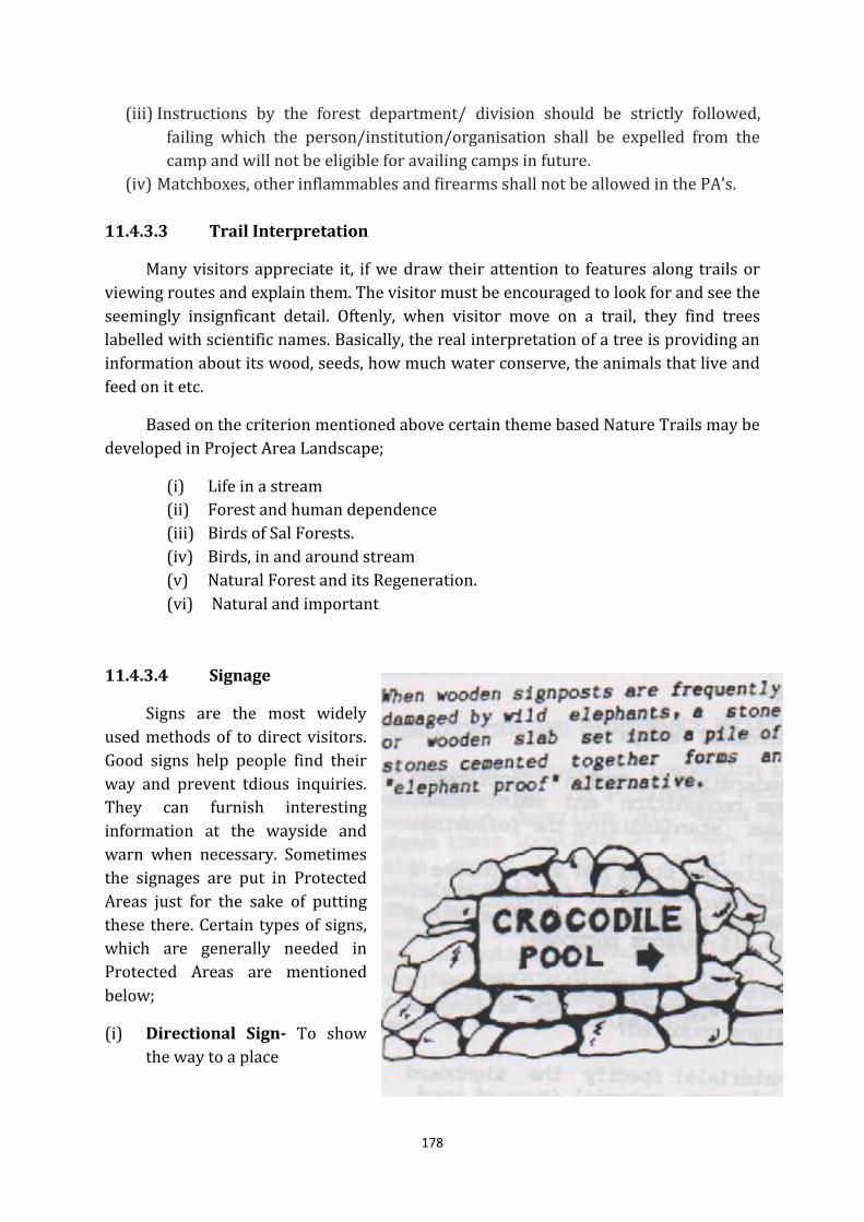
178
(iii) Instructions by the forest department/ division should be strictly followed,
failing which the person/institution/organisation shall be expelled from the
camp and will not be eligible for availing camps in future.
(iv) Matchboxes, other inflammables and firearms shall not be allowed in the PA’s.
11.4.3.3 Trail Interpretation
Many visitors appreciate it, if we draw their attention to features along trails or
viewing routes and explain them. The visitor must be encouraged to look for and see the
seemingly insignficant detail. Oftenly, when visitor move on a trail, they find trees
labelled with scientific names. Basically, the real interpretation of a tree is providing an
information about its wood, seeds, how much water conserve, the animals that live and
feed on it etc.
Based on the criterion mentioned above certain theme based Nature Trails may be
developed in Project Area Landscape;
(i) Life in a stream
(ii) Forest and human dependence
(iii) Birds of Sal Forests.
(iv) Birds, in and around stream
(v) Natural Forest and its Regeneration.
(vi) Natural and important
11.4.3.4 Signage
Signs are the most widely
used methods of to direct visitors.
Good signs help people find their
way and prevent tdious inquiries.
They can furnish interesting
information at the wayside and
warn when necessary. Sometimes
the signages are put in Protected
Areas just for the sake of putting
these there. Certain types of signs,
which are generally needed in
Protected Areas are mentioned
below;
(i) Directional Sign- To show
the way to a place

179
(ii) Orientation Sign- Help the visitor orient himself or give instructions.
(iii) Interpretative Sign- Convey a conservation Message.
While designing these signages, it must be kept in mind that Lattering style and
size is proper, language, symbols, colour and material etc. Further, cost , appeal, ease of
construction and durability should be considered while choosing the mateial. Wood and
natural Stone are preferred materials. Certain fallen trees and drift wood could be use
for making signages, which is attractive as well as durable. Further, in certain areas,
where wild animals may damage signages, mateial like iron, tin sheets etc. should not be
used. This type of material may damage animals like elephants even.

180
Chapter 12
Budget and Schedule of Operation
12.1 Budget and Financial Management
The activities are prescribed in the table below for the budget formulation. Further,
detailed budgetary proposals for Ten years is given in Annexure.
S.no Details of Work Unit
Rate
Qty
Total
Amount
(In Lacs)
1 2 3 4 5
1 Human Wildlife Conflict Mitigation
1.1 Elephant proof wall including maintenance
1.2 Elephant proof Trench including Bio fencing
1.3 Honorarium for villagers for conflict mitigation
1.4 Elephant Driving Squad & resource mobilization for
wildlife emergencies including Tiger Call Audio
1.5 Other Measures for Mitigation of Human Animal
Conflict
Total
2 Strengthening of Wildlife infrastructure and
Protection
2.1 Strengthening/maintenance of forest chowki/range
office/barriers (repair, water, toilet etc)
2.2 Construction of forest chowkies
2.3 Providing lights/solar Lights/Recharging Units to
Chowkies/barriers
2.4 Ex-servicemen/PRD/Local Villagers for anti-poaching
squad
2.5 Ration support for Long Distance Patrolling including
Ration
2.6 Procurement of Patrolling gears (shoes, Vardi,
Raincoat, Caps etc.)
2.7 Establishment of Community Mess for Field Staff
2.8 Hiring of Vehicles for wildlife protection and
prevention of illegal mining
2.9 POL and maintenance of vehicle
2.10 Wireless & Mobile communication
2.11 Maintenance of Forest Roads
2.12 Maintenance of Bridal Paths
2.13 GPS procurement
2.14 Procurement of Hi-tech Equipment for wildlife

181
protection (metal detector, range finder, Binocular,
Computers & other)
2.15 Arms & Ammunition
2.16 Establishment of Lockup for offenders
2.17 Legal expenditure related to court cases
2.18 Special Operation Group (SOG)/ Forest Patrol
2.19 Secret Funds for wildlife operations
2.20 Other Contingencies
Total
3 Forest Fire Control and Management
3.1 Maintenance of Fire lines
3.2 Control Burning
3.3 Fire Watchers
3.4 People's Participation and Awareness Generation
3.5 Other Contingencies
Total
4 Wildlife Habitat Improvement & Management
4.1 Grassland development / Perimeter planting
4.2 Creation of Water holes Bodies & Maintenance
4.3 Bamboo plantation in Lantana infested areas
&Maintenance
4.4 Management of Weeds and Exotic Species
4.5 Other Maintenance Activities for Habitat Management
4.6 Sal and other species Assisted Natural Regeneration
(ANR)
Total
5 Wildlife Health and Veterinary Management
5.1 Nutrient Supplements/salt Licks etc.
5.2 Establishment/repair of Transit-Rescue Center for
Herbivores.
5.3 Post Mortem (PM) Kit/ Conduct
5.4 Modernization of Veterinary Facilities
5.5 Procurement of Cages for animals in Stress Condition
5.6 Procurement of Tranquilizing Gun
5.7 Procurement of Jab Stick
5.8 Procurement of Wildlife Medicines & other rescue
equipment’s etc.
5.9 Quick Reaction Team for Wildlife Rescue
5.10 Hiring of Personnel for Vet. Care
Total
6 Wildlife Awareness & Human Resource
Development
6.1 Capacity Building Training (intelligence, patrolling,
wildlife rescue, Forest laws, H2 case writing, Seizure
report etc.) for Frontline staff
182
6.2 Refresher Courses/ training/ workshops
6.3 Development of Training Infrastructure
6.4 Study Tour/ Visits
Total
7 Wildlife Research/study & monitoring
7.1 Tiger, other Cooperator & Herbivore Monitoring
7.2 Camera Trap Procurement
7.3 Conducting Research Activities/ Studies etc.
7.4 Hiring of Personnel
Total
8 River Training Soil & water Conservation Works
8.1 River Training work for River Bank Stabilization (spur,
check dam etc.)
8.2 Soil and water Conservation Works (Vegetative Check
dams, Grass planting, Gabion etc.)
Total
9 Publication, Documentation And Database
Management
9.1 Data Entry Operator
9.2 JRF For Wildlife Research & Monitoring Related To
Predators, Herbivore, Vultures, other animals and Birds
etc.
9.3 Field Assistant For Wildlife Research/Study and
monitoring
Total
10 Tourism Regulation, Interpretation and Nature
Education
10.1 Development Interpretation/ Visitor Centre and
Tourism Regulation Infrastructure
10.2 Hiring of Personnel
10.3 Nature Education Camps
10.4 Awareness Generation
11 Administrative, Legal and other expenses related to
Wildlife Conservation
11.1 Setting up of new Offices and Infrastructure
11.2 Provision of Forest Line
11.3 Miscellaneous expenses and Contingencies
Total
Grand Total
All these works mentioned above would be carried out as per the schedule of
Rates issued by Conservator of Forests, Western Circle vide letter No. 2120/8-1(3), dated
May 22, 2014. DFO Nainital shall act as a Member Secretary for the preparation of APO
of Wildlife Conservation Plan of Project Area Landscape. The Chief Wildlife Warden,
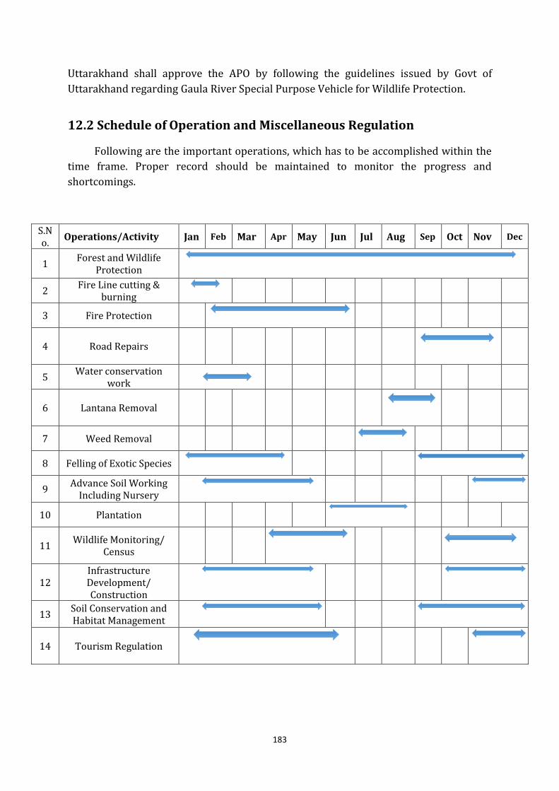
183
Uttarakhand shall approve the APO by following the guidelines issued by Govt of
Uttarakhand regarding Gaula River Special Purpose Vehicle for Wildlife Protection.
12.2 Schedule of Operation and Miscellaneous Regulation
Following are the important operations, which has to be accomplished within the
time frame. Proper record should be maintained to monitor the progress and
shortcomings.
S.N
o. Operations/Activity Jan Feb Mar Apr May Jun Jul Aug Sep Oct Nov Dec
1 Forest and Wildlife
Protection
2 Fire Line cutting &
burning
3 Fire Protection
4 Road Repairs
5 Water conservation
work
6 Lantana Removal
7 Weed Removal
8 Felling of Exotic Species
9 Advance Soil Working
Including Nursery
10 Plantation
11 Wildlife Monitoring/
Census
12
Infrastructure
Development/
Construction
13 Soil Conservation and
Habitat Management
14 Tourism Regulation
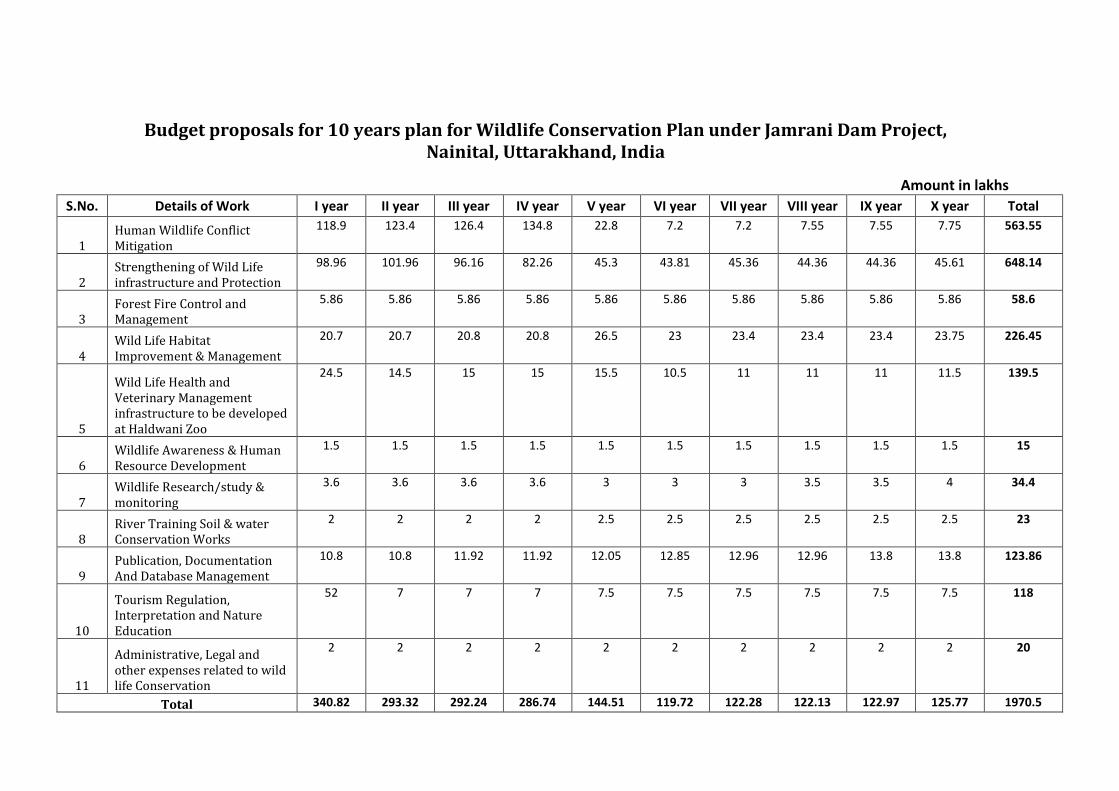
Budget proposals for 10 years plan for Wildlife Conservation Plan under Jamrani Dam Project,
Nainital, Uttarakhand, India
Amount in lakhs
S.No. Details of Work I year II year III year IV year V year VI year VII year VIII year IX year X year Total
1
Human Wildlife Conflict
Mitigation
118.9 123.4 126.4 134.8 22.8 7.2 7.2 7.55 7.55 7.75 563.55
2
Strengthening of Wild Life
infrastructure and Protection
98.96 101.96 96.16 82.26 45.3 43.81 45.36 44.36 44.36 45.61 648.14
3
Forest Fire Control and
Management
5.86 5.86 5.86 5.86 5.86 5.86 5.86 5.86 5.86 5.86 58.6
4
Wild Life Habitat
Improvement & Management
20.7 20.7 20.8 20.8 26.5 23 23.4 23.4 23.4 23.75 226.45
5
Wild Life Health and
Veterinary Management
infrastructure to be developed
at Haldwani Zoo
24.5 14.5 15 15 15.5 10.5 11 11 11 11.5 139.5
6
Wildlife Awareness & Human
Resource Development
1.5 1.5 1.5 1.5 1.5 1.5 1.5 1.5 1.5 1.5 15
7
Wildlife Research/study &
monitoring
3.6 3.6 3.6 3.6 3 3 3 3.5 3.5 4 34.4
8
River Training Soil & water
Conservation Works
2 2 2 2 2.5 2.5 2.5 2.5 2.5 2.5 23
9
Publication, Documentation
And Database Management
10.8 10.8 11.92 11.92 12.05 12.85 12.96 12.96 13.8 13.8 123.86
10
Tourism Regulation,
Interpretation and Nature
Education
52 7 7 7 7.5 7.5 7.5 7.5 7.5 7.5 118
11
Administrative, Legal and
other expenses related to wild
life Conservation
2 2 2 2 2 2 2 2 2 2 20
Total 340.82 293.32 292.24 286.74 144.51 119.72 122.28 122.13 122.97 125.77 1970.5
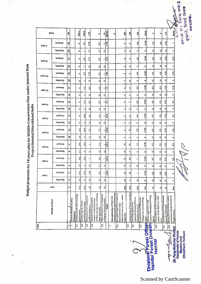
Scanned by CamScanner

Scanned by CamScanner
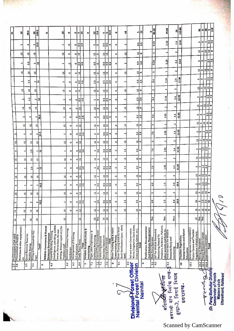
Scanned by CamScanner
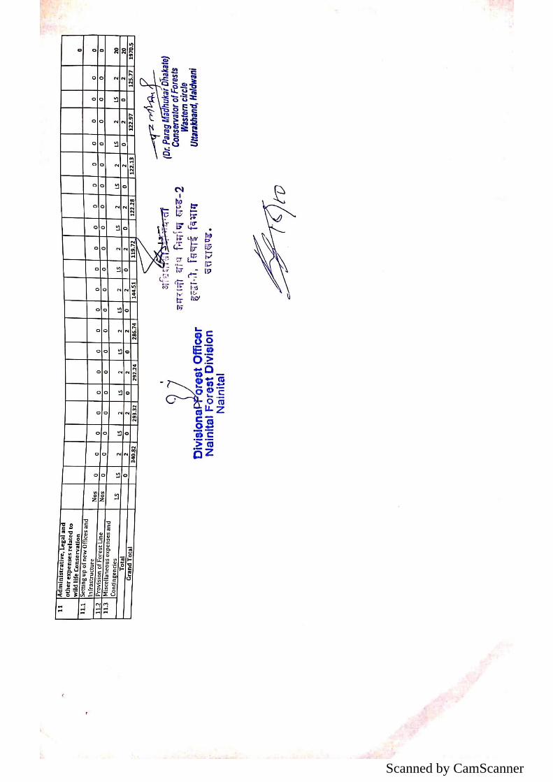
Scanned by CamScanner


