Download - COMPONENTS OF GIS
COMPONENTS OF GIS
Unit: I
Semester: II
Paper Code: GIS 07
Name of Paper: Geographic Information System
PG Diploma in RS & GIS
Dr. SHYAMA PRASAD MUKHERJEE UNIVERSITY, RANCHI
1
COMPONENTS OF GIS
1. Introduction:
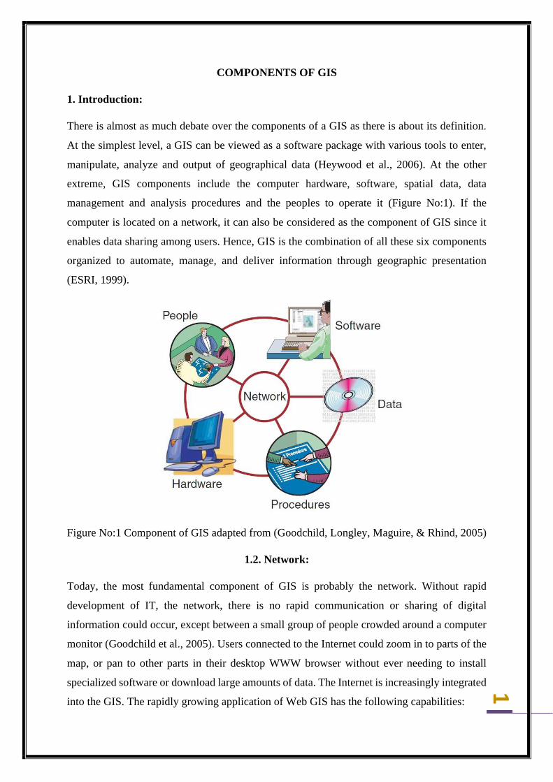
There is almost as much debate over the components of a GIS as there is about its definition.
At the simplest level, a GIS can be viewed as a software package with various tools to enter,
manipulate, analyze and output of geographical data (Heywood et al., 2006). At the other
extreme, GIS components include the computer hardware, software, spatial data, data
management and analysis procedures and the peoples to operate it (Figure No:1). If the
computer is located on a network, it can also be considered as the component of GIS since it
enables data sharing among users. Hence, GIS is the combination of all these six components
organized to automate, manage, and deliver information through geographic presentation
(ESRI, 1999).
Figure No:1 Component of GIS adapted from (Goodchild, Longley, Maguire, & Rhind, 2005)
1.2. Network:
Today, the most fundamental component of GIS is probably the network. Without rapid
development of IT, the network, there is no rapid communication or sharing of digital
information could occur, except between a small group of people crowded around a computer
monitor (Goodchild et al., 2005). Users connected to the Internet could zoom in to parts of the
map, or pan to other parts in their desktop WWW browser without ever needing to install
specialized software or download large amounts of data. The Internet is increasingly integrated
into the GIS. The rapidly growing application of Web GIS has the following capabilities:
2
✓ Displaying static maps which users can pan or zoom whilst online;
✓ Creating user-defined maps online which are in turn used to generate reports and new
maps from data on a server;
✓ integrating users ‘local data with data from the Internet;
✓ Providing data that are kept secure at the server site;
✓ Providing maps through high-speed intranets within organizations;
✓ Providing maps and data across the Internet to a global audience.
The remaining five components of GIS are entertained below.
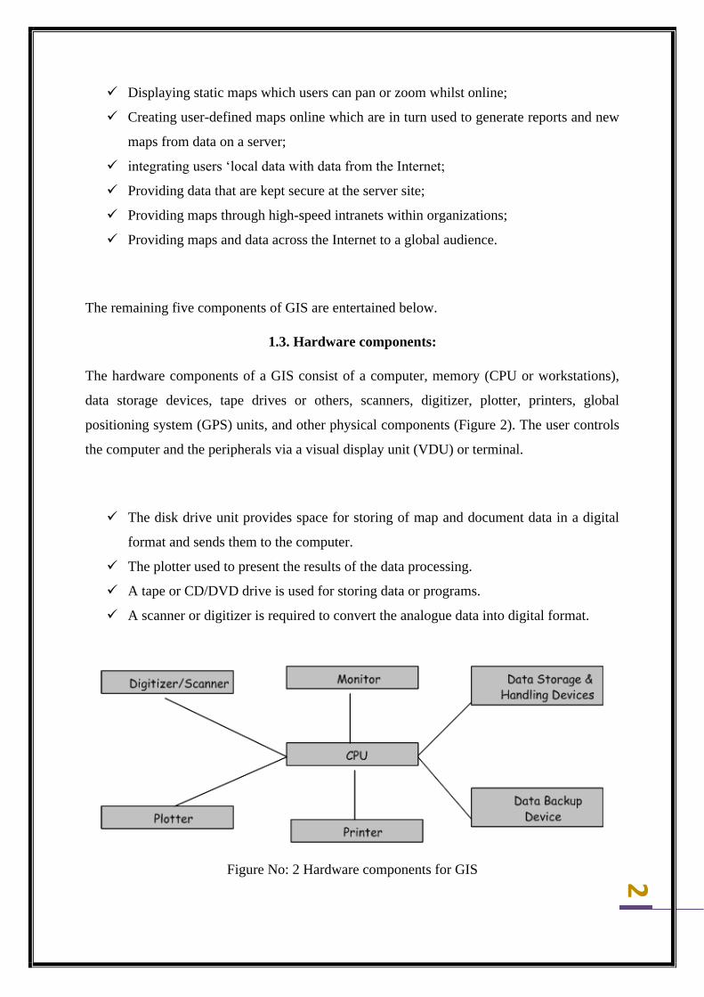
1.3. Hardware components:
The hardware components of a GIS consist of a computer, memory (CPU or workstations),
data storage devices, tape drives or others, scanners, digitizer, plotter, printers, global
positioning system (GPS) units, and other physical components (Figure 2). The user controls
the computer and the peripherals via a visual display unit (VDU) or terminal.
✓ The disk drive unit provides space for storing of map and document data in a digital
format and sends them to the computer.
✓ The plotter used to present the results of the data processing.
✓ A tape or CD/DVD drive is used for storing data or programs.
✓ A scanner or digitizer is required to convert the analogue data into digital format.
Figure No: 2 Hardware components for GIS
3
The choice of hardware ranges from personal computers to multi user super computers.
Computers should have essentially an efficient processor to run the software and sufficient
memory to store data. The essential hardware elements for effective GIS operations include:
a) The presence of a processor with sufficient power to run the software
b) Sufficient memory for the storage and backup of large volumes of data
c) A good quality, high resolution colour graphics screen or monitor and
d) Data input and output devices, like keyboards, printers and plotters.
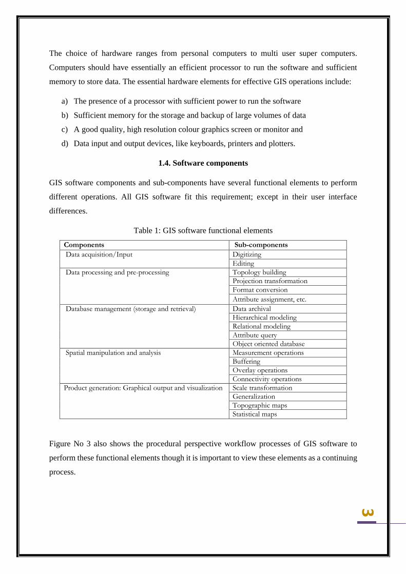
1.4. Software components
GIS software components and sub-components have several functional elements to perform
different operations. All GIS software fit this requirement; except in their user interface
differences.
Table 1: GIS software functional elements
Components Sub-components Data acquisition/Input Digitizing
Editing Data processing and pre-processing Topology building
Projection transformation Format conversion Attribute assignment, etc.
Database management (storage and retrieval) Data archival Hierarchical modeling Relational modeling Attribute query Object oriented database
Spatial manipulation and analysis Measurement operations Buffering Overlay operations Connectivity operations
Product generation: Graphical output and visualization Scale transformation Generalization Topographic maps Statistical maps
Figure No 3 also shows the procedural perspective workflow processes of GIS software to
perform these functional elements though it is important to view these elements as a continuing
process.
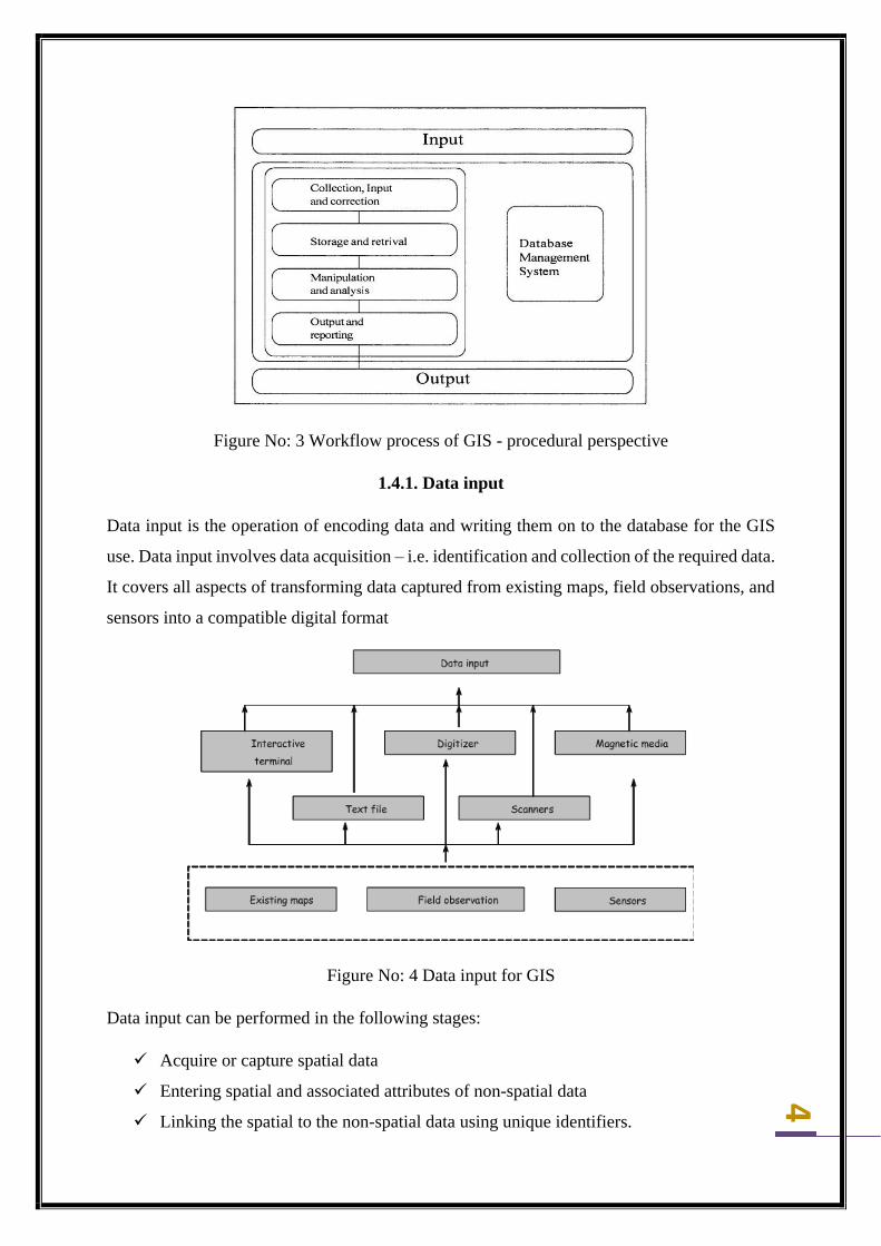
4
Figure No: 3 Workflow process of GIS - procedural perspective
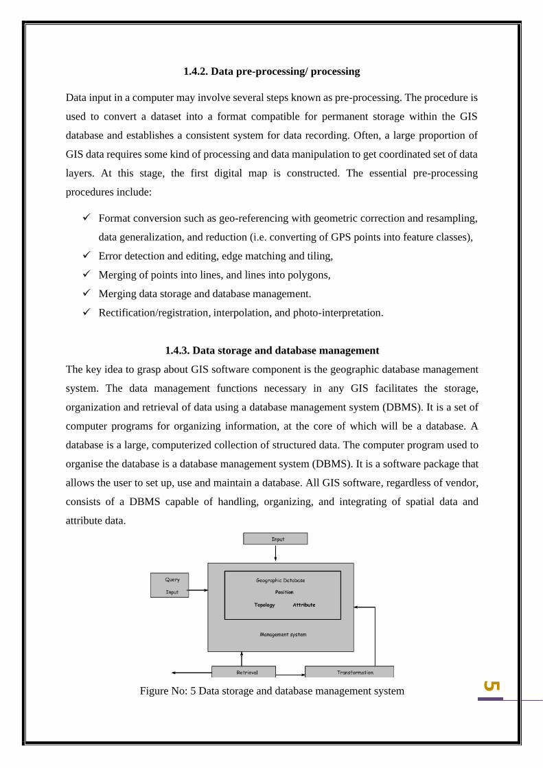
1.4.1. Data input
Data input is the operation of encoding data and writing them on to the database for the GIS
use. Data input involves data acquisition – i.e. identification and collection of the required data.
It covers all aspects of transforming data captured from existing maps, field observations, and
sensors into a compatible digital format
Figure No: 4 Data input for GIS
Data input can be performed in the following stages:
✓ Acquire or capture spatial data
✓ Entering spatial and associated attributes of non-spatial data
✓ Linking the spatial to the non-spatial data using unique identifiers.
5
1.4.2. Data pre-processing/ processing
Data input in a computer may involve several steps known as pre-processing. The procedure is
used to convert a dataset into a format compatible for permanent storage within the GIS
database and establishes a consistent system for data recording. Often, a large proportion of
GIS data requires some kind of processing and data manipulation to get coordinated set of data
layers. At this stage, the first digital map is constructed. The essential pre-processing
procedures include:
✓ Format conversion such as geo-referencing with geometric correction and resampling,
data generalization, and reduction (i.e. converting of GPS points into feature classes),
✓ Error detection and editing, edge matching and tiling,
✓ Merging of points into lines, and lines into polygons,
✓ Merging data storage and database management.
✓ Rectification/registration, interpolation, and photo-interpretation.
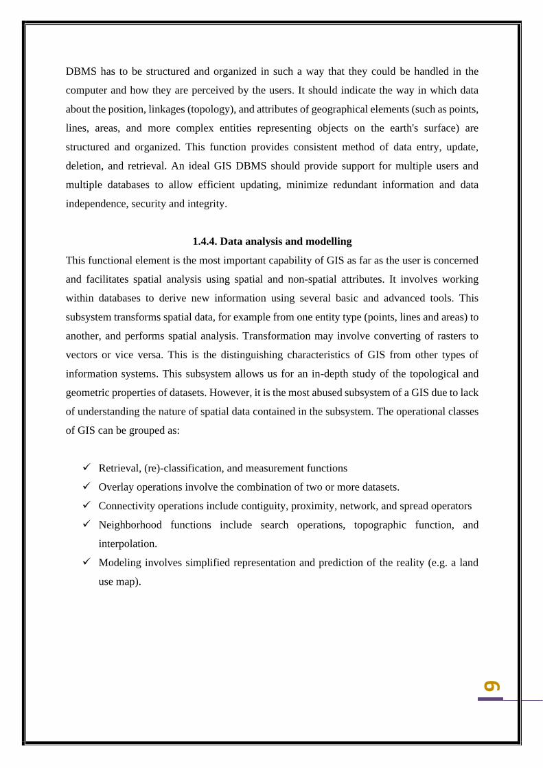
1.4.3. Data storage and database management
The key idea to grasp about GIS software component is the geographic database management
system. The data management functions necessary in any GIS facilitates the storage,
organization and retrieval of data using a database management system (DBMS). It is a set of
computer programs for organizing information, at the core of which will be a database. A
database is a large, computerized collection of structured data. The computer program used to
organise the database is a database management system (DBMS). It is a software package that
allows the user to set up, use and maintain a database. All GIS software, regardless of vendor,
consists of a DBMS capable of handling, organizing, and integrating of spatial data and
attribute data.
Figure No: 5 Data storage and database management system
6
DBMS has to be structured and organized in such a way that they could be handled in the
computer and how they are perceived by the users. It should indicate the way in which data
about the position, linkages (topology), and attributes of geographical elements (such as points,
lines, areas, and more complex entities representing objects on the earth's surface) are
structured and organized. This function provides consistent method of data entry, update,
deletion, and retrieval. An ideal GIS DBMS should provide support for multiple users and
multiple databases to allow efficient updating, minimize redundant information and data
independence, security and integrity.
1.4.4. Data analysis and modelling
This functional element is the most important capability of GIS as far as the user is concerned
and facilitates spatial analysis using spatial and non-spatial attributes. It involves working
within databases to derive new information using several basic and advanced tools. This
subsystem transforms spatial data, for example from one entity type (points, lines and areas) to
another, and performs spatial analysis. Transformation may involve converting of rasters to
vectors or vice versa. This is the distinguishing characteristics of GIS from other types of
information systems. This subsystem allows us for an in-depth study of the topological and
geometric properties of datasets. However, it is the most abused subsystem of a GIS due to lack
of understanding the nature of spatial data contained in the subsystem. The operational classes
of GIS can be grouped as:
✓ Retrieval, (re)-classification, and measurement functions
✓ Overlay operations involve the combination of two or more datasets.
✓ Connectivity operations include contiguity, proximity, network, and spread operators
✓ Neighborhood functions include search operations, topographic function, and
interpolation.
✓ Modeling involves simplified representation and prediction of the reality (e.g. a land
use map).

7
1.4.5. Data output
This functional element concerns with the ways in which data are displayed and the results of
analyses are reported to the users (Figure 2-6). These output products can be available in a
variety of ways that includes statistical reports, maps, tables, figures, and graphics of various
kinds.
Figure No: 6 Data output for GIS
The generated product may range from the ephemeral image on a cathode ray tube through
hard copy output drawn on printer or plotter to information recorded on magnetic media in
digital form. There are several professional GIS software packages in the market such as
ArcGIS, ILWIS, ERDAS, IDRISI, MAPINFO, GRASS, and the database systems of Oracle
and dBase.
1.5. Data
Perhaps data is the most important component of a GIS. GIS can integrate spatial data with
other existing data resources stored in a DBMS. All GIS software is designed to handle spatial
data (also called geographical data). GIS technology utilizes two basic data types: attribute and
spatial data.
8
✓ Attribute data describes the characteristics of spatial features often referred to as tabular
data such as a name, number of stories, depth, or population.
✓ Spatial data refer to the real-world geographic objects such as streets, buildings, and
countries, and their respective locations. They are represented in the form of vector data
(points, lines and areas feature) or in the form of raster or image data (grid form).
GIS processes any data that has a spatial component. This information is quite diverse—it can
be aerial photographs or satellite imagery, a collection of terrain contours, digital maps of the
built environment, or legal records of land ownership. However, geographic data can reside in
some unexpected places (i.e. any company that keeps a database of its customers has
geographic data).
1.6. People or expert
People are the key components of GIS, without which, nothing else would work or the GIS
will be useless. Hence, there must always be people to plan, design, program, maintain it,
supply it with data, interpret its results, implement and operate the system as well as make
decisions based on the required output. People are the most complex component of GIS. This
component is the most failure prone, and the only component capable of self-correcting; and
able to repair other components. People may operate individually or within a group or team.
Individuals may function as a GIS manager, analysts, technicians, or as a user. Almost all
should have the basic knowledge needed to work with geographic data– knowledge of data
sources, scale and accuracy, and software products (Heywood et al., 2006).
9
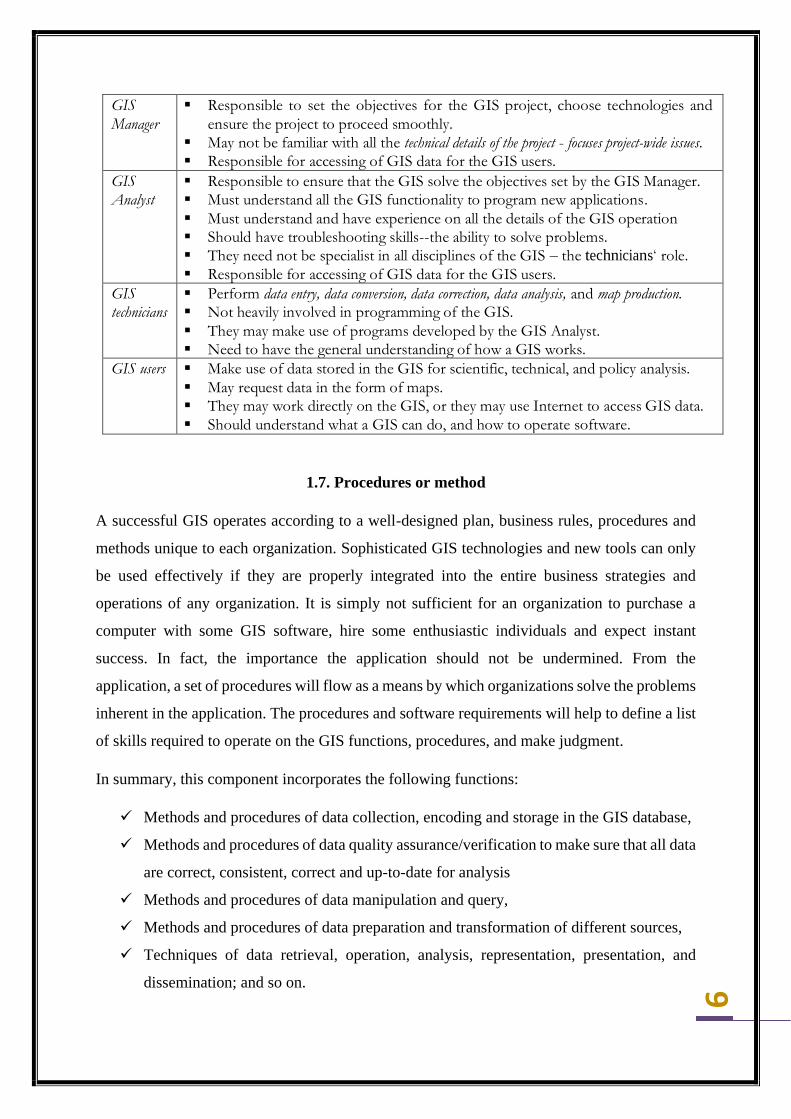
GIS
Manager
▪ Responsible to set the objectives for the GIS project, choose technologies and
ensure the project to proceed smoothly.
▪ May not be familiar with all the technical details of the project - focuses project-wide issues. ▪ Responsible for accessing of GIS data for the GIS users.
GIS
Analyst
▪ Responsible to ensure that the GIS solve the objectives set by the GIS Manager.
▪ Must understand all the GIS functionality to program new applications. ▪ Must understand and have experience on all the details of the GIS operation
▪ Should have troubleshooting skills--the ability to solve problems. ▪ They need not be specialist in all disciplines of the GIS – the technicians‘ role. ▪ Responsible for accessing of GIS data for the GIS users.
GIS
technicians
▪ Perform data entry, data conversion, data correction, data analysis, and map production.
▪ Not heavily involved in programming of the GIS. ▪ They may make use of programs developed by the GIS Analyst.
▪ Need to have the general understanding of how a GIS works.
GIS users ▪ Make use of data stored in the GIS for scientific, technical, and policy analysis.
▪ May request data in the form of maps.
▪ They may work directly on the GIS, or they may use Internet to access GIS data. ▪ Should understand what a GIS can do, and how to operate software.
1.7. Procedures or method
A successful GIS operates according to a well-designed plan, business rules, procedures and
methods unique to each organization. Sophisticated GIS technologies and new tools can only
be used effectively if they are properly integrated into the entire business strategies and
operations of any organization. It is simply not sufficient for an organization to purchase a
computer with some GIS software, hire some enthusiastic individuals and expect instant
success. In fact, the importance the application should not be undermined. From the
application, a set of procedures will flow as a means by which organizations solve the problems
inherent in the application. The procedures and software requirements will help to define a list
of skills required to operate on the GIS functions, procedures, and make judgment.
In summary, this component incorporates the following functions:
✓ Methods and procedures of data collection, encoding and storage in the GIS database,
✓ Methods and procedures of data quality assurance/verification to make sure that all data
are correct, consistent, correct and up-to-date for analysis
✓ Methods and procedures of data manipulation and query,
✓ Methods and procedures of data preparation and transformation of different sources,
✓ Techniques of data retrieval, operation, analysis, representation, presentation, and
dissemination; and so on.

10


