
The Author
Mike Alexander FRSB FCIEEM is the chairman-elect
of the Wildlife Trust of South and West Wales. He spent a year
as assistant warden on Skokholm Island in 1966, this was
followed by a year as warden on the Calf of Man. Later he was
warden of Skomer for 10 years, leaving in 1985 when he was
appointed Warden of 5 NNRs in North Wales. In 1991 he
became responsible, among other things, for the management
of the series of NNRS in Wales, a position he held for over
twenty years. He was one of the founders and is currently the
chairman of PONT, an organisation established to build the
essential bridges primarily between nature conservation and
farmers in Wales. He has long been at the forefront of
developing management planning, initially working with the
main conservation organisations in Britain. Soon his work
gained an international reputation and he became involved
with countries as diverse as Costa Rica, Uganda, India, The
Netherlands and Estonia. He is the author of ‘Management
Planning for Nature Conservation’ (2013), which has become
the standard international text book on the subject and is now
in its second edition. He contributed to the Birkbeck University
countryside management courses for over twenty years, and is
an honorary lecturer in the School of Natural Sciences, Bangor
University, where he is involved in both undergraduate and
postgraduate teaching. Mike is a Fellow of both the Charted
Institute of Ecology and Environmental Management, and The
Royal Society of Biology.

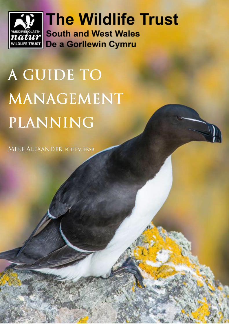
A GUIDE TO MANAGEMENT
PLANNING
Mike Alexander FRSB FCIEEM
Published by: Wildlife Trust of South and West Wales
(This planning guide is a modified and updated version of the CMS management planning guide, and the
Springer textbook, ‘Management Planning for Nature Conservation’, both previously published by Mike
Alexander.)
Copyright: © 2020 Wildlife Trust of South and West Wales
Reproduction of any material in this guide is permitted world-wide for any purpose
in perpetuity provided that following citation is included:
Citation: Alexander, M. (2020). A Guide to Management Planning. WTSWW, Bridgend
Wales, UK.
All photographs copyright Mike Alexander
Available from The Wildlife Trust of South and West Wales
https://www.welshwildlife.org/news/wildlife-trust-reports/
FOREWORD
This is a simple step by step guide; it contains limited historical and other background information on
management planning. This is a guide. It is not a workshop manual or rule book. It is a source of advice,
which should be used intelligently. No two sites or situations are exactly the same, and the advice given
in this guide should be adapted or modified to meet the needs of any given circumstance.
The planning process that I describe can be applied to any place which is managed entirely, or in part, for
wildlife. It is appropriate to both large-scale wildling initiatives, where the outcome is dictated by natural
processes, and situations where the desired outcome is specified, for example, meadows and most other
managed grasslands. It is equally relevant to nature reserves, where conservation is the primary land
use, and country parks, where wildlife management may be a secondary interest. It can be applied to the
management of species or habitats in any circumstance, regardless of any site designation. It is as
relevant at a landscape scale as it is on a small local nature reserve.
Nature conservation management is not a science, but successful or effective conservation is entirely
dependent on good science. Conservation mangers will often rely on the methods of science.
Conservation management is the application of science and knowledge to achieve desirable outcomes. In
addition to the objectivity of scientists, conservation managers require practical and communication
skills: these are usually achieved through experience. Managers must be prepared to compromise and
rely on judgement, as many of their decisions are based on limited information. (Bailey 1982).
Management planning is the intellectual or ‘thinking’ component of the conservation management
process. It is a dynamic, iterative process, it is about recognising the things that are important and
making decisions about what we want to achieve and what we must do. Planning is about sharing this
process with others so that we can reach agreement; it is about communication; it is about learning.
Planning must be rather more about thinking and less about the production of elaborate, verbose
documents. Planning should always come before management.
This could be summarised in three simple words: thought before action. Planning (thinking) is the most
important of all conservation management activities.
You do not need to read part 2, but it will help you to understand the planning process. Similarly, you do
not need to read the text contained in the blue text boxes or the text with blue headings. This is
supplementary information which will help you to understand some of the planning concepts, and
examples which illustrate the process.
If you have no interest in rewilding, wilding or management options you can ignore the relevant sections.
However, if your sites can be managed to some extent by enabling natural processes, I strongly
recommend these sections.
This guide is based on much of my previously published work, most of which now requires revision to
bring it up to date (Alexander 1991, 1994, 1995, 1996, 2000a, 2000b, 2003, 2005, 2008, 2013, 2015). I
will not provide specific references to these publications.
I cannot claim that this is the best way to plan, but it is the best that I know.
With few exceptions, planning is recognised as an essential component of almost all areas of human
endeavour. If planning is so important, why are so many sites managed without the support of a
planning process? When plans are prepared, why are they so often left unused or ignored? The answer
to the first question lies in the second. So many managers have direct or indirect experience of abysmal
management plans, produced at great cost but which deliver nothing, that there is a collective lethargy
and aversion for planning. This is surprising at a time when the destructive pressures on the environment
that we share with wildlife increase, while the resources available to combat these pressures are
decreasing. Before going any further we need to understand what a management plan should deliver.
Acknowledgements
I began writing this guide over thirty years ago. Since that time I have published 11 planning guides and
two editions of a textbook on management planning. It has been a long, evolutionary journey, but never
a lonely journey. So many people, far too many to mention, have contributed to the planning process,
and I am indebted to all of them. Three of my friends were constant companions through the most
formative and developmental years, endlessly trialling our evolving ideas and rewriting plans until,
eventually, we found a logical planning structure which met our needs as conservation managers. So, a
very special thank you to Doug Oliver, Tom Hellawell and, above all, to our dear, and sadly missed, friend
David Wheeler.
This guide is about adaptive planning, and so it is fitting that its entire development has been an adaptive
process. Our management plans must reflect the available knowledge, evidence, science and skills at the
time of writing, and the planning approach must be adapted to meet the ever-changing environmental
and anthropogenic factors. Six months ago, Kerry Rogers, a Conservation Manager for the Wildlife Trust
of South and West Wales, asked about the availability of an up-to-date version of a planning guide. I had
to confess that everything I had written was seriously out of date, and I agreed to produce a new guide
for the Wildlife Trust. Kerry Rogers and Lisa Morgan, Head of Islands and Marine for the Trust, received
my initial draft. Their response overwhelmed me. There were so many constructive comments on both
structure and content. As a consequence, I completely restructured and rewrote the guide, and, finally, I
gained their approval. This new version of the guide reflects their considerable experience, expertise and
commitment to nature conservation. I am very grateful.
WTSWW - A Guide to Management Planning-2020 1
CONTENTS FOREWORD.................................................................................................................................. 6
PART ONE – MINIMUM FORMAT PLANNING. ............................................................................... 6
The contents of a minimal plan ................................................................................................. 8
Plan headings ......................................................................................................................... 11
PART TWO – INTRODUCTION AND GENERAL GUIDANCE ............................................................. 12
Introduction ........................................................................................................................... 13
All management plans should answer six essential questions: ................................................................................. 13 Management planning should be a continuous, cyclical, iterative and developmental process. ............................. 13 The Precautionary Principle ....................................................................................................................................... 14 Language and Audience ............................................................................................................................................. 15 Survey, Surveillance, Monitoring & Recording .......................................................................................................... 16
Survey .................................................................................................................................................................... 16 Surveillance ............................................................................................................................................................ 17 Monitoring ............................................................................................................................................................. 18 Recording ............................................................................................................................................................... 20
Approaches to management ...................................................................................................................................... 22 Management by defining outcomes ...................................................................................................................... 22 Management by enabling process (wilding) .......................................................................................................... 23
Adaptive Management ........................................................................................................... 25
Adaptive management a minimal approach. ............................................................................................................. 27 1. Prepare an objective for each feature .......................................................................................................... 27 2. Identify or confirm management – the rationale ......................................................................................... 28 3. Implement management .............................................................................................................................. 28 4. Monitor the feature ...................................................................................................................................... 29 5. Review ........................................................................................................................................................... 29
Preparing a plan ......................................................................................................................................................... 32 The size of a plan - small is beautiful ..................................................................................................................... 32 Who should be involved in the preparation? ........................................................................................................ 32 Presentation .......................................................................................................................................................... 33 Plan approval ......................................................................................................................................................... 33 Thought before action ........................................................................................................................................... 34 Main sections in a plan .......................................................................................................................................... 35 Recommended structure for an ADAPTIVE management plan ............................................................................. 37 Structure of an integrated plan with a variety of features .................................................................................... 38 Recommended contents of a Management Plan .................................................................................................. 39
PART THREE – THE MANAGEMENT PLAN .................................................................................... 40
Plan Summary ........................................................................................................................ 41
1. Legislation & Policy .......................................................................................................... 41
1.1 Legislation ............................................................................................................................................................ 41 1.2 Policies ................................................................................................................................................................. 43
2. Description ...................................................................................................................... 44
2.1 General Information ..................................................................................................................................... 49
WTSWW - A Guide to Management Planning-2020 2
2.1.1 Location & site boundaries ....................................................................................................................... 49 2.1.2 Zones ........................................................................................................................................................ 49 2.1.3 Tenure ...................................................................................................................................................... 50 2.1.4 Past status of the site ............................................................................................................................... 51 2.1.5 Relationships with any other plans or strategies ..................................................................................... 51 2.1.6 Management / organisational infrastructure ........................................................................................... 51 2.1.7 Site infrastructure ..................................................................................................................................... 52 2.1.8 Map coverage ........................................................................................................................................... 52 3.1.9 Photographic coverage ............................................................................................................................. 52
2.2 Physical Environment ........................................................................................................................................... 53 2.2.1 Climate .......................................................................................................................................................... 53 2.2.2 Geology and geomorphology ....................................................................................................................... 53 2.2.3 Soils/substrates ............................................................................................................................................ 53 2.2.4 Hydrology / drainage .................................................................................................................................... 53
2.3 Biological .............................................................................................................................................................. 54 2.3.1 Flora .............................................................................................................................................................. 54
Habitats / communities ..................................................................................................................................... 54 2.3.2 Flora / Fauna - Species .................................................................................................................................. 54
Alien invasive / pest species .............................................................................................................................. 55 2.4 Cultural .......................................................................................................................................................... 57
2.4.1 Archaeology .............................................................................................................................................. 57 3.4.2 Past land use ............................................................................................................................................. 58 3.4.3 Present land use ....................................................................................................................................... 58 3.4.4 Past management for nature conservation .............................................................................................. 58
2.5 People – stakeholders, access, etc. ............................................................................................................... 58 2.5.1 Stakeholders / Stakeholder analysis ......................................................................................................... 58 3.5.2 Access ....................................................................................................................................................... 60 3.5.3 Interpretation provisions .......................................................................................................................... 60 3.5.4 Educational use ........................................................................................................................................ 60
2.6 Research use and facilities ............................................................................................................................ 61 2.7 Landscape ..................................................................................................................................................... 61 2.8 Bibliography .................................................................................................................................................. 61
3 Evaluation - Conservation Features ...................................................................................... 62
The selection of conservation features based on previously recognised assessments ............................................. 66 Criteria for assessing conservation features .............................................................................................................. 66 Preparing a list of conservation features ................................................................................................................... 69 Resolving conflicts between features ........................................................................................................................ 70 Combining features .................................................................................................................................................... 70 Identifying potential features on wildlife creation sites ............................................................................................ 71 Summary description of the feature .......................................................................................................................... 73
4 Options and processes ..................................................................................................... 74
Options ....................................................................................................................................................................... 74 Options for Sites and Habitats ............................................................................................................................... 75
Non-Intervention ............................................................................................................................................... 75 Minimal intervention ........................................................................................................................................ 76 Active Management .......................................................................................................................................... 76
Enabling natural processes (wilding) ..................................................................................................................... 76
5 Factors............................................................................................................................. 84
Types of factors .......................................................................................................................................................... 86 Internal and external factors ................................................................................................................................. 86 Anthropogenic and natural factors........................................................................................................................ 89
WTSWW - A Guide to Management Planning-2020 3
Features as factors ................................................................................................................................................. 90 Legislation and policy ............................................................................................................................................ 90 Health and safety ................................................................................................................................................... 91 Obligations non-legal ............................................................................................................................................. 91 Owners and Occupiers ........................................................................................................................................... 91 Stakeholder and public interest ............................................................................................................................. 91 Public use - access or tourism ................................................................................................................................ 92 Past-intervention / land use .................................................................................................................................. 92 Physical considerations/constraints ...................................................................................................................... 93 Resources ............................................................................................................................................................... 93 Size & Connectivity ................................................................................................................................................ 93 The preparation of a master list of factors ............................................................................................................ 94 Primary and secondary factors Primary and Secondary Factors ........................................................................... 96
6 Objectives ............................................................................................................................ 97
An objective must be communicable .................................................................................................................... 99 Favourable Conservation Status (FCS) ..................................................................................................................... 100 Optimal status .......................................................................................................................................................... 101 6.1 Visions ......................................................................................................................................................... 102
Visions for Habitats .............................................................................................................................................. 102 Vision for small, wet, upland, acid, oak woodland .............................................................................................. 103 Visions for extremely dynamic features .............................................................................................................. 108 Visions for species ............................................................................................................................................... 113
6.2 Performance indicators ............................................................................................................................... 115 Favourable condition and Favourable Conservation Status ............................................................................ 115
Attributes as performance indicators .................................................................................................................. 116 Selecting attributes ......................................................................................................................................... 117 Attributes should, whenever possible, be indicators of the future rather than the past ............................... 117 The selection of some attributes should be guided by factors ....................................................................... 117 Attributes must be quantifiable and measurable ........................................................................................... 119 Monitoring attributes ...................................................................................................................................... 119 Attributes are not objectives........................................................................................................................... 119 Specified Limits................................................................................................................................................ 119 Specified limits for attributes .......................................................................................................................... 119 What happens when a limit is exceeded? ....................................................................................................... 120 An example of attributes used to monitor a seabird population .................................................................... 120
Factors as performance indicators ...................................................................................................................... 122 The relationship between factors and attributes ............................................................................................ 123 Monitoring factors .......................................................................................................................................... 125 Factors can be monitored directly, indirectly or both..................................................................................... 126 Surveillance ..................................................................................................................................................... 127 Public use of a site as a factor ......................................................................................................................... 128 Specified limits for factors ............................................................................................................................... 129 The relationship between factors, attributes and monitoring ........................................................................ 130
Performance indicators and surveillance when enabling natural process (minimal intervention) ..................... 131 Performance indicators used for the vegetation on Skomer island ................................................................ 131 Performance indicators for a woodland where the management option is minimal intervention ................ 135
7 Rationale – Status and Factors ....................................................................................... 140
Conservation status ................................................................................................................................................. 140 Categories that describe the status of a feature: ................................................................................................ 140
Rationale - factors .................................................................................................................................................... 144
8 Action Plans ................................................................................................................... 145
WTSWW - A Guide to Management Planning-2020 4
The relationship between an objective and projects .......................................................................................... 145 8.1 Projects .............................................................................................................................................................. 147 8.2 Planning individual projects ............................................................................................................................... 148
Why the project is necessary ............................................................................................................................... 148 Potential impact on other features ..................................................................................................................... 148 When the project is active ................................................................................................................................... 148 Where the work will be carried out ..................................................................................................................... 149 Resources ............................................................................................................................................................. 149 Expenditure ......................................................................................................................................................... 149 Staff...................................................................................................................................................................... 149 Priority ................................................................................................................................................................. 149 General background information ........................................................................................................................ 151 Methodology ....................................................................................................................................................... 151 Project work programme ..................................................................................................................................... 151 Recommended structure for planning a management project ........................................................................... 152
Recommended format for describing monitoring / surveillance and RECORDING PROJECTs ........................ 153 8.3 Work programmes ............................................................................................................................................. 158
9. Planning access and tourism ............................................................................................. 159
9.1 Summary – access & tourism ...................................................................................................................... 159 9.2 Legislation & policy – access & tourism ...................................................................................................... 159 9.3 Legislation – access & tourism .................................................................................................................... 159 9.4 Policy – Access & tourism ........................................................................................................................... 160 9.5 Description Access & Tourism ..................................................................................................................... 162
9.5.1 Access / Tourist Zones (Compartments) ................................................................................................. 162 9.6 Evaluation Access / Tourism ....................................................................................................................... 163
9.6.1 Actual or potential demand .................................................................................................................... 164 9.6.2 Accessibility of the site ........................................................................................................................... 165 9.6.3 Accessibility within the site .................................................................................................................... 165 9.6.4 Site safety (dangerous terrain, infrastructure, artefacts, etc.) ............................................................... 165 9.6.5 Stakeholder interests .............................................................................................................................. 166 9.6.6 Carrying capacity .................................................................................................................................... 166
9.6.6.1 Carrying capacity of the features ................................................................................................... 167 9.6.6.2 Carrying capacity of the site .......................................................................................................... 168
9.6.7 Availability of resources ......................................................................................................................... 170 9.7 Access options............................................................................................................................................. 170 9.8 Access Objective ......................................................................................................................................... 171
9.8.1 Vision for access ..................................................................................................................................... 172 9.8.2 Performance indicators & monitoring .................................................................................................... 177
9.9 Status & Rationale....................................................................................................................................... 179 9.9.1 Status ...................................................................................................................................................... 179 9.9.2 Rationale ................................................................................................................................................. 179 9.9.3 Factors that may have implications for access ........................................................................................... 180
Legislation ....................................................................................................................................................... 180 Access to the site ............................................................................................................................................. 180 Access within the site ...................................................................................................................................... 180 Visitor safety.................................................................................................................................................... 181 Seasonal constraints ........................................................................................................................................ 181 Public awareness ............................................................................................................................................. 181 Excessive demand ........................................................................................................................................... 181 Visitor infrastructure ....................................................................................................................................... 181 Information ..................................................................................................................................................... 181 Interpretation .................................................................................................................................................. 181

WTSWW - A Guide to Management Planning-2020 5
Education......................................................................................................................................................... 182 9.10 Action plan Access & tourism ..................................................................................................................... 182
Management Projects ......................................................................................................................................... 182
10. Ecosystem Services ......................................................................................................... 183
Introduction ............................................................................................................................................................. 183 Ecosystem services as site features ..................................................................................................................... 185 Evaluation for ecosystem services ....................................................................................................................... 187
Potential ecosystem services ................................................................................................................................... 188 Provisioning services ............................................................................................................................................ 188
Food................................................................................................................................................................. 188 Wild food ......................................................................................................................................................... 188 Water .............................................................................................................................................................. 188 Medicinal resources ........................................................................................................................................ 188 Genetic Resources ........................................................................................................................................... 189
Regulatory services .............................................................................................................................................. 189 Climate regulation local and global contribution ............................................................................................ 189 Hazard regulation ............................................................................................................................................ 191 Pollination ....................................................................................................................................................... 191
Cultural services ................................................................................................................................................... 192 Natural settings – landscapes and seascapes.................................................................................................. 192 Access to green spaces / recreation - tourism ................................................................................................ 192 Appreciating wildlife ....................................................................................................................................... 192 Tranquility ....................................................................................................................................................... 193 Cultural Heritage ............................................................................................................................................. 193 Spiritual and religious value ............................................................................................................................ 194 Education......................................................................................................................................................... 194 Physical health and mental wellbeing ............................................................................................................. 195
GLOSSARY ............................................................................................................................ 196
Appendix 1 - Extract from the Skomer NNR plan. .................................................................. 200
Appendix 2 - Recommended contents for project plans ......................................................... 208
Appendix 3 - CMS Project Codes ........................................................................................... 210
Refferences .......................................................................................................................... 216
WTSWW - A Guide to Management Planning-2020 6
PART ONE – MINIMUM FORMAT PLANNING.
WTSWW - A Guide to Management Planning-2020 7
Minimum format planning
This section is intended as a quick guide to producing a very basic management plan. It is not
intended as a stand-alone document; it should be used alongside the full management planning
guide in section three.
Even where there may be a long-term aspiration to prepare a full plan for a site, the process can,
and perhaps should, begin as a brief outline or minimal statement. As further information or
resources become available the plan may grow. In order to allow for growth, I strongly recommend
that the plan follows exactly the same structure and numbering format as a full plan: this will
obviously facilitate the future development of the plan.
Most people who use this abbreviated guide will at times need further guidance. The numbering in
this guide matches the full guide given in section 3, and you can dip in and out of the full document
as the need arises.
The size of a management plan and, perhaps more importantly, the resource made available for its
production must be in proportion to the complexity of the site and also to the total resource
available for the safeguard and/or management of the site. Thus, for small, uncomplicated sites,
short, concise plans will suffice. A plan should be as small as possible - as large as the site requires
and no larger. For very small sites, with perhaps one or two features of interest, the plan need be
no longer than about 3000 words.
Even where it makes good sense to prepare minimal format plans, there is no justification for taking
shortcuts in the intellectual, or thinking, process. With the exception of site acquisition, the process
of making decisions about what we want and what we must do is the most important of all
management activities.
Begin by pasting in a set of headings: there is an example at the end of this section. The plan will
benefit if you complete it in the sequence suggested by the list. You could create a bespoke
template, but I am always concerned that templates can constrain flexibility and creativity. They
can, however, ensure that all the essential information is included. Make sure that you date your
document. This is such an obvious thing, and yet it is surprising how many plans remain undated.
It is very important that you do not get ‘stuck’ in any section, or that you feel that you must
complete every single section simply because it is included in the list of headings. Use your
judgement and only complete the sections that are relevant to your site, and add additional sub-
sections as appropriate.
Bear in mind that your plan is not intended as a literary masterpiece, so use plain language with
relatively short sentences. Cut and Paste from existing documents whenever the opportunity
arises. There are no prizes for original writing. Do not forget to provide references or to
acknowledge the source of original material.
It is a good idea to include maps and photographs of the site at the beginning of the plan. Use
photography whenever appropriate throughout the plan as this can help you avoid too much
descriptive text.
WTSWW - A Guide to Management Planning-2020 8
THE CONTENTS OF A MINIMAL PLAN
Plan Summary
This is optional: you might want to include a simple summary as an introduction to the plan, but it
will be hardly necessary if your plan is only a few pages long.
1. Legislation & Policy
Take care in this section. If the site is designated or it contains legally protected species you must
note the legal obligations. It is a good idea to provide a location where legal documents are stored.
Be very aware of health and safety and public liability legislation, and make sure that you highlight
any management obligations, for example, signage and safety barriers.
An organisational policy statement is essential. In addition to complying with all legal obligations, a
management plan must be guided by the policies of the organisation which owns, or is responsible
for the management of, a site. I would advise all organisations to provide a generic statement that
can be used in all their management plans.
2. Description
In some cases this need be no more than a paragraph or two, and the subheading can be ignored. I
include the subheads because some of the information may be essential for your plan. Use the
sequence provided by the subheadings as a structure for your description. even when you do not
use the headings.
2.1 Location & Site Boundaries This is obviously important information; the simplest approach is to include a map. I would strongly recommend the inclusion of a site and location map in all plans, regardless of size.
2.2 Tenure This is important. If the site is owned it may be sufficient to say little more than that. It is always worth checking the tenure documents to make sure that there are no reservations or conditions, for example, an obligation to maintain a boundary structure. If a site is leased provide a note on anything significant and give the location of tenure documents.
2.3 Environmental information
Physical information This could be further divided, but only if relevant, to include: climate, geology / geomorphology / soils, hydrology /drainage.
Biological For simple, small sites this broad heading will usually be sufficient. Focus on the features which make the site important and justify preparing a plan. There is rarely, if ever, any justification for long species lists. You can use the following subheadings:
Flora (habitats, communities) Include a description of the main habitats and, if necessary, plant communities. If there has been a previous survey, for example, NVC, note the community code and name, copy as much of the
WTSWW - A Guide to Management Planning-2020 9
survey descriptions as relevant and give a reference and location for the original survey documents.
Species (which can be subdivided into flora and fauna) Only include the important species and, obviously, any notified or protected species. It is important that you mention any significant invasive non-native species.
2.4 Cultural information
Archaeological / historical interest Occasionally, a site can contain scheduled ancient monuments or other important archaeological features: you must not ignore these. There will be an obligation to protect them or, at very least, to avoid any damage.
People, including access Include information on public interest, stakeholders, access, etc., but only if it is relevant to the management of the site. For example, there may be an obligation to maintain a right of way or to fence off a dangerous section.
3. Features
You must include a list of notified features on any designated site. The most likely designation that
you will encounter is an SSSI. Attach copies of the SSSI schedule and any other relevant and related
documentation to your plan, or list the documents and provide a location where they are stored.
If your site is notified, the list of notified features will be adequate for this section. If your site is not
notified, you will need to identify at least the key features. Many small sites will have just one
feature. Please refer to the main guide for further instructions.
4. Options
I suggest that you always consider the management options: non-intervention, minimal
intervention, or active management. They identify the general direction of management. Often, the
selection of options will be guided by organisational policy. There is no need for a lengthy written
justification, but you must give this careful thought.
5. Factors
Identify and list only the key factors, for example, on a small meadow you would include grazing,
scrub invasion and invasive non-native species. Use the examples of factors in the main guide as a
checklist. At this stage you do not need to provide a description of the factor.
6. Objective
Vision This is the most important section in your plan. You could write a simple, succinct
vision for each individual feature, or you may combine all the features in a single vision
statement. The vision is simply a pen-portrait of the condition that you require for the
features and / or the site. The full planning guide will provide all the help you need to
understand this section.
Performance indicators Even the simplest, smallest sites need something that can be easily
recognised, measured or monitored to provide an indication that management is
appropriate. For example, in a meadow, at very least, list the desirable species, perhaps
focusing on the flowering plants which are most vulnerable, indicative of what you require
WTSWW - A Guide to Management Planning-2020 10
and reasonably easy to identify. You can also list the undesirable species, for example, an
increase in the dominance of rye grass and white clover.
If the site is an SSSI you must follow organisational guidance.
7. Rationale
As with everything else in the minimal format plan, keep this as succinct as possible. The first step is
to consider each of the factors that you have already identified in turn. The factors will always
identify a management requirement. For example, returning to the meadow example, if the key
factor is grazing, consider how the site can be grazed and what animals are appropriate. (Make sure
that you consult or seek advice at this stage.) You might simply state that a local farmer will be
given a grazing licence, and provide a reference to the agreement. Do not forget about all the
implications of holding stock on a site. This will include, boundaries, water supply, public safety, dog
control, etc. The conclusion of the rationale is a list outlining each of the management activities
that must be carried out on the site.
8. Action plan There are no short cuts here: each of the outline management activities identified in
the rationale must be described in sufficient detail for the work to be completed to a satisfactory
standard. These are the projects or distinct tasks, and I suggest you look at the project templates
with examples given in the full guide.
All the projects will require an individual description and this will include, for each, the following
information:
When When will the work be carried out?
Where Where will activities take place?
Who Who will do the work and for how long?
Priority What priority is given to the project?
Expenditure How much will it cost?
Details A detailed description of the work
This part of the plan is confidential and, unless there are good reasons, it should not be available
outside an organisation.
Once all the projects have been described they key information contained in each can be combined
to produce a variety of work plans.
The most important reason for following the structure presented in this guide in sequence is that all
the work carried out on a site can be directly linked to the management objectives. In short, a
reader must be able to gain a clear understanding of why management activities are being carried
out on a site.
WTSWW - A Guide to Management Planning-2020 11
PLAN HEADINGS
Delete anything that you do not need and expand as necessary.
Plan Summary
1. Legislation & Policy
2. Description
Location & Site Boundaries
Tenure
Environmental information
Physical information
Biological
Flora (habitats, communities)
Species
Flora
Fauna
Cultural information
Archaeological / historical interest
People, including access
3. Features
4. Options
5. Factors
6. Objective
Vision
Performance indicators
7. Rationale
8. Action plan
WTSWW - A Guide to Management Planning-2020 12
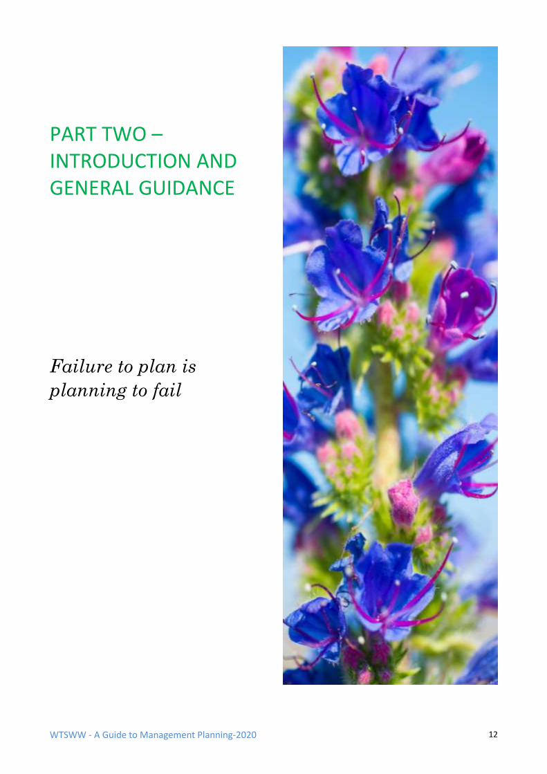
PART TWO – INTRODUCTION AND GENERAL GUIDANCE
Failure to plan is
planning to fail
WTSWW - A Guide to Management Planning-2020 13
INTRODUCTION
ALL MANAGEMENT PLANS SHOULD ANSWER SIX ESSENTIAL QUESTIONS:
• Why are we here? (Policy)
• What have we got? (Description)
• What is important? (Evaluation)
• What are the important influences? (Factors)
• What do we want? (Objectives)
• What must we do? (Action Plan)
MANAGEMENT PLANNING SHOULD BE A CONTINUOUS, CYCLICAL, ITERATIVE AND
DEVELOPMENTAL PROCESS.
‘A process in which management activities are implemented in spite of uncertainties about their effects, the effects of management are measured and evaluated, and the results are applied to future decisions’. (Elzinga et al. 2001)
• Monitoring and / or surveillance must be recognised as an integral and essential component of any planning process.
• It is good practice to record all actions undertaken in accordance with a plan.
• Factors must be identified and integrated in the planning process. (A factor is anything that has the potential to influence or change a feature, or to affect the way in which a feature is managed.)
• Plans and management actions should incorporate current best practice and be open to new and innovative ideas.
• Management should be reviewed continually within a time scale that is appropriate to the features. (Fragile and vulnerable habitats or populations will require more frequent attention than robust and secure features.)
• Internal management reviews should be supplemented with formal reviews at predetermined agreed dates.
WTSWW - A Guide to Management Planning-2020 14
THE PRECAUTIONARY PRINCIPLE
In essence, the precautionary principle is about not taking chances with our environment. It moves
the 'duty of care' or 'onus of proof' from those who attempt to protect the environment to those
who propose changes or development. The principle is almost always associated with the Rio
Convention on Biological Diversity. At the 1992 United Nations Conference on Environment and
Development in Rio de Janeiro, world leaders adopted, and advocated the widespread international
application of, the precautionary principle:
‘In order to protect the environment, the precautionary approach shall be widely applied by States according to their capabilities. Where there are threats of serious or irreversible damage, lack of full scientific certainty shall not be used as a reason for postponing cost-effective measures to prevent environmental degradation.’
The Rio Convention is aimed at protecting the world's natural assets. The introduction of ‘cost-
effectiveness’ to the definition is unfortunate as it diminishes the definition by providing an escape
route for politicians and developers. However, despite its weakness, the precautionary principle
supports most conservation efforts.
Despite its formal adoption by European and many other governments, the precautionary principle
is extremely controversial. There are concerns expressed by both environmentalists and
developers. Many argue that it is an obstacle to innovation and progress. However, most
environmental commentators appear to support the principle, and many make the point that it is
simple common sense.
The precautionary principle is important in the context of conservation management and planning.
It should be adopted regardless of any controversy, and it should influence the way in which we
manage sites, habitats and species. If the precautionary principle is applied, the following are some
of the more obvious implications for the management of protected areas:
• There is no need for scientific proof in order to restrict human use, or any specific activities,
when there is reason to believe that they are a potential threat. Logically, we should, in fact,
obtain conclusive evidence to demonstrate that an activity is not a threat to the site or to
the wildlife before giving consent.
• Unless we have conclusive evidence to demonstrate that conservation features are at
favourable conservation status, we should assume that they are unfavourable. (If the status
of a feature is unknown, we should assume that it is unfavourable.)
• We should take steps to control threats (factors) even when there is insufficient scientific
evidence to support our concern.
• We must not assume that management will inevitably achieve the desired results.
Management can only be considered appropriate when we have conclusive evidence to
demonstrate that it is delivering the required outcomes.
WTSWW - A Guide to Management Planning-2020 15
LANGUAGE AND AUDIENCE
Whenever possible, management plans should be made available to the widest possible audience.
Occasionally, there will be a need to include sensitive or confidential information, for example, the
location of rare and endangered species. Clearly, this should be omitted from a public version of a
plan. Everyone who has an interest of any kind in the site, particularly neighbours, local residents
and all other stakeholders, should be able to access information which is of interest or relevance to
them. Regrettably, this rarely happens, and even when plans are made available to the public the
style of presentation and the language used in the documents can be impenetrable.
If management plans are recognised as a means of communicating our intentions, sometimes to a
very wide audience, the use of plain language is essential. Occasionally, there may be circumstances
where a plan is prepared entirely by experts for use by experts, but this is rare. Conservation
management and planning should be an inclusive activity, and providing stakeholders with access
to management plans is possibly one of the best ways of encouraging their involvement. Plans must
never be written in a patronising style, but they should not contain difficult or obscure scientific
language. For example, scientific species names should be accompanied by a common name
whenever possible. Where a common name is widely understood the scientific name may not be
necessary. It is, however, important that the quality of the information conveyed in the plan is not
diminished as a consequence of using plain language.
Taking the way in which we communicate a little further, we can improve things by communicating
with genuine feeling. If we believe so strongly in the importance of wildlife, then perhaps we
should also be prepared to share our enthusiasm with others.
Emotion is the source of all becoming-consciousness. There can be no transforming of darkness into light and of apathy into movement without emotion. (Jung 1968)
Feelings and emotions are the source of our ideas, inspiration and creativity. (Naess 2002)
Most people involved in nature conservation, and consequently most people who write
management plans, will share a love of the natural environment. We take it so much for granted
that we often forget to speak about it, and this silence can become inhibiting. It is not always easy
to break through these hidden barriers and talk about feelings when the scientific realities are so
much safer and easier to quantify. Perhaps sometimes we hide behind the anonymity of scientific
jargon because we have no words for our own emotions. At work, we rarely talk about feelings or
emotions, and yet, for most people, the reason for their choice of vocation in nature conservation
was a deep, emotional response to an experience sometime in their lives. Some are motivated by a
positive experience and others as a consequence of witnessing disaster or destruction. We disguise
our emotions in an attempt to present the illusion of dispassionate objectivity. Clearly, there are
times and places when this is important, but, equally, there are times when we need to share our
feelings. If no one breaks the silence we will become trapped by conformity. A wide range of
influences, particularly peer pressure, encourage us to conform, but simply because ideas of
behaviour have become widely accepted it does not mean that there are no better alternatives.
WTSWW - A Guide to Management Planning-2020 16
There are several areas in a management plan, none more important than the objectives, which
would benefit enormously if the text could also convey some of the values and feelings we have for
the very special places that we manage. Through sharing our values with others we might inspire
them and help them to gain a deeper appreciation of what we are trying to achieve.
SURVEY, SURVEILLANCE, MONITORING & RECORDING
Survey, surveillance, monitoring and recording are all activities concerned with the collection and
management of information. They are an indispensable and integral component of management
planning: without information there can be no planning. If we read almost any publication on
conservation management, the words ‘monitoring', 'survey' and 'surveillance' will be found
frequently. Very few authors define what they mean by these words: there appears to be an
assumption that there are universally accepted definitions. Unfortunately, nothing could be further
from the truth: the standard dictionary definitions of these words are not adequate for the
purposes of conservation planning, and there are no other widely accepted definitive definitions.
The following definitions will be applied throughout this guide. This is not an attempt to lay claim to
the meaning of these words, but it is important to establish meanings that can be clearly
understood within the framework of this guide.
SURVEY
Making a single observation to measure and record something
The standard dictionary definitions, for example, ‘look carefully and thoroughly at’, or ‘to view
comprehensively and extensively’, are not really adequate. In common use, ‘survey’ is generally
taken to mean a once-only observation, and it usually also implies that a record is made. Indeed,
unless a record of some kind is made there can be little purpose in ‘looking carefully and thoroughly
at’.
Surveys can be very expensive, particularly in respect of the time required. There are many
examples where the cost of pre-plan data collection has exceeded the resource available to manage
the site for the duration of the plan. All the resources available for managing sites should be
allocated through a structured, logical planning process which identifies and prioritises the work
required to manage a site, and data collection should be no exception. There will always be things
that are not known. An intelligent approach differentiates between those things that we need to
know and those that we would like to know. It then prioritises the different needs. In short, it is the
planning process that identifies the need for data and provides a justification for surveys. It is also
the planning process that identifies and prioritises the need to maintain inventories or to ensure
that the site description is always up to date. There can be no doubt that management plans should
be based on the best available knowledge. Decisions (planning is making a series of decisions) made
in the absence of sufficient and reliable data are potentially dangerous. However, a failure to make
a decision or to take an action can be even more dangerous (Thomas & Middleton 2003; Keller
1999).
WTSWW - A Guide to Management Planning-2020 17
SURVEILLANCE
Making repeated standardised surveys in order that change can be detected.
This is quite different to, but often confused with, monitoring. Surveillance lacks the ‘formulated
standards’ that are so important in monitoring (JNCC 1988; Rose & Mclean 2003; Hurford &
Schneider 2006). Surveillance is used to detect change but cannot differentiate between acceptable
and unacceptable change. Surveillance is often used when monitoring is not possible, or necessary,
because ‘formulated standards’ or limits for the attributes and factors have not been specified or
are unknown. In these circumstances, surveillance projects can sometimes be a precursor to
monitoring projects. By measuring and recording changes we can begin to understand the limits
within which a factor or attribute can vary without giving any cause for concern. Where monitoring
is a very specific and targeted activity, surveillance can have a broader function and can be used to
detect a much wider range of changes. Surveillance can be a site-specific activity or part of a wider
national, or sometimes international, programme. There is nothing that can replace the sort of
informal surveillance that is only possible when reserve managers maintain a continual presence
and awareness of a site. Their experience and familiarity with the features and factors will often
mean that they can recognise very small changes that would be difficult to detect even with more
sophisticated surveillance, changes that would certainly be missed by tightly focused monitoring
projects.
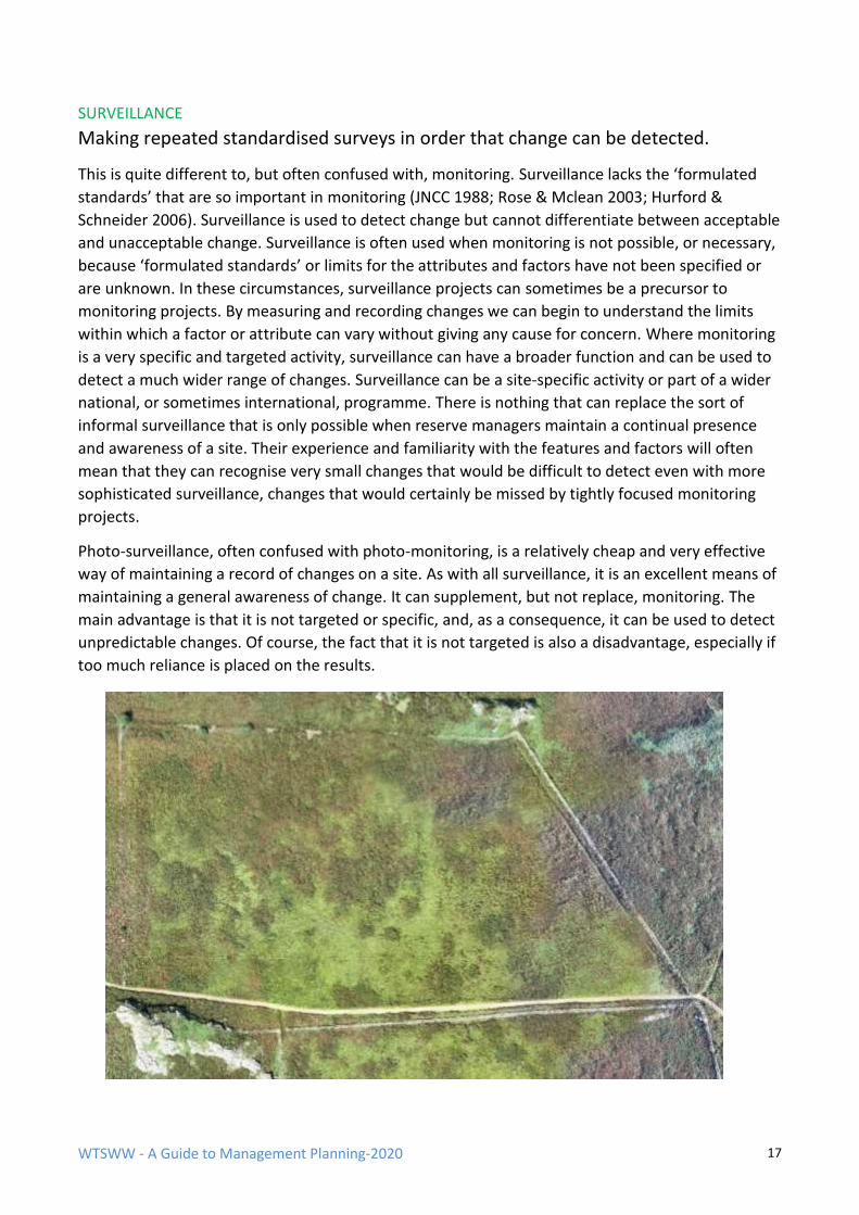
Photo-surveillance, often confused with photo-monitoring, is a relatively cheap and very effective
way of maintaining a record of changes on a site. As with all surveillance, it is an excellent means of
maintaining a general awareness of change. It can supplement, but not replace, monitoring. The
main advantage is that it is not targeted or specific, and, as a consequence, it can be used to detect
unpredictable changes. Of course, the fact that it is not targeted is also a disadvantage, especially if
too much reliance is placed on the results.
WTSWW - A Guide to Management Planning-2020 18
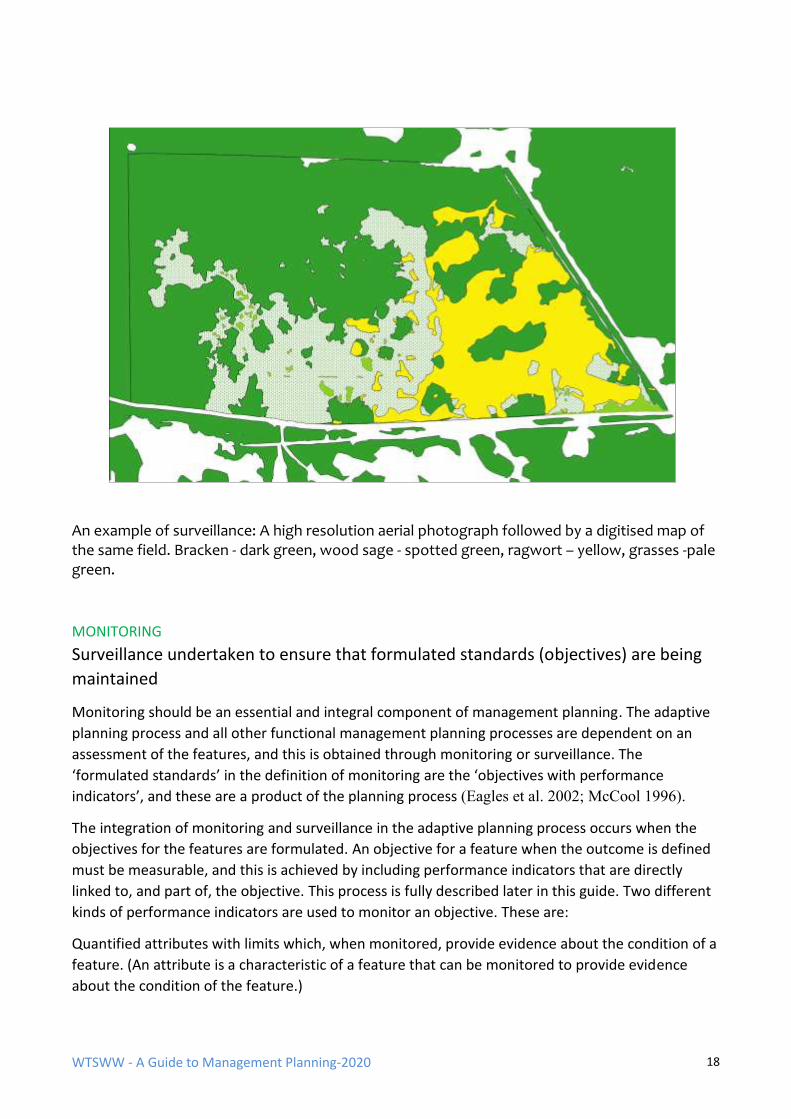
An example of surveillance: A high resolution aerial photograph followed by a digitised map of the same field. Bracken - dark green, wood sage - spotted green, ragwort – yellow, grasses -pale green.
MONITORING
Surveillance undertaken to ensure that formulated standards (objectives) are being
maintained
Monitoring should be an essential and integral component of management planning. The adaptive
planning process and all other functional management planning processes are dependent on an
assessment of the features, and this is obtained through monitoring or surveillance. The
‘formulated standards’ in the definition of monitoring are the ‘objectives with performance
indicators’, and these are a product of the planning process (Eagles et al. 2002; McCool 1996).
The integration of monitoring and surveillance in the adaptive planning process occurs when the
objectives for the features are formulated. An objective for a feature when the outcome is defined
must be measurable, and this is achieved by including performance indicators that are directly
linked to, and part of, the objective. This process is fully described later in this guide. Two different
kinds of performance indicators are used to monitor an objective. These are:
Quantified attributes with limits which, when monitored, provide evidence about the condition of a
feature. (An attribute is a characteristic of a feature that can be monitored to provide evidence
about the condition of the feature.)
WTSWW - A Guide to Management Planning-2020 19
Factors with limits which, when monitored, provide the evidence that the factors are under control
or otherwise. (A factor is anything that has the potential to influence or change a feature, or to
affect the way in which a feature is managed. These influences may exist, or have existed, at any
time in the past, present or future.)
The following notes are intended to guide the selection of appropriate monitoring methodologies.
This is not monitoring for reporting purposes and it is certainly not about research (hypothesis
testing). This is monitoring which is specific to management planning.
Monitoring projects should not be unnecessarily complicated. Most conservation managers, even
those who fail to carry out any monitoring, will readily accept that monitoring is extremely
important. When sites are not monitored the most common claim is there are insufficient
resources. However, I suspect that another, and more significant, reason is a misguided perception
of what monitoring means. Many people believe that monitoring is always a demanding, scientific
activity that requires high levels of expertise and is consequently expensive and time-consuming.
There is no point in pretending that this is not sometimes the case. When managing important,
fragile, or threatened habitats and species it may occasionally be necessary to obtain very accurate
and precise information, but this should be the exception and not the rule.
A decision must be made about how accurate a monitoring project needs to be. There should be a
direct relationship between the accuracy of the conditions that management can deliver and the
level of accuracy that a monitoring project is designed to measure. Nature conservation
management is a crude and often clumsy process and, given the tools and levels of control that are
available, attempting to fine-tune the quality of a habitat can be a futile activity. We should also
question the need to obtain precisely defined outcomes. Do they make any sense when managing
semi-natural or plagioclimactic habitats which were originally created as the by-products of farming
or other human activities? The quality of semi-natural communities would have varied enormously
in the past. They responded to a wide range of factors, including market demand, poverty,
mechanisation and war. There was no constant state. So why do some people believe that we need
precisely defined, constant states today? The management of habitats - grassland is a good
example - can be as serendipitous today as it always was. Nature conservation organisations,
particularly in the voluntary sector, have variable and unreliable resources. In addition, their ability
to obtain grazing is often dependent on other people, such as graziers and farmers, who
themselves are influenced by changing agricultural policies and legislation. So, even if we believe
that there is justification for precise outcomes for semi-natural habitats, they are generally not
obtainable. When managing the habitats that have suffered least from anthropogenic influence the
outcome is, or should be, determined as far as possible by natural processes. In these situations,
can there be any sense in seeking precise outcomes? Allowing for legislation, the preceding
arguments are applicable to the vast majority of protected areas. Whatever the conditions that we
want to obtain they will be variable and to some extent unpredictable. If we also acknowledge
global climate change and the consequential potential for habitat change it should be even more
obvious that we can only provide an approximation of what we wish to achieve and that we will
have to continually revise our objectives.
It is essential that monitoring projects are affordable. There is no purpose whatever in developing
expensive monitoring regimes or planning individual monitoring projects if the resources required
WTSWW - A Guide to Management Planning-2020 20
to carry out the work are not available. This is a common problem: even government conservation
agencies have sometimes fallen into the trap of developing rather ideal monitoring strategies based
on hopelessly expensive methodologies. The usual consequence is that features on a few sites are
monitored to a very high standard while the remainder are completely neglected. The development
of any monitoring strategy should be based on the availability of resources and on a risk
assessment. What can we afford to do, which features are the most vulnerable (i.e. most likely to
change) and which need remedial management (i.e. those which should change)? Ideally, all
features should be monitored to a minimum standard, even if the minimum is based entirely on
expert opinion. Once the minimum is achieved for all features, the information can be used to
identify the need for, and to prioritise, any additional, or more detailed, monitoring for the most
vulnerable features.
Most experts, including experienced reserve managers, should be competent to assess the status of
many features without relying on detailed data collection and analysis. Their assessment should
always be based on a written and agreed objective with performance indicators. This will ensure
consistency between visits and assessments made by different individuals. The experts should, in
addition to making the assessment, give an indication of the level of confidence in their decision. If
their confidence level is above a predetermined threshold, for example 80%, there may be no
justification for any further monitoring. Where there is limited confidence in an expert view this
could be the justification for monitoring based on detailed data collection.
RECORDING
Making a permanent and accessible record of significant activities (including
management), events and anything else that has relevance to the site
The concept of an integrated recording, reporting and planning system for conservation
management is not new. Unfortunately, managers rarely place a sufficiently high priority on this
aspect of their work. This is quite surprising, because the collection of information about wildlife is
the first activity that engages many individuals who eventually become conservation management
professionals. They bring into the profession a ‘recording ethic’, but they do not always record
relevant information.
Recording management activities must be given the highest priority: if something is worth doing it
must be worth recording. One of the most irritating problems that reserve managers have to face is
knowing that, at some time or other, some form of management action was taken, but they don’t
know when or what. They may be aware of the results, but where these are favourable the
management cannot be repeated, and if they are unfavourable there is a danger that the same
mistakes will be made again.
When management activities are carried out by a third party, as the consequence of a management
agreement, for example, the work must be recorded. This is sometimes called ‘compliance
monitoring’. It is a means of checking that planned work is actually completed.
The maintenance of records on a site is occasionally a legal requirement, for example, compliance
with health & safety legislation. The advent of a litigious society has placed a considerable burden
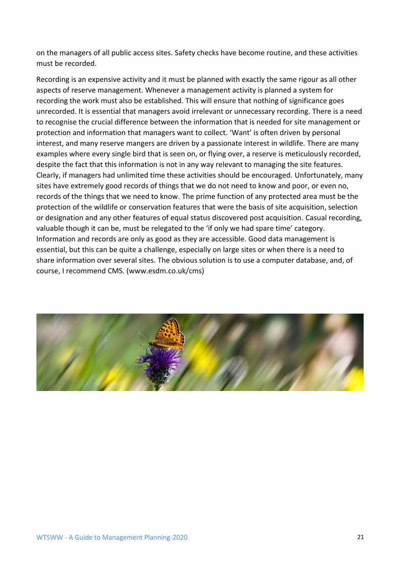
WTSWW - A Guide to Management Planning-2020 21
on the managers of all public access sites. Safety checks have become routine, and these activities
must be recorded.
Recording is an expensive activity and it must be planned with exactly the same rigour as all other
aspects of reserve management. Whenever a management activity is planned a system for
recording the work must also be established. This will ensure that nothing of significance goes
unrecorded. It is essential that managers avoid irrelevant or unnecessary recording. There is a need
to recognise the crucial difference between the information that is needed for site management or
protection and information that managers want to collect. ‘Want’ is often driven by personal
interest, and many reserve mangers are driven by a passionate interest in wildlife. There are many
examples where every single bird that is seen on, or flying over, a reserve is meticulously recorded,
despite the fact that this information is not in any way relevant to managing the site features.
Clearly, if managers had unlimited time these activities should be encouraged. Unfortunately, many
sites have extremely good records of things that we do not need to know and poor, or even no,
records of the things that we need to know. The prime function of any protected area must be the
protection of the wildlife or conservation features that were the basis of site acquisition, selection
or designation and any other features of equal status discovered post acquisition. Casual recording,
valuable though it can be, must be relegated to the ‘if only we had spare time’ category.
Information and records are only as good as they are accessible. Good data management is
essential, but this can be quite a challenge, especially on large sites or when there is a need to
share information over several sites. The obvious solution is to use a computer database, and, of
course, I recommend CMS. (www.esdm.co.uk/cms)
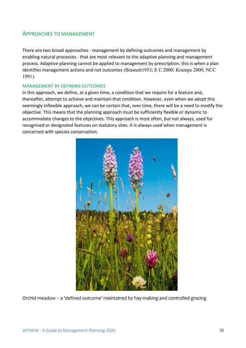
WTSWW - A Guide to Management Planning-2020 22
APPROACHES TO MANAGEMENT
There are two broad approaches - management by defining outcomes and management by
enabling natural processes - that are most relevant to the adaptive planning and management
process. Adaptive planning cannot be applied to management by prescription: this is when a plan
identifies management actions and not outcomes (Brasnett1953; E C 2000; Krumpe 2000; NCC
1991).
MANAGEMENT BY DEFINING OUTCOMES
In this approach, we define, at a given time, a condition that we require for a feature and,
thereafter, attempt to achieve and maintain that condition. However, even when we adopt this
seemingly inflexible approach, we can be certain that, over time, there will be a need to modify the
objective. This means that the planning approach must be sufficiently flexible or dynamic to
accommodate changes to the objectives. This approach is most often, but not always, used for
recognised or designated features on statutory sites. It is always used when management is
concerned with species conservation.
Orchid meadow – a ‘defined outcome’ maintained by hay-making and controlled grazing
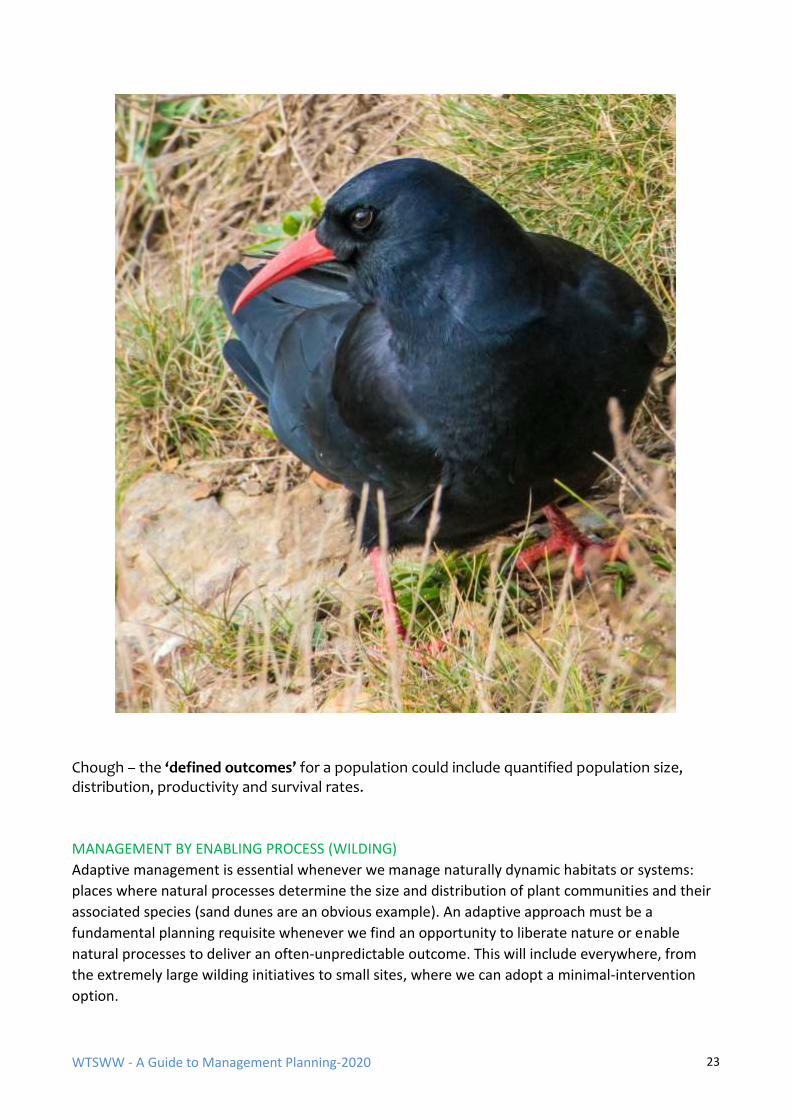
WTSWW - A Guide to Management Planning-2020 23
Chough – the ‘defined outcomes’ for a population could include quantified population size, distribution, productivity and survival rates.
MANAGEMENT BY ENABLING PROCESS (WILDING)
Adaptive management is essential whenever we manage naturally dynamic habitats or systems:
places where natural processes determine the size and distribution of plant communities and their
associated species (sand dunes are an obvious example). An adaptive approach must be a
fundamental planning requisite whenever we find an opportunity to liberate nature or enable
natural processes to deliver an often-unpredictable outcome. This will include everywhere, from
the extremely large wilding initiatives to small sites, where we can adopt a minimal-intervention
option.
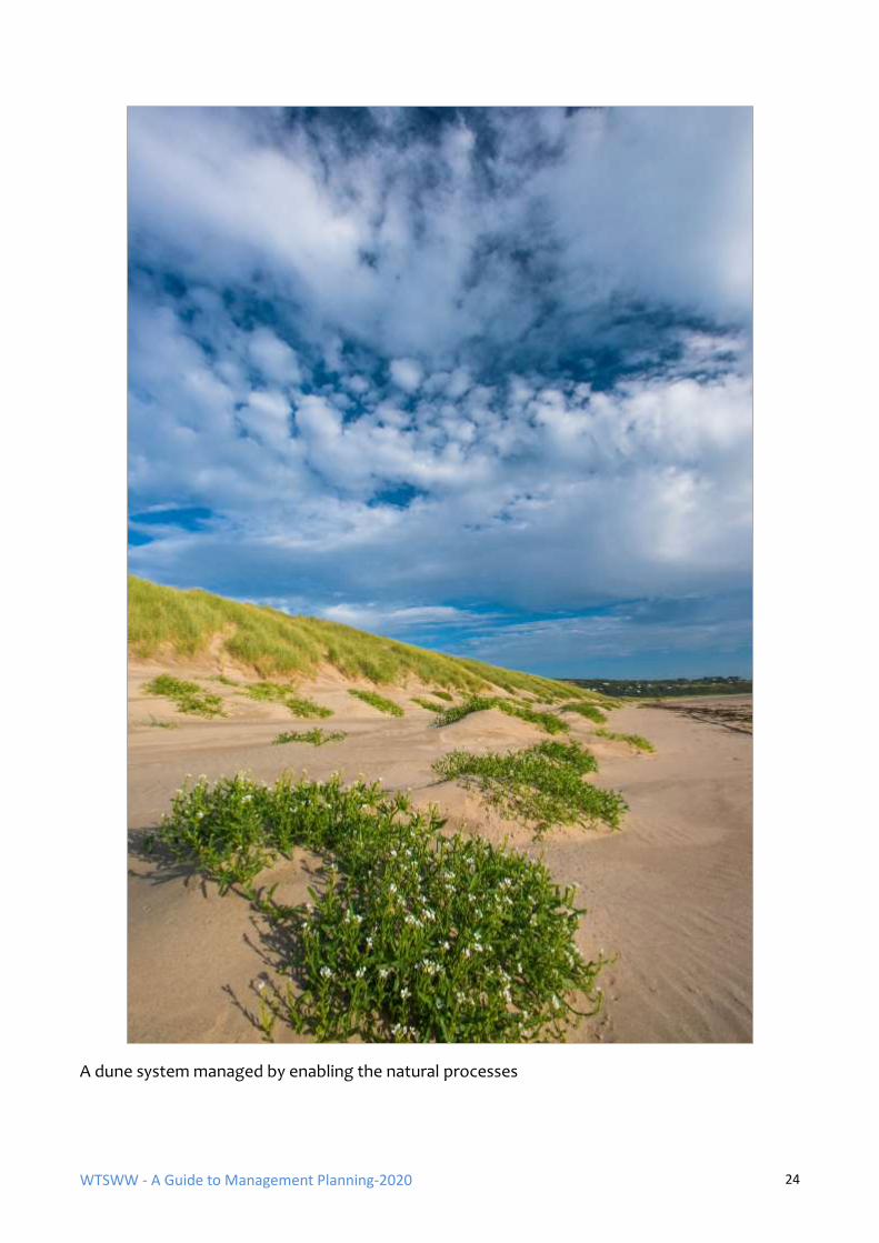
WTSWW - A Guide to Management Planning-2020 24
A dune system managed by enabling the natural processes
WTSWW - A Guide to Management Planning-2020 25
ADAPTIVE MANAGEMENT
Adaptive management is grounded in the admission that humans do not know enough to manage
ecosystems. (Lee 1999)
Adaptive management, although first described in the 1970s, and possibly a derivative of cyclic
incrementalism, was unfortunately not given much attention in Europe. In its original sense,
adaptive management was described as experimentation that enables changes to be linked to
cause and management (Holling 1978; Wood & Warren 1976, 1978; Walters 1986; Lee 1993, 1999;
Marmorek et al. 2006; Walter and Holling 1990).
The version described in this guide is not experimentation. It is not dependent on replicating
management actions or establishing control plots. There can be no doubt that, in an ideal world, we
would use ‘adaptive management’ in the experimental sense. Unfortunately, conservation
managers rarely, if ever, have the resources to do this (Elzinga et al. 2001; Ramsar 2002; Johnson
1999).
People usually talk about writing a management plan when, in fact, they should talk about
planning. Management planning should be regarded as a continuing, iterative process. It is obvious
that management activities will change with time. Planning is the intellectual or decision-making
component of the management process, and planning must also be dynamic to take account of
change.
Far too much emphasis is placed on the idea that it is somehow possible to prepare a definitive site
plan that will last for ever, and an enormous amount of time has been wasted in this pursuit. The
end-product of these attempts is usually an extremely expensive document that is rarely if ever
used. Even where there may have been an initial intention to review the plan at intervals (usually
five years), this is forgotten, and then, sometime in the future, a decision is made to rewrite this
long-obsolete document. This may sound harsh and over-critical, but, unfortunately, it happens all
too often.
It is not unusual for a plan to be out of date within months of production, some even before they
are finished. Sites, habitats and species are dynamic and constantly changing, as is our knowledge
and expertise. It is commonplace, even predictable, for new features to appear or be discovered as
our experience of managing a site increases. The progress of climate change will, without any
doubt, be accompanied by movements and changes in the distribution of species. In the future,
plans will probably have to change or be adapted even more rapidly.
Adaptive management emphasises the need to change or adapt the management section or action
plan. However, most other sections of the plan must also evolve. The description should obviously
be developed to account for new knowledge. This will have consequences for most other areas in
the plan. For example, new factors will appear which will require attention. It is important that we
learn to accept that a plan is never completed and can never be complete. Ideally, a plan should, at
any time, meet all the requirements of site management and be based on the best available
science, knowledge and experience. Where there are gaps in our knowledge there will be gaps in
the plan.
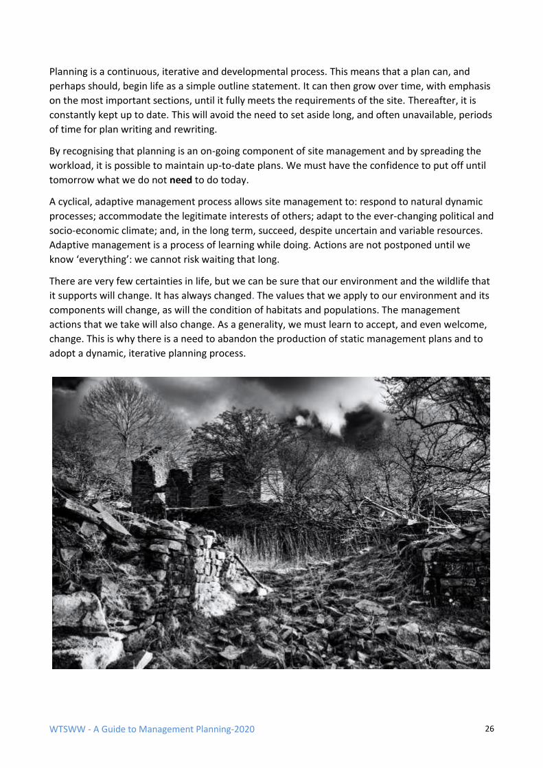
WTSWW - A Guide to Management Planning-2020 26
Planning is a continuous, iterative and developmental process. This means that a plan can, and
perhaps should, begin life as a simple outline statement. It can then grow over time, with emphasis
on the most important sections, until it fully meets the requirements of the site. Thereafter, it is
constantly kept up to date. This will avoid the need to set aside long, and often unavailable, periods
of time for plan writing and rewriting.
By recognising that planning is an on-going component of site management and by spreading the
workload, it is possible to maintain up-to-date plans. We must have the confidence to put off until
tomorrow what we do not need to do today.
A cyclical, adaptive management process allows site management to: respond to natural dynamic
processes; accommodate the legitimate interests of others; adapt to the ever-changing political and
socio-economic climate; and, in the long term, succeed, despite uncertain and variable resources.
Adaptive management is a process of learning while doing. Actions are not postponed until we
know ‘everything’: we cannot risk waiting that long.
There are very few certainties in life, but we can be sure that our environment and the wildlife that
it supports will change. It has always changed. The values that we apply to our environment and its
components will change, as will the condition of habitats and populations. The management
actions that we take will also change. As a generality, we must learn to accept, and even welcome,
change. This is why there is a need to abandon the production of static management plans and to
adopt a dynamic, iterative planning process.
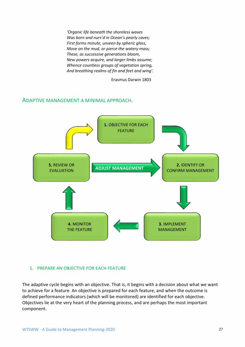
WTSWW - A Guide to Management Planning-2020 27
‘Organic life beneath the shoreless waves Was born and nurs’d in Ocean’s pearly caves; First forms minute, unseen by spheric glass, Move on the mud, or pierce the watery mass; These, as successive generations bloom, New powers acquire, and larger limbs assume; Whence countless groups of vegetation spring, And breathing realms of fin and feet and wing’.
Erasmus Darwin 1803
ADAPTIVE MANAGEMENT A MINIMAL APPROACH.
1. PREPARE AN OBJECTIVE FOR EACH FEATURE
The adaptive cycle begins with an objective. That is, it begins with a decision about what we want to achieve for a feature. An objective is prepared for each feature, and when the outcome is defined performance indicators (which will be monitored) are identified for each objective. Objectives lie at the very heart of the planning process, and are perhaps the most important component.
1. OBJECTIVE FOR EACH
FEATURE
5. REVIEW OR EVALUATION
2. IDENTIFY OR CONFIRM MANAGEMENT
4. MONITOR THE FEATURE
3. IMPLEMENT MANAGEMENT
ADJUST MANAGEMENT
WTSWW - A Guide to Management Planning-2020 28
2. IDENTIFY OR CONFIRM MANAGEMENT – THE RATIONALE
The approach in the rationale will change according to whether it is being applied in the first management cycle or in subsequent cycles: When adaptive management planning is introduced for the first time:
An assessment is made of the condition of the feature. (The condition of the feature is the difference between the state described by the objective and the actual state of the feature at the time that an assessment is made.) If a feature is in the required condition there is reason to assume that past or current management is probably appropriate. Conversely, if a feature is unfavourable there is reason to believe that management is inappropriate. This is followed by considering, in turn, the factors that have changed, are changing, or may have the potential to change, the feature. The management required to keep the factors under control must then be identified. (Conservation management is always about directly or indirectly controlling the influence of factors, or about the remedial management required following the impact of a factor. For sites managed by enabling natural processes the control of anthropogenic factors will often be the most significant component of the process.)
When adaptive management planning is at the end of the first, or any subsequent, cycle:
An assessment of the status of the feature will have been completed in Stage 5 (see below). This means that we should know whether current management is effective or otherwise. If the feature is favourable, and the factors are under control, management is considered to be effective. If the feature is unfavourable, and / or the factors are not under control, management is either ineffective or has not been in place for long enough. If possible, management efficiency should also be considered at this stage.
At stage 2 there is nothing to be gained by reinventing procedures. Managers may draw on a wide range of sources, often external, and make use of the best available information, evidence, expertise and experience to inform the decision-making process. Information generated as part of an internal process on one site will often be the source of external information for other sites. Do not assume that because a management activity worked at some time in some place it will necessarily work elsewhere. It may be reasonably easy to identify an appropriate type of management, but it will usually be much more difficult to quantify the intensity or frequency of that management.
3. IMPLEMENT MANAGEMENT
This is when the action plans are implemented. Management which is believed to be the most appropriate is applied. All management activities are planned in detail and must be carefully recorded. Management is carried out for a period of time. The length of the management period is determined by two main factors:
WTSWW - A Guide to Management Planning-2020 29
The predicted rate of change of the feature (some features can change very rapidly, while for others change is extremely slow).
The more important factor relevant to the minimal approach is our level of confidence in the planned management activities. Confidence levels will be high when adequate expertise and experience are available and low when this is not the case. For example, a fragile habitat, managed for the first time by inexperienced staff, will require close surveillance and monitoring each year. As experience and confidence grow the period can lengthen.
Ideally, a survey or monitoring should be carried out prior to the commencement of management activities (the initial assessment of conservation status) and thereafter at intervals which match the management period, or more frequently. Monitoring, in this context, is a very specific activity: the performance indicators (quantified when the objectives were prepared) are measured. This is one of the most critical aspects of the adaptive process.
4. MONITOR THE FEATURE
The performance indicators, which were identified when the objective for the feature was formulated, are monitored. The indicators will provide evidence about the status of the feature that is sufficient to allow us to evaluate management. When the management approach includes active management to achieve a specified outcome the emphasis will be on monitoring the attributes of the feature, along with the factors with specified limits. For places where the outcomes will be dictated by natural processes, monitoring the feature or its attributes may not always be appropriate. Surveillance can replace monitoring when outcomes are not defined or quantified, but the significant anthropogenic factors should be identified and, whenever possible, limits applied. These can then be monitored.
5. REVIEW
The results of monitoring and surveillance, along with reports of management activities and any other relevant observations (including external information), are considered. The first question should always be: is there any reason to change the objective? Even when management is concerned with obtaining specified outcomes defined by legislation, there will occasionally be a need for revision. Objectives will need to change for many different reasons. For example, we may have got it wrong in the first instance, or the status of a species can change with time. At best, an objective is an expression of something that we believe we want at any specific time: it can only reflect our values, knowledge, experience, science and the evidence available at that time. All of these things will, and must, change. If there is a need to change the objective in any significant way this can, of course, have implications for many of the planning stages. Each will have to be considered in sequence and, if necessary, revised. If the objective does not require revision, move on to consider the status of the feature. (This will have been disclosed by monitoring the performance indicators, and any additional relevant information will also have been considered.) There are two main questions: what is the condition of the feature, and are the factors under control?
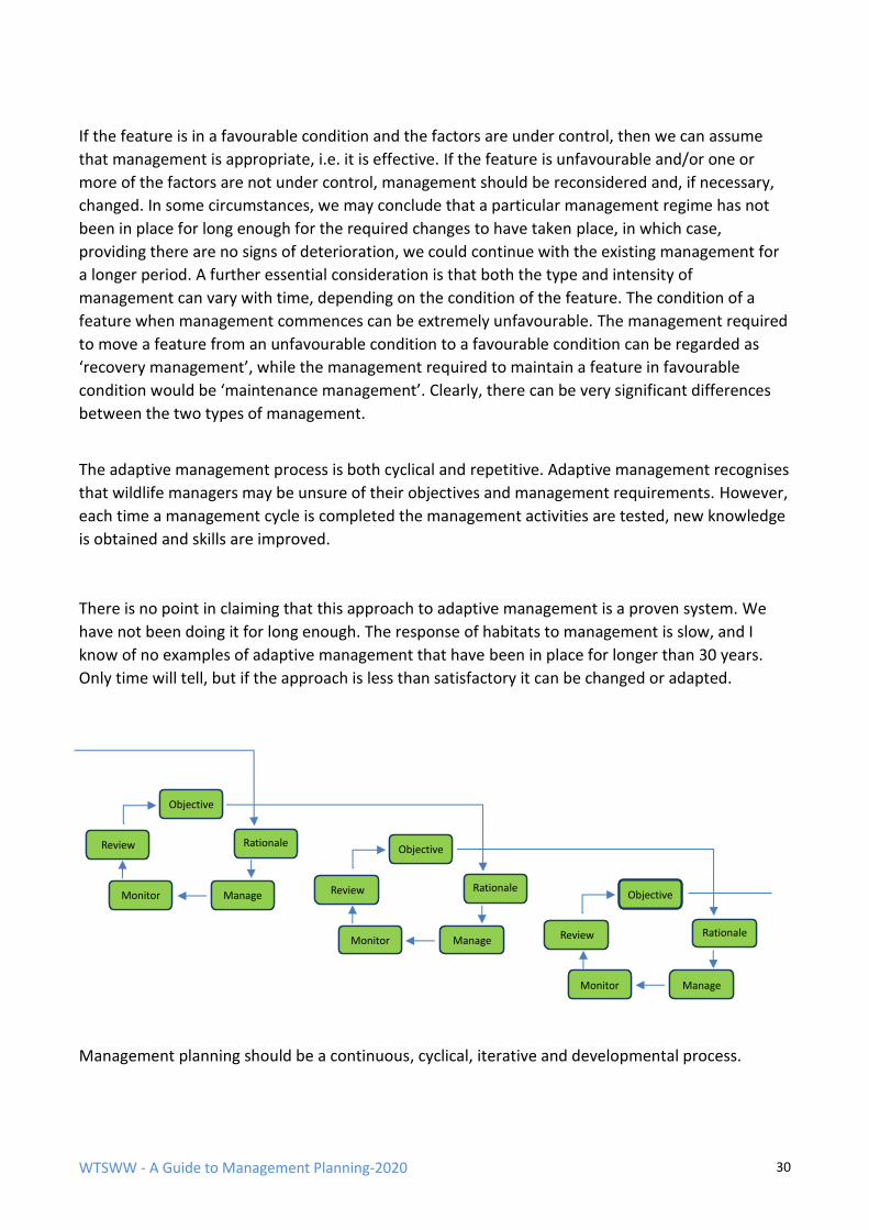
WTSWW - A Guide to Management Planning-2020 30
If the feature is in a favourable condition and the factors are under control, then we can assume
that management is appropriate, i.e. it is effective. If the feature is unfavourable and/or one or
more of the factors are not under control, management should be reconsidered and, if necessary,
changed. In some circumstances, we may conclude that a particular management regime has not
been in place for long enough for the required changes to have taken place, in which case,
providing there are no signs of deterioration, we could continue with the existing management for
a longer period. A further essential consideration is that both the type and intensity of
management can vary with time, depending on the condition of the feature. The condition of a
feature when management commences can be extremely unfavourable. The management required
to move a feature from an unfavourable condition to a favourable condition can be regarded as
‘recovery management’, while the management required to maintain a feature in favourable
condition would be ‘maintenance management’. Clearly, there can be very significant differences
between the two types of management.
The adaptive management process is both cyclical and repetitive. Adaptive management recognises
that wildlife managers may be unsure of their objectives and management requirements. However,
each time a management cycle is completed the management activities are tested, new knowledge
is obtained and skills are improved.
There is no point in claiming that this approach to adaptive management is a proven system. We
have not been doing it for long enough. The response of habitats to management is slow, and I
know of no examples of adaptive management that have been in place for longer than 30 years.
Only time will tell, but if the approach is less than satisfactory it can be changed or adapted.
Management planning should be a continuous, cyclical, iterative and developmental process.
Review
Rationale
Monitor
Manage
Objective
Review
Rationale
Monitor
Manage
Objective
Review
Rationale
Monitor
Manage
Objective
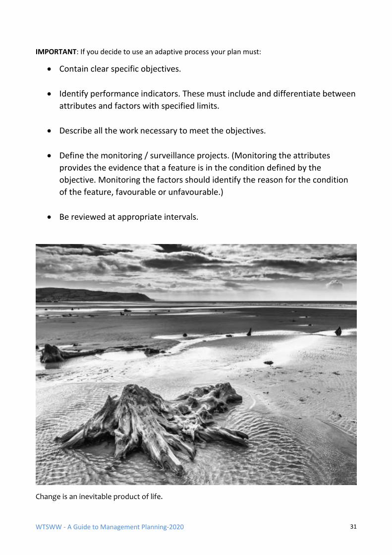
WTSWW - A Guide to Management Planning-2020 31
IMPORTANT: If you decide to use an adaptive process your plan must:
• Contain clear specific objectives.
• Identify performance indicators. These must include and differentiate between
attributes and factors with specified limits.
• Describe all the work necessary to meet the objectives.
• Define the monitoring / surveillance projects. (Monitoring the attributes
provides the evidence that a feature is in the condition defined by the
objective. Monitoring the factors should identify the reason for the condition
of the feature, favourable or unfavourable.)
• Be reviewed at appropriate intervals.
Change is an inevitable product of life.
WTSWW - A Guide to Management Planning-2020 32
PREPARING A PLAN
THE SIZE OF A PLAN - SMALL IS BEAUTIFUL
The size of a management plan and, perhaps more importantly, the resource made available for its
production must be in proportion to the complexity of the site and also to the total resource
available for the safeguard and/or management of the site. Thus, for small, uncomplicated sites,
short, concise plans will suffice. A plan should be as small as possible: as large as the site requires
and no larger.
Even where there may be a long-term intention to prepare a full plan for a site, the process can,
and perhaps should, begin as a brief outline or minimal statement. As further information or
resources become available the plan may grow.
Plans should, whenever possible, be prepared for an entire site. However, for very large and
complicated sites it may be necessary to divide the site into recognisable management units or
zones. These units may be based, for example, on tenure, site status, habitat distribution, tourism,
or public use. Specific plans can be written for each unit but must conform to an overview plan. If
possible, the overview should be written in advance of the unit plans.
WHO SHOULD BE INVOLVED IN THE PREPARATION?
Management planning must be an inclusive process. Everyone who is involved in the management
of the site, or will be in any way affected by management decisions, should at least be consulted
and whenever possible and appropriate included in the decision-making process. The most
important people of all are those responsible for managing the site: the managers must own the
plan. That is, they should agree with, or at least appreciate and accept, the reasons behind all
WTSWW - A Guide to Management Planning-2020 33
decisions. There are many examples where plans have been produced by external consultants, at
great expense, but never implemented. The reason for this failure is nearly always the same: the
site managers were not fully involved in plan production. Managers will rarely accept the
imposition of a plan prepared by others with no experience of managing the site unless they have
been fully involved in the planning process.
The preparation of all but the simplest plans should be undertaken as a team effort. No individual
will possess sufficient expertise in all the areas that require consideration. It is, however, essential
that one person has complete responsibility for the production of the plan. This role should be seen
as editorial, and the most appropriate person for this position is the site manager. The author of
the plan should have a good knowledge of the site and should understand the practical aspects of
management and the interactions between different interests and features.
Unfortunately, it is not always possible for the site managers to set aside sufficient time for
planning, and, consequently, organisations often use consultants to write plans. Although this may
be far from ideal, it is better to have a plan written by a consultant than no plan at all. Good
consultants, who are expert in planning and understand their role, are an invaluable asset. Their
employment can be very cost-effective. Most site managers will write only a few plans in their
entire career, and they may not have the opportunity to develop planning skills. Experienced
consultants will have a thorough understanding of planning, but they should rely on the site staff as
a source of expertise about the site. The site managers must be fully involved and consulted
regularly throughout the process. The CMS Partnership has developed a technique where the
consultants prepare the plan by interrogating the site managers and then obtain their approval for
each section. The plan can then legitimately be taken forward with the site manager as co-author.
While the format of a plan follows a logical structure, the production of a management plan need
not necessarily follow the precise sequential process. Work on one section will often give rise to
something that is relevant to other sections. There are also many good reasons for skipping some
sections and then returning to them once others are complete.
One of the best and most effective approaches to preparing a plan is to place raw information into
each section of the plan. Often, this will mean pasting in unedited information or preparing rough
notes on what information is available. Sufficient information should be included to enable decision
making, but there is no need for concern about language or structure at this stage. In this way, it is
possible to complete a full plan, in outline, very rapidly. The alternative is to become bogged down
in individual sections, and by the time these have been through several drafts or refinements their
significance to the rest of the plan will have been forgotten.
PRESENTATION
The need for a dynamic or adaptable approach to planning is discussed elsewhere. It follows that, if
a process is dynamic and subject to review and change, there can be little purpose in producing
printed documents.
PLAN APPROVAL
All organisations that require management plans should adopt a formal approval process. A plan
begins life as a draft statement written or approved by the site manager. Stakeholders, and
particularly the local community, will have been consulted, and, if appropriate, they will have
WTSWW - A Guide to Management Planning-2020 34
contributed to some of the decisions. At this stage, the plan can be regarded as a detailed
recommendation, with costs, put forward by the reserve manager to the organisation responsible
for managing the site. The plan should then be approved, with or without amendments, and
returned to the reserve manager. It has now become an instruction. By applying a formal approval
procedure, the organisation adopts and accepts responsibility for the plan, including all the
resource implications. This is simply good staff management. The reserve managers are fully
involved and given appropriate levels of control. Through the approval process, organisations
confirm their confidence in their employees and accept full responsibility for their actions. The
employees should respond by working to the requirements of the plan.
THOUGHT BEFORE ACTION
Planning is the intellectual or ‘thinking’ component of the conservation management process. It is
in itself a dynamic, iterative process. It is about recognising the things that are important and
making decisions about what we want to achieve and what we must do. Planning is about sharing
this process with others so that we can reach agreement; it is about communication; it is about
learning. It is the most important of all conservation management activities.
Planning should always come before management. Conservation management is about taking
control in order to obtain and maintain desirable conditions. ‘Control’ does not necessarily mean
doing something: it could mean choosing to do nothing. Taking control can have implications for
the actions and freedoms of others.
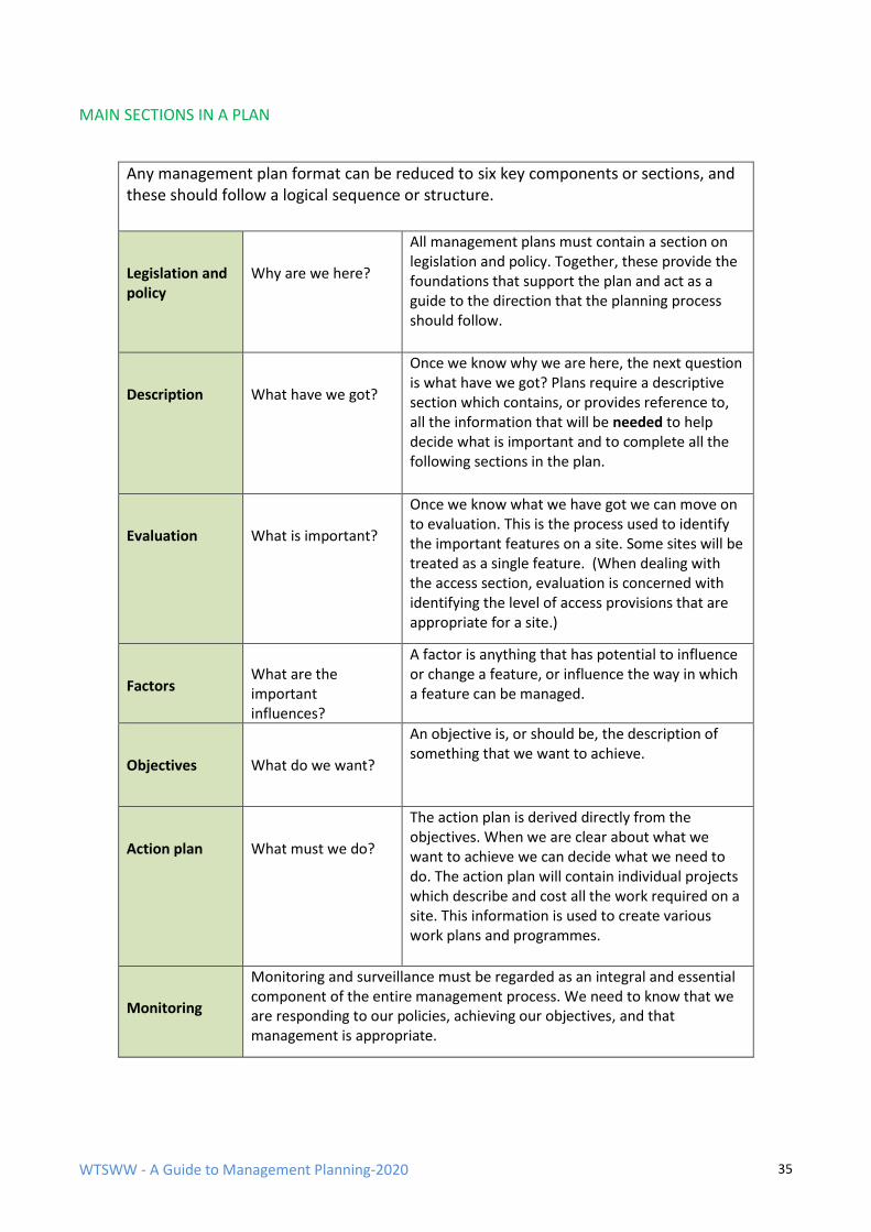
WTSWW - A Guide to Management Planning-2020 35
MAIN SECTIONS IN A PLAN
Any management plan format can be reduced to six key components or sections, and these should follow a logical sequence or structure.
Legislation and policy
Why are we here?
All management plans must contain a section on legislation and policy. Together, these provide the foundations that support the plan and act as a guide to the direction that the planning process should follow.
Description
What have we got?
Once we know why we are here, the next question is what have we got? Plans require a descriptive section which contains, or provides reference to, all the information that will be needed to help decide what is important and to complete all the following sections in the plan.
Evaluation
What is important?
Once we know what we have got we can move on to evaluation. This is the process used to identify the important features on a site. Some sites will be treated as a single feature. (When dealing with the access section, evaluation is concerned with identifying the level of access provisions that are appropriate for a site.)
Factors
What are the important influences?
A factor is anything that has potential to influence or change a feature, or influence the way in which a feature can be managed.
Objectives
What do we want?
An objective is, or should be, the description of something that we want to achieve.
Action plan
What must we do?
The action plan is derived directly from the objectives. When we are clear about what we want to achieve we can decide what we need to do. The action plan will contain individual projects which describe and cost all the work required on a site. This information is used to create various work plans and programmes.
Monitoring
Monitoring and surveillance must be regarded as an integral and essential component of the entire management process. We need to know that we are responding to our policies, achieving our objectives, and that management is appropriate.
WTSWW - A Guide to Management Planning-2020 36
The actual structure of all but the simplest plans will be more complex than that given above. There
is no one size that fits all in management planning. Different organisations, even different site
managers, will often wish to develop their own structure and contents to meet organisational
requirements or specific site conditions. However, there are clear advantages of attempting to
specify a common structure and standard contents within an organisation. This will improve
communication: plans are easier to read and assimilate if the structure of the document is familiar
to the reader. In addition, a uniform approach will help to establish common standards of planning
and to facilitate approval and audit processes. I recommend the plan structure and contents shown
in the following boxes: they have a long and proven track record. The structure has been used on a
wide range of protected areas, including Natura 2000 and Ramsar sites.
A sunset for Eric
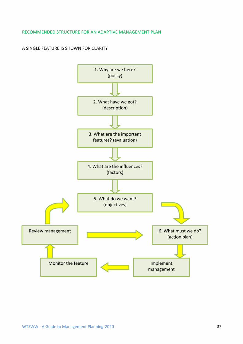
WTSWW - A Guide to Management Planning-2020 37
RECOMMENDED STRUCTURE FOR AN ADAPTIVE MANAGEMENT PLAN
A SINGLE FEATURE IS SHOWN FOR CLARITY
1. Why are we here? (policy)
2. What have we got? (description)
3. What are the important features? (evaluation)
4. What are the influences? (factors)
5. What do we want? (objectives)
Review management 6. What must we do? (action plan)
Monitor the feature Implement management
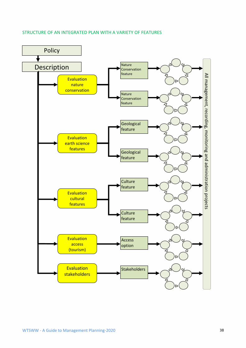
WTSWW - A Guide to Management Planning-2020 38
STRUCTURE OF AN INTEGRATED PLAN WITH A VARIETY OF FEATURES
Policy
Description
Evaluation nature
conservation
Evaluation earth science
features
Evaluation cultural features
Evaluation access
(tourism)
Evaluation stakeholders
Nature Conservation feature
Nature Conservation feature
All m
anagem
ent, reco
rdin
g, mo
nito
ring an
d ad
min
istration
pro
jects
Geological feature
Stakeholders
Access option
Geological feature
Culture feature
Culture feature
WTSWW - A Guide to Management Planning-2020 39
Notes on the structure diagrams:
• The policy and description sections contain information which is relevant to all subsequent
sections of the plan.
• An evaluation process is applied to identify nature conservation, geology and cultural
features.
• The diagram shows two features for each area of interest. In reality, a site can have many
more features. For example, Skomer Island has over 20 bird features.
• The adaptive cycle is described in section 5 above.
RECOMMENDED CONTENTS OF A MANAGEMENT PLAN
The following example is a simplified version of the list of contents of a plan. For clarity, it is
restricted to the nature conservation features and the access section. A complete plan would
contain the full range of the interest areas, including, for example, geological, cultural and
stakeholder interests. The objectives section for nature conservation features will be repeated for
each feature.
Plan Summary
1. Legislation & Policy
2. Description
3. Evaluation - Conservation Features
4. Options and Process
5. Factors
6. Objective
7. Rationale
8. Action plan

WTSWW - A Guide to Management Planning-2020 40
PART THREE – THE MANAGEMENT PLAN
WTSWW - A Guide to Management Planning-2020 41
The layout and numbering used in this section follows as closely as
possible the recommended layout for a management plan
PLAN SUMMARY
The purpose of the summary is to give the reader a rapid and clear overview of the entire site. It
should be based on the sections in the full description. Some plans contain a site vision in place of a
summary. The vision provides a portrait in words, pictures or maps of the site when all the
objectives have been achieved. This is an assemblage of all the individual visions prepared for each
objective. For obvious reasons, it should be one of the last sections to be written in a plan.
1. LEGISLATION & POLICY
All management plans must contain a section on legislation and policy, and this should be
completed before most other stages in the planning process. Together, they provide the
foundations that support the plan and act as a guide to the direction that the process should follow.
1.1 LEGISLATION The management of all sites will be influenced to some extent by legislation. On statutory
conservation sites, management may be governed almost entirely by legislation. In these
circumstances, managers can sometimes find that their freedom is severely limited. Even non-
statutory sites do not escape the implications of legislation: there will be health and safety
legislation, access legislation and a sometimes bewildering range of other national and local laws,
all requiring compliance.
It is essential that this section in any management plan is taken seriously and given adequate
attention. Legislation is, in most circumstances, intended to protect wildlife or people (both
managers and visitors). In general, legislation will have a very positive impact. Indeed, it is usually
the most important mechanism for protecting wildlife. There will also be a wide range of
obligations where, occasionally, compliance can be expensive, sometimes prohibitively so. For
example, in Britain the need to comply with Health and Safety law, particularly regarding the use of
safety equipment and the provision of certificated training, can mean that some management
activities requiring the use of dangerous power tools becomes too expensive. Whatever the
benefits or costs, all operations on a site must be legal: the cost of compliance will be significantly
less expensive than the cost of being prosecuted.
The purpose of this section in a management plan is to identify all the legislation which will directly
or indirectly influence the management of the site.
WTSWW - A Guide to Management Planning-2020 42
The legislation section in a plan can be conveniently divided into two main sub-sections: wildlife
legislation and general legislation.
The section on wildlife legislation should begin with a subsection which describes the statutory
status of a site and its features, along with the obligations that this imposes. This is one of the most
important considerations in any plan. When statutory sites are established to protect specified
features, species and/or habitats then the management plan must place the obligation to protect
these features above all other considerations. Sometimes, when organisations have limited
resources they will concentrate on the statutory features and give little, if any, attention to other
features. (This section should also take account of the various international designations, for
example, Ramsar, Biosphere and World Heritage, which will also influence the management of the
site features.)
General legislation is extremely complex and often difficult to deal with. This is because the
management of protected areas is always subject to a vast array of regional, domestic and local
legislation. This aspect of planning cannot be treated lightly since legislation will influence the
management of all sites. It would be impossible to produce a representative list of typical
legislation because this will vary so enormously from country to country and from site to site. For
example, in Britain planners will be obliged to consider:
Health and Safety at Work Act 1974.
The main principle is that those who create risk as a result of a work activity are responsible for the
protection of workers and members of the public from any consequences. The Act places specific
duties on employers, the self-employed, employees, designers, manufacturers, importers and
suppliers.
The Control of Substances Hazardous to Health Regulations 2002 (as amended) (COSHH)
This requires employers to control exposure to hazardous substances to prevent ill health. They
have to protect both employees and others who may be exposed.
The Equality Act 2010 brought UK legislation, including the Disability Discrimination Act, in line with
the EU Equal Treatment Directive.
This major statutory instrument protects against discrimination on grounds of religion or belief,
sexual orientation and age.
Occupiers’ Liability Acts of 1957 and 1984.
Under occupiers’ liability the person who occupies the land can be held liable when injury or some
kind of harm has occurred to another person on that land. Under the Occupiers’ Liability Act 1957
the occupier of the property means that person who is in control of the land, premises, building,
warehouse, office, etc.
Important: Most, if not all, the legislation which is relevant to management planning and
conservation management is readily available on the internet. However, the law is a difficult area
and often requires some interpretation. If in any doubt take legal advice.
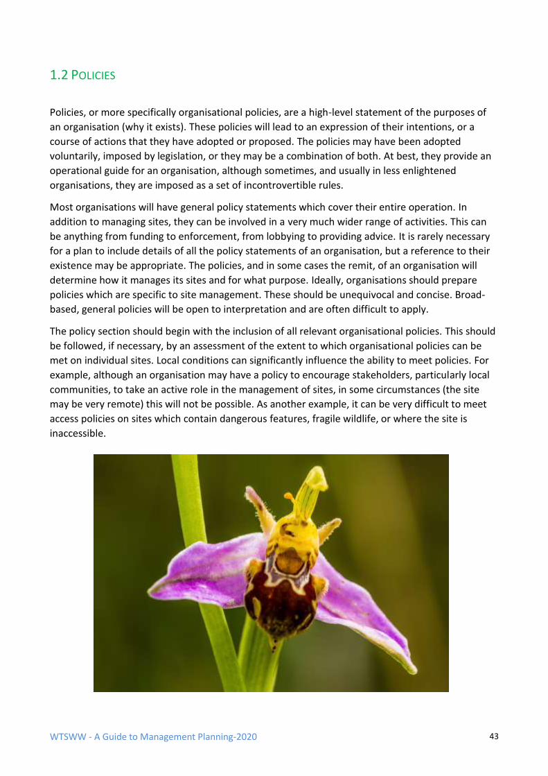
WTSWW - A Guide to Management Planning-2020 43
1.2 POLICIES
Policies, or more specifically organisational policies, are a high-level statement of the purposes of
an organisation (why it exists). These policies will lead to an expression of their intentions, or a
course of actions that they have adopted or proposed. The policies may have been adopted
voluntarily, imposed by legislation, or they may be a combination of both. At best, they provide an
operational guide for an organisation, although sometimes, and usually in less enlightened
organisations, they are imposed as a set of incontrovertible rules.
Most organisations will have general policy statements which cover their entire operation. In
addition to managing sites, they can be involved in a very much wider range of activities. This can
be anything from funding to enforcement, from lobbying to providing advice. It is rarely necessary
for a plan to include details of all the policy statements of an organisation, but a reference to their
existence may be appropriate. The policies, and in some cases the remit, of an organisation will
determine how it manages its sites and for what purpose. Ideally, organisations should prepare
policies which are specific to site management. These should be unequivocal and concise. Broad-
based, general policies will be open to interpretation and are often difficult to apply.
The policy section should begin with the inclusion of all relevant organisational policies. This should
be followed, if necessary, by an assessment of the extent to which organisational policies can be
met on individual sites. Local conditions can significantly influence the ability to meet policies. For
example, although an organisation may have a policy to encourage stakeholders, particularly local
communities, to take an active role in the management of sites, in some circumstances (the site
may be very remote) this will not be possible. As another example, it can be very difficult to meet
access policies on sites which contain dangerous features, fragile wildlife, or where the site is
inaccessible.
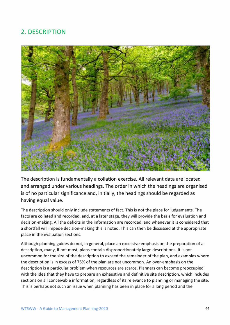
WTSWW - A Guide to Management Planning-2020 44
2. DESCRIPTION
The description is fundamentally a collation exercise. All relevant data are located
and arranged under various headings. The order in which the headings are organised
is of no particular significance and, initially, the headings should be regarded as
having equal value.
The description should only include statements of fact. This is not the place for judgements. The
facts are collated and recorded, and, at a later stage, they will provide the basis for evaluation and
decision-making. All the deficits in the information are recorded, and whenever it is considered that
a shortfall will impede decision-making this is noted. This can then be discussed at the appropriate
place in the evaluation sections.
Although planning guides do not, in general, place an excessive emphasis on the preparation of a
description, many, if not most, plans contain disproportionately large descriptions. It is not
uncommon for the size of the description to exceed the remainder of the plan, and examples where
the description is in excess of 75% of the plan are not uncommon. An over-emphasis on the
description is a particular problem when resources are scarce. Planners can become preoccupied
with the idea that they have to prepare an exhaustive and definitive site description, which includes
sections on all conceivable information, regardless of its relevance to planning or managing the site.
This is perhaps not such an issue when planning has been in place for a long period and the
WTSWW - A Guide to Management Planning-2020 45
description has grown over time. But even here we should not forget that management plans are
about communication; they should be as succinct as possible
It is very unlikely that any individual would be able to complete all the sections without assistance.
The author should consider his/her position as editorial, and should seek help and guidance from
others. For example, there is no point tackling the climate section when a full climatological
description of the site can be bought more cheaply than the raw meteorological data. Often,
specialists will already have prepared accurate, detailed descriptions of site features. Where these
are reasonably concise, there is little point in rewriting them for the plan, but they must obviously
be checked for accuracy and relevance. Where a description is acceptable, it should be
incorporated in the plan and attributed to the original author. If a report is too large to be
incorporated in a plan, a summary should be prepared. In these cases, provide a reference
including the location of the original document. Sites and populations of species are dynamic and
continually changing in response to natural and man-induced trends. The description must
accommodate these changes. The various sections will require review and update as additional
information becomes available. It is generally a good idea to give the name of the author and date
of each update.
The full description outlined below will not be appropriate for many sites. The various subsections
should be completed only if the information has relevance to site management or the planning
process. For example, on a coastal site, where the solid geology is totally obscured by a great depth
of blown sand, there would be little point in producing a detailed geological description. However,
if the section was omitted, readers may wrongly assume that the planner had forgotten to include,
or even consider, geology. A simple statement, ‘geology is not believed to be a significant
consideration in this plan’, would remove any ambiguity.
There is no purpose in using all the subheadings for small or uncomplicated sites, or when
resources for planning are in short supply. The headings can be used as prompts to guide the
process of preparing a simple description. The minimal description should at least contain enough
information for readers to understand the later sections in the plan.
Any system designed to hold information in some sort of logical or structured form is likely to give
rise to one of the two most frequent errors:
• Insufficient categories or headings: The consequence is that far too much data is held under
a single heading and, as a result, locating any particular item can be time-consuming and
tedious.
• Too many categories or headings: The consequence is that little or no information is
contained under each heading. Another problem associated with descriptions that contain a
plethora of headings is that people feel compelled to make an entry under each, regardless
of its relevance to the plan.
Both errors can be avoided by using a structure that grows by dividing and subdividing in relation to
the volume of information. For example, on a small, simple site all the biological information can be
held under one heading. As the quantity of information grows, ‘biological’ can be subdivided into
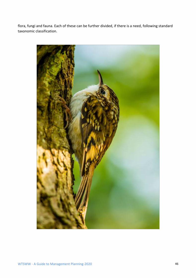
WTSWW - A Guide to Management Planning-2020 46
flora, fungi and fauna. Each of these can be further divided, if there is a need, following standard
taxonomic classification.
WTSWW - A Guide to Management Planning-2020 47
DESCRIPTION – Structure for the contents
Note: This level of detail is rarely, if ever, justified. For most sites the main headings will be sufficient. The description can grow and branch as information becomes available.
3 Description
3.1 General Information
3.1.1 Location & Site Boundaries
3.1.2 Zones (Compartments)
3.1.3 Tenure
3.1.4 Past status of the site
3.1.5 Relationships with any other plans or strategies
3.1.6 Management / organisational infrastructure
3.1.7 Site infrastructure
3.1.8 Map coverage
3.1.9 Photographic coverage
3.2 Environmental information
3.2.1 Physical
3.2.1.1 Climate
3.2.1.2 Geology & Geomorphology
3.2.1.3 Soils/substrates
3.2.1.4 Hydrology /drainage
3.2.2 Biological
3.2.2.1 Flora
3.2.2.1.1 Flora - habitats/communities
3.2.2.1.2 Flora - species
Vascular plants
Bryophytes
Lichens
WTSWW - A Guide to Management Planning-2020 48
3.2.2.2 Fungi
3.2.2.3 Fauna
3.2.2.3.1 Mammals
3.2.2.3.2 Birds
3.2.2.3.3 Reptiles
3.2.2.3.4 Amphibian
3.2.2.3.5 Fish
3.2.2.2.6 Invertebrates
3.2.2.4 Alien invasive / pest species
3.3 Cultural
3.3.1 Archaeology
3.3.2 Past land use
3.3.3 Present land use
3.3.4 Past management for nature conservation
3.4 People – stakeholders, access, etc.
3.4.1 Stakeholders
3.4.2 Access
3.4.3 Interpretation provisions
3.4.4 Educational use
3.5 Research use and facilities
3.6 Landscape
3.7 Bibliography
WTSWW - A Guide to Management Planning-2020 49
2.1 GENERAL INFORMATION
2.1.1 LOCATION & SITE BOUNDARIES
This section should provide the information that will enable the site to be easily located. A map
showing the location of the site is often sufficient. Any additional information that may help people
locate or gain access to the site is also provided. This could include, for example, the main routes to
the site and the name of the nearest town or village.
The national grid reference or latitude and longitude can be given, but this must be accompanied
by an indication of what the reference relates to, for example, the centre of the site, a car park or
gateway.
The location of the site boundaries is obviously essential information. The only sensible way to
present this information is on a map. The map can be annotated or supplemented with information
on how the boundaries can be located on the ground, for example, how they are marked. All
obligations or responsibilities for maintaining the boundaries should be included.
2.1.2 ZONES
Important: Deciding on the best time to tackle the issue of zoning in a plan is not easy. The
establishment of meaningful zones requires an analysis based on information derived from the
management objectives and their associated rationales. However, objectives cannot, and must not,
be completed until much later in the planning process. This leaves the planner with two
alternatives: either prepare a provisional zonation, which may need to be amended at a later stage,
or wait until the objectives and rationale have been completed before attempting anything.
Whichever option is adopted, the zone map should be placed at this early stage in the final plan, as
one of the key functions of the zonation map is to help describe the site and particularly the
management activities. Zones should be developed as the plan progresses and regarded as
provisional until the plan is complete.
Sites may be divided into zones to meet a wide variety of purposes, for example, to describe
management actions or to guide or control a number of activities. It is often very difficult to
describe, or even consider, the management of large or complicated sites unless they are divided
into a series of zones.
WTSWW - A Guide to Management Planning-2020 50
If zones are established, the following guidelines apply:
• The basis or justification for their selection should be outlined.
• A concise description of the function, including any restrictions that apply within each zone,
should be included.
• They should be clearly shown on a map.
• Maps must be made available to all interested parties.
• The boundaries of zones must be easily recognised and located on the ground. Physical
features such as rivers, walls or roads can be used as boundaries, but some of these may
move over time. On large, homogenous sites, where there are no obvious landscape
features, it may be necessary to install some form of permanent marker or use GPS.
• Zones should not generally be defined by the location and boundaries of habitats or
communities, particularly when the vegetation is dynamic and changing.
• Zones should be identified with a unique and, if possible, meaningful code. In some cases, a
simple numerical code will be adequate.
It is important that zonation systems are regarded as flexible management tools that can be
introduced, removed or modified according to need. They can be used for a very wide range of
different purposes.
2.1.3 TENURE
This section must be completed in all plans.
It is essential that the individuals preparing the plan have a full understanding of the land tenure
and legal status of the site. Tenure documents are usually over-complex and written in a style that
makes them difficult to understand. The role of the planner is to translate the document into
everyday language, but it is important that the translated documents are not used for legal
purposes. The first sentences in all cases should be: ‘This is not a legal document. Please refer to
the original tenure documents before taking any decision or any action which may have legal
implications.’ The location of all legal documents should be noted.
Where tenure is complicated by the presence of more than one owner/occupier, land holding or
status, each separate area should be individually described. A map showing the different areas of
tenure, rights of way, etc. should be included.
This subsection should include, for each tenure area, all the information that is relevant to planning
and managing a site. The following headings may be used. This is not a complete list, but it
represents the minimum requirement.
• Type of holding (for example, owned, leased or agreement)
• The names and contact details of owners and occupiers
WTSWW - A Guide to Management Planning-2020 51
• Date of acquisition or agreement
• Length of lease/agreement
• The area of each individual lease, holding, etc.
• Conditions and reservations: describe all the conditions imposed in respect of ownership,
lease, tenancy, agreement, etc.
• Legal rights of access
• Legal rights held by others (e.g. collection of shellfish, peat cutting or hunting)
• Obligations and legal responsibilities arising from tenure
For sites, or the parts of a site, that are owned by the organisation responsible for management,
some background information which describes the reason for, and process of, acquisition should be
included. For example, some sites are purchased because they have been identified in a formal
acquisition strategy, others simply because an opportunity arose and, occasionally, a site is
acquired through legal compulsory purchase.
The location of title deeds should be confirmed and recorded. It may, in some cases, be necessary
to include copies of deeds in an annex, but, in practice, these are rarely consulted.
All service routes entering, crossing or lying immediately adjacent to a site should be described.
Examples include roads, water pipes, gas pipes, electricity pylons and cables, drainage ditches and
canals. All arrangements for maintenance, the rights of access and the normal frequency of activity
should be noted.
2.1.4 PAST STATUS OF THE SITE
This section provides a brief historic review of the interest shown in the site. Although this will
usually refer to the attentions of scientists, it could also include naturalists, artists, writers and
others. This should be followed by details of any past legal conservation status. This information is
effectively an assessment or evaluation of the site made at an earlier time by others. It will often
indicate the prime reasons for site acquisition, and can prepare the way for the discussion in the
evaluation section of the plan.
2.1.5 RELATIONSHIPS WITH ANY OTHER PLANS OR STRATEGIES
The management of a site will often be influenced, or even regulated, as a consequence of other
plans. Situations also arise where a site contains features where the responsibility for management
and planning is held by a different organisation, for example, archaeological, historic and geological
features. It is important that all legitimate plans are recognised in the site plan.
2.1.6 MANAGEMENT / ORGANISATIONAL INFRASTRUCTURE
This section should contain a brief outline of the organisational structure and the staff deployed in
managing the site. This can include details of staff responsibilities. This statement should be in
respect of present staffing levels. Later sections in the plan may identify a need to revise the
staffing structure on a site.
WTSWW - A Guide to Management Planning-2020 52
2.1.7 SITE INFRASTRUCTURE
A description of all significant buildings and any other structures should be included, along with any
relevant information, for example, their purpose, suitability, condition, etc. Examples will include
visitor centres, hides, workshops and toilets. Maps showing locations will enhance this section.
2.1.8 MAP COVERAGE
Record any relevant contemporary maps and any useful historic maps. Include maps showing
topography, geology, soil, land use, vegetation, etc. Give the date, scale and location of the maps.
There is little or no purpose in attempting to locate every map ever produced which covers the site.
Many historical maps are very inaccurate and have little more than curiosity value. The degree to
which the site is believed to have changed or developed in recent times should influence the
amount of effort put into locating historical maps. For example, on dynamic coastal sites early
maps, particularly admiralty charts, can provide useful information about past conditions and
trends.
3.1.9 PHOTOGRAPHIC COVERAGE
The record of photographic coverage can contain sections on aerial and ground photographs.
Historical photographs can be a useful source of information on past land use and management.
Where individual photographs are of special interest they should be listed and described. Any
reference to an individual photograph should give a location and include comments on the contents
and quality. It is often sufficient to make general comments on the availability, or otherwise, of
photographs.
WTSWW - A Guide to Management Planning-2020 53
2.2 PHYSICAL ENVIRONMENT When planning the management of small, uncomplicated sites this subheading, without any
subdivisions, may be adequate. As the size or complexity of a site increases, further tiers of
subdivisions may be introduced:
2.2.1 CLIMATE
Climate is an extremely important factor. However, a simple outline or summary will be adequate
for most sites. Even when detailed records are available, there is usually no point in including them
in the plan. A brief description of the data, along with its location, will be sufficient.
Recent changes should be mentioned, and if any trends have become apparent these should be
included.
Microclimate can be important on some sites. For example, when managing mosses and liverworts
in deep woodland gorges humidity is one of the most important factors. High humidity levels are
maintained, in part, because air movement is suppressed by the trees.
2.2.2 GEOLOGY AND GEOMORPHOLOGY
A simple, general description will be sufficient in most cases. There are occasional exceptions where
there is justification for detailed accounts. These are:
• When the site contains important geological or geomorphological features which require
protection and / or management.
• When active geomorphological processes are a feature or when other important site
features are dependent on these processes, for example, river shingle banks and active sand
dune systems.
2.2.3 SOILS/SUBSTRATES
Describe the major soils or substrate types using a map whenever possible. Note anything that may
be relevant to site condition or management.
2.2.4 HYDROLOGY / DRAINAGE
The relevance of hydrology and drainage to the management of the site features will once again
determine the level of attention given to this subject. Obviously, when planning the management
of rivers, catchments, bogs, fens and, in fact, any wetland habitat, hydrology will be a significant
factor. It will also be important in less obvious circumstances. For example, the survival of humid
slack communities in a sand dune system is entirely dependent on the height of the water table.
Any significant human intervention, past and present, should be described, for example, past land
management, including drainage, peat cutting and river canalisation, and current off-site land use,
including drainage or water extraction within the catchment area.
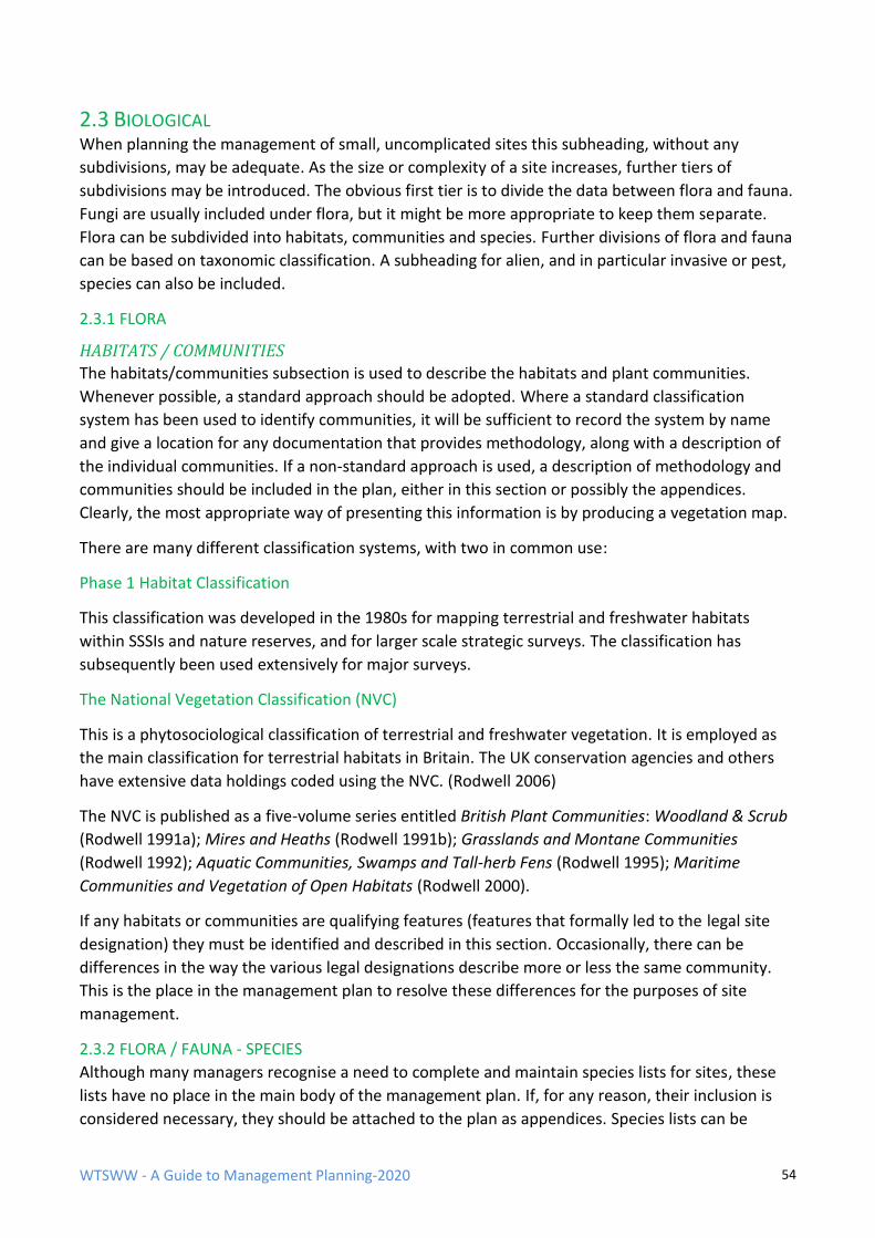
WTSWW - A Guide to Management Planning-2020 54
2.3 BIOLOGICAL When planning the management of small, uncomplicated sites this subheading, without any
subdivisions, may be adequate. As the size or complexity of a site increases, further tiers of
subdivisions may be introduced. The obvious first tier is to divide the data between flora and fauna.
Fungi are usually included under flora, but it might be more appropriate to keep them separate.
Flora can be subdivided into habitats, communities and species. Further divisions of flora and fauna
can be based on taxonomic classification. A subheading for alien, and in particular invasive or pest,
species can also be included.
2.3.1 FLORA
HABITATS / COMMUNITIES
The habitats/communities subsection is used to describe the habitats and plant communities.
Whenever possible, a standard approach should be adopted. Where a standard classification
system has been used to identify communities, it will be sufficient to record the system by name
and give a location for any documentation that provides methodology, along with a description of
the individual communities. If a non-standard approach is used, a description of methodology and
communities should be included in the plan, either in this section or possibly the appendices.
Clearly, the most appropriate way of presenting this information is by producing a vegetation map.
There are many different classification systems, with two in common use:
Phase 1 Habitat Classification
This classification was developed in the 1980s for mapping terrestrial and freshwater habitats
within SSSIs and nature reserves, and for larger scale strategic surveys. The classification has
subsequently been used extensively for major surveys.
The National Vegetation Classification (NVC)
This is a phytosociological classification of terrestrial and freshwater vegetation. It is employed as
the main classification for terrestrial habitats in Britain. The UK conservation agencies and others
have extensive data holdings coded using the NVC. (Rodwell 2006)
The NVC is published as a five-volume series entitled British Plant Communities: Woodland & Scrub
(Rodwell 1991a); Mires and Heaths (Rodwell 1991b); Grasslands and Montane Communities
(Rodwell 1992); Aquatic Communities, Swamps and Tall-herb Fens (Rodwell 1995); Maritime
Communities and Vegetation of Open Habitats (Rodwell 2000).
If any habitats or communities are qualifying features (features that formally led to the legal site
designation) they must be identified and described in this section. Occasionally, there can be
differences in the way the various legal designations describe more or less the same community.
This is the place in the management plan to resolve these differences for the purposes of site
management.
2.3.2 FLORA / FAUNA - SPECIES
Although many managers recognise a need to complete and maintain species lists for sites, these
lists have no place in the main body of the management plan. If, for any reason, their inclusion is
considered necessary, they should be attached to the plan as appendices. Species lists can be
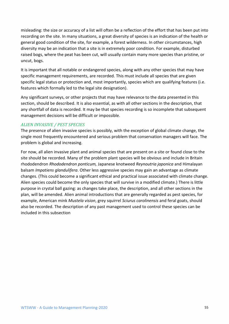
WTSWW - A Guide to Management Planning-2020 55
misleading: the size or accuracy of a list will often be a reflection of the effort that has been put into
recording on the site. In many situations, a great diversity of species is an indication of the health or
general good condition of the site, for example, a forest wilderness. In other circumstances, high
diversity may be an indication that a site is in extremely poor condition. For example, disturbed
raised bogs, where the peat has been cut, will usually contain many more species than pristine, or
uncut, bogs.
It is important that all notable or endangered species, along with any other species that may have
specific management requirements, are recorded. This must include all species that are given
specific legal status or protection and, most importantly, species which are qualifying features (i.e.
features which formally led to the legal site designation).
Any significant surveys, or other projects that may have relevance to the data presented in this
section, should be described. It is also essential, as with all other sections in the description, that
any shortfall of data is recorded. It may be that species recording is so incomplete that subsequent
management decisions will be difficult or impossible.
ALIEN INVASIVE / PEST SPECIES
The presence of alien invasive species is possibly, with the exception of global climate change, the
single most frequently encountered and serious problem that conservation managers will face. The
problem is global and increasing.
For now, all alien invasive plant and animal species that are present on a site or found close to the
site should be recorded. Many of the problem plant species will be obvious and include in Britain
rhododendron Rhododendron ponticum, Japanese knotweed Reynoutria japonica and Himalayan
balsam Impatiens glandulifera. Other less aggressive species may gain an advantage as climate
changes. (This could become a significant ethical and practical issue associated with climate change.
Alien species could become the only species that will survive in a modified climate.) There is little
purpose in crystal ball gazing: as changes take place, the description, and all other sections in the
plan, will be amended. Alien animal introductions that are generally regarded as pest species, for
example, American mink Mustela vision, grey squirrel Sciurus carolinensis and feral goats, should
also be recorded. The description of any past management used to control these species can be
included in this subsection
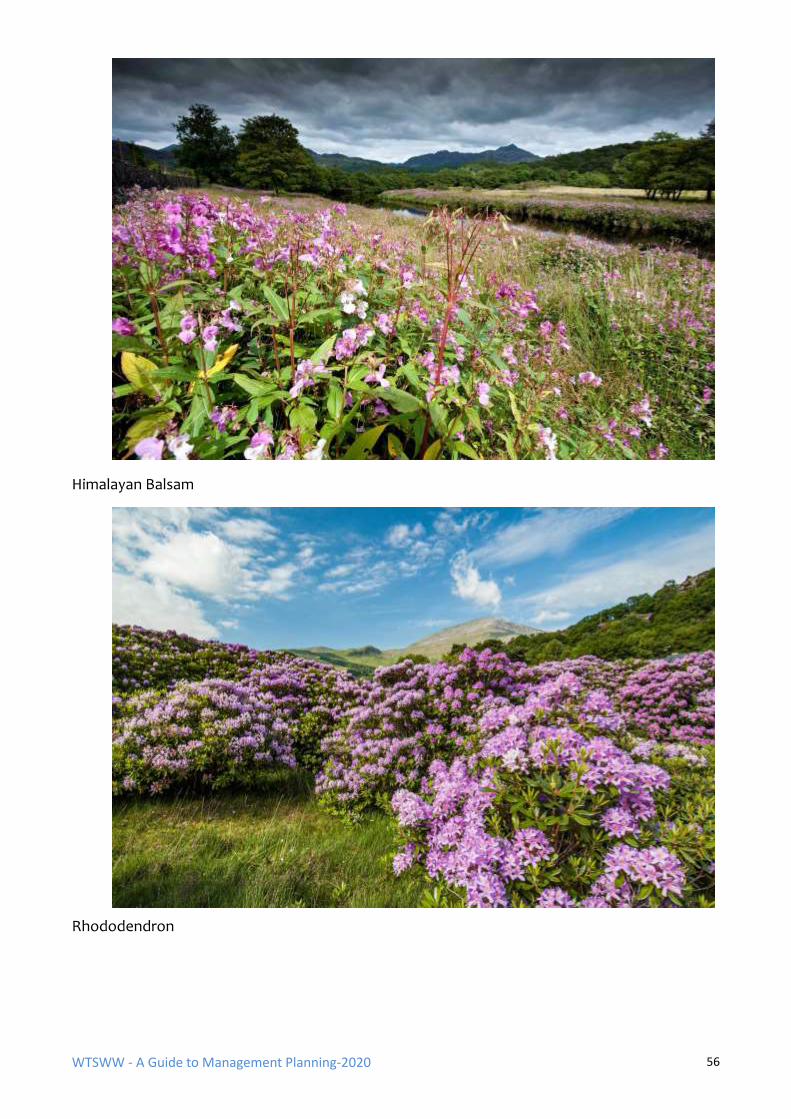
WTSWW - A Guide to Management Planning-2020 56
Himalayan Balsam
Rhododendron
WTSWW - A Guide to Management Planning-2020 57
2.4 CULTURAL
This section deals with the impact of man and with human values.
2.4.1 ARCHAEOLOGY
The presence of any archaeological or historical remains on the site should be recorded, along with
any implications for management. Ancient monuments are often legally protected, and the site
manager may be responsible for ensuring their safeguard. Even when there is no need to provide
active-management, it is essential that other management operations do not in any way threaten
these remains. It is important, therefore, that all recorded remains, particularly all legally protected
monuments, are noted, and shown on a map whenever possible. Where nothing is known, this may
indicate the need for future surveys.
Archaeological remains, along with a recorded history of past land use, can provide valuable
guidance for future management. This is particularly important when dealing with semi-natural or
artificial habitats.
An Iron Age hut circle
WTSWW - A Guide to Management Planning-2020 58
3.4.2 PAST LAND USE
An appreciation of past land use will often provide the planner with an essential guide to
understanding the current condition of the features on a site. This is particularly important when
dealing with damaged or semi-natural features. Although of academic interest, there is generally
little purpose in looking too far into the past. Consider the period that is most likely to have
affected the present condition.
3.4.3 PRESENT LAND USE
Record present land use, but exclude management for nature conservation. Record all aspects of
land use, e.g. forestry, agriculture, water extraction, etc. Note the impact that any of these
activities are known to have on the site.
3.4.4 PAST MANAGEMENT FOR NATURE CONSERVATION
This should be the easiest section to complete for all managed sites. In reality, records have usually
not been adequately maintained and, consequently, this essential section is often difficult, or
impossible, to write. When records have been kept, the best way to present the information is to
follow the structure used in the plan. The projects should be grouped in relation to the objective
that they serve.
2.5 PEOPLE – STAKEHOLDERS, ACCESS, ETC.
This section is used to describe all aspects of current (at the time of plan preparation) public use
and interest in the site. ‘Public’ is taken to mean anyone with an interest in the site, and will include
local people, tourists and special interest groups.
2.5.1 STAKEHOLDERS / STAKEHOLDER ANALYSIS
A stakeholder is any individual, group, or community living within the influence of the
site or likely to be affected by a management decision or action, and any individual,
group or community likely to influence the management of the site.
Stakeholder and community interests can have considerable implications, both positive and
negative, for site management, and they can impose significant obligations on the site manager.
Public interest, at all levels, must be taken into account (Borrini-Feyerabed et al. 2004; Caldwell &
Evison 2005).
Conservation managers must recognise that other people may have many different, and sometimes
opposing, interests in the site. It is essential that these interests are safeguarded wherever
possible. There may be a justifiable need for compromise, providing, of course, that the prime
objectives of management are not jeopardised. Maintaining communication and, whenever
necessary, consultation with stakeholders is essential, at the very least to keep them informed of
any developments that may affect them. In order to safeguard wildlife successfully, conservation
managers need to adopt a flexible approach that will allow them to respond to the legitimate
WTSWW - A Guide to Management Planning-2020 59
interests of others, to adapt to the ever-changing political climate, to accommodate uncertain and
variable resources, and to survive the vagaries of the natural world (Margoluis & Salafsky 1998;
Alexander 2000b).
A stakeholder analysis is simply a systematic approach to identifying all relevant stakeholders. The
information can be used to prepare an action plan which will define the circumstances when the
stakeholders will be consulted and how they should be involved. All stakeholders or groups of
stakeholders will require attention at some time, but usually not all at the same time or for the
same purpose.
All the stakeholders should be identified. One way of doing this is to consider the reasons for
wanting or needing to engage with stakeholders, and also why they would want or need to be
contacted. Stakeholders can be divided into three main groups, each with different interests:
Primary stakeholders
• Stakeholders whose permission, approval or (financial) support is required. (This will
include statutory consultees.)
• Stakeholders directly affected by site management.
• Stakeholders who will benefit.
• Stakeholders who will suffer loss or damage.
Secondary stakeholders
• Stakeholders who are indirectly affected.
Tertiary stakeholders
• Stakeholders who are not directly involved, but can influence opinion.
Once the stakeholders have been identified, the following information should be recorded:
• The most appropriate means of communicating with each individual or group.
• The sort of engagement they require, if any.
• Their contact details (or, when dealing with a group, details of a representative).
• How they want to be contacted, for example, mail or email.
• Their interests or the issues they want to be involved in.
• Their relationship with the protected area. (This will include an extremely diverse
range of interests, for example, dog walking, bird watching, fishing, grazing or other
agricultural rights.)
WTSWW - A Guide to Management Planning-2020 60
The relationships that organisations choose to have with stakeholders are entirely a consequence
of their policies. It is possible to write a simple objective for relationships with stakeholders.
Once a stakeholder analysis is complete, for most sites it can lead to the inclusion of a project in the
action plan which identifies all the activities necessary to maintain good relationships with the
stakeholders. Very occasionally, the interests of stakeholders can be so important that there is
justification for including a stakeholder section in the management plan, which identifies an
objective with performance indicators and an action plan.
3.5.2 ACCESS
For very small sites where access is not a significant issue, a simple statement (a paragraph or two)
under a broad heading may suffice. The following list of headings can be used for larger sites and
particularly for sites where the provision of access is important. The headings are neither exclusive
nor exhaustive; additional headings should be added when necessary. Maps can be used where
these will help to convey the information. This could include maps to show the area surrounding
the site, provision by others in the area, where visitors come from, etc.
• Visitor numbers
• Visitor characteristics
• Visit characteristics
• Access to the site
• Access within the site
• Visitor facilities and infrastructure
• The reasons why people visit the site
• Recreational activities
• The site in a wider context
3.5.3 INTERPRETATION PROVISIONS
For sites where interpretation is an important consideration this subsection should be included. The
current interpretation provisions should be described. This includes information on the current
beneficiaries or recipients, and the general purpose, or focus, of present interpretation. For
example, are facilities intended for the interpretation of the site alone or for nature conservation in
general? In some cases, it may also be appropriate to include accounts of earlier attempts at
interpretation, whether successful or otherwise. Often, site managers will have experimented with
various approaches to interpretation, and it may be possible to learn from their successes and
failures.
3.5.4 EDUCATIONAL USE
For sites where educational use is an important consideration this subheading should be included.
The current educational use of the site is described, including who uses it and for what purpose.
When available, information on the number of individuals or organisations that use the site should
be included. All current facilities are described. These will include, for example, the provision of
guided educational visits, leaflets, education packs, education centres and the employment of
dedicated staff.
WTSWW - A Guide to Management Planning-2020 61
2.6 RESEARCH USE AND FACILITIES
An outline of any significant research that has been, or is being, carried out on the site should be
provided. This should include any approved research projects that will be carried out in the future.
Describe any research facilities that may be available, for example, some sites are equipped with a
field laboratory. Include a note on the suitability of the site for research. For example, a site which
is open to public use may not be suitable for certain types of research projects.
2.7 LANDSCAPE
Other sections in the plan will describe most of the components that make up the landscape. Later,
and if appropriate, landscape will be considered in some detail during the evaluation process. The
purpose of this section is to provide an objective description of features that form the landscape. In
practice, this will often be a summary of visible features discussed under the previous headings.
Include topography or landform, land cover and man-made elements. This section is descriptive
and there should be no attempt to evaluate the landscape: that comes later.
2.8 BIBLIOGRAPHY
The bibliography should be the most important section in the description. It will contain a reference
to all papers, reports, journals, books, etc. used during the preparation of the plan.
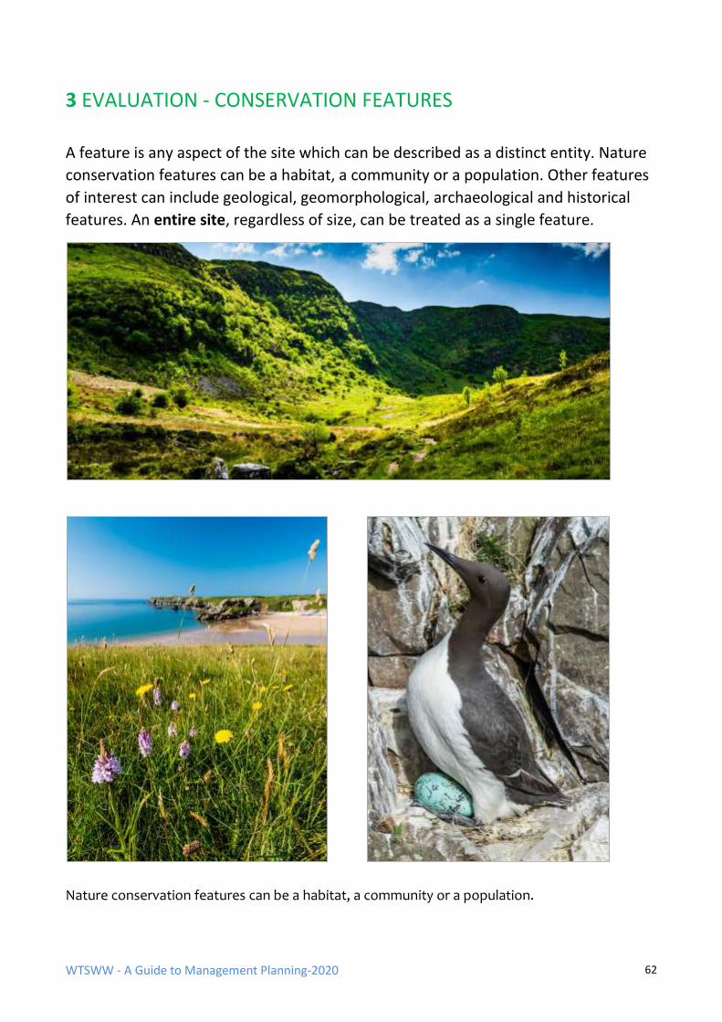
WTSWW - A Guide to Management Planning-2020 62
3 EVALUATION - CONSERVATION FEATURES
A feature is any aspect of the site which can be described as a distinct entity. Nature
conservation features can be a habitat, a community or a population. Other features
of interest can include geological, geomorphological, archaeological and historical
features. An entire site, regardless of size, can be treated as a single feature.
Nature conservation features can be a habitat, a community or a population.
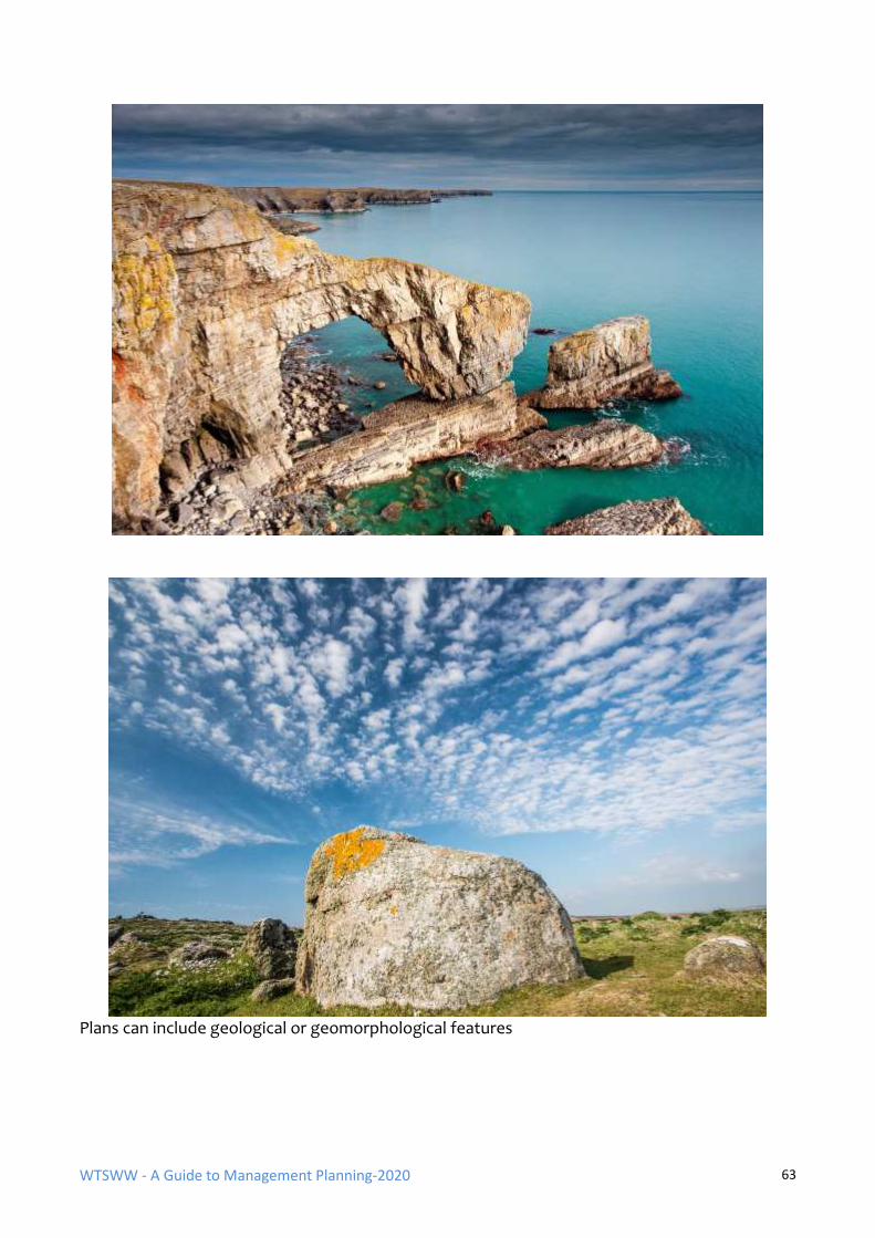
WTSWW - A Guide to Management Planning-2020 63
Plans can include geological or geomorphological features
WTSWW - A Guide to Management Planning-2020 64
The first step is to consider if there is a need to identify multiple features on a site. Some sites will
only contain a single feature. In other circumstances - dynamic sand dunes are a good example - the
size and distribution of individual communities within a habitat will be dictated by natural
processes, and, consequently, there is no purpose in treating each community as an individual
feature.
For many sites, the presence of conservation features will have been the basis of site acquisition,
selection or designation. This means that at some time in the past the site will have been evaluated
and the most important features identified. When preparing, or substantially revising, a
management plan, the list of features should be reconsidered to ensure that they are still relevant.
There may also be additions.
The selection of features is not difficult. Once any site manager understands what is meant by
features, they will immediately be able to provide a list for their site. It is not possible to manage a
site, with or without a formal plan, without having a clear idea of what is important. There are a
few exceptions to this. These are most likely to involve restoration areas with no current wildlife
interest, but where there is an intention is to create something.
The first step is to prepare a provisional list of the features that are considered, for whatever
reason, to be important. Ideally, all the features on a site should be considered. However, in
practice, it may be necessary to concentrate on a shortlist of the most important features. These
should be obvious from the site description and any previous evaluations. It is probably wiser to
include rather than omit features, though this will obviously incur the penalty of having to assess
them. Do not forget that it is not uncommon on smaller sites for a single habitat feature to occupy
the entire site and, if there are no particularly important species, for this to be the only feature.
A controversial, and sometimes troublesome, issue arises when dealing with vegetation as a
feature. This involves the level of definition that we apply to the feature. There may be choices as
to whether the feature is defined at sub-community, community or habitat level. For statutory
sites, legislation can define communities at each of these levels, so there is sometimes no choice
but to follow the dictates of law. On sites where the features have no statutory status, it is
generally best to define the feature at the level most appropriate for management. For example, a
woodland habitat can contain a patchwork of different woodland communities, each being the
consequence of different natural factors. There are no fences or other barriers separating the
communities, and each individual community could be recognised as a feature. However, because
management cannot be specifically directed at any given community and the woodland can only be
managed as a whole, the most sensible approach is to define the feature at habitat level.
When preparing the shortlist for further evaluation, begin by including all statutory features.
Beyond this, there are no hard and fast guidelines. Ideally, perhaps all habitats or plant
communities should be included, but some sites can hold very small and insignificant areas of
vegetation that simply do not justify any attention.
Making decisions about species that have no formal protection, and where there is no requirement
to report on population changes, can sometimes be a problem. Which species should be included
as features and which omitted? The best way of dealing with this is to ask a simple question: will all
the management requirements of this species be met through managing the habitats on the site?
WTSWW - A Guide to Management Planning-2020 65
Species management is, in most cases, achieved through maintaining habitats at favourable status.
If there are no specific management requirements other than those that are already included in the
management of the habitats then the species need not be included as a feature.
When species are recognised as features on a site the habitats that support them should also be
treated as features, regardless of the independent status of the habitat. Once again, this is because,
in most instances, species protection is about ensuring that there is sufficient habitat in a condition
that meets the needs of the species. In some instances, a habitat that is not considered important
can support a number of very important species.
Feature assessment or evaluation is simply the means of identifying, or confirming, which of the
short-listed features should become the focus for the remainder of the planning process. It is about
asking a question of each provisional feature in turn: is this feature, in its own right or in association
with other features, sufficiently important to be regarded as one of the prime reasons for
maintaining the protected area? Given that the process is about asking a question, the conclusion
must be an answer to that question. Far too often, this section can evolve into a rambling,
inconclusive description of the feature.
Each feature identified in the provisional list is considered in turn. This means that the evaluation
process is repeated several times. This may sound complicated, but it is far easier than trying to
deal with everything at once.
There are two different approaches to identifying or selecting the important features on a site:
• Selection based on the use of the Nature Conservation Review criteria for identifying
important features. This is a derivative of an approach developed in Britain to identify the
most important nature conservation sites (Ratcliffe 1977).
• Selection based on the use of the previously recognised status (local, national and
international) of a feature. In some ways, this may be regarded as a consensus approach
because it takes account of as wide a range of opinion as possible.
There is no suggestion that either approach can be regarded as scientific or objective. At best, they
are an amalgamation of scientific value judgements (which interpret the significance of the
available scientific information) and social value judgements (which take account of society’s
preferences and aspirations). I will not include a section on the use of the NCR criteria in this guide.
I have no doubt that it was a valid approach and that it has significant merits, but, in my experience,
it is rarely effective.
Ranking or prioritising features can be extremely difficult. Obviously, there will be no problem in
ranking two features where one is of international importance and the other of limited local
importance. Reasons for ranking could include situations where the safeguard of one feature
threatens another, or when resources are so scarce that it is not possible to protect all the features.
Under most circumstances, it is probably wise to regard all features that have survived a rigorous
selection process as being equal.
WTSWW - A Guide to Management Planning-2020 66
THE SELECTION OF CONSERVATION FEATURES BASED ON PREVIOUSLY RECOGNISED
ASSESSMENTS
The individual features on a provisional list are each considered against a variety of different
systems that have been previously used to define the status or importance of the feature. These
evaluation systems can be international, national, local or organisational.
For example, a Natura 2000 site will always contain some habitats or species of high European
status. Given that a range of different evaluation systems may have been used to define the status
of the feature, it is essential that each criterion is fully understood or defined by the planner. There
are many different evaluation systems that can be included. The following examples are provided
to give an indication of the different approaches that can be adopted. Ideally, individual
organisations should produce a list of criteria that meets their specific requirements and apply this
to features on all their sites. Do not forget that the evaluation process is about asking questions and
providing answers.
CRITERIA FOR ASSESSING CONSERVATION FEATURES
➢ Red Data Books: Is the feature included in any of the various Red Data Books for species or
habitats? Many countries publish Red Data Books for specific groups of plants or animals.
The species listed in the books are classified according to the perceived risk.
The International Union for Conservation of Nature and Natural Resources (IUCN) publishes
a set of criteria with guidelines for classifying species at high risk of global extinction. The
following are the red list categories as described in the guidelines. They are internationally
recognised.
• Not Evaluated (NE)
• Data Deficient (DD)
• Least Concern (LC)
• Near Threatened (NT)
• Vulnerable (VU)
• Endangered (EN)
• Critically Endangered (CR)
• Extinct in the Wild (EW)
• Extinct (E)
A full definition of each of these categories can be obtained from the IUCN website, and
most individual RDBs describe the criteria used in their specific publication. Clearly, the
higher the risk category of a species is the greater will be the concern and the justification
for recognising it as a feature on a site.
WTSWW - A Guide to Management Planning-2020 67
➢ International status: Does the feature have international status arising from, for example,
CITES or Ramsar?
➢ European legal status: Is the site a SAC or SPA? If yes, is the feature listed for the site? Or, if
it is not a designated site, is this a feature listed in the Natura annexes? If the feature is
listed for the site, it must be given full attention in the management plan.
➢ National legal status: Does the feature have national status arising from local legislation?
For example, UK domestic wildlife legislation provides for the designation of an important
area as a Site of Special Scientific Interest (SSSI). On these sites, the features cited in the
designation will be given full attention in the management plan.
➢ Organisational values: Does the policy of the organisation responsible for the site identify
any features as an internal priority? For example, an NGO responsible for bird protection
may have prioritised lists of birds for protection.
➢ Relationship with other features: A feature can be dependent on the presence of other
features for its survival. The most important factor which influences the survival of all
populations of species is the habitat, or habitats, which support it. Therefore, even when a
habitat is generally not considered important enough to be recognised as a feature, it makes
sense to treat it as a feature when it supports species that are a feature. For example, reed
beds may be commonplace in an area and may not be considered important. However, if a
site is notified because it contains a population of bitterns Botaurus stellaris which is
entirely dependent on the reed bed, then the reed bed should also be included as a feature.
➢ The feature from a wider perspective: Unfortunately, some site managers believe that their
responsibility is to maximise biodiversity on their sites. Conservation management is about
preventing, or at least minimising, loss of biodiversity. It is not about wanting everything
everywhere: it is about ensuring that there is a place somewhere for everything. This means
that we should have some means of ensuring that we focus on the features in our locality
that are most important from a global or national perspective. We should not be too
concerned about features that are better represented and protected elsewhere. This is not
an easy section to deal with, and it is difficult to judge the significance of a feature unless we
have some grasp of the wider perspective. Ideally, the conservation of species and habitats
would be based on strategies that take account of their conservation requirements within
their entire range or extensive geographical region. Unfortunately, this is rarely happens,
although there have been some good examples. There is little purpose in individual site
managers trying to take account of the wider strategy if one does not exist. Nor is there any
purpose in attempting to second-guess the outcome of a strategy. If there are no formal or
published strategies, one possible alternative is to contact known experts (if there are any).
➢ Aesthetic values (intrinsic appeal) (Note: intrinsic appeal and intrinsic value are different
concepts.) Does the feature have aesthetic value? This was regarded as a difficult criterion
when it appeared in the NCR. The issues remain unresolved and are a continuing area of
debate. We could argue that nature conservation should be concerned with delivering
something that the majority of us find appealing, but if we allow ourselves to be over-
influenced in this way, giving this criterion disproportionate attention, only those habitats or
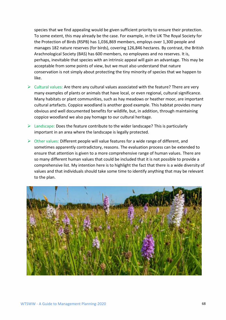
WTSWW - A Guide to Management Planning-2020 68
species that we find appealing would be given sufficient priority to ensure their protection.
To some extent, this may already be the case. For example, in the UK The Royal Society for
the Protection of Birds (RSPB) has 1,036,869 members, employs over 1,300 people and
manages 182 nature reserves (for birds), covering 126,846 hectares. By contrast, the British
Arachnological Society (BAS) has 600 members, no employees and no reserves. It is,
perhaps, inevitable that species with an intrinsic appeal will gain an advantage. This may be
acceptable from some points of view, but we must also understand that nature
conservation is not simply about protecting the tiny minority of species that we happen to
like.
➢ Cultural values: Are there any cultural values associated with the feature? There are very
many examples of plants or animals that have local, or even regional, cultural significance.
Many habitats or plant communities, such as hay meadows or heather moor, are important
cultural artefacts. Coppice woodland is another good example. This habitat provides many
obvious and well documented benefits for wildlife, but, in addition, through maintaining
coppice woodland we also pay homage to our cultural heritage.
➢ Landscape: Does the feature contribute to the wider landscape? This is particularly
important in an area where the landscape is legally protected.
➢ Other values: Different people will value features for a wide range of different, and
sometimes apparently contradictory, reasons. The evaluation process can be extended to
ensure that attention is given to a more comprehensive range of human values. There are
so many different human values that could be included that it is not possible to provide a
comprehensive list. My intention here is to highlight the fact that there is a wide diversity of
values and that individuals should take some time to identify anything that may be relevant
to the plan.
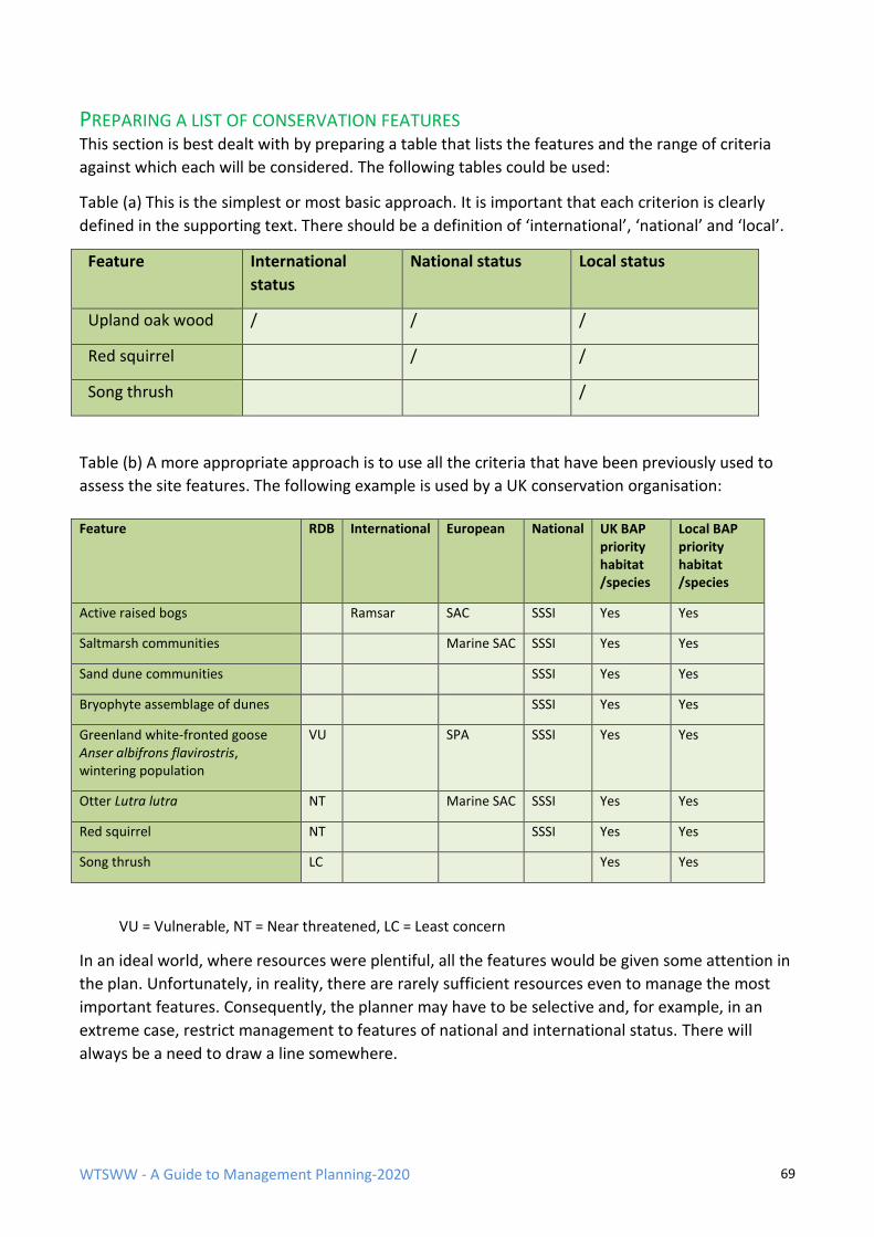
WTSWW - A Guide to Management Planning-2020 69
PREPARING A LIST OF CONSERVATION FEATURES This section is best dealt with by preparing a table that lists the features and the range of criteria
against which each will be considered. The following tables could be used:
Table (a) This is the simplest or most basic approach. It is important that each criterion is clearly
defined in the supporting text. There should be a definition of ‘international’, ‘national’ and ‘local’.
Feature International
status
National status Local status
Upland oak wood / / /
Red squirrel / /
Song thrush /
Table (b) A more appropriate approach is to use all the criteria that have been previously used to
assess the site features. The following example is used by a UK conservation organisation:
VU = Vulnerable, NT = Near threatened, LC = Least concern
In an ideal world, where resources were plentiful, all the features would be given some attention in
the plan. Unfortunately, in reality, there are rarely sufficient resources even to manage the most
important features. Consequently, the planner may have to be selective and, for example, in an
extreme case, restrict management to features of national and international status. There will
always be a need to draw a line somewhere.
Feature RDB International European National UK BAP priority habitat /species
Local BAP priority habitat /species
Active raised bogs Ramsar SAC SSSI Yes Yes
Saltmarsh communities Marine SAC SSSI Yes Yes
Sand dune communities SSSI Yes Yes
Bryophyte assemblage of dunes SSSI Yes Yes
Greenland white-fronted goose Anser albifrons flavirostris, wintering population
VU
SPA SSSI Yes Yes
Otter Lutra lutra NT Marine SAC SSSI Yes Yes
Red squirrel NT SSSI Yes Yes
Song thrush LC Yes Yes
WTSWW - A Guide to Management Planning-2020 70
RESOLVING CONFLICTS BETWEEN FEATURES Sometimes, there are conflicts between features. These can often be resolved by understanding
the relationship between the different site features. A feature can have a considerable direct
impact on another feature. For example, it is not impossible for both a predatory species and its
prey to be features of equal standing. In extremely rare circumstances, there might be a need for
one or other of the features to be sacrificed.
A feature can also have consequences for the management and the actual condition of another
feature. This happens on sites where species have specific habitat requirements and both the
species and the habitat are features. For example, in a northern forest there are two features: the
forest itself and a population of grouse. The grouse require open areas for displaying males, high
forest for nesting, and areas of dwarf willow for feeding hens prior to egg laying. These specific
conditions will have to be reflected in the forest objective and, of course, the way in which the
forest is managed. Thus, the grouse population is a factor that influences the way in which we
manage the forest.
These conflicts are fortunately rare and can usually be accommodated in the planning process. In
most cases, one feature will be regarded as more important than another.
COMBINING FEATURES Occasionally, there may be an advantage in combining several features and preparing a common
objective. This will occur when features are not easily separated for monitoring or management
purposes. Complex habitat mosaics, where each component qualifies as a feature, are good
examples. Whenever it is expedient to combine features, include a detailed, well-considered
justification in this section.
This also highlights the need to think ahead when confirming the features and the level at which
they are defined. For example, vegetation can be defined at sub-community, community or habitat
level. The level used to define features will usually determine the level at which their condition can
be monitored and managed.
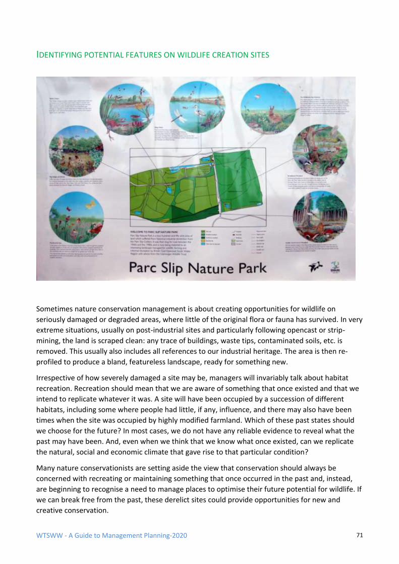
WTSWW - A Guide to Management Planning-2020 71
IDENTIFYING POTENTIAL FEATURES ON WILDLIFE CREATION SITES
Sometimes nature conservation management is about creating opportunities for wildlife on
seriously damaged or degraded areas, where little of the original flora or fauna has survived. In very
extreme situations, usually on post-industrial sites and particularly following opencast or strip-
mining, the land is scraped clean: any trace of buildings, waste tips, contaminated soils, etc. is
removed. This usually also includes all references to our industrial heritage. The area is then re-
profiled to produce a bland, featureless landscape, ready for something new.
Irrespective of how severely damaged a site may be, managers will invariably talk about habitat
recreation. Recreation should mean that we are aware of something that once existed and that we
intend to replicate whatever it was. A site will have been occupied by a succession of different
habitats, including some where people had little, if any, influence, and there may also have been
times when the site was occupied by highly modified farmland. Which of these past states should
we choose for the future? In most cases, we do not have any reliable evidence to reveal what the
past may have been. And, even when we think that we know what once existed, can we replicate
the natural, social and economic climate that gave rise to that particular condition?
Many nature conservationists are setting aside the view that conservation should always be
concerned with recreating or maintaining something that once occurred in the past and, instead,
are beginning to recognise a need to manage places to optimise their future potential for wildlife. If
we can break free from the past, these derelict sites could provide opportunities for new and
creative conservation.
WTSWW - A Guide to Management Planning-2020 72
Traditionalist or otherwise, we will need to decide what we want for these sites. We can adopt one
of two broad approaches. We could, if we had the courage, take the opportunity to experiment and
allow nature to deliver whatever it can in these circumstances: some people will describe this as
wildling or enabling natural processes. This is discussed in more detail in the following section on
options.
Regrettably, we are obliged to adopt a more prescriptive approach, where the selection of
biological features will follow some sort of landscape design which has been prepared to reflect the
intended future use of the site. Future use could include anything from a nature reserve to an area
for recreational activities. Providing there is some intention in the overall scheme to do something
for wildlife then the preparation of a management plan that at least identifies the habitat features
is justified.
So, how do we decide which habitats we want to occupy the site? First, we must understand that, if
our intention is to create conditions that will improve or optimise opportunities for wildlife, there
are limited possibilities. We cannot have, and do not want, everything everywhere.
The type of vegetation (plant communities) that can occupy and thrive in an area will be dictated,
initially, by a range of natural factors. We have limited ability to change the natural factors and,
even where we could, we need to consider the implications and cost. Perhaps this is one of the
more significant differences between gardening and nature conservation. Gardeners will, to varying
degrees, modify their land by controlling natural factors to provide artificial situations that support
assemblages of exotic species which bear no relationship to the native flora. Nature
conservationists, on the other hand, in general but perhaps not always, recognise and celebrate the
limitations imposed by the natural factors that create the diversity of habitats. There are, of course,
exceptions when intervention is necessary and desirable, for example, the application of lime to
maintain particular kinds of hay meadow.
The following are some examples of natural factors that will influence the vegetation: altitude,
slope, aspect, soil, geology, drainage, climate, grazing by wild animals and catastrophic events. We
never start with a bare canvas: it has been primed and the background wash applied. The factors, in
combination, will dictate the type or range of plant communities that can occupy an area. The
specific communities that will occupy a place are a consequence of the combined influence of
natural and controlled anthropogenic factors.
Once we understand the outcomes that nature, with and without human influence, will allow on a
site, we need to decide what we want. There are no rules that can be applied here: within the
realm of possibilities the choice is dictated mainly by human preference. However, decisions should
always take account of the resource implications: we must strive to do the most for wildlife while
using the least possible resource.
Each potential feature can, of course, be evaluated using one or other of the methods previously
described, and the features likely to make the greatest contribution to wildlife can be selected as
the future occupants of a site. A cost-benefit analysis could also be included.
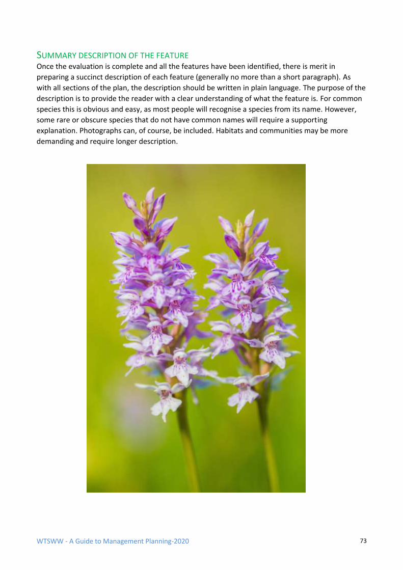
WTSWW - A Guide to Management Planning-2020 73
SUMMARY DESCRIPTION OF THE FEATURE Once the evaluation is complete and all the features have been identified, there is merit in
preparing a succinct description of each feature (generally no more than a short paragraph). As
with all sections of the plan, the description should be written in plain language. The purpose of the
description is to provide the reader with a clear understanding of what the feature is. For common
species this is obvious and easy, as most people will recognise a species from its name. However,
some rare or obscure species that do not have common names will require a supporting
explanation. Photographs can, of course, be included. Habitats and communities may be more
demanding and require longer description.

WTSWW - A Guide to Management Planning-2020 74
4 OPTIONS AND PROCESSES
OPTIONS Options identify, at a high level, the general approach that will be adopted for the
management of a site or individual features. There are three recommended options:
non-intervention, minimal intervention and active management.
Options are included at this position in the management plan because it logically follows from the
confirmation of features and must precede development of the management objectives. The
detailed decisions about management begin in the rationale which follows the objective.
WTSWW - A Guide to Management Planning-2020 75
OPTIONS FOR SITES AND HABITATS
NON-INTERVENTION
This option strictly means doing nothing, and relying on natural processes to deliver an
outcome. There has been much debate and confusion, mainly because the definition has
been interpreted in many different ways. For example, should the introduction of predators
be regarded as intervention? I guess predators could be introduced before the option is
adopted. Does the option allow for a perimeter fence? Can we ever completely remove the
influence of our species? The recognition of global climate change should provide the
Options - background
The early approaches (1970s) to conservation management in Britain advocated the use of ‘options’, a
concept pioneered by George Peterken. Options as a management planning concept, appeared in a 1981
Handbook for the preparation of management plans for NNRs in Wales, where they were described as
policies. In two subsequent Nature Conservancy Council guides, published in 1983 and 1988 they had
become options. They were also central to a 1996 Countryside Council for Wales internal guide. The original
options were:
• Non-intervention
• Limited intervention
• Active management
Non-intervention, as defined by NCC, was a ‘climax or natural vegetation concept’. It is clear that ‘natural’
excluded, as far as possible, the influence of man. In the absence of natural (primeval) habitats in Britain,
the aim was to acquire semi-natural habitats and allow them to develop free from as much human
influence, direct and indirect, as possible.
The original definition of limited intervention is rather woolly and suggests that this is an ephemeral option
employed when there is doubt that non-intervention will deliver. This option might be applied to process
management if the definition is modified, hence the appearance in 2006 of minimal intervention. A minimal
intervention option would enable natural processes but would control, or remove, the influence of
undesirable anthropogenic factors (although some people would argue that all anthropogenic factors are
undesirable). In a tropical forest, for example, management aims to prevent illegal logging, poaching,
squatters, invasive species, etc. (Alexander et al. 1992). But this is not necessarily consistent with an
obvious obligation to protect the rights of indigenous peoples. Even if we should and could control
anthropogenic factors, there will be some factors that we are not aware of, and there will always be the
potential for new factors to appear.
Options for nature conservation features were abandoned following the first version (1998) of the JNCC
common standards for monitoring statement. Conservation management in the UK agencies became almost
entirely focused on a feature approach where a quantified outcome was specified for each feature.
More recently, conservation scientists and practitioners have come to understand that our outcomes can,
and often should, be dictated by natural processes. The original options include options for habitats, species,
research, education and access. Of these, only the habitat and access options retain their relevance to
current management planning, the habitat options can be applied to species conservation.
WTSWW - A Guide to Management Planning-2020 76
answer. On balance, it is probably best to regard this as an interesting but hypothetical
option: good for endless debate but not much else.
MINIMAL INTERVENTION
This option was described as ‘limited intervention’ in earlier (1990s) management plans. It
was only slightly different in concept: the degree of intervention was pre-determined and
specified in the plan. Minimal intervention is the most appropriate option for any site or
feature where the intention is to enable, as far as possible, natural processes to deliver an
outcome. In short, we will only intervene when necessary, and then only applying the
lightest of hands. The option recognises that there will always be negative influences, the
impact of some factors will be unpredictable and other factors will appear seemingly from
nowhere (or at least not from anywhere that we know about). It is likely that climate change
will unleash some very challenging surprises.
ACTIVE MANAGEMENT This option is always applied when managing semi-natural or plagioclimactic vegetation
which rely on human intervention for their survival. Some will be the deliberate
consequence of past management, even though that management was never intended to
deliver nature conservation. The best examples are species-rich hay meadows and most of
our heathlands. It is always appropriate when we focus on species management.
The selection of options follows the confirmation of features. It is the process of identifying the
management option which best defines the degree of intervention that will be appropriate for an
entire site or features within the site. Bear in mind that a site, regardless of size, can be treated as a
single feature, and that options can, in many circumstances, vary from feature to feature on a site.
When a features approach is considered appropriate an option should be identified for each
feature. The generic definition of options (given above) should be modified for each feature. For
example, the Skomer Island management plan identifies a minimal intervention option for the
vegetation, but this is conditioned by placing a limit on the extent of bramble and the spread of
bracken into the Puffin colonies.
The site-specific choice of options can be dictated by the nature of the feature: the more ‘natural’ a
feature the less likely the need for intervention. When a site is special because of its semi-natural
features (a heath community, for example) which will require significant ongoing management, the
option will be ‘active management’. An option can also be dictated by organisational policy. For
example, some organisations may have a strong presumption in favour of enabling natural
processes (wildling).
ENABLING NATURAL PROCESSES (WILDING)
Rewilding has, for many reasons (good and bad), become a very contentious and divisive concept.
This is not the place for an in-depth account of the background and concepts, but, given that it has
become one of the predominant directions for nature conservation, it must be given an appropriate
level of attention in this guide.
WTSWW - A Guide to Management Planning-2020 77
A very brief history of the development and background of the concept might help. We have known
for a very long time, almost as long as we have been managing places for nature conservation, that
we must rely on natural processes whenever we can. It is the most effective approach to
conservation, and is usually very much easier and cheaper than imposing our will and deliberately
obstructing nature. This is not to be taken as a suggestion that we should undervalue or abandon
our semi-natural or cultural landscapes and plant communities.
Pleistocene rewilding has been discussed for many years. The earliest publications appeared in the
1990s (Soule 1990; Martin and Burney 1999). The most influential publication appeared in 2005. It
was an article on Pleistocene rewilding published in the journal ‘Nature’, a widely respected
publication which features scientific peer-reviewed research papers (Donlan et al. 2005). The paper
outlined a North American Pleistocene rewilding proposal, and it was significantly more ambitious
than any of the previous versions of rewilding. The proposal was the re-construction of an ancient
ecosystem by translocating a diverse assemblage of African and Asian megafauna to geographical
regions that have evolved in the absence of these creatures since the Pleistocene. The plan involved
animals that are both the descendants of extinct species and surrogates for the extinct species. The
species included predators such as African cheetahs and lions, and large herbivores, including
African and Asian elephants, horses and Bactrian camels.
The paper, which attracted much attention from scientists and the popular media, confirmed a
widely held assertion that one of the key purposes of conservation should be the re-creation of
something that happened in the past. Many of the words that we use as conservation managers
begin with the ‘re’ prefix. There was rarely any allusion to a specific time in the past, with, of
course, the exception of Pleistocene rewilding, where the conservation objective for the future was
to re-create something that had happened at least 12,000 years ago. In addition to re-creating the
past, the defining features of re-wilding also included the need for very large core areas, corridors
to provide functional ecological connectivity and the presence of large carnivores.
The past is important. Some of the keys to understanding the present, and recognising potential
future ecosystems, lie in the past, but what does this really mean? Certainly, understanding the
history of habitat development - their past composition and structure, their spatial and temporal
variability, and the principal factors, or processes, that influenced them - might help us to identify
potential futures. The big questions are, how far back can, or should, we go, and was there a time in
the past that we want for tomorrow? George Peterken helps with his definition of ‘original
naturalness’: this was the state that existed before man became a significant ecological factor. The
important word is ‘significant’, although, unfortunately, George Peterken does not provide a
definition for this. Was there a time in the past, perhaps in the early Holocene, which could be
regarded as ‘original natural’?
George Peterken also suggests a different naturalness: ‘present naturalness’ - the state that would
prevail now if man had not become a significant ecological factor. Even if people had been absent
from Britain over the past 7,000 years the habitats would have changed: they would have evolved;
they would have responded to changing natural influences. We can never know for certain, or in
sufficient detail, what ‘present natural’ might be. Consequently, the concept does not provide a
useful target for future conservation management, but it certainly undermines the validity of a
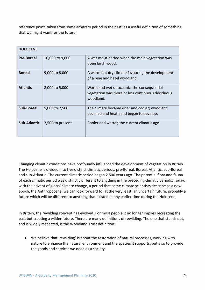
WTSWW - A Guide to Management Planning-2020 78
reference point, taken from some arbitrary period in the past, as a useful definition of something
that we might want for the future.
HOLOCENE
Pre-Boreal 10,000 to 9,000 A wet moist period when the main vegetation was
open birch wood.
Boreal 9,000 to 8,000 A warm but dry climate favouring the development
of a pine and hazel woodland.
Atlantic 8,000 to 5,000 Warm and wet or oceanic: the consequential
vegetation was more or less continuous deciduous
woodland.
Sub-Boreal 5,000 to 2,500 The climate became drier and cooler; woodland
declined and heathland began to develop.
Sub-Atlantic 2,500 to present Cooler and wetter, the current climatic age.
Changing climatic conditions have profoundly influenced the development of vegetation in Britain.
The Holocene is divided into five distinct climatic periods: pre-Boreal, Boreal, Atlantic, sub-Boreal
and sub-Atlantic. The current climatic period began 2,500 years ago. The potential flora and fauna
of each climatic period was distinctly different to anything in the preceding climatic periods. Today,
with the advent of global climate change, a period that some climate scientists describe as a new
epoch, the Anthropocene, we can look forward to, at the very least, an uncertain future: probably a
future which will be different to anything that existed at any earlier time during the Holocene.
In Britain, the rewilding concept has evolved. For most people it no longer implies recreating the
past but creating a wilder future. There are many definitions of rewilding. The one that stands out,
and is widely respected, is the Woodland Trust definition:
• We believe that ‘rewilding’ is about the restoration of natural processes, working with
nature to enhance the natural environment and the species it supports, but also to provide
the goods and services we need as a society.
WTSWW - A Guide to Management Planning-2020 79
• We support the view that re-establishing natural processes can be an important and
powerful way to manage land alongside conventional or traditional forms of land
management for food production and maintaining valued landscapes.
• Whilst wild areas may be separate from farmed landscapes, there are also opportunities for
integrating more wild space within farming systems in ways which support both wildlife and
production.
• Creating a sense of wildness is possible in most places. However, the degree to which
natural processes are able to dominate will be affected by both scale and location. Large
remote areas are more likely to have a greater degree of self-determination than small sites
in urban areas.
• We believe habitats should be extended, enriched, and linked in a way that allows both
habitats and species to operate and interact over sufficiently large areas to support dynamic
natural processes. In many cases re-establishing natural processes will require intervention.
This might include the creation of habitat such as woodland, or on occasions the
reintroduction of species that have been lost.
• Reintroduction of larger animals, including large herbivores and carnivores, is sometimes
identified as important to re-establishing natural processes. This should only be undertaken
where sufficient suitable habitat exists to ensure the wellbeing of viable populations of the
reintroduced species. Any species reintroduction needs to take full consideration of the
legitimate concerns of stakeholders and, in particular, local communities whose livelihoods
and wellbeing might be affected.
Woodland Trust - Position statement 2017

WTSWW - A Guide to Management Planning-2020 80
It is sometimes, but not always, difficult to understand why rewilding has attracted such extreme
controversy and prejudice. It is extremely important that anyone making decisions about rewilding
devotes a significant effort to understand both side of the controversy.
In 2019 a number of signs appeared on the outskirts of Machynlleth in mid Wales. They were
erected by the local farming community in response to a rather clumsy attempt to establish a large
rewilding scheme in the area. The area around Machynlleth is very special, and over many decades
the conservation organisations, government and non-government have worked successfully
alongside local people and farmers. This perhaps explains the text on one of the signs: it supported
conservation but not rewilding, despite the fact that most of the established conservation
initiatives in the area would mesh very easily with the Woodland Trust definition of wilding. The
‘Cofiwch Dryweryn’ logo refers to a famous roadside sign, south of Aberystwyth. It is a protest
against the time (1965) when outsiders (the city of Liverpool), via an Act of Parliament, flooded a
Welsh valley to supply water to their city. An entire community was displaced when a village - with
a school, post office, chapel and cemetery - together with its surrounding farms, was drowned. The
response from the Machynlleth farming community reflected their real and deep concerns about
the project: they felt threatened. They were deeply offended that strangers from outside their
community could presume a right to impose their will on the land without consulting the local
community. The rewilding project leaders were reported in the local press as claiming that farmers
had ‘misunderstood the project’. This was a clear demonstration of their failure to communicate
effectively and respectfully with local people. The outcome might have been very different had the
project managers understood the need to work with local people, to respect them and to involve
them in all aspects of the project, beginning with the earliest conceptual stages.
It might make some sense, and help avoid unnecessary antagonism, if ‘rewilding’ is at least
replaced with ‘wilding’, or if we revert to the using the widely acceptable concept of ‘enabling
natural processes to obtain a resilient and sustainable future for our wildlife’. The concepts of
‘enabling natural processes’ or ‘non-intervention management’ have been around for a very long
time, and they were never contentious. It simply made good common and scientific sense. We
could, of course, also use ‘minimal-intervention’ to describe our intentions.
Non-intervention was about allowing or enabling nature, or natural processes, to dictate the future
of a site, habitat or population. In truth, non-intervention was generally regarded as a theoretical
concept which had, at least in Britain, no practical application. I attended many lectures by George
Peterken in the 1980s and 90s, and I particularly remember him saying, more than once: ‘If ever we
WTSWW - A Guide to Management Planning-2020 81
are able to adopt a non-intervention option in British woodlands we will need decades, if not
centuries, of active-management to obtain conditions suitable for non-intervention. Even if this
could be achieved, we would be wise to adopt a minimal-intervention policy.’ Sites will never be
completely isolated from external factors: global climate change and invasive non-native species are
just two of many anthropogenic factors that will always impede natural processes.
There still exists a ‘purist’ belief that rewilding should be an all or nothing approach. However,
‘perfection is the enemy of success’. We should not assume that because the ideal might be very
large areas with wild or feral herbivores and large carnivores anything less is a failure. In reality,
there will, in all situations, be a need for some compromise, in that the degree to which we can
enable processes will be constrained by any number of insurmountable factors. Every step we take
towards a wilder future is a success. When managing places or habitats through enabling natural
process we will have to be less concerned with obtaining specified outcomes. We would have to
accept unpredictable outcomes if they provided optimal opportunities for wildlife.
• Should there always be a presumption in favour of enabling natural processes whenever
and wherever we can?
• Should nature conservation be more concerned with what we require of the future, and less
about recreating the past or fossilising some intermediate state?
• Can we create at least some sustainable places where, as far as possible, we rely on natural
processes, where opportunities for wildlife are optimal, where human interaction is not
exploitation, and where our mutual interdependence is recognised? In other words, could
these be tomorrow’s wild places?
We must never forget to value the essential contribution that semi-natural communities make
towards conserving nature and our cultural heritage. Some people believe that nature reserves,
along with their statutory wildlife features, are yesterday’s solution to nature conservation and that
we must find alternative approaches. Obviously, we need landscape-scale areas for nature, and,
equally, we must give the wider countryside the attention it requires, but we should never
underestimate the crucial role that nature reserves must play in any future nature conservation
strategy.
Nature reserves are places where we protect and conserve wildlife: secure, sustainable places,
where we provide opportunities for wildlife and where our mutual dependence is recognised. They
are places where we can safeguard species and habitats that are extremely vulnerable and which,
once lost, will be gone for ever. Our countryside - our habitats with their wild populations- is a
fragmented mosaic of small, fragile remnants, few of which can ever thrive in isolation. Nature
reserves play an essential role as we begin to repair the damage of the past generations, by
connecting places with places and building robust, sustainable ecosystems.
We must never underestimate one of the most essential purposes of many nature reserves; they
provide opportunities for people to experience and connect with nature. People are rapidly losing
any direct connection with wildlife; the virtual media experiences are no replacement. One of the
greatest challenges that faces the conservation movement is re-connection. People will only

WTSWW - A Guide to Management Planning-2020 82
conserve what they value; this is why values are so central to nature conservation. There can be no
values without understanding, no understanding without awareness and no awareness without
experience.
In conclusion, there are limited opportunities for large-scale wilding projects. Even when, or if, they
can be established, they will require several decades or longer to deliver optimal conditions for
wildlife. They cannot replace, certainly in the short term and probably never, our nature reserves.
Nature conservation will benefit from a pluralistic approach. We should recognise that there are a
variety of equally valid, but sometimes contradictory, values, theories and actions.
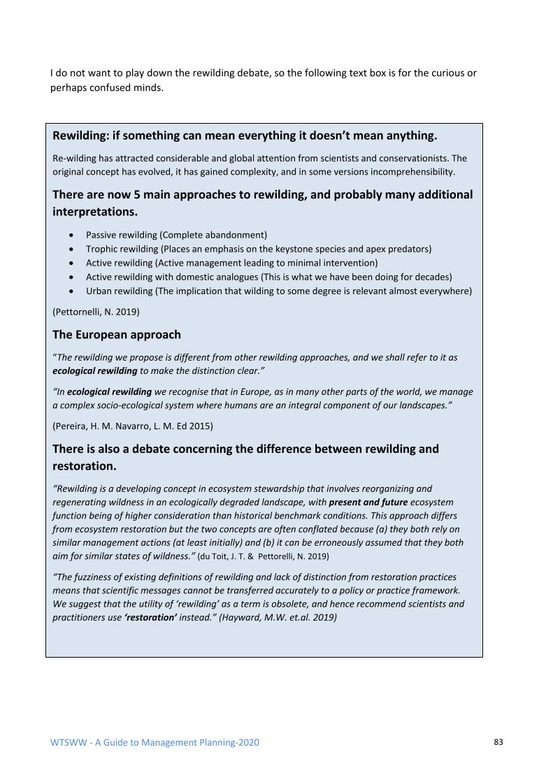
WTSWW - A Guide to Management Planning-2020 83
I do not want to play down the rewilding debate, so the following text box is for the curious or
perhaps confused minds.
Rewilding: if something can mean everything it doesn’t mean anything.
Re-wilding has attracted considerable and global attention from scientists and conservationists. The
original concept has evolved, it has gained complexity, and in some versions incomprehensibility.
There are now 5 main approaches to rewilding, and probably many additional
interpretations.
• Passive rewilding (Complete abandonment)
• Trophic rewilding (Places an emphasis on the keystone species and apex predators)
• Active rewilding (Active management leading to minimal intervention)
• Active rewilding with domestic analogues (This is what we have been doing for decades)
• Urban rewilding (The implication that wilding to some degree is relevant almost everywhere)
(Pettornelli, N. 2019)
The European approach
“The rewilding we propose is different from other rewilding approaches, and we shall refer to it as
ecological rewilding to make the distinction clear.”
“In ecological rewilding we recognise that in Europe, as in many other parts of the world, we manage
a complex socio-ecological system where humans are an integral component of our landscapes.”
(Pereira, H. M. Navarro, L. M. Ed 2015)
There is also a debate concerning the difference between rewilding and
restoration.
“Rewilding is a developing concept in ecosystem stewardship that involves reorganizing and
regenerating wildness in an ecologically degraded landscape, with present and future ecosystem
function being of higher consideration than historical benchmark conditions. This approach differs
from ecosystem restoration but the two concepts are often conflated because (a) they both rely on
similar management actions (at least initially) and (b) it can be erroneously assumed that they both
aim for similar states of wildness.” (du Toit, J. T. & Pettorelli, N. 2019)
“The fuzziness of existing definitions of rewilding and lack of distinction from restoration practices
means that scientific messages cannot be transferred accurately to a policy or practice framework.
We suggest that the utility of ‘rewilding’ as a term is obsolete, and hence recommend scientists and
practitioners use ‘restoration’ instead.” (Hayward, M.W. et.al. 2019)
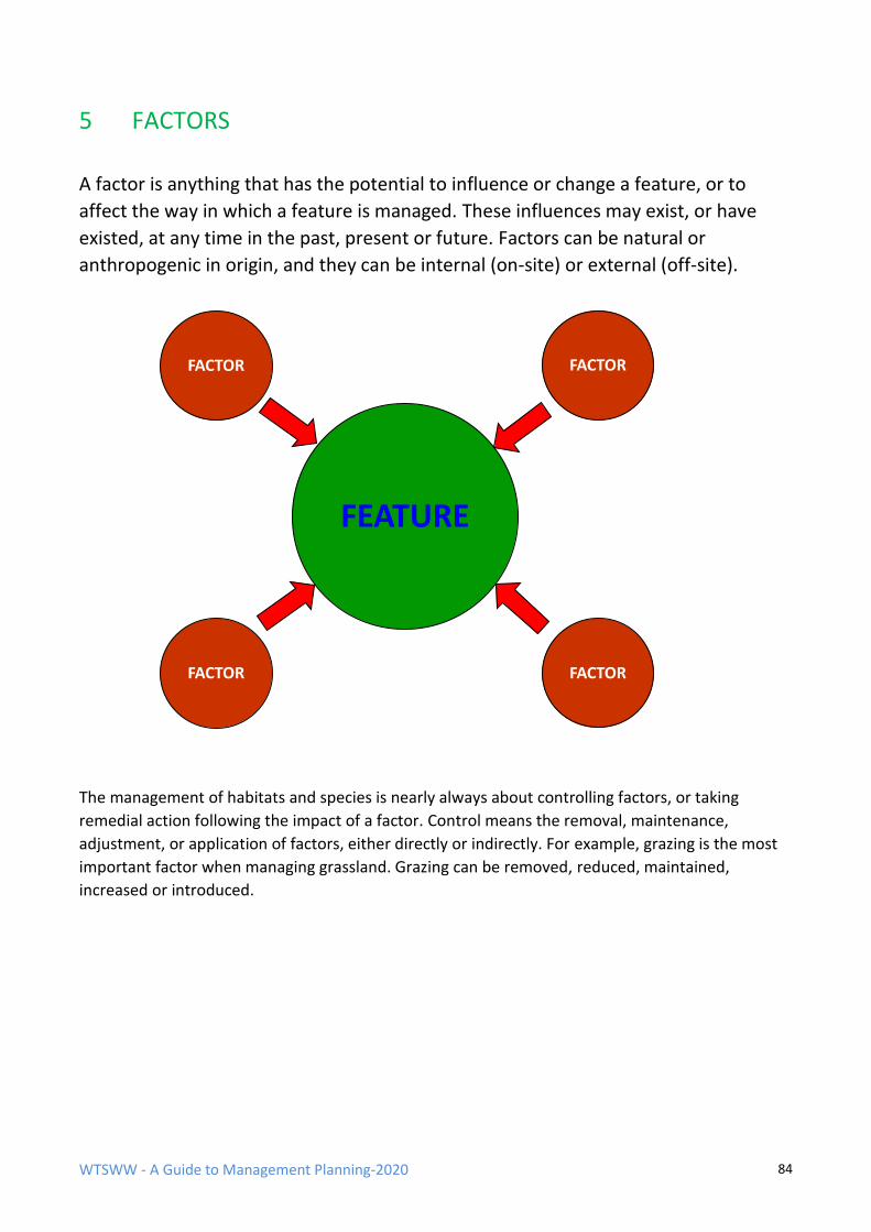
WTSWW - A Guide to Management Planning-2020 84
5 FACTORS
A factor is anything that has the potential to influence or change a feature, or to
affect the way in which a feature is managed. These influences may exist, or have
existed, at any time in the past, present or future. Factors can be natural or
anthropogenic in origin, and they can be internal (on-site) or external (off-site).
The management of habitats and species is nearly always about controlling factors, or taking
remedial action following the impact of a factor. Control means the removal, maintenance,
adjustment, or application of factors, either directly or indirectly. For example, grazing is the most
important factor when managing grassland. Grazing can be removed, reduced, maintained,
increased or introduced.
FEATURE
FACTOR
FACTOR FACTOR
FACTOR
WTSWW - A Guide to Management Planning-2020 85
Factors are considered at several key stages in the planning process for each feature. These are:
The selection of attributes for features
Quantified attributes are used as performance indicators to provide evidence about the
condition of a feature. The selection of some of the attributes should, to some extent, be
guided by the presence of factors. While factors are the influences that can change or
maintain a feature, attributes can reflect the changes that take place, or the conditions that
prevail as a consequence of these influences.
The use of factors as performance indicators
For a feature, habitat, or species to be at favourable conservation status (FCS) the factors
must be kept under control. This means that, for all features where the objective is FCS, all
the factors that could change the feature must be monitored, directly or indirectly, to
ensure that they are under control. Indirect monitoring is achieved by using attributes (see
above). There are occasions, though not many, when the levels or limits of tolerance to a
factor are known and where the impact of the factor is difficult to measure. In these cases,
the factor can be monitored directly. These factors are always human influences, and the
most frequently encountered examples are invasive alien species. An upper limit which
represents our tolerance to the factor is specified, and this provides the performance
indicator.
The management rationale
The management rationale is the stage in the management process (repeated for each
feature) where all the management requirements are identified. All the actions or projects
required to ensure that the factors are kept under control are identified. The influences that
all the other factors will have on the management of the feature are also considered. This
can be complicated by the fact that, while an individual factor may have only a limited
impact on a feature, several factors in combination can become a significant issue. This
means that factors should be considered both individually and collectively.
Because of the different uses, and to avoid unnecessary repetition, factors are best identified at this
stage in the planning process. They can be presented as a master list and used later in the plan as
appropriate.
Factors can be positive or negative
Factors are influences which can be negative, or positive, or both. Factors can change, becoming
positive or negative depending on the intensity of their influence. For example: grazing is a factor;
both over-grazing and under-grazing are negative influences; grazing at an appropriate level has a
positive influence. A factor will also influence different features in different ways. For example,
riverbank erosion may destroy grassland, but the same process will create and maintain shingle
banks.
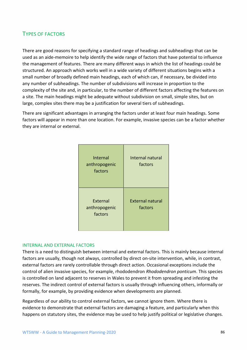
WTSWW - A Guide to Management Planning-2020 86
TYPES OF FACTORS
There are good reasons for specifying a standard range of headings and subheadings that can be
used as an aide-memoire to help identify the wide range of factors that have potential to influence
the management of features. There are many different ways in which the list of headings could be
structured. An approach which works well in a wide variety of different situations begins with a
small number of broadly defined main headings, each of which can, if necessary, be divided into
any number of subheadings. The number of subdivisions will increase in proportion to the
complexity of the site and, in particular, to the number of different factors affecting the features on
a site. The main headings might be adequate without subdivision on small, simple sites, but on
large, complex sites there may be a justification for several tiers of subheadings.
There are significant advantages in arranging the factors under at least four main headings. Some
factors will appear in more than one location. For example, invasive species can be a factor whether
they are internal or external.
INTERNAL AND EXTERNAL FACTORS
There is a need to distinguish between internal and external factors. This is mainly because internal
factors are usually, though not always, controlled by direct on-site intervention, while, in contrast,
external factors are rarely controllable through direct action. Occasional exceptions include the
control of alien invasive species, for example, rhododendron Rhododendron ponticum. This species
is controlled on land adjacent to reserves in Wales to prevent it from spreading and infesting the
reserves. The indirect control of external factors is usually through influencing others, informally or
formally, for example, by providing evidence when developments are planned.
Regardless of our ability to control external factors, we cannot ignore them. Where there is
evidence to demonstrate that external factors are damaging a feature, and particularly when this
happens on statutory sites, the evidence may be used to help justify political or legislative changes.
Internal
anthropogenic
factors
Internal natural
factors
External
anthropogenic
factors
External natural
factors
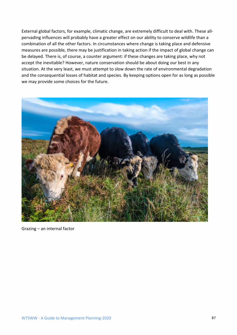
WTSWW - A Guide to Management Planning-2020 87
External global factors, for example, climatic change, are extremely difficult to deal with. These all-
pervading influences will probably have a greater effect on our ability to conserve wildlife than a
combination of all the other factors. In circumstances where change is taking place and defensive
measures are possible, there may be justification in taking action if the impact of global change can
be delayed. There is, of course, a counter argument: if these changes are taking place, why not
accept the inevitable? However, nature conservation should be about doing our best in any
situation. At the very least, we must attempt to slow down the rate of environmental degradation
and the consequential losses of habitat and species. By keeping options open for as long as possible
we may provide some choices for the future.
Grazing – an internal factor

WTSWW - A Guide to Management Planning-2020 88
Air pollution – an external factor
Oil pollution on a National Nature Reserve – an internal or an external factor?

WTSWW - A Guide to Management Planning-2020 89
ANTHROPOGENIC AND NATURAL FACTORS
The division between natural and anthropogenic factors (human influences or the consequence of
human activities) is also significant. This can be an extremely difficult division, both in practical
terms and from a philosophical perspective. It is often impossible to differentiate between changes
to a feature which are the consequence of natural processes and those which are a consequence of
anthropogenic processes or a combination of the two. The more significant issue is the definition of
‘natural’ or the concept of ‘natural’ which excludes humanity as a component. Unfortunately, there
is no consistency in the way in which ‘natural’ is defined or applied. All decisions concerning the
objectives, i.e. what we want to achieve, are made at a different stage in the planning process, and
that is when the consequences of conservation ethics should be considered. This is not the place to
visit that debate. However, the division between natural and anthropogenic is important because it
will help to differentiate between factors which are regarded as having a positive influence and
those which are considered negative.
The management of wilderness, and other situations where habitats are allowed to develop in
response to natural processes, is usually concerned with controlling or removing anthropogenic
influences. In contrast, our cultural landscapes and habitats are most often managed by controlling
natural processes or factors. For example, hay meadows are highly regarded semi-natural grassland
communities, and yet the maintenance of these features is entirely dependent on our ability to
suppress natural processes. A combination of mowing, grazing and fertilising prevents the
regeneration of scrub and maintains soil fertility. If we can accept that ‘natural’ can be used in
relative terms (that is, some features will be more natural or subject to less human influence than
others), then at the natural end of the spectrum human influence will be mainly negative and
natural influences mainly positive. The converse is also true. When managing cultural habitats some
human influence will be positive while natural processes can be negative.
Sitka spruce, a non-native species, invades.
WTSWW - A Guide to Management Planning-2020 90
FEATURES AS FACTORS
Some of the most important natural factors encountered on a site will be the features. This is
because each individual feature has the potential to influence the management of the other
features. The relationship between features is only very rarely a significant problem. Species and
habitats coexist for good reasons and they are often interdependent. Whenever a species is
recognised as an important feature on a site, the habitat that supports it will always be one of the
most important factors. It is not unusual for both the species and the supporting habitat to be
recognised as independently important features of the same site.
Complications will occasionally arise when a species feature and the habitat feature require
conflicting management. This can happen when a habitat that has been damaged is recovering. For
example, the restoration of a raised bog (habitat feature) will have a negative impact on a nightjar
Caprimulgus europaeus population (species feature). The nightjars thrive in the previously
degraded bog, but the restored bog will not provide suitable habitat. In situations where the
requirements of a species are in conflict with the habitat that supports it, the first step is to decide
which is the most important. If it is the species, the condition of the habitat may have to be
compromised, and, of course, the opposite action will be taken when the habitat is more
important.
This issue will occasionally emerge when dealing with species that are dependent on successional
or ephemeral habitats. When planning the management of these, it is essential that the
relationship between the species and the successional communities is understood. For example, on
a large dune system the dune slack communities provide an ideal habitat for many species of orchid
Orchidaceae. The orchids are a feature and so is the dune habitat. Mobile dunes continually
inundate the orchid slacks and, in order to protect the orchids, managers may attempt to stabilise
the dunes. However, dune slacks are created by mobile dunes and blow-outs, and they must be
regarded as ephemeral communities. In time, even in the absence of mobile dunes, a slack will
change and eventually no longer support orchids. Management must recognise that, over time,
these communities will move within the site or, in some cases, another site may become more
suitable for them. It is important that they exist but not where they exist.
There will, of course, also be some occasions, particularly when managing very rare and threatened
species, where the habitat will have to be modified or maintained in an early successional state to
meet the requirements of the species.
LEGISLATION AND POLICY
Legislation and policy are such important factors that they should be included as subheadings in all
management plans. Legislation and policies are described and discussed at an early stage in the
planning process. Both will have a very significant influence on the selection of the features and the
development of objectives for the features. They also influence the management of the features
and, consequently, should be regarded as factors. Wildlife legislation, although intended to protect
wildlife, can occasionally limit our ability to carry out management. Employment and health and
safety legislation can also severely restrict our ability to manage sites.
WTSWW - A Guide to Management Planning-2020 91
HEALTH AND SAFETY
This is a subsection of legislation, but it is so important that it must not be overlooked in any plan.
Almost every management activity will require a risk assessment and many will require expensive
safety equipment and procedures. Health and safety considerations are not a direct or primary
factor, but there will always be implications for the way in which management is carried out. In
some extreme cases, it will not be possible to provide adequate safety measures and work will not
be possible. This has led to sites being abandoned.
OBLIGATIONS NON-LEGAL
Obligations which have no legal basis can arise for a variety of reasons. Some are obvious, for
example, the need to maintain good relationships with neighbours and the public in general. Most
obligations of this type will arise from traditional uses and activities which, although there may be
no legal basis for them, carry a moral obligation.
OWNERS AND OCCUPIERS
Many protected areas are owned or occupied by other people. It is essential that their interests are
considered and, as far as possible, safeguarded. It is equally important that liaison and all other
management activities relating to owners and occupiers are identified and included in the plan. Any
attempt to complete this section without some level of communication with owners and occupiers
will probably fail. Ideally, this section should contain a statement about their aspirations for the
site: for example, they may wish to continue their present use or to increase utilisation. In some
cases, it may only be possible to gain an indication of future intent based on their current and past
practices. All that is really necessary at this stage is a decision to include or exclude
owners/occupiers as factors. When dealing specifically with the individual features at the rationale
stage the discussion should focus on the extent to which owner/occupier activities are compatible
with managing the features or how they will influence our ability to manage the features.
STAKEHOLDER AND PUBLIC INTEREST
A stakeholder is any individual, group or community living within the influence of the site or likely
to be affected by a management decision or action, and any individual, group or community likely
to influence the management of the site. Stakeholder interests will usually have implications for
site management. They cover a broad spectrum, ranging from the interests of the local individual or
community to organised national, or even international, interest.
In ideal circumstances, a management plan should have a section and objective for stakeholder
management. Stakeholder interests and involvement will vary enormously from site to site, and,
obviously, the attention given to the subject should be appropriate to individual circumstances.
Stakeholders should at least be considered as factors, even if they are not included anywhere else
in the plan. They can have both a negative and a positive impact on site management. There are
many sites where management would not be possible without the direct involvement of
stakeholders, and there are some sites where stakeholder activities are a serious threat to features.
Strictly, visitors, tourists and people who use a site for leisure activities are stakeholders. However,
given that providing for visitors is usually a specific and separate management activity, it is
recommended that factors arising from this form of public use are dealt with separately.
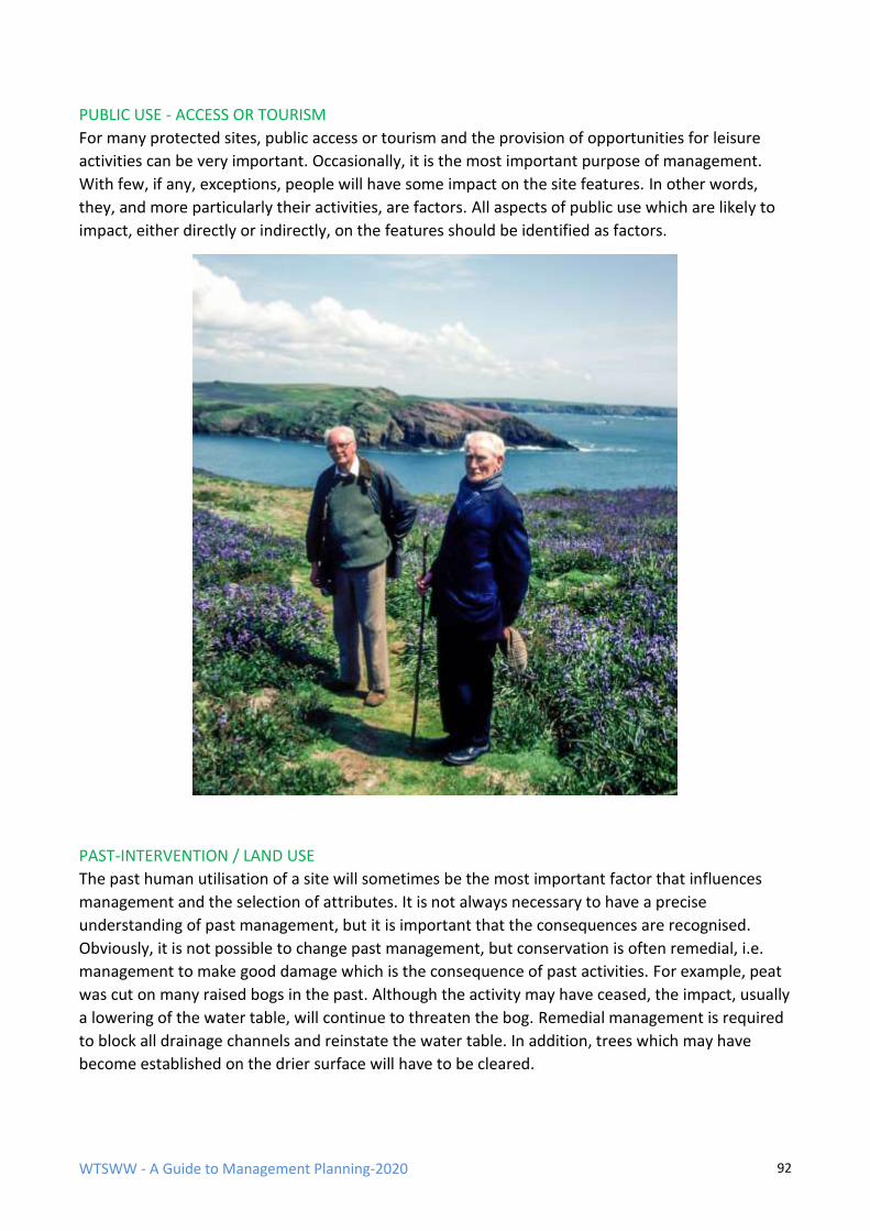
WTSWW - A Guide to Management Planning-2020 92
PUBLIC USE - ACCESS OR TOURISM
For many protected sites, public access or tourism and the provision of opportunities for leisure
activities can be very important. Occasionally, it is the most important purpose of management.
With few, if any, exceptions, people will have some impact on the site features. In other words,
they, and more particularly their activities, are factors. All aspects of public use which are likely to
impact, either directly or indirectly, on the features should be identified as factors.
PAST-INTERVENTION / LAND USE
The past human utilisation of a site will sometimes be the most important factor that influences
management and the selection of attributes. It is not always necessary to have a precise
understanding of past management, but it is important that the consequences are recognised.
Obviously, it is not possible to change past management, but conservation is often remedial, i.e.
management to make good damage which is the consequence of past activities. For example, peat
was cut on many raised bogs in the past. Although the activity may have ceased, the impact, usually
a lowering of the water table, will continue to threaten the bog. Remedial management is required
to block all drainage channels and reinstate the water table. In addition, trees which may have
become established on the drier surface will have to be cleared.
WTSWW - A Guide to Management Planning-2020 93
Sometimes, past intervention is the most important positive factor on a site. This is nearly always
the case when the features are plagioclimatic habitats or communities, for example, hay meadows
and pastures. In these situations, the key to managing the future often lies in an understanding of
the past.
PHYSICAL CONSIDERATIONS/CONSTRAINTS
These can be quite significant, for example, a site may be so remote and inaccessible that
management is impossible. Sites on mountain slopes can be inaccessible to machinery. Sometimes,
when managing a bog, for example, it is difficult or prohibitively expensive to carry out
management works.
RESOURCES
The availability of resources will obviously influence our ability to manage sites and features.
Ideally, a management plan will be used as a bidding document. It sets out the objectives along
with a costed action plan. Senior Managers or donor organisations would then decide on the level
of resource that they would make available for management. If this were always the case,
‘resources’ would not be a significant factor.
Unfortunately, in most circumstances, this does not happen; conservation management is generally
under-resourced. This does not diminish the use of a management plan as a bidding tool. In fact,
quite the opposite is true. In a resource-deprived environment, extraordinary levels of care are
required to ensure that everything is justified before resources are allocated. It is important that
organisations or individuals responsible for managing sites are aware of the actual cost of
management. They can then make decisions about limiting resources with a full understanding of
the consequences of their decisions. In the first instance, resources should not be included as a
factor. Management is identified according to need and then costed. If the required resources are
not made available, resources are later applied as a factor and the proposed management activity is
abandoned or modified. This will often mean that it takes longer to meet the objectives or that
management is less efficient.
SIZE & CONNECTIVITY
“Let’s start by imagining a fine Persian carpet and a hunting knife. The carpet is twelve feet by eighteen. That gives us 216 square feet of continuous woven material . . . When we’re finished cutting, we measure the individual pieces, total them up – and find that there’s still nearly 216 square feet of recognizably carpet-like stuff. But what does it amount to? Have we got thirty-six nice Persian throw rugs? No. All we’re left with is three dozen ragged fragments, each one worthless and commencing to come apart.”
(David Quammen ‘The Song of the Dodo 1997)
An ecosystem is a tapestry of species and relationships. Chop away a section, isolate that
section, and there arises a problem of unravelling.
WTSWW - A Guide to Management Planning-2020 94
It would be extremely unwise to ignore the theory of 'island biogeography'. The theory builds on
the first principles of population ecology and genetics to explain how distance and area combine to
regulate the balance between immigration and extinction in island populations (MacArthur &
Wilson 2001).Expressed in simpler language, the smaller and more isolated an island, the more
likely it is for species to become extinct. On the mainland, localised extinctions of species are not
necessarily a disaster if there are physical links with areas of habitat where the same species has
survived. These species can re-colonise the area if the local factors which led to the original
extinction are brought under control. This is not true of isolated, small islands. When a species
becomes extinct, re-colonisation may never occur without artificial re-introduction. George
Peterken extended the application of the theory by applying it to isolated, fragmented habitats
surrounded by an ecologically degraded landscape.
The size of an area of habitat and its degree of isolation will obviously have significant implications
for sustainability. These factors will influence the management of a habitat. For example, they may
lead to the development of an acquisition strategy if the area of the habitat within a site is
considered too small to be viable, or to the establishment of corridors or linkages with other areas
of similar habitat when the site is isolated.
Connectivity is the re-establishment of linkages between isolated fragments of habitat. Although
connectivity is an essential consideration for most plans, it is not easy to decide where it should be
included in a plan. I have included connectivity as a factor because, if it is an issue on a site, it will
have a significant impact on the management of the features. It will also have some relevance to
the selection of features.
Whenever we recognise the need for improving or maintaining connectivity, or extending a site,
it should be included in the objective. There should always be a presumption in favour of
connectivity and extending sites.
THE PREPARATION OF A MASTER LIST OF FACTORS
Factors are considered for each feature at several key stages in the planning process. However, an
individual factor can have implications for many different features on a site; for some it will be a
positive influence, for others negative. To avoid unnecessary repetition, a master list of all the
factors is prepared at an early stage in the plan. The list should contain all the factors that have
affected, are affecting or may in the future affect any of the features on a site. Once a master list
has been prepared, it can be used to ensure that all the relevant factors are considered for each
feature.
The following table contains examples of the different factors that may be used at various times in
the management plan. The main reason for including a list is that it provides planners with the
prompts which will help to ensure that factors are not unintentionally omitted. In reality, it is
virtually impossible to produce a list that covers everything and, given that there are so many
different factors, the list would be very long and unwieldy. Some of the subheadings will be
important on all sites, while some will rarely be encountered. The lists are not definitive and the
factors could be categorised under a variety of different, but equally valid, headings.
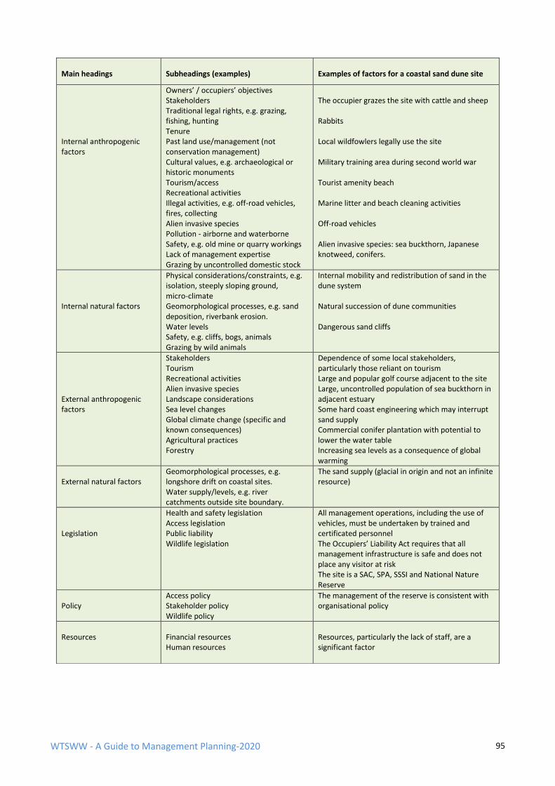
WTSWW - A Guide to Management Planning-2020 95
Main headings
Subheadings (examples)
Examples of factors for a coastal sand dune site
Internal anthropogenic factors
Owners’ / occupiers’ objectives Stakeholders Traditional legal rights, e.g. grazing, fishing, hunting Tenure Past land use/management (not conservation management) Cultural values, e.g. archaeological or historic monuments Tourism/access Recreational activities Illegal activities, e.g. off-road vehicles, fires, collecting Alien invasive species Pollution - airborne and waterborne Safety, e.g. old mine or quarry workings Lack of management expertise Grazing by uncontrolled domestic stock
The occupier grazes the site with cattle and sheep Rabbits Local wildfowlers legally use the site Military training area during second world war Tourist amenity beach Marine litter and beach cleaning activities Off-road vehicles Alien invasive species: sea buckthorn, Japanese knotweed, conifers.
Internal natural factors
Physical considerations/constraints, e.g. isolation, steeply sloping ground, micro-climate Geomorphological processes, e.g. sand deposition, riverbank erosion. Water levels Safety, e.g. cliffs, bogs, animals Grazing by wild animals
Internal mobility and redistribution of sand in the dune system Natural succession of dune communities Dangerous sand cliffs
External anthropogenic factors
Stakeholders Tourism Recreational activities Alien invasive species Landscape considerations Sea level changes Global climate change (specific and known consequences) Agricultural practices Forestry
Dependence of some local stakeholders, particularly those reliant on tourism Large and popular golf course adjacent to the site Large, uncontrolled population of sea buckthorn in adjacent estuary Some hard coast engineering which may interrupt sand supply Commercial conifer plantation with potential to lower the water table Increasing sea levels as a consequence of global warming
External natural factors
Geomorphological processes, e.g. longshore drift on coastal sites. Water supply/levels, e.g. river catchments outside site boundary.
The sand supply (glacial in origin and not an infinite resource)
Legislation
Health and safety legislation Access legislation Public liability Wildlife legislation
All management operations, including the use of vehicles, must be undertaken by trained and certificated personnel The Occupiers’ Liability Act requires that all management infrastructure is safe and does not place any visitor at risk The site is a SAC, SPA, SSSI and National Nature Reserve
Policy
Access policy Stakeholder policy Wildlife policy
The management of the reserve is consistent with organisational policy
Resources
Financial resources Human resources
Resources, particularly the lack of staff, are a significant factor
WTSWW - A Guide to Management Planning-2020 96
PRIMARY AND SECONDARY FACTORS PRIMARY AND SECONDARY FACTORS
The division of factors into ‘primary and ‘secondary’ is another useful, but not essential, process that can
help to ensure that all the important factors have been identified.
The master list of factors is created by brainstorming. This will inevitably identify many factors that are not
relevant to the planning process. These are mainly factors that have not had, and will not have, any impact
on the feature. Much more significantly, brainstorming will usually identify a number of natural factors
which are unchanging, for example, soils, aspect, slope and altitude: these underlying factors are the reasons
why a particular plant community or habitat can exist in any given location. Clearly, they will only change in
extreme circumstances, and so, for planning purposes, they can be set aside. The factors that are relevant to
planning are those that meet the definition given at the beginning of this section: the factors that have the
potential to influence or change a feature, or to affect the way in which a feature is managed. These
influences may exist, or have existed, at any time in the past, present or future.
Primary factors
Primary factors will always have a direct influence on a feature. They will always require direct or indirect
control, and they should be monitored, either directly or indirectly. Examples of primary factors include
grazing, invasive alien species, pollution, burning and offshore dredging.
There is another group of primary factors, those which, although no longer active, were at some time in the
past responsible for changing a feature. Nearly all the examples of this type of factor are past human
intervention or management. For example, many woodlands were felled during the First or Second World
Wars (felling is the factor). The consequences of this are: insufficient dead wood; a young and even-aged
canopy structure; diminished species diversity in the canopy; (in an oak wood) suppressed natural
regeneration of oak.
Secondary factors
Secondary factors have an indirect influence on a feature. They will have implications for our ability to
manage features. For example, one of the primary factors which has a negative influence on an oak wood is
the presence of beech Fagus sylvatica in the canopy. A nature reserve has, over many years, become so
infested with beech that it dominates the canopy. The most efficient and effective way of removing the
beech would be to fell all the trees in as short a time as possible. However, there is a secondary factor: the
woodland reserve sits within an area where the landscape is legally protected. The landscape designation is
concerned with maintaining woodland and does not differentiate between desirable and undesirable canopy
species. The consequence is that the beech trees will have to be removed gradually over a very long period
of time. The eventual outcome will be the same; it will just take longer to get there.
WTSWW - A Guide to Management Planning-2020 97
6 OBJECTIVES
Objectives lie at the very heart of a management plan and, without doubt, are the
single most important section in any plan. An objective is, quite simply, an expression
of something that we want to achieve: our aspiration. It is, and can only be, a
reflection of our values, knowledge and expertise at the time of writing. This means
that, in common with the remainder of the plan, objectives must be reviewed at
intervals.
Management plans must contain objectives, and an objective is a description of something that we
want to achieve. Clearly, what we want will change with time and so must the objectives. The
concept and consequence of using an adaptive approach is described in an earlier section of this
guide. Adaptive management is only possible if we know what we are trying to achieve, even when
this is the unpredictable outcome of enabling natural processes. This is a fundamental component
of any planning process applied to any area of human endeavour. Could an architect produce a plan
for constructing a building if it described only the actions, and did not provide a detailed description
of what the completed building would look like? It is only when we know what we are trying to
achieve that we can determine whether or not our actions are appropriate.
Objectives contain two basic components: a vision which describes in plain language the outcome
or condition that we require for a feature, and performance indicators which are monitored to
provide the evidence that will be used to determine whether the condition that we require is being
met.
SMART Objectives
Specific
Measurable
Achievable (Aspirational)
Relevant
Time-based
The definition of a SMART objective can, with modifications, be applied to wildlife objectives for
most sites. There will be some difficulty in applying SMART to sites where the outcome is specified
but not quantified.
WTSWW - A Guide to Management Planning-2020 98
Specific
Objectives for features must specifically address the feature. An objective must be written to
include each of the features identified as being important during the preceding evaluation. Specific
also implies that objectives should be clearly defined and should not be open to different
interpretations. This is particularly important when preparing objectives for statutory sites where
objectives for must be sufficiently robust and specific to stand up to legal challenge. In most
circumstances wildlife objectives should not be prescriptive: they define the condition required of a
feature, and not the actions taken to obtain or maintain that condition. This difference between
prescription and outcome becomes very blurred when the outcome is the consequence of natural
processes.
Measurable
If objectives are not measurable, how will we ever know that they are being achieved? Clearly,
objectives for features with a defined and quantified outcome must be measurable.
Achievable (Aspirational)
Provided that an outcome could be achieved if resources were available, then the objective should
be considered achievable. In the world of nature conservation we must recognise that it may take
decades, even centuries, to obtain our objectives, and that long before we reach our goal the
objective may have changed. Whenever we achieve a condition that we consider favourable there
should be a long-term commitment to maintaining that condition. (‘Long term’ will be discussed
under the ‘time-based’ heading.) There is also an argument that objectives need not be achievable,
that they should, in fact, be aspirational. If we reach for the treetops we may only collide with the
trunk, but if we aim for the stars we will soar above the trees.
Relevant
Objectives must be relevant and must comply with the strategies, policies and legal obligations that
govern the organisation responsible for managing the site or feature. This should also be taken to
mean that objectives should, in the context of the governance, be desirable.
Time-based
If we recognise that our commitment to nature should be endless and not time-based, and that
management planning is an adaptive process intended to optimise opportunities for wildlife, the
concept of a time-based objective is uncomfortable. An objective for a feature should be a
description of the condition that we want to achieve, and thereafter maintain, in the long term.
However, there is no widely accepted definition of long term, there is certainly no forever, and we
cannot predict how long any particular condition can or should persist. Long term is in the mind of
the beholder; it is as far ahead as anyone can envisage.
WTSWW - A Guide to Management Planning-2020 99
We recognise that all natural features will change (of this we can be certain) and that the degree
and direction of change is not always predictable. An objective can do no more than reflect our
values, knowledge and aspirations at the time that it is written. The cyclic adaptive planning process
was developed as a response to these issues, and an essential element of the process is the
mandatory requirement to review the objectives at intervals. The length of the interval will be
determined by our confidence in the objective, and this will be influenced by a range of different
issues. The most important are:
➢ Our knowledge and understanding of a feature; we often have to manage features, species
and habitats when there is very little available information.
➢ The natural dynamics of a feature. Some habitat features, for example sand dunes, can be
very dynamic, even ephemeral; other features can be very stable.
➢ The quality of the scientific evidence that is available.
➢ Our direct experience of, and competence in, managing the feature.
➢ Changing environmental factors, for example, global climate change.
➢ Changing human values and perceptions.
➢ Each time an objective is reviewed a date, which reflects the confidence of the review team,
should be set for the next review. It is likely that the period between reviews will vary.
Review does not necessarily mean that an objective will be discarded or even modified. In
many cases, the review may confirm that an objective is appropriate and should remain
unchanged.
AN OBJECTIVE MUST BE COMMUNICABLE
An objective must be easily understood by the intended audience. Management plans, and
particularly objectives, are about communicating our intentions, sometimes to a very wide
audience, many of whom will not be scientists or conservationists. In addition to informing others,
the objective must also provide a clear and unequivocal guide for reserve managers. Objectives for
defined outcomes must also be quantified so that they can be monitored. This is quite a tall order;
an objective is a multi-purpose statement that describes the required outcome of a feature
(something that we want to achieve) using both plain and quantified scientific language. The
solution is to prepare composite statements that combine a vision for the feature with quantified
and measurable performance indicators. The first part of the objective, the vision, is a portrait in
words that should create a picture in the reader’s mind of what we want to achieve.
Visions should be written using plain language. They must never be patronising, but they should not
contain difficult or obscure scientific language. For example, the use of scientific species names
should be avoided whenever possible. It is important that the quality of the information conveyed
by the vision is not diminished as a consequence of using plain language. The quantified and
measurable performance indicators which accompany the vision provide the evidence that is used
to assess the status of the feature. The performance indicators, in contrast to the vision, should be
written using precise scientific language which will include scientific names.
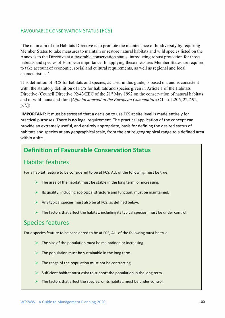
WTSWW - A Guide to Management Planning-2020 100
FAVOURABLE CONSERVATION STATUS (FCS)
‘The main aim of the Habitats Directive is to promote the maintenance of biodiversity by requiring
Member States to take measures to maintain or restore natural habitats and wild species listed on the
Annexes to the Directive at a favorable conservation status, introducing robust protection for those
habitats and species of European importance. In applying these measures Member States are required
to take account of economic, social and cultural requirements, as well as regional and local
characteristics.’
This definition of FCS for habitats and species, as used in this guide, is based on, and is consistent
with, the statutory definition of FCS for habitats and species given in Article 1 of the Habitats
Directive (Council Directive 92/43/EEC of the 21st May 1992 on the conservation of natural habitats
and of wild fauna and flora [Official Journal of the European Communities OJ no. L206, 22.7.92,
p.7.])
IMPORTANT: It must be stressed that a decision to use FCS at site level is made entirely for
practical purposes. There is no legal requirement. The practical application of the concept can
provide an extremely useful, and entirely appropriate, basis for defining the desired status of
habitats and species at any geographical scale, from the entire geographical range to a defined area
within a site.
Definition of Favourable Conservation Status
Habitat features
For a habitat feature to be considered to be at FCS, ALL of the following must be true:
➢ The area of the habitat must be stable in the long term, or increasing.
➢ Its quality, including ecological structure and function, must be maintained.
➢ Any typical species must also be at FCS, as defined below.
➢ The factors that affect the habitat, including its typical species, must be under control.
Species features
For a species feature to be considered to be at FCS, ALL of the following must be true:
➢ The size of the population must be maintained or increasing.
➢ The population must be sustainable in the long term.
➢ The range of the population must not be contracting.
➢ Sufficient habitat must exist to support the population in the long term.
➢ The factors that affect the species, or its habitat, must be under control.
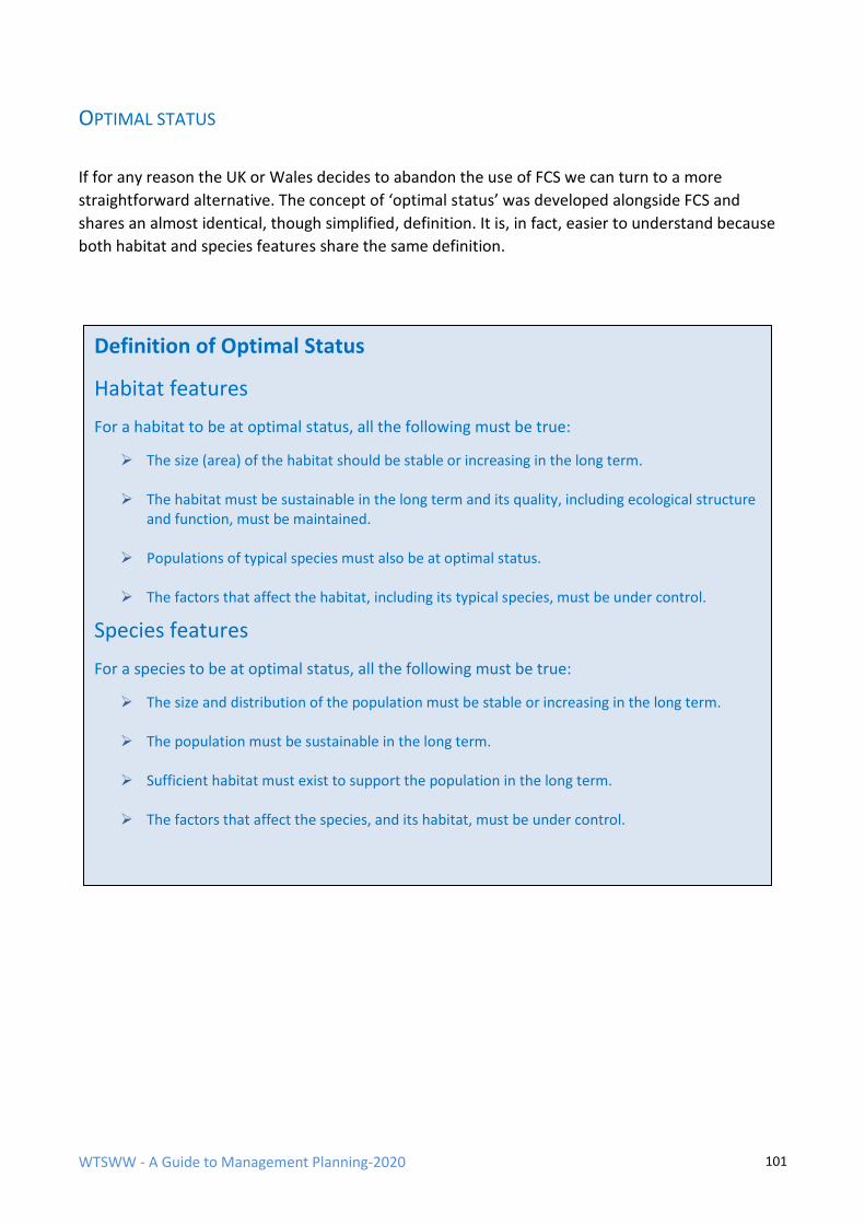
WTSWW - A Guide to Management Planning-2020 101
OPTIMAL STATUS
If for any reason the UK or Wales decides to abandon the use of FCS we can turn to a more
straightforward alternative. The concept of ‘optimal status’ was developed alongside FCS and
shares an almost identical, though simplified, definition. It is, in fact, easier to understand because
both habitat and species features share the same definition.
Definition of Optimal Status
Habitat features
For a habitat to be at optimal status, all the following must be true:
➢ The size (area) of the habitat should be stable or increasing in the long term.
➢ The habitat must be sustainable in the long term and its quality, including ecological structure and function, must be maintained.
➢ Populations of typical species must also be at optimal status.
➢ The factors that affect the habitat, including its typical species, must be under control.
Species features
For a species to be at optimal status, all the following must be true:
➢ The size and distribution of the population must be stable or increasing in the long term.
➢ The population must be sustainable in the long term.
➢ Sufficient habitat must exist to support the population in the long term.
➢ The factors that affect the species, and its habitat, must be under control.
WTSWW - A Guide to Management Planning-2020 102
6.1 VISIONS
Writing an objective for a feature will always be challenging, but it is much easier when the vision is
based on the definition of favourable conservation status or optimal status. FCS and OS are
uncomplicated and common-sense expressions of what we should attempt to achieve for all
important features. I will use FCS for the purpose of this guide. It is a generic statement that could
be applied anywhere but should not, in its original raw form, be used as an objective. It is very
important that objectives are site-specific. Our commitment to maintaining biodiversity must
include an obligation to ensure that local distinctiveness is maintained.
An objective can be built around the FCS definition by dealing with each section of the definition in
turn. Before beginning to create a structured objective, it helps to jot down, in any order, the
qualities or attributes of the feature that are clearly desirable. Consider the current condition of the
feature on the site. If any part, or parts, of the feature appear to be in the required condition, this
provides an excellent starting point for deciding what favourable might mean. In situations where
features are not in a favourable condition, the question should be: why is the feature unfavourable,
and what is the difference between what we see and what we want to see? Experience from other
similar places where the feature is considered to be favourable may help, but do not forget the
importance of local distinctiveness.
VISIONS FOR HABITATS
For a habitat to be at FCS its size must be stable or increasing. This is a very obvious requirement. In
addition to the area occupied by a feature, its distribution can also be extremely important. So, an
objective should begin with some indication of the size and distribution of the feature. In short,
how much do we want and where do we want it. Many nature reserves can be isolated fragments
of habitats, some are so small that the loss of species is almost a certainty, and consequently they
will not be sustainable in the long term. Whenever there is any potential for increasing the size of a
site or improving connectivity, this should be identified in the objective. The easiest and best way of
indicating where something should be is to use a map; there is no reason to restrict the expression
of an objective to the written word. Maps and illustrations should be used whenever they will help
to clarify the objective.
Specifying the desired location of features is occasionally complicated. There are situations where
more than one important habitat feature occupies the same area of a site, and where there is a
requirement to obtain FCS for each of these features. For example, consider a site which contains
two important habitat features; scrub and grassland, could each occupy the same space. At any one
time the site will contain areas of grassland which are free of scrub, areas newly colonised by scrub,
and areas of mature scrub. The total area occupied by scrub will not change, but the distribution of
scrub over the site must change. This means that the objective for scrub should specify an upper
limit and lower limit for the extent of the scrub, but there would be no purpose in expressing limits
for the grassland as it will occupy the remainder of the site. The precise location of the
communities at any time may not be an issue. However, there can be occasions, often as a
consequence of associated species, where the actual distribution of the communities is important.
For example, there may be reason to ensure that the scrub is distributed around the edges of a site.
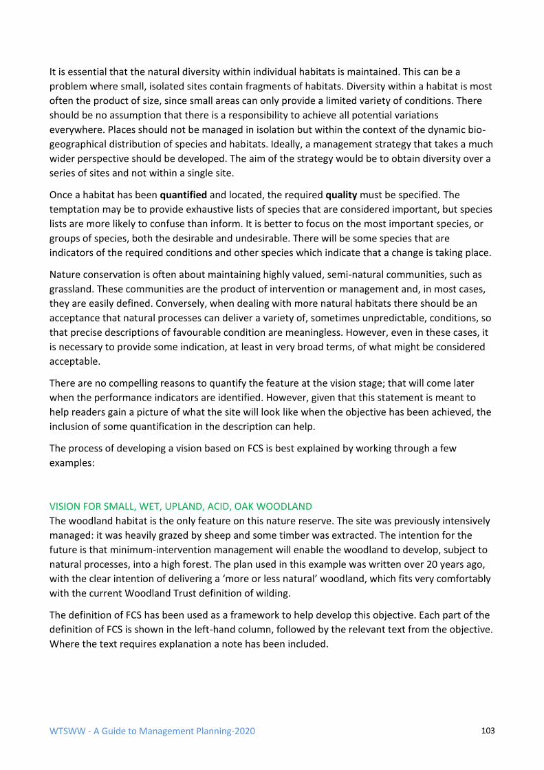
WTSWW - A Guide to Management Planning-2020 103
It is essential that the natural diversity within individual habitats is maintained. This can be a
problem where small, isolated sites contain fragments of habitats. Diversity within a habitat is most
often the product of size, since small areas can only provide a limited variety of conditions. There
should be no assumption that there is a responsibility to achieve all potential variations
everywhere. Places should not be managed in isolation but within the context of the dynamic bio-
geographical distribution of species and habitats. Ideally, a management strategy that takes a much
wider perspective should be developed. The aim of the strategy would be to obtain diversity over a
series of sites and not within a single site.
Once a habitat has been quantified and located, the required quality must be specified. The
temptation may be to provide exhaustive lists of species that are considered important, but species
lists are more likely to confuse than inform. It is better to focus on the most important species, or
groups of species, both the desirable and undesirable. There will be some species that are
indicators of the required conditions and other species which indicate that a change is taking place.
Nature conservation is often about maintaining highly valued, semi-natural communities, such as
grassland. These communities are the product of intervention or management and, in most cases,
they are easily defined. Conversely, when dealing with more natural habitats there should be an
acceptance that natural processes can deliver a variety of, sometimes unpredictable, conditions, so
that precise descriptions of favourable condition are meaningless. However, even in these cases, it
is necessary to provide some indication, at least in very broad terms, of what might be considered
acceptable.
There are no compelling reasons to quantify the feature at the vision stage; that will come later
when the performance indicators are identified. However, given that this statement is meant to
help readers gain a picture of what the site will look like when the objective has been achieved, the
inclusion of some quantification in the description can help.
The process of developing a vision based on FCS is best explained by working through a few
examples:
VISION FOR SMALL, WET, UPLAND, ACID, OAK WOODLAND
The woodland habitat is the only feature on this nature reserve. The site was previously intensively
managed: it was heavily grazed by sheep and some timber was extracted. The intention for the
future is that minimum-intervention management will enable the woodland to develop, subject to
natural processes, into a high forest. The plan used in this example was written over 20 years ago,
with the clear intention of delivering a ‘more or less natural’ woodland, which fits very comfortably
with the current Woodland Trust definition of wilding.
The definition of FCS has been used as a framework to help develop this objective. Each part of the
definition of FCS is shown in the left-hand column, followed by the relevant text from the objective.
Where the text requires explanation a note has been included.
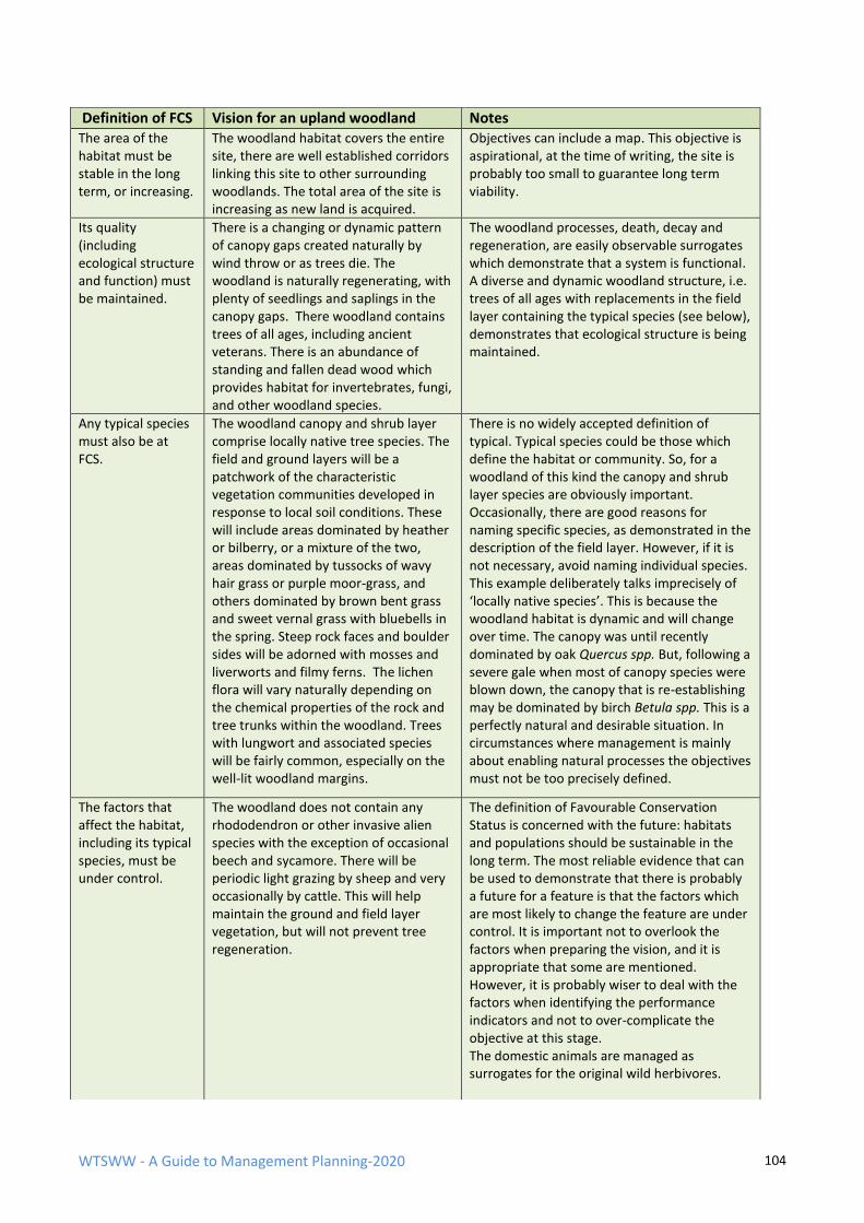
WTSWW - A Guide to Management Planning-2020 104
Definition of FCS Vision for an upland woodland Notes The area of the habitat must be stable in the long term, or increasing.
The woodland habitat covers the entire site, there are well established corridors linking this site to other surrounding woodlands. The total area of the site is increasing as new land is acquired.
Objectives can include a map. This objective is aspirational, at the time of writing, the site is probably too small to guarantee long term viability.
Its quality (including ecological structure and function) must be maintained.
There is a changing or dynamic pattern of canopy gaps created naturally by wind throw or as trees die. The woodland is naturally regenerating, with plenty of seedlings and saplings in the canopy gaps. There woodland contains trees of all ages, including ancient veterans. There is an abundance of standing and fallen dead wood which provides habitat for invertebrates, fungi, and other woodland species.
The woodland processes, death, decay and regeneration, are easily observable surrogates which demonstrate that a system is functional. A diverse and dynamic woodland structure, i.e. trees of all ages with replacements in the field layer containing the typical species (see below), demonstrates that ecological structure is being maintained.
Any typical species must also be at FCS.
The woodland canopy and shrub layer comprise locally native tree species. The field and ground layers will be a patchwork of the characteristic vegetation communities developed in response to local soil conditions. These will include areas dominated by heather or bilberry, or a mixture of the two, areas dominated by tussocks of wavy hair grass or purple moor-grass, and others dominated by brown bent grass and sweet vernal grass with bluebells in the spring. Steep rock faces and boulder sides will be adorned with mosses and liverworts and filmy ferns. The lichen flora will vary naturally depending on the chemical properties of the rock and tree trunks within the woodland. Trees with lungwort and associated species will be fairly common, especially on the well-lit woodland margins.
There is no widely accepted definition of typical. Typical species could be those which define the habitat or community. So, for a woodland of this kind the canopy and shrub layer species are obviously important. Occasionally, there are good reasons for naming specific species, as demonstrated in the description of the field layer. However, if it is not necessary, avoid naming individual species. This example deliberately talks imprecisely of ‘locally native species’. This is because the woodland habitat is dynamic and will change over time. The canopy was until recently dominated by oak Quercus spp. But, following a severe gale when most of canopy species were blown down, the canopy that is re-establishing may be dominated by birch Betula spp. This is a perfectly natural and desirable situation. In circumstances where management is mainly about enabling natural processes the objectives must not be too precisely defined.
The factors that affect the habitat, including its typical species, must be under control.
The woodland does not contain any rhododendron or other invasive alien species with the exception of occasional beech and sycamore. There will be periodic light grazing by sheep and very occasionally by cattle. This will help maintain the ground and field layer vegetation, but will not prevent tree regeneration.
The definition of Favourable Conservation Status is concerned with the future: habitats and populations should be sustainable in the long term. The most reliable evidence that can be used to demonstrate that there is probably a future for a feature is that the factors which are most likely to change the feature are under control. It is important not to overlook the factors when preparing the vision, and it is appropriate that some are mentioned. However, it is probably wiser to deal with the factors when identifying the performance indicators and not to over-complicate the objective at this stage. The domestic animals are managed as surrogates for the original wild herbivores.
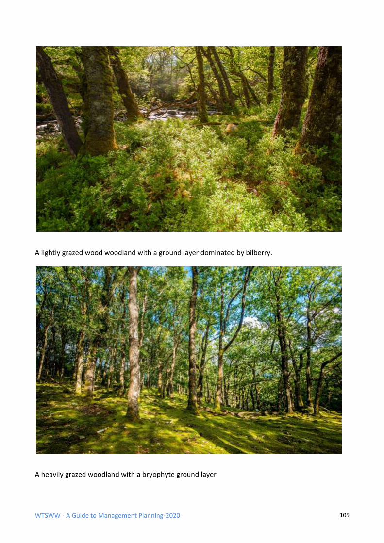
WTSWW - A Guide to Management Planning-2020 105
A lightly grazed wood woodland with a ground layer dominated by bilberry.
A heavily grazed woodland with a bryophyte ground layer
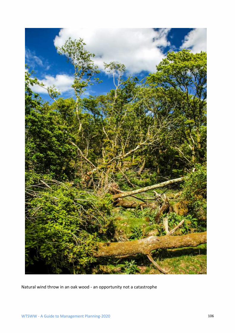
WTSWW - A Guide to Management Planning-2020 106
Natural wind throw in an oak wood - an opportunity not a catastrophe
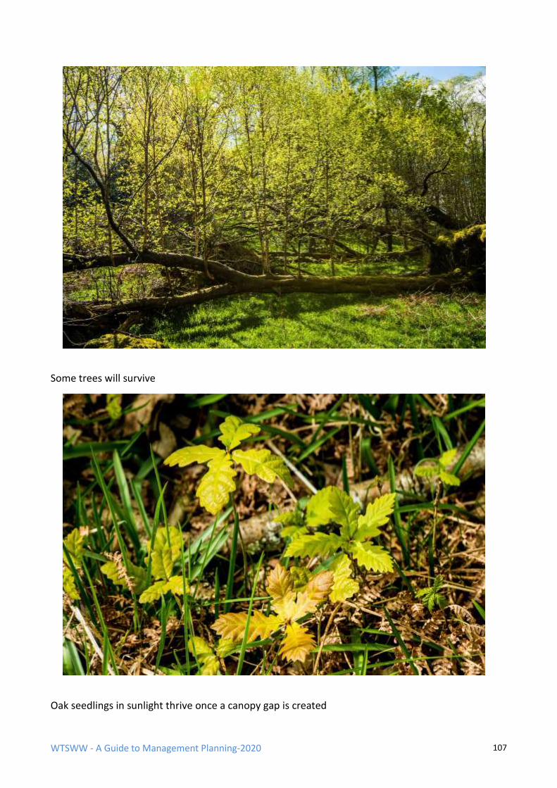
WTSWW - A Guide to Management Planning-2020 107
Some trees will survive
Oak seedlings in sunlight thrive once a canopy gap is created
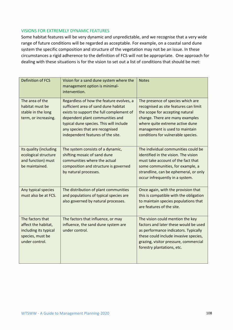
WTSWW - A Guide to Management Planning-2020 108
VISIONS FOR EXTREMELY DYNAMIC FEATURES
Some habitat features will be very dynamic and unpredictable, and we recognise that a very wide
range of future conditions will be regarded as acceptable. For example, on a coastal sand dune
system the specific composition and structure of the vegetation may not be an issue. In these
circumstances a rigid adherence to the definition of FCS will not be appropriate. One approach for
dealing with these situations is for the vision to set out a list of conditions that should be met:
Definition of FCS Vision for a sand dune system where the
management option is minimal-
intervention.
Notes
The area of the
habitat must be
stable in the long
term, or increasing.
Regardless of how the feature evolves, a
sufficient area of sand dune habitat
exists to support the full complement of
dependent plant communities and
typical dune species. This will include
any species that are recognised
independent features of the site.
The presence of species which are
recognised as site features can limit
the scope for accepting natural
change. There are many examples
where quite extreme active dune
management is used to maintain
conditions for vulnerable species.
Its quality (including
ecological structure
and function) must
be maintained.
The system consists of a dynamic,
shifting mosaic of sand dune
communities where the actual
composition and structure is governed
by natural processes.
The individual communities could be
identified in the vision. The vision
must take account of the fact that
some communities, for example, a
strandline, can be ephemeral, or only
occur infrequently in a system.
Any typical species
must also be at FCS.
The distribution of plant communities
and populations of typical species are
also governed by natural processes.
Once again, with the provision that
this is compatible with the obligation
to maintain species populations that
are features of the site.
The factors that
affect the habitat,
including its typical
species, must be
under control.
The factors that influence, or may
influence, the sand dune system are
under control.
The vision could mention the key
factors and later these would be used
as performance indicators. Typically
these could include invasive species,
grazing, visitor pressure, commercial
forestry plantations, etc.
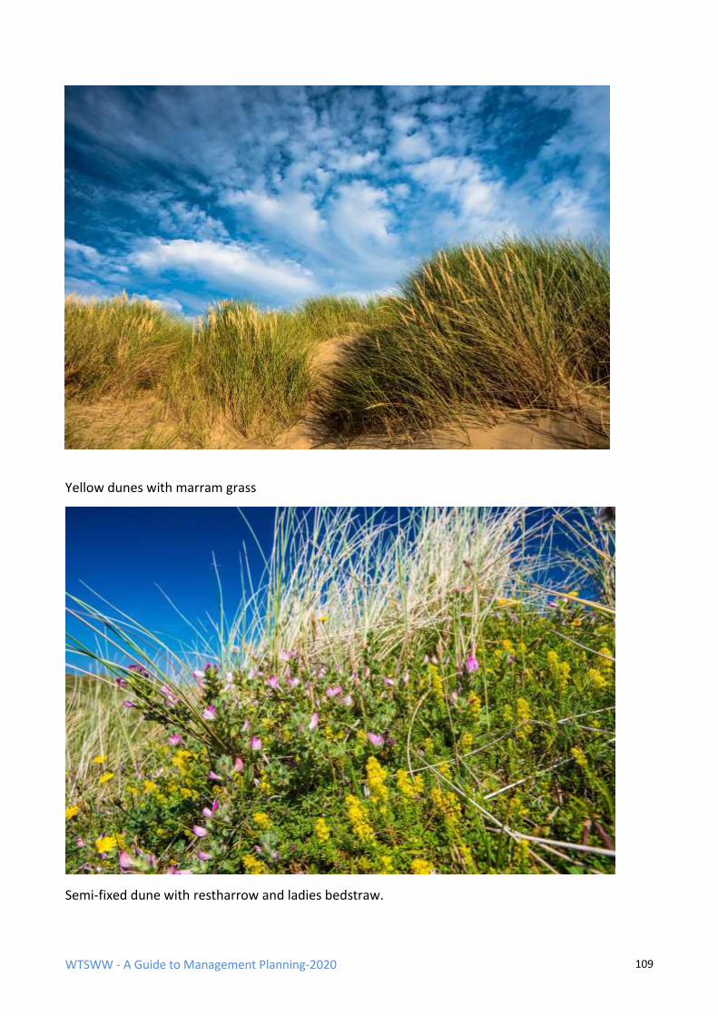
WTSWW - A Guide to Management Planning-2020 109
Yellow dunes with marram grass
Semi-fixed dune with restharrow and ladies bedstraw.
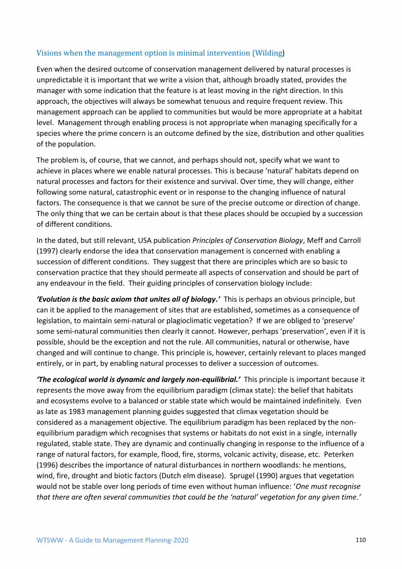
WTSWW - A Guide to Management Planning-2020 110
Visions when the management option is minimal intervention (Wilding)
Even when the desired outcome of conservation management delivered by natural processes is
unpredictable it is important that we write a vision that, although broadly stated, provides the
manager with some indication that the feature is at least moving in the right direction. In this
approach, the objectives will always be somewhat tenuous and require frequent review. This
management approach can be applied to communities but would be more appropriate at a habitat
level. Management through enabling process is not appropriate when managing specifically for a
species where the prime concern is an outcome defined by the size, distribution and other qualities
of the population.
The problem is, of course, that we cannot, and perhaps should not, specify what we want to
achieve in places where we enable natural processes. This is because ‘natural’ habitats depend on
natural processes and factors for their existence and survival. Over time, they will change, either
following some natural, catastrophic event or in response to the changing influence of natural
factors. The consequence is that we cannot be sure of the precise outcome or direction of change.
The only thing that we can be certain about is that these places should be occupied by a succession
of different conditions.
In the dated, but still relevant, USA publication Principles of Conservation Biology, Meff and Carroll
(1997) clearly endorse the idea that conservation management is concerned with enabling a
succession of different conditions. They suggest that there are principles which are so basic to
conservation practice that they should permeate all aspects of conservation and should be part of
any endeavour in the field. Their guiding principles of conservation biology include:
‘Evolution is the basic axiom that unites all of biology.’ This is perhaps an obvious principle, but
can it be applied to the management of sites that are established, sometimes as a consequence of
legislation, to maintain semi-natural or plagioclimatic vegetation? If we are obliged to ‘preserve’
some semi-natural communities then clearly it cannot. However, perhaps ‘preservation’, even if it is
possible, should be the exception and not the rule. All communities, natural or otherwise, have
changed and will continue to change. This principle is, however, certainly relevant to places manged
entirely, or in part, by enabling natural processes to deliver a succession of outcomes.
‘The ecological world is dynamic and largely non-equilibrial.’ This principle is important because it
represents the move away from the equilibrium paradigm (climax state): the belief that habitats
and ecosystems evolve to a balanced or stable state which would be maintained indefinitely. Even
as late as 1983 management planning guides suggested that climax vegetation should be
considered as a management objective. The equilibrium paradigm has been replaced by the non-
equilibrium paradigm which recognises that systems or habitats do not exist in a single, internally
regulated, stable state. They are dynamic and continually changing in response to the influence of a
range of natural factors, for example, flood, fire, storms, volcanic activity, disease, etc. Peterken
(1996) describes the importance of natural disturbances in northern woodlands: he mentions,
wind, fire, drought and biotic factors (Dutch elm disease). Sprugel (1990) argues that vegetation
would not be stable over long periods of time even without human influence: ‘One must recognise
that there are often several communities that could be the ‘natural’ vegetation for any given time.’
WTSWW - A Guide to Management Planning-2020 111
He used African savannas, the Big Woods of Minnesota and the lodge pole pine forests of
Yellowstone National Park as examples.
One of the few things that we can be certain of when we adopt a minimal-intervention option is
that these places will change, but how will we know that the changes that we observe are
acceptable? What might acceptable mean? Will we ever be able to differentiate between changes
that are a consequence of anthropogenic or natural factors? The impact of humanity is all-
pervasive: there is no corner of this world that has escaped our influence.
I have mentioned that, although the outcomes of minimal intervention would be unpredictable,
since they are more or less the product of natural processes, any outcome could be regarded as
acceptable. However, if nature conservation is to have any purpose it should contribute towards
preventing, or at least reducing, the rate of extinction of species and habitats. This would mean that
management should be about working with, or enabling, natural processes to deliver something
that at least optimises opportunities for nature. When working in cultural landscapes, ideally, we
should have some means of defining and measuring nature conservation benefits or, at least, of
obtaining evidence to suggest that conditions are moving in an acceptable direction and certainly
not declining. This does not necessarily mean that the site should be becoming more diverse. For
example, the optimal diversity on a raised bog would have a very low number of specialised
species. A degraded bog would have many more common species, usually displacing the typical
bog species.
Visions for minimal-intervention sites can appear to be rather negative. Many years ago I wrote a
management plan for a virgin cloud forest in Costa Rica. Our vision was quite obviously to retain the
forest in its current, pristine condition, allowing for the natural processes and dynamics to dictate
all outcomes. The plan focused on the anthropogenic influences or factors. We simply identified all
the actual and potential human activities that were having, or could in the future have, an impact
on the forest, and then set limits which were an expression of our tolerance of these factors. For
example, although green tourism was an essential source of revenue, strict upper limits were
applied to the number of visitors permitted access to the forest. We also limited the locations
where access was permitted.
The following example is taken from the Skomer Island management plan. The management option
for the vegetation is minimal intervention, and the vision is a deliberately succinct statement which
simply states that natural processes will be enabled but constrained by specified limits. Skomer is
internationally recognised as one of the most important seabird sites in Britain. The seabirds, and a
few important terrestrial species, occupy the entire island, and, consequently, managers incur a
responsibility to ensure, regardless of the intrinsic or scientific value of the vegetation, that it is
maintained in a condition which meets the needs of the breeding bird populations. The conclusion
of the discussion leading to the development of the vision can be summarised:
➢ Nature conservation on Skomer will be concerned with what we require of the future and not about recreating or fossilising the past.
➢ We recognise the need, whenever possible, to move away from an approach to nature conservation
that is almost entirely based on achieving defined or specified outcomes.
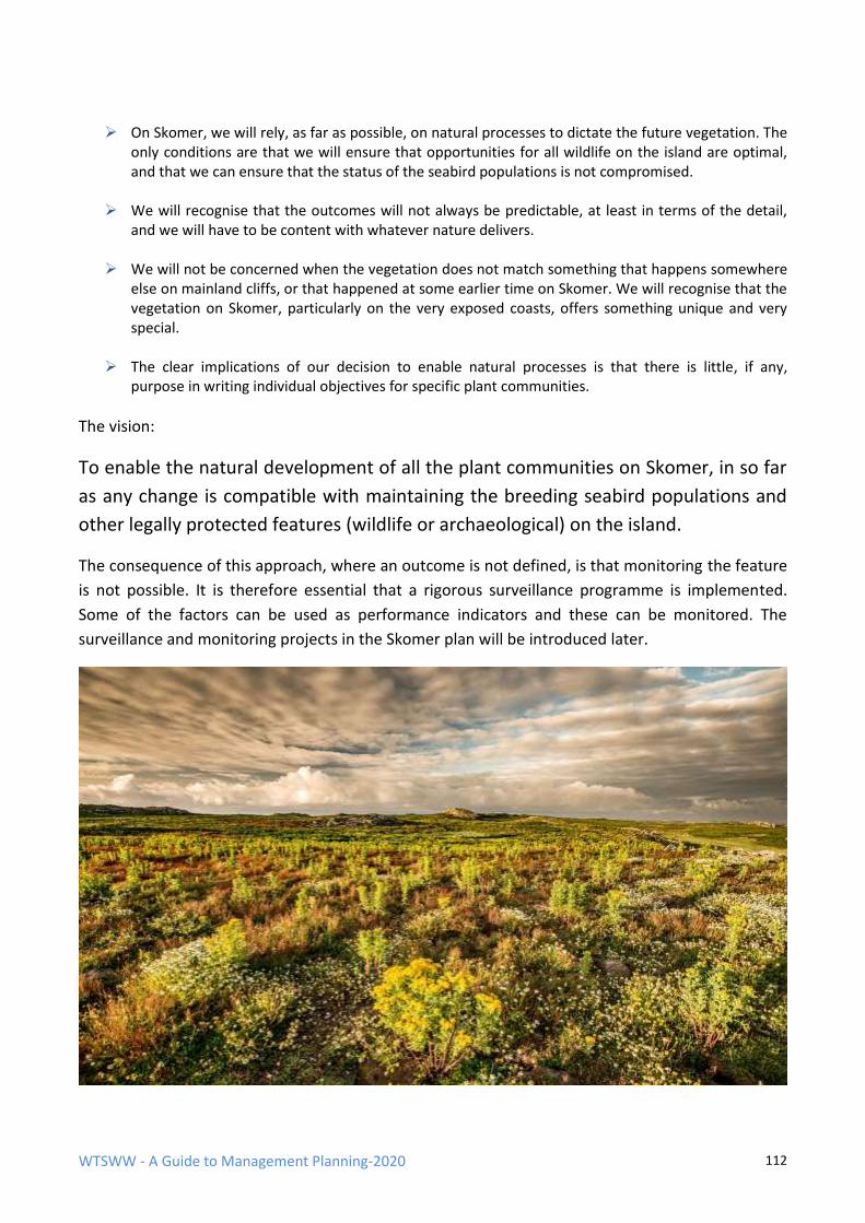
WTSWW - A Guide to Management Planning-2020 112
➢ On Skomer, we will rely, as far as possible, on natural processes to dictate the future vegetation. The
only conditions are that we will ensure that opportunities for all wildlife on the island are optimal, and that we can ensure that the status of the seabird populations is not compromised.
➢ We will recognise that the outcomes will not always be predictable, at least in terms of the detail,
and we will have to be content with whatever nature delivers.
➢ We will not be concerned when the vegetation does not match something that happens somewhere else on mainland cliffs, or that happened at some earlier time on Skomer. We will recognise that the vegetation on Skomer, particularly on the very exposed coasts, offers something unique and very special.
➢ The clear implications of our decision to enable natural processes is that there is little, if any,
purpose in writing individual objectives for specific plant communities.
The vision:
To enable the natural development of all the plant communities on Skomer, in so far
as any change is compatible with maintaining the breeding seabird populations and
other legally protected features (wildlife or archaeological) on the island.
The consequence of this approach, where an outcome is not defined, is that monitoring the feature
is not possible. It is therefore essential that a rigorous surveillance programme is implemented.
Some of the factors can be used as performance indicators and these can be monitored. The
surveillance and monitoring projects in the Skomer plan will be introduced later.
WTSWW - A Guide to Management Planning-2020 113
VISIONS FOR SPECIES
It is invariably easier to write a vision for the population of a species than it is to write a vision for a
habitat. This is because, in most cases, there is significantly less that can be said about a population.
We can describe the size and distribution of a population, the site-specific factors and, in
exceptional circumstances, the age structure, survival and productivity rates, and that is all.
The following example is from Skomer Island which has extremely important colonies of seabirds.
One of the Natura 2000 SPA features is a population of guillemots Uria aalge. Guillemots are
members of the auk Alcidae family. They are quite large, cliff-nesting, diving seabirds, with a
northern distribution in Europe. This example is chosen because of the exceptionally good
information that is available for this particular site. In this sense it is atypical. For most species
features there is very little information available on population dynamics, and for many there are
no reliable means of assessing population size or trends. This example tackles one of the more
difficult, though widely encountered, problems in species management: the management of a
protected area where the most important species are mobile or migratory, and where they depend
on an area for only part of their annual life cycle.
Note: The most significant factor as far as any species is concerned is the habitat that supports it.
However, because habitats are so important for species, the definition of FCS gives them specific
attention and deals with them separately from the other factors. This is confusing because, at a
later stage, the definition of FCS states that the factors affecting the habitat must also be under
control. The need to treat the habitat that supports an important species as an independent
feature, even when it does not qualify as a feature, was explained earlier. This example for
guillemots is an exception to that general guidance. The nesting habitats are rocky cliffs where the
vegetation is irrelevant; all that matters is that the area is free from excessive human disturbance
and ground predators. Consequently, in this case there is no need to write an objective for the
habitat. The guillemots use the island as a place to breed and nothing more. They spend the greater
part of the year offshore. Adults are present at sea, but reasonably close to the breeding colonies,
throughout the year. Younger birds disperse widely over a larger area in the Atlantic. Therefore, the
important habitat is the sea and wider ocean. Clearly, we cannot write an objective for the
southern Irish Sea or the Atlantic Ocean. In this particular circumstance, the sea immediately
surrounding the island is a marine nature reserve. Together, the terrestrial and marine reserve can
do no more than contribute towards protecting the species from local human disturbance. Two of
the most important anthropogenic factors are marine pollution, particularly oil spills, and
commercial fishing, but apart from identifying the factors and recognising their potential impact
there is not much else that can be done in the local management plan. These are global problems,
and they must be dealt with at that level. This does not in any way negate the value of an objective
when the control of factors lies outside the remit of site management. Information from the
individual sites, and the failure or otherwise to meet local objectives, will inform politicians and
others responsible for policy and legislation.
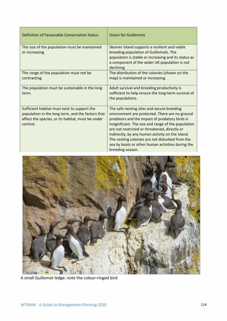
WTSWW - A Guide to Management Planning-2020 114
A small Guillemot ledge: note the colour-ringed bird
Definition of Favourable Conservation Status
Vision for Guillemots
The size of the population must be maintained or increasing.
Skomer Island supports a resilient and viable breeding population of Guillemots. The population is stable or increasing and its status as a component of the wider UK population is not declining
The range of the population must not be contracting.
The distribution of the colonies (shown on the map) is maintained or increasing.
The population must be sustainable in the long term.
Adult survival and breeding productivity is sufficient to help ensure the long-term survival of the populations.
Sufficient habitat must exist to support the population in the long term, and the factors that affect the species, or its habitat, must be under control.
The safe nesting sites and secure breeding environment are protected. There are no ground predators and the impact of predatory birds is insignificant. The size and range of the population are not restricted or threatened, directly or indirectly, by any human activity on the island. The nesting colonies are not disturbed from the sea by boats or other human activities during the breeding season.
WTSWW - A Guide to Management Planning-2020 115
6.2 PERFORMANCE INDICATORS If we try to apply the SMART test of an objective to the examples of visions given above, they will
fail. With a few minor exceptions, the visions do not quantify the features in a way that makes it
possible for the objective to be measured. It is neither possible nor necessary to quantify every
aspect of a feature, and quantification is only part of the issue; there is little purpose in quantifying
something if it cannot be measured.
A number of performance indicators can be used to quantify the objective and provide the
evidence that a feature is in a favourable condition or otherwise. The evidence will not be sufficient
to allow a conclusion to be proven beyond any reasonable doubt, but we are dealing with wildlife
and not criminal law. A feature can only be considered to be favourable when the values of all the
performance indicators fall within the specified range. A balance must be struck between having
sufficient performance indicators to minimise the risk of errors and the cost implications of having
too many. All performance indicators must be monitored - that is their entire purpose - but
monitoring can be very expensive, and there are inadequate resources for nature conservation.
FAVOURABLE CONDITION AND FAVOURABLE CONSERVATION STATUS
So far, the case for performance indicators which provide evidence that a feature is at favourable
or optimal condition, or otherwise, has been discussed. This is the condition of a feature when the
desired outcome has been achieved. The example of a vision for a woodland describes the
favourable condition of the wood. This is rather like a snapshot taken at some point in time, but it
gives no indication of the factors that must be under control for the condition of the woodland to
be considered sustainable. Two of the factors which affect the woodland are grazing and invasive
alien species. For a feature to be at favourable conservation status, the condition of the feature
must be favourable, and this condition must be sustainable in the long term. An objective based on
FCS must, therefore, deal with both aspects of the definition and, consequently, two different kinds
of performance indicators are used to monitor an objective. These are:
• Quantified attributes with limits which, when monitored, provide evidence about the
condition of a feature.
• Factors with limits which, when monitored, provide the evidence that the factors are under
control or otherwise.
There is a slight complication. Factors are the agents of change, and attributes are the
characteristics of a feature which change as a consequence of the factors. Consequently, the
selection of attributes as performance indicators should, to some extent, be guided by the presence
of factors. This also means that the evidence that can be used to demonstrate that a factor is under
control can be obtained directly, by measuring the factor, or indirectly, by measuring the attribute
which changes as a consequence of the factor. The only difficult issue is that there is a need to
introduce both factors and attributes at the same time. Clearly, this is impossible, so, following
some sort of logic, attributes will be introduced first. However, you might want to refer to the
section on factors while reading about attributes.
WTSWW - A Guide to Management Planning-2020 116
ATTRIBUTES AS PERFORMANCE INDICATORS
An attribute is a characteristic of a feature that can be monitored to provide evidence
about the condition of the feature.
Examples of attributes
For species
Quantity
• The size of a population, for example:
o The total number of individuals present
o The total number of breeding adults
o The population at a specified point in an annual cycle
o The distribution of a population
Quality
• Adult survival rates
• Productivity
• Age structure
• Sex ratio
For habitats
Quantity
• The size of the area occupied by the habitat, or by one or more constituent
communities
• The distribution of the habitat, or of one or more constituent communities
Quality
• Physical structure (a wide range of attributes is possible here, and they are very
feature-specific)
• Presence, abundance, relative proportions, distribution of individual species, or
groups of species, indicative of condition
• Presence, abundance, relative proportions, distribution of individual species, or
groups of species, indicative of change
WTSWW - A Guide to Management Planning-2020 117
Additional attributes for woodland
Quality
• Tree and shrub layer canopy cover
• Tree and shrub canopy composition
• Canopy gap creation rate
• Tree regeneration
• Age structure of trees
• Volume of dead wood
• Field and ground layer composition
SELECTING ATTRIBUTES The best guide for the selection of attributes is the definition of FCS; this has already been used to
construct the vision. It is important that there is consistency between the vision and the choice of
attributes. By this I mean that the attributes that are selected as performance indicators should
also have been mentioned in the vision.
ATTRIBUTES SHOULD, WHENEVER POSSIBLE, BE INDICATORS OF THE FUTURE RATHER THAN
THE PAST
It is essential that attributes tell us that a change is taking place before a feature is seriously
damaged, and not that a change has taken place.
THE SELECTION OF SOME ATTRIBUTES SHOULD BE GUIDED BY FACTORS
All the important factors, and particularly the primary factors, have been identified by this stage in
the plan. The selection of attributes should, to some extent, be guided by the presence of factors.
While factors are the influences that can change or maintain a feature, attributes reflect the
changes that take place, or the conditions that prevail as a consequence of these influences. This
means that the evidence to demonstrate that a factor is under control can be obtained directly, by
measuring the factor, or indirectly, by measuring the attribute that changes as a consequence of
the factor.
Factors that no longer have any influence on a feature will also influence the choice of attributes.
The past management of a site will sometimes be the most important factor that influences the
selection of attributes. It is not always necessary to have a precise understanding of past
management, but it is important that the consequences are recognised.
The relationship between factors and the selection of attributes for habitats and plant communities
is very important. It is clearly impossible to measure everything in a plant community, let alone a
habitat. Even if we could, it would be prohibitively expensive and quite unnecessary. There is a
need to focus on a limited range of attributes which, together, can provide sufficient evidence to
reveal the condition of the feature.
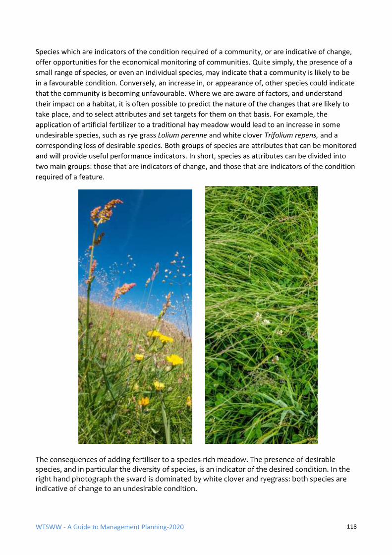
WTSWW - A Guide to Management Planning-2020 118
Species which are indicators of the condition required of a community, or are indicative of change,
offer opportunities for the economical monitoring of communities. Quite simply, the presence of a
small range of species, or even an individual species, may indicate that a community is likely to be
in a favourable condition. Conversely, an increase in, or appearance of, other species could indicate
that the community is becoming unfavourable. Where we are aware of factors, and understand
their impact on a habitat, it is often possible to predict the nature of the changes that are likely to
take place, and to select attributes and set targets for them on that basis. For example, the
application of artificial fertilizer to a traditional hay meadow would lead to an increase in some
undesirable species, such as rye grass Lolium perenne and white clover Trifolium repens, and a
corresponding loss of desirable species. Both groups of species are attributes that can be monitored
and will provide useful performance indicators. In short, species as attributes can be divided into
two main groups: those that are indicators of change, and those that are indicators of the condition
required of a feature.
The consequences of adding fertiliser to a species-rich meadow. The presence of desirable species, and in particular the diversity of species, is an indicator of the desired condition. In the right hand photograph the sward is dominated by white clover and ryegrass: both species are indicative of change to an undesirable condition.
WTSWW - A Guide to Management Planning-2020 119
ATTRIBUTES MUST BE QUANTIFIABLE AND MEASURABLE
Attributes must be quantifiable and measurable so that they can be monitored; that is their entire
purpose. When making the initial selection of attributes, it is important to consider, and describe in
outline, how the attribute will be monitored. The details of the monitoring methodology can be left
until later.
It is essential that the reasons for selecting each of the attributes that will be used as performance
indicators are clearly explained in the management plan. This should include an explanation of why
an attribute has been selected, what information it is intended to convey, and what, if any, is the
relationship between the attribute and the factors.
MONITORING ATTRIBUTES
Whenever attributes are identified they must be monitored: that is their purpose. Monitoring
attributes provides some of the evidence that is used in the assessment of the conservation status
of the features. (Monitoring is surveillance undertaken to ensure that formulated standards are
being maintained.)
This approach to management planning recognises that monitoring is an integral component of the
planning process and particularly of the objectives. There is, of course, a penalty: a monitoring
project must be developed for every performance indicator.
ATTRIBUTES ARE NOT OBJECTIVES The exclusive use of attributes that can be monitored is a dubious basis for defining objectives. In
the UK, some organisations have adopted an approach to setting management objectives which is
entirely based on those attributes that can be monitored. In other words, there is no vision
statement. The consequence is that the expression of an objective is guided by, and limited to,
something that can be monitored: if it can’t be counted it doesn’t count.
SPECIFIED LIMITS
Specified limits define the degree to which the value of a performance indicator is
allowed to fluctuate without creating any cause for concern.
SPECIFIED LIMITS FOR ATTRIBUTES
In ideal circumstances, attributes would have two values: an upper limit and a lower limit.
Unfortunately, it is not always possible to define both limits. Specified limits were developed in
recognition of the inherent dynamics and cyclical change in populations and communities, and in
acknowledgement of the fact that such variation is often acceptable in conservation terms. In
reality, there are very few features for which the inherent fluctuations are fully understood. For a
population, the lower limit might be the threshold beyond which that population will cease to be
viable. However, even if the viability threshold is known, it is at best incautious and at worst
foolhardy to set a lower limit close to the point of possible extinction. The upper limit could be the
point at which a population might begin to threaten another important feature, or where a
population becomes so large that it risks compromising the habitat that supports it. Often, upper
limits may be unnecessary. In many ways, specified limits can be regarded as limits of confidence.
When the value of all attributes falls within the specified limits, we can be confident that the
feature is in a favourable condition, and if all factors are also within their limits we can conclude
that the feature is at favourable conservation status.
WTSWW - A Guide to Management Planning-2020 120
It is important to remember that the identification of specified limits will always require a degree of
judgement. Firstly, it is rare to have robust empirical datasets that show the inherent variability of
features from which specified limits can be directly derived. The best that can be done in many
cases is to set limits using expert judgement (expert in terms of the feature generally and in terms
of knowledge of the site), backed up by some form of peer review and corporate ownership gained
through the management planning approval process. Conservation objectives are about what we
want on sites, and this is not necessarily what we currently have. Specified limits are primarily value
judgements rather than scientifically derived figures (McCool & Cole1998; Thomas & Middleton
2003).
WHAT HAPPENS WHEN A LIMIT IS EXCEEDED? The key to understanding how limits work is to understand how we should respond to a limit when
it is exceeded. Attributes with limits represent part of the evidence required in order to judge
whether or not an objective is being met. Part, because, when taken alone, the values of the
attributes describe the condition of a feature: they can tell us whether it is acceptable or otherwise.
Objectives are concerned with defining the status of a feature, and so additional evidence is
required to demonstrate that the factors are under control. For the condition of a feature to be
considered favourable, the values of all the attributes must fall within the specified limits. However,
for a feature to be considered unfavourable, only one limit need be exceeded. When this happens,
the following procedure should be adopted:
• The monitoring project and the data collected must be checked to ensure that there are no
errors. If everything is in order proceed to the next step. If not, the monitoring project
should be amended and any decision deferred until the monitoring project has been
corrected.
• If a change has taken place and the limit has been exceeded, the reason for the change must
be established. Changes happen because of the impact of a factor, or factors, or the lack of
appropriate management. Where the reason for a change is known, remedial management
can be carried out to deal with the factor, or to improve management.
• When a change has taken place and the reason is unknown a research project should be
established to identify the cause.
Do not forget the precautionary principle: we do not need conclusive, scientific proof in order to
take an action to protect a feature.
AN EXAMPLE OF ATTRIBUTES USED TO MONITOR A SEABIRD POPULATION
The first requirement of favourable conservation status is: the size of the population must be
maintained or increasing. In this example, the size of the population is measured in two different
ways. A whole island count, which also provides information on the distribution of the colonies, and
more accurate counts at long-established study plots. Distribution is also a very useful attribute; it
is not unusual for the distribution of a population to change without any consequential changes to
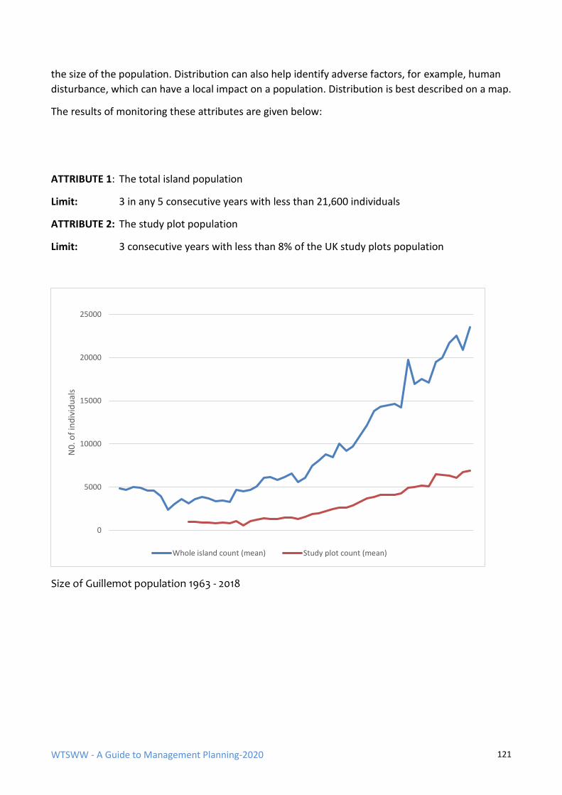
WTSWW - A Guide to Management Planning-2020 121
the size of the population. Distribution can also help identify adverse factors, for example, human
disturbance, which can have a local impact on a population. Distribution is best described on a map.
The results of monitoring these attributes are given below:
ATTRIBUTE 1: The total island population
Limit: 3 in any 5 consecutive years with less than 21,600 individuals
ATTRIBUTE 2: The study plot population
Limit: 3 consecutive years with less than 8% of the UK study plots population
Size of Guillemot population 1963 - 2018
0
5000
10000
15000
20000
25000
N0
. of
ind
ivid
ual
s
Whole island count (mean) Study plot count (mean)
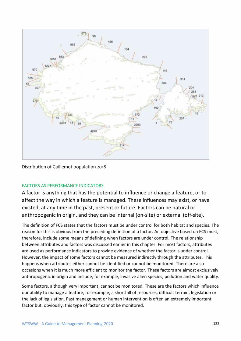
WTSWW - A Guide to Management Planning-2020 122
Distribution of Guillemot population 2018
FACTORS AS PERFORMANCE INDICATORS
A factor is anything that has the potential to influence or change a feature, or to
affect the way in which a feature is managed. These influences may exist, or have
existed, at any time in the past, present or future. Factors can be natural or
anthropogenic in origin, and they can be internal (on-site) or external (off-site).
The definition of FCS states that the factors must be under control for both habitat and species. The
reason for this is obvious from the preceding definition of a factor. An objective based on FCS must,
therefore, include some means of defining when factors are under control. The relationship
between attributes and factors was discussed earlier in this chapter. For most factors, attributes
are used as performance indicators to provide evidence of whether the factor is under control.
However, the impact of some factors cannot be measured indirectly through the attributes. This
happens when attributes either cannot be identified or cannot be monitored. There are also
occasions when it is much more efficient to monitor the factor. These factors are almost exclusively
anthropogenic in origin and include, for example, invasive alien species, pollution and water quality.
Some factors, although very important, cannot be monitored. These are the factors which influence
our ability to manage a feature, for example, a shortfall of resources, difficult terrain, legislation or
the lack of legislation. Past management or human intervention is often an extremely important
factor but, obviously, this type of factor cannot be monitored.
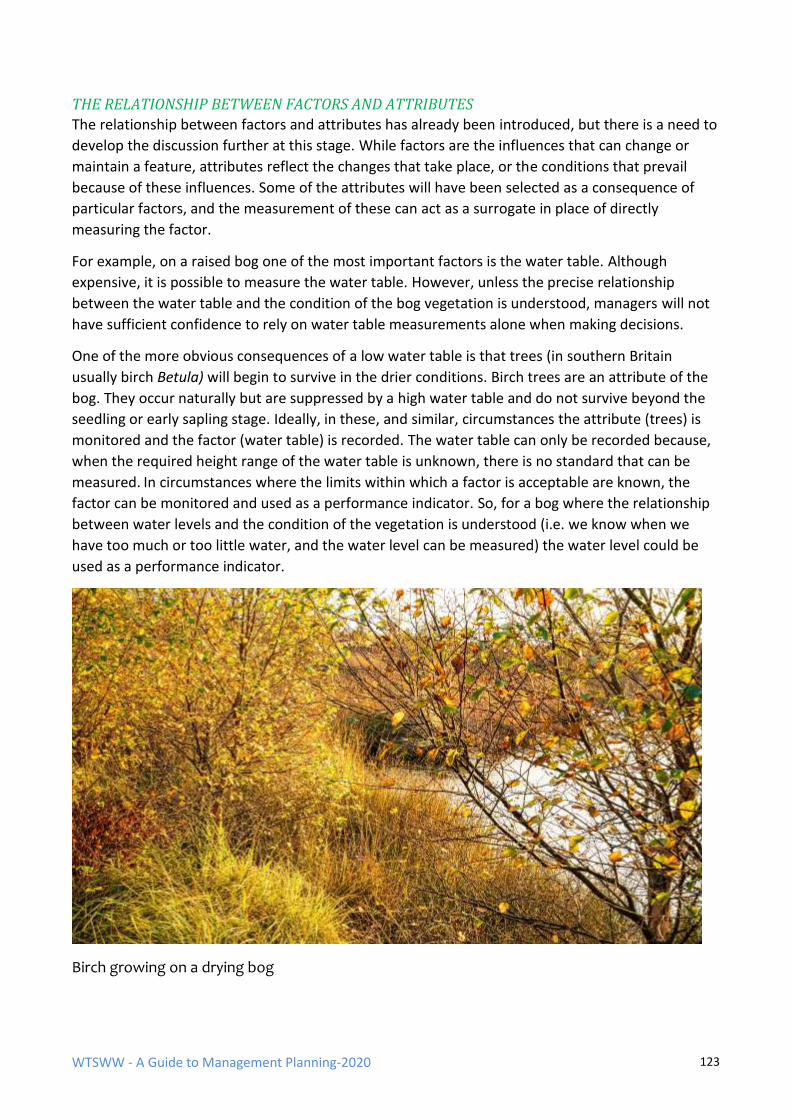
WTSWW - A Guide to Management Planning-2020 123
THE RELATIONSHIP BETWEEN FACTORS AND ATTRIBUTES
The relationship between factors and attributes has already been introduced, but there is a need to
develop the discussion further at this stage. While factors are the influences that can change or
maintain a feature, attributes reflect the changes that take place, or the conditions that prevail
because of these influences. Some of the attributes will have been selected as a consequence of
particular factors, and the measurement of these can act as a surrogate in place of directly
measuring the factor.
For example, on a raised bog one of the most important factors is the water table. Although
expensive, it is possible to measure the water table. However, unless the precise relationship
between the water table and the condition of the bog vegetation is understood, managers will not
have sufficient confidence to rely on water table measurements alone when making decisions.
One of the more obvious consequences of a low water table is that trees (in southern Britain
usually birch Betula) will begin to survive in the drier conditions. Birch trees are an attribute of the
bog. They occur naturally but are suppressed by a high water table and do not survive beyond the
seedling or early sapling stage. Ideally, in these, and similar, circumstances the attribute (trees) is
monitored and the factor (water table) is recorded. The water table can only be recorded because,
when the required height range of the water table is unknown, there is no standard that can be
measured. In circumstances where the limits within which a factor is acceptable are known, the
factor can be monitored and used as a performance indicator. So, for a bog where the relationship
between water levels and the condition of the vegetation is understood (i.e. we know when we
have too much or too little water, and the water level can be measured) the water level could be
used as a performance indicator.
Birch growing on a drying bog
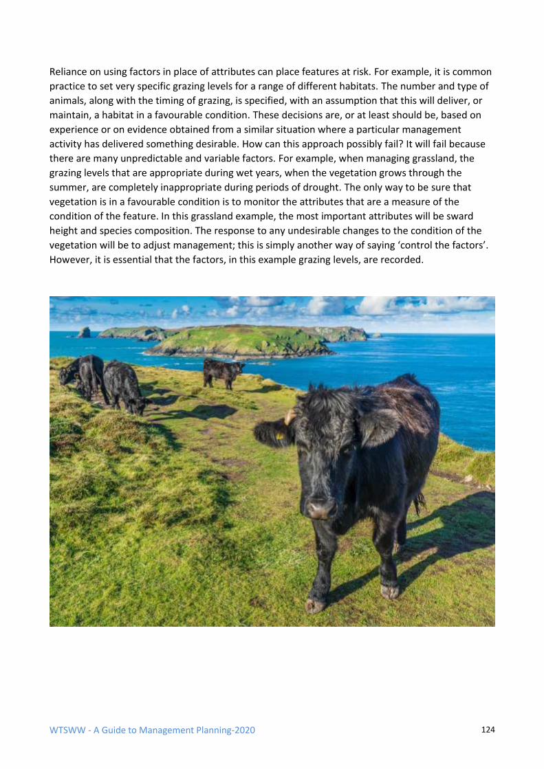
WTSWW - A Guide to Management Planning-2020 124
Reliance on using factors in place of attributes can place features at risk. For example, it is common
practice to set very specific grazing levels for a range of different habitats. The number and type of
animals, along with the timing of grazing, is specified, with an assumption that this will deliver, or
maintain, a habitat in a favourable condition. These decisions are, or at least should be, based on
experience or on evidence obtained from a similar situation where a particular management
activity has delivered something desirable. How can this approach possibly fail? It will fail because
there are many unpredictable and variable factors. For example, when managing grassland, the
grazing levels that are appropriate during wet years, when the vegetation grows through the
summer, are completely inappropriate during periods of drought. The only way to be sure that
vegetation is in a favourable condition is to monitor the attributes that are a measure of the
condition of the feature. In this grassland example, the most important attributes will be sward
height and species composition. The response to any undesirable changes to the condition of the
vegetation will be to adjust management; this is simply another way of saying ‘control the factors’.
However, it is essential that the factors, in this example grazing levels, are recorded.
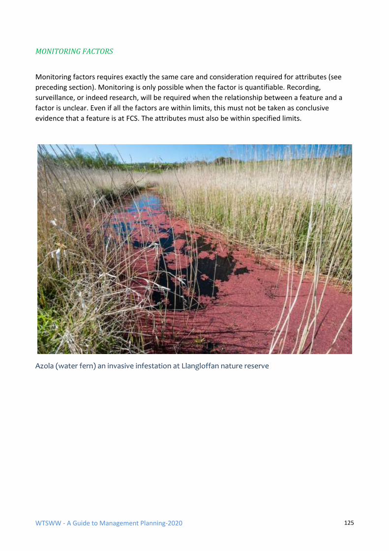
WTSWW - A Guide to Management Planning-2020 125
MONITORING FACTORS
Monitoring factors requires exactly the same care and consideration required for attributes (see
preceding section). Monitoring is only possible when the factor is quantifiable. Recording,
surveillance, or indeed research, will be required when the relationship between a feature and a
factor is unclear. Even if all the factors are within limits, this must not be taken as conclusive
evidence that a feature is at FCS. The attributes must also be within specified limits.
Azola (water fern) an invasive infestation at Llangloffan nature reserve
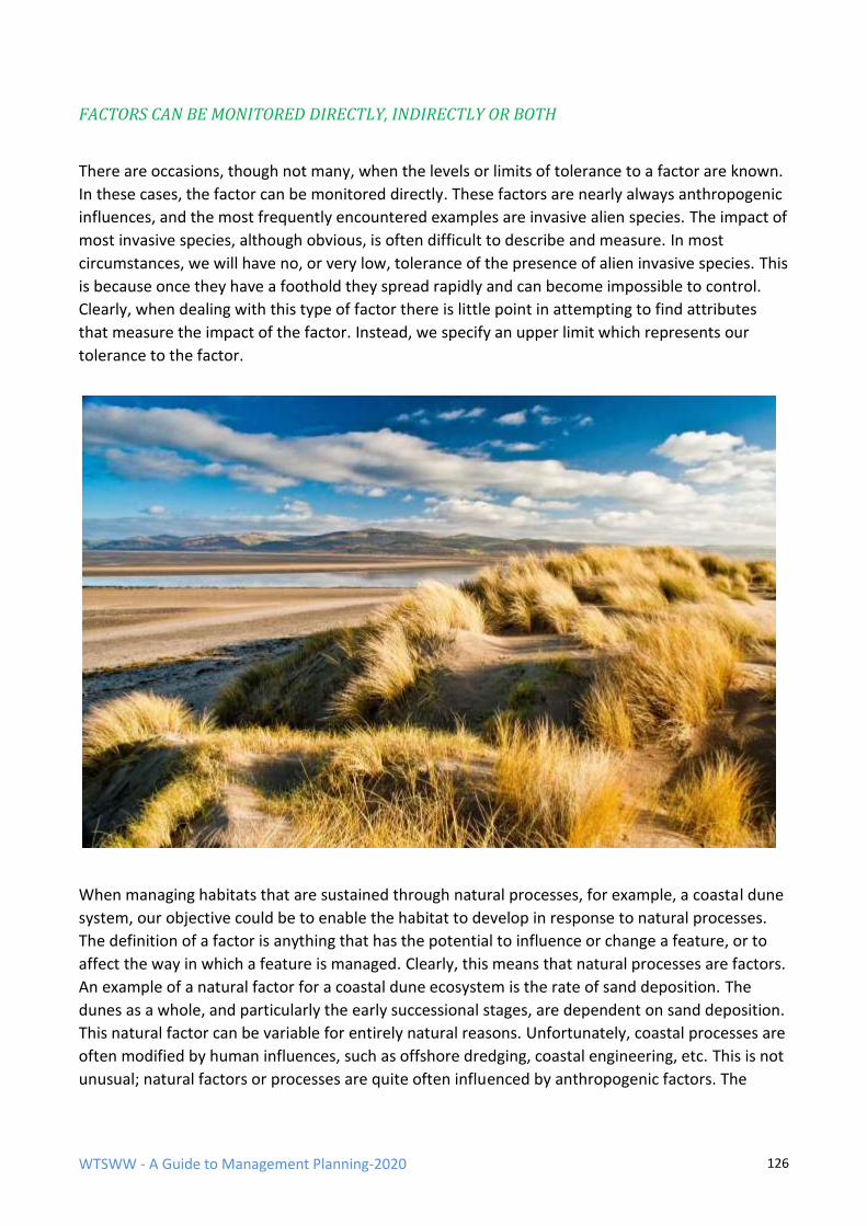
WTSWW - A Guide to Management Planning-2020 126
FACTORS CAN BE MONITORED DIRECTLY, INDIRECTLY OR BOTH
There are occasions, though not many, when the levels or limits of tolerance to a factor are known.
In these cases, the factor can be monitored directly. These factors are nearly always anthropogenic
influences, and the most frequently encountered examples are invasive alien species. The impact of
most invasive species, although obvious, is often difficult to describe and measure. In most
circumstances, we will have no, or very low, tolerance of the presence of alien invasive species. This
is because once they have a foothold they spread rapidly and can become impossible to control.
Clearly, when dealing with this type of factor there is little point in attempting to find attributes
that measure the impact of the factor. Instead, we specify an upper limit which represents our
tolerance to the factor.
When managing habitats that are sustained through natural processes, for example, a coastal dune
system, our objective could be to enable the habitat to develop in response to natural processes.
The definition of a factor is anything that has the potential to influence or change a feature, or to
affect the way in which a feature is managed. Clearly, this means that natural processes are factors.
An example of a natural factor for a coastal dune ecosystem is the rate of sand deposition. The
dunes as a whole, and particularly the early successional stages, are dependent on sand deposition.
This natural factor can be variable for entirely natural reasons. Unfortunately, coastal processes are
often modified by human influences, such as offshore dredging, coastal engineering, etc. This is not
unusual; natural factors or processes are quite often influenced by anthropogenic factors. The
WTSWW - A Guide to Management Planning-2020 127
primary factor is the natural rate of sand deposition and the secondary factors are the
anthropogenic influences.
Let us assume, in this case, that there is a decision to enable natural processes. It is recognised that
the dune systems can be ephemeral features; the natural sand supply may become depleted and
the system may erode. However, in contrast, there will be no tolerance of changes to the sand
supply which are the consequence of anthropogenic factors, particularly when these might be
controllable. The problem is the perceived need to differentiate between natural and
anthropogenic factors. How can management differentiate between changes in sand deposition
which are the consequences of either natural or anthropogenic factors or a combination of both?
This may, of course, be impossible, but there is a potential way forward. The important issue is that
the primary factor - which is the rate of sand deposition - can be easily measured and, once limits
are specified, it can be monitored. If the limits are exceeded, the manager will know that there has
been a change which is sufficient to give cause for concern. This is the point at which there is an
actual need to differentiate between natural change and change brought about by anthropogenic
factors. In addition to monitoring the sand, all human influences (dredging, soft and hard
engineering, etc.) in the coastal cell are recorded. If the specified limits for the rate of sand
deposition are exceeded, and there is a direct and demonstrable correlation with human influences
or engineering works, this will provide the evidence required to justify a detailed investigation and,
if necessary, the suspension of the works.
As a general rule, the factors that directly impact on a feature are monitored as performance
indicators, and the secondary factors that indirectly impact on a feature (that is, by influencing
other factors) are recorded or placed under surveillance. It can be the secondary factors that
provide the focus for management activities.
SURVEILLANCE
It should now be clear that in ideal circumstances all the important factors should be monitored,
indirectly, directly, or both. Even when attributes provide an indirect means of monitoring the
impact of a factor, there is good reason for also measuring the factor. This is because attributes will
change as a consequence of a single factor or the combined influence of several factors. When a
change takes place it is essential that we understand which factors are responsible. When a factor
cannot be monitored because it is not possible to set limits, we must, at very least, measure or
record the factor. This is surveillance (definition: making repeated standardised surveys in order
that change can be detected). It is quite different to, but often confused with, monitoring.
Surveillance is used to detect change, but cannot differentiate between acceptable and
unacceptable change. It is important that monitoring or surveillance projects are identified for all
known and potential factors. For example, an invasive species on a site is an obvious target for
monitoring, but it is equally important to monitor when the species occurs close to a site and is an
obvious potential threat. There is also always a need for informal surveillance, to maintain an
awareness of a site that is sufficient to detect any new factors. Once again, these new and
unpredictable factors are often invasive species which can appear without warning.
WTSWW - A Guide to Management Planning-2020 128
Over time, an understanding of the relationship between factors and a feature will be developed
and management effectiveness will improve.
PUBLIC USE OF A SITE AS A FACTOR - and the relationship between objectives for features and
planning for access or tourism
For many protected sites, public access or tourism and the provision of opportunities for leisure
activities can be very important. Occasionally, it is the most important purpose of management.
With few, if any, exceptions, people will have some impact on the site features. In other words,
they, and more particularly their activities, are factors. However, the key role of any protected area
or nature reserve is to ensure that wildlife is safeguarded against the excesses of uncontrolled
human behaviour. This is true even when the prime purpose of a site is to provide for people. If the
wildlife, countryside or wilderness quality which attracts people to a site is lost or damaged people
may stop visiting, or the quality of their experience may be diminished. As a consequence, human
activity must be controlled, but there may also have to be some limited compromises, and areas of
habitat may have to sacrificed to provide the infrastructure necessary to accommodate people (for
example, paths, roads, parking facilities, accommodation, information centres, etc.).
Some aspects of public use can have serious and obvious consequences for wildlife features, for
example, climbing on cliffs used by seabirds, dog walking (emptying) in sensitive botanical sites,
wildfowling where the feature is a wintering population of wildfowl. Where the activity is changing,
or has obvious potential to change, a feature, these activities should be recognised as factors which
must be kept under control. This type of factor is often monitored directly, i.e. specified limits are
used to define our tolerance and provide a performance indicator.
It is much more difficult to deal with human use when there is not such a direct or obvious impact
on a feature or features. From an ethical, and sometimes legal, position, it is difficult to rationalise a
situation where an area is declared a nature reserve and the consequence is that subsequent public
use of the area damages the wildlife. An appropriate response in these circumstances would be to
consider the precautionary approach. In essence, the precautionary principle is about not taking
chances with our environment. So, logically, when applying the principle to the carrying capacity of
a feature, there should be an obligation to prove, with full scientific certainty, that an activity will
not cause any damage before an activity, or level of activity, is permitted.
Having made the case for recommending that the precautionary principle should be applied to the
actual and potential public use of an area, the next step is to consider the need for performance
indicators. Earlier in this section the point was made that factors can only be monitored when the
limits within which they can be tolerated are known. For many, if not most, human activities,
particularly leisure activities, the limits are not known. The precise impact that public use will have
on features is also rarely understood and so the potential for using attributes as surrogates is very
limited. The obvious way forward is to limit or manage access and human activities rather than
expecting the wildlife to adapt. The management required to control human activities will be
identified and described in the ‘rationale’ section, which follows later in the planning process.
Compliance monitoring or formal recording will be used to ensure that appropriate management is
in place.
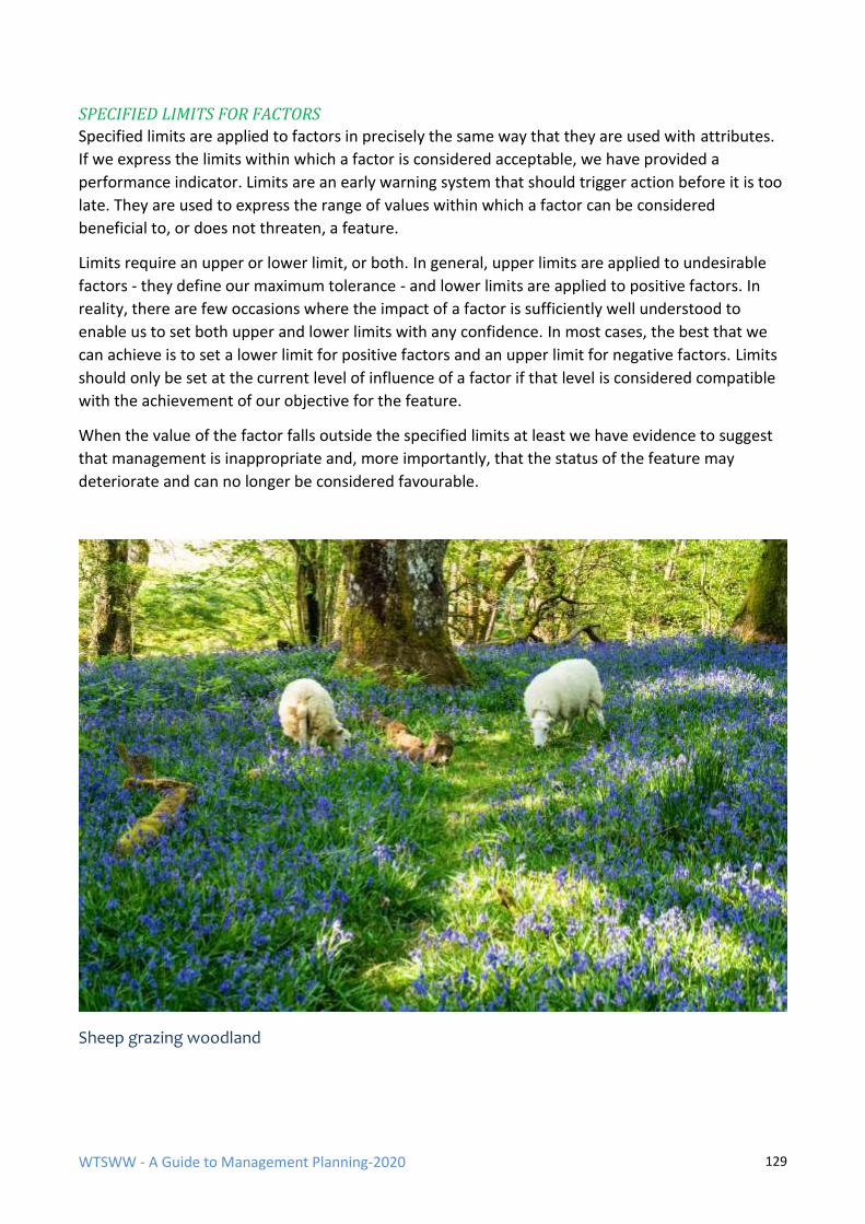
WTSWW - A Guide to Management Planning-2020 129
SPECIFIED LIMITS FOR FACTORS
Specified limits are applied to factors in precisely the same way that they are used with attributes.
If we express the limits within which a factor is considered acceptable, we have provided a
performance indicator. Limits are an early warning system that should trigger action before it is too
late. They are used to express the range of values within which a factor can be considered
beneficial to, or does not threaten, a feature.
Limits require an upper or lower limit, or both. In general, upper limits are applied to undesirable
factors - they define our maximum tolerance - and lower limits are applied to positive factors. In
reality, there are few occasions where the impact of a factor is sufficiently well understood to
enable us to set both upper and lower limits with any confidence. In most cases, the best that we
can achieve is to set a lower limit for positive factors and an upper limit for negative factors. Limits
should only be set at the current level of influence of a factor if that level is considered compatible
with the achievement of our objective for the feature.
When the value of the factor falls outside the specified limits at least we have evidence to suggest
that management is inappropriate and, more importantly, that the status of the feature may
deteriorate and can no longer be considered favourable.
Sheep grazing woodland
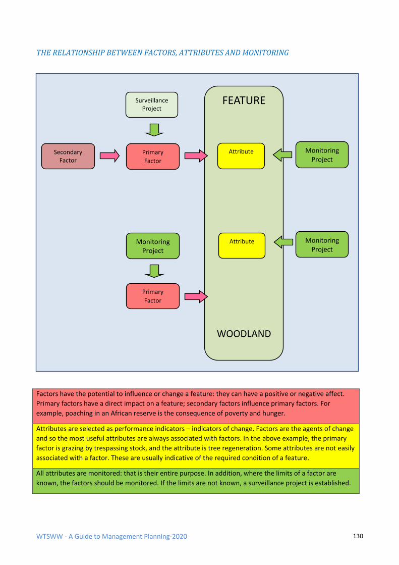
WTSWW - A Guide to Management Planning-2020 130
THE RELATIONSHIP BETWEEN FACTORS, ATTRIBUTES AND MONITORING
Factors have the potential to influence or change a feature: they can have a positive or negative affect.
Primary factors have a direct impact on a feature; secondary factors influence primary factors. For
example, poaching in an African reserve is the consequence of poverty and hunger.
Attributes are selected as performance indicators – indicators of change. Factors are the agents of change
and so the most useful attributes are always associated with factors. In the above example, the primary
factor is grazing by trespassing stock, and the attribute is tree regeneration. Some attributes are not easily
associated with a factor. These are usually indicative of the required condition of a feature.
All attributes are monitored: that is their entire purpose. In addition, where the limits of a factor are
known, the factors should be monitored. If the limits are not known, a surveillance project is established.
FEATURE
WOODLAND
Attribute Monitoring Project
Primary
Factor
Secondary Factor
Surveillance Project
Attribute Monitoring Project
Monitoring Project
Primary
Factor
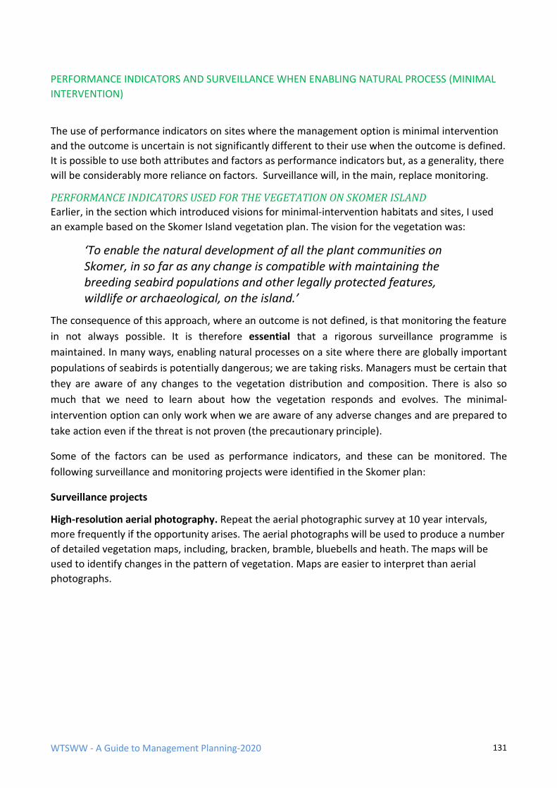
WTSWW - A Guide to Management Planning-2020 131
PERFORMANCE INDICATORS AND SURVEILLANCE WHEN ENABLING NATURAL PROCESS (MINIMAL
INTERVENTION)
The use of performance indicators on sites where the management option is minimal intervention
and the outcome is uncertain is not significantly different to their use when the outcome is defined.
It is possible to use both attributes and factors as performance indicators but, as a generality, there
will be considerably more reliance on factors. Surveillance will, in the main, replace monitoring.
PERFORMANCE INDICATORS USED FOR THE VEGETATION ON SKOMER ISLAND
Earlier, in the section which introduced visions for minimal-intervention habitats and sites, I used
an example based on the Skomer Island vegetation plan. The vision for the vegetation was:
‘To enable the natural development of all the plant communities on Skomer, in so far as any change is compatible with maintaining the breeding seabird populations and other legally protected features, wildlife or archaeological, on the island.’
The consequence of this approach, where an outcome is not defined, is that monitoring the feature
in not always possible. It is therefore essential that a rigorous surveillance programme is
maintained. In many ways, enabling natural processes on a site where there are globally important
populations of seabirds is potentially dangerous; we are taking risks. Managers must be certain that
they are aware of any changes to the vegetation distribution and composition. There is also so
much that we need to learn about how the vegetation responds and evolves. The minimal-
intervention option can only work when we are aware of any adverse changes and are prepared to
take action even if the threat is not proven (the precautionary principle).
Some of the factors can be used as performance indicators, and these can be monitored. The
following surveillance and monitoring projects were identified in the Skomer plan:
Surveillance projects
High-resolution aerial photography. Repeat the aerial photographic survey at 10 year intervals,
more frequently if the opportunity arises. The aerial photographs will be used to produce a number
of detailed vegetation maps, including, bracken, bramble, bluebells and heath. The maps will be
used to identify changes in the pattern of vegetation. Maps are easier to interpret than aerial
photographs.
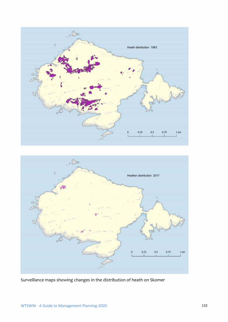
WTSWW - A Guide to Management Planning-2020 132
Surveillance maps showing changes in the distribution of heath on Skomer
WTSWW - A Guide to Management Planning-2020 133
Changes in the distribution of bracken between 1969 and 2017
WTSWW - A Guide to Management Planning-2020 134
Fixed point photography surveillance. Develop fixed point photography, having regard for all past
photo recording projects.
Permanent vegetation quadrats. Maintain 90 fixed and permanently marked vegetation quadrats.
Thought must also be given to the detail recorded in each quadrat. Simple presence or absence of a
species is probably far too crude. The measurement of cover/abundance using the Domin scale
would probably be the most appropriate approach. There is also a need to decide which species
need to be recorded. If a sub-set of the most significant species is considered sufficient, this would
both speed up the recording process and enable the work to be carried out by less expert
personnel. Finally, the interval of recording must be established, although this need not be more
frequently than every 10 years.
Record significant damage to vegetation. There have been a number of quite significant incidents
when areas of coastal vegetation have been damaged.
New potentially invasive or threatening species. Island managers must always maintain a high
level of vigilance sufficient to recognise and respond to the appearance of any new species to the
island.
Rabbit surveillance. Rabbits are the most significant factor of all. The population is unstable,
surveillance is essential.
Ragwort. Map the distribution of ragwort during ‘ragwort years’ and maintain annual records of
status.
Bramble surveillance. Manx Shearwaters can become trapped in the bramble and, occasionally, dead
birds are found entangled in bramble. However, the scale of the impact has not been assessed. There is also
a possibility that Shearwaters will not be able to burrow in areas of dense bracken: this requires further
investigation. There is insufficient evidence to support bramble control at this time, but a surveillance
project will be established to record any changes in the extent and distribution of bramble.
Monitoring projects
The objective for vegetation requires that any changes must be compatible with conserving the
breeding seabird populations. There could, for example, be a significant increase in scrub which
would threaten ground-nesting seabirds. The surveillance projects will detect changes in the
vegetation but there is also a need to focus on the bird populations. These are all monitored, and
any significant changes in the numbers or distribution of seabird populations (exceeding a specified
limit) will be investigated. If there is reason to suggest a relationship between a decline in a bird
population and a change in the vegetation, the vegetation will be controlled. The only current
concern is that bracken can invade the Puffin colonies: Puffins will not burrow in dense vegetation.
Monitor bracken encroachment into Puffin colonies. Bracken should be mapped along the edges
of the Puffin colonies that are likely to be invaded. Acceptable boundaries should be defined and
subsequently monitored. If the Puffin population continues to increase, these boundaries must be
reviewed.
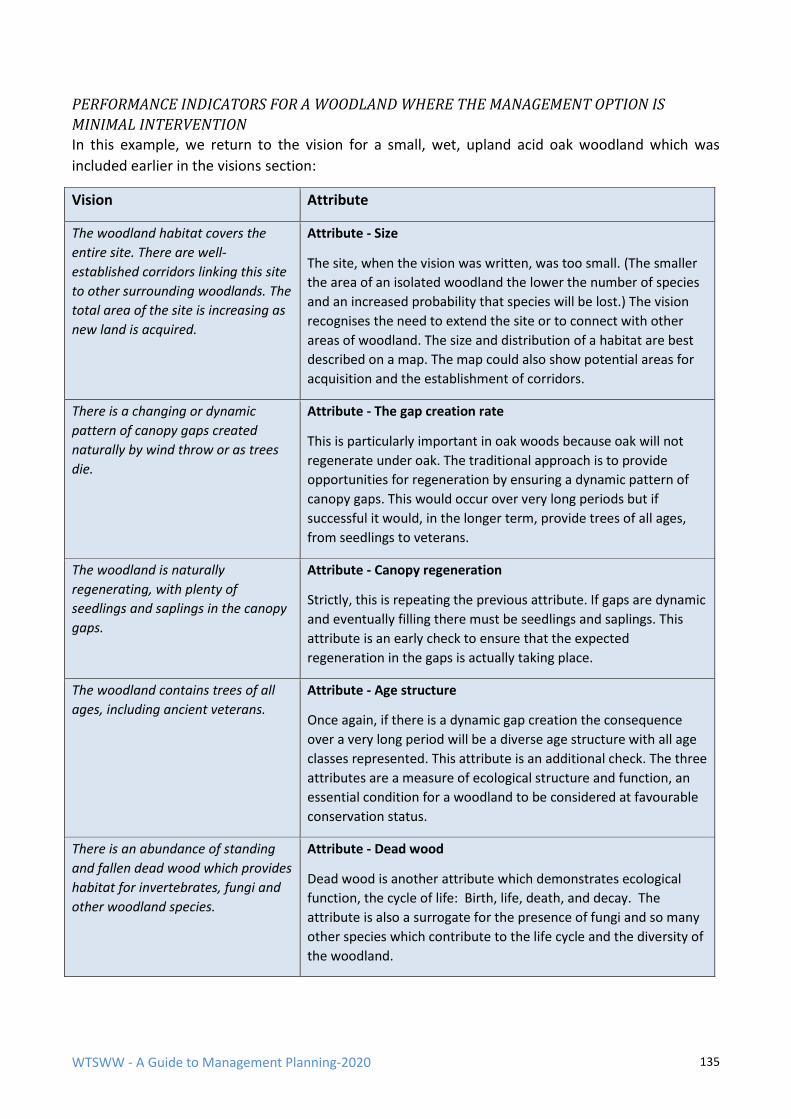
WTSWW - A Guide to Management Planning-2020 135
PERFORMANCE INDICATORS FOR A WOODLAND WHERE THE MANAGEMENT OPTION IS
MINIMAL INTERVENTION In this example, we return to the vision for a small, wet, upland acid oak woodland which was
included earlier in the visions section:
Vision Attribute
The woodland habitat covers the
entire site. There are well-
established corridors linking this site
to other surrounding woodlands. The
total area of the site is increasing as
new land is acquired.
Attribute - Size
The site, when the vision was written, was too small. (The smaller
the area of an isolated woodland the lower the number of species
and an increased probability that species will be lost.) The vision
recognises the need to extend the site or to connect with other
areas of woodland. The size and distribution of a habitat are best
described on a map. The map could also show potential areas for
acquisition and the establishment of corridors.
There is a changing or dynamic
pattern of canopy gaps created
naturally by wind throw or as trees
die.
Attribute - The gap creation rate
This is particularly important in oak woods because oak will not
regenerate under oak. The traditional approach is to provide
opportunities for regeneration by ensuring a dynamic pattern of
canopy gaps. This would occur over very long periods but if
successful it would, in the longer term, provide trees of all ages,
from seedlings to veterans.
The woodland is naturally
regenerating, with plenty of
seedlings and saplings in the canopy
gaps.
Attribute - Canopy regeneration
Strictly, this is repeating the previous attribute. If gaps are dynamic
and eventually filling there must be seedlings and saplings. This
attribute is an early check to ensure that the expected
regeneration in the gaps is actually taking place.
The woodland contains trees of all
ages, including ancient veterans.
Attribute - Age structure
Once again, if there is a dynamic gap creation the consequence
over a very long period will be a diverse age structure with all age
classes represented. This attribute is an additional check. The three
attributes are a measure of ecological structure and function, an
essential condition for a woodland to be considered at favourable
conservation status.
There is an abundance of standing
and fallen dead wood which provides
habitat for invertebrates, fungi and
other woodland species.
Attribute - Dead wood
Dead wood is another attribute which demonstrates ecological
function, the cycle of life: Birth, life, death, and decay. The
attribute is also a surrogate for the presence of fungi and so many
other species which contribute to the life cycle and the diversity of
the woodland.
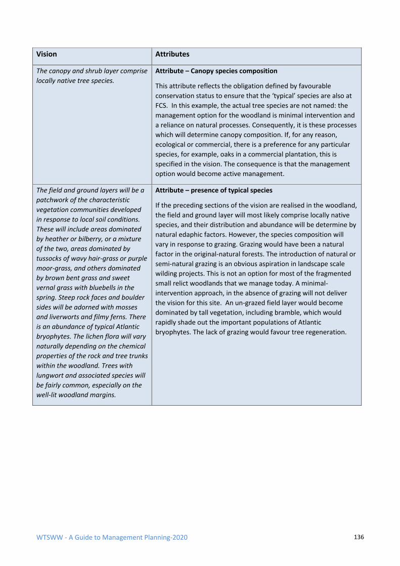
WTSWW - A Guide to Management Planning-2020 136
Vision Attributes
The canopy and shrub layer comprise
locally native tree species.
Attribute – Canopy species composition
This attribute reflects the obligation defined by favourable
conservation status to ensure that the ‘typical’ species are also at
FCS. In this example, the actual tree species are not named: the
management option for the woodland is minimal intervention and
a reliance on natural processes. Consequently, it is these processes
which will determine canopy composition. If, for any reason,
ecological or commercial, there is a preference for any particular
species, for example, oaks in a commercial plantation, this is
specified in the vision. The consequence is that the management
option would become active management.
The field and ground layers will be a
patchwork of the characteristic
vegetation communities developed
in response to local soil conditions.
These will include areas dominated
by heather or bilberry, or a mixture
of the two, areas dominated by
tussocks of wavy hair-grass or purple
moor-grass, and others dominated
by brown bent grass and sweet
vernal grass with bluebells in the
spring. Steep rock faces and boulder
sides will be adorned with mosses
and liverworts and filmy ferns. There
is an abundance of typical Atlantic
bryophytes. The lichen flora will vary
naturally depending on the chemical
properties of the rock and tree trunks
within the woodland. Trees with
lungwort and associated species will
be fairly common, especially on the
well-lit woodland margins.
Attribute – presence of typical species
If the preceding sections of the vision are realised in the woodland,
the field and ground layer will most likely comprise locally native
species, and their distribution and abundance will be determine by
natural edaphic factors. However, the species composition will
vary in response to grazing. Grazing would have been a natural
factor in the original-natural forests. The introduction of natural or
semi-natural grazing is an obvious aspiration in landscape scale
wilding projects. This is not an option for most of the fragmented
small relict woodlands that we manage today. A minimal-
intervention approach, in the absence of grazing will not deliver
the vision for this site. An un-grazed field layer would become
dominated by tall vegetation, including bramble, which would
rapidly shade out the important populations of Atlantic
bryophytes. The lack of grazing would favour tree regeneration.
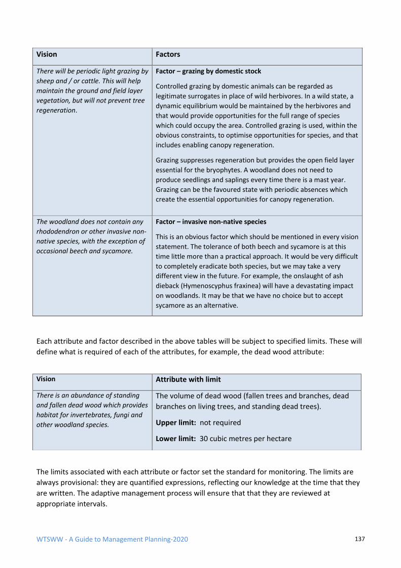
WTSWW - A Guide to Management Planning-2020 137
Vision Factors
There will be periodic light grazing by
sheep and / or cattle. This will help
maintain the ground and field layer
vegetation, but will not prevent tree
regeneration.
Factor – grazing by domestic stock
Controlled grazing by domestic animals can be regarded as
legitimate surrogates in place of wild herbivores. In a wild state, a
dynamic equilibrium would be maintained by the herbivores and
that would provide opportunities for the full range of species
which could occupy the area. Controlled grazing is used, within the
obvious constraints, to optimise opportunities for species, and that
includes enabling canopy regeneration.
Grazing suppresses regeneration but provides the open field layer
essential for the bryophytes. A woodland does not need to
produce seedlings and saplings every time there is a mast year.
Grazing can be the favoured state with periodic absences which
create the essential opportunities for canopy regeneration.
The woodland does not contain any
rhododendron or other invasive non-
native species, with the exception of
occasional beech and sycamore.
Factor – invasive non-native species
This is an obvious factor which should be mentioned in every vision
statement. The tolerance of both beech and sycamore is at this
time little more than a practical approach. It would be very difficult
to completely eradicate both species, but we may take a very
different view in the future. For example, the onslaught of ash
dieback (Hymenoscyphus fraxinea) will have a devastating impact
on woodlands. It may be that we have no choice but to accept
sycamore as an alternative.
Each attribute and factor described in the above tables will be subject to specified limits. These will
define what is required of each of the attributes, for example, the dead wood attribute:
The limits associated with each attribute or factor set the standard for monitoring. The limits are
always provisional: they are quantified expressions, reflecting our knowledge at the time that they
are written. The adaptive management process will ensure that that they are reviewed at
appropriate intervals.
Vision Attribute with limit
There is an abundance of standing
and fallen dead wood which provides
habitat for invertebrates, fungi and
other woodland species.
The volume of dead wood (fallen trees and branches, dead
branches on living trees, and standing dead trees).
Upper limit: not required
Lower limit: 30 cubic metres per hectare
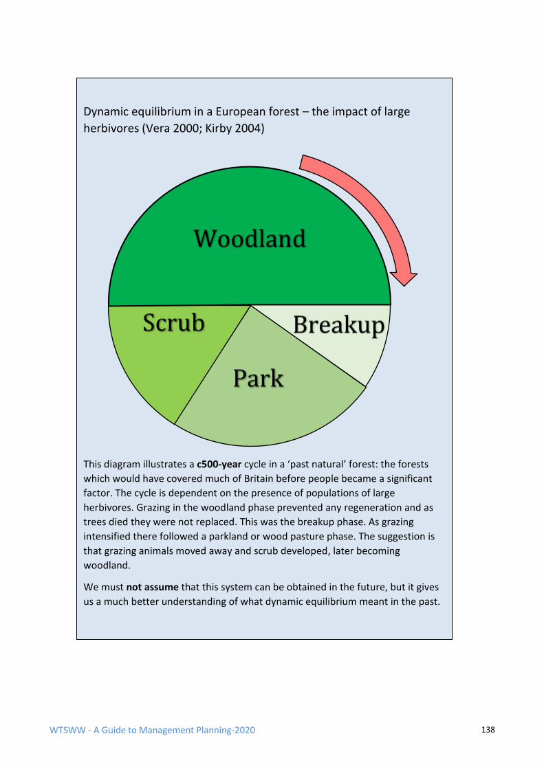
WTSWW - A Guide to Management Planning-2020 138
Dynamic equilibrium in a European forest – the impact of large
herbivores (Vera 2000; Kirby 2004)
This diagram illustrates a c500-year cycle in a ‘past natural’ forest: the forests
which would have covered much of Britain before people became a significant
factor. The cycle is dependent on the presence of populations of large
herbivores. Grazing in the woodland phase prevented any regeneration and as
trees died they were not replaced. This was the breakup phase. As grazing
intensified there followed a parkland or wood pasture phase. The suggestion is
that grazing animals moved away and scrub developed, later becoming
woodland.
We must not assume that this system can be obtained in the future, but it gives
us a much better understanding of what dynamic equilibrium meant in the past.
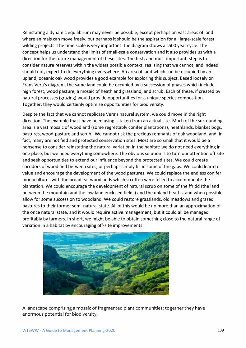
WTSWW - A Guide to Management Planning-2020 139
Reinstating a dynamic equilibrium may never be possible, except perhaps on vast areas of land
where animals can move freely, but perhaps it should be the aspiration for all large-scale forest
wilding projects. The time scale is very important: the diagram shows a c500 year cycle. The
concept helps us understand the limits of small-scale conservation and it also provides us with a
direction for the future management of these sites. The first, and most important, step is to
consider nature reserves within the widest possible context, realising that we cannot, and indeed
should not, expect to do everything everywhere. An area of land which can be occupied by an
upland, oceanic oak wood provides a good example for exploring this subject. Based loosely on
Frans Vera’s diagram, the same land could be occupied by a succession of phases which include
high forest, wood pasture, a mosaic of heath and grassland, and scrub. Each of these, if created by
natural processes (grazing) would provide opportunities for a unique species composition.
Together, they would certainly optimise opportunities for biodiversity.
Despite the fact that we cannot replicate Vera’s natural system, we could move in the right
direction. The example that I have been using is taken from an actual site. Much of the surrounding
area is a vast mosaic of woodland (some regrettably conifer plantations), heathlands, blanket bogs,
pastures, wood-pasture and scrub. We cannot risk the precious remnants of oak woodland, and, in
fact, many are notified and protected conservation sites. Most are so small that it would be a
nonsense to consider reinstating the natural variation in the habitat: we do not need everything in
one place, but we need everything somewhere. The obvious solution is to turn our attention off site
and seek opportunities to extend our influence beyond the protected sites. We could create
corridors of woodland between sites, or perhaps simply fill in some of the gaps. We could learn to
value and encourage the development of the wood pastures. We could replace the endless conifer
monocultures with the broadleaf woodlands which so often were felled to accommodate the
plantation. We could encourage the development of natural scrub on some of the ffridd (the land
between the mountain and the low land enclosed fields) and the upland heaths, and when possible
allow for some succession to woodland. We could restore grasslands, old meadows and grazed
pastures to their former semi-natural state. All of this would be no more than an approximation of
the once natural state, and it would require active management, but it could all be managed
profitably by farmers. In short, we might be able to obtain something close to the natural range of
variation in a habitat by encouraging off-site improvements.
A landscape comprising a mosaic of fragmented plant communities: together they have enormous potential for biodiversity.
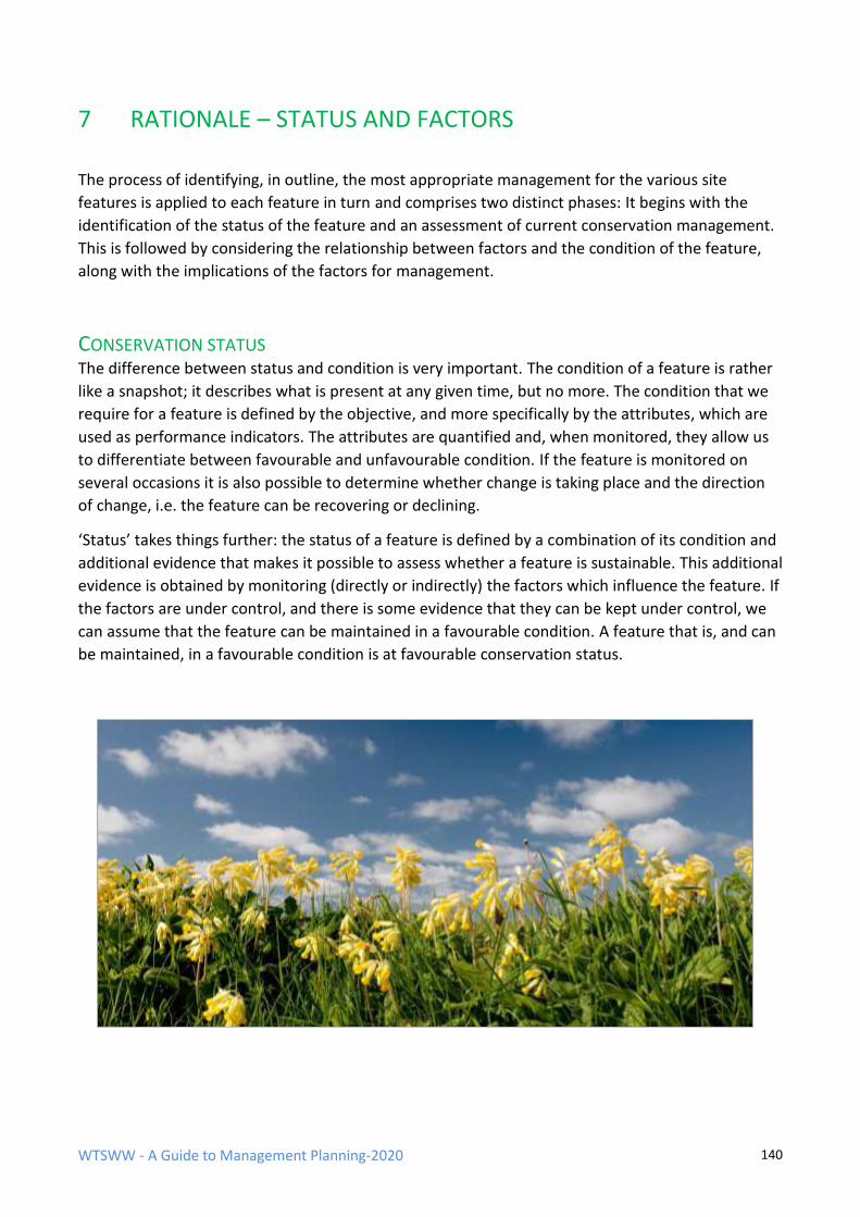
WTSWW - A Guide to Management Planning-2020 140
7 RATIONALE – STATUS AND FACTORS
The process of identifying, in outline, the most appropriate management for the various site
features is applied to each feature in turn and comprises two distinct phases: It begins with the
identification of the status of the feature and an assessment of current conservation management.
This is followed by considering the relationship between factors and the condition of the feature,
along with the implications of the factors for management.
CONSERVATION STATUS The difference between status and condition is very important. The condition of a feature is rather
like a snapshot; it describes what is present at any given time, but no more. The condition that we
require for a feature is defined by the objective, and more specifically by the attributes, which are
used as performance indicators. The attributes are quantified and, when monitored, they allow us
to differentiate between favourable and unfavourable condition. If the feature is monitored on
several occasions it is also possible to determine whether change is taking place and the direction
of change, i.e. the feature can be recovering or declining.
‘Status’ takes things further: the status of a feature is defined by a combination of its condition and
additional evidence that makes it possible to assess whether a feature is sustainable. This additional
evidence is obtained by monitoring (directly or indirectly) the factors which influence the feature. If
the factors are under control, and there is some evidence that they can be kept under control, we
can assume that the feature can be maintained in a favourable condition. A feature that is, and can
be maintained, in a favourable condition is at favourable conservation status.
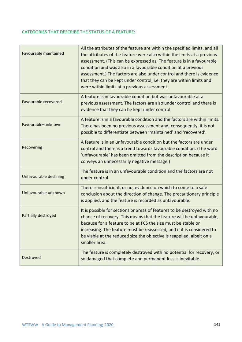
WTSWW - A Guide to Management Planning-2020 141
CATEGORIES THAT DESCRIBE THE STATUS OF A FEATURE:
Favourable maintained
All the attributes of the feature are within the specified limits, and all
the attributes of the feature were also within the limits at a previous
assessment. (This can be expressed as: The feature is in a favourable
condition and was also in a favourable condition at a previous
assessment.) The factors are also under control and there is evidence
that they can be kept under control, i.e. they are within limits and
were within limits at a previous assessment.
Favourable recovered
A feature is in favourable condition but was unfavourable at a
previous assessment. The factors are also under control and there is
evidence that they can be kept under control.
Favourable–unknown
A feature is in a favourable condition and the factors are within limits.
There has been no previous assessment and, consequently, it is not
possible to differentiate between ‘maintained’ and ‘recovered’.
Recovering
A feature is in an unfavourable condition but the factors are under
control and there is a trend towards favourable condition. (The word
‘unfavourable’ has been omitted from the description because it
conveys an unnecessarily negative message.)
Unfavourable declining
The feature is in an unfavourable condition and the factors are not
under control.
Unfavourable unknown
There is insufficient, or no, evidence on which to come to a safe
conclusion about the direction of change. The precautionary principle
is applied, and the feature is recorded as unfavourable.
Partially destroyed
It is possible for sections or areas of features to be destroyed with no
chance of recovery. This means that the feature will be unfavourable,
because for a feature to be at FCS the size must be stable or
increasing. The feature must be reassessed, and if it is considered to
be viable at the reduced size the objective is reapplied, albeit on a
smaller area.
Destroyed
The feature is completely destroyed with no potential for recovery, or
so damaged that complete and permanent loss is inevitable.
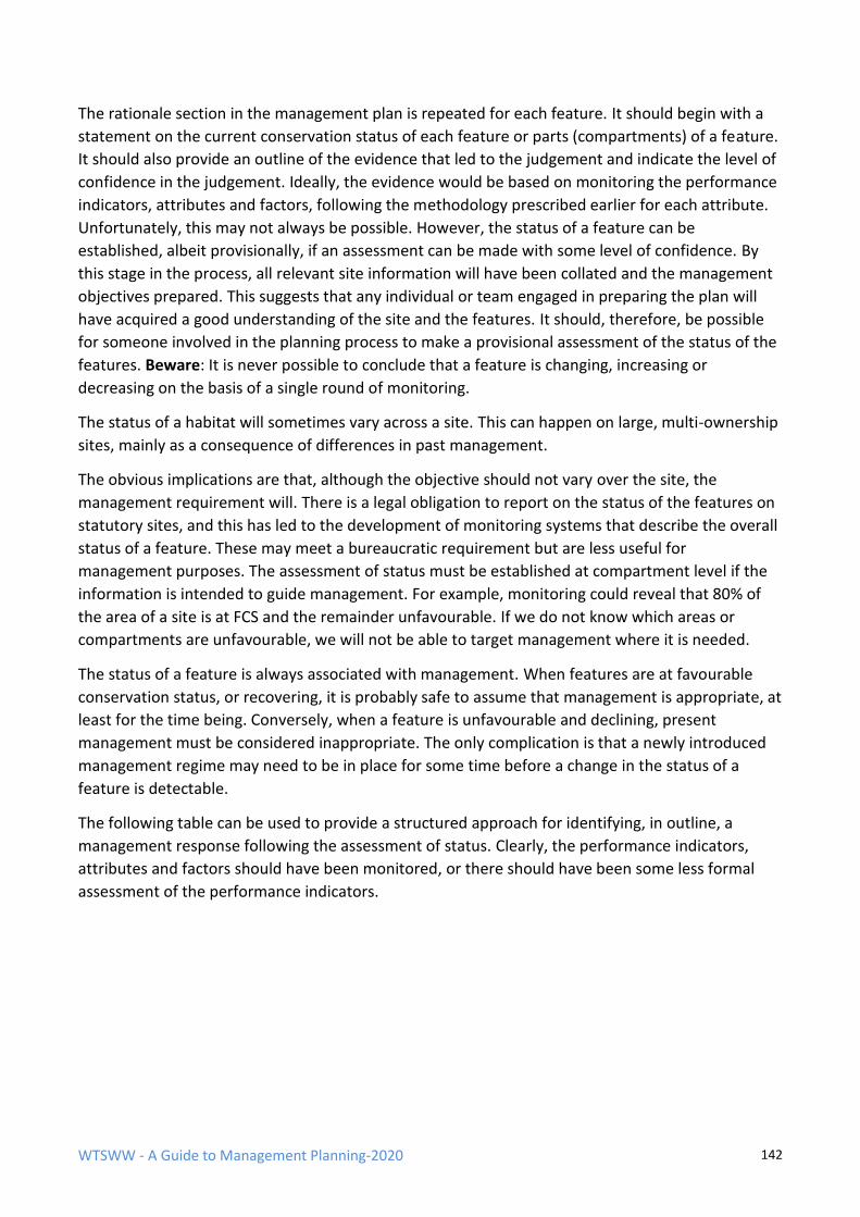
WTSWW - A Guide to Management Planning-2020 142
The rationale section in the management plan is repeated for each feature. It should begin with a
statement on the current conservation status of each feature or parts (compartments) of a feature.
It should also provide an outline of the evidence that led to the judgement and indicate the level of
confidence in the judgement. Ideally, the evidence would be based on monitoring the performance
indicators, attributes and factors, following the methodology prescribed earlier for each attribute.
Unfortunately, this may not always be possible. However, the status of a feature can be
established, albeit provisionally, if an assessment can be made with some level of confidence. By
this stage in the process, all relevant site information will have been collated and the management
objectives prepared. This suggests that any individual or team engaged in preparing the plan will
have acquired a good understanding of the site and the features. It should, therefore, be possible
for someone involved in the planning process to make a provisional assessment of the status of the
features. Beware: It is never possible to conclude that a feature is changing, increasing or
decreasing on the basis of a single round of monitoring.
The status of a habitat will sometimes vary across a site. This can happen on large, multi-ownership
sites, mainly as a consequence of differences in past management.
The obvious implications are that, although the objective should not vary over the site, the
management requirement will. There is a legal obligation to report on the status of the features on
statutory sites, and this has led to the development of monitoring systems that describe the overall
status of a feature. These may meet a bureaucratic requirement but are less useful for
management purposes. The assessment of status must be established at compartment level if the
information is intended to guide management. For example, monitoring could reveal that 80% of
the area of a site is at FCS and the remainder unfavourable. If we do not know which areas or
compartments are unfavourable, we will not be able to target management where it is needed.
The status of a feature is always associated with management. When features are at favourable
conservation status, or recovering, it is probably safe to assume that management is appropriate, at
least for the time being. Conversely, when a feature is unfavourable and declining, present
management must be considered inappropriate. The only complication is that a newly introduced
management regime may need to be in place for some time before a change in the status of a
feature is detectable.
The following table can be used to provide a structured approach for identifying, in outline, a
management response following the assessment of status. Clearly, the performance indicators,
attributes and factors should have been monitored, or there should have been some less formal
assessment of the performance indicators.
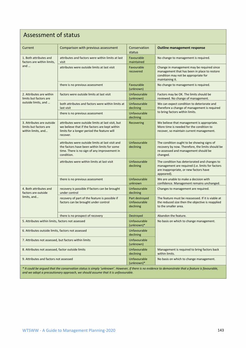
WTSWW - A Guide to Management Planning-2020 143
Assessment of status
Current Comparison with previous assessment Conservation status
Outline management response
1. Both attributes and factors are within limits, and …
attributes and factors were within limits at last visit
Favourable maintained
No change to management is required.
attributes were outside limits at last visit Favourable recovered
Change in management may be required since management that has been in place to restore condition may not be appropriate for maintaining it.
there is no previous assessment Favourable (unknown)
No change to management is required.
2. Attributes are within limits but factors are outside limits, and …
factors were outside limits at last visit Unfavourable (unknown)
Factors may be OK. The limits should be reviewed. No change of management.
both attributes and factors were within limits at last visit
Unfavourable declining
We can expect condition to deteriorate and therefore a change of management is required to bring factors within limits. there is no previous assessment Unfavourable
declining
3. Attributes are outside limits but factors are within limits, and…
attributes were outside limits at last visit, but we believe that if the factors are kept within limits for a longer period the feature will recover.
Recovering We believe that management is appropriate. More time is needed for the condition to recover, so maintain current management.
attributes were outside limits at last visit and the factors have been within limits for some time. There is no sign of any improvement in condition.
Unfavourable declining
The condition ought to be showing signs of recovery by now. Therefore, the limits should be re-assessed and management should be changed.
attributes were within limits at last visit Unfavourable declining
The condition has deteriorated and changes to management are required (i.e. limits for factors are inappropriate, or new factors have appeared).
there is no previous assessment Unfavourable unknown
We are unable to make a decision with confidence. Management remains unchanged.
4. Both attributes and factors are outside limits, and…
recovery is possible if factors can be brought under control
Unfavourable declining
Changes to management are required.
recovery of part of the feature is possible if factors can be brought under control
Part destroyed Unfavourable declining
The feature must be reassessed. If it is viable at the reduced size then the objective is reapplied to the smaller area.
there is no prospect of recovery Destroyed Abandon the feature.
5. Attributes within limits, factors not assessed Unfavourable (unknown)*
No basis on which to change management.
6. Attributes outside limits, factors not assessed Unfavourable declining
7. Attributes not assessed, but factors within limits Unfavourable (unknown)
8. Attributes not assessed, factor outside limits Unfavourable declining
Management is required to bring factors back within limits.
9. Attributes and factors not assessed Unfavourable (unknown)*
No basis on which to change management.
* It could be argued that the conservation status is simply ‘unknown’. However, if there is no evidence to demonstrate that a feature is favourable, and we adopt a precautionary approach, we should assume that it is unfavourable.
WTSWW - A Guide to Management Planning-2020 144
RATIONALE - FACTORS
There is a difference in the rationale between planning for the first time, when there is no record of
management, and on subsequent occasions, when there is a record of management. An
assessment of status is required for both, but the conclusions reached when planning for the first
time will be limited by the lack of any previous assessment and records of management. The use of
status as a guide to identifying appropriate management will be extremely limited. In these
circumstances, an analysis of the factors is the best method for identifying management.
Management is invariably about controlling factors. Control means the removal, maintenance,
adjustment, or application of factors, either directly or indirectly. For example, grazing is an obvious
factor for grassland habitats. Grazing can be removed, reduced, maintained at current levels,
increased, or introduced.
All the factors that have the potential to influence or change a feature (directly or indirectly) or to
affect the way in which a feature is managed, as well as the relationship between the factors and
management of the feature, are identified at an earlier stage in the planning process. The
relationship between management, the factors and the feature is the starting point for the
discussion in this section of the plan.
The list of identified factors provides the subheadings for discussing the factors. Each should be
considered in turn, beginning with an assessment of their impact on the feature (i.e. how they have
changed, are changing, or could change, the feature). This will have been discussed when factors
were used to guide the selection of some of the attributes.
The next step is to consider how the factors should be controlled or managed. Do not forget that
factors can be positive and/or negative. The management of the primary factors can be influenced
by any number of secondary factors. There is a complication: although individual factors may have
a limited impact on a feature, in combination they can become a serious issue. This means that
factors should be considered both individually and collectively. The outcome of this section is an
outline of the management required to ensure that the factors are kept under control so that the
feature can be restored to, or maintained at, favourable conservation status. This approach can be
a useful means of confirming or checking the management on sites which have a history of
conservation management.
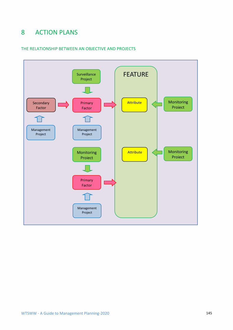
WTSWW - A Guide to Management Planning-2020 145
8 ACTION PLANS
THE RELATIONSHIP BETWEEN AN OBJECTIVE AND PROJECTS
FEATURE
Attribute Monitoring Project
Primary
Factor
Management Project
Secondary Factor
Surveillance Project
Attribute Monitoring Project
Monitoring Project
Management Project
Management Project
Primary
Factor
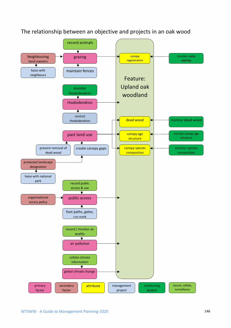
WTSWW - A Guide to Management Planning-2020 146
The relationship between an objective and projects in an oak wood
primary
factor
secondary
factor attribute monitoring
project
management
project
record, collate,
surveillance
canopy
regeneration
monitor viable
saplings
rhododendron
control
rhododendron
grazing Neighbouring land owners
record animals
liaise with
neighbours maintain fences
monitor
rhododendron
past land use
prevent removal of
dead wood create canopy gaps
dead wood
canopy age
structure
canopy species
composition
protected landscape
designation
liaise with national
park
organisational
access policy public access
foot paths, gates,
car-park
monitor dead wood
monitor canopy age
structure
monitor species
composition
record public
access & use
air pollution
global climate change
record / monitor air
quality
collate climate
information
Feature:
Upland oak
woodland
WTSWW - A Guide to Management Planning-2020 147
8.1 PROJECTS
A project is a clearly defined and planned unit of work. These are the cornerstones of action
planning. Everything else is derived directly from the information contained in the individual project
plan. There is an extremely wide range of different types of projects that can be active on a site. In
the mid-1970s, the Nature Conservancy Council introduced a system of codes linked to standard
descriptions which were intended to provide a common basis for describing work on their National
Nature Reserves. This list, significantly modified and updated, is still used by most conservation
organisations in the UK and by many organisations in other countries. The list is organised in a
hierarchical structure, beginning with three main divisions:
Recording, Management and Administration
The full range of projects is given in Appendix 1.
The standard codes and the associated project titles are used, unmodified, by all users. In a site-
specific context, each individual project code can be divided up to 99 times, and each division is
numbered and accompanied by a ‘qualifying phrase’. For example:
RA01 monitor mammals
RA01 / 01 monitor mammals, grey seals
RA01 / 02 monitor mammals, bank voles
The relationship between the individual monitoring projects and the objectives is established when
the objectives and performance indicators are identified. Every objective has associated
performance indicators. (Objectives for conservation features and all other sections in a
management plan must be quantified and measurable.) The performance indicators for
conservation objectives are based on attributes and factors: each attribute and measurable factor
has an associated monitoring project. (Occasionally, surveillance projects will be used in place of
monitoring projects.) All management projects are identified, or confirmed, in the rationale
(confirmed when there is already a history of conservation management).
The list of projects for a site will include all the work that is required to meet all the objectives. The
projects must be linked, and relevant, to the management objectives. This is for two reasons: it will
enable managers to cost the individual objectives and, more importantly, it will ensure that there is
a purpose for all the work planned for a site. When auditing sites, one of the most frequently
encountered problems is active projects for which there is no justification. These are things that
people do simply because that is the way things have always been done: often they are projects
that were initiated at some time in the past by staff who have long since moved on.
There is a slight complication in that an individual project will often have relevance to more than
one objective.
WTSWW - A Guide to Management Planning-2020 148
8.2 PLANNING INDIVIDUAL PROJECTS
The following information should be included in all individual project
plans:
WHY THE PROJECT IS NECESSARY
The first consideration when planning every individual project must be: what objective or objectives
is the project linked to? This should be followed by: why is the project necessary? (i.e. the intended
outcome must be explained.) There is a need to provide this information for other people, but the
most important function is to ensure that managers pay adequate attention to justifying everything
that they do.
POTENTIAL IMPACT ON OTHER FEATURES
When planning management projects, it is essential that the implication of the work for other
features is considered. In some cases, this could extend to completing an impact assessment. As an
example: A wetland site contains a number of ephemeral lakes that are particularly important
because they contain rare communities of aquatic plants. The lakes gradually silt up, and there is a
need for occasional dredging. The lakes also contain populations of otter and several important
breeding birds (these are also protected features). The management of the lakes is essential, not
only for the aquatic flora but also for the otters and birds. An impact assessment will take all of this
into account, and a management approach designed to minimise impact on the protected features
will be devised. Obviously, the work will be undertaken outside the breeding seasons and only small
sections will be dredged at any time. This will ensure that most of the habitat is always in the
required condition.
On some statutory sites, there will be a legal requirement to obtain formal consent before carrying
out any management work which has potential to influence any of the features.
WHEN THE PROJECT IS ACTIVE
Projects can be a one-off activity or something that is repeated annually or several times each year.
An action plan is prepared for a specified period, usually five years. With occasional exceptions, it is
difficult to plan any further ahead. Some organisations maintain their reserve plans on a five-year
programme which rolls forward at the end of each financial year. This means that the plans are
always valid for at least 4 years. In addition, expensive capital projects or acquisitions are planned
over a ten-year period. For example, it is usually possible to estimate the life expectancy of a major
boardwalk or of expensive machinery that will have to be replaced at intervals. The ability to
predict financial and staff requirements is a management necessity for many organisations.
Managers will need to decide when, and how many times, during a year a project will be active
(sometimes work is seasonal, for example, monitoring nesting birds). There is also a need to
identify the year, or years, within the life of a plan that a project will be active. Obviously, some will
be active each year or even several times each year.
WTSWW - A Guide to Management Planning-2020 149
WHERE THE WORK WILL BE CARRIED OUT
For many projects, the precise location where the work should be carried out is an important
consideration. Maps can be extremely useful to show, for example, the location of surveillance
plots or the line that a new fence will follow.
RESOURCES
Resource planning is as important, if not more so, than any other section in the action plan.
Whenever possible, the plan should identify the resource requirement (financial and staff)
necessary to complete each project. This will allow managers to attribute full costs to a project and
enable the preparation of work plans. It is only through assessing the resource requirements for
each project and aggregating this data that it becomes possible to make a justified case for
resources. This could include the information essential for a successful grant application.
EXPENDITURE
The cost of each project should be calculated and the potential, or actual, source of funds
identified. Some organisations use financial coding systems to organise internal expenditure. The
reserve manager will often be obliged to comply with organisational protocols.
STAFF
This can include employed staff and, for some organisations, volunteers. Whenever possible, the
plan should identify the individuals responsible for carrying out each project and give an indication
of the time required of each person. This will enable the preparation of various work plans. Staff
shortages are usually one of the major problems faced by conservation managers. There is rarely
any purpose in stating the obvious, i.e. we need more staff, unless this can be quantified. The most
persuasive argument is to list the work that will not be carried out as a consequence of staff
shortages. Demonstrating that there will be a failure to protect the features, to meet health and
safety requirements, or to provide safe facilities for visitors will often persuade the most
intransigent senior staff.
PRIORITY
It is rarely, if ever, possible to complete all the work on a site, and there can be many different
reasons for failure. The completion of any outdoor work will be constrained by seasonal variations,
the vagaries of weather and other natural conditions. Resources, or more specifically the lack of
adequate resources, will always restrict a manager’s ability to do all the work that is necessary to
manage a site. Managers can never expect to do everything that they need to do, let alone what
they want to do. This is why it is essential that all projects are prioritised: if managers had unlimited
resources, they would not need priorities.
I have been attempting to devise priority systems for over 25 years and I have learned that the
simpler the system (i.e. the fewer priorities) the more likely it is to be effective. Occasionally,
organisations will devise hopelessly complicated, multi-layered priority systems, and managers may
have no choice but to comply with this inappropriate system. However, I am convinced that three
priorities are adequate in almost all circumstances.
WTSWW - A Guide to Management Planning-2020 150
Priority 1
These are the essential projects: work that has to be completed regardless of cost. These will
include:
• Projects which carry legal obligations. For example, tenure, vehicle maintenance,
public rights of way, Disability Discrimination Act and the communication of legal or
safety messages relating to site management.
• Animal welfare - stock husbandry.
• Health & Safety and public liability requirements relating to staff, the public use of
the site, access infrastructure and the communication of safety messages.
• Habitat/species management projects which are essential to maintain qualifying
features at current status.
• Protection of statutory features through the management of public access or the
communication of access messages.
• Monitoring the protected features, but only when they are threatened or in decline.
Priority 2
These projects are essential in the longer term, but the consequences will not be too serious if they
are delayed. These include:
• Projects required to meet the long-term objectives of conservation management.
• Projects relating to non-qualifying features and the site fabric.
• Monitoring the protected features, even though they are not threatened or in
decline.
• Projects which provide information and interpretation for visitors.
Priority 3
These projects are important in the longer term, but can be deferred to a later date. The can also
be regarded as ‘if only’ projects: if only we had more time or more money; if only a volunteer would
appear with specific skills. The identification of priority 3 projects is important when responding to
opportunities that may arise. Opportunistic management is generally inappropriate. However, in
reality, many conservation organisations are dependent on grants and other donations which are
often linked to schemes where the donors dictate terms. The consequence is that, in order to
obtain finance, organisations will carry out work that is not entirely appropriate and, more
seriously, will neglect essential work as a result. This problem is largely insurmountable in a quick-
fix, target-obsessed society, but through identifying work in advance and ensuring that it is
relevant, organisations are in a better position to recognise appropriate funding opportunities. This
issue can also arise when an organisation discovers an under-spend at certain stages in a financial
WTSWW - A Guide to Management Planning-2020 151
cycle. A financially astute manager with previously planned priority 3 projects can use these
opportunities to respond rapidly and confidently with a bid for windfall resources.
GENERAL BACKGROUND INFORMATION
Quite often, a project will have evolved and been revised over a long period of time. The
management methods can have a history of trial and development, both locally and elsewhere.
There may be a body of relevant scientific research. This information will provide the background
and reasoning behind the selection of any particular management technique or approach to
monitoring. It can also be relevant to infrastructure management, for example, an explanation of
why an exacting fencing specification or the use of a particular product is necessary.
METHODOLOGY
This should contain, or refer to, sufficient guidance to enable anyone required to carry out the work
to do so without needing to use any other instructions. When the project is relatively simple or is
site-specific, the instructions provided in the project description should be sufficient. However, if a
project is based on a standard methodology which is easily accessible, there may be little purpose
in repeating the information in the project description. The instructions should be clear and
succinct: often a series of points will be more appropriate than large blocks of text.
Organisations which manage several sites will recognise that many of the projects will be common
throughout. They may also wish to apply corporate standards for some of their work. In these
cases, there is little purpose in each individual site manager independently replicating the same
methodology when there are considerable and obvious benefits of sharing. Whenever an individual
is planning a project, the first step should be to find out if the organisation has a standard
specification or if colleagues responsible for other sites have developed a similar project. Ideally,
this information should be available both internally and externally.
It is important that managers seek evidence from other sites, search the scientific and conservation
management literature, obtain advice from experts and then follow the adaptable management
process. If the outcome is acceptable, continue; if not, modify the management approach or try
something different. It is also important to bear in mind that factors and their effect can change
with time. Management activities considered appropriate today might be completely inappropriate
tomorrow.
PROJECT WORK PROGRAMME
Often, projects will be phased over a period, for example, a planning phase, a preparation phase
and a construction phase, followed by a maintenance phase. Each phase will lead to the completion
of the project. When projects are phased within a year, and particularly when they are phased over
several years, a work programme should be prepared for each phase of the project.
WTSWW - A Guide to Management Planning-2020 152
RECOMMENDED STRUCTURE FOR PLANNING A MANAGEMENT PROJECT
PROJECT CODE AND TITLE
1. FEATURE: Identify the feature.
2. DATE: This is usually the date, during the current planned period, when the project commences
and ends. Projects which are not active during the current project period should be included and
marked inactive.
3. PROJECT PRIORITY: Refer to project guidance
4. PROJECT SUPERVISOR: It is generally a good idea to identify a project supervisor for all projects
and in particular monitoring and surveillance projects. It is essential that the supervisor is consulted
before any of the project details are changed
5. INDIVIDUAL/S RESPONSIBLE FOR CARRYING OUT THE PROJECT: Give the job title of the member
of staff, avoid using names. This heading can also be used to provide an estimate of staff time
required each year to complete the project.
6. COST: The inclusion of this heading must be considered at an organisational level. Generally costs
are not included when the plan is a public document.
7. GENERAL BACKGROUND/BIBLIOGRAPHY: Note any relevant background information including
references to standard techniques which are described elsewhere. Provide a brief history of the
project if it has been active prior to the current plan period.
8. JUSTIFICATION FOR THE PROJECT (I.E. THE PURPOSE AND INTENDED OUTCOME): Provide a brief justification or rationale for the project. Don’t forget that this should have been discussed in the preceding rationale. 9. METHODOLOGY: Provide a detailed description of the methods used to complete the project.
There should be sufficient information to allow the individual responsible for the project to
complete the work. Standard projected descriptions can be appended.
10. Location of the work: It is usually worth providing a map.
11. Work programme: Set out the details of the work programme, events and timing.
12. Equipment: Identify all the equipment required for project. Pay particular attention to the need
for specialised equipment or machinery.
13. Special considerations: Note anything that may have implications for the project, for example,
the presence of rare species, or the need to inform a neighbour.
14. Risk assessment: Every project must be accompanied by a full risk assessment, refer to
organisational guidance and protocols. This should be accompanied by a general site specific or
habitat specific risk assessment.
15. REPORTING/CIRCULATION OF REPORTS: It is essential that all the work carried out on a site in
recorded. The location of record should be noted.
WTSWW - A Guide to Management Planning-2020 153
RECOMMENDED FORMAT FOR DESCRIBING MONITORING / SURVEILLANCE AND RECORDING
PROJECTS
PROJECT CODE AND TITLE
1. FEATURE: Identify the feature (for example, Puffin).
2. ATTRIBUTE or FACTOR: Identify the attribute of the feature or the factor to be monitored.
3. DATE: This is usually the date, during the current planned period, when the project commences
and ends. Projects which are not active during the current project period should be included and
marked inactive.
4. PROJECT PRIORITY: Refer to project guidance
5. PROJECT SUPERVISOR: It is generally a good idea to identify a project supervisor for all projects
and in particular monitoring and surveillance projects. It is essential that the supervisor is consulted
before any of the project details are changed.
6. INDIVIDUAL/S RESPONSIBLE FOR CARRYING OUT THE PROJECT: Give the job title of the member
of staff, avoid using names. This heading can also be used to provide an estimate of staff time
required each year to complete the project.
7. GENERAL BACKGROUND/BIBLIOGRAPHY: Some organisations include a general note for all
monitoring projects, for example:
‘Monitoring is entirely dependent on the accurate repetition of survey or census. A project
description must include sufficient information and guidance to enable anyone to carry out the
work without further instruction. When projects follow a generic methodology, give a reference to
the guide and a location where it is available. Make sure that any variations or adaptations are
noted.’
Note any relevant background information including references to standard techniques which are
described elsewhere.
8. METHODOLOGY
8.1 Location of the sample: Define the area where the sample is collection. Refer to fixed points on
the site or give an OS Grid Ref. (When counting seabirds, or similar, also provide the location of the
observer.) Use photographs whenever appropriate. Attach a map with the locations marked if
appropriate.
If fixed point markers are used, describe the type of marker and location of each marker. Describe
any programme of maintenance for fixed point markers. Some projects may demand an extensive
system of markers. A completely separate project may be required to plan and record
maintenance. Use a map to provide locations.
8.2 Sampling technique and equipment: Describe the technique used for collecting sample data.
Make sure that you provide sufficient detail for others to carry out the work. List all equipment,
such as telescopes, binoculars, etc. noting any detailed specifications and location of equipment if
WTSWW - A Guide to Management Planning-2020 154
appropriate. If you intend to use an obscure piece of equipment, for example, a Borman disc, give a
reference to bibliographic material which describes the equipment in detail.
8.3 Unit of measurement: Identify the unit of measurement (for example, individual flowering
spikes of orchid spp.; cm² of lichen spp.; cm of rise/fall in water table; apparently occupied
territories; nest sites).
8.4 Sampling period and frequency of sampling: Give the time period within which the set of
sample data is collected. This will usually be a period within 1 calendar year (for example, May -
July). Include the number of different samples that will be collected and the intervals between
each sample.
8.5 Repeat interval: For example, once a year; once every 5 years.
8.6 Special considerations: Note any other factors which affect data collection (for example,
limitations imposed by weather conditions).
9. DATA MANAGEMENT (Format, location, security and any analytical technique): Identify the
software used for data storage. Give the location of all original data. Monitoring data are
irreplaceable. Make and record the location of all copies of data. Note the method of data analysis.
Refer to statistical techniques, etc. Give file ref. if relevant.
10. REPORTING/CIRCULATION OF REPORTS: Define report interval and content, giving circulation
list for reports.
WTSWW - A Guide to Management Planning-2020 155
The following is a Kittiwake monitoring project taken directly from the Skomer
management plan, this is a real example, be aware that although the structure is
consistent with the preceding guidance the numbering is different.
Project code- RA11/09
1. FEATURE: Black-legged Kittiwake Rissa tridactyla 2. ATTRIBUTE OR FACTOR: The total island population and distribution of colonies. 3. GENERAL BACKGROUND / BIBLIOGRAPHY
Project supervisor: Lizzie Wilberforce Monitoring is entirely dependent on the accurate repetition of survey or census. This project description must be followed. If a need for change, of any kind arises, permission must be obtained from the project supervisor and a detailed record made of any variations or adaptations. 4. METHODOLOGY Follow the census/population-monitoring methods as described in the JNCC Seabird Monitoring Handbook. General guidance on whole island counts: Counts should be made in the first three weeks of June in good weather conditions with wind less than force 4. Counting in heavy or persistent rain should be avoided. Guillemots, Razorbills, Fulmars, Kittiwakes, Shags and Cormorants are all counted whilst doing the whole island Counts. Some Herring, Lesser Black-backed and Great Black-backed Gulls (those which were not counted as part of the Lesser Black-backed Gull eye counts, see LBBG section) also need to be counted from the sea. Keep an eye out for nesting Peregrines, Buzzards and Choughs whilst conducting the counts. Start counting at the start of June and try to have two complete counts done by the end of the third week of June. For some species, like Fulmar and, in some years, Kittiwake, Cormorant and Shag, counting can start in late May or continue until the end of June. Cliff nesting species, especially the auks (in this case Guillemots and Razorbills), should only be counted between 10:00 and 16:00. Keep an eye on weather forecasts and tide timetables to make decisions on which sections to count on a given day. Base your decision on wind direction, strength, tide times and which sections and species need to be counted. Consult the Whole Island Count Sections Map for count sections and the section photographs folder for the exact boundaries of each section (take a copy of both with you when counting, leaving the originals in the island office). There is also a map to show which sections need to be counted from the land and which from sea. When it comes to sea counts, count the north coast when there is a southerly wind and the south coast in northerly (also, try to avoid the north coast in westerly winds). The north coast can be rough on a north flowing tide, so is best counted when the tide is ebbing and thus going south. This is especially true between the Garland Stone and Skomer Head. There are very few birds in sections 28, 29 and 31 around Skomer Head, and this should only be attempted on a flat sea. A good average for a day’s counting from the boat is
WTSWW - A Guide to Management Planning-2020 156
four or five sections. Land based counts can be done when conditions are not so good for sea counts or by people who get sea sickness. In large sections like the Wick, Amos and Bull Hole take a photocopy or drawing of the section/cliff and use prominent cracks, ledges, fissures and other natural features to subdivide into smaller, more manageable sections to avoid under- or double counting. Point these out or draw them on the map so that anyone counting with you knows where they are counting to and so that you know where you have counted to when you finish. Count each section/subsection as many times as it takes to become happy with the accuracy of your count. This will usually be at least twice as it often takes two counts to get your ‘eye in’. If there are two people counting the same species within a section the mean of the two counts can be taken when they are within at least 10% of each other. The hardest species to count are Razorbills, Guillemots and Fulmars, in that order, so experienced counters should count these and inexperienced counters should start on Kittiwakes, Cormorants and Shags, although Shags can also be difficult. In some of the less packed sections, Guillemots can be easier to count and inexperienced counters can be given these to count to gain experience. An attempt should be made to map distribution within each section and around the island as a whole whilst doing the counts. a) Equipment: Good quality binoculars with good field of view (8x32 or 8x42). Good quality telescope, with 27x eyepiece, or similar, and good field of view. Tripod with adjustable angle legs, short centre column, pan and tilt head. Notebook and pencil. Clickers. Copies of the Whole Island Count Sections Map and photographs of section boundaries. Mobile phone, VHF radio or both. For boat-based counts it is essential to take a VHF radio, the boat safety box (containing flares, tool kit etc.), enough lifejackets for everyone on board and enough fuel for the period of the count. b) Location: Whole island (See Whole Island Count Sections Map) c) Fixed point markers: d) Sampling technique: Follow the general advice on whole island counts (above). This is additional guidance for this specific projet. Whether counting from land or sea, every well-built nest capable of containing eggs with attendant adult/s should be counted. Trace nests (half-built nests) and groups of loafing birds should not be counted or, if they are, these should be kept separate from the count of fully built nests. In big colonies, use prominent cracks, ledges, fissures and other natural features to subdivide into smaller, more manageable sections to avoid under-or double counting and to make the count easier. Make note of areas that cannot be counted from land and mark on a map for a boat-based count. Counts can be made at any time of day but very early dawn and very late dusk should be avoided. Avoid strong wind and persistent rain. Count each section/subsection until you are happy with the accuracy of your count. This will usually be at least twice as it often takes two counts to get your ‘eye in’. If there are two people counting the mean of the two counts can be taken when they are within at least 10% of each other. The final count should be reported as the highest reliable count of the whole colony and not the sum of individual subsection peaks. An attempt should be made to map distribution within each section and around the island as a whole whilst doing the counts. e) Unit of measurement: Well-built nests, or Apparently occupied nests (AON)
WTSWW - A Guide to Management Planning-2020 157
f) Sampling period: Counts should be made in the first three weeks of June but may continue until the end of June in some years. g) Frequency of sampling during sampling period: h) No. of samples collected during sampling period: At least two whole island counts should be attempted in June. j) Repeat interval: Annual k) Special considerations: If birds are late in building nests then counts might need to be delayed. For Kittiwakes this will be indicated by a high proportion of trace nests or unattended well-built nests. Counts should be made in dry, safe and favourable weather conditions with good visibility and wind less than force 4. General health and safety precautions should be taken i.e. take a first aid kit and mobile phone or radio with you. If you use a boat: Counts should be made in dry, safe and favourable weather conditions with good visibility, wind less than force 4 and in sea state: Slight. There should be at least three people in the boat at all times, one as a boat handler and at least two to count. General boat safety should be observed at all times and there should be at least one person with a RYA Powerboat level 2 (or above) and RYA VHF Short Range Certificate on board. Counts on the north coast of Skomer should be made when there are winds from anything between south west and east (or extremely light northerlies-force 3 or less). Counts around the Garland Stone should be made on a south flowing tide i.e. on a falling tide. Counts on the south side of Skomer can be made when there is a northerly wind or light southerlies (force 3 or less). 5. DATA MANAGEMENT (Format, location and security)
• Each day’s results should be entered into an electronic data file which should be backed up daily. The field notebooks should be retained at least until the final results have been checked.
• Field data, notebooks, inputted regularly (at least weekly) and shared electronically each week with the project supervisor.
• Once complete the paper field maps must be scanned
• When the project is complete all the maps will be copied in a GIS (QGIS)
• The data should be recorded in an Excel file.
• The master copy will be held by WTSWW 6. REPORTING/CIRCULATION OF REPORTS: The project report will be entered in the NRW CMSi database. This will be accessible to project supervisors, Trust staff, NRW staff, and any approved partners.

WTSWW - A Guide to Management Planning-2020 158
8.3 WORK PROGRAMMES
Site managers will require a range of different work programmes. For the key personnel they will
usually need a programme that contains basic information, such as: what they should do; for how
long; when or with what frequency; where; the priority of the work. There are many variations and
different requirements, but they should all be generated from information contained in the
individual project plans.
Unless computer databases or spreadsheets are used, this can be an extremely tedious and difficult
task. Sites can have many objectives, and each objective can be associated with a range of projects.
Often, an individual project will be relevant to more than one objective. Computer databases are
the obvious solution, and this has been a justification for the development of the Conservation
Management System (CMS).
Examples of various work programmes which have been generated by CMS can be viewed on the
CMS website.
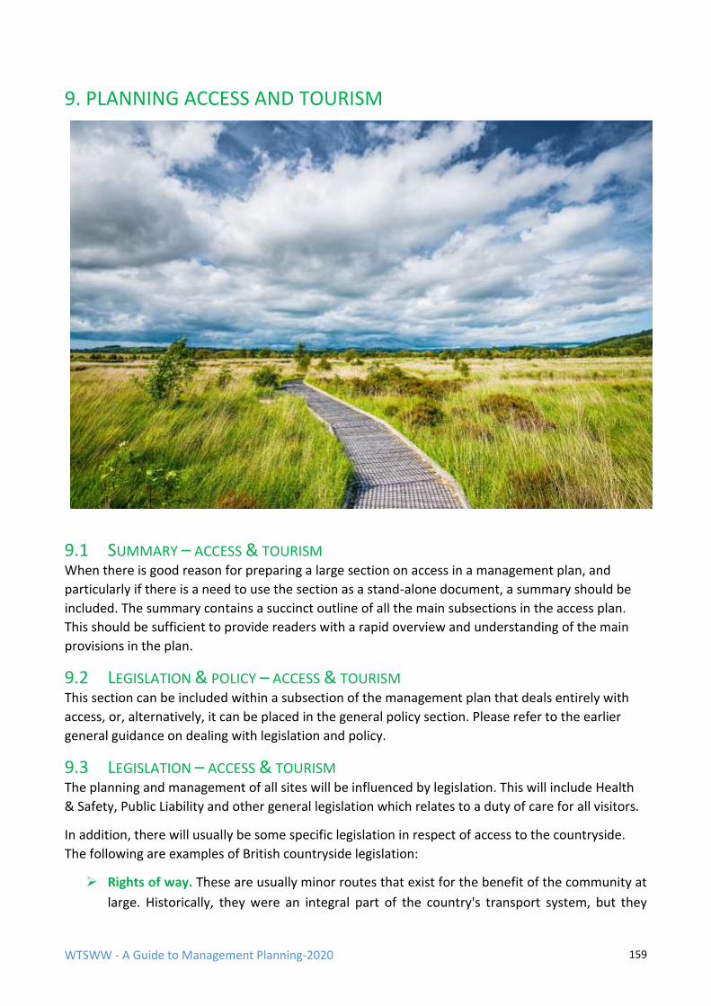
WTSWW - A Guide to Management Planning-2020 159
9. PLANNING ACCESS AND TOURISM
9.1 SUMMARY – ACCESS & TOURISM When there is good reason for preparing a large section on access in a management plan, and
particularly if there is a need to use the section as a stand-alone document, a summary should be
included. The summary contains a succinct outline of all the main subsections in the access plan.
This should be sufficient to provide readers with a rapid overview and understanding of the main
provisions in the plan.
9.2 LEGISLATION & POLICY – ACCESS & TOURISM This section can be included within a subsection of the management plan that deals entirely with
access, or, alternatively, it can be placed in the general policy section. Please refer to the earlier
general guidance on dealing with legislation and policy.
9.3 LEGISLATION – ACCESS & TOURISM The planning and management of all sites will be influenced by legislation. This will include Health
& Safety, Public Liability and other general legislation which relates to a duty of care for all visitors.
In addition, there will usually be some specific legislation in respect of access to the countryside.
The following are examples of British countryside legislation:
➢ Rights of way. These are usually minor routes that exist for the benefit of the community at
large. Historically, they were an integral part of the country's transport system, but they
WTSWW - A Guide to Management Planning-2020 160
have long since evolved into a recreational web which enables people to explore the
countryside. Where these rights of way pass through a site, with few exceptions, they must
be kept open at all times.
➢ Access to open countryside. The Countryside and Rights of Way Act 2000 provides a
statutory right of public access on foot for informal recreation over mountain, moor, heath,
down and all registered common land. Maps show where rights over open country and
registered common land under Part 1 of the CRoW Act apply. The implications of a site
falling within an open access area are obvious: the public has right of access. Limited
restrictions can be applied to protect sensitive wildlife.
This section of the plan must contain reference to all legislation that has implications for site access
and particularly for the safety of visitors. This is not the place to discuss the implications of the law.
9.4 POLICY – ACCESS & TOURISM
The development of the access, public use and tourism section of the plan is entirely guided by
policy, and policies must reflect legislation. This section should describe all organisational and any
other policies which have relevance to access provisions on the site. Much of the following
evaluation is concerned with assessing the extent to which organisational policies can be met on
individual sites. Local conditions, for example, dangerous features, fragile wildlife, or inaccessibility,
can significantly influence the ability to meet policies.
The following is an example of the access policies from a UK organisation which has a responsibility
for managing a large number of nature reserves:
The sustainable public use of the reserves will be encouraged in so far as such use:
Is consistent with our duty to maintain or restore the nature conservation and geological features to favourable conservation status
Does not expose visitors or staff, including contractors, to any significant hazards
All legitimate and lawful activities will be permitted in so far as these activities:
Are consistent with our duty to maintain or restore the nature conservation and geological features to favourable conservation status
Do not expose visitors or staff, including contractors, to any significant hazards
Do not diminish the enjoyment of other visitors to the site
Access Policy (strategy) for a suite of sites
There are many reasons for attempting to prioritise access provisions over a suite of sites. The most
usual is insufficient resources. If an organisation attempts to spread resources too thinly over a
number of sites it is unlikely that anything of real value will be achieved anywhere. A strategic
approach is essential when an organisation aims to ensure that each individual site within a suite of
WTSWW - A Guide to Management Planning-2020 161
sites is managed in the most appropriate way to meet organisational policies. There is no need, or
justification, to do everything everywhere.
A full analysis of the access potential of all sites should be completed. Each site should be examined
against a range of criteria; these will be more or less the same as those used to evaluate individual
sites. They will include, for example, accessibility of the site, accessibility within the site, safety,
fragility of features and site fabric, features of public interest, current public use, facilities and
provisions, and suitability to meet other organisational objectives. Clearly, the ideal way of
obtaining an overview would be to prepare access plans for each site. Unfortunately, even the cost
of preparing the simplest access plan can be prohibitive for some organisations. An initial
assessment, based on the above evaluation criteria, would identify the priorities for the subsequent
preparation of management plans.
The following is an example of a strategy identifying the priorities for access provisions applied to a
suite of nature reserves. The priorities were developed by considering each site against a list of
criteria similar to those mentioned above (CCW 2004).
The nature reserves were divided into three categories:
a) Sites where access is a major issue
This group comprises some of the most important tourist attractions in Wales. These sites, with few exceptions, attract
very large numbers of people regardless of their status as nature reserves. Unfortunately, with the exception of several
key well-known sites, the access potential of some sites in this group has not been realised. These sites provide ideal
opportunities to promote the value of the nature reserves, nature conservation and the countryside.
Resources will be made available to optimise public use of these sites and to ensure that an appropriate infrastructure is
in place. In many cases, the carrying capacity of this group of sites will have been reached, and there will be no
justification for increasing the number of visitors. However, there should be scope for improving the quality of the visit
on some sites. The completion of the access sections of the management plan for these sites is given the highest priority.
b) Sites where access is important but where, for a variety of reasons, there are relatively few visitors
These may not be the most important tourist sites, but they are very important sites for local people and those who are
particularly interested in the countryside and wildlife. Many have an underdeveloped infrastructure, and few have any
significant provisions for visitors. The importance of this group of sites must not be underestimated as they provide
obvious opportunities for development.
Wherever possible, access to these sites will be improved. A full and fresh appraisal of these sites is required and will be
undertaken as part of the site management planning process.
c) Sites where there is little public interest and where there is a range of factors that severely restricts, or prevents,
access.
These sites can be important to local people and individuals with specialist interests. They should be regarded as areas
with potential for improvement. However, it is important to recognise that there will be a small number of sites in this
group that are not suitable for public access.
These sites must not be neglected. Although not currently important for access, unless there are compelling reasons for
doing otherwise, steps should be taken to facilitate at least limited access. Planning should commence once plans for
the two preceding tiers are complete.
WTSWW - A Guide to Management Planning-2020 162
9.5 DESCRIPTION ACCESS & TOURISM
The section of the plan that contains the general site description is dealt with earlier in this guide.
All the basic site information, much of it relevant to this section, will have been included there, for
example, location, tenure, and descriptions of the features. Some additional information is required
when preparing a management plan for access. Ideally, this should also be included in the general
description. Occasionally, there may be justification for presenting the access section of a full
management plan as a stand-alone document. In these cases, the parts of the description that
specifically relate to access can be held in the access section of the management plan.
The following is a recommended list of contents for the access section of the description:
Contents:
9.5.1 Access / Tourist Zones (Compartments)
9.5.2 Visitor numbers
9.5.3 Visitor characteristics
9.5.4 Visit characteristics
9.5.5 Access to the site
9.5.6 Access within the site
9.5.7 Visitor facilities and infrastructure
9.5.8 The reasons why people visit the site
Wildlife attractions
Other features that attract people
9.5.9 Recreational activities
9.5.10 Current and past concessions
9.5.11 Stakeholder interests
9.5.12 The site in a wider context
9.5.1 ACCESS / TOURIST ZONES (COMPARTMENTS)
On many sites, the conclusions of the following access evaluation will vary from place to place
within the site and, consequently, the level of access will vary across a site. Some parts may be
suitable for access, while others are unsafe or fragile. Many other factors can also influence the
selection of visitor zones, for example, the distribution of features of interest to visitors, the
availability of access routes, and the protection of wildlife.
WTSWW - A Guide to Management Planning-2020 163
As the evaluation progresses, consideration should be given at each stage to the need to divide the
site into access zones. A range of different levels of access may be identified for the whole site or
for the zones within a site. For example, it would be reasonable to include total exclusion zones,
controlled access zones and open access zones within an individual site. It is also sometimes
necessary to establish activity zones, i.e. areas where specified activities are permitted or
prohibited. Zones can be seasonal. For example, exclusions can be imposed during the breeding
season of vulnerable nesting birds.
It is important that zonation systems are regarded as flexible management tools that can be
introduced, removed, or modified according to need. They can be used for a very wide range of
different purposes. The only important rules are:
• They should be clearly shown on a map.
• Maps must be made available to all interested parties.
• The boundaries of the zones must be marked, or otherwise easily located, on the ground.
A site may have been previously divided into zones for a variety of different reasons, but these may
not necessarily be relevant to access. This is not an issue since it is perfectly acceptable to have
several different overlapping zoning systems on an individual site. When it is necessary to divide a
site into visitor zones, the delineation and description of the zones, along with an explanation
outlining the basis for their selection, is required.
9.6 EVALUATION ACCESS / TOURISM
The outcome of this section is a clear statement of the level of access, including recreational
activities, that is appropriate for a site, or parts of a site. In other words, to what extent can an
organisation’s access policy be applied to the site?
Organisational access policies were discussed at the beginning of this section. They provide the
basis for developing the site-specific access objectives. The level at which access can be provided on
individual sites, or areas within a site, will be dependent on a range of local factors and on any
strategic plans.
The evaluation can be based on the following list of criteria. This list is offered as guidance and
should not be regarded as definitive. Some of these criteria will not be relevant to some sites and
will not be used. Conversely, additional criteria, not mentioned below, may be useful in some
situations. The criteria are interrelated and cannot be dealt with in isolation; each is dealt with in
turn but considered within the context of the whole.
The order in which the questions are presented is quite important. It is intended to avoid
unnecessary effort on sites where access is either not possible or extremely low key. Although an
organisation may have an access policy that is aimed at encouraging appropriate levels of access
and recreational use on sites, there can be occasions when, for good reasons, access cannot be
WTSWW - A Guide to Management Planning-2020 164
provided or there is no need to provide access. For example, there are sites where, with the
exception of a few scientists, people have no interest, and there is no potential to encourage
interest. Sites can be completely inaccessible, possibly as a consequence of legal or physical
barriers. Some sites are so dangerous that access cannot be permitted. If it becomes apparent, at
any stage in the evaluation, that there are good reasons for not providing access then the process
can come to an end. There is no point in considering carrying capacity for a site where there will be
no, or very few, visitors. Later, in the rationale, there may be opportunities for some form of virtual
access. This could be anything from interactive computer programmes to remote viewing. For
example, remote cameras are an excellent means of providing the public with opportunities to view
rare birds at their nests.
Evaluation is always about asking questions and providing answers. It must not become a rambling,
inconclusive discussion. All the information needed for the evaluation should be contained in the
description.
The criteria provide a logical sequence of questions:
1. What is the actual or potential demand?
2. Is the site accessible?
3. Is access possible within the site?
4. Is the site safe?
5. What are the implications of stakeholder interests?
6. What is the carrying capacity of the features?
7. What is the carrying capacity of the site?
8. Availability of resources
9.6.1 ACTUAL OR POTENTIAL DEMAND
The first step in the evaluation is an assessment of the demand, or requirement, for access. When
trying to assess potential public demand, one of the more important questions is: how popular is
the site with visitors, and could promotion or publicity increase interest and demand? There is no
need to consider detail at this stage; an outline will suffice. Projects to promote or publicise the site
can be developed at a later stage. The current information on visitor numbers and profile should be
held in the general site description, so there is no point in simply repeating that information.
The reason for beginning with this question is that if, for any reason, there is no actual, or potential,
demand there is little purpose in continuing with the evaluation. Whether or not a site has visitors
it is important to ask why this is the case. The features of interest have been described in the
preceding description. At this stage, the features are assessed to establish the actual, or potential,
interest. Many features mentioned in the description may, for a variety of reasons, fail to interest
visitors, while others may attract thousands of people each year.
WTSWW - A Guide to Management Planning-2020 165
The seasonal nature of features should be considered. For example, the feature that attracts the
majority of visitors to an offshore island nature reserve is the breeding population of seabirds,
particularly the Puffins, but these birds are absent in the winter.
What are the recreational opportunities; what do people do on the site, or what do they want to
do; how many of them want to do it? This is an expression of interest and not a replay of the
description. The actual carrying capacity, or tolerance to recreational activities, will be considered
in the sections of the management plan that deal with the wildlife features. This will be
summarised later in the subsection of this evaluation which deals with carrying capacity.
9.6.2 ACCESSIBILITY OF THE SITE
The obvious question is: how accessible is the site, or parts of the site, and can people get there? Is
it close to, or easily accessible from, major highway networks? If it is remote, are there any roads,
trails or footpaths, and are these in a condition that can be used, for example, by vehicles, bicycles
or on foot? If people travel by private vehicle, can they park? The legal rights of access are also
important. There may be seasonal aspects; some sites are not accessible in winter. If sites are not
accessible, and there is little or no potential for improvement, there will be no point in making
access provisions.
9.6.3 ACCESSIBILITY WITHIN THE SITE
How easily can visitors gain access within the site? What is the capacity of the current
infrastructure? What are the limitations, if any? For example, footpaths may be extremely severe
and only suitable for fit, active people, or, alternatively, the site may contain a network of level,
wide, well-surfaced tracks that are suitable for everyone. In the UK land can be designated as open
access, where there is no restriction on access, but there may be restrictions on activities such as
the use of vehicles.
Is access controlled? For example, are vehicles, bicycles or horses permitted? Are there periods of
the year when parts of the site may have to be closed to protect wildlife or for any other reason?
When a site cannot meet its potential carrying capacity because of problems of access within the
site, there may be opportunities for remedial action. At this stage in the plan there is no need for
detail. An indication will suffice as the detail will be included in the management rationale. The
conclusion of this section will be the extent to which access within the site will have an influence on
the potential for the site to provide for visitors.
9.6.4 SITE SAFETY (DANGEROUS TERRAIN, INFRASTRUCTURE, ARTEFACTS, ETC.)
Access to any site may be restricted by the presence of hazards. In extreme circumstances, there
may be an obligation to close parts of sites, or even entire sites. The first step when completing this
section is to ensure compliance with all statutory and organisational health and safety procedures.
For example, in the UK all organisations which employ staff on sites, or provide public access to
sites, must complete a detailed risk assessment or audit of the site. All potential dangers or threats
WTSWW - A Guide to Management Planning-2020 166
on the site must be identified. All the implications for the health and safety of visitors are
considered, and then limits, if necessary, are established and applied. For example, a section of a
site may have to be closed to public access. Of course, in some instances, it will be possible to take
remedial action to remove or isolate the risk and ensure visitor safety. The conclusion of this
section is an assessment of the extent to which safety considerations limit public use of the site.
9.6.5 STAKEHOLDER INTERESTS
Are there any stakeholder interests, rights and expectations that will influence access to the site,
and will they influence access provisions on the site? This extends the evaluation to consider the
concerns, expectations and aspirations of stakeholders. Some stakeholders may benefit, but others
will be adversely affected as a consequence of visitor activity. Is there any potential for conflict with
other local provisions, or opportunities for working with other providers? It is important that
opportunities for working with others are considered. It may be possible to work with stakeholders
to provide improved opportunities for visitors, thereby enhancing their experience and providing
income or other benefits to the stakeholders.
9.6.6 CARRYING CAPACITY
Ideally, managers need to differentiate between changes that result from natural processes and
which, in the context of wilderness management, are considered acceptable, and changes resulting
from the impact of human activities, which are not acceptable. In reality, it may not possible to
differentiate, with any certainty, between the effects of natural processes and the effects of
anthropogenic activity, since change is often the consequence of the combined impact of several
factors, both natural and anthropogenic.
Biological carrying capacity may be complicated, but it pales into insignificance when carrying
capacity is used to define the quality of the human experience. The values are subjective and,
consequently, difficult to defend. Limits on the level of access, i.e. the total number of visitors, can
be meaningless. Activities also need to be limited, and some activities will be intolerable to all but a
very small minority. In addition to the type of activity, the size of groups, the behaviour of
individuals, and the time that they spend in an area, will all have implications for the enjoyment of
others.
One way forward, which is recognised by most planning systems, is to ensure public participation in
this process. But for sites that offer opportunities for a multitude of competing or incompatible
leisure activities it will not be possible to please everyone. Different people have different interests
and expectations. They will judge their experience of a site from an almost infinite range of
personal perspectives. At one extreme, some individuals will seek solitude, and even a single
encounter with other people will diminish the quality of their experience. At the other extreme,
many people feel very uncomfortable when they are away from the crowd; wilderness, wild places
and nature can be threatening to those who see them as unfamiliar territory.
WTSWW - A Guide to Management Planning-2020 167
9.6.6.1 CARRYING CAPACITY OF THE FEATURES
The relationship between access and the wildlife features of a site is an extremely important
consideration in a plan. It is essential that public access does not put the wildlife features at risk.
Establishing the carrying capacity of individual features, i.e. their tolerance of human activities, is
quite different to dealing with the carrying capacity of a site. In many, if not most, cases, it is
possible at least to identify the activities that could damage features. However, defining acceptable
levels is more difficult. The process that identifies the carrying capacity of the important wildlife
features will be contained in the section of the plan that establishes the limits for the factors which
have implications for the wildlife features. Consequently, the sections containing the wildlife
objectives must be completed before dealing with access.
Except in rare circumstances, people will have some level of impact on the site features; in other
words, they, and in particular their activities, are factors. The key role of nature reserves, and most
protected areas, is to ensure that wildlife is safeguarded against the excesses of uncontrolled,
illegal or destructive human behaviour. The consequence is that human activity must be controlled.
There may, occasionally, be justification for some compromise, and areas of habitat may have to be
sacrificed to provide the infrastructure necessary to accommodate people (for example, paths,
roads, parking facilities, etc.). Also, be aware that the landscape qualities of a site can easily be
compromised by the construction of inappropriate boardwalks, footpaths or other management
infrastructure.
Some aspects of public use can have very serious and obvious consequences for wildlife features,
for example, climbing on cliffs used by seabirds, dog walking (emptying) in sensitive botanical sites,
wildfowling where the feature is a wintering population of wildfowl. Where an activity is changing,
or has obvious potential to change, a feature, these activities should be regarded as factors which
must be kept under control. When our tolerance of the factor can be defined by specified limits this
will provide a performance indicator.
This process, or analysis, is not part of the access section. These limits are established when
preparing the objectives for the important wildlife features. They can then be copied into this
section of the plan. In some circumstances, there may be a need to return to the wildlife objectives
to make sure that the access factors have been given adequate attention. The impact of all current
activities on each of the wildlife features, on the landscape and on other important features,
particularly those that have legal protection (for example, archaeological features), must be
considered. Examples of activities include climbing, cycling, canoeing, fishing, wildfowling and, in
fact, any activity that could change a feature.
NOTE: The management required to control human activities should be identified and described in
the ‘rationale’ section for each of the objectives for the wildlife features. The same projects will also
be linked to the access objective.
The precautionary principle
Establishing the carrying capacity of features where access and recreational use does not have any
easily measured impact on the important features is more complicated. From an ethical, and
sometimes legal, position, it would be extremely difficult to defend a situation where an area is
WTSWW - A Guide to Management Planning-2020 168
declared a nature reserve and the consequence is that subsequent public use damages the wildlife.
Managers must avoid this situation, and they must not leave anything to chance. A precautionary
approach should be adopted; this is described in the introduction to this guide.
If the precautionary principle is applied, there is no need for scientific proof in order to restrict
human use or any specific activities when there is a reason to believe that they are a threat. In
essence, the precautionary principle is about not taking chances with our environment. So,
logically, when applying the principle to the carrying capacity of a site, or a feature, there should be
an obligation to prove, with full scientific certainty, that an activity will not cause any damage
before that activity, or level of activity, is permitted.
Clearly, there is an obligation to limit or manage access and activities, rather than expecting wildlife
to adapt to the presence of people. The precise impact that public use will have on a feature is
rarely understood, so the potential for establishing evidence-based limits is low. The current level
of use is a good starting point. An obvious question would be: has the past, or current, level of use
had a detrimental impact on any of the wildlife features? If the answer is ‘no’, but there is reason to
believe that an increase in public use would put features or the site at risk, then limits can be set at
the current level. If there is no evidence to suggest that an increase in public use will have any
detrimental impact, limits need not be applied. However, surveillance will be essential and it should
be linked to the wildlife monitoring projects. If the answer is ‘yes’, the activities must be controlled
or reduced. The factors with limits (access and recreational activities are factors) that are used as
performance indicators for the wildlife features must be set below a level which threatens a
feature.
Even when public access and recreation is not considered a threat, it must be recorded. If in the
future any damage to the features is detected, or there is concern that there is potential for
damage, and this is linked to an increase in public use, access limits can be established at that time.
When people seek permission to engage in new recreational activities or to significantly increase a
current activity, a full impact assessment must be completed before consent is given. Logically, the
applicant, and not the site manager, should finance this assessment.
9.6.6.2 CARRYING CAPACITY OF THE SITE This is the level of access that can be accommodated without detracting from the quality of the
experience that visitors enjoy on the site. There will be two main areas of impact:
Direct impact on infrastructure or landscape qualities
Visitors can have a direct impact on the infrastructure, landscape and wilderness qualities of a site,
for example, paths may become over-wide and unsightly. It is relatively easy to deal with the direct
physical impact; the consequences of over use are tangible and measurable. Carrying capacity can
be defined by the condition required of, for example, trails and viewing areas. Trails should not
become too wide or develop into multiple tracks, and viewing areas should not become hopelessly
eroded areas of mud or dust. In short, carrying capacity in this context is an expression of the how
many people a site can accommodate without showing unacceptable signs of wear.
WTSWW - A Guide to Management Planning-2020 169
This issue is complicated because footpaths and trails of all sorts can be constructed to withstand
pressure. For example, in some upland National Parks the footpaths have been constructed using
heavy stone slabs. Some people consider that these diminish the ‘natural’ qualities of sites, while
others appreciate the opportunity to gain relatively easy access to these upland sites. This section
on access planning begins with policy because it is so important. Organisations have choices, and
these choices are expressed through their policies: they can provide access opportunities regardless
of impact on the intrinsic values of a site, or they can restrict access and maintain some of the
natural wilderness character. There must be room for both, and a strategic approach that identifies
different levels of use for different sites would be ideal. Where site mangers are not blessed with
guidance from a wider strategy, they should at least look to other providers in the local area, and
perhaps seek to offer alternative experiences.
On very large sites, it will be possible to delineate different zones for different levels of use within
the site. For example, footpaths close to parking areas could be provided with robust, even
surfaces, while, at the opposite extreme, the footpaths in remote areas could be left unmade. The
decisions to open up or restrict access to areas by managing the condition of the footpaths will, of
course, be influenced by the carrying capacity of the wildlife features and by most of the other
criteria included in this evaluation.
Impact on the quality of the experience available for visitors
People can visit sites in such large numbers that they become a distraction to others. This is
particularly important in areas of high landscape or wilderness value. There is also a problem with
some recreational activities which, although perfectly legal, may be considered intrusive and
antisocial by other visitors. Assessing the quality of experience is never easy; it will always be an
entirely subjective analysis. Different people will have very different views: for some a visit to a
beach is about being in a crowd and they obviously enjoy that experience, but others deliberately
seek out wild and lonely landscapes, where they have few encounters with others.
There is a view that activities of all kinds, in so far as they are compatible with protecting the
important wildlife features, should be promoted on nature reserves. Often, our preoccupation with
applying scientific reasoning, i.e. to establish a scientific basis for approving or encouraging an
activity, the very special character of these sites is forgotten. Protected areas provide some of the
few remaining places where people can find opportunities to enjoy nature. These connections with
the wild provide the intangible, almost spiritual, experiences that can enhance our sense of well-
being. Regardless of our inability to obtain empirical evidence to support this, there must be an
obligation to protect and, if at all possible, improve opportunities for these experiences.
Perhaps we should question the need for noisy or intrusive activities in these very special areas.
Would it not be more constructive to promote a sense of respect for the unique atmosphere of
these places? There are now so few remaining opportunities, particularly in the developed world,
to experience a true closeness with nature, that it may be better to decide that the more disruptive
activities should be accommodated elsewhere. There are many places that provide ideal conditions
for off-road driving or jet skiing, but a landscape with wilderness qualities, that gives a sense of
peace and solitude, is something rare and precious that is too easily destroyed. This is not a call for
WTSWW - A Guide to Management Planning-2020 170
exclusivity or some form of elitism. Nature reserves should fulfil the role of providing opportunities
for anyone who wishes to enjoy the unique experiences that they can provide.
Clearly, there is an obligation at least to attempt to provide opportunities to suit everyone
somewhere. Ideally, a strategic approach should be adopted that is not limited to any individual
nature reserves, but would take into account all the access opportunities in a given area. A strategy
should recognise the need to provide the widest possible range of recreational activities, including
opportunities for people to enjoy the tranquillity of a nature reserve that is largely undisturbed.
In the absence of a wider strategy, the management planning process, and particularly this section
on carrying capacity, can, and should, consider the site within a wider geographical context. All
existing, and potential, recreational activities should be considered, and a decision should be made
at this point whether to encourage, permit, control or prohibit them. As with all other sections in
this evaluation, whenever decisions are made reasons must be provided. This is particularly
important when making decisions that cannot be based on objective analysis. There is no scientific
or magic formula that can be used to calculate a carrying capacity that is consistent with
maintaining a high-quality experience, because, in this context, ‘quality’ has an infinite range of
values.
9.6.7 AVAILABILITY OF RESOURCES
The level of resources available, or anticipated, will almost always be a consideration that has
significant implications for the level of access that can be provided on a site. One of the functions of
any management plan is to provide the justification for resources. If the resource level has not been
previously specified, it is best not to allow planning to be constrained by a perceived lack of
resources at this stage. The level of access should be determined by the other evaluation criteria,
and this should provide a site-specific interpretation of organisational access policy. However, some
organisations may specify resource levels prior to the preparation of a plan. In these cases, the
availability of resources becomes a very important factor, which will have implications for the site-
specific implementation the organisation’s general access policy. For example, at an organisational
level there may be a strong presumption in favour of providing access, but the lack of resources to
provide a safe infrastructure on a site could severely restrict access.
Summary of the evaluation
This is the final stage in the evaluation. A succinct summary, based on the preceding evaluation, is
prepared. It describes the extent to which organisational policies for access can be met when taking
account of the prevailing circumstances on an individual site. An indication is given of the number
of people and what activities the site, or zones within a site, will accommodate.
9.7 ACCESS OPTIONS
Access options are a simple means of indicating the level of access that is considered appropriate
for the site, or for zones within the site, following the evaluation. (If a site is divided into different
zones a map should be included.)
WTSWW - A Guide to Management Planning-2020 171
Options are, in fact, site-specific access policies. They are best defined at an organisational level
and should, ideally, be applied in a standard way to all the sites managed by an organisation. This
would contribute to the development of a strategic access approach, described in an earlier section
of this chapter. The following are examples of access options:
a) Access is encouraged with no limits applied to any legal recreational activity.
b) Access is encouraged and recreational activities are controlled within specified limits.
c) Access levels and recreational activities are encouraged but controlled within specified
limits.
d) Access is permitted, but only unobtrusive or passive activities are allowed.
e) Access is limited to legal rights of way courtesy paths and other facilities.
f) Access is limited to legal rights of way.
g) No access.
9.8 ACCESS OBJECTIVE
It is a very small step to move from an option (site-specific policy) to an objective. A policy is a
broad or general statement of intent, while an objective is, or should be, SMART. The concept of
SMART objectives was covered in detail in an earlier section. As a reminder:
Specific
Measurable
Achievable
Relevant
Time-based
An access objective will be specific to the provision of access on an individual site. It will be
measurable because there will be associated performance indicators. Certainly, in the long term, it
will be achievable. Objectives will always be relevant to an organisation’s policies. ‘Time-based’
requires a significantly different definition to that used in the version of SMART for wildlife
objectives. Access objectives should be time-based and written for specified periods. The period
can range from as little as a year to, in exceptional circumstances, as long as 10 years. There is little
purpose in trying to predict what will be relevant beyond that time scale.
For sites that are robust and resilient, and where organisational access policies can be applied
without significant modification, an access objective could be:
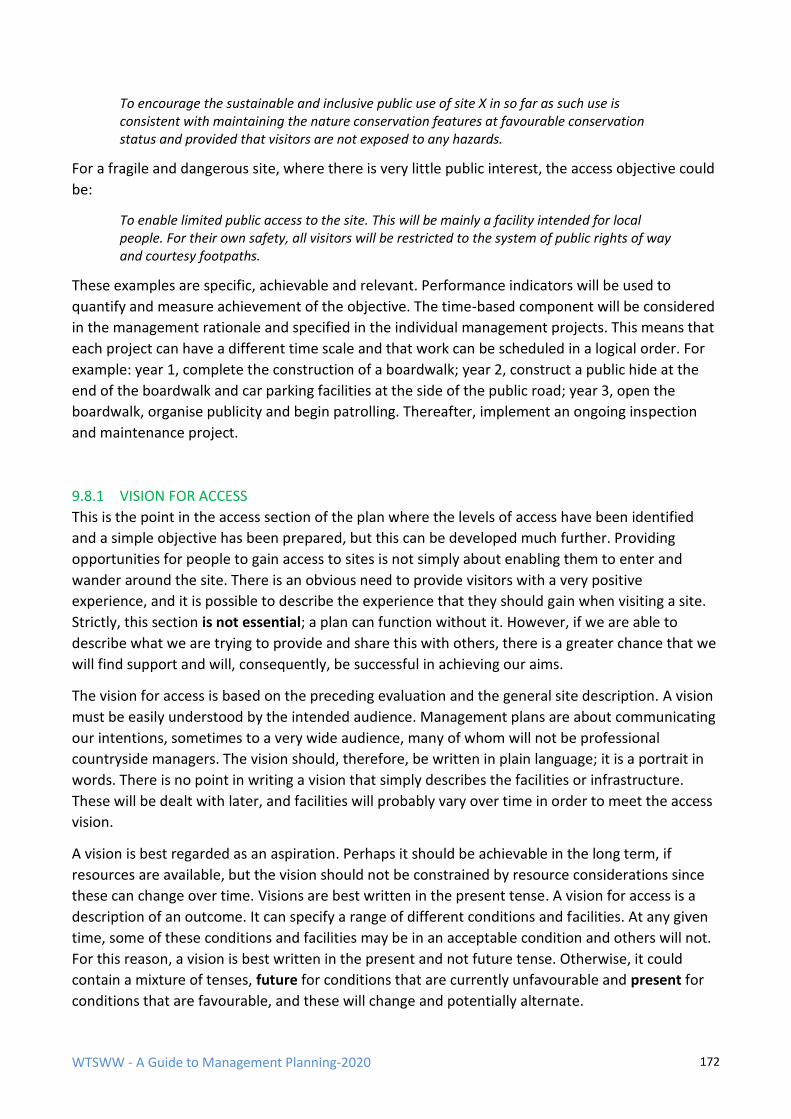
WTSWW - A Guide to Management Planning-2020 172
To encourage the sustainable and inclusive public use of site X in so far as such use is consistent with maintaining the nature conservation features at favourable conservation status and provided that visitors are not exposed to any hazards.
For a fragile and dangerous site, where there is very little public interest, the access objective could
be:
To enable limited public access to the site. This will be mainly a facility intended for local people. For their own safety, all visitors will be restricted to the system of public rights of way and courtesy footpaths.
These examples are specific, achievable and relevant. Performance indicators will be used to
quantify and measure achievement of the objective. The time-based component will be considered
in the management rationale and specified in the individual management projects. This means that
each project can have a different time scale and that work can be scheduled in a logical order. For
example: year 1, complete the construction of a boardwalk; year 2, construct a public hide at the
end of the boardwalk and car parking facilities at the side of the public road; year 3, open the
boardwalk, organise publicity and begin patrolling. Thereafter, implement an ongoing inspection
and maintenance project.
9.8.1 VISION FOR ACCESS
This is the point in the access section of the plan where the levels of access have been identified
and a simple objective has been prepared, but this can be developed much further. Providing
opportunities for people to gain access to sites is not simply about enabling them to enter and
wander around the site. There is an obvious need to provide visitors with a very positive
experience, and it is possible to describe the experience that they should gain when visiting a site.
Strictly, this section is not essential; a plan can function without it. However, if we are able to
describe what we are trying to provide and share this with others, there is a greater chance that we
will find support and will, consequently, be successful in achieving our aims.
The vision for access is based on the preceding evaluation and the general site description. A vision
must be easily understood by the intended audience. Management plans are about communicating
our intentions, sometimes to a very wide audience, many of whom will not be professional
countryside managers. The vision should, therefore, be written in plain language; it is a portrait in
words. There is no point in writing a vision that simply describes the facilities or infrastructure.
These will be dealt with later, and facilities will probably vary over time in order to meet the access
vision.
A vision is best regarded as an aspiration. Perhaps it should be achievable in the long term, if
resources are available, but the vision should not be constrained by resource considerations since
these can change over time. Visions are best written in the present tense. A vision for access is a
description of an outcome. It can specify a range of different conditions and facilities. At any given
time, some of these conditions and facilities may be in an acceptable condition and others will not.
For this reason, a vision is best written in the present and not future tense. Otherwise, it could
contain a mixture of tenses, future for conditions that are currently unfavourable and present for
conditions that are favourable, and these will change and potentially alternate.
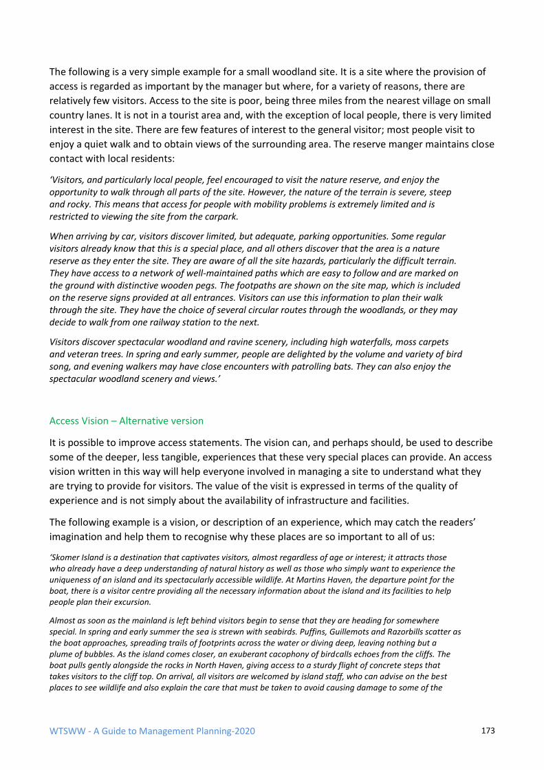
WTSWW - A Guide to Management Planning-2020 173
The following is a very simple example for a small woodland site. It is a site where the provision of
access is regarded as important by the manager but where, for a variety of reasons, there are
relatively few visitors. Access to the site is poor, being three miles from the nearest village on small
country lanes. It is not in a tourist area and, with the exception of local people, there is very limited
interest in the site. There are few features of interest to the general visitor; most people visit to
enjoy a quiet walk and to obtain views of the surrounding area. The reserve manger maintains close
contact with local residents:
‘Visitors, and particularly local people, feel encouraged to visit the nature reserve, and enjoy the opportunity to walk through all parts of the site. However, the nature of the terrain is severe, steep and rocky. This means that access for people with mobility problems is extremely limited and is restricted to viewing the site from the carpark.
When arriving by car, visitors discover limited, but adequate, parking opportunities. Some regular visitors already know that this is a special place, and all others discover that the area is a nature reserve as they enter the site. They are aware of all the site hazards, particularly the difficult terrain. They have access to a network of well-maintained paths which are easy to follow and are marked on the ground with distinctive wooden pegs. The footpaths are shown on the site map, which is included on the reserve signs provided at all entrances. Visitors can use this information to plan their walk through the site. They have the choice of several circular routes through the woodlands, or they may decide to walk from one railway station to the next.
Visitors discover spectacular woodland and ravine scenery, including high waterfalls, moss carpets and veteran trees. In spring and early summer, people are delighted by the volume and variety of bird song, and evening walkers may have close encounters with patrolling bats. They can also enjoy the spectacular woodland scenery and views.’
Access Vision – Alternative version
It is possible to improve access statements. The vision can, and perhaps should, be used to describe
some of the deeper, less tangible, experiences that these very special places can provide. An access
vision written in this way will help everyone involved in managing a site to understand what they
are trying to provide for visitors. The value of the visit is expressed in terms of the quality of
experience and is not simply about the availability of infrastructure and facilities.
The following example is a vision, or description of an experience, which may catch the readers’
imagination and help them to recognise why these places are so important to all of us:
‘Skomer Island is a destination that captivates visitors, almost regardless of age or interest; it attracts those who already have a deep understanding of natural history as well as those who simply want to experience the uniqueness of an island and its spectacularly accessible wildlife. At Martins Haven, the departure point for the boat, there is a visitor centre providing all the necessary information about the island and its facilities to help people plan their excursion.
Almost as soon as the mainland is left behind visitors begin to sense that they are heading for somewhere special. In spring and early summer the sea is strewn with seabirds. Puffins, Guillemots and Razorbills scatter as the boat approaches, spreading trails of footprints across the water or diving deep, leaving nothing but a plume of bubbles. As the island comes closer, an exuberant cacophony of birdcalls echoes from the cliffs. The boat pulls gently alongside the rocks in North Haven, giving access to a sturdy flight of concrete steps that takes visitors to the cliff top. On arrival, all visitors are welcomed by island staff, who can advise on the best places to see wildlife and also explain the care that must be taken to avoid causing damage to some of the
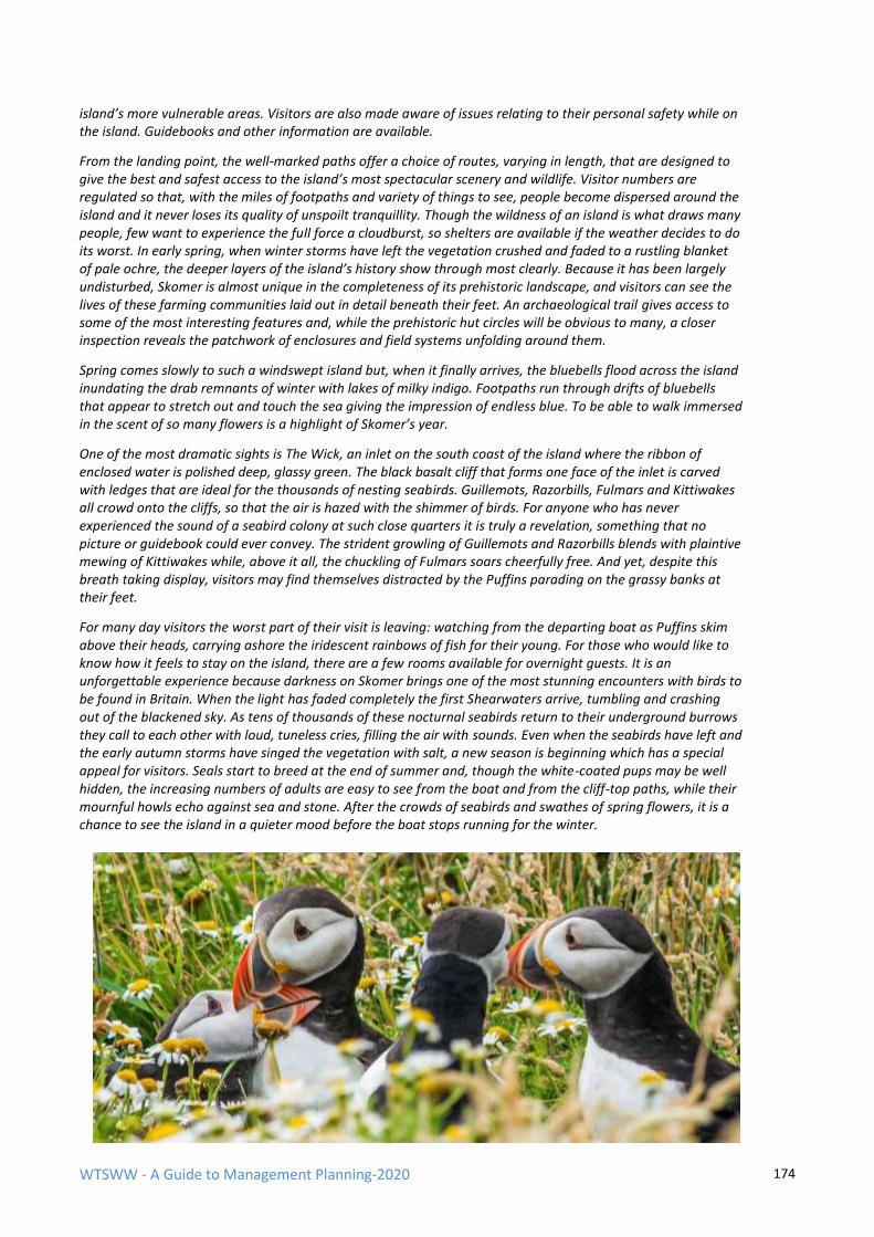
WTSWW - A Guide to Management Planning-2020 174
island’s more vulnerable areas. Visitors are also made aware of issues relating to their personal safety while on the island. Guidebooks and other information are available.
From the landing point, the well-marked paths offer a choice of routes, varying in length, that are designed to give the best and safest access to the island’s most spectacular scenery and wildlife. Visitor numbers are regulated so that, with the miles of footpaths and variety of things to see, people become dispersed around the island and it never loses its quality of unspoilt tranquillity. Though the wildness of an island is what draws many people, few want to experience the full force a cloudburst, so shelters are available if the weather decides to do its worst. In early spring, when winter storms have left the vegetation crushed and faded to a rustling blanket of pale ochre, the deeper layers of the island’s history show through most clearly. Because it has been largely undisturbed, Skomer is almost unique in the completeness of its prehistoric landscape, and visitors can see the lives of these farming communities laid out in detail beneath their feet. An archaeological trail gives access to some of the most interesting features and, while the prehistoric hut circles will be obvious to many, a closer inspection reveals the patchwork of enclosures and field systems unfolding around them.
Spring comes slowly to such a windswept island but, when it finally arrives, the bluebells flood across the island inundating the drab remnants of winter with lakes of milky indigo. Footpaths run through drifts of bluebells that appear to stretch out and touch the sea giving the impression of endless blue. To be able to walk immersed in the scent of so many flowers is a highlight of Skomer’s year.
One of the most dramatic sights is The Wick, an inlet on the south coast of the island where the ribbon of enclosed water is polished deep, glassy green. The black basalt cliff that forms one face of the inlet is carved with ledges that are ideal for the thousands of nesting seabirds. Guillemots, Razorbills, Fulmars and Kittiwakes all crowd onto the cliffs, so that the air is hazed with the shimmer of birds. For anyone who has never experienced the sound of a seabird colony at such close quarters it is truly a revelation, something that no picture or guidebook could ever convey. The strident growling of Guillemots and Razorbills blends with plaintive mewing of Kittiwakes while, above it all, the chuckling of Fulmars soars cheerfully free. And yet, despite this breath taking display, visitors may find themselves distracted by the Puffins parading on the grassy banks at their feet.
For many day visitors the worst part of their visit is leaving: watching from the departing boat as Puffins skim above their heads, carrying ashore the iridescent rainbows of fish for their young. For those who would like to know how it feels to stay on the island, there are a few rooms available for overnight guests. It is an unforgettable experience because darkness on Skomer brings one of the most stunning encounters with birds to be found in Britain. When the light has faded completely the first Shearwaters arrive, tumbling and crashing out of the blackened sky. As tens of thousands of these nocturnal seabirds return to their underground burrows they call to each other with loud, tuneless cries, filling the air with sounds. Even when the seabirds have left and the early autumn storms have singed the vegetation with salt, a new season is beginning which has a special appeal for visitors. Seals start to breed at the end of summer and, though the white-coated pups may be well hidden, the increasing numbers of adults are easy to see from the boat and from the cliff-top paths, while their mournful howls echo against sea and stone. After the crowds of seabirds and swathes of spring flowers, it is a chance to see the island in a quieter mood before the boat stops running for the winter.
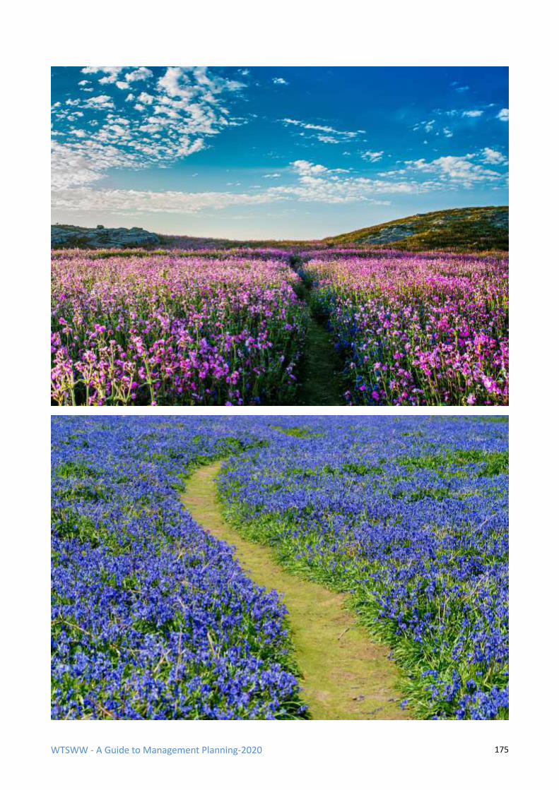
WTSWW - A Guide to Management Planning-2020 175
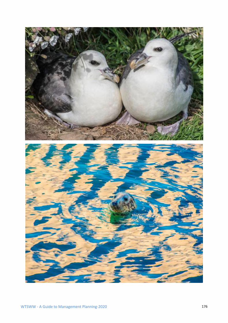
WTSWW - A Guide to Management Planning-2020 176
WTSWW - A Guide to Management Planning-2020 177
9.8.2 PERFORMANCE INDICATORS & MONITORING
Monitoring is central to any management planning process. If there is no monitoring, it is not
possible to know that an objective is being met, and there is no means of knowing that
management is appropriate. Monitoring requires a focus. The planning process identifies the
objective with performance indicators, which are, in fact, the formulated standard referred to in
the definition of monitoring. Without a standard there can be no monitoring.
Performance indicators for access need to be selected with care. They must be measurable and
quantified (i.e. so that they can be monitored), and the data should be easy to collect. The number
of indicators should be kept to a minimum, but there should be sufficient to provide the evidence
necessary to ensure that the quality of the access provisions can be measured.
There is no need to include performance indicators for the condition of the infrastructure at this
stage. The access infrastructure (for example, the roads, footpaths, trails, boardwalks, hides, etc.)
will be described later in the action plan. The condition of all infrastructure provisions must be
monitored to ensure that it meets prescribed standards and, more specifically, legal safety
standards. However, this is best regarded as compliance monitoring (i.e. compliance with the plan).
So, whenever a plan identifies the need to construct or maintain a structure in order to meet an
access objective (for example, a boardwalk over a raised bog), there will be an associated project
for inspecting or monitoring the condition of the structure.
Monitoring visitor attendance and their activities on a site (how many, how often, when and
where) will provide a useful range of performance indicators. Examples can include:
• The total annual number of visitors, or a representative sample, for the whole, or part, of
the site. (This can be used to measure trends.)
• The spatial distribution of use within a site.
• The seasonal distribution of visits.
• The number of different tour operators, or the total annual number of organised tours, on a
site.
• The number of educational groups.
As with all performance indicators, the relationship between the number of visitors to a site and
the quality of the access provisions can be very tenuous. There are many examples of nature
reserves where high levels of public use are not related to the status, the features of interest, or the
provisions on a site. Visitors may be passing through a site for some unrelated purpose. For
example, disproportionately high numbers of people are recorded on a footpath that leads through
a nature reserve in South Wales; this is because the footpath provides a short cut between a
residential area and a main bus stop. Visitors sometimes visit a site for reasons that have nothing to
do with the wildlife or the fact that it is a nature reserve. For example, there are many coastal sand
dune nature reserves with beaches that attract people not because of the wildlife but because they
wish to sunbathe or swim in the sea.
WTSWW - A Guide to Management Planning-2020 178
A second area with potential for misinterpretation is that people will often visit sites regardless of
the quality or quantity of access provisions. The features of interest, wildlife or otherwise, can be so
special that visitor numbers will exceed expectation and capacity even in the absence of any
provisions intended to attract them.
Taken alone, the total number of people visiting or using a site has little meaning unless their
reasons for visiting are understood and there is some relationship with the quality of the services
provided. In other words, quantity as a performance indicator should be accompanied by indicators
of quality. Quality is not easily measured. The following are a few examples of approaches that
have been used with some success:
• The number of repeat visits by individuals, or by a particular tour operator.
• Level of satisfaction measured informally by, for example, visitor books.
• Level of satisfaction measured formally by, for example, structured questionnaires or visitor
surveys.
• The number of complaints or compliments.
Limits
All performance indicators must be quantified. Specified limits define the degree to which the value
of a performance indicator is allowed to fluctuate without creating any cause for concern. In ideal
circumstances, two values are required: an upper limit and a lower limit. Limits can be used for
access performance indicators in much the same way that they are used for wildlife objectives.
Limits can provide a warning that there are too many or too few visitors to a site. Too many can
damage the features of interest or the fabric of a site; too few can, in some circumstances, lead to a
loss of direct income, or indirect contributions to a local community.
It is important to remember that the identification of specified limits will always require a degree of
judgement. The best that can be done, in many cases, is to set limits using expert judgement,
backed up by some form of peer review, corporate ownership and consultation with stakeholders.
The planning process is cyclical and iterative; limits will be tested and, if they fail, can be changed.
An adaptable approach to planning allows us to learn from our mistakes.
Reminder: Access objectives are about what we want to provide on a site, and this is not
necessarily what we currently have.
WTSWW - A Guide to Management Planning-2020 179
9.9 STATUS & RATIONALE
9.9.1 STATUS
The status of access provisions is the difference between the current state and the required state,
as defined by the objective and the performance indicators. Terms such as favourable and
unfavourable can be used to describe the status of access provisions. However, the definition of
favourable conservation status, as applied to wildlife features, is not relevant and cannot be applied
to the status of access provisions.
If the status is unfavourable, reasons should be provided. Consideration is given to the quality of
the provisions currently on offer. Are they adequate? The shortfall, if any, is noted. Whenever
possible, reasons should be given for the failure, but remedial management actions are not
considered at this stage. They will be identified in the next section.
One of the failings may be that insufficient numbers of people are visiting the site. It may be that,
as a consequence of the lack of public transport, access is only available to car owners. If the site
objective is to ensure that, for whatever reason, people are not, or do not feel, excluded, does the
actual visitor profile match the aspirations for the site?
In some cases, the problem may be that more people want access to a site, or parts of a site, than
can be safely accommodated without putting themselves or the integrity of the site at risk. These
problems will be identified in this section and carried through to the rationale, where management
projects will be identified.
9.9.2 RATIONALE
Having decided what is to be achieved and the extent to which the access objective is being met,
this is the stage at which all the management actions that are required to meet the access objective
are identified and outlined. Many activities or projects will be derived from the preceding
assessment of status. If, for example, the conclusion is that access is already at appropriate levels,
all the work that is currently being undertaken to maintain the provision should be continued.
However, if there is a shortfall (for example, very few people visiting a site that should attract, and
could easily accommodate, larger numbers) the reasons or factors that contribute to the shortfall
must be identified. Management projects can then be introduced to manage, reduce or remove the
influence of the factor.
There is a difference in the rationale between planning for the first time, when there is no record of
management, and on subsequent occasions, when there is a record of management. An
assessment of status is required for both, but the conclusions reached when planning for the first
time will be limited by the lack of any previous assessment and records of management. The use of
status as a guide to identifying appropriate management will be extremely limited. In these
circumstances, an analysis of the factors is the best method for identifying management.
The rationale should identify projects which include all construction and maintenance work, liaison,
people management, provision of information and, in some circumstances, interpretation and
WTSWW - A Guide to Management Planning-2020 180
education. The projects will not be described in any detail at this stage; that comes later. The range
of projects will vary enormously from site to site.
The following is a list of factors, along with related questions, that may help to structure the
rationale. This is not a definitive list, and some of the factors will not be relevant to some sites. For
many large and complex sites there will be many more factors. In these cases, begin by including
the following examples and then list all the additional factors that may influence access provisions.
The factors should be treated as a series of questions; the answers will be the work or projects
required to provide access for visitors. For example, one factor that will nearly always influence the
number of visitors is the accessibility of a site. If visitor numbers are low, ask the obvious question:
is accessibility a contributing factor? If the answer is yes, identify a project or projects to improve
accessibility.
9.9.3 FACTORS THAT MAY HAVE IMPLICATIONS FOR ACCESS
LEGISLATION Legislation, or the need to comply with legislation, must be given adequate attention. All the
legislation that is relevant to access management should have been included in the description. This
is the stage at which the implications are considered. Some of the most important legislation will be
Health & Safety and Public Liability. The plan must recognise the duty of care to all visitors, and this
will, of course, include staff. Other areas of legislation will place an obligation on site management
to maintain routes or areas of the site open to unimpeded public access. There is also legislation to
protect the rights of disabled visitors. All of these will have implications for management and will
give rise to specific projects, for example, safety signs and information, safety barriers, exclusion
zones, safety inspections and audits, and rights of way management. There will also be legal
implications for many of the projects identified when considering the following factors. For
example, when considering ‘access within the site’ the conclusion could be that it is inadequate
because there are no safe routes across a raised bog. The solution is to provide a boardwalk.
However, as a consequence of the Disability Discrimination Act, the boardwalk must be constructed
to a standard suitable for disabled people.
ACCESS TO THE SITE
If this is inadequate, can any projects, for example, liaison with the local Highways Department, be
identified to improve the situation? One of the issues that can exclude potential visitors is the lack
of public transport. In these circumstances, a project could be identified to assess the potential for
public transport, and this could lead to liaison with local providers. Are there adequate and safe
parking facilities? Projects can be identified to ensure that car parks are constructed to an
appropriate standard and that they are maintained.
ACCESS WITHIN THE SITE Are there adequate roads, bridleways, paths and boardwalks? Do all existing routes meet legal and
any other specified standards? Projects must be identified for the construction and maintenance of
all existing and planned routes.
WTSWW - A Guide to Management Planning-2020 181
VISITOR SAFETY
The most obvious and important question has to be: is there an up to date site hazard assessment?
The health and safety of visitors must always be a prime concern. Consideration must be given to
what steps should be taken to minimise the risks to visitors. Depending on the nature of the hazard,
there are a number of management actions that can be employed. The most obvious is to prevent
access to dangerous areas or objects. In all cases, there is a requirement to ensure that visitors are
aware of the hazards and of any steps that they must take to avoid risk. A management project
must be included to ensure that a formal risk assessment is implemented and recorded. In addition,
projects that cover the implementation and maintenance of all safety provisions must be identified.
SEASONAL CONSTRAINTS
Are there any seasonal constraints? For example, some sites are only accessible at certain times of
the year. This could be the consequence of seasonal weather or because the site contains species
which are easily disturbed during the breeding season. Seasonality can also be a problem when too
many people want to visit the site at the same time, usually because the wildlife interest is only
present or accessible at certain times. Are there any projects that can be identified to help resolve
these problems?
PUBLIC AWARENESS Are potential visitors aware that the site exists and what it has to offer? This question is only
relevant when visitor numbers fall below potential. If numbers are low, identify projects (for
example, publicity, liaison or open days) which raise the public awareness of the site.
EXCESSIVE DEMAND
Some sites, or parts of sites, can be extremely popular, and demand will far exceed carrying
capacity. In these situations, consideration should be given to finding opportunities to discourage
excessive use or to improve the distribution of numbers on the site. For example: close, reduce or
move car parks, close footpaths or establish new routes, reconsider signage, restrict publicity.
VISITOR INFRASTRUCTURE
In addition to footpaths and other routes, what sort of visitor infrastructure is required? This should
be based on the current visitor facilities, but will also consider the facilities required to meet the
access potential of the site as defined by the objective. Outlines of the work required should be
provided, and the projects for both construction and maintenance should be identified.
INFORMATION
What information, signs, leaflets, etc. are required to help visitors find their way both to and
around the site, locate the various areas or features of interest, and avoid any dangers? Some of
these projects will arise elsewhere. The need for safety signs should be considered as part of the
section on ‘visitor safety’.
INTERPRETATION
What level of interpretation would be appropriate or necessary? This is not the place for an
interpretation plan: that is a separate exercise. The intention here is to give an indication of the
scale of interpretive facilities that would be relevant to the site.
WTSWW - A Guide to Management Planning-2020 182
EDUCATION
Is there potential and demand for the provision of educational opportunities or facilities on the
site? If this is at a very low level, for example, providing opportunities for a local primary school,
this can be dealt with in this section. However, once it is recognised that that there is a significant
demand, and therefore the justification for providing facilities, the preparation of an education plan
should be considered.
In some cases, it may not be possible to conclude, with any certainty, what the appropriate level of
facilities should be. The only approach is to rely on experience, seek the best available advice and
run a trial. If the outcome is acceptable, continue; if not, modify the approach or try something
different. To some extent, most management is trial and error; we learn through experience what
the most effective and efficient management may be at any given time.
9.10 ACTION PLAN ACCESS & TOURISM
MANAGEMENT PROJECTS
The rationale is complete when all the management projects required to meet the objective have
been identified and described. Management projects can include, for example, provision of site
infrastructure, paths, car parks, bridges, etc. The final stage in planning for access is to provide, in
sufficient detail, all the information that the individuals who will be required to carry out the work
will need to ensure the successful completion of the project.
Occasionally, access will be a major operation on a site and can include the construction and
maintenance of substantial buildings, for example, information centres, shops and restaurants.
When confronted with a very large scale project, consider the need for operational objectives.
WTSWW - A Guide to Management Planning-2020 183
10. ECOSYSTEM SERVICES
INTRODUCTION
Ecosystem services, the latest manifestation of anthropocentric values, are defined as services
provided by the natural environment that benefit humans. The millennium ecosystem assessment
framework is a widely accepted method that has categorised ecosystem services into four broad
categories:
• Supporting Services, such as soil formation, nutrient cycling, water cycling and primary
production. These underpin the provision of the other ‘service’ categories.
• Provisioning Services, such as food, fiber, fuel, bio-materials and water.
• Regulating Services, such as climate regulation, flood protection, pollination and
air/soil/water quality.
• Cultural Services, such as education, cultural heritage/sense of place, health, recreation,
tourism and aesthetic value.
We should, perhaps with a degree of caution, welcome the recognition of ‘ecosystem services’ as a
means of demonstrating our dependence on the natural world. It is important that we value our
ecosystems for what they provide, for example, a carbon store, agriculture, forestry, fisheries and
leisure. However, if the value of these services becomes the only way in which we can measure or
value ecosystems then all our good intentions could fail.
We may develop an ability to assess the cost of environmental damage in terms of our losses. It is
also relatively easy to understand the impact of our actions when the consequential environmental
losses are described as our losses. But, once again, we must be extremely careful: we can only deal
with the known benefits of an ecosystem. There will certainly be many more that we do not yet
understand or recognise.
We can place monetary value on extractive industries, such as forestry or fisheries. We may be able
to measure tertiary services such as tourism. The intangible benefits of intrinsic appeal will always
be extremely difficult, perhaps impossible, to calculate, but it will never be possible to quantify the
intrinsic value of an ecosystem. There is a significant danger that, in the final calculation, given that
we tend to measure gains within the constraints of a human lifetime, intrinsic value will always
remain less important than human gains. If we rely on ecosystem services as the main justification
for conserving biodiversity there is a risk, possibly a small risk, that if it is shown that there are
alternative artificial means of obtaining some of these services that justification will be discredited.
There is a common assertion that if ecosystems are delivering the desired goods and services
biodiversity will be conserved. A logical, but seriously erroneous, consequence could be the
replacement of policies and objectives concerned with conserving biodiversity with those
concerned with maintaining ecosystem services. It is wrong to believe that if ecosystems are
delivering the desired services then biodiversity will be conserved. In reality, a seriously depleted
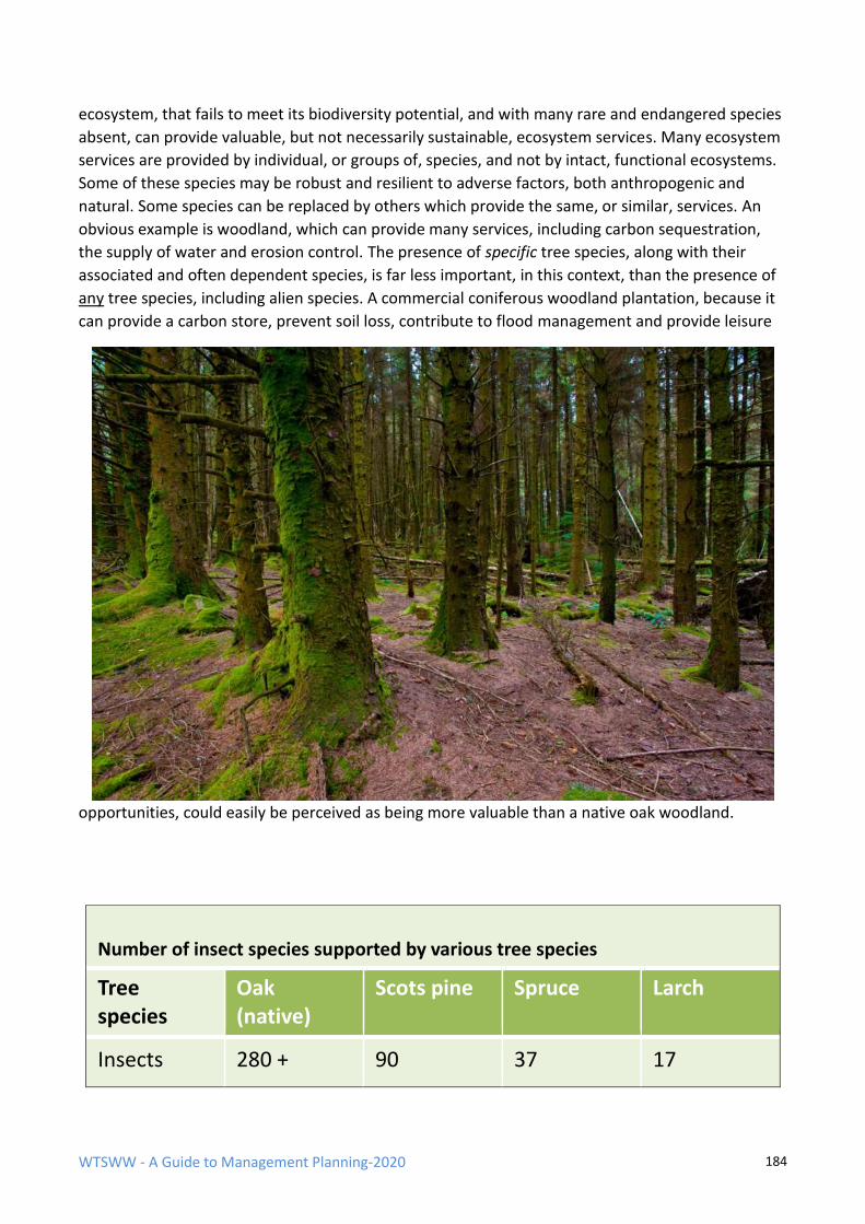
WTSWW - A Guide to Management Planning-2020 184
ecosystem, that fails to meet its biodiversity potential, and with many rare and endangered species
absent, can provide valuable, but not necessarily sustainable, ecosystem services. Many ecosystem
services are provided by individual, or groups of, species, and not by intact, functional ecosystems.
Some of these species may be robust and resilient to adverse factors, both anthropogenic and
natural. Some species can be replaced by others which provide the same, or similar, services. An
obvious example is woodland, which can provide many services, including carbon sequestration,
the supply of water and erosion control. The presence of specific tree species, along with their
associated and often dependent species, is far less important, in this context, than the presence of
any tree species, including alien species. A commercial coniferous woodland plantation, because it
can provide a carbon store, prevent soil loss, contribute to flood management and provide leisure
opportunities, could easily be perceived as being more valuable than a native oak woodland.
Number of insect species supported by various tree species
Tree species
Oak (native)
Scots pine Spruce Larch
Insects 280 + 90 37 17
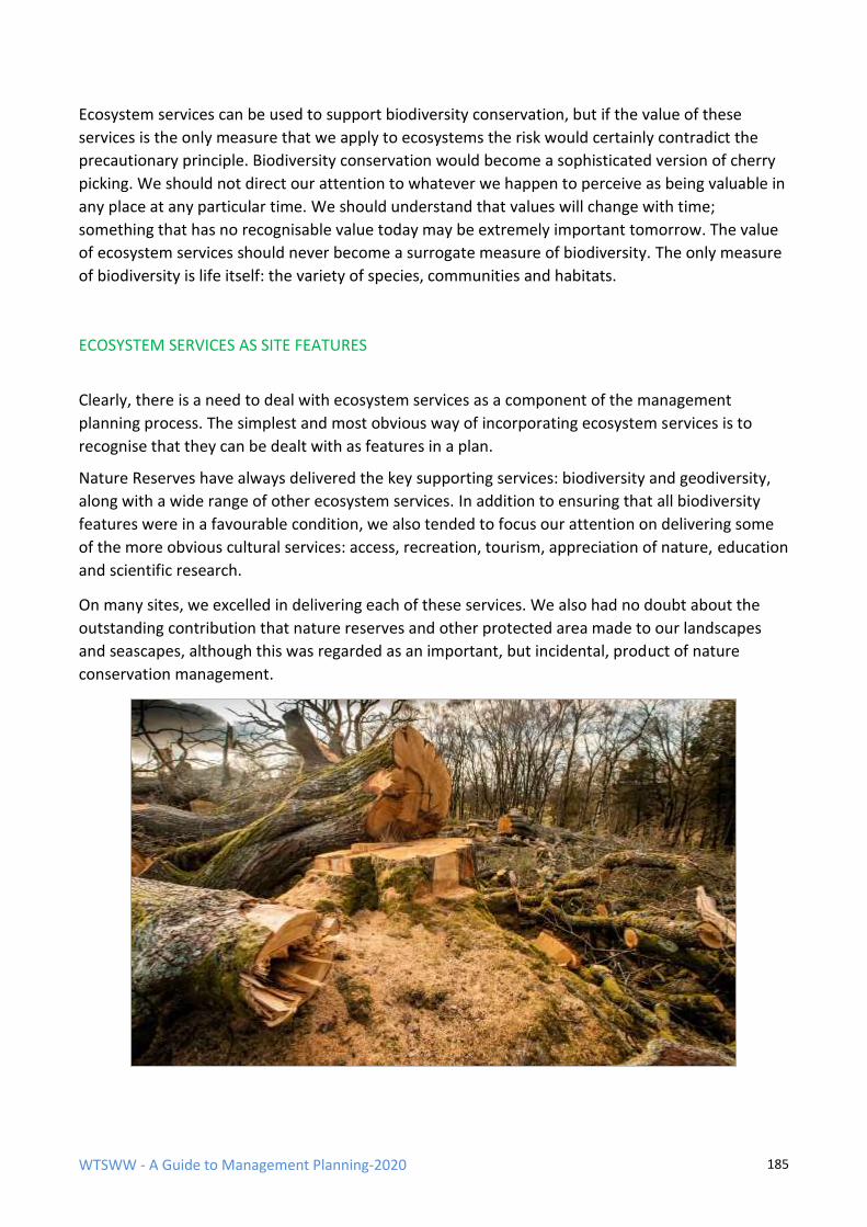
WTSWW - A Guide to Management Planning-2020 185
Ecosystem services can be used to support biodiversity conservation, but if the value of these
services is the only measure that we apply to ecosystems the risk would certainly contradict the
precautionary principle. Biodiversity conservation would become a sophisticated version of cherry
picking. We should not direct our attention to whatever we happen to perceive as being valuable in
any place at any particular time. We should understand that values will change with time;
something that has no recognisable value today may be extremely important tomorrow. The value
of ecosystem services should never become a surrogate measure of biodiversity. The only measure
of biodiversity is life itself: the variety of species, communities and habitats.
ECOSYSTEM SERVICES AS SITE FEATURES
Clearly, there is a need to deal with ecosystem services as a component of the management
planning process. The simplest and most obvious way of incorporating ecosystem services is to
recognise that they can be dealt with as features in a plan.
Nature Reserves have always delivered the key supporting services: biodiversity and geodiversity,
along with a wide range of other ecosystem services. In addition to ensuring that all biodiversity
features were in a favourable condition, we also tended to focus our attention on delivering some
of the more obvious cultural services: access, recreation, tourism, appreciation of nature, education
and scientific research.
On many sites, we excelled in delivering each of these services. We also had no doubt about the
outstanding contribution that nature reserves and other protected area made to our landscapes
and seascapes, although this was regarded as an important, but incidental, product of nature
conservation management.
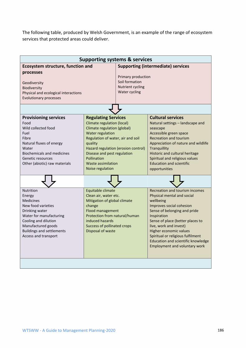
WTSWW - A Guide to Management Planning-2020 186
The following table, produced by Welsh Government, is an example of the range of ecosystem
services that protected areas could deliver.
Supporting systems & services
Ecosystem structure, function and processes
Geodiversity Biodiversity Physical and ecological interactions Evolutionary processes
Supporting (intermediate) services
Primary production Soil formation Nutrient cycling Water cycling
Provisioning services Food Wild collected food Fuel Fibre Natural fluxes of energy Water Biochemicals and medicines Genetic resources Other (abiotic) raw materials
Regulating Services Climate regulation (local) Climate regulation (global) Water regulation Regulation of water, air and soil quality Hazard regulation (erosion control) Disease and pest regulation Pollination Waste assimilation Noise regulation
Cultural services Natural settings – landscape and seascape Accessible green space Recreation and tourism Appreciation of nature and wildlife Tranquillity Historic and cultural heritage Spiritual and religious values Education and scientific
opportunities
Nutrition Energy Medicines New food varieties Drinking water Water for manufacturing Cooling and dilution Manufactured goods Buildings and settlements Access and transport
Equitable climate Clean air, water etc. Mitigation of global climate change Flood management Protection from natural/human induced hazards Success of pollinated crops Disposal of waste
Recreation and tourism incomes Physical mental and social wellbeing Improves social cohesion Sense of belonging and pride Inspiration Sense of place (better places to live, work and invest) Higher economic values Spiritual or religious fulfilment Education and scientific knowledge Employment and voluntary work
WTSWW - A Guide to Management Planning-2020 187
Supporting services
Ecosystem services are usually defined as, ‘services provided by the natural environment that
benefit humans’. The natural environment comprises, geodiversity, biodiversity, physical and
ecological interactions, and all are subject to evolutionary processes. Unfortunately, the above
table, and so many other similar lists of ecosystem services, includes the components of our natural
environment with the services that it delivers. This may not appear to be important, but it can be
confusing and has led to serious misinterpretation. The following is a quote taken directly from the
website of a government organisation:
“Our ‘natural resources’ - provide us with our basic needs, including food, energy, health and
enjoyment.
When cared for in the right way, they can help us to reduce flooding, improve air quality and supply
materials for construction. They also provide a home for some rare and beautiful wildlife and iconic
landscapes we can enjoy and which boost the economy via tourism.”
The status of wildlife appears to have been relegated to somewhere below that of ‘materials for
construction’.
Do not forget that all protected areas should excel in the delivery of the fundamental supporting
services: ‘supporting’ because every other service is reliant on geodiversity, biodiversity, the
physical and ecological interactions and evolutionary processes.
EVALUATION FOR ECOSYSTEM SERVICES
The purpose of this section in a plan is to identify the ecosystem services which could be included
as ‘features’ in a management plan. Evaluation to identify ecosystem services follows a similar
pattern to that described for biodiversity/geodiversity/cultural features. The process begins by
identifying all potential services. The next step is to ask a simple question of each: are these
services delivered as an incidental by-product of managing the site for the biodiversity/geodiversity
/cultural features? If the answer is yes, there is nothing more to do other than confirm the
contribution that the site is making. If the answer is no, further evaluation is necessary, and the first
question must always be: will the delivery of the service contradict or compromise in any way the
obligation to safeguard the conservation features? In many ways, this should be regarded as a
simple impact analysis. Occasionally, services may be identified which are compatible with the
prime objectives of the site but need specific management. These services should be treated no
differently to all other features: they will become a focus for objectives, monitoring and
management. The provision of access, recreation, tourism, and other associated services will
always require planning; this is covered in a separate section of this guide.
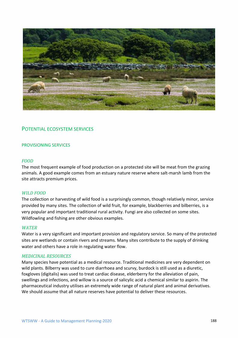
WTSWW - A Guide to Management Planning-2020 188
POTENTIAL ECOSYSTEM SERVICES
PROVISIONING SERVICES
FOOD
The most frequent example of food production on a protected site will be meat from the grazing animals. A good example comes from an estuary nature reserve where salt-marsh lamb from the site attracts premium prices.
WILD FOOD
The collection or harvesting of wild food is a surprisingly common, though relatively minor, service
provided by many sites. The collection of wild fruit, for example, blackberries and bilberries, is a
very popular and important traditional rural activity. Fungi are also collected on some sites.
Wildfowling and fishing are other obvious examples.
WATER
Water is a very significant and important provision and regulatory service. So many of the protected
sites are wetlands or contain rivers and streams. Many sites contribute to the supply of drinking
water and others have a role in regulating water flow.
MEDICINAL RESOURCES Many species have potential as a medical resource. Traditional medicines are very dependent on wild plants. Bilberry was used to cure diarrhoea and scurvy, burdock is still used as a diuretic, foxgloves (digitalis) was used to treat cardiac disease, elderberry for the alleviation of pain, swellings and infections, and willow is a source of salicylic acid a chemical similar to aspirin. The pharmaceutical industry utilises an extremely wide range of natural plant and animal derivatives. We should assume that all nature reserves have potential to deliver these resources.
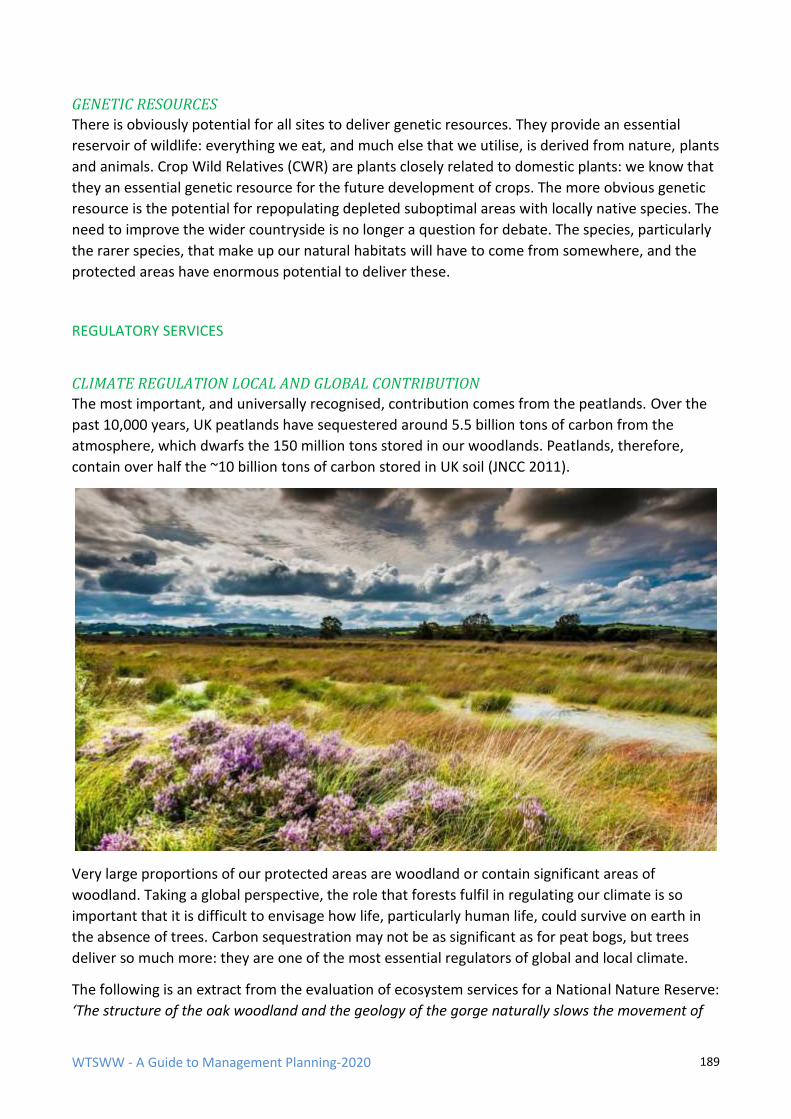
WTSWW - A Guide to Management Planning-2020 189
GENETIC RESOURCES
There is obviously potential for all sites to deliver genetic resources. They provide an essential
reservoir of wildlife: everything we eat, and much else that we utilise, is derived from nature, plants
and animals. Crop Wild Relatives (CWR) are plants closely related to domestic plants: we know that
they an essential genetic resource for the future development of crops. The more obvious genetic
resource is the potential for repopulating depleted suboptimal areas with locally native species. The
need to improve the wider countryside is no longer a question for debate. The species, particularly
the rarer species, that make up our natural habitats will have to come from somewhere, and the
protected areas have enormous potential to deliver these.
REGULATORY SERVICES
CLIMATE REGULATION LOCAL AND GLOBAL CONTRIBUTION
The most important, and universally recognised, contribution comes from the peatlands. Over the
past 10,000 years, UK peatlands have sequestered around 5.5 billion tons of carbon from the
atmosphere, which dwarfs the 150 million tons stored in our woodlands. Peatlands, therefore,
contain over half the ~10 billion tons of carbon stored in UK soil (JNCC 2011).
Very large proportions of our protected areas are woodland or contain significant areas of
woodland. Taking a global perspective, the role that forests fulfil in regulating our climate is so
important that it is difficult to envisage how life, particularly human life, could survive on earth in
the absence of trees. Carbon sequestration may not be as significant as for peat bogs, but trees
deliver so much more: they are one of the most essential regulators of global and local climate.
The following is an extract from the evaluation of ecosystem services for a National Nature Reserve:
‘The structure of the oak woodland and the geology of the gorge naturally slows the movement of
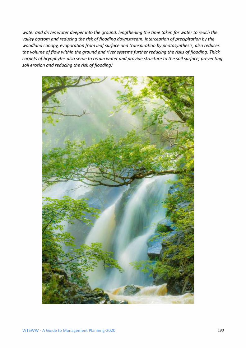
WTSWW - A Guide to Management Planning-2020 190
water and drives water deeper into the ground, lengthening the time taken for water to reach the
valley bottom and reducing the risk of flooding downstream. Interception of precipitation by the
woodland canopy, evaporation from leaf surface and transpiration by photosynthesis, also reduces
the volume of flow within the ground and river systems further reducing the risks of flooding. Thick
carpets of bryophytes also serve to retain water and provide structure to the soil surface, preventing
soil erosion and reducing the risk of flooding.’
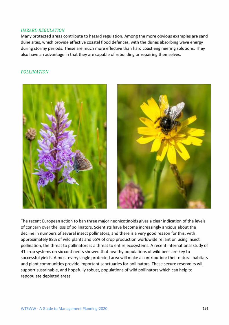
WTSWW - A Guide to Management Planning-2020 191
HAZARD REGULATION
Many protected areas contribute to hazard regulation. Among the more obvious examples are sand
dune sites, which provide effective coastal flood defences, with the dunes absorbing wave energy
during stormy periods. These are much more effective than hard coast engineering solutions. They
also have an advantage in that they are capable of rebuilding or repairing themselves.
POLLINATION
The recent European action to ban three major neonicotinoids gives a clear indication of the levels
of concern over the loss of pollinators. Scientists have become increasingly anxious about the
decline in numbers of several insect pollinators, and there is a very good reason for this: with
approximately 88% of wild plants and 65% of crop production worldwide reliant on using insect
pollination, the threat to pollinators is a threat to entire ecosystems. A recent international study of
41 crop systems on six continents showed that healthy populations of wild bees are key to
successful yields. Almost every single protected area will make a contribution: their natural habitats
and plant communities provide important sanctuaries for pollinators. These secure reservoirs will
support sustainable, and hopefully robust, populations of wild pollinators which can help to
repopulate depleted areas.
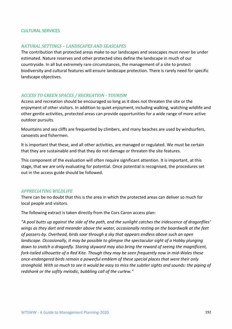
WTSWW - A Guide to Management Planning-2020 192
CULTURAL SERVICES
NATURAL SETTINGS – LANDSCAPES AND SEASCAPES
The contribution that protected areas make to our landscapes and seascapes must never be under
estimated. Nature reserves and other protected sites define the landscape in much of our
countryside. In all but extremely rare circumstances, the management of a site to protect
biodiversity and cultural features will ensure landscape protection. There is rarely need for specific
landscape objectives.
ACCESS TO GREEN SPACES / RECREATION - TOURISM
Access and recreation should be encouraged so long as it does not threaten the site or the
enjoyment of other visitors. In addition to quiet enjoyment, including walking, watching wildlife and
other gentle activities, protected areas can provide opportunities for a wide range of more active
outdoor pursuits.
Mountains and sea cliffs are frequented by climbers, and many beaches are used by windsurfers,
canoeists and fishermen.
It is important that these, and all other activities, are managed or regulated. We must be certain
that they are sustainable and that they do not damage or threaten the site features.
This component of the evaluation will often require significant attention. It is important, at this
stage, that we are only evaluating for potential. Once potential is recognised, the procedures set
out in the access guide should be followed.
APPRECIATING WILDLIFE
There can be no doubt that this is the area in which the protected areas can deliver so much for
local people and visitors.
The following extract is taken directly from the Cors Caron access plan:
“A pool butts up against the side of the path, and the sunlight catches the iridescence of dragonflies’
wings as they dart and meander above the water, occasionally resting on the boardwalk at the feet
of passers-by. Overhead, birds soar through a sky that appears endless above such an open
landscape. Occasionally, it may be possible to glimpse the spectacular sight of a Hobby plunging
down to snatch a dragonfly. Staring skyward may also bring the reward of seeing the magnificent,
fork-tailed silhouette of a Red Kite. Though they may be seen frequently now in mid-Wales these
once-endangered birds remain a powerful emblem of these special places that were their only
stronghold. With so much to see it would be easy to miss the subtler sights and sounds: the piping of
redshank or the softly melodic, bubbling call of the curlew.”
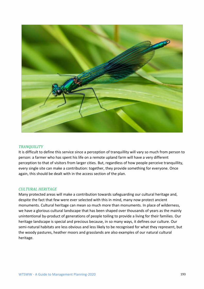
WTSWW - A Guide to Management Planning-2020 193
TRANQUILITY
It is difficult to define this service since a perception of tranquillity will vary so much from person to
person: a farmer who has spent his life on a remote upland farm will have a very different
perception to that of visitors from larger cities. But, regardless of how people perceive tranquillity,
every single site can make a contribution: together, they provide something for everyone. Once
again, this should be dealt with in the access section of the plan.
CULTURAL HERITAGE
Many protected areas will make a contribution towards safeguarding our cultural heritage and,
despite the fact that few were ever selected with this in mind, many now protect ancient
monuments. Cultural heritage can mean so much more than monuments. In place of wilderness,
we have a glorious cultural landscape that has been shaped over thousands of years as the mainly
unintentional by-product of generations of people toiling to provide a living for their families. Our
heritage landscape is special and precious because, in so many ways, it defines our culture. Our
semi-natural habitats are less obvious and less likely to be recognised for what they represent, but
the woody pastures, heather moors and grasslands are also examples of our natural cultural
heritage.
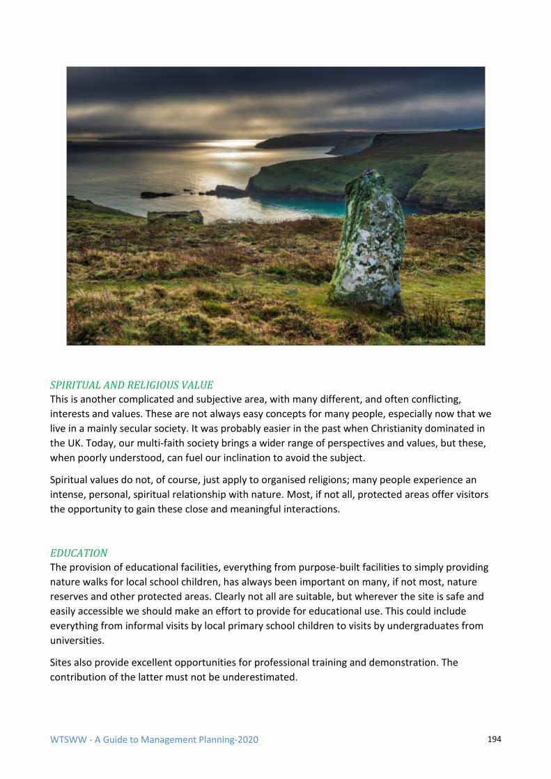
WTSWW - A Guide to Management Planning-2020 194
SPIRITUAL AND RELIGIOUS VALUE
This is another complicated and subjective area, with many different, and often conflicting,
interests and values. These are not always easy concepts for many people, especially now that we
live in a mainly secular society. It was probably easier in the past when Christianity dominated in
the UK. Today, our multi-faith society brings a wider range of perspectives and values, but these,
when poorly understood, can fuel our inclination to avoid the subject.
Spiritual values do not, of course, just apply to organised religions; many people experience an
intense, personal, spiritual relationship with nature. Most, if not all, protected areas offer visitors
the opportunity to gain these close and meaningful interactions.
EDUCATION
The provision of educational facilities, everything from purpose-built facilities to simply providing
nature walks for local school children, has always been important on many, if not most, nature
reserves and other protected areas. Clearly not all are suitable, but wherever the site is safe and
easily accessible we should make an effort to provide for educational use. This could include
everything from informal visits by local primary school children to visits by undergraduates from
universities.
Sites also provide excellent opportunities for professional training and demonstration. The
contribution of the latter must not be underestimated.

WTSWW - A Guide to Management Planning-2020 195
As with all provisions for visitors, education, training etc. are best dealt with by adding sections to
the access plan.
PHYSICAL HEALTH AND MENTAL WELLBEING
The enormous benefits to the health and mental wellbeing provided by our countryside have been
extremely well documented.
Access to protected areas provides people with a chance to experience wild places and wildlife, to
find tranquillity and to marvel at the spectacle of natural landscapes. So perhaps the only point to
add to the issues already discussed in this document is that nature and wild places are good for
people’s health.
WTSWW - A Guide to Management Planning-2020 196
GLOSSARY
Action plan A plan of action for a specific period of time containing several individual projects that describe specific actions. The information contained in the individual projects is aggregated to produce a wide variety of work and resource plans.
Adaptable
management
A cyclical, adaptable management process which allows site management to: respond to natural dynamic processes; accommodate the legitimate interests of others; adapt to the ever-changing political and socio-economic climate; and, in the long term, succeed, despite uncertain and variable resources.
Anthropocentric Human values; also called instrumental values.
Anthropogenic Something of human origin; the consequence of a human action or intervention.
Attribute An attribute is a characteristic of a feature that can be monitored to provide evidence about the condition of the feature.
Audit A critical examination of the performance of the plan, or a part of the plan, so as to measure the quality of the plan and its implementation, carried out by the management organisation (internal audit) or by an independent authority not directly associated with the site (external audit), usually at the invitation of the management organisation.
Evaluation Evaluation is simply the means of identifying, or confirming, which of the features on a site should become the focus for the remainder of the planning process.
WTSWW - A Guide to Management Planning-2020 197
Factor A factor is anything that has the potential to influence or change a feature, or to affect the way in which a feature is managed. These influences may exist, or have existed, at any time in the past, present or future. Factors can be natural or anthropogenic in origin, and they can be internal (on-site) or external (off-site).
Favourable
conservation
status (FCS)
FCS is the desired status of a habitat or species, at any geographical scale from its entire geographical range to a defined area within a site. Although the concept of FCS originates in international and European treaties and directives, it is a concept that can be used for any wildlife management plan anywhere.
Feature A feature is any aspect of the site which can be described as a distinct entity. Nature conservation features can be a habitat, a community or a population. Other features of interest can include geological, geomorphological, archaeological and historical features.
IUCN Protected area
An area of land and/or sea especially dedicated to the protection and maintenance of biological diversity, and of natural and associated cultural resources, and managed through legal or other effective means. (Protected areas are categorised according to their primary management objective.)
Management Management is about taking control to achieve a desired outcome. ‘Control’ does not necessarily imply taking an action. It can, for example, mean ‘enabling’ a process.
Monitoring Surveillance undertaken to ensure that formulated standards are being maintained.
NCR criteria The UK Nature Conservation Review (NCR) criteria are recognised as the standard or conventional approach to identifying important nature conservation sites, and are also used as a basis for identifying biological site features. They are: size, diversity, naturalness, rarity, fragility, typicalness, recorded history, position in an ecological / geographical unit, potential value and intrinsic appeal.
Precautionary
principle
Where there are threats of serious or irreversible damage, lack of full scientific certainty shall not be used as a reason for postponing cost-effective measures to prevent environmental degradation.
WTSWW - A Guide to Management Planning-2020 198
Project A project is a clearly defined and planned unit of work.
Rationale The rationale is the process of identifying, in outline, the most appropriate management for the various site features.
Recording Making a permanent and accessible record of significant activities (including management), events and anything else that has relevance to the site.
Site A site is the area covered by a management plan. It can vary in size from less than a hectare to a large National Park covering many square kilometres. The term is used synonymously with area.
SMART
objectives
Specific, Measurable, Achievable, Relevant, Time-based
Specified Limits Specified limits define the degree to which the value of a performance indicator is allowed to fluctuate without creating any cause for concern.
Stakeholder A stakeholder is any individual, group or community living within the influence of the site or likely to be affected by a management decision or action, and any individual, group or community likely to influence the management of the site.
Surveillance Making repeated standardised surveys in order that change can be detected.
Survey Making a single observation to measure and record something.
Wilderness IUCN definitions:
Large area of unmodified or slightly modified land, and/or sea, retaining its natural character and influence, without permanent or significant habitation, which is protected and managed so as to preserve its natural condition.
And:
Ecosystems where, since the industrial revolution (1750), human impact (a) has been no greater than that of any other native species, and (b) has not affected the ecosystem’s structure. Climate change is excluded from this definition.
Zones Sites may be divided into zones to meet a wide variety of purposes, for example, to describe management actions or to guide or control a number of

WTSWW - A Guide to Management Planning-2020 199
activities.
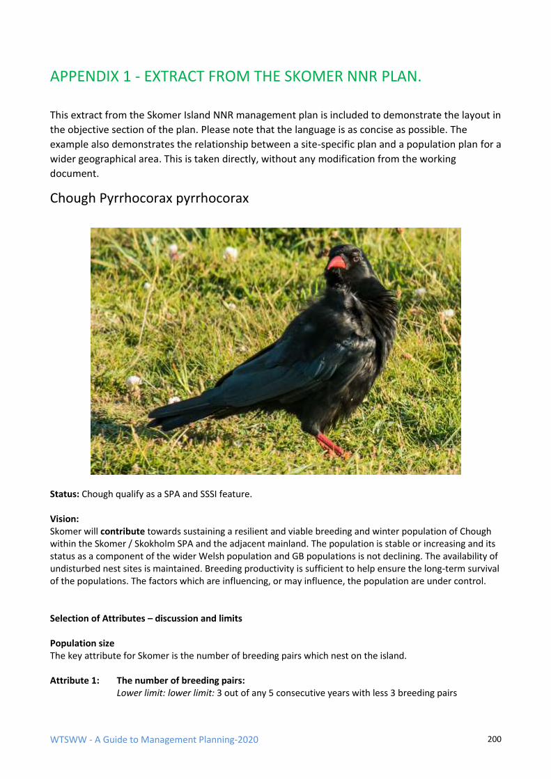
WTSWW - A Guide to Management Planning-2020 200
APPENDIX 1 - EXTRACT FROM THE SKOMER NNR PLAN.
This extract from the Skomer Island NNR management plan is included to demonstrate the layout in
the objective section of the plan. Please note that the language is as concise as possible. The
example also demonstrates the relationship between a site-specific plan and a population plan for a
wider geographical area. This is taken directly, without any modification from the working
document.
Chough Pyrrhocorax pyrrhocorax
Status: Chough qualify as a SPA and SSSI feature. Vision: Skomer will contribute towards sustaining a resilient and viable breeding and winter population of Chough within the Skomer / Skokholm SPA and the adjacent mainland. The population is stable or increasing and its status as a component of the wider Welsh population and GB populations is not declining. The availability of undisturbed nest sites is maintained. Breeding productivity is sufficient to help ensure the long-term survival of the populations. The factors which are influencing, or may influence, the population are under control. Selection of Attributes – discussion and limits Population size The key attribute for Skomer is the number of breeding pairs which nest on the island. Attribute 1: The number of breeding pairs:
Lower limit: lower limit: 3 out of any 5 consecutive years with less 3 breeding pairs
WTSWW - A Guide to Management Planning-2020 201
Relationship with national trends The relationship between the island population, the local Pembrokeshire population and the wider UK population size is an essential attribute. If the ratio changes this could point to local factors which could be managed, for example, changes to local vegetation. Attribute 2: The relationship with local and national trends. (This requires attention.)
lower limit: The island population should not fall below X% of the Pembrokeshire mainland population for more than 3 out of 5 consecutive years.
The availability of undisturbed nest sites It is important that the availability of undisturbed nest sites should not be constrained by any human influences. The only potential factor is excessive visitor pressure at a nest location. There is no purpose in setting a limit. Management action will be taken if any existing or new Chough breeding sites are compromised (for example, footpaths can be re-routed). The location of nest sites The nest sites on Skomer should be mapped. Attribute 3: The location of nest sites: this is a surveillance project Annual breeding productivity Breeding success is a key measure of the long-term viability of this species and it should be measured. Records for the other Chough SPAs in Pembrokeshire indicate that a successful and sustainable breeding population should produce 2.5 fledged chicks for each nest. (The SPA target is 2.5 per successful nest.) If this approach was applied on Skomer, productivity targets would be met if only one nest produced 2.5 chicks, and this would not deliver a sustainable population. The SPA plan also includes, as an attribute, the ratio of non-breeding immature birds to the total winter population. This cannot be used on the Skomer as the island birds winter offsite. Attribute 4: The annual breeding success:
Lower limit: 3 in any 5 consecutive years with less than 2.5 fledged chicks per breeding pair Factors – discussion: Vegetation The vegetation on Skomer cannot be managed. It is likely that, with the exception of the exposed cliff edges (mainly the west facing coasts), it will continue to become less suitable feeding habitat for Chough. The suitability of the exposed areas will vary in response to the impact of the changing rabbit population. This means that the single most important factor, i.e. suitable invertebrate-rich coastal vegetation, cannot be guaranteed on the island. Consequently, limits for this factor cannot be established. The relationship between the local Skomer plan and the SPA plan is vital because the SPA plan provides the only practical solution to establishing limits for this factor.
Disturbance at nest sites The availability of undisturbed nest sites is extremely important. The only potential factor is excessive visitor pressure at a nest location. There is no purpose in setting a limit: management action will be taken if any existing or new Chough breeding sites are compromised. For example, footpaths can be re-routed.
WTSWW - A Guide to Management Planning-2020 202
RA11/44
1. FEATURE: Chough Pyrrhocorax pyrrhocorax 2. ATTRIBUTE OR FACTOR: Total island population and location of nests 3. GENERAL BACKGROUND / BIBLIOGRAPHY
Project supervisor: Lizzie Wilberforce Monitoring / surveillance is entirely dependent on the accurate repetition of survey or census. This project description must be followed. If a need for change of any kind arises permission must be obtained from the project supervisor and a detailed record made of any variations or adaptations. The monitoring of Choughs on Skomer is undertaken as part of the wider Pembrokeshire scheme, and it is important that Skomer protocols are always consistent with those applied elsewhere in the county. The following guidelines have been developed and are appropriate for use on Skomer: Annual surveillance of Chough populations in the Pembrokeshire Coast National Park: note on surveillance methods, prepared by Jane Hodges, Ecologist, & Bob Haycock, Naturalist & Ornithologist, 26th January 2015. The Pembrokeshire Coast National Park supports a nationally/internationally important Chough population that has been the subject of annual surveillance since the early 1990s. The main focus of the annual surveillance programme has been and continues to be on the numbers and distribution of breeding pairs and on productivity, in line with the Chough Conservation Strategy for Pembrokeshire (1) and the Pembrokeshire Local Biodiversity Action Plan Species Action Plan for the chough (2). Information on the numbers and distribution of Choughs outside the breeding season has been collected on a more ad hoc basis e.g. during snap-shot surveys in the autumn and winter such as the Winter Coastal Birds Survey carried out in February 2011 (3). Key components of the annual surveillance of the resident Chough population in the National Park include the surveillance of the sub-populations that utilise the three Special Protection Areas within the National Park for which the Chough is a (or the) feature of European importance. The three SPA s are:
• Ramsey & St David’s Peninsula Coast SPA;
• Skomer & Skokholm SPA;
• Castlemartin Coast SPA Data for the three SPA s are collected to enable an assessment to be made of the conservation status of the Chough feature in accordance with the vision, conservation objectives and performance indicators set out by the Natural Resources Wales in its core management plans for each of the three SPA s (4-6). Separate reports are produced for each SPA in which data collected during the breeding season are presented and assessed in more detail (note: a report on the Skomer & Skokholm SPA is provided to the WTS&WW and is circulated to the Islands Advisory Committee). 4. METHODOLOGY a) Equipment: Good quality binoculars with good field of view (8x32 or 8x42). Good quality telescope, with 27x eyepiece or similar and good field of view. Tripod with adjustable angle legs, short centre column, pan and tilt head. Notebook and pencil. Mobile phone, VHF radio or both.
WTSWW - A Guide to Management Planning-2020 203
The methods outlined below are based on key stages of the annual life cycle of Choughs in the National Park. Surveillance and recording are carried out on a territory by territory basis. On the mainland, historic or traditional territories as well as currently or recently occupied territories are visited at intervals between mid-March and late May to confirm the following:
• Whether or not territories are occupied.
• Whether or not the resident pairs occupying those territories attempt to breed (i.e. that they got at least as far as building a nest).
Follow-up visits are made between late May and mid-July to confirm the following:
• The stage at which any attempts to breed failed.
• If (and how many) young fledged from each nest site. Information on non-breeding Choughs together with important foraging areas/habitats is collected during visits to check on breeding pairs (it should be noted that data on non-breeding Choughs as distinct from failed breeders or juveniles that tend to associate with non-breeding birds can only be reliably collected during March, April and the first half of May). On Ramsey, Skomer and Skokholm information on occupied territories/nest sites and non-breeding birds is collected by island staff and volunteers. On Caldey Island, information on Choughs is collected on an infrequent and opportunistic basis e.g. during visits to carry out sea bird counts. The criteria used (on the mainland) to determine the breeding status and subsequent progress through the breeding season are based on standard methods used to interpret information collected e.g. during the decadal census of 2002 (7), summarised as follows: Territory occupied: evidence of territorial and courtship behaviour; pairs visiting a known or potential nest site; Pair attempting to breed: evidence of nest-building/lining; territorial behaviour including aggression towards other Choughs entering the resident pair's territory; Eggs laid: behavioural evidence indicating that the female is incubating eggs e.g. male feeding close by alone and making regular return visits to the nest to feed the female. The female is usually called off the nest by the male and is usually away from the nest for a short time during which the male feeds her (she may also forage for a few minutes and may also take a short flight with the male before returning to the nest): “one in; two out; one in and one away”; Young known to be in the nest: behavioural evidence such as adults visiting a nest with food and leaving after a short time followed (typically) by bill-wiping on a perch near-by; bringing out of faecal sacs for disposal away from the nest (usually these are dropped over the sea): “two in; two out and two away”. Note: after hatching, young are brooded by the female for the first few days until they have developed a full covering of down. During this stage, the male has to forage for the female and young in the nest and (typically) will be making trips to and from the nest every 20-30 minutes or so. Well-grown young can often be heard calling in the nest from the cliff tops especially as the moment of fledging approaches. Aggressive behaviour on the part of the adults (typically towards Peregrine Falcons, Ravens and Carrion
WTSWW - A Guide to Management Planning-2020 204
Crows) will also often be observed when there are eggs or young in the nest. These species in particular are known to predate the contents of Chough nests and/or recently fledged young. Number of young known to have fledged: noisy family parties out on the cliff tops; adults feeding recently fledged young (which beg incessantly-sometimes from other Choughs who are not their parents!); aggressive-defensive behaviour on the part of the adults in the presence of potential predators or under some circumstances other Choughs which are deemed to have entered the territory-holders' foraging territory and are therefore in competition with the family for food. Features such as bill and leg colour, calls/voice and general demeanour such as proficiency of flight (which increases rapidly after fledging and the family starts to move further away from the nest site) can (with experience) be used to gauge how long young Choughs have been out of the nest. Note: return visits are often required at this stage in order to be certain about the outcomes of breeding attempts. Within a few days of fledging, family groups become highly mobile often moving considerable distances away from the nest sites. The task of determining how many Choughs fledge from each site becomes increasingly difficult as time goes on. More than one visit may also be required to ensure that all the young that have fledged from a particular site have been counted. The young often hide under rocks etc. whilst the adults feed or if predators are around. Some young Choughs may be more reticent about finally leaving the nest site than their siblings and can be over-looked unless return visits are made. Non-breeding Choughs: as noted above, the best time to obtain information on non-breeding Choughs is considered to be between mid-March and mid-May, after which the situation becomes confused by failed breeders which may leave their territories for periods of time and associate with non-breeding birds which tend to move around the coast (and between the mainland and islands) in flocks. Later on, these groups may be joined by juveniles as they disperse from their natal territories (this can be from early July onwards). Recording non-breeding Choughs in the spring has another advantage: the information provides an indication of how well (or otherwise) the less experienced birds without a territory have survived the winter and are therefore potentially available for recruitment to the breeding population. On the mainland, the locations and numbers of non-breeding Choughs are noted during visits to check on breeding pairs/nest sites. Colour-ringed Choughs: on the mainland, a note is made of the location of any colour-ringed Choughs that are encountered together with the colour ring combination on each leg e.g. “right leg yellow over yellow; left leg red over metal BTO ring” (a note is also made of any markings that are engraved on colour rings if possible). Details of any sightings of colour-ringed Choughs are sent to Bob Haycock (who maintains a data base on colour-ringed Choughs seen in Pembrokeshire) in the first instance. j) Repeat interval: Annual k) Special considerations: Counts should be made in dry, safe and favourable weather conditions with good visibility and wind less than force 4. General health and safety precautions should be taken i.e. take a first aid kit and mobile phone or radio with you. 5. DATA MANAGEMENT (Format, Location and security)
• Each day’s results should be entered into an electronic data file which should be backed up daily. The field notebooks should be retained at least until the final results have been checked.
• Field data, notebooks, inputted regularly (at least weekly) and shared electronically each week with the project supervisor.
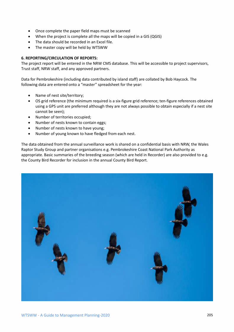
WTSWW - A Guide to Management Planning-2020 205
• Once complete the paper field maps must be scanned
• When the project is complete all the maps will be copied in a GIS (QGIS)
• The data should be recorded in an Excel file.
• The master copy will be held by WTSWW 6. REPORTING/CIRCULATION OF REPORTS: The project report will be entered in the NRW CMS database. This will be accessible to project supervisors, Trust staff, NRW staff, and any approved partners. Data for Pembrokeshire (including data contributed by island staff) are collated by Bob Haycock. The following data are entered onto a “master” spreadsheet for the year:
• Name of nest site/territory;
• OS grid reference (the minimum required is a six-figure grid reference; ten-figure references obtained using a GPS unit are preferred although they are not always possible to obtain especially if a nest site cannot be seen);
• Number of territories occupied;
• Number of nests known to contain eggs;
• Number of nests known to have young;
• Number of young known to have fledged from each nest. The data obtained from the annual surveillance work is shared on a confidential basis with NRW, the Wales Raptor Study Group and partner organisations e.g. Pembrokeshire Coast National Park Authority as appropriate. Basic summaries of the breeding season (which are held in Recorder) are also provided to e.g. the County Bird Recorder for inclusion in the annual County Bird Report.

WTSWW - A Guide to Management Planning-2020 206
WTSWW - A Guide to Management Planning-2020 207
RA11/45
1. FEATURE: Chough Pyrrhocorax pyrrhocorax 2. ATTRIBUTE OR FACTOR: Relationship with national trends 3. GENERAL BACKGROUND / BIBLIOGRAPHY
Project supervisor: Lizzie Wilberforce This is a very simple but significant project. It is always important that we detect any variations in the population trend of the island birds when compared to a wider, but local, population, for example, the total SPA population or the Pembrokeshire population. For many species this comparison will have little meaning, simply because the island population is such a large proportion of the local population. Where national data are available, for example, on the JNCC website, a comparison will also be possible at that scale. If the trend for an island population is different to the wider local or national population, we should conclude that one or more of the factors which influence the population are having a different impact. When the island population is doing better than elsewhere, we might suspect that the onsite factors are favourable, but, obviously, the converse is also true. Examples of on-site factors which could have a negative impact would include, increased levels of predation, disturbance by visitors, and loss or change of habitat. In some cases, once a variation from a wider trend is detected it should be possible to identify the local factor or factors responsible, and, if desirable and possible, management interventions should be applied. 4. METHODOLOGY Identify the most appropriate data sets for comparison. Begin with the SAC and in particular the monitoring results obtained from the Pembrokeshire census. The most significant information for comparison will be the JNCC website. These data are not always up to date and appear to be entered for different species at different times. Visit the website occasionally during the following year and update the project as information becomes available. If JNCC offer an explanation for any changing trends in their data include a note in CMS if this information is relevant to Skomer. There is no specific reporting or data management requirement for this project.
WTSWW - A Guide to Management Planning-2020 208
APPENDIX 2 - RECOMMENDED CONTENTS FOR PROJECT PLANS
RECOMMENDED CONTENTS FOR A MONITORING / SURVEILLANCE / RECORDING
PROJECT.
PROJECT CODE AND TITLE
1. FEATURE:
2. ATTRIBUTE or FACTOR:
3. DATE:
4. PROJECT PRIORITY:
5. PROJECT SUPERVISOR:
6. INDIVIDUAL/S RESPONSIBLE FOR CARRYING OUT THE PROJECT:
7. GENERAL BACKGROUND/BIBLIOGRAPHY:
8. METHODOLOGY
8.1 Location of the sample:
8.2 Sampling technique and equipment:
8.3 Unit of measurement:
8.4 Sampling period and frequency of sampling:
8.5 Repeat interval:
8.6 Special considerations:
9. DATA MANAGEMENT (Format, location, security and any analytical technique)
10. REPORTING/CIRCULATION OF REPORTS:

WTSWW - A Guide to Management Planning-2020 209
RECOMMENDED CONTENTS FOR A MANAGEMENT PROJECT
PROJECT CODE AND TITLE
1. FEATURE:
2. DATE:
3. PROJECT PRIORITY:
4. PROJECT SUPERVISOR:
5. INDIVIDUAL/S RESPONSIBLE FOR CARRYING OUT THE PROJECT:
6. COST
7. GENERAL BACKGROUND/BIBLIOGRAPHY:
8. JUSTIFICATION FOR THE PROJECT (I.E. THE PURPOSE AND INTENDED OUTCOME):
9. METHODOLOGY
10. LOCATION OF THE WORK:
11. WORK PROGRAMME:
12. EQUIPMENT:
13. SPECIAL CONSIDERATIONS:
14. RISK ASSESSMENT
15. REPORTING/CIRCULATION OF REPORTS:
WTSWW - A Guide to Management Planning-2020 210
APPENDIX 3 - CMS PROJECT CODES
R Recording RB Record Biological Interest
RA Record Fauna
RA0 Mammals
RA00 Record Mammals
RA01 Monitor Mammals
RA1 Birds
RA10 Record Birds
RA11 Monitor Birds
RA2 Herptiles
RA20 Record Herptiles
RA21 Monitor Herptiles
RA3 Fish
RA30 Record Fish
RA31 Monitor Fish
RA4 Lepidoptera
RA40 Record Lepidoptera
RA41 Monitor Lepidoptera
RA5 Odonata
RA50 Record Odonata
RA51 Monitor Odonata
RA6 Orthoptera
RA60 Record Orthoptera
RA61 Monitor Orthoptera
RA7 Insects
RA70 Record Insects
RA71 Monitor Insects
RA8 Invertebrates
RA80 Record Invertebrates
RA81 Monitor Invertebrates
RF Record Vegetation
RF0 Vegetation Communities / Habitats
RF00 Record Vegetation Communities / Habitats
RF01 Monitor Vegetation Communities / Habitats
RF1 Trees / Shrubs
RF10 Record Trees / Shrubs
RF11 Monitor Trees / Shrubs
RF2 Vascular Plants
RF20 Record Vascular Plants
RF21 Monitor Vascular Plants
RF3 Bryophytes
WTSWW - A Guide to Management Planning-2020 211
RF30 Record Bryophytes
RF31 Monitor Bryophytes
RF4 Algae
RF40 Record Algae
RF41 Monitor Algae
RF5 Lichens
RF50 Record Lichens
RF51 Monitor Lichens
RF6 Fungi
RF60 Record Fungi
RF61 Monitor Fungi
RM Record Marine
RM0 Benthic Faunal Communities
RM00 Record Benthic Faunal Communities
RM01 Monitor Benthic Faunal Communities
RM1 Porifera
RM10 Record Porifera
RM11 Monitor Porifera
RM2 Cnidaria
RM20 Record Cnidaria
RM21 Monitor Cnidaria
RM3 Annelida
RM30 Record Annelida
RM31 Monitor Annelida
RM4 Crustacea
RM40 Record Crustacea
RM41 Monitor Crustacea
RM5 Mollusca
RM50 Record Mollusca
RM51 Monitor Mollusca
RM6 Bryozoa
RM60 Record Bryozoa
RM61 Monitor Bryozoa
RM7 Echinodermata
RM70 Record Echinodermata
RM71 Monitor Echinodermata
RM8 Tunicata
RM80 Record Tunicata
RM81 Monitor Tunicata
RM9 Marine fauna
RM90 Record Marine Fauna
RM91 Monitor Marine Fauna
RP Record Physical Environment
RP0 Climate
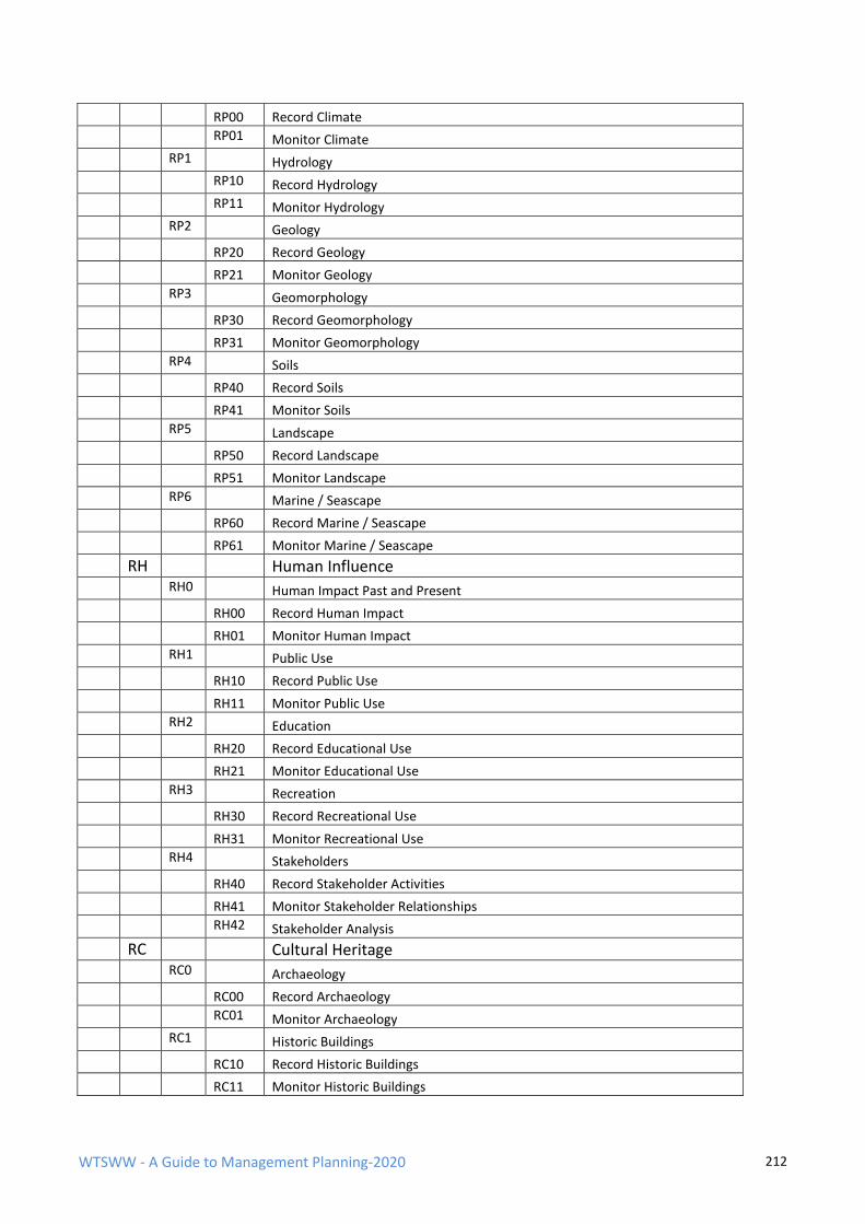
WTSWW - A Guide to Management Planning-2020 212
RP00 Record Climate
RP01 Monitor Climate
RP1 Hydrology
RP10 Record Hydrology
RP11 Monitor Hydrology
RP2 Geology
RP20 Record Geology
RP21 Monitor Geology
RP3 Geomorphology
RP30 Record Geomorphology
RP31 Monitor Geomorphology
RP4 Soils
RP40 Record Soils
RP41 Monitor Soils
RP5 Landscape
RP50 Record Landscape
RP51 Monitor Landscape
RP6 Marine / Seascape
RP60 Record Marine / Seascape
RP61 Monitor Marine / Seascape
RH Human Influence
RH0 Human Impact Past and Present
RH00 Record Human Impact
RH01 Monitor Human Impact
RH1 Public Use
RH10 Record Public Use
RH11 Monitor Public Use
RH2 Education
RH20 Record Educational Use
RH21 Monitor Educational Use
RH3 Recreation
RH30 Record Recreational Use
RH31 Monitor Recreational Use
RH4 Stakeholders
RH40 Record Stakeholder Activities
RH41 Monitor Stakeholder Relationships
RH42 Stakeholder Analysis
RC Cultural Heritage
RC0 Archaeology
RC00 Record Archaeology
RC01 Monitor Archaeology
RC1 Historic Buildings
RC10 Record Historic Buildings
RC11 Monitor Historic Buildings

WTSWW - A Guide to Management Planning-2020 213
RC2 Industrial Archaeology
RC20 Record Industrial Archaeology
RC21 Monitor Industrial Archaeology
RC3 Historical Landscapes
RC30 Record Historical Landscapes
RC31 Monitor Historical Landscapes
RC4 Religious / Spiritual Interest
RC40 Monitor Religious / Spiritual Interest
RC41 Record Religious / Spiritual Interest
RV Record / Maintain Archive Information
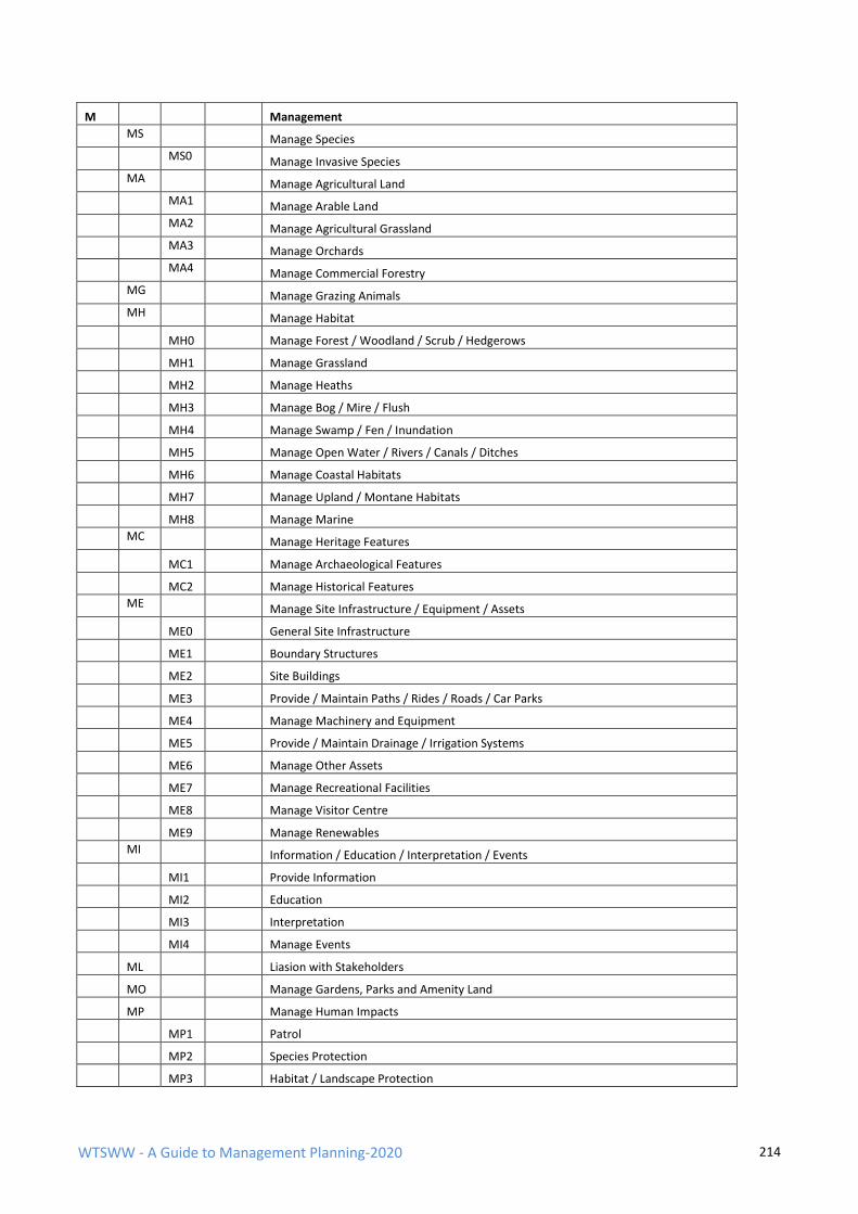
WTSWW - A Guide to Management Planning-2020 214
M Management
MS Manage Species
MS0 Manage Invasive Species
MA Manage Agricultural Land
MA1 Manage Arable Land
MA2 Manage Agricultural Grassland
MA3 Manage Orchards
MA4 Manage Commercial Forestry
MG Manage Grazing Animals
MH Manage Habitat
MH0 Manage Forest / Woodland / Scrub / Hedgerows
MH1 Manage Grassland
MH2 Manage Heaths
MH3 Manage Bog / Mire / Flush
MH4 Manage Swamp / Fen / Inundation
MH5 Manage Open Water / Rivers / Canals / Ditches
MH6 Manage Coastal Habitats
MH7 Manage Upland / Montane Habitats
MH8 Manage Marine
MC Manage Heritage Features
MC1 Manage Archaeological Features
MC2 Manage Historical Features
ME Manage Site Infrastructure / Equipment / Assets
ME0 General Site Infrastructure
ME1 Boundary Structures
ME2 Site Buildings
ME3 Provide / Maintain Paths / Rides / Roads / Car Parks
ME4 Manage Machinery and Equipment
ME5 Provide / Maintain Drainage / Irrigation Systems
ME6 Manage Other Assets
ME7 Manage Recreational Facilities
ME8 Manage Visitor Centre
ME9 Manage Renewables
MI Information / Education / Interpretation / Events
MI1 Provide Information
MI2 Education
MI3 Interpretation
MI4 Manage Events
ML Liasion with Stakeholders
MO Manage Gardens, Parks and Amenity Land
MP Manage Human Impacts
MP1 Patrol
MP2 Species Protection
MP3 Habitat / Landscape Protection

WTSWW - A Guide to Management Planning-2020 215
MP4 Manage Pollution
MP5 Manage Damage / Vandalism
MU Manage Earth Science Features
A Administration
AA Site Acquisition, Tenure / Ownership / Lease
AD Site Designation
AE Employ, Support and Ensure Staff Development
AF Financial Planning, Recording and Administration
AI Inspections and Audits
AL Legal Matters, Agreements, Grants and Payments
AP Planning, Plan Preparation and Revision
AR Reports and General Correspondence
AS Site and Species Safeguard, Law Enforcement & Admin.
AT Working with Partners, Public and Volunteers
AT1 Working with Volunteers
AT2 Working with Partner Organisations
AT3 Working with Stakeholders / Local Communities
AO Administration Other
WTSWW - A Guide to Management Planning-2020 216
REFFERENCES Alexander, M. (1991). The Countryside Management System Handbook, Version 3. Countryside Council for Wales, Bangor, Wales.
Alexander, M. (1994). Management Planning Handbook. Countryside Council for Wales, Bangor, Wales.
Alexander, M. (1995). Management Planning in Relation to Protected Areas. Parks (IUCN) Vol. 5 No 1, Gland, Switzerland1
Alexander, M. (1996). A Guide to the Production of Management Plans for Nature Conservation and Protected Areas. Countryside Council for Wales, Bangor, Wales.
Alexander, M. (2000a). A Management Planning Handbook. Uganda Wildlife Authority, Kampala, Uganda.
Alexander, M. (2000b). Guide to the Production of Management Plans for Protected Areas. CMS Partnership, Aberystwyth, Wales.
Alexander, M. (2000b). Guide to the Production of Management Plans for Protected Areas. CMS Partnership, Aberystwyth, Wales.
Alexander, M. (2003). CCW Guide to Management Planning for SSSIs, Natura 2000 Sites and Ramsar Sites. Countryside Council for Wales, Bangor, Wales.
Alexander, M. (2005). The CMS Guide to Management Planning. The CMS Consortium, Talgarth, Wales.
Alexander, M. (2008) Management Planning for Nature Conservation, a theoretical basis and practical guide, Springer Science, Dordrecht
Alexander, M. (2013) Management Planning for Nature Conservation, a theoretical basis and practical guide, 2nd ed., Springer Science, Dordrecht
Alexander, M. (2015). A Management Planning Guide. CMS Consortium, Talgarth, Wales, UK.
Allan, C. and Stankey, G.H. eds. (2009). Adaptive Environment Management. Springer, The Netherlands.
Angermeier, P. L. (2000). The natural imperative for biological conservation. Conservation Biology, 14, 373-381.
Bailey, J. A. (1982), Wildlife Society Bulletin, 10, 363-369
Benson, J. (2000). Environmental ethics – An introduction with readings. Routledge, London.
Borrini-Feyerabend, G., Kothari, A. and Oviedo, G. (2004). Indigenous and Local communities and Protected Areas: Towards Equity and Enhanced Conservation. IUCN, Gland, Switzerland & Cambridge, UK.
Brasnett, N. V. (1953). Planned Management of Forests. George Allen and Unwin, London
Caldwell, N. and Evison, S. (2005). The role of National Nature Reserves in the Countryside Council for Wales’ approach to stakeholder involvement. Unpublished report, Countryside Council for Wales, Bangor.
Clarke, R. and Mount, D. (1998). Site Management Planning. Countryside Commission, Cheltenham, UK.
Cook, K. (2004). Wildlife Law: Conservation and Biodiversity. Cameron May, London, UK.
du Toit, J. T. & Pettorelli, N. (2019) The differences between rewilding and restoring an ecologically degraded landscape. Journal of Applied Ecology, Vol 56 issue 11, 2467-2471
Eagles, P. F. J., McCool, S.F. and Haynes, C. D. A. (2002). Sustainable Tourism in Protected Areas: Guidelines for Planning and Management. IUCN, Gland, Switzerland and Cambridge, UK.
Elzinga, C. L., Salzer, D. W., Willoughby, J. W. and Gibbs, J. P. (2001). Monitoring Plant and Animal Populations: A Handbook for Field Biologists. Blackwell Science, Inc. Malden, Massachusetts, USA.

WTSWW - A Guide to Management Planning-2020 217
European Communities (2000). Managing Natura 2000 Sites, The provisions of Article 6 of the Habitats Directive 92/43/EEC. European Communities, Luxembourg.
European Communities (2000). Managing Natura 2000 Sites, The provisions of Article 6 of the Habitats Directive 92/43/EEC. European Communities, Luxembourg.
Eurosite (1992). European Guide for the Preparation of management Plans. Eurosite, Tilburg, The Netherlands.
Eurosite (1996). Management Plans for Protected and Managed Natural and Semi-natural Areas. Eurosite, Tilburg, The Netherlands.
Eurosite (1999). Toolkit for management planning. Eurosite, Tilburg, The Netherlands.
Eurosite (2002). Report on the 67th EUROSITE Workshop – Nature Management Planning and Stakeholder Involvement. Eurosite, Tilburg, The Netherlands.
Eurosite (2003). Ecological monitoring of protected natural areas – providing guidance and best practice. Eurosite, Tilburg, The Netherlands.
Graham, R., Nilsen, P. and Payne, R. J. (1998). Visitor Management in Canadian National Parks. Tourism Management 1988 9 (1) 44—62.
Graefe, A., Kuss, F. R. and Vaske, J. J. (1990). Visitor impact management: the planning framework. National Parks and Conservation Association, Washington DC, USA.
Hayward, M.W. et.al. (2019) Reintroducing rewilding to restoration – Rejecting the search for novelty, Biological Conservation, Vol 233 255-259
Hirons, G., Goldsmith, B. and Thomas, G. (1995). Site management planning. In Managing Habitats for Conservation. ed. W. J. Sutherland and D. A. Hill. Cambridge University Press, Cambridge, UK.
Holling, C. S. (1978). Adaptive Environmental Assessment and Management. John Wiley and Sons, New York.
Hurford, C. and Schneider, M. (eds.), (2006). Monitoring Nature Conservation in Cultural Habitats. Springer, The Netherlands
IUCN (2001). IUCN Red List Categories and Criteria: Version 3.1. IUCN Species Survival Commission, IUCN, Gland, Switzerland and Cambridge, UK.
IUCN (2011). The IUCN Red List of Threatened Species. Version 2011.2. http://www.iucnredlist.org.
Jepson, P. and Canney, S. (2003). Values-led conservation. Global Ecology and Biogeography 12, 271-274.
JNCC (1998). A Statement on Common Standards Monitoring. Joint Nature Conservation Committee, Peterborough, UK
Johnson, B. L. (1999). The Role of Adaptive Management as an Operational Approach for Resource Management Agencies. Conservation Ecology 3(2):8.
Jung, C. G. (1968). Collected Works of C. G. Jung, Vol. 9, Part 1. 2nd ed. Princeton University Press, USA.
Keller, G. (1999). Guidelines for Marine Protected Areas. IUCN Gland, Switzerland
Krumpe, E. E. (2000). The Role of Science in Wilderness Planning – A State-of-Knowledge Review. USDA Forest Services Proceedings RMRS-P-15-VOL-4. U.S. Department of Agriculture, Forest Services, Ogden, UT
Lee, K. N. (1993). Compass and Gyroscope: integrating science and politics for the environment. Island Press, Washington DC, USA.
Lee, K. N. (1999). Appraising Adaptive Management. Conservation Ecology 3(2)
Macarthur, R.H. and Wilson, E.O. (2001). The theory of Island biogeography. Princeton University Press, Princeton and Oxford.
WTSWW - A Guide to Management Planning-2020 218
Margoluis, R. and Salafsky, N. (1998). Measures of Success: Designing, managing, and monitoring Conservation and development Projects. Island Press, Washington D.C.
Marmorek, D.R., Robinson, D.C.E., Murray, C. and Grieg, L. (2006). Enabling Adaptive Forest Management. National Commission on Sustainable Forestry, Vancouver, B.C.
Manning, R. E., Lime, D. W., Hof, M. and Freimund, W. A. (1995). The Visitor Experience and Resource Protection (VERP) Process. The George Wright Forum 12(3).
McCool, S. F. (1996). A framework for managing national protected areas: Experiences from the United States. Maritime Institute of Malaysia, Kuala Lumpur, Malaysia.
McCool, S. F. and Cole, D. N. (1998). Proceedings – Limits of Acceptable Change and related planning processes: progress and future directions; 1997 Missoula, MT. Gen. Tech. Rep. INT-GTR-371. Ogden, UT. USA.
Meff G, K., Carroll, C. R. and contributors (1997). Principles of Conservation Biology, Second Edition. Sinauer Associates, Inc., Sunderland, Massachusetts, USA.
Ministere Charge de l’Environmement (1991). Plans de gestion des reserves naturelles. Direction de la Protection de la Nature, Paris.
Naess, A. (2002). Life’s Philosophy: Reason and Feelings in a Deeper World. The University of Georgia Press, Athens and London.
NCC. (1991). Site management plans for nature conservation, a working guide (Revised). Nature Conservancy Council, Peterborough. UK.
NCC (1988). Site management plans for nature conservation, a working guide. Nature Conservancy Council, Peterborough, UK.
NCC (1989). Guidelines for the selection of biological SSSIs. Nature Conservancy Council, Peterborough, UK.
NCC (1991). Site management plans for nature conservation, a working guide (revised). Nature Conservancy Council, Peterborough, UK.
Natuurmonumenten (2005). Connectivity in process: examples from the field. Natuurmonumenten, s-Graveland, The Netherlands.
Nilsen, P. and Tayler, G. (1998). A Comparative Analysis of Protected Area Planning and Management Frameworks. Pages 49–57 in McCool, S. F. and Cole, D. N. (compilers), Limits of Acceptable Change and Related Processes: Programs and Future Directions. Proceedings of conference, 1997 May 20–22, Missoula, MN. Gen. Tech. Rep. INT-GTR-371. U. S. Department of Agriculture, Forest Service, Rocky Mountains Research Station, Ogden, UT, USA.
Norton, B. G. (1991). Towards Unity Among Environmentalists. Oxford University Press, New York, USA.
Noss, R. F., O’Connell, M. A. and Murphy, D. D. (1997). The Science of Conservation Planning, Habitat Conservation Under the Endangered Species Act. Island press, Washington, D.C. USA.
Oliver, D. M. and Hellawell, T. C. (2001). Management Plan for Hafod Garegog National Nature Reserve. Unpublished document, Countryside Council for Wales, Bangor, Wales.
Peterken, G. F. (1993). Woodland Conservation and Management, Second edition. Chapman and Hall, London.
Peterken, G. F. (1996). Natural Woodland, Ecology and Conservation in Northern Temperate Regions. Cambridge University Press, Cambridge, UK.
Pereira, H. M. Navarro, L. M. Ed (2015) Rewilding European Landscapes, Springer Open, Dordrecht.
Pettorelli, N., Durant, ed. (2019) Rewilding, Cambridge University press, Cambridge UK.
Phillips, A. (2002). Management Guidelines for IUCN Category V Protected Areas, Protected Landscapes/Seascapes. IUCN Gland, Switzerland and Cambridge, UK.
WTSWW - A Guide to Management Planning-2020 219
Pullin, A. S. (2003). Support for decision-making in conservation. English Nature research reports, 493. English Nature, Peterborough, UK.
Pullin, A. S. and Knight, T. M. (2001). Effectiveness in conservation practice: pointers from medicine and public health. Conservation Biology 15, 50-54.
Quammen, D. (1997) The Song of the Dodo: Island Biogeography in an Age of Extinctions. Scribner.
Rackham, O. (2006). Woodlands, Collins London
Ramsar Convention Bureau (2002). New Guidelines for Management Planning for Ramsar Sites and Other Wetlands, Ramsar resolution VIII.14. Ramsar Convention Bureau, Gland, Switzerland.
Ratcliffe, D.A. (ed.) (1977). A Nature Conservation Review. Cambridge University Press. Cambridge
Rodwell, J. (1991a). British Plant Communities, Volume 1 Woodlands and Scrub. Cambridge University Press, Cambridge, UK.
Rodwell, J. (1991b). British Plant Communities, Volume 2 Mires and Heaths. Cambridge University Press, Cambridge, UK.
Rodwell, J. (1992). British Plant Communities, Volume 3 Grasslands and Montane Communities. Cambridge University Press, Cambridge, UK.
Rodwell, J. (1995). British Plant Communities, Volume 4 Aquatic Communities, Swamps and Tall-herb Fens. Cambridge University Press, Cambridge, UK.
Rodwell, J. (2000). British Plant Communities, Volume 5 Maritime Communities and Vegetation of Open Habitat. Cambridge University Press, Cambridge, UK.
Rodwell, J. (2006). National Vegetation Classification Users’ Handbook. JNCC, Peterborough, UK.
Roszak, T. (2001). The Voice of the Earth, An Exploration of Ecopsychology. Phanes Press Inc., Grand Rapids, MI, USA.
Rose, P. and McLean, I. (2003). The Future Role of JNCC in Biological Surveillance and Monitoring. JNCC, Peterborough, UK.
RSPB (1993). RSPB Management Plan Guidance Notes, version 3. Internal publication, The Royal Society for the Protection of Birds, Sandy, UK.
RSPB (2003). RSPB Management Plan Guidance Notes, version 6. Internal publication, The Royal Society for the Protection of Birds, Sandy, UK.
Sprugel, G.S. (1990). Disturbance, Equilibrium, and Environmental Variability: What is 'Natural' Vegetation in a Changing Environment? Biological Conservation, 58, 1 - 18.
Stankey, G. H., McCool, S.F. and Stokes, G.L. (1984). Limits of Acceptable Change: A new framework for managing the Bob Marshall Wilderness. Western Wildlands 10(3): 33-37.
Stankey, G. H. and McCool, S.F. (1990). Managing for appropriate wilderness conditions: The carrying capacity issue. In J. C. Hendee, G. H. Stankey and R. C. Lucas (eds.) Wilderness Management (pp. 215–40). Golden, CO: North American Press.
Stankey, G. H., Clark, R. N. and Bormann, B.T. (2005). Adaptive management of natural resources: theory,concepts, and management institutions. Report, Department of Agriculture, Forest Service, Portland, OR, USA.
Sutherland, W. J. (ed.) (1998). Conservation science and action. Blackwell Science, Oxford, UK.
Sutherland, W. J. (2000). The Conservation Handbook: Research, Management and Policy. Blackwell, Oxford, UK.
Sutherland, W. J., Pullin, A. S., Dolman, P.M. and Knight, T. M. (2004). The need for evidence-based conservation. Trends in Ecology and Evolution 19, 305-308.
Thomas, L. and Middleton, J. (2003). Guidelines for Management Planning of Protected Areas. IUCN Gland, Switzerland and Cambridge, UK.

WTSWW - A Guide to Management Planning-2020 220
Walter, C. (1986). Adaptive Management of Renewable Resources. Macmillan, New York.
Walters, C. J. and Holling, C. S. (1990). Large-scale Management Experiments and Learning by Doing. Ecology 71:2060-2068
Welsh Assembly Government (2006). Environment Strategy for Wales. Cardiff, Wales, UK.
Wood, J. B. and Warren, A. (Ed.) (1978). A Handbook for the Preparation of Management Plans – Conservation Course Format, Revision 2. University College London, Discussion Papers in Conservation, No. 18. London.
Wilson, E. O. (1984). Biophilia. Harvard University Press, Cambridge, Massachusetts, USA.
Wilson, E. O. (1994). The Diversity of Life. Penguin, Harmondsworth, UK.
Wood, J. B. and Warren, A. (Ed.) (1978). A Handbook for the Preparation of Management Plans – Conservation Course Format, Revision 2. University College London, Discussion Papers in Conservation No. 18, London.

WTSWW - A Guide to Management Planning-2020 1


