figure 6-30 biology net environmental effects - wcecwcec.wm.com/resource-documents/01_main...
TRANSCRIPT

Environmental Assessment West Carleton Environmental Centre
6-127
chapter 6. detailed impact assessment of the undertaking
Figure 6-30 Biology Net Environmental Effects
Environmental Assessment West Carleton Environmental Centre
6-128
chapter 6. detailed impact assessment of the undertaking
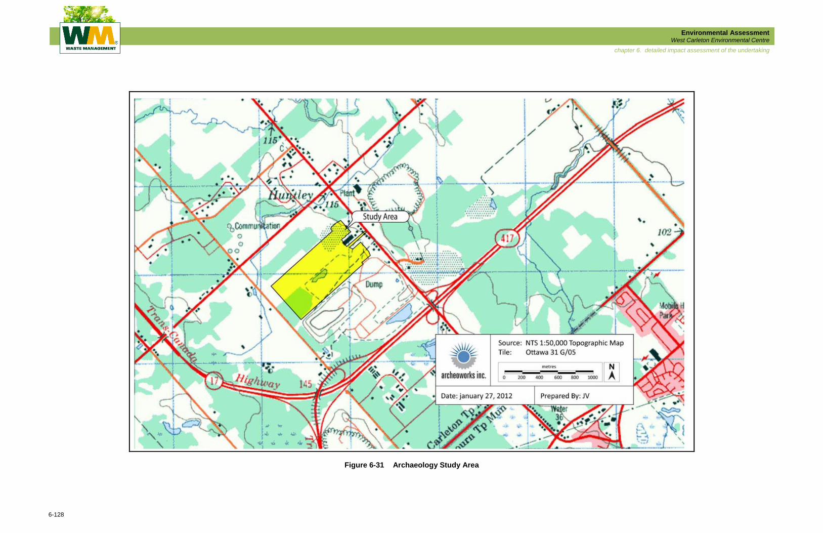
Figure 6-31 Archaeology Study Area
Environmental Assessment West Carleton Environmental Centre
6-129
chapter 6. detailed impact assessment of the undertaking
6.7.5.1 Detailed Description of the Archaeology Environment Potentially Affected
The Stage 1 Archaeological Assessment completed in 2006 which included the Study Area (at
the time) established archaeological potential for the location and recovery of Aboriginal
material within the study area limits due to the proximity of an unnamed tributary of the Carp
River, a secondary watercourse. The determination of historic potential was based on a review
of the 1879 Illustrated Historical Atlas of the County of Carleton, which revealed that the parts of
Lots 4 and 5, Concession 3, where the Preferred Alternative Landfill Footprint option lies,
contained one historic structure and was located immediately adjacent to Carp Road, a historic
transportation route. The Stage 1 report identified areas with no archaeological potential due to
their disturbed condition. These disturbances were caused by aggregate extraction and grading
associated with a kitchen factory, and residential development along Carp Road. This
classification of no archaeological potential has been accepted by the Ministry of Tourism,
Culture and Sport (Sherratt, 2008). The Report also identified other areas where a Stage 2
Archaeological Assessment would be required, which was carried out in 2011.
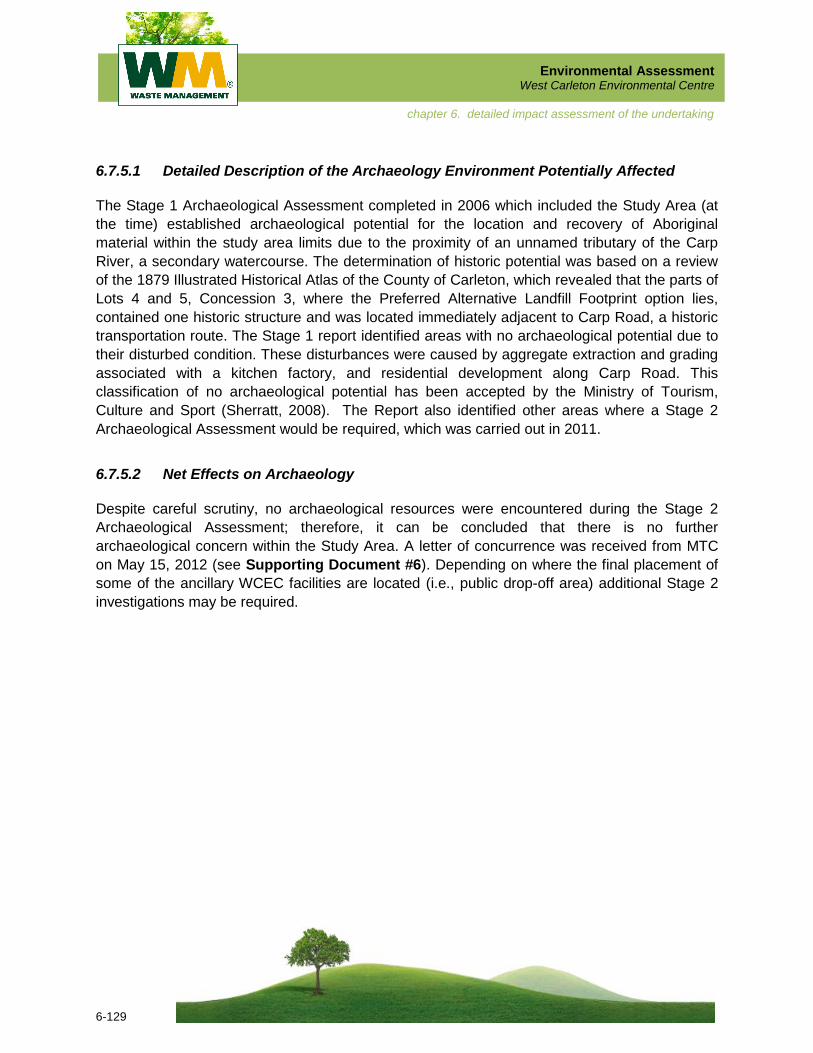
6.7.5.2 Net Effects on Archaeology
Despite careful scrutiny, no archaeological resources were encountered during the Stage 2
Archaeological Assessment; therefore, it can be concluded that there is no further
archaeological concern within the Study Area. A letter of concurrence was received from MTC
on May 15, 2012 (see Supporting Document #6). Depending on where the final placement of
some of the ancillary WCEC facilities are located (i.e., public drop-off area) additional Stage 2
investigations may be required.
Environmental Assessment West Carleton Environmental Centre
6-130
chapter 6. detailed impact assessment of the undertaking
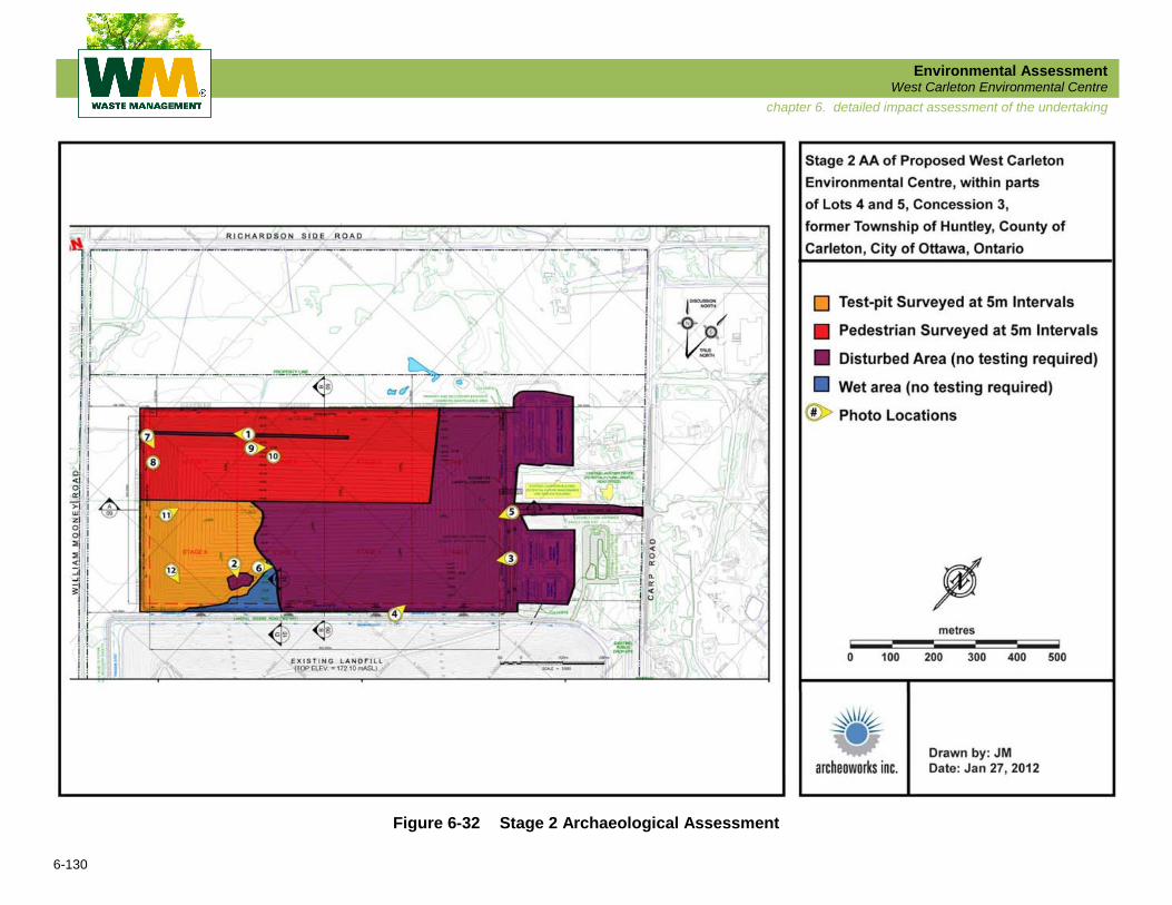
Figure 6-32 Stage 2 Archaeological Assessment

Environmental Assessment West Carleton Environmental Centre
6-131
chapter 6. detailed impact assessment of the undertaking
6.7.6 Cultural Heritage
The specific study areas for the Cultural Heritage Detailed Impact Assessment include the following:
On-Site .............. the lands required for the Preferred Alternative Landfill Footprint;
and
Site-Vicinity ....... the resources on properties adjacent to the Preferred Alternative
Landfill Footprint.
6.7.6.1 Detailed Description of the Cultural Heritage Environment Potentially Affected
During the visual review of Cultural Heritage Resources it became apparent that there were a
number of cultural resources identified during the Existing Conditions field work in 2006 that
were no longer extant. These resources are described below.
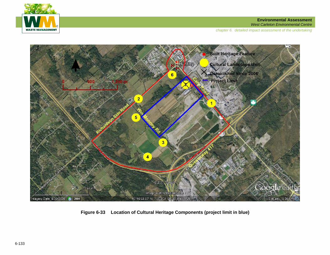
BHF2 – 2491 Carp Road
A garden shed business occupied the property when the visual review was completed on
January 9, 2012. This garden shed business appears to have been in place when the Existing
Conditions Report was done in 2006. That report identifies the building on that property as
seeming to be “abandoned.” A review of the aerial photographs shows that there was no
evidence of the structure by 2008. An email from the City of Ottawa’s heritage planner stated
that there is a “shed business on the southwest corner of Carp Road and Richardson Side
Road. There have been a number of demolition permits for buildings on this site; this may be
one of them.”
BHF4 – 2511 Carp Road
The area where this house would have been was an open field when the visual review was
completed on January 9, 2012. A check of the air photos shows no evidence of the structures
on the 2008 images. An email from the heritage planner indicates only that the structures were
“demolished” but offers no date.
CLU7 – 2425 Carp Road
Access to this site was difficult because of the snow and the overgrown nature of the property.
However, despite views from several locations, this cultural resource could not be located
during the visual review completed January 9, 2012. It was subsequently determined that the
buildings associated with CLU7 were demolished in 2011.
Environmental Assessment West Carleton Environmental Centre
6-132
chapter 6. detailed impact assessment of the undertaking
Accordingly the above-listed properties were removed from further consideration as built
heritage features (BHF) or cultural landscape units (CLU).
The City of Ottawa’s heritage planner also stated that 2431 Carp Road (BHF1) “appears to have
been demolished, permit issued 2007;” however, the property is a fairly large kitchen cabinet
factory and the demolition could have related to another building. The building shown in the
Cultural Heritage Existing Conditions Report (Supporting Document #1 – Existing
Conditions Technical Reports) is still standing and the built heritage feature which is identified
in the report remains on the list for further consideration.
The locations of the existing and no longer extant resources are shown in Figure 6-33.
6.7.6.2 Potential Effects on Cultural Heritage
The potential effects on cultural heritage resources from the Preferred Alternative Landfill
Footprint are described below.
BHF1 – 2413 Carp Road
The house has been significantly altered for modern residential use. The setting for this building
has already been significantly altered for industrial use. Any further work done as part of the
construction of the WCEC will not have an impact. WM has identified this building as having
potential for a future landfill administrative office. An appropriate use for the building, such as
offices, is essential to the long term preservation of its heritage values. Any further alterations to
this building to accommodate offices will not affect whatever cultural heritage values remain
within the enclosed log structure.
BHF3 – 2193 Richardson Side Road
Building is more than 0.6 km from the site operations. Any surviving cultural heritage value or
interest will not be affected as long as visual buffering is provided.
CLU4 – 27 William Mooney Road
Farm complex is more than 0.35 km from the site operations. Any surviving cultural heritage
value or interest will not be affected as long as visual buffering is provided.
CLU5 – 569 William Mooney Road
Farm complex is approximately 300 m from the site operations. Any surviving cultural heritage
value or interest will not be affected as long as visual buffering is provided.
Environmental Assessment West Carleton Environmental Centre
6-133
chapter 6. detailed impact assessment of the undertaking
Figure 6-33 Location of Cultural Heritage Components (project limit in blue)
Environmental Assessment West Carleton Environmental Centre
6-134
chapter 6. detailed impact assessment of the undertaking
CLU6 - 2485 Carp Road
Farm complex is almost 0.5 km from the site operations. Any surviving cultural heritage value or
interest will not be affected as long as visual buffering is provided.
6.7.6.3 Culture Heritage Mitigation and/or Compensation Measures
In order to mitigate the potential effects on cultural heritage resources identified above adequate
visual buffering must be put in place.
6.7.6.4 Culture Heritage Net Effects
Implementation of the proposed mitigation measures will result in no net effects on the heritage
values of the cultural heritage resources identified within the Study Area.
6.7.7 Transportation
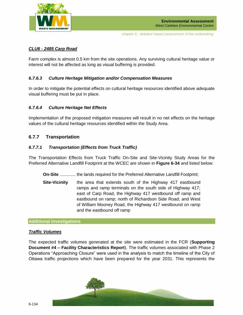
6.7.7.1 Transportation (Effects from Truck Traffic)
The Transportation Effects from Truck Traffic On-Site and Site-Vicinity Study Areas for the
Preferred Alternative Landfill Footprint at the WCEC are shown in Figure 6-34 and listed below:
On-Site ............. the lands required for the Preferred Alternative Landfill Footprint;
Site-Vicinity the area that extends south of the Highway 417 eastbound
ramps and ramp terminals on the south side of Highway 417;
east of Carp Road, the Highway 417 westbound off ramp and
eastbound on ramp; north of Richardson Side Road; and West
of William Mooney Road, the Highway 417 westbound on ramp
and the eastbound off ramp
Additional Investigations
Traffic Volumes
The expected traffic volumes generated at the site were estimated in the FCR (Supporting
Document #4 – Facility Characteristics Report). The traffic volumes associated with Phase 2
Operations “Approaching Closure” were used in the analysis to match the timeline of the City of
Ottawa traffic projections which have been prepared for the year 2031. This represents the
Environmental Assessment West Carleton Environmental Centre
6-135
chapter 6. detailed impact assessment of the undertaking
Figure 6-34 Transportation Effects from Truck Traffic Detailed Impact Assessment Study Area
Environmental Assessment West Carleton Environmental Centre
6-136
chapter 6. detailed impact assessment of the undertaking
maximum traffic on Carp Road and the second busiest period for site traffic, which together
were considered “worst case” conditions for traffic. The City of Ottawa 2031 traffic projections
are for the AM peak period only. Since traffic volumes are relatively similar northbound and
southbound on Carp Road, volumes were reversed to undertake a PM peak analysis.
The number of trips entering and exiting the site in the analysis hour was estimated at 70 (35
entering and 35 exiting) and to this was added 45 trips during the peak AM and PM hours
associated with the ancillary uses (35 entering and 10 exiting in the AM, reversed in the PM).
Since few trips are expected to arrive at the site from the north, only 5 trips were assigned to
this direction and the remainder were considered to arrive from the south as northbound left
turning vehicles.
Traffic volumes for the driveway immediately east of the proposed site access were estimated in
consultation with the business owner. Of the 25 employees estimated to arrive/leave in the peak
hour, 20 were assigned from and to the south and 5 were assigned from and to the north. Few
trucks use this driveway. Occasionally a truck from the north will turn left.
Detailed Description of the Transportation (Effects from Truck Traffic) Environment
Potentially Affected
Traffic Volumes (Site-Vicinity)
The anticipated level of service for the traffic on Carp Road and for the traffic using the site
access was assessed during the review of the preferred landfill footprint. In addition, the impact
of potential future widening of Carp Road from 2 to 4 lanes on traffic operations was assessed.
While this widening is not included in the City’s Transportation Master Plan at this time, traffic
volumes at Carp Road and Richardson Side Road indicate that this section may also require
widening in the future if growth occurs in this area.
Traffic Operations and Level of Service(Site-Vicinity)
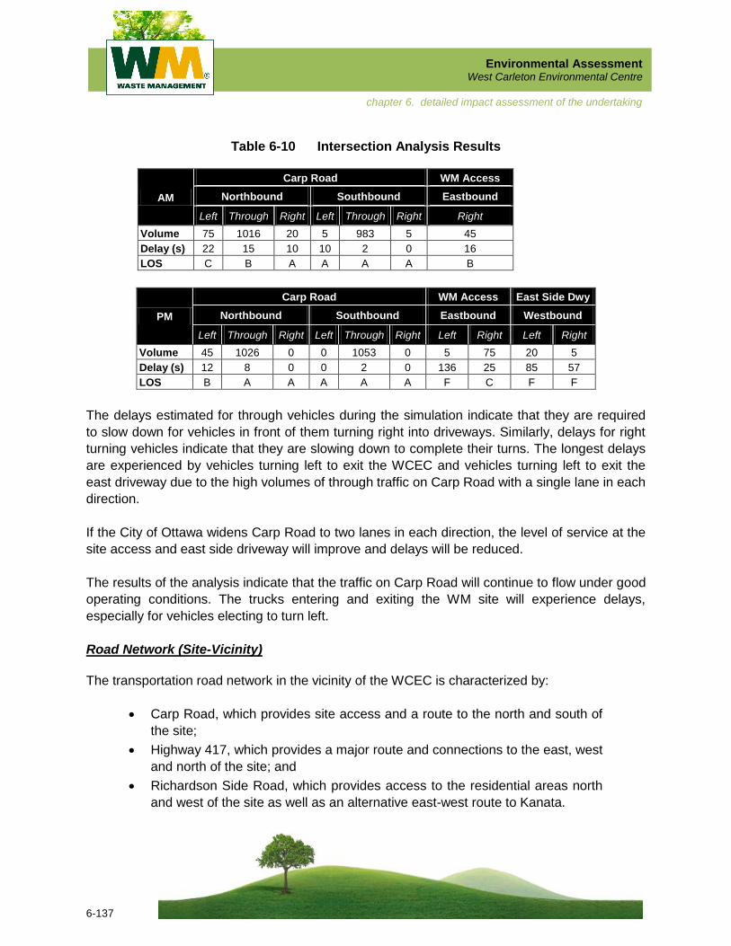
The results of the analysis are shown below in Table 6-10 in terms of delay and the related level
of service. The analysis was performed using the Synchro software version 7.0 and the results
are taken from the SimTraffic model, which examined the operations of the proposed site
access as well as the adjacent signalized intersections at Richardson Side Road and the
eastbound Highway 417 ramp terminal intersection. The SimTraffic model is useful for analyzing
the effects of signals on adjacent driveways as in this situation.
In the AM peak, no traffic is estimated to be leaving the east side driveway or turning left out of
the WCEC.
Environmental Assessment West Carleton Environmental Centre
6-137
chapter 6. detailed impact assessment of the undertaking
Table 6-10 Intersection Analysis Results
AM
Carp Road WM Access
Northbound Southbound Eastbound
Left Through Right Left Through Right Right
Volume 75 1016 20 5 983 5 45
Delay (s) 22 15 10 10 2 0 16
LOS C B A A A A B
PM
Carp Road WM Access East Side Dwy
Northbound Southbound Eastbound Westbound
Left Through Right Left Through Right Left Right Left Right
Volume 45 1026 0 0 1053 0 5 75 20 5
Delay (s) 12 8 0 0 2 0 136 25 85 57
LOS B A A A A A F C F F
The delays estimated for through vehicles during the simulation indicate that they are required
to slow down for vehicles in front of them turning right into driveways. Similarly, delays for right
turning vehicles indicate that they are slowing down to complete their turns. The longest delays
are experienced by vehicles turning left to exit the WCEC and vehicles turning left to exit the
east driveway due to the high volumes of through traffic on Carp Road with a single lane in each
direction.
If the City of Ottawa widens Carp Road to two lanes in each direction, the level of service at the
site access and east side driveway will improve and delays will be reduced.
The results of the analysis indicate that the traffic on Carp Road will continue to flow under good
operating conditions. The trucks entering and exiting the WM site will experience delays,
especially for vehicles electing to turn left.
Road Network (Site-Vicinity)
The transportation road network in the vicinity of the WCEC is characterized by:
Carp Road, which provides site access and a route to the north and south of
the site;
Highway 417, which provides a major route and connections to the east, west
and north of the site; and
Richardson Side Road, which provides access to the residential areas north
and west of the site as well as an alternative east-west route to Kanata.
Environmental Assessment West Carleton Environmental Centre
6-138
chapter 6. detailed impact assessment of the undertaking
These roads were described in detail in the existing conditions.
Driveways to other industrial and commercial operations, including production of aggregates
and precast concrete are located along Carp Road between Highway 417 and Richardson Side
Road. These operations contribute to the level of truck traffic observed along Carp Road in the
site vicinity. One driveway serving an industrial property east of Carp Road is located in the
vicinity of the site access.
Construction of the expansion of Highway 417 in the site vicinity commenced in 2011. The
rehabilitation and widening of the Carp Road bridge over Highway 417 will require one-way
operation (signal controlled) during construction. This work is scheduled for completion before
2014, which is estimated to be the earliest that the landfill expansion would commence.
Potential Effects on Transportation (Effects from Truck Traffic)
More conflicts between left turning trucks and through traffic on Carp Road are anticipated to
occur with the construction and operation of the Preferred Alternative Landfill Footprint. Truck
traffic volumes will be similar to those during previous operations; however, the volume of
through traffic will increase over time. Increased delay for northbound traffic on Carp Road due
to left turning trucks waiting in the roadway to complete their turn is also expected with the
construction and operation of the Preferred Alternative Landfill Footprint. The proposed
northbound left turn lane will add a minor amount of paved surface with minimal effect on runoff,
maintenance and related activities. Other improvements on Carp Road by the MTO and the City
of Ottawa are planned to address traffic operations issues resulting from non-site-related traffic
at locations adjacent to the Site.
Mitigation and/or Compensation Measures for Transportation (Effects from Truck Traffic)
A new site access is proposed that is further north of Highway 417 than the existing entrance
(i.e., the new access would be closer to Richardson Side Road). The new access will include a
northbound left turn lane on Carp Road, designed and constructed in accordance with the
standards and practices of the City of Ottawa and the Province of Ontario and with
consideration for the likely number of trucks that could be present at one time. The location
selected for the access provides improved sight distance over the existing location.
This new left turn lane will improve safety by reducing conflicts between northbound left turning
and through vehicles, by reducing driver frustration and by improving sight distances.
Northbound through drivers will not be forced to wait behind a turning truck until a suitable gap
is available for the truck driver to complete the turn.

Environmental Assessment West Carleton Environmental Centre
6-139
chapter 6. detailed impact assessment of the undertaking
This new left turn lane will similarly improve traffic operations by allowing through traffic to
proceed around left turning vehicles, providing an improved level of service. Given the
estimated northbound and southbound traffic volumes on Carp Road, the northbound left turn
lane is warranted in accordance with provincial standards.
The inconvenience to the public during the construction of the left turn lane will be temporary and
similar to that experienced during other similar road construction projects. Staging of traffic during
construction will be done in accordance with City and provincial standards for safety of construction
workers, vulnerable road users and vehicular traffic as well as for reasonable traffic operations.
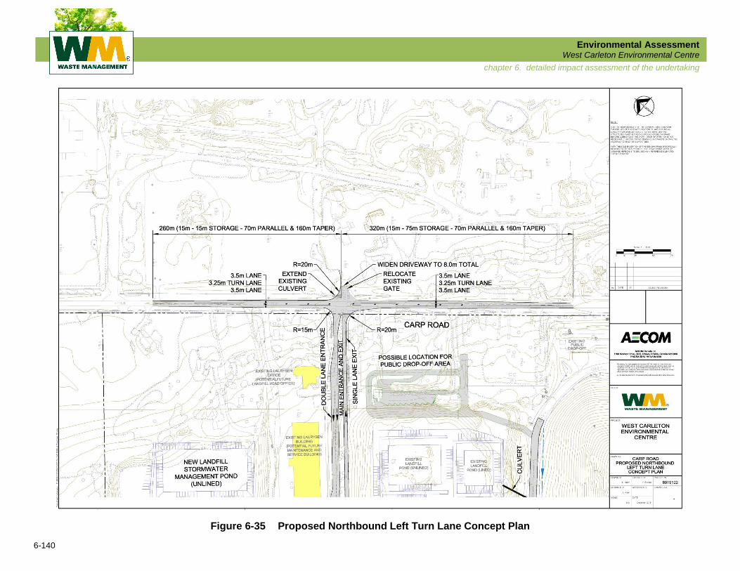
Left Turn Lane Design
The appropriate length of the Carp Road northbound left turn lane to the proposed WCEC site
access was assessed using traffic volumes generated for the expected operating conditions
with consideration for the ancillary facilities potentially present at the site as described above.
The experience of WM with respect to the number of trucks potentially arriving at one time was
also considered.
Using the left turn lane warrant graphs in the MTO Geometric Design Standards and the
following data:
Advancing Volume ......................... 983
Opposing Volume ......................... 1016
Left Turning Volume ......................... 75
Design Speed ......................... 100 km/h
% Trucks ...................................... 100%
the storage lane length for a left turn lane into the WCEC facility was determined to be 40 m.
Normal geometric design standards would potentially underestimate the length of left turn lane
required because of the concentration of trucks in the left turning stream at the WCEC and their
operating characteristics, especially when fully loaded. These trucks need a larger gap to
complete their turn. Once the percentage of trucks is considered, the length of the northbound
left turn lane is increased to 75 m. In accordance with MTO standards, 230 m was added to
provide a deceleration lane and a taper length.
For the southbound direction, a left turn lane was added opposite the northbound left turn lane.
The southbound left turning volumes are expected to be small and consist mainly of passenger
vehicles with some trucks. As a result, a minimum storage length of 15 m was applied to the
design of the southbound left turn lane. The proposed northbound left turn lane is show in
Figure 6-35.
Environmental Assessment West Carleton Environmental Centre
6-140
chapter 6. detailed impact assessment of the undertaking
Figure 6-35 Proposed Northbound Left Turn Lane Concept Plan

Environmental Assessment West Carleton Environmental Centre
6-141
chapter 6. detailed impact assessment of the undertaking
Mapping
Mapping was obtained from WM to provide a basis for the design of the northbound left turn
lane from Carp Road to the proposed WCEC site access road. The area was then reviewed in
the field to check for any changes observed since the mapping was created, such as utility
locations and drainage features.
Net Transportation (Effects from Truck Traffic) Effects
With the planned mitigation measures, the resulting net effects on transportation will be as
follows:
There will be improved safety when compared with existing conditions with
the separation of northbound through and left turning traffic and the relocation
of the entrance to a location with improved sight distances;
Operations will be improved for northbound through traffic in comparison with
existing conditions since they will not have to wait behind left turning vehicles
at the site access; and
During construction of the proposed left turn lane, minor temporary effects will
remain.
6.7.7.2 Transportation (Integrated Gull Management)
Detailed Description of the Transportation (Integrated Gull Management) Environment
Potentially Affected
In 2009, an Integrated Gull Management Plan (IGMP) was implemented at the Ottawa WMF
(now closed). The Plan included both active and passive management techniques that were
employed by WM on a daily basis in order to reduce the number of gulls using the facility (see
Supporting Document #5L).
A full-time wildlife management officer was employed who was responsible for minimizing the
number of loafing and feeding gulls at the facility. Through the implementation of the
recommendations contained in the IGMP, the landfill was able to successfully reduce the
number of birds using the facility. Data recorded by the Wildlife Management Officer at the
landfill, and correspondence with management at the Carp Airport indicate that there was a
decrease in gull use at the landfill after the program was initiated.
Environmental Assessment West Carleton Environmental Centre
6-142
chapter 6. detailed impact assessment of the undertaking
Potential Effects on Transportation (Integrated Gull Management)
The presence of large numbers of gulls can be undesirable for several reasons, including
human sensitization to large gull numbers and the fouling of rooftops, playing fields, water
supply reservoirs and other human use areas in the vicinity of a waste disposal facility.
Gulls may be attracted by the following components of the Preferred Alternative Landfill
Footprint and WCEC facility:
Active tipping face;
Standing fresh water (use it for drinking and bathing purposes and to avoid
ground predators);
Staff lunching outdoors (gulls looking for handouts);
Wind-blown waste (attract gulls that are not familiar with the property); and
Existing and any new buildings that are constructed on the subject property
(could attract loafing gulls).
Mitigation and/or Compensation Measures for Transportation (Integrated Gull Management)
An IGMP will be implemented to manage the presence of gulls at the WCEC facility. The
management of wildlife generally, and especially gulls, at outdoor facilities that handle food
waste inevitably requires the use of active management and deterrents. Deterrents to be
employed as part of the IGMP at the WCEC may include such things as pyrotechnics, propane
cannons, lethal reinforcement, etc.
In addition to the deterrents described above, the IGMP may include some of the recommended
measures described below.
Recommended active tipping face mitigation measures:
Nightly cover should be applied with diligence to the active face;
During the daily cover process efforts should be made to minimize the
amount of waste that protrudes through the cover or is exposed such that it
attracts gulls;
Cover operations must be monitored daily and especially prior to weekends
for exposed waste and additional cover placed over areas where food waste
is at the surface;
Food waste and waste containers should be inaccessible to gulls during
daylight hours; and
Cover must be of a type that does not limit the use of pyrotechnics (due to fire
risk).

Environmental Assessment West Carleton Environmental Centre
6-143
chapter 6. detailed impact assessment of the undertaking
Recommended mitigation measures for open fresh water:
Drainage features in low grade areas should be permitted (where feasible) to
in-fill with a moderate amount of emergent vegetation (i.e., cattails);
Stormwater management ponds should, where feasible, be elongated and all
should have deep, steep banks (3:1) that will discourage bird use by blocking
their line of site and making them feel threatened by possible predators. This
will also prevent birds from walking into the ponds;
Vegetation around the ponds should be uncut or long grass at a length of at
least 10 cm; and
Should existing ponds on the site begin to regularly attract numbers of gulls it
may be necessary to overwire the water areas (using engineered posts and
independently attached aircraft wire at 10 m intervals).
Recommended mitigation measures for wind blow waste:
Measures should be taken to minimize the tracking of garbage with food
scraps by waste haulers traveling on the site and exiting from the site;
Wildlife-proof outdoor litter containers should be placed near the buildings;
Conifer shrub landscaping should be at an increased density around the
buildings; and
Regular litter management procedures and techniques should be applied to
reduce the presence of blown litter across the site (when necessary).
Recommended mitigation measure for loafing gulls:
Buildings over one storey in height should have bird spikes (i.e., needle or
porcupine wire) affixed to the ridge lines of the structures.
In order to operate a successful IGMP there must also be adequate staffing, sufficient
communication, and thorough training of all employees at the WCEC facility.
Net Transportation (Integrated Gull Management) Effects
With the proper implementation of an IGMP at the WCEC facility, the presence of gulls at the
WCEC will be minimized.
Environmental Assessment West Carleton Environmental Centre
6-144
chapter 6. detailed impact assessment of the undertaking
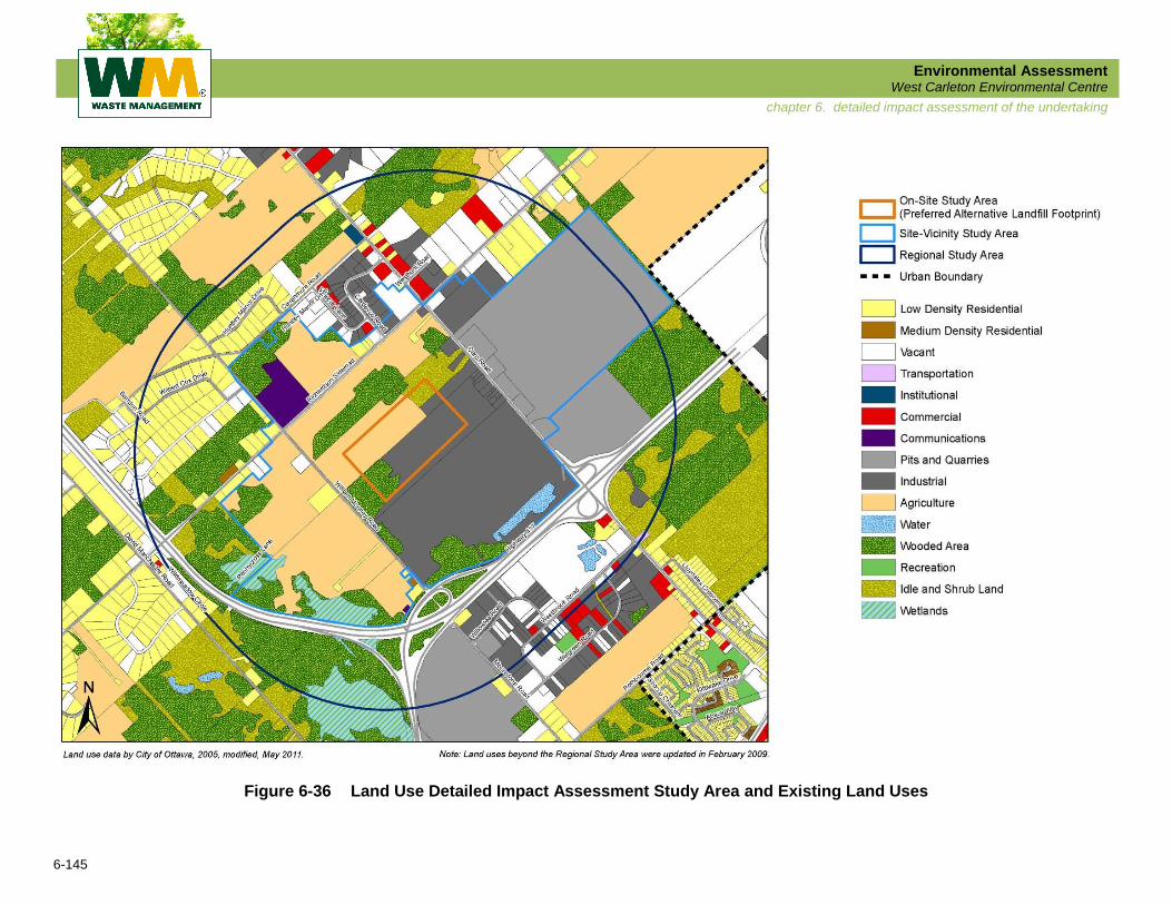
6.7.8 Land Use
For the purposes of the Detailed Impact Assessment, the On-Site Study Area is defined as the
lands for the Preferred Alternative Landfill Footprint; the Site-Vicinity Study Area is defined as all
properties lying wholly or partially within a 500 m radius of the Preferred Landfill Footprint; and
the Regional Study Area extends an additional 1 km from the Site-Vicinity Study Area (refer to
Figure 6-36).
6.7.8.1 Detailed Description of the Land Use Environment Potentially Affected
On-Site
The existing land uses in the On-Site Study Area are a combination of industrial uses,
agricultural uses, wooded area and shrubland. Despite the presence of agricultural uses, a
wooded area, and shrubland, the future uses planned for the lands are for heavy and light
industrial uses, as outlined in the policies of the City of Ottawa Official Plan and Carp Road
Corridor Rural Employment Area.
A new landfill footprint is consistent with the policy framework of the Ottawa Official Plan and
Carp Road Corridor Rural Employment Area and amendments to these plans are not
anticipated to be needed. An amendment to the Ottawa Comprehensive Zoning By-law;
however, would be required.
Site-Vicinity
There are seven residential lots located within the Site-Vicinity Study Area. Four lots are
currently non-conforming with future planned uses as outlined in the Official Plan (three lots are
located on Richardson Side Road, just west of Cardevco Road, one lot is located on Carp Road,
south of Richardson Side Road). A further two lots are located on lands either owned or
optioned by WM (located on William Mooney Road). One lot at the corner of William Mooney
Road and Richardson Side Road conforms with current Official Plan policies.
There is one livestock operation within the Site-Vicinity Study Area, located west of William
Mooney Road. Livestock operations are considered sensitive to landfilling activities. The lands
fronting on William Mooney Road south of Richardson Side Road are either owned or optioned
by WM. Lands designated for heavy industrial, light industrial, and mineral extraction activities
envision future land uses that are compatible with landfilling activities.
Environmental Assessment West Carleton Environmental Centre
6-145
chapter 6. detailed impact assessment of the undertaking
Figure 6-36 Land Use Detailed Impact Assessment Study Area and Existing Land Uses
Environmental Assessment West Carleton Environmental Centre
6-146
chapter 6. detailed impact assessment of the undertaking
Lands designated for commercial and rural activities envision future land uses that may or may
not be compatible with landfilling activities.
Policies for Solid Waste Disposal Sites (Section 3.8) of the Official Plan require that proponents
of development proposals within the influence area of a solid waste disposal site undertake a
study to demonstrate that the landfill will not have any unacceptable adverse effects on the
proposed development and will not pose any risks to human health and safety. Particular
attention is required for those proposals that accommodate people or include animal husbandry
or food production. The policies of Section 3.8 also state that the City must be satisfied that
there will be no impacts from the proposed use on continued landfill operations.
Regional
There are many residential land uses located within the Regional Study Area. These uses are
concentrated in two country lot subdivisions in the rural northwestern portion of the Study Area.
All of these residential uses are in conformity with the policies of the Official Plan. These uses
are beyond the generalized 500 m prescribed influence area of a landfill site, as outlined in
MOE Guideline D-4 and Ottawa Official Plan policies.
Many of the future uses in the Regional Study Area are intended for industrial, commercial,
mineral extraction, and natural uses which are not considered sensitive to landfilling operations.
Although some of the future uses in the Regional Study Area, such as residential and some
types of commercial and agricultural uses are considered sensitive to landfilling operations, the
Official Plan does not restrict sensitive land uses on properties located greater than 500 m from
a landfill footprint.
6.7.8.2 Potential Effects on Land Use
Current Land Uses
The main land use effects for the Preferred Alternative Landfill Footprint are the loss of some
rural/agricultural lands as well as some wooded and shrub lands. There is also some industrial
land that would be converted for the new footprint, including an exhausted sand pit that was
previously used to extract daily cover material.
There are seven residential properties and one livestock operation (i.e., cattle) that fall within the
500 m Site-Vicinity Study Area. No other potentially sensitive land uses (as defined in
Guidelines D-1 and D-4, and associated Procedures) are found within 500 m of the Preferred
Alternative Landfill Footprint.
Environmental Assessment West Carleton Environmental Centre
6-147
chapter 6. detailed impact assessment of the undertaking
Planned Future Land Uses
The Preferred Alternative Landfill Footprint falls completely within the planning area of the Carp
Road Corridor CDP. The lands that would be used to construct this option are designated Heavy
Industrial and Light Industrial in the CDP. These designations do not permit waste disposal
operations but they are more compatible with waste disposal uses than rural or residential uses.
The CDP anticipates the potential expansion of the landfill site and indicates that if an expansion
proceeds, a zoning by-law amendment will be required in addition to the EA.
Four of the residences within the 500 m Site-Vicinity Study Area are designated for Light
Industrial uses in the Carp Road Corridor CDP and are therefore non-conforming to the future
land use vision for this area. These residences include three adjacent properties along
Richardson Side Road (north side, next to Cardevco-West Hunt Industrial Area) and one
property immediately south of the intersection of Carp Road and Richardson Side Road.
The Carp Road Corridor CDP also identifies a Convenience Commercial node at the
intersection of Carp Road and Richardson Side Road, a portion of which falls within the 500 m
Site-Vicinity Study Area. The purpose of the Convenience Commercial nodes in the Carp Road
Corridor is to satisfy some of the day to day service and retail requirements of area residents
and employees. As such, examples of Convenience Commercial land uses include convenience
stores, professional offices, business offices, gas bars, banks, and restaurants. Some of these
uses, in particular restaurants and offices, may be considered sensitive land uses.
The 1.5 km Regional Study Area takes in a greater portion of the Carp Road Corridor CDP area.
The lands in the southern end of the corridor are designated primarily for industrial uses, which
are mainly concentrated in the A.G. Reed Industrial Park on the south side of Highway 417 and
the Cardevco-West Hunt Industrial Area on the north side of Richardson Side Road. The vacant
lots in these industrial parks indicate that there will be more industrial development in the
corridor in the future; however, industrial uses are generally considered compatible with a
landfill and its related uses. Outside the corridor, there are some marginal agricultural lands and
country lot subdivisions. Within the country lot subdivisions, there are some vacant lots which
are expected to be filled in with new residences in the longer term.
Types and Proximity of Off-site Recreational Resources within 500 m of Landfill Footprint
Off-site recreational resources of the type considered under this indicator are described in
provincial land use Procedure D-1-3 (Land Use Compatibility: Definitions) issued by the
Province of Ontario in July 1995. These include uses such as a trailer park or picnic area.
During the evaluation, no recreational resources were found within 500 m of the Preferred
Alternative Landfill Footprint. There are no effects with respect to this indicator.
Environmental Assessment West Carleton Environmental Centre
6-148
chapter 6. detailed impact assessment of the undertaking
Type(s) and Proximity of Off-site Sensitive Land Uses (i.e., dwellings, churches,
cemeteries, parks) within 500 m of Landfill Footprint
Similar to the above, off-site sensitive land uses are described in provincial land use Procedure
D-1-3 (July 1995). These land uses generally include places where people sleep (i.e.,
dwellings), churches, cemeteries and parks. There are seven residences within 500 m of the
landfill footprint. Measures would need to be put in place to manage any potential nuisance
(e.g., noise, odour, visual impact) resulting from the construction and operation of the landfill site
within 500 m of these residences.
6.7.8.3 Mitigation and/or Compensation Measures for Land Use
The Carp Road Corridor CDP includes compatibility guidelines to ensure that industrial uses in the
Carp Road Corridor can co-exist with adjacent residential uses. These guidelines include locating
all unsightly and noise-generating elements (e.g., service lanes, loading zones, and outdoor
storage) away from residential properties, and physically buffering industrial uses from adjacent
residential uses with landscaping (e.g., berms and dense evergreen plantings). These measures
may provide some degree of mitigation from any visual and noise effects generated by the landfill.
The City of Ottawa Official Plan also provides a number of complementary compatibility criteria
which seek to avoid land use conflicts between uses. Of particular application to the landfill site
and the residential properties in the vicinity are those relating to noise and air quality. BMPs
identified by other technical disciplines (i.e., air, noise, etc.) will therefore be required to
minimize the potential for significant adverse effects on adjacent sensitive land uses relative to
noise, odours and other emissions. Mitigation measures are expected to include:
Daily cover of the landfill;
Installation of a LFG collection system;
Berms and evergreen buffers; and
Fencing.
While it is expected that the mitigation measures will be sufficient to avoid significant negative
effects on sensitive land uses within the Site-Vicinity Study Area, there may be situations where
it is appropriate to compensate neighbours for certain effects. In terms of land use, in the ToR
WM committed to developing a property value protection plan as part of the EA.
6.7.8.4 Land Use Net Effects
With the implementation of the mitigation and compensation measures described above there
will be minimal net effects of the Preferred Alternative Landfill Footprint on adjacent land uses.

Environmental Assessment West Carleton Environmental Centre
6-149
chapter 6. detailed impact assessment of the undertaking
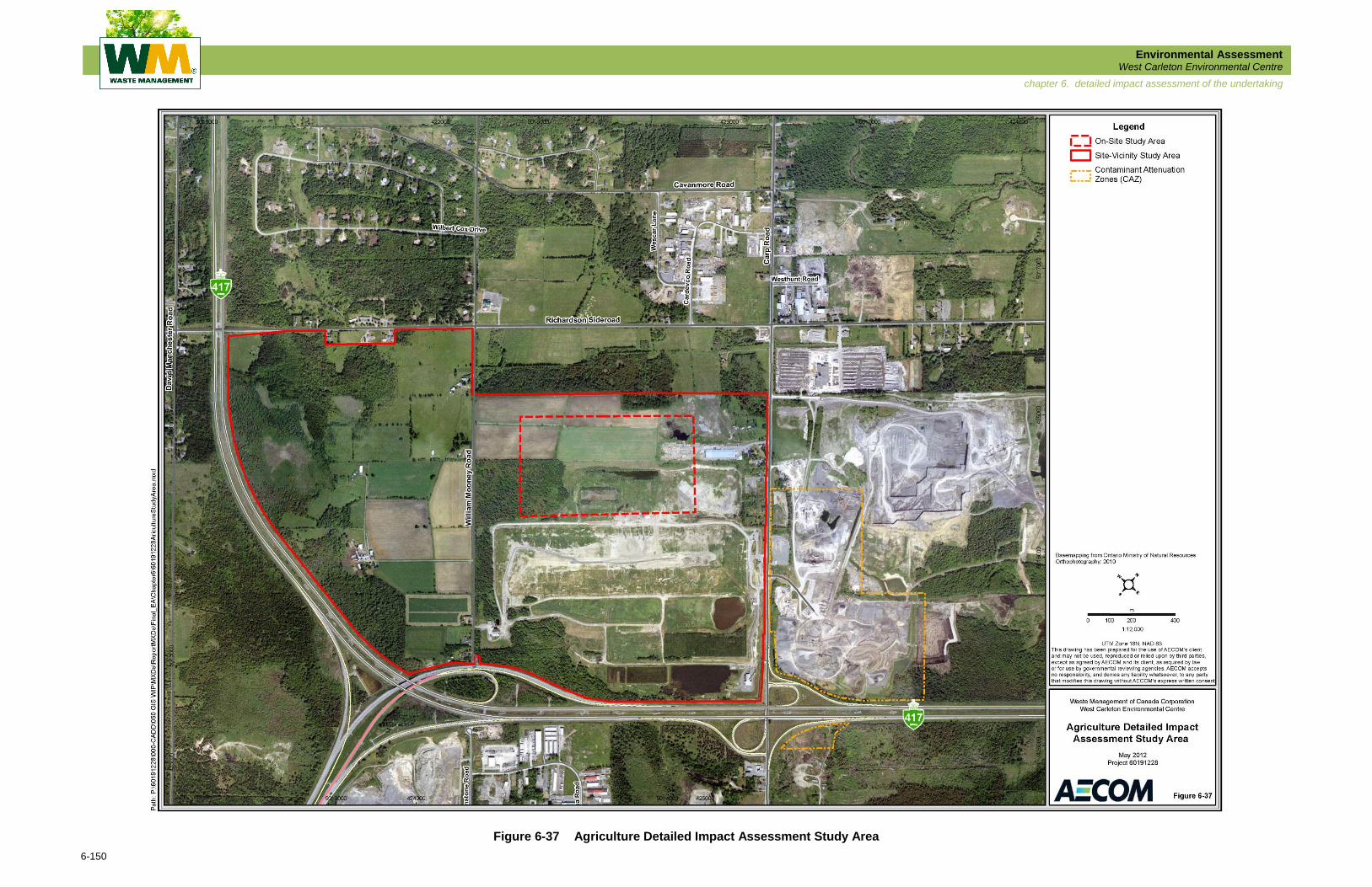
6.7.9 Agriculture
The Study Areas for the Agriculture environmental component are shown in Figure 6-37 and
described as follows:
On-Site .............. the lands required for the Preferred Alternative Landfill Footprint;
and
Site-Vicinity ....... the lands in the vicinity of the Preferred Alternative Landfill
Footprint, bounded by Highway 417, Richardson Side Road,
and Carp Road.
6.7.9.1 Detailed Description of the Agriculture Environment Potentially Affected
On-Site
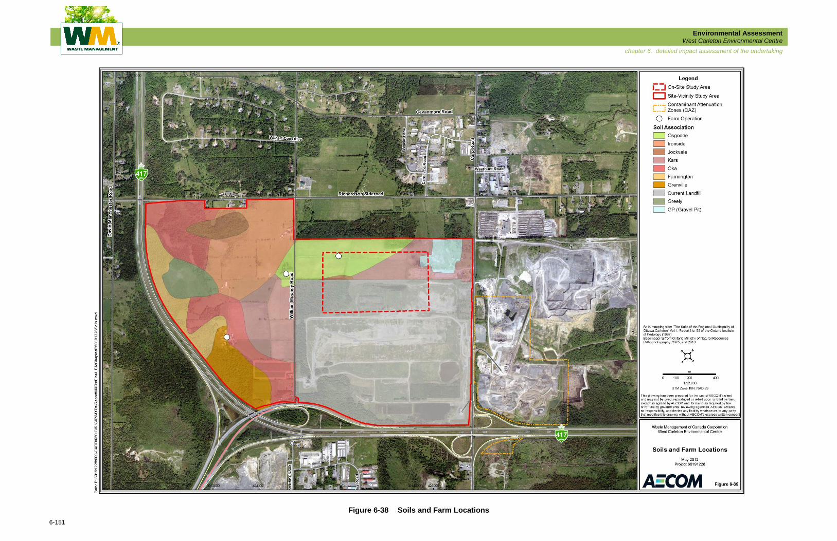
The cleared agricultural land on the Preferred Alternative Landfill Footprint is comprised of four
fields abutting William Mooney Road for a distance of approximately 295 m, and stretching
toward Carp Road for approximately 835 m. The area of the four fields is estimated to be
approximately 24 ha. The four fields are mainly Osgoode sand with some Kars soil toward the
part of the Preferred Landfill Footprint nearest Carp Road (refer to Figure 6-38). The Osgoode
soil has an agriculture soil capability rating of Class 3, and the Kars soil is a Class 4. The fields
are farmed by the dairy farmer on the west side of William Mooney Road to provide feed for his
herd.
Site-Vicinity
There are two active farms within the Site-Vicinity Study Area, both of which are located across
William Mooney Road, west of the Preferred Alternative Landfill Footprint. One is a dairy farm
and the other is a part-time beef farm. The two farms include more than 62 ha of cleared land.
6.7.9.2 Potential Effects on Agriculture
Four cultivated fields totalling approximately 24 ha are located within the area bounded by
William Mooney Road, the existing landfill, Carp Road, and the northern extent of the Site-
Vicinity Study Area, half of which lies within the Preferred Landfill Footprint. These fields are
owned by the dairy farmer on the west side of William Mooney Road and produce feed for the
farmer’s dairy herd. Construction of the Preferred Landfill Footprint will result in the loss of this
cropland to the dairy farm.
Environmental Assessment West Carleton Environmental Centre
6-150
chapter 6. detailed impact assessment of the undertaking
Figure 6-37 Agriculture Detailed Impact Assessment Study Area
Environmental Assessment West Carleton Environmental Centre
6-151
chapter 6. detailed impact assessment of the undertaking
Figure 6-38 Soils and Farm Locations
Environmental Assessment West Carleton Environmental Centre
6-152
chapter 6. detailed impact assessment of the undertaking
The dairy farm cropland located within the Preferred Landfill Footprint consists of roughly half
Class 3 and half Class 4 agricultural capability soil. A strip of Class 3 soil between the Preferred
Landfill Footprint and William Mooney Road, as well as a strip of land consisting of Class 3 and
Class 4 soils along the north side of the Preferred Landfill Footprint, between the footprint and
the property boundary, will remain following construction of the Preferred Landfill Footprint. East
of the cropland is an area of Class 4 soil and an old gravel pit, both of which are designated as
Mineral Extraction areas on the Ottawa Zoning Map (Ottawa Comprehensive Zoning By-law
2008-250). The south part of the cropland is zoned as Rural Heavy Industrial, and the northern
part is zoned as Rural General Industrial, as shown on the Ottawa Zoning Map.
6.7.9.3 Mitigation and/or Compensation Measures for Agriculture
The following two compensation measures are available to address the loss of cropland to the
dairy farm: 1) purchase the entire dairy farm, including the cropland east of William Mooney
Road, then re-sell or lease the land and buildings on the west side of William Mooney Road; or
2) purchase the cropland from the dairy farmer, who could in turn buy or lease other cropland to
replace the portion sold, or contract his feed supply on an annual basis from other farmers.
6.7.9.4 Net Effects on Agriculture
The loss of the dairy farm’s cropland to the Preferred Alternative Landfill Footprint could
conceivably result in the loss of the dairy farm, should the farmer decide to sell the rest of his
land or retire. However; the location of the Preferred Alternative Landfill Footprint on the east
side of William Mooney Road preserves the farm infrastructure on the west side of the road,
including farm buildings, farm roads, fences and drainage systems on the dairy farm and the
adjacent part-time beef farm. With the core of the dairy farm operation remaining intact, the
additional feed requirements can be met elsewhere.
6.7.10 Socio-Economic Environment
6.7.10.1 Socio-Economic Environment
For the purposes of the Socio-Economic Detailed Impact Assessment, the general Study Areas
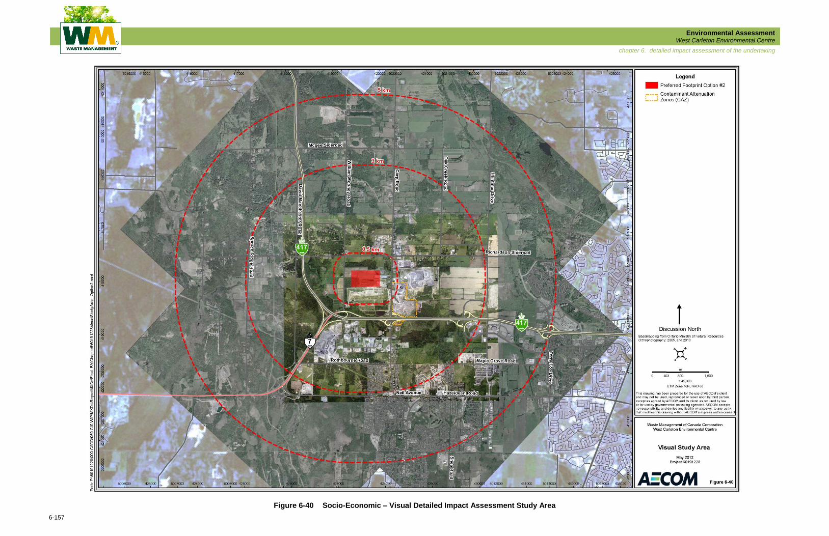
are shown in Figure 6-39 and described below:
On-Site .............. the lands required for the Preferred Alternative Landfill Footprint;
Site-Vicinity ....... the lands in the vicinity of the Preferred Alternative Landfill
Footprint, extending approximately 500 m in all directions; and
Regional ............ the lands and neighbourhoods within approximately 3 km of the
perimeter of the Preferred Alternative Landfill Footprint.

Environmental Assessment West Carleton Environmental Centre
6-153
chapter 6. detailed impact assessment of the undertaking
Figure 6-39 Socio-Economic Detailed Impact Assessment Study Area
Environmental Assessment West Carleton Environmental Centre
6-154
chapter 6. detailed impact assessment of the undertaking
Detailed Description of the Socio-Economic Environment Potentially Affected
On-Site Study Area
Within the On-Site Study Area there are limited opportunities for significant impacts on the
socio-economic environment. Much of the land in this area is used for agricultural purposes,
farmed by the dairy farmer on the west side of William Mooney Road to provide feed for his
herd.
Site-Vicinity Study Area
The Site-Vicinity Study Area includes five residences and does not contain any recreational
resources.
Regional Study Area
The Regional Study Area contains a significant number of residential properties (approximately
6,100) including new subdivisions with existing and planned homes as well as older rural residences
that are generally single homes on large plots. These properties may be sensitive to landfilling
activities with potential impacts on the use and enjoyment of their property. The Regional Study
Area includes neighbourhood parks, walking trails, recreational facilities such as golf clubs and
community features such as schools, cemeteries and churches. There is potential for impacts on
these facilities from noise, dust, and odour as well as impacts on access and egress.
Potential Effects on the Socio-Economic Environment
The following components were considered for the Socio-Economic Detailed Impact Assessment:
Effects on the Cost of Services to Customers
Maximizing the ratio of landfill disposal airspace achieved to total soil handled
translates to reduced construction and operation costs, which are ultimately
transferred to the customer.
Continued Services to Customers
By developing the facility WM can continue to provide waste disposal
services within the City of Ottawa for a further 10 years.
Economic Benefit to Local Municipality
Development of the WCEC will create more jobs in the area and also present
the opportunity to provide improved products or services to people in the
area.
Environmental Assessment West Carleton Environmental Centre
6-155
chapter 6. detailed impact assessment of the undertaking
Effects on Residential and Commercial Development
The development of the WCEC has the potential to affect development in the
area, as some developers may choose not to build within the vicinity of a landfill.
Effects on Property Tax Revenue in the City of Ottawa
Changing the use of land from agricultural to commercial will change the rate
of tax paid to the City of Ottawa.
Visual Impact of the Facility and Surrounding Areas
In building and operating the Preferred Footprint, the visual impact of the site
must be considered. If there is an impact visually there may be additional,
indirect social impacts including: stigma, perceptions of the community to
people from outside the area.
Local Residents
Local residents can be affected by work at the site by increased levels of
noise, odour, dust and traffic. These issues can affect the extent to which
people can use and enjoy private property and the ease with which they can
travel in the site vicinity.
Recreational Facilities
Use and enjoyment of recreation facilities in the area can be affected by
factors such as noise, odour, dust and traffic. This is particularly so at outdoor
facilities such as golf courses.
Together, these components represent the features in the socio-economic environment that are
potentially susceptible to effects from the Preferred Landfill Footprint. There is potential for both
direct and indirect effects on the socio-economic components listed above and they may not all
be affected by the site developments.
Mitigation and/or Compensation Measures for the Socio-Economic Environment
Measures recommended to mitigate potential effects on the Socio-Economic Environment
include (but are not limited to) the following:
BMPs implemented across the facility;
Noise barriers;
Appropriate equipment and vehicle maintenance;
Progressive implementation of LFG collection and utilization;
Making any reconfigurations to the road layout in accordance with city and
provincial standards; and
Implementing visual screening to minimize visual impacts.
Environmental Assessment West Carleton Environmental Centre
6-156
chapter 6. detailed impact assessment of the undertaking
Net Socio-Economic Environment Effects
Net effects on the Socio-Economic Environment are considered to be low and, in some cases,
may be positive. It should be noted that additional criteria and indicators have been included in
the assessment which are considered “standalone” environmental components. The socio-
economic environment is comprised of many different factors, and evaluation must draw on
other disciplines in order to be (e.g., noise and air emissions). While technical information is
provided on these in their respective Detailed Impact Assessments they were also considered in
the Socio-Economic Detailed Impact Assessment as they have potential to effect the Social-
Economic Environment. Nuisance levels of noise or emissions for example can affect the social
environment in many ways; they can affect the extent to which people can use and enjoy their
private property or other outdoor areas such as recreation facilities, public spaces and parks.
Consequently, it is important to consider these aspects when conducting this socio-economic
impact assessment.
Effects from aspects such as noise, odour and air emissions should be effectively managed so
as not to affect people’s use and enjoyment of their private property and of other areas, such as
outdoor recreation facilities and community facilities. An increase in the work force will bring
more employment to the area and provide important economic stimulus; a positive net effect.
There may be some short term inconvenience from additional traffic; however, it is not expected
that there will be increased traffic congestion around the site over the long term.
6.7.10.2 Visual Environment
The specific On-Site, Site-Vicinity, and Regional study areas for the Socio-Economic – Visual
Detailed Impact Assessment are illustrated in Figure 6-40 and described as follows:
On-Site .............. the lands required for the Preferred Alternative Landfill Footprint;
Site-Vicinity ....... the lands in the vicinity of the Preferred Alternative Landfill
Footprint, extending about 500 m in all directions from the edge
of the preferred landfill footprint; and,
Regional ............ the lands within approximately 5 km of the Preferred Alternative
Landfill Footprint.
For the purposes of the Socio-Economic Visual Impact Assessment all directions noted are
based on ‘Discussion North’ as shown on Figure 6-40.
Environmental Assessment West Carleton Environmental Centre
6-157
chapter 6. detailed impact assessment of the undertaking
Figure 6-40 Socio-Economic – Visual Detailed Impact Assessment Study Area
Environmental Assessment West Carleton Environmental Centre
6-158
chapter 6. detailed impact assessment of the undertaking
Upon review of the Existing Conditions findings with the public it was identified that the Regional
Study Area for the Detailed Impact Assessment of the Preferred Landfill Footprint should be
extended from approximately 3 km to approximately 5 km. Within the 5 km study area, views of
the Preferred Landfill Footprint can be placed into one of three different categories based on the
degree of existing screening by a combination of topography, vegetation, and man-made
features: 1) fully screened, 2) partially screened, or 3) fully exposed. These categories can be
further divided into two different classes: distant or close-up views. The detailed visual impact
assessment was conducted with these classifications in mind.
Additional field visits to the site and surrounding areas were conducted in late October 2011 to
assess the visual character of the project site and collect additional photographs. The field
inventory included the nature of distant vistas beyond the project site from various viewpoints.
Detailed Description of the Visual Environment Potentially Affected
The Preferred Alternative Landfill Footprint is located within an area that is already significantly
screened from the surrounding areas.
On-Site Study Area
The preferred site is a relatively flat parcel of land comprised of farmland, a section of existing
woodlot, and a large open disturbed area that is sporadically covered mostly with low growing
scrub material. The Preferred Footprint has no significant adverse effect on the existing
vegetation, requiring only partial removal of a woodlot from the interior of the site. There are
only two locations from which the site can be viewed within the surrounding area, including an
opening in the tree-line along Richardson Side Road, just west of the Carp Road intersection,
and across the farmland that borders William Mooney Road just south of the intersection at
Richardson Side Road. Both views (as described above) are limited with no distant views of
areas to the south or the east. In both cases, the existing landfill feature blocks views beyond.
Site-Vicinity Study Area
The existing surrounding vegetation and topographic features block any distant views through
the site from all adjacent viewpoints. As discussed in the previous section there are only a few
opportunities to view the interior of the site from the adjacent surrounding areas. With significant
vegetation growth and topographic features around the site there are already extensive
screening elements in place to obscure views of the preferred landform. The woodlots along the
north and west edges of the site have significant stands of coniferous trees providing effective
screening year round. Along the east edge of the site there is a ridge that rises approximately
8 m adjacent to the west side of Carp Road. The ridge is covered with hedgerows and stands of
mixed vegetation, offering varying levels of screening.
Environmental Assessment West Carleton Environmental Centre
6-159
chapter 6. detailed impact assessment of the undertaking
Regional Study Area
The surrounding region is generally flat with the exception of a ridge approximately 4.5 km east
of the site that runs northwest along the east bank of the Carp River. The Preferred Landfill
Footprint is located immediately north of the existing landfill mound and will be approximately
13 m lower than the existing landfill mound. For this reason, the new landfill feature will have
little to no adverse effect on the existing views from the south and the north. From these two
directions, the Preferred Footprint will not impact the horizon or any distant views. When viewed
from the south, the Preferred Footprint will be completely hidden by the existing landfill feature.
When viewed from the north, the Preferred Footprint will be back-dropped by the existing landfill
mound. The area to the west and northwest of the proposed site is heavily vegetated. This
vegetation obscures all views of the existing landfill feature as well as distant views from the
east. Due to the size of the Preferred Footprint, it will not be visible from any viewpoint from the
west and northwest (i.e., Highway 417, or any points west of the highway). From areas to the
east and southeast there are varying levels of views of the Preferred Footprint, ranging from
fully screened to fully exposed.
Potential Effects on the Visual Environment
In general, the introduction of the Preferred Landfill Footprint Option will have minimal impact on the
visual environment from distant viewpoints. Although the height of the Preferred Landfill Footprint
will be visible on the horizon, there are no natural or man-made landmarks within the view-sheds
that will be obscured. Within the Site-Vicinity and Regional Study Areas views of the Preferred
Footprint vary from fully obscured to fully exposed (refer to Figure 6-41 and Figure 6-42).
Distant Views (Regional)
Distant views from the west, southwest, and south will not be impacted by the introduction of
the Preferred Footprint due to the presence of existing vegetation and topographic features.
Distant views from the north (e.g., Huntmar Drive south of Old Carp Road) will have a
minimal visual impact. From the north, only a small portion of the top of the preferred landfill
option will be visible. There is significant vegetation growth present in the immediate site
vicinity that will obscure the majority of the Preferred Footprint.
Distant views from the east will be most affected by the introduction of the Preferred Landfill
Footprint. From this area (e.g., Kanata Avenue at Terry Fox Road North), which is an
elevated position, existing vegetation growing east of the site is less effective for screening,
but will be capable of obscuring over half the height of the Preferred Footprint.