fifth five year review report for mowbray … · ncp national oil and hazardous substances...
TRANSCRIPT
Five-Year Review Report
Fifth Five-Year Review Report for
Mowbray Engineering Co. Superfund Site ALD031618069
Greenville Butler County, Alabama
September 201 3
United States Environmental Protection Agency Region 4
Atlanta, Georgia
Date: A::~~ ¢.-//s 7
'L Franklin E. Hill Director, Superfund Division
IWii Ill

1
Fifth Five-Year Review Report for
Mowbray Engineering Co. Junction of Second Street and Beeland Street
Greenville Butler County, Alabama
List of Acronyms ........................................................................................................................... 3
Executive Summary ...................................................................................................................... 4
Five-Year Review Summary Form .............................................................................................. 6
1.0 Introduction ............................................................................................................................. 9
3.0 Background ........................................................................................................................... 12
3.1 PHYSICAL CHARACTERISTICS ........................................................................................ 12 3.2 LAND AND RESOURCE USE ............................................................................................ 15 3.3 HISTORY OF CONTAMINATION ....................................................................................... 15 3.4 INITIAL RESPONSE ......................................................................................................... 15 3.5 BASIS FOR TAKING ACTION ........................................................................................... 16
4.0 Remedial Actions .................................................................................................................. 18
4.1 REMEDY SELECTION ...................................................................................................... 18 4.2 REMEDY IMPLEMENTATION ........................................................................................... 19 4.3 OPERATION AND MAINTENANCE .................................................................................... 20
5.0 Progress Since the Last Five-Year Review ......................................................................... 21
5.1 ENVIRONMENTAL COVENANT ........................................................................................ 21 5.2 DETECTION LIMITS ........................................................................................................ 22 5.3 INDEPENDENT CONTRACTORS ........................................................................................ 22
6.0 Five-Year Review Process .................................................................................................... 23
6.1 ADMINISTRATIVE COMPONENTS .................................................................................... 23 6.2 COMMUNITY INVOLVEMENT .......................................................................................... 23 6.3 DOCUMENT REVIEW ...................................................................................................... 23 6.4 DATA REVIEW ............................................................................................................... 27 6.5 SITE INSPECTION ............................................................................................................ 28 6.6 INTERVIEWS ................................................................................................................... 29
7.0 Technical Assessment ........................................................................................................... 30
7.1 QUESTION A: IS THE REMEDY FUNCTIONING AS INTENDED BY THE DECISION DOCUMENTS? ............................................................................................................... 30
7.2 QUESTION B: ARE THE EXPOSURE ASSUMPTIONS, TOXICITY DATA, CLEANUP LEVELS AND REMEDIAL ACTION OBJECTIVES (RAOS) USED AT THE TIME OF REMEDY SELECTION STILL VALID? ............................................................................................................... 30
7.3 QUESTION C: HAS ANY OTHER INFORMATION COME TO LIGHT THAT COULD CALL INTO QUESTION THE PROTECTIVENESS OF THE REMEDY? ...................................................... 31
7.4 TECHNICAL ASSESSMENT SUMMARY ............................................................................. 31
8.0 Issues ...................................................................................................................................... 32
9.0 Recommendations and Follow-up Actions ......................................................................... 33

2
10.0 Protectiveness Statement .................................................................................................... 34
11.0 Next Review ......................................................................................................................... 35
Appendix A: List of Documents Reviewed ............................................................................. A-1
Appendix B: Press Notice ......................................................................................................... B-1
Appendix C: Interview Forms ................................................................................................. C-1
Appendix D: Site Inspection Checklist ................................................................................... D-1
Appendix E: Photographs from Site Inspection Visit ........................................................... E-1
Tables Table 1: Chronology of Site Events .............................................................................................. 11 Table 2: Annual O&M Costs ........................................................................................................ 20 Table 3: Progress on Recommendations from the 2008 FYR ...................................................... 21 Table 4: Deed Documents from Butler County Register of Deeds .............................................. 25 Table 5: Institutional Control (IC) Summary Table ..................................................................... 25 Table 6: Monitoring Data .............................................................................................................. 27 Table 7: Monitoring Data for April 9, 2013 ................................................................................. 27 Figures Figure 1: Site Location Map ......................................................................................................... 13 Figure 2: Detailed Site Map .......................................................................................................... 14 Figure 3: Institutional Control Base Map ..................................................................................... 26
3
List of Acronyms ADEM Alabama Department of Environmental Management APCO Alabama Power Company ARAR Applicable or Relevant and Appropriate Requirement CD Consent Decree CDC Centers for Disease Control CERCLA Comprehensive Environmental Response, Compensation and Liability Act CFR Code of Federal Regulations CIC Community Involvement Coordinator COC Contaminant of Concern EPA United States Environmental Protection Agency FDA Food and Drug Administration FIT Field Investigation Team FYR Five-Year Review IC Institutional Control MCL Maximum Contaminant Level MEC Mowbray Engineering Company mg/kg Milligrams per Kilogram µg/L Micrograms per Liter NCP National Oil and Hazardous Substances Pollution Contingency Plan NIOSH National Institute for Occupational Safety and Health NPL National Priorities List PCB Polychlorinated Biphenyl PRP Potentially Responsible Party RA Remedial Action RAO Remedial Action Objective RCRA Resource Conservation and Recovery Act RD Remedial Design RI/FS Remedial Investigation/Feasibility Study ROD Record of Decision RPM Remedial Project Manager SDWA Safe Drinking Water Act TSCA Toxic Substances Control Act
4
Executive Summary Introduction The Mowbray Engineering Co. Superfund site (the Site) in Greenville, Alabama, is approximately 2.7 acres in size and is located at the junction of Beeland and Second Streets. Mowbray Engineering Company (MEC) began operating on Beeland Street in the 1950s. Company workers disposed of used transformer oil from site operations on the ground behind the plant. The used transformer oil flowed into a stormwater system and into a wetland and creek located across Beeland Street from the MEC facility. The improper disposal techniques resulted in two fish kills and contaminated soil and sediment at the Site with polychlorinated biphenyls (PCBs). The EPA proposed the Site for the National Priorities List (NPL) on December 30, 1982. The EPA finalized the Site on the NPL on September 8, 1983. The EPA chose a remedy and issued the Record of Decision (ROD) on September 25, 1986. The EPA completed the site cleanup in 1991 and deleted the Site from the NPL on December 30, 1993. The EPA carried out the remedy for the Site, including: removing underground storage tanks at the MEC facility, removing waste oils, building a drainage diversion system for surface run-on; excavating and stabilizing contaminated soil on-site; restoring the swamp area; abandoning an on-site city supply well; and monitoring and maintaining the solidified contaminated soil. The potentially responsible party (PRP) currently conducts soil, sediment and ground water sampling. The triggering action for this policy review was the signing of the previous Five-Year Review (FYR) on September 25, 2008. Remedial Action Objectives (RAOs) Remedial Action Objectives were not formally established in the Record of Decision (ROD), however, the ROD discusses removing waste oils and PCB contaminated soils, preventing potential future human exposure to contaminated soil, restoring the swamp, and protecting aquatic life. Technical Assessment The remedy is functioning as intended by the decision document. The capped monolith is performing as expected and the property is well maintained. Most PCB concentrations in soil samples have been below detection limits, with a few detections well below the cleanup levels. Ground water is sampled to monitor for potential PCB migration from the monolith and most PCB concentrations are also below detection limits. In April 2013, the PRP conducted confirmatory ground water sampling analysis with a detection level of 0.5 micrograms per liter (µg/L). All PCB concentrations in the ground water were below detection limits and PCBs are not migrating out of the monolith. Due to a lab quality control issue, the detection limit for Aroclor 1221 was 1.0 µg/L, above the planned detection level and MCL of 0.5 µg/L. Since the objective of the groundwater sampling is to monitor for leaching from the monolith, the detection limits are adequate even though the detection limit for Aroclor 1221 was elevated. There are no current pathways of exposure to site ground water. In 2009, a restrictive covenant was added to the property deed to prohibit residential use or any activities that could damage the integrity of the monolith. The cleanup levels for the Site remain valid and no other information has become known that could call into question the protectiveness of the remedy.

5
Conclusion The remedy at the Site is protective of human health and the environment. The stabilization and solidification of the PCB-contaminated soils is performing as expected and necessary institutional controls are in place for the property to prohibit residential development and any activities that would affect the monolith.
6
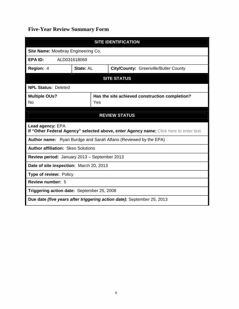
Five-Year Review Summary Form
SITE IDENTIFICATION
Site Name: Mowbray Engineering Co.
EPA ID: ALD031618069
Region: 4 State: AL City/County: Greenville/Butler County
SITE STATUS
NPL Status: Deleted
Multiple OUs? No
Has the site achieved construction completion? Yes
REVIEW STATUS
Lead agency: EPA If “Other Federal Agency” selected above, enter Agency name: Click here to enter text.
Author name: Ryan Burdge and Sarah Alfano (Reviewed by the EPA)
Author affiliation: Skeo Solutions
Review period: January 2013 – September 2013
Date of site inspection: March 20, 2013
Type of review: Policy
Review number: 5
Triggering action date: September 25, 2008
Due date (five years after triggering action date): September 25, 2013

7
Five-Year Review Summary Form (continued)
Issues/Recommendations
OU(s) without Issues/Recommendations Identified in the Five-Year Review: OU1
Protectiveness Statements
Operable Unit: OU1
Protectiveness Determination: Protective
Addendum Due Date (if applicable): Click here to enter date.
Protectiveness Statement: The remedy at the Site is protective of human health and the environment. The stabilization and solidification of the PCB-contaminated soils is performing as expected and necessary institutional controls are in place for the property to prohibit residential development and any activities that would affect the monolith.
Sitewide Protectiveness Statement Protectiveness Determination: Protective
Addendum Due Date (if applicable): Click here to enter date.
Protectiveness Statement: The remedy at the Site is protective of human health and the environment. The stabilization and solidification of the PCB-contaminated soils is performing as expected and necessary institutional controls are in place for the property to prohibit residential development and any activities that would affect the monolith.

8
Five-Year Review Summary Form (continued)
Environmental Indicators - Current human exposures at the Site are under control. - This is not a ground water site.
Are Necessary Institutional Controls in Place?
All Some None
Has EPA Designated the Site as Sitewide Ready for Anticipated Use?
Yes No
Has the Site Been Put into Reuse?
Yes No

9
Fifth Five-Year Review Report for
Mowbray Engineering Co. Superfund Site 1.0 Introduction The purpose of a five-year review (FYR) is to evaluate the implementation and performance of a remedy in order to determine if the remedy will continue to be protective of human health and the environment. FYR reports document FYR methods, findings and conclusions. In addition, FYR reports identify issues found during the review, if any, and document recommendations to address them. The United States Environmental Protection Agency prepares FYRs pursuant to the Comprehensive Environmental Response, Compensation and Liability Act (CERCLA) Section 121 and the National Oil and Hazardous Substances Pollution Contingency Plan (NCP). CERCLA Section 121 states:
If the President selects a remedial action that results in any hazardous substances, pollutants, or contaminants remaining at the site, the President shall review such remedial action no less often than each 5 years after the initiation of such remedial action to assure that human health and the environment are being protected by the remedial action being implemented. In addition, if upon such review it is the judgment of the President that action is appropriate at such site in accordance with section [104] or [106], the President shall take or require such action. The President shall report to the Congress a list of facilities for which such review is required, the results of all such reviews, and any actions taken as a result of such reviews.
The EPA interpreted this requirement further in the NCP, 40 Code of Federal Regulations (CFR) Section 300.430(f)(4)(ii), which states:
If a remedial action is selected that results in hazardous substances, pollutants, or contaminants remaining at the site above levels that allow for unlimited use and unrestricted exposure, the lead agency shall review such action no less often than every five years after initiation of the selected remedial action.
Skeo Solutions, an EPA Region 4 contractor, conducted the FYR and prepared this report regarding the remedy implemented at the Mowbray Engineering Co. Superfund site (the Site) in Greenville, Butler County, Alabama. The EPA’s contractor conducted this FYR from January to September 2013. The EPA is the lead agency for developing and implementing the remedy for the PRP-financed cleanup at the Site. The Alabama Department of Environmental Management (ADEM), as the support agency representing the State of Alabama, has reviewed all supporting documentation and provided input to the EPA during the FYR process. This is the fifth FYR for the Site. The triggering action for this policy review is the previous FYR. The FYR is required due to the fact that hazardous substances, pollutants or contaminants

10
remain at the Site above levels that allow for unlimited use and unrestricted exposure. The Site consists of one operable unit (OU).

11
2.0 Site Chronology Table 1 lists the dates of important events for the Site. Table 1: Chronology of Site Events
Event Date
Mowbray Engineering Company’s holding tank overflowed and caused a major fish kill in the Tanyard Branch
May 1975
The EPA conducted extensive sampling and analysis of the area to determine the extent of contamination
February 1, 1981
The EPA initiated a removal action, which removed the top 6 inches of contaminated soil on the Site
May 12, 1981
The EPA completed the removal action June 10, 1981
The EPA sampled soil at the Site August 1981
The EPA proposed the Site for listing on the National Priorities List (NPL) December 30, 1982
The EPA listed the Site on the NPL September 8, 1983
The EPA began a remedial investigation/feasibility study (RI/FS) February 2, 1985
The EPA conducted an NPL responsible party search for the Site February 15, 1985
The EPA issued notice letters to potentially responsible parties (PRPs) June 25, 1985
The EPA completed the RI/FS The EPA signed the Record of Decision (ROD)
September 25, 1986
The EPA initiated a remedial action (RA) June 4, 1987
The EPA entered into a Consent Decree with the PRP The PRP began operation and maintenance of the site
May 10, 1991
The EPA completed RA and designated the Site construction complete The EPA completed a Superfund Site Close Out Report
September 16, 1991
The EPA completed the first FYR for the Site January 8, 1993
The EPA deleted the Site from the NPL December 30, 1993
The EPA completed the second FYR for the Site August 3, 1998
The EPA completed the third FYR for the Site September 29, 2003
The EPA sent a letter to the City of Greenville requesting they record a restrictive covenant to protect the remedy
March 21, 2006
The EPA completed a title search of the property April 2008
The EPA completed the fourth FYR for the Site September 25, 2008
The EPA issued an environmental covenant as an institutional control December 1, 2008
The City of Greenville recorded an environmental covenant to the property deed January 9, 2009
12
3.0 Background 3.1 Physical Characteristics
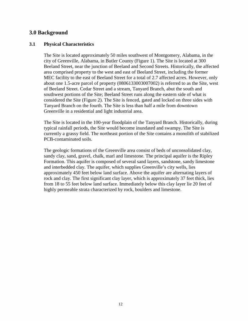
The Site is located approximately 50 miles southwest of Montgomery, Alabama, in the city of Greenville, Alabama, in Butler County (Figure 1). The Site is located at 300 Beeland Street, near the junction of Beeland and Second Streets. Historically, the affected area comprised property to the west and east of Beeland Street, including the former MEC facility to the east of Beeland Street for a total of 2.7 affected acres. However, only about one 1.5-acre parcel of property (0806133003007002) is referred to as the Site, west of Beeland Street. Cedar Street and a stream, Tanyard Branch, abut the south and southwest portions of the Site; Beeland Street runs along the eastern side of what is considered the Site (Figure 2). The Site is fenced, gated and locked on three sides with Tanyard Branch on the fourth. The Site is less than half a mile from downtown Greenville in a residential and light industrial area.
The Site is located in the 100-year floodplain of the Tanyard Branch. Historically, during typical rainfall periods, the Site would become inundated and swampy. The Site is currently a grassy field. The northeast portion of the Site contains a monolith of stabilized PCB-contaminated soils. The geologic formations of the Greenville area consist of beds of unconsolidated clay, sandy clay, sand, gravel, chalk, marl and limestone. The principal aquifer is the Ripley Formation. This aquifer is composed of several sand layers, sandstone, sandy limestone and interbedded clay. The aquifer, which supplies Greenville’s city wells, lies approximately 450 feet below land surface. Above the aquifer are alternating layers of rock and clay. The first significant clay layer, which is approximately 37 feet thick, lies from 18 to 55 feet below land surface. Immediately below this clay layer lie 20 feet of highly permeable strata characterized by rock, boulders and limestone.

13
Figure 1: Site Location Map
Disclaimer: This map and any boundary lines within the map are approximate and subject to change. The map is not a survey. The map is for informational purposes only regarding the EPA’s response actions at the Site.

14
Figure 2: Detailed Site Map
Disclaimer: This map and any boundary lines within the map are approximate and subject to change. The map is not a survey. The map is for informational purposes only regarding the EPA’s response actions at the Site.
15
3.2 Land and Resource Use
MEC used the former facility to the east of Beeland Street for light industrial operations for over 20 years before filing for Chapter 7 bankruptcy in 1985. The property owner also filed for bankruptcy and, as a result, the City of Greenville, Alabama, acquired the title to the property. The Site, located west of Beeland Street, contained a swamp during MEC operations but the former swamp currently contains the soil monolith and an unused grassy field. The gate entrance to the Site is located near the junction of Beeland Street and Second Street. Alabama Power Company (APCO), the PRP, maintains appropriate signage on the perimeter fencing. The former MEC facility is used for storage. All residents in the Greenville area receive water from the city’s public drinking water system. None rely on private wells for their water supply.
3.3 History of Contamination
MEC began in the 1940s as a business repairing electrical transformers. The company moved to Beeland Street from downtown Greenville in the 1950s. Company workers disposed of used transformer oil from facility operations on the ground behind the facility, across the street from the former swamp. Approximately 180,000 gallons of oil containing PCBs flowed into a city storm sewer drain at the property and ultimately into the former swampy area at the Site. This disposal method continued until the mid-1970s. In May 1975, investigations revealed that an overflow of waste oils from a MEC holding tank had caused a major fish kill in the Tanyard Branch. As a result, the EPA and the Alabama Water Improvement Commission investigated the soils for PCB concentrations and found trace amounts of PCBs in the soils.
3.4 Initial Response
In 1980, a second fish kill occurred in the Tanyard Branch due to another spill. ADEM investigated and found soils with PCB concentrations greater than 500 milligrams per kilogram (mg/kg). In February 1981, the EPA conducted extensive soil sampling and analysis to determine the extent of contamination and to delineate an area for possible removal of contaminated soil. Due to the results of this investigation, the EPA removed the top 6 inches of contaminated soil from the former swamp area during the early summer of 1981 in order to obtain acceptable soil concentrations of 50 mg/kg. The EPA sent the contaminated soils to an approved hazardous waste landfill. In August 1981, the EPA sampled the soil at the Site, which revealed a maximum PCB concentration of 19 mg/kg. In 1981, the EPA, the U.S. Food and Drug Administration (FDA), the Centers for Disease Control (CDC) and the National Institute for Occupational Safety and Health
16
(NIOSH) completed additional investigations. The FDA investigation concluded that PCB concentrations in edible catfish tissue collected downstream of the Tanyard Branch were below the FDA level of 2.0 mg/kg. An EPA investigation revealed PCB concentrations above background levels in the roots of some plants growing in the water in the saturated soil. The EPA ecological investigation revealed that Tanyard Branch was almost completely devoid of biota from below the Site to its confluence with Persimmon Creek (approximately one mile downstream). The EPA determined that acute aquatic effects were likely due to the oil overflows rather than the presence of PCBs. The CDC/NIOSH investigation revealed that MEC workers did not appear to be exposed to excessive levels of PCBs. In 1983, during a routine investigation, ADEM collected grab soil samples from the Site. One of the soil samples collected from the stormwater drainage pathway through the Site had a PCB concentration of 1,737 mg/kg. On December 30, 1982, the EPA proposed the Site to the NPL. On September 8, 1983, the EPA listed the Site on the NPL.
3.5 Basis for Taking Action
In February 1984, an EPA Field Investigation Team conducted a site inspection to characterize existing conditions and prepare a detailed sampling study plan. In April 1984, EPA’s investigations found that soils and ground water had similar levels of PCBs (Aroclor 1260) to those measured in 1981 prior to the removal action. In 1985, the EPA authorized a remedial investigation and feasibility study (RI/FS) to further determine the nature and extent of the contamination and to explore potential remedies. The EPA’s contractor completed the RI/FS in 1986. Based on the environmental sampling, the EPA found PCBs to be an on-site chemical that posed an unacceptable risk to human health or the environment, based on the frequency of detection, concentrations detected and inherent toxicity. PCBs are the only contaminant of concern (COC) for soil. The RI/FS also revealed low levels of phenol, chloroform, dichloroethane and trichloroethanes on site but determined the risk associated with these levels to be insignificant. The Tanyard Branch and Persimmon Creek were the downstream surface water recipients of PCB contamination from the Site. The Site’s exposure assessment established that there were no contaminants above the 1980 EPA water quality criteria in the upstream and downstream surface water samples from Tanyard Branch and Persimmon Creek. Though there were very low levels of PCBs in downstream sediment samples, in conjunction with the limited use of these streams, the EPA considers the potential for significant exposure via dermal contact or inadvertent ingestion of surface water by fishermen or children to be remote. Investigators considered regular recreational use of Tanyard Branch to be unlikely because of its small size and inaccessibility due to its steep, overgrown banks. Locals

17
may use Persimmon Creek, further downstream, for recreational fishing and swimming. The exposure assessment determined that the potential for exposure to PCBs via ingestion of ground water and direct human contact with on-site contaminated soils is remote.

18
4.0 Remedial Actions In accordance with the NCP, the EPA analyzed remedial options based on important cost and non-cost factors, such as performance, reliability, implementability, institutional requirements, and public health and environmental considerations. These analysis criteria provide for the determination of the most technically feasible, cost-effective remedy that adequately protects public health, welfare and the environment. In addition to considering such cost factors as capital and operation and maintenance, the EPA also considered the results of a sensitivity analysis in the overall cost of each remedy alternative. The purpose of the sensitivity analysis is to assess the effect of variation in specific assumptions associated with the cost estimates of the remedial action alternatives. 4.1 Remedy Selection
The EPA chose a remedy and issued the Record of Decision (ROD) on September 25, 1986. The EPA selected the remedy for the area based on data collected during the 1985-1986 RI/FS, previous investigations and the exposure assessment. Though RAOs were not established in the ROD, the goal of the cleanup was preventing potential future human exposure to contaminated soil, restoring the swamp, protecting aquatic life, with appropriate institutional controls to protect the remedial components. The remedial components include:
• Excavation, removal and disposal of the underground storage tanks located on the
MEC property. • Treatment or disposal of waste oils encountered in the swamp area and in the
underground storage tanks by a Toxic Substances Control Act (TSCA)-approved method.
• Drainage diversion of surface run-on around the contaminated swamp area. • Excavation of soils with PCB concentrations above 25 mg/kg and on-site
stabilization/solidification of these soils. • Grading and revegetation of the contaminated swamp area. • Proper closure of the abandoned on-site city supply well (in accordance with
ADEM well closure regulations). • Operation and maintenance (O&M) activities were to include maintenance of the
drainage diversion ditch, the revegetated area and, possibly, monitoring and maintenance of the solidified matrix.
The EPA selected stabilization/solidification because the small amount of soils needing remediation and the low PCB concentrations would have made it inefficient and not cost-effective to incinerate the soils. Since the EPA chose to stabilize the contaminants on site, the ROD required the development and implementation of a long-term monitoring program to verify the effectiveness of the remedy. The remedy noted that the remedial design would identify land use restrictions if necessary to protect the remedy and restrict exposure pathways.

19
The EPA selected the cleanup level of 25 mg/kg for PCBs in soil to be consistent with the proposed TSCA regulations. Four monitoring wells were installed at the site. One ground water sample from MW-2, located near the point where waste oil from the Mowbray Engineering Co. plant discharged into the swamp, had a PCB (Arochlor 1260) concentration of 2.4 µg/L during site investigations. However, the water samples collected from all the monitoring wells were unfiltered and PCBs are nearly insoluble in water. Investigators determined that PCBs might have adsorbed onto the clay particles collected with the water samples. In addition to these findings, the 1980 EPA Water Quality Standards, used during the initial site evaluation, did not list an MCL for PCBs. Therefore, the EPA did not list any ground water cleanup goals in the 1986 ROD. Additional sampling of the monitoring wells, including MW-2, did not result in any detections for PCBs. During the 1993 FYR, the EPA noted that the National Primary Drinking Water standard for PCBs is 0.5 µg /l (40 CFR part 141).
4.2 Remedy Implementation
On June 4, 1987, the EPA contractor, HazTech Corporation, began the cleanup. In summary, the constructed remedy consisted of the following components:
• Stabilization/solidification of approximately 2,500 cubic yards of PCB- contaminated soil within an on-site monolith.
• Capping of the monolith. • Construction of a diversion ditch around the swamp. • Installing fencing around the swamp area. • Grading and revegetating the swamp area. • Closure of the abandoned city well. • Storage tank removal. • Removal of abandoned transformers. • Disposal/treatment of waste oil in the underground storage tanks, barrels,
transformers and tanker trailer.
Construction of the cap over the solidified material began on August 10, 1987. The construction activities associated with the remedial components ended on August 20, 1987. Contractors excavated soil at any location where soil PCB concentrations exceeded the cleanup goal of 25 mg/kg. They solidified the excavated soil to reduce contaminant mobility and placed it on site under a protective six-foot-thick cap. Confirmation sampling indicated all soils above the 25 mg/kg cleanup goal for PCB were excavated. The cap consists of a minimum of 2 feet of compacted clay, a drainage layer of 2 feet of compacted fine-medium sand, a water-permeable geotextile fabric and 2 feet of topsoil. Remedial workers planted grass on top of the cap to prevent degradation by erosion.

20
Workers also closed the abandoned city well by removing the well casing and pump, and then filling the well shaft with 5.5 cubic yards of grout. The EPA deleted the Site from the NPL in December 1993. After the 2008 FYR, the City of Greenville and the EPA issued an environmental covenant as an institutional control. The covenant, signed December 2008, restricts any agricultural, residential, commercial or industrial use of the site property without the EPA’s approval and restricts uses that may interfere with the construction, operation, maintenance, monitoring or efficacy of any components, structures or improvements relating to the remedial action. Butler County added this environmental covenant to their publicly-accessible deed records in January 2009.
4.3 Operation and Maintenance
In 1991, the EPA and PRPs agreed to a Consent Decree requiring compensation for remedial actions and compliance with an O&M plan listed as Appendix A of the Consent Decree. That plan is included in this FYR as Appendix F. The Consent Decree presents the O&M plan in detail and states that APCO will facilitate and fund the O&M for 30 years. The Consent Decree’s O&M requirements include regular site inspections, ground water and soil sampling, vegetation control in the monolith area, maintaining site security, and maintaining the integrity of the soil cover and drainage system. The City of Greenville owns the property and APCO is responsible for site maintenance and for ensuring that the Site is secured. O&M activities include sampling ground water, soil and sediment every two years, and site maintenance activities such as mowing, checking for burrowing animals and repairs to the site fencing. The Consent Decree requires quarterly maintenance and inspections; however, due to frequent visits to the area for other projects, APCO usually inspects and maintains the property, as needed, on a monthly basis. The Consent Decree does not provide an updated annual O&M cost estimate. The ROD’s projected costs were $414,144 present worth for 30 years. APCO provided the actual recent annual O&M costs presented in Table 2.
Table 2: Annual O&M Costs
Date Range Total Cost (rounded to the nearest $1,000)
2008 $10,000 2009 $9,000 2010 $10,000 2011 $9,000 2012 $11,000
21
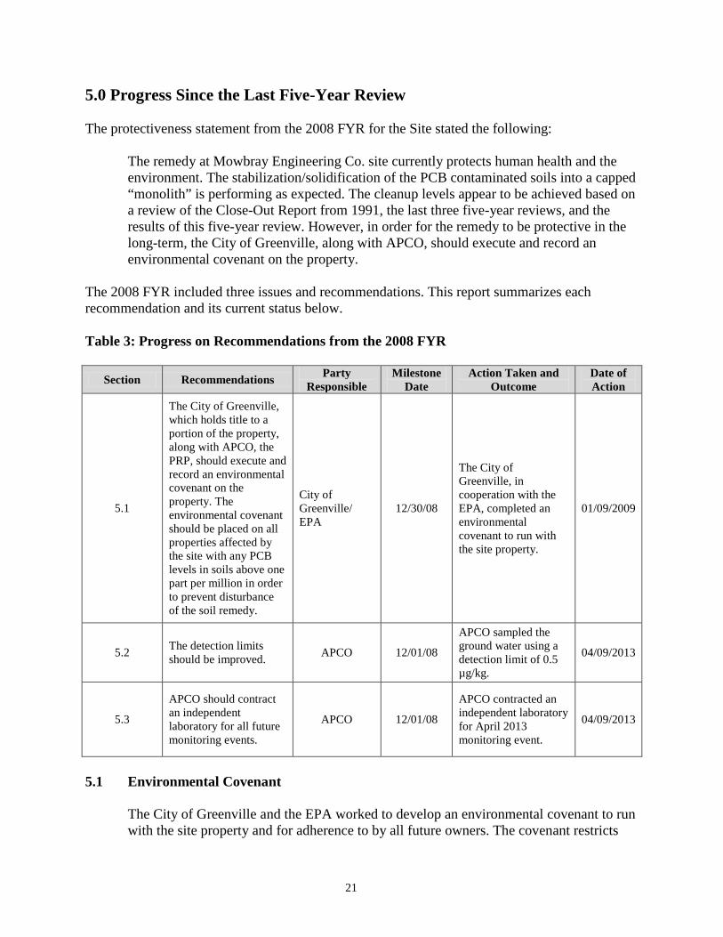
5.0 Progress Since the Last Five-Year Review The protectiveness statement from the 2008 FYR for the Site stated the following:
The remedy at Mowbray Engineering Co. site currently protects human health and the environment. The stabilization/solidification of the PCB contaminated soils into a capped “monolith” is performing as expected. The cleanup levels appear to be achieved based on a review of the Close-Out Report from 1991, the last three five-year reviews, and the results of this five-year review. However, in order for the remedy to be protective in the long-term, the City of Greenville, along with APCO, should execute and record an environmental covenant on the property.
The 2008 FYR included three issues and recommendations. This report summarizes each recommendation and its current status below. Table 3: Progress on Recommendations from the 2008 FYR
Section Recommendations Party Responsible
Milestone Date
Action Taken and Outcome
Date of Action
5.1
The City of Greenville, which holds title to a portion of the property, along with APCO, the PRP, should execute and record an environmental covenant on the property. The environmental covenant should be placed on all properties affected by the site with any PCB levels in soils above one part per million in order to prevent disturbance of the soil remedy.
City of Greenville/ EPA
12/30/08
The City of Greenville, in cooperation with the EPA, completed an environmental covenant to run with the site property.
01/09/2009
5.2 The detection limits should be improved. APCO 12/01/08
APCO sampled the ground water using a detection limit of 0.5 µg/kg.
04/09/2013
5.3
APCO should contract an independent laboratory for all future monitoring events.
APCO 12/01/08
APCO contracted an independent laboratory for April 2013 monitoring event.
04/09/2013
5.1 Environmental Covenant
The City of Greenville and the EPA worked to develop an environmental covenant to run with the site property and for adherence to by all future owners. The covenant restricts

22
any agricultural, residential, commercial or industrial use of the site property without the EPA’s approval as well as any interference with the construction, operation, maintenance, monitoring or efficacy of any components, structures or improvements relating to the remedial action. Butler County added this covenant to their publicly-accessible deed records in January 2009.
5.2 Detection Limits
Throughout the past five years, APCO used a method with a detection limit of 1.0 mg/kg for PCBs in soil and 5 µg/L in ground water. On, April 9, 2013, APCO conducted ground water sampling using a detection limit of 0.5 µg/L, which is the current MCL for PCBs. At the March 2013 site inspection, APCO explained that based on verbal communication after the previous FYR, they continued to use the same EPA-approved method for analysis that they have continued using the same method for the duration of the project. During the site inspection, the EPA clarified that the minimum detection limits for the hazardous waste EPA method is higher than the limit for the drinking water method, and that the latter more stringent sampling technique should be used for the next sampling event. In response, APCO sampled MW-2 and MW-4 on April 9, 2013. APCO sent the samples to Tuscaloosa Testing Laboratory in Tuscaloosa, Alabama on April 10, 2013. The laboratory used the EPA-approved Test Method 505 for PCBs in drinking water. The laboratory tested for Aroclor 1016, Aroclor 1232, Aroclor 1242, Aroclor 1248, Aroclor 1254 and Aroclor 1260 using the 0.5 µg/L detection limit. However, the laboratory could not use a detection limit of 0.5 µg/L for Aroclor 1221 and used a detection limit of 1.0 µg/L instead. All results were non-detect. There are no current exposure pathways to ground water. All area residents and businesses connect to municipal water.
5.3 Independent Contractors
Over the past five years, APCO has contracted an independent laboratory for one round of sampling. On April 10, 2013, the independent laboratory contracted by APCO, Tuscaloosa Testing Laboratory, evaluated samples from MW-2 and MW-4. In earlier samplings, APCO used an in-house laboratory.

23
6.0 Five-Year Review Process 6.1 Administrative Components
EPA Region 4 initiated the FYR in January 2013 and scheduled its completion for September 2013. The EPA remedial project manager (RPM) Erik Spalvins led the EPA site review team, which also included the EPA community involvement coordinator (CIC) L’Tonya Spencer and contractor support provided to the EPA by Skeo Solutions. In February 2013, the EPA held a scoping call with the review team to discuss the Site and items of interest as they related to the protectiveness of the remedy currently in place. The review schedule established consisted of the following activities:
• Community notification. • Document review. • Data collection and review. • Site inspection. • Local interviews. • FYR Report development and review.
6.2 Community Involvement
On March 20, 2013, the EPA published a public notice in the Greenville Advocate announcing the commencement of the FYR process for the Site, providing contact information for the Site Remedial Project Manager and the Site Community Involvement Coordinator and inviting community participation. The press notice is available in Appendix B. No one contacted the EPA as a result of the advertisement. The EPA will make the final FYR Report available to the public. Upon completion of the FYR, the EPA will place copies of the document in the designated site repository: Greenville-Butler County Public Library located at 309 Fort Dale Road, Greenville, Alabama 36037.
6.3 Document Review
This FYR included a review of relevant, site-related documents, including the ROD, remedial action reports and recent monitoring data. Appendix A presents a complete list of the documents reviewed.
ARARs Review
CERCLA Section 121(d)(1) requires that Superfund remedial actions attain “a degree of cleanup of hazardous substance, pollutants, and contaminants released into the environment and of control of further release at a minimum which assures protection of human health and the environment.” The remedial action must achieve a level of cleanup that at least attains those any requirements that EPA determines to be Applicable or Relevant and Appropriate Requirements (ARARs). Applicable requirements are those

24
cleanup standards, standards of control, and other substantive requirements, criteria, or limitations promulgated under federal environmental or state environmental or facility siting laws that specifically address a hazardous substance, remedial action, location or other circumstance found at a CERCLA site. Relevant and appropriate requirements are those standards that, while not “applicable,” address problems or situations sufficiently similar to those encountered at the CERCLA site that their use is well suited to the particular site. Only those state standards that are more stringent than federal requirements may be applicable or relevant and appropriate. To-be-considered criteria are non-promulgated advisories and guidance that are not legally binding but should be considered in determining the necessary remedial action. For example, to-be-considered criteria may be particularly useful in determining health-based levels where no ARARs exist or in developing the appropriate method for conducting a remedial action.
Chemical-specific ARARs are health- or risk-based numerical values or methodologies which, when applied to site-specific conditions, result in the establishment of numerical values. These values establish an acceptable amount or concentration of a chemical that may remain in, or be discharged to, the ambient environment. Examples of chemical-specific ARARs include MCLs under the federal Safe Drinking Water Act (SDWA) and ambient water quality criteria enumerated under the federal Clean Water Act.
Action-specific ARARs are technology- or activity-based requirements or limits on actions taken with respect to a particular hazardous substance. These requirements are triggered by a particular remedial activity, such as discharge of contaminated groundwater or in-situ remediation.
Location-specific ARARs are restrictions on hazardous substances or the conduct of the response activities solely based on their location in a special geographic area. Examples include restrictions on activities in wetlands, sensitive habitats and historic places.
Remedial actions are required to comply with the chemical-specific ARARs identified in the ROD. In performing the FYR for compliance with ARARs, only those ARARs that address the protectiveness of the remedy are reviewed. The soil cleanup level of 25 mg/kg PCBs was chosen to be consistent with the proposed TSCA regulations. The cleanup goal remains consistent with current TSCA requirements. Although the SDWA is discussed in the ROD, it was not deemed applicable in the ROD. Institutional Controls Review Skeo Solutions conducted online research through the Butler County Register of Deeds and found the deed and institutional control information pertaining to the Site listed below in Table 4.
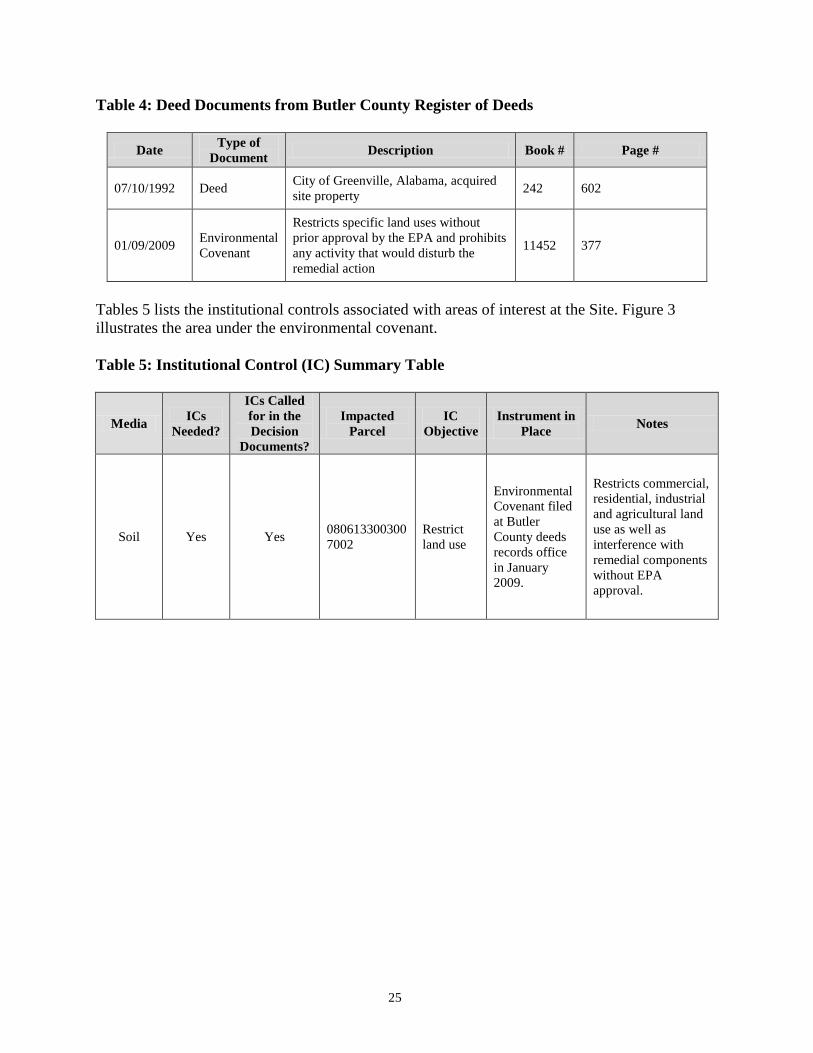
25
Table 4: Deed Documents from Butler County Register of Deeds
Date Type of Document Description Book # Page #
07/10/1992 Deed City of Greenville, Alabama, acquired site property 242 602
01/09/2009 Environmental Covenant
Restricts specific land uses without prior approval by the EPA and prohibits any activity that would disturb the remedial action
11452 377
Tables 5 lists the institutional controls associated with areas of interest at the Site. Figure 3 illustrates the area under the environmental covenant. Table 5: Institutional Control (IC) Summary Table
Media ICs Needed?
ICs Called for in the Decision
Documents?
Impacted Parcel
IC Objective
Instrument in Place Notes
Soil Yes Yes 0806133003007002
Restrict land use
Environmental Covenant filed at Butler County deeds records office in January 2009.
Restricts commercial, residential, industrial and agricultural land use as well as interference with remedial components without EPA approval.

26
Figure 3: Institutional Control Base Map
Disclaimer: This map and any boundary lines within the map are approximate and subject to change. The map is not a survey. The map is for informational purposes only regarding the EPA’s response actions at the Site.
27
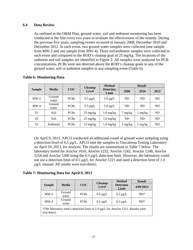
6.4 Data Review
As outlined in the O&M Plan, ground water, soil and sediment monitoring has been conducted at the Site every two years to evaluate the effectiveness of the remedy. During the previous five years, sampling events occurred in January 2008, December 2010 and December 2012. In each event, two ground water samples were collected (one sample from MW-2 and one sample from MW-4). Three soil/sediment samples were collected in each event and compared to the ROD’s cleanup goal of 25 mg/kg. The locations of the sediment and soil samples are identified in Figure 2. All samples were analyzed for PCB concentrations. PCBs were not detected above the ROD’s cleanup goals in any of the ground water, soil or sediment samples in any sampling event (Table 6).
Table 6: Monitoring Data
Sample Media COC Cleanup Level
Method Detection
Limit
Result
2008 2010 2012
MW-2 Ground water PCBs 0.5 µg/L 5.0 µg/L ND ND ND
MW-4 Ground water PCBs 0.5 µg/L 5.0 µg/L ND ND ND
S1 Soil PCBs 25 mg/kg 1.0 mg/kg 7 mg/kg 1 mg/kg ND
S2 Soil PCBs 25 mg/kg 1.0 mg/kg ND ND ND
S3 Sediment PCBs 25 mg/kg 1.0 mg/kg 1 mg/kg 1 mg/kg ND
On April 9, 2013, APCO conducted an additional round of ground water sampling using a detection level of 0.5 µg/L. APCO sent the samples to Tuscaloosa Testing Laboratory on April 10, 2013, for analysis. The results are summarized in Table 7 below. The laboratory tested for Aroclor 1016, Aroclor 1232, Aroclor 1242, Aroclor 1248, Aroclor 1254 and Aroclor 1260 using the 0.5 µg/L detection limit. However, the laboratory could not use a detection limit of 0.5 µg/L for Aroclor 1221 and used a detection limit of 1.0 µg/L instead. All results were non-detect.
Table 7: Monitoring Data for April 9, 2013
Sample Media COC Cleanup Level
Method Detection
Limit
Result
4/09/2013
MW-2 Ground water PCBs 0.5 µg/L 0.5 µg/L ND*
MW-4 Ground water PCBs 0.5 µg/L 0.5 µg/L ND*
*The laboratory used a detection limit of 1.0 µg/L for Aroclor 1221. Results were non-detect.

28
6.5 Site Inspection
On March 20, 2013, stakeholders gathered at the Site to perform the FYR site inspection. In attendance were Erik Spalvins, the EPA RPM; L’Tonya Spencer, the EPA CIC; Adam Warnke, ADEM; Tommy Ryals, APCO; Franklin Horn, APCO; Brian Hayes, APCO; and Ryan Burdge and Sabrina Foster, Skeo Solutions. For a full list of site inspection activities, see the Site Inspection Checklist in Appendix D. For photographs taken during the site inspection, see Appendix E. Site inspection participants walked along the monolith and perimeter of the site property. The property fence was in good condition. APCO reported that the only recurring issues at the Site are related to fence maintenance. APCO repairs fencing when large trees limbs fall on the fence or when cars along Beeland Street veer off the road and damage the fence. APCO replaced two fence posts prior to the site inspection because a vehicle struck the fence along Beeland Street at the northeast corner of the Site. The APCO representatives identified the locations of soil and sediment sampling for site O&M activities. The Site has two active ground water monitoring wells: MW-2, located in the northeastern corner of the Site near Beeland Street, and MW-4, located southwest of the Site across Tanyard Branch and along Cedar/First Street. Both wells were secured and clearly labeled. APCO also identified an inactive monitoring well near the central portion of the southern boundary of the Site that is typically dry because it is screened above the current level of the water table. This monitoring well is secured, but has not been properly abandoned. Since site inspection participants discovered an armadillo burrow during the site inspection for the 2008 FYR, APCO has begun treating the Site for grubs, which can attract armadillos. Site inspection participants did not identify any animal burrows during the site inspection.
The EPA CIC L’Tonya Spencer conducted FYR interviews with ADEM representative, Adam Warnke, and APCO representative, Tommy Ryals, at the Site. On March 20, 2013, Skeo Solutions staff visited the site repository at Greenville-Butler County Library at 309 Fort Dale Street, Greenville, Alabama 36037. Skeo Solutions staff found that the library had no site-related documents. The EPA CIC will send the administrative record to the library on compact disk.

29
6.6 Interviews
The FYR process included interviews with parties affected by the Site. The purpose was to document the perceived status of the Site and any perceived problems or successes with the remedy. The interviews took place during the site inspection on March 20, 2013. The interviews are summarized below. Appendix C provides the complete interviews. Adam Warnke: Mr. Warnke works for ADEM. This was Mr. Warnke’s first visit to the Site. His overall impressions were positive, and the site inspections seemed to confirm his confidence that the remedy is working successfully. He reports that ADEM has not conducted any site-related communications in the past five years. Tommy Ryals: Mr. Ryals works for APCO, the PRP for the Site. His overall impression of the remedial activities was positive and he noted that APCO works to ensure the proper maintenance and security of the property. Mr. Ryals stated that O&M workers are at the Site once a month and after major rainfall events, to check on the fence and gate. He reports that ground water monitoring samples are taken every two years and thus far no signs of contamination have been found.

30
7.0 Technical Assessment 7.1 Question A: Is the remedy functioning as intended by the decision documents?
The remedy is functioning as intended by the decision documents. The stabilization and solidification of the PCB-contaminated soils into a capped monolith is performing as expected. Regular inspections and maintenance have ensured no damage to the monolith from woody vegetation, burrowing animals or large precipitation events. The property is well fenced and there are no signs of trespassing. The City of Greenville owns the property. There are no known intended uses of the property. In 2009, the City of Greenville added a restrictive covenant to the property deed to ensure protection of the monolith and to restrict land use. Most PCB concentrations in ground water and soil samples have been below detection limits, with a few detections in soils below the ROD cleanup levels. Ground water concentrations have remained below the laboratory detection limit of 5.0 µg/L during the past five years. There are no cleanup levels for ground water in the ROD and ground water monitoring is intended to monitor the effectiveness of the monolith. However, the current EPA MCL for PCBs is 0.5 µg/L. On April 9, 2013, APCO conducted an additional round of sampling using a detection level of 0.5 µg/L and all results were non-detect. The laboratory could not attain a detection limit of 0.5 µg/L for one of the PCBs, Aroclor 1221, and used a detection limit of 1.0 µg/L instead. No PCBs were detected on site. All residents and businesses in the Greenville area receive water from the city’s public drinking water system. There are no known potential exposure pathways to ground water at the Site. Ground water monitoring is intended to monitor the effectiveness of the monolith.
7.2 Question B: Are the exposure assumptions, toxicity data, cleanup levels and remedial action objectives (RAOs) used at the time of remedy selection still valid? The cleanup goal of 25 mg/kg for PCBs in soil and sediment is still valid. The current screening level associated with a risk of 10-6 for PCBs is 0.74 mg/kg for industrial or commercial soil. A comparison of the cleanup level to this generic screening level indicates that the risk associated with the 25 mg/kg soil cleanup level (3.4x10⁻⁵) is within the EPA’s acceptable cancer risk range (10-4 to 10-6) for industrial use. In addition, soil sampling indicates concentrations are generally at or below 1 mg/kg. The ROD did not identify ground water cleanup goals for the Site. The PRP monitors PCB concentrations in ground water to ensure no PCBs are escaping the monolith and entering the ground water. The April 2013 sampling event ensured that all PCB concentrations are below the MCL. The laboratory detection limit for one of the PCBs, Aroclor 1221, was higher than the current MCL for PCBs but results were non-detect. Since the objective of the groundwater sampling is to monitor for leaching from the

31
monolith, the detection limits are adequate even though the detection limit for Aroclor 1221 was elevated.
7.3 Question C: Has any other information come to light that could call into question the protectiveness of the remedy?
No other information has become known that could call into question the protectiveness of the remedy.
7.4 Technical Assessment Summary
The remedy is functioning as intended by the decision documents. The capped monolith is performing as expected and the property is well maintained. Most PCB concentrations in ground water and soil samples have been below detection limits, with a few detections well below the cleanup levels in soils, indicating no PCB migration from the monolith. In April 2013, the PRP conducted confirmatory ground water sampling analysis with a detection level of 0.5 µg/L. Sampling confirmed that all PCB concentrations in the ground water are below detection limits. Due to a lab quality control issue, the detection limit for Aroclor 1221 was 1.0 µg/L, above the planned detection level and MCL of 0.5 µg/L. Since the objective of the groundwater sampling is to monitor for leaching from the monolith, the detection limits are adequate even though the detection limit for Aroclor 1221 was elevated. There are no current pathways of exposure to site ground water. In 2009, a restrictive covenant was added to the property deed to prohibit residential use or any activities that could damage the integrity of the monolith. The cleanup levels for the Site remain valid and no other information has become known that could call into question the protectiveness of the remedy.

32
8.0 Issues There are no current site issues.

33
9.0 Recommendations and Follow-up Actions There are no formal recommendations needed to ensure the protectiveness of the remedy. The EPA noted that, as a matter of good site management, that the PRP properly abandon an inactive, dry monitoring well near the central portion of the southern boundary of the Site. The PRP has secured the on-site well and it does not create any exposure pathways for ground water but it should be properly abandoned. This item is not expected to affect protectiveness.

34
10.0 Protectiveness Statement The remedy at the Site is protective of human health and the environment. The stabilization and solidification of the PCB-contaminated soils is performing as expected and necessary institutional controls are in place for the property to prohibit residential development and any activities that would affect the monolith.

35
11.0 Next Review The next FYR will be due within five years of the signature/approval date of this FYR.

A-1
Appendix A: List of Documents Reviewed 2008 Environmental Affairs Water Quality Field Data Sheet for Mowbray Site. Prepared by Alabama Power Company. December 16, 2008. 2009 Environmental Affairs Water Quality Field Data Sheet for Mowbray Site. Prepared by Alabama Power Company. December 12, 2009. 2010 Environmental Affairs Water Quality Field Data Sheet for Mowbray Site. Prepared by Alabama Power Company. December 8, 2010. 2011 Environmental Affairs Water Quality Field Data Sheet for Mowbray Site. Prepared by Alabama Power Company. December 5, 2011. 2012 Environmental Affairs Water Quality Field Data Sheet for Mowbray Site. Prepared by Alabama Power Company. December 12, 2012. Alabama Uniform Environmental Covenants Act, Alabama Code 35-19-1. Effective January 1, 2008. Closeout Report for Mowbray Engineering Co. Superfund Site, Greenville, Alabama. September 16, 1991. Consent Decree for the Mowbray Engineering Company Site, Civil Action No. 90-2769. Prepared by EPA Region 4. May 10, 1991. Draft Environmental Covenant, for Mowbray Engineering Company Site. Prepared by EPA Region 4. May 13, 2008. Email message from Trevor Black, EPA to Derek Matory, EPA regarding Mowbray Institutional Controls, August 17, 2006. Five-Year Review Final Report, Revision I, for Mowbray Engineering Company Superfund Site, Greenville, Alabama. Prepared Roy F. Weston, Inc. for EPA Region 4. February 23, 1993. Fourth Five-Year Review Final Report for Mowbray Engineering Company Site, Greenville, Alabama. Prepared by U.S. Army Corp. of Engineers for EPA Region 4. September 25, 2008. Institutional Controls Review Checklist for Mowbray Engineering Company Site, completed by Humberto Guzman for EPA Region 4. September 13, 2005. Letter from Richard Hartley, Hartley & Hickman Attorneys at Law, to Trevor Black, EPA, regarding the deed and lack of deed restrictions, August 11, 2005.
A-2
Letter from Trevor Black, EPA to Richard Hartley and Steven McKinney, regarding recording of a restrictive easement or restrictive covenant on the Mowbray property, March 21, 2006. Record of Decision for Mowbray Engineering Company, EPA ID: ALD031618069, Greenville, AL. Prepared by EPA Region 4. September 25, 1986. Second Five-Year Review Final Report for Mowbray Engineering Company Site, Greenville, Alabama. Prepared by EPA Region 4. August 3, 1998. Superfund Site Close Out Report for Mowbray Engineering Company Site, Greenville, Alabama. Prepared by EPA Region 4. September 16, 1991. Third Five-Year Review Report for Mowbray Engineering Company Site, Greenville, Butler County, Alabama. Prepared by EPA Region 4. September 29, 2003.
B-1
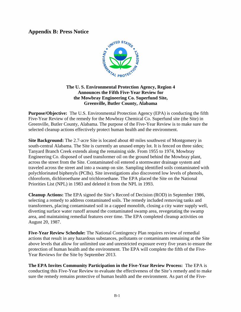
Appendix B: Press Notice
The U. S. Environmental Protection Agency, Region 4 Announces the Fifth Five-Year Review for
the Mowbray Engineering Co. Superfund Site, Greenville, Butler County, Alabama
Purpose/Objective: The U.S. Environmental Protection Agency (EPA) is conducting the fifth Five-Year Review of the remedy for the Mowbray Chemical Co. Superfund site (the Site) in Greenville, Butler County, Alabama. The purpose of the Five-Year Review is to make sure the selected cleanup actions effectively protect human health and the environment. Site Background: The 2.7-acre Site is located about 40 miles southwest of Montgomery in south-central Alabama. The Site is currently an unused empty lot. It is fenced on three sides; Tanyard Branch Creek extends along the remaining side. From 1955 to 1974, Mowbray Engineering Co. disposed of used transformer oil on the ground behind the Mowbray plant, across the street from the Site. Contaminated oil entered a stormwater drainage system and traveled across the street and into a swamp on site. Sampling identified soils contaminated with polychlorinated biphenyls (PCBs). Site investigations also discovered low levels of phenols, chloroform, dichloroethane and trichloroethane. The EPA placed the Site on the National Priorities List (NPL) in 1983 and deleted it from the NPL in 1993. Cleanup Actions: The EPA signed the Site’s Record of Decision (ROD) in September 1986, selecting a remedy to address contaminated soils. The remedy included removing tanks and transformers, placing contaminated soil in a capped monolith, closing a city water supply well, diverting surface water runoff around the contaminated swamp area, revegetating the swamp area, and maintaining remedial features over time. The EPA completed cleanup activities on August 20, 1987. Five-Year Review Schedule: The National Contingency Plan requires review of remedial actions that result in any hazardous substances, pollutants or contaminants remaining at the Site above levels that allow for unlimited use and unrestricted exposure every five years to ensure the protection of human health and the environment. The EPA will complete the fifth of the Five-Year Reviews for the Site by September 2013.
The EPA Invites Community Participation in the Five-Year Review Process: The EPA is conducting this Five-Year Review to evaluate the effectiveness of the Site’s remedy and to make sure the remedy remains protective of human health and the environment. As part of the Five-

B-2
Year Review process, EPA staff members are available to answer any questions about the Site. Community members who have questions about the Site or the Five-Year Review process, or who would like to participate in a community interview, should contact: Erik Spalvins L’Tonya Spencer EPA Remedial Project Manager EPA Community Involvement Coordinator Phone: (404) 562-8938 Phone: (404) 562-8463 Email: [email protected] Email: [email protected] Mailing Address: U.S. EPA Region 4, 61 Forsyth Street, S.W., 11th Floor, Atlanta, GA 30303-8960 Additional site information is available at the Site’s local document repository, located at Greenville Public Library, 309 Fort Dale Street, Greenville, Alabama 36037, and online at: http://www.epa.gov/region4/superfund/sites/npl/alabama/mowbrengal.html.

C-1
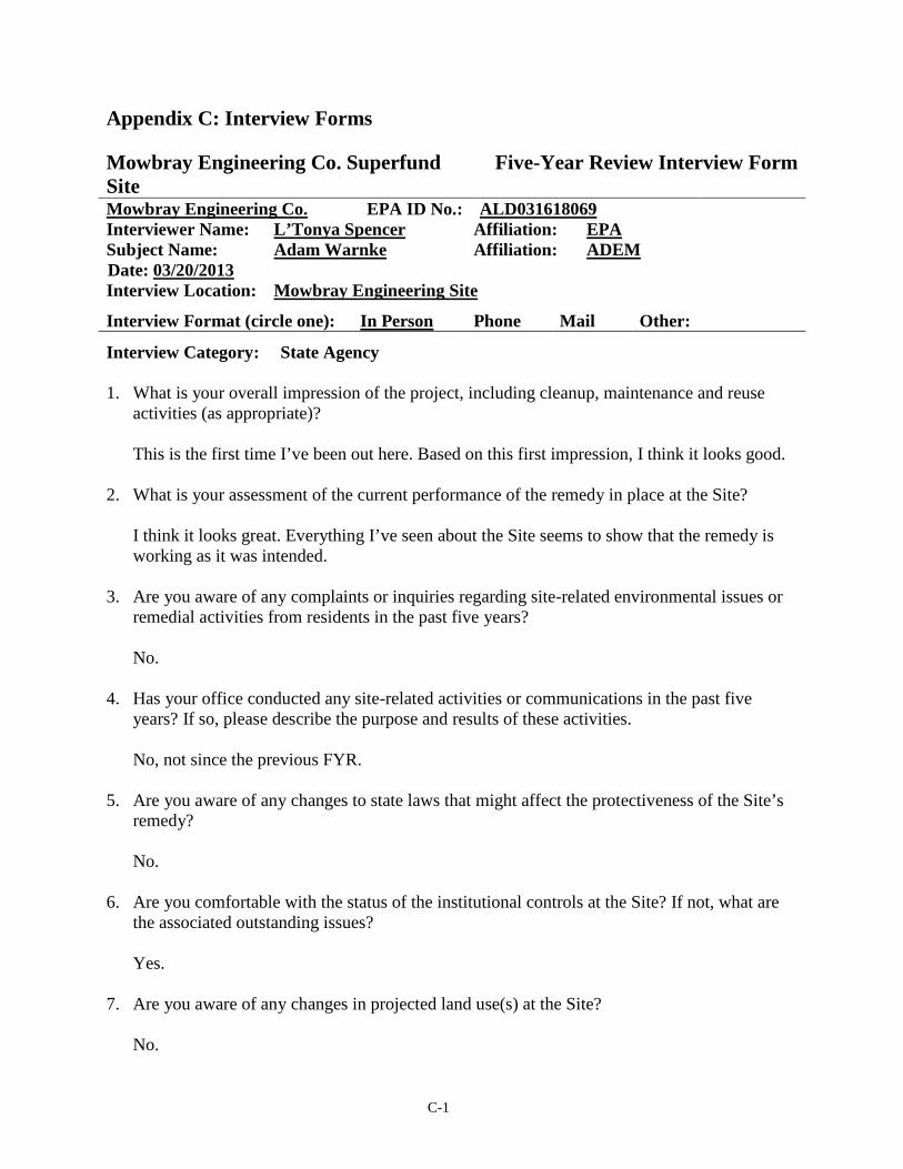
Appendix C: Interview Forms Mowbray Engineering Co. Superfund Site
Five-Year Review Interview Form
Mowbray Engineering Co. EPA ID No.: ALD031618069 Interviewer Name: L’Tonya Spencer Affiliation: EPA Subject Name: Adam Warnke Affiliation: ADEM
Date: 03/20/2013 Interview Location: Mowbray Engineering Site
Interview Format (circle one): In Person Phone Mail Other:
Interview Category: State Agency 1. What is your overall impression of the project, including cleanup, maintenance and reuse
activities (as appropriate)? This is the first time I’ve been out here. Based on this first impression, I think it looks good.
2. What is your assessment of the current performance of the remedy in place at the Site? I think it looks great. Everything I’ve seen about the Site seems to show that the remedy is working as it was intended.
3. Are you aware of any complaints or inquiries regarding site-related environmental issues or
remedial activities from residents in the past five years? No.
4. Has your office conducted any site-related activities or communications in the past five
years? If so, please describe the purpose and results of these activities. No, not since the previous FYR.
5. Are you aware of any changes to state laws that might affect the protectiveness of the Site’s
remedy? No.
6. Are you comfortable with the status of the institutional controls at the Site? If not, what are
the associated outstanding issues? Yes.
7. Are you aware of any changes in projected land use(s) at the Site? No.

C-2
8. Do you have any comments, suggestions or recommendations regarding the management or
operation of the Site’s remedy? No. I think they are doing a great job.
C-3
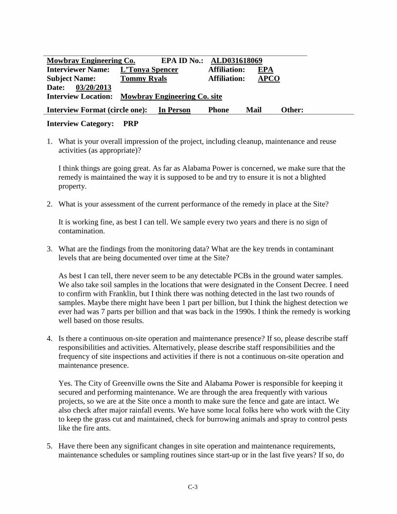
Mowbray Engineering Co. EPA ID No.: ALD031618069 Interviewer Name: L’Tonya Spencer Affiliation: EPA Subject Name: Tommy Ryals Affiliation: APCO Date: 03/20/2013 Interview Location: Mowbray Engineering Co. site
Interview Format (circle one): In Person Phone Mail Other:
Interview Category: PRP 1. What is your overall impression of the project, including cleanup, maintenance and reuse
activities (as appropriate)? I think things are going great. As far as Alabama Power is concerned, we make sure that the remedy is maintained the way it is supposed to be and try to ensure it is not a blighted property.
2. What is your assessment of the current performance of the remedy in place at the Site?
It is working fine, as best I can tell. We sample every two years and there is no sign of contamination.
3. What are the findings from the monitoring data? What are the key trends in contaminant levels that are being documented over time at the Site? As best I can tell, there never seem to be any detectable PCBs in the ground water samples. We also take soil samples in the locations that were designated in the Consent Decree. I need to confirm with Franklin, but I think there was nothing detected in the last two rounds of samples. Maybe there might have been 1 part per billion, but I think the highest detection we ever had was 7 parts per billion and that was back in the 1990s. I think the remedy is working well based on those results.
4. Is there a continuous on-site operation and maintenance presence? If so, please describe staff responsibilities and activities. Alternatively, please describe staff responsibilities and the frequency of site inspections and activities if there is not a continuous on-site operation and maintenance presence. Yes. The City of Greenville owns the Site and Alabama Power is responsible for keeping it secured and performing maintenance. We are through the area frequently with various projects, so we are at the Site once a month to make sure the fence and gate are intact. We also check after major rainfall events. We have some local folks here who work with the City to keep the grass cut and maintained, check for burrowing animals and spray to control pests like the fire ants.
5. Have there been any significant changes in site operation and maintenance requirements, maintenance schedules or sampling routines since start-up or in the last five years? If so, do

C-4
they affect the protectiveness or effectiveness of the remedy? Please describe changes and impacts. No, I think it has been the same since about 1994.
6. Have there been unexpected operation and maintenance difficulties or costs at the Site since start-up or in the last five years? If so, please provide details. I don’t know that I would say they are difficulties, but we do have to repair the fence a lot. Still it is pretty minimal maintenance. And there are no significant costs associated with the Site other than the sampling and analysis.
7. Have there been opportunities to optimize operation and maintenance activities or sampling efforts? Please describe changes and any resulting or desired cost savings or improved efficiencies. I don’t know how we can optimize more than we have now.
8. Do you have any comments, suggestions or recommendations regarding operation and maintenance activities and schedules at the Site? None off the top of my head.
D-1
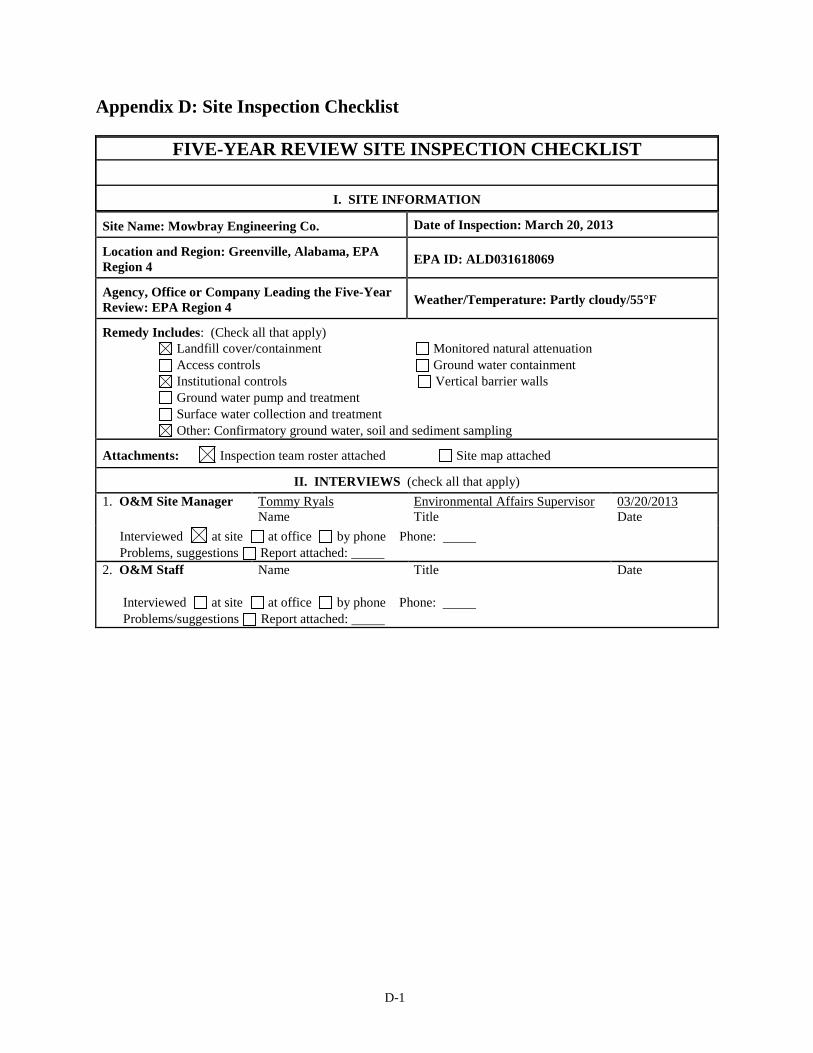
Appendix D: Site Inspection Checklist
FIVE-YEAR REVIEW SITE INSPECTION CHECKLIST
I. SITE INFORMATION
Site Name: Mowbray Engineering Co. Date of Inspection: March 20, 2013
Location and Region: Greenville, Alabama, EPA Region 4 EPA ID: ALD031618069
Agency, Office or Company Leading the Five-Year Review: EPA Region 4 Weather/Temperature: Partly cloudy/55°F
Remedy Includes: (Check all that apply) Landfill cover/containment Monitored natural attenuation Access controls Ground water containment Institutional controls Vertical barrier walls Ground water pump and treatment Surface water collection and treatment Other: Confirmatory ground water, soil and sediment sampling
Attachments: Inspection team roster attached Site map attached
II. INTERVIEWS (check all that apply) 1. O&M Site Manager Tommy Ryals
Name Environmental Affairs Supervisor Title
03/20/2013 Date
Interviewed at site at office by phone Phone: Problems, suggestions Report attached:
2. O&M Staff Name Title Date
Interviewed at site at office by phone Phone: Problems/suggestions Report attached:
D-2
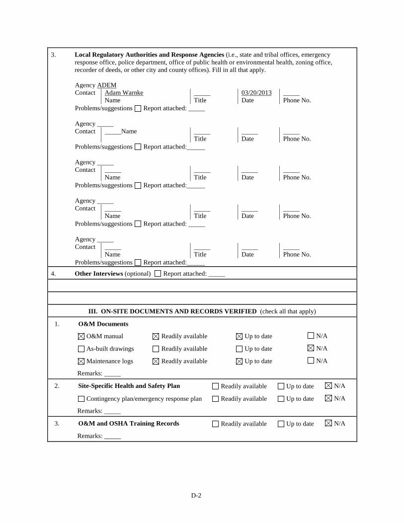
3. Local Regulatory Authorities and Response Agencies (i.e., state and tribal offices, emergency response office, police department, office of public health or environmental health, zoning office, recorder of deeds, or other city and county offices). Fill in all that apply.
Agency ADEM Contact Adam Warnke
Name Title
03/20/2013 Date
Phone No.
Problems/suggestions Report attached: Agency Contact Name
Title Date
Phone No.
Problems/suggestions Report attached: Agency Contact
Name Title
Date
Phone No.
Problems/suggestions Report attached: Agency Contact
Name Title
Date
Phone No.
Problems/suggestions Report attached: Agency Contact
Name Title
Date
Phone No.
Problems/suggestions Report attached:
4. Other Interviews (optional) Report attached:
III. ON-SITE DOCUMENTS AND RECORDS VERIFIED (check all that apply)
1. O&M Documents
O&M manual Readily available Up to date N/A
As-built drawings Readily available Up to date N/A
Maintenance logs Readily available Up to date N/A
Remarks:
2. Site-Specific Health and Safety Plan Readily available Up to date N/A
Contingency plan/emergency response plan Readily available Up to date N/A
Remarks:
3. O&M and OSHA Training Records Readily available Up to date N/A
Remarks:

D-3
4. Permits and Service Agreements
Air discharge permit Readily available Up to date N/A
Effluent discharge Readily available Up to date N/A
Waste disposal, POTW Readily available Up to date N/A
Other permits: Readily available Up to date N/A
Remarks:
5. Gas Generation Records Readily available Up to date N/A
Remarks:
6. Settlement Monument Records Readily available Up to date N/A
Remarks:
7. Ground Water Monitoring Records Readily available Up to date N/A
Remarks:
8. Leachate Extraction Records Readily available Up to date N/A
Remarks:
9. Discharge Compliance Records
Air Readily available Up to date N/A
Water (effluent) Readily available Up to date N/A
Remarks:
10. Daily Access/Security Logs Readily available Up to date N/A
Remarks:
IV. O&M COSTS
1. O&M Organization
State in-house Contractor for state
PRP in-house Contractor for PRP
Federal facility in-house Contractor for Federal facility
D-4
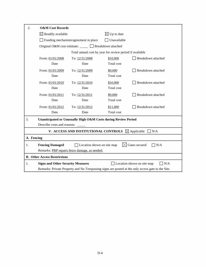
2. O&M Cost Records
Readily available Up to date
Funding mechanism/agreement in place Unavailable
Original O&M cost estimate: Breakdown attached
Total annual cost by year for review period if available
From: 01/01/2008 Date
To: 12/31/2008 Date
$10,000 Total cost
Breakdown attached
From: 01/01/2009 Date
To: 12/31/2009 Date
$9,000 Total cost
Breakdown attached
From: 01/01/2010 Date
To: 12/31/2010 Date
$10,000 Total cost
Breakdown attached
From: 01/01/2011 Date
To: 12/31/2011 Date
$9,000 Total cost
Breakdown attached
From: 01/01/2012 Date
To: 12/31/2012 Date
$11,000 Total cost
Breakdown attached
3. Unanticipated or Unusually High O&M Costs during Review Period Describe costs and reasons:
V. ACCESS AND INSTITUTIONAL CONTROLS Applicable N/A
A. Fencing
1. Fencing Damaged Location shown on site map Gates secured N/A Remarks: PRP repairs fence damage, as needed.
B. Other Access Restrictions
1. Signs and Other Security Measures Location shown on site map N/A Remarks: Private Property and No Trespassing signs are posted at the only access gate to the Site.
D-5
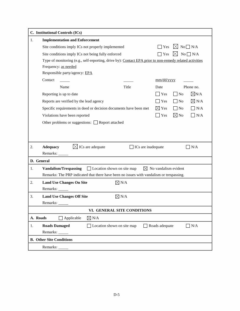
C. Institutional Controls (ICs)
1. Implementation and Enforcement
Site conditions imply ICs not properly implemented Yes No N/A
Site conditions imply ICs not being fully enforced Yes No N/A Type of monitoring (e.g., self-reporting, drive by): Contact EPA prior to non-remedy related activities Frequency: as needed Responsible party/agency: EPA
Contact mm/dd/yyyy
Name Title Date Phone no.
Reporting is up to date Yes No N/A
Reports are verified by the lead agency Yes No N/A
Specific requirements in deed or decision documents have been met Yes No N/A
Violations have been reported Yes No N/A
Other problems or suggestions: Report attached
2. Adequacy ICs are adequate ICs are inadequate N/A Remarks:
D. General
1. Vandalism/Trespassing Location shown on site map No vandalism evident Remarks: The PRP indicated that there have been no issues with vandalism or trespassing.
2. Land Use Changes On Site N/A Remarks:
3. Land Use Changes Off Site N/A Remarks:
VI. GENERAL SITE CONDITIONS
A. Roads Applicable N/A
1. Roads Damaged Location shown on site map Roads adequate N/A Remarks:
B. Other Site Conditions
Remarks:

D-6
VII. LANDFILL COVERS Applicable N/A
A. Landfill Surface
1. Settlement (low spots) Location shown on site map Settlement not evident
Arial extent: Depth:
Remarks:
2. Cracks Location shown on site map Cracking not evident
Lengths: Widths: Depths:
Remarks:
3. Erosion Location shown on site map Erosion not evident
Arial extent: Depth:
Remarks:
4. Holes Location shown on site map Holes not evident
Arial extent: Depth:
Remarks:
5. Vegetative Cover Grass Cover properly established
No signs of stress Trees/shrubs (indicate size and locations on a diagram)
Remarks: In addition to mowing, the PRP treats for grubs and fire ants.
6. Alternative Cover (e.g., armored rock, concrete) N/A
Remarks:
7. Bulges Location shown on site map Bulges not evident
Arial extent: Height:
Remarks:
8. Wet Areas/Water Damage Wet areas/water damage not evident
Wet areas Location shown on site map Arial extent:
Ponding Location shown on site map Arial extent:
Seeps Location shown on site map Arial extent:
Soft subgrade Location shown on site map Arial extent:
Remarks:
9. Slope Instability Slides Location shown on site map
No evidence of slope instability
Arial extent:
Remarks:
B. Benches Applicable N/A (Horizontally constructed mounds of earth placed across a steep landfill side slope to interrupt the slope in order to slow down the velocity of surface runoff and intercept and convey the runoff to a lined channel.)

D-7
1. Flows Bypass Bench Location shown on site map N/A or okay
Remarks:
2. Bench Breached Location shown on site map N/A or okay
Remarks:
3. Bench Overtopped Location shown on site map N/A or okay
Remarks:
C. Letdown Channels Applicable N/A (Channel lined with erosion control mats, riprap, grout bags or gabions that descend down the steep side slope of the cover and will allow the runoff water collected by the benches to move off of the landfill cover without creating erosion gullies.)
1. Settlement (Low spots) Location shown on site map No evidence of settlement
Arial extent: Depth:
Remarks:
2. Material Degradation Location shown on site map No evidence of degradation
Material type: Arial extent:
Remarks:
3. Erosion Location shown on site map No evidence of erosion
Arial extent: Depth:
Remarks:
4. Undercutting Location shown on site map No evidence of undercutting
Arial extent: Depth:
Remarks:
5. Obstructions Type: No obstructions
Location shown on site map Arial extent:
Size:
Remarks:
6. Excessive Vegetative Growth Type:
No evidence of excessive growth
Vegetation in channels does not obstruct flow
Location shown on site map Arial extent:
Remarks:

D-8
D. Cover Penetrations Applicable N/A
1. Gas Vents Active Passive
Properly secured/locked Functioning Routinely sampled Good condition
Evidence of leakage at penetration Needs maintenance N/A
Remarks:
2. Gas Monitoring Probes
Properly secured/locked Functioning Routinely sampled Good condition
Evidence of leakage at penetration Needs maintenance N/A
Remarks:
3. Monitoring Wells (within surface area of landfill)
Properly secured/locked Functioning Routinely sampled Good condition
Evidence of leakage at penetration Needs maintenance N/A
Remarks:
4. Extraction Wells Leachate
Properly secured/locked Functioning Routinely sampled Good condition
Evidence of leakage at penetration Needs maintenance N/A
Remarks:
5. Settlement Monuments Located Routinely surveyed N/A
Remarks:
E. Gas Collection and Treatment Applicable N/A
1. Gas Treatment Facilities
Flaring Thermal destruction Collection for reuse
Good condition Needs maintenance
Remarks:
2. Gas Collection Wells, Manifolds and Piping
Good condition Needs maintenance
Remarks:
3. Gas Monitoring Facilities (e.g., gas monitoring of adjacent homes or buildings)
Good condition Needs maintenance N/A
Remarks:
F. Cover Drainage Layer Applicable N/A
1. Outlet Pipes Inspected Functioning N/A
Remarks:

D-9
2. Outlet Rock Inspected Functioning N/A
Remarks:
G. Detention/Sedimentation Ponds Applicable N/A
1. Siltation Area extent: Depth: N/A
Siltation not evident
Remarks:
2. Erosion Area extent: Depth:
Erosion not evident
Remarks:
3. Outlet Works Functioning N/A
Remarks:
4. Dam Functioning N/A
Remarks:
H. Retaining Walls Applicable N/A
1. Deformations Location shown on site map Deformation not evident
Horizontal displacement: Vertical displacement:
Rotational displacement:
Remarks:
2. Degradation Location shown on site map Degradation not evident
Remarks:
I. Perimeter Ditches/Off-Site Discharge Applicable N/A
1. Siltation Location shown on site map Siltation not evident
Area extent: Depth:
Remarks: Site perimeter ditches discharge to Tanyard Branch near Cedar/First Street.
2. Vegetative Growth Location shown on site map N/A
Vegetation does not impede flow
Area extent: Type:
Remarks:
3. Erosion Location shown on site map Erosion not evident
Area extent: Depth:
Remarks:
4. Discharge Structure Functioning N/A
Remarks:

D-10
VIII. VERTICAL BARRIER WALLS Applicable N/A
1. Settlement Location shown on site map Settlement not evident
Area extent: Depth:
Remarks:
2. Performance Monitoring Type of monitoring:
Performance not monitored
Frequency: Evidence of breaching
Head differential:
Remarks:
IX. GROUND WATER/SURFACE WATER REMEDIES Applicable N/A
A. Ground Water Extraction Wells, Pumps and Pipelines Applicable N/A
1. Pumps, Wellhead Plumbing and Electrical
Good condition All required wells properly operating Needs maintenance N/A
Remarks:
2. Extraction System Pipelines, Valves, Valve Boxes and Other Appurtenances
Good condition Needs maintenance
Remarks:
3. Spare Parts and Equipment
Readily available Good condition Requires upgrade Needs to be provided
Remarks:
B. Surface Water Collection Structures, Pumps and Pipelines Applicable N/A
1. Collection Structures, Pumps and Electrical
Good condition Needs maintenance
Remarks:
2. Surface Water Collection System Pipelines, Valves, Valve Boxes and Other Appurtenances
Good condition Needs maintenance
Remarks:
3. Spare Parts and Equipment
Readily available Good condition Requires upgrade Needs to be provided
Remarks:

D-11
C. Treatment System Applicable N/A
1. Treatment Train (check components that apply)
Metals removal Oil/water separation Bioremediation
Air stripping Carbon adsorbers
Filters:
Additive (e.g., chelation agent, flocculent):
Others:
Good condition Needs maintenance
Sampling ports properly marked and functional
Sampling/maintenance log displayed and up to date
Equipment properly identified
Quantity of ground water treated annually:
Quantity of surface water treated annually:
Remarks:
2. Electrical Enclosures and Panels (properly rated and functional)
N/A Good condition Needs maintenance
Remarks:
3. Tanks, Vaults, Storage Vessels
N/A Good condition Proper secondary containment Needs maintenance
Remarks:
4. Discharge Structure and Appurtenances
N/A Good condition Needs maintenance
Remarks:
5. Treatment Building(s)
N/A Good condition (esp. roof and doorways) Needs repair
Chemicals and equipment properly stored
Remarks:
6. Monitoring Wells (pump and treatment remedy)
Properly secured/locked Functioning Routinely sampled Good condition
All required wells located Needs maintenance N/A
Remarks:
D. Monitoring Data
1. Monitoring Data
Is routinely submitted on time Is of acceptable quality
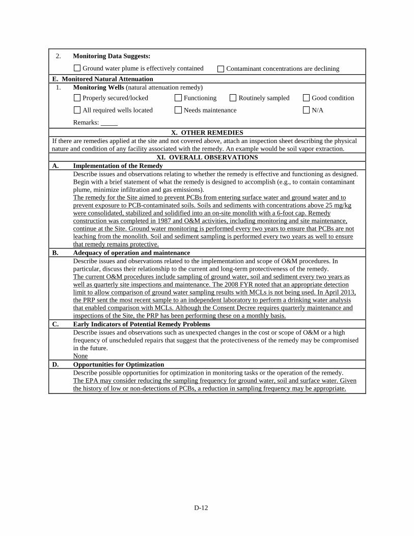
D-12
2. Monitoring Data Suggests:
Ground water plume is effectively contained Contaminant concentrations are declining
E. Monitored Natural Attenuation 1. Monitoring Wells (natural attenuation remedy)
Properly secured/locked Functioning Routinely sampled Good condition
All required wells located Needs maintenance N/A
Remarks:
X. OTHER REMEDIES If there are remedies applied at the site and not covered above, attach an inspection sheet describing the physical nature and condition of any facility associated with the remedy. An example would be soil vapor extraction.
XI. OVERALL OBSERVATIONS A. Implementation of the Remedy
Describe issues and observations relating to whether the remedy is effective and functioning as designed. Begin with a brief statement of what the remedy is designed to accomplish (e.g., to contain contaminant plume, minimize infiltration and gas emissions). The remedy for the Site aimed to prevent PCBs from entering surface water and ground water and to prevent exposure to PCB-contaminated soils. Soils and sediments with concentrations above 25 mg/kg were consolidated, stabilized and solidified into an on-site monolith with a 6-foot cap. Remedy construction was completed in 1987 and O&M activities, including monitoring and site maintenance, continue at the Site. Ground water monitoring is performed every two years to ensure that PCBs are not leaching from the monolith. Soil and sediment sampling is performed every two years as well to ensure that remedy remains protective.
B. Adequacy of operation and maintenance Describe issues and observations related to the implementation and scope of O&M procedures. In particular, discuss their relationship to the current and long-term protectiveness of the remedy. The current O&M procedures include sampling of ground water, soil and sediment every two years as well as quarterly site inspections and maintenance. The 2008 FYR noted that an appropriate detection limit to allow comparison of ground water sampling results with MCLs is not being used. In April 2013, the PRP sent the most recent sample to an independent laboratory to perform a drinking water analysis that enabled comparison with MCLs. Although the Consent Decree requires quarterly maintenance and inspections of the Site, the PRP has been performing these on a monthly basis.
C. Early Indicators of Potential Remedy Problems Describe issues and observations such as unexpected changes in the cost or scope of O&M or a high frequency of unscheduled repairs that suggest that the protectiveness of the remedy may be compromised in the future. None
D. Opportunities for Optimization Describe possible opportunities for optimization in monitoring tasks or the operation of the remedy. The EPA may consider reducing the sampling frequency for ground water, soil and surface water. Given the history of low or non-detections of PCBs, a reduction in sampling frequency may be appropriate.
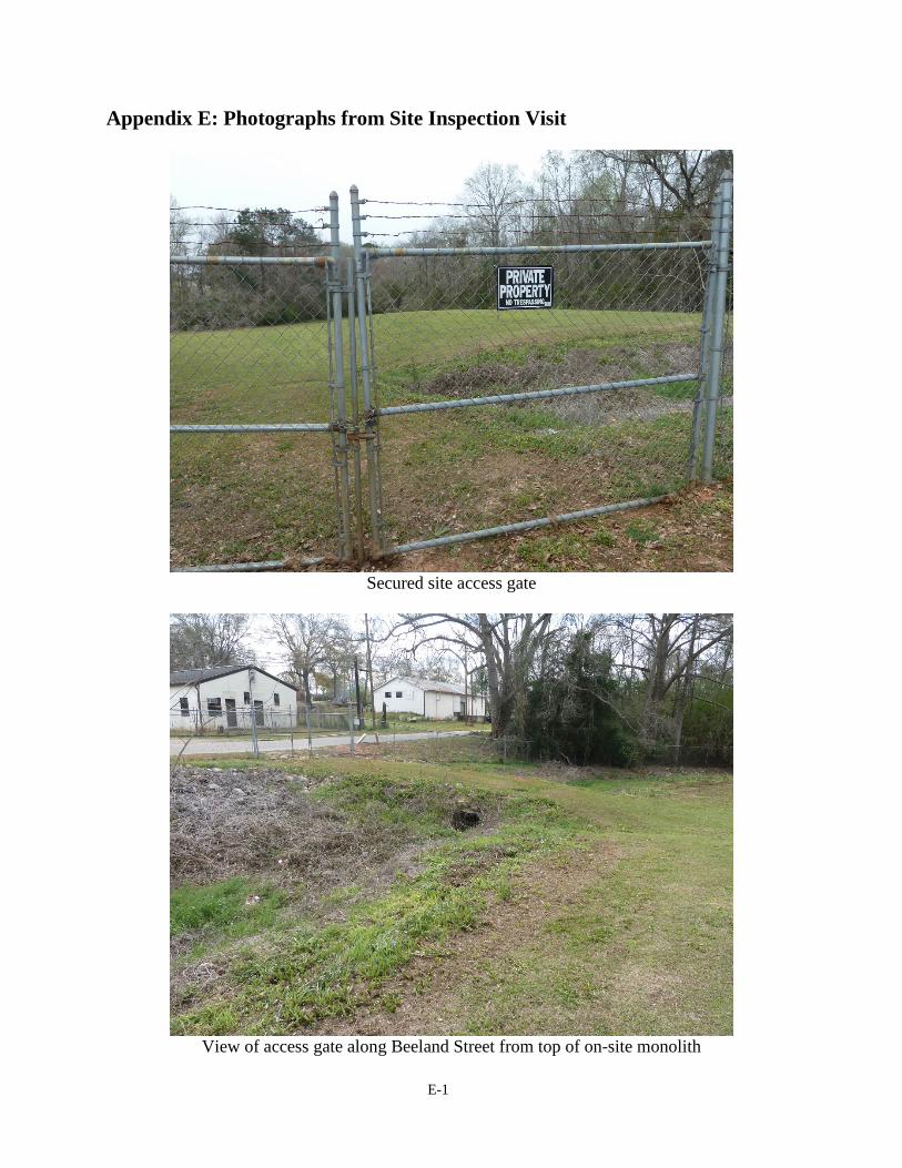
E-1
Appendix E: Photographs from Site Inspection Visit
Secured site access gate
View of access gate along Beeland Street from top of on-site monolith

E-2
View of established vegetative cover looking west along the southern edge of monolith
Dense vegetation along Tanyard Branch prevents site access, although this side of the Site is not
fenced.
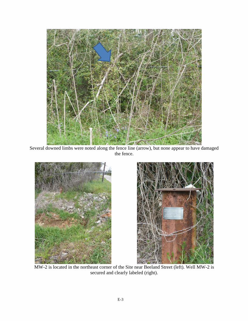
E-3
Several downed limbs were noted along the fence line (arrow), but none appear to have damaged
the fence.
MW-2 is located in the northeast corner of the Site near Beeland Street (left). Well MW-2 is
secured and clearly labeled (right).

E-4
MW-4 is located off site, to the southwest side of Tanyard Branch relative to the Site, along
Cedar/First Street (left). Well MW-4 is secured and clearly labeled (right).