fieldwalking at bulmer, essex, november 2012 carenza lewis and
TRANSCRIPT

1
Fieldwalking at Bulmer, Essex,
November 2012
Carenza Lewis and Catherine Ranson

2

3
Fieldwalking at Bulmer, Essex, November 2012
Carenza Lewis and Catherine Ranson
Access Cambridge Archaeology McDonald Institute for Archaeological Research
University of Cambridge Downing Street
Cambridge CB2 3ER
01223 761518
www.arch.cam.ac.uk/aca

4

5
Contents
1 SUMMARY .................................................................................................................................... 8
2 INTRODUCTION........................................................................................................................... 9
2.1 THE MANAGING A MASTERPIECE PROJECT .............................................................................. 9 2.2 ACCESS CAMBRIDGE ARCHAEOLOGY ...................................................................................... 9
3 AIMS, OBJECTIVES AND DESIRED OUTCOMES .................................................................. 10
3.1 AIMS ................................................................................................................................... 10 3.2 OBJECTIVES ........................................................................................................................ 10 3.3 DESIRED OUTCOMES ............................................................................................................ 10
4 METHODOLOGY........................................................................................................................ 11
4.1 PRE-FIELD-WALKING ............................................................................................................ 11 4.2 FIELD-WALKING METHODS .................................................................................................... 11 ON-SITE ARCHAEOLOGICAL SUPERVISION ........................................................................................... 11 ON-SITE RECORDING ......................................................................................................................... 11 FINDS PROCESSING ........................................................................................................................... 11 FINDS RECORDING AND RETENTION .................................................................................................... 12
Finds appropriate for recording, analysis, reporting, retention and curation .................12
Finds appropriate for disposal after recording and reporting ........................................12
Legal ownership of finds .............................................................................................12
Curation of retained archaeological finds ....................................................................13
5 LOCATION, GEOLOGY AND TOPOGRAPHY ......................................................................... 14
5.1 LOCATION ............................................................................................................................ 14 5.2 GEOLOGY AND TOPOGRAPHY ............................................................................................... 16
6 ARCHAEOLOGICAL AND HISTORICAL BACKGROUND ...................................................... 17
6.1 PREHISTORIC ....................................................................................................................... 17 6.2 ROMAN ................................................................................................................................ 17 6.3 ANGLO SAXON ..................................................................................................................... 17 6.4 MEDIEVAL ............................................................................................................................ 18 6.5 POST MEDIEVAL AND LATER .................................................................................................. 19 6.6 UNDATED ............................................................................................................................ 20
7 RESULTS OF THE FIELDWALKING AT BULMER .................................................................. 21
7.1 PREHISTORIC ....................................................................................................................... 22 7.2 ROMAN ................................................................................................................................ 24 7.3 ANGLO SAXON ..................................................................................................................... 25 7.4 MEDIEVAL ............................................................................................................................ 25 7.5 POST MEDIEVAL .................................................................................................................. 28 7.6 19
TH CENTURY ...................................................................................................................... 29
7.7 UNDATED ............................................................................................................................ 31
8 DISCUSSION .............................................................................................................................. 33
8.1 PREHISTORIC PERIOD ........................................................................................................... 33 8.2 ROMAN PERIOD .................................................................................................................... 33 8.3 ANGLO-SAXON PERIOD ........................................................................................................ 33 8.4 MEDIEVAL PERIOD ................................................................................................................ 34 8.5 POST-MEDIEVAL AND LATER .................................................................................................. 35
9 COMMUNITY ENGAGEMENT ................................................................................................... 36
10 CONCLUSION ....................................................................................................................... 36
11 ACKNOWLEDGMENTS ........................................................................................................ 37
6
12 REFERENCES: ..................................................................................................................... 37
13 APPENDICES ........................................................................................................................ 39
13.1 POTTERY REPORT – PAUL BLINKHORN ................................................................................. 39 13.1.1 Pottery Types ..............................................................................................39
13.1.2 Pottery results .............................................................................................40
13.2 FLINT REPORT – DAVID MCOMISH ........................................................................................ 43 13.3 OTHER FINDS – CATHERINE RANSON .................................................................................... 48
List of Tables
Table 1 – The pottery identified from fieldwalking at Bulmer Table 2 – All the flint and burnt stone from the Bulmer fieldwalking Table 3 – Other finds from the transect -140 Table 4 – Other finds from the transect -120 Table 5 – Other finds from the transect -100 Table 6 – Other finds from the transect -80 Table 7 – Other finds from the transect -60 Table 8 – Other finds from the transect -40 Table 9 – Other finds from the transect -20 Table 10 – Other finds from the transect 0 Table 11 – Other finds from the transect 20 Table 12 – Other finds from the transect 40 Table 13 – Other finds from the transect 60 Table 14 – Other finds from the transect 80 Table 15 – Other finds from the transect 100 Table 16 – Other finds from the transect 120 Table 17 – Other finds from the transect 140 Table 18 – Other finds from the transect 160 Table 19 – Other finds from the transect 180 Table 20 – Other finds from the transect 200 Table 21 – Other finds from the transect 220 Table 22 – Other finds from the transect 240 Table 23 – Other finds from the transect 240 Table 24 – Other finds from the transect 280 Table 25 – Other finds from the transect 300 Table 26 – Other finds from the transect 320 Table 27 – Other finds from the transect 340
List of Figures Figure 1 – Map of England with a close up insert of East Anglia, and the Village of Bulmer highlighted in red Figure 2 – The location of the field walked (in red) in relation to the village of Bulmer and the town of Sudbury to the north-west Figure 3 – The location of the field walked (in red) in relation to Bulmer village Figure 4 – 1870’s Map of the field walked (in red) in relation to Bulmer village Figure 5 – The fieldwalking grid at Goldingham Hall, Bulmer, showing the total extent of the field that were walked Figure 6 – The presence and distribution of struck flint Figure 7 – The presence and distribution of flint tools Figure 8 – The presence and distribution of fire cracked flint Figure 9 – Roman pottery distribution Figure 10 – Late Saxon pottery distribution Figure 11 – High medieval pottery distribution

7
Figure 12 – Late medieval pottery distribution Figure 13 – High medieval pottery and oyster shell distribution Figure 14 – Post medieval pottery distribution Figure 15 – 19
th century pottery distribution
Figure 16 – 19th century pottery and tile distribution
Figure 17 – Tile distribution Figure 18 – Oyster shell distribution Figure 19 – Feedback from volunteers (local residents)
8
1 Summary Over a period of two days in November 2012 a programme of community field-walking was undertaken on a field north and west of Goldingham Hall near Bulmer in Essex. The field-walking was funded by the Heritage Lottery Fund as part of the Managing a Masterpiece programme in the Stour Valley and enabled more than 70 local residents and volunteers living in the surrounding area including schoolchildren attending Bulmer Primary School to take part in the field-walking which was supervised by Access Cambridge Archaeology at the University of Cambridge and directed by Dr Carenza Lewis. With just one field walked, results are difficult to interpret, but they suggest that site was lightly used throughout most of the prehistoric period from the Mesolithic onwards, with a short episode of localised more intensive use in the late Neolithic and early Bronze age. In the Roman period the site may have been in use as arable. Small amounts of pottery hint at some human presence, possibly related to the documented manorial site of Goldingham to the east of the walked area in the high medieval period up to about 1400 AD. Thereafter the site seems to been used as fields, with very little post-medieval or modern material recovered, apart from a spread of roof tile which may have come from Goldingham Hall. The field-walking successfully engaged a large number of volunteers from the local area, including pupils from Bulmer Primary School. Feedback was excellent, with a number who reported favourably on their experience.

9
2 Introduction Two single days of archaeological field-walking were undertaken at Goldingham Hall on the edge of the village of Bulmer, just outside Sudbury in Essex, on the 8th and 9th of November 2012. The field-walking was funded by Managing a Masterpiece in conjunction and directed with Access Cambridge Archaeology (ACA) as a community project. The field-walking was undertaken by 71 local residents and volunteers over the two days, including 30 pupils attending Bulmer Primary School.
2.1 The Managing a Masterpiece Project
Managing a Masterpiece (http://www.managingamasterpiece.org/) is a £1.1 million Landscape Partnership Scheme for the Stour Valley with £910,000 of that awarded by the National Heritage Memorial Fund for 62 projects within three programmes over three years. Delivery of the scheme began on 1 June 2010. The Managing a Masterpiece vision is for a Stour Valley where the landscape is understood cared for and celebrated by communities with the knowledge, skills and opportunities needed to manage and enjoy it. The scheme consists of three programmes, under which there are fifteen projects and around sixty outputs across a range of work including archaeology, access, public training events, outreach projects to traditionally hard to reach groups, school projects, built conservation projects, public survey of heritage features, production of a heritage compendium, use of church towers as interpretation points, website development, provision of a Hopper Bus, new walking and cycling leaflets, new art exhibitions and projects, restoration of a Stour lighter (barge), new hedge and tree planting and management, new displays for museums and practical conservation management. Programme 1, ‘Understanding the Masterpiece’ seeks to increase awareness and understanding of the Stour Valley by residents and those with an interest in its landscape and heritage assets, by learning more about them and how they are managed, and actively working to manage and restore the key features. A component of the Understanding the Masterpiece programme is ‘Project 1f: Stripping Back the Layers’ which comprises archaeological projects carried out by community volunteers trained, supervised and led by professional archaeologists and summarised in a chapter of the Stour Valley Heritage Compendium. The archaeological field-walking on Long Small Bridge Field comprised one of the smaller projects associated with ‘Stripping Back the Layers’.
2.2 Access Cambridge Archaeology
Access Cambridge Archaeology (ACA) (http://www.arch.cam.ac.uk/aca/) is an archaeological outreach organisation based in the McDonald Institute for Archaeological Research in the University of Cambridge which aims to enhance economic, social and personal well-being through active engagement with archaeology. It was set up by Dr Carenza Lewis in 2004 and specialises in providing opportunities for members of the public to take part in purposeful, research-orientated archaeological investigations including excavation. Educational events and courses range in length from a few hours to a week or more, and involve members of the public of all ages.
Thousands of members of the public have taken part in scores of programmes run by ACA, including teenagers involved in Higher Education Field Academy (HEFA) test pit excavation programmes intended since 2005 to build academic skills, confidence and aspirations. More widely, ACA has involved thousands of members of the public of all ages and backgrounds, including those with special needs, in a wide range of archaeological activities including field-walking, excavation, analysis and reporting. These have included
10
projects funded by the Heritage Lottery Fund and events in 2011-12 as part of the Cultural Olympiad for the 2012 London Olympic Games.
3 Aims, objectives and desired outcomes
3.1 Aims
The aims of the field-walking near Goldingham Hall were as follows:
To engage with local communities and ‘hard to reach groups’, widening the participation of people in the heritage of the valley.
To allow local community participants to develop a wide range of practical and analytical archaeological skills.
To increase knowledge and understanding of the historical development of the land now encompassed within Long Small Bridge Field.
To increase understanding of the area to support employment, sustainable tourism and encourage inward investment.
3.2 Objectives
The objectives of the field-walking at near Goldingham Hall were as follows:
To investigate the archaeology near Goldingham Hall through archaeological field-walking.
To provide the opportunity for a minimum of 30 volunteers to learn new practical and analytical archaeological skills.
To provide 60 person-days of hands-on archaeological training and experience.
To support and engage with members of local communities and ‘hard to reach’ groups through involvement with the project.
3.3 Desired outcomes
The desired outcomes of the field-walking near Goldingham Hall were as follows:
A minimum of 30 people with new archaeological skills.
A minimum of 30 people with an enhanced understanding and awareness of the archaeological resource and potential of the landscape around Long Small Bridge Field.
A local population more engaged and informed about the historic landscape near Goldingham Hall.

11
4 Methodology The field-walking was carried out using line-walking with stints at 20m intervals. Field-walkers worked across the field systematically, in order along the base line, starting with 0/0-20, then 20/0-20, 40/0-20 and so on until the next transect was started at 0/20-40.
4.1 Pre-field-walking
Novice volunteers were briefed on the aims and methods of the field-walking and shown examples of material likely to be found, including worked flint, fire-cracked flint and pottery sherds ranging in date from Neolithic to 19th century.
Field-walkers were instructed to pick up all items thought to be human artefacts, of any date and material.
A SSW-NNE orientated base line was set up along the edge of the field nearest Goldingham Hall.
This base line transect was marked every 20m with canes.
Stints were also marked in 20m intervals heading north from the base line transect.
Canes at every 100m mark were highlighted with red and white bunting to aid in locating the correct stints to be walked.
4.2 Field-walking methods
The volunteers were divided into groups of 1-2 people allowing those who wished to work together to do so. Most walkers worked singly or in pairs
Each 20m stint was walked for 15 minutes with an area of c. 1m either side of the line scanned visually achieving a 10% coverage of the walked area.
Finds were collected by field-walkers and checked in with the site supervisor after each stint was completed.
On-site archaeological supervision
Four archaeologists from ACA were on hand for the duration of the field-walking, with one supervisor specifically assigned to directing the volunteers from a central base as well as recording which stints have been walked. Volunteers assisted with marking out stints for walkers to follow. A pottery specialist was on site to spot date ceramic finds.
On-site recording
A scale plan map of the field and grid was drawn at 1:1000 with the transects and stints marked when completed to avoid repetition.
Finds bags were labelled prior to being supplied to volunteers with transect and stint numbers, for example: 0/0-10, with also the site code (which includes the settlement name code and year of the activity).
The site code for the field-walking in Bulmer was BUL/12.
Finds processing
All collected finds were retained for initial identification and processing.
Non-metallic inorganic finds and bone (unless in very poor condition) were washed, thoroughly dried and bagged separately for each spit walked. This was done during post-excavation when also the animal bone, pottery, burnt clay, flint and burnt stone are bagged separately, ready to be given to specialists.
12
Finds recording and retention
Few excavations or field-walking surveys retain all the finds that are made if they are deemed to be of little or no research value. Surface collection during field-walking may produce significant quantities of modern material, not all of which will have research value.
Finds appropriate for recording, analysis, reporting, retention and curation
All pottery
All faunal remains, worked and burnt stone
Any other finds pre-dating 1800 have been retained.
All finds pre-dating 1900 have been retained
Finds appropriate for disposal after recording and reporting
The following finds which are not considered to warrant any further analysis were sorted, counted, weighed, photographed and then discarded: Slate, coal, plastic, Perspex, modern glass, modern metal objects (including nails), concrete, modern mortar, modern fabric, shoes and other modern items (including batteries and shotgun cartridges), naturally occurring animal shells, unworked flint and other unworked stone (including fossils).
C20th window and vessel glass was sorted, counted, weighed and then discarded.
Modern tile (floor, roof and wall) was discarded after counting and weighing, with a sample of each type of pre-modern tile retained with the remainder discarded after counting and weighing. Any decorated examples were retained unless recovered in very large quantities in which case representative samples were retained with the remainder discarded after counting, weighing and photographing.
Brick was sorted, counted, weighed and then discarded. One sample of any examples of CBM that appeared to be pre-modern was retained
Most metal finds of modern date were discarded. Metal finds of likely pre-modern date were retained if considered useful for future study. Modern nails were discarded but handmade nails were retained.
Legal ownership of finds
Ownership of objects rests in the first instance with the landowner, except where other law overrides this (e.g. Treasure Act 1996, 2006, Burials Act 1857).
Owners of private unscheduled land where field-walking is undertaken who enquire about the final destination of finds from their property will be informed that ACA prefers to retain these in the short term for analysis and ideally also in the longer term in order that the excavation archives will be as complete as possible.
NB: Most land-owners are not concerned about retaining ownership of the finds and are happy to donate them to ACA.
Any requests by owners for the final return of finds to them will be agreed. Finds will be returned after recording, analysis and reporting is complete, accompanied by a letter inviting them to treat the finds with care, retain them in association with identifying documentation and to consider donating them to ACA/University of Cambridge Museum of Archaeology and Anthropology should they ever change their minds about wishing to have possession of them.
If the landowners are unwilling, for whatever reason, to donate any or all of the finds from the excavation on their land to ACA, the requested finds are returned to them after recording and analysis is completed, safely packaged and conserved (if required), accompanied by a letter explaining how they should be cared for and asking for them to be returned to the University of Cambridge if for any reason the

13
owners no longer wish to retain them, and that if they are moved from the address to which they were returned the ACA should be informed. The location of such finds will be stated in the site archive.
Curation of retained archaeological finds
All finds which are not discarded or returned to owners are retained and stored in conditions where they will not deteriorate. Most finds are stored in cool dry condition in sealed plastic finds bags, with small pierced holes to ventilate them. Pottery, bone and flint have been bagged separately from other finds.
Finds which are more fragile, including ancient glass or metal objects, are stored in small boxes protected by padding and if necessary, acid free paper. Metal objects are curated with silica gel packets if necessary to prevent deterioration.
All finds bags/boxes from the field-walking days have been bagged/boxed together. All bags and boxes used for storage are clearly marked in permanent marker with the site code and the transect and stint walked
14
5 Location, geology and topography
5.1 Location
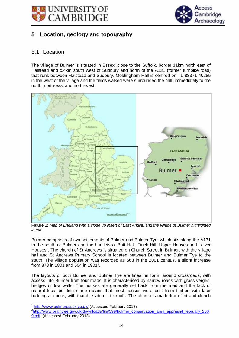
The village of Bulmer is situated in Essex, close to the Suffolk, border 11km north east of Halstead and c.4km south west of Sudbury and north of the A131 (former turnpike road) that runs between Halstead and Sudbury. Goldingham Hall is centred on TL 83371 40285 in the west of the village and the fields walked were surrounded the hall, immediately to the north, north-east and north-west.
Figure 1: Map of England with a close up insert of East Anglia, and the village of Bulmer highlighted in red Bulmer comprises of two settlements of Bulmer and Bulmer Tye, which sits along the A131 to the south of Bulmer and the hamlets of Batt Hall, Finch Hill, Upper Houses and Lower Houses1. The church of St Andrews is situated on Church Street in Bulmer, with the village hall and St Andrews Primary School is located between Bulmer and Bulmer Tye to the south. The village population was recorded as 568 in the 2001 census, a slight increase from 378 in 1801 and 504 in 19012. The layouts of both Bulmer and Bulmer Tye are linear in form, around crossroads, with access into Bulmer from four roads. It is characterised by narrow roads with grass verges, hedges or low walls. The houses are generally set back from the road and the lack of natural local building stone means that most houses were built from timber, with later buildings in brick, with thatch, slate or tile roofs. The church is made from flint and clunch
1 http://www.bulmeressex.co.uk/ (Accessed February 2013)
2http://www.braintree.gov.uk/downloads/file/399/bulmer_conservation_area_appraisal_february_200
9.pdf (Accessed February 2013)

15
and was the only building of this construction until the 18th century when flint was used again as a building material, although mainly on local cottages3.
Figure 2: The location of the field walked (in red) in relation to the village of Bulmer and the town of Sudbury to the north-west
Figure 3: The location of the field walked (in red) in relation to Bulmer village
3 Ibid
16
5.2 Geology and Topography
Essex is a coastal county in East Anglia, bounded by Suffolk to the north, the North Sea to the east, London to the south, Hertfordshire to the west and Cambridgeshire to the north-west. The village sits away from the River Stour valley that dominates the north Essex and south Suffolk landscape, in what has been classified as ‘Wickham Farmland Plateau’. This is characterised as a landscape which is surrounded by the tributaries of the River Stour, the Belchamp Brook runs to the north of Bulmer and has large arable fields on the flat tops of hills with smaller fields for pasture, marshes and woodland in the valleys. Hedgerows and ditches define the fields and small linear settlements are common along the roads, but mainly in the valleys. Wide views are evident across the landscape.4 The higher ground is situated to the south of the parish, particularly around Bulmer Tye, which sits at between 80 and 85m OD. Bulmer sits in a slightly lower position with the church at 70m OD and Goldingham Hall is lower in the valley at 50m OD. The field that was walked is on ground which is on level ground at c. 47m OD near the hall but sloping down to the north and west to the Belchamp Brook to just below c. 35m OD in its north-western corner. The underlying geology consists of consists of Thames Group London clay5 and superficial layers of both Essex chalk till and glacial sand and gravel closer to the river valleys6.
4 http://www.brentwood.gov.uk/pdf/pdf_1178.pdf (Accessed February 2013)
5 http://www.geo-east.org.uk/geology.htm (Accessed February 2013)
6http://www.braintree.gov.uk/downloads/file/399/bulmer_conservation_area_appraisal_february_200
9.pdf (Accessed February 2013)

17
6 Archaeological and Historical Background The site of the field-walking at Goldingham Hall was built near the original medieval manorial site, known locally as Goggum, which was actually sited further north between the current hall and the pond but was destroyed by a fire in the early to mid-19th century (Slaughter 1979). The building presently named Goldingham Hall was built after 1836 of white Suffolk brick with a slated roof. The manor of Goldingham Hall at the time of the Domesday survey belonged to Robert Malet, and before the Conquest by a free man called Godwin who had 10 head of cattle, two horses, 50 sheep and 40 goats and was worth 60 shillings. At the time of the Domesday survey it was recorded as having two ploughs, six villans, two slaves and five bordars with 16 acres of meadow, 12 head of cattle, one horse, 260 sheep, 65 pigs and five hives of bees, valued at a considerable sum of £6 (Williams and Martin 2003). Soon after the Domesday survey the manor was granted to Sir Hugh de Goldyngham, whose family held the land for the next 500 years (Slaughter 1979).
6.1 Prehistoric
There is limited evidence for prehistoric activity in Bulmer, but it seems likely that the area was inhabited given the large amount of prehistoric activity identified along the Stour Valley; that would have also continued along the Belchamp valley. A Neolithic flint arrowhead has been identified from a field in the parish (Cooper 2011)7 and a probable burnt mound was identified in the floor of the Belchamp valley (SMR 47916), thought to date to the Bronze Age and extended under the peat, although its full extent is unknown. The whole deposit was also set in a rich charcoal matrix and a large cattle leg bone was the only find also recovered, thought to be from an auroch. From the hill to the north of Hole Farm in the far west of the parish and close to the site of the Bulmer Brickworks, has yielded fragments of Bronze Age urn during ploughing with later Roman and Anglo-Saxon sherds (Blake 1959).
6.2 Roman
There is some evidence and finds for Romano-British activity in Bulmer, with fragments of Roman brick that had been used in the construction of the church (SMR 8518) and a few sherds of Roman pottery that were also uncovered after deep ploughing on a hill to the north of Hole Farm in the west of the parish. These were found with sherds of both Bronze Age and Anglo Saxon pottery and may be associated with the well-known villa site at Hill Farm. This villa is actually just over the parish border into Gestingthorpe (SMR 13859). A number of masonry buildings have been identified there, including the villa, with associated pits, gullies, ditches, hearths and burnt areas as well as 12 circular huts (two of which have been excavated). It is possible that there was further Roman settlement in the area as it is thought that a Roman road passes through the parish to cross the River Stour, where it is fordable to link Chelmsford and Long Melford (Burnett 2010).
6.3 Anglo Saxon
It has been suggested that the area around the church was the location for the lost Saxon manor Thundersley or ‘Thunors Hill’, given its prominent hill top position, and named after Thor, the god of thunder, war and farming. The name was also given to the half hundred in
7 http://www.braintree.gov.uk/downloads/file/1343/bulmer_village_design_statement (Accessed
February 2013)

18
the Domesday Book, which comprised the manors of Ballingdon, Belchamp Walter and Binesley in Bulmer (Slaughter 1979). The name of Bulmer is also thought to have Saxon origins, and was recorded in the Domesday Book as Bulenemera meaning ‘Bull’s Pond’ and suggests that there may have been a settlement here in the later Saxon period at least, in association with the four manors that were recorded in the Domesday Book (Cooper 2011)8 (see section 7.4). A 6th or 7th century small settlement site was thought to have been sited on a hill overlooking Hole Farm in the west of the parish, which was identified after deep ploughing in the 1950’s. The flint and stone deposits identified were thought to be evidence of huts, although no features were actually recorded. The activity here may have been an extension from the Hill Farm villa site where a number of huts have been identified and could be Roman or Saxon in date (Blake 1959).
6.4 Medieval
The four medieval manors that were recorded in the Domesday Book were at Goldingham Hall to the west of the village, Smeetham Hall (also moated) to the north (SMR 8508), Binsley (now thought to be the area around Kitchen Farm) to the east (SMR 8537) and an un-named manor that was probably at Butlers Hall to the south-west of the village. This manor is the record for Bulmer is the Domesday Book, which was recorded as having one plough, woodland for five pigs, two acres of meadow and it was worth 22s 2d (Williams and Martin 2003). A separate entry for Goldingham also exists in the Domesday Book as the land of Robert Malet, previously held by a free man known as Godwine. There was then three ploughs, now two, six villains and five bordars. There were six slaves, now two, with sixteen acres of meadow. To the manor also belonged four sokemen with 17 acres and one acre of meadow. There were then 10 head of cattle, two horses, 50 sheep and 40 goats. There are now 12 head of cattle, one horse, 260 sheep, 65 pigs and five hives of bees. It was then worth 60s and now worth £6 (Ibid). It is probable that the layout of the village, over the crossroads, was established during the medieval period, although there is no evidence for this early settlement surviving to this day.9 St Andrews Church (SMR 28491) is situated on the high ground in the south of the village and is likely originally 12th century in date, as its earliest reference is from 1178 during a dispute over tithes with neighbouring parish of Brundon (Cooper 2011)10. The chancel was rebuilt in the early 14th century with the north vestry and the north aisle and the west tower was built in the early 15th century. The north vestry was subsequently pulled down in the 18th century and the church was only restored during the 19th century. The south porch is modern11. The settlement around Bulmer Tye (Tye meaning ‘green’ or ‘common’) also began to prosper during the medieval period, as the main road between Sudbury and London ran through the middle of the green, which was particularly evident after with the construction of Ballingdon Bridge over the River Stour at the start of the 13th century (Gill 2007). The earliest documentary evidence of it is from 1310 (Slaughter 1979). The settlement grew and expanded from being on this maid road trade route, and there was a sense of wealth created by agriculture, particularly given the new farms that were built in Bulmer Tye, as well as the improvements to the church in later centuries.
8http://www.braintree.gov.uk/downloads/file/1343/bulmer_village_design_statement (Accessed
February 2013) 9http://www.braintree.gov.uk/downloads/file/399/bulmer_conservation_area_appraisal_february_200
9.pdf (Accessed February 2013) 10
http://www.braintree.gov.uk/downloads/file/1343/bulmer_village_design_statement (Accessed February 2013) 11
http://www.british-history.ac.uk/report.aspx?compid=122423 (Accessed February 2013)
19
The Auberies estate is situated to the south-east of Bulmer, on which a mound has been recorded on the edge of the estate and close to the main road. It is known locally as Peppermint or Peppermint Hill and measures 30m in diameter and 3.2m high and has a rectangular dry pond on its eastern side with a 1m deep ditch around its northern side (SMR 9388). Its exact use and date are unknown, but it has been suggested that it was a small motte and bailey or a medieval mill mound. It may also have been a prehistoric burial mound, but further investigations would be needed to confirm this.
6.5 Post medieval and later
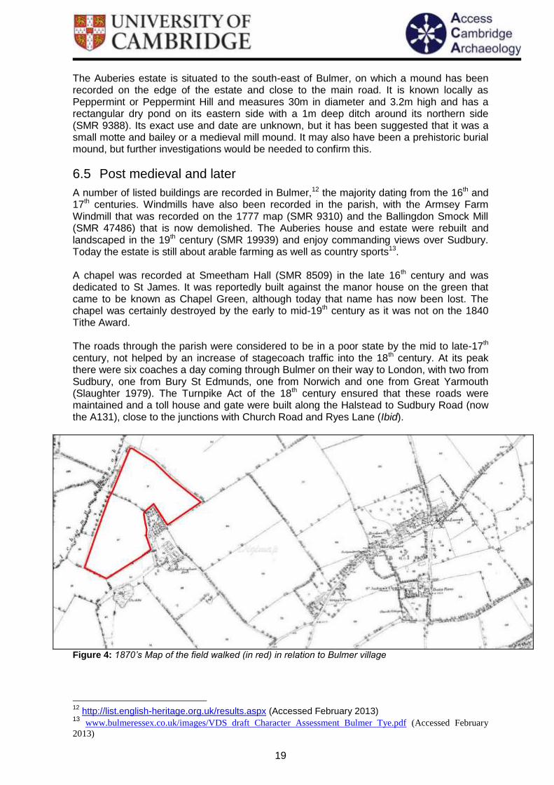
A number of listed buildings are recorded in Bulmer,12 the majority dating from the 16th and 17th centuries. Windmills have also been recorded in the parish, with the Armsey Farm Windmill that was recorded on the 1777 map (SMR 9310) and the Ballingdon Smock Mill (SMR 47486) that is now demolished. The Auberies house and estate were rebuilt and landscaped in the 19th century (SMR 19939) and enjoy commanding views over Sudbury. Today the estate is still about arable farming as well as country sports13. A chapel was recorded at Smeetham Hall (SMR 8509) in the late 16th century and was dedicated to St James. It was reportedly built against the manor house on the green that came to be known as Chapel Green, although today that name has now been lost. The chapel was certainly destroyed by the early to mid-19th century as it was not on the 1840 Tithe Award. The roads through the parish were considered to be in a poor state by the mid to late-17th century, not helped by an increase of stagecoach traffic into the 18th century. At its peak there were six coaches a day coming through Bulmer on their way to London, with two from Sudbury, one from Bury St Edmunds, one from Norwich and one from Great Yarmouth (Slaughter 1979). The Turnpike Act of the 18th century ensured that these roads were maintained and a toll house and gate were built along the Halstead to Sudbury Road (now the A131), close to the junctions with Church Road and Ryes Lane (Ibid).
Figure 4: 1870’s Map of the field walked (in red) in relation to Bulmer village
12
http://list.english-heritage.org.uk/results.aspx (Accessed February 2013) 13 www.bulmeressex.co.uk/images/VDS draft Character Assessment Bulmer Tye.pdf (Accessed February
2013)
20
The 1808 maps shows the presence of lime kilns in kiln field (SMR 16887), which today is also the site of the Bulmer Brick and Tile Company, located to the west of Bulmer Tye at Hole Farm, and on the B1058 Hedingham Road. A medieval or Tudor kiln has also been identified at the same site, suggesting that there have been brickworks on the site for many hundreds of years utilising the local London Clays (Benfield 2011) and lime kilns are also know from Goldingham Hall itself.
6.6 Undated
A number of undated features have been recorded on the HER, mainly in the form of cropmarks, including a double ditched trackway in the east of the parish (SMR 8539) that has also been cut by a residential development. Cropmarks of another trackway and possible rectilinear enclosure have also been recorded (SMR 17075) at Bardfield Bridge. A rectangular cropmark feature has also been identified (SMR 8532) as well as a rectangular enclosure and field boundaries at Church Cottage (SMR 17073), linear features and field boundaries at Blackhouse Farm (SMR 17074) and to the north of Round Wood in the form of linear cropmarks as seen in an aerial photograph that may be of a trackway (SMR 17817). The OS Record has also recorded cropmarks to the north-west of the Gestingthorpe villa complex, with one ditch running east away from the villa (SMR 9299). Further cropmarks of former field boundaries have also been noted (SMR 17920). Previous archaeological work in Bulmer is limited. An archaeological evaluation was undertaken at Bulmer Brick Works prior to an extension to the quarry pit, where two evaluation trenches were opened. A ditch was excavated in trench one which contained post medieval and modern finds and a single later prehistoric flint flake was recovered from the spoil heap of trench two (Benfield 2011). Unofficial small excavations have also been undertaken by the current landowner, in which a number of sherds of medieval pottery, slag, oyster shell and animal bone have all been recorded.

21
7 Results of the fieldwalking at Bulmer The field-walking at Bulmer was undertaken on land at Goldingham Hall, the field wrapped around three sides of a complex now including a range of converted farm buildings, a pond and small stands of trees immediately north of the hall. The total extent of the grid walked over the two days of the 8th and 9th of November 2012 can be seen in figure 5 below. A total of 170 20m stints were walked over the two days, covering a distance of 3.4km. The total area walked was approximately 7ha with coverage of c. 10%. The field surface was well-weathered when walked and had been sown with wheat which was at a very early stage of growth and did not obscure any of the field surface, hence ground surface visibility was 100%. Weather conditions on 8th were sunny and dry. Weather conditions on the 9th November were overcast and dry all day. The western part of the field was not available for field-walking at the request of the landowner due to recent crop-spraying. The field slopes down gently down to the south-west as it approaches the bottom of the valley of the Belchamp Brook, with the north-eastern limit of the walked area lying at just over 45m OD, approximately 20m higher than the lowest part of the field,. There is thus some scope for solifluxion or hill wash on the western part of the walked area to have carried material down towards or beyond the southern limits of the walked area, or for surface finds to have been obscured by a build-up of soil, although given the relatively slight gradient this is considered unlikely to have caused significant relocation.
Figure 5: The field-walking grid at Goldingham Hall, Bulmer, showing the total extent of the field that was walked (Map courtesy of Edina Digimap)
0,0
360,0
0,160
300,-180

22
The pottery and flint distribution maps for the field-walking can be seen in the following sections, in chronological order. The circles used to represent the distribution of finds are shown within the grid squares immediately east of each stint walked.
7.1 Prehistoric
Figure 6: The presence and distribution of struck flint (Map courtesy of Edina Digimap)
23
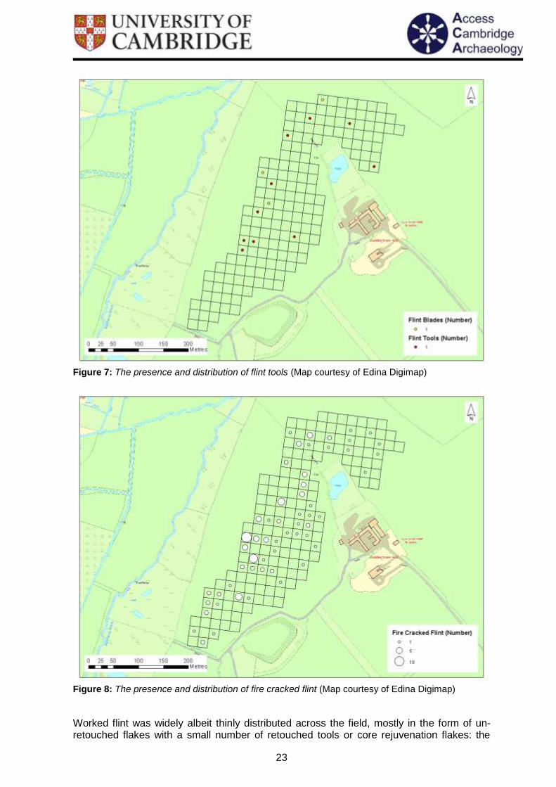
Figure 7: The presence and distribution of flint tools (Map courtesy of Edina Digimap)
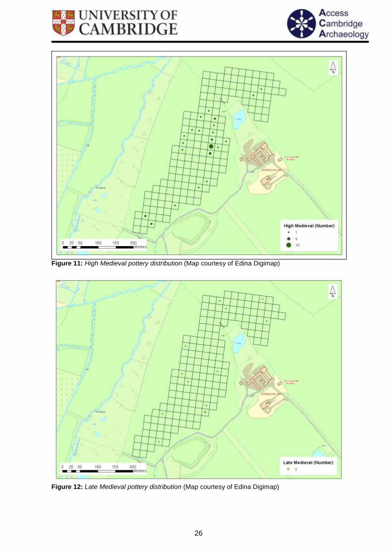
Figure 8: The presence and distribution of fire cracked flint (Map courtesy of Edina Digimap)
Worked flint was widely albeit thinly distributed across the field, mostly in the form of un-retouched flakes with a small number of retouched tools or core rejuvenation flakes: the

24
latter can be more confidently identified as of prehistoric date, while simple flakes may alternatively be of later origin relating to medieval or later building construction involving flint-faced walls.
7.2 Roman
Figure 9: Roman pottery distribution (Map courtesy of Edina Digimap)
Only seven sherds of Roman pottery were identified through the field-walking and all but one of these were found along a small plateau of land that extends around the hall, before dropping away to the west towards the brook.

25
7.3 Anglo Saxon
Figure 10: Late Saxon pottery distribution (Map courtesy of Edina Digimap)
A single sherd of Late Saxon Thetford Ware was recorded from a flat area of land close to the western extent of the current hall
7.4 Medieval
26
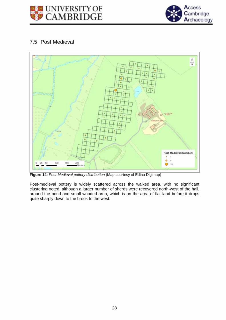
Figure 11: High Medieval pottery distribution (Map courtesy of Edina Digimap)
Figure 12: Late Medieval pottery distribution (Map courtesy of Edina Digimap)

27
Pottery of high medieval date was recovered in small amounts but in a distribution that included a notable concentration close to the western side of the current hall, although the remainder of the pottery of this date and also later medieval pottery are otherwise well-distributed across the field with no sign of any significant clustering. There is a notable correlation between the area with the greatest volume of high medieval pottery and that with the most oyster shell, which also appears in a cluster immediately west of the hall.
Figure 13: High Medieval pottery and oyster shell distribution (Map courtesy of Edina Digimap)
28
7.5 Post Medieval
Figure 14: Post Medieval pottery distribution (Map courtesy of Edina Digimap)
Post-medieval pottery is widely scattered across the walked area, with no significant clustering noted, although a larger number of sherds were recovered north-west of the hall, around the pond and small wooded area, which is on the area of flat land before it drops quite sharply down to the brook to the west.
29
7.6 19th century
Figure 15: 19
th century pottery distribution (Map courtesy of Edina Digimap)

30
Figure 16: 19
th century pottery and tile distribution (Map courtesy of Edina Digimap)
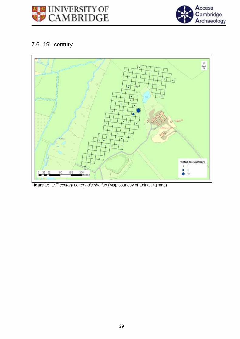
The field-walking results show that there is a small concentration of Victorian pottery from the edge of the field immediately north-west of the hall. Otherwise 19th century pottery is scattered widely but thinly across the walked area.

31
7.7 Undated
Figure 17: Tile distribution (Map courtesy of Edina Digimap)
A large amount of tile was particularly noted around the southern edge of the field as well as clusters from around the north of the pond. Very little tile was recorded from the south western corner of the field.

32
Figure 18: Oyster shell distribution (Map courtesy of Edina Digimap)
There is a definite large cluster of oyster shell to the west of the hall, although there are also a few fragments identified to the north of the pond as well as in the south western corner of the field. The full list of all the finds that were picked up during the field-walking, along with the numbers of tile for each stint, can be seen in appendix 13.3.

33
8 Discussion The results of the field-walking in 2012 around Goldingham Hall, Bulmer, carried out over c. 7ha at 10% coverage in optimum (100%) visibility by novice field-walkers, are discussed below in chronological order by historic period. Interpreting data from field-walking is never straightforward, but attempting this for a single field is particularly problematic as there is no scope for local comparisons to be made. If we accept that ‘With the single exception of 'manuring scatter' all field-walking finds ultimately derive from significant archaeological contexts’ (Foard 1978, 363), then we could simply note the locations of finds, and their different dates and leave it at that. However, more meaningful patterns revealing variations in land use can become evident when densities of finds can be compared across a larger area such as a parish or more (e.g. Lobb and Rose 1996; Rogerson et al 1997; Davison 1990, Parry 2006; Gerrard and Aston 2007). This allows areas of more and less intensive use to be distinguished, enabling patterns of settlement, agriculture, industry, ritual and other land use to be reconstructed (with varying degrees of confidence). But in the case of Goldingham, we have no neighbouring field-walking data to compare the 2012 data against. Nonetheless, some potentially interesting observations can be made of the 2012 data.
8.1 Prehistoric period
Worked flint was recovered widely across the site, and where it could be dated ranged in from the Mesolithic to the Bronze Age. Slight overall concentrations of worked flint (fig 6) were apparent in two areas: firstly in the north-west corner of the walked area (immediately north of the present pond), and secondly along the west side of the walked area on the crest of the valley approximately due west of the modern building of Goldingham Hall. Although the latter concentration was not particularly marked overall, it is notable that this area produced most of the worked flint tools recovered (fig 8) and most of the fire-cracked flint (fig 9). It thus seems likely that the worked flint along the west side of the walked area does represent prehistoric activity, while it should be borne in mind that the north-west cluster may be partly due to medieval or later construction, possibly combined with prehistoric flint.
8.2 Roman period
The distribution of Roman pottery from the walked area (fig 9) is very thin with no sign of clustering. There is nothing to suggest any more intensive use than arable involving manuring of this area at this time. The known Roman villa site in Gestingthorpe is situated just over 1km to the south-west of Goldingham Hall, at Hill Farm, so it is highly likely that the land here was utilised as part of its farmland. The presence of Roman building material that has also been identified in the church further suggests that there was likely scattered Roman settlements in the area, particularly given the proximity of the site to the route of the probable Roman road, which extended from Chelmsford to Long Melford.
8.3 Anglo-Saxon period
Just a single sherd of Anglo-Saxon pottery, of late (9th – 11th century) date, was recovered from the field-walking at Goldingham (fig 10). Although manuring remains uncommon at this date and pottery, while used in greater quantities than in the 5th – 8th centuries, still

34
tends be recovered in smaller quantities than is the case for later periods, any material might be of interest, but the recovery of just a single sherd can perhaps be used to infer little more than that the site was probably not heavily wooded in the later Anglo-Saxon period, and possibly in use as arable. A much larger quantity of pottery would normally be expected were a settlement of this date to have been close by (cf Rogerson et al 1997, figs 45 & 46). One of the four manors that were recorded in the Domesday Book is thought to have been at Goldingham Hall, so it is possible that the site was also occupied during the 10th or 11th century as well. The location the original manor is unknown but given the lack of pottery from the field-walking, it seems likely that if present in this area, it was located under the present building complex. This does place it close to the area from which the single sherd of late Anglo-Saxon pottery was recovered.
8.4 Medieval period
A relatively small amount of medieval pottery was recovered during the field-walking (fig 11), with just 35 sherds of high medieval date (c. 1100-1400 AD) totalling 265g in weight and only 9 sherds of late medieval date (c. 1400-1550 AD), totalling 105g in weight. Most of the sherds were utilitarian grey wares, with just two sherds of higher quality Hedingham ware recovered. The cluster of high medieval pottery on the edge of the plateau of high ground and to the west of the current hall suggests the presence of medieval occupation and could be the location of the medieval manor at Goldingham Hall. The similar distribution of the oyster shell to the high medieval pottery also suggests that these are likely mostly medieval in date, either caught locally or bought in from afar via trade on the River Stour. Into the later medieval and potentially after the Black Death, there seems to be a decline in the pottery, possibly suggesting a shift in settlement focus. At this stage it is unsure if the manor was abandoned completely; the widespread distribution of the later medieval pottery however, suggests that there was still activity on site, although further investigation would be needed to determine its extent. 35 sherds of pottery of high medieval date recovered from a 10% coverage of 7ha clearly indicate some sort of human use of the area at this time, although this is not necessarily indicative of settlement on this site. While there is no agreed limit for the density of sherds which should be taken to indicate the likely presence of a settlement site, it is recognised that ‘Roman, Medieval, and Iron Age sites produce hundreds of sherds when intensively walked.’ (Foard 1987, 363). At Burghfield in the Lower Kennett Valley the recovery of 62 sherds from one hectare was considered likely to represent the site of a building (Lobb and Rose 1996, 64-5), while the 6.5ha walked area of the deserted medieval settlement at Caldectote (Norfolk) produced hundreds of medieval sherds. Overall, the medieval pottery from Goldingham therefore seems likely to derive from manuring of arable rather than settlement. However, there is a marked concentration evident immediately west of the present site of Goldingham Hall, and it is reasonable to suggest that this is likely to indicate more intensive medieval use of this part of the field-walked area: ‘twenty-to-thirty thirteenth/fourteenth century pieces derived from the surface of a large field indicates no more than manuring distribution; if 25 of those sherds came from a small area, say 100 square metres in one corner of that field, then it might be considered a small site’ (Davison 1990, 12). It seems likely that the field-walking data is indicating some degree of settlement of high medieval date immediately west of the present Goldingham Hall building complex, perhaps relating to a manorial site, or to a small village or hamlet. This is given some support by the tendency of oyster shell also to concentrate in this same area (fig 13), suggesting that the latter may be related to medieval settlement, as

35
it does not cluster in the same area as Roman or Victorian pottery. The significant reduction in number of sherds of late medieval date recovered suggest that although the land was probably still farmed, manuring was considerably reduced and the putative nearby settlement may have contracted from the 14th or 15th century.
8.5 Post-medieval and later
56 sherds weighing 541g in total of post-medieval pottery (c. 1550-1800 AD) were recovered from Goldingham. These were widespread across the field with no significant concentrations, and are most likely to relate to manuring spread by subsequent ploughing. The vast majority of the post-medieval pottery (79%) was glazed red earthenware, with the rest dominated by German stoneware and a few sherds of Staffordshire wares. Pottery of 19th century and later date was recovered in similar numbers, with only one evident cluster on the edge of the field, immediately west of the hall evidently relating to the occupation of the present hall after it was built in the 19th century.
36
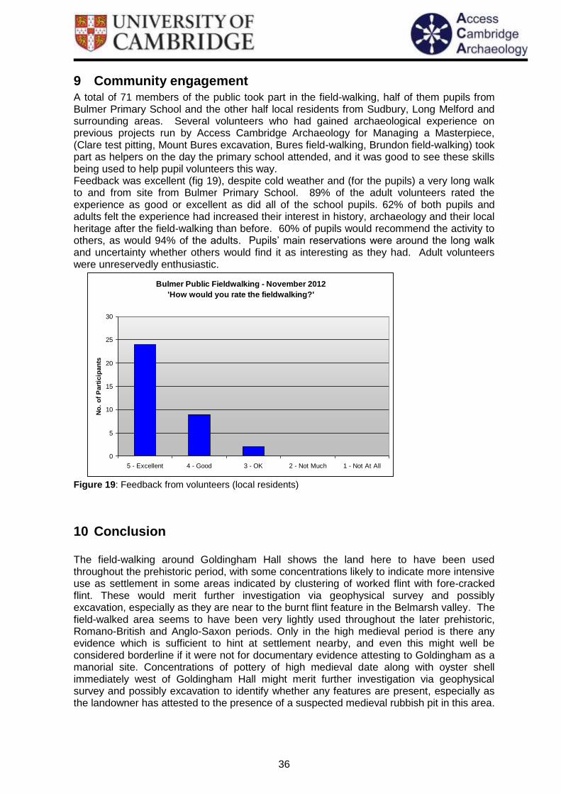
9 Community engagement A total of 71 members of the public took part in the field-walking, half of them pupils from Bulmer Primary School and the other half local residents from Sudbury, Long Melford and surrounding areas. Several volunteers who had gained archaeological experience on previous projects run by Access Cambridge Archaeology for Managing a Masterpiece, (Clare test pitting, Mount Bures excavation, Bures field-walking, Brundon field-walking) took part as helpers on the day the primary school attended, and it was good to see these skills being used to help pupil volunteers this way. Feedback was excellent (fig 19), despite cold weather and (for the pupils) a very long walk to and from site from Bulmer Primary School. 89% of the adult volunteers rated the experience as good or excellent as did all of the school pupils. 62% of both pupils and adults felt the experience had increased their interest in history, archaeology and their local heritage after the field-walking than before. 60% of pupils would recommend the activity to others, as would 94% of the adults. Pupils’ main reservations were around the long walk and uncertainty whether others would find it as interesting as they had. Adult volunteers were unreservedly enthusiastic.
Bulmer Public Fieldwalking - November 2012
'How would you rate the fieldwalking?'
0
5
10
15
20
25
30
5 - Excellent 4 - Good 3 - OK 2 - Not Much 1 - Not At All
No
. o
f P
art
icip
an
ts
Figure 19: Feedback from volunteers (local residents)
10 Conclusion The field-walking around Goldingham Hall shows the land here to have been used throughout the prehistoric period, with some concentrations likely to indicate more intensive use as settlement in some areas indicated by clustering of worked flint with fore-cracked flint. These would merit further investigation via geophysical survey and possibly excavation, especially as they are near to the burnt flint feature in the Belmarsh valley. The field-walked area seems to have been very lightly used throughout the later prehistoric, Romano-British and Anglo-Saxon periods. Only in the high medieval period is there any evidence which is sufficient to hint at settlement nearby, and even this might well be considered borderline if it were not for documentary evidence attesting to Goldingham as a manorial site. Concentrations of pottery of high medieval date along with oyster shell immediately west of Goldingham Hall might merit further investigation via geophysical survey and possibly excavation to identify whether any features are present, especially as the landowner has attested to the presence of a suspected medieval rubbish pit in this area.

37
11 Acknowledgments The 2012 field-walking at Goldingham Hall, Bulmer was funded as part of ‘Managing a Masterpiece’ by the Heritage Lottery Fund their support is gratefully acknowledged. The Field-walking was directed by Dr Carenza Lewis and supervised by Catherine Ranson, with help from Clemency Cooper. Maps were generated by Clemency Cooper with help from David Redhouse. Thanks are due to Chris Burton and Dan King for their support on site during the field-walking. Finally, thanks are due to all the 74 volunteers who took part in the field-walking and worked so assiduously to recover new evidence for the past, and especially to landowner Ashley Cooper who provided access to the land and buildings to use as a base, enthusiastic support for the field-walking, and generously provide much-appreciated refreshments
12 References: Aston, M.A. and Gerrard, C. 1999 ‘Unique, traditional and charming: the Shapwick Project, Somerset’ The Antiquaries Journal, 79, 1-58 Benfield, S 2011 An Archaeological Evaluation at Bulmer Brick Works, Bulmer, Essex. Colchester Archaeological Trust Report 619 Beresford, M.W. 1957 The Lost Villages of England. London Beresford, M.W. and Hurst, J.G. 1971 Deserted Medieval Villages. London Blake, B 1959 An Anglo-Saxon site at Hole Farm, Bulmer Tye, Essex. Medieval Archaeology 3, 282-5 Bowden, M. 1999. Unravelling the Landscape. Stroud: Tempus. Burnett, D. 2010 Brundon: The enigma in Sudbury’s shadow. Sudbury Museum Trust Cooper, A. A History of Bulmer. http://www.bulmerhistory.co.uk/history.html Davison, A. 1990. The Evolution of settlement in three parishes of south-east Norfolk. Gressenhall: East Anglian Archaeology Report Series 49. Foard, G. 1978. Systematic Fieldwalking and the Investigation of Saxon Settlement in Northamptonshire. World Archaeology, Vol. 9, No. 3, Landscape Archaeology, pp. 357-374. Gerrard, C. 2003 Medieval Archaeology: understanding traditions and contemporary approaches. London Gerrard, C. and Aston, M. 2007. The Shapwick Project, Somerset. A rural landscape explored. Society for Medieval Archaeology Monograph 25. Leeds: Maney. Haselgrove, C. 1985. ‘Inference from Ploughsoil samples’ in C Haselgrove, M Millett and I Smith (ed) Archaeology from the Ploughsoil. Sheffield: Department of Archaeology and Prehistory. pp 7-29. Gill, D 2007. Ballingdon Bridge, Sudbury BCB 012. A report on the archaeological monitoring, 2002. Suffolk County Council Archaeological Service Report 2007/020 Hoskins, W.G. 1955 The Making of the English Landscape. London
Jones, R and Page, M. 2007. Medieval Villages, Beginning and Ends. Windgather Press

38
Lewis, C. 2012. ‘A practical guide to investigating Medieval Rural Settlements’ in N. Christie and P. Stamper (ed) Medieval Rural Settlement: Britain and Ireland, AD 800-1600. Oxford, Oxbow Books: pp 288-307. Millett, M. 1985. ‘Field Survey calibration: a caution’ in C Haselgrove, M Millett and I Smith (ed) Archaeology from the Ploughsoil. Sheffield: Department of Archaeology and Prehistory. pp 31-37. Lewis, C., Mitchell Fox, P., and Dyer, C. C. 2001. Village, Hamlet and Field. Macclesfield: Windgather Orton, C. 2000 Sampling in Archaeology. Cambridge University Press. Parry, S. 2006. Raunds Area Survey. Oxford, Oxbow books. Rogerson, A., Davison, A., Pritchard, D. and Silvester, R. 1997. Barton Bendish and Caldecote: Fieldwork in south-west Norfolk. Gressenhall: East Anglian Archaeology Report Series 80. Shennan, S. J. 1981. ‘Settlement History in East Hampshire’ in S J Shennan and T Schadla Hall (ed) The Archaeology of Hampshire. Hampshire Field Club Monograph 1. Shennan, S. J. 1985. Experiments in the collection and analysis of Archaeological Survey data: The East Hampshire Survey. Sheffield: Department of Archaeology and Prehistory. Slaughter, B. (Ed) 1979 Bulmer – Then and Now. Bulmer Branch of W.E.A Spence, C. 1990 Archaeological Site Manual. Museum of London Archaeology Service. London Williams, A & Martin, G.H 2003. Domesday Book – A Complete Translation. Volume III. Little Domesday and Index of Places. London: The Folio Society

39
13 Appendices
13.1 Pottery Report – Paul Blinkhorn
13.1.1 Pottery Types
F10: Roman-British An assortment of common types of Roman pottery such as shelly ware and Nene Valley Colour-Coated Ware, and was made in many different places in Britain. Lots of different types of vessels were made. F102: Thetford ware. So-called because archaeologists first found it in Thetford, but the first place to make it was Ipswich, around AD850. Potters first began to make it in Thetford sometime around AD925, and carried on until around AD1100. Many kilns are known from the town. It was made in Norwich from about AD1000, and soon after at many of the main towns in England at that time. The pots are usually grey, and the clay has lots of tiny grains of sand in it, making the surface feel a little like fine sandpaper. Most pots were simple jars, but very large storage pots over 1m high were also made, along with jugs, bowls and lamps. It is found all over East Anglia and eastern England as far north as Lincoln and as far south as London. F300: Early Medieval Ware: AD1100-1400. Hard fabric with plentiful quartz temper, occasional fragments of flint, chert and/or calcareous material. Manufactured at a wide range of generally unknown sites all over eastern England. Mostly cooking pots, but bowls and occasionally jugs also known. F301: Essex Grey ware. 12th – 14th century. Grey pottery with lots of visible sand grains mixed in with the clay. Seven kilns which were making this pottery type were sited just outside the north gat of the medieval town of Colchester. Similar pottery was made at other places in Essex, such as Mile End, Great Horkesley and Sible Hedingham. Most of the pots were simple cooking pots or jars, and were not glazed. F320: Hedingham Ware: Late 12th – 14th century. Fine orange/red glazed pottery, made at Sible Hedingham in Essex. The surfaces of the sherds have a sparkly appearance due to there being large quantities of mica, a glassy mineral, in the clay. Pots usually glazed jugs. F401: Late medieval ware. 1400 – 1550. Very hard red pottery with lots of sand visible in the clay body. Main type of pots were big jugs, some with geometric designs painted on them in white liquid clay (‘slip’). Evidence of their manufacture has been found near Colchester Castle, and also in Magdalen Street, which is located just outside the walls of the medieval town of Colchester. Similar pottery was also made at Chelmsford. F403: Midland Purple ware. Made and used between AD1450-1600. Very hard, red to dark purplish-grey in colour, usually with a dark purple to black glaze. Wide range of different pots made such as jars, bowls and jugs. F405: German Stonewares. First made around AD1350, and some types still made today. Made at lots of places along the river Rhine in Germany, such as Cologne, Siegburg and Frechen. Very hard grey clay fabric, with the outer surface of the pot often having a mottled brown glaze, with some having blue and purple painted decoration, and others moulded medallions (‘prunts’) with coat-of-arms or mythical scenes on them. The most common vessel type was the mug, used in taverns in Britain and all over the world.

40
Surviving records from the port of London (‘port books’) show that millions such pots were brought in by boat from Germany from around AD1500 onwards. F425: Glazed Red Earthenwares: Fine sandy earthenware, usually with a brown or green glaze, usually on the inner surface. Made at numerous locations all over England. Occurs in a range of practical shapes for use in the households of the time, such as large mixing bowls, cauldrons and frying pans. It was first made around the middle of the 16th century, and in some places continued in use until the 19th century. Such pottery was made in both Colchester and Chelmsford. F416: Staffordshire Slipware. Made between about AD1640 and 1750. This was the first pottery to be made in moulds in Britain since Roman times. The clay fabric is usually a pale buff colour, and the main product was flat dishes and plates, but cups were also made. These are usually decorated with thin brown stripes and a yellow glaze, or yellow stripes and a brown glaze. F438: English Stoneware: Very hard, grey fabric with white and/or brown surfaces. First made in Britain at the end of the 17th century, became very widespread in the 18th and 19th century, particularly for beer mugs, mineral water bottles and beer jars. F443: Staffordshire White Salt-Glazed Stoneware. Hard, white pottery with a white glaze with a texture like orange peel. Made between 1720 and 1780, pots usually table wares such as tea bowls, tankards and plates. F1000: ‘Victorian’. A wide range of different types of pottery, particularly the cups, plates and bowls with blue decoration which are still used today. First made around AD1800
13.1.2 Pottery results
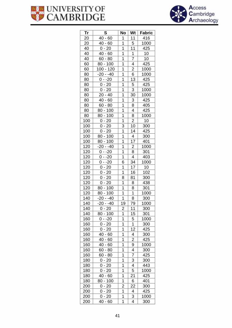
Tr S No Wt Fabric
-120 140 - 160 1 33 301
-120 140 - 160 1 3 320
-100 120 - 140 1 29 401
-100 160 - 180 2 4 301
-100 160 - 180 1 48 1000
-100 180 - 200 1 16 10
-60 80 - 100 1 2 300
-60 100 - 120 2 41 425
-60 160 - 180 1 5 416
-60 160 - 180 1 7 438
-40 60 - 80 2 16 425
-40 60 - 80 1 6 1000
-40 160 - 180 2 11 425
-20 100 - 120 2 11 1000
-20 120 - 140 1 25 405
-20 120 - 140 1 11 1000
0 0 - 20 1 8 401
0 0 - 20 1 1 405
0 20 - 40 1 6 300
0 20 - 40 1 5 425
0 20 - 40 1 12 1000
20 0 - 20 1 10 301
20 0 - 20 1 2 405
20 0 - 20 1 7 425
41
Tr S No Wt Fabric
20 40 - 60 1 11 416
20 40 - 60 1 5 1000
40 0 - 20 1 11 425
40 40 - 60 1 1 10
40 60 - 80 1 7 10
60 80 - 100 1 4 425
60 100 - 120 1 2 1000
80 -20 - -40 1 6 1000
80 0 - -20 1 13 425
80 0 - 20 1 5 425
80 0 - 20 1 3 1000
80 20 - 40 1 30 1000
80 40 - 60 1 3 425
80 60 - 80 1 8 405
80 80 - 100 1 4 425
80 80 - 100 1 8 1000
100 0 - 20 1 2 10
100 0 - 20 3 10 300
100 0 - 20 1 14 425
100 80 - 100 1 4 300
100 80 - 100 1 17 401
120 -20 - -40 1 2 1000
120 0 - -20 1 8 301
120 0 - -20 1 4 403
120 0 - -20 6 34 1000
120 0 - 20 1 17 10
120 0 - 20 1 16 102
120 0 - 20 8 81 300
120 0 - 20 1 8 438
120 80 - 100 1 8 301
120 80 - 100 1 1 1000
140 -20 - -40 1 8 300
140 -20 - -40 19 79 1000
140 0 - 20 2 11 300
140 80 - 100 1 15 301
160 0 - -20 1 5 1000
160 0 - 20 1 1 300
160 0 - 20 1 12 425
160 40 - 60 1 4 300
160 40 - 60 1 2 425
160 40 - 60 1 9 1000
160 60 - 80 1 4 300
160 60 - 80 1 7 425
180 0 - 20 1 3 300
180 0 - 20 1 4 443
180 0 - 20 1 5 1000
180 40 - 60 1 21 425
180 80 - 100 1 6 401
200 0 - 20 2 22 300
200 0 - 20 1 4 425
200 0 - 20 1 3 1000
200 40 - 60 1 4 300

42
Tr S No Wt Fabric
200 40 - 60 1 7 416
200 40 - 60 1 5 425
220 -120 - -140 1 7 425
220 -120 - -140 1 21 1000
220 -100 - -120 1 10 425
220 20 - 40 1 9 301
220 20 - 40 1 6 425
240 -120 - -140 1 12 425
240 -100 - -120 1 14 425
240 20 - 40 2 48 425
240 20 - 40 2 3 1000
240 40 - 60 1 11 425
260 -60 - -80 1 6 1000
260 0 - 20 1 3 1000
260 20 - 40 4 25 1000
280 20 - 40 1 3 425
280 -80 - -100 1 6 300
280 -80 - -100 1 4 425
280 -120 - -140 1 9 401
280 -120 - -140 2 18 425
300 -160 - -180 1 1 1000
300 -120 - -140 1 15 425
300 -120 - -140 1 1 1000
300 -100 - -120 1 9 320
300 -80 - -100 1 24 425
300 -60 - -80 1 9 425
300 -20 - -40 1 1 10
300 0 - -20 1 4 401
300 0 - 20 1 1 425
300 20 - 40 1 4 401
320 -140 - -160 1 6 425
320 -120 - -140 2 23 425
320 -120 - -140 1 3 443
320 -40 - -60 1 2 425
320 0 - -20 1 7 425
320 0 - 20 1 24 401
320 0 - 20 1 3 1000
320 20 - 40 1 10 1000
340 -100 - -120 1 12 405
340 -80 - -100 1 12 425
340 -60 - -80 1 13 10
340 -20 - -40 1 27 425
340 0 - -20 1 3 1000 Table 1: The pottery identified from fieldwalking at Bulmer

43
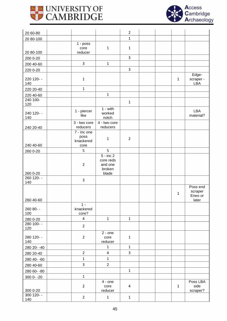
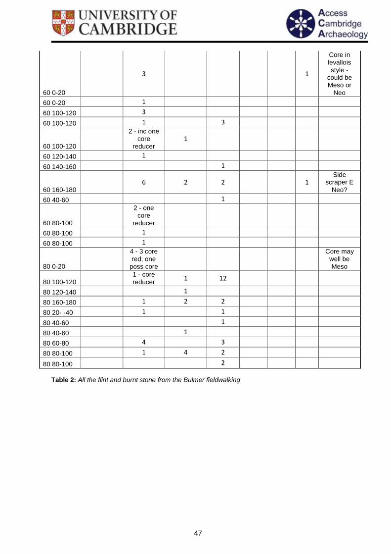
13.2 Flint Report – David McOmish
Flint artefacts from the Bulmer fieldwalking included struck flints and fire-cracked flint. These were identified to type and date if possible, with retouching and other distinguishing characteristics noted if present. In most instances a date could not be established. Flint artefacts are listed here by transect and stint with particular points of interest discussed in sections 8 and 9.
Unworked Flint
Nodule
Primary Working Waste flakes
Secondary Working Waste flakes
Fire-cracked
Flint Blades Flakes Tools Comments
0 100-120 1
2 - one is core
reducer
0 120-140
2 core reducers-one with
edge damage
0 20-40 1 1 1
100 0- -20
1 - worked nodule
1
100 0-20 1
100 100-120
1 - core reducer
100 140-160
1 - core reducer
1 - core reducer
100 20-40 1
100 20-40 1
100 40-60 1
100 60-80 1
100 80-100 1
Blade core - Meso
120 0- -20 1 2
120 0-20 1
120 140-160
3, one poss
core reducer
1
120 180-200
2 1
120 -20- -40
1
120 20-40 1
120 40-60 1
120 40-60 2 2 1
120 60-80
1
1 - core
rejuvination
Blade may be Late Meso/E
Neo
120 80-100 3
3 - two poss core reducers
2
120 80-100 2
140 0 - - 20 2 1 1

44
140 0-20 1 1
140 0-20 3 1 140 160-180
1 2
140 20- -40 1
140 20- -40 1
140 20- -40 1 1
140 40-60 2
140 40-60 1
140 60-80 1
140 80-100
2 - poss core
reducers
140 80-100
2 - one with edge
damage/retouch
160 0- -20 1
160 0-20 1
1 - poss core
reducer
160 40-60 1 1 5
160 40-60
2 - one core
reducer 1 1
160 60-80 1 1
E Neo side and end scraper
160 80-100 4 2
180 0-20
1 - axe-trimming
flake?
Plus piece of
?conglomerate stone
180 0-20 3
180 60-80 1
180 80-100 1
20 0-20
1 - core reducer
20 100-120 1
20 100-120
3 1 2 1
Retouch on end of blade - Meso/E
Neo
20 10-20 1 1 8
20 120-140 1
20 120-140
6 - one with edge
retouch/damage
4 - one core
reducer
Flake with edge work
may well be scraper
20 140-160 1 1
20 20-40 1 - ball
20 40-60 1 2
20 60-80 1
45
20 60-80 2
20 80-100 1
20 80-100
1 - poss core
reducer 1 1
200 0-20 3
200 40-60 3 1
220 0-20 3
220 120- -140
1 1 Edge-
scraper - LBA
220 20-40 1
220 40-60 1 240 100-120
1
240 120- -140
1 - piercer
like
1 - with worked notch
LBA
material?
240 20-40
3 - two core reducers
4 - two core reducers
240 40-60
7 - inc one poss
knackered core
1 2
260 0-20 5 5
260 0-20
2
5 - inc 2 core reds and one broken blade
260 120- -140
3
260 40-60
1
Poss end scraper Eneo or
later
260 80- -100
1 -
knackered core?
280 0-20 4 1 1 280 100- -120
2
280 120- -140
2 2 - one
core reducer
1
280 20- -40 1 1
280 20-40 2 4 3
280 40- -60 1 1
280 40-60 3 2
280 60- -80 1
300 0- -20 1
300 0-20 2
4 - one core
reducer 4 1
Poss LBA side
scraper?
300 120- -140
2 1 1

46
300 160-180
1 2
300 20- -40 3 2 2
300 40-60 1
300 60- -80 2 1 1
Poss gun flint
320 0-20 1 320 100- -120
1
320 140- -160
2
320 20- -40 6
3 - one with notch
320 60- -80 1 2 1
320 80-100 3
3 - one poss core reducer
340 0-20
1
1 - core
rejuvination
Blade may well be
Late Meso/Eneo
340 20- -40
1 - broken flake
340 40- -60 1 1
340 60- -80 1 340 80- -100
2
40 0- -20 2 1
40 0-20 1
40 0-20 1
40 100-120 1 1 1
40 100-120
7 2 - inc one poss core
frag 5
40 100-120
4 - inc one poss flake
core 3 1
Flake core - Meso
40 120-140 1 1
40 140-160 1 2
40 160-180 2
40 20-40 1
40 40-60 1 1
Plus one piece of
glass
40 60-80 5
40 80-100 1
40 80-100
3 - inc one core frag
5 1
Side retouch on flake - edge scraper? E
Neo
40 80-100 3
60 0- -20
2, one poss core
1 - poss core
reducer
47
60 0-20
3 1
Core in levallois style -
could be Meso or
Neo
60 0-20 1
60 100-120 3
60 100-120 1 3
60 100-120
2 - inc one core
reducer 1
60 120-140 1
60 140-160 1
60 160-180 6 2 2 1
Side scraper E
Neo?
60 40-60 1
60 80-100
2 - one core
reducer
60 80-100 1
60 80-100 1
80 0-20
4 - 3 core red; one
poss core
Core may well be Meso
80 100-120
1 - core reducer
1 12
80 120-140 1
80 160-180 1 2 2
80 20- -40 1 1
80 40-60 1
80 40-60 1
80 60-80 4 3
80 80-100 1 4 2
80 80-100 2
Table 2: All the flint and burnt stone from the Bulmer fieldwalking
48
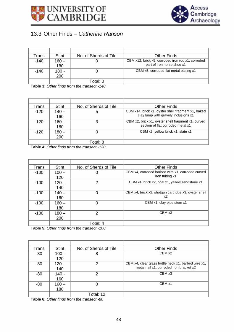
13.3 Other Finds – Catherine Ranson
Trans Stint No. of Sherds of Tile Other Finds
-140 160 – 180
0 CBM x12, brick x5, corroded iron rod x1, corroded part of iron horse shoe x1
-140 180 - 200
0 CBM x5, corroded flat metal plating x1
Total: 0
Table 3: Other finds from the transect -140
Trans Stint No. of Sherds of Tile Other Finds
-120 140 – 160
5 CBM x14, brick x1, oyster shell fragment x1, baked clay lump with gravely inclusions x1
-120 160 – 180
3 CBM x2, brick x1, oyster shell fragment x1, curved section of flat corroded metal x1
-120 180 – 200
0 CBM x2, yellow brick x1, slate x1
Total: 8
Table 4: Other finds from the transect -120
Trans Stint No. of Sherds of Tile Other Finds
-100 100 – 120
0 CBM x4, corroded barbed wire x1, corroded curved iron tubing x1
-100 120 – 140
2 CBM x4, brick x2, coal x1, yellow sandstone x1
-100 140 – 160
0 CBM x4, brick x2, shotgun cartridge x3, oyster shell x2
-100 160 – 180
0 CBM x1, clay pipe stem x1
-100 180 – 200
2 CBM x3
Total: 4
Table 5: Other finds from the transect -100
Trans Stint No. of Sherds of Tile Other Finds
-80 100 - 120
8 CBM x2
-80 120 – 140
2 CBM x4, clear glass bottle neck x1, barbed wire x1, metal nail x1, corroded iron bracket x2
-80 140 - 160
2 CBM x3
-80 160 – 180
0 CBM x1
Total: 12
Table 6: Other finds from the transect -80

49
Trans Stint No. of Sherds of Tile Other Finds
-60 80 – 100
22 CBM x25, slate x1
-60 100 – 120
1 CBM x2
-60 120 – 140
9 CBM x3, clear container glass x1,
-60 140 – 160
3 CBM x3, brick x2, corroded curved iron fragment x1, oyster shell fragment x1
-60 160 – 180
16 CBM x19, brick x1, yellow brick x1
Total: 51
Table 7: Other finds from the transect -60
Trans Stint No. of Sherds of Tile Other Finds
-40 20 – 40 0 Brick x1
-40 40 – 60 26 CBM x23, brick x6
-40 60 – 80 109 CBM x3, white tile x1, red brick x13, shotgun cartridge x1
-40 80 – 100 31 Brick x3, shotgun cartridge x4
-40 100 – 120
45 CBM x64, concrete x1
-40 120 – 140
7 CBM x13, slate x1, yellow brick x1, green bottle glass x1
-40 140 – 160
17 CBM x10, flat corroded metal plate x1, bent metal plate with screw holes and one screw still attached
x1
-40 160 – 180
12 CBM x20, slate x1, yellow CBM x1, green bottle glass x1
Total: 247
Table 8: Other finds from the transect -40
Trans Stint No. of Sherds of Tile Other Finds
-20 20 – 40 61 CBM x16, pink/yellow land drain x1, brick x5
-20 20 – 40 5
-20 40 – 60 28 CBM x19, shotgun cartridge x1, piece of flat metal plate with letters “HEN” x1
-20 60 – 80 19 CBM x27, shotgun cartridge x1, clear container glass x1
-20 80 – 100
14 CBM x25, brick x2, flat grey stone x1, clear container glass
-20 100 - 120
19 CBM x24, yellow tile x1, lump of mortar/concrete x1
-20 120 – 140
18 CBM x34, slate x1
-20 140 - 160
17 CBM x26
Total: 181
Table 9: Other finds from the transect -20

50
Trans Stint No. of Sherds of Tile Other Finds
0 0 – 20 16 Red brick x2, white floor tile x1, yellow sandstone block cut for use in a building x1
0 20 – 40
16 CBM x17, brick x3, white tile x1, slate x1, corroded iron hook or fastening x1
0 40 – 60
14 CBM x8
0 60 – 80
10 CBM x28
0 80 – 100
5 Brick x1
0 100 – 120
28 CBM x17, coal x1
0 120 – 140
13 CBM x36
Total: 102
Table 10: Other finds from the transect 0
Trans Stint No. of Sherds of Tile Other Finds
20 0 - -20
53 CBM x64, brick x4
20 0 – 20 28 CBM x59, oyster shell x1
20 20 – 40
8 CBM x6
20 40 – 60
30 CBM x23, land drain x2, slate x2, metal hoop, finger ring? X1
20 60 – 80
23 CBM x17, red brick x2, white land drain x1
20 80 – 100
14 CBM x41, slate x1, green bottle glass x1, corroded iron nail x1, corroded iron rod x1, flat banana-shaped
piece of corroded iron x1
20 100 - 120
19 CBM x29, slate x1, green bottle glass x3
Total: 175
Table 11: Other finds from the transect 20
Trans Stint No. of Sherds of Tile Other Finds
40 0 - -20
30 CBM x2, brick x2, oyster shell x1
40 0 – 20 20 CBM x22, red brick x1, yellow land drain x1, red shotgun cartridge x1
40 20 – 40
7 CBM x2
40 40 – 60
21 CBM x16, bent square plate of metal x1
40 60 – 80
9 CBM x16, oyster shell x1
40 80 – 100
27 CBM x24, red/orange brick x1, clear container glass x1
40 100 – 120
10 CBM x22

51
Total: 124
Table 12: Other finds from the transect 40
Trans Stint No. of Sherds of Tile Other Finds
60 -20 - -40
12 White brick x1, land drain x1
60 0 - -20
7 CBM x13, coal x1, clear flat glass x1
60 0 – 20 21 CBM x28, slate x1, corroded square iron nail x1
60 20 – 40
2 CBM x2, oyster shell x1
60 40 – 60
19 CBM x7
60 60 – 80
12 CBM x5
60 80 – 100
19 CBMx40, yellow land drain x1
60 100 - 120
1 CBM x26, slate x1
Total: 93
Table 13: Other finds from the transect 60
Trans Stint No. of Sherds of Tile Other Finds
80 -20 - -40
5 CBM x6, brick x1, slate x1, folded sheet of metal x1, pink plastic tag x1, flat slightly twisted lead bar x1,
80 0 - -20
1
80 0 – 20 25 CBM x26, brick x2, oyster shell fragment x1
80 20 – 40
6 CBM x2
80 40 – 60
54 CBM x12, clay pipe stem x1, green bottle glass x1
80 60 – 80
6 CBM x3, brick x3
80 80 – 100
19 CBM x13, corroded iron horse shoe complete x1, corroded flat banana-shaped piece of iron with holes
in x1
80 100 – 120
20 CBM x19, red land drain x1
Total: 136
Table 14: Other finds from the transect 80
Trans Stint No. of Sherds of Tile Other Finds
100 0 - -20 3 CBM x1
100 0 – 20 12 CBM x8, yellow land drain x1, corroded fragment of metal plate, slightly curved x1, oyster shell fragments
x6
100 -20 - -40
5 CBM x11, lump of stone x1, brown glass bottle base x1
100 20 – 40
2 Brick x2, white land drain x1, oyster shell x1
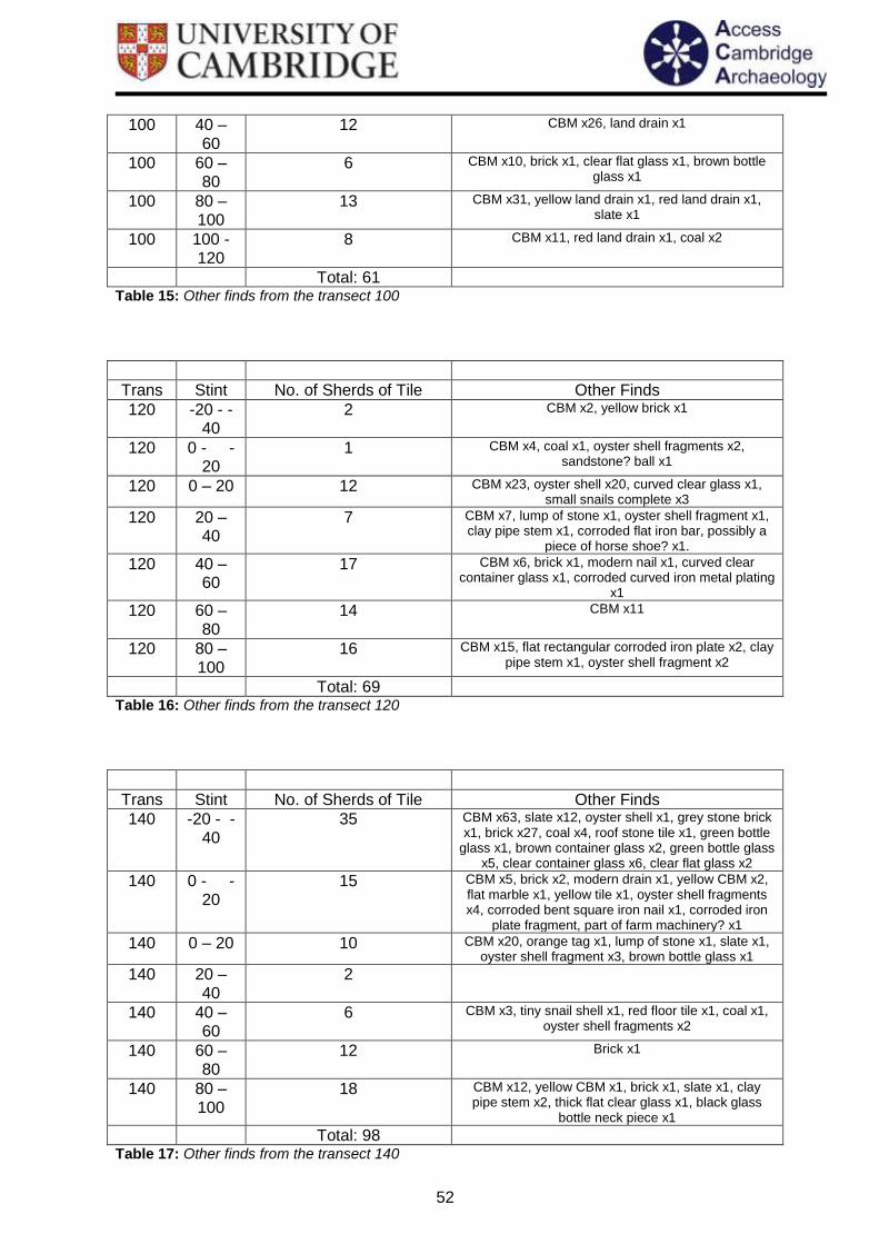
52
100 40 – 60
12 CBM x26, land drain x1
100 60 – 80
6 CBM x10, brick x1, clear flat glass x1, brown bottle glass x1
100 80 – 100
13 CBM x31, yellow land drain x1, red land drain x1, slate x1
100 100 - 120
8 CBM x11, red land drain x1, coal x2
Total: 61
Table 15: Other finds from the transect 100
Trans Stint No. of Sherds of Tile Other Finds
120 -20 - -40
2 CBM x2, yellow brick x1
120 0 - -20
1 CBM x4, coal x1, oyster shell fragments x2, sandstone? ball x1
120 0 – 20 12 CBM x23, oyster shell x20, curved clear glass x1, small snails complete x3
120 20 – 40
7 CBM x7, lump of stone x1, oyster shell fragment x1, clay pipe stem x1, corroded flat iron bar, possibly a
piece of horse shoe? x1.
120 40 – 60
17 CBM x6, brick x1, modern nail x1, curved clear container glass x1, corroded curved iron metal plating
x1
120 60 – 80
14 CBM x11
120 80 – 100
16 CBM x15, flat rectangular corroded iron plate x2, clay pipe stem x1, oyster shell fragment x2
Total: 69
Table 16: Other finds from the transect 120
Trans Stint No. of Sherds of Tile Other Finds
140 -20 - -40
35 CBM x63, slate x12, oyster shell x1, grey stone brick x1, brick x27, coal x4, roof stone tile x1, green bottle
glass x1, brown container glass x2, green bottle glass x5, clear container glass x6, clear flat glass x2
140 0 - -20
15 CBM x5, brick x2, modern drain x1, yellow CBM x2, flat marble x1, yellow tile x1, oyster shell fragments x4, corroded bent square iron nail x1, corroded iron
plate fragment, part of farm machinery? x1
140 0 – 20 10 CBM x20, orange tag x1, lump of stone x1, slate x1, oyster shell fragment x3, brown bottle glass x1
140 20 – 40
2
140 40 – 60
6 CBM x3, tiny snail shell x1, red floor tile x1, coal x1, oyster shell fragments x2
140 60 – 80
12 Brick x1
140 80 – 100
18 CBM x12, yellow CBM x1, brick x1, slate x1, clay pipe stem x2, thick flat clear glass x1, black glass
bottle neck piece x1
Total: 98
Table 17: Other finds from the transect 140

53
Trans Stint No. of Sherds of Tile Other Finds
160 0 - -20
9 CBM x1, clear container glass x2, dirty yellow drain, slightly curved x1
160 0 – 20 8 CBM x22, oyster shell x2
160 20 – 40
7 CBM x2
160 40 – 60
15 CBM x26, brick x2, oyster shell fragments x3
160 60 – 80
55 CBM x55, red brick x1, curved drain x2, corroded iron nail x1, corroded iron rod x1, part of green glass
bottle base x1
160 80 – 100
4 CBM x3, slate x1
Total: 98
Table 18: Other finds from the transect 160
Trans Stint No. of Sherds of Tile Other Finds
180 0 - -20
21 Large frogged brick x1, slate x2
180 0 – 20 12 CBM x32, slate x1, yellow CBM x1, clear bottle glass x1, brown bottle glass x1, green bottle glass x1
180 20 – 40
0 Grey stone x1, coal x1
180 40 – 60
41 CBM x34, red land drain x1, slate x2, brown bottle glass x2, clear container glass x1, degraded green
bottle glass x2, oyster shell fragment x1, large fragment of corroded iron drain pipe? X1
180 60 – 80
14 CBM x13, red land drain x1,
180 80 – 100
22 CBM x16, brick x1, red land drain x1
Total: 110
Table 19: Other finds from the transect 180
Trans Stint No. of Sherds of Tile Other Finds
200 0 - -20
0 CBM x18, brick x9
200 0 – 20 22 CBM x9, brick x4, oyster shell fragments x10, corroded iron bar, part of fork from farm equipment??
X1
200 20 – 40
20 Oyster shell x4
200 40 – 60
37 CBM x65, red land drain x5, square plate of metal x1, slate x, coal x1, yellow CBM x2, oyster shell
fragments x3
Total: 79
Table 20: Other finds from the transect 200

54
Trans Stint No. of Sherds of Tile Other Finds
220 -120 - -140
17 CBM x19, slate x1, metal flat disk with hole in centre x1
220 -100 - -120
5 CBM x24, slate x1, brick x1, curved oblong plate of metal with hole in centre x1
220 20 – 40
37 CBM x50
220 40 – 60
18 CBM x16, slate x2, oyster shell x1
Total: 77
Table 21: Other finds from the transect 220
Trans Stint No. of Sherds of Tile Other Finds
240 -120 - -140
8 CBM x6, sate x1
240 -100 - -120
21 CBM x30, red land drain x1, red brick fragment with gravel inclusions x1
240 -80 - -100
11 CBM x8
240 20 – 40
20 CBM x8, red land drain x1, brick x1
240 40 – 60
40 CBM x24, slate x1, corroded iron handle? x1
Total: 100
Table 22: Other finds from the transect 240
Trans Stint No. of Sherds of Tile Other Finds
260 -120 - -140
12 CBM x19, slate x1, coal x1
260 -100 - -120
5 CBM x 4
260 -80 - -100
6 CBM x3
260 -60 - -80
14 CBM x23
260 0 - -20
1 CBM x18, red land drain x2
260 0 – 20 5 CBM x2, land drain x1, thick flat clear glass x1
260 20 – 40
0 Thick clear container glass x1, curved dark green bottle glass x1, slag x1, CBM x2, red land drain x1
260 40 – 60
5 CBM x13, red land drain x1
Total: 48
Table 23: Other finds from the transect 260
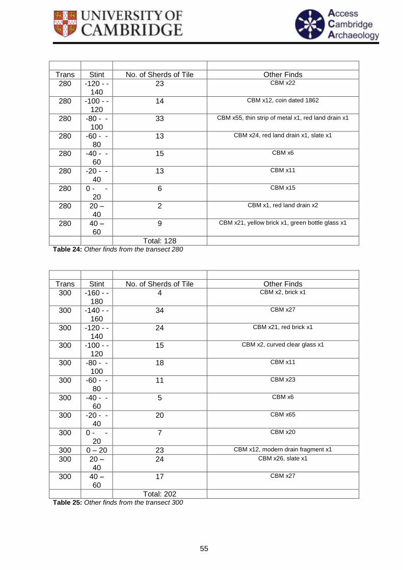
55
Trans Stint No. of Sherds of Tile Other Finds
280 -120 - -140
23 CBM x22
280 -100 - -120
14 CBM x12, coin dated 1862
280 -80 - -100
33 CBM x55, thin strip of metal x1, red land drain x1
280 -60 - -80
13 CBM x24, red land drain x1, slate x1
280 -40 - -60
15 CBM x6
280 -20 - -40
13 CBM x11
280 0 - -20
6 CBM x15
280 20 – 40
2 CBM x1, red land drain x2
280 40 – 60
9 CBM x21, yellow brick x1, green bottle glass x1
Total: 128
Table 24: Other finds from the transect 280
Trans Stint No. of Sherds of Tile Other Finds
300 -160 - -180
4 CBM x2, brick x1
300 -140 - -160
34 CBM x27
300 -120 - -140
24 CBM x21, red brick x1
300 -100 - -120
15 CBM x2, curved clear glass x1
300 -80 - -100
18 CBM x11
300 -60 - -80
11 CBM x23
300 -40 - -60
5 CBM x6
300 -20 - -40
20 CBM x65
300 0 - -20
7 CBM x20
300 0 – 20 23 CBM x12, modern drain fragment x1
300 20 – 40
24 CBM x26, slate x1
300 40 – 60
17 CBM x27
Total: 202
Table 25: Other finds from the transect 300

56
Trans Stint No. of Sherds of Tile Other Finds
320 -140 - -160
19 CBM x5
320 -120 - -140
42 CBM x27, slate x1
320 -100 - -120
13 CBM x24, roof tile x1, green bottle glass x2
320 -80 - -100
9 Oyster shell x2
320 -60 - -80
16 CBM x11, red land drain x2, slate x1
320 -40 - -60
24 CBM x42
320 -20 - -40
1 CBM x4
320 0 – 20 32 CBM x102, slate x1, red land drain x1
320 20 – 40
25 CBM x89, slate x1, shotgun cartridges x2
Total: 181
Table 26: Other finds from the transect 320
Trans Stint No. of Sherds of Tile Other Finds
340 -120 - -140
11 CBM x1
340 -100 - -120
15 CBM x20
340 -80 - -100
18 CBM x9
340 -40 - -60
4 CBM x2, slate x1
340 -20 - -40
20 CBM x44
340 0 - -20
7 CBM x6, land drain x1
Total: 75
Table 27: Other finds from the transect 340