field tour guide - soilsnigeriaconference.com
TRANSCRIPT

SOIL SCIENCE SOCIETY OF NIGERIA (SSSN)
44TH ANNUAL CONFERENCE, COAL CITY, 2020
Field Tour Guide
to
Songhai Enugu Farm: Climate-smart Village for Reduced Climate Risk and
Food Insecurity
And
Ezeagu Waterfalls
DATE: March 19th 2020
HOST: Enugu State University of Science and Technology, Enugu, Nigeria
THEME: Climate-smart soil management, soil health/quality and land management:
synergies for sustainable ecosystem services

Martin A.N Anikwe is a Professor of Soil Science and Dean, Faculty of
Agriculture and Natural Resources Management, Enugu State University of
Science and Technology (ESUT).
Virginia Okwu-Delunzu is a Research Scientist and Head, Department of Geography
and Meteorology Enugu State University of Science and Technology (ESUT).
Kevin E. Chukwu is a Research Scientist and Lecturer, Department of Geography and
Meteorology Enugu State University of Science and Technology (ESUT).
Titus O. Enudu is a Professor of Business Administration and Director,
ESUT Business School, Enugu.

Table of Contents
1. Climate of Enugu
2. Climate Smart Agriculture Strategy for Enugu State and Adaptation Options at
Farm/Community/Local Level
3. ESUT Meteorological Observatory
4. ENUGU SONGHAI FARM: Climate-smart Village for Reduced Climate Risk
and Food Insecurity
5. Ezeagu water falls

1. Climate of Enugu
The climate is tropical.
The summers are much rainier than the winters in Enugu.
The Köppen-Geiger climate classification is Aw.
In Enugu, the average annual temperature is 26.3 °C.
In a year, the average rainfall is 1730 mm.
The driest month is December, with 9 mm of rain.
The greatest amount of precipitation occurs in September, with an average of 298 mm.
March is the warmest month of the year.
The temperature in March averages 28.4 °C.
The lowest average temperatures in the year occur in August, when it is around 24.0 °C.
There is a difference of 289 mm of precipitation between the driest and wettest months.
The variation in temperatures throughout the year is 4.4 °C.
Enugu Climate table // historical Weather data
Jan Feb Mar April May Jun July August September October November December Avg. Temp
(°C)
Min. Temp
(°C)
Max. Temp
(°C)
26.8 27.7 28.4 27.9 26.8 25.3 24.8 24
21.7 22.4 23.6 23.1 22.5 21.4 21.4 21.4
32 33.1 33.2 32.7 31.1 29.3 28.2 26.7
25.3
21.4
29.2
25.8
21.4
30.2
26.8
22
31.6
26.4
20.8
32.1
Precipitation
/ Rainfall 13 20 76 137 224 241 246 220 298 216 30 9
(mm)

2. ESUT Meteorological Observatory
Field tour guide to ESUT Meteorological Observatory
Briefs on ESUT Meteorological Observatory The ESUT Meteorological Observatory is a modern weather station consisting of two sections, namely: (i) The manual weather station installed and operated since 1985. (ii) The TRODAN equipment which is a digital (Campbell model) meteorological station installed in 2012 (See Fig. 1). The server of this automatic weather station is located at the Center for Atmospheric Research (CAR). The station is programmed and controlled from the server. Just as the name implies, the station lies in a cellular environment, mobile handset (GSM) GPRS or EDGE network. It is also connected to other twenty two automatic weather observing stations in Nigeria. The Center for Atmospheric Research (CAR) undertakes a routine maintenance of the station annually as well as capacity building for the operation of the station. The station was part of the network of the project called Nigerian Environmental Climatic Observing Programme (NECOP) which is now known as Tropospheric Data Acquisition Network (TRODAN). It measures and records ten different weather/climatic elements simultaneously with an update of 300 seconds interval. The elements are. Atmospheric Temperature (0C); Precipitation Amount ; Relative Humidity (%); Atmospheric pressure (PEN) ; Soil moisture (%) ; Wind speed (m/s) ;Wind direction (0N) ; Soil Temperature (0C) Rainfall rate (mm/min) ; Solar Radiation (W/m2)
The digital station is equipped with a solar panel which provides uninterrupted power supply (24-7), to the
equipment. The LOC, therefore, hopes that by this field study, the conference participants will see the obvious reasons to avail themselves of the opportunities provided by the ESUT meteorological observatory to enhance their research works on environmental, weather, climate, hydrological, atmospheric and space sciences.
ESUT Meteorological Observatory, TRODAN Station, Ebeano City, Agbani

Table 1: Climate change Adaptation options for agricultural management
3.Climate Smart Agriculture Strategy for
Enugu State and Adaptation Options at
Farm/Community/Local Level
Martin Anikwe, Ken Ife, Emeka Nzeh
Climate change impacts can be organized at successive levels of the economy, including farm level, community level, sector level (e.g. agriculture, health, industry, environment, water, etc), and macro level (loss to GDP, loss of employment, increased incidence of poverty, increase in social and economic vulnerabilities). At the local household/farm/community level, in Nigeria (Southern Nigeria precisely and Enugu State in particular) climate change impacts are observed in terms of increased weed growth, increase in pest and disease infestation, drought/reduction in moisture, uncertainty in weather conditions, reduction in soil nutrient, decrease in agricultural yield, loss of agricultural land to flood and erosion, and land degradation. The identified adaptation/mitigation options for these impacts include cover cropping, early planting, prompt weeding, regulated/controlled herbicide use, use of weed-tolerant crop varieties, mixed cropping, use of pest and disease-resistant crops/species, rouging, crop replacement, mulching, irrigation schemes, efficient water harvesting and storage techniques, prevention of forest losses along water bodies, use of weather forecast technologies, application of the daily weather reports from the media, prayers, flexibility in timing of farming operations, green manuring, composting, crop rotation, fallowing, use of organic fertilizers and manures, and diversification in crop and animal production. Others include value-chain addition, biotechnology and nanotechnology application, improved extension services, government support and interventions, climate change education, enterprise diversification, tree planting, improved land management techniques, biodiversity conservation, controlled grazing, construction and maintenance of drainage channels, construction of rock molls and barriers against ocean surge, planting across slope, emergency relief strategies, agro-forestry practices, forestry regulations, afforestation programmes, and reduced tillage.
Adaptation option Relative cost Relative Benefit GOVERNMENT POLICY Providing greater support for agricultural research H H Improving transportation of agricultural goods M H Offering subsidies and other protective trade regulations devices H M Reforming land tenure and land management policies M H Establishing markets for products M M Implementing medium- to long-term development strategies for industries based on sustainable agricultural principles
H H
FARM MANAGEMENT Disseminating research findings to farmers L M Creating more efficient food storage/processing systems M M Improving pest management M H Creating water tanks/reservoirs in dry areas M H Reducing bush-burning M M Developing a more reliable system of seasonal predictions M M Engaging in labour migration M M Changing farm location M L Selling farm assets L L SOIL EROSION Initiating and stringently enforcing anti-erosion laws, including limiting access to eroded and erosion-prone areas
M L
Public education M M Erecting contour bunds around farmlands L M Prioritizing soil and water conservation in government policy L M

Table 2: Climate change Adaptation options for agricultural sub-sectors
The „low/medium cost‟ but „high benefit‟ options presented in the above tables are potentially good value-for-money responses to the threat of climate change in Enugu Nigeria. These have been listed below, where each option can be implemented at a range of scales, from the individual farm up to the national level:
using disease-resistant, quick-maturing crop and plant species (e.g. cassava sticks, fruits and nuts) (farm level); introducing mixed farming practices (e.g. utilizing forest products as a buffer to crop failure in climatically marginal areas) (farm level); designing new industrial activities with increased resilience and flexibility with respect to climate change already built in (site level); establishing wood-lots with fast-maturing plant species that yield domestic fuel wood for nearby communities (district level); reforming land tenure and land management policies (national level) Improving pest management (district level); protecting watersheds and reservoir sites through establishment of intensive vegetation cover to minimize evaporation (district level); establishing seed banks to maintain biological diversity and provide farmers with opportunities to diversify (national level); better monitoring of ground-water resources (national level); and undertaking a coast protection strategy to determine where and what form of coast protection schemes are required.
Adaptation option Relative cost Relative Benefit
Adaptation option Relative cost Relative Benefit CROPS Using agro-forestry and organic farming techniques. For example, organic manure instead of chemical fertilizers
L M
Increasing crop area or crop intensity M M Using disease-resistant, quick-maturing crop and plant species (e.g. cassava sticks, fruits and nuts)
L H
Developing better heat- and drought-resistant crops H H Improving the production efficiencies in arid lands and marginal areas of early maturing crops
M H
Developing high-yield varieties H H Properly preserving seeds and plant seedlings to ensure healthy germination in the following farming season
M M
Introducing mixed farming practices (e.g. utilizing forest products as a buffer to crop failure in climatically marginal areas)
L H
LIVESTOCK Reducing herd and farm sizes L L Diversifying animal stock – especially to smaller animals M H Transitioning to sedentary herds L M Culling animals L L FISHERIES Maintaining water levels so that fish can spawn M M Development of mariculture M H FORESTS Establishing wood-lots with fast-maturing plant species that yield domestic fuel wood for nearby communities
L H
Establishing seed banks to maintain biological diversity and provide farmers with opportunities to diversify
M H
Decentralizing resources to local governance arrangements i.e. adopting Community Based Natural Resource Management
L M
Improving all-round management of tree plantations, including prevention of soil erosion
M M

4.ENUGU SONGHAI FARM:
Climate-smart Village for Reduced Climate
Risk and Food Insecurity
1.0 Executive summary
The Agricultural Sector in Enugu State is largely a subsistent sector that is presently characterized by inefficiency, high risk, low productivity and very little diversification. The prevalent wastes arising from the lack of proper handling of agricultural products, especially perishable ones (in processing, packaging and storage), has resulted in their inability to access the best markets for their products, in both the regional and international markets. The Nigerian agriculture does not escape from this situation which has rendered this sector non attractive, not only for the future entrepreneurs, but also the investors. That is why a large number of youths is now moving away from the rural communities into urban areas. We are all aware of the ever increasing urban decay as consequences of this trend. The challenge before all of us is how to turn the rural sector around to become productive, efficient and remunerative with the view to seriously tackling the employment problem and considerably slowing down the massive rural exodus in Enugu and Nigeria. In other words, the objective here is to make the African Agriculture competitive. This is an inescapable pathway to a viable and broad-based economy in Nigeria. If this becomes a reality, agriculture would become a weapon of mass construction and rural growth that will effectively fight poverty. Agricultural growth must therefore be seen as a key to the rural development and the eradication of poverty. This new process requires the concomitant development of the secondary and tertiary sectors. Agriculture does not develop by itself, but requires a complex institutional system to support it – market its products, and provide inputs, credits and technology and management. Rural communities need services, such as education, health, public facilities and commercial outlets. “RURAL CITY” that insures those services is a key to rural growth. The Songhai concept as an integrated development model includes these services as essential elements of “rural cities”. Rural growth will be difficult to take off without these enabling and complimentary services that constitute the framework of a “rural city”. Rural development is a cluster industry. Since agriculture is carried out by a multitude of individual producers, and groups, their willingness and ability to participate in any program of change is a crucial factor. Social planning and organization will also be a critical factor in rural growth. This will involve a complex of principles and methods of organizing and planning, designed to utilize social forces for attaining the goals of development. Rural Development is, in effect, a complete transformation of the whole institutional structure of the rural society. Institutional economics should be seen as an essential element in social capital development. We must however recognize and leverage the following pathway to rural socio-economic transformation:
o Increasing the number of employees in the agric sector as it becomes efficient and attractive is the first step
o The non-agric sectors (secondary and tertiary) must also expand sufficiently to absorb the surplus
labor due to the decrease in the relative share of the employed in the agric labor force. This will develop into a broad-based economy that can reach many people especially in the rural areas.
In developing a rural project based on the Songhai model, the following have to be taken into consideration: a) the economic stage of regional and national development b) the ecological conditions prevailing in a specific area – (one of the reasons of developing hubs, satellites
and spokes). It must be contextual and must be built on the comparative advantage of the local area. c) the existing and foreseeable technological level of the region under consideration. d) the farmers‟ proficiency in adapting to innovations and the human factor involved in the project.

In its search for sustainable solutions to the socio-economic problems of the 471 Communities in Enugu State,
the Ministry of Agriculture is taking steps to appropriate the Songhai model in its development plan. The Songhai Center headquartered in the Republic of Benin is an African Regional Center of Excellence.
The Songhai Regional Centre of Excellence is conceived to create a “spread effect”. The principle or concept of
“spread effect” is that starting development activities in relatively small area or on an institution and then engaging efforts (extension, credit, organization, marketing, etc.) in order to achieve maximum social, economic and psychological effects. Such concentration of production factors to achieve high quality results could constitute the basis and spring board for expansion and extension, affecting the whole region. Innovative institutions of this type are keys to building “competitive” economic units in the region. The Songhai Enugu Initiative will therefore be designed to be an innovative institution that incubates technical and entrepreneurial capacities and also strengthens SME linkages and small-holder access to national, regional and global agribusiness and agro-Industry value chains.
The centre is designed to integrate the concepts and dynamics of:
Mother farm Capacity building Centre Networking Centre Technology park Service /Resource Centre Extension Space
This is the Songhai Enugu Incubation Centre (SEIC ). We are very proud that these pilots have yielded successful outputs and outcomes that are even informing CSA initiatives in other regions of the world. CSA options are benefiting to the rural population in the country and the Government is now considering climate information as an agricultural input, similar to fertilizers and improved seeds. During the field visit, participants will witness how the project use technology and climate information to support their day-to-day agriculture decisions and how they integrate crop-livestock-tree production options for more climate-resilient agro-ecosystems in Songhai Enugu Initiate Farm Heneke.
The farm is located in Obinofia Ndiuno in Ezeagu LGA at kilometer 25 along Enugu-Onitsha- Expressway. It is bounded by Okpudo and Aguoba Umuba communities to the north; Obinofia Ndiagu community to the south, Omughu community to the west and Nachi in Udi L.G.A to the East. The population estimate of the community is currently 9,000. Obinofia Ndiuno is the ancestral home of the entire Obinofia people who are mostly subsistent farmers. Some of them migrated to a distant farmland (Obinofia Ndiagu) where the soil is more fertile for agriculture. Thus the local people ab-initio had a tradition and skill for subsistent agriculture before the establishment of the Songhai Agricultural Model Farm. The farm is a climate smart agricultural model established by the government of Enugu state. It is a mechanized
agricultural farm of international standard with special and unique techniques for soil moisture conservation to the crops especially during the periods of dry season with high soil moisture deficiency for crops. It has facilities for
(i) different cash crops such as rice, yams, cassava, fruits and vegetable. (ii) fishery and agriculture. (iii) animal husbandry.
(iv) food processing and rice mill plants.
(v) agricultural vocational training center .
(vi) medical research centre and
(v) games reserve.
Climate-Smart Agriculture (CSA) • Agriculture that sustainably increases productivity, resilience (adaptation), reduces/removes
greenhouse gases (mitigation), and enhances achievement of national food security and development goals (FAO 2010).
• Agriculture has to address simultaneously three intertwined challenges: ensuring food security through increased productivity and income, adapting to climate change and contributing to climate change mitigation.
Agriculture must become
“climate-smart”
•
•
•
contributes to climate change adaptation by
sustainably increasing productivity & resilience
mitigates climate change by reducing greenhouse
gases where possible
and enhances the achievement of national food
security and development goals
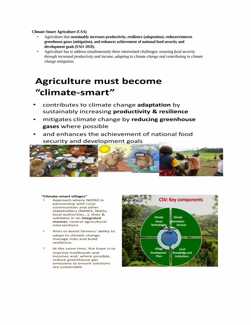
“Climate-smart villages” • Approach where NEPAD in
partnership with rural communities and other stakeholders (NARES, NGOs, local authorities…), tests & validates in an integrated manner, several agricultural interventions
CSV: Key components
Climate Climate Smart Information
Technologies Services
•
•
Aims to boost farmers’ ability to adapt to climate change, manage risks and build resilience.
At the same time, the hope is to
Climate Smart Village Action
research
Village
Local
improve livelihoods and incomes and, where possible, reduce greenhouse gas
Development Plans
Knowledge and Institutions
emissions to ensure solutions are sustainable
42

Conservation agriculture is an effective Climate-Smart Agriculture option
CA: farming practices that contribute to the three key principles of: reducing soil disturbance, maintaining soil
cover and practicing crop rotation
Cassava under plastic film mulch
We adopt a broader view of CA (than its current definition): concept for natural resource-saving that strives to achieve acceptable profits with high and sustained production levels while concurrently conserving the environment
Short high yielding Plantains under a combination of plastic film mulch and plantain refuse mulch
• Protecting soil surface using crop residues reduces water erosion, run off, soil T° and soil evaporation; Main constraints are: low availability of the straws and their fraudulent collection and uses for other purposes (feed, building materials, sales, etc.)

Soil preparation before planting. Note that the soil was completely covered
Cucumber plants growing under a combination of plastic film mulch and grass mulch
The plants were also staked to expose the leaves to more sunshine to increase photosynthesis


BRIEF ON THE SOURCE OF WATER SUPPLY FOR IRRIGATION IN
THE SONGHAI FARM The major source of water to the farm apart from rain fed agriculture is from a confined aquifer located in the western part of the farm. The farm occupies a total land area of about 200 hectares This type of aquifer is also referred to as pressure or artesian aquifer. In the Songhai farm, it is found where the underground water is restricted and confined under great hydrostatic pressure. That is, the pressure is higher than the atmospheric pressure as a result of overlying comparatively impermeable layer of rock formation. In the bore hole penetrating the aquifer of the Songhai farm, the water level rises above the bottom of the confining bed. See Photo below which shows the Songhai flowing well from the artesian aquifer. Surface runoff and rainfall infiltrate and percolate to the confined aquifer in the vicinity of the Songhai farm were the confining bed rises to the earth surface to take advantage of the recharge region. Thus where the confining bed ends underground, the aquifer becomes unconfined. No plant or pumping machine is installed to pump water from the Songhai well. The water flows out of the well by its own hydrostatic pressure. Thus the rises and falls of water in the Songhai artesian well result mainly from changes in pressure rather than changes in storage volumes. The well displays only very little seasonal variation in storage and seems to function basically as conduit for transferring water from recharge area in the vicinity of the model farm. The piezometric surface or potentiometric surface of the well coincides with the hydrostatic pressure level of the water in the confined aquifer. The water level in the well defines the elevation of the piezometric surface at that point. Because the piezometric surface in the Songhai well lies above the ground surface, the ground water gives rise to a flowing well. The conference/field tour participants should also notice that a small unconfined aquifer occurs above the artesian well in the Songhai model farm.
Pipes connected to control water to the field Water harvesting in an artificial basin

Rice is produced all year round in this climate smart farm courtesy of „natural‟ irrigation facilities developed in the farm
In the fields, water is pumped to over head tanks, which reticulate the water through drip irrigation to the farm

5. THE EZEAGU WATER FALLS
The Ugwugwo Hills form the source of a tributary stream of Oji River on the boundary between Enugu and Anambra states. From there Henke Caves-ancient twins cave- link the water falls of both warm and cold water. Both the Waterfalls and the twin caves are about 15 minutes drive form the Songhai farm. In this tourist site, one notices a stream of water falling where the river tributary (course) is interrupted by an abrupt and steep drop. This is as a result of an outcrop of resistant rock to the fluvial erosional processes of the river. It occurs across the channel /course of the river. See plate 3. The river course environment is very rocky and rugged and visitors occasionally must have to jump over rocky hummock hollows and obstacles in order to reach the hot spring and cold water. Domestic animals like sheep, goat, and fowls, to mention a few are held in sacro-sanctity for the gods of the River. The LOC also wish to caution members to wear only low heel foot wears as high heel foot wears can cause accident along the rugged terrain features. Ugwugwo Hills is also a nearby tourist attraction of natural topography overlooking the area (Anikwe, 2015)
Other Important Unique Features and Land Marks (i)
(ii)
(iii) (iv)
The Ugwu Nkwokachi Hill - This is a Cuesta with one face steeper than the other which is gentle. The popular St Mary‟s Catholic Church Obinofia is built on the piedmont section of the Hill. The Ugwu Akulu Hill is found along the Enugu- Onitsha- Expressway.
Ugwu Anu Hill: This is a super imposing land mark with an altitude about 1,000 feet a.s.l . This highland is located in the southern part of Obinofia Ndiuno. The Nkwo Ezeagu market: This is the largest market in the community and it is located along Enugu- Onitsha-Expressway. The main crop sold in the market is cassava. Other farm products include maize, fruits and Vegetables.
Nature‟s wonder – Erosion

Experience the warm and cold springs of Ezeagu waterfalls here
The natural vegetation of the waterfalls environment

ANNEX 1 : TIMELINE OF THe FIELD TRIP
DATE TIME DESCRIPTION
Thursday 19 March 2020 09 am Departure from ESUT BIZ School to Songhai Farm by bus (expected journey time - 1 hour)
9.00 - 10 am Travel across various cities and
landscapes
10.00 – 11.00 am Introductory meeting on the field visit and research
11-11 30 am: Break and refreshments
11.30 pm-12.30 pm: Travel and visits to Ezeagu waterfall Field Tour to Ezeagu Waterfalls
1.00 pm Departure