fens and their rare plants in the beartooth mountains ... · all rocky mountain research station...
TRANSCRIPT

United States Department of Agriculture
Forest Rocky Mountain General Technical ReportService Research Station RMRS-GTR-369 November 2017
Fens and Their Rare Plants in the Beartooth Mountains, Shoshone National Forest, WyomingBonnie Heidel, Walter Fertig, Sabine Mellmann-Brown, Kent E. Houston, and Kathleen A. Dwire

Heidel, Bonnie; Fertig, Walter; Mellmann-Brown, Sabine; Houston, Kent E.; Dwire, Kathleen A. 2017. Fens and their rare plants in the Beartooth Mountains, Shoshone National Forest, Wyoming. Gen. Tech. Rep. RMRS-GTR-369. Fort Collins, CO: U.S. Department of Agriculture, Forest Service, Rocky Mountain Research Station. 110 p.
Abstract
Fens are common wetlands in the Beartooth Mountains on the Shoshone National Forest, Clarks Fork Ranger District, in Park County, Wyoming. Fens harbor plant species found in no other habitats, and some rare plants occurring in Beartooth fens are found nowhere else in Wyoming. This report summarizes the studies on Beartooth fens from 1962 to 2009, which have contributed to current knowledge of rare plant distributions and biodiversity conservation. The study area is the Wyoming portion of the Beartooth Mountains in the Middle Rocky Mountains. Here, we profile 18 fens that occur over the range of elevations, settings, geomorphic landforms, and vegetation. The wetland flora from these 18 fens is composed of 58 families, 156 genera, and 336 vascular plant species—more than 10 percent of the known Wyoming flora. We discuss 32 rare vascular plant species and 1 bryophyte species associated with Beartooth fens and their State and regional significance.
Protection and management of Beartooth fens are addressed in guidance documents prepared by the U.S. Forest Service Groundwater Program, regional peatland and sensitive species policies, and the Shoshone National Forest Management Plan. Information compiled in this report increases understanding of Beartooth fens, provides a basis for future research and comparisons with mountain fens elsewhere in Wyoming and the Rocky Mountains, and contributes to conservation of fen resources and services.
Keywords: fen, wetland, rare plant, vascular flora, Beartooth Mountains, Shoshone National Forest
All Rocky Mountain Research Station publications are published by U.S. Forest Service employees and are in the public domain and available at no cost. Even though U.S. Forest Service publications are not copyrighted, they are formatted according to U.S. Department of Agriculture standards and research findings and formatting cannot be altered in reprints. Altering content or formatting, including the cover and title page, is strictly prohibited.
Cover photo: Swamp Lake Fen in the Clarks Fork Valley, Shoshone National Forest, Wyoming (photo: Mack Frost, used with permission).

Authors
Bonnie Heidel is Lead Botanist of the Wyoming Natural Diversity Database at the University of Wyoming. She holds a B.A. degree in biology from Carleton College and an M.S. degree in botany from Washington State University. She conducts Statewide research on Threatened, Endangered, and Sensitive plant species and maintains the Wyoming Plant Species of Concern list. Her research interests include biodiversity, biogeography, and conservation botany.
Walter Fertig is owner of Moenave Botanical Consulting and prior assistant curator at Arizona State University. He holds a B.S. degree in botany from Oregon State University, and an M.S. degree and Ph.D. in botany from the University of Wyoming. He was formerly the Botanist with the Wyoming Natural Diversity Database where he surveyed rare plants and vegetation types throughout the State. His research interests include floristics, gap analysis, plant geography, weed science, and conservation botany.
Sabine Mellmann-Brown is a Vegetation Ecologist with the U.S. Forest Service Northern Region in Missoula, Montana. She holds an M.S. degree in geography and a Ph.D. in landscape ecology from the Univeristy of Münster, Germany, and worked as a postdoctoral research scientist at Montana State University before joining the U.S. Forest Service. She is currently working on a landscape scale restoration effort but continues to be interested in riparian and wetland ecology and high mountain ecosystems.
Kent E. Houston (retired) was Ecologist/Soil Scientist/Botanist with Shoshone National Forest and was responsible for the sensitive plant species program, soils, invasive species, and natural areas programs on the Forest. He holds a B.A. degree in forestry from Southern Illinois University and an M.S. degree in soil science from the University of Idaho, Moscow.
Kathleen A. Dwire is a Riparian Research Ecologist with the U.S. Forest Service Rocky Mountain Research Station in Fort Collins, Colorado. She holds a B.A. degree in environmental biology from the University of California, Santa Barbara, an MS degree from the University of California, Davis, and a Ph.D. from Oregon State University. She studies riparian and wetland ecology in mountains of the western United States. Her research interests include impacts of disturbance (insects, fire, management activities) on riparian vegetation and function, and characterization of groundwater-dependent ecosystems (springs and fens) and other wetlands in headwater basins.
The use of trade or firm names in this publication is for reader information and does not imply endorsement by the U.S. Department of Agriculture of any product or service.

Acknowledgments
This publication reflects research by a legion of botanists and other scientists named in the report, whose Beartooth studies advance current knowledge of mountain fens and fostered additional studies. Information and insights provided by Erwin Evert are acknowledged with gratitude. Scott Laursen (Wyoming Natural Diversity Database; WYNDD) contributed during the pilot work on fens in 2002. Later fen inventory trips were accompanied by Yelena Kosovich-Anderson and Ron Anderson, Emily Elliott and Brian Elliott, Leslie Marty, and John Osgood. The geographic information system (GIS) modeling of Eli Rodemaker (Wyoming Geographic Information Science Center) and initial GIS design work of Rob Thurston (WYNDD) are acknowledged with special appreciation. The expertise of Roger Hopper (Wyoming Department of Agriculture, Analytical Services Lab) in providing water chemistry analyses is gratefully acknowledged, as are soils analyses by Ramona Belden (University of Wyoming Soils Testing Lab). This work would not have been possible without the resources of the Rocky Mountain Herbarium (University of Wyoming), along with the expertise and encouragement of Ron Hartman and B.E. Nelson. The contributions of Joy Handley and all other botanists who entered study area plant records into the database of WYNDD are much appreciated. Thanks to J. Stephen Shelly (U.S. Forest Service Region 1, Missoula, Montana), Paige Wolken (U.S. Army Corps of Engineers, Cheyenne, Wyoming), and Dave Weixelman (U.S. Forest Service Region 5, Nevada City, California) for insightful reviews. Incorporation of their comments and suggested revisions strengthened this report. The botany studies that took place in Beartooth fens were conducted through WYNDD in collaboration with the Shoshone National Forest and the U.S. Environmental Protection Agency.
We appreciate the careful editing provided by Cynthia Moser, and thank Connie Lemos and Patricia Cohn for guidance through the revision process, and for the creative layout and production of the final report.
ii

Contents
Introduction .....................................................................................................................1
Beartooth Mountains Study Area ..................................................................................3
Peatland Studies in the Beartooth Mountains .............................................................6
Fen Flora .........................................................................................................................8
Fen Vegetation ................................................................................................................9Forested Vegetation ................................................................................................................9
Shrub Vegetation ..................................................................................................................10
Graminoid Vegetation ...........................................................................................................10
Aquatic Floating and Submerged Vegetation........................................................................11
Environmental Characteristics....................................................................................14Geology and Soils .................................................................................................................14
Hydrology ..............................................................................................................................16
Water Chemistry ...................................................................................................................16
Disturbance ...........................................................................................................................18
Description of 18 Beartooth Fens ...............................................................................18Swamp Lake Fen ..................................................................................................................18
Clay Butte Fen ......................................................................................................................25
Fantan Fen............................................................................................................................27
Ghost Creek Fen...................................................................................................................30
Lake WGN Fen .....................................................................................................................32
Lily Lake East Fen ................................................................................................................34
Lily Lake Fen.........................................................................................................................37
Little Bear Lake Fen ..............................................................................................................38
Little Moose Lake Fen...........................................................................................................41
Littlerock Creek Fen ..............................................................................................................42
Meadow Lake Fen ................................................................................................................45
Meadow Lake North Fen.......................................................................................................47
Mud Lake Fen .......................................................................................................................49
Poke Lake Fen ......................................................................................................................50
Rock Creek Fen ....................................................................................................................52
Sawtooth Palsa Fen ..............................................................................................................52
Trail Fen ................................................................................................................................58
Wyoming Creek ....................................................................................................................58
Rare Plants of Beartooth Fens ....................................................................................63
Disturbances .................................................................................................................78Anthropogenic Disturbances .................................................................................................78
Natural Disturbances ............................................................................................................79
iii

Future Directions ..........................................................................................................79Inventory ...............................................................................................................................79
Classification .........................................................................................................................80
Research and Monitoring ......................................................................................................80
Conservation and Management ............................................................................................82
References ....................................................................................................................82
Appendix: Vascular Flora of Beartooth Mountains Fens, Wyoming .......................93
iv
USDA Forest Service RMRS-GTR-369. 2017. 1
Introduction
Peatlands are wetlands with water-saturated soils where dead organic matter in various stages of decomposition accumulates as peat. They occur extensively in northern latitudes of North America across Alaska and Canada (Rydin and Jeglum 2013). In the western United States, mountain peatlands are generally small and are dependent on localized climate and hydrological conditions that allow peat to accumulate faster than it decomposes under rela- tively stable inflows of groundwater over millennia (Bedford and Godwin 2003; Windell et al. 1986). Such groundwater-dependent peatlands are referred to as “fens.” As defined in this report, fens have peat thickness of at least 40 cm (16 in) to meet the organic soil criterion established by the U.S. Department of Agriculture (USDA), Natural Resources Conservation Service (NRCS) (USDA NRCS 2014).
We describe 18 fens in the Beartooth Mountains on the Shoshone National Forest (NF) in Park County, Wyoming (table 1), and the distribution of 32 rare vascular plant species and 1 rare bryophyte species associated with them. The 18 fens occur over a range of elevation, to- pography, and water chemistry in the Beartooth Mountains. They include most of the largest intact fens in the study area and many of those harboring more than one rare plant popula-tions. For each fen, botanical attributes, significance, and documentation are presented as a
Table 1—Characteristics of the 18 fens described in this report. These fens are located in the southern portion of the Beartooth Mountains on the Shoshone National Forest, Wyoming.
FenElevation
(m)Area(ha) Setting Vegetation structure Underlying geology
Clay Butte Fen 2,740 4.7 Basin Graminoid, shrub Quaternary glacial deposit
Fantan Fen 2,910 4.8 Sloping Graminoid Quaternary glacial deposit
Ghost Creek Fen 2,410 2 Basin Graminoid Precambrian bedrock
Lake WGN Fen 2,890 1.9 Basin Graminoid Quaternary glacial deposit
Lily Lake East Fen 2,520 5.1 Basin Graminoid Quaternary glacial deposit
Lily Lake Fen 2,340 14.2 Sloping Graminoid, shrub Precambrian bedrock
Little Bear Lake Fen 2,910 4.1 Sloping Graminoid Quaternary glacial deposit
Little Moose Lake Fen 2,440 3.1 Basin Graminoid, shrub Precambrian bedrock
Littlerock Creek Fen 3,220–3,270
8.4 Sloping Graminoid Oldest gneiss complex
Meadow Lake Fen 2,990 4.7 Sloping Graminoid Quaternary glacial deposit
Meadow Lake North Fen 3,000 2.9 Basin Graminoid Quaternary glacial deposit
Mud Lake Fen 2,350 8.1 Sloping Graminoid, shrub Quaternary glacial deposit
Poke Lake Fen 2,630 4.7 Basin Graminoid Precambrian bedrock
Rock Creek Fen 2,340 1 Basin Graminoid Quaternary glacial deposit
Sawtooth Palsa Fen 2,950 8 Basin Graminoid Oldest gneiss complex
Swamp Lake Fen 2,010 98.9 Basin Graminoid, shrub, forest
Quaternary alluvium and colluvium
Trail Fen 2,940 3.1 Sloping Graminoid Oldest gneiss complex
Wyoming Creek 3,020–3,250
mosaic Sloping Graminoid, shrub Oldest gneiss complex

2 USDA Forest Service RMRS-GTR-369. 2017.
baseline for future research in the Beartooth Mountains and for comparison with other moun-tain ranges in the western United States. This report is primarily a reference for botanists and wetland ecologists, and secondarily for hydrologists, soil scientists, and other resource specialists.
Like all wetlands on public lands, fens are protected under the Clean Water Act of 1972, and managed to comply with the National Environmental Policy Act of 1969 and the Endangered Species Act of 1973 (Suzuki and Olson 2008). On National Forest lands, protection of fens and other wetlands is also governed by U.S. Forest Service Manual 2881.2 (USDA Forest Service 2010), and rules stated as Standards and Guidelines in the forest plan for each national forest, as updated by the 2012 Planning Rule (USDA Forest Service 2012a). Guidance for inventory and management of fens as groundwater-dependent ecosystems is provided by the Forest Service Groundwater Program (USDA Forest Service 2007), the peatland policy of the Forest Service’s Region 2 (Rocky Mountain Region), hereafter called Region 2, (USDA Forest Service 2002), and the Shoshone NF Management Plan (USDA Forest Service 2015a).
Fens are also protected where they harbor Forest Service sensitive species (USDA Forest Service 2015b). Some fens can support a disproportionately high number of sensitive and other rare plant species and uncommon vegetation types due to their environmental condi- tions and stability. Mountain peatland floras include vascular plant species and bryophytes that are more typical of boreal regions of Alaska and Canada, some of which are restricted to fen habitats where present in the Rocky Mountains. The Beartooth fens described in this report support 32 vascular species recognized as Wyoming Plant Species of Concern by the Wyoming Natural Diversity Database (Heidel 2007). Four of the 32 Species of Concern occur nowhere else in Wyoming: Amerorchis rotundifolia, Arctostaphylos rubra, Salix barrattiana, and Salix myrtillifolia. Twelve of the 32 species are listed as sensitive by Region 2 (USDA Forest Service 2011). One bryophyte species, Sphagnum angustifolium, is designated as sensitive. Studies in the Beartooth Mountains study area that address fen floristic composition include Fertig and Jones (1992), Heidel and Laursen (2003b), Heidel and Rodemaker (2008), Jones and Fertig (1999b), Jones et al. (2011a,b,c) and Mellmann-Brown (2004). Studies else- where in Wyoming have been conducted in fens of the Medicine Bow Mountains (Heidel and Jones 2006; Heidel and Laursen 2003a; Heidel and Thurston 2004), the Big Horn Mountains (Heidel 2011), the Laramie Range (Heidel et al. 2013), Yellowstone National Park (Chadde et al. 1988; Lemly 2007; Lemly and Cooper 2011), and other locations (Heidel 2013a,b; Heidel et al. 2013). Studies elsewhere in the Rocky Mountains that address fen floristic composi- tion include Austin (2008), Austin and Cooper (2015), Bursik (1990), Chimner et al. (2010), Cooper and Andrus (1994), Lesica (1986), and Lyon et al. (2007). In addition, Chadde et al. (1998) focused on Idaho and Montana fens, while citing information from two fens in the Beartooth Mountains study area (this report).
Over the years, fen studies in the Beartooth Mountains and elsewhere in the State have provided the basis for reevaluating what species are present and rare in the Shoshone NF and in the State, and have been used in addressing the Region 2 sensitive species list under the Forest Service sensitive species policy. The studies also provide information for main- taining the Wyoming Species of Concern list and State ranks. In the following section, the pioneering work at Swamp Lake Fen and other fen studies in the Beartooth Mountains are presented. Collectively, findings are reflected in updates to the Wyoming Species of Concern list and State species accounts, and posted online in the Wyoming Natural Diversity Database

USDA Forest Service RMRS-GTR-369. 2017. 3
(WYNDD 2016). Some of the rare plants in Beartooth Mountain fens have been included in earlier State and Forest Service field guides (Fertig et al. 1994; Houston et al. 2001; Mills and Fertig 1996a). Scientific names for plants used throughout this report follow the PLANTS da-tabase (USDA NRCS 2015), with synonyms and common names provided in the Appendix.
Beartooth Mountains Study Area
The Beartooth Mountains are a northwest-southeast trending landform that straddles the Montana-Wyoming State line in Park County, Wyoming and Park and Stillwater Counties, Montana. The study area is confined to the Beartooth Mountains of Wyoming (fig. 1), part of the Middle Rocky Mountains (Bailey 1997). The Beartooth Mountains occur within the Yellowstone River watershed, and portions of the range are located on three national forests, the Shoshone NF in Wyoming and the Custer and Gallatin NFs in Montana. The Absaroka- Beartooth Wilderness Area occurs in the central Beartooth Mountains, at the highest elevations in the range, and extends to the Absaroka Range.
The Beartooth Mountains formed from an anticlinal thrust wedge uplifted during the Laramide Orogeny in the late Cretaceous or early Tertiary (Foose et al. 1961). Erosion has ex- posed the Precambrian crystalline core of the mountains, though small areas of Mid- to Upper Cambrian and Devonian sedimentary formations remain. The extensive Precambrian forma- tions are mapped as the “oldest gneiss complex” in Wyoming; are composed of gneiss, schist, and related metamorphic rocks that have been modified by strong faulting; and are base-poor parent material (Foose et al. 1961). Sedimentary formations are found along the southern study area boundary (locally known as the “reef”), on the eastern flanks of the Beartooth uplift, and on the prominent geologic remnant called Beartooth Butte. For purposes of this report, we include the Clarks Fork Valley, located between the Beartooth Mountains and the Absaroka Range, as part of the Beartooth study area. Sedimentary formations and Quaternary deposits derived from them provide base-rich parent material. Groundwater conditions that support fens are found on all formations, and are influenced by faults, bedding planes, and topography. The associated water chemistry differs among the geologic formations.
Wyoming fens are often in glaciated mountain landscapes (Knight et al. 2014). Three ma- jor periods of glaciation in the Beartooth Mountains resulted in extensive Quaternary deposits in valley bottoms (Love and Christiansen 1985; Pierce 1965, 1980; Pierce and Nelson 1971). Within the large crystalline fault block, U-shaped valleys and other glacial features contribute to the distinctive plateau-type benches characteristic of the Beartooth Mountains. Quaternary morainal deposits are dominated by granitic materials that originated at higher elevations in the Beartooth Mountains. There is little information about the climate over geological time apart from the characterization of the Beartooth Mountains as part of the northern Greater Yellowstone landscape, where the climate was wetter in the early Holocene (9,000–14,000 years before present [YBP]) (Whitlock and Bartlein 1993) than current conditions. The Beartooth Plateau is an alpine peneplain that hosts a number of arctic-alpine plant species that are disjunct between British Columbia and Colorado (Marr et al. 2012), including the wide-spread arctic-alpine plant, alpine mountainsorrel (Oxyria digyna) (Marr et al. 2008).
The Beartooth Plateau was first hypothesized to have areas of unglaciated refugia by Pierce (1979). The present landscape and soils have been modified by colluvial, fluvial, and frost- churning geomorphic processes (Johnson and Billings 1962; Love and Christiansen 1985).

4 USDA Forest Service RMRS-GTR-369. 2017.
Figure 1—Beartooth Mountains study area and representative fens, Park County, Wyoming.

USDA Forest Service RMRS-GTR-369. 2017. 5
Wetlands are common in much of this landscape. In Wyoming, the Beartooth Mountains were identified as having high wetland density and high total wetland area (Copeland et al. 2010). Wetland soil types in the study area include Cryaquents, Cryofluvents, Cryaquepts, Cryaquolls, and Cryofibrists (USDA NRCS Soil Survey Staff 2008). The soil units mapped in the fens described in this report are Cryofibrists (USDA NRCS Soil Survey Staff 2008), with organic matter composed of undecayed or partially decayed sedge and bryophyte material, gen- erally more than 40 cm thick. Permafrost in the study area was first reported by Pierce (1961) at the Sawtooth Peatbeds. Frozen soils were also reported underlying alpine fens at the headwaters of Wyoming Creek by Johnson and Billings (1962), who noted peat depths of 46 cm (18 in). Similar depths were found at the Sawtooth Peatbeds. Permafrost is defined by substrate tem- peratures that remain below 0 °C (32 °F) for more than 2 years. Such soils belong to the Gelisol order and are classified as Hemic Glacistels (USDA NRCS Soil Survey Staff 2014).
The upland soils and bedrock parent material can influence the groundwater supporting fens. Upland soils in the study area consist of Inceptisols, Mollisols, and Alfisols (USDA NRCS Soil Survey Staff 2008). On Precambrian formations, soils are generally poorly devel- oped and classified as Inceptisols, Entisols, or Mollisols. Typically they have coarse textures and low base saturations. More developed soils are classified as Haplocryolls, but with increasing elevation Eutrocryepts, Dystrocryepts, and Cryorthents become more common. At the highest elevations, alpine soils on Beartooth Plateau Precambrian formations are weakly developed and tend to have a loamy surface “A” horizon with sandy textured subsoils. Base saturations are low and soils are classified as Eutrocryepts, Dystrocryepts, and Cryorthents. Alluvial deposits derived from sedimentary formations are also found along the southern study area boundary. These soils have fine textures and high base saturations; they are classi- fied as Typic Cryalfs, Calcic Cryalfs, or Haplocryolls (USDA NRCS Soil Survey Staff 2008).
The Beartooth Mountains have a continental climate with dry, warm summers and cold, moist winters. Annual precipitation in the Beartooth Mountains ranges from 25 to 157 cm (10 to 62 in), with a strong elevation gradient and increasingly dry conditions toward the eastern side of the mountains. Most annual precipitation falls as snow. A snow telemetry (SNOTEL) station is centrally located in the study area at an elevation of 2,853 m (9,360 ft) in subalpine spruce-fir (Picea engelmanii-Abies lasiocarpa) forest near Beartooth Lake (http://wcc. sc.egov.usda.gov/nwcc/site?sitenum=326). Average annual precipitation at the SNOTEL station is 81 cm (32 in) based on 1980–2015 data (Curtis and Grimes 2004) (fig. 2). The aver-age daily minimum temperature of the coldest month (December) was −27.3 °C (−7.1 °F) between 1980 and 2015; the coldest temperature on record is −39 °C (−38.2 °F) (USDA NRCS 2016). There is extensive alpine habitat with low temperatures during the short grow-ing season, with similarities and dissimilarities relative to arctic latitudes (Billings 1973). The alpine conditions reduce water loss and decay rates and are conducive to the accumulation of organic material despite the short growing season.
The montane and subalpine vegetation in the Beartooth Mountains of Wyoming is dominated by spruce-fir forest, lodgepole pine (Pinus contorta) woodland, and Douglas-fir (Pseudotsuga menziesii) woodland interspersed with mountain big sagebrush (Artemisia tridentata ssp. vaseyana), subalpine forb and herbaceous meadows, and wetlands (Driese et al. 1997; Knight et al. 2014). Stunted, tundra-like alpine vegetation covers large portions of the plateau landscape (Johnson and Billings 1962). The vegetation has been classified and de-scribed in previous studies (Fertig and Bynum 1994; Fertig and Jones 1992; Jones and Fertig 1999a,b; Tweit and Houston 1980; Walford et al. 2001).

6 USDA Forest Service RMRS-GTR-369. 2017.
Peatland Studies in the Beartooth Mountains
Most of the Beartooth Mountains are in Montana, but fen studies have been concentrated in the southern portion of the Beartooth Mountains in Wyoming due to environmental dif- ferences and easier access. The information presented in this report is from the Wyoming portion of the Beartooth Mountains, an area of about 828 km2 (320 mi2). This area is man- aged as part of the Clarks Fork Ranger District, Shoshone NF. The fens described in the report (fig. 1) occur from 2,010 to 3,270 m (6,590 to 10,730 ft) in elevation, spanning most of the range of the Beartooth Mountains of Wyoming. The highest elevation fens are on the Beartooth Plateau, and the lowest elevation fens are in the Clarks Fork Valley on the border between the Beartooth Mountains and the Absaroka Range.
Numerous studies have been conducted on peatlands in the southern Beartooth Mountains, though few were designed as peatland research. The first published research on a Beartooth fen described the Sawtooth Peatbeds (fig. 1; Sawtooth Palsa Fen) as raised, peat-covered mounds over a permafrost core (Pierce 1961). Palsas are large mounds that contain frozen ice lenses and frequently develop in peatland areas of boreal regions. Although isolated patches of permafrost have been reported in the Rocky Mountains as far south as Arizona, this is the only palsa-fen feature described to date in the conterminous United States (Collins
Figure 2—Climate diagram for the Beartooth Lake SNOTEL station (2,853 m), located in subalpine spruce–fir forest, for the period of record (1980 to 2015). Top line of graph shows mean monthly precipitation. Bottom line of graph shows mean monthly temperatures from January to December. Black bar indicates months with mean minimum temperatures <0 °C; diagonally hatched bar indicates that, for most years, minimum temperatures for July are >0 °C (USDA NRCS 2016).

USDA Forest Service RMRS-GTR-369. 2017. 7
et al. 1984). Next, Johnson and Billings (1962) examined both terrestrial and wetland alpine vegetation of the Beartooth Mountains in relation to soil- forming processes. They described the “alpine bog” habitat of Wyoming Creek.
The third Beartooth fen described in a research publication was Swamp Lake Fen, where botany work started in 1979 (fig. 1, Swamp Lake Special Botanical Area; see also cover photo). Evert et al. (1986) documented nine new State vascular plant records. Swamp Lake Fen was proposed and evaluated for natural area designation based on the occurrence of a high number of rare species (Evert 1984; Johnston 1987; USDA Forest Service 1986). A floristic inventory documenting species composition and a rare plant survey noting the local distribution of rare plant species were conducted in tandem with vegetation mapping by researchers from WYNDD (Fertig and Jones 1992). None of the above-mentioned publica-tions referred to either peatlands or fens, but Swamp Lake Fen and Sawtooth Peatbeds were included in a publication on peatlands of the Northern Rocky Mountains (Chadde et al. 1998) based primarily on these earlier works.
Pilot fen studies were conducted at six known fens including Swamp Lake Fen and Sawtooth Palsa Fen, as treated by Heidel and Laursen (2003b) and Mellmann-Brown (2004). This work provided a springboard for extensive fen studies using photointerpreta- tion and remote sensing across the montane and subalpine elevations of the Wyoming side (Heidel and Rodemaker 2008), an area of 548 km2 (212 mi2). The six sites were used for reference to identify and trace outlines of other wetlands that appeared to have saturated conditions late in the growing season and fen features such as floating mats or distinctive vegetative or geo-morphic patterning. Photointerpretation was conducted in 2005 using color infrared digital orthophotography taken late in the 2001 growing season.
A total of 413 prospective fens were digitized. Field visits of 194 wetlands from 2005- 2007 verified that 105 qualified as fens (i.e., they contained peat and met the 40-cm peat thickness criterion). GPS points were recorded at opposite ends of each peatland to project them onto digital aerial imagery and cross-check them with digitized boundaries that were based on photointerpretation. The fen settings, geology (Love and Christiansen 1985), and vegetation were recorded and the occurrence of rare plants was documented at each of the 105 fens. In addition, photographs and pH readings were taken and rare plant specimen vouchers were collected. The 105 fens ranged from 0.06 ha (0.15 ac) to 949 ha (234 ac) in area; collectively, the area sampled represented more than 75 percent of the total area digi- tized as potential peatland habitat in the Beartooth Mountains (Heidel and Rodemaker 2008) (fig. 3). The majority of sites that were not visited were less than 0.4 ha (1 ac) and located in the Absaroka–Beartooth Wilderness Area. It is estimated that fens account for up to 1.0 per-cent of the Beartooth landscape area included in this project (Heidel and Rodemaker 2008).
These fen studies did not originally investigate the alpine zone because fewer man- age-ment activities occur at alpine elevations than lower elevations. In 2009, two alpine wetlands with peat, Littlerock Creek Fen and Wyoming Creek, were identified based on fen indicator species. Although they did not meet the 40-cm criterion for peat thickness, they were charac-terized in the same way as other fen sites included in this report.
The results of the pilot and extensive fen studies were integrated with prior site studies and combined to profile the fen flora, vegetation, and environmental characteristics of fens and an array of intact, representative sites.

8 USDA Forest Service RMRS-GTR-369. 2017.
Fen Flora
Documentation of the Beartooth Mountain fen flora began with peatland-related studies from the Beartooth Plateau (Evert 1982; Johnson 1962) and in 1979 at Swamp Lake Fen. Forest-wide rare plant species surveys were conducted in the Shoshone NF, including the Beartooth Mountains, from 1995 through 1997 (Fertig 1997, 1998; Mills and Fertig 1996b), though they did not focus on the Beartooth Mountains or on wetland species. Baseline rare plant surveys, floristic inventory, and vegetation description of Lake Creek (a proposed Research Natural Area) led to the discovery of a fen east of Lily Lake in 1996 (Lily Lake East Fen; fig. 1) (Jones and Fertig 1999b). In response to the proposed widening of the Beartooth Highway (U.S. Highway 212), intensive botanical surveys were conducted along the road corridor and documented rare plant occurrences in Clay Butte Fen and Little Bear Lake Fen (fig. 1) (ERO Resources Corporation 1999a,b, 2000). In 2007–2008, vascular floristic inven- tories of the Absaroka Range in Montana and the Beartooth Mountains in both Wyoming and Montana were conducted (Elliott 2014) and included fens.
In 2001, Heidel determined that about 10 percent of the Wyoming Plant Species of Concern at that time occurred in peatlands, based on comparison of the Wyoming Species of Concern list with species in Chadde et al. (1998). Since 2001, some fen species have been
Figure 3—Potential fen sites were identified and mapped on digital orthophotograph imagery, and stored by quarter-quad. This is the Muddy Creek topographic quad, in the northwest quarter. Potential fen boundaries were digitized and are shown in red. Quarter-quad boundaries are in white. This image also shows Precambrian outcrop (upper right) and Quaternary deposits (lower left) (Heidel and Rodemaker 2008).

USDA Forest Service RMRS-GTR-369. 2017. 9
removed from the list because they have been found to be more common than previously known. Collectively compiled from the studies described above, the wetland flora from the 18 Beartooth fens comprises 58 families, 156 genera, and 336 vascular plant species (Appendix), more than 10 percent of the known Wyoming flora (Dorn 2001 and subsequent additions). More recently, a catalog and atlas of vascular plants in the Greater Yellowstone Area was published, the first floristic publication to refer to fen habitat in Wyoming (Evert 2010).
Bryophytes are an integral component of fen vegetation (Vitt 2006, 2014). The first concerted collecting of fen bryophytes in the study area was conducted at Swamp Lake Fen (Elliott 1995), and reflected in Wyoming checklists compiled by Eckel (1996, 2007). Since then, systematic floristic bryophyte inventories have been conducted in the Beartooth Mountains (Kosovich-Anderson 2009, 2010, 2011).
Fen Vegetation
In the 1990s, peatland vegetation sampling was conducted by WYNDD researchers for the Shoshone NF as part of forest-wide vegetation studies to characterize major riparian and wetland vegetation types (Walford et al. 2001). Soils were classified in the field (USDA Soil Conservation Service 1994), and samples were collected for verification. At each fen, vegetation was sampled in a circular plot (radius of 11.36 m or 37.25 ft) in which cover and height of all vascular plant species were recorded (Houston 1993). Field work was conducted in 1993, 1995, 1996, and 1997 (Walford et al. 2001). The resulting classification identified 12 plant community types reported to have organic soils, a requisite of peatlands (Walford et al. 2001). Most of the plant community types sampled on organic soils were in the Beartooth Mountains portion of the Shoshone NF. Six of the 18 fens described in this report were sampled by Walford et al. (2001). Moss cover from Shoshone NF vegetation on Histosols was reported as ranging from 10 to 50 percent (Walford et al. 2001). Wetland vegetation informa-tion from these sampling efforts is limited but provided preliminary characterizations, and served as the basis for the following descriptions of forested, shrub-dominated, graminoid-dominated, and aquatic community types in Beartooth fens.
Many of the characteristic vascular plants of Wyoming fen vegetation are summarized in Knight et al. (2014). Studies of fen vegetation conducted in Wyoming and adjoining States are cited in this report (Austin and Cooper 2015; Carsey et al. 2003; Chadde et al. 1998; Cooper and Andrus 1994; Lemly 2007; Lemly and Cooper 2011).
Forested Vegetation
Forested fen vegetation in the Beartooth Mountains is found at the low elevations in the Clarks Fork Valley, mainly below 2,200 m (7,200 ft) (Heidel and Rodemaker 2008). Clarks Fork Valley has a tree canopy of Engelmann spruce (Picea engelmannii), white spruce (P. glauca), or hybrids of P. engelmannii × P. glauca (Haselhorst and Buerkle 2013), mainly at lower study area elevations. Understory species include Equisetum arvense, sometimes with high cover of Carex disperma, C. interior, or C. leptalea on mossy hummocks. In the Beartooth Mountains, forested fens or forested portions of fens were located at points of groundwater discharge along stream segments and valley toe slopes (Heidel and Rodemaker 1998) (fig. 4). A plant association of Engelmann spruce and Equisetum arvense is described

10 USDA Forest Service RMRS-GTR-369. 2017.
from the Beartooth Mountains by Walford et al. (2001), and is noted as occurring in fens of central and western Montana (Chadde et al. 1998).
Shrub Vegetation
Shrub fen vegetation is found at elevations from 2,010 to 3,270 m in the Beartooth Mountains. Walford et al. (2001) described two shrub height categories: tall (over 0.6 m; 2 ft) and low (under 0.6 m). Tall shrub communities have Salix boothii, S. planifolia, or S. wolfii, often associated with Carex utriculata. Low shrub communities have Salix planifolia, often associated with Carex scopulorum at high elevations, and with C. aquatilis and other sedges at low elevations. Uncommon willows, such as Salix candida (fig. 5), may be locally preva-lent. Salix species present in the study area are described in Fertig and Markow (2001).
Graminoid Vegetation
Graminoid fen vegetation, composed of grasses and grass-like plants, is found at elevations from 2,010 to 3,270 m in the Beartooth Mountains (Heidel and Rodemaker 2008). The most abundant species are sedges (family Cyperaceae). Carex scopulorum is the most important sedge in “alpine bog” vegetation (Johnson and Billings 1962). Dominants at lower elevations include C. aquatilis, C. limosa, C. simulata, C. utriculata, and Eleocharis pauciflora (Heidel and Laursen 2003b; Mellmann-Brown 2004; Johnson and Billings 1962, Walford et al. 2001). In addition, Triglochin maritima (family Juncaginaceae) is also reported as a domi-nant graminoid species at Swamp Lake Fen (Fertig and Jones 1992). Graminoid-dominated fens may be mistaken for non-fen wetlands, but they retain saturated conditions at or near the surface and have sufficient thickness of accumulated peat to be classified as peatlands.
Figure 4—Forested fens are dominated by Picea species. This forested stand borders the graminoid-dominated portions of Swamp Lake Fen, where individuals of relatively pure P. glauca and hybrids with P. engelmannii are present (photo: Bonnie Heidel, WYNDD).

USDA Forest Service RMRS-GTR-369. 2017. 11
Figure 5—Shrub dominated fens range from low shrub height and density to tall shrub height and high density. This low shrub stand at Mud Lake Fen is dominated by Salix candida (photo: Bonnie Heidel, WYNDD).
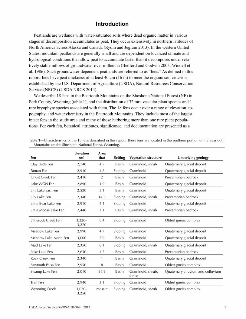
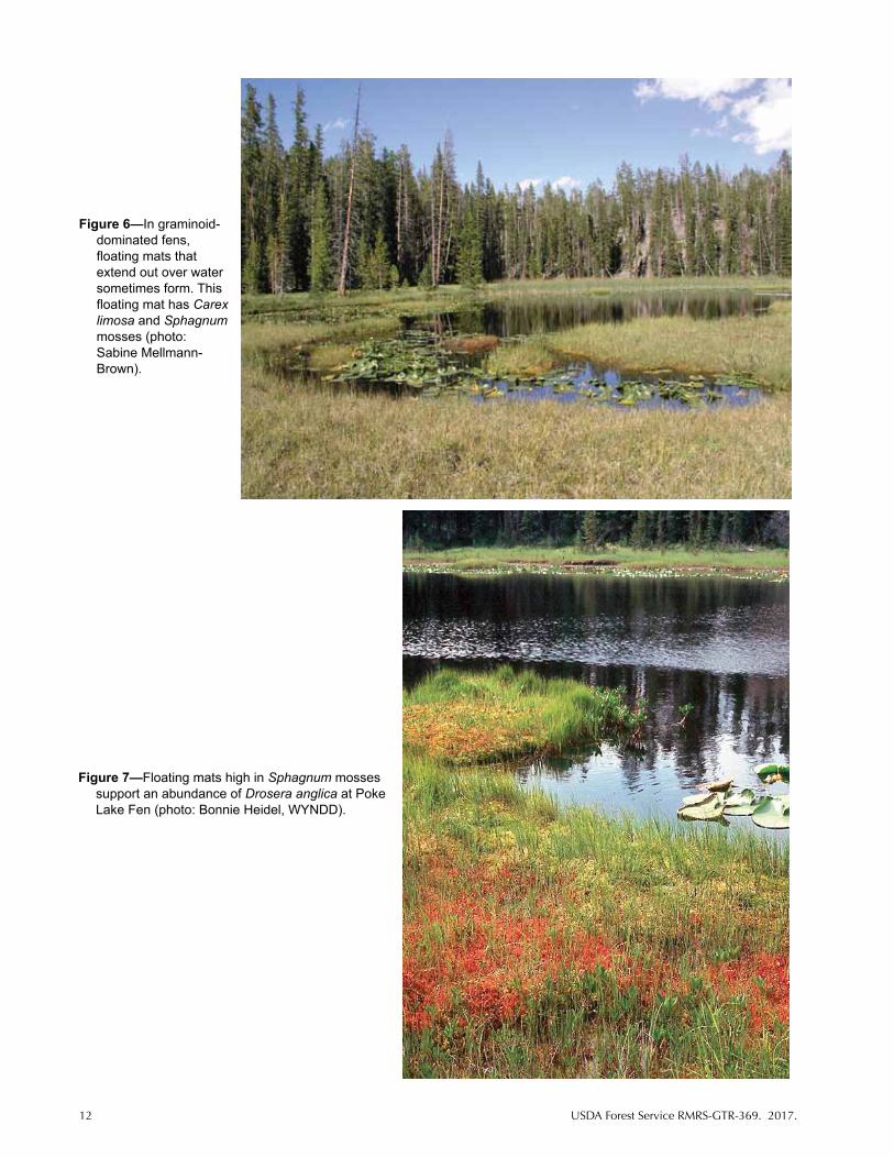
Peat characteristics vary in graminoid-dominated fens, and sometimes contribute to micro-habitats for rare plants that are often discernible on aerial imagery (Heidel and Rodemaker 2008). For example, floating mats are composed of peat derived from graminoid vegetation and may be dominated by Carex limosa, C. simulata, C. lasiocarpa, and Menyanthes trifo-liata with or without solid mats of Sphagnum mosses (figs. 6 and 7). The mats form around open water and are suspended over the water column. Most floating mats occur in shallow ba-sins, but a few border deep lake basins. Patterned fens are composed of parallel mound-swale series in sloping settings, oriented perpendicular to the slope, and can be discerned on aerial imagery. The patterning results from geomorphic peat formation processes, forming “stripes” with narrow, raised, elongate hummocks of moss and graminoid vegetation, separated by shallow, narrow depressional swales (Rydin and Jeglum 2013) (figs. 8 and 9). The peat thick-ness and underlying conditions may differ between the mounds and the swales (figs. 10 and 11), and the swales may or may not be inundated for part or all of the growing season. The mounds have a prevalence of C. scopulorum and the moss Aulacomnium palustre. Common associated species include Packera subnuda, Sedum rhodanthum, Symphyotrichum foliaceum var. apricum, and Polygonum bistortoides. The swales may have standing water with aquatic vegetation, emergent cover, or merely shorter, sparser cover of C. scopulorum and Caltha lep-tosepala on exposed peat with little moss cover.
Aquatic Floating and Submerged Vegetation
Small pools and ponds of shallow water support floating and submerged vegetation within fens or bordering fen habitat. Many such open-water features are locally dominated by Nuphar polysepala floating on the surface. Small, shallow pools are often dominated by Sparganium angustifolium, Callitriche species, and brown mosses (e.g., Drepanocladus
12 USDA Forest Service RMRS-GTR-369. 2017.
Figure 6—In graminoid-dominated fens, floating mats that extend out over water sometimes form. This floating mat has Carex limosa and Sphagnum mosses (photo: Sabine Mellmann-Brown).
Figure 7—Floating mats high in Sphagnum mosses support an abundance of Drosera anglica at Poke Lake Fen (photo: Bonnie Heidel, WYNDD).

USDA Forest Service RMRS-GTR-369. 2017. 13
Figure 8—Graminoid-dominated fens sometimes have microtopography of parallel linear mounds and intervening swales. The swales may have standing water or peat exposed at the surface (photo: Bonnie Heidel, WYNDD).
Figure 9—Mounds and exposed swales are both dominated by Carex scopulorum at Little Bear Lake Fen. The mounds have higher vascular plant cover, higher moss cover, and higher species diversity compared to swales (photo: Bonnie Heidel, WYNDD).

14 USDA Forest Service RMRS-GTR-369. 2017.
Figure 10—A soil core collected from a mound showed evidence of oxidized iron in the mineral portion at the base (left side of photo), indicating fluctuating water table and seasonal aerobic conditions (photo: Bonnie Heidel, WYNDD).
Figure 11—A soil core collected from a swale directly adjoining the mound in figure 10 showed no evidence of oxidized iron in the mineral portion at the base, suggesting underlying differences over short distances (photo: Bonnie Heidel, WYNDD).
aduncus). Chara species are macroscopic green algae and have been observed in alkaline Beartooth fens. They grow profusely in alkaline shallow pools and in littoral waters with precipitated carbonates, or marl (Hutchinson 1975).
Environmental Characteristics
Geology and Soils
Beartooth fens occur in basins or on slopes, usually separate but sometimes present within a single wetland complex. Basin (topogenous) fens occupy peat-filled depressions or depressions that are partially filled by peat around open water. Sloping (soligenous) fens occur at gently sloping valley margins, the base of alluvial fans, and other headwater settings where groundwater discharges near the surface. Both basin and slope fens are also found in Yellowstone National Park (Lemly and Cooper 2011). Basin fens appear to be more numer- ous than sloping fens in the Beartooth Mountains based on field surveys to date (71 of 105 fens, or 68 percent; Heidel and Rodemaker 2008). Underlying geology was determined for each site by using Love and Christiansen (1985), as represented in digital form. Field notes were taken on any rock outcrops that directly adjoined fens.
Fens must have a peat thickness of at least 40 cm within the upper 80 cm (31 in) of the soil to meet one of the criteria for designation as an organic soil established by the USDA NRCS. (Study area fens had a contiguous peat thickness of at least 40 cm thickness from the surface downward, but please see USDA NRCS 2014 for an explanation of additional potential criteria for soil properties such as clay content and depth to lithic contact). Peat thickness was measured by coring surface peat with an Oakfield or McAuley auger. The augers could sample only to 90 cm, so total peat thickness was not measured in most fens (table 2). A cen- tral location was selected for coring to obtain the deepest cores possible. In fens with more than one dominant vegetation type, multiple cores were taken (i.e., in forest-, shrub-, and graminoid-dominated portions of fens). A 40-cm minimum peat thickness was used to define fens in early Beartooth fen studies (Heidel and Laursen 2003b; Mellmann-Brown 2004) and extensive inventories from 2004 through 2006 (Heidel and Rodemaker 2008). In later work,

USDA Forest Service RMRS-GTR-369. 2017. 15
Tabl
e 2—
Cha
ract
eris
tics
of p
eat i
n B
eart
ooth
Mou
ntai
n fe
ns.a
Fen
Peat
thi
ckne
ssb
(cm
)
Dep
th t
o w
ater
tab
le
(cm
)Pe
at p
Hc
Peat
co
nduc
tivit
y (µ
S/cm
)C
a²+
(mg/
L)M
g²+
(mg/
L)
Na+
(m
g/L)
Stan
ding
w
ater
pH
Stan
ding
wat
er
cond
uctiv
ity
(µS/
cm)
Cla
y B
utte
Fen
>
900
6.2–
7.1
180–
320
27–5
33.
6–6.
30.
9–1.
16.
9–7.
614
0–26
0
Fant
an F
en>
90–d
––
––
––
–
Gho
st C
reek
Fen
>90
2–11
5.6–
5.7
67–7
84.
9–5.
32.
0–2.
33.
3–4.
06.
648
Lake
WG
N F
en>
90–
––
––
––
–
Lily
Lak
e Ea
st F
en
>90
0–1
4.3–
5.0d
e ,5.
3-6.
050
–400
e
54–6
03.
9–7.
21.
5–2.
62.
1–2.
96.
427
Lily
Lak
e Fe
n >
900–
56.
391
–180
11–2
82.
6–5.
23.
0–3.
696
–250
Littl
e B
ear
Lake
Fen
>
900–
105.
5–5.
714
–73
1.2–
3.6
0.3–
1.0
1.0–
5.0
6.1
18
Littl
e M
oose
Lak
e Fe
n>
90–
4.9–
5.5e
110–
360e
––
––
–
Littl
eroc
k C
reek
Fen
19–3
51
5.9
191
0.3
1.4
6.6
11
Mea
dow
Lak
e Fe
n >
900–
155.
1–5.
613
–71
1.4–
5.5
0.2–
0.7
0.8–
3.8
6.7
18
Mea
dow
Lak
e N
orth
Fen
>90
45.
634
2.4
0.3
1.6
6.1
17
Mud
Lak
e Fe
n >
900
6.9
270
438.
73.
67.
928
0
Poke
Lak
e Fe
n>
90–
––
––
––
–
Roc
k C
reek
Fen
>
90–
––
––
––
–
Saw
toot
h Pa
lsa
Fen
Est.
310–
460f
––
––
––
––
Swam
p La
ke F
en6,
10g
0–10
7.5–
7.6
530–
770
58–8
530
–49
6–11
7.3–
8.4
400–
520
Trai
l Fen
>
90–
––
––
––
–
Wyo
min
g C
reek
46h
05.
243
2.5
0.6
25.
714
a Pe
at th
ickn
ess
was
mea
sure
d us
ing
auge
rs. D
epth
to w
ater
tabl
e, p
H o
f soi
l wat
er, a
nd c
once
ntra
tions
of C
a2+
, Mg2
+, a
nd N
a+ o
f soi
l wat
er w
ere
mea
sure
d fr
om p
eat c
ore
hole
s in
Bea
rtoo
th M
ount
ain
fens
; pH
and
con
duct
ivity
wer
e al
so m
easu
red
in a
djac
ent s
tand
ing
wat
er (p
ool,
pond
, or
stre
am).
b H
eide
l and
Rod
emak
er (2
008)
.c
pH a
nd a
ll ot
her
wat
er c
hem
istr
y da
ta a
re fr
om H
eide
l (20
09) u
nles
s ot
herw
ise
stat
ed.
d “–
” in
dica
tes
that
dat
a ar
e no
t ava
ilabl
e.
e H
eide
l and
Lau
rsen
(200
3a).
f Pie
rce
(196
1).
g St
ephe
n Ja
ckso
n, b
otan
y pr
ofes
sor/
paly
nolo
gist
, Bot
any
Dep
artm
ent,
Uni
vers
ity o
f Wyo
min
g, L
aram
ie, W
yom
ing,
200
7, p
erso
nal c
omm
unic
atio
n.h
John
son
and
Bill
ings
(196
2).

16 USDA Forest Service RMRS-GTR-369. 2017.
however, two alpine sites with peat thickness ranging from 20 to 40 cm (8 to 16 in) were also included. All cores documented continuous peat from the surface downward. Some peat cores were suspended above the water column (floating) and others were continuous down to mineral soil (anchored).
Hydrology
Fens are supported by groundwater, which can originate from multiple sources. Hydrology information for Beartooth fens is limited to records of the locations of source water inlets, where present, and outlet streams. There are both basin and sloping fens at headwater posi-tions that have no inlets.
Water Chemistry
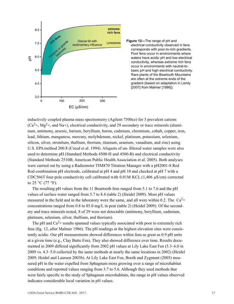
Peatland water chemistry can have a major influence on the distribution of plant species and has been used as a basis for fen classification (Rydin and Jeglum 2013). Early European fen classifications were based on pH values (Sjörs 1948), then expanded to include electrical conductivity, base richness, and concentrations of major cations, particularly calcium (Ca2+), magnesium (Mg2+), and sodium (Na+) (Rydin and Jeglum 2013). Using this approach, fens are classified along a continuum from poor (low pH, electrical conductivity, and ionic con-centrations) to extremely rich (highest pH, electrical conductivity, and ionic concentrations) (fig. 12). Although developed for more extensive peatlands in boreal regions, the poor-to-rich classification has been applied to mountain fens in the western United States (Bursik 1990; Chadde et al. 1998; Cooper and Andrus 1994; Lesica 1986; Weddell 2005). Water chemistry was sampled in Beartooth fens to better characterize environmental conditions and examine the influence of water chemistry on the distribution of rare plant species.
At 13 Beartooth fens, water chemistry was sampled in 2009 over a range of elevation, parent material, and settings. These fens were selected from the 105 fens identified previ-ously (Heidel and Rodemaker 2008), and 11 are described in this report (table 2). At each of the 13 fens, pH was measured and water samples were collected in a central location within areas dominated by forest, shrub, or graminoid vegetation, resulting in multiple measure-ments for some fens. For the pH readings, first a 15-cm (6-in) peat core at or below the water table was removed with an auger, and water was allowed to refill the hole. Next the pH probe was immersed in the hole to take pH readings. Water samples were then collected from the hole. At sites with patterned microtopography, the peat pH of both mounds and swales were measured, usually within 1 meter of one another. A water sample was also collected from the nearest source of surface water. Surface water samples were collected in shallow, open-water pools surrounded by peat. If there was no open water surrounded by peat, then surface water samples were collected from adjoining lakes or streams. Measurements of pH were taken using an Oakton® Instruments pH meter, calibrated each morning prior to measurements by using pH 4, 7, and 10 standards. Measurements and water samples were collected from July 21 through July 23, 2009.
Water samples were packed with dry ice and shipped overnight to the Wyoming Department of Agriculture, Analytical Services Laboratory in Laramie, Wyoming. Upon receipt, water samples were promptly filtered through 0.45-μ hydrophilic polytetrafluoro-ethylene syringe filters to remove suspended material, acidified to 1 percent v/v with both trace metal-grade nitric and hydrochloric acid, and analyzed by using collision-reaction cell
USDA Forest Service RMRS-GTR-369. 2017. 17
Figure 12—The range of pH and electrical conductivity observed in fens corresponds with poor-to-rich gradients. Poor fens occur in environments where waters have acidic pH and low electrical conductivity, whereas extreme rich fens occur in environments with neutral-to-basic pH and high electrical conductivity. Rare plants of the Beartooth Mountains are often at the extreme ends of the gradient (based on adaptation in Lemly [2007] from Malmer [1986]).
inductively coupled plasma mass spectrometry (Agilent 7500ce) for 3 prevalent cations (Ca2+, Mg2+, and Na+), electrical conductivity, and 29 secondary or trace minerals (alumi-num, antimony, arsenic, barium, beryllium, boron, cadmium, chromium, cobalt, copper, iron, lead, lithium, manganese, mercury, molybdenum, nickel, platinum, potassium, selenium, silicon, silver, strontium, thallium, thorium, titanium, uranium, vanadium, and zinc) using U.S. EPA method 200.8 (Creed et al. 1994). Aliquots of un- filtered water samples were also used to determine pH (Standard Methods 4500-H and 4500-B) and electrical conductivity (Standard Methods 2510B; American Public Health Association et al. 2005). Both analyses were carried out by using a Radiometer TIM870 Titration Manager with a pH2001-8 Red Rod combination pH electrode, calibrated at pH 4 and pH 10 and checked at pH 7 with a CDC566T four-pole conductivity cell calibrated with 0.01M KCL (1,406 μS/cm) corrected to 25 °C (77 °F).
The resulting pH values from the 11 Beartooth fens ranged from 5.1 to 7.6 and the pH values of surface water ranged from 5.7 to 8.4 (table 2) (Heidel 2009). Most pH values measured in the field and in the laboratory were the same, and all were within 0.2. The Ca2+ concentrations ranged from 0.8 to 85.0 mg/L in peat (table 2) (Heidel 2009). Of the second-ary and trace minerals tested, 8 of 29 were not detectable (antimony, beryllium, cadmium, platinum, selenium, silver, thallium, and thorium).
The pH and Ca2+ results spanned values typically associated with poor to extremely rich fens (fig. 12, after Malmer 1986). The pH readings at the highest elevation sites were consis-tently acidic. Our pH measurements showed differences within fens as great as 0.9 pH units at a given time (e.g., Clay Butte Fen). They also showed difference over time. Results docu-mented in 2009 differed significantly from 2002 pH values at Lily Lake East Fen (5.3–6.0 in 2009 vs. 4.3–5.0 collected by the same methods at nearly the same locations in 2002) (Heidel 2009; Heidel and Laursen 2003b). At Lily Lake East Fen, Booth and Zygmunt (2005) mea-sured pH in the water expelled from Sphagnum moss growing over a range of microhabitat conditions and reported values ranging from 3.7 to 5.6. Although they used methods that were fairly specific to the study of Sphagnum microhabitats, the range in pH values observed indicates considerable local variation in pH values.

18 USDA Forest Service RMRS-GTR-369. 2017.
The range of pH values in Beartooth fens may be explained by their association with both base-rich and base-poor bedrock formations, as well as Quaternary deposits from different mixtures of the formations in alluvium, colluvium, and glacial till. Lemly and Cooper (2011) analyzed multiscale factors controlling vegetation and plant species distribution in peatland-sthroughout Yellowstone National Park and determined that the primary gradient driving plant species distribution is site-level water chemistry. They described fens of Yellowstone National Park within the context of the poor-to-rich gradient except for the geothermally influenced peatlands. However, variations in pH values within individual fens, over time, and with elevation were not addressed.
Disturbance
Signs of disturbance were noted when the extensive fen inventory was conducted from 2005 through 2007 (Heidel and Rodemaker 2008). Anthropogenic disturbances include graz-ing by cattle (Bos spp.), horses (Equus caballus), or sheep (Ovis aries); roads and ditches; and presence of noxious weeds. Natural disturbances included fire, and concentrated wildlife use by native ungulates and beavers (Castor canadensis).
Description of 18 Beartooth Fens
This report describes 18 fens that occur across a range of elevation, lithology, geomorphic settings, vegetation types, and water chemistry conditions in the Beartooth Mountains (table 1), including many of the largest fens with rare plant populations. We describe the 3 earlieststudied fens (Swamp Lake Fen, Sawtooth Palsa Fen, Wyoming Creek), and 15 additional fens.
Swamp Lake Fen is the largest of all fens documented in the Beartooth Mountains to date. It is profiled first because it is often a basis for comparing other Beartooth fens. Descriptions of the other 17 fens are presented alphabetically by assigned place names that reflect the near-est local named landmark on U.S. Geological Survey 7.5-minute topographic maps. Each fen is delineated on an aerial photograph.
Swamp Lake Fen
Location: Swamp Lake Fen is located at the base of the Cathedral Cliffs along the Clarks Fork Valley, on the south side of Chief Joseph Highway (State Highway 296) about 3.2 km (2 mi) east of the Crandall Ranger Station and about 54.7 km (34 mi) northwest of Cody. It has public access from County Road 128, which leads to a public boat launch at the K-Bar Z Ranch at the west end (figs. 13 and 14), closed off above the fen between east and west ends.
Area: 98.9 ha (244.4 ac)
Elevation: 2,010 m (6,600 ft)
Environment: Swamp Lake Fen is in a large basin with slightly sloping forested fen on the southern perimeter. It is in the Clarks Fork Valley, underlain by Quaternary alluvium and colluvium, and surrounded by collapsed glacial moraine topography derived from the dolomitic Cathedral Cliffs, and Precambrian outcrops (figs. 15 and 16). The central open water is surrounded by marsh and fen vegetation. There are two tributaries, Oliver Gulch and Corral Creek, and one outlet. The single peat thickness measurement was reported at

USDA Forest Service RMRS-GTR-369. 2017. 19
Figure 13—Topographic map of Swamp Lake Fen, outlined in red.
Figure 14—Swamp Lake Fen in a basin setting on a color infrared aerial image.

20 USDA Forest Service RMRS-GTR-369. 2017.
6.1 m (20 ft; Stephen Jackson, botany professor/palynologist at University of Wyoming, Botany Department, personal communication, 2007). Peat pH measured in graminoid- and forest-dominated portions of the fen ranged from 7.5 to 7.6 (table 2) (Heidel 2009). Swamp Lake Fen had the highest levels of major cations (Ca2+, Mg2+, and Na+) in peat samples (table 2) (Heidel 2009), consistent with an extreme rich fen.
Vegetation: Eight different plant communities were described at Swamp Lake Fen by Fertig and Jones (1992). The southern fen margin is lined by Picea species, including relatively pure P. glauca and hybrids with P. engelmannii (Haselhorst and Buerkle 2013). Toward the interior of the fen, the trees are stunted (Fertig and Jones 1992). Graminoid-dominated portions of the fen have floating mats of Carex simulata, margins with C. utriculata, and an area with Triglochin maritima and Eleocharis quinqueflora (figs. 17 and 18), which are associated with precipitated carbonates, or marl. The marl has mound and swale patterns that are present on the east end. The basin is filled by a mosaic of emergent vegetation in standing water including Schoenoplectus acutus and Typha latifolia. A band of Alnus incana was also noted at the west end.
Figure 16—Overview of Swamp Lake Fen in 2007 (photo: Bonnie Heidel, WYNDD).
Figure 15—Overview of Swamp Lake Fen in 1987 (photo: Hollis Marriott, WYNDD).

USDA Forest Service RMRS-GTR-369. 2017. 21
Figure 17—East end of Swamp Lake Fen in 1992 (photo: George Jones, WYNDD).
Figure 18—East end of Swamp Lake Fen in 2007 (photo: Bonnie Heidel, WYNDD).
Rare Species: The number of Wyoming Plant Species of Concern found at Swamp Lake Fen was originally reported at 28 species (Fertig and Jones 1992). All but one of these species, Botrychium virginianum, are directly associated with fen habitat. Since 1992, two more Species of Concern have been found, Packera indecora and Utricularia minor. Ten of the species were later found to be more common than previously known and were removed from the Species of Concern list (Heidel 2007). The 19 Wyoming Species of Concern found at Swamp Lake Fen are Amerorchis rotundifolia, Arctostaphylos rubra, Botrychium virginianum, Carex concinna, C. diandra, C. leptalea, C. limosa, C. livida, C. microglochin, Eriophorum viridicarinatum, Kobresia simpliciuscula, Muhlenbergia glomerata, Packera indecora, Primula egaliksensis, Salix candida, S. myrtillifolia,

22 USDA Forest Service RMRS-GTR-369. 2017.
Sparganium natans, Trichophorum pumilum, and Utricularia minor. Earliest botanical collections were made by Evert, Dorn, Hartman, and Lichvar (Evert 1984; Evert et al. 1986) and systematic plant surveys were conducted by Fertig (Fertig and Jones 1992).
Significance: Swamp Lake Fen is the largest fen in the study area (fig. 19), is one of the more alkaline fens in the study area, and supports the highest concentration of Plant Species of Concern among fens in Wyoming. It occurs at the lowest elevation of profiled sites and is one of the few in the study area that includes forested fen vegetation. Two of the rare plant species, Arctostaphylos rubra and Salix myrtillifolia, occur nowhere else in Wyoming. Arctostaphylos rubra is disjunct from boreal latitudes and the population at Swamp Lake Fen is the only known location in the conterminous United States. Salix myrtillifolia is disjunct from boreal latitudes in the Rocky Mountains, is not known from Montana, and also occurs in Colorado. Swamp Lake Fen was the first place of discovery for many of the rare plant species of Beartooth fens (table 3) and has a well-documented, diverse flora (Appendix). In 1987, the area was designated as Swamp Lake Special Botanical Area (Evert 1984; Johnston 1987; USDA Forest Service 2015a; Wolf 1986).
Disturbances: State Highway 296 (Chief Joseph Highway) was rebuilt across the Swamp Lake Fen outlet in the 1970s. The 1988 Clover Mist crown fire burned the slopes above Swamp Lake Fen and salvage logging was implemented after the fire. Runoff gullies formed (fig. 20) and erosion debris fans were noted in 1989 and 1992 (Fertig and Jones
Figure 19—Swamp Lake Fen is the largest fen in the study area with a length of more than 3 km, (photo: Bonnie Heidel, WYNDD).

USDA Forest Service RMRS-GTR-369. 2017. 23
1992). Private lands upstream from Swamp Lake Fen have been drained. Water level fluctuations are indicated by high-water marks in hydrologically connected ponds. Current range management does not allow horses to use the wetland. Swamp Lake Fen was also the site of a fox (Vulpes vulpes) farm, mink (Mustella vison) ranch, and gravel pit in the past (John Mumma, Shoshone National Forest Supervisor, personal communication, ca. 1986). Wildlife, most notably elk (Cervus elaphus) and moose (Alces americanus), use Swamp Lake Fen and the surrounding area. Cirsium arvense is a localized invasive species mainly at the wetland margin (Heidel and Laursen 2003b). Astragalus cicer, a nonnative species formerly used in postfire rehabilitation, was widely seeded for stabilization after the 1988 fire and has been observed in fen habitat (Rocky Mountain Herbarium 2016).
Documentation: Evert (1984), Evert et al. (1986), Wolf (1986), Johnston (1987), Fertig and Jones (1992) with updates in, Fertig (1997, 1998), Chadde et al. (1998), Heidel and Laursen (2003b), Heidel and Rodemaker (2008), Heidel (2009), Jones et al. (2011c).
Figure 20—A gully formed directly above Swamp Lake Fen in 1989 after the 1988 fire burned slopes above (photo: George Jones, WYNDD).

24 USDA Forest Service RMRS-GTR-369. 2017.
Figure 21—Topographic map of Clay Butte Fen, outlined in red.
Figure 22—Clay Butte Fen, outlined in red, in a basin setting on a color infrared aerial image.

USDA Forest Service RMRS-GTR-369. 2017. 25
Clay Butte Fen
Location: Clay Butte Fen is located at the base of Clay Butte, on the south side of the Beartooth Highway (U.S. Highway 212), almost across from the sign for the turnoff to the Clay Butte fire tower (figs. 21–23).
Area: 4.7 ha (11.6 ac)
Elevation: 2,740 m (8,980 ft)
Environment: Clay Butte Fen is a basin fen underlain by Quaternary glacial deposits (Love and Christiansen 1985). Peat thickness exceeded the 90-cm length of the auger used to core the peat. The peat pH values ranged from 6.2 in a floating mat to 7.1 in a tall shrub- dominated portion of the fen (table 2) (Heidel 2009). Clay Butte Fen has an outlet in the southwestern corner that drains into an unnamed tributary of Beartooth Creek.
Vegetation: Graminoid vegetation is prevalent and is interrupted by swales and pools that have floating mats in some places (fig. 24). The graminoid-dominated portion of the fen has Carex aquatilis and Carex livida (Mellmann-Brown 2004). The fen perimeter has low to tall shrub vegetation on three sides. The low shrub communities have Salix planifolia with Carex aquatilis (Heidel and Laursen 2003b; Mellmann-Brown 2004; Walford et al. 2001); the tall shrub community has Salix eastwoodiae and S. farrie with Carex utriculata (Mellmann-Brown 2004; Walford et al. 2001). The floating mats have Carex
Figure 23—Clay Butte Fen is one of three fens addressed in this report that lie within the Beartooth Highway corridor (U.S. Highway 212, in foreground) (photo: Bonnie Heidel, WYNDD).

26 USDA Forest Service RMRS-GTR-369. 2017.
limosa, with Eleocharis quinqueflora. The pools have submerged and floating vegetation. Pools in the southeast corner have Sparganium angustifolium, those at the northwest corner have Nuphar polysepala, and pools at the south end are filled with bicarbonate- accumulating Chara species (Hutchinson 1975). The fen is surrounded by subalpine forest except on the north margin, where it borders the highway.
Rare Species: Six Wyoming Plant Species of Concern are present: Carex diandra, C. leptalea, C. limosa, C. livida, Eriophorum gracile, and Utricularia minor, most of which were first reported by Mellmann-Brown (ERO Resources Corporation 1999b, 2000; Mellmann-Brown 2004).
Significance: Clay Butte Fen is the most alkaline of the fens at higher elevations in the study area, likely due to calcium carbonate-rich parent material. It has many rare species—some near their upper elevation limits—and an array of pools. Some of its rare species were mentioned in an evaluation of Beartooth Butte as a potential Research Natural Area (Jones and Fertig 1999a), but it lies outside of currently proposed boundaries (USDA Forest Service 2015a).
Disturbances: The fen adjoins the Beartooth Highway (U.S. Highway 212). Current plans are to widen the highway by expanding the roadbed away from the fen. The Beartooth Highway is designated a National Scenic Highway and all of the fen falls within the travel corridor management zone (USDA Forest Service 2015a).
Documentation: ERO Resources Corporation (1999b), Walford et al. (2001), Heidel and Laursen (2003b), Mellmann-Brown (2004), Heidel and Rodemaker (2008), Heidel (2009).
Figure 24—Overview of Clay Butte Fen and an array of pools and vegetation zones (photo: Bonnie Heidel, WYNDD).

USDA Forest Service RMRS-GTR-369. 2017. 27
Figure 25—Topographic map of Fantan Fen (at left) and Lake WGN Fen.
Fantan Fen
Location: Fantan Fen is located 1.1 km (0.7 mi) east-southeast of Fantan Lake. It is accessible from the Beartooth Highway (U.S. Highway 212) via Forest Service Road 149 and by four-wheel-drive (4WD) vehicle or on foot (figs. 25 and 26).
Area: 4.8 ha (11.9 ac)
Elevation: 2,910 m (9,560 ft)
Environment: Fantan Fen is a sloping fen underlain by Quaternary glacial deposits (Love and Christiansen 1985). The fen appears to straddle a ridge that is a hydrological divide draining in opposite directions into Paradise Lake and Chain Lakes, both of which drain into Canyon Creek (figs. 25, 26, and 27). A cliff rises abruptly to the north. Peat thickness exceeded the 90-cm length of the auger.
Vegetation: Carex scopulorum is prevalent on linear peat mounds with high cover of the moss Aulacomnium palustre (figs. 27 and 28). Between the mounds on swale flats is sparse cover of Carex scopulorum growing with little or no moss cover. A few swales also have Eriophorum angustifolium (fig. 29). Pools are present on the steeper gradient, behind mounds covered by Carex vesicaria. The fen is surrounded by dry, open grassland to the east, forest to the west, and a rugged outcrop to the north.
Rare Species: None are known to date.

28 USDA Forest Service RMRS-GTR-369. 2017.
Figure 27—Peat mound and intervening swale patterns at Fantan Fen are parallel to slopes (photo: Bonnie Heidel, WYNDD).
Figure 26—Fantan Fen in a sloping setting on a color infrared aerial image.

USDA Forest Service RMRS-GTR-369. 2017. 29
Figure 28—Fantan Fen peat mound and swale patterns are subtle at eye level (photo: Bonnie Heidel, WYNDD).
Figure 29—Tall cottongrass (Eriophorum angustifolium) in Fantan Fen swales (photo: Bonnie Heidel, WYNDD).

30 USDA Forest Service RMRS-GTR-369. 2017.
Significance: Fantan Fen occupies an unlikely setting for a fen, straddling a ridge.
Disturbances: None have been identified. A 4WD road is located downslope of the fen, but no offroad use has been noted. Hummocks at the southeastern borders may reflect past grazing. The fen lies in lands managed for backcountry nonmotorized recreation in the summer and motorized winter recreation (USDA Forest Service 2015a).
Documentation: Heidel and Rodemaker (2008).
Ghost Creek Fen
Location: Ghost Creek Fen is located at the headwaters of Ghost Creek, about 1.1 km (0.7 mi) south of the Beartooth Highway (U.S. Highway 212). It is accessible by Forest Service Road 118 and on foot (figs. 30 and 31).
Area: 2.0 ha (4.9 ac)
Elevation: 2,410 m (7,900 ft)
Environment: Ghost Creek Fen is a basin fen underlain by Precambrian bedrock (Love and Christiansen 1985). It lies south of a steep outcrop and fault line (Love and Christiansen 1985) (fig. 32). In this graminoid-dominated fen, pH in peat was measured at 5.6 in a
Figure 30—Topographic map of Ghost Creek Fen, outlined in red.

USDA Forest Service RMRS-GTR-369. 2017. 31
floating mat and 5.7 in adjoining peat (table 2) (Heidel 2009). Peat thickness exceeded the 90-cm length of the auger. The fen is located at the headwaters of Ghost Creek.
Vegetation: The graminoid vegetation of Ghost Creek Fen has Carex interior and C. buxbaumii, with C. lasiocarpa abundant in standing water. Floating mats adjoining the open-water pools have Carex limosa and Menyanthes trifoliata, with abundant
Figure 31—Ghost Creek Fen, outlined in red, in a basin setting on a color infrared aerial image.
Figure 32—Overview of Ghost Creek Fen and central floating mat zones with small pools (photo: Bonnie Heidel, WYNDD).

32 USDA Forest Service RMRS-GTR-369. 2017.
Drosera anglica in some places. Along the perimeter are broad bands of Calamagrostis canadensis. Vegetation around the outlet is tall shrub grading into forest. The fen is surrounded by dry forests and rugged outcrop knolls to the north and south.
Rare Species: Eight Wyoming Plant Species of Concern are present: Carex diandra, C. leptalea, C. limosa, C. microglochin, Drosera anglica, Eriophorum chamissonis, E. gracile, and Utricularia minor, most of which were first collected by Mellmann-Brown in 2004 (table 3). In addition, the Columbia spotted frog (Rana luteiventris), a U.S. Forest Service sensitive species (USDA Forest Service 2015b) was photographed incidental to plant surveys at Ghost Creek Fen.
Significance: Ghost Creek Fen is significant in having a high concentration of Species of Concern for its size, including combinations of species not reported elsewhere, notably Drosera anglica with Eriophorum chamissonis and E. gracile.
Disturbances: There are no signs of direct disturbance. The floating mat appeared to be lower and less buoyant in drought years. The discrete ring of Calamagrostis canadensis around much of the outer perimeter may reflect fluctuations in water level and susceptibility of the margins to shifts from anaerobic to aerobic conditions. Fire scars have been observed on tree stumps bordering Ghost Creek Fen. It lies in lands managed for motorized backcountry recreation and forest restoration (USDA Forest Service 2015a).
Documentation: Heidel and Rodemaker (2008), Heidel (2009), Elliott (2014).
Lake WGN Fen
Location: Lake WGN Fen is located 1.1 km (0.7 mi) northwest of Sawtooth Lake, at the head of a small tributary draining into Sawtooth Lake. It is identified as Lake WGN on topographic maps. It is accessible from the Beartooth Highway (U.S. Highway 212) via Forest Service Road 149 and by 4WD or on foot (figs. 25 and 33).
Figure 33—Lake WGN Fen, outlined in red, in a basin setting on a color infrared aerial image.

USDA Forest Service RMRS-GTR-369. 2017. 33
Area: 1.9 ha (4.7 ac)
Elevation: 2,890 m (9,480 ft)
Environment: Lake WGN Fen is a basin fen underlain by Quaternary glacial deposits (Love and Christiansen 1985). It is located at the head of a small, open valley that drains into Sawtooth Lake. Spring-fed rivulets enter on three sides (fig. 34). The incised outlet has downcut to underlying mineral layers (fig. 35). Peat thickness exceeded the 90-cm length of the auger.
Vegetation: Lake WGN Fen is dominated by graminoids, and has a central floating mat of Carex limosa. Both mounds and swales are dominated by Carex scopulorum, with the moss Aulacomnium palustre also occurring on the mounds. Subalpine forests of Pinus albicaulis and Picea engelmannii are on the adjacent hillslopes. A corridor of wet and dry meadows extends down the valley between the fen and Sawtooth Lake.
Rare Species: Two Wyoming Plant Species of Concern, Carex limosa and Eriophorum chamissonis, occur at Lake WGN Fen (Heidel and Rodemaker 2008).
Significance: Lake WGN Fen has a surface that resembles a saucer, flat in the center and sloping at the margins. Conspicuous springs are present at the perimeters (fig. 34), whereas most of the Beartooth fens visited do not have pronounced springs discharging at the surface.
Disturbances: No signs of disturbance were noted. However, this fen has an incised stream channel outlet, where the floating mat vegetation is 0.5 m (20 in) higher than
Figure 34—Lake WGN Fen has pronounced springs at the perimeter. This view is from the upper end looking inward (photo: Bonnie Heidel, WYNDD).

34 USDA Forest Service RMRS-GTR-369. 2017.
the adjoining stream channel (fig. 35). It lies in lands managed for back-country nonmotorized recreation in the summer and motorized winter recreation (USDA Forest Service 2015a).
Documentation: Heidel and Rodemaker (2008), Heidel (2009).
Lily Lake East Fen
Location: Lily Lake East Fen is about 1.1 km (0.7 mi) east-northeast of Lily Lake. It was referred to as “Lily Lake Fen” by Heidel and Laursen (2003b) before the recognition of a separate fen that directly adjoins Lily Lake, and was called “East Lilypad Peatland” by Booth and Zygmunt (2005). It is accessible from the Lily Lake Campground on foot (figs. 36 and 37).
Area: 5.1 ha (12.6 ac)
Elevation: 2,524 m (8,280 ft)
Environment: Lily Lake East Fen is a basin fen that lies along a fault line and is underlain by Precambrian bedrock (Love and Christiansen 1985). Outcrop hills rise to the north. The peat pH readings documented in 2008 were 5.3 (Sphagnum mat) to 6.0 (graminoid-dominated portion of the fen; table 2) (Heidel 2009). Measurements taken at the same locations in 2002 were 4.3 (Sphagnum mat) and 5.0 (graminoid vegetation) (Heidel and Laursen 2003b). In addition, pH measurements of the water retained by Sphagnum peat in
Figure 35—The outlet of Lake WGN Fen is eroded to the mineral layer, though there are saturated floating mats directly above the incised channel. This view is from the outlet at the lower end looking inward (photo: Bonnie Heidel, WYNDD).

USDA Forest Service RMRS-GTR-369. 2017. 35
Figure 36—Topographic map of Lily Lake Fen (north end of Lily Lake), Lily Lake East Fen, and Mud Lake Fen, outlined in red.
the full range of local microhabitats were collected in 2002 (Booth and Zygmunt 2005), reported at 3.7 to 5.6.
Vegetation: Graminoid vegetation surrounds two open-water pools that are bordered by well-developed floating Sphagnum mats (fig. 38). Carex lasiocarpa encircles pools of standing water, Carex limosa and Menyanthes trifoliata are mixed into the floating Sphagnum mats, and Carex vesicaria is on adjoining peat. There is also an aquatic community of floating and submerged vegetation. The wet forest border is narrow and has Ledum glandulosum. The surrounding uplands are forested, but the rugged topography supports mainly dry, open woodland, with rock outcrops to the north.
Rare Species: Seven Wyoming Plant Species of Concern are present: Carex diandra, C. leptalea, C. limosa, Drosera anglica, Eriophorum gracile, Sphagnum angustifolium, and Utricularia minor. Two other species previously reported, Carex buxbaumii and Epilobium palustre var. palustre, are no longer regarded as rare in the State. The rare species were first documented in 1996 by Fertig and Mellmann-Brown (Fertig 1997, 1998; Jones and Fertig 1999b; Jones et al. 2011a). The fen was also visited by two other research teams (Booth and Zygmunt 2005; Heidel and Laursen 2003b), both of whom collected Sphagnum angustifolium. Utricularia minor was recently added (Heidel 3341

36 USDA Forest Service RMRS-GTR-369. 2017.
RM). The collector and the collection number in the Rocky Mountain Herbarium (RM) are provided; see table 3 for more information.
Significance: Lily Lake East Fen has a fairly acidic pH (table 2) and more pH readings over time than other study area fens. It has well-developed floating mats with Sphagnum angustifolium present. It is one of only two fens in the study area where testate amoebae microfossils were used as hydrological proxies for environmental and paleoenvironmental conditions (Booth and Zygmunt 2005).
Disturbances: The fen is located within the Absaroka-Beartooth Wilderness Area, and no signs of disturbance were observed in the vicinity. It is also within the proposed Lake Creek Research Natural Area.
Figure 38—Overview of Lily Lake East Fen with two large pools and floating mats (photo: Scott Laursen, WYNDD).
Figure 37—Lily Lake East Fen in a basin setting on a color infrared aerial image.

USDA Forest Service RMRS-GTR-369. 2017. 37
Documentation: Fertig (1997, 1998), Jones and Fertig (1999b) with updates in Jones et al. (2011a), Heidel and Laursen (2003b), Booth and Zygmunt (2005), Heidel and Rodemaker (2008), Heidel (2009).
Lily Lake Fen
Location: Lily Lake Fen is located on the northwest end of Lily Lake. It is accessible from the Lily Lake Campground by foot (figs. 36 and 39).
Area: 14.2 ha (35.1 ac)
Elevation: 2,340 m (7,680 ft)
Environment: Lily Lake Fen is in a basin, but it has a slight slope down to Lily Lake. It is underlain by Quaternary glacial deposits, and bordered on one side by Precambrian bedrock along a fault line (Love and Christiansen 1985). Lily Lake Fen is a very subtly sloping fen with a series of large pools in the middle (fig. 40). Peat thickness exceeded the 90-cm length of the auger. The pH in peat was measured at 6.3 in both shrub-dominated and graminoid-dominated portions of the fen in July 2008 (table 2) (Heidel 2009).
Vegetation: Three vegetation zones are present from the lower to upper ends of the fen: tall shrubs immediately above the lake, a graminoid-dominated zone mixed with pools, and a low shrub-dominated zone at the upper end. Common species include Salix wolfii, S. boothii, Carex scopulorum, C. limosa, Menyanthes trifoliata, and C. utriculata.
Figure 39—Lily Lake Fen, outlined in red, in a sloping setting with a series of large pools on a color infrared aerial image.

38 USDA Forest Service RMRS-GTR-369. 2017.
Rare Species: Six Wyoming Plant Species of Concern are present: Carex diandra, C. leptalea, C. limosa, Eriophorum gracile, Packera indecora, and Salix candida (Heidel and Rodemaker 2008). In addition, Potamogeton amplifolius and Potamogeton praelongus are submerged in Lily Lake at the shoreline adjoining fen boundaries (Fertig 1998).
Significance: Lily Lake Fen has areas of well-developed shrub habitat. It has among the largest known populations of Carex diandra and Packera indecora. There is one report in the literature of a pollen profile at Lily Lake in the Beartooth Mountains (Whitlock and Bartlein 1993) though the exact location is not given. This fen is much more accessible and apparent from the lake than Lily Lake East Fen, so it seems to be the more likely of sampling sites in the area. But the profile has not been published apart from generalizations made about palynology in the Yellowstone region.
Disturbances: Lily Lake Fen is located close to the Lily Lake Campground, but does not receive recreational use apart from people fishing at the lakeshore. It is within an active grazing allotment, but no cattle trails or other signs were evident. The fen could be affected if lake levels were manipulated. It lies in lands managed for vegetation and landscape patterns influenced not only by natural disturbances but also by prescribed fire, timber harvest, and other silviculture treatments (USDA Forest Service 2015a).
Documentation: Heidel and Rodemaker (2008), Heidel (2009).
Little Bear Lake Fen
Location: Little Bear Lake Fen is located at the southeastern end of Little Bear Lake. It is crossed by the Beartooth Highway (U.S. Highway 212); more than 90 percent of the fen is located on the south side of the highway (figs. 41 and 42).
Area: 4.1 ha (10.3 ac)
Elevation: 2,910 m (9,560 ft)
Environment: Little Bear Lake Fen is a sloping fen underlain by Quaternary glacial deposits (Love and Christiansen 1985). Peat thickness exceeded the 90-cm length of the auger. Peat pH values were measured at 5.5 in a mound and 5.7 in a directly adjoining swale (table 2) (Heidel 2009).
Figure 40—Overview of Lily Lake Fen directly above Lily Lake (left of view) showing portions of the fen dominated by shrubs. (photo: Bonnie Heidel, WYNDD).

USDA Forest Service RMRS-GTR-369. 2017. 39
Figure 41—Topographic map of Little Bear Lake Fen, Meadow Lake Fen and Meadow Lake North Fen (at left), outlined in red.
Figure 42—Little Bear Lake Fen in a sloping setting on a color infrared aerial image.

40 USDA Forest Service RMRS-GTR-369. 2017.
Vegetation: Little Bear Lake Fen has a series of elongate mounds and swales over much of the area (fig. 43). Carex scopulorum is on peat mounds with high cover of the moss Aulacomnium palustre. Between the mounds are swales with much sparser cover of Carex scopulorum and sometimes with Carex saxatilis but with little or no moss cover. Central areas have Carex limosa mixed with C. scopulorum and C. saxatilis. There is a large swale filled with Carex utriculata at the western edge of the fen. A low shrubland of Salix glauca associated with Caltha leptosepala is located at the southern end on mineral soils. Little Bear Fen is surrounded by dry grassland, with open woodland and outcrops scattered on more rugged terrain to the east.
Rare Species: Plant surveys were first conducted by Mellmann-Brown for ERO Resources Corporation (1999b, 2000). Two Wyoming Plant Species of Concern are present: Carex limosa and Sparganium natans (ERO Resources Corporation 1999b, 2000; Mellmann- Brown 2004).
Significance: Little Bear Lake Fen is among the larger fens at this elevation and has very elongate peat mounds and swales.
Disturbances: This is the only major fen in the Beartooth Mountains of Wyoming that is traversed by a highway (U.S. Highway 212). Current plans for widening of the highway call for replacing a portion of the roadbed with a bridge to restore the natural drainage pattern. Water levels were monitored with 6 surface water gauges and 13 wells in Federal Highway Administration-sponsored baseline studies. Eventually, the raised portion of the road through the wetland will be replaced by a bridge, a change that may restore the natural drainage pattern but may also lower current water levels in the southern section of the fen (Mellmann-Brown 2004). The Beartooth Highway is designated as a National Scenic Highway, and all of the fen is located within the travel corridor management zone (USDA Forest Service 2015a).
Documentation: ERO Resources Corporation (1999b, 2000), Mellmann-Brown (2004), Heidel and Rodemaker (2008), Heidel (2009).
Figure 43—Peat mounds and intervening swales add a distinct microtopography to Little Bear Lake Fen (photo: Bonnie Heidel, WYNDD).

USDA Forest Service RMRS-GTR-369. 2017. 41
Little Moose Lake Fen
Location: Little Moose Lake Fen is on the south end of Little Moose Lake. It is accessible via Forest Service Road 130 and by 4WD or on foot (figs. 44 and 45).
Area: 3.1 ha (7.7 ac)
Elevation: 2,440 m (8,000 ft)
Environment: This basin fen is in a lacustrine setting underlain by Precambrian bedrock (Love and Christiansen 1985). Peat thickness exceeded the 90-cm length of the auger. The pH measurements in peat were made in 2002, reporting 4.9 in a Sphagnum mat and 5.5 in the graminoid-dominated portion of the fen (Heidel and Laursen 2003b). In addition, pH measurements of the water retained by Sphagnum peat in the full range of local microhabitats were collected in 2002 (Booth and Zygmunt 2005), reported at 4.3 to 6.1.
Vegetation: The fen vegetation of Little Moose Lake is predominantly graminoid, with well- developed floating mats at the lakeshore and shrubs bordering the uplands. The fen has Carex aquatilis and Carex utriculata (Heidel and Laursen 2003b; Walford et al. 2001). The floating mat has Carex limosa and Menyanthes trifoliata, and perimeter areas have Salix planifolia and Carex aquatilis. The fen is surrounded by conifer forest; dry parkland to the east; rugged, sparsely wooded knolls to the west, and Little Moose Lake to the north.
Figure 44—Topographic map of Little Moose Lake Fen, outlined in red.

42 USDA Forest Service RMRS-GTR-369. 2017.
Rare Species: Six Wyoming Plant Species of Concern are present: Carex diandra, C. leptalea, C. limosa, Drosera anglica, Eriophorum gracile, and Potamogeton praelongus. They were first documented by Fertig and Mellmann-Brown in 1996 (Fertig 1997, 1998). These species are concentrated on the floating mat along the lakeshore. This fen was surveyed again for rare plants (Heidel and Laursen 2003b), when Sphagnum angustifolium was first documented. In 2009 water chemistry was sampled and Utricularia minor, an additional rare plant, was found.
Significance: Little Moose Fen is significant in having a well-developed floating mat in one of the few lakeshore settings. It is one of two fens in the study area where testate amoebae microfossils were used as proxies for environmental and paleoenvironmental conditions (Booth and Zygmunt 2005). The fen also harbors a high concentration of Species of Concern.
Disturbances: The fen was part of a cattle allotment when it was first surveyed (Mills and Fertig 1996b), and livestock trampling was noted in the original surveys. It lies in lands managed for motorized backcountry recreation and forest restoration (USDA Forest Service 2015a).
Documentation: Fertig (1997, 1998), Heidel and Laursen (2003b), Booth and Zygmunt (2005), Heidel and Rodemaker (2008).
Littlerock Creek Fen
Location: Littlerock Creek Fen is located about 0.8 km (0.5 mi) east of Christmas Lake at the head of an unnamed tributary to Littlerock Creek. It is located about 1 km (0.6 mi) southeast of the Beartooth Highway (U.S. Highway 212) and lies directly southwest of Forest Service Trail 623 (figs. 46 and 47).
Figure 45—Little Moose Lake Fen in a basin setting on a color infrared aerial image.

USDA Forest Service RMRS-GTR-369. 2017. 43
Area: 8.4 ha (20.8 ac)
Elevation: 3,220–3,270 m (10,560–10,740 ft)
Environment: Littlerock Creek Fen is a south-facing sloping fen, underlain by Precambrian bedrock mapped as “oldest gneiss complex” (Love and Christiansen 1985). Peat thickness ranged from 19 to 35 cm (7 to 14 in); this fen is one of two alpine fens where the 40-cm-thickness threshold was waived. The fen is dissected by a stream and has diffuse borders grading into seeps and wet and dry meadow. The pH of the peat was measured at 5.9 (table 2) (Heidel 2009). In the middle of the fen are several large isolated mounds of turf more than 50 cm (20 in) in height. Polygons formed by frost action as described by Johnson and Billings (1962) occur along the upper margin. The fen boundary is subtle on the south and east sides (fig. 48). The fen is bordered by rocky ridges on the north and west sides with a semipermanent snowbank to the west (fig. 49).
Vegetation: The vegetation has Carex scopulorum and Salix planifolia (Walford et al. 2001). Sparsely vegetated late snowmelt slopes and flats border the west side. The fen is surrounded by dry, alpine meadow and gravelly ridges.
Rare Species: Two Wyoming Plant Species of Concern are present, Carex nelsonii and Eriophorum callitrix (Fertig 1998). Two other Species of Concern, Carex misandra and Pedicularis oederi, occur mainly along fen margins (Heidel and Rodemaker 2008). In addition, Phippsia algida and Koenigia islandica are present in snowmelt-fed seeps
Figure 46—Topographic map of Littlerock Creek Fen (two red outlines to the south) and Wyoming Creek Complex, outlined in red.

44 USDA Forest Service RMRS-GTR-369. 2017.
bordering the west side of the fen. The latter is an annual throughout its range and the former is regarded as an annual in Colorado (Weber and Wittmann 2012), but a perennial in Wyoming (Dorn 2001). Poa alpina ssp. vivipara was also documented in Littlerock Creek Fen (Heidel 3023, 3055). Although this species is common in Wyoming, the viviparous subspecies was not previously known from the conterminous United States (Soreng 2007).
Significance: Littlerock Creek Fen is large for an alpine fen and harbors four Wyoming Plant Species of Concern in or adjoining the fen, and two more rare species along the fen margins.
Disturbances: Forest Service Trail 623 passes around the northeastern part of the fen, and was historically used by motorized vehicles, as evidenced by the automobile that remains
Figure 48—Alpine fen boundaries are subtle, and peat depth is shallow, deceiving an early motorist at Littlerock Creek Fen (photo: Bonnie Heidel, WYNDD).
Figure 47—Littlerock Creek Fen in a sloping setting on a color infrared aerial image.

USDA Forest Service RMRS-GTR-369. 2017. 45
(fig. 48). This trail is no longer maintained or signed along the highway. The area was part of a sheep allotment up until about 2000. It lies in lands managed for backcountry nonmotorized recreation in the summer and motorized winter recreation (USDA Forest Service 2015a).
Documentation: Fertig (1997, 1998), Heidel and Rodemaker (2008), Heidel (2009).
Meadow Lake Fen
Location: Meadow Lake Fen almost encircles Meadow Lake. It is located 1.3 km (0.8 mi) northwest of Fantan Lake. It is accessible from the Beartooth Highway (U.S. Highway 212) via Forest Service Road 149 and by 4WD or on foot (figs. 41 and 50). Area: 4.7 ha (11.1 ac)
Elevation: 2,990 m (9,800 ft)
Environment: Meadow Lake Fen is a sloping fen in a basin setting underlain by Quaternary glacial deposits (Love and Christiansen 1985). It has mounds and shallow, narrowly spaced swales on the perimeter slopes of a small lake (fig. 51). Peat thickness exceeded the 90-cm length of the auger. The peat pH was measured at 5.1 in a mound and at 5.6 in an adjoining swale (table 2) (Heidel 2009). The peat sample also had the highest titanium levels (0.020 mg/L) among any of the study fens (Heidel 2009). The fen has an inlet fed by Meadow Lake North Fen, and the outlet drains into an unnamed tributary of Table Creek.
Vegetation: Carex scopulorum is on peat mounds with high cover of the moss Aulacomnium palustre. Swales have sparse cover of Carex scopulorum and little or no moss cover (fig. 52).
Rare Species: Carex limosa was found by Yelena Kosovich-Anderson and Heidel in 2008.
Figure 49—Rocky ridges, late-melting snow banks, and seeps encircle Littlerock Creek Fen (photo: Bonnie Heidel, WYNDD).

46 USDA Forest Service RMRS-GTR-369. 2017.
Significance: Meadow Lake Fen represents a fen formed at basin slopes. It is at the upper elevation limit of Carex limosa.
Disturbances: No potential threats have been identified. It lies in lands managed for back- country nonmotorized recreation in the summer and motorized winter recreation (USDA Forest Service 2015a).
Documentation: Heidel and Rodemaker (2008), Heidel (2009).
Figure 50—Meadow Lake Fen in a sloping setting above the basin on a color infrared aerial image.
Figure 51—Patterned slope fen habitat lies above the small lake of Meadow Lake Fen (photo: Bonnie Heidel, WYNDD).
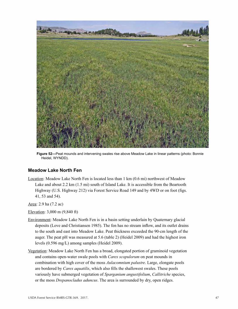
USDA Forest Service RMRS-GTR-369. 2017. 47
Meadow Lake North Fen
Location: Meadow Lake North Fen is located less than 1 km (0.6 mi) northwest of Meadow Lake and about 2.2 km (1.5 mi) south of Island Lake. It is accessible from the Beartooth Highway (U.S. Highway 212) via Forest Service Road 149 and by 4WD or on foot (figs. 41, 53 and 54).
Area: 2.9 ha (7.2 ac)
Elevation: 3,000 m (9,840 ft)
Environment: Meadow Lake North Fen is in a basin setting underlain by Quaternary glacial deposits (Love and Christiansen 1985). The fen has no stream inflow, and its outlet drains to the south and east into Meadow Lake. Peat thickness exceeded the 90-cm length of the auger. The peat pH was measured at 5.6 (table 2) (Heidel 2009) and had the highest iron levels (0.596 mg/L) among samples (Heidel 2009).
Vegetation: Meadow Lake North Fen has a broad, elongated portion of graminoid vegetation and contains open-water swale pools with Carex scopulorum on peat mounds in combination with high cover of the moss Aulacomnium palustre. Large, elongate pools are bordered by Carex aquatilis, which also fills the shallowest swales. These pools variously have submerged vegetation of Sparganium angustifolium, Callitriche species, or the moss Drepanocladus aduncus. The area is surrounded by dry, open ridges.
Figure 52—Peat mounds and intervening swales rise above Meadow Lake in linear patterns (photo: Bonnie Heidel, WYNDD).

48 USDA Forest Service RMRS-GTR-369. 2017.
Rare Species: There are none known.
Significance: Meadow Lake North Fen fills a basin where the basin itself tilts. It has the largest pool-filled swales of the Beartooth fens. It lies immediately upstream from Meadow Lake Fen, where peat accumulation is restricted to the basin perimeter.
Disturbances: Distinct hummocks are along part of the southwestern margin and may be a remnant of past grazing. There are no current signs of use by pack animals or other recreational uses. The fen lies in lands managed for backcountry nonmotorized recreation in the summer and motorized winter recreation (USDA Forest Service 2015a).
Documentation: Walford et al. (2001), Heidel and Rodemaker (2008), Heidel (2009).
Figure 53—Meadow Lake North Fen in a basin setting, with elongate pools, on a color infrared aerial image.
Figure 54—Meadow Lake North Fen is encircled by glacial erratics (photo: Bonnie Heidel, WYNDD).

USDA Forest Service RMRS-GTR-369. 2017. 49
Mud Lake Fen
Location: Mud Lake Fen is about 1.0 km (0.6 mi) west of Lily Lake. It is identified as Mud Lake on the 1988 Absaroka-Beartooth Wilderness map. It is accessible by Forest Service Road 130 with 4WD and lies directly to the south (figs. 36 and 55).
Area: 8.1 ha (20.0 ac)
Elevation: 2,350 m (7,700 ft)
Environment: Mud Lake Fen is a basin fen underlain by Quaternary glacial deposits (Love and Christiansen 1985). Peat thickness exceeded the 90-cm length of the auger. The pH in peat was measured at 6.9 (table 2) (Heidel 2009). Peat samples had the highest silicon concentrations (20 mg/L) among the 11 fens sampled (Heidel 2009).
Vegetation: This graminoid-dominated fen has Carex utriculata, and contains an inner floating mat and central open water. Vegetation plot data were collected in a broad band of Salix candida that includes part of the floating mat and was characterized as low shrubland (fig. 5) (Walford et al. 2001). In addition, the northeastern corner has Salix wolfii, Betula glandulosa, and Carex aquatilis. The open water has extensive areas of floating Chara species with Carex lasiocarpa and C. vesicaria around the margins. The surrounding gently sloping uplands are mainly open forest with some montane grassland.
Rare Species: Six Wyoming Plant Species of Concern are present: Carex diandra, C. limosa, Eriophorum gracile, Packera indecora, Salix candida, and Sparganium natans, most of which were first documented by Mills (Fertig 1997, 1998; Mills and Fertig 1996b).
Significance: Mud Lake Fen has the only shrubland where Salix candida is common.
Figure 55—Mud Lake Fen in a basin setting on a color infrared aerial image.

50 USDA Forest Service RMRS-GTR-369. 2017.
Disturbances: Mud Lake was grazed by livestock when first surveyed (Mills and Fertig 1996b). Its north margin is very close to Forest Service Road 130A, which gets heavy use by 4WD and offroad vehicles. Shrubs and tree saplings were selectively cut from the northeastern lobe for wildlife habitat management purposes in the 1990s. An unauthorized camping site and pulloff were noted near its northwestern margin incidental to extensive surveys (Heidel, personal observation, 2006). It lies in lands managed for vegetation and landscape patterns influenced not only by natural disturbances, but also by prescribed fire, timber harvest, and other silviculture treatments (USDA Forest Service 2015a).
Documentation: Mills and Fertig (1996b), Fertig (1997, 1998), Heidel and Rodemaker (2008), Heidel (2009).
Poke Lake Fen
Location: Poke Lake Fen is located immediately west of Granite Lake, about 1.6 km (1 mi) south of the Wyoming-Montana State line. It is accessible from the Beartooth Highway (U.S. Highway 212) via the Clay Butte Road trailhead or the Muddy Creek trailhead and then on foot (figs. 56 and 57).
Area: 4.7 ha (11.6 ac)
Elevation: 2,630 m (8,640 ft)
Environment: Poke Lake Fen is a basin fen with a very irregular outline, underlain by Precambrian bedrock (Love and Christiansen 1985). Peat thickness exceeded the 90-cm length of the auger. It has no stream inlet but has an outlet that drains into Granite Lake.
Figure 56—Topographic map of Poke Lake Fen, outlined in red.

USDA Forest Service RMRS-GTR-369. 2017. 51
Vegetation: Graminoid fen vegetation at Poke Lake Fen encircles elongated ponds, with small areas dominated by short shrubs (fig. 58). There are two large ponds, including a humic blackwater pond at the north end. The dominant graminoid is Carex buxbaumii. Floating mats are dominated by Carex limosa with Menyanthes trifoliata, and C. vesicaria occurs in patches. Areas dominated by short shrubs have Salix planifolia and Carex scopulorum. The fen is bordered by subalpine forest.
Figure 57—Poke Lake Fen in a basin setting on a color infrared aerial image.
Figure 58—Poke Lake Fen has extensive floating mats of mud sedge (Carex limosa) (photo: Bonnie Heidel, WYNDD).

52 USDA Forest Service RMRS-GTR-369. 2017.
Rare Species: Four Wyoming Plant Species of Concern are present: Carex limosa, Drosera anglica, Juncus filiformis, and Utricularia minor. Plant surveys were first conducted in 2006 by Heidel (Heidel and Rodemaker 2008).
Significance: Poke Lake Fen has an extensive floating mat, contains one of only two known populations of Juncus filiformis in the Beartooth Mountains, and is a high elevation occurrence for Drosera anglica in Wyoming.
Disturbances: The fen lies within the Absaroka-Beartooth Wilderness Area and no signs of disturbance were observed.
Documentation: Heidel and Rodemaker (2008).
Rock Creek Fen
Location: Rock Creek Fen is located about 2.4 km (1.5 mi) north-northeast of Fox Creek Campground near the Montana State line. It is accessible via the Gallatin National Forest trailhead leading to Vernon Lake and on foot (figs. 59 and 60).
Area: 1.0 ha (2.5 ac)
Elevation: 2,340 m (7,680 ft)
Environment: Rock Creek Fen is a basin fen underlain by Quaternary glacial deposits (Love and Christiansen 1985). It lies south of a steep outcrop and a mapped fault line (Love and Christiansen 1985). Peat thickness exceeded the 90-cm length of the auger.
Vegetation: Rock Creek has a large, central floating mat dominated by Carex limosa and Menyanthes trifoliata and low moss cover. The floating mat is surrounded by a ring of Carex limosa and high moss cover. The outermost ring of graminoid-dominated vegetation has Carex utriculata, C. buxbaumii, and Calamagrostis canadensis. The area is bordered by a rocky knoll on the north and by dry, open forests.
Rare Species: Four Wyoming Plant Species of Concern are present: Carex limosa, Drosera anglica, Eriophorum chamissonis, and E. gracile. The first plant survey was conducted at Rock Creek Fen in 2007 by Heidel, E. Elliott, and B. Elliott (table 3).
Significance: Rock Creek Fen is unusual in its abundance of floating mat vegetation and its very symmetrical, concentric vegetation zonation.
Disturbances: The fen lies within the Absaroka–Beartooth Wilderness Area, and no signs of disturbance were observed.
Documentation: Heidel and Rodemaker (2008).
Sawtooth Palsa Fen
Location: Sawtooth Palsa Fen is in the middle of a larger 35.6 ha (88.0 ac) area of wetland due south of Sawtooth Mountain. It is labeled as “Peat Beds” on topographic maps and on the Shoshone NF Map. It is accessible from the Beartooth Highway (U.S. Highway 212) and the Morrison Trail (Forest Service Road 120) by 4WD or on foot (figs. 61 and 62).
Area: About 8 ha (19.8 ac) of the wetland is palsa.
Elevation: 2,950 m (9,680 ft)

USDA Forest Service RMRS-GTR-369. 2017. 53
Figure 59—Topographic map of Rock Creek Fen, outlined in red.
Figure 60—Rock Creek Fen in a basin setting on a color infrared aerial image.

54 USDA Forest Service RMRS-GTR-369. 2017.
Environment: Sawtooth Palsa Fen lies in a broad subalpine basin underlain by “oldest gneiss complex,” a deeply weathered Precambrian rock surrounded by Quaternary glacial deposits with a raised peat deposit and permafrost (Pierce 1961). It differs from all other known basin fens in that it has a dome shape, referred to as “palsa” (fig. 63). Collins (1984) reported it as about 1,000 km (620 mi) south of the southernmost palsa fens in Canada. A palsa is typically an ombrogenous bog, formed at below-freezing average annual temperatures under moist conditions (Vitt 2006). It is the only known palsa in the 48 contiguous States, though isolated patches of permafrost occur throughout the Rocky Mountains as far south as Arizona (Pierce 1979; discussed in Collins 1984). It is in a basin but straddles a hydrological divide and drains south into Thief Creek and northwest into Canyon Creek. The depth to permafrost was reported as 38 to 46 cm (15 to 18 in) by Pierce (1961). Measurements made in 2007 found depth to permafrost at 46 to 56 cm (18 to 22 in) (USDA NRCS 2008). The original locations of depth measurement are unknown so trend cannot be interpreted, but permafrost thaw rates have accelerated over the last decades in peatlands of higher latitudes (Rydin and Jeglum 2013). Questions remain as to whether the permafrost is melting. Polygonal frost-wedge patterns are present (figs. 64 and 65). The palsa is raised 1 to 2 m (3 to 6 ft) above the surrounding wetland; it is almost devoid of vegetation and pocked by thaw depression pools (figs. 66 and 67). Th palsa does not have any saturated peat conditions at the surface, so all pH measurements
Figure 61—Topographic map of Sawtooth Palsa Fen, outlined in red.

USDA Forest Service RMRS-GTR-369. 2017. 55
Figure 62—Sawtooth Palsa Fen in a basin setting on a color infrared aerial image.
Figure 63—Sawtooth Palsa Fen has a central raised palsa dome in the middle of a graminoid-dominated fen (photo: Sabine Mellmann-Brown).
were taken from open water of pools and outlets. Peat thickness was estimated at 3.1 to 4.6 m (10 to 15 ft) (Pierce 1961).
Vegetation: The peat substrate of the palsa is desiccated and oxidized, and the sparse vegetation is concentrated in polygon cracks. Festuca brachyphylla and Deschampsia cespitosa are the most common plants on top of the palsa. Encircling fen vegetation has dense cover of Carex scopulorum and C. canescens, and patchy cover of C. aquatilis and

56 USDA Forest Service RMRS-GTR-369. 2017.
C. illota. Some of the slightly raised areas have Salix planifolia. The moss cover is high in most surrounding communities, and bryophytes are locally dominant on some mounds to the exclusion of vascular plants. More details are provided by Chadde et al. (1998), Collins et al. (1984), Mellmann-Brown (2004), and Pierce (1961). Sawtooth Palsa Fen is surrounded by dry meadow, with open subalpine woodland of Picea engelmannii and Pinus albicaulis on parts of the surrounding basin rim.
Rare Species: Agrostis mertensii is the only Wyoming Plant Species of Concern known from the palsa; Heidel collected this species in 2007.
Figure 64—Frost-heave polygon patterns at Sawtooth Palsa Fen in 1987 (photo: Hollis Marriott, WYNDD).
Figure 65—Frost-heave polygon patterns at Sawtooth Palsa Fen in 2003 (photo: Sabine Mellmann-Brown).

USDA Forest Service RMRS-GTR-369. 2017. 57
Significance: Sawtooth Palsa Fen is the only known palsa, or remnant of true bog formed under past climates, in the lower 48 States (Collins et al. 1984). It is included in the current Shoshone NF Management Plan as the proposed Sawtooth Peatbeds Geological Area (USDA Forest Service 2015a). It may represent the southernmost example of the Gelisol soil order. It is the only fen in the study area where peat has been dated by radiocarbon techniques (Pierce 1961, 1980). The top of the peat layer was dated at 7,570 +/- 400 YBP, and the bottom of the peat layer was dated at 8,600 +/- 300 YBP.
Figure 66—Thaw-depression pool at Sawtooth Palsa Fen in 1987 (photo: Hollis Marriott, WYNDD).
Figure 67—Thaw-depression pool at Sawtooth Palsa Fen in 2003 (photo: Sabine Mellmann-Brown).

58 USDA Forest Service RMRS-GTR-369. 2017.
Disturbances: There was one accidental entry of cattle in the Sawtooth Palsa Fen in 2004. As a result, the polygonal pattern on the palsa was obscured by trampling as photographed by Mellmann-Brown, who revisited the site 1 year after sampling vegetation (Mellmann-Brown 2004).
Documentation: Pierce (1961, 1965), Pierce and Nelson (1971), Collins et al. (1984), Mellmann-Brown (2004), Heidel and Rodemaker (2008), Jones et al. (2011b).
Trail Fen
Location: Trail Fen is located about 0.8 km (0.5 mi) south of Hauser Lake, immediately to the east of the Beartooth Loop National Recreational Trail (Forest Service Trail 613 as shown on the topographic map). It is accessible from the Beartooth Highway (U.S. Highway 212) via the Morrison Trail (Forest Service Road 120) and Forest Service Trail 613 (figs. 68 and 69).
Area: 3.1 ha (7.7 ac)
Elevation: 2,940 m (9,640 ft)
Environment: Trail Fen is a basin fen with a slight slope in the northwest, underlain by “oldest gneiss complex” (Love and Christiansen 1985). Peat thickness exceeded the 90-cm length of the auger. The fen has well-developed pools (fig. 70) and a perennial inlet that feeds a stream running its entire length (fig. 71).
Vegetation: The graminoid vegetation includes mound and swale zones at the northwest end. Carex scopulorum is on the peat mounds with high cover of the moss Aulacomnium palustre. A much sparser cover of Carex scopulorum and C. limosa occurs in the swales. The rest of the basin has C. scopulorum and Deschampsia cespitosa. The fen is surrounded by rolling terrain with dry meadow, open woodland, and low outcrops.
Rare Species: One Wyoming Plant Species of Concern is present, Carex limosa (Heidel and Rodemaker 2008).
Significance: Trail Fen is the highest elevation where Carex limosa has been found in the study area. It is one of the few fens with a major inlet and stream channel along its length.
Disturbances: Distinct mounds along part of the margins may be a remnant of past grazing history. There are no signs of use by pack animals or other recreational uses even though a major trail runs along the fen.
Documentation: Heidel and Rodemaker (2008).
Wyoming Creek
Location: Wyoming Creek is located about 3.2 km (2 mi) south of the Montana State line, immediately east of the Beartooth Highway (U.S. Highway 212). At the head of Wyoming Creek are a highway pulloff and unsigned trailhead for Forest Service Trail 623. Wyoming Creek is less than 1.6 km (1 mi) north of Littlerock Creek Fen, separated by a high ridge. The Wyoming Creek site is a wetland complex rather than an area of discrete, continuous fen habitat. In this report, it is referred to as Wyoming Creek without “Fen” in the name because fen habitat is widely scattered rather than in a continuous block (figs. 46 and 72).

USDA Forest Service RMRS-GTR-369. 2017. 59
Figure 68—Topographic map of Trail Fen, outlined in red.
Figure 69—Trail Fen in a basin setting on a color infrared aerial image.

60 USDA Forest Service RMRS-GTR-369. 2017.
Area: Undetermined peatland area, forming mosaic Elevation: 3,020–3,250 m (9,920–10,680 ft)
Environment: The Wyoming Creek wetland complex is underlain by the “oldest gneiss complex” in the Beartooth Mountains (Love and Christiansen 1985). The headwaters of Wyoming Creek have a series of terraces, likely the product of mass movement downslope by saturated soil composed of a series of at least six stairsteps (after Johnson and Billings
Figure 70—Trail Fen pools (photo: Bonnie Heidel, WYNDD).
Figure 71—A discrete stream—uncommon within the fens studied—runs the length of Trail Fen (photo: Bonnie Heidel, WYNDD).

USDA Forest Service RMRS-GTR-369. 2017. 61
1962). Peat thickness of 46 cm (18 in) was reported by Johnson and Billings (1962) with permafrost depths (i.e., freezing part of the peat profile) as shallow as 30 cm (12 in) early in the summer. The setting was described by Johnson and Billings (1962) as lying below snow accumulation areas in shallow basins which receive abundant meltwater during the summer. Measurements of pH 5.2 were documented for peat mounds at the head of a tributary of Wyoming Creek (table 2) (Heidel 2009). It was one of two fens with detectable mercury in peat (Heidel 2009).
Vegetation: Johnson and Billings (1962) described the presence of “alpine bog” vegetation at the head of Wyoming Creek and observed Carex scopulorum, often with Eriophorum callitrix and Salix planifolia. They referred to patterns of vegetation and topography in fen habitat that reflect intensive freezing and thawing of saturated soils, including small, unvegetated frost boils, and terracing (Johnson and Billings 1962). A latticework pattern was noted in recent visits (fig. 73). The mosaic also has early- and late-melting snowbanks with well-developed vegetation along seeps and wet meadows associated with churning or heaving of soil around wetland patches and snowbanks. The surrounding uplands include dry rocky meadows, dominated by Geum rossii.
Rare Species: Nine wetland Plant Species of Concern occur in the Wyoming Creek, though only six occur in fen portions of the wetland complex. Johnson (1962) and Johnson and Billings (1962) documented two species as restricted to peat-lined terraces: Carex misandra and Eriophorum callitrix. They also documented two species from the fen as new to the Beartooth Mountains, Carex nelsonii (from fens) and Juncus albescens (later re-determined as J. triglumis var. triglumis), in addition to Pedicularis oederi, which occurs in a variety of habitats. Three other species were collected from adjoining terraces with frost action (Kobresia sibirica, Koenigia islandica, Phippsia algida). In addition, Sphagnum angustifolium was collected in 2008 by Ron Hartman. Most of the aforementioned vascular species were also found in the highway corridor in tributaries of Wyoming Creek by Mellmann-Brown, and in the Twin Lakes area, part of the Line Creek Research Natural Area
Figure 72—Wyoming Creek in a sloping setting on a color infrared aerial image.

62 USDA Forest Service RMRS-GTR-369. 2017.
to the west, by Fertig and Mike Bynum (ERO Resources Corporation 1999b, 2000; Fertig 1997, 1998; Fertig and Bynum 1994).
Significance: Wyoming Creek exemplifies the polygonal patterns that result from intensive freezing and thawing of saturated ground at alpine elevations (Johnson and Billings 1962). Locations of the vegetation sampling and depth to permafrost measurements by Johnson and Billings (1962) were not permanently marked, but their early research findings provide valuable background information.
Disturbances: Current plans for widening U.S. Highway 212 require avoidance of wetlands. The Wyoming Creek wetland complex is potentially affected by road management practices and runoff. The pullout at the head of Wyoming Creek attracts motorists. Grazing was identified as a potential threat to some Wyoming Creek Species of Concern (Fertig 1998), but the sheep grazing lease was terminated about 2000 (Decision Notice of January 9, 2003). Use of pack animals now requires a permit and is thus limited. This wetland complex lies in lands managed for back-country nonmotorized recreation in the summer and motorized winter recreation (USDA Forest Service 2015a).
Documentation: Johnson (1962), Johnson and Billings (1962), Fertig (1997, 1998), ERO Resources Corporation (1999b), Heidel (2009).
Figure 73—Wyoming Creek fen habitat forms a mosaic of peat mounds and swales (photo: Bonnie Heidel, WYNDD).

USDA Forest Service RMRS-GTR-369. 2017. 63
Rare Plants of Beartooth Fens
There are 32 Wyoming vascular Plant Species of Concern that occur in fens of the Beartooth Mountains (table 4) as determined from the overlap between the species listed in Chadde et al. (1998) and those on the Wyoming Plant Species of Concern list (Heidel 2007). Of the 32 species, 12 are designated as sensitive in U.S. Forest Service Region 2 (Rocky Mountain Region), hereafter called Region 2 (USDA Forest Service 2013) (table 4). In addition, there is one Wyoming nonvascular plant Species of Concern that occurs in fens of the Beartooth Mountains, and it is likewise designated as sensitive in Region 2 (USDA Forest Service 2015b) (table 4). Four of the vascular species were later removed from rare species status in Wyoming (Heidel 2012): Carex leptalea, C. limosa, Packera indecora, and Sparganium natans. Five of the vascular species were reassigned a rare species status from “track” to “watch” (table 4): Carex livida, Drosera anglica, Eriophorum chamissonis, E. gracile, and Utricularia minor. The 32 species exclude 12 species, previously tracked as Species of Concern by WYNDD, that were removed from consideration because they were found to be more widespread in the State than previously known (Keinath et al. 2003). These species are: Agoseris lackschewitzii, Botrychium virginianum, Carex buxbaumii, C. dioica (syn. C. gynocrates), Comarum palustre (syn. Potentilla palustris), Eleocharis rostellata, Listera cordata, Petasites sagittatus, Salix farriae, Symphyotrichum boreale (syn. Aster junci-formis), Tephroseris lindstroemii (syn. Senecio fuscatus), and Thalictrum alpinum.
The rare vascular plant species of Beartooth fens separate into two groups by elevation; 6 species occur primarily in the alpine range (2,900 to 3,340 m, or 9,510 to 10,960 ft) and 26 occur at lower elevations (1,980 to 2,940 m, or 6,490 to 9,640 ft). Four of the rare plant spe- cies are characterized by Johnson (1962) and Johnson and Billings (1962) as alpine species (table 4), to which we add Agrostis mertensii based on Weber and Wittmann (2012) and Salix barrattiana based on Dorn (2001). Almost all of the rare vascular plant species of Beartooth fens (31) have their centers of distribution in arctic or boreal latitudes. The exception is Carex nelsonii, a regional endemic (Heidel 2012).
Eighteen of the vascular plant Species of Concern are obligate wetland plants in western mountains of the United States (Lichvar et al. 2014). This means that they almost always oc- cur in wetlands (Lichvar et al. 2012) (table 4). Most are found only in fen habitat, and even though we now know this habitat is more common in the study area than previously thought, only a fraction of fens support rare species.
For each of the 32 rare plant species, the description of Beartooth populations, elevation range, and number of populations in the study area are reported in table 3, cross-referenc-ing the 18 Beartooth fens described in this report. Species’ distribution and habitat in the Beartooth Mountains refer to the Wyoming portion of the mountains unless otherwise stated. The history of documentation is briefly described for each species in the following pages and presented in table 3. Ten of the rare Beartooth plant species were first discovered in Wyoming at either Swamp Lake or Wyoming Creek. Updated information on rare plant species distribu-tion in Wyoming is maintained by WYNDD and Rocky Mountain Herbarium (RM), and is posted in WYNDD reports and in State plant species accounts (WYNDD 2016). Of the 32 species, 14 have conservation assessments prepared for Region 2. The reader is also referred to the RM online database (RM 2016) for collection label information to accompany the dis-tribution and habitat information in this report.

64 USDA Forest Service RMRS-GTR-369. 2017.
Spec
ies
Elev
atio
n ra
nge
in
Bea
rtoo
th
Mtn
s. (
m)
Sett
ing
in
Bea
rtoo
th
Mtn
s.
Veg
etat
ion
stru
ctur
e of
ha
bita
t in
B
eart
ooth
M
tns.
Tota
l B
eart
ooth
M
tns.
po
pula
tion
s
Tota
l W
yom
ing
popu
lati
ons
Col
lect
ions
from
the
Bea
rtoo
th M
tns.
stu
dy a
rea
(Seq
uenc
ed b
y ea
rlie
st y
ear,
grou
ped
by fe
n na
me
as a
cron
ym a
mon
g 18
pr
ofile
d fe
ns, t
hen
by c
olle
ctor
. Col
lect
ions
from
oth
er lo
cati
ons
in t
he
Bea
rtoo
th M
ount
ains
stu
dy a
rea
are
pref
aced
by
“els
ewhe
re.”
)
Agr
ostis
mer
tens
ii 2,
900–
3,26
0B
asin
Gra
min
oid
313
Else
whe
re –
Mel
lman
n-B
row
n (1
109,
111
5, 1
199,
120
6, 1
211,
121
2, 1
213,
12
14) 1
998
RM
; (26
05b)
199
6 R
M. S
PF –
Hei
del (
2989
) 200
7 R
M; E
. Elli
ott
(355
9) 2
007
RM
.
Am
eror
chis
rot
undi
folia
2,
010–
2,10
0B
asin
Fore
st3
3SL
F –
Pear
son
(82)
192
4 R
M; L
ichv
ar (2
062)
197
9 R
M; E
vert
(745
4) 1
984
MO
R, (
7841
) 198
5 R
M, M
OR
, (40
92) 2
004
RM
; B.E
. Nel
son
(168
85) 1
989
RM
; Fer
tig (1
3370
) 199
2 R
M. E
lsew
here
– E
vert
(783
4) 1
985
RM
, (40
900)
20
04 R
M, M
OR
, NY;
B. E
lliot
t (14
082)
200
8 R
M.
Arc
tous
rub
ra
2,01
0 B
asin
Mar
gin
of
fore
st1
1SL
F –
Ever
t (74
94) 1
984
RM
, MO
R; D
orn
(411
9) 1
984
NY,
RM
; Har
tman
(1
8548
) 198
4 R
M; B
.E. N
elso
n (1
6876
) 198
9 R
M.
Car
ex c
onci
nna
2,01
0–2,
130
Bas
inM
argi
n of
fo
rest
26
SLF
– Ev
ert (
9824
) 198
6 R
M; F
ertig
(133
68) 1
992
RM
. Els
ewhe
re –
Eve
rt
(409
14) 2
004
RM
; E. E
lliot
t (56
2) 2
007
RM
.
Car
ex d
iand
ra
2,01
0–2,
740
Bas
inG
ram
inoi
d8
24SL
F –
Ever
t (76
66) 1
984
RM
, (78
74) 1
985
RM
; Fer
tig (1
3348
) 199
2 R
M;
Hei
del (
2618
) 200
4 R
M. L
MLF
– M
ills
(126
) 199
5 R
M; H
eide
l (22
04) 2
002
RM
. LLF
/MLF
– M
ills
(145
, 147
, 153
) 199
5 R
M; M
ellm
ann-
Bro
wn
(162
1)
2004
RM
; Fer
tig (1
7301
) 198
5 R
M; H
eide
l (28
33, 2
867)
200
6 R
M. L
LEF
– Fe
rtig
(173
10) 1
996
RM
. CB
F –
Mel
lman
n-B
row
n (1
159,
116
9) 1
999
RM
, (1
510)
199
8 R
M, F
ertig
(188
73) 1
999
RM
; Hei
del (
3021
) 200
7 R
M. G
CF
– M
ellm
ann-
Bro
wn
(162
8) 2
004
RM
; Hei
del (
2960
) 200
7 R
M. E
lsew
here
–
Hei
del (
3004
) 200
7 R
M.
Car
ex le
ptal
ea
1,98
0–2,
740
Bas
inFo
rest
1332
Else
whe
re –
Dor
n (3
606)
198
0 R
M; H
eide
l (26
27) 2
004
RM
; Eve
rt (4
0899
, 40
916)
200
4 R
M; H
eide
l (26
04) 2
004
RM
, (2
747,
276
3) 2
005
RM
, (28
38,
2840
) 200
6 R
M, (
3033
) 200
7 R
M. S
WL
– Ev
ert (
4737
) 198
2 R
M, (
7658
) 19
84 R
M, (
4090
5) 2
004
RM
; Dor
n (5
011)
198
9 R
M; N
elso
n (1
6868
) 198
9 R
M; H
eide
l (26
16) 2
004
RM
. LM
LF –
Fer
tig (1
7250
) 199
6 R
M. L
LEF
– Fe
rtig
(1
7306
) 199
6 R
M. G
CF
– H
eide
l (26
15) 2
004
RM
, (29
61) 2
007
RM
. CB
F –
Hei
del (
3016
) 200
7 R
M.
Car
ex li
mos
a 2,
010–
2,94
0B
asin
, sl
opin
gG
ram
inoi
d15
66SL
F –
Ever
t (75
05) 1
984
RM
; Dor
n (4
128)
198
4 R
M, (
5014
) 198
9 R
M, N
Y;
Har
tman
(185
59) 1
984
RM
, Lic
hvar
(702
6) 1
984
RM
; Nel
son
(168
86) 1
989
RM
; Fer
tig (1
3356
, 133
87, 1
3398
) 199
2 R
M; J
ones
(858
) CW
C. C
BF
– Fe
rtig
(1
4518
) 199
3 R
M, (
1887
1) 1
999
RM
. LLE
F –
Fert
ig (1
7313
) 199
6 R
M. L
BLF
–
Mel
lman
n-B
row
n (1
132)
199
8 R
M. L
MLF
– M
ills
(124
) 199
5 R
M. M
LF
Tabl
e 3—
Envi
ronm
enta
l cha
ract
eris
tics
asso
ciat
ed w
ith o
ccur
renc
es o
f the
32
rare
pla
nts
spec
ies
and
1 br
yoph
yte
spec
ies
in fe
ns o
f the
Bea
rtoo
th M
ount
ains
des
crib
ed in
this
re
port
, num
bers
of k
now
n po
pula
tions
, and
doc
umen
tatio
n of
her
bari
um s
peci
men
col
lect
ions
.

USDA Forest Service RMRS-GTR-369. 2017. 65
Spec
ies
Elev
atio
n ra
nge
in
Bea
rtoo
th
Mtn
s. (
m)
Sett
ing
in
Bea
rtoo
th
Mtn
s.
Veg
etat
ion
stru
ctur
e of
ha
bita
t in
B
eart
ooth
M
tns.
Tota
l B
eart
ooth
M
tns.
po
pula
tion
s
Tota
l W
yom
ing
popu
lati
ons
Col
lect
ions
from
the
Bea
rtoo
th M
tns.
stu
dy a
rea
(Seq
uenc
ed b
y ea
rlie
st y
ear,
grou
ped
by fe
n na
me
as a
cron
ym a
mon
g 18
pr
ofile
d fe
ns, t
hen
by c
olle
ctor
. Col
lect
ions
from
oth
er lo
cati
ons
in t
he
Bea
rtoo
th M
ount
ains
stu
dy a
rea
are
pref
aced
by
“els
ewhe
re.”
)
Tabl
e 3—
Con
tinue
d.
Erio
phor
um
virid
icar
inat
um
2,01
0B
asin
Gra
min
oid
112
SLF
– D
orn
(414
0) 1
984
RM
; Eve
rt (7
505)
198
4 R
M, (
7854
) 198
5 R
M;
Nel
son
(168
87) 1
989
RM
; Fer
tig (1
3354
) 199
2 R
M.
Junc
us fi
lifor
mis
2,
630
Bas
inG
ram
inoi
d1
20PL
F –
Hei
del (
2855
) 200
6 R
M.
Kobr
esia
sim
plic
iusc
ula
2,01
0B
asin
Gra
min
oid
16
SLF
– D
orn
(414
1) 1
984
RM
; Eve
rt (7
503)
198
4 R
M, (
7843
) 198
5 R
M;
Lich
var
(702
1) 1
984
RM
; Fer
tig (1
3351
, 134
02) 1
992,
(188
60) 1
999
RM
.
Muh
lenb
ergi
a gl
omer
ata
2,01
0B
asin
Gra
min
oid
117
SLF
– H
artm
an (1
8563
) 198
4 R
M; F
ertig
(133
44, 1
3388
) 199
2 R
M.
Pack
era
inde
cora
2,
010–
2,41
0B
asin
Shru
b, m
argi
n of
fore
st10
10El
sew
here
– W
illia
ms
(s.n
.) 19
32 N
Y; R
ober
tson
136
5 (1
977)
RM
, M
ellm
ann-
Bro
wn
(115
3) 1
999
RM
; Dor
n (3
601)
198
0 R
M, H
eide
l (26
07)
2004
RM
; (28
49) 2
006
RM
. SLF
– H
eide
l (26
17) 2
004
RM
, (28
41) 2
006
RM
, (30
32) 2
007
RM
, (30
40) 2
007
RM
. LLF
– M
ellm
ann-
Bro
wn
(162
3)
2004
RM
; Hei
del (
2832
) 200
6 R
M.
Pedi
cula
ris o
eder
i 3,
110–
3,34
0Sl
opin
gG
ram
inoi
d1
1W
CC
– P
enne
ll (2
4000
) 193
8 R
M; H
itchc
ock
(134
99) 1
945
RM
; Eve
rt
(420
58) 2
007
RM
; B. E
lliot
t (14
621)
200
8 R
M; H
eide
l (33
56) 2
009
RM
. LC
F –
Wal
ford
(248
6) 1
996
RM
. Els
ewhe
re –
Phi
llips
(44b
) 195
8 R
M; S
cott
(473
6) 1
985
RM
; Byn
um (6
05, 6
39) 1
994
RM
; Fer
tig (1
5126
) 199
4 R
M,
(172
88) 1
996
RM
; Mel
lman
n-B
row
n (2
345)
199
6 R
M; E
. Elli
ott (
5666
, 62
61, 6
379,
642
4) 2
008
RM
; B. E
lliot
t (13
921)
200
8 R
M; H
artm
an (8
7892
, 87
962)
200
8 R
M.
Pota
mog
eton
am
plifo
lius
Bas
inO
penw
ater
16
LLF
– Fe
rtig
(173
03) 1
996
RM
.
Pota
mog
eton
illin
oens
is
2,37
0B
asin
Ope
nwat
er1
5El
sew
here
– H
eide
l (28
48) 2
006
RM
.
Pota
mog
eton
pr
aelo
ngus
2,
340
Bas
inO
penw
ater
115
LLF
– Fe
rtig
(173
04) 1
996
RM
.
Prim
ula
egal
ikse
nsis
2,
010
Bas
inG
ram
inoi
d1
2SL
F –
Har
tman
(185
61) 1
984
RM
; Eve
rt (7
844)
198
5 R
M, (
9823
) 198
6 R
M,
(409
07) 2
004
RM
; Nel
son
(168
88) 1
989
RM
; Fer
tig (1
3399
) 199
2 R
M.
Salix
bar
ratti
ana
2,99
0–3,
200
Slop
ing
Shru
b1
1W
CC
– P
attie
(790
) 196
4 R
M; D
orn
(111
1) 1
970
RM
, (17
42) 1
972
RM
, (5
222)
199
1 R
M, (
5332
) 199
2 R
M; H
eide
l (33
59) 2
009
RM
.
Salix
can
dida
2,
010–
2,34
0B
asin
Gra
min
oid
325
SLF
– Ev
ert (
7488
) 198
4 R
M, (
7853
) 198
5 R
M; D
orn
(412
1, 4
123)
198
4 R
M; N
elso
n (1
6883
) 198
9 R
M; F
ertig
(133
49) 1
992
RM
; MLF
/LLF
– M
ills
(148
, 149
, 165
) 199
5 R
M; M
ellm
ann-
Bro
wn
(161
9) 2
004
RM
; Wal
ford
(9
94) 1
993;
Hei
del (
2716
) 200
5 R
M, (
3250
) 200
8 R
M. M
LF –
Mel
lman
n-B
row
n (1
619)
. 200
4 R
M. E
lsew
here
– H
eide
l (27
65) 2
005
RM
.

66 USDA Forest Service RMRS-GTR-369. 2017.
Spec
ies
Elev
atio
n ra
nge
in
Bea
rtoo
th
Mtn
s. (
m)
Sett
ing
in
Bea
rtoo
th
Mtn
s.
Veg
etat
ion
stru
ctur
e of
ha
bita
t in
B
eart
ooth
M
tns.
Tota
l B
eart
ooth
M
tns.
po
pula
tion
s
Tota
l W
yom
ing
popu
lati
ons
Col
lect
ions
from
the
Bea
rtoo
th M
tns.
stu
dy a
rea
(Seq
uenc
ed b
y ea
rlie
st y
ear,
grou
ped
by fe
n na
me
as a
cron
ym a
mon
g 18
pr
ofile
d fe
ns, t
hen
by c
olle
ctor
. Col
lect
ions
from
oth
er lo
cati
ons
in t
he
Bea
rtoo
th M
ount
ains
stu
dy a
rea
are
pref
aced
by
“els
ewhe
re.”
)
Car
ex li
mos
a 2,
010–
2,94
0B
asin
, sl
opin
gG
ram
inoi
d15
66–
Mill
s (1
61) 1
995
RM
; Mel
lman
n-B
row
n (1
620)
200
4 R
M; H
eide
l (27
45)
2005
RM
. GC
F –
Mel
lman
n-B
row
n (1
629)
200
4 R
M; H
eide
l (29
54) 2
007
RM
. LLF
– H
eide
l (28
34) 2
006
RM
. PLF
– H
eide
l (28
53) 2
006
RM
. RC
F –
Hei
del (
3012
) 200
7 R
M. L
WG
NF
– (2
973)
200
7 R
M. E
lsew
here
– H
eide
l (3
030a
) 200
7 R
M. M
LF –
Hei
del (
3243
) 200
8 R
M.
Car
ex li
vida
2,
010–
2,74
0B
asin
Gra
min
oid
226
SLF
– D
orn
(501
3) 1
984
RM
; Eve
rt (7
867)
198
5 R
M; B
.E. N
elso
n (1
6875
, 16
888)
198
9 R
M; F
ertig
(133
55) 1
992
RM
. CB
F –
Mel
lman
n-B
row
n (1
127)
19
98 R
M; F
ertig
(188
65) 1
999
RM
.
Car
ex m
icro
gloc
hin
2,01
0–2,
410
Bas
inG
ram
inoi
d2
20SL
F –
Dor
n (4
145)
198
4 R
M; E
vert
(750
6) 1
984
RM
, (78
48) 1
985
RM
; Li
chva
r (7
028)
198
4 R
M; B
.E. N
elso
n (1
6880
) 198
9 R
M. G
CF
– H
eide
l (2
952)
200
7; E
. Elli
ott (
3251
) 200
7 R
M.
Car
ex m
isan
dra
3,03
0–3,
290
Slop
ing
Gra
min
oid
112
WC
C/L
CF
– B
liss
(788
) 195
5 R
M; J
ohns
on (2
04, 2
33) 1
960
RM
; Ald
rich
(1
53) 1
979
RM
; Eve
rt (3
408)
198
1 R
M, (
6207
, 622
6) 1
983
RM
; Mel
lman
n-B
row
n (1
124)
199
8 R
M; H
eide
l (30
22) 2
007
RM
.
Car
ex n
elso
nii
3,17
0–3,
290
Slop
ing
Gra
min
oid
116
WC
C/L
CF
– Jo
hnso
n (2
32) 1
960
RM
; Mel
lman
n-B
row
n (1
114,
111
9b,
1122
, 113
5, 1
136
, 113
7, 1
138,
118
7) 1
998
RM
; Fer
tig (1
7263
) 199
6 R
M.
Dro
sera
ang
lica
2,27
0–2,
630
Bas
inG
ram
inoi
d6
27LL
EF –
Dou
tt (1
52) 1
930
YEL
LO; F
ertig
(173
11) 1
996
RM
. LM
LF -
Mill
s (1
22) 1
995
RM
; Fer
tig (1
7246
) 199
6 R
M. G
CF
– M
ellm
ann-
Bro
wn
(163
2)
2004
RM
; Hei
del (
2759
) 200
5 R
M; E
. Elli
ott (
3226
) 200
7 R
M. P
LF –
Hei
del
(285
6) 2
006
RM
. RC
F –
Hei
del (
3009
) 200
7 R
M; E
. Elli
ott (
3844
) 200
7.
Equi
setu
m fl
uvia
tile
2,48
0B
asin
Gra
min
oid
13
Else
whe
re –
Fer
tig (1
7291
) 199
6 R
M.
Erio
phor
um c
allit
rix
3,05
0–3,
290
Slop
ing
Gra
min
oid
15
WC
C/L
CF
and
else
whe
re –
John
son
(58b
) 195
8 R
M; E
vert
(243
0) 1
980
RM
, (4
740)
198
2 R
M, (
4205
76) 2
007
RM
; Dor
n (4
103)
198
4 R
M; S
cott
(494
2)
1985
CW
C, R
M; M
ellm
ann-
Bro
wn
(259
0) 1
996
RM
; Hei
del (
3024
) 200
7;
E. E
lliot
t (36
57) 2
007
RM
; Har
tman
(878
97) 2
008
RM
; B. E
lliot
t (13
917,
14
627,
147
15, 1
4725
) 200
8 R
M.
Erio
phor
um
cham
isso
nis
2,27
0–2,
910
Bas
inG
ram
inoi
d4
41G
CF
– M
ellm
ann-
Bro
wn
(196
1) 2
004
RM
; Hei
del (
2956
) 200
7 R
M; E
. El
liott
(325
4) 2
007
RM
. RC
F –
Hei
del (
3010
) 200
7 R
M; E
. Elli
ott (
3830
) 20
07 R
M. L
WF
– H
eide
l (29
74) 2
007
RM
.
Erio
phor
um g
raci
le
2,27
0–2,
780
Bas
inG
ram
inoi
d9
25LM
LF –
Mill
s (1
29) 1
995
RM
. MLF
– M
ills
(158
, 162
) 199
5 R
M. L
LEF
– Fe
rtig
(173
12) 1
996
RM
. CB
F –
Mel
lman
n-B
row
n (1
203)
199
9 R
M. R
CF
– H
eide
l (30
11) 2
007
RM
; E. E
lliot
t (38
31) 2
007
RM
. GC
F –
Hei
del (
2958
) 20
07 R
M; E
lliot
t (32
5) 2
007
RM
. Els
ewhe
re –
Hei
del (
3030
b) 2
007
RM
.
Tabl
e 3—
Con
tinue
d.

USDA Forest Service RMRS-GTR-369. 2017. 67
Tabl
e 3—
Con
tinue
d.
Spec
ies
Elev
atio
n ra
nge
in
Bea
rtoo
th
Mtn
s. (
m)
Sett
ing
in
Bea
rtoo
th
Mtn
s.
Veg
etat
ion
stru
ctur
e of
ha
bita
t in
B
eart
ooth
M
tns.
Tota
l B
eart
ooth
M
tns.
po
pula
tion
s
Tota
l W
yom
ing
popu
lati
ons
Col
lect
ions
from
the
Bea
rtoo
th M
tns.
stu
dy a
rea
(Seq
uenc
ed b
y ea
rlie
st y
ear,
grou
ped
by fe
n na
me
as a
cron
ym a
mon
g 18
pr
ofile
d fe
ns, t
hen
by c
olle
ctor
. Col
lect
ions
from
oth
er lo
cati
ons
in t
he
Bea
rtoo
th M
ount
ains
stu
dy a
rea
are
pref
aced
by
“els
ewhe
re.”
)
Salix
myr
tillif
olia
2,
010
Bas
inG
ram
inoi
d1
1SL
F –
Ever
t (74
89) 1
984
RM
, MO
R; (
7873
) 198
5 R
M; D
orn
(411
8) 1
984
RM
, (52
21) 1
991
RM
; Lic
hvar
(703
9) 1
984
RM
; Fer
tig (1
3380
) 199
2.
Spar
gani
um n
atan
s 2,
010–
2,91
0B
asin
Ope
nwat
er6
16+
SL
F –
Port
er (6
791)
195
5 R
M; E
vert
(714
7) 1
984
RM
; Fer
tig (1
3367
) 199
2 R
M. L
LF –
Hei
del (
2835
) 200
6 R
M. M
LF H
eide
l (29
77) 2
007
RM
; E. E
lliot
t (3
225)
200
7 R
M. E
lsew
here
– M
ellm
ann-
Bro
wn
(161
0) 2
004
RM
; Hei
del
(264
8) 2
006
RM
.
Tric
hoph
orum
pu
milu
m
2,01
0B
asin
Gra
min
oid
18
SLF
– D
orn
(413
3) 1
984
RM
; Eve
rt (7
498)
198
4 R
M, M
OR
, (78
46) 1
985
RM
, (98
22) 1
986
RM
; Nel
son
(168
89) 1
989
RM
; Fer
tig (1
3350
) 199
2 R
M.
Utr
icul
aria
min
or
2,01
0–2,
780
Bas
inO
penw
ater
639
SLF
– Fe
rtig
(167
97) 1
996
RM
. PLF
– H
eide
l (28
54) 2
006
RM
. GC
F –
Hei
del
(295
5) 2
007
RM
. CB
F –
Hei
del (
3019
) 200
7 R
M. L
LEF
– H
eide
l (33
41)
2009
RM
. GC
F –
E. E
lliot
t (32
25) 2
007
RM
.
Spha
gnum
an
gust
ifoliu
m2,
470–
2,90
0B
asin
Gra
min
oid
23
Else
whe
re –
Web
er (B
4426
8) 1
973
CO
LO. L
LEF
– B
ooth
(s.n
.) 20
02 B
ING
; H
eide
l (s.
n.) 2
002
RM
. WC
– H
artm
an (8
7944
) 200
8 R
M.

68 USDA Forest Service RMRS-GTR-369. 2017.
Table 4—Global conservation ranking, State and regional conservation status, and wetland indicator status for the 32 rare plant species and 1 bryophyte species that occur in fens of the Beartooth Mountains described in this report.
SpeciesFS sensitive status
(Regions 1a and 2b)Global rankc
Wyoming State rank
Wyoming statusd
Present in Beartooth Mtns.
of MontanaeMontana
State rankf
Wetland indicator statusg
Agrostis mertensii G5 S2 Track Yes S3? FACU
Amerorchis rotundifolia R1, R2 S G5 S1 Track No S3 OBL
Arctostaphylos rubra G5 S1 Track (Not in MT) – FAC
Carex concinna G5 S1 Track No S4 FAC
Carex diandra R2 S G5 S2 Track Yes S4 OBL
Carex leptalea Formerly R1, R2 S G5 S3 Delete Yes S4 OBL
Carex limosa G5 S3 Delete Yes S3S4 OBL
Carex livida R2 S, formerly R1 S G5 S3 Track No S4 OBL
Carex microglochin G5? S2 Track (Reported in MT) – FACW
Carex misandra G5 S2 Track Yes S3S4 FACU
Carex nelsonii G3 S3 Track Yes S2? FAC
Drosera anglica R1, R2 S G5 S3 Watch Yes S3 OBL
Equisetum fluviatile G5 S1 Track No S4 OBL
Eriophorum callitrix G5 S2 Track Yes S2S3 OBL
Eriophorum chamissonis R2 S G3 S3 Watch No S4 OBL
Eriophorum gracile R1, R2 S G5 S3 Watch No S3 OBL
Eriophorum viridicarinatum Formerly R1 S G5 S2 Track No S4 OBL
Juncus filiformis G5 S2 Delete No SNR FACW
Kobresia simpliciuscula R2 S G5 S1 Track No S3 FACW
Muhlenbergia glomerata Formerly R2 S G5 S2 Track No SU FACW
Packera indecora G5 S2 Delete Yes S4? FACW
Pedicularis oederi G5 S2 Track Yes S3 No status
Potamogeton amplifolius G5 S1 Track No – OBL
Potamogeton illinoensis G5 S1 Track No – OBL
Potamogeton praelongus G5 S1 Track No – OBL
Primula egaliksensis R2 S G4 S1 Track (Not in MT) – OBL
Salix barrattiana R2 S G5 S1 Track Yes S2 FACW
Salix candida R2 S G5 S2 Track No S3S4 OBL
Salix myrtillifolia R2 S G5 S1 Track (Not in MT) – FACW
Sparganium natans G5 S2 Delete No S4 OBL
Trichophorum pumilum G5 S1 Track No S3 FACW
Utricularia minor R2 S G5 S3 Watch No S3 OBL
Sphagnum angustifolium R2 S G5 S1 Track No S2 Not applicable
a Sensitive plants species of U.S. Forest Service Region 1 in Montana (http://www.fs.usda.gov/detail/r1/plants-animals/?cid=stelprdb5130525).b Sensitive plant species of U.S. Forest Service Region 2 (http://www.fs.usda.gov/wps/portal/fsinternet/detail/r2/plants-
animals/?cid=stelprdb5350842).c NatureServe global and state ranking and definitions (NatureServe. 2016. NatureServe Explorer. (http://www.natureserve.org/explorer/index.html).d Wyoming Natural Diversity Database (Heidel 2012) as posted on WYNDD homepage (http://www.uwyo.edu/wyndd/ ).e Based on Lesica (2012). f Montana Natural Heritage Program as posted on MTNHP homepage (http://mtnhp.org/plants/).g Wetland indicator status codes and descriptions (Lichvar et al. 2012):
OBL (Obligate wetland plants) – Almost always occur in wetlandsFACW (Facultative wetland plants) – Usually occur in wetlandsFAC (Facultative wetland plants) – Occur in wetlands and nonwetlandsFACU (Facultative upland plants) – Usually occur in nonwetlands, but may occur in wetlands

USDA Forest Service RMRS-GTR-369. 2017. 69
Agrostis mertensii Trin. (northern bentgrass, Poaceae) is a boreal species that reaches its southern limits in Colorado, where it is described as “common on tundra” (Weber and Wittmann 2012), and in Utah. It is known from the Beartooth Mountains of Montana (Lesica 2012, Montana Natural Heritage Program 2015). In Wyoming it occurs in the Beartooth, Absaroka, Medicine Bow, Teton, and Wind River mountains, growing in meadows, open and forested stream, and lake margins. At Sawtooth Palsa Fen, it grows with Carex paysonii and Festuca brachyphylla on the central portion of the palsa on raised mounds covered by oxidized, desiccated peat, consistent with its categorization as a facultative upland species (Lichvar et al. 2014). Agrostis mertensii was collected from the Beartooth Mountains first in 1998 by Mellmann-Brown and then in 2007 at the Sawtooth Palsa Fen by Heidel and Elliott (table 3).
Amerorchis rotundifolia (Banks ex Pursh) ex Hulten (roundleaf orchid, Orchidaceae) (fig. 74) is a boreal species at its southern limits in the Beartooth Mountains of Wyoming, the extent of its distribution within Region 2. It is not known from the Beartooth Mountains of Montana. It is otherwise known in the Rocky Mountains from both sides of the Continental Divide in northwestern Montana (Lesica 2012; Montana Natural Heritage Program 2015) and in northern Idaho. Wyoming populations grow in spruce forest at Swamp Lake Fen and other forested fen locations in the Clarks Fork Valley. It occurs on peat accumulated at the base of trees within a microhabitat of moss and graminoid vegetation. Amerorchis rotundifolia was first collected near Swamp Lake in 1924 by E. Pearson and D. Pearson, and not again until 1979 by Lichvar (Evert 1986) (table 3). It was surveyed at Swamp Lake Fen by Fertig (Fertig and Jones 1992) and more recently documented on the opposite side of the Clarks Fork Valley (Elliott and Elliott 2011). Conservation status for Amerorchis rotundifolia in Region 2 is summarized by Handley and Heidel (2005).
Arctostaphylos rubra (Rehder & Wilson) Fernald (syn. Arctous rubra; red fruit bearberry, Ericaceae) (fig. 75) is a disjunct boreal species, and its occurrence at Swamp Lake Fen is the only known location in Wyoming and the lower 48 States. It grows at the borders between forested and graminoid-dominated portions of the fen. It is commonly associated with Juniperus horizontalis, Betula glandulosa, Salix planifolia, and S. candida. Arctostaphylos rubra was first collected in 1984 by Evert, Dorn, Hartman, and Lichvar (Evert et al. 1986) and was later surveyed by Fertig (Fertig and Jones 1992).
Carex concinna R. Br. (beautiful sedge, Cyperaceae) is a boreal species at its southern limits in eastern Colorado (Crins 2002; Weber and Wittman 2012). Although present in Montana, it is not known from the Beartooth Mountains (Lesica 2012). In Wyoming, Carex concinna occurs in the Beartooth Mountains, Black Hills, Wind River Range, and Yellowstone Plateau. It grows in forests beside streams and wetlands on moist, mossy, or deep duff
Figure 74—Roundleaf orchid (Amerorchis rotundifolia) at Swamp Lake Fen (photo: Walter Hartung, used with permission).
Figure 75—Red fruit bearberry (Arctous rubra) at Swamp Lake Fen, the only place it occurs in the lower 48 States (photo: Jennifer Whipple, used with permission).

70 USDA Forest Service RMRS-GTR-369. 2017.
surfaces. At Swamp Lake Fen, it grows on hummocks at the base of trees in forested portions of the fen and at the transition between the fen and uplands. Carex concinna was first collected from the Beartooth Mountains at Swamp Lake Fen in 1986 by Evert (table 3) and was later surveyed by Fertig (Fertig and Jones 1992).
Carex diandra Schrank (lesser panicled sedge, Cyperaceae) (fig. 76) is a circumboreal species that is occasional to rare throughout most of its United States range (Cochrane 2002a). It reaches its southern limits in New Mexico and is present in Montana, including the Beartooth Mountains (Lesica 2012). In Wyoming, Carex diandra is also known from the Yellowstone Plateau, Medicine Bow Mountains, and Big Horn Mountains. It grows along pool and lake margins of graminoid-dominated fens at Clay Butte Fen, Lily Lake East Fen, Ghost Creek Fen, Lily Lake Fen, Mud Lake Fen, and Swamp Lake Fen. The first collection from the study area was made by Evert at Swamp Lake Fen in 1984 (table 3). Carex diandra was surveyed by Fertig (Fertig and Jones 1992). Its conservation status in Region 2 is summarized by Gage and Cooper (2006a).
Carex leptalea Wahlenb. (bristlystalked sedge, Cyperaceae) (fig. 77) has the widest distribution in North America of any sedge species (Cochrane 2002b), extending as far south as Mexico and from coast to coast. It is known from all surrounding States, including the Beartooth Mountains in Montana (Lesica 2012). In Wyoming, Carex leptalea also occurs in the Black Hills, Medicine Bow Range, Jackson Hole, and Yellowstone Plateau areas and is no longer recognized as a State Species of Concern. It grows in forested or shrub-dominated fens, or at wooded fen margins, typically in shade on peat with high moss cover. It occasionally grows with Equisetum arvense. It was first collected from Swamp Lake in 1982 by Evert (table 3) and surveyed by Fertig (Fertig and Jones 1992). Its conservation status in Region 2 is summarized by Gage and Cooper (2006b).
Carex limosa L. (mud sedge, Cyperaceae) (fig. 78) is a circumboreal species that reaches its southern limits in the Uintah Mountains of Utah (Ball 2002). It is also known from fens in Nebraska and from the Beartooth Mountains in Montana (Lesica 2012). In Wyoming, Carex limosa is also known from the Big Horn Mountains, Medicine Bow Range, Sierra Madre Range, Wind River Range, Jackson Hole, and Yellowstone Plateau and is no longer recognized as a State Species of Concern. Carex limosa is prevalent in floating mats of basin fens at Lily Lake East Fen, Ghost Creek Fen, Lake WGN, Lily Lake Fen, Mud Lake Fen, Poke Lake Fen, Rock Creek Fen, and
Figure 76—Lesser panicled sedge (Carex diandra) at Clay Butte Fen (photo: Sabine Mellmann-Brown).
Figure 77—Bristlystalked sedge (Carex leptalea) at Ghost Creek Fen (photo: Sabine Mellmann-Brown).
Figure 78—Mud sedge (Carex limosa) at Mud Lake Fen (photo: Sabine Mellmann-Brown).

USDA Forest Service RMRS-GTR-369. 2017. 71
Swamp Lake Fen. It is also found at higher elevations in sloping fens, including Little Bear Lake Fen, Meadow Lake Fen, and Trail Fen. It was first collected from Swamp Lake Fen in 1984 by Evert (table 3) and was later surveyed by Fertig (Fertig and Jones 1992). Its conservation status in Region 2 is summarized by Gage and Cooper (2006c).
Carex livida L. (livid sedge, Cyperaceae) (fig. 79) is a circumboreal species at its southern limits for the Rocky Mountains in Larimer and Park Counties, Colorado (Rochrock and Reznicek 2002). It is otherwise known from northwestern Montana (Lesica 2012). In Wyoming, Carex livida occurs in the Beartooth Mountains, Wind River Range, Jackson Hole, and Yellowstone Plateau. It grows on floating mats in graminoid- dominated vegetation of basin fens at Clay Butte Fen and Swamp Lake Fen. It was first collected in Wyoming at Swamp Lake Fen in 1985 by Evert (table 3) and was later surveyed by Fertig (Fertig and Jones 1992). It was subsequently found at Clay Butte Fen by Mellmann-Brown (2004). Its conservation status in Region 2 is summarized by Gage and Cooper (2006d).
Carex microglochin Wahlenb. (fewseeded bog sedge, Cyperaceae) (fig. 80) occurs in North America, Eurasia, and South America, where it is regarded as a separate subspecies (Cochrane 2002c). It extends south in the Rocky Mountains to Colorado, Utah, and Wyoming and is reported for Montana though there are no known voucher specimens (Lesica 2012). In Wyoming, it is known from the Beartooth Mountains, upper Green River Basin, Wind River Range, and Yellowstone Plateau. Carex microglochin grows in graminoid-dominated portions of basin fens, including Swamp Lake Fen and Ghost Creek Fen. It was first collected in Wyoming in 1984 at Swamp Lake Fen by Evert, Dorn, and Lichvar (Evert et al. 1986) and was later surveyed by Fertig (Fertig and Jones 1992). It was subsequently documented at Ghost Creek Fen by Mellmann-Brown in 2004 (table 3).
Carex misandra R. Br. (Carex fulginosa in Ball and Mastroguiseppe 2002; shortleaf sedge, Cyperaceae) is a circumboreal species, extending as far south as Colorado and Utah (Ball and Mastroguiseppe 2002). It extends as far south in Canada as central Alberta and northern British Columbia (Marr et al. 2012). In Montana it is known from the Beartooth and Bitterroot Mountains (Lesica 2012) and is more widespread in Colorado (Weber and Wittmann 2012). In Wyoming, it is also known from the Bighorn Mountains and Wind River Range. Carex misandra grows in wet meadows, in willow thickets, along streambanks, in alpine tundra and fen margins, and at the transition between peatland and wet meadow in Littlerock Creek Fen and Wyoming Creek. It was first collected in Wyoming in 1955 by L. Bliss and Johnson (1962) near Wyoming Creek and Littlerock Creek Fens (table 3). Its distribution on the Beartooth Plateau may represent one very large population.
Carex nelsonii Mack. (Nelson’s sedge, Cyperaceae) is a Rocky Mountain species that occurs as far north as the Beartooth Mountains of Montana, extending south to central Colorado
Figure 79—Livid sedge (Carex livida) at Swamp Lake Fen (photo: Sabine Mellmann-Brown).
Figure 80—Fewseeded bog sedge (Carex microglochin) at Ghost Creek Fen (photo: Sabine Mellmann-Brown).

72 USDA Forest Service RMRS-GTR-369. 2017.
and northeastern Utah (Murray 2002). In Wyoming, it is also known from the Bighorn Mountains and Medicine Bow, Sierra Madre, and Wind River Ranges. Carex nelsonii grows in moist sedge meadows, sloping fens, and alpine tundra, on rocky slopes, and along lakeshores. It was first collected at Wyoming Creek by Johnson (1962) and has since been collected more widely across the Beartooth Plateau (table 3).
Drosera anglica Huds. (English sundew, Droseraceae; fig. 81) is a circumboreal species that reaches its southern extent in the San Juan Mountains, Colorado (Weber and Wittmann 2012b). It is known from the Beartooth Mountains and elsewhere in Montana (Lesica 2012). In Wyoming, it is also known from the Yellowstone Plateau, Jackson Hole, and the Big Horn Mountains. It usually grows on floating mats, particularly floating mats of Sphagnum, as found at Lily Lake East Fen, Poke Lake Fen, and Rock Creek Fen. This species was first collected in 1930 by M. Doutt, apparently at Lily Lake East Fen, and was found at Little Moose Lake in 1995 by Mills (Mills and Fertig 1996b) (table 3). Additional mapping was conducted at Lily Lake East Fen in 1996 by Fertig and Mellmann-Brown (Fertig 1997). Its conservation status in Region 2 is summarized by Wolf et al. (2006).
Equisetum fluviatile L. (water horsetail, Equisetaceae) is a circumboreal species at the southern limits of its Rocky Mountain distribution in Wyoming, but it extends farther south along the east and west coasts of North America. It occurs in Montana but is not known from the Beartooth Mountains (Lesica 2012). In Wyoming, it also occurs on the Yellowstone Plateau and is known from a historical collection by Aven Nelson (6548 RM) on Jackson Lake in 1899 before the water level was raised in 1906 (Marston et al. 2005). In Wyoming, habitat includes wetlands and the margins of pools, ponds, and streambanks. In the Beartooth Mountains, it has been collected only once—in 1996— from a dried pond on clay-rich soil among Carex utriculata within a broad meadow valley along Muddy Creek wetland by Fertig, Mellmann-Brown, and Houston (Fertig 1997) (table 3).
Eriophorum callitrix Cham. ex C.A. Mey. (arctic cottongrass, Cyperaceae) (fig. 82) is a circumboreal species with an arctic-alpine distribution and southern limits in Wyoming (Ball and Wujek 2002). It also occurs in Montana, including the Beartooth Mountains (Lesica 2012), and in the Wind River Range of Wyoming. It grows in sloping fens, in sedge meadows, and along streambanks at Littlerock Creek Fen and Wyoming Creek. At Wyoming Creek, it was described as occupying peat terraces in association with Carex scopulorum (Johnson and Billings 1962). It was first collected in Wyoming at Wyoming Creek by Johnson (1962) and its distribution on the Beartooth Plateau may represent one extensive population (table 3).
Figure 81—English sundew (Drosera anglica) at Ghost Creek Fen (photo: Sabine Mellmann-Brown).
Figure 82—Arctic cottongrass (Eriophorum callitrix) at Wyoming Creek (photo: Bonnie Heidel, WYNDD).

USDA Forest Service RMRS-GTR-369. 2017. 73
Eriophorum chamissonis C.A. Mey. (Chamisso’s cottongrass, Cyperaceae; fig. 83) is a circumboreal species at its southern limits in Colorado and Utah. It occurs in Montana, but is not known from the Beartooth Mountains (Lesica 2012). In Wyoming, Eriophorum chamissonis is also known from the Big Horn Mountains, southern Absaroka Range, Wind River Range, and Yellowstone Plateau. It grows in graminoid-dominated fens, including Ghost Creek Fen, Lake WGN Fen, and Rock Creek Fen. It was first collected in the Beartooth Mountains at Ghost Creek Fen in 2004 by Mellmann-Brown (table 3). Its conservation status in Region 2 is summarized by Decker et al. (2006a).
Eriophorum gracile W.D.J. Koch (slender cottongrass, Cyperaceae) (fig. 84) is a circumboreal species at its southern limits in the Rocky Mountains in Colorado (Ball and Wujek 2002). It occurs in Montana, but is not known from the Beartooth Mountains (Lesica 2012). In Wyoming it occurs in the Beartooth Mountains, Jackson Hole, Yellowstone Plateau, Medicine Bow Mountains, and Big Horn Mountains. It grows in graminoid-dominated fens, often on floating mats, at Lily Lake East Fen, Ghost Creek Fen, Little Moose Lake Fen, and Rock Creek Fen. It was first collected at Little Moose Lake Fen in 1995 by Mills (Mills and Fertig 1996b), at East Lily Lake Fen in 1996 by Fertig and Mellmann-Brown (Fertig 1997, 1998), and at Ghost Creek Fen in 2004 by Mellmann-Brown (table 3). Its conservation status in Region 2 is summarized by Decker et al. (2006b).
Eriophorum viridicarinatum L. (thinleaf cottongrass, Cyperaceae) is a boreal species that reaches its southern Rocky Mountain limits in Colorado. It occurs in Montana but is not known from the Beartooth Mountains (Lesica 2012). In Wyoming, Eriophorum viridicarinatum is also known from Jackson Hole and the Yellowstone Plateau. It was first collected in the study area at Swamp Lake Fen in 1984 by Evert and Dorn (Evert et al. 1986) (table 3) and later surveyed by Fertig, who described its habitat as a type of graminoid-dominated fen (Fertig and Jones 1992).
Juncus filiformis L. (thread rush, Juncaceae) is a circumboreal species at its southern limits in New Mexico. It occurs in Montana but is not known from the Beartooth Mountains (Lesica 2012). In Wyoming it is known from the Beartooth Mountains, Yellowstone Plateau, Jackson Hole, and Sierra Madre Range and is no longer recognized as a State Species of Concern. It grows in a range of wet habitats such as riverbanks, lakeshores, and seepage areas, including thermally influenced peatlands. It was first collected at Poke Lake Fen in Wyoming in 2006 by Heidel (table 3). It was also found at a nearby gravelly, rocky shore of Granite Lake, Wyoming.
Kobresia simpliciuscula (Wahlenb.) Mack. (simple kobresia, Cyperaceae) is a circumboreal species that reaches its southern extent in the Rocky Mountains of Colorado and Utah. It is not known from Montana (Lesica 2012). In Wyoming, it is known from the Beartooth Mountains and Wind River Range and in the upper Green River Basin. At Swamp Lake Fen it grows on floating mats with Carex simulata, and on moist, calcium carbonate-rich
Figure 83—Chamisso’s cottongrass (Eriophorum chamissonis) (photo: Bonnie Heidel, WYNDD).
Figure 84—Slender cottongrass (Eriophorum gracile) (photo: Bonnie Heidel, WYNDD).

74 USDA Forest Service RMRS-GTR-369. 2017.
hummocks with Eleocharis quinqueflora and Triglochin maritima (Fertig and Jones 1992). In Wyoming, it was first collected at Swamp Lake Fen in 1984 by Evert and Dorn (Evert et al. 1986) (table 3) and was later surveyed by Fertig (Fertig and Jones 1992). Its conservation status in Region 2 is summarized by Decker et al. (2006c).
Muhlenbergia glomerata (Willd.) Trin. (marsh muhly, Poaceae) is a boreal species that is sparsely distributed at temperate latitudes. It occurs in Montana but is not known from the Beartooth Mountains (Lesica 2012). It occurs in Wyoming in the Black Hills, Yellowstone Plateau, upper Green River Basin, and Jackson Hole. At Swamp Lake Fen, Muhlenbergia glomerata is associated with Carex simulata, Eleocharis quinqueflora, and Triglochin maritima in graminoid-dominated fens, at the edges of forested fens, and on ant mounds (Fertig and Jones 1992). It was first collected in the Beartooth Mountains at Swamp Lake Fen in 1984 by Evert and Hartman (table 3) and was surveyed by Fertig (Fertig and Jones 1992).
Packera indecora (Greene) Á. Löve & D. Löve (syn. Senecio indecorus; elegant groundsel, Asteraceae) occurs in eastern Canada and in the Rocky Mountains (Trock 2006). It is present in Montana, including the Beartooth Mountains. It reaches its southern extent in the Beartooth Mountains in Wyoming and does not occur elsewhere in the State. It grows in graminoid- and shrub-dominated fens, along streams and river bars, on mud flats, and in disturbed areas. It is no longer recognized as a Wyoming Plant Species of Concern. It is present at Mud Lake Fen and Lily Lake Fen and along the shoreline at Swamp Lake Fen. In the Beartooth Mountains, it appears to grow as a biennial, fluctuating in population numbers between consecutive years (Heidel, personal observations, 2004– 2009). It was found in other wetlands that apparently burned in the Clover Mist Fire of 1988. It was first collected near Crazy Creek in 1932 by L. Williams.
Pedicularis oederi Vahl. ex Hornem. (Oeder’s lousewort, Scrophulariaceae) (fig. 85) is an arctic-alpine species that is disjunct between central British Columbia and south-central Montana (Marr et al. 2012), where it is known from the Beartooth and Crazy Mountains (Lesica 2012). In Wyoming, it is widespread on the Beartooth Plateau, forming a single, very large population, the only one in the State. The study area represents the extent of its distribution in Region 2. It is the only species among the rare Beartooth fen species in Montana that is not on the National Wetland Plant list. It occupies habitat that ranges from turf communities of Geum rossii to wet meadows and graminoid-dominated fens and fen margins. It was first collected in the Beartooth Mountains in 1938 by F. Pennell (24000, 24010 RM) and is represented by many subsequent collections (table 3).
Potamogeton amplifolius Tuck. (largeleaf pondweed, Potamogetonaceae) is common throughout much of North America (Haynes and Hellquist 2000), and scattered widely across locations in the interior western United States. It is present in northwestern Montana, but not in the Beartooth Mountains (Lesica 2012). In Wyoming, Potamogeton amplifolius is known from the Beartooth Mountains and the Sierra Madre Range, Big Horn Mountains, and Wind River Range. At Lily Lake, it was rooted in organic rich mud that may or may
Figure 85—Oeder’s lousewort (Pedicularis oederi) at Wyoming Creek (photo: Bonnie Heidel, WYNDD).

USDA Forest Service RMRS-GTR-369. 2017. 75
notindicate peat substrate. It was also found in Lily Lake and adjoining Lily Lake Fen, as well as in slow-moving streams. It was first collected in the Beartooth Mountains in 1996 at Lily Lake and Lily Lake East Fen by Fertig and Mellmann-Brown (Fertig 1997, 1998) (table 3).
Potamogeton illinoensis Morong (Illinois pondweed, Potamogetonaceae) is a widespread New World species (Haynes and Hellquist 2000). It is present in northeastern and northwestern Montana but not in the Beartooth Mountains (Lesica 2012). In Wyoming, it is also known from historical collections in the Laramie Basin, Sweetwater River valley, Wind River Range, and Yellowstone Plateau. It occurs in deep ponds and lakes and slow-moving streams. It was first collected in the Beartooth Mountains by Heidel in 2006 (Heidel and Rodemaker 2008), when it was collected from over 1 m depth in a small open-water area at Bugle Lake (table 3).
Potamogeton praelongus Wulfen (whitestem pondweed, Potamogetonaceae) is a widespread northern species, extending as far south in the Rocky Mountains as Colorado. It is known from western Montana but not from the Beartooth Mountains (Lesica 2012). In Wyoming, this species is known from the Beartooth Mountains, Big Horn Mountains, Medicine Bow Range, and Yellowstone Plateau. It grows in conditions that range from slow-moving streams to deepwater lakes as found at Lily Lake below Lily Lake Fen and at Little Moose Lake Fen. In Wyoming, it was first collected in the Beartooth Mountains in 1996 at Lily Lake and Little Moose Lake by Fertig and Mellmann-Brown (Fertig 1997, 1998) (table 3).Primula egaliksensis Wormsk. ex Hornem. (Greenland primrose, Primulaceae) (fig. 86) occurs across boreal and arctic latitudes of North America and the Russian Far East, extending as far south as Colorado. It is not known from Montana (Lesica 2012). In Wyoming, the only known populations are in the Wind River Range and at Swamp Lake Fen. It grows at Swamp Lake Fen primarily on peat hummocks that are calcium carbonate-rich with Eleocharis quinqueflora and Triglochin maritima, and to a lesser extent on floating mats of Carex simulata (Fertig and Jones 1992). Primula egaliksensis was first collected in Wyoming at Swamp Lake Fen in 1984 by Evert and Hartman (Evert et al. 1986) (table 3) and was later surveyed by Fertig (Fertig and Jones 1992). Its conservation status in Region 2 is summarized by Anderson et al. (2006).
Salix barrattiana Hook. (Barratt’s willow, Salicaceae) (fig. 87) is an arctic-alpine species at its southern range limits (Argus 2010; Dorn 2010). The Beartooth Mountain population is the only one known in the conterminous United States, and it spans the State line, partially in Montana and the rest in Wyoming (Lesica 2012). It was first collected in the Beartooth Mountains and in Wyoming in 1964 by D. Pattie and collected later that year by G. Argus (table 3). Its habitat in the Beartooth Mountains has been described as boggy lakeshores, streambanks, and wet meadows (Ladyman 2005), but it has also been collected on broad willow flats on histic soils (Heidel 3359). Its conservation status in Region 2 is summarized by Ladyman (2005).
Figure 86—Greenland primrose (Primula egaliksensis) at Swamp Lake Fen (photo: Walter Fertig, WYNDD).
Figure 87—Barratt’s willow (Salix barrattiana) at Wyoming Creek (photo: Bonnie Heidel, WYNDD).

76 USDA Forest Service RMRS-GTR-369. 2017.
Salix candida Flueggé ex Willd. (hoary willow, Salicaceae) (fig. 88) is a boreal species that extends south to Colorado in the Rawah Range and South Park (Argus 2010; Dorn 2010; Weber and Wittmann 2012). It is known from Montana but not from the Beartooth Mountains (Lesica 2012). In Wyoming, it is also known from the Laramie, Medicine Bow, and Wind River Ranges, Yellowstone Plateau, and upper Green River Basin. In the Beartooth Mountains, it grows in graminoid- and shrub- dominated fens including Mud Lake Fen and Swamp Lake Fen. It was first collected in the Beartooth Mountains at Swamp Lake Fen in 1984 by Evert and Dorn (Evert et al. 1986) (table 3) and was later surveyed by Fertig (Fertig and Jones 1992). Its conservation status in Region 2 is summarized by Decker (2006).
Salix myrtillifolia Andersson (blueberry willow, Salicaceae) (fig. 89) is a disjunct boreal species that reaches its southern extent in South Park, Colorado (Argus 2010; Dorn 2010; Weber and Wittmann 2012). It is not known from the Montana flora. Swamp Lake Fen is the only known location in Wyoming. It was first collected there in 1984 by Evert, Dorn, and Lichvar (Evert et al. 1986) (table 3) and was later surveyed by Fertig (Fertig and Jones 1992). Its conservation status in Region 2 is summarized by Neid et al. (2006).
Sparganium natans L. (syn. Sparganium minimum; small bur-reed, Sparganiaceae) is a circumboreal species that reaches its southern range limits in the Rocky Mountains in Colorado. In Wyoming, it is also known from the Yellowstone Plateau, Jackson Hole, and Wind River and Medicine Bow Ranges. It grows submerged in shallow pools at Little Bear Lake Fen, Mud Lake Fen, and Swamp Lake Fen with other submergents such as Callitriche species. It also occurs in ponds bordered by emergents such as Carex lasiocarpa. It does not appear to be restricted to fens, and Weber and Wittmann (2012) reported it from subalpine marshes and old beaver ponds. It is no longer recognized as a Wyoming Plant Species of Concern. The species was first collected in the Beartooth Mountains in 1955 by C.L. Porter, possibly from Swamp Lake Fen, and was found there in 1984 by Evert (table 3).
Trichophorum pumilum (Vahl) Schinz & Thell. (syn. Scirpus pumilus; Rolland’s bulrush, Cyperaceae) (fig. 90) is a circumboreal species that is at its southern extent for the Rocky Mountains in South Park, Colorado (Weber and Wittmann 2012); it is also present in California (Crins 2002). It is known from Montana but not from the Beartooth Mountains (Lesica 2012). In Wyoming, it is also known from the Gros Ventre Range, Jackson Hole, Medicine Bow Range, and upper Green River Basin. At Swamp Lake Fen, it grows on sparsely vegetated mounds of peat with high calcium carbonate accumulation (Fertig and Jones 1992). It was first collected in Wyoming at Swamp Lake Fen by Dorn and Evert (Evert et al. 1986) (table 3) and was later surveyed by Fertig (Fertig and Jones 1992).
Figure 88—Hoary willow (Salix candida) (photo: Sabine Mellmann-Brown).
Figure 89—Blueberry willow (Salix myrtillifolia) at Swamp Lake Fen (photo: Jennifer Whipple, used with permission).
Figure 90—Rolland’s bulrush (Trichophorum pumilum) (photo: Bonnie Heidel, WYNDD).

USDA Forest Service RMRS-GTR-369. 2017. 77
Utricularia minor L. (lesser bladderwort, Lentibulariaceae) (fig. 91) is a circumboreal species that reaches its southern extent in the Rocky Mountains of Colorado. In Wyoming, it is known from the Yellowstone Plateau, Jackson Hole, and Laramie Basin, and the Laramie, Medicine Bow, Big Horn, and Wind River mountains. It grows submerged in shallow water and pool margins of basin fens, often beside floating mats as found at Clay Butte Fen, Ghost Creek Fen, and Swamp Lake Fen. It was first collected in the Beartooth Mountains at Swamp Lake Fen in 1996 by Fertig, Walford, and Mellmann-Brown (Fertig 1997) (table 3). Its conservation status in Region 2 is summarized by Neid (2006).
Sphagnum angustifolium (Russ.) C. Jens. (narrowleaf sphagnum, Sphagnaceae) is the only bryophyte species in Wyoming designated as sensitive by the U.S. Forest Service, Rocky Mountain Region. However, Sphagnum angustifolium is perhaps the most common Sphagnum species across North American boreal peatlands (Vitt 2014). It has sporadic distribution in the Rocky Mountains extending as far south as Colorado. In Wyoming, it is known from the Beartooth Mountains, where it was first collected in 1973 by W. Weber, but since then it has not been observed in the area. It has also been collected from the Big Horn Mountains (Lenz 2011) and the Wind River Range (Kosovich-Anderson 2014). Elsewhere in the Beartooth Mountains, it occurs at Lily Lake East Fen, collected from floating Sphagnum mat in 2002 by Heidel and Laursen (2003b) and by Booth and Zygmunt (2005); at Wyoming Creek, collected in 2008 by Hartman; and at Top Lake, collected in 2009 by Kosovich-Anderson (Kosovich- Anderson 2010).
One of the putative Wyoming Plant Species of Concern, Carex scirpodea Michx. var. scirpiformis (Mack.) O’Neill & Duman (Canadian single-spike sedge, Cyperaceae), is in the current State flora (Dorn 2001), but not accepted as distinct from C. scirpodea var. scor-poidea by Dunlop (2002). The only other known population of this variety in Wyoming is from the Flat Creek Fen in the National Elk Refuge near Jackson. In Swamp Lake Fen it is associated with Carex simulata, Eleocharis quinqueflora, and Triglochin maritima; it grows in graminoid-dominated portions of the fen on calcium carbonate-rich peat and on fen borders dominated by stunted spruce forest (Fertig and Jones 1992). It was first collected in Wyoming at Swamp Lake Fen in 1984 by Dorn (Evert et al. 1986) and was later surveyed by Fertig (Fertig and Jones 1992).
Two Wyoming Plant Species of Concern are known from moist habitats adjacent to fens in the Beartooth Mountains, but have not been documented growing on peat: Carex infirmi- nervia (C. deweyana var. bolanderi misappl.) and Viburnum edule, collected in the Clarks Fork River Valley. Four additional Wyoming Species of Concern are known from moist habi-tats bordering alpine fens in the Beartooth Mountains, but have not been documented growing on peat: Juncus triglumis var. triglumis, Kobresia sibirica, Koenigia islandica, and Phippsia algida (see the information on Littlerock Creek Fen and Wyoming Creek).
Figure 91—Lesser bladderwort (Utricularia minor) (photo: Bonnie Heidel, WYNDD).
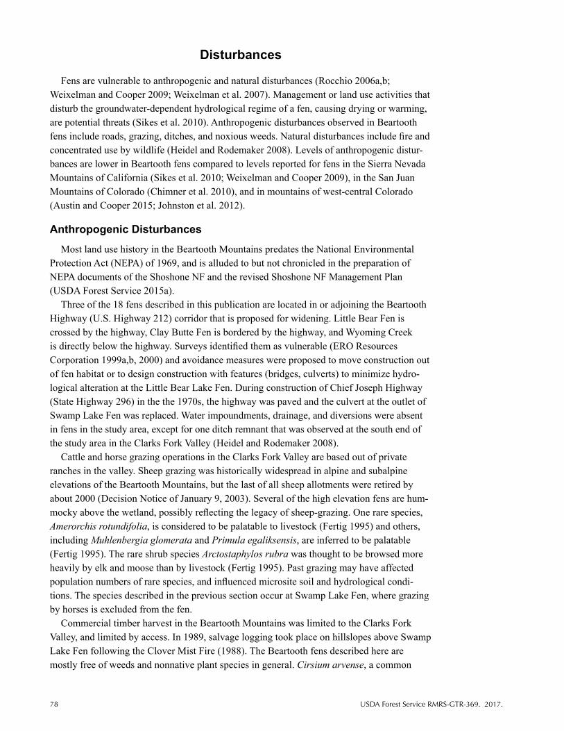
78 USDA Forest Service RMRS-GTR-369. 2017.
Disturbances
Fens are vulnerable to anthropogenic and natural disturbances (Rocchio 2006a,b; Weixelman and Cooper 2009; Weixelman et al. 2007). Management or land use activities that disturb the groundwater-dependent hydrological regime of a fen, causing drying or warming, are potential threats (Sikes et al. 2010). Anthropogenic disturbances observed in Beartooth fens include roads, grazing, ditches, and noxious weeds. Natural disturbances include fire and concentrated use by wildlife (Heidel and Rodemaker 2008). Levels of anthropogenic distur-bances are lower in Beartooth fens compared to levels reported for fens in the Sierra Nevada Mountains of California (Sikes et al. 2010; Weixelman and Cooper 2009), in the San Juan Mountains of Colorado (Chimner et al. 2010), and in mountains of west-central Colorado (Austin and Cooper 2015; Johnston et al. 2012).
Anthropogenic Disturbances
Most land use history in the Beartooth Mountains predates the National Environmental Protection Act (NEPA) of 1969, and is alluded to but not chronicled in the preparation of NEPA documents of the Shoshone NF and the revised Shoshone NF Management Plan (USDA Forest Service 2015a).
Three of the 18 fens described in this publication are located in or adjoining the Beartooth Highway (U.S. Highway 212) corridor that is proposed for widening. Little Bear Fen is crossed by the highway, Clay Butte Fen is bordered by the highway, and Wyoming Creek is directly below the highway. Surveys identified them as vulnerable (ERO Resources Corporation 1999a,b, 2000) and avoidance measures were proposed to move construction out of fen habitat or to design construction with features (bridges, culverts) to minimize hydro-logical alteration at the Little Bear Lake Fen. During construction of Chief Joseph Highway (State Highway 296) in the the 1970s, the highway was paved and the culvert at the outlet of Swamp Lake Fen was replaced. Water impoundments, drainage, and diversions were absent in fens in the study area, except for one ditch remnant that was observed at the south end of the study area in the Clarks Fork Valley (Heidel and Rodemaker 2008).
Cattle and horse grazing operations in the Clarks Fork Valley are based out of private ranches in the valley. Sheep grazing was historically widespread in alpine and subalpine elevations of the Beartooth Mountains, but the last of all sheep allotments were retired by about 2000 (Decision Notice of January 9, 2003). Several of the high elevation fens are hum-mocky above the wetland, possibly reflecting the legacy of sheep-grazing. One rare species, Amerorchis rotundifolia, is considered to be palatable to livestock (Fertig 1995) and others, including Muhlenbergia glomerata and Primula egaliksensis, are inferred to be palatable (Fertig 1995). The rare shrub species Arctostaphylos rubra was thought to be browsed more heavily by elk and moose than by livestock (Fertig 1995). Past grazing may have affected population numbers of rare species, and influenced microsite soil and hydrological condi-tions. The species described in the previous section occur at Swamp Lake Fen, where grazing by horses is excluded from the fen.
Commercial timber harvest in the Beartooth Mountains was limited to the Clarks Fork Valley, and limited by access. In 1989, salvage logging took place on hillslopes above Swamp Lake Fen following the Clover Mist Fire (1988). The Beartooth fens described here are mostly free of weeds and nonnative plant species in general. Cirsium arvense, a common

USDA Forest Service RMRS-GTR-369. 2017. 79
weedy species, was found at two Beartooth fens (Appendix). Encroachment by nonnative species seeded to stabilize the eroding soil above Swamp Lake Fen includes Astragalus cicer, growing directly above the fen (Heidel 3034 RM) and in low numbers in the fen.
Natural Disturbances
Signs of elk and moose were common in Beartooth fens and included browsing, trampling, and scat. There was no evidence that wildlife use affected shrub vigor or longevity. Old, unoccupied beaver lodges were present where Populus tremuloides grew above fens of the Clarks Fork Valley (Heidel and Rodemaker 2008).
The most recent major fire in the study area was the Clover Mist Fire (1988), a stand- replacing fire that burned the wooded hillslopes above Swamp Lake Fen. After the fire, water runoff and erosion increased and deep gullies formed on adjoining slopes; debris flows were noted in 1989 and 1992 (Fertig and Jones 1992). The extensive Clover Mist Fire also burned near Rock Lake Fen. Disturbance by wildfire can alter runoff, snow interception, water perco- lation, groundwater flows, and surface flow volume and timing (Luce et al. 2012) but has not been evaluated in the study area.
The fen fieldwork conducted in the Beartooth Mountains from 2002 to 2007 coincided with a period in which more than 70 percent of Wyoming was in moderate to exceptional drought through most or all of the growing season (Wyoming State Climate Office 2015), consistent with field observations in the Beartooth Mountains study area. At Ghost Creek Fen and Rock Creek Fen, the floating mats that appeared on aerial imagery were not buoyant when visited in 2005. At Ghost Creek Fen, Rock Creek Fen, and Lily Lake Fen, the transi- tion from wetland vegetation to adjacent upland vegetation was dominated by Calamagrostis canadensis. Although this grass species is native, it is tolerant of shifts from aerobic to an- aerobic conditions, conferring competitive advantage under fluctuating water levels.
Future Directions
In this final section, recommendations for future work on fens of the Beartooth Mountains and elsewhere are presented, similar to the framework proposed for fens of California (Sikes et al. 2010). Related policy directives and steps toward improved management of fens on national forests are briefly described.
Inventory
Over the past decade, there has been increased interest in documenting fen resources on public lands in Wyoming (Heidel 2011; Heidel 2012; Heidel 2013 a,b; Heidel and Jones 2006; Heidel and Laursen 2003 a,b; Heidel and Rodemaker 2008; Heidel and Thurston 2004; Lemly 2007; Lemly and Cooper 2011; Mellmann-Brown 2004) and in Colorado (Austin 2008; Austin and Cooper 2015; Chimner et al. 2010; Johnston et al. 2012; Lyon et al. 2007). The following factors have contributed to the need for improved information on the distribu- tion of fens: increased awareness of the rare plants and other biota that occur in fens; the unique ecosystem qualities of many fens, particularly carbon and water storage; recogni-tion that fens are irreplaceable and very old ecosystems (Charman 2002)—most fens in the Rocky Mountains are more than 6,000 years old; the potential for fens to serve as indicators of climate change (Drexler et al. 2013); and revised policy directives with explicit language

80 USDA Forest Service RMRS-GTR-369. 2017.
addressing groundwater-dependent ecosystems (GDEs). The development of standardized inventory protocols by the Forest Service Groundwater Program has resulted in more con-sistent data collection and data management for fens and springs on national forests (USDA 2012b,c).
More information is needed on fens in the Beartooth Mountains. For Wyoming, most of the unsurveyed fens are small (<0.4 ha; 1 ac) and many are located in the Absaroka-Beartooth Wilderness Area. A systematic fen inventory is warranted for the Beartooth Mountains in Montana. More work on alpine fens is needed in both States, including documentation of peat thickness and continuity. A comprehensive inventory of GDEs, including springs, fens, and other groundwater-fed wetlands, throughout the Beartooth Mountains would be informative, particularly in areas of high wetland density. This effort would ideally include additional biot-ic inventories (fauna, vascular and nonvascular flora) to improve documentation of local and regional biodiversity, thus contributing to more informed management on the Shoshone NF. More complete floristic inventories are needed for quantitative comparisons and biodiversity assessments among Rocky Mountain fens. The National Wetlands Inventory mapping (USDI Fish and Wildlife Service 2014) and 1-m resolution color digital orthophoto imagery of the National Agricultural Imagery Program (NAIP) became available for the study area after the 2005–2007 fieldwork, and offer additional resources for conducting inventories of Beartooth fens.
Classification
Statewide wetland vegetation has been classified in Montana (Hansen et al. 1995) and in Colorado (Carsey et al. 2003), with advances in Wyoming by Walford et al. (2001) and others. However, outstanding gaps exist in the study area and the rest of Wyoming. A classification for Wyoming wetland vegetation and an ecological classification of fens would ideally include bryophyte species, reflecting their contributions to biomass, vegetation cover, and diversity. Classification of Beartooth fens would cover a wide range of conditions and serve as a spring-board for wetland classification work elsewhere in the State.
Groundwater chemistry is critical in regulating the distribution of fen vegetation in moun-tainous regions (Lemly and Cooper 2011; Weixelman and Cooper 2009). Expanded baseline research on peat and groundwater chemistry is warranted in the Beartooth Mountains, within and among fens and and over time (table 2). Resulting information would contribute to clas-sification of Beartooth fens and provide valuable context for existing vegetation and water chemistry data over the elevation gradient within the Beartooth Mountains. Comparisons with existing fen classifications that incorporate water chemistry could then be conducted (Bridgham et al. 1996; Vitt 2006; Wheeler and Proctor 2000).
Research and Monitoring
Fens in the Beartooth Mountains occur across a wide range of elevations, geomorphic set-tings, and substrates that influence peat-forming processes, local hydrology, and biodiversity. This range of fen settings provides a natural laboratory for monitoring and research.
Fens require stable hydrological conditions and are important for their water storage and release capacities. Hydrological research and monitoring are needed at select sites to address site-specific questions. For example, at Sawtooth Palsa Fen, monitoring depth to permafrost and discharge at the two outlet streams could assist in determining the impact of

USDA Forest Service RMRS-GTR-369. 2017. 81
climate change on the hydrology of this unique fen and surrounding wetland. At Swamp Lake Fen, hydrological data on surface flow could contribute to assessing impacts of the drained wetland upstream, an elevated outlet downstream, and postfire runoff in the absence of for-est regeneration since the 1988 fire. If management activities on the Shoshone NF have the potential to impair fen functionality, hydrological monitoring would be warranted.
Mountainous areas are the only locations in Wyoming where precipitation exceeds evapo- ration (Curtis and Grimes 2004), and mountain snowpacks serve as Wyoming’s primary source of water. Many mountain fens occur in headwater positions with outlets but no inlets. Research on fen water storage and release, possibly in tandem with research on nutrient storage and release, could provide landscape-scale perspectives documenting the role of fens in watershed hydrology. Improved understanding of the hydrology of mountain fens would contribute to the evaluation of potential climate change impacts, including vulnerability as- sessments for mitigation and adaptative management on national forests (Littell et al. 2012).
Globally, peatlands store carbon and nitrogen, retaining about one-third of the world’s soil carbon and 16 to 28 percent of the world’s soil nitrogen while occupying only 3 to 4 percent of the Earth’s surface (Dise 2009; Vitt 2014). Peat thickness in fens of the Beartooth Mountains (table 2) and elsewhere (Chimner et al. 2010) suggests that cumulative carbon storage could be considerable in mountain ranges with high fen densities. Basic research on carbon dynamics, quantification of carbon pools, determinants of local and regional peat ac- cumulation, and potential impacts of climate change are needed for mountain fens thoughout the western United States. In addition, little is known about the nutrient status of mountain fens, including nitrogen and other macronutrients, as well as micronutrients.
Repeat visits to document trends in the rare species described in this report would inform future conservation efforts. Monitoring of rare plant populations would include periodically assessing population numbers and extent, as well as visiting and documenting additional sites with habitat potential to support certain species. Monitoring of rare plant populations is a high priority for species that occur in fens subject to management-related hydrological changes and current or potential encroachment of invasive species. Changes in plant phenology and visitation by pollinating insects have been documented for high elevation environments throughout the western United States (Boggs and Inouye 2012; Inouye et al. 2000, 2002). Although many rare fen species are wind-pollinated, tracking seasonal changes and annual patterns of plant phenology and pollinator visitation could contribute to assessment of climate change impacts.
Peatlands have long been recognized as archives of past environments (Charman 2002). Accumulated peat can contain charcoal, pollen, and microfossils and macrofossils of past vegetation, as well as records of the ecological and hydrological development of the peatland itself through charcoal, diatoms, invertebrate remains, and testate amoebae shells. Limited palynological information has been collected in the study area (Whitlock and Bartlein 1993). For Beartooth fens, additional radiocarbon dates at a specific site could provide insights into the initiation of peat accumulation and spatial development of the fen. Additional radiocarbon dates over a range of elevations and in different environments could elucidate patterns of peat accumulation over past millennia in response to changing climates. In concert with other paleoecology research, such as lake cores, examination of peat cores from the Beartooth Mountains could contribute to reconstruction of past vegetation and climatic conditions in this part of the Rocky Mountains.

82 USDA Forest Service RMRS-GTR-369. 2017.
Conservation and Management
Recognition of the ecological values of Beartooth fens has resulted in special designation, partially with the intention of protecting and fostering future research at these sites. Swamp Lake Special Botanical Area is designated (Johnston 1987), and a proposal to designate Sawtooth Palsa Fen as a Special Geological Area (Sawtooth Peatbed Geological Area) is included in the Shoshone NF Resource Management Plan revision (USDA Forest Service 2015a). Final designation awaits an establishment report. Likewise, the Lake Creek proposed Research Natural Area, which includes Lily Lake East Fen and Poke Lake Fen, awaits an establishment report. Poke Lake Fen and Rock Creek Fen are located within the Absaroka-Beartooth Wilderness, which provides protection from many management activities and assures maintenance of natural conditions and processes (Public Law 98-550). Management guidance for fens without special designation is provided by regional peatland policies, and the Shoshone NF Management Plan.
Management of fens and other GDEs has been hampered on public lands due to limited information on their locations, characteristics, and condition. Improved inventory and assess-ment of fens is occurring across national forests nationwide, facilitated by the development of protocols, guidance, and assistance from the Forest Service Groundwater Program (USDA Forest Service 2007). For improved management of fens, the first step for many Forest Service management units is the assessment of GDE resources and identification of manage-ment or land use activities that may be affecting the groundwater resources (USDA Forest Service 2007). The work of resource managers supports agency commitments to protect, con-serve, and restore waters, watersheds, and listed wildlife and plant species and their habitats and to conserve biological diversity. For fens and other GDEs, this work begins with informa-tion about their distribution, condition, function, and value, as well as the influence of current management (USDA Forest Service 2010). This report summarizes work to date on fens that occur on a portion of the Shoshone NF, but additional inventory and assessment are needed, as noted earlier. For many national forests, next steps include integration of GDE protection with other management (roads, timber, grazing) and conservation priorities. Where fens have been compromised by management or land use, restoration efforts should be guided by the best available science and information regarding the specific site(s).
A review of statutes and policies that establish management requirements related to GDEs can be found in the Groundwater Dependent Ecosystem Inventory and Monitoring Business Requirements Analysis (USDA Forest Service 2012a,b). In addition, several sections of the 2012 Planning Rule (USDA Forest Service 2012c) include further consideration of GDEs during the revision of forest plans.
References
American Public Health Association; American Water Works Association; and Water Environment Federation. 2005. Standard methods for the examination of water and waste water. 21st ed. Washington, DC: American Public Health Association. 1200 p.
Anderson, David G.; Neid, Stephanie L.; Decker, Karin. 2006. Primula egaliksensis Wormskjold ex Hornemann (Greenland primrose): A technical conservation assessment. Golden, CO: U.S. Department of Agriculture, Forest Service, Rocky Mountain Region. http://www.fs.fed.us/r2/ projects/scp/assessments/. [Accessed 26 February 2016].

USDA Forest Service RMRS-GTR-369. 2017. 83
Argus, George W. 2010. Salix. In: Flora of North America Editorial Committee, eds. Flora of North America North of Mexico. Vol. 7. Magnoliophyta: Salicaceae to Brassicaceae. New York: Oxford University Press: 23–162.
Austin, Gay. 2008. Fens of Grand Mesa, Colorado: Characterization, impacts from human activities, and restoration. Thesis. Prescott, AZ: Prescott College, Department of Environmental Studies. 120 p.
Austin, Gay; Cooper, David J. 2015. Persistence of high elevation fens in the Southern Rocky Mountains, on Grand Mesa, Colorado, U.S.A. Wetlands Ecology and Management. doi 10.1007/ s11273-015-9458-7.
Bailey, Robert G. 1997. Map: Ecoregions of North America (revised). Washington, DC: U.S. Department of Agriculture, Forest Service;The Nature Conservancy; U.S. Geological survey. 1:15,000,000.
Ball, Peter W. 2002. Carex sect. Limosae. In: Flora of North America Editorial Committee, eds. Flora of North America North of Mexico. Vol. 23. Magnoliophyta: Commelinidae (in part): Cyperaceae. New York: Oxford University Press: 416–419.
Ball, Peter W.; Mastrogiuseppe, Joy. 2002. Carex sect. Aulocystis. In: Flora of North America Editorial Committee, eds. Flora of North America North of Mexico. Vol. 23. Magnoliophyta: Commelinidae (in part): Cyperaceae. New York: Oxford University Press: 477–482.
Ball, Peter W.; Wujek, Daniel E. 2002. Eriophorum. In: Flora of North America Editorial Committee, eds. Flora of North America North of Mexico. Vol. 23. Magnoliophyta: Commelinidae (in part): Cyperaceae. New York: Oxford University Press: 21–27.
Bedford, Barbara L.; Godwin, Kevin S. 2003. Fens of the United States: Distribution, characteristics, and scientific connection versus legal isolation. Wetlands. 23(3): 608–629.
Billings, W.D. 1973. Arctic and alpine vegetation: Similarities, differences, and susceptibility to disturbance. Bioscience. 23: 697–704.
Boggs, Carol L.; Inouye, David W. 2012. A single climate driver has direct and indirect effects on pollinator numbers. Ecology Letters. 15(5): 502–508.
Booth, Robert K.; Zygmunt, Jennifer R. 2005. Biogeography and comparative ecology of testate amoebae inhabiting Sphagnum-dominated peatlands in the Great Lakes and Rocky Mountain regions of North America. Diversity and Distributions. 11: 577–590.
Bridgham, Scott D.; Pastor, John; Janssens, Jan A.; [et al.]. 1996. Multiple limiting gradients in peatlands: A call for a new paradigm. Wetlands. 16(1): 45–65.
Bursik, Robert. 1990. Floristic and phytogeographic analysis of northwestern Rocky Mountain Peatlands, U.S.A. Thesis. Moscow, ID: University of Idaho.
Carsey, Kathy; Kittel, Gwen; Decker, Karin; [et al.]. 2003. Field guide to the wetland and riparian plant associations of Colorado. Fort Collins, CO: Colorado Natural Heritage Program.
Chadde, Steve W.; Hansen, Paul L.; Pfister, Robert D. 1988. Wetland plant communities of the northern range, Yellowstone National Park. Montana Riparian Association, Final Report. Missoula, MT: University of Montana, School of Forestry.
Chadde, Steve W.; Shelly, J. Stephen; Bursik, Robert J.; [et al.]. 1998. Peatlands on national forests of the Northern Rocky Mountains: Ecology and conservation. Gen. Tech. Rep. RMRS-GTR-11. Ogden, UT: U.S. Department of Agriculture, Forest Service, Rocky Mountain Research Station.
Charman, Dan. 2002. Peatlands and environmental change. West Sussex, Englan: John Wiley and Sons, Ltd.
Chimner, Rod A.; Lemly, Joanna M.; Cooper, David J. 2010. Mountain fen distribution, types and restoration priorities, San Juan Mountains, Colorado, USA. Wetlands. 30(4): 763–771.
Federal Water Pollution Control Act of 1972 (“Clean Water Act”). 33 U.S.C. 1251–1387. Cochrane, Thomas S. 2002a. Carex sect. Leptocephalae. In: Flora of North America Editorial
Committee, eds. Flora of North America North of Mexico. Vol. 23. Magnoliophyta: Commelinidae (in part): Cyperaceae. New York: Oxford University Press: 5655–566.
Cochrane, Thomas S. 2002b. Carex sect. Leucoglochin. In: Flora of North America Editorial Committee, eds. Flora of North America North of Mexico. Vol. 23. Magnoliophyta: Commelinidae (in part): Cyperaceae. New York: Oxford University Press: 530–531.

84 USDA Forest Service RMRS-GTR-369. 2017.
Cochrane, Thomas S. 2002c. Carex sect. Paniculatae. In: Flora of North America Editorial Committee, eds. Flora of North America North of Mexico. Vol. 23. Magnoliophyta: Commelinidae (in part): Cyperaceae. New York: Oxford University Press: 278–281.
Collins, Ellen I.; Lichvar, Robert W.; Evert, Erwin F. 1984. Description of the only known fen-palsa in the contiguous United States. Arctic and Alpine Research. 16(2): 255–258.
Cooper, David J.; Andrus, Richard E. 1994. Patterns of vegetation and water chemistry in peatlands of the west-central Wind River Range, Wyoming, U.S.A. Canadian Journal of Botany. 72: 1586–1597.
Copeland, Holly E.; Tessman, Stephen A.; Girvetz, Evan H.; [et al.]. 2010. A geospatial assessment on the distribution, condition, and vulnerability of Wyoming‘s wetlands. Ecological Indicators. 10: 869–879.
Creed, J.T.; Brockhoff, C.A.; Martin, T.D. 1994. Determination of trace elements in waters and wastes by inductively coupled plasma-mass spectroscopy, EPA Method 200.8, revision 5.4, EMMC version. Cincinnati, OH: U.S. Environmental Protection Agency, National Exposure Research Laboratory (NERL).
Crins, William J. 2002. Carex sect. Clandestinae. In: Flora of North America Editorial Committee, eds. Flora of North America North of Mexico. Vol. 23. Magnoliophyta: Commelinidae (in part): Cyperaceae. New York: Oxford University Press: 546–548.
Curtis, Jan; Grimes, Kate. 2004. Wyoming climate atlas. Laramie, WY: University of Wyoming, Wyoming Water Resources Data System.
Decker, Karin. 2006. Salix candida Fluegge ex Wild. (sageleaf willow): A technical conservation assessment. Golden, CO: U.S. Department of Agriculture, Forest Service, Rocky Mountain Region. http://www.fs.fed.us/r2/projects/scp/assessments/. [Accessed 26 February 2016].
Decker, Karin; Culver, Denise R.; Anderson, D.G. 2006a. Eriophorum chamissonis C.A. Mey. (Chamisso’s cottongrass): A technical conservation assessment. Golden, CO: U.S. Department of Agriculture, Forest Service, Rocky Mountain Region. http://www.fs.fed.us/r2/projects/scp/ assessments/. [Accessed 26 February 2016].
Decker, Karin; Culver, Denise R.; Anderson, D.G. 2006b. Eriophorum gracile W.D.J. Koch (slender cottongrass): A technical conservation assessment. Golden, CO: U.S. Department of Agriculture, Forest Service, Rocky Mountain Region. http://www.fs.fed.us/r2/projects/scp/assessments/. [Accessed 26 February 2016].
Decker, Karin; Culver, Denise R.; Anderson, David G. 2006c. Kobresia simpliciuscula (Wahlenberg) Mackenzie (simple bog sedge): A technical conservation assessment. Golden, CO: U.S. Department of Agriculture, Forest Service, Rocky Mountain Region. http://www.fs.fed.us/r2/projects/scp/ assessments/. [Accessed 26 February 2016].
Dise, Nancy B. 2009. Peatland response to global change. Science. 326: 810–811.Dorn, Robert D. 2001. Vascular plants of Wyoming. 3rd ed. Cheyenne, WY: Mountain West Publishing.Dorn, Robert D. 2010. The genus Salix in North America North of Mexico. Ebook. Raleigh, NC: Lulu
Press, Inc. 59 p. http://www.lulu.com/us/en/shop/robert-dorn/the-genus-salix-in-north-america- north-of-mexico/ebook/product-6517733.html.
Drexler, Judith Z.; Knifong, Donna; Tuil, JayLee; [et al.]. 2013. Fens as whole ecosystem gauges of groundwater recharge under climate change. Journal of Hydrology. 481: 22–34.
Driese, Ken; Reiners, William A.; Merrill; Evelyn H.; [et al.]. 1997. A digital land cover map for Wyoming, USA: A tool for vegetation analysis. Journal of Vegetation Science. 8: 133–146.
Dunlop, Debra A. 2002. Carex sect. Scirpinae. In: Flora of North America Editorial Committee, ed. Flora of North America North of Mexico. Vol. 23. Magnoliophyta: Commelinidae (in part): Cyperaceae. New York: Oxford University Press: 549–553.
Eckel, Patricia M. 1996. Synopsis of the mosses of Wyoming. Great Basin Naturalist. 56(3):197–204.Eckel, Patricia M. 2007. County checklist of the mosses of Wyoming. Res Botanica, a Missouri
Botanical Garden website. [Previously posted on Missouri Botanical Garden homepage, 17 August 2007].
Elliott, Joe C. 1995. Personal communication to Patricia Eckel. (Letter of 5 February re. bryophyte specimens collected at Swamp Lake accompanying set of Swamp Lake bryophyte specimens

USDA Forest Service RMRS-GTR-369. 2017. 85
collected in 1990 and deposited in Clinton Herbarium). Wyoming Natural Diversity Database manual files.
Elliott, Brian A.; Elliott, Emily. 2011. Amerorchis rotundifolia (round-leaf orchid) survey report, Shoshone National Forest. Unpublished report on file with: Shoshone National Forest. Laramie, WY.
Elliott, Emily R. 2014. A floristic inventory of the northern Absaroka, Beartooth, and Gallatin Ranges, Wyoming and Montana, U.S.A. Thesis. Laramie, WY: University of Wyoming, Department of Botany.
Endangered Species Act of 1973 [ESA]; 16 U.S.C. 1531–1536, 1538–1540.ERO Resources Corporation. 1999a. Draft report: Plant species of concern, four bridge crossings of
U.S. 212 (FH4), the Beartooth Highway, Park County, Wyoming. Prepared for the Federal Highway Administration by ERO Resources Corp., Denver, CO.
ERO Resources Corporation. 1999b. Final report: Plant species of concern, portions of US 212 (FH 4), the Beartooth Highway, Park County, Wyoming. Prepared for the Federal Highway Administration by ERO Resources Corp., Denver, CO.
ERO Resources Corporation. 2000. Plant Species of Concern, Final Report, Portions of U.S. 212 (FH4), The Beartooth Highway, Park County, Wyoming and Park County, Montana. Prepared for the Federal Highway Administration-Central Federal Lands Highway Division, Lakewood, CO.
Evert, Erwin F. 1982. Noteworthy collections, Wyoming. Madroño. 29 (2): 124–125.Evert, Erwin F. 1984. A research natural area proposal and suitability investigation report for the
Cathedral Cliffs Wetland Complex. Unpublished report on file with: The Nature Conservancy and the Wyoming Native Plant Society.
Evert, Erwin F. 1986. The Yellowstone region: Endemics and other interesting plants. In: Williams, J., ed. Rocky Mountain alpines. Denver, CO: American Rock Garden Society and Denver Botanic Gardens.
Evert, Erwin F. 2010. Vascular plants of the Greater Yellowstone Area: Annotated catalog and atlas. Park Ridge, IL: Erwin F. Evert.
Evert, Erwin F.; Dorn, Robert D.; Hartman, Ronald H.; [et al.]. 1986. Noteworthy collections, Wyoming. Madroño. 33(4): 315-317.
Fertig, Walter. 1995. Report on the potential vulnerability of Shoshone National Forest Candidate and Sensitive plant species to livestock grazing. Unpublished report on file with: University of Wyoming, Wyoming Natural Diversity Database, Laramie, WY.
Fertig, Walter. 1997. Plant species of special concern on Shoshone National Forest: 1996 survey results. Unpublished report on file with: University of Wyoming, Wyoming Natural Diversity Database, Laramie, WY.
Fertig, Walter. 1998. The status of rare plants on Shoshone National Forest: 1995-97 survey results. Report on file with: University of Wyoming, Wyoming Natural Diversity Database, Laramie, WY.
Fertig, Walter; Bynum, Michael. 1994. Biological report on the Proposed Twin Lakes Research Natural Area. Unpublished report on file with: University of Wyoming, Wyoming Natural Diversity Database, Laramie, WY. 95 p.
Fertig, Walter; Jones, George. 1992. Plant communities and rare plant species of the Swamp Lake Botanical Area, Clarks Fork Ranger District, Shoshone National Forest. Unpublished report on file with: University of Wyoming, Wyoming Natural Diversity Database, Laramie, WY.
Fertig, Walter; Markow, Stuart. 2001. Guide to the willows of Shoshone National Forest. Gen. Tech. Rep. RMRS-GTR-83. U.S. Department of Agriculture, Forest Service, Rocky Mountain Research Station. 79 p. http://www.treesearch.fs.fed.us/pubs/29200. [Accessed 26 February 2016].
Fertig, Walter; Refsdal, Charmaine; Whipple, Jennifer. 1994. Wyoming rare plant field guide. Cheyenne, WY: Wyoming Rare Plant Technical Committee.
Foose, R.M.; Wise, D.U.; Bargarini, G.S. 1961. Structural geology of the Beartooth Mountains, Montana and Wyoming. Geological Society of America Bulletin. 72(8): 1143–1172.

86 USDA Forest Service RMRS-GTR-369. 2017.
Gage, Edward; Cooper, David J. 2006a. Carex diandra Schrank (lesser panicled sedge): A technical conservation assessment. Golden, CO: U.S. Department of Agriculture, Forest Service, Rocky Mountain Region. http://www.fs.fed.us/r2/projects/scp/assessments/. [Accessed 26 February 2016].
Gage, Edward; Cooper, David J. 2006b. Carex leptalea Wahlenberg (bristly-stalked sedge): A technical conservation assessment. Golden, CO: U.S. Department of Agriculture, Forest Service, Rocky Mountain Region. http://www.fs.fed.us/r2/projects/scp/assessments/. [Accessed 26 February 2016].
Gage, Edward; Cooper, David J. 2006c. Carex limosa L. (mud sedge): A technical conservation assessment. Golden, CO: U.S. Department of Agriculture, Forest Service, Rocky Mountain Region. http://www.fs.fed.us/r2/projects/scp/assessments/. [Accessed 26 February 2016].
Gage, Edward; Cooper, David J. 2006d. Carex livida (Wahlenberg) Willdenow (livid sedge): A Technical Conservation Assessment. Golden, CO: U.S. Department of Agriculture, Forest Service, Rocky Mountain Region. http://www.fs.fed.us/r2/projects/scp/assessments/. [Accessed 26 February 2016].
Handley, Joy; Heidel, Bonnie. 2005. Amerorchis rotundifolia (Banks ex Pursh) Hulten (round-leaved orchid): A technical conservation assessment. Golden, CO: U.S. Department of Agriculture, Forest Service, Rocky Mountain Region. http://www.fs.fed.us/r2/projects/scp/assessments/. [Accessed 26 February 2016].
Hansen, Paul L.; Pfister, Robert D.; Boggs, Keith; [et al.]. 1995. Classification and management of Montana’s riparian and wetland sites. Misc. Publ. 54. Missoula, MT: University of Montana, Montana Forest and Conservation Experiment Station.
Haselhorst, Monia S.H.; Buerkle, C. Alex. 2013. Population genetic structure of Picea engelmannii, P. glauca and their previously unrecognized hybrids in the central Rocky Mountains. Tree Genetics & Genomes. 9(3): 669–681.
Haynes, Robert R.; Hellquist, C. Barre. 2000. Potamogetonaceae. In: Flora of North America Editorial Committee, eds. Flora of North America North of Mexico. Vol. 22 Magnoliophyta: Alismatidae, Arecidae, Commelinidae (in part), and Zingiberidae. New York: Oxford University Press: 47–74.
Heidel, Bonnie. 2007. Wyoming plant species of concern. On file with: University of Wyoming, Wyoming Natural Diversity Database, Laramie, WY.
Heidel, Bonnie. 2009. Water chemistry of fens in the Beartooth Mountains. Unpublished report for Shoshone National Forest. On file with: University of Wyoming, Wyoming Natural Diversity Database, Laramie, WY. http://www.uwyo.edu/wyndd/reports-and-publications/. [Accessed 26 February 2016].
Heidel, Bonnie. 2011. Status report on sensitive plant species of fen habitats, Big Horn Mountains, north-central Wyoming. Cooperative Agreement No. 09-CS-11020200-013. On file with: University of Wyoming, Wyoming Natural Diversity Database, Laramie, WY. http://www.uwyo.edu/wyndd/ reports-and-publications/. [Accessed 26 February 2016].
Heidel, Bonnie. 2012. Wyoming plant species of concern. On file with: University of Wyoming, Wyoming Natural Diversity Database, Laramie, WY. http://www.uwyo.edu/wyndd/species-of- concern/index.html. [Accessed 26 February 2016].
Heidel, Bonnie. 2013a. Sensitive plant survey in the Dickinson Park area, Shoshone National Forest. Report on file with: University of Wyoming, Wyoming Natural Diversity Database, Laramie, WY. http://www.uwyo.edu/wyndd/reports-and-publications/. [Accessed 26 February 2016].
Heidel, Bonnie. 2013b. Status of Antennaria arcuata (Meadow pussytoes) in Sublette County, Wyoming. On file with: University of Wyoming, Wyoming Natural Diversity Database, Laramie, WY. http://www.uwyo.edu/wyndd/reports-and-publications/. [Accessed 26 February 2016].
Heidel, Bonnie; Handley, Joy; Arnett, Melanie. 2013. Status report on sensitive plant species of Pole Mountain wetlands. On file with: University of Wyoming, Wyoming Natural Diversity Database, Laramie, WY. http://www.uwyo.edu/wyndd/reports-and-publications/. [Accessed 26 February 2016].
Heidel, Bonnie; Jones, George. 2006. Botanical and ecological characteristics of fens in the Medicine Bow Mountains, Medicine Bow National Forest, Albany and Carbon counties, Wyoming. On file with: University of Wyoming, Wyoming Natural Diversity Database, Laramie, WY. http://www. uwyo.edu/wyndd/reports-and-publications/. [Accessed 26 February 2016].

USDA Forest Service RMRS-GTR-369. 2017. 87
Heidel, Bonnie; Laursen, Scott. 2003a. Botanical and ecological inventory of peatland sites on the Medicine Bow National Forest. On file with: University of Wyoming, Wyoming Natural Diversity Database, Laramie, WY. http://www.uwyo.edu/wyndd/reports-and-publications/. [Accessed 26 February 2016].
Heidel, Bonnie; Laursen, Scott. 2003b. Botanical and ecological inventory of peatland sites on the Shoshone National Forest. On file with: University of Wyoming, Wyoming Natural Diversity Database, Laramie, WY. http://www.uwyo.edu/wyndd/reports-and-publications/. [Accessed 26 February 2016].
Heidel, Bonnie; Rodemaker, Eli. 2008. Inventory of peatland systems in the Beartooth Mountains, Park County, Wyoming. On file with: University of Wyoming, Wyoming Natural Diversity Database, Laramie, WY. http://www.uwyo.edu/wyndd/reports-and-publications/. [Accessed 26 February 2016].
Heidel, B.; Thurston, Robert. 2004. Extensive inventory of peatland sites on the Medicine Bow National Forest. Unpublished report on file with: University of Wyoming, Wyoming Natural Diversity Database, Laramie, WY.
Houston, K. 1993. SRI vegetation handbook. Unpublished report on file with: U.S. Department of Agriculture, Forest Service, Shoshone National Forest, Cody, WY.
Houston, Kent E.; Hartung, Walter J.; Hartung, Carol J. 2001. A field guide for forest indicator plants, sensitive plants, and noxious weeds of the Shoshone National Forest, Wyoming. Gen. Tech. Rep. RMRS-GTR-84, Ogden, UT: U.S. Department of Agriculture, Forest Service Rocky Mountain Research Station.
Hutchinson, George E. 1975. A treatise on limnology. III Limnological Botany. New York: Wiley. 660 p.
Inouye, David W.; Barr, Billy; Armitage, Kenneth B.; [et al.]. 2000. Climate change is affecting altitudinal migrants and hibernating species. Proceedings of the National Academy of Sciences. 97(4): 1630–1633.
Inouye, David W.; Morales, Manuel A.; Dodge, Gary J. 2002. Variation in timing and abundance of flowering by Delphinium barbeyi (Ranunculaceae): The roles of snowpack, frost, and La Niña in the context of climate change. Oecologia. 130: 543–550.
Johnson, Philip L. 1962. The occurrence of new arctic-alpine species in the Beartooth Mountains, Wyoming-Montana. Madroño. 16(7): 229–233.
Johnson, Philip L.; Billings, W. D. 1962. The alpine vegetation of the Beartooth Plateau in relation to cryopedogenic processes and patterns. Ecological Monographs. 32(2):105–133.
Johnston, Barry C. 1987. Establishment report for Swamp Lake Botanical Area, Shoshone National Forest, Park County, WY. Golden, CO: U.S. Department of Agriculture, Forest Service, Rocky Mountain Region.
Johnston, Barry C.; Stratton, Benjamin T.; Young, Warren R.; [et al.]. 2012. Inventory of fens in a large landscape of west-central Colorado: Grand Mesa, Uncompaghre, and Gunnison National Forests. Delta, CO: U.S. Department of Agriculture, Forest Service, Grand Mesa, Uncompaghre, and Gunnison National Forests. 209 p. http://www.fs.usda.gov/detailfull/gmug/landmanagement/resourc emanagement/?cid=stelprdb5363685&width=full. [Accessed 26 February 2016].
Jones, George P.; Fertig, Walter. 1999a. Ecological evaluation of the potential Lake Creek Research Natural Area within the Shoshone National Forest, Park County, Wyoming. On file with: Wyoming Natural Diversity Database, Laramie, WY.
Jones, George P.; Fertig, Walter. 1999b. Ecological evaluation of the potential Beartooth Butte Research Natural Area within the Shoshone National Forest, Park County, Wyoming. Unpublished report prepared for the Shoshone National Forest. On file with: University of Wyoming, Wyoming Natural Diversity Database, Laramie, WY.
Jones, George; Heidel, Bonnie; Fertig, Walter. 2011a. Plants and vegetation of the Swamp Lake Special Botanical Area within the Shoshone National Forest, Park County, Wyoming. Prepared for the Shoshone National Forest, USDA Forest Service. On file with: University of Wyoming, Wyoming Natural Diversity Database, Laramie, WY. http://www.uwyo.edu/wyndd/reports-and-publications/. [Accessed 26 February 2016]. 40 p.

88 USDA Forest Service RMRS-GTR-369. 2017.
Jones, George; Heidel, Bonnie; Fertig, Walter. 2011b. Plants and vegetation of the Potential Lake Creek Research Natural Area within the Shoshone National Forest, Park County, Wyoming. Prepared for the Shoshone National Forest, USDA Forest Service. On file with: University of Wyoming, Wyoming Natural Diversity Database, Laramie, WY. http://www.uwyo.edu/wyndd/ reports-and-publications/. [Accessed 26 February 2016]. 30 pp.
Jones, George; Heidel, Bonnie; Fertig, Walter. 2011c. Plants and vegetation of the Potential Sawtooth Fen-Palsa Special Interest Area within the Shoshone National Forest, Park County, Wyoming. Prepared for the Shoshone National Forest, USDA Forest Service. On file with: University of Wyoming, Wyoming Natural Diversity Database, Laramie, WY. http://www.uwyo.edu/wyndd/ reports-and-publications/. [Accessed 26 February 2016]. 26 pp.
Keinath, Doug A., Heidel, Bonnie; Beauvais, Gary. 2003. Wyoming Plant and Animal Species of Special Concern. On file with: University of Wyoming, Wyoming Natural Diversity Database, Laramie, WY.
Knight, Dennis H.; Jones, George P.; Reiners, William A.; [et al.]. 2014, 2nd ed. Mountains and Plains: The ecology of Wyoming landscapes. New Haven, CT: Yale University Press.
Kosovich-Anderson, Yelena I. 2009. Preliminary annotated checklist of bryophytes of the Beartooth Mountains of Wyoming, Shoshone National Forest. Prepared for Shoshone National Forest. On file with: University of Wyoming, Wyoming Natural Diversity Database, Laramie, WY.
Kosovich-Anderson, Yelena I. 2010. Annotated checklist of bryophytes of the Beartooth Mountains of Wyoming, Shoshone National Forest. Unpublished report prepared for Shoshone National Forest. On file with: University of Wyoming, Wyoming Natural Diversity Database, Laramie, WY. http:// www.uwyo.edu/wyndd/reports-and-publications/. [Accessed 26 February 2016].
Kosovich-Anderson, Yelena I. 2011. Annotated checklist of bryophytes of Beartooth Mountains of Wyoming, Shoshone National Forest. A technical report. Laramie, WY: University of Wyoming, Natural Diversity Database.
Kosovich-Anderson, Yelena I. 2014. An annotated checklist of bryophytes of the east slope of the Wind River Range, Wyoming: Preliminary results of bryophyte inventory. Laramie, WY: University of Wyoming, Wyoming Natural Diversity Database. http://www.uwyo.edu/wyndd/reports-and- publications/. [Accessed 26 February 2016].
Ladyman, Juanita A. R. 2005. Salix barrattiana Hooker (Barratt’s willow): A technical conservation assessment. Golden, CO: U.S. Department of Agriculture, Forest Service, Rocky Mountain Region. http://www.fs.fed.us/r2/projects/scp/assessments/. [Accessed 26 February 2016].
Lemly, Joanna M. 2007. Fens of Yellowstone National Park, USA: Regional and local controls over plant species distribution. Thesis. Fort Collins, CO: Colorado State University.
Lemly, Joanna M.; Cooper, David J. 2011. Multiscale factors control community and species distribution in mountain peatlands. Botany. 89: 689–713.
Lenz, Martin. 2011. The bryophyte flora of Bighorn National Forest fens: A checklist. Report prepared for the Bighorn National Forest. On file with: University of Wyoming, Wyoming Natural Diversity Database, Laramie, WY.
Lesica, Peter. 1986. Vegetation and flora of Pine Butte Fen, Teton County, Montana. Great Basin Naturalist. 46: 22–32.
Lesica, Peter. 2012. Manual of Montana vascular plants. Fort Worth, TX: BRIT Press.Lichvar, Robert W.; Melvin, Norman C.; Butterwick, Mary L.; [et al.]. 2012. National wetland plant
list indicator rating definitions. ERDC/CRREL TN-12-1. Washington, DC: U.S. Army Corps of Engineers, Wetland Regulatory Assistance Program.
Lichvar, Robert W.; Melvin, Norman C.; Butterwick, Mary L.; [et al.]. 2014. The National wetland plant list: 2014 update of wetland ratings. Phytoneuron. 2014-41: 1–42.
Littell, Jeremy S.; Peterson, David L.; Millar, Constance I.; [et al.]. 2012. U.S. national forests adapt to climate change through science-management partnerships. Climatic Change. 110: 269–296.
Love, J. David.; Christiansen, Ann C. 1985. Geological map of Wyoming. Reston, VA: U.S. Geological Survey. 1:250,000.
Luce, Charles; Morgan, Penny; Dwire, Kathleen; [et al.]. 2012. Climate change, forests, fire, water, and fish: Building resilient landscapes, streams and managers. Gen. Tech. Rep. RMRS-GTR-290; Fort

USDA Forest Service RMRS-GTR-369. 2017. 89
Collins, CO: U.S. Department of Agriculture, Forest Service, Rocky Mountain Research Station. 215 p. http://www.treesearch.fs.fed.us/pubs/41932. [Accessed 26 February 2016].
Lyon, Peggy; Rohman, Marian; Crawford, Julie. 2007. San Juan National Forest botanical survey of fens. Prepared for San Juan National Forest. Fort Collins, CO: Colorado Natural Heritage Program.
Malmer, Nils. 1986. Vegetational gradients in relation to environmental conditions in northwestern European mires. Canadian Journal of Botany. 64: 375–383.
Marr, Kendrick L.; Allen, Geraldine A.; Hebda, Richard J. 2008. Refugia in the cordilleran ice sheet of western North America: Chloroplast DNA diversity in the Arctic-alpine plant Oxyria digyna. Journal of Biogeography. 35(7a): 1323–1334.
Marr, Kendrick L.; Hebda, Richard J.; MacKenzie, William H. 2012. New alpine plant records for British Columbia and the recognition of a new biogeographic element in western North America. Botany. 90(6): 445–455.
Marston, Richard A.; Mills, John D.; Wrazien, David R.; [et al.]. 2005. Effects of Jackson Lake Dam on the Snake River and its floodplain, Grand Teton National Park, Wyoming, USA. Geomorphology. 71: 79–98.
Mellmann-Brown, Sabine. 2004. Botanical and ecological inventory of selected peatland sites on the Shoshone National Forest. Prepared for Shoshone National Forest. Laramie, WY: University of Wyoming, Wyoming Natural Diversity Database.
Mills, Stephanie; Fertig, Walter. 1996a. Field guide to rare and sensitive plants of the Shoshone National Forest. Unpublished report on file with University of Wyoming, Wyoming Natural Diversity Database, Laramie, WY.
Mills, Stephanie; Fertig, Walter. 1996b. Survey of plant species of special concern on the Shoshone National Forest, 1995. Prepared for Shoshone National Forest. Unpublished report on file with: the Wyoming Natural Diversity Database, Laramie, WY.
Montana Natural Heritage Program. 2015. Montana field guides: Plants. Database. http://mtnhp.org/ plants/. [Accessed 26 February 2016].
Murray, David F. 2002. Carex sect. Racemosae. Pages. In: Flora of North America Editorial Committee, edsr. Flora of North America North of Mexico. Vol. 23. Magnoliophyta: Commelinidae (in part): Cyperaceae. New York: Oxford University Press: 401–414.
National Environmental Policy Act of 1969 [NEPA]; 42 U.S.C. 4321 et seq.NatureServe. 2016. NatureServe Explorer: An online encyclopedia of life. Database. http://www.
natureserve.org/explorer/index.htm. [Accessed 26 February 2016].Neid, Stephanie L. 2006. Utricularia minor L. (lesser bladderwort): A technical conservation
assessment. Golden, CO: U.S. Department of Agriculture, Forest Service, Rocky Mountain Region. http://www.fs.fed.us/r2/projects/scp/assessments/. [Accessed 26 February 2016].
Neid, Stephanie; Decker, Karin; Anderson, David G. 2006. Salix myrtillifolia Anderss. (blueberry willow): A technical conservation assessment. [Online]. Golden, CO: USDA Forest Service, Rocky Mountain Region. http://www.fs.fed.us/r2/projects/scp/assessments/. [Accessed 26 February 2016].
Pierce, Kenneth L. 1979. History and dynamics of glaciation in the northern Yellowstone National Park area. Geological Survey Professional Paper 729F. Washington, DC: U.S. Department of the Interior, Geological Survey. 102 p.
Pierce, William G. 1961. Permafrost and thaw depressions in a peat deposit in the Beartooth Mountains, northwestern Wyoming. In: Short papers of the geologic and hydrologic sciences, articles 1–146. U.S. Geological Survey Professional Paper 424B. Washington, DC: U.S. Department of the Interior, Geologic Survey: 154–156.
Pierce, William G. 1965. Geological quadrangle maps of the United States: Geological map of the Deep Lake Quadrangle, Park County, Wyoming. Map GQ-478. Washington, DC: U.S. Department of the Interior, Geological Survey.
Pierce, William G. 1980. Geological map of the Cody 1 degree by 2 degrees quadrangle, Wyoming. 1:250,000. (Compiled 1978). Miscellaneous Field Studies Map 963. Washington, DC: U.S. Department of the Interior, Geological Survey.

90 USDA Forest Service RMRS-GTR-369. 2017.
Pierce, William G.; Nelson, Willis H. 1971. Geological quadrangle maps of the United States: Geological map of the Beartooth Butte Quadrangle, Park County, Wyoming. Map 935. Washington, DC: U.S. Department of the Interior, Geological Survey.
Rocchio, Joe. 2006a. Rocky Mountain subalpine-montane fen ecological system: Ecological integrity assessment. Fort Collins, CO: Colorado Natural Heritage Program. 79 p.
Rocchio, Joe. 2006b. Vegetation index of biotic integrity for Southern Rocky Mountain fens, wet meadows, and riparian shrublands: Phase 1 Final Report. Fort Collins, CO: Colorado Natural Heritage Program. 78 p.
Rocky Mountain Herbarium. 2016. RM specimen database. Laramie, WY: University of Wyoming, Department of Botany. http://www.rmh.uwyo.edu/. [Accessed 26 February 2016].
Rothrock, P.E.; Reznicek, A.A. 2002. Carex sect. Paniceae. In: Flora of North America Editorial Committee, eds. Flora of North America North of Mexico. Vol. 23. Magnoliophyta: Commelinidae (in part): Cyperaceae. New York: Oxford University Press:426–431.
Rydin, Håkan; Jeglum, John. 2013. The biology of peatlands. 2nd ed. Oxford, UK: Oxford University Press.
Sikes, Kendra; Cooper, David; Weis, Sue; [et al.]. 2010. Fen conservation and vegetation assessment in the national forests of the Sierra Nevada and adjacent mountains, California. Sacramento, CA: California Native Plant Society Vegetation Program and California Department of Fish and Game; Fort Collins, CO: Colorado State University; Vallejo, CA: U.S. Forest Service, Pacific Southwest Region; and Davis, CA: University of California Davis. 314 p.
Sjörs, H. 1948. Myrvegetation i Bergslagen. [Mire vegetation in Bergslagen, Sweden]. Acta Phytogeographica Suevica. 21: 1–299.
Soreng, Robert J. 2007. Poa. In: Flora of North America Editorial Committee, eds. Flora of North America North of Mexico. Vol. 24. Magnoliophyta: Commelinidae (in part): Poaceae, part 1. New York: Oxford University Press: 486–601.
Suzuki, Nobuya; Olson, Deanna H. 2008. Options for biodiversity conservation in managed forest landscapes of multiple ownerships in Oregon and Washington, USA. Biodiversity Conservation. 17: 1017–1039.
Trock, Debra K. 2006. Packera. In: Flora of North America Editorial Committee, eds. Flora of North America North of Mexico. Vol. 20. Magnoliophyta: Asteridae (in part): Asteraceae part 2. New York: Oxford University Press: 570–602.
Tweit, Susan; Houston, Kent. 1980. Grassland and shrubland types of the Shoshone National Forest. Golden, CO: U.S. Department of Agriculture, Forest Service, Rocky Mountain Region. 143 p.
U.S. Department of Agriculture, Forest Service [USDA Forest Service]. 1986. Final Environmental Impact Statement—Shoshone National Forest Land and Resource Management Plan. Cody, WY:
U.S. Department of Agriculture, Forest Service, Rocky Mountain Region, Shoshone National Forest.U.S. Department of Agriculture, Forest Service [USDA Forest Service]. 2002. Wetland protection:
Fens. Regional Directive Memo, 19 March 2002 from Marisue Hillard, Director, Renewable Resources, Rocky Mountain Region, to Forest Supervisors. Personal communication on file with:
U.S. Department of Agriculture, Forest Service, Rocky Mountain Region, Golden, CO.U.S. Department of Agriculture, Forest Service [USDA Forest Service]. 2007. Technical guide to
managing groundwater resources. FS-881. Washington, DC: U.S. Department of Agriculture, Forest Service, Minerals and Geology Management, Watershed, Fish, Wildlife, Air, and Rare Plants. 281 p.
U.S. Department of Agriculture, Forest Service [USDA Forest Service]. 2010. Inventory and analysis of groundwater dependent ecosystems. Forest Service Manual FSM 2881.2. Washington, DC: U.S. Department of Agriculture, Forest Service.
U.S. Department of Agriculture, Forest Service [USDA Forest Service]. 2012a. National Forest System Land Management Planning. 77 FR 21162-21276. 2012 Planning Rule (36 CFR Part 219) http:// www.fs.usda.gov/Internet/FSE_DOCUMENTS/stelprdb5362536.pdf. [Accessed 26 February 2016].
U.S. Department of Agriculture, Forest Service [USDA Forest Service]. 2012b. Groundwater- dependent ecosystems: Level I inventory field guide; inventory methods for assessment and planning. Gen. Tech. Rep. WO-86a. Washington, DC: U.S. Department of Agriculture, Forest Service. http://www.fs.fed.us/geology/groundwater.html. [Accessed 26 February 2016].

USDA Forest Service RMRS-GTR-369. 2017. 91
U.S. Department of Agriculture, Forest Service [USDA Forest Service]. 2012c. Groundwater- dependent ecosystems: Level II inventory field guide; inventory methods for assessment and planning. Gen. Tech. Rep. WO-86b. Washington, DC: U.S. Department of Agriculture, Forest Service. (http://www.fs.fed.us/geology/groundwater.html). [Accessed 26 February 2016].
U.S. Department of Agriculture, Forest Service [USDA Forest Service]. 2015a. Land Management Plan—2015 Revision. Cody, WY: U.S. Department of Agriculture, Forest Service, Shoshone National Forest. http://www.fs.usda.gov/Internet/FSE_DOCUMENTS/stelprd3842886.pdf. [Accessed 26 February 2016].
U.S. Department of Agriculture, Forest Service [USDA Forest Service]. 2015b. Threatened, endangered and sensitive plants and animals. Supplement No: 2600-2015-1. In: FSM 2600 – Wildlife, fish and sensitive plant habitat management chapter 2670. Effective Date: August 29, 2015. (http://www.fs.usda.gov/detail/r2/landmanagement/) [Accessed 26 February 2016].
U.S. Department of Agriculture, Natural Resources Conservation Service, Soil Survey Staff. 2008. Soil classification in Shoshone National Forest, Wyoming. Unpublished data on file with: U.S. Department of Agriculture, Natural Resources Conservation Services, Washington, DC.
U.S. Department of Agriculture, Natural Resources Conservation Service, Soil Survey Staff. 2014. Keys to soil taxonomy. 12th ed. Washington, DC: U.S. Department of Agriculture, Natural Resources Conservation Service. 372 p. [Accessed April 2015].
U.S. Department of Agriculture, Natural Resources Conservation Service. 2015. PLANTS database. http://www.plants.usda.gov/. [Accessed 26 February 2016].
U.S. Department of Agriculture, Natural Resources Conservation Service. 2016. Snow telemetry and snow course data and products. http://www.wcc.nrcs.usda.gov/snow/. [Accessed 26 February 2016].
U.S. Department of the Interior, Fish and Wildlife Service. 2014. National wetlands inventory. Database. Washington, DC: U.S. Department of the Interior, Fish and Wildlife Service. http://www. fws.gov/wetlands/. [Accessed 26 February 2016].
U.S. Public Law 98-550. Wyoming Wilderness Act of 1984.October 30, 1984.Vitt, Dale H. 2006. Functional characteristics and indicators of boreal peatlands. In: Wieder, R.
Kelman; Vitt, Dale H., eds. Boreal peatland ecosystems. New York: Springer: 9–24.Vitt, Dale H. 2014. A key and review of bryophytes common in North American peatlands. Evansia.
31(4): 121–156.Walford, Gillian; Jones, George; Fertig, Walter; [et al.]. 2001. Riparian and wetland plant community
types of the Shoshone National Forest. Gen. Tech. Rep. RMRS-GTR-85. Fort Collins, CO: U.S. Department of Agriculture, Forest Service, Rocky Mountain Research Station. http://www. treesearch.fs.fed.us/pubs/29275. [Accessed 26 February 2016].
Weber, William A.; Wittmann, Ronald C. 2012. Colorado flora—Eastern slope. 4th ed. Boulder, CO: University Press of Colorado.
Weddell, Bertie J. 2005. Peatlands: Potential national natural landmarks in the northern Rocky Mountains. Idaho Cooperative Fish and Wildlife Unit report. Unpublished report on file with: U.S. Department of the Interior, National Park Service, Pacific West Region, San Francisco, CA.
Weixelman, Dave; Weis, Sue; Linton, Fletcher; [et al.]. 2007. Condition checklist for fens in the montane and subalpine zones of the Sierra Nevada and Southern Cascade Ranges, California. Draft report on file with: U.S. Department of Agriculture, Forest Service, Pacific Southwest Region, Vallejo, CA.
Weixelman, Dave A.; Cooper, David J. 2009. Assessing proper functioning condition for fen areas in the Sierra Nevada and Southern Cascade Ranges in California: A user guide. R5-TP-028. Vallejo, CA. U.S. Department of Agriculture, Forest Service, Pacific Southwest Region. 58 p.
Wheeler, B.D.; Proctor, M.C.F. 2000. Ecological gradients, subdivisions and terminology of north-west European mires. Journal of Ecology. 88: 187–203.
Whitlock, Cathy; Bartlein, Patrick J. 1993. Spatial variations of Holocene climatic change in the Yellowstone Region. Quaternary Research. 39: 231–238.
Windell, John T.; Willard, Beatrice E.; Cooper, David J.; [et al.]. 1986. An ecological characterization of Rocky Mountain montane and subalpine wetlands. Biological Report 86(11). Washington, DC:
U.S. Department of the Interior, Fish and Wildlife Service. 298 p.

92 USDA Forest Service RMRS-GTR-369. 2017.
Wolf, Evan; Gage, Edward; Cooper, David J. 2006. Drosera anglica Huds. (English sundew): A Technical Conservation Assessment. Golden, CO: U.S. Department of Agriculture, Forest Service, Rocky Mountain Region. http://www.fs.fed.us/r2/projects/scp/assessments/. [Accessed 26 February 2016].
Wolf, Tom. 1986. Establishment report for Cathedral Cliffs wetlands complex. Fort Collins, CO: The Nature Conservancy.
Wyoming Natural Diversity Database [WYNDD]. 2016. Laramie, WY: University of Wyoming, Wyoming plant species accounts. http://www/uwyo.edu. [Accessed 26 February 2016].
Wyoming State Climate Office. 2015. Percentage of Wyoming in each drought category by week (January 2000–May 2015). Data from: National Drought Mitigation Center. www.wrds.uwyo.edu/ sco/drought/droughttimeline.html. [Accessed 26 February 2016].

USDA Forest Service RMRS-GTR-369. 2017. 93
Spec
ies s
cien
tific
na
me
(PL
AN
TS)
Sy
nony
m
Com
mon
nam
e (P
LA
NT
S)
Fam
ily
Clay Butte Fen
Fantan Fen
Ghost Creek Fen
Lake WGN Fen
Lily Lake East Fen
Lily Lake Fen
Little Bear Lake Fen
Little Moose Lake Fen
Littlerock Creek Fen
Meadow Lake Fen
Meadow Lake North Fen Mud Lake Fen
Poke Lake Fen
Rock Creek Fen
Sawtooth Palsa Fen
Swamp Lake Fen
Trail Fen
Wyoming Creek
Abie
s las
ioca
rpa
var.
lasi
ocar
pa
Abie
s bifo
lia
suba
lpin
e fir
Pi
nace
ae
X
X
Acer
gla
brum
Roc
ky M
ount
ain
map
le
Ace
race
ae
X
Acta
ea ru
bra
re
d ba
nebe
rry
Ran
uncu
lace
ae
X
Ag
oser
is g
lauc
a
pale
ago
seris
A
ster
acea
e
X
X
Ag
oser
is
lack
sche
witz
ii
Milk
Cre
ek a
gose
ris
Ast
erac
eae
X
Agro
stis
exa
rata
spik
e be
ntgr
ass
Poac
eae
X
X
Agro
stis
mer
tens
ii
north
ern
bent
gras
s Po
acea
e
X
Agro
stis
scab
ra
Agro
stis
hi
emal
is
roug
h be
ntgr
ass
Poac
eae
X
Agro
stis
st
olon
ifera
cree
ping
ben
tgra
ss
Poac
eae
X
X
Agro
stis
var
iabi
lis
m
ount
ain
bent
gras
s Po
acea
e
X
X
X
Alliu
m
brev
isty
lum
shor
tsty
le o
nion
A
lliac
eae
X
Alliu
m c
ernu
um
no
ddin
g on
ion
Alli
acea
e
X
Alnu
s inc
ana
ssp.
te
nuifo
lia
th
inle
af a
lder
B
etul
acea
e
X
X
X
X
Alop
ecur
us
prat
ensi
s
mea
dow
foxt
ail
Poac
eae
X
X
Amer
orch
is
rotu
ndifo
lia
Orc
his
rotu
ndifo
lia
roun
dlea
f orc
hid
Orc
hida
ceae
X
Anem
one
mul
tifid
a va
r. m
ultif
ida
Anem
one
mul
tifid
a va
r. hu
dson
iana
, A.
m. v
ar. s
anso
nii
Paci
fic a
nem
one
Ran
uncu
lace
ae
X
Anem
one
parv
iflor
a
smal
lflow
ered
an
emon
e R
anun
cula
ceae
X
X
Ange
lica
argu
ta
Ly
all’s
ang
elic
a A
piac
eae
X
X
Ante
nnar
ia
cory
mbo
sa
fla
t-top
pus
syto
es
Ast
erac
eae
X
X
Ante
nnar
ia la
nata
woo
lly p
ussy
toes
A
ster
acea
e
X
X
X
X
App
endi
x—Va
scul
ar fl
ora
of B
eart
ooth
Mou
ntai
ns F
ens,
Wyo
min
g.

94 USDA Forest Service RMRS-GTR-369. 2017.
Spec
ies s
cien
tific
na
me
(PL
AN
TS)
Sy
nony
m
Com
mon
nam
e (P
LA
NT
S)
Fam
ily
Clay Butte Fen
Fantan Fen
Ghost Creek Fen
Lake WGN Fen
Lily Lake East Fen
Lily Lake Fen
Little Bear Lake Fen
Little Moose Lake Fen
Littlerock Creek Fen
Meadow Lake Fen
Meadow Lake North Fen Mud Lake Fen
Poke Lake Fen
Rock Creek Fen
Sawtooth Palsa Fen
Swamp Lake Fen
Trail Fen
Wyoming Creek
Ante
nnar
ia
luzu
loid
es
ru
sh p
ussy
toes
A
ster
acea
e
X
Ante
nnar
ia
mic
roph
ylla
little
leaf
pus
syto
es
Ast
erac
eae
X
Ante
nnar
ia
pulc
herr
ima
ha
ndso
me
puss
y-to
es
Ast
erac
eae
X
X
X
Arce
utho
bium
am
eric
anum
Am
eric
an d
war
f m
istle
toe
Vis
cace
ae
X
Arct
osta
phyl
os
rubr
a Ar
ctou
s rub
ra
red
frui
t bea
rber
ry
Eric
acea
e
X
Arct
osta
phyl
os
uva-
ursi
bear
berr
y Er
icac
eae
X
Arni
ca m
ollis
hairy
arn
ica
Ast
erac
eae
X
X
Astr
agal
us c
icer
chic
kpea
milk
vetc
h Fa
bace
ae
X
As
trag
alus
eu
cosm
us
el
egan
t milk
vetc
h Fa
bace
ae
X
X
X
Astr
agal
us m
iser
Fa
bace
ae
X
Be
tula
gla
ndul
osa
tim
ber m
ilkve
tch
Bet
ulac
eae
X
X
X
X
X
X
X
Bo
tryc
hium
vi
rgin
ianu
m
ra
ttles
nake
fern
O
phio
glos
sace
ae
X
Brom
us c
iliat
us
fr
inge
d br
ome
Poac
eae
X
Br
omus
iner
mis
va
r. in
erm
is
sm
ooth
bro
me
Poac
eae
X
Brom
us
mar
gina
tus
Brom
us
mar
gina
tus v
ar.
cari
natu
s
mou
ntai
n br
ome
Poac
eae
X
Cal
amag
rost
is
cana
dens
is
bl
uejo
int
Poac
eae
X
X
X
X
X
X
X
X
X
X
X
X
X
X
Cal
amag
rost
is
purp
uras
cens
purp
le re
edgr
ass
Poac
eae
X
Cal
amag
rost
is
rube
scen
s
pine
gras
s Po
acea
e
X
Cal
amag
rost
is
stri
cta
ssp.
in
expa
nsa
Cal
amag
rost
is
inex
pans
a no
rther
n re
edgr
ass
Poac
eae
X
X
X
X

USDA Forest Service RMRS-GTR-369. 2017. 95
Spec
ies s
cien
tific
na
me
(PL
AN
TS)
Sy
nony
m
Com
mon
nam
e (P
LA
NT
S)
Fam
ily
Clay Butte Fen
Fantan Fen
Ghost Creek Fen
Lake WGN Fen
Lily Lake East Fen
Lily Lake Fen
Little Bear Lake Fen
Little Moose Lake Fen
Littlerock Creek Fen
Meadow Lake Fen
Meadow Lake North Fen Mud Lake Fen
Poke Lake Fen
Rock Creek Fen
Sawtooth Palsa Fen
Swamp Lake Fen
Trail Fen
Wyoming Creek
Cal
amag
rost
is
stri
cta
ssp.
stri
cta
sl
imst
em re
edgr
ass
Poac
eae
X
X
Cal
litri
che
palu
stri
s
vern
al w
ater
-sta
rwor
t Pl
anta
gina
ceae
X
Cal
litri
che
sten
opte
ra
no
rther
n w
ater
-st
arw
ort
Plan
tagi
nace
ae
X
X
Cal
tha
lept
osep
ala
w
hite
mar
sh m
arig
old
Ran
uncu
lace
ae
X
X
X
X
X
X
X
X
X
X
X
X
X
X
X
X
Cal
ypso
bul
bosa
fairy
slip
per
Orc
hida
ceae
X
Car
dam
ine
brew
eri
B
rew
er’s
bitt
ercr
ess
Bra
ssic
acea
e
X
Car
ex a
quat
ilis
w
ater
sedg
e C
yper
acea
e X
X
X
X
X
X
X
X
X
X
X
X
X
Car
ex a
urea
gold
en se
dge
Cyp
erac
eae
X
X
X
X
Car
ex b
ebbi
i
Beb
b’s s
edge
C
yper
acea
e
C
arex
bux
baum
ii
Bux
baum
’s se
dge
Cyp
erac
eae
X
X
X
X
X
X
Car
ex c
anes
cens
silv
ery
sedg
e C
yper
acea
e X
X
X
X
X
X
X
X
X
Car
ex c
apill
aris
hair-
like
sedg
e C
yper
acea
e
X
X
X
Car
ex c
onci
nna
lo
w n
orth
ern
sedg
e C
yper
acea
e
X
Car
ex d
iand
ra
le
sser
pan
icle
d se
dge
Cyp
erac
eae
X
X
X
X
X
X
X
X
Car
ex d
ispe
rma
so
ftlea
f sed
ge
Cyp
erac
eae
X
X
X
X
X
X
Car
ex g
ynoc
rate
s C
arex
dio
ica
north
ern
bog
sedg
e C
yper
acea
e X
X
X
X
X
X
X
X
C
arex
hay
deni
ana
cl
oud
sedg
e C
yper
acea
e
X
Car
ex
hete
rone
ura
var.
chal
ciol
eps
C. a
trat
a va
r. ch
alci
olep
s H
olm
sedg
e C
yper
acea
e
X
Car
ex il
lota
shee
p se
dge
Cyp
erac
eae
X
X
X
X
X
X
X
X
X
C
arex
inte
rior
inla
nd se
dge
Cyp
erac
eae
X
X
X
X
Car
ex la
chen
alii
Car
ex b
ipar
tita
twot
ippe
d se
dge
Cyp
erac
eae
X
X
C
arex
lasi
ocar
pa
w
oolly
frui
t sed
ge
Cyp
erac
eae
X
X
X
X
X
C
arex
lept
alea
bris
tlyst
alke
d se
dge
Cyp
erac
eae
X
X
X
X
X
C
arex
lim
osa
m
ud se
dge
Cyp
erac
eae
X
X
X
X
X
X
X
X
X
X
X
X
Car
ex li
vida
C
. liv
ida
var.
radi
caul
is
livid
sedg
e C
yper
acea
e X
X
Car
ex m
aclo
vian
a
thic
khea
d se
dge
Cyp
erac
eae
X
X

96 USDA Forest Service RMRS-GTR-369. 2017.
Spec
ies s
cien
tific
na
me
(PL
AN
TS)
Sy
nony
m
Com
mon
nam
e (P
LA
NT
S)
Fam
ily
Clay Butte Fen
Fantan Fen
Ghost Creek Fen
Lake WGN Fen
Lily Lake East Fen
Lily Lake Fen
Little Bear Lake Fen
Little Moose Lake Fen
Littlerock Creek Fen
Meadow Lake Fen
Meadow Lake North Fen Mud Lake Fen
Poke Lake Fen
Rock Creek Fen
Sawtooth Palsa Fen
Swamp Lake Fen
Trail Fen
Wyoming Creek
Car
ex
mic
rogl
ochi
n
few
seed
ed b
og se
dge
Cyp
erac
eae
X
X
Car
ex m
icro
pter
a C
arex
fest
ivel
la,
var.
C.
mac
lovi
ana
var.
mic
ropt
era
smal
lwin
g se
dge
Cyp
erac
eae
X
X
X
Car
ex m
isan
dra
Car
ex fu
ligin
osa
shor
tleav
ed se
dge
Cyp
erac
eae
X
X
Car
ex
nebr
asce
nsis
Neb
rask
a se
dge
Cyp
erac
eae
Car
ex n
elso
nii
N
elso
n’s s
edge
C
yper
acea
e
X
X
C
arex
neu
roph
ora
al
pine
ner
ve se
dge
Cyp
erac
eae
X
C
arex
nig
rica
ns
bl
ack
alpi
ne se
dge
Cyp
erac
eae
X
Car
ex n
orve
gica
va
r. st
even
ii C
arex
stev
enii
Stev
en’s
sedg
e C
yper
acea
e X
Car
ex p
ayso
nis
Pa
yson
’s se
dge
Cyp
erac
eae
X
X
C
arex
pel
lita
Car
ex
lanu
gino
sa
woo
lly se
dge
Cyp
erac
eae
X
X
Car
ex p
etas
ata
Li
ddon
sedg
e C
yper
acea
e
X
Car
ex
phae
ocep
hala
dunh
ead
sedg
e C
yper
acea
e
X
X
Car
ex
prae
cept
orum
early
sedg
e C
yper
acea
e
X
Car
ex
prae
grac
ilis
cl
uste
red
field
sedg
e C
yper
acea
e
X
Car
ex p
yren
aica
Pyre
nean
sedg
e C
yper
acea
e
X
X
X
X
C
arex
saxa
tilis
rock
sedg
e C
yper
acea
e X
X
X
X
C
arex
scir
poid
ea
ssp.
ps
eudo
scir
poid
ea
w
este
rn si
ngle
spik
e se
dge
Cyp
erac
eae
X
X
Car
ex sc
irpo
idea
ss
p. sc
irpo
idea
C
arex
scir
poid
ea
ssp.
scir
pifo
rmis
no
rther
n si
ngle
spik
e se
dge
Cyp
erac
eae
X
Car
ex sc
opul
orum
mou
ntai
n se
dge
Cyp
erac
eae
X
X
X
X
X
X
X
x
X
X
X
Car
ex si
mul
ata
an
alog
ue se
dge
Cyp
erac
eae
X
X
X
C
arex
utr
icul
ata
Car
ex ro
stra
ta
var.
utri
cula
ta
Nor
thw
est T
errit
ory
sedg
e C
yper
acea
e X
X
X
X
X
X
X
X
X
X
X
X
X
X
X

USDA Forest Service RMRS-GTR-369. 2017. 97
Spec
ies s
cien
tific
na
me
(PL
AN
TS)
Sy
nony
m
Com
mon
nam
e (P
LA
NT
S)
Fam
ily
Clay Butte Fen
Fantan Fen
Ghost Creek Fen
Lake WGN Fen
Lily Lake East Fen
Lily Lake Fen
Little Bear Lake Fen
Little Moose Lake Fen
Littlerock Creek Fen
Meadow Lake Fen
Meadow Lake North Fen Mud Lake Fen
Poke Lake Fen
Rock Creek Fen
Sawtooth Palsa Fen
Swamp Lake Fen
Trail Fen
Wyoming Creek
Car
ex v
esic
aria
blis
ter s
edge
C
yper
acea
e X
X
X
X
X
X
X
X
X
Cas
tille
ja m
inia
ta
gi
ant r
ed In
dian
pa
intb
rush
O
roba
ncha
ceae
X
Cas
tille
ja
rhex
ifolia
split
leaf
Indi
an
pain
tbru
sh
Oro
banc
hace
ae
X
X
X
Cat
abro
sa
aqua
tica
w
ater
who
rlgra
ss
Poac
eae
Cer
atop
hyllu
m
dem
ersu
m
C
oon’
s tai
l C
erat
ophy
llace
ae
X
Cha
mer
ion
angu
stifo
lium
var
. an
gust
ifoliu
m
Epilo
bium
an
gust
ifoliu
m
var.
angu
stifo
lium
firew
eed
Ona
grag
acea
e X
X
X
X
Chi
map
hila
um
bella
ta v
ar.
occi
dent
alis
pi
psis
sew
a Er
icac
eae
X
Cic
uta
mac
ulat
a
spot
ted
wat
er h
emlo
ck
Api
acea
e
X
Cin
na la
tifol
ia
dr
oopi
ng w
oodr
eed
Poac
eae
Cir
sium
arv
ense
Can
ada
this
tle
Ast
erac
eae
X
X
Cir
sium
sc
ario
sum
mea
dow
this
tle
Ast
erac
eae
X
Cir
sium
vul
gare
bull
this
tle
Ast
erac
eae
X
C
omar
um
palu
stre
C
omar
um
palu
stre
pu
rple
mar
shlo
cks
Ros
acea
e
X
X
X
X
X
X
X
X
Cor
nus s
eric
ea
Cor
nus
stol
onife
ra v
ar.
stol
onife
ra
redo
sier
dog
woo
d C
orna
ceae
X
Dan
thon
ia
inte
rmed
ia
tim
ber o
atgr
ass
Poac
eae
X
X
Dan
thon
ia
unis
pica
ta
on
espi
ke d
anth
onia
Po
acea
e
X
X
Das
ipho
ra
frut
icos
a ss
p.
flori
bund
a
Pote
ntill
a fr
utic
osa;
Pe
ntap
hyllo
ides
flo
ribu
nda
shru
bby
cinq
uefo
il R
osac
eae
X
X
X
X
X
X

98 USDA Forest Service RMRS-GTR-369. 2017.
Spec
ies s
cien
tific
na
me
(PL
AN
TS)
Sy
nony
m
Com
mon
nam
e (P
LA
NT
S)
Fam
ily
Clay Butte Fen
Fantan Fen
Ghost Creek Fen
Lake WGN Fen
Lily Lake East Fen
Lily Lake Fen
Little Bear Lake Fen
Little Moose Lake Fen
Littlerock Creek Fen
Meadow Lake Fen
Meadow Lake North Fen Mud Lake Fen
Poke Lake Fen
Rock Creek Fen
Sawtooth Palsa Fen
Swamp Lake Fen
Trail Fen
Wyoming Creek
Des
cham
psia
ce
spito
sa
tu
fted
hairg
rass
Po
acea
e X
X
X
X
X
X
X
X
X
X
X
X
X
Des
cham
psia
el
onga
ta
sl
ende
r hai
rgra
ss
Poac
eae
Dod
ecat
heon
pu
lche
llum
D
odec
athe
on
pauc
iflor
um
dark
thro
at
shoo
tings
tar
Prim
ul
X
Dra
ba a
lber
tina
sl
ende
r dra
ba
Bra
ssic
acea
e
X
X
X
Dro
sera
ang
lica
En
glis
h su
ndew
D
rose
race
ae
X
X
X
El
eoch
aris
pa
lust
ris
co
mm
on sp
iker
ush
Cyp
erac
eae
X
X
Eleo
char
is
quin
quef
lora
El
eoch
aris
pa
ucifl
ora
few
flow
er sp
iker
ush
Cyp
erac
eae
X
X
X
X
X
X
Eleo
char
is
rost
ella
ta
be
aked
spik
erus
h C
yper
acea
e
X
Elym
us g
lauc
us
bl
ue w
ildry
e Po
acea
e
El
ymus
spic
atus
Ag
ropy
ron
spic
atum
; &
Pseu
odro
egne
ria
spic
ata;
incl
udes
ss
p. in
erm
is &
ss
p. sp
icat
a
blue
bunc
h w
heat
gras
s Po
acea
e
X
Elym
us
trac
hyca
ulus
var
. tr
achy
caul
us
Agro
pyro
n ca
ninu
m
slen
der w
heat
gras
s Po
acea
e
X
X
X
Epilo
bium
an
agal
lidifo
lium
pim
pern
el w
illow
herb
O
nagr
acea
e
X
X
X
X
Epilo
bium
ci
liatu
m v
ar.
cilia
tum
fr
inge
d w
illow
herb
O
nagr
acea
e
X
X
Epilo
bium
ha
llean
um
gl
andu
lar w
illow
herb
O
nagr
acea
e
X
Epilo
bium
le
ptop
hyllu
lm
bo
g w
illow
herb
O
nagr
acea
e
X
X
X
X
Equi
setu
m
arve
nse
fie
ld h
orse
tail
Equi
seta
ceae
X
X
X
X

USDA Forest Service RMRS-GTR-369. 2017. 99
Spec
ies s
cien
tific
na
me
(PL
AN
TS)
Sy
nony
m
Com
mon
nam
e (P
LA
NT
S)
Fam
ily
Clay Butte Fen
Fantan Fen
Ghost Creek Fen
Lake WGN Fen
Lily Lake East Fen
Lily Lake Fen
Little Bear Lake Fen
Little Moose Lake Fen
Littlerock Creek Fen
Meadow Lake Fen
Meadow Lake North Fen Mud Lake Fen
Poke Lake Fen
Rock Creek Fen
Sawtooth Palsa Fen
Swamp Lake Fen
Trail Fen
Wyoming Creek
Equi
setu
m
fluvi
atile
wat
er h
orse
tail
Equi
seta
ceae
Equi
setu
m
hyem
ale
var.
affin
e
sc
ourin
grus
h ho
rset
ail
Equi
seta
ceae
X
X
Equi
setu
m
vari
egat
um
va
riega
ted
scou
ringr
ush
Equi
seta
ceae
X
X
X
Erig
eron
acr
is
bi
tter f
leab
ane
Ast
erac
eae
X
Er
iger
on
pere
grin
us v
ar.
calli
anth
emus
Erig
eron
pe
regr
inus
var
. sc
apos
us; E
. gl
acia
lis v
ar.
glac
ialis
suba
lpin
e fle
aban
e A
ster
acea
e
X
Erio
phor
um
angu
stifo
lium
Er
ioph
orum
po
lyst
achi
on
tall
cotto
ngra
ss
Cyp
erac
eae
X
X
X
X
X
X
X
X
X
X
X
Erio
phor
um
calli
trix
arct
ic c
otto
ngra
ss
Cyp
erac
eae
X
Erio
phor
um
cham
mis
onis
Cha
mis
so’s
co
ttong
rass
C
yper
acea
e
X
X
X
X
Erio
phor
um
grac
ile
sl
ende
r cot
tong
rass
C
yper
acea
e X
X
X
X
X
Erio
phor
um
viri
dica
rina
tum
thin
leaf
cot
tons
edge
C
yper
acea
e
X
Eury
bia
cons
picu
a As
ter c
onsp
icuu
s w
este
rn sh
owy
aste
r A
ster
acea
e
X
Fest
uca
brac
hyph
ylla
alpi
ne fe
scue
Po
acea
e
X
Fest
uca
min
utifl
ora
sm
allfl
ower
fesc
ue
Poac
eae
X
Frag
aria
ves
ca
w
oodl
and
stra
wbe
rry
Ros
acea
e X
X
Fr
agar
ia
virg
inia
na
V
irgin
ia st
raw
berr
y R
osac
eae
X
X
Fras
era
spec
iosa
Sw
ertia
radi
ata
elkw
eed
Gen
tiana
ceae
X
Gal
ium
bor
eale
north
ern
beds
traw
R
ubia
ceae
X
Gal
ium
trifi
dum
thre
epet
al b
edst
raw
R
ubia
ceae
X
X
X
X
X

100 USDA Forest Service RMRS-GTR-369. 2017.
Spec
ies s
cien
tific
na
me
(PL
AN
TS)
Sy
nony
m
Com
mon
nam
e (P
LA
NT
S)
Fam
ily
Clay Butte Fen
Fantan Fen
Ghost Creek Fen
Lake WGN Fen
Lily Lake East Fen
Lily Lake Fen
Little Bear Lake Fen
Little Moose Lake Fen
Littlerock Creek Fen
Meadow Lake Fen
Meadow Lake North Fen Mud Lake Fen
Poke Lake Fen
Rock Creek Fen
Sawtooth Palsa Fen
Swamp Lake Fen
Trail Fen
Wyoming Creek
Gal
ium
trifl
orum
frag
rant
bed
stra
w
Rub
iace
ae
X
G
entia
na a
ffini
s Pn
eum
onan
the
affin
is
plea
ted
gent
ian
Gen
tiana
ceae
X
Gen
tiana
alg
ida
w
hitis
h ge
ntia
n G
entia
nace
ae
X
X
X
G
entia
nella
am
arel
la
Gen
tiane
lla
amar
ella
ssp.
ac
uta
autu
mn
dwar
f gen
tian
Gen
tiana
ceae
X
X
Gen
tiane
lla
tene
lla
D
ane’
s dw
arf g
entia
n G
entia
nace
ae
X
X
X
Gen
tiano
psis
th
erm
alis
G
entia
na
deto
nsa
Roc
ky M
ount
ain
frin
ged
gent
ian
Gen
tiana
ceae
X
X
X
X
X
X
X
X
Ger
aniu
m
rich
ards
onii
R
icha
rdso
n's g
eran
ium
G
eran
iace
ae
X
Ger
aniu
m
visc
osis
sim
um
Ger
aniu
m
visc
osis
sim
um
var.
nerv
osum
stic
ky p
urpl
e ge
rani
um
Ger
ania
ceae
X
Geu
m
mac
roph
yllu
m
var.
peri
ncis
um
la
rgel
eaf a
vens
R
osac
eae
X
X
X
X
Gly
ceri
a bo
real
is
sm
all f
loat
ing
man
nagr
ass
Poac
eae
X
X
Gly
ceri
a st
riat
a
fow
l man
nagr
ass
Poac
eae
X
X
Goo
dyer
a ob
long
ifolia
wes
tern
rattl
esna
ke
plan
tain
O
rchi
dace
ae
X
Her
acle
um
max
imum
H
erac
leum
la
natu
m; H
. sp
hond
yliu
m ss
p.
lana
tum
com
mon
cow
pars
nip
Api
acea
e
X
Heu
cher
a cy
lindr
ica
var.
cylin
dric
a
ro
undl
eaf a
lum
root
Sa
xifr
agac
eae
X
Hip
puri
s vul
gari
s
com
mon
mar
e’s-
tail
Hip
purid
acea
e
X
X
X
X
H
orde
um
brac
hyan
ther
um
m
eado
w b
arle
y Po
acea
e X
X
Hor
deum
juba
tum
foxt
ail b
arle
y Po
acea
e
X

USDA Forest Service RMRS-GTR-369. 2017. 101
Spec
ies s
cien
tific
na
me
(PL
AN
TS)
Sy
nony
m
Com
mon
nam
e (P
LA
NT
S)
Fam
ily
Clay Butte Fen
Fantan Fen
Ghost Creek Fen
Lake WGN Fen
Lily Lake East Fen
Lily Lake Fen
Little Bear Lake Fen
Little Moose Lake Fen
Littlerock Creek Fen
Meadow Lake Fen
Meadow Lake North Fen Mud Lake Fen
Poke Lake Fen
Rock Creek Fen
Sawtooth Palsa Fen
Swamp Lake Fen
Trail Fen
Wyoming Creek
Junc
us a
rctic
us
ssp.
litto
ralis
Ju
ncus
bal
ticus
; J.
arc
ticus
var
. ba
lticu
s
mou
ntai
n ru
sh
Junc
acea
e
X
X
X
Junc
us b
iglu
mis
twof
low
ered
rush
Ju
ncac
eae
X
X
Junc
us
brev
icau
datu
s
narr
owpa
nicl
e ru
sh
Junc
acea
e
X
Junc
us c
asta
neus
toad
rush
Ju
ncac
eae
X
Ju
ncus
dr
umm
ondi
i
Dru
mm
ond’
s rus
h Ju
ncac
eae
X
X
X
X
Junc
us e
nsifo
lius
sw
ordl
eaf r
ush
Junc
acea
e
X
Junc
us lo
ngis
tylu
s
long
styl
e ru
sh
Junc
acea
e X
X
X
Junc
us
mer
tens
iana
Mer
tens
’ rus
h Ju
ncac
eae
X
X
X
X
X
X
Junc
us p
arry
i
Parr
y’s r
ush
Junc
acea
e
X
Junc
us tr
iglu
mis
Ju
ncus
trig
lum
is
var.
trig
lum
is
thre
e-hu
lled
rush
Ju
ncac
eae
X
Juni
peru
s co
mm
unis
var
. de
pres
sa
co
mm
on ju
nipe
r C
upre
ss
X
Juni
peru
s ho
rizo
ntal
is
cr
eepi
ng ju
nipe
r C
upre
ss
X
X
Kal
mia
m
icro
phyl
la
al
pine
laur
el
Eric
acea
e
X
X
X
X
X
X
X
Kob
resi
a m
yosu
roid
es
Kob
resi
a be
llard
ii B
ella
rdi b
og se
dge
Cyp
erac
eae
X
X
X
Kob
resi
a si
mpl
iciu
scul
a
sim
ple
bog
sedg
e C
yper
acea
e
X
Koe
nigi
a is
land
ica
is
land
pur
slan
Po
lygo
nace
ae
X
X
Lact
uca
tata
rica
La
ctuc
a pu
lche
lla
Tata
rian
hone
ysuc
kle
Ast
erac
eae
X
Ledu
m
glan
dulo
sum
wes
tern
Lab
rado
r tea
Er
icac
eae
X
X
X
X
X
Lem
na tu
rion
ifera
turio
n du
ckw
eed
Lem
nace
ae
X

102 USDA Forest Service RMRS-GTR-369. 2017.
Spec
ies s
cien
tific
na
me
(PL
AN
TS)
Sy
nony
m
Com
mon
nam
e (P
LA
NT
S)
Fam
ily
Clay Butte Fen
Fantan Fen
Ghost Creek Fen
Lake WGN Fen
Lily Lake East Fen
Lily Lake Fen
Little Bear Lake Fen
Little Moose Lake Fen
Littlerock Creek Fen
Meadow Lake Fen
Meadow Lake North Fen Mud Lake Fen
Poke Lake Fen
Rock Creek Fen
Sawtooth Palsa Fen
Swamp Lake Fen
Trail Fen
Wyoming Creek
Leuc
opoa
kin
gii
Hes
pero
chlo
a ki
ngii
spik
e fe
scue
Po
acea
e
X
Linn
aea
bore
alis
Li
nnae
a bo
real
is
ssp.
am
eric
ana
twin
flow
er
Linn
acea
e
X
X
List
era
cord
ata
he
artle
af tw
aybl
ade
Orc
hida
ceae
X
Loni
cera
in
volu
crat
a
twin
berr
y ho
neys
uckl
e C
aprif
olia
ceae
X
X
X
X
Luzu
la m
ultif
lora
va
r. fr
igid
a
com
mon
woo
drus
h Ju
ncac
eae
X
Luzu
la p
arvi
flora
smal
lflow
ered
w
oodr
ush
Junc
acea
e X
X
X
X
Luzu
la sp
icat
a
spik
ed w
oodr
ush
Junc
acea
e
X
X
Ly
copo
dium
an
notin
um
st
iff c
lubm
oss
Lyco
podi
acea
e
X
Mai
anth
emum
ra
cem
osum
Sm
ilaci
na
race
mos
a fe
athe
ry fa
lse
lily
of
the
valle
y C
onva
llaria
ceae
X
Mai
anth
emum
st
ella
tum
Sm
ilaci
na
stel
lata
st
arry
fals
e lil
y of
the
valle
y C
onva
llaria
ceae
X
Med
icag
o sa
tiva
alfa
lfa
Faba
ceae
X
Mel
ilotu
s of
ficin
alis
yello
w sw
eetc
love
r Fa
bace
ae
X
Men
yant
hes
trifo
liata
buck
bean
M
enya
ntha
ceae
X
X
X
X
X
X
X
X
Mim
ulus
gut
tatu
s Er
ythr
anth
e gu
ttata
se
ep m
onke
yflo
wer
Ph
yrm
acea
e
Mite
lla p
enta
ndra
fives
tam
en m
iterw
ort
Saxi
frag
acea
e
X
Mite
lla
stau
rope
tala
smal
lflow
er m
iterw
ort
Saxi
frag
acea
e
X
Mon
eses
uni
flora
Py
rola
uni
flora
si
ngle
del
ight
Er
icac
eae
X
M
uhle
nber
gia
andi
na
fo
xtai
l muh
ly
Poac
eae
X
Muh
lenb
ergi
a fil
iform
is
pu
llup
muh
ly
Poac
eae
X

USDA Forest Service RMRS-GTR-369. 2017. 103
Spec
ies s
cien
tific
na
me
(PL
AN
TS)
Sy
nony
m
Com
mon
nam
e (P
LA
NT
S)
Fam
ily
Clay Butte Fen
Fantan Fen
Ghost Creek Fen
Lake WGN Fen
Lily Lake East Fen
Lily Lake Fen
Little Bear Lake Fen
Little Moose Lake Fen
Littlerock Creek Fen
Meadow Lake Fen
Meadow Lake North Fen Mud Lake Fen
Poke Lake Fen
Rock Creek Fen
Sawtooth Palsa Fen
Swamp Lake Fen
Trail Fen
Wyoming Creek
Muh
lenb
ergi
a gl
omer
ata
Incl
uded
in
Muh
lenb
ergi
a ra
cem
osa
by
som
e au
thor
s
spik
ed m
uhly
Po
acea
e
X
Muh
lenb
ergi
a ri
char
dson
is
m
at m
uhly
Po
acea
e
X
Myr
ioph
yllu
m
sibi
ricu
m
Myr
ioph
yllu
m
exal
besc
ens M
. sp
icat
um v
ar.
exal
besc
ens
shor
tspi
ke
wat
erm
ilfoi
l H
alor
agac
eae
X
X
Nem
ophi
la
brev
iflor
a
H
ydro
phlla
ceae
X
Nup
har l
utea
ssp.
po
lyse
pala
Roc
ky M
ount
ain
pond
-lily
N
ymph
acea
e X
X
X
X
X
Ort
hilia
secu
nda
Pyro
la se
cund
a si
debe
lls w
inte
rgre
en
Eric
acea
e
X
X
O
smor
hiza
de
paup
erat
a
blun
tsee
d sw
eetro
ot
Api
acea
e
X
Oxy
trop
is d
efle
xa
var.
seri
cea
bl
ue n
oddi
ng
loco
wee
d Fa
bace
ae
X
Pack
era
inde
cora
eleg
ant g
roun
dsel
A
ster
acea
e
X
X
X
Pack
era
paup
ercu
la
Sene
cio
paup
ercu
lus
bals
am g
roun
dsel
A
ster
acea
e
X
Pack
era
subn
uda
Sene
cio
cym
bala
rioi
des;
Pa
cker
a bu
ekii
Bue
k’s g
roun
dsel
A
ster
acea
e X
X
X
X
X
X
X
X
X
X
X
X
X
X
Parn
assi
a fim
bria
ta v
ar.
fimbr
iata
fr
inge
d gr
ass o
f Pa
rnas
sus
Parn
assi
acea
e X
X
X
Parn
assi
a pa
lust
ris v
ar.
mon
tane
nsis
Incl
udes
var
. te
nuis
m
ount
ain
gras
s of
Parn
assu
s Pa
rnas
siac
eae
X
X
X
Pedi
cula
ris
groe
nlan
dica
elep
hant
head
lo
usew
ort
Plan
tagi
nace
ae
X
X
X
X
X
X
X
X
X
X
X
X
X
Pedi
cula
ris o
eder
i
Oed
er’s
lous
ewor
t Pl
anta
gina
ceae
X

104 USDA Forest Service RMRS-GTR-369. 2017.
Spec
ies s
cien
tific
na
me
(PL
AN
TS)
Sy
nony
m
Com
mon
nam
e (P
LA
NT
S)
Fam
ily
Clay Butte Fen
Fantan Fen
Ghost Creek Fen
Lake WGN Fen
Lily Lake East Fen
Lily Lake Fen
Little Bear Lake Fen
Little Moose Lake Fen
Littlerock Creek Fen
Meadow Lake Fen
Meadow Lake North Fen Mud Lake Fen
Poke Lake Fen
Rock Creek Fen
Sawtooth Palsa Fen
Swamp Lake Fen
Trail Fen
Wyoming Creek
Peta
site
s fri
gidu
s va
r. sa
gitta
tus
Peta
site
s sa
gitta
tus
arct
ic sw
eet c
olts
foot
A
ster
acea
e
X
X
Phip
psia
alg
ida
ic
egra
ss
Poac
eae
X
X
Phle
um a
lpin
um
al
pine
tim
othy
Po
acea
e
X
X
X
X
X
X
Ph
leum
pra
tens
e
timot
hy
Poac
eae
X
X
Phyl
lodo
ce
empe
trifo
rmis
pink
mou
ntai
nhea
th
Eric
acea
e
X
X
X
Pice
a en
gelm
anni
i
Enge
lman
n sp
ruce
Pi
nace
ae
X
X
X
X
X
X
Pice
a gl
auca
whi
te sp
ruce
Pi
nace
ae
?
?
X
Pi
nus c
onto
rta
var.
latif
olia
lodg
epol
e pi
ne
Pina
ceae
X
X
X
X
X
X
X
Pinu
s fle
xilis
limbe
r pin
e Pi
nace
ae
X
Pl
anta
go m
ajor
com
mon
pla
ntai
n Pl
anta
gina
ceae
X
Plat
anth
era
aqui
loni
s In
clud
ed in
H
aben
aria
hy
perb
orea
north
ern
gree
n or
chid
O
rchi
dace
ae
X
X
X
X
Plat
anth
era
obtu
sata
H
aben
aria
ob
tusa
ta
blun
tleav
ed o
rchi
d O
rchi
dace
ae
X
X
X
Poa
alpi
na
al
pine
blu
egra
ss
Poac
eae
X
X
Poa
arid
a Po
a gl
auci
folia
pl
ains
blu
egra
ss
Poac
eae
X
X
Poa
arno
wia
e
Was
atch
blu
egra
ss
Poac
eae
Poa
lept
ocom
a
mar
sh b
lueg
rass
Po
acea
e
X
X
Po
a pa
lust
ris
fo
wl b
lueg
rass
Po
acea
e
X
Poa
prat
ensi
s
Ken
tuck
y bl
uegr
ass
Poac
eae
X
X
Poa
refle
xa
no
ddin
g bl
uegr
ass
Poac
eae
X
Po
a tr
ivia
lis
ro
ugh
blue
gras
s Po
acea
e
X
Poa
whe
eler
i
Whe
eler
’s b
lueg
rass
Po
acea
e
X
Poly
gonu
m
amph
ibiu
m
Poly
gonu
m
cocc
ineu
m;
Pers
icar
ia
cocc
inea
wat
er k
notw
eed
Poly
gona
ceae
X
Poly
gonu
m
bist
orto
ides
Am
eric
an b
isto
rt Po
lygo
nace
ae
X
X
X
X

USDA Forest Service RMRS-GTR-369. 2017. 105
Spec
ies s
cien
tific
na
me
(PL
AN
TS)
Sy
nony
m
Com
mon
nam
e (P
LA
NT
S)
Fam
ily
Clay Butte Fen
Fantan Fen
Ghost Creek Fen
Lake WGN Fen
Lily Lake East Fen
Lily Lake Fen
Little Bear Lake Fen
Little Moose Lake Fen
Littlerock Creek Fen
Meadow Lake Fen
Meadow Lake North Fen Mud Lake Fen
Poke Lake Fen
Rock Creek Fen
Sawtooth Palsa Fen
Swamp Lake Fen
Trail Fen
Wyoming Creek
Poly
gonu
m
vivi
paru
m
Bist
orta
viv
ipar
a al
pine
bis
tort
Poly
gona
ceae
X
X
X
X
X
X
X
X
X
X
Popu
lus
trem
uloi
des
qu
akin
g as
pen
Salic
acea
e
X
Pota
mog
eton
al
pinu
s
alpi
ne p
ondw
eed
Pota
mog
eton
acea
e
X
Pota
mog
eton
am
plifo
lius
la
rgel
eaf p
ondw
eed
Pota
mog
eton
acea
e
X
Pota
mog
eton
ep
ihyd
rous
ribbo
nlea
f pon
dwee
d Po
tam
oget
onac
eae
X
Pota
mog
eton
fo
liosu
s
leaf
y po
ndw
eed
Pota
mog
eton
acea
e
X
Pota
mog
eton
ill
inoi
ensi
s
Illin
ois p
ondw
eed
Pota
mog
eton
acea
e
Pota
mog
eton
pr
aelo
ngus
whi
test
em p
ondw
eed
Pota
mog
eton
acea
e
X
Pota
mog
eton
pu
sillu
s var
. pu
sillu
s
sm
all p
ondw
eed
Pota
mog
eton
acea
e
X
X
Pote
ntill
a di
vers
ifolia
varil
eaf c
inqu
efoi
l R
osac
eae
X
X
X
X
X
Pote
ntill
a ef
fusa
Po
tent
illa
hipp
iana
var
. ef
fusa
bran
ched
cin
quef
oil
Ros
acea
e
X
Pote
ntill
a gr
acili
s
slen
der c
inqu
efoi
l R
osac
eae
X
X
X
Pr
imul
a eg
alik
sens
is
G
reen
land
prim
rose
Pr
imul
acea
e
X
Pros
arte
s tr
achy
carp
a D
ispo
rum
tr
achy
carp
um
roug
hfru
it fa
irybe
lls
Cal
ocho
rtace
ae
X
Pseu
dots
uga
men
zies
ii va
r. gl
auca
D
ougl
as-f
ir Pi
nace
ae
X
X
Pyro
la a
sari
folia
liver
leaf
win
terg
reen
Er
icac
eae
X
Py
rola
chl
oran
tha
Pyro
la v
iren
s gr
eenf
low
ered
w
inte
rgre
en
Eric
acea
e
X

106 USDA Forest Service RMRS-GTR-369. 2017.
Spec
ies s
cien
tific
na
me
(PL
AN
TS)
Sy
nony
m
Com
mon
nam
e (P
LA
NT
S)
Fam
ily
Clay Butte Fen
Fantan Fen
Ghost Creek Fen
Lake WGN Fen
Lily Lake East Fen
Lily Lake Fen
Little Bear Lake Fen
Little Moose Lake Fen
Littlerock Creek Fen
Meadow Lake Fen
Meadow Lake North Fen Mud Lake Fen
Poke Lake Fen
Rock Creek Fen
Sawtooth Palsa Fen
Swamp Lake Fen
Trail Fen
Wyoming Creek
Pyro
la m
inor
snow
line
win
terg
reen
Er
icac
eae
X
Ra
nunc
ulus
cy
mba
lari
a
al
kali
butte
rcup
R
anun
cula
ceae
X
Ranu
ncul
us
esch
scho
ltzii
Es
chsc
holtz
’s
butte
rcup
R
anun
cula
ceae
X
X
Ranu
ncul
us
hype
rbor
eus
hi
gh n
orth
ern
butte
rcup
R
anun
cula
ceae
X
Ranu
ncul
us
long
iros
tris
Ra
nunc
ulus
aq
uatil
is v
ar.
diffu
sa
long
beak
but
terc
up
Ran
uncu
lace
ae
Ranu
ncul
us
pygm
eus
py
gmy
butte
rcup
R
anun
cula
ceae
X
Ranu
ncul
us
scel
erat
us v
ar.
mul
tifid
us
Hec
aton
ia
scel
erat
a cu
rsed
but
terc
up
Ran
uncu
lace
ae
X
Ranu
ncul
us
unci
natu
s
Idah
o bu
tterc
up
Ran
uncu
lace
ae
X
Rhod
iola
in
tegr
ifolia
Se
dum
in
tegr
ifoliu
m
varil
eaf c
inqu
efoi
l C
rass
ulac
eae
X
Ribe
s cer
eum
var
. pe
dice
llare
In
clud
es R
ibes
ce
reum
var
. in
ebri
ans
whi
sky
curr
ant
Gro
ssul
aria
ceae
X
Rori
ppa
palu
stri
s va
r. br
evic
auda
ta
bo
g ye
llow
cres
s B
rass
icac
eae
X
Rosa
aci
cula
ris
ssp.
sayi
pric
kly
rose
R
osac
eae
X
Rosa
woo
dsii
W
oods
’ ros
e R
osac
eae
X
Ru
bus i
daeu
s ssp
. st
rigo
sus
Rubu
s ida
eus
var.
acul
eatis
sim
us
varil
eaf c
inqu
efoi
l R
osac
eae
X
Rubu
s par
viflo
rus
th
imbl
eber
ry
Ros
acea
e
X
Rum
ex c
risp
us
va
rilea
f cin
quef
oil
Poly
gona
ceae
X
Salix
bar
clay
i
Bar
clay
’s w
illow
Sa
licac
eae
X
Sa
lix b
arra
ttian
a
varil
eaf c
inqu
efoi
l Sa
licac
eae
X
Sa
lix b
ebbi
ana
va
rilea
f cin
quef
oil
Salic
acea
e
X
X

USDA Forest Service RMRS-GTR-369. 2017. 107
Spec
ies s
cien
tific
na
me
(PL
AN
TS)
Sy
nony
m
Com
mon
nam
e (P
LA
NT
S)
Fam
ily
Clay Butte Fen
Fantan Fen
Ghost Creek Fen
Lake WGN Fen
Lily Lake East Fen
Lily Lake Fen
Little Bear Lake Fen
Little Moose Lake Fen
Littlerock Creek Fen
Meadow Lake Fen
Meadow Lake North Fen Mud Lake Fen
Poke Lake Fen
Rock Creek Fen
Sawtooth Palsa Fen
Swamp Lake Fen
Trail Fen
Wyoming Creek
Salix
boo
thii
B
ooth
’s w
illow
Sa
licac
eae
X
X
X
Sa
lix b
rach
ycar
pa
sh
ortfr
uit w
illow
Sa
licac
eae
X
X
X
X
X
Sa
lix c
andi
da
sa
gele
af w
illow
Sa
licac
eae
X
X
X
Sa
lix
drum
mon
dian
a
Dru
mm
ond’
s will
ow
Salic
acea
e X
Salix
eas
twoo
diae
mou
ntai
n w
illow
Sa
licac
eae
X
X
Salix
farr
iae
Fa
rr’s
will
ow
Salic
acea
e X
X
Sa
lix g
eyer
iana
Gey
er w
illow
Sa
licac
eae
X
X
Salix
gla
uca
gr
ayle
af w
illow
Sa
licac
eae
X
X
X
Sa
lix in
teri
or
Salix
exi
gua
var
inte
rior
; S. e
. va
r. pe
dice
llata
sand
bar w
illow
Sa
licac
eae
X
Salix
lute
a
yello
w w
illow
Sa
licac
eae
X
Sa
lix m
yrtil
lifol
ia
bl
uebe
rry
will
ow
Salic
acea
e
X
Salix
niv
alis
Sa
lix re
ticul
ata
varil
eaf c
inqu
efoi
l Sa
licac
eae
X
X
Salix
pet
roph
ila
Salx
arc
tica
ssp.
pe
trae
a va
rilea
f cin
quef
oil
Salic
acea
e
X
Salix
pla
nifo
lia
di
amon
dlea
f will
ow
Salic
acea
e X
X
X
X
X
X
X
X
X
X
X
X
X
X
X
Salix
ps
eudo
mon
ticol
a
fals
e m
ount
ain
will
ow
Salic
acea
e
X
Salix
wol
fii
W
olf’
s will
ow
Salic
acea
e
X
X
X
X
X
Sam
bucu
s ra
cem
osa
var.
mel
anoc
arpa
R
ocky
Mou
ntai
n el
der
Ado
xace
ae
X
Saxi
frag
a
cesp
itosa
tufte
d al
pine
saxi
frag
e Sa
xifr
agac
eae
X
Saxi
frag
a
odon
tolo
ma
br
ook
saxi
frag
e Sa
xifr
agac
eae
X
X
Saxi
frag
a su
bape
tala
Yel
low
ston
e sa
xifr
age
Saxi
frag
acea
e
X
Scho
enop
lect
us
acut
us v
ar.
occi
dent
alis
Scir
pus a
cutu
s tu
le
Cyp
erac
eae
X
Scho
enop
lect
us
tabe
rnae
mon
tani
Sc
irpu
s val
idus
so
ftste
m b
ulru
sh
Cyp
erac
eae
X

108 USDA Forest Service RMRS-GTR-369. 2017.
Spec
ies s
cien
tific
na
me
(PL
AN
TS)
Sy
nony
m
Com
mon
nam
e (P
LA
NT
S)
Fam
ily
Clay Butte Fen
Fantan Fen
Ghost Creek Fen
Lake WGN Fen
Lily Lake East Fen
Lily Lake Fen
Little Bear Lake Fen
Little Moose Lake Fen
Littlerock Creek Fen
Meadow Lake Fen
Meadow Lake North Fen Mud Lake Fen
Poke Lake Fen
Rock Creek Fen
Sawtooth Palsa Fen
Swamp Lake Fen
Trail Fen
Wyoming Creek
Scut
ella
ria
gale
ricu
lata
mar
sh sk
ullc
ap
Men
yant
hace
ae
X
Sedu
m
rhod
anth
um
re
dpod
ston
ecro
p C
rass
ulac
eae
X
X
X
X
X
X
Sene
cio
ampl
ecte
ns
Sene
cio
ampl
ecte
ns
show
y al
pine
ragw
ort
Ast
erac
eae
X
Sene
cio
inte
gerr
imus
lam
bsto
ngue
ragw
ort
Ast
erac
eae
X
X
X
X
Sene
cio
luge
ns
sm
all b
lack
tip ra
gwor
t A
ster
acea
e
X
Sene
cio
serr
a
ta
ll ra
gwor
t A
ster
acea
e
X
Shep
herd
ia
cana
dens
is
ru
sset
buf
falo
berr
y El
aegn
acea
e
X
X
Sibb
aldi
a pr
ocum
bens
cree
ping
sibb
aldi
a R
osac
eae
X
Sisy
rinc
hium
id
ahoe
nse
var.
occi
dent
ale
va
rilea
f cin
quef
oil
Irid
acea
e
X
Solid
ago
mis
sour
iens
is v
ar.
fasc
icul
ata
M
isso
uri g
olde
nrod
A
ster
acea
e
X
Sorb
us sc
opul
ina
var.
scop
ulin
a
Gre
ene’
s mou
ntai
n as
h R
osac
eae
X
Spar
gani
um
angu
stifo
lium
narr
owle
af b
ur-r
eed
Spar
gani
acea
e
X
X
X
X
X
X
Spar
gani
um
nata
ns
Spar
gani
um
min
imum
sm
all b
ur-r
eed
Spar
gani
acea
e
X
X
X
Spir
aea
betu
lifol
ia v
ar.
luci
da
sh
inyl
eaf s
pire
a R
osac
eae
X
Spir
anth
es
rom
anzo
ffian
a
hood
ed la
dy’s
tres
ses
Orc
hida
ceae
X
X
X
X
X
X
X
X
Stel
lari
a bo
real
is
bo
real
star
wor
t C
aryo
phyl
lace
ae
X
St
ella
ria
long
ifolia
long
leaf
star
wor
t C
aryo
phyl
lace
ae
X
Stel
lari
a lo
ngip
es
lo
ngst
alk
star
wor
t C
aryo
phyl
lace
ae
X
X
X

USDA Forest Service RMRS-GTR-369. 2017. 109
Spec
ies s
cien
tific
na
me
(PL
AN
TS)
Sy
nony
m
Com
mon
nam
e (P
LA
NT
S)
Fam
ily
Clay Butte Fen
Fantan Fen
Ghost Creek Fen
Lake WGN Fen
Lily Lake East Fen
Lily Lake Fen
Little Bear Lake Fen
Little Moose Lake Fen
Littlerock Creek Fen
Meadow Lake Fen
Meadow Lake North Fen Mud Lake Fen
Poke Lake Fen
Rock Creek Fen
Sawtooth Palsa Fen
Swamp Lake Fen
Trail Fen
Wyoming Creek
Stuc
keni
a fil
iform
is
Pota
mog
eton
fil
iform
is
finel
eaf p
ondw
eed
Pota
mog
eton
acea
e
X
Swer
tia p
eren
nis
fe
lwor
t G
entia
nace
ae
X
X
Sym
phor
icar
pos
albu
s
com
mon
snow
berr
y C
aprif
olia
ceae
X
Sym
phyo
tric
hum
bo
real
e As
ter
junc
iform
is; A
. bo
real
is
north
ern
bog
aste
r A
ster
acea
e
X
Sym
phyo
tric
hum
fo
liace
um v
ar.
apri
cum
Aste
r fol
iace
us
var.
apri
cus
A
ster
acea
e X
X
X
X
X
X
Sym
phyo
tric
hum
la
nceo
latu
m ss
p.
hesp
eriu
m v
ar.
hesp
eriu
m
Aste
r lan
ceol
atus
va
r. he
sper
ius;
A.
hes
peri
us
whi
te p
anic
le a
ster
A
ster
acea
e
X
X
X
Sym
phyo
tric
hum
sp
athu
latu
m
Aste
r sp
athu
latu
s w
este
rn m
ount
ain
aste
r A
ster
acea
e
X
X
Tara
xacu
m
laev
igat
um
ro
ck d
ande
lion
Ast
erac
eae
X
Tara
xacu
m
offic
inal
e
com
mon
dan
delio
n A
ster
acea
e
X
X
Thal
ictr
um
alpi
num
alpi
ne m
eado
w-r
ue
Ran
uncu
lace
ae
X
X
Thal
ictr
um
occi
dent
ale
w
este
rn m
eado
w-r
ue
Ran
uncu
lace
ae
X
X
X
Trag
opog
on
dubi
us
ye
llow
sals
ify
Ast
erac
eae
X
Tric
hoph
orum
pu
milu
m
Scir
pus p
umilu
s;
S. ro
lland
ii R
olla
nd’s
bul
rush
C
yper
acea
e
X
Trifo
lium
hy
brid
um
al
sike
clo
ver
Faba
ceae
X
Trifo
lium
pr
aten
se
re
d cl
over
Fa
bace
ae
X
Trifo
lium
repe
ns
w
hite
clo
ver
Faba
ceae
X

110 USDA Forest Service RMRS-GTR-369. 2017.
Spec
ies s
cien
tific
na
me
(PL
AN
TS)
Sy
nony
m
Com
mon
nam
e (P
LA
NT
S)
Fam
ily
Clay Butte Fen
Fantan Fen
Ghost Creek Fen
Lake WGN Fen
Lily Lake East Fen
Lily Lake Fen
Little Bear Lake Fen
Little Moose Lake Fen
Littlerock Creek Fen
Meadow Lake Fen
Meadow Lake North Fen Mud Lake Fen
Poke Lake Fen
Rock Creek Fen
Sawtooth Palsa Fen
Swamp Lake Fen
Trail Fen
Wyoming Creek
Trig
loch
in
mar
itim
a
seas
ide
arro
wgr
ass
Junc
agin
acea
e
X
Trig
loch
in
palu
stri
s
mar
sh a
rrow
gras
s Ju
ncag
inac
eae
X
Tris
etum
spic
atum
spik
e tri
setu
m
Poac
eae
X
X
X
Tr
iset
um w
olfii
Wol
f’s t
riset
um
Poac
eae
X
X
Trol
lius l
axus
var
. al
biflo
rus
Trol
lius
albi
floru
s A
mer
ican
glo
beflo
wer
R
anun
cula
ceae
X
X
X
X
X
Typh
a la
tifol
ia
br
oadl
eaf c
atta
il Ty
phac
eae
X
X
Utr
icul
aria
m
acro
rhiz
a U
tric
ular
ia
vulg
aris
co
mm
on b
ladd
erw
ort
Lent
ibul
aria
ceae
X
X
X
X
Utr
icul
aria
min
or
le
sser
bla
dder
wor
t Le
ntib
ular
iace
ae
X
X
X
X
X
Va
ccin
ium
sc
opar
ium
grou
se w
hortl
eber
ry
Eric
acea
e
X
X
X
X
Vahl
odea
at
ropu
rpur
ea
Des
cham
psia
at
ropu
rpur
ea
mou
ntai
n ha
irgra
ss
Poac
eae
X
Vale
rian
a oc
cide
ntal
is
w
este
rn v
aler
ian
Val
eria
nace
ae
X
X
Vero
nica
am
eric
ana
A
mer
ican
spee
dwel
l Pl
anta
gina
ceae
X
Vero
nica
w
orm
skol
dii
A
mer
ican
alp
ine
spee
dwel
l Pl
anta
gina
ceae
X
X
X
Viol
a m
aclo
skey
i va
r. pa
llens
smoo
th w
hite
vio
let
Vio
lace
ae
X
X
X
X
Viol
a pa
lust
ris
m
arsh
vio
let
Vio
lace
ae
X


In accordance with Federal civil rights law and U.S. Department of Agriculture (USDA) civil rights regu-
lations and policies, the USDA, its Agencies, offices, and employees, and institutions participating in or
administering USDA programs are prohibited from discriminating based on race, color, national origin,
religion, sex, gender identity (including gender expression), sexual orientation, disability, age, marital sta-
tus, family/parental status, income derived from a public assistance program, political beliefs, or reprisal
or retaliation for prior civil rights activity, in any program or activity conducted or funded by USDA (not
all bases apply to all programs). Remedies and complaint filing deadlines vary by program or incident.
Persons with disabilities who require alternative means of communication for program information (e.g.,
Braille, large print, audiotape, American Sign Language, etc.) should contact the responsible Agency or
USDA’s TARGET Center at (202) 720-2600 (voice and TTY) or contact USDA through the Federal Relay
Service at (800) 877-8339. Additionally, program information may be made available in languages other
than English.
To file a program discrimination complaint, complete the USDA Program Discrimination Complaint
Form, AD-3027, found online at http://www.ascr.usda.gov/complaint_filing_cust.html and at any USDA
office or write a letter addressed to USDA and provide in the letter all of the information requested in
the form. To request a copy of the complaint form, call (866) 632-9992. Submit your completed form or
letter to USDA by: (1) mail: U.S. Department of Agriculture, Office of the Assistant Secretary for Civil
Rights, 1400 Independence Avenue, SW, Washington, D.C. 20250-9410; (2) fax: (202) 690-7442; or (3)
email: [email protected].
To learn more about RMRS publications or search our online titles:www.fs.fed.us/rm/publications
www.treesearch.fs.fed.us/