feature-based mapping with grounded landmark...
TRANSCRIPT

Feature-based Mapping withGrounded Landmark and Place Labels
Alexander J. B. Trevor, John G. Rogers III, Carlos Nieto-Granda, Henrik I. ChristensenRobotics & Intelligent Machines, Georgia Institute of Technology
Abstract—Service robots can benefit from maps that supporttheir tasks and facilitate communication with humans. For effi-cient interaction, it is practical to be able to reference structuresand objects in the environment, e.g. “fetch the mug from thekitchen table.” Towards this end, we present a feature-basedSLAM and semantic mapping system which uses a variety offeature types as landmarks, including planar surfaces such aswalls, tables, and shelves, as well as objects such as door signs.These landmarks can be optionally labeled by a human for laterreference. Support for partitioning maps into labeled regions orplaces is also presented.
I. INTRODUCTION
Service robots need to have maps that support their tasks.Traditional robot mapping solutions are well-suited to sup-porting navigation and obstacle avoidance tasks by repre-senting occupancy information. However, it can be difficultto enable higher-level understanding of the world’s structureusing occupancy-based mapping solutions. One of the mostimportant competencies for a service robot is to be able toaccept commands from a human user. Many such commandswill include instructions that reference objects, structures, orplaces, so our mapping system should be designed with thisin mind.
Towards this goal, we present GTmapper, a feature basedSLAM and semantic mapping system. In contrast to gridbased mappers or visual SLAM systems that use featuressuch as SIFT keypoints, our mapper utilizes landmarks thatcorrespond to entities that are meaningful to humans as well asthe robot, such as walls, tables, shelves, or objects such as doorsigns. In conjunction with a human operator, GTmapper allowsfor labeling of these structures and objects. It also supportspartitioning the map into labeled spaces, with the assistanceof a human providing the labels. Landmarks such as door signsmake labeling particularly easy, as the appropriate label canbe read directly from the landmark using optical characterrecognition (OCR), without the need for human assistance.
We believe that our map representation is well suited togrounding of labels, as each landmark used by our mapper isa distinct entity in the world, and can optionally be labeled bya human. We present a summary of our work on this mappingsystem, and discuss its suitability for tasks that require spatialdialog.
II. RELATED WORK
The most closely related line of research to this work isthe previous work on semantic mapping which focuses oncreating maps that capture a higher level of understanding
and meaning, such as [5] and [1]. There has also beena great deal of previous work on segmentation of indoorenvironments into relevant parts for use by service robots, suchas [8]. Additionally, another related focus has been on the useof language for referencing spatial information contained inmaps, such as understanding of natural language directionswith respect to a map, as presented in [4].
For a more detailed treatment of the related work, see [9],[6], and [10].
III. MAPPING SYSTEM
Our feature-based mapping system makes use of the GT-SAM (smoothing and mapping) library of Dellaert [2]. GT-SAM solves the smoothing and mapping problem using factorgraphs that relate landmark poses to robot poses. The factorsare nonlinear measurements produced by measuring variousfeatures. New factor types can be defined and used by speci-fying a measurement function along with its derivatives withrespect to the robot pose and the landmark pose. The resultingfactor graph can be used to optimize the positions of thelandmarks as well as the robot poses. Note that we are solvingthe full SLAM problem, recovering not just the current robotpose, but the full trajectory along with the landmark poses.
Our mapping system makes use of the GTSAM optimizationand inference tools, and defines a variety of feature typesthat can be used for SLAM and semantic mapping. Wehave defined features which correspond to discrete entitiesin the world, such as planar surfaces or door signs, whichcan optionally be labeled. A detailed description of earlierwork on this system using 2D line measurements as featuresis presented in [9]. Here we will present our recent work,focusing on semantic labeling of landmarks and places. Anexample demonstrating the map representation is shown inFigure 1.
The robot used to create these maps is the Jeeves robot,shown in Figure 2. Jeeves is comprised of a Segway RMP-200 mobile base, and is equipped with a variety of sensors. ASICK LMS-291 laser scanner is used for obstacle avoidance,as well as a 3D laser scanner comprised of a Hokuyo UTM-30LX laser scanner on a Directed Perception DP-47-70 pan-tiltunit, and a Prosilica camera used for object recognition. Theplatform is also equipped with a parallel jaw gripper mountedon a 1-DOF linear actuator, which allows basic manipulationtasks when combined with the Segway’s additional degrees offreedom.
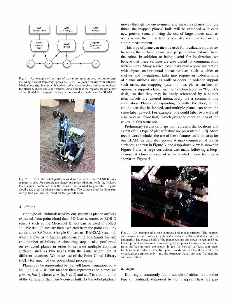
Fig. 1. An example of the type of map representation used by our system,including a robot trajectory (poses x1 ... x4), a planar feature with attachedlabel, a door sign feature with a label, and a labeled region. Labels are optionalfor planar features and sign features. Also note that the regions are not a partof the SLAM factor graph, as they are not used as landmarks for SLAM.
Fig. 2. Jeeves, the robot platform used in this work. The 2D SICK laserscanner is used for obstacle avoidance and place labeling, while the Hokuyolaser scanner combined with the pan-tilt unit is used to generate 3D pointcloud data, used for planar surface mapping. The camera used for door signrecognition can also be found on the pan-tilt head.
A. Planes
One type of landmark used by our system is planar surfacesextracted from point cloud data. 3D laser scanners or RGB-Dsensors such as the Microsoft Kinect can be used to collectsuitable data. Planes are then extracted from the point cloud byan iterative RANdom SAmple Consensus (RANSAC) method,which allows us to find all planes meeting constraints for sizeand number of inliers. A clustering step is also performedon extracted planes in order to separate multiple coplanarsurfaces, such as two tables with the same height, but atdifferent locations. We make use of the Point Cloud Library(PCL) for much of our point cloud processing.
Planes can be represented by the well known equation: ax+by + cz + d = 0. Our mapper then represents the planes as:p =
[n, hull
]where: n =
[a, b, c, d
]and hull is a point cloud
of the vertices of the plane’s convex hull. As the robot platform
moves through the environment and measures planes multipletimes, the mapped planes’ hulls will be extended with eachnew portion seen, allowing the use of large planes such aswalls where the full extent is typically not observed in anysingle measurement.
This type of plane can then be used for localization purposesby using the surface normal and perpendicular distance fromthe robot. In addition to being useful for localization, webelieve that these surfaces are also useful for communicationwith humans. Many service robot tasks may require interactionwith objects on horizontal planar surfaces, such as tables orshelves, and navigational tasks may require an understandingof planar surfaces such as walls or doors. In order to supportsuch tasks, our mapping system allows planar surfaces tooptionally support a label, such as “kitchen table” or “Henrik’sdesk,” so that they may be easily referenced by a humanuser. Labels are entered interactively via a command lineapplication. Planes corresponding to walls, the floor, or theceiling can also be labeled, and multiple planes can share thesame label as well. For example, one could label two walls ofa hallway as “front hall,” which gives the robot an idea of theextent of this structure.
Preliminary results on maps that represent the locations andextent of this type of planar feature are presented in [10]. Morerecent work includes the use of these features as landmarks forour SLAM, as described above. A map comprised of planarsurfaces is shown in Figure 3, and a top-down view is shown inFigure 4 after a large correction was made following a loop-closure. A close-up view of some labeled planar features isshown in Figure 5.
Fig. 3. An example of a map composed of planar surfaces. The mappedarea shows several cubicles, with walls, cubicle walls, and desks used aslandmarks. The convex hulls of the planar regions are shown in red, and bluelines represent measurements, indicating which poses features were measuredfrom. Surface normals are shown in red for vertical surfaces, and greenfor horizontal surfaces. The full point clouds are displayed in white, forvisualization purposes only; only the extracted planes are used for mappingand localization.
B. Signs
Door signs commonly found outside of offices are anothertype of landmark supported by our mapper. These are par-
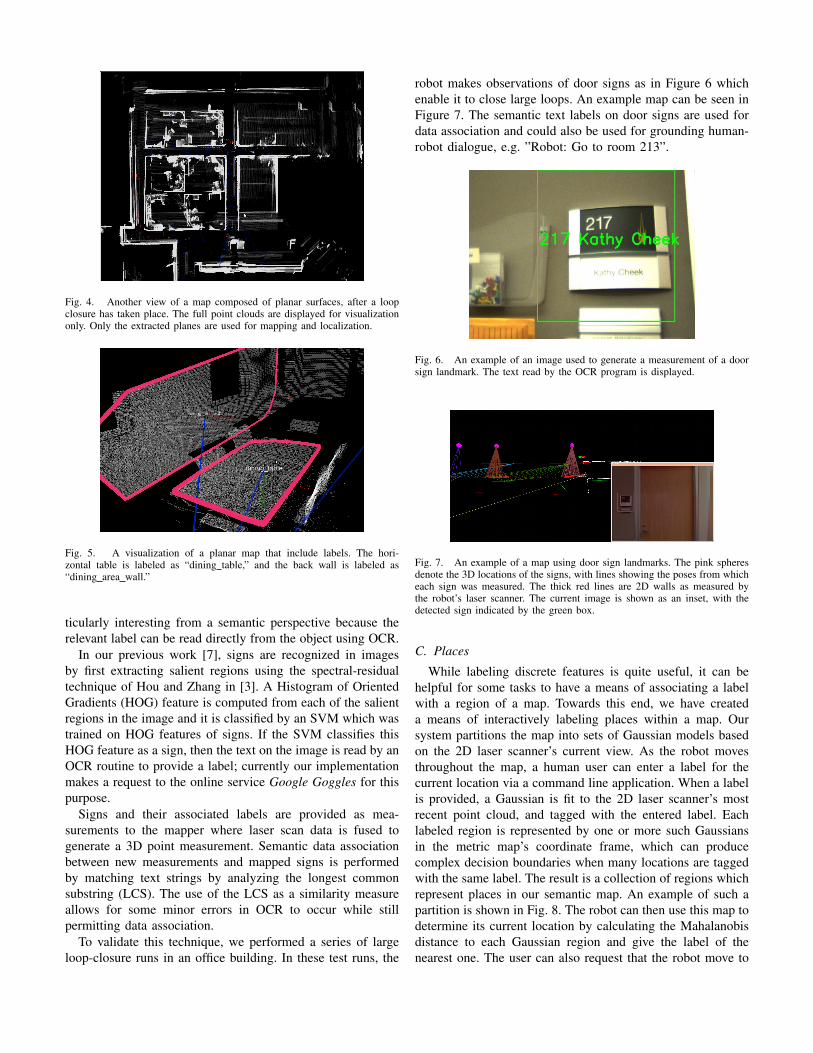
Fig. 4. Another view of a map composed of planar surfaces, after a loopclosure has taken place. The full point clouds are displayed for visualizationonly. Only the extracted planes are used for mapping and localization.
Fig. 5. A visualization of a planar map that include labels. The hori-zontal table is labeled as “dining table,” and the back wall is labeled as“dining area wall.”
ticularly interesting from a semantic perspective because therelevant label can be read directly from the object using OCR.
In our previous work [7], signs are recognized in imagesby first extracting salient regions using the spectral-residualtechnique of Hou and Zhang in [3]. A Histogram of OrientedGradients (HOG) feature is computed from each of the salientregions in the image and it is classified by an SVM which wastrained on HOG features of signs. If the SVM classifies thisHOG feature as a sign, then the text on the image is read by anOCR routine to provide a label; currently our implementationmakes a request to the online service Google Goggles for thispurpose.
Signs and their associated labels are provided as mea-surements to the mapper where laser scan data is fused togenerate a 3D point measurement. Semantic data associationbetween new measurements and mapped signs is performedby matching text strings by analyzing the longest commonsubstring (LCS). The use of the LCS as a similarity measureallows for some minor errors in OCR to occur while stillpermitting data association.
To validate this technique, we performed a series of largeloop-closure runs in an office building. In these test runs, the
robot makes observations of door signs as in Figure 6 whichenable it to close large loops. An example map can be seen inFigure 7. The semantic text labels on door signs are used fordata association and could also be used for grounding human-robot dialogue, e.g. ”Robot: Go to room 213”.
Fig. 6. An example of an image used to generate a measurement of a doorsign landmark. The text read by the OCR program is displayed.
Fig. 7. An example of a map using door sign landmarks. The pink spheresdenote the 3D locations of the signs, with lines showing the poses from whicheach sign was measured. The thick red lines are 2D walls as measured bythe robot’s laser scanner. The current image is shown as an inset, with thedetected sign indicated by the green box.
C. Places
While labeling discrete features is quite useful, it can behelpful for some tasks to have a means of associating a labelwith a region of a map. Towards this end, we have createda means of interactively labeling places within a map. Oursystem partitions the map into sets of Gaussian models basedon the 2D laser scanner’s current view. As the robot movesthroughout the map, a human user can enter a label for thecurrent location via a command line application. When a labelis provided, a Gaussian is fit to the 2D laser scanner’s mostrecent point cloud, and tagged with the entered label. Eachlabeled region is represented by one or more such Gaussiansin the metric map’s coordinate frame, which can producecomplex decision boundaries when many locations are taggedwith the same label. The result is a collection of regions whichrepresent places in our semantic map. An example of such apartition is shown in Fig. 8. The robot can then use this map todetermine its current location by calculating the Mahalanobisdistance to each Gaussian region and give the label of thenearest one. The user can also request that the robot move to
a region with a specific label, and it will plan a path and moveto the nearest region with the requested label.
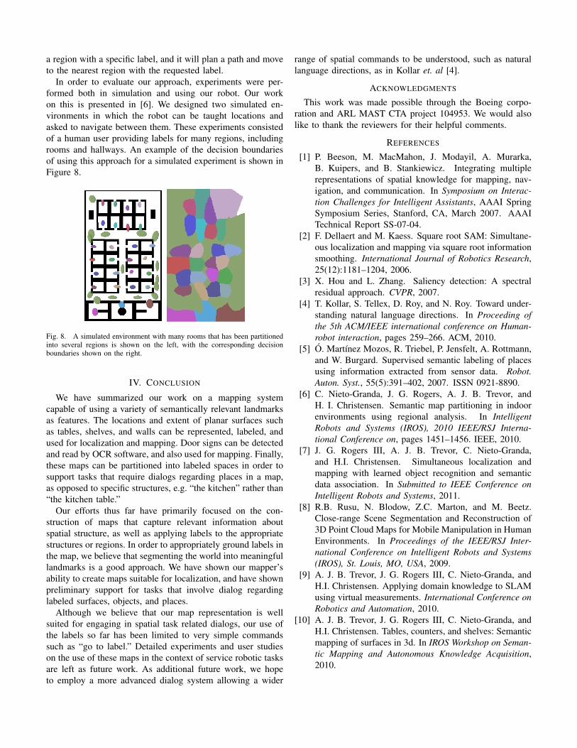
In order to evaluate our approach, experiments were per-formed both in simulation and using our robot. Our workon this is presented in [6]. We designed two simulated en-vironments in which the robot can be taught locations andasked to navigate between them. These experiments consistedof a human user providing labels for many regions, includingrooms and hallways. An example of the decision boundariesof using this approach for a simulated experiment is shown inFigure 8.
Fig. 8. A simulated environment with many rooms that has been partitionedinto several regions is shown on the left, with the corresponding decisionboundaries shown on the right.
IV. CONCLUSION
We have summarized our work on a mapping systemcapable of using a variety of semantically relevant landmarksas features. The locations and extent of planar surfaces suchas tables, shelves, and walls can be represented, labeled, andused for localization and mapping. Door signs can be detectedand read by OCR software, and also used for mapping. Finally,these maps can be partitioned into labeled spaces in order tosupport tasks that require dialogs regarding places in a map,as opposed to specific structures, e.g. “the kitchen” rather than“the kitchen table.”
Our efforts thus far have primarily focused on the con-struction of maps that capture relevant information aboutspatial structure, as well as applying labels to the appropriatestructures or regions. In order to appropriately ground labels inthe map, we believe that segmenting the world into meaningfullandmarks is a good approach. We have shown our mapper’sability to create maps suitable for localization, and have shownpreliminary support for tasks that involve dialog regardinglabeled surfaces, objects, and places.
Although we believe that our map representation is wellsuited for engaging in spatial task related dialogs, our use ofthe labels so far has been limited to very simple commandssuch as “go to label.” Detailed experiments and user studieson the use of these maps in the context of service robotic tasksare left as future work. As additional future work, we hopeto employ a more advanced dialog system allowing a wider
range of spatial commands to be understood, such as naturallanguage directions, as in Kollar et. al [4].
ACKNOWLEDGMENTS
This work was made possible through the Boeing corpo-ration and ARL MAST CTA project 104953. We would alsolike to thank the reviewers for their helpful comments.
REFERENCES
[1] P. Beeson, M. MacMahon, J. Modayil, A. Murarka,B. Kuipers, and B. Stankiewicz. Integrating multiplerepresentations of spatial knowledge for mapping, nav-igation, and communication. In Symposium on Interac-tion Challenges for Intelligent Assistants, AAAI SpringSymposium Series, Stanford, CA, March 2007. AAAITechnical Report SS-07-04.
[2] F. Dellaert and M. Kaess. Square root SAM: Simultane-ous localization and mapping via square root informationsmoothing. International Journal of Robotics Research,25(12):1181–1204, 2006.
[3] X. Hou and L. Zhang. Saliency detection: A spectralresidual approach. CVPR, 2007.
[4] T. Kollar, S. Tellex, D. Roy, and N. Roy. Toward under-standing natural language directions. In Proceeding ofthe 5th ACM/IEEE international conference on Human-robot interaction, pages 259–266. ACM, 2010.
[5] O. Martınez Mozos, R. Triebel, P. Jensfelt, A. Rottmann,and W. Burgard. Supervised semantic labeling of placesusing information extracted from sensor data. Robot.Auton. Syst., 55(5):391–402, 2007. ISSN 0921-8890.
[6] C. Nieto-Granda, J. G. Rogers, A. J. B. Trevor, andH. I. Christensen. Semantic map partitioning in indoorenvironments using regional analysis. In IntelligentRobots and Systems (IROS), 2010 IEEE/RSJ Interna-tional Conference on, pages 1451–1456. IEEE, 2010.
[7] J. G. Rogers III, A. J. B. Trevor, C. Nieto-Granda,and H.I. Christensen. Simultaneous localization andmapping with learned object recognition and semanticdata association. In Submitted to IEEE Conference onIntelligent Robots and Systems, 2011.
[8] R.B. Rusu, N. Blodow, Z.C. Marton, and M. Beetz.Close-range Scene Segmentation and Reconstruction of3D Point Cloud Maps for Mobile Manipulation in HumanEnvironments. In Proceedings of the IEEE/RSJ Inter-national Conference on Intelligent Robots and Systems(IROS), St. Louis, MO, USA, 2009.
[9] A. J. B. Trevor, J. G. Rogers III, C. Nieto-Granda, andH.I. Christensen. Applying domain knowledge to SLAMusing virtual measurements. International Conference onRobotics and Automation, 2010.
[10] A. J. B. Trevor, J. G. Rogers III, C. Nieto-Granda, andH.I. Christensen. Tables, counters, and shelves: Semanticmapping of surfaces in 3d. In IROS Workshop on Seman-tic Mapping and Autonomous Knowledge Acquisition,2010.