feasibility study - ncdot · this feasibility study provides a ... brother’s pizza ... no other...
TRANSCRIPT

STIP Project FS‐1514A
Proposed Improvements to Wilson Road (SR 1540)
from US 276 to Old US 64/Old Hendersonville Highway (SR 1504)
FEASIBILITY STUDY
Transylvania County,
North Carolina
Feasibility Studies Unit
Division of Planning and Programming
North Carolina Department of Transporta on
Prepared By:
David Bass, PE
Design Services Manager
HNTB
Derrick W. Lewis, PE
Feasibility Studies Unit Head
Feasibility Studies Unit
Lynnise Hawes, PE
Feasibility Studies Engineer
Feasibility Studies Unit
December 2016
DocuSign Envelope ID: B28C43D0-2870-4900-A75A-1EF90ACA8F93

Feasibility Study Improvements to Wilson Road (SR 1540)
Table of Contents
1 INTRODUCTION ..................................................................................................................................... 1
1.1 GENERAL DESCRIPTION ................................................................................................................. 1
2 BACKGROUND ....................................................................................................................................... 1
2.1 PURPOSE AND NEED ..................................................................................................................... 1
2.2 EXISTING CONDITIONS .................................................................................................................. 1
2.3 EXISTING LAND USE ...................................................................................................................... 2
3 PREVIOUS STUDIES ................................................................................................................................ 2
4 ADJACENT PROJECTS ............................................................................................................................. 2
5 CRASH ANALYSIS ................................................................................................................................... 2
6 ALTERNATIVES ....................................................................................................................................... 3
6.1 BUILD ALTERNATIVES .................................................................................................................... 3
7 TRAFFIC VOLUMES ................................................................................................................................ 4
8 BUILD ALTERNATIVE IMPACTS AND COST ESTIMATES ......................................................................... 5
8.1 IMPACTS ........................................................................................................................................ 5
8.2 COST ESTIMATES ........................................................................................................................... 5
9 COMMUNITY RESOURCES ..................................................................................................................... 6
9.1 PLANS ............................................................................................................................................ 6
Transylvania County .............................................................................................................................. 6
City of Brevard ...................................................................................................................................... 6
Land of Sky Regional Planning Organization ......................................................................................... 7
9.2 COMMUNITY FACILITIES ............................................................................................................... 7
Water and Wastewater ......................................................................................................................... 7
9.3 EMERGENCY MANAGEMENT SERVICES ........................................................................................ 7
9.4 HISTORIC RESOURCES ................................................................................................................... 7
9.5 ARCHAEOLOGICAL RESOURCES .................................................................................................... 8
10 NATURAL ENVIRONMENT ................................................................................................................. 8
10.1 WATER QUALITY RESOURCES ....................................................................................................... 8
10.2 JURISDICTIONAL FEATURES........................................................................................................... 9
DocuSign Envelope ID: B28C43D0-2870-4900-A75A-1EF90ACA8F93

Feasibility Study Improvements to Wilson Road (SR 1540)
10.3 PROTECTED SPECIES .................................................................................................................... 10
10.4 EXISTING NCDOT MITIGATION SITES .......................................................................................... 10
10.5 FEMA HAZARD MITIGATION GRANT PROGRAM PROPERTIES .................................................... 10
10.6 NCDEQ, DIVISION OF ENERGY, MINERAL, AND LAND RESOURCES ............................................ 11
Stormwater ......................................................................................................................................... 11
Erosion and Sediment Control ............................................................................................................ 11
11 CONCLUSION ................................................................................................................................... 11
12 REFERENCES .................................................................................................................................... 12
FIGURES
APPENDIX A: ALTERNATIVE DESIGNS (under separate cover)
DocuSign Envelope ID: B28C43D0-2870-4900-A75A-1EF90ACA8F93

Feasibility Study Improvements to Wilson Road (SR 1540)
December 2016 1
1 INTRODUCTION
1.1 GENERAL DESCRIPTION
This Feasibility Study provides a screening‐level review of potential improvements needed to reduce
over‐topping of Wilson Road (SR 1540) by the French Broad River in Transylvania County. Wilson Road is
a two‐lane facility and is classified as a major collector by the Land of Sky Regional Planning Organization
(RPO). It is approximately 3.6 miles from US 276 to Old US 64/Old Hendersonville Highway (SR 1504).
Wilson Road forms the eastern boundary of the City of Brevard’s planning jurisdiction. The project
vicinity is shown on Figure 1.
2 BACKGROUND
2.1 PURPOSE AND NEED
The purpose of this project is to improve the facility and reduce over‐topping of the road by the French
Broad River during flood events. Sections of Wilson Road flood during 10‐year and 50‐year flood events,
making the road impassable, except by boat, to residents, those traveling to or from businesses, and to
the City of Brevard’s wastewater treatment plant (WWTP). Elevating the roadway out of the 50‐year
floodplain would decrease the number of times the road is impassable due to flooding, thereby
improving the perceived level of service.
In addition to the stated purpose and need, the Transylvania Transportation Advisory Committee
identified other concerns and interests in its January 26, 2016 committee meeting. These include the
need for guard rails where Wilson Road is adjacent to the river; raising and extending the bridge over
the river at the northern end of the project out of the floodplain; increasing the travel lane width;
straightening or realigning curves; providing paved bike lanes and shoulders; and improving the
intersection of Wilson Road at US 276 and realigning Wilson Road at Ecusta Road.
2.2 EXISTING CONDITIONS
Within the project study area, Wilson Road is a two‐lane facility connecting US 276 and Old US 64/Old
Hendersonville Highway, a distance of approximately 3.6 miles. The posted speed limit is 40 miles per
hour (mph). The Land of Sky RPO classifies Wilson Road as a major collector. Wilson Road is located
east of Brevard and serves as a bypass around the city in conjunction with Ecusta Road, connecting
US 276 to US 64 (to the east)/US 276 (to the west) north of Brevard. Wilson Road is included as part of
It should be noted that a Feasibility Study is a preliminary document that is the initial step in the planning and design
process for a candidate project and not the product of exhaustive environmental or design investigations. The purpose
of this feasibility study is to describe the proposed project, including cost, and identify potential problems that may
require consideration in the planning and design phases.
If a candidate project is identified for funding in the State Transportation Improvement Program (STIP), the Feasibility
Study is followed by a rigorous planning and design process that meets the requirements of the National Environmental
Policy Act (NEPA).
DocuSign Envelope ID: B28C43D0-2870-4900-A75A-1EF90ACA8F93
Feasibility Study Improvements to Wilson Road (SR 1540)
December 2016 2
each of the six bicycle routes provided by the City of Brevard. Transylvania County has designated Old
US 64/Old Hendersonville Highway as bicycle Route 1.
Bridges crossed by Wilson Road, or intersecting roads in the vicinity of the study area, are listed in Table
1 and shown in Figure 2.
Table 1. Bridges
Bridge
Number Roadway Carried Feature/Roadway Crossed Structure
870036 Wilson Road (SR 1540) French Broad River Bridge
870038 Elm Bend Road (SR 1543) French Broad River Bridge
870039 US 276 French Broad River Bridge
870040 Wilson Road (SR 1540) Williamson Creek Bridge
870206 Elm Bend Road (SR 1543) French Broad River Overflow Bridge
2.3 EXISTING LAND USE
Land use along Wilson Road is predominantly pastoral with the French Broad River and farmland along
the western side of the road and houses and subdivisions along the eastern side. The French Broad
River follows a sinuous path, and is immediately adjacent to Wilson Road in two locations for
approximately 1.0 mile and 0.25 mile, respectively. These sections lie within the FEMA designated
100‐year floodplain of the French Broad River. Where the river diverges from the road, fields are
located in the floodplain. Wilson Road crosses the French Broad River at the northern end of the
project, approximately 0.25 mile from its intersection with Old US 64/Old Hendersonville Highway.
From the southern terminus of the project, single family houses are located to the east, generally
upslope of the floodplain. Subdivisions, including Knob Creek, Middlemount, and Glen Cannon are also
located to the east of Wilson Road. Single family homes, including some manufactured houses, are
located between the French Broad River bridge crossing and the intersection of Wilson Road with Old US
64/Old Hendersonville Highway. In addition, there are several business and retail locations on Old US
64/Old Hendersonville Highway between the Wilson Road and Ecusta Road intersections. They include
All American Electric of Brevard, NC, U.S. Post Office, TanksTees Screenprinting, Exxon, and Hunt
Brother’s Pizza, among others.
3 PREVIOUS STUDIES
No other studies have been conducted to determine the feasibility of improving the Wilson Road facility.
4 ADJACENT PROJECTS
There are no current NCDOT STIP projects within the study area.
5 CRASH ANALYSIS
A crash analysis of the Wilson Road corridor was conducted utilizing crash data provided by the NCDOT
Traffic Safety Unit for a five‐year period from October 1, 2010 to September 30, 2015.
DocuSign Envelope ID: B28C43D0-2870-4900-A75A-1EF90ACA8F93

Feasibility Study Improvements to Wilson Road (SR 1540)
December 2016 3
Between October 2010 and September 2015, a total of 75 crashes was reported along Wilson Road. Of
the 75 total crashes in the study area during the five‐year period, none were fatal and 22 reported non‐
fatal injuries. Fixed object collisions accounted for the majority of incidents, with 38 crashes or 51
percent of total crashes. Among the objects struck, ditches accounted for 12 crashes, or 32 percent, and
embankments accounted for 10 crashes, or 26 percent, of the total fixed object crashes.
Between October 2010 and September 2015, a total crash rate of 384.35 per 100 million vehicle miles
traveled (MVMT) was reported in the study area. The total crash rate for Wilson Road is higher than the
total critical crash rate of 253.10 for rural secondary roads identified by NCDOT. Critical crash rates are
crash rates that have been statistically adjusted, based on other roads with similar characteristics, to
remove the elements of chance and randomness. This is a check to determine if the “rate at a particular
location is significantly higher than a pre‐determined average rate for locations of similar characteristics,
based on Poisson’s distribution” (Khisty and Lall, 1998). The crash rate for non‐fatal injury, 112.74, and
for wet crashes, 71.75, is higher than the critical crash rates of 73.41 for non‐fatal injury and 42.77 for
wet crashes. Statewide and critical crash rates are not calculated for property damage only crashes.
Accident data for fatal, non‐fatal, property damage, and wet crashes are provided below in Table 2.
Table 2. Crash Data Analysis Summary
Location Number of
Crashes Crash Rate
Statewide
Crash Rate1
Critical Crash
Rate2
Fatal 0 0 2.57 3.19
Non‐Fatal Injury 22 112.74 70.26 73.41
Property Damage Only 53 271.61 ‐ ‐
Wet Crashes 14 71.75 40.38 42.77
Total 75 384.35 247.22 253.10 12012‐2014 Statewide crash rates in crashes per 100 million vehicle miles for urban interstates in North Carolina. 2Based on the statewide crash rate (95% confidence interval).
6 ALTERNATIVES
6.1 BUILD ALTERNATIVES
Three build alternatives were analyzed for human and environmental impacts and to create cost
estimates.
Build Alternative 1 – Minimal upgrade using NCDOT’s Resurfacing, Restoration, and Rehabilitation (R‐
R‐R or 3R) Guidelines (3R Alternative). This alternative would add paved shoulders and correct some
horizontal and vertical deficiencies, as well as adding safety features like guardrail. No major grade work
or realignment would take place. The bridge over Williamson Creek would be replaced on new
alignment due to a sub‐standard horizontal curve. The bridge over the French Broad River at the
northern terminus of the project would be replaced and realigned to help address flooding concerns.
Build Alternative 2 – Upgrade to Major Collector Design Standards. Wilson Road is designated as a
major collector by the Land of Sky RPO. However, the horizontal and vertical curvatures are well below
American Association of State Highway and Transportation Officials (AASHTO) standards for a facility
with this designation and posted speed (40 mph). Build Alternative 2 corrects the horizontal curvature
DocuSign Envelope ID: B28C43D0-2870-4900-A75A-1EF90ACA8F93

Feasibility Study Improvements to Wilson Road (SR 1540)
December 2016 4
by increasing the radii to meet minimum AASHTO standards. The vertical design would also meet
AASHTO minimum design standards and move Wilson Road out of the 50‐year floodplain. The bridges
over Williamson Creek and the French Broad River would be replaced on new alignment. Build
Alternative 2 also adds paved shoulders and increases the design speed of the road to 45 mph.
Build Alternative 3 – Upgrade to Principal Arterial (US Route) Design Standards. Wilson Road would
become the primary route at the US 276 intersection and design speed would increase to 60 mph, with
a posted speed limit of 55 mph. Due to the increased speed, horizontal and vertical upgrades would be
required. This design would also raise and realign the road out of the 50‐year floodplain. The bridges
over Williamson Creek and the French Broad River would be realigned and replaced. Paved shoulders
would be added. This alternative would benefit the City of Brevard by removing through traffic on local
roads.
7 TRAFFIC VOLUMES
The average annual daily traffic (AADT) was forecast by NCDOT Transportation Planning Branch (TPB) for
2015 and 2040 and is shown in Table 3.
Table 3. AADT for the No Build Alternative for years 2015 and 2040
Facility 2015
(vpd)1
2040
(vpd)
US 276 to “Break” 1,800 2,000
“Break” to Elm Bend Road 2,600 2,900
Elm Bend Road to Williamson Creek Road (SR 1541) 3,600 4,000
Williamson Creek Road to Glen Cannon Drive (SR 1580) 3,000 3,400
Glen Cannon Drive to “Break” 3,200 3,600
“Break” to Old US 64/Old Hendersonville Highway (SR 1504) 3,600 4,000 1vpd = vehicles per day 2The “Break” occurs where there is a long distance between forecast values or there are intermediate
roads/facilities/shopping centers that can notably change the forecast values.
As shown in Table 3 the No Build volume of vehicles increases between the year 2015 and 2040. The
average increase in traffic is predicted to be approximately 350 vehicles or 17 percent.
Based on this analysis, traffic volumes on Wilson Road are anticipated to increase. Improving the road,
such that it is out of the 50‐year storm event floodplain, will reduce the amount of time the facility is
closed thereby potentially improving perceived user benefit.
Evaluation of this complexity could not be performed as a part of this feasibility study level due to limitations associated
with the traffic forecast and uncertainty of the design requirements. As such, the methodology utilized within this
feasibility study was developed to provide an order of magnitude comparison of alternatives considered, utilizing the
available traffic forecast. Information or feasible components identified within this feasibility study should provide an
initial concept to begin this type of investigation during the NEPA phase, which will include the preparation of an
updated traffic forecast and detailed traffic operations analysis.
DocuSign Envelope ID: B28C43D0-2870-4900-A75A-1EF90ACA8F93

Feasibility Study Improvements to Wilson Road (SR 1540)
December 2016 5
8 BUILD ALTERNATIVE IMPACTS AND COST ESTIMATES
8.1 IMPACTS
Potential impacts and cost estimates were developed for the Build Alternatives based on the functional
designs. Impacts were measured using a 2,000‐foot wide corridor and using the alternatives’ slope
stake limits plus 40 feet for impacts to streams, wetlands, and FEMA‐regulated waters. Potential
impacts are summarized in Table 4 and discussed further in Section 9.
Table 4. Potential Impacts of the Build Alternatives
Resource Study Area
Historic Resources
(6 known potential)
Elizur Patton House (Study List eligible)
Jenkins House (Study List)
Archaeological Resources
13 previously recorded sites
Additional surveys would require coordination with the Eastern Band of
Cherokee Indians
Natural Heritage Element
Occurrence
4 Federal Species of Concern
1 Threatened (Similarity of Appearance)
Resource Alternative 1:
3‐3‐3
Alternative 2:
Collector
Alternative 3:
US Route
Stream 5, 050 ft 3,950 ft 2,260 ft
National Wetland
Inventory (NWI) Wetland 0.14 ac 0 ac 0 ac
FEMA
100‐year flood zone (AE) 31 ac
(9.5 ac in the floodway)
29 ac
(4.7 ac in the floodway)
19.0 ac
(3.2 ac in the floodway)
500‐year flood zone 9 8 5
Residential Relocatees 12 15 53
Business Relocatees 1 1 0
8.2 COST ESTIMATES
Right of way limits for the various alternatives were reduced or increased according to the various
typical section dimensions of each alternative. Table 5 shows the estimated cost of each alternative.
Because this feasibility study is not the product of an exhaustive environmental or design effort, but rather an initial
step to this process, it was concluded that a more detailed impacts analysis would be performed during the NEPA
phase.
DocuSign Envelope ID: B28C43D0-2870-4900-A75A-1EF90ACA8F93

Feasibility Study Improvements to Wilson Road (SR 1540)
December 2016 6
Table 5. Cost Estimate
Build Alternative Cost
Construction1 Right of Way Utility Relocation Total
Alternative 1 (3R) $20,000,000 $4,000,000 $800,000 $24,800,000
Alternative 2 (Collector)
$27,000,000 $5,100,000 $1,800,000 $33,900,000
Alternative 3 (US Route)
$81,000,000 $18,000,000 $3,600,000 $102,600,000
1Includes utility construction
9 COMMUNITY RESOURCES
A detailed community resources study was not conducted for this feasibility study. Geographic
Information System (GIS) level research and a preliminary site review were completed. Figure 2 shows
the location of documented community resources within and near the project study area.
9.1 PLANS Transylvania County
2005 Comprehensive Plan – This plan serves as a policy guide in developing the community’s physical
and social form. A goal of the plan is to collaborate with the NCDOT to provide the best possible roads
for Transylvania County and promote alternative transportation. The plan lists Wilson Road as a minor
collector among the thoroughfare plan roads.
2025 Comprehensive Plan – The Final Draft 2025 Comprehensive Plan was sent to the Transylvania
Board of Commissioners in August for a public hearing and adoption. The plan is designed as a policy
guide for decision in the next 10 years and is a tool for sharing Transylvania County’s vision of the future.
The plan does not provide regulations. However, Wilson Road is the sixth “road improvement” listed in
response to the 2025 Survey Question “…What one road or road improvement is needed in 10 years?”
City of Brevard
2002 Land Use Plan – The purpose of this plan was to provide a way to coordinate land use planning,
infrastructure planning, and environmental protection to help guide the growth and development of the
community.
2015 Comprehensive Plan – The plan uses a direction‐setting framework based around five functional
elements that include: Arts and Culture, Economic Health, Environmental Health, a Livable Community,
and Infrastructure. This framework provides a “clear, relevant basis for the City’s growth and
development over the next several years.” This Comprehensive Plan also refers to the Transylvania
County Comprehensive Transportation Plans and supports their implementation.
DocuSign Envelope ID: B28C43D0-2870-4900-A75A-1EF90ACA8F93

Feasibility Study Improvements to Wilson Road (SR 1540)
December 2016 7
Land of Sky Regional Planning Organization
Transylvania Comprehensive Transportation Plan – Highway Map (updated 2012) – The CTP highway
map shows Wilson Road as a minor thoroughfare that needs improvement.
Transylvania Comprehensive Transportation Plan – Bicycle Map (updated 2012) – The CTP bicycle map
shows Wilson Road as having on‐road bicycle facilities that need improvement.
Blue Ridge Bike Plan – Plan developed to address safety and other concerns including the best
expenditure of resources, identification of dangerous roads and intersections, and identification of
destination connections. The plan developed recommendations that communities could use to improve
bicycling conditions. Wilson Road from Barclay Road to Old US 64/Old Hendersonville Highway was
identified as Transylvania County Priority Corridor 1. The plan proposes bike lanes within the City of
Brevard’s ETJ and bikeable shoulders in the unincorporated areas.
9.2 COMMUNITY FACILITIES
There are no schools, churches, cemeteries, parks or greenways within the project study area. There is a
post office located near the intersection of Wilson Road and Old US 64/Old Hendersonville Highway at
1 Old Hendersonville Highway, Pisgah Forest.
Water and Wastewater
A City of Brevard wastewater treatment plant (WWTP) is located at 3226 Wilson Road. According to
plant manager Emory Owen, the plant opened in 1987. It currently treats 1.3 million gallons per day
(MGD) and is rated for 2.5 MGD. The plant discharges under National Pollution Discharge Elimination
Systems (NPDES) permit number NC0060534 into the French Broad River, upstream of Wilson Road.
Upgrades to the WWTP are underway and will eventually result in increasing the plant capacity,
according to David Lutz, City of Brevard Public Works Director. This plant serves the City of Brevard,
including those residences immediately adjacent to Wilson Road. In addition, the City maintains water
service along Wilson Road. It is unknown whether or not residents of the subdivisions off Wilson Road
use city water and sewer services.
This WWTP is also affected during flood events. There is only one point of ingress/egress from Wilson
Road and during flood events it is not always accessible by vehicle.
9.3 EMERGENCY MANAGEMENT SERVICES
The study area is served by the Transylvania County Sheriff’s Department and the City of Brevard Police
Department. Fire and rescue services are provided by the Brevard Fire Department. There are no
police, fire, or emergency medical system (EMS) stations within the project study area.
9.4 HISTORIC RESOURCES
Records and maps were reviewed on the North Carolina State Historic Preservation Office’s (HPO)
website for historic architectural resources that had been identified in previous surveys or that were
listed in or had been determined eligible for listing in the National Register of Historic Places (NRHP). Six
DocuSign Envelope ID: B28C43D0-2870-4900-A75A-1EF90ACA8F93
Feasibility Study Improvements to Wilson Road (SR 1540)
December 2016 8
architectural resources were found within the study area. The Elizur Patton House is located on Old
US 64/Old Hendersonville Highway and is study list eligible. The Jenkins House is located on Wilson
Road near the southern terminus of the project and is on the study list. It is recommended that further
assessment of these and the other remaining sites be completed. Additional surveys of the study area
may be required to determine if additional resources are present.
9.5 ARCHAEOLOGICAL RESOURCES
A review of archaeological site files on June 10, 2016 identified approximately 13 previously recorded
archaeological sites within the project study area. It is unlikely that the project would impact all 13 sites
and only those that have the potential for ground disturbance should be evaluated for the presence of
archaeological resources. Additional surveys may be required to examine areas with a high probability
of archaeological resources.
Transylvania County is within the Eastern Band of Cherokee Indians territory and any additional surveys
would require coordination with them.
10 NATURAL ENVIRONMENT
A detailed environmental study was not conducted for this feasibility study. GIS level research and a
preliminary site review were completed. Figure 3 shows the location of documented natural resources
within and near the project study area.
10.1 WATER QUALITY RESOURCES
The project is located in the French Broad River Basin (8‐digit hydrologic unit code (HUC) 06010105).
Wilson Road is within the Davidson River‐French Broad River Sub‐Basin (10‐digit HUC 0601010502); and
is also within the Williamson Creek‐French Broad River watershed.
There are several “blue line” streams within the corridor that are listed on the following table. “Blue
line” streams are shown on the USGS 7.5‐minute Topographic Quadrangle maps as solid blue lines,
indicating that they were considered to be perennial waters at the time the map was developed. There
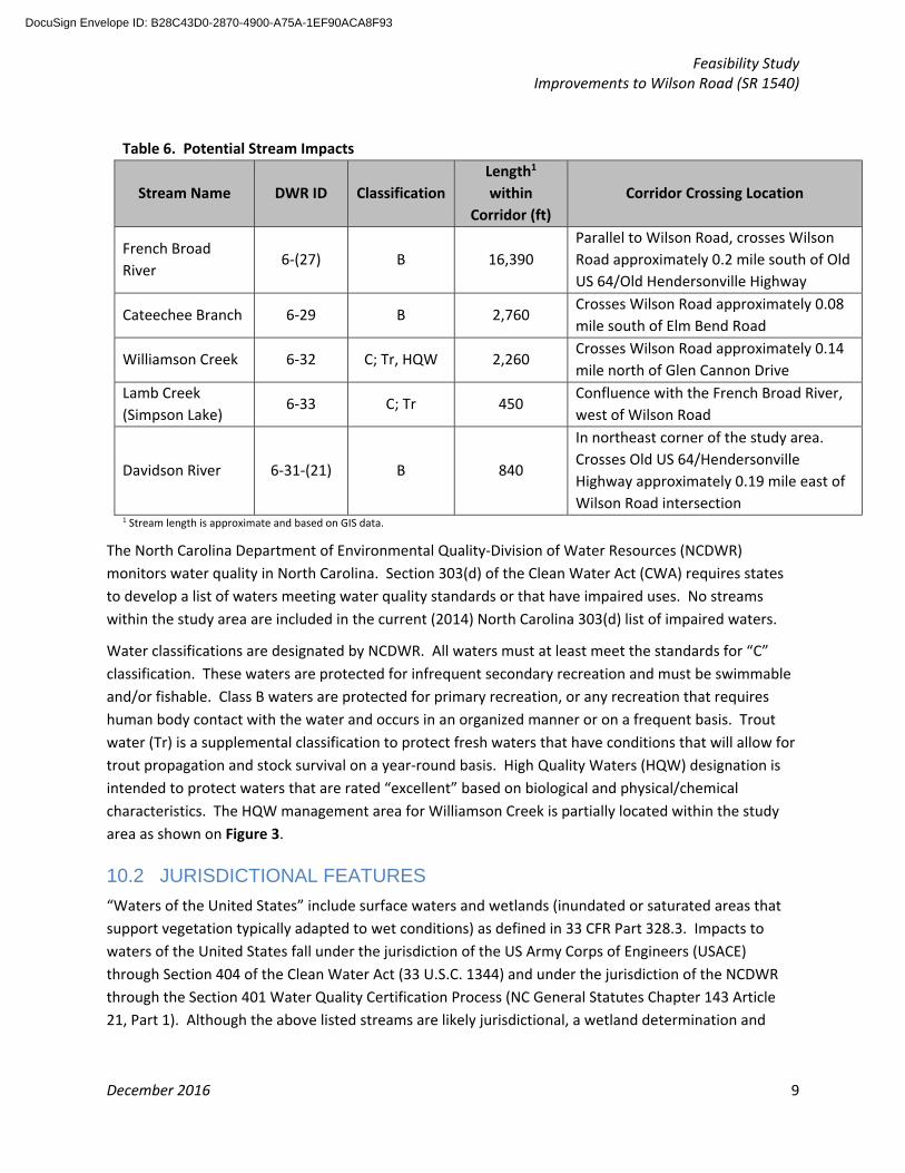
are five streams, totaling 22,692 feet, within the study area. These streams are listed in Table 6.
DocuSign Envelope ID: B28C43D0-2870-4900-A75A-1EF90ACA8F93
Feasibility Study Improvements to Wilson Road (SR 1540)
December 2016 9
Table 6. Potential Stream Impacts
Stream Name DWR ID Classification
Length1
within
Corridor (ft)
Corridor Crossing Location
French Broad
River 6‐(27) B 16,390
Parallel to Wilson Road, crosses Wilson
Road approximately 0.2 mile south of Old
US 64/Old Hendersonville Highway
Cateechee Branch 6‐29 B 2,760 Crosses Wilson Road approximately 0.08
mile south of Elm Bend Road
Williamson Creek 6‐32 C; Tr, HQW 2,260 Crosses Wilson Road approximately 0.14
mile north of Glen Cannon Drive
Lamb Creek
(Simpson Lake) 6‐33 C; Tr 450
Confluence with the French Broad River,
west of Wilson Road
Davidson River 6‐31‐(21) B 840
In northeast corner of the study area.
Crosses Old US 64/Hendersonville
Highway approximately 0.19 mile east of
Wilson Road intersection 1 Stream length is approximate and based on GIS data.
The North Carolina Department of Environmental Quality‐Division of Water Resources (NCDWR)
monitors water quality in North Carolina. Section 303(d) of the Clean Water Act (CWA) requires states
to develop a list of waters meeting water quality standards or that have impaired uses. No streams
within the study area are included in the current (2014) North Carolina 303(d) list of impaired waters.
Water classifications are designated by NCDWR. All waters must at least meet the standards for “C”
classification. These waters are protected for infrequent secondary recreation and must be swimmable
and/or fishable. Class B waters are protected for primary recreation, or any recreation that requires
human body contact with the water and occurs in an organized manner or on a frequent basis. Trout
water (Tr) is a supplemental classification to protect fresh waters that have conditions that will allow for
trout propagation and stock survival on a year‐round basis. High Quality Waters (HQW) designation is
intended to protect waters that are rated “excellent” based on biological and physical/chemical
characteristics. The HQW management area for Williamson Creek is partially located within the study
area as shown on Figure 3.
10.2 JURISDICTIONAL FEATURES
“Waters of the United States” include surface waters and wetlands (inundated or saturated areas that
support vegetation typically adapted to wet conditions) as defined in 33 CFR Part 328.3. Impacts to
waters of the United States fall under the jurisdiction of the US Army Corps of Engineers (USACE)
through Section 404 of the Clean Water Act (33 U.S.C. 1344) and under the jurisdiction of the NCDWR
through the Section 401 Water Quality Certification Process (NC General Statutes Chapter 143 Article
21, Part 1). Although the above listed streams are likely jurisdictional, a wetland determination and
DocuSign Envelope ID: B28C43D0-2870-4900-A75A-1EF90ACA8F93

Feasibility Study Improvements to Wilson Road (SR 1540)
December 2016 10
stream identification field study would be required, with concurrence from the USACE, to establish
whether they are jurisdictional.
There is one National Wetland Inventory wetland identified within the project study area that is
approximately 3.8 acres. There are also two ponds that total 1.7 acres. A field study would be required
to determine whether there are additional wetlands or ponds and if they are jurisdictional.
10.3 PROTECTED SPECIES
Species with the federal status of endangered or threatened are protected under provisions of the
Endangered Species Act (ESA) of 1973 as amended (16 USC 1531 et. seq.). Any action likely to adversely
affect a species classified as federally protected will require field surveys and will be subject to review by
the United States Fish and Wildlife Service (USFWS). The USFWS online database was reviewed for
federally listed species potentially occurring in Transylvania County. There are 11 federally protected
species listed for Transylvania County as of July 24, 2015. They are listed in Table 7. Those with an
asterisk (*) are in the NC Natural Heritage Program’s Natural Heritage Element Occurrence database and
have been reported to occur within the project study area.
Although not within the study area, critical habitat is designated for the Appalachian elktoe.
There are 27 “current” species listed as Federal Species of Concern and no Candidate species listed by
the USFWS for Transylvania County.
Table 7. Threatened and Endangered Species in Transylvania County
Scientific Name Common Name Status
Glyptemys muhlenbergii* Bog turtle Threatened
(due to similarity of appearance)
Glaucomys sabrinus coloratus Carolina northern flying squirrel Endangered
Myotis grisescens Gray bat Endangered
Myotis septentrionalis Northern long‐eared bat Threatened
Alasmidonta raveneliana Appalachian elktoe Endangered
Sarracenia rubra ssp. Jonesii Mountain sweet pitcher plant Endangered
Isotria medeoloides Small whorled pogonia Threatened
Geum radiatum Spreading avens Endangered
Helonias bullata Swamp pink Threatened
Spiraea virginiana Virginia spiraea Threatened
Gymnoderma lineare Rock gnome lichen Endangered
10.4 EXISTING NCDOT MITIGATION SITES
There are no NCDOT mitigation sites within the project study area.
10.5 FEMA HAZARD MITIGATION GRANT PROGRAM PROPERTIES
Transylvania County participates in the FEMA National Flood Insurance Program (NFIP). The amount of potential floodplain impacts within the study area are listed in Table 8.
DocuSign Envelope ID: B28C43D0-2870-4900-A75A-1EF90ACA8F93

Feasibility Study Improvements to Wilson Road (SR 1540)
December 2016 11
Table 8. Potential Floodplain Impacts
Zone Area (ac)
100‐year flood zone (Zone AE, with base flood
elevation, mandatory flood insurance purchase) 470
500‐year flood zone
(Zone 0.2 percent chance annual flood hazard) 35
This project will involve construction activities on or adjacent to FEMA‐regulated streams. Therefore, in accordance with Executive Order 11988, the NCDOT Hydraulics Unit will need to coordinate with the NC Floodplain Mapping Program (FMP), the delegated state agency for administering the NFIP, to determine the status of the project with regard to applicability of NCDOT’s Memorandum of Agreement with FMP (dated April 22, 2013), or approval of a Conditional Letter of Map Revision (CLOMR) and subsequent final Letter of Map Revision (LOMR).
The Draft Transylvania County Multi‐Jurisdictional Hazard Mitigation Plan was developed in a
collaborative effort among Transylvania County, the City of Brevard, and Town of Rosman in 2011. The
primary purpose of the plan was “to substantially, or permanently, reduce the planning area’s
vulnerability to natural hazards.” This document has not been adopted by any of the collaborators to
date.
10.6 NCDEQ, DIVISION OF ENERGY, MINERAL, AND LAND RESOURCES (DEMLR)
Stormwater
In addition to the Section 404 Water Quality Certification Process discussed in Section 10.2, NCDWR also
monitors streams and water bodies under NPDES. NPDES is a storm water permitting program for
roadway construction and material storage facilities. The permit requirements include implementing a
comprehensive storm water management program, monitoring the program, and annual reports of the
program’s effectiveness and direction. Neither Transylvania County nor the City of Brevard have NPDES
stormwater permit requirements. As noted in Section 9.2, the City of Brevard Wastewater Treatment
Plant (adjacent to Wilson Road) discharges into the French Broad River under a NPDES major/minor
permit.
Erosion and Sediment Control
In accordance with the North Carolina Sedimentation Pollution Control Act of 1973, projects disturbing
more than one acre of land must submit an Erosion and Sedimentation Control Plan to the NCDEQ
DEMLR. The plan must include erosion control measures and be approved by the DEMLR prior to
construction.
11 CONCLUSION
Developing any of the Build Alternatives to reduce over‐topping of Wilson Road by the French Broad
River presents many challenges, the topography, proximity of the river to the road, and the winding
DocuSign Envelope ID: B28C43D0-2870-4900-A75A-1EF90ACA8F93

Feasibility Study Improvements to Wilson Road (SR 1540)
December 2016 12
nature of the road among them. The primary purpose of improving the road would be to reduce over‐
topping by moving the road out of the 10‐year and 50‐year floodplain.
Alternative 1 (3R) would improve the sub‐standard curvature of the road at the Williamson Creek bridge
and add a paved shoulder and correct other horizontal and vertical deficiencies. With the exception of
the bridge replacement at the French Broad River, the road would not be moved out of the 100‐year
and 50‐year floodplains, thereby not meeting the purpose of the project.
Alternative 2 (Collector) corrects the horizontal curvature by increasing the radii to meet minimum
AASHTO standards. The vertical design would also meet AASHTO minimum design standards and move
Wilson Road out of the 50‐year floodplain. The bridge over Williamson Creek and the French Broad
River would be replaced on new alignment. Build Alternative 2 also adds paved shoulders and increases
the design speed of the road to 45 mph. This alternative would meet the purpose of the project.
Alternative 3 (US Route) would change the classification of Wilson Road from a major collector to a
principal arterial. Design standards would be more restrictive and posted speed limits would increase
and therefore horizontal and vertical upgrades would be required. This design would also raise and
realign the road out of the 50‐year floodplain. The bridges over Williamson Creek and the French Broad
River would be realigned and replaced. Paved shoulders would be added. This alternative would meet
the purpose of the project.
The proposed Alternatives may result in impacts to overhead and underground utilities, streams and
wetlands, residential and business relocations, and other cultural resources. It should be noted that
indirect and cumulative effects of the project were not evaluated as part of this feasibility study.
The cost estimate for each Build Alternative is listed in Table 5.
The high‐level traffic analysis predicts traffic to increase by approximately 350 vehicles or 17 percent.
Improving the road, such that it is out of the 50‐year storm event floodplain, will reduce the amount of
time the facility is closed thereby potentially improving perceived user benefit. Improving the horizontal
curvature, vertical design, pavement, and adding paved shoulders on the road may reduce the number
of crashes. Alternative 2 meets the purpose and need of the project and is therefore the Preferred
Alternative.
12 REFERENCES
City of Brevard. August 2002. 2002 Land Use Plan.
City of Brevard. November 2015. 2015 Comprehensive Land Use Plan.
Khisty, C. Jostin and B. Kent Lall. 1998. Transportation Engineering, An Introduction. 2nd ed.
Land of Sky Regional Planning Organization. 2016. FRBRMPO/LOSRPO Functional Roadway
Classifications Map.
http://ncarc.maps.arcgis.com/apps/webappviewer/index.html?id=b5a4819d120142e099b1845
d7075b018. Accessed April 2016.
Land of Sky Regional Planning Organization. 2013. Blue Ridge Bike Plan.
Land of Sky Regional Planning Organization. April 2012. Comprehensive Plan –Highway Map.
DocuSign Envelope ID: B28C43D0-2870-4900-A75A-1EF90ACA8F93

Feasibility Study Improvements to Wilson Road (SR 1540)
December 2016 13
Land of Sky Regional Planning Organization. April 2012. Comprehensive Plan – Bicycle Map.
Lutz, David. Public Works Director. City of Brevard. May 2016. Personal conversation with HNTB.
NC Department of Transportation. Congestion Management. July 2015. Capacity Analysis Guidelines.
NC Department of Transportation. Division of Highways. April 2004. R‐R‐R Guide.
NC Department of Transportation. Traffic Safety Unit. October 2015. Crash Analysis.
Suzanne Mason. NC Natural Heritage Program. April 2016. Personal communication with HNTB.
NC Office of State Archaeology. June 2016. Records review by HNTB.
NC Office of State Budget and Management. http://data.osbm.state.nc.us/pls/linc/dyn_linc_main.show.
Accessed 2016.
North Carolina State Historic Preservation Office. www.hpo.ncdcr.gov/. Accessed 2016.
Owen, Emory. Plant Manager. City of Brevard. May 2016. Personal conversation with HNTB.
Transylvania County. September 2016. 2025 Comprehensive Plan. Final Draft.
Transylvania County. February 2005. 2005 Comprehensive Plan.
Transylvania County Emergency Services. June 2011. Draft Transylvania County Multi‐Jurisdictional
Hazard Mitigation Plan.
United States Fish and Wildlife Service. July 25, 2015. Threatened and Endangered Species in North
Carolina: Transylvania County. www.fws.gov/raleigh/species/cntylist/transylvania.html
Accessed 2016.
DocuSign Envelope ID: B28C43D0-2870-4900-A75A-1EF90ACA8F93

Feasibility Study Improvements to Wilson Road (SR 1540)
FIGURES
DocuSign Envelope ID: B28C43D0-2870-4900-A75A-1EF90ACA8F93

FRENCH BROAD RIVER
WILSON RD
OLD US 64
ELM BEND RD
ECUSTA RD
MIDDLE MT RD
GLEN CANNON DR
BREVARD
A l l i s o n C r e e k
Dav i dso
n
R i v e r
KnobB
r a n c h
C a m p C r e e kK i n g C r e e k
L a mb o
C r eek
H o g s e d
C r e e k
£¤64
£¤276
NC OneMap, NC Center for Geographic Information and Analysis, NC 911Board
VICINITY MAPSTIP Project No. FS-1514A
Improvements to Wilson RoadTransylvania County
FIGURE
1¯ 0 0.5 10.25Mile
1 inch = 0.5 mile
LegendStudy AreaUS RouteNC RouteRoadStreamWater BodyMunicipal Boundary
DocuSign Envelope ID: B28C43D0-2870-4900-A75A-1EF90ACA8F93

¾¾½¾¾½
¾¾½¾¾½
¾¾½
¾¾½
¾¾½¾¾½
¾¾½¾¾½
¾¾½
¾¾½
¾¾½¾¾½¾¾½
¾¾½¾¾½
¾¾½
¾¾½
¾¾½
¾¾½
¾¾½
¾¾½
¾¾½¾¾½
¾¾½
¾¾½
¾¾½¾¾½¾¾½
¾¾½¾¾½¾¾½
¾¾½¾¾½¾¾½
¾¾½
¾¾½¾¾½
¾¾½¾¾½
¾¾½
¾¾½
¾¾½
¾¾½¾¾½¾¾½
¾¾½¾¾½¾¾½
¾¾½¾¾½
¾¾½
!(
!(
ÆP
ÆP
ÆP
ÆP
ÆP
ÆP
ÆP
ÆP
ÆP
ÆP
ÆP
ÆP
ÆP
ÆP
ÆP
ÆP
ÆP
ÆP
ÆP
ÆP
ÆPÆP
ÆP
ÆP
ÆP
ÆP
ÆP
ÆP
ÆP
ÆP
ÆP
ÆP
ÆP
ÆP
ÆP
ÆP
ÆP
ÆP
ÆP
ÆP
ÆP
ÆP
ÆP
ÆP
ÆP
ÆP
ÆP
ÆP
ÆP
ÆP
ÆP
æ
æ
æ
")
")
")
")
")
")
")
")
")
")
")
")
")
")
")
")
")
")
")") ")
")
")
")
")
")
")
")
")
")
")
")
")
")
")
")
")
")
$+
$+$+$+
$+
$+
$+
$+
$+
FRENCH BROAD RIVER
WILSON RD
OLD US 64
ELM BEND RD
MIDDLE MT RD
GLEN CANNON DR
³Ú
City of BrevardWastewater
Treatment Plant
#870038
#870039
#870040
#870036
#870206
BREVARD£¤64
£¤276
Wi l l i a m s o n C r e e k
D a v i d s o n R i v e r
K i n g C r e e k
A l l i s o n C r e ek
L a m bo C r e e k
C a m p C r e e k
K n o b
B r a n c h
FR E N C HB R O A D R I V E R
F R E N C H
B R O A D R I V E R
COMMUNITY FEATURESSTIP Project No. FS-1514A
Improvements to Wilson RoadTransylvania County
LegendHistoric Site$+ Study List, Determined Eligible$+ Study List$+ Surveyed Area$+ Surveyed Only, No Designation$+ Surveyed Only, Gone") Bridge
æ Church
ÆP HospitalNPDES Wastewater Facility!( Major
Study Area¾¾½ Bike Route
US RouteNC RouteRoadStreamWater BodyMunicipal BoundaryBrevard ETJParcel
¯ FIGURE
20 1,200 2,400600
Feet1 inch = 1,200 feet
Sources: City of Brevard, Transylvania County, NCDEQ, NCDOT, and NCOneMap
DocuSign Envelope ID: B28C43D0-2870-4900-A75A-1EF90ACA8F93

FRENCH BROAD RIVER
WILSON RD
OLD US 64
ELM BEND RDMIDDLE MT RD
GLEN CANNON DR
³Ú
BREVARD
£¤64
£¤276
D a v i d s o n R i v er
F R E N C H B R O A D R I V E R
C am p C r e e k
A l l i s o n C r e e kT h r a s h B r anch
K i n g C r e e k
K n o b
B r a n ch
L a mb o C r e e k
W i l l i a m s o n C r e e k
F R E N C HB R O A D R I V E R
F R E N C HB R O A D R I V E R
NATURAL RESOURCES FEATURESSTIP Project No. FS-1514A
Improvements to Wilson RoadTransylvania County
LegendStudy AreaUS RouteNC RouteRoadStreamWater Body
NWI WetlandHQW Management AreaMunicipal Boundary
FEMA Flood Zone100-year Floodplain500-year Floodplain
¯ FIGURE
30 1,200 2,400600
Feet1 inch = 1,200 feet
Sources: City of Brevard, NC One Map, NCDOT, NCDEQ, NCFMP
DocuSign Envelope ID: B28C43D0-2870-4900-A75A-1EF90ACA8F93