farming on the edge rapport web - nordlige verdener
TRANSCRIPT

Edited by Ditlev L. Mahler &
Carina Andersen
Short papers from the network
meeting in Lerwick, Shetland
September 7th - 10th 2010
Farming on the edge: Cultural Landscapes
of the North

Farming on the edge:
Cultural Landscapes of the North.
Some features of the Neolithic of Shetland.
Short papers from the network meeting in Lerwick, Shetland, September 7th - 10th 2010.
Copyright © The National Museum of Denmark and all individual authors. All rights reserved. Copenhagen 2011
Edited by Ditlev L. Mahler and Carina Andersen (technical editor).
Designed by Anne Marie Brammer. Printed in Denmark by Rosendahls - Schultz Grafisk
ISBN: 978-87-7602-158-0
Funded by the Augustinus Foundation
You may freely copy articles from this publication but the author must be acknowledged, no chang-es must be made and you may not sell any part of this work.
The digital version of this publication is at:
http://nordligeverdener.natmus.dk/forsknings-initiativer/samlet_projektoversigt/shetlandsoeerne _landbrug_paa_graensen_4000_3000_fvt/
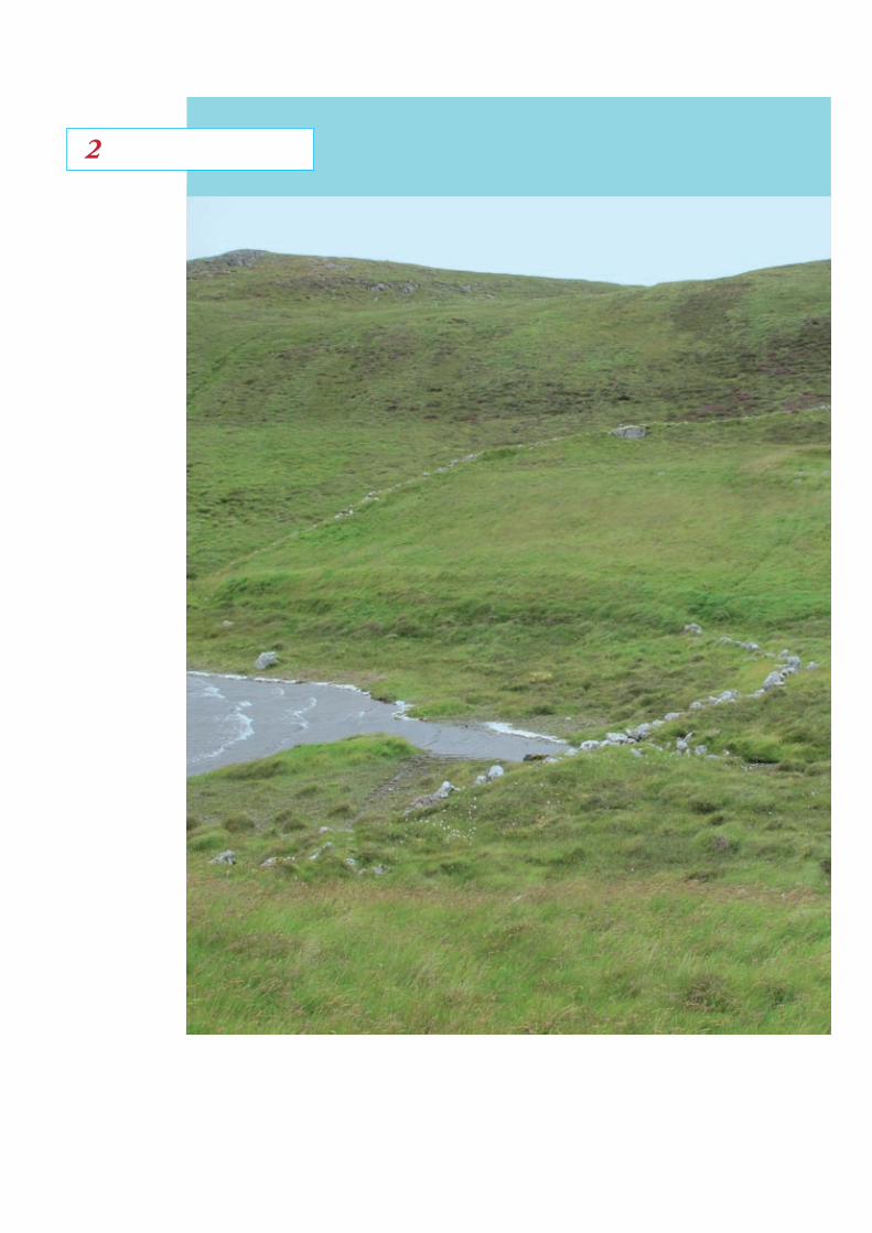
Front cover:
Part of the Neolithic settlement area, Pinhoul-land, West Mainland. Photo by Ditlev L. Mahler, summer 2010
Edited by Ditlev L. Mahler &
Carina Andersen
Northern Worlds
The National Museum of Denmark
Copenhagen 2011
Short papers from the network
meeting in Lerwick, Shetland
September 7th - 10th 2010
Farming on the edge: Cultural Landscapes
of the North
Some features of the Neolithic of Shetland
2

Nordlige VerdenerShetlandsprojekt
Content Northern Worlds The interdisciplinary research
initiative of the National Museum
Hans Christian Gulløv
Shetland – the Border of Farming 4000-3000 BC
Some Features of the Neolithic of Shetland
Ditlev L. Mahler
From Homestead Enclosure to Farm? Field
Development in Shetland in the Neolithic Period
Val Turner
The Post-Glacial Colonization of Shetland
– Integration or Isolation?
Evidence from Lithic and Stone Assemblages
Torben Ballin
Early Agriculture at the Border
Flemming Kaul
Highlights from the Northernmost Bronze Age
societies in Norway
Preben Rønne
Post-Medieval Reuse of Neolithic Sites in
Shetland
Ian Tait
Three ancient cultivation tools from Shetland
Jenny Murray
Contributors
4
6
19
32
44
58
70
80
92
The National Museum of Denmark has
initiated its most comprehensive inter-
disciplinary research venture so far:
Northern Worlds. Between 2009 and
2013, the programme will produce and
communicate new knowledge on the re-
lationship between people and environ-
ment over the last 15,000 years in ways
relevant to the present, with its notable
climatic changes.
The research initiative Northern Worlds
combines and coordinates the expertise
of the National Museum within the dis-
ciplines of archaeology, history, ethnog-
raphy, conservation and natural science
(environmental history).
Northern Worlds has 20 different sub-
projects, which are led by researchers
from the various research departments
at the National Museum. The projects
are organized within three main re-
search areas defined to create suffi-
ciently broad, dynamic and interdiscipli-
nary research environments for the
following topics:
Climate changes and society:
When climatic boundaries move
The focus of Climate changes and soci-
ety concerns selected periods within the
last 15,000 years, during which time cli-
mate changes radically affected the
lives of northern prehistoric and historic
peoples. This will put the influence of
present-day climate changes into per-
spective.
Farming on the edge:
Cultural landscapes of the North
The expansion of agriculture into the
Northern Worlds The interdisciplinary
research initiative of the National MuseumHans Christian GulløvCoordinator, senior researcher
ETHNOGRAPHIC COLLECTION, National Museum of Denmark
4

Nordlige VerdenerShetlandsprojekt
temperate and sub-arctic zones of the
planet represents a more than 6,000 year
long narrative, characterized by repeated
advances followed by stagnation. Farm-
ing on the edge focuses on periods and
areas with large potential for the crea-
tion of new knowledge on agricultural
advances and their associated social
structures and ideologies. The ultimate
boundaries of farming communities in
different parts of Scandinavia and the
North Atlantic are explored. The project
Shetland – the Border of Farming 4000-
3000 BC is part of this initiative.
Networks in the North: Communi-
cation, trade and cultural markers
The ‘marginal’ northern peoples have al-
ways been organized in cultural and
trade-based networks that connect them
with the wider world. Through studies
of material culture, Networks in the
North will allow the unique expertise of
the National Museum to map and ex-
plore the geographical extent of these
northern networks.
In economical terms, Northern Worlds is
the National Museum’s greatest re-
search initiative ever. The Augustinus
Foundation is the main funder of North-
ern Worlds. It is with pleasure that it is
possible to present the first report from
the network conference held in Lerwick,
Shetland, September 7th-10th 2010 with in
the scientific project Shetland – the Bor-
der of Farming 4000-3000 BC.
Introduction
Through an examination of the various
elements constituting the Neolithic Pe-
riod, the research project will provide a
comparative analysis involving the Neo-
lithic communities in Shetland and Scan-
dinavia with particular emphasis on
Southern Scandinavia. The comparative
elements do not merely involve farming
such as grain cultivation and domesti-
cated animals, but also ornamented ce-
ramics, polished tools, the use of the ard,
ritual depositions in wetlands as well as
monumental structures including mega-
liths and gathering places. These di-
verse elements constitute the Neolithic
Period in Southern Scandinavia; howev-
er, they are not all present simultane-
ously. Rather, some are present at an
early stage whereas others appear rela-
tively quickly after. Renewed analyses
point to a rising ritualisation of the early
Neolithic communities as part of an ex-
planation (Jensen, J. 2001: 409 ff.). It is
certain though, that a Neolithisation oc-
curs among the existing population in
Southern Scandinavia shortly after 4000
BC, without disregarding a certain popu-
lation displacement from the South.
Compared to Southern Scandinavia, the
existing conditions on Shetland are rath-
er different because Shetland does not
have exact traces of a Mesolithic popu-
lation which could turn Neolithic. In
2004-2005 though, very early dates of
4200-3600 cal BC were connected to a
kitchen midden excavated at West Voe,
Sumburgh (Melton 2009: 184, see also
Melton 2007: 99, 2008: 23 ff.). Even
though none of the West Voe finds can
tie the area to a Mesolithic environ-
Shetland: The Border of Farming
4000-3000 BCFeatures of the Neolithic
Period on Shetland
Ditlev L. Mahler
66
Nordlige VerdenerShetlandsprojekt
ment, or a Neolithic for that matter, the
presence of hazel may indicate the pos-
sibility of at least Mesolithic visits on
Shetland (Edwards et al. 2009: 113). In
this context, hazel should probably be
viewed as a cultural plant due to its veg-
etational development here (Jóhansen
1985: 78-79; Malmros 1994: 552-558;
Turner 1998: 20). Rather than address-
ing why the Neolithisation happened,
the research project will explore the
mentioned Neolithic elements in order
to assess when and how the Neolithisa-
tion occurred.
Why choose Shetland?
There are several reasons to choose
Shetland as one part of a comparative
analysis. First of all, Shetland is consid-
ered to be the northernmost area of Eu-
rope where farming was practised as a
result of the expansion around 4000 BC.
After a standstill of about 1,000 years
on the Continental lowlands just south
of the Baltic, the farming economies ex-
panded to the North and West. In Scan-
dinavia, the expansion ebbed away at
Svinesund on the border of present day
Sweden and Norway 58,5° North, while
it reached its ultimate boundary on the
British Isles approximately 60° north on
Shetland, and according to past marine
technology further expansion was im-
possible. Absolute dates from Shetland
are infrequent, but the dates from Scord
of Brouster, 3870 cal BC (Edwards &
Whittington 1998: 14) and 4029 cal BC
(Owen & Lowe 1999: appendix 7) have
been confirmed as some of the oldest.
Shetland is moreover a closed unit, al-
though it is scarcely also a closed labo-
ratory. One of the tasks set by the re-
search project will be to clarify possible
outward relations after the islands were
first colonised by the farming popula-
tion. It is evident that the Neolithic cul-
tures on Shetland were related to the
rest of the Neolithic traditions in North-
West Europe, and it is just as evident
that the Neolithic communities devel-
oped their own cultural traits in regards
to tools, building traditions, and grave
monuments.
Shetland and the National
Museum of Denmark
The National Museum of Denmark has a
certain tradition of working together
with Shetland without overrating this
aspect. In 1839, ‘Governor’ (amtmand)
on the Faroe Islands Christian Pløyen
(1803-1867), planned a journey to Shet-
land and Orkney (Pløyen 1840), a journey
which caught the attention of Carl Chris-
tian Rafn. Rafn (1795-1864) was then
secretary for the 14 year old Royal Soci-
ety of Northern Antiquaries and in Chris-
tian Pløyen he recognised an opportuni-
ty to enrich the National Museum of
Denmark with finds from Shetland. Thus,
Pløyen became in charge of procuring
7
multiple contacts to the museum and
subsequently shipped many Neolithic
finds to the museum (Jensen, I. &
Jensen, J. S. 1988: 211 f.) and today; as
a result, the National Museum of Den-
mark contains a rich and varied collec-
tion of especially knives and some fel-
site axes. Felsite is a type of stone
occurring as dykes in the granite of
North Maven on Shetland. It is a very
fine grained volcanic rock primarily con-
sisting of feldspar and quartz (Lund et
al. 1996: 259; see also Ballin this vol.).
Pløyen actually also provided the com-
parative collection of the National Mu-
seum of Denmark with a fragment of a
Viking bone comb (Hansen 2008: 178).
Later, further finds of a coarser sort of
rock, presumably recovered by a certain
Dr. James Hunt during a visit in 1841 in
Sefster, Mainland were later brought to
the National Museum of Denmark. The
finds in question are so-called ‘rude
stone implements’ with a relatively wide
dating (Clarke 2006: 109 f.).
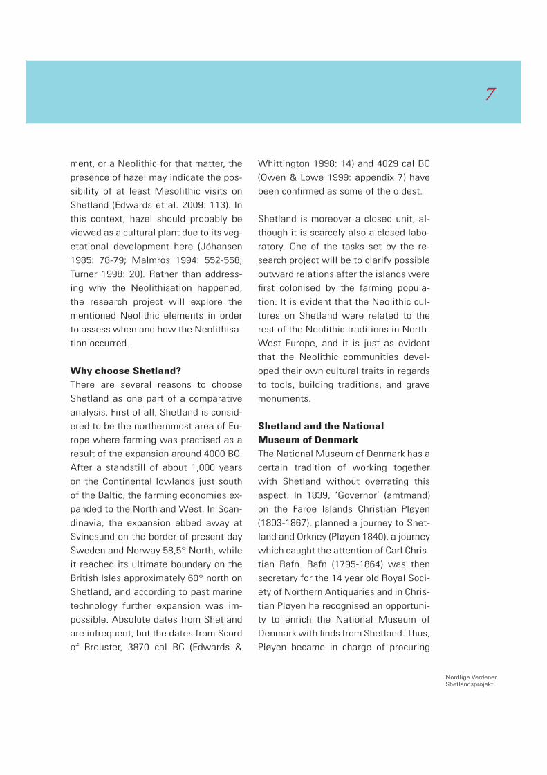
Axes and knives
Of the several felsite tools in the collec-
tion of the National Museum of Den-
mark is a felsite axe (fig. 1) which will be
used as a representation of Shetland
felsite tools as well as to illustrate the
division of felsite axes and knives into a
type classification system. Specifically,
it is a point butted axe with a length of
22.5 centimetres which derives from
Mainland, Shetland according to the
only information of find details in our
possession. It is completely polished
with the exception of a single area on
the one narrow side, and the small hacks
in the edge are presumably recent. A
careful examination of the axe reveals
no traces after hafting or of wear on the
edge. The axe is Neolithic and though
its point butted shape allows for a wide
Fig.1: One of the felsite axes in the collection of the Danish National Museum.
Mahler photo
88
Nordlige VerdenerShetlandsprojekt
dating, it quite possibly dates back to
the Early Neolithic Period on Shetland.
In order to classify this particular felsite
axe, it was compared extensively to simi-
lar felsite tools in the stores of Shetland
Museum in Lerwick during the summer
of 2010. After exploring the collection of
felsite axes and other felsite tools it be-
came clear that the axe from the Na-
tional Museum of Denmark could be
tied to a large group of around 55 felsite
axes in the possession of Lerwick Mu-
seum. All of the axes are large, up to 36
centimetres in length as well as com-
pletely polished and contrary to other
felsite axes in the care of Lerwick Mu-
seum they reveal no traces of wear, re-
sharpening or hafting. These common
traits as well as formation, size, cross
section etc. allow for a temporary type
classification of the 55 axes into six
types of which the point butted axes
with out traces of wear etc. have been
categorised as type 1. After classifying
the axes by type it has also been possi-
ble to arrange the axes chronologically:
The type 3 axes are then quite possibly
Middle Neolithic and the axes from the
type 6 category are probably from the
Late Neolithic Period or Early Bronze Age
(see also Murray this volume fig. 5).
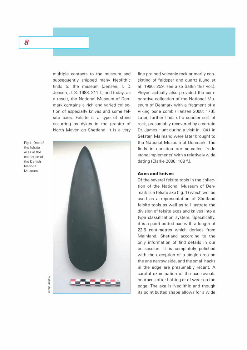
Fig. 2: Some Shetland Knives in the collection of the Danish National Museum.
Mahler photo
9

The unclear and sparse find circum-
stances of the type 1 felsite axes make
it rather difficult to affirm what these
axes were intended for. There appears,
however, to be an apparent connection
of these axes to the wetlands or peat
deposits on Shetland, even though the
type 1 axes usually are stray finds. It is
possible then that the axes were intend-
ed for ritual deposition; similar to the
deposition of the large, completely pol-
ished point and thin butted flint axes in
Southern Scandinavia (Jensen , J. 2001:
421; Mahler 2002: 4 f.). Both the South-
ern Scandinavian flint axes as well as
the type 1 felsite axes from Shetland
may very well have been intended for
ritual deposition as a socio-economic
activity in the Early Neolithic “big-man”
society (Sahlins 1968: 96 f.).
As part of the collections of the Nation-
al Museum of Denmark are also numer-
ous felsite knives and knife fragments
and compared to the felsite axes, the
Shetland felsite knives appear to be a
more complex group of objects. After
exploring the larger collection of felsite
knives from Lerwick Museum, it became
clear that the felsite knives can be divid-
ed into perhaps six different types.
Among the types are the type 1 knives
which also go by the name Shetland
Knives. These knives are oval, 2-3 milli-
metres thick and measure approximately
15 x 12 centimetres. They occur in ritual
deposits in collections of up to 19 speci-
mens (Fojut 2006: 35) and are character-
ised by a completely polished appear-
ance without retouch, facets, or traces
of hafting. Similar to the type 1 felsite
axes, the Shetland Knives must also
have been produced for ritual purposes.
Fojut suggests that the type Shetland
Knives date to the Late Neolithic Period
(idem 2006: 37) whereas the types of
knives with no retouch or traces of re-
sharpening probably could have a wider
dating in the Neolithic.
The type 1 axes, Shetland Knives, and
the Southern Scandinavian thin butted
axes from the large ritual deposits are
especially interesting, as their common
aesthetic characteristics cannot be ran-
dom. As part Early Neolithic, part Late
Neolithic objects, their aesthetic qualities
still apply today as well as in the early
years of archaeology where they caught
the attention of both national and inter-
national collectors. At the time of pro-
duction, the objects were also almost
definitely regarded as unique and valued
for their intended aesthetic features.
The technique and shape are closely
linked together as the technique was
continually perfected so the objects
would please the human sense of beauty.
Such careful control of both technique
and shape conveys a signal of excess
and luxury (Boas 1955: 20, 22). Though it
is unnecessary to polish a certain axe to
1010
Nordlige VerdenerShetlandsprojekt
perfection, it is probably through this
aspect we discover its aesthetic quali-
ties. To illustrate this careful control of
technique and shape, Boas chose a Late
Neolithic fishtail dagger from Southern
Scandinavia (Boas 1955: 41).
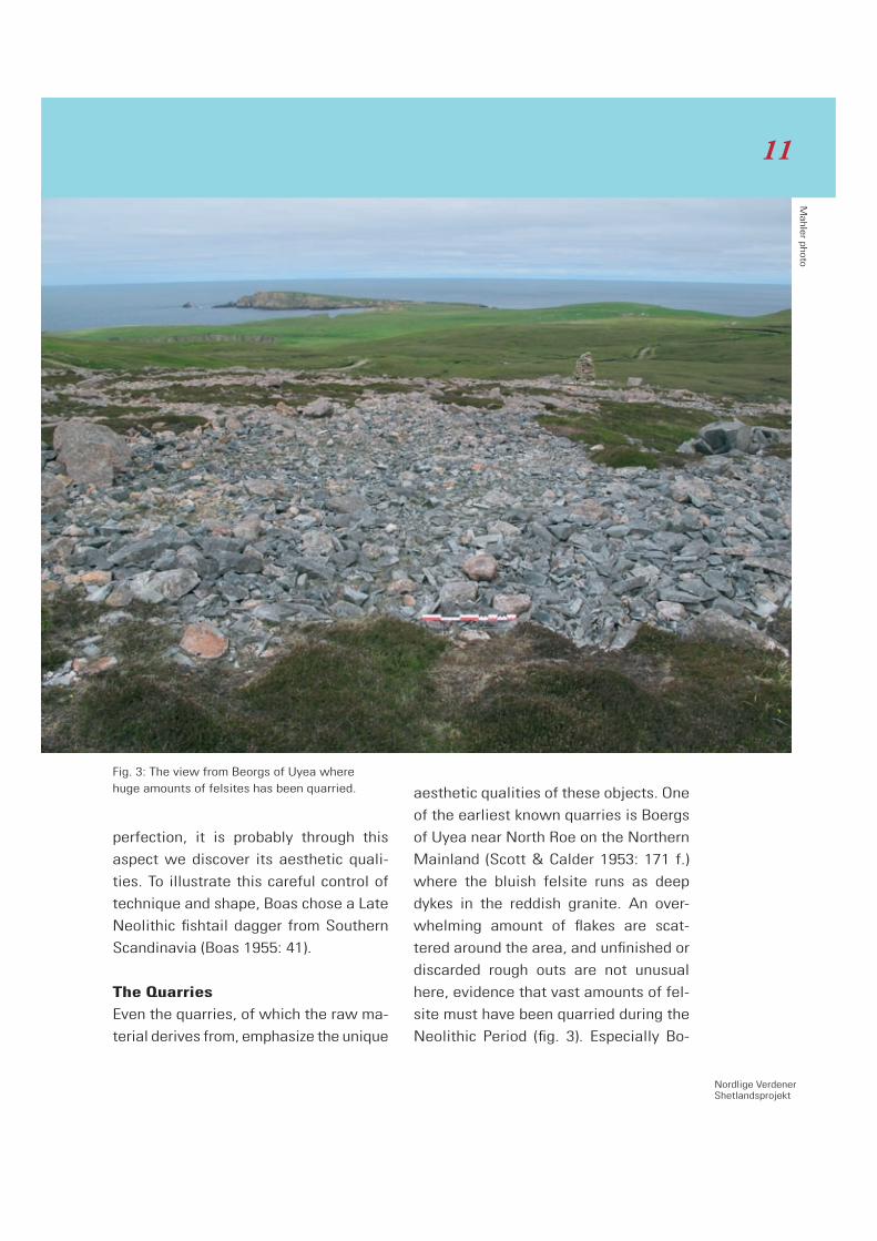
The Quarries
Even the quarries, of which the raw ma-
terial derives from, emphasize the unique
aesthetic qualities of these objects. One
of the earliest known quarries is Boergs
of Uyea near North Roe on the Northern
Mainland (Scott & Calder 1953: 171 f.)
where the bluish felsite runs as deep
dykes in the reddish granite. An over-
whelming amount of flakes are scat-
tered around the area, and unfinished or
discarded rough outs are not unusual
here, evidence that vast amounts of fel-
site must have been quarried during the
Neolithic Period (fig. 3). Especially Bo-
Fig. 3: The view from Beorgs of Uyea where huge amounts of felsites has been quarried.
Mahler photo
11
ergs of Uyea was primarily used for ex-
traction of the material used for these
particular felsite axes and the rough
outs must have been moved and pol-
ished elsewhere. The quarry has actu-
ally been called a factory (Turner 1998:
49), although one may wonder why the
number of known axes in the museum
stores today does not correspond with
the activity traces here. Boergs of Uyea
is impressively situated and can boast
of a spectacular view. Also, the quarries
are visible from the sea and were most
likely accessed from the sea in the Neo-
lithic Period.
In comparison, the felsite quarries on Mid
Field are not visible from the sea, but
while the area is overflowing with flakes,
it is largely recognised for its individual
knapping places. Mid Field is located
near Grut Wells on the highest point of
Shetland, Ronas Hill (388 m.a.s.l.) and
the area was primarily used for cutting
rough outs for knives, especially Shet-
land Knives. Depressions in the terrain
clearly show how the quarries follow
the single dykes of felsite and if the are-
as with geologically occurring felsite
were systematically explored, it would
surely result in the acknowledgement of
a great many quarries. Clusters of small
knapping places are actually scattered
across the entire area from Mid Field all
the way down to Roe Water. Although
not visible from the sea, the Mid Field
quarry is just as impressively situated
as Boergs of Uyea and the phenomenal
aspects of both quarries are certainly
astonishing (compare Hamilton & White-
house 2006: 31).
Monumental grave structures
Shetland is a finding place of many Neo-
lithic grave monuments and although
their dimensions usually are rather
small, they are still of monumental qual-
ity. The Shetland grave monuments con-
sist of cairns, some without chambers
and others with chambers that are more
or less clearly connected with a pas-
sage. The condition of the cairns does,
however, present problems of dating as
only a few of the graves have been pro-
fessionally excavated while others are
dilapidated because they were used as
quarries in the 19th and 20th Century.
Those graves which are quite similar to
passage graves are most likely Neolithic
due to the characteristically trefoil
shaped ground plans of their chambers
(Henshall 1963, vol I: 135; Calder 1964:
37f.), although some of the cairns also
contain stone cists probably dating to
the Bronze Age. Although skeletal mate-
rial from the Shetland Neolithic Period
is rare, a stone cist containing the re-
mains of 18 individuals was recovered
at Sumburgh, Mainland and later 14C
dated to 3315 cal BC (Turner 1998: 41;
Owen & Lowe 1999: appendix 7).
1212

Nordlige VerdenerShetlandsprojekt
One of the well-preserved passage
graves is located on the Isle of Vementry
at the northern coast of Walls-Sandst-
ing in a spectacular setting (Turner 1998:
65). It is evident that the structure con-
tains several phases (fig. 4) when ob-
serving the original outline and section
plan measured by Calder in RCAHMS
(1946, Vol. III: 115). Representing the
oldest phase is the cairn of 6.3 metres in
diameter enclosing an approximately
2.3 x 2 metres large trefoil shaped cham-
ber out of which a 2 metres long pas-
sage leads south-east. In this case the
heel shaped front, one of the character-
istic standard features of Shetland grave
13
Fig. 4: Heel-shaped cairn, Vementry, with the secondary façade marked with red. After RCHANS 1946, Vol. III: 115.
monuments, was later lengthened by
7.3 metres and several stones were af-
fixed to the cairn making the mid axis
7.7 metres in length. The heel shaped
front actually blocks the passage from
the chamber, thus the front must be
younger than the construction of the
chamber (see also Fojut 2006: 25).
As mentioned in the introduction, Shet-
land is the northernmost location im-
pacted by the farming expansion about
4000 BC. Shetland is also the location of
the northernmost megalithic tomb of Eu-
rope and several candidates apply. On
Saxa Vord is one which is composed of
five dilapidated cairns, and with its
height of 270 m.a.s.l., it is the highest
point on Unst. When these cairns were
visited in 1930, it was considered possi-
ble that one of the cairns was once
chambered, but due to the lack of evi-
dence it cannot be affirmed (RCAHMS
1946: 135). Back then, the cairns were
already heavily damaged as a conse-
quence of the construction of modern
land marks and today the cairns no long-
er exist.
Another possibility is the passage grave
on Hill of Caldback, Unst which is an ob-
vious candidate from Henshall’s per-
spective (1963: 162). Originally, it was
12.5 metres in diameter containing a
small chamber of 1.5 metres in diameter
as a centre. A passageway leading
south-east from the chamber was origi-
nally 4 metres long. We may possibly
never obtain clarification of its original
appearance and must content ourselves
with evidence of the northernmost ex-
isting passage graves. This site is part
of the 2011 field work plan.
Gathering place?
When Stanydale was excavated by
Charles Calder in 1949 (Calder 1951), he
initially described it as a temple, but
Calder’s interpretation as well as the
placing of Stanydale in a Mediterranean
context were later revised. It is no won-
der though, as archaeology as science is
still developing and making progress
over time. Still, Stanydale hall is never-
theless an archaeological challenge (fig.
5). The two ailed hall measures 13 me-
tres in length and 6 metres in width and
with its two large post-holes in the cen-
tre, 3 metres thick walls and six built-in
niches it is an unusual structure. It could
either be conceived as a great residen-
tial structure or as a hall with a separate
function. It is certain, however, that
Stanydale’s present appearance is a re-
sult of its reconstruction after Calder’s
excavation. Taking a closer look at the
outline of the hall, the structure clearly
consists of several phases of which two
at first stand out from the others due to
an asymmetrical appearance (Calder
1951: 187). The mid axis which is indi-
cated by the two strongly built post-
1414

Nordlige VerdenerShetlandsprojekt
holes is the only evidence revealing the
original structure. Later the structure’s
mid axis is turned 14 degrees in an east-
erly direction and the heel shaped front
with the attached symmetrically posi-
tioned entrance was constructed. Al-
though the Late Neolithic pottery shards
found in the area indicate a late dating,
it is still not clear when Stanydale was
constructed. Neolithic structures can, as
we know, have a very long life expect-
ancy (Fojut 2006: 27).
Stanydale is situated in a rare location
on Shetland as it is one of the few Neo-
lithic structures from where the sea is
not visible - a location which cannot be
random. The hall is surrounded by a dis-
tinct cultural landscape consisting of
standing stones, stone dykes, smaller
structures both of Neolithic and Bronze
Age character as well as six cairns. Also,
stones have been placed in a stream lo-
cated to the southeast of the hall (Brad-
ley 2000: 97 f.; Bender 2000: 23 f.) lead-
ing us to believe that all these features
cannot possibly be random and several
questions arise: How is the view from
the hall and how is the view to the hall
from the standing stones as well as from
the cairns? Is there any indication of a
connection between the various fea-
tures of the hall and its surrounding
structures which may be able to eluci-
date the unique qualities of Stanydale?
If these questions are answered per-
haps then will the function of the hall in
the ritualised Neolithic society become
clearer (compare Ingold 2000: 77)
Buildings
The Shetland landscapes are awash
with settlement structures and unmis-
takable activity traces in the shape of
Fig. 5: Stany-dale seen from South-east as it ap-peared during fieldwork 2010.
Mahler photo
15

stone dykes and clearance cairns. West
Mainland in particular is a significant lo-
cation in this regard due to the wide-
spread peat growth which has sealed
most of the Neolithic relics in this area
since the (Late) Bronze Age (Calder 1964:
37f). In comparison, evidence shows
that the East Coast had greater poten-
tial for grain cultivation, leading scien-
tists to consider West Mainland as a
more pastoral landscape whereas the
east and south supplied the grain on
Mainland (Edwards & Whittington 1998:
16). Settlement archaeology especially
owes much to Charles Caulder who un-
dertook a series of important investiga-
tions at the end of the 1940s and 1950s
(see also Whittle 1986: 1-3).
The latest recovered Neolithic locality,
Scord of Brouster, was excavated by
Alistair Whittle in 1979 and consists of
four buildings of which House 2 is the
oldest. It is located on a south-east fac-
ing slope and is enclosed by field dykes
and cairns. As mentioned previously, the
oldest activity traces found here place
Scord of Brouster shortly after 4000 BC.
Evidence indicates that the domesticat-
ed animals raised here were primarily
livestock, although bones from sheep
and occasional game such as deer have
also been found. All mammals on Shet-
land, though, must have been brought
here by humans (Noddle in Whittle 1986:
132). Traces of charred grain found in
the area suggest a cultivation of barley,
but traces of threshing waste are scarce
(Milles in Whittle 1986: 119) and the
few wheat grains found here are regard-
ed as weeds in the barley field. This pic-
ture, however, is supplemented by Ness
of Gruting (Calder 1957) which, though,
is dated to 2301 cal BC (Owen & Lowe
1999: appendix 7).
Conclusion
At this stage in the development of the
research project, it is clear that the men-
tioned elements give the impression of
a functioning Neolithic community. A
comparison of the Neolithic features of
Shetland with those of Southern Scan-
dinavia shows that many, if not all the
elements constituting the Neolithic com-
munities are present during the Neolithic
Period. Furthermore, it is actually possi-
ble to draw many parallels between the
Neolithic communities on the continent
(especially North West Europe) and
Shetland. It will be interesting to see
what 2011 will reveal.
Bibliography
Bender, B., 2000. Investigating Land-
scape and Identity in the Neolithic. Neo-
lihic Orkney in its European context.
Ritchie, A. ed.: 23-30.
1616

Nordlige VerdenerShetlandsprojekt
Boas, F., 1955. Primitive Art. New York.
Bradley, R., 2000. An Archaeology of
Natural Places. London.
Calder, C.S.T., 1951. Report on the Exca-
vation of a Neolithic Temple at Stany-
dale in the Parish of Sandsting, Shet-
land. Proceedings of the Society of
Antiquaries of Scotland. (1949-50): 185-
205.
Calder, C.S.T. 1957. Report on the dis-
covery of numerous Stone Age house-
sites in Shetland. Proceedings of the So-
ciety of Antiquaries of Scotland. 89:
340-97.
Calder, C.S.T., 1964. Cairns, Neolithic
houses and burnt mounds in Shetland.
Proceedings of the Society of Antiquar-
ies of Scotland. 98 (1963-64): 37-86.
Clarke, A., 2006. Stone Tools and the
Prehistory of the Northern Isles. BAR
British Series 406.
Edwards, K.J., Schofield, J.E., Whitting-
ton, G. and Melton, N.D., 2009. Palynol-
ogy ”On the Edge” and the Archaeologi-
cal Vindication of a Mesolithic Presence?
The case of Shetland. From Bann Flakes
to Bushmills, papers in honour of Pro-
fessor Peter Woodman, Finlay, N., Mc-
Cartan, S., Milner, N. and Wickham-
Jones, C. eds.: 113-123.
Edwards, K.J. & Whittington, G. 1998.
Landscape and environment in prehis-
toric West Mainland, Shetland. Land-
scape History. Vol. 20: 5-17.
Fojut, N., 2006. A Guide to Prehistoric
and Viking Shetland. Lerwick.
Hamilton, S. & Whitehouse, R., 2006.
Phenomenology in Practice: Towards a
Methodology for a “Subjective” Ap-
proach. European Journal of Archaeology.
Vol. 9 (1): 31-71.
Hansen, S.S., 2008. A Shetland Viking
Comb in Copenhagen. Proceedings of
the Society of Antiquaries of Scotland.
138: 177-183.
Henshall, A.S., 1963. The Chambered
Tombs of Scotland. Vol. 1 & 2, Edin-
burgh.
Ingold, T., 2000. The Perception of the
Environment. Essays on Livelihood,
dwelling and skill. London.
Jensen, J., 2001. Danmarks Oldtid.
København.
Jensen, I. & Jensen J.S., 1988. Det
kongelige Nordiske Oldskriftselskabs
breve 1825-1864. Aarbøger for Nordisk
Oldkydighed og Historie. (1987): 211-
273.
17

Jóhansen, J., 1985. Studies in the veg-
etational history of the Faroe and Shet-
land Islands, (Annales Societatis Scien-
tarum Færoensis Supplementum, XI),
Tórshavn.
Lund, J. et al., 1996. Den store danske
encyklopædi. Vol. 6.
Mahler, D.L., 2002. Efterskrift. Magle-
højsvange ti tyndnakkede flintøkser - et
nyt offerfund fra Sørup Rende. Ledøje-
Smørum Historiske Forenings Årsskrift.
4-17.
Malmros, C., 1994. Exploitation of Local,
Drifted and Imported Wood by the Vi-
kings on the Faroe Islands. Archaeobot-
any. Botanical Journal of Scotland. 46,
part 4: 552-558.
Melton, N.D. 2009. Shells, seals and ce-
ramics: an evaluation of a midden at
West Voe, Sumburgh, Shetland, 2004-5.
Mesolithic Horizons, Papers presented
at the Seventh International Conference
on the Mesolithic in Europe, Belfast
2005. MaCartan, S., Schulting, R., War-
ren, G. and Woodman, P. eds., Vol. 1:
184-189.
Melton, D.N. & Hicholson, E.A., 2007. A
Late Mesolithic – Early Neolithic mid-
den at West Voe, Shetland. Shell Mid-
dens in Atlantic Europe. Milner, N.,
Craig, O. E. and Baily, G. N. eds.
Owen, O. & Lowe, C., 1999. Kebister:
The Four-thousand-year-old Story of One
Shetland Township. Society of Antiquar-
ies of Scotland Monograph Series
Number 14. Edinburgh.
Pløyen, C., 1840. Erindringer fra en Reise
til Shetlandsøerne, Ørkenøerne og Skot-
land i Sommeren 1839. Kjøbenhavn
1840.
RCAHMS, 1946. Twelth Report with an
Inventory of the Ancient Monuments of
Orkney & Shetland. Vol. III. Inventory of
Shetland. Edinburgh, His Majesty’s Sta-
tionary Office.
Sahlins, D., 1968. Tribesmen. Founda-
tion of Modern Anthropology Series.
Scott, L.G. & Calder, C.S.T., 1953. Notes
on a Chambered Cairn, and a Working
Gallery on the Beorgs of Uyea, North-
maven, Shetland. Proceedings of the
Society of Antiquaries of Scotland. 86,
(1951-1952): 171-177.
Turner, V., 1998. Ancient Shetland. His-
toric Scotland. London.
Whittle, A., Keith-Lucas, M., Miles, A.,
Noddle, B., Rees, S. and Romans, J.C.C.,
1986. Scord of Brouster. An Early Agri-
cultural Settlement on Shetland. Oxford
University Committee for Archaeology,
monograph no. 9.
1818
Nordlige VerdenerShetlandsprojekt
Introduction
In Shetland there are two types of set-
tlement patterns which are generally
ascribed to the Neolithic/Bronze Age
periods. These take the form of single
Enclosures and Multiple Field Systems.
The discussion of these sites which fol-
lows is part of a wider study into the
form and function of prehistoric to Norse
field systems within Shetland, which fo-
cuses on Shape Analysis, Boundary
Analysis and Soil Micromorphology.
The purpose of this paper is to explore
whether there are geographical reasons
which might explain why some Enclo-
sure sites show evidence of developing
into Multiple Field Systems whilst oth-
ers appear not to have done. Issues re-
lating to possible differing functions be-
tween the sites will be explored in the
wider study (Turner, forthcoming) and
this determined the selection of the
principle sites in the study. These were
selected from the Shetland Sites and
Monuments Record because they each
have clear complete or near-complete
enclosure boundaries.
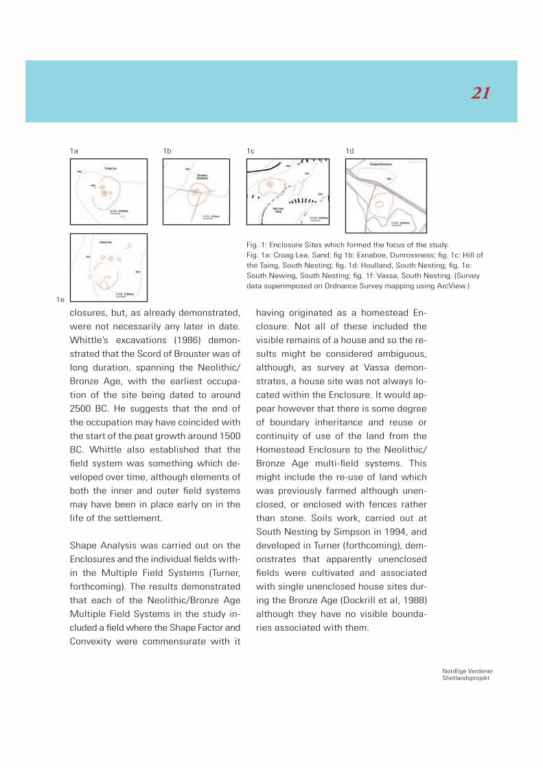
Enclosure Sites and
the Multiple Field Systems
The defining characteristics of the En-
closure sites are that they comprise a
boundary which is sub-circular and in-
clude a house site which is situated either
within, or at the edge of, the enclosure.
These sites were originally termed “Home-
stead Sites” by the Ordnance Survey
and appeared on their mapping as such.
Their simple appearance may indicate
that they are of an early, and therefore
Neolithic, date but excavated examples
are few and the excavations which have
taken place largely predate the raft of
more sophisticated dating techniques
which are becoming increasingly avail-
From Homestead Enclosure to Farm? Field Development in Shetland
in the Neolithic Period
Val Turner
19
able to even modest archaeological pro-
jects. It is therefore difficult to date the
Enclosure sites with any certainty, al-
though approaches have been proposed
based on typology (Turner, 1998; Downes
and Lamb, 2000: 119-123). Ballin-Smith
(2005: 75) suggested that the excavated
example at Catpund is Bronze Age on the
basis of the artefact assemblage, which
she compared with that from the Scord
of Brouster, House 1, which was radio-
carbon dated to between 2510 ± 70 BP
and 1715 ± 75 BP (Whittle 1986: 75). This
comparison is interesting in itself be-
cause it suggests that the sites are con-
temporary. It is possible that an Enclo-
sure may have originally been part of a
more extensive pattern of land use
which included boundaries which are no
longer visible. Alternatively, the lack of
other visible boundaries may arise be-
cause such boundaries were never need-
ed, for example if stock were tethered,
and therefore cleared, cultivated, areas
of land did not need enclosing. Alterna-
tively, boundaries may have been con-
structed of wood and therefore no longer
be readily identifiable in the present day
landscape.
The Multiple Field Systems comprise
several small, irregularly shaped fields,
described by Noel Fojut as tear-drop
shaped (pers. comm.), and which are
usually, but not necessarily, contiguous.
Each field system contains one or more
visible prehistoric house sites and many
of them also contain mounds of stones
cleared from the fields during the course
of agriculture. Whittle excavated two
clearance cairns at the Scord of Brouster
(1986) and established that they contain-
ed larger stone at the bottom than they
did at the top. Whittle interpreted this as
being due to the size of stone removed
from the field diminishing over time.
The majority of the Multiple Field Sy -
stems which are known to survive today
are located on the West Side of Shet-
land. Four of these were included in this
study. A site of broadly similar appear-
ance was identified in the South Main-
land and was also selected in order to
increase the geographical spread. Many
of the field systems on the West Side
have lengths of substantial prehistoric
dykes between them. Some of these ap-
pear to be aligned on hill tops or Neo-
lithic chambered cairns, and some fol-
low ridges or shoulders of hills. These
often disappear into areas of deeper
peat between the sites. Fojut (2006)
suggests that these might define early
“estate boundaries” and indicate that
the division of the hill was sufficiently
important to justify the considerable la-
bour which would have been required to
undertake it.
The Multiple Field Systems appear to be
more complex than the Homestead En-
2020
Nordlige VerdenerShetlandsprojekt
closures, but, as already demonstrated,
were not necessarily any later in date.
Whittle’s excavations (1986) demon-
strated that the Scord of Brouster was of
long duration, spanning the Neolithic/
Bronze Age, with the earliest occupa-
tion of the site being dated to around
2500 BC. He suggests that the end of
the occupation may have coincided with
the start of the peat growth around 1500
BC. Whittle also established that the
field system was something which de-
veloped over time, although elements of
both the inner and outer field systems
may have been in place early on in the
life of the settlement.
Shape Analysis was carried out on the
Enclosures and the individual fields with-
in the Multiple Field Systems (Turner,
forthcoming). The results demonstrated
that each of the Neolithic/Bronze Age
Multiple Field Systems in the study in-
cluded a field where the Shape Factor and
Convexity were commensurate with it
having originated as a homestead En-
closure. Not all of these included the
visible remains of a house and so the re-
sults might be considered ambiguous,
although, as survey at Vassa demon-
strates, a house site was not always lo-
cated within the Enclosure. It would ap-
pear however that there is some degree
of boundary inheritance and reuse or
continuity of use of the land from the
Homestead Enclosure to the Neolithic/
Bronze Age multi-field systems. This
might include the re-use of land which
was previously farmed although unen-
closed, or enclosed with fences rather
than stone. Soils work, carried out at
South Nesting by Simpson in 1994, and
developed in Turner (forthcoming), dem-
onstrates that apparently unenclosed
fields were cultivated and associated
with single unenclosed house sites dur-
ing the Bronze Age (Dockrill et al, 1988)
although they have no visible bounda-
ries associated with them.
Fig. 1: Enclosure Sites which formed the focus of the study. Fig. 1a: Croag Lea, Sand; fig 1b: Exnaboe, Dunrossness; fig. 1c: Hill of the Taing, South Nesting; fig. 1d: Houlland, South Nesting; fig. 1e: South Newing, South Nesting; fig. 1f: Vassa, South Nesting. (Survey data superimposed on Ordnance Survey mapping using ArcView.)
1a 1b 1c 1d
1e
21

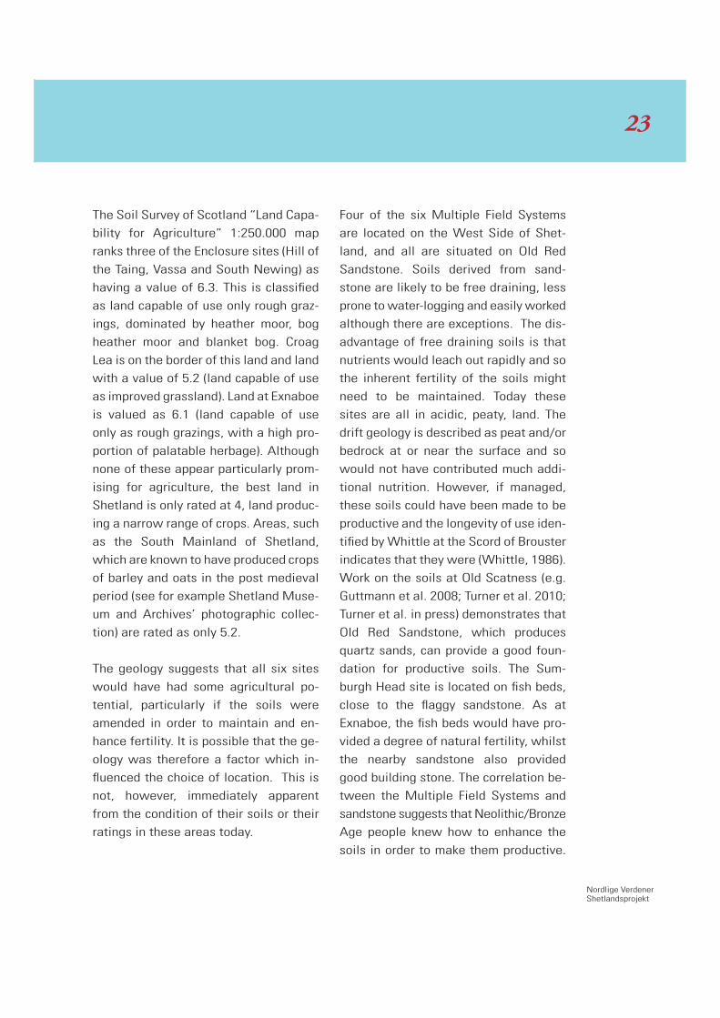
Geology and Soils
The six Enclosure sites considered in the
study are located on three different
types of solid geology. Three (Hill of the
Taing, Houlland and Vassa) are on calc
schist, a metamorphism of calcareous silt
or mud (J. Swale, pers. comm.), which
would have produced a reasonable agri-
cultural soil. Exnaboe was situated in a
fairly favourable location geologically: at
the junction of fish beds, which are also
calcareous silt occasionally with thin
lime stones, (J. Swale, pers. comm.) and
which would have added some calcium
and therefore a degree of fertility to the
soil, and flaggy sandstone, which although
soft is good building stone. Croag Lea,
however, is situated on granitic gneiss
which would only ever have produced a
thin, stony, acidic soil. The drift geology
may have gone some way to redeeming
this, as it includes till and moraine. The
granitic gneiss would potentially have
provided good building stone, depending
on the localised jointing. South Newing
is also on granitic gneiss, but a lime-
stone band runs through the area and
the drift geology includes lake alluvium;
both of these would be likely to have
contributed to the fertility of the area.
Fig. 2: Multiple Field Sys-tems which formed the focus of the study. Fig. 2a: Scord of Brouster and Gallow Hill; fig. 2b: Pinhoulland; fig. 2c: Ness of Gruting; fig. 2d: Sumburgh Head. (Survey data superimposed on Ordnance Survey map-ping using ArcView.)
2a 2b
2c 2d
2222
Nordlige VerdenerShetlandsprojekt
The Soil Survey of Scotland “Land Capa-
bility for Agriculture” 1:250.000 map
ranks three of the Enclosure sites (Hill of
the Taing, Vassa and South Newing) as
having a value of 6.3. This is classified
as land capable of use only rough graz-
ings, dominated by heather moor, bog
heather moor and blanket bog. Croag
Lea is on the border of this land and land
with a value of 5.2 (land capable of use
as improved grassland). Land at Exnaboe
is valued as 6.1 (land capable of use
only as rough grazings, with a high pro-
portion of palatable herbage). Although
none of these appear particularly prom-
ising for agriculture, the best land in
Shetland is only rated at 4, land produc-
ing a narrow range of crops. Areas, such
as the South Mainland of Shetland,
which are known to have produced crops
of barley and oats in the post medieval
period (see for example Shetland Muse-
um and Archives’ photographic collec-
tion) are rated as only 5.2.
The geology suggests that all six sites
would have had some agricultural po-
tential, particularly if the soils were
amended in order to maintain and en-
hance fertility. It is possible that the ge-
ology was therefore a factor which in-
fluenced the choice of location. This is
not, however, immediately apparent
from the condition of their soils or their
ratings in these areas today.
Four of the six Multiple Field Systems
are located on the West Side of Shet-
land, and all are situated on Old Red
Sandstone. Soils derived from sand-
stone are likely to be free draining, less
prone to water-logging and easily worked
although there are exceptions. The dis-
advantage of free draining soils is that
nutrients would leach out rapidly and so
the inherent fertility of the soils might
need to be maintained. Today these
sites are all in acidic, peaty, land. The
drift geology is described as peat and/or
bedrock at or near the surface and so
would not have contributed much addi-
tional nutrition. However, if managed,
these soils could have been made to be
productive and the longevity of use iden-
tified by Whittle at the Scord of Brouster
indicates that they were (Whittle, 1986).
Work on the soils at Old Scatness (e.g.
Guttmann et al. 2008; Turner et al. 2010;
Turner et al. in press) demonstrates that
Old Red Sandstone, which produces
quartz sands, can provide a good foun-
dation for productive soils. The Sum-
burgh Head site is located on fish beds,
close to the flaggy sandstone. As at
Exnaboe, the fish beds would have pro-
vided a degree of natural fertility, whilst
the nearby sandstone also provided
good building stone. The correlation be-
tween the Multiple Field Systems and
sandstone suggests that Neolithic/Bronze
Age people knew how to enhance the
soils in order to make them productive.
23

Fig. 3: Map of Shetland showing the location of the Enclosures (green) and Multiple Field Systems (orange) in the study.
2424

Nordlige VerdenerShetlandsprojekt
This will be tested by soil micromorpho-
logy (Turner, forthcoming), which has the
potential to demonstrate anthropogenic
activity which can be set in the context
of natural pedogenic and sedimentary
processes (Dockrill and Simpson, 1994).
Archaeologists are just beginning to un-
derstand the degree to which the sand-
stone in the West Mainland was impor-
tant for the manufacture of the stone
tools, including ard points, which were
found to be so abundant at the Scord of
Brouster (Whittle, 1986). Shallow quarry
pits and associated chipping floors have
recently been identified both at Sum-
burgh Head (Turner, forthcoming) and in
the hill land in the West Mainland (ob-
servation by Turner and Cowley). The
manufacture of stone tools, particularly
ard points and “spades” was fundamen-
tal to the effectiveness of the Multiple
Field Systems and their hinterland, de-
fined perhaps by the boundaries which
extend beyond the field systems (for ex-
ample as mapped during the survey at
Pinhoulland and at Gallow Hill), may
have been just as important to the econ-
omy of the sites as the cultivated land
itself. Thus the geology of the sites may
have influenced the location of success-
ful field systems beyond its contribution
to the makeup of the soils.
Each of the sites at Gruting, Pinhoul-
land, Gallow Hill and the Scord of
Brouster has a Land capability value of
5.2, land capable of use as improved
grassland with high growth rates and
satisfactory stocking values. Sumburgh
Head is on land valued as 6.1, land ca-
pable of use only as rough grazings having
high proportions of palatable herbage.
Overall, the Multiple Field Systems are
land which is rated as having a higher
value for Land Capability than that occu-
pied by the Homestead Enclosures. The
underlying geology and the resultant ca-
pacity of the land do therefore seem to
have influenced the locations of the
Multiple Field Systems, although Sum-
burgh Head is an exception.
Height Above Ordnance Datum
The height Above Ordnance Datum (aod)
may have had significance in the loca-
tion of the site types under considera-
tion, not least because height could po-
tentially impact on climate, the nature
of the soils and the length of the grow-
ing season. The heights of the Enclo-
sures in the study range between Vassa
(3-13 metres aod) to Croag Lea (38-42
metres aod). The Multiple Field Systems
have an even wider range: Pinhoulland
starts close to sea level (3 metres aod)
but the core area of the site rises to 39
metres aod. The field systems at Gal-
low Hill and the Scord of Brouster rise to
heights of 50 and 51 metres aod respec-
tively.
25

It is generally believed that the upland
sites were inhabited at times when the
climate was better and when there was
also pressure on the amount of land
available. Whittle (1989) argues that
one of the major factors in the abandon-
ment of the Scord of Brouster was the
increasing peat-growth, which may have
been climatically induced. Rising sea
level and upland peat encroaching would
certainly have increased the pressure on
the land (Fojut 1993: 32-33). Complex
societies are thought to have some re-
silience to inter-annual or even inter-
decadal climatic variation, but they re-
spond to stresses which occur over
multiple decades and centuries (deMen-
ocal 2001). A community might be able
to withstand the occasional bad year,
particularly in terms of subsistence, by
broadening their resource base and fall-
ing back on seafood, however constant-
ly declining yields would inevitably
eventually lead to abandonment. The
higher the altitude of the site, the great-
er the risk of crop failure would be in
any given year.
Site Alignment
The Enclosure sites are small and sub-
circular and cannot therefore be consid-
ered to have an alignment in terms of
relationship to the hillslope. The field
boundaries associated with them broad-
ly follow the contours of the hill.
In contrast, the Multiple Field Systems are
elongated and therefore do have identi-
fiable alignments. In five out of the six
sites within this study, the field systems
are clearly aligned along the slope. The
steepness and extent of slope varies in
each case. The Scord of Brouster has a
height difference of 24 metres across the
width of the site but, nevertheless, on
the ground it feels locally flat. At Sum-
burgh Head, the field system has a very
strong relationship with the contours,
following the curvature of the hill. The
height differences at Gallow Hill, the
Ness of Gruting and the core of the field
system at Sumburgh Head, are 15 metres
across the widths of the field systems.
At Gallow Hill, the field system is locat-
ed on flatter land then that immediately
below it. Pinhoulland is the one excep-
tion, but even here the compact central
area of the Multiple Field System at Pin-
houlland has a similar height range, fits
the same pattern and, locally, the fields
within it appear relatively flat. However,
the Pinhoulland field system also in-
cludes additional fields lower down the
slope, to the northeast: these extend the
lower limit of the site to 3 metres aod
and also change the overall alignment
of the site. These fields, which are de-
tached from the core area, were largely
omitted during Whittle’s survey (1986).
Assuming that the Multiple Field Sy-
stems accreted over time rather than be-
2626

Nordlige VerdenerShetlandsprojekt
ing created as part of a single event, a
hypothesis supported by Whittle’s exca-
vations at the Scord of Brouster (1986),
it would appear that as a Multiple Field
System expanded, or the focus relocated,
it took in land at a similar height, further
along the slope, rather than up or down
it. This is borne out by the excavated ev-
idence from the Scord of Brouster (Whit-
tle 1986), where the first and second
house sites both fall on the 40 metre
contour. The final house at the Scord of
Brouster was located slightly lower down
the slope. Whether the lower land was
already in use, thereby preventing a
downward expansion, or whether ex-
pansion along the slope was a positive
choice cannot be determined with any
certainty. Individual fields would be easi-
er to work if they were aligned along the
slope, particularly if they were being
ploughed. Cultivation down the slope
would exacerbate the migration of soil
down the hill. At Sumburgh Head, the
land below the field system is signifi-
cantly flatter and today appears much
more attractive for cultivation, which
would suggest that the lower land was
already occupied. However at the other
upland sites, where the soils had poten-
tial, and if the growing season was not
significantly impaired by a slight increase
of altitude, the acquisition of the flattest
neighbouring land could be seen as hav-
ing advantages over trying to cultivate
steeper, but lower, slopes.
Site Aspect/Sunshine
Five of the six Enclosure sites have a
site aspect of between south and east.
The exception is Houlland where the lo-
cal aspect of the site is north, although
it is on a hill slope which faces south. A
southerly aspect would maximise the
amount of sun which a site received,
which would be important to agriculture
and may determine the success or fail-
ure of a site. Today, the prevailing wind
in Shetland comes from between the
west and the south-east (Windroses for
Sumburgh 1986-1995; Scatsta 1991-
2000, UK Met Office Data, 2010). Three
of the Multiple Field Systems share
broadly similar aspects, with the other
two sites facing southeast.
Anecdotally, today the West Side of
Shetland is considered to be sunnier
than the east, which is more prone to
fog. This is supported by comparing the
Cloud-base Occurrence Data and the
Visibility Percentage Charts relating to
Sumburgh 1986-1995 and Scatsta 1991-
2000 (UK Met Office Data, 2010). Scat-
sta, in the North Mainland, has weather
systems which correspond with the
west side of Shetland, in contrast to
Sumburgh Head which shares its weath-
er systems with the east side (Dave
Wheeler, North Isles Weather, pers.
comm.). The amount of sun which a field
receives becomes increasingly signifi-
cant with latitude. By the 17th Century
27

Fig. 4: Locations of known Houses, Enclosures and Multiple Field Sys-tems in Shetland. (Data taken from Shetland Sites and Monuments Record, Shetland Amenity Trust)
2828

Nordlige VerdenerShetlandsprojekt
AD (but probably considerably before
this) the Faroese had developed a sy-
stem where strips three metres broad,
known as “teigar”, were usually half a
metre higher on one long side than the
other, in order to both improve drainage
and maximise the amount of heat avail-
able from the sun (Arge, 2005: 29).
Five of the six enclosures under consid-
eration are located on the east side of
Shetland, Croag Lea being the excep-
tion. By contrast, four of the six Multiple
Field Systems are located on the West
Side, the other two being in the South
Mainland. If the amount of sun, repre-
sented by a high cloud base and good
visibility, followed a similar pattern in
the prehistoric period as in the present,
this may have been a factor in determin-
ing why the Multiple Field Systems de-
veloped on the West Side and the single
enclosures are located on the east.
In order to test the extent to which this
is true throughout Shetland, all prehis-
toric house sites, Homestead Enclosures
and Multiple Field Systems have been
mapped using data from the Shetland
Sites and Monuments Record. Where
the SMR record is ambiguous, sites
were also investigated using vertical
aerial photographs. The results demon-
strate a clear concentration of Multiple
Field Systems located in the west of
Shetland, particularly on the West Side
where recent field work (by Cowley et
al, RCAHMS) suggests this is likely to
be an under-recording. The majority of
the examples which occur to the South
and East either correspond with areas
which are today still fertile (e.g. Fetlar
and Whalsay) or are located in the South
Mainland. They are largely coastal and
most are close to stretches of water
which face south. All this adds to a pic-
ture of trying to maximise the amount of
sun available. Sun being reflected off
the sea would have a small impact in in-
creasing the temperature locally. In con-
trast, the single house sites, with or
without surviving Enclosures around
them, appear to be spread more uni-
formly throughout the islands. The
amount of sun therefore appears to have
been a significant factor in determining
which Enclosure sites developed into
Multiple Field Systems.
Conclusions
Today, the majority of the Enclosures
and Multiple Field Systems survive in
land which is acidic and peaty, however
this does not necessarily reflect the con-
dition of the soils 3-4000 years ago. The
Enclosures in the study were all con-
structed on land which could have been
productive if the soil was maintained.
However, the majority of the Multiple
Field Systems are located on land which
today has a higher Land Capability value
than that occupied by the Homestead
29

Enclosures. It is therefore possible that
geology and the related soil had an im-
pact on whether or not an Enclosure de-
veloped into a Multiple Field System.
The Multiple Field Systems at Gallow
Hill and the Scord of Brouster rise to ap-
proximately 50 metres and therefore
height aod did not determine which En-
closures developed into Multiple Field
Systems. This is supported by the site
alignments which demonstrate that that
the availability of flat land was more im-
portant to site development than steep-
er land at a lower altitude.
House sites, with or without surviving
Enclosures, have been identified through-
out the islands. The Multiple Field Sy-
stems have been shown to have a more
restricted geographical range, being re-
stricted to the West of Shetland, the
South Mainland or having a location
close to a south-facing coast. The warmth
of the sun therefore would appear to be
the most important geographical factor
in determining which Enclosure sites
developed into Multiple Field Systems.
Further research is required in order to
explore the functions of the fields and
enclosures in this study, and this is be-
ing progressed using micromorphology.
Acknowledgements
Thanks to Jonathan Swale, Scottish
Natural Heritage, for discussing Shet-
land’s geology with me, to Dave Wheeler,
North Isles Weather, for discussing wind
and sun with me and to Prof. Ian Simpson,
University of Stirling, for commenting on
an earlier draft of this paper.
Bibliography
Arge, S.V., 2005. Cultural Landscapes
and Cultural Environmental Issues in the
Faroes. Viking and Norse in the North
Atlantic. Mortensen, A. and Arge, S.V.
eds. Torshavn: 22-38.
Ballin Smith, B., 2005. Catpund: a pre-
historic house in Shetland, Scottish Ar-
chaeological Internet Report 7, Society
of Antiquaries of Scotland.
deMenocal, P.B., 2001. Cultural respons-
es to climatic change during the Late
Holocene. Science 292: 667-673.
Dockrill, S., Bond, J. and O’Connor, T.,
1998. Beyond the Burnt Mound: The
South Nesting Palaeolandscape Project.
The Shaping of Shetland. Developments
on Shetland Lanscape Archaeology.
Turner, V. ed. Shetland Times, Lerwick:
61-82.
Dockrill, S. and Simpson I. A., 1994. The
identification of prehistoric anthropo-
genic soils in the Northern Isles using
3030
Nordlige VerdenerShetlandsprojekt
an integrated sampling methodology.
Archaeological Prospection 1: 75-92.
Downes, J. and Lamb, R. 2000. Prehis-
toric Houses at Sumburgh in Shetland.
Excavations at Sumburgh Airport 1967-
74. Oxford.
Fojut, N., 1993 A Guide to Prehistoric
and Viking Shetland. Shetland Times,
Lerwick.
Fojut, N., 1983, 2005. Towards a Geog-
raphy of Shetland Brochs. Glasgow Ar-
chaeological Journal, Vol. 9, 1983: 38-
59. Reprinted in Tall Stories: 2 millennia
of Brochs. Turner, V.E., Nicholson, R.,
Dockrill, S.J. and Bond, J. M. eds. 2005.
Lerwick: 144-168.
Fojut, N., 2006. Prehistoric and Viking
Shetland. Fifth edition. Shetland Times,
Lerwick.
Guttmann, E. B., Simpson, I. A., Nielsen,
N., and Dockrill, S.J., 2008. Anthrosols
in Iron Age Shetland: Implications for
Arable and economic Activity. Geoar-
chaeology: An International Journal,
Vol. 23, No 6: 799-823.
Turner, V. E., 1998. Ancient Shetland.
London.
Turner, V. E, forthcoming, PhD Thesis,
University of Stirling.
Turner, V. E., Guttmann-Bond, E. B. A,
Burbidge, C. I. and Simpson, I. A., 2010.
Old Scatness: the Viking and Norse an-
throsols. Excavations at Old Scatness,
Shetland. Volume 1: The Pictish Village
and Viking Settlement, Dockrill, S. J.,
Bond, J. M., Turner, V. E., Brown, L. D.,
Bashford, D. J., Cussans, J. E., Nichol-
son, R. A. Lerwick.
Turner, V. E., Guttmann-Bond, E. B. A,
Burbidge, C. I., and Simpson, I. A., in
press. Old Scatness: the Iron Age an-
throsols. Excavations at Old Scatness,
Shetland. Volume 2: The Iron Age Broch
and Village. Dockrill, S. J., Bond, J. M.,
Turner, V. E., Brown, L. D., Bashford, D.
J., Cussans, J. E., Nicholson, R. A. Eds.
Lerwick.
Whittle A., 1989. Islands of history: sec-
ond millennium change in the north of
Scotland. Transactions of the British-
Scandinavian Colloquium in Stockholm,
May 10-11, 1985. Bronze Age Studies 6,
Nordström, H-Å and Knape A. Stock-
holm: 163-172.
Whittle A., Keith-Lucas M., Millies A.,
Noddle B., Rees S., and Romans J. C. C.,
1986. Scord of Brouster: An Early Agri-
cultural Settlement on Shetland, Oxford
University Committee for Archaeology
Monograph 9, Oxford.
31
Introduction
In terms of post-glacial colonization,
Shetland is most relevantly compared to
other island groups north and west of
the British mainland, such as the West-
ern Isles towards the south-west, the
Orkney Islands towards the south, and
the Faroe Islands towards the north. In
all these cases, the time and character
of the initial colonization has been, and
still is, an important issue.
Although, at North ton on Harris, a
number of burnt hazelnut shells were
dated to c. 7-6000 cal BC (AA-50332-6;
Simpson et al. 2006: 22), no diagnostic
lithic artefacts were recovered from this
site (ibid. 2006: 23), and diagnostic Me-
solithic artefacts have not been found
anywhere else within the Western Isles.
Relatively numerically large Early and
Late Neolithic lithic assemblages have
been recovered (e.g. Armit 1992; Simp-
son et al. 2006; Ashmore forthcoming),
but the fact that the Western Isles are
visible from the Scottish mainland at
most times makes it highly likely that
the island group was colonized earlier,
and that the undiagnostic lithic assem-
blage from Northon’s basal layers is ac-
tually Mesolithic.
Like the Western Isles, Orkney is visible
from the Scottish mainland, but until re-
cently Mesolithic indicators were scarce.
Lacaille (1954; fig. 119) identified a
number of small flints as possibly of Me-
solithic date, and Saville (2000) charac-
terized these and other stray finds from
Orkney as almost certainly Mesolithic.
Recently, a large lithic assemblage in-
cluding diagnostic Mesolithic pieces
The Post-Glacial Colonization of Shetland – Integration or Isolation?
Evidence from Lithic and
Stone Assemblages
Torben Bjarke Ballin
3232
Nordlige VerdenerShetlandsprojekt
(e.g. true microliths) was excavated on
Stronsay (Pitts 2007; Naomi Woodward
pers. comm.). Numerous Early and Late
Neolithic lithic collections are available
from excavated settlement sites, as well
as from prehistoric houses and cham-
bered cairns (Ritchie 2000).
Although Shetland is situated more than
80 km from the Orkney Islands, it is pos-
sible from this island group – on a clear
day – to see Fair Isle (midway between
Orkney and Shetland) and, from Fair Isle,
the southern end of Shetland Mainland
(Johnston 1999). Therefore, although no
definite Mesolithic types have yet been
retrieved from Shetland, it is highly like-
ly that the northernmost island group in
Britain was colonized, or at least visit-
ed, in the Mesolithic, as the Stronsay
finds clearly prove Orkney was.
The Earliest Finds from Shetland
No diagnostic Mesolithic artefacts have
been recovered from Shetland, with the
assemblage from West Voe near Sum-
burgh presently being the island group’s
oldest settlement. In 2004 and 2005,
Bradford University carried out excava-
tions at this site, with the archaeological
investigation focusing on two shell mid-
dens which had been exposed by coastal
erosion (Melton 2008). The lower midden
consisted largely of oysters, whereas
the upper midden consisted entirely of
cockles. The two main anthropogenic
layers were separated by sterile sand,
and they both contained animal bones
and lithic material, although the vast
majority of bones and lithics were asso-
ciated with the early midden. The early
activities were radiocarbon dated to
4320-4030 cal BC (SUERC-572) and
3750-3520 cal BC (SUERC-573), respec-
tively (ibid. 2008).
The undiagnostic lithic assemblage (289
pieces) is entirely in quartz, with flint
being absent (Ballin 2006). Approxi-
mately 83% of the lithics were recov-
ered from Phase I, and the remainder
from later phases. The dimensions of
the individual pieces, as well as techno-
logical data, support an early date. Al-
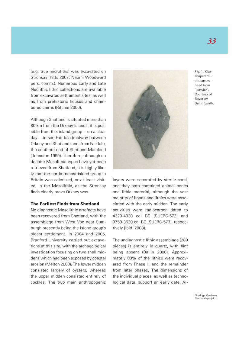
Fig. 1: Kite-shaped fel-site arrow-head from ‘Lerwick’. Courtesy of Beverley Ballin Smith.
33

though the earliest radiocarbon date
from West Voe was initially perceived
by the excavator as an indication of Me-
solithic settlement, re-interpretation of
this date now suggests settlement at
the location in the earliest stages of the
Early Neolithic Period (Nigel Melton per-
sonal comment).
Lithic assemblages have been recovered
from many Neolithic house sites, but
only from a small number of Neolithic
burials, and a very small proportion of
these assemblages are associated with
radiocarbon dates.
A large quartz assemblage from Scord
of Brouster, West Mainland, includes
two approximately kite-shaped arrow-
heads, a relatively large number of bifa-
cial curved knives, as well as many less
spectacular implements; stone artefacts
include a number of sandstone ard
points and a burnt scraper based on a
fragment of a polished felsite axehead
(Ballin 2005). The oldest dwelling, House
2, was dated to c. 3700-3100 cal BC (the
later part of the Early Neolithic Period)
and the later House 1 to c. 3000-2700
cal BC (the Late Neolithic Period), where-
as the smaller House 3 appears to be a
Bronze Age structure (CAR-242-53; CAR-
477-9; HAR-2413).
A cist burial at Sumburgh, near Shet-
land’s southern tip, was radiocarbon
dated to c. 3500-2700 cal BC (the Early/
Late Neolithic transition; GU-1075). The
cist contained the remains of several in-
dividuals, as well as three plain bowls,
five stone beads, a polished stone axe-
head, and a number of lithics in jasper
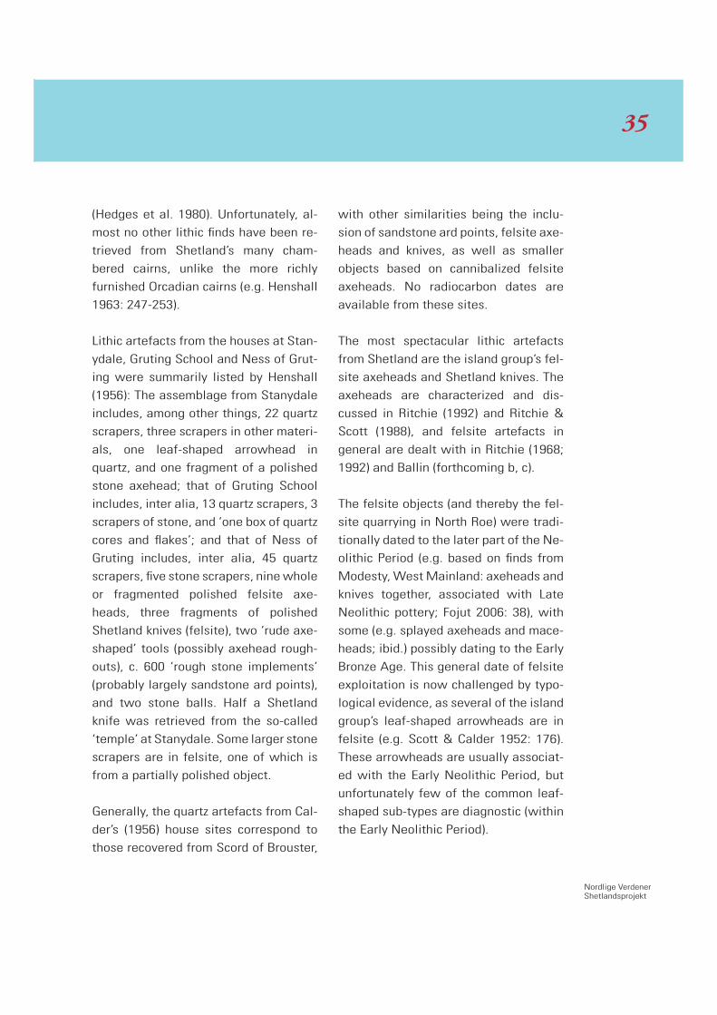
Fig. 2. Felsite Shetland knife. Courtesy of Ian Tait, Shetland Museum.
3434
Nordlige VerdenerShetlandsprojekt
(Hedges et al. 1980). Unfortunately, al-
most no other lithic finds have been re-
trieved from Shetland’s many cham-
bered cairns, unlike the more richly
furnished Orcadian cairns (e.g. Henshall
1963: 247-253).
Lithic artefacts from the houses at Stan-
ydale, Gruting School and Ness of Grut-
ing were summarily listed by Henshall
(1956): The assemblage from Stanydale
includes, among other things, 22 quartz
scrapers, three scrapers in other materi-
als, one leaf-shaped arrowhead in
quartz, and one fragment of a polished
stone axehead; that of Gruting School
includes, inter alia, 13 quartz scrapers, 3
scrapers of stone, and ‘one box of quartz
cores and flakes’; and that of Ness of
Gruting includes, inter alia, 45 quartz
scrapers, five stone scrapers, nine whole
or fragmented polished felsite axe-
heads, three fragments of polished
Shetland knives (felsite), two ‘rude axe-
shaped’ tools (possibly axehead rough-
outs), c. 600 ‘rough stone implements’
(probably largely sandstone ard points),
and two stone balls. Half a Shetland
knife was retrieved from the so-called
‘temple’ at Stanydale. Some larger stone
scrapers are in felsite, one of which is
from a partially polished object.
Generally, the quartz artefacts from Cal-
der’s (1956) house sites correspond to
those recovered from Scord of Brouster,
with other similarities being the inclu-
sion of sandstone ard points, felsite axe-
heads and knives, as well as smaller
objects based on cannibalized felsite
axeheads. No radiocarbon dates are
available from these sites.
The most spectacular lithic artefacts
from Shetland are the island group’s fel-
site axeheads and Shetland knives. The
axeheads are characterized and dis-
cussed in Ritchie (1992) and Ritchie &
Scott (1988), and felsite artefacts in
general are dealt with in Ritchie (1968;
1992) and Ballin (forthcoming b, c).
The felsite objects (and thereby the fel-
site quarrying in North Roe) were tradi-
tionally dated to the later part of the Ne-
olithic Period (e.g. based on finds from
Modesty, West Mainland: axeheads and
knives together, associated with Late
Neolithic pottery; Fojut 2006: 38), with
some (e.g. splayed axeheads and mace-
heads; ibid.) possibly dating to the Early
Bronze Age. This general date of felsite
exploitation is now challenged by typo-
logical evidence, as several of the island
group’s leaf-shaped arrowheads are in
felsite (e.g. Scott & Calder 1952: 176).
These arrowheads are usually associat-
ed with the Early Neolithic Period, but
unfortunately few of the common leaf-
shaped sub-types are diagnostic (within
the Early Neolithic Period).
35
However, several of the Shetland pieces
are kite-shaped, such as those from ‘Ler-
wick’ (Fig. 1) and Semblester in Sandst-
ing. These points are usually associated
with the later part of the Early Neolithic
Period and the earliest part of the Late
Neolithic, and with artefacts such as
Seamer/Duggleby axeheads and pol-
ished flint knives. As typical Shetland
knives (Fig. 2) resemble later Neolithic
discoidal flint knives of Clark’s Type IV
closely (Clark 1932: 44), and as felsite
maceheads are exceptionally rare, the
main period of felsite exploitation most
likely spans the later part of the Early
Neolithic and the earlier part of the Late
Neolithic.
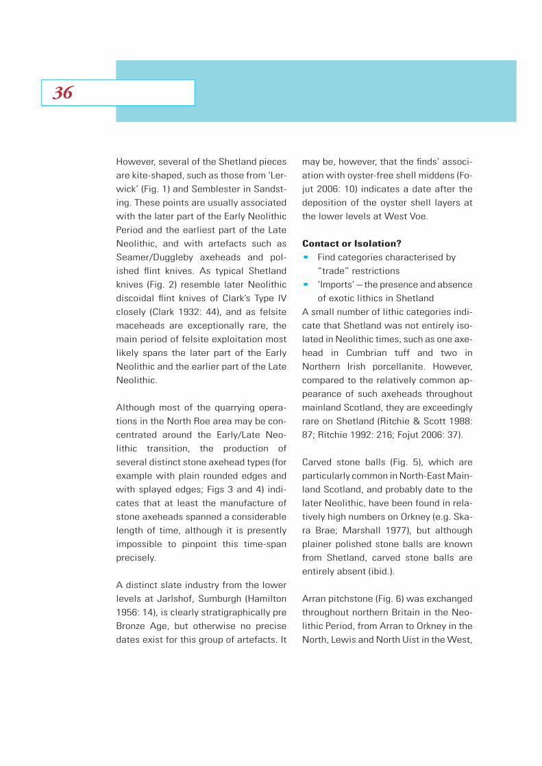
Although most of the quarrying opera-
tions in the North Roe area may be con-
centrated around the Early/Late Neo-
lithic transition, the production of
several distinct stone axehead types (for
example with plain rounded edges and
with splayed edges; Figs 3 and 4) indi-
cates that at least the manufacture of
stone axeheads spanned a considerable
length of time, although it is presently
impossible to pinpoint this time-span
precisely.
A distinct slate industry from the lower
levels at Jarlshof, Sumburgh (Hamilton
1956: 14), is clearly stratigraphically pre
Bronze Age, but otherwise no precise
dates exist for this group of artefacts. It
may be, however, that the finds’ associ-
ation with oyster-free shell middens (Fo-
jut 2006: 10) indicates a date after the
deposition of the oyster shell layers at
the lower levels at West Voe.
Contact or Isolation?
Find categories characterised by
“trade” restrictions
‘Imports’ – the presence and absence
of exotic lithics in Shetland
A small number of lithic categories indi-
cate that Shetland was not entirely iso-
lated in Neolithic times, such as one axe-
head in Cumbrian tuff and two in
North ern Irish porcellanite. However,
compared to the relatively common ap-
pearance of such axeheads throughout
mainland Scotland, they are exceedingly
rare on Shetland (Ritchie & Scott 1988:
87; Ritchie 1992: 216; Fojut 2006: 37).
Carved stone balls (Fig. 5), which are
particularly common in North-East Main-
land Scotland, and probably date to the
later Neolithic, have been found in rela-
tively high numbers on Orkney (e.g. Ska-
ra Brae; Marshall 1977), but although
plainer polished stone balls are known
from Shetland, carved stone balls are
entirely absent (ibid.).
Arran pitchstone (Fig. 6) was exchanged
throughout northern Britain in the Neo-
lithic Period, from Arran to Orkney in the
North, Lewis and North Uist in the West,
3636
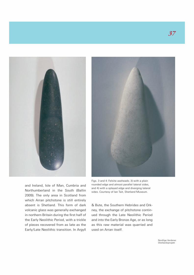
Nordlige VerdenerShetlandsprojekt
and Ireland, Isle of Man, Cumbria and
Northumberland in the South (Ballin
2009). The only area in Scotland from
which Arran pitchstone is still entirely
absent is Shetland. This form of dark
volcanic glass was generally exchanged
in northern Britain during the first half of
the Early Neolithic Period, with a trickle
of pieces recovered from as late as the
Early/Late Neolithic transition. In Argyll
& Bute, the Southern Hebrides and Ork-
ney, the exchange of pitchstone contin-
ued through the Late Neolithic Period
and into the Early Bronze Age, or as long
as this raw material was quarried and
used on Arran itself.
Figs. 3 and 4: Felsite axeheads; 3) with a plain rounded edge and almost parallel lateral sides, and 4) with a splayed edge and diverging lateral sides. Courtesy of Ian Tait, Shetland Museum.
37

In Scotland, the Late Neolithic Period is
generally characterized by extensive ex-
change in so-called Yorkshire flint, and on
for example Orkney, immediately south
of Shetland, lithic assemblages from the
island group’s high-status sites (Barn-
house and Ness of Brodgar; Richards
2005) are characterized by high propor-
tions of Yorkshire flint. The author ex-
posed the unpublished collection from
Ness of Brodgar to cursory examination
in early 2010 (kindly permitted by the
excavator, Nick Card, Orkney Research
Centre for Archaeology), and he esti-
mates that possibly as much as half of
this assemblages of several thousand
pieces is in this form of exotic flint. In
comparison, no Yorkshire flint has been
reported from Shetland, where all known
lithic assemblages are heavily dominat-
ed by local quartz, with flint making up
between one per cent and one per mille
of the lithics. Had Shetland followed the
pattern of Scotland in general, probably
all the lithic assemblages from the well-
known house-sites would have included
substantial proportions of Yorkshire flint.
In the South, later Neolithic assemblages
in Yorkshire flint are usually associated
with the so-called Levallois-like tech-
nique and its distinct cores and types of
debitage (Ballin forthcoming a). With
flint being as rare as it is on Shetland,
the Levallois-like technique was never
adopted, and the local industries are
based on more traditional lithic tech-
niques suitable for the reduction of
quartz.
‘Exports’ – Felsite Objects
Recovered Outside Shetland
Being as spectacular as they are – in
terms of size, colour and patterning –
one would have expected Shetland’s fel-
site axeheads and Shetland knives to
have been favoured as exchange ob-
jects. This, however, does not seem to
be the case.
The archaeological literature mentions
one knife found outside Shetland, name-
ly a specimen from Lanarkshire. Howev-
er, Fojut (2006: 35) inspected the piece
in Kelvingrove Museum in Glasgow, and
apparently the old Victorian label on the
artefact had been misread: ‘rather than
“Lanark”, it clearly said “Lerwick”’. Ba-
sically, according to Dr Fojut, no Shet-
land knives have been recovered out-
side the island group.
A number of axeheads recovered out-
side Shetland are claimed to be in rie-
beckite felsite (Ritchie 1968: 136; 1992:
216; Fojut 2006: 37), including pieces
from North-East Scotland, the Central
Belt, and the Scottish Borders. At
present, only one axehead found out-
side Shetland has been thin-sectioned
and identified as certainly riebeckite fel-
site, namely that of Pencaitland in East
3838

Nordlige VerdenerShetlandsprojekt
Lothian (Ritchie & Scott 1988: 88). Pres-
ently, all the above pieces are speci-
mens which individual archaeologists or
geologists thought ‘looked a bit like’ rie-
beckite felsite, but they need to be thin-
sectioned (or analysed in other less de-
structive ways) to have this assumption
confirmed.
Another problem, which has not yet
been touched upon in the archaeologi-
cal literature, is the fact that riebeckite
felsite – no matter how exotic the term
may sound – is not restricted to loca-
tions in the far north, but also occurs in
Southern Scotland, such as at several
locations (e.g. Eildon Hill) in the Scottish
Borders (Irving 1930). Could some of the
small number of felsite axeheads recov-
ered outside Shetland actually be in lo-
cal forms of this rock? Again, thin-sec-
tioning or other analysis (such as XRF) of
all likely riebeckite felsite axeheads
from non-Shetland locations is crucial,
followed by comparison with samples
from southern outcrops of felsite.
Nevertheless: even if all the above axe-
heads are in riebeckite felsite from Shet-
land, it is clear that the number of such
axeheads ‘exported’ to the Scottish
mainland is very small indeed, both com-
pared to the number of axeheads pro-
duced in North Roe (cf. Ritchie 1992),
and compared to the number of, for ex-
ample, axeheads in Cumbrian tuff ‘im-
ported’ into Scotland from the
south. Ritchie & Scott (1988: 87)
list 186 thin-sectioned Scot-
tish axeheads in this material,
but many hundreds of likely
tuff axeheads are known from
locations throughout Scotland.
A small number of maceheads from
mainland Scotland have been claimed
to be in this raw material, but Ritchie
(1968: 136) ‘... feels that the really dis-
tinctive diagnostic characteristics are
not present and that sectioning is es-
sential ...’.
Conclusion
Although the relative closeness of Shet-
land to the Scottish mainland, and defi-
nitely Orkney, makes it likely that the is-
land group was colonized, or at least
visited, relatively early in the Holocene
Period, the oldest lithic assemblage
from Shetland is presently that of West
Voe, Sumburgh, dating to the Mesolith-
ic/Neolithic transition. Few Early Neo-
lithic assemblages are known, with finds
becoming more numerous towards the
Early/Late Neolithic transition, with
Scord of Brouster, probably most of Cal-
der’s house sites, and the assemblage
from the Sumburgh cist dating to this
period.
The lithic finds indicate that, although
some signs of contact with the Scottish
Fig. 5: Carved stone ball from Towie, Aberdeen-shire (Evans 1897: 421).
he
7)
39

mainland have been recorded (a small
number of axeheads in Cumbrian tuff
and Northern Irish porcellanite), other
groups of finds are entirely absent, such
as Arran pitchstone (which was mostly
exchanged in the Early Neolithic Period)
and Yorkshire flint (which was mostly
exchanged in the Late Neolithic Period).
The ‘export’ of riebeckite felsite from
Shetland seems to have been restricted
4040
Nordlige VerdenerShetlandsprojekt
– no Shetland knives are known from
the mainland, and very few axeheads.
Basically, the Neolithic Shetlanders ap-
pear to have been aware of the existence
of people towards the South, but con-
tact was highly restricted. This situation
finds a parallel in Southern Scandinavia,
where Scandinavian hunter-gatherers
clearly knew of Neolithic people, economy
and habits towards the South, but chose
not to adopt the full Neolithic package.
A small number of elements, like pot-
tery (Prangsgaard 1992), were adopted
fully in the later Mesolithic Period,
whereas other elements, like Schuelei-
stenkeile (Fischer 1982), were only ‘im-
ported’ occasionally as high-prestige
exotica. The Neolithic economy as such
seems to have been deliberately ‘shun-
ned’. In the same way, decisions must
have been made on Shetland in Neolith-
ic times as to what level of contact and
outside influence should be accepted.
Acknowledgements
The author would like to thank Ian Tait,
Shetland Museum, and Beverley Ballin
Smith for permission to use their pho-
tos; Nick Card, Orkney Research Centre
for Archaeology, for permission to use
information on the finds from Ness of
Brodgar; and Alan Saville, National Mu-
seums Scotland, for comments to the
draft manuscript.
Bibliography
Armit, I., 1992. The Hebridean Neolithic.
Vessels for the Ancestors. Essays on the
Neolithic of Britain and Ireland in hon-
our of Audrey Henshall. Sharples, N. &
Sheridan, A. eds. Edinburgh: 307-322.
Ashmore, P., forthcoming. Calanais, Isle
of Lewis, Western Isles. Scottish Ar-
chaeological Internet Reports (SAIR).
Ballin, T.B., 2005. Re-Examination of the
Quartz Artefacts from Scord of Brouster.
A lithic assemblage from Shetland and
its Neolithic context. Scottish Archaeo-
logical Internet Reports (SAIR)17: [http://
www.sair.org.uk/sair17/index.html].
Ballin, T.B., 2006. The lithic assemblage
from West Voe, Sumburgh, Shetland.
Unpublished report.
Ballin, T.B., 2009. Archaeological Pitch-
stone in Northern Britain. Characteriza-
tion and interpretation of an important
prehistoric source. British Archaeologi-
cal Reports, British Series 476, Oxford.
Ballin, T.B., forthcoming a. The British
Late Neolithic ‘Levalloisian’, and other
operational schemas from the later pre-
historic period. A discussion based on
finds from the Stoneyhill Project, Aber-
deenshire. Proceedings of Conference
41
held by the British Neolithic Studies
Group, at the British Museum 2005.
Ballin, T.B., forthcoming b. The Felsite
Quarries of North Roe – an overview.
Proceedings of a Conference held by the
Implement Petrology Group, at York Uni-
versity 2007.
Ballin, T.B., forthcoming c. The Felsite
Quarry Complex of Northmaven. Obser-
vations from a fact-finding mission to
Shetland. Proceedings of Conference
held by the British Neolithic Studies
Group, at the British Museum 2005.
Calder, C.S.T., 1956. Report on the Dis-
covery of Numerous Stone Age House-
Sites in Shetland. Proceedings of the
Society of Antiquaries of Scotland. 89:
340-397.
Clark, J.G.D., 1932. Discoidal Polished
Flint Knives - Their Typology and Distri-
bution. Proceedings of the Prehistoric
Society. VI: 40-54.
Evans, S.J., 1897. The Ancient Stone Im-
plements, Weapons and Ornaments of
Great Britain. London.
Fischer, A., 1982. Trade in Danubian
Shaft-Hole Axes and the Introduction of
Neolithic Economy in Denmark. Journal
of Danish Archaeology. 1: 7-12.
Fojut, N., 2006. Prehistoric and Viking
Shetland. Shetland Times. Lerwick.
Hamilton, J.R.C., 1956. Excavations at
Jarlshof, Shetland. Ministry of Works,
Archaeological Reports I, Edinburgh.
Hedges, J.W. & Parry, G.W., 1980. ‘A
Neolithic multiple burial at Sumburgh
Airport, Shetland’. Glasgow Archaeo-
logical Journal. 7: 15-26.
Henshall, A.S., 1956. Appendix II: Pot-
tery and Stone Implements from Ness of
Gruting. In: Calder, C.S.T.: Report on the
Discovery of Numerous Stone Age
House-Sites in Shetland. Proceedings of
the Society of Antiquaries of Scotland.
89: 381-397.
Henshall, A.S., 1963. The Chambered
Tombs of Scotland. Vol. one. Edinburgh
Irving, J., 1930. Four ‘Felstone’ Intru-
sions in Central Berwickshire. Geologi-
cal Magazine. 67: 529-541.
Johnston, J.L., 1999. A Naturalist’s Shet-
land. Poyser Natural History, London.
Lacaille, A.D., 1954. The Stone Age in
Scotland. London.
Marshall, D.N., 1977. Carved stone
balls. Proceedings of the Society of An-
tiquaries of Scotland. 108: 40-72.
4242

Nordlige VerdenerShetlandsprojekt
Melton, N.D., 2008. West Voe: A Meso-
lithic-Neolithic transition site in Shet-
land. Scottish odysseys: the archaeolo-
gy of islands. Noble, G., Poller, T., Raven
J. and Verril, L. eds., Stroud: 23-36.
Pitts, M., 2007. Orkney finds confirm
early Scottish colonisation. British Ar-
chaeology. (Nov/Dec 2007), 9.
Prangsgaard, K., 1992. Introduktion af
keramik i den Yngre Ertebøllekultur i
Sydskandinavien. LAG. 3: 29-52.
Richards, C. ed., 2005. Dwelling among
the monuments. The Neolithic village of
Barnhouse, Maeshowe passage grave
and surrounding monuments at Sten-
ness, Orkney. McDonald Institute Mono-
graphs, Cambridge.
Ritchie, A.,ed., 2000. Neolithic Orkney in
its European context. McDonald Insti-
tute Monographs, Cambridge.
Ritchie, P.R., 1968. The Stone Implement
Trade in Third-millenium Scotland. Stud-
ies in Ancient Europe. Essays presented
to Stuart Piggott. Coles, J.M. & Simp-
son, D.D.A. eds., Leicester:119-136.
Ritchie, R., 1992. Stone Axeheads and
Cushion Maceheads from Orkney and
Shetland: Some Similarities and Con-
trasts. Vessels for the Ancestors. Essays
on the Neolithic of Britain and Ireland in
honour of Audrey Henshall. Sharples, N.
& Sheridan, A., eds., Edinburgh: 213-
220.
Ritchie, P.R., & Scott, J.G., 1988. The
petrological identification of stone axes
from Scotland. Stone Axe Studies, 2.
The Petrology of Prehistoric Stone Im-
plements from the British Isles. Clough,
T.H.M. & Cummins, W.A., eds., CBA Re-
search Reports 67, London: 85-91.
Saville, A., 2000. Orkney and Shetland
before the Neolithic period. Neolithic
Orkney in its European context. Ritchie,
A. ed., McDonald Institute Monographs,
Cambridge.
Schei, L.K. & Moberg, G., 1991. The
Faroe Islands. London.
Scott, L.G. & Calder, C.S.T., 1952. Notes
on a Chambered Cairn, and a Working
Gallery, on the Beorgs of Uyea, North-
maven, Shetland. Proceedings of the
Society of Antiquaries of Scotland. 86:
171-177.
Simpson, D.D.A., Murphy, E.M. and Gre-
gory, R.A., 2006. Excavations at North-
ton, Isle of Harris. BAR British Series
408, Oxford.
43

Introduction
As mentioned in the foreword one of the
projects under the National Museum’s
research initiative Northern Worlds has
as its main topic the expansion of agrar-
ian economy in the North. The focus ar-
eas include Denmark, South West Swe-
den and Norway. The coastal zone facing
the Atlantic represents an important
part of the research area.
The Neolithization – also in a broad Eu-
ropean sense – did not advance slowly
like a constantly moving wave from
South to North. The progress of agrarian
economy and the related ‘cultural pack-
ages’ look like swift and large-scale
‘leaps’ separated by interludes where a
border zone remained stable for centu-
ries until yet another swift expansion
phase proceeded.
Around 4000 BC the Neolithization took
place in Southern Scandinavia. Within a
short span of time most parts of South-
ern Scandinavia were encompassed by
the Neolithic Funnel Beaker Culture.
Soon afterwards the first monumental
burial architecture appeared as non-
megalithic earthen long barrows, while
the large-scale work-consuming con-
struction of megalithic tombs – first dol-
mens, then passage graves – began
around 3500 BC.
In South-western Scandinavia, the Neo-
lithic expansion halted close to what is
now the Swedish-Norwegian border at
Svinesund. Just north of this border we
find the northernmost dolmens and a
pottery material clearly related to the
Funnel Beaker Culture. But the dolmens
are few and small (Østmo 2007; Glör-
stad 2009). As soon as we move into
Swedish Bohuslän south of Svinesund,
we find more megalithic tombs includ-
ing a number of large passage graves.
For centuries the border-zone at
Svinesund remained stable. In most
parts of Southern, South-Western and
Western Norway there was seemingly
only a very limited Neolithic or agricul-
tural impact (Prescott 1996; Glørstad
Early Agriculture at the Border
Flemming Kaul
4444
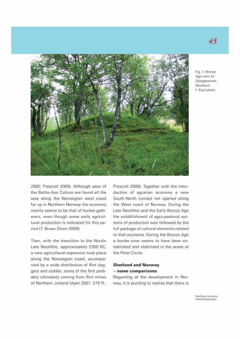
Nordlige VerdenerShetlandsprojekt
2005; Prescott 2009). Although axes of
the Battle-Axe Culture are found all the
way along the Norwegian west coast
far up in Northern Norway the economy
mainly seems to be that of hunter-gath-
erers, even though some early agricul-
tural production is indicated for this pe-
riod (T. Bruen Olsen 2009).
Then, with the transition to the Nordic
Late Neolithic, approximately 2350 BC,
a new agricultural expansion took place
along the Norwegian coast, accompa-
nied by a wide distribution of flint dag-
gers and sickles, some of the flint prob-
ably ultimately coming from flint mines
of Northern Jutland (Apel 2001: 279 ff.;
Prescott 2009). Together with the intro-
duction of agrarian economy a new
South-North contact net opened along
the West coast of Norway. During the
Late Neolithic and the Early Bronze Age
the establishment of agro-pastoral sys-
tems of production was followed by the
full package of cultural elements related
to that economy. During the Bronze Age
a border-zone seems to have been es-
tablished and stabilised in the areas at
the Polar Circle.
Shetland and Norway
– some comparisons
Regarding at the development in Nor-
way, it is puzzling to realise that there is
Fig. 1: Bronze Age cairn at Skjeggesness, Nordland. F. Kaul photo.
45

almost no Neolithic in Norway, apart
from the southernmost landscapes at
the Oslo Fjord. Questions should be
posed such as: Why are there no real
Neolithic and megalithic tombs in South
West Norway – or for that matter in
Trøndelag, areas with rich agricultural
potentials? Why did the Neolithic ex-
pansion come to a standstill for almost
2000 years, close to what is now the
border between Norway and Sweden?
-- Why did people in most of Norway
‘choose’ not to be included in the ‘Neo-
lithic world’, when they must have had
at least some knowledge of what was
going on further south? – Why, then at
around 2000 BC, did a huge leap for
agrarian economy take place?
When comparing with the Shetland evi-
dence, further questions arise: Why are
there no megalithic tombs in South West
Norway, for instance at Stavanger, while
on Shetland far out in the Atlantic we
find a full Neolithic package including
megalithic tombs? -- Were the condi-
tions so much better on Shetland? At
any rate Shetland became part of the
primary neolithization process of Brit-
ain, while most of Norway remained
outside the Neolithic ‘family’. At the
same time as a true Neolithic culture
was flourishing in Shetland (with a rela-
tively high density of megalithic tombs),
the economy in most of Norway re-
mained Mesolithic. First around 2000
BC we see a new boom of movement of
the border-zone of agrarian economy.
It is astonishing to realise, that at the
very time when this expansion boom
took place in Norway, we see a regres-
sion in Shetland. There seems to be no
bronzes from the early and middle
Bronze Age, and it looks like Shetland
was more or less cut off from the chain
of contacts giving the possibilities of ac-
quiring prestige bronzes or other items
of prestige. Here, there are certainly no
‘counterparts’ or reflections of the Wessex
Culture, as seen in mainland Scotland
(G. & A. Ritchie 1985: 75 ff.), and even in
Orkney (A. Ritchie 1995: 89-90).
It seems as though Shetland had be-
Fig. 2: Ripen-ing barley, Alstahaug, Nord land. F. Kaul photo.
4646
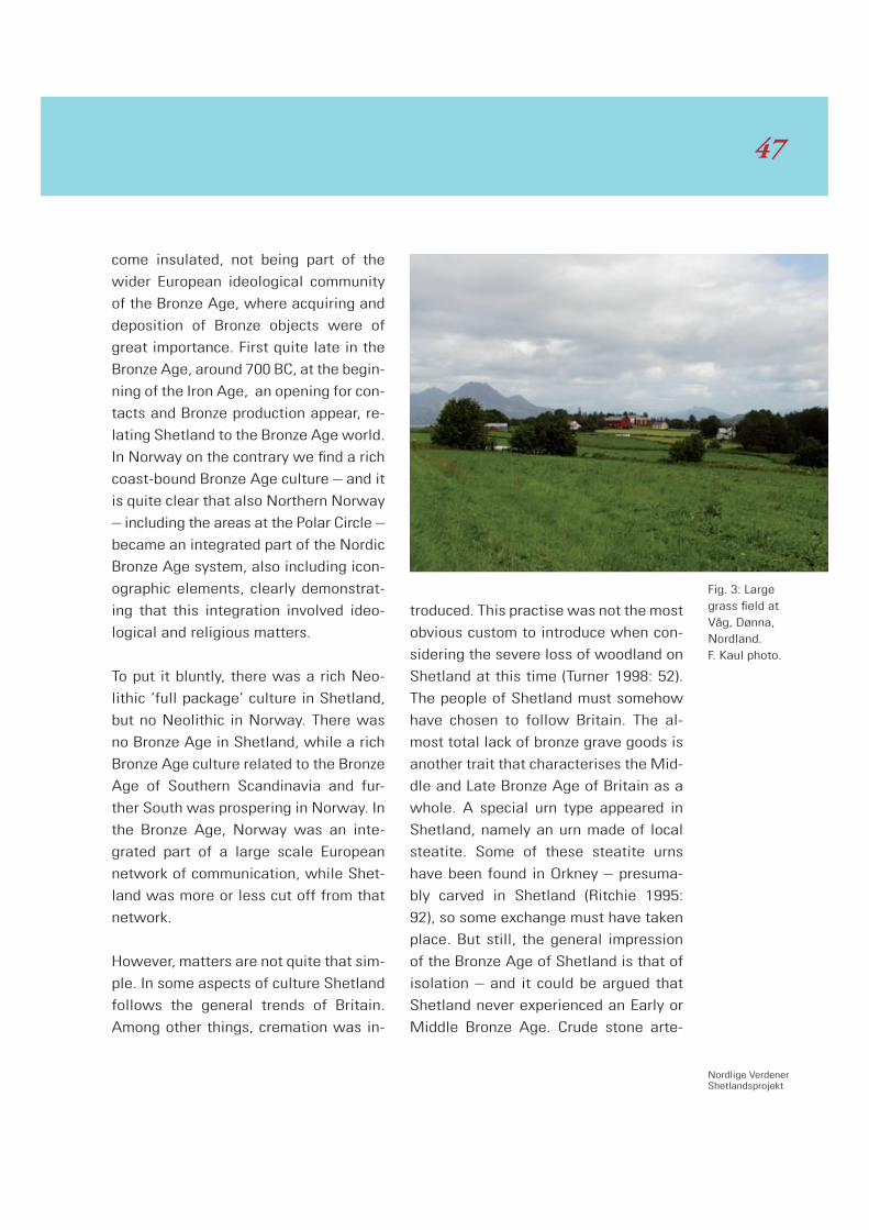
Nordlige VerdenerShetlandsprojekt
come insulated, not being part of the
wider European ideological community
of the Bronze Age, where acquiring and
deposition of Bronze objects were of
great importance. First quite late in the
Bronze Age, around 700 BC, at the begin-
ning of the Iron Age, an opening for con-
tacts and Bronze production appear, re-
lating Shetland to the Bronze Age world.
In Norway on the contrary we find a rich
coast-bound Bronze Age culture – and it
is quite clear that also Northern Norway
– including the areas at the Polar Circle –
became an integrated part of the Nordic
Bronze Age system, also including icon-
ographic elements, clearly demonstrat-
ing that this integration involved ideo-
logical and religious matters.
To put it bluntly, there was a rich Neo-
lithic ‘full package’ culture in Shetland,
but no Neolithic in Norway. There was
no Bronze Age in Shetland, while a rich
Bronze Age culture related to the Bronze
Age of Southern Scandinavia and fur-
ther South was prospering in Norway. In
the Bronze Age, Norway was an inte-
grated part of a large scale European
network of communication, while Shet-
land was more or less cut off from that
network.
However, matters are not quite that sim-
ple. In some aspects of culture Shetland
follows the general trends of Britain.
Among other things, cremation was in-
troduced. This practise was not the most
obvious custom to introduce when con-
sidering the severe loss of woodland on
Shetland at this time (Turner 1998: 52).
The people of Shetland must somehow
have chosen to follow Britain. The al-
most total lack of bronze grave goods is
another trait that characterises the Mid-
dle and Late Bronze Age of Britain as a
whole. A special urn type appeared in
Shetland, namely an urn made of local
steatite. Some of these steatite urns
have been found in Orkney – presuma-
bly carved in Shetland (Ritchie 1995:
92), so some exchange must have taken
place. But still, the general impression
of the Bronze Age of Shetland is that of
isolation – and it could be argued that
Shetland never experienced an Early or
Middle Bronze Age. Crude stone arte-
Fig. 3: Large grass field at Våg, Dønna, Nordland. F. Kaul photo.
47

facts appear reflecting isolated ‘devel-
opments’. The Bronze Age was a time of
regression, where Shetland was con-
stantly facing an agricultural crisis with
reduction of arable land due to peat
growth and rising sea level (Turner 1998:
51-52). When times were at hardest, we
can imagine that some people were
waiting for a ship to arrive, to carry them
away from these islands of depleted
and overgrazed soils at the margins for
agriculture.
Northern Norway
When returning to Bronze Age Norway
there is – as mentioned above -- nothing
here that indicates isolation or reces-
sion during the Bronze Age. North Trøn-
delag – c. 400 kilometres south of the
Polar Circle – is rich in finds of all cate-
gories. Here we meet the full agricultur-
al package of the Nordic Bronze Age
Culture: Houses, farmsteads, burial
cairns, votive offerings, and iconogra-
phy on rock carvings and portable ob-
jects. North Trøndelag, however – also
today a rich agricultural area – dotted
with barley fields – was not at the bor-
derline of agriculture.
Further north, in Helgeland, in the coast-
al areas at Alstahaug near Sandnes-
sjøen (c. 50 kilometres south of the Po-
lar Circle) we find the northernmost
evidence of the full cultural package of
the Nordic Bronze Age Culture (Binns
1985). There is evidence of agriculture
and cattle breeding, burials with typical
Nordic Bronze Age objects, votive offer-
ings of bronze objects (also in bogs), and
rock carving iconography of Nordic
Bronze Age tradition. The landscapes of
Helgeland are rich in contrasts. With a
background of snow-covered mountains,
patches of nicely sheltered arable land
can be observed.
Recent barley and grass fields and
Bronze Age sites in Northern Norway
At Skjeggesnes near Alstahaug, Helge-
land, Nordland a stone cist in a cairn
has been excavated.
It contained the skeletal remains of two
human beings, a pottery vessel, a bronze
pin and a bronze razor with a horse
headed handle (Binns 1985: 165-168;
Kaul & Rønne 2008: 26; Rønne: this vol-
ume). The burial can be dated to per. III
of the Nordic Bronze Age, 1300-1100
BC. The razor with the handle in the
shape of a horse head should be regard-
ed as being an emblem of the Nordic
Bronze Age Culture known from a large
amount of relatively rich grave finds,
particularly from Southern Scandinavia.
Here we are dealing with the northern-
most finds of this type.
The cairn is part of a larger cemetery of
cairns, more than 16, most of them situ-
ated on a low ridge close to the coast.
4848

Nordlige VerdenerShetlandsprojekt
Even though this cairn is the only one
that has been excavated, it is presumed
that the others should be dated to the
Bronze Age as well. This cairn cemetery
in its landscape setting can easily be
compared with similar sites further
south. From most of the cairns there is a
fine view over the sea, and on the inland
side the best agricultural land can be
seen. The fields are found in a sheltered
position between the low ridges dotted
with cairns, just south of the mountains
known as the Seven Sisters.
The farmer of the Skjeggesnes farm has
kindly informed me that the fields are
well suited for growing barley, but grass
for hay harvest was preferred. With al-
most no darknights, two hay (some years
three) harvests can be produced each
summer. The hay is used for winter pro-
visions for milk-producing cattle. On an-
other field belonging to the farm a mixed
crop consisting of barley, peas and vetch
was growing, excellent for silage cattle
fodder.
Not far away, at Alstahaug Church, in
August, a rich ripening barley field was
observed. The fine 12th century roman-
esque church at Alstahaug bears wit-
ness to the economical potential of the
area in later periods. The results of ar-
chaeological excavations at Alstahaug
vicarage (Medieval Period) as well as
the testimony of written sources from
18th century document the importance
of cereal growing (including barley) and
cattle breeding here. Also fishing was of
great importance (Berglund 2007).
Fig. 4: Pier and byre, the fields being behind the byre – part of a farm on Dønna, Nord-land. F. Kaul photo.
49
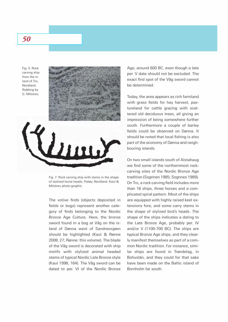
The votive finds (objects deposited in
fields or bogs) represent another cate-
gory of finds belonging to the Nordic
Bronze Age Culture. Here, the bronze
sword found in a bog at Våg on the is-
land of Dønna west of Sandnessjøen
should be highlighted (Kaul & Rønne
2008, 27; Rønne: this volume). The blade
of the Våg sword is decorated with ship
motifs with stylized animal headed
stems of typical Nordic Late Bronze style
(Kaul 1998, 164). The Våg sword can be
dated to per. VI of the Nordic Bronze
Age, around 600 BC, even though a late
per. V date should not be excluded. The
exact find spot of the Våg sword cannot
be determined.
Today, the area appears as rich farmland
with grass fields for hay harvest, pas-
tureland for cattle grazing with scat-
tered old deciduous trees, all giving an
impression of being somewhere further
south. Furthermore a couple of barley
fields could be observed on Dønna. It
should be noted that local fishing is also
part of the economy of Dønna and neigh-
bouring islands.
On two small islands south of Alstahaug
we find some of the northernmost rock-
carving sites of the Nordic Bronze Age
tradition (Sognnes 1985; Sognnes 1989).
On Tro, a rock carving field includes more
than 16 ships, three horses and a com-
plicated spiral pattern. Most of the ships
are equipped with highly raised keel ex-
tensions fore, and some carry stems in
the shape of stylized bird’s heads. The
shape of the ships indicates a dating to
the Late Bronze Age, probably per. IV
and/or V (1100-700 BC). The ships are
typical Bronze Age ships, and they clear-
ly manifest themselves as part of a com-
mon Nordic tradition. For instance, simi-
lar ships are found in Trøndelag, in
Bohuslän, and they could for that sake
have been made on the Baltic island of
Bornholm far south.
Fig. 5. Rock carving ship from the is-land of Tro, Nordland. Rubbing by G. Milstreu.
Fig. 7: Rock carving ship with stems in the shape of stylised horse heads, Flatøy, Nordland. Kaul & Milstreu photo-graphic.
5050

Nordlige VerdenerShetlandsprojekt
The rock carvings are facing a field of
the best agricultural land. The field
forms an almost 1 kilometres long gen-
tle slope facing south being a well shel-
tered ‘basin’ between ridges of higher
land. The field ends at a sandy beach
with good landing possibilities. Today
grass for hay harvest is the main crop
giving high yields, but part of the field is
used for cattle pasture.
On Flatøy, separated from Tro by a nar-
row strait, another rock carving field of
evidently Nordic Bronze Age tradition
can be observed with ships, horses and
footprints (Sognnes 1985; Sognnes
1989). The shape of the ships and the
horses indicates rock carving activity
both during the middle of the Early Nor-
dic Bronze Age and during the Late
Bronze Age. When approaching the is-
land of Flatøy by boat the coastal set-
ting of the rock-carving site is indisput-
able. However, when landed, and
walking a few meters up behind the rock
carvings, then suddenly an open, agri-
cultural landscape emerges, with pas-
tures, grass fields, and with scattered
Fig. 6: Grass field close to the rock carv-ings on Tro, Nordland. F. Kaul photo.
51
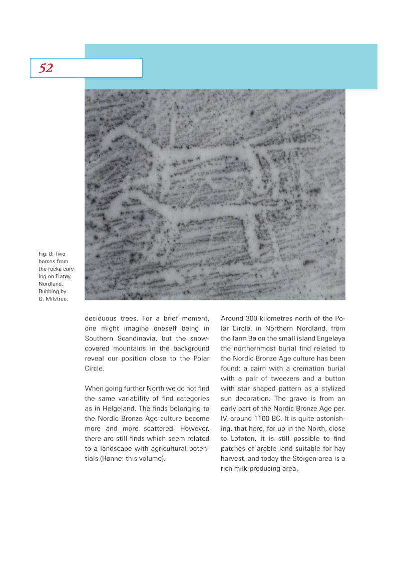
deciduous trees. For a brief moment,
one might imagine oneself being in
Southern Scandinavia, but the snow-
covered mountains in the background
reveal our position close to the Polar
Circle.
When going further North we do not find
the same variability of find categories
as in Helgeland. The finds belonging to
the Nordic Bronze Age culture become
more and more scattered. However,
there are still finds which seem related
to a landscape with agricultural poten-
tials (Rønne: this volume).
Around 300 kilometres north of the Po-
lar Circle, in Northern Nordland, from
the farm Bø on the small island Engeløya
the northernmost burial find related to
the Nordic Bronze Age culture has been
found: a cairn with a cremation burial
with a pair of tweezers and a button
with star shaped pattern as a stylized
sun decoration. The grave is from an
early part of the Nordic Bronze Age per.
IV, around 1100 BC. It is quite astonish-
ing, that here, far up in the North, close
to Lofoten, it is still possible to find
patches of arable land suitable for hay
harvest, and today the Steigen area is a
rich milk-producing area.
Fig. 8: Two horses from the rocka carv-ing on Flatøy, Nordland. Rubbing by G. Milstreu.
5252
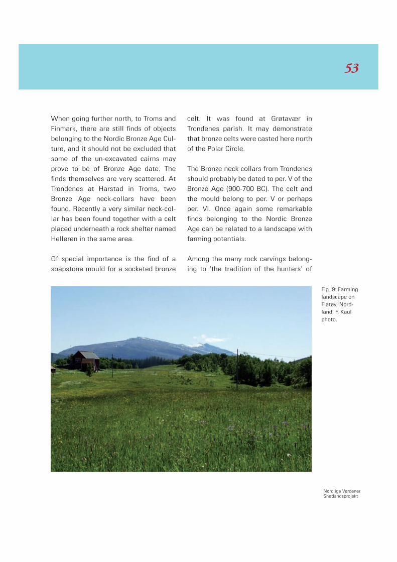
Nordlige VerdenerShetlandsprojekt
When going further north, to Troms and
Finmark, there are still finds of objects
belonging to the Nordic Bronze Age Cul-
ture, and it should not be excluded that
some of the un-excavated cairns may
prove to be of Bronze Age date. The
finds themselves are very scattered. At
Trondenes at Harstad in Troms, two
Bronze Age neck-collars have been
found. Recently a very similar neck-col-
lar has been found together with a celt
placed underneath a rock shelter named
Helleren in the same area.
Of special importance is the find of a
soapstone mould for a socketed bronze
celt. It was found at Grøtavær in
Trondenes parish. It may demonstrate
that bronze celts were casted here north
of the Polar Circle.
The Bronze neck collars from Trondenes
should probably be dated to per. V of the
Bronze Age (900-700 BC). The celt and
the mould belong to per. V or perhaps
per. VI. Once again some remarkable
finds belonging to the Nordic Bronze
Age can be related to a landscape with
farming potentials.
Among the many rock carvings belong-
ing to ‘the tradition of the hunters’ of
Fig. 9: Farming landscape on Flatøy, Nord-land. F. Kaul photo.
53
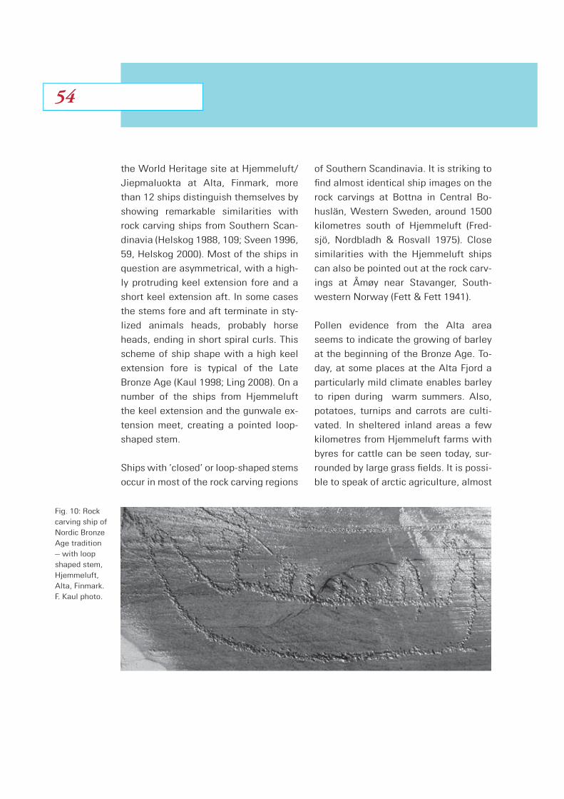
the World Heritage site at Hjemmeluft/
Jiepmaluokta at Alta, Finmark, more
than 12 ships distinguish themselves by
showing remarkable similarities with
rock carving ships from Southern Scan-
dinavia (Helskog 1988, 109; Sveen 1996,
59, Helskog 2000). Most of the ships in
question are asymmetrical, with a high-
ly protruding keel extension fore and a
short keel extension aft. In some cases
the stems fore and aft terminate in sty-
lized animals heads, probably horse
heads, ending in short spiral curls. This
scheme of ship shape with a high keel
extension fore is typical of the Late
Bronze Age (Kaul 1998; Ling 2008). On a
number of the ships from Hjemmeluft
the keel extension and the gunwale ex-
tension meet, creating a pointed loop-
shaped stem.
Ships with ‘closed’ or loop-shaped stems
occur in most of the rock carving regions
of Southern Scandinavia. It is striking to
find almost identical ship images on the
rock carvings at Bottna in Central Bo-
huslän, Western Sweden, around 1500
kilometres south of Hjemmeluft (Fred-
sjö, Nordbladh & Rosvall 1975). Close
similarities with the Hjemmeluft ships
can also be pointed out at the rock carv-
ings at Åmøy near Stavanger, South-
western Norway (Fett & Fett 1941).
Pollen evidence from the Alta area
seems to indicate the growing of barley
at the beginning of the Bronze Age. To-
day, at some places at the Alta Fjord a
particularly mild climate enables barley
to ripen during warm summers. Also,
potatoes, turnips and carrots are culti-
vated. In sheltered inland areas a few
kilometres from Hjemmeluft farms with
byres for cattle can be seen today, sur-
rounded by large grass fields. It is possi-
ble to speak of arctic agriculture, almost
Fig. 10: Rock carving ship of Nordic Bronze Age tradition – with loop shaped stem, Hjemmeluft, Alta, Finmark. F. Kaul photo.
5454

Nordlige VerdenerShetlandsprojekt
as far north as you can get, hundreds of
kilometres north of the Polar Circle, at
70 degrees north.
The evidence, though scanty, could make
oneself ponder upon the possibilities of
a stable population of Bronze Age farm-
ers even here, in the ultimate north that
kept regular contacts with people in the
south.
All the way from Helgeland, along the
coast as far north as Alta in Finmark, we
find evidence of the Nordic Bronze Age
Culture, and in each case the sites are
situated where there are patches of land
suitable for agriculture. Today these
places favoured by a mild local climate
yield possibilities for farming and cattle
breeding (there are not so many sheep
as in Shetland).
We may envisage these patches –
where agriculture was carried out at the
border – as small islands of arable land
surrounded by mountains and the sea
(many of the sites are actually on is-
lands), where the only possible vehicle
of transport and contacts was the ship.
It is evident then that the finds related
to the Nordic Bronze Age Culture are re-
lated to the coastal zone.
Fig. 11: Large farm at Alta, Finmark. F. Kaul photo.
55
Bibliography
Apel, J., 2001. Daggers, Knowledge &
Power. Uppsala.
Berglund, B., 2007. Alstahaug på Helge-
land 1000-1750. Det Kongelige Norske
Videnskabers Selskab Skrifter 2007, no.
1, Trondheim.
Binns, K.S., 1985. De første tegn til jord-
bruk. Helgeland Historie. Pettersen, K. &
Wik, B. eds., vol. 1, Helgeland: 148-
171.
Bruen Olsen, T., 2009. The phase of
transformation in western Norway. Me-
solithic Horizons. Papers presented at
the Seventh International Conference
on the Mesolithic in Europe, Belfast
2005. McCartan, S., Schulting, R., War-
ren, G. and Woodman, P. eds., vol. 2,
London: 583-588.
Fett, E & Fett, P., 1941. Sydvestnorske
Helleristninger, Rogaland og Lista. Sta-
vanger Museum.
Fredsjö, Å., Nordbladh, J. & Rosvall, J.,
1975. Hällristningar Kville Härad i Bo-
huslän, Bottna socken. Studier i Nordisk
arkeologi 13. Göteborg.
Glørstad, H., 2005. Tangen – En neolit-
tisk boplass fra Tangen av Barmen,
Kragerø kommune, Telemark. Noen be-
traktninger omkring boplassens kultur-
miljø og Traktbegerkulturens vestgrense.
Viking 68: 25-54.
Glørstad, H., 2009. The Northern Prov-
ince? The Neolithisation of Southern
Norway. Neolithisation as if History
mattered. Processes of Neolithisation in
North-Western Europe. Glørstad, H. &
Prescott, C. eds., Lindome: 135-168.
Helskog, K., 1988. Helleristningene i
Alta. Finmarks Fylkeskomune, Icomos,
Alta.
Helskog, K., 2000. Changing rock carv-
ings – changing societies. Adoranten.
5-16.
Kaul, F., 1998. Ships on Bronzes, A Study
in Bronze Age Religion and Iconography,
Publications from the National Muse-
um, vol. 3 (1 & 2), Copenhagen.
Kaul, F. & Rønne, P., 2008. Ved den ytter-
ste grense? Spor. No. 2: 24-27.
Ling, J., 2008. Elevated rock art. To-
wards a maritime understanding of rock
art in Northern Bohuslän, Sweden.
GOTARC Serie B, Gothenburg Archaeo-
logical Thesis 49, Göteborg Universitet,
Göteborg.
5656
Nordlige VerdenerShetlandsprojekt
Prescott, C., 1996. Was there really a
Neolithic in Norway. Antiquity. 70: 77-
87.
Prescott, C., 2009. History in Prehistory
– the later Neolithic/Early Metal Age,
Norway. Neolithisation as if History
mattered. Processes of Neolithisation in
North-Western Europe. Glørstad, H. &
Prescott, C. eds., Lindome: 193-215.
Ritchie, A., 1995. Prehistoric Orkney.
Historic Scotland. London.
Ritchie, G. & A., 1985. Scotland. Archae-
ology and Early History. London.
Sognnes, K., 1985. Bergkunsten. Helge-
land Historie. Pettersen, K.& Wik, B.,
vol. 1, Helgeland: 133-171.
Sognnes, K., 1989. Rock art at the Arctic
Circle. Acta Archaelogica. 59 (1988): 67-
95.
Sognnes, K., 1999. Helleristninger i
Stjørdal. Stjørdal Museum.
Sveen, A., 1996. Helleristninger Jiep-
maluokta Hjemmeluft, Alta. Utgitt i sa-
marbeid med Alta Museum, Alta.
Turner, V., 1998. Ancient Shetland.
Amenity Trust, Historic Scotland, Lon-
don.
Østmo, E., 2007. The Northern periphery
of the TRB. Acta Archaeologica. 78, 2:
111-142.
57
Introduction
The National Museums research project
Northern Worlds includes several
projects, two of which have Shetland
and Norway as subjects as part of the
theme, Farming on the Edge: Cultural
Landscapes of the North. The intention
is to create a comparative study be-
tween the early farming societies in the
both areas. This article is a catalogue of
some bronze objects from Middle and
North Norway mirroring the expansion
of the farming culture see Kaul this vol-
ume.
The specific research area in Norway is
1.700 kilometers long from south to
north, crossing the polar circle half way.
Shetland is situated close to the 60th
degree of latitude, almost the same as
Bergen, which lies about 300 km south
of the southern end of the research area
in Norway.
Artifacts imported from South Scandi-
navia of flint and bronze are almost al-
ways found in areas where agriculture
is possible, and only 3% of Norway is
suitable to agriculture. The rest is moun-
tainous or woodland. That suggests the
concentration of objects is much more
significant than it looks like by the first
impression. The objects presented here
are a very small segment from 132 lo-
calities with bronze finds in the research
area.
Early Bronze Age Period I
c. 1700 – 1500 BC
From the beginning of the Neolithic
there is clear evidence of contact be-
tween Southern Scandinavia and Mid-
dle and Northern Norway. Many finds of
thin- and thick butted stone axes from
along the coast show this, and especial-
ly on the outer islands there are many
single finds of flint axes. In the Late Ne-
olithic Period we have the first hoards
especially in the southern part of the re-
search area, Møre and Romsdal. The
Highlights from the Northernmost Bronze
Age societies in NorwayPreben Rønne
5858
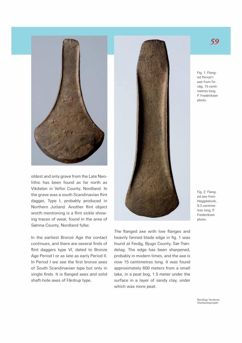
Nordlige VerdenerShetlandsprojekt
oldest and only grave from the Late Neo-
lithic has been found as far north as
Vikdalen in Vefsn County, Nordland. In
the grave was a south Scandinavian flint
dagger, Type I, probably produced in
Northern Jutland. Another flint object
worth mentioning is a flint sickle show-
ing traces of wear, found in the area of
Sømna County, Nordland fylke.
In the earliest Bronze Age the contact
continues, and there are several finds of
flint daggers type VI, dated to Bronze
Age Period I or as late as early Period II.
In Period I we see the first bronze axes
of South Scandinavian type but only in
single finds. It is flanged axes and solid
shaft-hole axes of Fårdrup type.
The flanged axe with low flanges and
heavily fanned blade edge in fig. 1 was
found at Fevåg, Bjugn County, Sør-Trøn-
delag. The edge has been sharpened,
probably in modern times, and the axe is
now 15 centimetres long. It was found
approximately 600 meters from a small
lake, in a peat bog, 1.5 meter under the
surface in a layer of sandy clay, under
which was more peat.
Fig. 1: Flang-ed Period I axe from Fe-våg, 15 centi-metres long. P. Frederiksen photo.
Fig. 2: Flang-ed axe from Heggdalsvik, 9.3 centime-tres long. P. Frederiksen photo.
59

Another flanged axe with high flanges
and a light brown, bog patina is 9.3 cen-
timetres long, fig. 2. The axe was found
lying openly on the underlying gravel
layer where the peat had been removed
on the side of the country road in Heg-
gdalsvik, Midsund County, Møre and
Romsdal.
A Solid shaft-hole axe of Fårdrup type is
from the area of Sunndal district also in
Møre and Romsdal. It measures 17.5
centimetres in length and is 5.7 centi-
metres broad at the edge. It is orna-
mented with lines and points on proba-
bly the upper narrow side and on both
the broad sides. It is rather heavy with a
weight of 1675 grams. The axe was
found near a farm road in a stony grass
field, approximately 350 meters north of
a farm and around 50 meters east of Vi-
setbækken, near a farm road. It lay visi-
ble in a burn where the creek bed shifts
in connection with flooding after strong
rainfalls.
Early Bronze Age Period II
c. 1500 – 1300 BC
In period II the material becomes far
more varied. Normally the Bronze Age
graves are found in isolated cairns, but
there are examples of grave finds from
one cairn cemetery. This cemetery is sit-
uated near two farms, Todnes and Holan
in the County of Steinkjer, Nord-Trønde-
lag. Todnes and Holan is the only fully
excavated Bronze Age cemetery in the
research area, and it is worth having a
closer look at this particular site.
From 1879–1880 and again in 1905-
1906 Karl Rygh, Vitenskapsmuseet
Fig. 3: Shaft-hole axe, 17.5 centimeres long from Sunndal. P. Frederiksen photo.
6060

Nordlige VerdenerShetlandsprojekt
Trondheim, undertook a number of exca-
vations of the cairns in the area sur-
rounding the farms. These excavations
by Rygh more than a hundred years ago
are still the only real research excava-
tions that have been done on a Bronze
Age cemetery in Central and Northern
Norway. In all, Rygh excavated twenty-
three cairns on these two farms.
Todnes is a small peninsula only about a
kilometre wide and stretching about 1.5
kilometre out into the Beitstadfjord in
the district of Sparbu in Nord-Trøndelag.
The cairns form, for the most part, two
rows in smaller groups. One stretches
along the beach at the northern end of
the peninsula and runs south toward the
Longås farm that lies somewhat south
of the peninsula. The other row runs
east from Todnes and also down toward
Longås. Some of the excavations under-
taken by Rygh were done on the fields of
the Holan farm and therefore bear that
name, but the farmyard at Holan, lies a
good distance from the cairns. There are
no drawings of either the cairns or the
graves, and no photographic documen-
tation of the excavations. Neither do Ry-
gh’s diaries contain any information not
found in his publication.
I am convinced that Skjeggesnes in Al-
stahaug County, Nordland can be com-
pared with this place (see Kaul this vol-
ume), and I suppose that they are not
the only ones. Pri-
marily these types
of cemeteries are
situated along the
coast, where no
modern develop-
ment has taken
place, which is
the reason why so
few have been ex-
cavated.
To be highlighted
in Trøndelag are
two fragments of
a razor found in a
cist in a cairn. To-
day only the outer
edge of the blade is preserved. It is de-
corated with opposing triangular orna-
ments that form a zigzag motif along the
back of the razor. The other fragment
cannot be located today, but was
sketched in 1906. It had a handle formed
as a naturalistic horse head with ears
turned forward and small protruded
eyes. Parts of a skeleton were found in
Cairn X, Todnes too.
From the same cemetery comes a sword
blade with four rivet holes with two only
half preserved, fig. 4. The blade is 53
centimetres long and 3, 7 centimetres
wide under the rivet holes, narrowing
thereafter and fanning out again a little
below the middle. Along the center up
Fig. 4: Sword with loose pommel from Todness, Peri-od II. P. Frede-riksen photo.
61
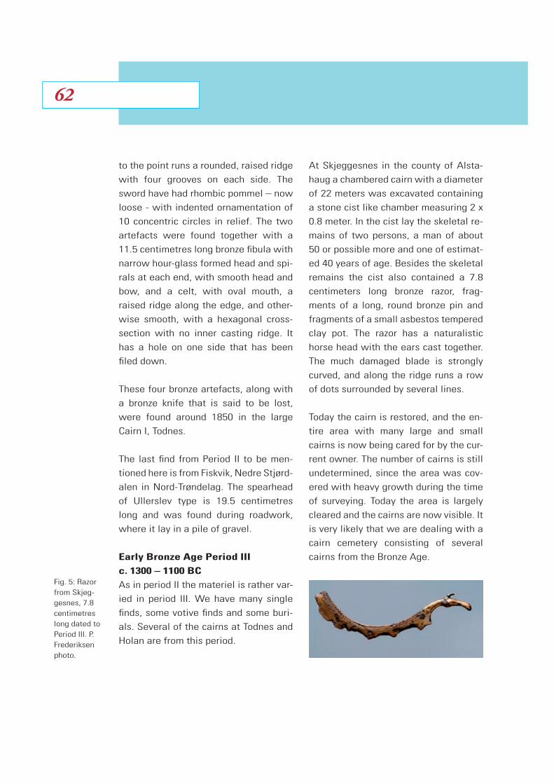
to the point runs a rounded, raised ridge
with four grooves on each side. The
sword have had rhombic pommel – now
loose - with indented ornamentation of
10 concentric circles in relief. The two
artefacts were found together with a
11.5 centimetres long bronze fibula with
narrow hour-glass formed head and spi-
rals at each end, with smooth head and
bow, and a celt, with oval mouth, a
raised ridge along the edge, and other-
wise smooth, with a hexagonal cross-
section with no inner casting ridge. It
has a hole on one side that has been
filed down.
These four bronze artefacts, along with
a bronze knife that is said to be lost,
were found around 1850 in the large
Cairn I, Todnes.
The last find from Period II to be men-
tioned here is from Fiskvik, Nedre Stjørd-
alen in Nord-Trøndelag. The spearhead
of Ullerslev type is 19.5 centimetres
long and was found during roadwork,
where it lay in a pile of gravel.
Early Bronze Age Period III
c. 1300 – 1100 BC
As in period II the materiel is rather var-
ied in period III. We have many single
finds, some votive finds and some buri-
als. Several of the cairns at Todnes and
Holan are from this period.
At Skjeggesnes in the county of Alsta-
haug a chambered cairn with a diameter
of 22 meters was excavated containing
a stone cist like chamber measuring 2 x
0.8 meter. In the cist lay the skeletal re-
mains of two persons, a man of about
50 or possible more and one of estimat-
ed 40 years of age. Besides the skeletal
remains the cist also contained a 7.8
centimeters long bronze razor, frag-
ments of a long, round bronze pin and
fragments of a small asbestos tempered
clay pot. The razor has a naturalistic
horse head with the ears cast together.
The much damaged blade is strongly
curved, and along the ridge runs a row
of dots surrounded by several lines.
Today the cairn is restored, and the en-
tire area with many large and small
cairns is now being cared for by the cur-
rent owner. The number of cairns is still
undetermined, since the area was cov-
ered with heavy growth during the time
of surveying. Today the area is largely
cleared and the cairns are now visible. It
is very likely that we are dealing with a
cairn cemetery consisting of several
cairns from the Bronze Age.
Fig. 5: Razor from Skjeg-gesnes, 7.8 centimetres long dated to Period III. P. Frederiksen photo.
6262
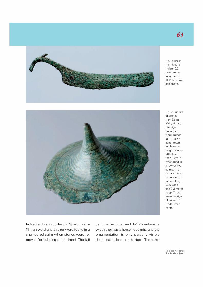
Nordlige VerdenerShetlandsprojekt
In Nedre Holan’s outfield in Sparbu, cairn
XIII, a sword and a razor were found in a
chambered cairn when stones were re-
moved for building the railroad. The 6.5
centimetres long and 1-1.2 centimetre
wide razor has a horse head grip, and the
ornamentation is only partially visible
due to oxidation of the surface. The horse
Fig. 6: Razor from Nedre Holan, 6.5 centimetres long, Period III. P. Frederik-sen photo.
Fig. 7: Tutulus of bronze from Cairn XVIII, Holan, Steinkjer County in Nord-Trønde-lag. It is 5.8 centimeters in diameter, height is now little less than 3 cm. It was found in a row of five cairns, in a burial cham-ber about 1.5 meters long, 0.35 wide and 0.3 meter deep. There were no sign of bones. P. Frederiksen photo.
63

head is narrow and bent and the ears are
bent back instead of pointing forward,
which is a little unusual. There were no
traces of bones in the chamber.
Tutulus from Cairn XVIII, 5.8 centimetres
in diameter, fig. 7. It was found in a cairn
covering a chamber 1, 5 meters long
covered with a single large stone slab.
The dagger with bronze hilt and rhombic
pommel, fig. 8, was found in Cairn II. A
piece of the pommel has been lost, so
one can see that the hilt is cast over an
internal clay core, through the middle of
which runs a bronze tang. The dagger
was found together with a smooth celt
with a narrow roll at the socket opening.
The items were found along with un-
burnt bones of an individual, whereof
some, mainly extremities, were brought
to the Museum. The cairn was rather
large, 15 meters in diameter, with a
chamber built of standing, flat stone and
a 1.5 meter long flat stone as a lid.
Late Bronze Age Period IV
c. 1100 – 900 BC
At the Bø farm in the county of Steigen
in Nordland the northernmost grave find
from the Bronze Age was found. The
cairn contained a pair of tweezers, 4
centimetres long, with inverted tongs,
smooth and without ornamentation, fig.
9. Besides the tweezers a double button
with a long rod was found, fig. 10. On
the plate where the rod starts an indent-
Fig. 8: Dagger from Nedre Holan, period III. P. Frederik-sen photo.
6464

Nordlige VerdenerShetlandsprojekt
ed star motif can be seen. Altogether
the double button is 7.5 centimetres
long, whereof the rod is 6.2. Both arte-
facts were found when the owner was
clearing the cairn, and no chamber was
ever recorded.
Late Bronze Age Period V
c. 900 - 700 BC
The 58 centimeter long spearhead
comes from the Hoddøy farm in North
Trøndelag. It stood between two 0.6 me-
ter high stone slabs point down and
socket up. The northern end of the stone
Fig. 9: Pair of tweezers, found together with the dou-ble button, fig. 10 dated to Period IV. Tromsø Muse-um photo.
Fig. 10: Double button from Nord-land. Tromsø Museum photo.
65
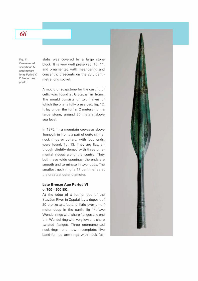
slabs was covered by a large stone
block. It is very well preserved, fig. 11,
and ornamented with meandering and
concentric crescents on the 20.5 centi-
metre long socket.
A mould of soapstone for the casting of
celts was found at Grøtavær in Troms.
The mould consists of two halves of
which the one is fully preserved, fig. 12.
It lay under the turf c. 2 meters from a
large stone; around 35 meters above
sea level.
In 1875, in a mountain crevasse above
Tennevik in Troms a pair of quite similar
neck rings or collars, with loop ends,
were found, fig. 13. They are flat, al-
though slightly domed with three orna-
mental ridges along the centre. They
both have wide openings; the ends are
smooth and terminate in two loops. The
smallest neck ring is 17 centimetres at
the greatest outer diameter.
Late Bronze Age Period VI
c. 700 - 500 BC.
At the edge of a former bed of the
Stavåen River in Oppdal lay a deposit of
20 bronze artefacts, a little over a half
meter deep in the earth, fig 14: two
Wendel rings with sharp flanges and one
thin Wendel ring with very low and sharp
twisted flanges. Three unornamented
neck-rings, one now incomplete; five
band-formed arm-rings with hook fas-
Fig. 11: Ornamented spearhead 58 centimeters long, Period V. P. Frederiksen photo.
6666

Nordlige VerdenerShetlandsprojekt
tener; two spectacle-formed
adornments of bronze; a piece
of bronze chain; one tutulus-
formed adornment plate with
six concentric, raised rings of
equal distance and in the
center adorned with a coni-
cal-formed point; and lastly
four celts with more or less
fanned blade edges and two
with loops below the rim.
The last artefact to be men-
tioned here is a Hallstatt
sword of Gündlingen type, fig
15. In the flat hilt without flang-
es there are holes for nine riv-
ets. The preserved sword is 65
centimetres long as the tip is
missing, whereof the hilt is
around 10 centimetres. The
blade is ornamented with,
among other things, arch orna-
ments and figures of ships with
bow formed as seabirds at the
very top of the blade toward the
hilt. The ornamentation contin-
ues the entire length of the pre-
served sword. The sword was
found in a bog on the farm Våg at
Dønna in Helgeland. It lay on the
sandy bottom covered by bog soil.
Conclusion
The bronze objects from the districts
Møre and Romsdal, Sør-Trøndelag,
Fig. 12: Mould of steatite for casting celts, Period V. P. Frederiksen photo.
67
Nordlige VerdenerShetlandsprojekt
acle-formed
ze; a piece
e tutulus-
plate with
d rings of
d in the
h a coni-
nd lastly
e or less
aand two
e rim.
be men-
Hallstatt
n type, fig
hout flang-
or nine riv-
word is 65
the tip is
the hilt is
etres. The
nted with,
arch orna-
f ships with
birds at the
e toward the
ation contin-
h of the pre-
sword was
e farm Våg at
. It lay on the
ed by bog soil.
rom the districts
l, Sør-Trøndelag,
Fig. 12: Mould of steatite for casting celts, Period V. P. Frederiksen photo.

Fig. 15: Upper part of a Hallstat sword. The hilt is 10 centimeters long. Period VI. Oldsakesamlingen photo.
Nord-Trøndelag, Nordland, Troms
and Finmark have not yet been
fully published. When looking at
some surveys of the Norwegian
Prehistory, the Bronze Age of Cen-
tral and Northern Norway seems to
be virtually absent. It is my aim –
as part of my contribution to the
research initiative Northern
Worlds – to work out a full, com-
mented catalogue of Bronze Age
bronze objects, so that this solid
evidence of material culture can
be used for future research.
The material is obviously larger in South-
ern and South-western Norway than in
Central and Northern Norway. On the
other hand, even in Northern Norway,
different find categories are represented,
such as burials and votive depositions –
where the sites are always related to
environments of high agricultural poten-
tial – including the finds highlighted
here. Particularly in Helgeland the full
Bronze Age ‘cultural package’ is present.
It is quite clear that Northern Norway
with its coast bound Bronze Age culture
was an integrated part of the Nordic
Bronze Age system.
Fig. 13: One of the neck-ring of a pair. Diameter 17 centimeters. Perod V. Tromsø Museum photo.
1 15: Fig. 1per part Uppe Hallstat of a H
ord. The hilt is swor centimeters long. 10 cenriod VI. Oldsakesamlingen photo.Period
Fig. 13: One of the neck-ring of a pair. Diameter 17 centimeters. Perod V. Tromsø Museum photo.
6868
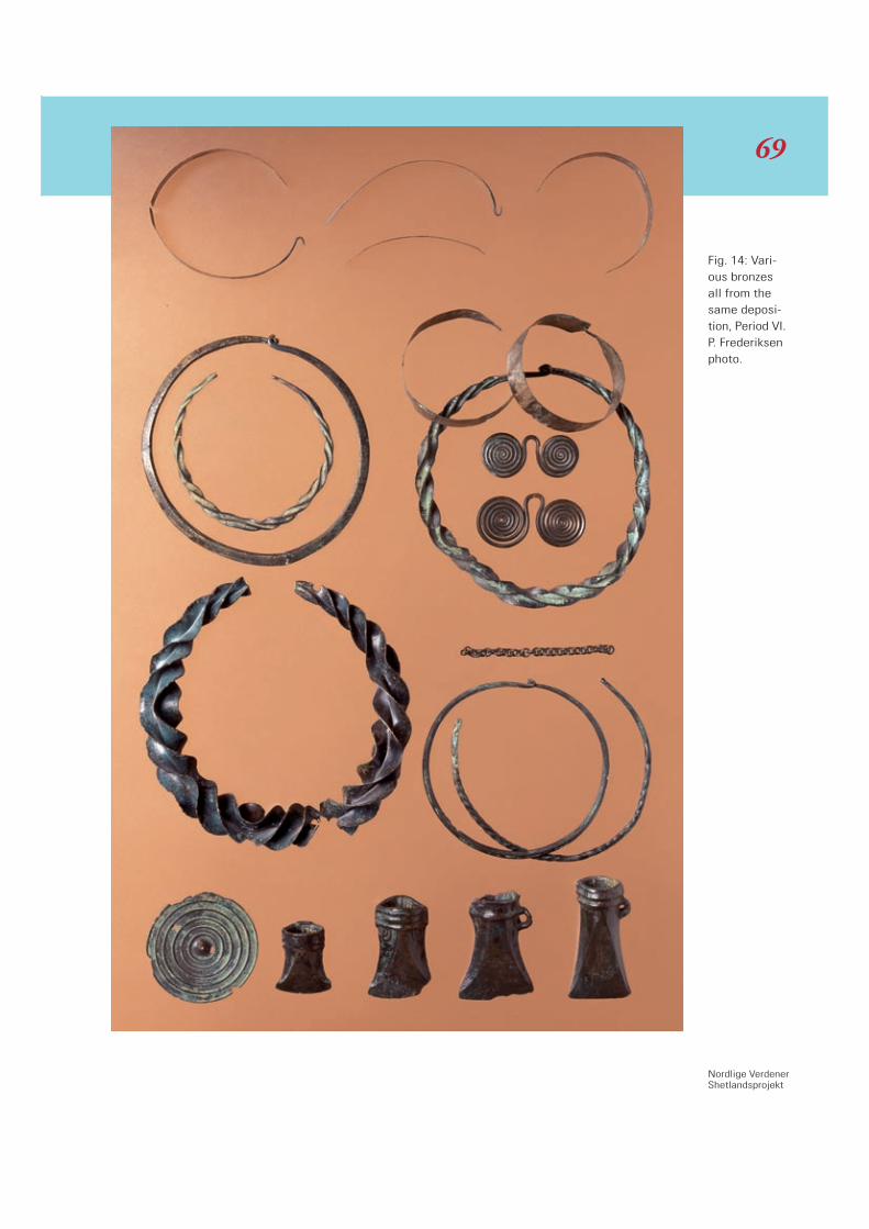
Nordlige VerdenerShetlandsprojekt
Fig. 14: Vari-ous bronzes all from the same deposi-tion, Period VI. P. Frederiksen photo.
69
Introduction
Centuries of climatic stability facilitated
an unchanging pattern of settlement in
Shetland, with populations distributed
all over the islands, on high and low
ground alike. Only the most exposed
hilltops, or those districts with scant soil
cover, were unsuitable for habitation.
However, from around 1000 BC the cli-
mate in the North Atlantic region gradu-
ally changed, bringing with it cooler
temperatures, harder winters, and more
rainfall. Geology permitting, this led to
encroachment of heather, and eventual-
ly peat deposits formed over much of
the hills. In turn, islanders had to aban-
don farmlands there, and upland settle-
ments were lost from memory.
This is relevant because it gave rise to
structures that were left undisturbed in
the landscape, and which sometimes
found a secondary use centuries, or mil-
lennia, after their abandonment. After
the Stone Age, people continued to in-
habit lower-lying terrain, and any such
Neolithic structures as existed there
were destroyed through continual re-
modelling. But on the hills hundreds,
probably thousands, of prehistoric struc-
tures were left as they were in the land-
scape, sometimes clear to view, some-
times obscured by peat bog.
That there was re-use in prehistoric
times is certain, as can be seen in such
adaptations as the later insertion of a
burial cist in a Neolithic cairn at Petti-
garth, Whalsay, and it is also true that a
great many sites were left just as they
were since the Stone Age because we
have many today that show no obvious
sign of alteration beyond displacement
of rubble. Only if an ancient site was
near to some agricultural process re-
quiring building stone was it to be of
any use. This paper is concerned with
this re-use from Medieval times onward
until the 19th century – a period of great
stability in subsistence agriculture that
ended only with the move to a cash
economy, and the old way of doing
things altered forever.
Post-Medieval Reuse of Neolithic Sites in Shetland
Ian Tait
7070

Nordlige VerdenerShetlandsprojekt
Whereas classification of Neolithic
buildings divides by building type, with
the later use being a secondary consid-
eration, we need to look at things the
other way around – from the point of
view of Early Modern Shetlanders, who
could not know what the structures
were originally for, but who knew exact-
ly what kind of building they themselves
needed to construct.
Township and Commons
Since the Middle Ages, Shetland was
divided between township and common
lands. Where ancient buildings lay on
lower terrain, this was often in town-
ship land, and the sites were liable to be
quarried into to obtain building rubble.
This generally did not involve purposeful
destruction of a recognisable ancient
building, because continuous settlement
on the lowlands meant there was inten-
sive reuse of rubble, and by medieval
times huge numbers of Neolithic dwell-
ings had disappeared already. However,
Neolithic artefacts can be found in build-
ings that point to Neolithic dwellings
having originally existed on-site. In the
case of any structure built from a Stone
Age house, the wall of the Early Modern
building will contain stone artefacts un-
wittingly included in the masonry, typi-
cally hammerstones or ploughshares.
For example, at Vevoe, Whalsay, a field
dyke contains a Neolithic quern, and
there is a quern on-site at Islesburgh,
Northmavine. Another instance is the
deposition of polished axes in walls as
talismen to ward off strike by lightning.
These so-called “thunderbolts” were
Fig. 1: The most frequent re-use of Neolithic sites was the erection of a krobb (kale nursery) on a house site, as here at Duri, Cunnings-burgh. Shet-land Museum.
71

set above a hearth or door lintel to pro-
vide a sort of lucky charm protection.
Further from the township area, in the
common grazings, Neolithic sites were
more numerous, and it was in this zone
that most characteristic re-use patterns
can be seen. All three main types of
Stone Age building in Shetland – home-
steads, tombs, dykes - were re-used.
The pre-existence of these ancient struc-
tures was often the determinant in
erecting a structure in the first place; if
the rubble was there, it was a conven-
ient site.
Kale Nurseries
A krobb was an enclosure used to rear
kale seedlings over winter before they
were transplanted to the farmstead in
spring, to be matured to full-grown
plants. Such structures were always sit-
ed in the common grazings, to obtain
the optimum soil conditions, and krobbs
tended to be clustered in groups where
ideal conditions had been determined
through time. This was the type of ter-
rain where Neolithic houses could be
found, and the commonest type of re-
use on Neolithic sites in Shetland was
undoubtedly the siting of a krobb on a
homestead. The krobb was either circu-
lar or square, and typically the ancient
building was plundered for any handle-
able stones, and only the large perime-
ter stones of the house wall and those
larger blocks delineating the wall cells
are left. Most often the kale enclosure
was built on top of the ancient home-
stead, as was the case of krobbs each
at: Duri, Cunningsburgh; Skellister, Nest-
ing; Loch of Vara, Aithsting. This pattern
has been encountered by the Northern
Worlds network already south of Isles-
burgh, Northmavine, where there is an
intact Neolithic homestead comprising
a field dyke and a house, surmounted by
a krobb which has belonged to either
Islesburgh or to Culster, to the south
across the bay.
The remodelling of tombs for the con-
struction of krobbs was altogether less
common, because chambered cairns
were generally erected on hilltops, and
Fig. 2: Remnants of Stone Age house visible under foundations of krobb at Skellister, Nesting. Shetland Amenity Trust.
7272

Nordlige VerdenerShetlandsprojekt
such exposed locations were unsuitable
for rearing kale, because of wind dam-
age to the crop. There were exceptions,
such as one at the Hill of Olligarth,
Whiteness. This tomb has been entirely
denuded, leaving only two exceptionally
large stones, which are doubtless top-
pled monoliths from the outer edges of
the tomb facade. It is most irregular for
a krobb to be erected whilst still leaving
rocks in the interior, but these two
stones were more of a challenge to later
Shetlanders than they had been to Neo-
lithic farmers, and the kale nursery has
been built around the site of the tomb.
Krobbs were typically sited in multiples,
and single examples created from one
Neolithic building were somewhat atyp-
ical, the situation having arisen from
there being a convenient supply of stone.
The situation at the Hill of Burravoe,
Delting, equates with the more usual
situation; here the rubble has been re-
moved from two tombs and taken off-
site to build four krobbs.
Stock Enclosures
Pens were used in township land, and
more especially the hill land, and farm-
ers penned sheep, cattle, and horses, in
these enclosures during times when crops
were growing. These pens, or retts, re-
quired large quantities of rubble, and
large ancient structures were invaluable
sources of rocks in erecting them. Exam-
ples exist which have been constructed
from all types of Neolithic buildings:
near the Dutch Loch, Papa Stour, a pre-
historic dyke was dismantled to erect an
enclosure; at Hjokland, Sandsting, a
dyke was constructed using rubble plun-
dered from a Stone Age homestead; and
Fig. 3: Top-pled ortho-stats are all that remain from a tomb at the Hill of Olligarth, Whiteness, that was con-verted to a krobb. I. Tait.
73
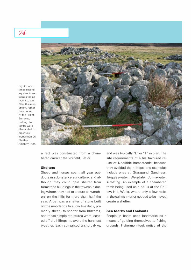
a rett was constructed from a cham-
bered cairn at the Vordeld, Fetlar.
Shelters
Sheep and horses spent all year out-
doors in subsistence agriculture, and al-
though they could gain shelter from
farmstead buildings in the township dur-
ing winter, they had to endure all weath-
ers on the hills for more than half the
year. A bøl was a shelter of stone built
on the moorlands to allow livestock, pri-
marily sheep, to shelter from blizzards,
and these simple structures were locat-
ed off the hilltops, to avoid the harshest
weather. Each comprised a short dyke,
and was typically “L” or “T” in plan. The
site requirements of a bøl favoured re-
use of Neolithic homesteads, because
they avoided the hilltops, and examples
include ones at: Starapund, Sandness;
Truggleswater, Weisdale; Sulmawater,
Aithsting. An example of a chambered
tomb being used as a bøl is at the Gal-
low Hill, Walls, where only a few rocks
in the cairn’s interior needed to be moved
create a shelter.
Sea Marks and Lookouts
People in boats used landmarks as a
means of guiding themselves to fishing
grounds. Fishermen took notice of the
Fig. 4: Some-times second-ary structures were sited ad-jacent to the Neolithic mon-ument, rather than on top. At the Hill of Burravoe, Delting, two tombs were dismantled to erect four krobbs nearby. Shetland Amenity Trust.
7474

Nordlige VerdenerShetlandsprojekt
relative positions of natural and man-
made features when they were at a
good fishing area, so that they could be
sure to find the same place on future
trips. Besides pre-existing buildings be-
ing used, special cairns called meids
were erected to provide markers. Hill-
tops were the most useful land features,
and such areas often had a Neolithic
cairn in any case, so there was available
rubble to build a marker cairn. Examples
existed at Rønisfell, Northmavine, and
at Husavord, Unst. Not all the heaps of
stones we see today on top of ruinous
tombs are sea-marks; some are virdeks
(marker cairns), which were simply set
up as distinctive landmarks to aid peo-
ple walking over the moors. Today, in
the era of road travel, it is hard to real-
ise just how vital virdeks were to Shet-
landers over 150 years ago. Two exam-
ples are one each at chambered cairns
at the Hill of Crookster, Delting, and Fors-
water, Aithsting.
The hilltop sites that ancient cairns oc-
cupied, and the ruins of the tombs them-
selves, were made use of as lookout
posts from medieval times up to the
18th century. These were places where
islanders mounted a watch to guard
against attacks by pirates, and some
chambered tombs were converted into a
wakhus (watch hut), as at Eshaness,
Northmavine, and the Wart of Bruland,
Sandsting.
Peripheral Settlements
From Medieval times, Norway and its
colonies were periodically ravaged by
leprosy, and this disease still affected
Shetland into the early 18th Century.
The afflicted were isolated from the rest
of the community in little hovels in fara-
way places, to prevent their infecting
the general populace. Huts were tiny,
and the neighbouring farmers who had
the task of setting up the shack didn’t
require large resources of stone and turf
to do it. The occupant depended on char-
ity, and arable land was not even a ne-
cessity. Because Neolithic homesteads
were situated in the hills, it is not sur-
prising that some of the heaps of rubble
on the moorlands that were used to
erect a spilt hus (leper hut) were origi-
nally Stone Age dwellings. An example
Fig. 5: Large uprights sur-vive from a prehistoric dyke demol-ished to build a stock pen near the Dutch Loch, Papa Stour. Shetland Amenity Trust.
75

was one south-west of Laxo, Lunnas-
ting. Such a conversion of a homestead
into a dwelling after some four thou-
sand years is remarkable, and leper huts
were the only instances of domestic re-
use, in fact, a reversion to the building’s
original use.
From the late 18th century Shetland’s
population soared, as the islands’ land-
owners sought larger families to work
as fishermen, and this, in turn, pushed
indigent people out to the margins of
the long-established settlement area.
For centuries settlement had remained
within the traditional township dykes,
but now new farms were created in
open hill land, sometimes as an exten-
sion from the original dyke, and at other
times as isolated farms created where
no settlement had existed before. The
availability of cultivable land was a de-
terminant in their siting, but especially
in the case of the isolated farms a sup-
ply of stone almost as vital, and some
dwellings took use of supplies of stone
that had lain untouched for thousands of
years, in the form of Neolithic home-
steads. An example is Hogapund, North-
mavine, where a Stone Age house pro-
vided ample rubble for a house, byre,
and dyke.
Fig. 6: Neolithic site comprehen-sively plun-dered to build enclosure near the Loch of Hjokland, Sandsting. I. Tait.
7676
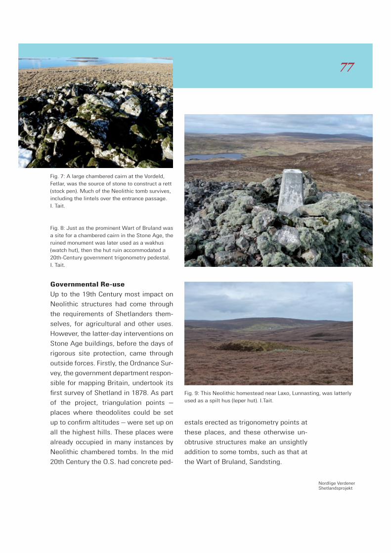
Nordlige VerdenerShetlandsprojekt
Governmental Re-use
Up to the 19th Century most impact on
Neolithic structures had come through
the requirements of Shetlanders them-
selves, for agricultural and other uses.
However, the latter-day interventions on
Stone Age buildings, before the days of
rigorous site protection, came through
outside forces. Firstly, the Ordnance Sur-
vey, the government department respon-
sible for mapping Britain, undertook its
first survey of Shetland in 1878. As part
of the project, triangulation points –
places where theodolites could be set
up to confirm altitudes – were set up on
all the highest hills. These places were
already occupied in many instances by
Neolithic chambered tombs. In the mid
20th Century the O.S. had concrete ped-
estals erected as trigonometry points at
these places, and these otherwise un-
obtrusive structures make an unsightly
addition to some tombs, such as that at
the Wart of Bruland, Sandsting.
Fig. 7: A large chambered cairn at the Vordeld, Fetlar, was the source of stone to construct a rett (stock pen). Much of the Neolithic tomb survives, including the lintels over the entrance passage. I. Tait. Fig. 8: Just as the prominent Wart of Bruland was a site for a chambered cairn in the Stone Age, the ruined monument was later used as a wakhus (watch hut), then the hut ruin accommodated a 20th-Century government trigonometry pedestal. I. Tait.
Fig. 9: This Neolithic homestead near Laxo, Lunnasting, was latterly used as a spilt hus (leper hut). I.Tait.
77
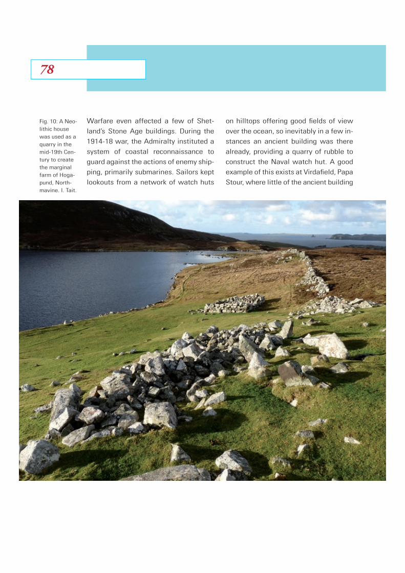
Warfare even affected a few of Shet-
land’s Stone Age buildings. During the
1914-18 war, the Admiralty instituted a
system of coastal reconnaissance to
guard against the actions of enemy ship-
ping, primarily submarines. Sailors kept
lookouts from a network of watch huts
on hilltops offering good fields of view
over the ocean, so inevitably in a few in-
stances an ancient building was there
already, providing a quarry of rubble to
construct the Naval watch hut. A good
example of this exists at Virdafield, Papa
Stour, where little of the ancient building
Fig. 10: A Neo-lithic house was used as a quarry in the mid-19th Cen-tury to create the marginal farm of Hoga-pund, North-mavine. I. Tait.
7878

Nordlige VerdenerShetlandsprojekt
survives. However, this damage was no-
where near as drastic as the effect that
national defence had on a Neolithic inter-
ment site in Unst during the 1960s. This
remarkable site, Saxavord, was evidently
an important place in Stone Age Shetland
society, for there were no fewer than
five tombs on this prominent hill, but all
these were eradicated to accommodate
an air force base during the Cold War.
Conclusion
Neolithic sites are remarkably numer-
ous in Shetland, and although many an-
cient structures have Early Modern
buildings superimposed, such later sites
are usually regarded with somewhat
less esteem than the prehistoric origi-
nals. In survey, the post-Medieval struc-
tures are frequently dismissed as ‘re-
cent’, they need to be removed first to
allow an excavation to proceed, and re-
use of Neolithic sites has received scant
study up to now. The Northern Worlds
project is addressing this issue for the
first time.
Acknowledgement
I am grateful to Chris Dyer at Shetland
Amenity Trust for helpfully retrieving da-
tabase site records and photographs.
Fig. 11: Virdafield, Papa Stour, provided an imposing site for a Neolithic tomb, and the usefulness of this vantage point meant the monu-ment was destroyed to make a Naval watch hut in the 1910s. Shetland Amenity Trust.
79
Introduction
When we consider prehistoric society,
archaeological evidence may be the only
means of gaining a deeper understand-
ing of people’s daily lives and belief sys-
tems. Excavation offers many such in-
sights but it is often the stray archaeo-
lo gical find that presents us with a
fascinating glimmer of the everyday life
of our ancestors. Some items may be
accidental losses but others were pur-
posefully deposited for varying reasons,
and it is these that can offer hints about
the beliefs of prehistoric societies. This
study seeks to show that these were
shared philosophies and practices be-
tween communities around the northern
world, including the Shetland Isles and
Scandinavia. I will look at some of these
remarkable finds and discuss how they
can highlight these cultural links.
Much of the landscape in Shetland is
covered by a blanket of deep moorland.
This has not always been the case, but
the formation of peat has continued
since environmental changes and cli-
matic deterioration noted in the Bronze
Age (Owen and Lowe 1999: 5-7; Ed-
wards and Whittington1998: 12). While
this spread of heathland may have
caused headaches for our prehistoric
ancestors, over the following millennia
peat has become an important source of
fuel in the Islands and it is during the
cutting of peat that many archaeological
finds are made. The Shetland Museum
houses many of these finds including
cultivation tools perfectly preserved in
the anaerobic conditions that peat of-
fers. This paper will concentrate on
three such items from within the collec-
tion: a wooden ard (plough), ox yoke and
foot-spade.
The Shetland Ard and Yoke
Evidence for early cultivation by Neo-
lithic and Bronze Age farmers in the is-
lands is found in abundance. Confirma-
tion of ard use is evident from the broken
stone ard points or shares which have
been found in numerous deposits recov-
ered from the walls of prehistoric build-
ings, rønies (clearance cairns) and dykes.
Three Ancient Cultivation Tools from Shetland
Jenny Murray
8080

Nordlige VerdenerShetlandsprojekt
75 of these stone shares were found at
the early agricultural settlement at the
Scord of Brouster and 187 at a Bronze
Age site in Sumburgh to give just two
examples (Whittle et al. 1986: 75-76;
Downes & Lamb 2000: 91). Ard marks or
plough furrows have also been discov-
ered in the subsoil during excavations
including those at Sumburgh; these
were found under the earliest layers
where wooden structures had later been
erected. Radiocarbon analysis of do-
mestic refuse found down the post-
holes of these buildings gave dates of
1679 and 1550 BC. Lamb concludes
these dates suggest ard cultivation was
well under way by 2000 BC cal (Lamb &
Rees 1981: 117). Further evidence for
early cultivation in the Islands includes
carbonised barley found in excavation; a
deposit of 28 pounds was recovered
with half of a broken quern within the
walls of a Neolithic house at the Ness
of Gruting (Calder 1955: 353). Numerous
quern stones have been found during
excavations in Shetland confirming the
grinding of meal at all settlements (Turn-
er 1998: 32). A man cutting peat at Vir-
difield, Dunrossness in 1965 discovered
a complete ard at a depth of 1.83 me-
tres. Its components along with another
stilt from a similar ard were laid side by
side, indicating deliberate deposit in the
moor. The ard is of the composite type
very similar to the Døstrup ard which
Fig. 1. Wooden ard and ox yoke on display in Shetland Museum.
Fig 2. Shet-land ard showing posi-tioning of stone share on wooden stilt. Shetland Museum
81

was recovered from a bog in Jutland in
1884, which has been radiocarbon dat-
ed with a calibrated date given as 810
BC (610 BC) placing it in the Danish
Younger Bronze Age (Lerche 1969: 128).
There are around ten similar finds from
the Danish bogs such as the Donnerup-
lund ard found in three metres of peat,
also in Jutland (see Glob 1945: 93).
These are all believed to be deliberate
deposits, including the Nørre Smedeby
plough which was discovered in a bog
with a number of wooden dishes and
earthenware pots, very typical of votive
finds (Glob 1945: 107-8).
Similar Scottish finds include a rudimen-
tary ard from the Pict’s Knowe in Dum-
fries; of the crook type, it is similar to
the Danish Bronze Age ard from Hvorster
(Thomas 2007: 117).1 This too may have
been placed in the ground deliberately
as it was found in a ditch with numerous
fragments of broken quernstones (Tho-
mas 2007: 152). Likewise a wooden ard
stilt and head were uncovered from the
floor level of an Iron Age crannog in Mil-
ton Loch, Kirkcudbrightshire. Radiocar-
bon dating of the wood gave a date of
400±100 cal BC (K1394) (Dixon 2004:
53). Piggott, excavator in the early 1950s
suggested this may have been a ritual
deposit as it was placed in the fabric of
the buildings foundation layer (Piggott
1952: 143-144). Also suggestive of a vo-
tive deposition, an alder plough beam of
the Døstrup type was found deep in the
1 Pict’s Knowe is a deceiving name as the excavation revealed a multi-period site dating from Neolithic to Roman-Iron Age (see Thomas 2007).
Fig 3. The Døstrupard (Glob 1951:37, Fig. 37). Professor Glob’s diagram shows the ard consists of the long beam (1) on to which the oxen were yoked by the means of a hook (2); at the other end is a mortise through which a single wooden stilt passes (3); the ard head (5) is seen underneath the share or fore-share (6) as it is some-times called. Number (4) depicts the handle for the user to steer (Lerche1994:11). Courtesy of the National Museum of Denmark.
1
2
3
4
5
6
8282

Nordlige VerdenerShetlandsprojekt
peat moor in Lochmaben, Dumfrieshire.
Similar finds of this kind include an Iron
Age wooden share recovered in Dundarg
in Aberdeenshire (see Rees 1983) and
further south in England a Bronze Age
ard was uncovered in a prehistoric chan-
nel of the River Thames dated to 900-
760 BC.2
These ancient ploughs may have been
worked by people themselves, but early
yokes suggest that draught animals
were also being used. A head yoke
shown in figure 1 was found in the 1920s
deep in a peat bank. Measuring 1.43
metres the Shetland yoke has three hor-
izontal openings, presumably used to
lash the harness straps either to the
horns or neck of the beasts driving the
plough (Fenton 1986: 34). Traditionally, in
Shetland, oxen and horses were used to
pull the plough but prehistoric evidence
would suggest the draught animal of
choice was oxen. This is supported by
cattle bones found during archaeologi-
cal excavations such as those at the
Ness of Gruting and Scord of Brouster
(Calder 1955: 358, 380; Whittle et al.
1986: 132). The Shetland yoke is almost
identical to the Bronze Age example
found in the peat moor at Loch Nell,
Argyll which has been dated to 3430
± 85 (OxA-3541), calibrated to 1950-
1525 BC (PSAS 1889-90: 143; Cowie &
Shepherd 2005: 164).
Using typological evidence we can date
the Shetland cultivation implements by
referring to similar items that have been
securely dated from the archaeological
context such as the Milton Loch ard but
further research is required to establish
securer dates for the Shetland items so
that cultural links can be ascertained
between finds from Denmark and Scot-
land. For example, were these imple-
ments being deposited as ritual offer-
ings at the same time in both these
regions, suggesting a shared cultural
tradition? To help in this process we
need to look at the area where they
were deposited to see if there are other
clues found in the vicinity.
A field survey of the Virdifield area
where the ard was discovered revealed
a prehistoric field boundary, a Neolithic/
Bronze Age house (in Shetland we had a
rather elongated Neolithic period so
structures in themselves are difficult to
date precisely) and a cist of probable
Bronze Age date. The area where the
ard was found lay approximately 500
metres inland from the house within a
dip in the boggy landscape (HU4035
1920). This area, below the surrounding
hills, may have previously been arable
but later came under threat from the en-
croaching heathland. Was the deposi-
tion of the ard a gift to appease the
weather gods to help slow the forma-
tion of peat and water logged soils (see
2 See http://www.britarch.ac.uk/ba/ba26/BA26NEWS.HTML
83
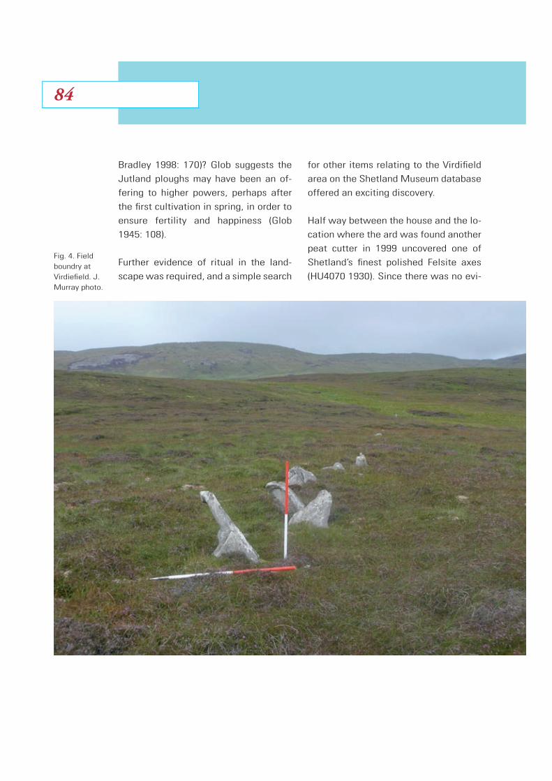
Bradley 1998: 170)? Glob suggests the
Jutland ploughs may have been an of-
fering to higher powers, perhaps after
the first cultivation in spring, in order to
ensure fertility and happiness (Glob
1945: 108).
Further evidence of ritual in the land-
scape was required, and a simple search
for other items relating to the Virdifield
area on the Shetland Museum database
offered an exciting discovery.
Half way between the house and the lo-
cation where the ard was found another
peat cutter in 1999 uncovered one of
Shetland’s finest polished Felsite axes
(HU4070 1930). Since there was no evi-
Fig. 4. Field boundry at Virdiefield. J. Murray photo.
8484
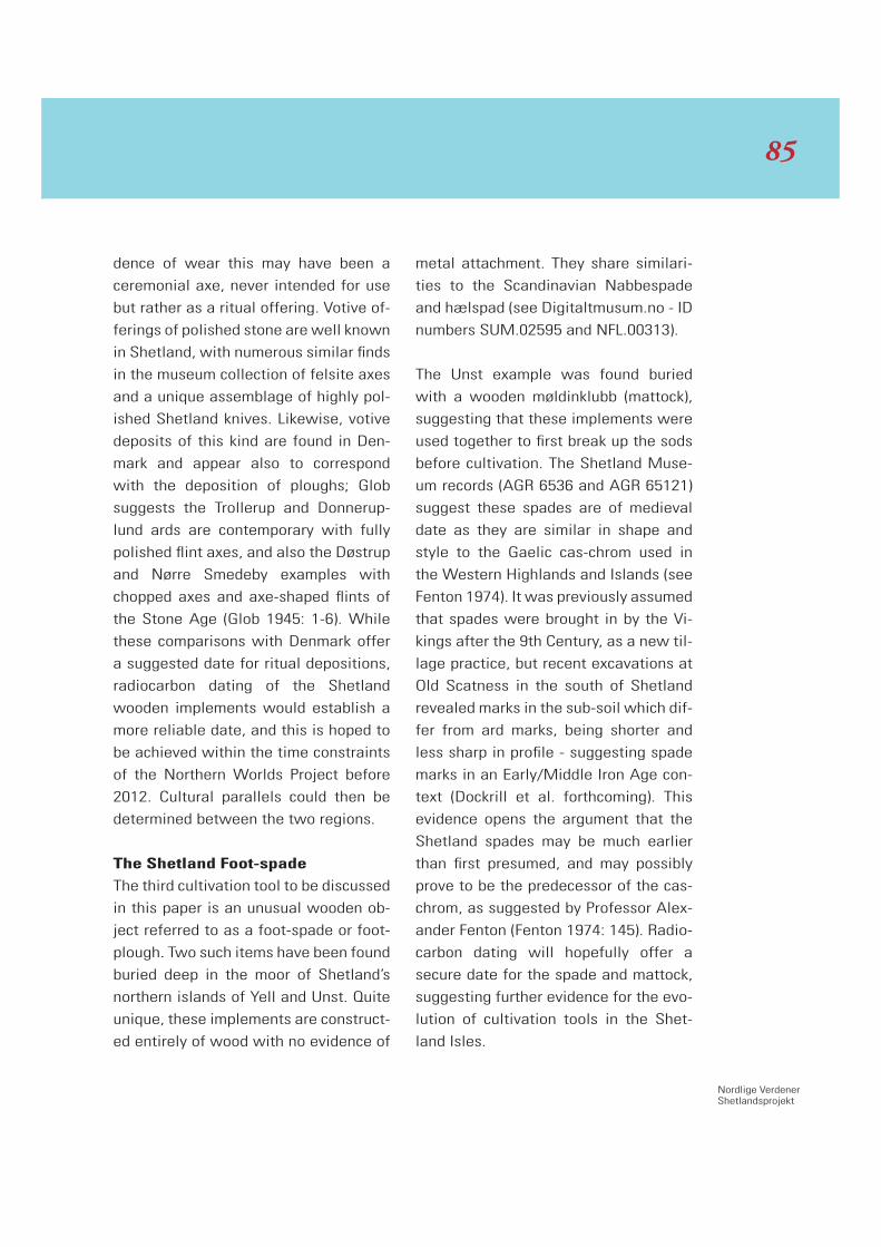
Nordlige VerdenerShetlandsprojekt
dence of wear this may have been a
cere monial axe, never intended for use
but rather as a ritual offering. Votive of-
ferings of polished stone are well known
in Shetland, with numerous similar finds
in the museum collection of felsite axes
and a unique assemblage of highly pol-
ished Shetland knives. Likewise, votive
deposits of this kind are found in Den-
mark and appear also to correspond
with the deposition of ploughs; Glob
suggests the Trollerup and Donnerup-
lund ards are contemporary with fully
polished flint axes, and also the Døstrup
and Nørre Smedeby examples with
chopped axes and axe-shaped flints of
the Stone Age (Glob 1945: 1-6). While
these comparisons with Denmark offer
a suggested date for ritual depositions,
radiocarbon dating of the Shetland
wooden implements would establish a
more reliable date, and this is hoped to
be achieved within the time constraints
of the Northern Worlds Project before
2012. Cultural parallels could then be
determined between the two regions.
The Shetland Foot-spade
The third cultivation tool to be discussed
in this paper is an unusual wooden ob-
ject referred to as a foot-spade or foot-
plough. Two such items have been found
buried deep in the moor of Shetland’s
northern islands of Yell and Unst. Quite
unique, these implements are construct-
ed entirely of wood with no evidence of
metal attachment. They share similari-
ties to the Scandinavian Nabbespade
and hælspad (see Digitaltmusum.no - ID
numbers SUM.02595 and NFL.00313).
The Unst example was found buried
with a wooden møldinklubb (mattock),
suggesting that these implements were
used together to first break up the sods
before cultivation. The Shetland Muse-
um records (AGR 6536 and AGR 65121)
suggest these spades are of medieval
date as they are similar in shape and
style to the Gaelic cas-chrom used in
the Western Highlands and Islands (see
Fenton 1974). It was previously assumed
that spades were brought in by the Vi-
kings after the 9th Century, as a new til-
lage practice, but recent excavations at
Old Scatness in the south of Shetland
revealed marks in the sub-soil which dif-
fer from ard marks, being shorter and
less sharp in profile - suggesting spade
marks in an Early/Middle Iron Age con-
text (Dockrill et al. forthcoming). This
evidence opens the argument that the
Shetland spades may be much earlier
than first presumed, and may possibly
prove to be the predecessor of the cas-
chrom, as suggested by Professor Alex-
ander Fenton (Fenton 1974: 145). Radio-
carbon dating will hopefully offer a
secure date for the spade and mattock,
suggesting further evidence for the evo-
lution of cultivation tools in the Shet-
land Isles.
85

If the Shetland spades are proven to
date from the Iron Age, ritual deposition
into the peat would be a possibility. Ri-
chard Bradley suggests this practice
continues well into the Iron Age and lat-
er periods throughout Europe, with dep-
ositions including weaponry and from
southern Scandinavia offerings of pots
containing food (1998: 160-161). If how-
ever they are found to be later, a more
practical reason for their burial may be
assumed. Were they tools left behind
after a day’s work but never retrieved, or
were they placed in the peat to keep
them wet during the summer months?
This practice is suggested in warmer cli-
mates recorded by Gorecki in the New
Guinea Highlands, where a wooden pre-
historic digging stick was placed in a
drain. Local inhabitants believed its
owner must have moved somewhere
else and forgotten to retrieve it from
where it was soaking (Gorecki 1978:
187). It may be the acidity of the peat
works in the same biological way as
tannic acid as an inhibitor of decay (Ear-
wood 1993: 17). When discussing the
Danish ard deposits Glob disputes the
argument that these objects were bur-
ied to preserve them, stating that wood
Fig. 5. Felsite axe of excep-tional quality from Virdifield. J. Murray photo.
8686

Nordlige VerdenerShetlandsprojekt
that had been soaked all summer would
be far less resistant to the abrasion of
the soil during ploughing than wood that
was completely dry (Glob 1945: 107).
Both scenarios seem doubtful in the
Shetland environment. Firstly a wooden
implement would be an expensive com-
modity in Shetland’s treeless landscape.
It is therefore unlikely that the owner
would be so careless. Wood was be-
coming scarce by the Iron Age (Owen &
Lowe 1999: 280-282; Edwards et al.
1998: 11-12); driftwood was now being
utilised, as is evident in the burrows of
the Teredo worm (shipworm) in many of
the Shetland Museum’s wooden arte-
facts, including the foot spade from Yell.
Secondly, the climate within Shetland is
quite humid due to its island nature, and
the temperature never gets very hot dur-
ing the summer months. Also, why
would the owners of these valuable
items go to the bother of taking them up
on the hillside to bury them, where they
could most certainly get lost, instead of
placing them nearer to home? These
spades and mattock would appear to
have been deliberately buried in the
peat as the wood has not been weath-
Fig. 6a. Shet-land foot-spade from Yell. J. Mur-ray photo. Fig. 6b. there are no traces of metal fit-tings on the wooden blade. J. Mur-ray photo.
87

ered. Had they been left lying in the hill
it would have taken years for the peat to
have covered them, causing some dry-
ing and warping of the wood. Hopefully
radiocarbon dating will help answer
these varied questions.
Conclusion
It is anticipated that by having these
wooden cultivation tools scientifically
dated we will gain a better understand-
ing not just of the cultivation practices,
but also the belief systems of the peo-
ple who used them. Ritual deposition is
well known throughout the prehistory of
Northern Europe, and it is fascinating to
think that these farmers living as far
apart as Shetland and Denmark may
have been sharing the same cultural tra-
ditions at the same time; working the
land with an optimism that the fertility
of the soil would be secured by their
faith and ritual customs.
Acknowledgements
I would like to sincerely thank Dr Simon
Clarke for his unfailing support and en-
couragement and also Val Turner for
kindly allowing me to use material from
her forthcoming book.
Bibliography
Bradley, R., 1998. The Passage of Arms,
an Archaeological analysis of prehistor-
ic hoard and votive deposits. Oxford.
Calder, C.S.T., 1955. Report on the Dis-
covery of Numerous Stone Age House-
sites in Shetland. Proceedings of the So-
ciety of Antiquaries Scotland. Vol. 89,
1955 - 1956.
Cowie, T.G. and Shepherd, I.A.G., 2005.
The Bronze Age. Scotland After The Ice
Age. Edwards, K.J. and Ralston, I.B.M.,
eds., Edinburgh.
Dixon, N., 2004. The Crannogs of Scot-
land: an underwater archaeology.
Gloucestershire.
Dockrill, S.J., Bond, J.M., Turner, V.E.,
Brown, L.D et al. forthcoming. Excava-
tions at Old Scatness. Shetland Vol. 2:
The Iron Age Broch and Village. Shet-
land Heritage Publications, Lerwick.
Downes, J. and Lamb, R., 2000. Prehis-
toric Houses at Sumburgh in Shetland,
Excavations at Sumburgh Airport 1967-
1974. Oxford.
Earwood, C., 1993. Domestic Wooden
Artefacts in Britain and Ireland from Ne-
olithic to Viking Times. Exeter.
Edwards, K.J. and Whittington, G., 1998.
Landscape and Environment in Prehis-
toric West Mainland, Shetland. Land-
scape History. Vol. 20, Society for Land-
scape Studies, Wakefield, Yorkshire:
5-17.
8888
Nordlige VerdenerShetlandsprojekt
Fenton, A., 1974. The Cas-chrom: A Re-
view of the Scottish Evidence. Lerche,
G., Fenton, A., Steensberg, A.: Tools and
Tillage. Vol. II: 3, National Museum of
Denmark, Copenhagen.
Fenton, A., 1986. The Shape of the Past
2: Essays in Scottish Ethnology. Edin-
burgh.
Glob, P.V., 1945. Ploughs of the Døstrup
Type, Found in Denmark. Acta Archaeo-
logica. Vol. 13: 93-111.
Glob, P.V., 1951. Ard og plov I Nordens
oldtid. Jysk arkæologisk Selskabs skrift-
er. Vol. 1, Aarhus.
Gorecki, P.P., 1978. Further Notes on Pre-
historic Wooden Spades from the New
Guinea Highlands. In: Lerche, G., Fen-
ton, A., Steensberg, A.: Tools and Til-
lage. Vol. III: 3, National Museum of
Denmark, Copenhagen: 185-190.
Lamb, R. and Rees, S., 1981. Ard Culti-
vation at Sumburgh, Shetland. In: Lerche,
G., Fenton, A., Steensberg, A.: Tools and
Tillage. Vol. IV: 2, National Museum of
Denmark, Copenhagen.
Lerche, G., 1969. The Radiocarbon Dat-
ed Implements. In: Lerche, G., Fenton,
A., Steensberg, A.: Tools and Tillage.
Vol. I: 2, National Museum of Denmark,
Copenhagen.
Lerche, G.,1994. Ploughing Implements
and Tillage Practices in Denmark from
the Viking Period to About 1800. Poul
Kristensen, Herning.
Owen, O. & Lowe, C., 1999. Kebister:
The four-thousand-year-old story of one
Shetland Township. Stroud, Glos.
Piggott, C.M., 1952. Milton Loch Cran-
nog 1: A Native House of the 2nd Cen-
tury AD in Kirkcudbrightshire. Proceed-
ings of the Society of Antiquaries
Scotland. Vol. 87, 1952-1953.
Proceedings of the Society of Antiquar-
ies Scotland, Vol. 24, 1889-1890: 443.
Rees, S., 1983. A Wooden Ard Share
from Dunarg, Aberdeenshire, with a
note on other wooden plough pieces.
Proceedings of the Society of Antiquar-
ies Scotland. Vol. 113, 1983.
Thomas, J., 2007. Place and memory:
Excavations at the Pict’s Knowe, Holy-
wood and Holm Farm, Dumfries and Gal-
loway, 1994-8. Oxford.
Turner, V., 1998. Ancient Shetland. London.
Whittle, A., Keith-Lucas, M., Milles, A.,
Noddle, B., Rees, S., Romans, J.C.C.,
1986. Scord of Brouster, An Early Agri-
cultural Settlement on Shetland, Exca-
vations 1977-1979. London.
89
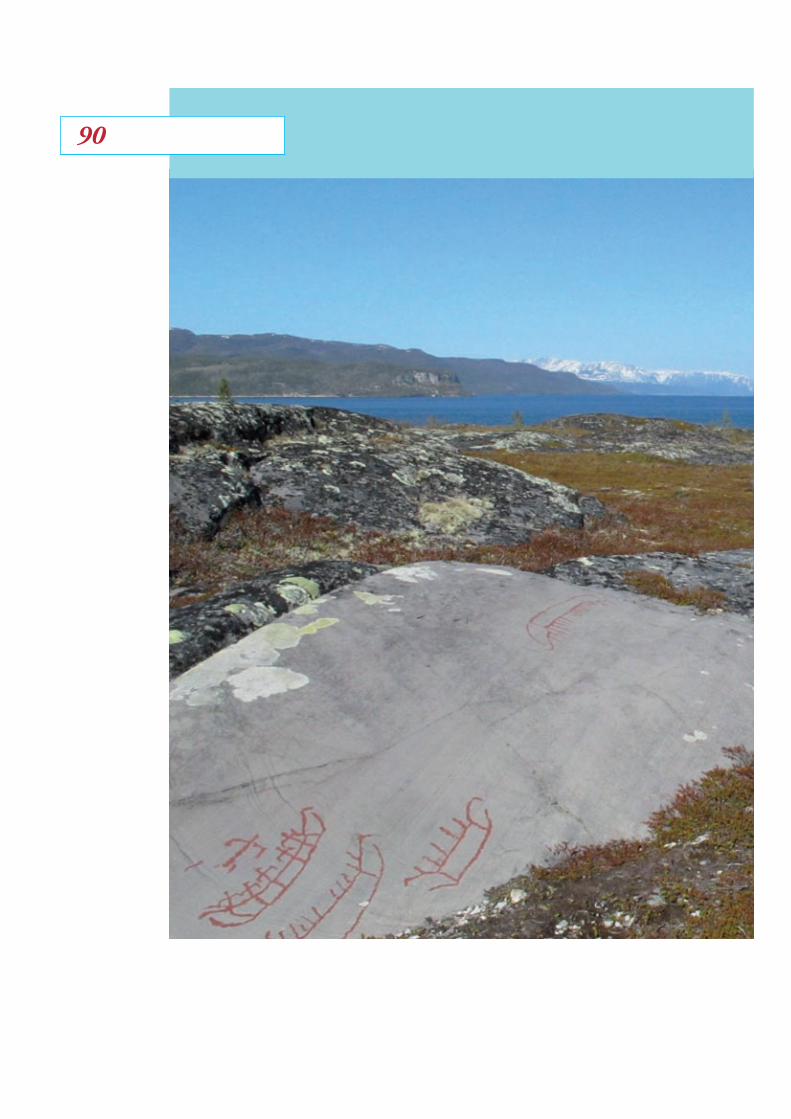
9090

Nordlige VerdenerShetlandsprojekt
Rock carvings from Alta, Northern Norway. D. Mahler photo.
91

Torben Ballin
Ph D
Litich Research
Hans Christian Gulløv
Senior researcher, DPhil,
Etnografical Collection,
The National Museum of Denmark
Flemming Kaul
Senior researcher, DPhil,
Danish Prehistoric Collection,
National Museum of Denmark
Ditlev L. Mahler
Project senior researcher, Ph D,
Danish Prehistoric Collection,
The National Museum of Denmark,
Coordinator
Jenny Murray
Curator of Collections,
Shetland Museum and Archives
Preben Rønne
Associate professor Ph D
Vitenskapsmuseet,
University of Trondheim,
Ian Tait
Curator, Ph D
Shetland Museum and Archives
Val Turner
County Archaeologist,
Shetland Amenity Trust
Contributors
92
The National Museum of DenmarkFrederiksholms Kanal 12DK-1220 Copenhagen K
Farming on the edge:
Cultural Landscapes of the North.
Backcover: participants in the network meeting during September 2010: From the left Val Turner, Preben Rønne, Torben Ballin, Flemming Kaul, Jenny Murray, Ian Tait, Carol Christiansen, Ditlev Mahler, Chris Dyer.

Farming on the edge:
Cultural Landscapes of the North.
Short papers from the network
meeting in Lerwick, Shetland
September 7th - 10th 2010
http://nordligeverdener.natmus.dk