f.7 geography ch 5 farming hazards. it is the interaction of nature and man positive result -...
TRANSCRIPT

F.7 geographyF.7 geography
Ch 5 Farming HazardsCh 5 Farming Hazards

It is the interaction of Nature It is the interaction of Nature and Man and Man
Positive result - considered Positive result - considered natural resources, which we natural resources, which we either use or conserve. either use or conserve.
The negative aspects - to The negative aspects - to make a response in order to make a response in order to minimize risk and danger. minimize risk and danger.


For example, loess is formed by fertile wind-For example, loess is formed by fertile wind-blown deposit which provides good soils for fblown deposit which provides good soils for farming in North China. The fiord coast in Noarming in North China. The fiord coast in Norway provides good natural harbours. They erway provides good natural harbours. They encourage the development of fishing industrncourage the development of fishing industry. y.
The natural environment is unstable. And froThe natural environment is unstable. And from the beginning, people have had to learn to m the beginning, people have had to learn to deal with the environmental risks and changdeal with the environmental risks and changes produced by the unstable environment. es produced by the unstable environment.
Natural hazards are events in the physical Natural hazards are events in the physical environment caused by forces of nature environment caused by forces of nature which bring harm to man. which bring harm to man.
For example, floods would not be hazards if For example, floods would not be hazards if no human settlements occupied the flood no human settlements occupied the flood plains. They are merely parts of a regular plains. They are merely parts of a regular process of nature.process of nature.

Below diagram shows the interaction of Below diagram shows the interaction of nature and man. nature and man.
The interaction of nature and man creates The interaction of nature and man creates both useful resources and hazardous both useful resources and hazardous threats for human beings. threats for human beings.

(C) FARMING HAZARDS:(C) FARMING HAZARDS:
MEASURING AND ANALYING MEASURING AND ANALYING
NATURAL HAZARDSNATURAL HAZARDS

Geographers use six indicators to measure Geographers use six indicators to measure and analyse the extreme geophysical eventand analyse the extreme geophysical events that comprise natural hazards. These six is that comprise natural hazards. These six indicators are :ndicators are :
1. 1. magnitude magnitude (( 強烈程度強烈程度 ) )
2. 2. speed of onsetspeed of onset ( ( 出現時間的速度出現時間的速度 ) )
3. 3. durationduration ( ( 持續期持續期 ) )
4. 4. areal extentareal extent ( ( 影響面積影響面積 ) )
5. 5. areal reliabilityareal reliability ( ( 影響範圍的穩定性影響範圍的穩定性 ) )
6. 6. frequencyfrequency ( ( 頻率頻率 ) )

(D) FARMING HAZARDS: IMPACT OF NATURAL (D) FARMING HAZARDS: IMPACT OF NATURAL
HAZARDS AND LEVEL OF ECONOMIC DEVELOPMENTHAZARDS AND LEVEL OF ECONOMIC DEVELOPMENT We should pay particular attention to the level of We should pay particular attention to the level of economic development in the area concerned, for economic development in the area concerned, for there is a noticeable worldwide relationship there is a noticeable worldwide relationship between economic development and the impact of between economic development and the impact of natural hazards. natural hazards.
About 95% of disaster related deaths occur among the two thirds of the world's population that occupy developing countries


(E) FARMING HAZARDS - (E) FARMING HAZARDS - FLOODING FLOODING

1. 1. WHAT IS FLOODING WHAT IS FLOODING ??
A “flood” refers to an abnormally high wateA “flood” refers to an abnormally high water level in the river channel, above the criticr level in the river channel, above the critical upper limit of the “bankful stage” of the rial upper limit of the “bankful stage” of the river, such that overbank flow occurs and thver, such that overbank flow occurs and the adjoining flat ground becomes inundated e adjoining flat ground becomes inundated

Coastal floodingCoastal flooding caused by : caused by : a. unusual atmospheric conditions, e.g the high a. unusual atmospheric conditions, e.g the high
seas created by onshore hurricane or tornado seas created by onshore hurricane or tornado winds; or winds; or
b. earth tremors or volcanic eruptions that set up b. earth tremors or volcanic eruptions that set up huge tidal surges. huge tidal surges.

River floodingRiver flooding, occur anywhere in a river , occur anywhere in a river channel, where the flow exceeds bank-full channel, where the flow exceeds bank-full capacity. capacity.
This can happen when there is very heavy This can happen when there is very heavy rain or rapidly melting snow, or very rarely, rain or rapidly melting snow, or very rarely, when natural or man-made dams collapse when natural or man-made dams collapse and the impounded water is released. and the impounded water is released.
Most rivers are subject to flooding in the Most rivers are subject to flooding in the lower courselower course..

Distribution: Distribution:
Flooding is especially common on the floodplFlooding is especially common on the floodplains of Nile, Huang He (Yellow River), Chang ains of Nile, Huang He (Yellow River), Chang Jiang (Yangtze), Ganges(Jiang (Yangtze), Ganges( 恆河恆河 ), Indus, Mek), Indus, Mekong, Mississippi and Missouri. ong, Mississippi and Missouri.
Low–lying floodplains are attractive to farmerLow–lying floodplains are attractive to farmers because of the following advantages: s because of the following advantages:

- They are covered by deposits of alluvium, - They are covered by deposits of alluvium, hence fertile soil, for agriculture. hence fertile soil, for agriculture.
- They provide extensive level land for - They provide extensive level land for farming. farming.
- The rivers which cross the floodplains - The rivers which cross the floodplains provide irrigation water. provide irrigation water.
- And cheap river transport of agriculture - And cheap river transport of agriculture products. products.

Farming and settlements on floodplains, Farming and settlements on floodplains, however, can also be subject to great risk, however, can also be subject to great risk, for once in a while the rivers may overflow for once in a while the rivers may overflow their banks and cause great damage to their banks and cause great damage to crops, livestock, farmhouses and settlement, crops, livestock, farmhouses and settlement, and even loss of human lives. and even loss of human lives.

FREQUENCY: The study of long periods of FREQUENCY: The study of long periods of records of river stage and past floods records of river stage and past floods enables us to estimate the probability and enables us to estimate the probability and frequency of floods in a river system.frequency of floods in a river system.
In a floodplain, there is at least once a year In a floodplain, there is at least once a year unless some flood prevention work has been unless some flood prevention work has been done, e.g. in the Nile floodplain today. done, e.g. in the Nile floodplain today.
In some floodplains, the annual flood often In some floodplains, the annual flood often corresponds with the period of maximum corresponds with the period of maximum river flow after prolonged monsoon rains or river flow after prolonged monsoon rains or after the melting of snow in the upper after the melting of snow in the upper courses of the river. courses of the river.
For example, In Huang He and Ganges, For example, In Huang He and Ganges, flooding may be experienced twice in a year, flooding may be experienced twice in a year, one in late spring and the other in late one in late spring and the other in late summer. This is because these rivers have summer. This is because these rivers have the upper courses in snow-covered the upper courses in snow-covered highlands and receive heavy monsoon rains. highlands and receive heavy monsoon rains.

Magnitude of flood: Magnitude of flood:
It depend on the height of the floodwaters It depend on the height of the floodwaters above their mean annual heights. In some above their mean annual heights. In some area, the magnitude of flood stage may be area, the magnitude of flood stage may be enlarged by occasional tropical cyclones enlarged by occasional tropical cyclones which bring heavy rainfall in summer which bring heavy rainfall in summer months. months.

2. 2. WHAT IS IT LIKE WHEN FLOODING OCCURS WHAT IS IT LIKE WHEN FLOODING OCCURS ??
Floods are the most common of all natural Floods are the most common of all natural hazards. It also covers the largest spatial area hazards. It also covers the largest spatial area and causes the greatest loss of life and property and causes the greatest loss of life and property compared to other natural hazards. compared to other natural hazards.
The reasons are obvious. Human beings are The reasons are obvious. Human beings are attracted to the flood plains because of their attracted to the flood plains because of their natural characteristics - abundant water supply, natural characteristics - abundant water supply, fertile soil and flat relief.fertile soil and flat relief.
Due to the dense human settlement in the flood Due to the dense human settlement in the flood plains, the damage potential of floods is great. plains, the damage potential of floods is great.

Causes of flood: Causes of flood:
1. Unreliable, erratic rainfall comes sudde1. Unreliable, erratic rainfall comes suddenly with high intensity. nly with high intensity.
2. Melting of snow and glaciers in upper 2. Melting of snow and glaciers in upper mountain courses results in a sudden incremountain courses results in a sudden increase of meltwater in the rivers. ase of meltwater in the rivers.
3. Excessive / large water volume and he3. Excessive / large water volume and heavy load or sediment are brought down by avy load or sediment are brought down by rivers and tributaries. rivers and tributaries.

4. Low relief/gentle gradient causes slow flow an4. Low relief/gentle gradient causes slow flow and deposition of silt / load, thereby rising tiver beds d deposition of silt / load, thereby rising tiver beds and making channels shallow. and making channels shallow. 5. There is silting in the river mouth / delta region 5. There is silting in the river mouth / delta region due to weak tidal currents. due to weak tidal currents. 6. Absence of lakes in upper and middle courses 6. Absence of lakes in upper and middle courses to regulate the flow of river. to regulate the flow of river. 7. Absence of dams / reservoirs to filter sediment7. Absence of dams / reservoirs to filter sediments and control river flow. s and control river flow. 8. Frequent landslides may dam the river channe8. Frequent landslides may dam the river channels and block the movement of water in the rivers. ls and block the movement of water in the rivers. 9. Rapid runoff due to deforestation. 9. Rapid runoff due to deforestation.
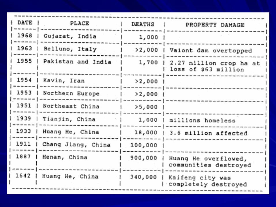
4. DAMAGES OF FLOODING4. DAMAGES OF FLOODING
Study the table below showing historic floods Study the table below showing historic floods around the world. around the world.

Effects of flooding on cropping:Effects of flooding on cropping:
Massive flooding cause outright and destruction of Massive flooding cause outright and destruction of crops, and excessive prolonged waterlogging. Alluvcrops, and excessive prolonged waterlogging. Alluvium though deposited cannot be readily usable.ium though deposited cannot be readily usable.
Controlled or small-scale flooding does not bring so Controlled or small-scale flooding does not bring so much harm and may be beneficial at times – it depmuch harm and may be beneficial at times – it deposits a lot of alluvium, which can be readily used by osits a lot of alluvium, which can be readily used by crops after the surface water recedes by evaporatiocrops after the surface water recedes by evaporation and drainage. n and drainage.

5. FLOODING :5. FLOODING : PEOPLE'S PEOPLE'S RESPONSES TO FLOODSRESPONSES TO FLOODS

Geographers and psychologists studying peGeographers and psychologists studying people's perceptions of natural hazards have gople's perceptions of natural hazards have gone a longone a long way way to help use understand how to help use understand how people will interpret various hazards and respeople will interpret various hazards and respond to public education programmes or hapond to public education programmes or hazard warning and preparation schemes. zard warning and preparation schemes.

They have found that people exhibit a range They have found that people exhibit a range of responses - from accepting the hazard as of responses - from accepting the hazard as an Act of God, inevitable and uncontrollable, an Act of God, inevitable and uncontrollable, through trying to predict hazardous events, through trying to predict hazardous events, taking appropriate action to reduce the taking appropriate action to reduce the damage potential, to offsetting the losses damage potential, to offsetting the losses through insurance. through insurance.
A range of hazard perceptions and samples A range of hazard perceptions and samples of common response in the case of flooding of common response in the case of flooding are provided in the following figure. are provided in the following figure.


The hazard research discovered to explain the great The hazard research discovered to explain the great variety of perceptions and responses:variety of perceptions and responses:
1.1. The past record of hazards, especially magnitude, frequeThe past record of hazards, especially magnitude, frequency and tedency;ncy and tedency;
2.2. The strength of traditional cultures, especially people's attThe strength of traditional cultures, especially people's att
itudes to the environment; itudes to the environment;
3. Education standards in the community; 3. Education standards in the community;
4. Relative levels of wealth and economic development; 4. Relative levels of wealth and economic development;

5. community awareness and preparations; 5. community awareness and preparations;
6. willingness of local and national 6. willingness of local and national government to spend money on long-term government to spend money on long-term hazard prevention and damage reduction hazard prevention and damage reduction schemes compared with short-term schemes compared with short-term emergency relief after a disaster. emergency relief after a disaster.