f5 arup ecology scoping report 2013 - scambs.gov.uk · a bat scoping survey was conducted on...
TRANSCRIPT

Homes and Communities Agency Northstowe Phase 2 Environmental Statement
F5 Arup Ecology Scoping Report 2013
| |
Page F5
Homes and Communities Agency Northstowe Phase 2Ecology Scoping Report
| Issue | 16 January 2014
J:\230000\230781 NORTHSTOWE PHASE 2 PLANNING APPLICATION\22_23_24 APPL PREP\4 INTERNAL\4 ENV\4.06 REPORTS\SCOPING\APPENDICES\APPENDIX D\ECOLOGY SCOPING REPORT FINAL ISSUE.DOCX
Page 17
[19]. Environment Agency, (1999); ‘Otters and River Habitat Management (Second Edition).’ Bristol.
[20]. English Nature, (2001); ‘Great Crested Newt Mitigation Guidelines.’ Peterborough.
[21]. Froglife, (1999); ‘Froglife Advice Sheet 10; Reptile Survey. An Introduction to Planning, Conducting and Interpreting Surveys for Snake and Lizard Conservation.’
[22]. Natural England, (2011); ‘Standing Advice Species Sheet: Reptiles.’
[23]. Bibby, C.J., Burgess, N.D., Hill, D.A. and Mustoe, S., (2007); ‘Bird Census Techniques. (Second Edition).’ Academic Press, London.
[24]. Her Majesties Stationary Office (HMSO) (1981); ‘Wildlife and Countryside Act 1981.’
[25]. Environment Agency, (2008); ‘Technical Reference Material: Freshwater Macroinvertebrate Sampling in Rivers.’
[26]. Biggs J., Fox, G., Nicolet, P., Walker, D., Whitfield, M. and Williams, P. (1998); ‘A Guide to the Methods of the National Pond Survey.’ Pond Action, Oxford.
[27]. International Union for Conservation of Nature and Natural Resources (IUCN), (2013); ‘IUCN Red List of Threatened Species.’ Available at: http://www.iucnredlist.org/.
[28]. Bickmore, C J. (2002); ‘Hedgerow Survey Handbook.’
[29]. HMSO, (1997); ‘Hedgerow Regulations 1997.’
[30]. Scottish Natural Heritage, (no date); ‘Best Practice Guidance – Badger Surveys.’

Homes and Communities Agency Northstowe
Ecology Report
Issue | 15 May 2014
This report takes into account the particular instructions and requirements of our client.
It is not intended for and should not be relied upon by any third party and no responsibility is undertaken to any third party. Job number 230781
Ove Arup & Partners Ltd 13 Fitzroy Street London W1T 4BQ United Kingdom www.arup.com

Homes and Communities Agency NorthstoweEcology Report
| Issue | 15 May 2014
J:\230000\230781 NORTHSTOWE PHASE 2 PLANNING APPLICATION\230781-05 NORTHSTOWE ECOLOGY\4 INTERNAL PROJECT DATA\REPORTS\ECOLOGY REPORT\BREEDING BIRDS UPDATE\ECOLOGY REPORT_FINAL FOR ES.TM.DOCX
Page 1
Contents
Page
1 Executive Summary 4
2 Introduction 7
2.1 Background 7 2.2 Scope of Work 8 2.3 Relevant Legislative and Biodiversity Context 9
3 Methods 12
3.1 Extended Phase 1 Habitat Survey 12 3.2 Bat Surveys 12 3.3 Badger Survey 15 3.4 Breeding Bird Survey 16 3.5 Great Crested Newt Surveys 18 3.6 Reptile Survey 19 3.7 Hedgerow Regulations Survey 21 3.8 General Limitations 22
4 Results 23
4.1 Extended Phase 1 Habitat Survey 23 4.2 Bat Surveys 26 4.3 Badger Survey 57 4.4 Breeding Bird Survey 57 4.5 Great Crested Newt Surveys 66 4.6 Reptile Survey 68 4.7 Hedgerow Regulations Survey 71
5 Discussion 72
5.1 Bats 72 5.2 Badgers 74 5.3 Breeding Birds 75 5.4 Amphibians 76 5.5 Reptiles 77 5.6 Hedgerows 77
6 Recommendations 79
6.1 General Approach 79 6.2 Mitigation 79 6.3 Enhancements 84 6.4 Further Work 87

Homes and Communities Agency NorthstoweEcology Report
| Issue | 15 May 2014
J:\230000\230781 NORTHSTOWE PHASE 2 PLANNING APPLICATION\230781-05 NORTHSTOWE ECOLOGY\4 INTERNAL PROJECT DATA\REPORTS\ECOLOGY REPORT\BREEDING BIRDS UPDATE\ECOLOGY REPORT_FINAL FOR ES.TM.DOCX
Page 2
Tables Table 1: Scope of Surveys Undertaken Table 2: Bat Activity Surveys on the Site Table 3: Breeding Bird Survey Visit Details Table 4: Great Crested Newt Surveys on the Site Table 5: Reptile Survey Visits Table 6: DOMIN Scale used for Assessing Plant Cover Abundance Table 7: Potential of Buildings within the Site to Support Roosting Bats Table 8: Potential of Trees within the Site to Support Roosting Bats Table 9: Summary of Automated Survey Data within the Site Table 10: All Bird Species Recorded and their Site Breeding Status Table 11: Key Bird Species Recorded at the Site Table 12: Habitat Suitability Indices Results Table 13: Great Crested Newt Presence/Absence Survey Results Table 14: Reptile Survey Results Table 15: Combined Reptile Survey Results Table 16: Criteria for Estimating Common Lizard and Grass Snake Populations Table 17: Hedgerows of Importance Figures Figure 1: Site Layout Figure 2: Breeding Bird Transect Routes Figure 3: Phase 1 Habitat Map Figure 4: Bat Roost Potential Figure 5: Bat Activity Survey Methods and Results Figure 7: Territory Map of Schedule 1 and Red Listed Bird Species Figure 8: Territory Map of Amber Listed Bird Species Figure 9: Locations of Artificial Reptile Refugia and Results Figure 10: Important Hedgerows Location Map Appendices
Appendix A
Invertebrate Survey Report
Appendix B
Raw Automated Bat Survey Data
Appendix C

Homes and Communities Agency NorthstoweEcology Report
| Issue | 15 May 2014
J:\230000\230781 NORTHSTOWE PHASE 2 PLANNING APPLICATION\230781-05 NORTHSTOWE ECOLOGY\4 INTERNAL PROJECT DATA\REPORTS\ECOLOGY REPORT\BREEDING BIRDS UPDATE\ECOLOGY REPORT_FINAL FOR ES.TM.DOCX
Page 3
European Bird Census Council Breeding Categories

Homes and Communities Agency NorthstoweEcology Report
| Issue | 15 May 2014
J:\230000\230781 NORTHSTOWE PHASE 2 PLANNING APPLICATION\230781-05 NORTHSTOWE ECOLOGY\4 INTERNAL PROJECT DATA\REPORTS\ECOLOGY REPORT\BREEDING BIRDS UPDATE\ECOLOGY REPORT_FINAL FOR ES.TM.DOCX
Page 4
1 Executive Summary
The Homes and Communities Agency (HCA) commissioned Ove Arup & Partners Limited (Arup) to undertake a range of ecology surveys to inform future planning applications for the proposed Northstowe new town in Cambridgeshire. It is currently expected that planning applications will start to be submitted in 2014. The site has been divided into the following areas that are referred to below: land north of Rampton Road (including Larksfield Nursery and Brookfield Farm); land to the west of Long Lane; Oakington Barracks and Airfield; and the Off-Site Infrastructure Area (OSIA). Two planning applications are due to be submitted in 2013, comprising Phase 2 in the northern half of Oakington Barracks and Airfield as well as associated infrastructure between Phase 2 and the A14.
A range of habitat and protected species surveys were conducted between May and November 2013 to supplement previous surveys carried out on the site. An extended Phase 1 habitat survey was conducted within the land north of Rampton Road and Oakington Barracks and Airfield. This survey identified habitats that have a potential to support bats, badger, reptiles and amphibians, although no additional ponds were recorded. However, it was not possible to access land at Larksfield Nursery, which should be subject to an extended Phase 1 habitat survey, badger and bat scoping survey and Hedgerow Regulations survey prior to submitting the planning application. This work should be carried out between March and April 2014.
A bat scoping survey was conducted on buildings and trees within the site, which identified the presence of 27 buildings that have a low or moderate potential to support roosting bats, as well as one confirmed roost within the bungalow at Brookfield Farm. Furthermore, 352 trees have a potential to support roosting bats, along with three woodlands. Bat activity and automated surveys were also carried out, which identified important foraging areas for bats along Long Lane, the lake at Oakington Barracks and Airfield (Pond 3), as well as the access road into the barracks, Oakington Brook and Wilson’s Road. Bat emergence and return surveys should be conducted on trees and buildings that could be affected by the proposed developments. This work should be carried out between May and June 2014. A European Protected Species Mitigation licence will be required with respect to any bat roosts that have a potential to be affected as a result of the proposed developments. Mitigation will also be required to minimise disturbance to bats due to lighting. Suitable roosting, foraging and commuting habitat should be incorporated into the proposed developments.
A badger scoping survey was carried out and 31 setts were recorded, of which 25 were well-used, five were partially disused and one was disused. High levels of badger activity were recorded, in line with the results of the previous surveys, including four main setts. The badger setts should be retained where possible, particularly the main setts. A licence would be required to close any active setts and artificial setts would need to be created prior to the closure of main setts. It would be necessary to establish buffer zones around the setts to avoid disturbance, with a licence also required where works are required within these zones. The foraging habitat around the setts should also be retained and enhanced. Considering the complex nature of the badger activity within the site, the status of badger setts within the site and the territorial boundaries of the social groups should be confirmed by conducting a badger bait-marking survey, including

Homes and Communities Agency NorthstoweEcology Report
| Issue | 15 May 2014
J:\230000\230781 NORTHSTOWE PHASE 2 PLANNING APPLICATION\230781-05 NORTHSTOWE ECOLOGY\4 INTERNAL PROJECT DATA\REPORTS\ECOLOGY REPORT\BREEDING BIRDS UPDATE\ECOLOGY REPORT_FINAL FOR ES.TM.DOCX
Page 5
within suitable habitat 40m beyond the site boundary. This work should be undertaken between February and April 2014.
Two breeding bird surveys were carried out by Arup between May and June 2013 within the OSIA, land north of Rampton Road and land to the west of Long Lane, with two further surveys undertaken in March and April 2014. An additional survey was carried out within Oakington Barracks and Airfield and land north of Rampton Road in June 2013, to replicate the survey carried out by URS in 2012 when the conditions were suboptimal. A total of 73 species of birds were recorded at the site. Of these, 61 were either confirmed as breeding or probably breeding on the site. The site supports three Schedule 1 species – two confirmed as breeding (hobby and barn owl) and one non-breeding (fieldfare), plus 13 red list species and 21 amber list species, the majority of which were considered to be breeding at the site. The results indicate that the site is of local importance, with 42 species confirmed as breeding within the site. The inclusion of probable breeders would increase this count to 61, which would indicate that the site is of county importance. Habitat clearance should occur outside of the main breeding bird season (March to August inclusive) and where this is not possible, a suitably qualified ecologist will need to check for the presence of breeding birds prior to the commencement of clearance and demolition. Measures will also need to be implemented to avoid disturbance to breeding birds. Potential habitat loss associated with land clearance should be compensated for by the creation and enhancement of a range of habitat types. Nesting and foraging habitat for birds should be incorporated into the proposed development, including nest boxes for barn owl within the proposed buildings.
A great crested newt Habitat Suitability Indices (HSI) survey was carried out on eight ponds recorded within the site, with presence/absence surveys conducted on six of these ponds (Ponds 1-6). Ponds 2 and 5 fall within the good suitability category, Ponds 1, 4 and 7 into the average suitability category and Ponds 3, 6 and 8 into the poor suitability category. Great crested newt was recorded in Pond 4, with a maximum count of 1, which indicates that the site supports a small population. However, URS recorded great crested newt in Ponds 1, 2 and 4, with a peak count of 13, which indicates a medium population. Adopting a precautionary approach, it is concluded that a medium population of great crested newt is present on the site. An approved European Protected Species (EPS) Mitigation Licence will be required prior to the commencement of clearance of works. Where possible, Ponds 1, 2 and 4 should be retained, protected and enhanced during the future development of the site, as well as the surrounding terrestrial habitat. Where it is not possible to retain these ponds, further on or off-site ponds would need to be created. Pond 3 should also be retained, as it was found to provide valuable breeding habitat for common toad. Ponds 5 and 7 should be subject to a presence/absence survey between mid-March and mid-June 2014. Six ponds within 500m of the site should be subject to an HSI survey and presence/absence survey as appropriate, access permitting.
Four reptile surveys were undertaken across the site during September to complement the seven surveys carried out by URS in 2012 and inform population estimates. Grass snake and common lizard were recorded within the site, in line with the results of the previous surveys. A low population of common lizard was recorded within the OSIA. Furthermore, a low population of grass snake and a good population of common lizard were recorded within Oakington Barracks and Airfield. The proposed developments will be phased, thus providing an
Homes and Communities Agency NorthstoweEcology Report
| Issue | 15 May 2014
J:\230000\230781 NORTHSTOWE PHASE 2 PLANNING APPLICATION\230781-05 NORTHSTOWE ECOLOGY\4 INTERNAL PROJECT DATA\REPORTS\ECOLOGY REPORT\BREEDING BIRDS UPDATE\ECOLOGY REPORT_FINAL FOR ES.TM.DOCX
Page 6
opportunity to enhance certain areas of the site for reptiles that would act as receptor sites for any reptiles displaced by sensitive clearance works in other parts of the site. These enhancements should be implemented prior to the commencement of clearance works in other areas.
The important hedgerows within the site were surveyed in June 2013, to update the previous survey undertaken by WSP Environmental Ltd. in 2004. The hedgerows were re-evaluated for importance in accordance with the Wildlife or Landscape criteria of The Hedgerow Regulations 1997; the Section 41 list of habitats of principal importance in conserving biodiversity; the Cambridgeshire and Peterborough Biodiversity Action Plan; and within the site context. Since 2004, two hedgerows have been removed and one has been partially removed. A total of 29 important hedgerows were recorded, including one hedge along Long Lane that is ‘Important’ according to Wildlife and Landscape criteria of The Hedgerows Regulations 1997 because it supports more than seven ‘woody’ species. Hedgerow 102 is now located within the southeast corner of the site near to the A14. The other 28 important hedgerows remain unchanged since 2004. The retained hedgerows should be enhanced and opportunities should be sought to link the existing hedgerows with native species-rich hedgerows.
Further surveys are recommended prior to the submission of the planning applications in addition to those described above. This comprises an update fish survey along Oakington Brook, further invertebrate surveys between April and June 2014 and an arboricultural survey. It is also recommended that biodiversity offsetting is carried out to establish the baseline conditions of the site in terms of biodiversity units and the losses and gains to biodiversity as a result of the proposed development.

Homes and Communities Agency NorthstoweEcology Report
| Issue | 15 May 2014
J:\230000\230781 NORTHSTOWE PHASE 2 PLANNING APPLICATION\230781-05 NORTHSTOWE ECOLOGY\4 INTERNAL PROJECT DATA\REPORTS\ECOLOGY REPORT\BREEDING BIRDS UPDATE\ECOLOGY REPORT_FINAL FOR ES.TM.DOCX
Page 7
2 Introduction
2.1 Background The Homes and Communities Agency (HCA) commissioned Ove Arup & Partners Limited (Arup) to undertake a range of ecology surveys to inform future planning applications for the proposed Northstowe new town in Cambridgeshire. It is currently expected that planning applications will start to be submitted in 2014.
The surveys are considered necessary to update previous surveys undertaken on the site by WSP Environmental Ltd (WSP) between July 2003 and November 2007 [1] and URS Infrastructure and Environment UK Limited (URS) between April and October 2012 [2] [3]. These surveys were carried out across the Northstowe site, including areas proposed for offsite infrastructure. Terence O’Rourke also completed ecology surveys in 2011 in support of the proposals that were subsequently approved for Phase 1 of the development at the northern end of the site.
2.1.1 The Site
The site is centred at Ordnance Survey grid reference TL 40101 65222, to the northwest of Cambridge. The site is bounded by Oakington to the southeast, Longstanton to the northwest, the A14 to the southwest and the Cambridgeshire Guided Busway (CGB) to the northeast. The site is shown in Figure 1 and has been divided into the following areas that are referred to in this report:
Land north of Rampton Road, which contains Brookfield Farm and Larksfield Nursery;
Land to the west of Long Lane, which is located to the west of Oakington Barracks and Airfield and is dominated by pasture fields;
Oakington Barracks and Airfield, which comprises the majority of the northern part of the site, including cattle-grazed grassland, arable fields, plantation woodland and scattered buildings and hardstanding; and
The Off-Site Infrastructure Area (OSIA) to the south of Oakington Barracks and Airfield, which is dominated by arable farmland. Longstanton and Oakington Brooks flow northeast through the OSIA. This part of the site lies adjacent to the Hatton’s Road attenuation pond area that formed part of the Phase 1 planning application boundary.
2.1.2 Proposed Development
The planning application boundaries for Phase 2 and the associated access roads were unclear prior to the commencement of the ecology surveys and were potentially to include all or parts of the areas shown on Figure 1. Therefore all areas shown on Figure 1 have been included in our proposed scope of work. Certain details regarding these future planning applications have since been clarified, which are outlined below.
An outline planning application for Phase 2 of the proposed development is expected to be submitted in late spring 2014. The development will be located at

Homes and Communities Agency NorthstoweEcology Report
| Issue | 15 May 2014
J:\230000\230781 NORTHSTOWE PHASE 2 PLANNING APPLICATION\230781-05 NORTHSTOWE ECOLOGY\4 INTERNAL PROJECT DATA\REPORTS\ECOLOGY REPORT\BREEDING BIRDS UPDATE\ECOLOGY REPORT_FINAL FOR ES.TM.DOCX
Page 8
the northern half of Oakington Barracks and Airfield and is likely to comprise a mix of uses such as dwellings, employment areas primary and secondary schools and sports hubs [4], [5]. Interconnecting wildlife corridors and green buffers are expected to be incorporated, including ‘ponds and ditches, meadows and scrub, retained landscape features, green links and linear parks to create a mosaic of habitats and green space utilising and emphasising water features’ [5]. A green buffer is proposed between Longstanton and the built development. In conjunction with the above, it is expected that a separate detailed planning application will be submitted in conjunction with the Phase 2 planning application for a new access road between Phase 2 and Hatten’s Road, as well as an extension to the CGB to provide connectivity to the site.
2.2 Scope of Work
2.2.1 Objectives
Arup was commissioned to complete a gap analysis of the existing baseline ecology reports relating to the site, to identify further work required to inform the future planning applications. The results of this work are outlined in a separate Ecology Scoping Report [6].
This report outlines the methods and results of the first tranche of surveys completed in 2013, in accordance with the recommendations made in the Ecology Scoping Report. It also provides recommendations for further survey work, mitigation and enhancement. Invertebrate surveys were also carried out on the site in 2013, the results of which are outlined in a separate report contained in Appendix A.
2.2.2 Habitat and Protected Species Surveys
A range of habitat and protected species surveys were carried out across the site between May 2013 and April 2014, as shown in Table 1. Further details regarding the methods of these surveys are provided in Section 3.
Table 1: Scope of Surveys Undertaken Survey Timing
Extended Phase 1 habitat survey August
Bat scoping and inspection survey July, September and November
Bat activity and automated survey May to September
Badger survey May to July
Breeding bird survey May and June 2013 and March and April 2014
Great crested newt habitat suitability indices (HSI) and presence/absence surveys
May and June
Reptile survey August and September
Hedgerow Regulations survey June

Homes and Communities Agency NorthstoweEcology Report
| Issue | 15 May 2014
J:\230000\230781 NORTHSTOWE PHASE 2 PLANNING APPLICATION\230781-05 NORTHSTOWE ECOLOGY\4 INTERNAL PROJECT DATA\REPORTS\ECOLOGY REPORT\BREEDING BIRDS UPDATE\ECOLOGY REPORT_FINAL FOR ES.TM.DOCX
Page 9
2.3 Relevant Legislative and Biodiversity Context
2.3.1 Bats
All bat species are fully protected under the Wildlife and Countryside Act 1981 [7] (as amended) (WCA) and The Conservation of Habitats and Species Regulations 2010 [8] (as amended) (Habitats and Species Regulations), which together make it an offence to:
Intentionally or recklessly capture, kill or injure bats; Deliberately disturb bats (including when they are outside their roosts) or
intentionally or recklessly disturb roosting bats; or Damage or destroy their roosts or intentionally or recklessly obstruct access to
their roosts (whether bats are present or not).
Under the Habitats and Species Regulations, disturbance includes in particular any disturbance which is likely to impair their ability to survive; breed or reproduce; rear or nurture their young; or hibernate or to affect significantly the local distribution or abundance of the species.
Some bat species are also listed under relevant Biodiversity Action Plans (BAP), which identify priorities for conservation as required under the Convention on Biological Diversity in 1992 [9]. The UK Post-2010 Biodiversity Framework [10] superseded the UK Biodiversity Action Plan [11], but the lists of priority species and habitats continue to provide valuable reference sources while a National Biodiversity Strategy and/or Action Plan (NBSAP) is being produced. Bat species listed under the former UK BAP that could be relevant to the site are barbastelle bat Barbastella barbastellus, noctule Nyctalus noctula, soprano pipistrelle Pipistrellus pygmaeus and brown long-eared bat Plecotus auritus. The UK BAP is relevant in the context of Section 40 of the Natural Environment and Rural Communities (NERC) Act 2006 [12], meaning that Priority Species and Habitats are material considerations in planning. These species are also of principal importance in conserving biodiversity in England [13], as required under Section 41 of the NERC Act 2006.
Barbastelle bat is a particularly rare species of bat listed under Annex II of the Council Directive 92/43/EEC on the Conservation of natural habitats and of wild fauna and flora [14] (EC Habitats Directive). This Annex identifies species of community interest whose conservation requires the designation of Species Areas of Conservation (SACs). Eversden and Wimpole Woods SAC is designated on account of the presence of a maternity colony of barbastelle bat at Wimpole Woods, which is located approximately 12.5km southwest of the site.
Pipistrelle bats Pipistrellus sp. are also listed under the Cambridgeshire and Peterborough (Local) BAP [15].
2.3.2 Badgers
The Protection of Badgers Act 1992 [16] makes it an offence to wilfully kill, take, possess or cruelly ill-treat a badger, or attempt to do so; interfere with a sett by damaging or destroying it; obstruct access to, or any entrance of, a badger sett; or disturb a badger when it is occupying a sett.

Homes and Communities Agency NorthstoweEcology Report
| Issue | 15 May 2014
J:\230000\230781 NORTHSTOWE PHASE 2 PLANNING APPLICATION\230781-05 NORTHSTOWE ECOLOGY\4 INTERNAL PROJECT DATA\REPORTS\ECOLOGY REPORT\BREEDING BIRDS UPDATE\ECOLOGY REPORT_FINAL FOR ES.TM.DOCX
Page 10
2.3.3 Other Wild Mammals
The Wild Mammals (Protection) Act 1996 [17] makes it an offence to intentionally cause wild mammals’ any unnecessary suffering by certain methods, including crushing and asphyxiation.
Furthermore, brown hare Lepus europaeus is listed under the former UK BAP and Local BAP and is on the Section 41 list of species of principal importance in conserving biodiversity.
2.3.4 Breeding Birds
All birds, their active nests and eggs are protected under the WCA. This legislation makes it an offence to kill, injure or take any wild bird or to take, damage or destroy the nest of any wild bird while that nest is in use or being built.
Special penalties are given for these offences when related to birds listed on Schedule 1. The WCA makes it illegal to intentionally disturb any wild bird listed in Schedule 1 of the Act while it is building a nest or is in, or near a nest containing eggs or young or to disturb the dependent young.
Various bird species are listed under the former UK BAP and are on the Section 41 list of species of principal importance in conserving biodiversity, including dunnock Prunella modularis, song thrush Turdus philomelos, European turtle dove Streptopelia turtur and grey partridge Perdix perdix. In addition, grey partridge, sky lark Alauda arvensis and song thrush are listed on the Local BAP.
Birds are also assigned a category according to the Birds of Conservation Concern criteria [18]. This defines birds as Red, Amber of Green listed considering their rarity and any declines in their status.
2.3.5 Amphibians
2.3.5.1 Great Crested Newt
Great crested newt Triturus cristatus is fully protected under the WCA and Habitats and Species Regulations, which together make it an offence to:
Intentionally or recklessly capture, kill, injure or disturb great crested newts; and
Damage or destroy a breeding site or resting place for great crested newt or intentionally or recklessly obstruct access to any structure or place used for shelter or protection.
Under the Habitats and Species Regulations, disturbance includes in particular any disturbance which is likely to impair their ability to survive; breed or reproduce; rear or nurture their young; or hibernate or to affect significantly the local distribution or abundance of the species.
Great crested newt is also listed under the former UK BAP and the Local BAP and is on the Section 41 list of species of principal importance in conserving biodiversity.

Homes and Communities Agency NorthstoweEcology Report
| Issue | 15 May 2014
J:\230000\230781 NORTHSTOWE PHASE 2 PLANNING APPLICATION\230781-05 NORTHSTOWE ECOLOGY\4 INTERNAL PROJECT DATA\REPORTS\ECOLOGY REPORT\BREEDING BIRDS UPDATE\ECOLOGY REPORT_FINAL FOR ES.TM.DOCX
Page 11
2.3.5.2 Common Amphibians
Common amphibians, including common toad Bufo bufo, common frog Rana temporaria and smooth newt Lissotriton vulgaris, are only protected from sale under the WCA. Common toad is also listed under the former UK BAP and is on the Section 41 list of species of principal importance in conserving biodiversity.
2.3.6 Reptiles
Common reptiles, including common lizard Zootoca vivipara, slow worm Anguis fragilis and grass snake Natrix natrix, are listed on Schedule 5 of the WCA, which makes it illegal to deliberately or recklessly injure or kill these species. These species are also listed under the former UK BAP and are on the Section 41 list of species of principal importance in conserving biodiversity.
2.3.7 Hedgerows
The Hedgerow Regulations 1997 [19] includes criteria for the identification of important hedgerows, the removal of which requires approval from the local planning authority. A hedgerow is important if it has existed for 30 years or more; and satisfies at least one of the criteria listed in the regulations. This includes archaeology and history and wildlife and landscape criteria, the latter of which is relevant to this report. These relate to the presence of protected species, as well as woody and woodland species within the hedgerow.
Homes and Communities Agency NorthstoweEcology Report
| Issue | 15 May 2014
J:\230000\230781 NORTHSTOWE PHASE 2 PLANNING APPLICATION\230781-05 NORTHSTOWE ECOLOGY\4 INTERNAL PROJECT DATA\REPORTS\ECOLOGY REPORT\BREEDING BIRDS UPDATE\ECOLOGY REPORT_FINAL FOR ES.TM.DOCX
Page 12
3 Methods
3.1 Extended Phase 1 Habitat Survey The areas of the site that were not surveyed by URS in 2012 were subject to an extended Phase 1 habitat survey on 23rd August 2013, in accordance with the JNCC guidelines for Phase 1 habitat survey [20]. The survey area comprised the majority of the land north of Rampton Road and parts of Oakington Barracks and Airfield, where the former Barracks buildings were located (refer to Figure 1). This excluded Larksfield Nursery, as access was not permitted to this part of the site. This part of the site was mapped from aerial photography and is indicated on Figure 3.
The habitats were classified according to the Phase 1 habitat survey methodology, which informed updates to the Phase 1 Habitat Map prepared by URS in 2012 [2]. Higher plant species identified within each of the habitat parcels were recorded and their relative abundance was assessed using the DAFOR scale:
D Dominant; A Abundant; F Frequent; O Occasional; and R Rare (meaning ‘rarely encountered in the survey’ rather than inherently
uncommon as a species).
In addition ‘locally’ (L) was appended, where appropriate, to any of the above five categories in order to reflect a local distribution. It should be recognised that this scale represents relative abundance within each habitat type, rather than regional or national abundances. The Phase 1 survey was ‘extended’ to include an assessment of the potential of the surveyed areas to support notable and protected species. Incidental faunal observations were also recorded during the survey.
The survey included a search for invasive species listed on Part II of Schedule 9 of the WCA, such as Japanese knotweed Fallopia japonica.
3.2 Bat Surveys
3.2.1 Scoping and Inspection Survey
On 8th, 9th, 24th and 31st July, 30th September and 25th and 26th November 2013, a bat scoping and inspection survey was conducted across the site. The trees were inspected from the ground to assess their potential to support roosting bats and identify any signs to indicate their presence, particularly any staining that may be evident on tree trunks. This excluded the trees along Long Lane and around the fields to the west of Long Lane, as it is understood that that this part of the site will be retained as a buffer for the proposed Phase 2 development.
The buildings that were not surveyed by URS were inspected externally. Where these were deemed to have a potential to support roosting bats, for example due to the presence of an internal roof void, these were also inspected internally by a licensed bat worker (Natural England licence number 20123625) and an Arup
Homes and Communities Agency NorthstoweEcology Report
| Issue | 15 May 2014
J:\230000\230781 NORTHSTOWE PHASE 2 PLANNING APPLICATION\230781-05 NORTHSTOWE ECOLOGY\4 INTERNAL PROJECT DATA\REPORTS\ECOLOGY REPORT\BREEDING BIRDS UPDATE\ECOLOGY REPORT_FINAL FOR ES.TM.DOCX
Page 13
ecologist experienced in conducting internal inspections, with the aid of a ladder and high powered torch, access permitting. The only exceptions were the private house adjacent to Welney Farms Ltd (B35), which will not be affected by the proposed Phase 2 or infrastructure works. Larksfield Nursery (B80-90) (within the land north of Rampton Road) could not be inspected externally or internally due to a lack of access to this part of the site. The buildings were inspected using aerial photography.
The trees and buildings were assessed for their suitability to support roosting bats based on the current Bat Conservation Trust (BCT) Good Practice Guidelines [21] as follows:
Negligible potential/Category 3 - No features that could be used by bats (for roosting, foraging or commuting);
Low potential/Category 2 – A small number of potential roosting features, isolated habitat that could be used by foraging bats, e.g. a lone tree or patch of scrub but not parkland and an isolated site not connected by prominent linear features (but if suitable foraging habitat is adjacent it may be valuable if it is all that is available);
Moderate potential/Category 1 - Several potential roosting features, habitat could be used by foraging bats e.g. trees, shrub, grassland or water and the site is connected with the wider landscape by linear features that could be used by commuting bats e.g. lines of trees and scrub or linked back gardens;
High potential/Category 1* – Features of particular significance for roosting bats, habitat of high quality for foraging bats e.g. broadleaved woodland, tree-lined watercourses and grazed parkland and the site is connected with the wider landscape by strong linear features that would be used by commuting bats e.g. river/stream valleys or hedgerows, site is close to known roosts; and
Confirmed roosting - Evidence indicates that roosting bats are present, e.g. bats seen roosting or observed flying from a roost or freely in the habitat; droppings, carcasses, feeding remains, etc. found; and/or bats heard ‘chattering’ inside on a warm day or at dusk and bats recorded/observed using an area for foraging or commuting.
The trees of at least Category 2 potential were labelled on a map of the site and located using 10-digit Ordnance Survey (OS) grid references. The buildings of at least low potential were also identified.
3.2.2 Activity Survey
Bat activity surveys were undertaken on the site between May and September 2013. With reference to the BCT guidelines, the site was considered to be large and of medium habitat quality and, as such, monthly surveys were undertaken within the site. The purpose of these surveys was to supplement the data obtained by URS in 2012 [3], as follows:
The transects surveyed by URS within Oakington Barracks and Airfield between June and September 2012 were repeated in May 2013;
The transects surveyed by URS within the OSIA between July and September 2012 were repeated in May and June 2013; and

Homes and Communities Agency NorthstoweEcology Report
| Issue | 15 May 2014
J:\230000\230781 NORTHSTOWE PHASE 2 PLANNING APPLICATION\230781-05 NORTHSTOWE ECOLOGY\4 INTERNAL PROJECT DATA\REPORTS\ECOLOGY REPORT\BREEDING BIRDS UPDATE\ECOLOGY REPORT_FINAL FOR ES.TM.DOCX
Page 14
The areas of the site that were not previously surveyed by URS (land north of Rampton Road and west of Long Lane) were surveyed between May and September 2013.
Dusk activity surveys were carried out as above, in addition to a dawn activity survey in August. The dusk activity surveys commenced around sunset and transects were walked for approximately two hours, apart from the first survey that started and finished later. The dawn survey started two hours prior to sunrise and was completed at sunrise. The transect routes are shown in Figure 5. Stopping points were employed in key locations and the routes were alternated to avoid any bias in the data in terms of activity in different areas of the site at different times.
The surveyors were equipped with an Anabat SD1 or SD2 bat detector or a Batbox Duet attached to a Roland R-09 portable stereo recorder. The Roland data was analysed using BatSound and the Anabat data using Analook, with reference to current guidelines [22].
The transects walked during each survey, as well as the dates, times and weather conditions are shown in Table 2, with reference to Figure 5.
Table 2: Bat Activity Surveys on the Site Date Transects Survey
Type(s) Sunset/ Sunrise Times
Start-End Times
Weather Conditions
29/05 1-3 Dusk activity
21:07 22:15 - 00:15
Minimum temperature 14.8°C, dry, 8/8 cloud, still
30/05 4-7 Dusk activity
21:08 21:25 – 23:30
Minimum temperature 13°C, dry start leading to light drizzle, 8/8 cloud, light to moderate wind
17/06 1-3 and 6 Dusk activity
21:24 21:45 – 00:00
Minimum temperature 11°C, dry to light drizzle, 1/8 cloud, light wind
08/07 6 Dusk activity
21:22 21:22 – 23:00
Minimum temperature 17.5°C, dry, 0/8 cloud, still
22/08 6 Dusk activity
20:08 20:25 – 22:50
Minimum temperature 18°C, dry, 3/8 cloud, light wind
23/08 6 Dawn activity
05:55 03:55 – 05:55
Minimum temperature 15.4°C, dry, 7/8 cloud, light wind
19/09 6 Dusk activity
19:05 19:20 – 21:45
Minimum temperature 13°C, dry, 7/8 cloud, still
3.2.3 Automated Survey
In conjunction with each activity survey, SM2BAT+ and Anabat SD2 bat detectors were located on the site to record bat passes. Their locations are shown in Figure 5. For consistency, the static detectors were located in approximately the same locations as per URS’ survey in 2012.
In accordance with the requirements of the BCT guidelines with respect to large sites of medium habitat quality, two automated devices were employed along each transect. These were in situ each month that activity surveys were carried out

Homes and Communities Agency NorthstoweEcology Report
| Issue | 15 May 2014
J:\230000\230781 NORTHSTOWE PHASE 2 PLANNING APPLICATION\230781-05 NORTHSTOWE ECOLOGY\4 INTERNAL PROJECT DATA\REPORTS\ECOLOGY REPORT\BREEDING BIRDS UPDATE\ECOLOGY REPORT_FINAL FOR ES.TM.DOCX
Page 15
along those transects to supplement the data obtained by URS in 2012, with reference to Table 2. Up to five nights of data from each automated device were analysed using Analook.
3.2.4 Limitations
The bat scoping survey was predominantly undertaken between July and September 2013, which is not an ideal time to conduct this work as the leaves restrict the view of features that may provide roosting habitat for bats.
The bat activity survey within the OSIA in May started just over an hour late and therefore did not coincide with a peak in bat activity after sunset. This was not considered to be a significant constraint, considering that this data will be analysed in conjunction with extensive bat activity and automated survey data that will be used to assess the importance of the site for foraging and commuting bats. Transect route 1 had to be altered slightly when compared to the route walked by URS in 2012, due to suspected lamping along the planned route. The route that was walked is shown on Figure 5. Transect route 6 could not be completed during the surveys in June and July, as it was not possible to survey the fields at Brookfield Farm.
One of the static detectors (SD6) was relocated during the survey period. It was originally located further from the lake, at grid reference TL4045765421, but was relocated to the position shown on Figure 5 on 31st May to detect bat activity over the lake. Furthermore, SD11 was located further north than the location shown on Figure 5 during the survey in May, at grid reference TL 39152 65624. It is not thought that this would significantly affect the survey results as the data would likely be comparable to the location shown on Figure 5. In a few cases, less than five nights of automated survey data were obtained, due to technical problems with the static bat detectors. SD13 did not record any data during the June survey period. The survey periods for each static detector are identified in Appendix B. These factors are not considered to significantly affect the robustness of the results when considered in conjunction with the URS survey data.
Bats show great variety in their calls depending on the surrounding habitat and species call parameters overlap, meaning that it was not always possible to identify bats to species level. Bats identified as pipistrelle bats are either common or soprano pipistrelle bats; or common pipistrelle or Nathusius’ pipistrelle Pipistrellus nathusii. Furthermore, noctule or Leisler’s bat Nyctalus leisleri calls were identified as Nyctalus sp. and Leisler’s bat or serotine Eptesicus serotinus calls as ‘big bats’.
3.3 Badger Survey On 30th and 31st May, 4th and 11th June and 30th July 2013, a badger Meles meles survey was carried out, which focussed on re-assessing the setts recorded during previous surveys by URS and WSP. Access was obtained to all areas apart from Larksfield Nursery. Any signs to indicate the presence of badgers were recorded, including sett entrances, hairs, latrines and tracks and the setts were classified in accordance with Harris et al. (1989) [23].

Homes and Communities Agency NorthstoweEcology Report
| Issue | 15 May 2014
J:\230000\230781 NORTHSTOWE PHASE 2 PLANNING APPLICATION\230781-05 NORTHSTOWE ECOLOGY\4 INTERNAL PROJECT DATA\REPORTS\ECOLOGY REPORT\BREEDING BIRDS UPDATE\ECOLOGY REPORT_FINAL FOR ES.TM.DOCX
Page 16
3.3.1 Limitations
Badger surveys should ideally be carried out in the spring or early autumn/winter [24], when dense vegetation is less likely to obscure sett entrances and other signs. Some of the surveys were carried out in the summer. This was not generally considered to affect the survey results considering the nature of habitats surveyed and since the majority of the survey effort involved confirming the status of setts that had already been mapped. The badger setts are predominantly located in plantation woodland and grazed grassland, where badger signs were readily identifiable and not obscured by dense scrub or tall ruderal vegetation. The only exception to this relates to sett 23 located along a ditch within the OSIA (refer to Table 9 and Figure 6), as the presence of dense vegetation made it difficult to confirm the status of the sett.
The setts have been characterised based on the field signs recorded during the survey. However, a badger bait marking survey would be required in order to verify the status of the setts at the site, particularly with respect to the main setts (refer to Section 6.4.3).
Badger surveys should ideally be carried out within 30m of the site boundary, in order to identify any setts located outside the site that could be affected by the proposed development. This was not possible as access was not granted beyond the boundaries of the site.
3.4 Breeding Bird Survey The breeding bird surveys were undertaken to supplement surveys undertaken by URS between May and June 2012 [3]. URS conducted three breeding bird surveys, but it was recognised that the final survey in June was carried out during sub-optimal conditions, due to heavy showers. There is also no survey data from early in the survey season and some areas of the site were not surveyed.
The general principles of the Common Bird Census (CBC) methodology [25], [26] were employed during each of the survey visits. The CBC methodology was designed by the British Trust for Ornithology (BTO) to monitor populations of common breeding birds, particularly song birds, which are most vocally active during the early morning.
Set transect routes were walked on each occasion (Figure 2), with the surveyor able to walk to within at least 10m of all areas, ensuring all birds present could be seen and/or heard. Four breeding bird surveys were carried out by Arup between May and June 2013 and March and April 2014, covering areas of the site that were not previously surveyed, comprising the OSIA, land north of Rampton Road and land to the west of Long Lane (transects 1-3, Figure 2).
An additional survey was carried out within Oakington Barracks and Airfield and land north of Rampton Road (transects 4 and 5, Figure 2) in June 2013. Only one survey visit was carried out in this part of the site, as a repeat of the survey carried out by URS when the weather conditions were suboptimal.
Each survey was carried out over two mornings, with these visits commencing shortly after dawn and being completed by 9.00am. A pair of 8 x 32 binoculars was used for observations. During the surveys, all birds that were seen or heard, together with evidence of breeding behaviour, were recorded on large scale maps
Homes and Communities Agency NorthstoweEcology Report
| Issue | 15 May 2014
J:\230000\230781 NORTHSTOWE PHASE 2 PLANNING APPLICATION\230781-05 NORTHSTOWE ECOLOGY\4 INTERNAL PROJECT DATA\REPORTS\ECOLOGY REPORT\BREEDING BIRDS UPDATE\ECOLOGY REPORT_FINAL FOR ES.TM.DOCX
Page 17
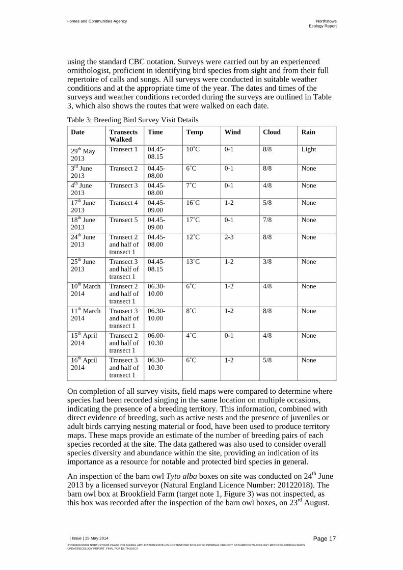
using the standard CBC notation. Surveys were carried out by an experienced ornithologist, proficient in identifying bird species from sight and from their full repertoire of calls and songs. All surveys were conducted in suitable weather conditions and at the appropriate time of the year. The dates and times of the surveys and weather conditions recorded during the surveys are outlined in Table 3, which also shows the routes that were walked on each date.
Table 3: Breeding Bird Survey Visit Details Date Transects
Walked Time Temp Wind Cloud Rain
29th May 2013
Transect 1 04.45-08.15
10˚C 0-1 8/8 Light
3rd June 2013
Transect 2 04.45-08.00
6˚C 0-1 8/8 None
4th June 2013
Transect 3 04.45-08.00
7˚C 0-1 4/8 None
17th June 2013
Transect 4 04.45-09.00
16˚C 1-2 5/8 None
18th June 2013
Transect 5 04.45-09.00
17˚C 0-1 7/8 None
24th June 2013
Transect 2 and half of transect 1
04.45-08.00
12˚C 2-3 8/8 None
25th June 2013
Transect 3 and half of transect 1
04.45-08.15
13˚C 1-2 3/8 None
10th March 2014
Transect 2 and half of transect 1
06.30-10.00
6˚C 1-2 4/8 None
11th March 2014
Transect 3 and half of transect 1
06.30-10.00
8˚C 1-2 8/8 None
15th April 2014
Transect 2 and half of transect 1
06.00-10.30
4˚C 0-1 4/8 None
16th April 2014
Transect 3 and half of transect 1
06.30-10.30
6˚C 1-2 5/8 None
On completion of all survey visits, field maps were compared to determine where species had been recorded singing in the same location on multiple occasions, indicating the presence of a breeding territory. This information, combined with direct evidence of breeding, such as active nests and the presence of juveniles or adult birds carrying nesting material or food, have been used to produce territory maps. These maps provide an estimate of the number of breeding pairs of each species recorded at the site. The data gathered was also used to consider overall species diversity and abundance within the site, providing an indication of its importance as a resource for notable and protected bird species in general.
An inspection of the barn owl Tyto alba boxes on site was conducted on 24th June 2013 by a licensed surveyor (Natural England Licence Number: 20122018). The barn owl box at Brookfield Farm (target note 1, Figure 3) was not inspected, as this box was recorded after the inspection of the barn owl boxes, on 23rd August.

Homes and Communities Agency NorthstoweEcology Report
| Issue | 15 May 2014
J:\230000\230781 NORTHSTOWE PHASE 2 PLANNING APPLICATION\230781-05 NORTHSTOWE ECOLOGY\4 INTERNAL PROJECT DATA\REPORTS\ECOLOGY REPORT\BREEDING BIRDS UPDATE\ECOLOGY REPORT_FINAL FOR ES.TM.DOCX
Page 18
3.4.1 Limitations
Ideally, all surveys would have been carried out in the same year, but project timescales did not allow for this in this case. No surveys can produce a definitive list of species or population sizes. However, based on professional opinion, it is considered that the surveys have produced a robust assessment of the populations and species diversity within the areas surveyed and provided a full data set for Oakington Barracks and Airfield in conjunction with URS’ survey data.
3.5 Great Crested Newt Surveys
3.5.1 Habitat Suitability Indices
In conjunction with the great crested newt presence/absence survey described in Section 3.5.2, the ponds within the site were assessed for their potential to support great crested newt in accordance with Oldham et al. (2000) [27]. The ponds were scored under ten categories. These categories each have a bearing on the suitability of waterbodies to support great crested newt. The scores were translated into Suitability Indices that were used to calculate a Habitat Suitability Index (HSI) for each pond.
3.5.2 Presence/Absence Survey
Between 20th May and 10th June 2013, a great crested newt presence/absence survey was undertaken on the ponds within the site by a licensed surveyor (Natural England licence number CLS001908 and CLS00709) and an assistant, with reference to the Great Crested Newt Mitigation Guidelines [28]. The exceptions to this are Ponds 7 and 8. Pond 7 was not surveyed as it was only recorded on 25th November. Pond 8 was not surveyed as it was dry throughout the survey period.
The aim of this work was to update survey work carried out by URS in 2012 [3], as only four survey visits were undertaken on ponds where great crested newt was recorded, although great crested newt was recorded in Ponds 1, 2 and 4 (refer to Figure 3). At least three methods were employed, selected out of bottle trapping, egg search, torching and netting.
Where possible, four survey visits were carried out on each pond where great crested newt was not recorded, increased to six where there was a positive result during the first four survey visits. There were deviations from the guidelines with respect to the timings of the surveys and number of surveys completed, which are discussed in Section 3.5.3.
The ponds are identified on Figure 3 and the dates and weather conditions during the surveys are outlined in Table 4. The weather conditions during each of the surveys were suitable for carrying out great crested newt surveys, with night-time air temperatures remaining well above 5°C.

Homes and Communities Agency NorthstoweEcology Report
| Issue | 15 May 2014
J:\230000\230781 NORTHSTOWE PHASE 2 PLANNING APPLICATION\230781-05 NORTHSTOWE ECOLOGY\4 INTERNAL PROJECT DATA\REPORTS\ECOLOGY REPORT\BREEDING BIRDS UPDATE\ECOLOGY REPORT_FINAL FOR ES.TM.DOCX
Page 19
Table 4: Great Crested Newt Surveys on the Site Visit Date Ponds Surveyed Weather Conditions
1 20-21/05 1-4 and 6 Air temperature 14.6°C, dry
2 21-22/05 1-4 and 6 Air temperature 11°C, dry 3 23-24/05 1-4 and 6 Air temperature 10.5°C, occasional
light showers 4 03-04/06 1-6 Air temperature 10.2°C, dry 5 04-05/06 1-6 Air temperature 11°C, dry 6 10-11/06 1-4* Air temperature 9°C, dry
*Pond 5 was dry and therefore could not be surveyed
3.5.3 Limitations
It is recognised that the presence/absence surveys were carried out later within the great crested newt survey season than recommended, meaning that half of the survey visits were not undertaken between mid-April and mid-May. Half of the surveys were undertaken only marginally later than the key survey season (20th to 24th May). It has also been suggested that the cold weather in early spring 2013 may have delayed the start of the amphibian breeding season [29]. However, higher numbers of great crested newt were recorded by URS in 2012 and in additional ponds [3] when compared to the results of the Arup surveys in 2013 (refer to Section 1.1.1). It is therefore considered possible that the late commencement of surveys may have adversely affected the survey results, by leading to an underestimation of the size of the population within the site. This is not considered to pose a significant constraint, as the results obtained during 2013 will be considered in conjunction with the URS’ survey results from 2012.
It was not possible to torch Pond 2 on visits 5 and 6 due to the presence of cattle around the pond. This pond was also too dry to bottle trap on visit 6. Pond 5 was not surveyed during visits 1-3 and was only later recorded on visit 4. It was therefore surveyed on visits 4 and 5 and was dry on visit 6. URS’ report indicates that this pond was dry on all surveys apart from visit 4. This decreases the suitability of this pond for great crested newt. In addition, no surveys could be carried out on Pond 7.
Further great crested newt surveys are proposed in 2014 to cover ponds that could not be surveyed within the site, as well as those located within 500m of the site (refer to Section 6.4.4). It is considered that the collation of this data will provide adequate information to estimate the population size within the site and inform requirements for mitigation.
3.6 Reptile Survey URS conducted seven reptile survey visits between 18th June and 20th September 2013, which provided adequate data to determine the presence or likely absence of reptiles on the site. In order to compliment URS’ suite of reptile surveys undertaken in 2012 and to inform population estimates, a further four reptile surveys were undertaken across the site during September 2013 in accordance with current guidelines [30].
In total 227 artificial refugia made of bituminous roofing felt tiles which measured approximately 0.5m by 0.5m and 0.5m by 1m were distributed across the site on

Homes and Communities Agency NorthstoweEcology Report
| Issue | 15 May 2014
J:\230000\230781 NORTHSTOWE PHASE 2 PLANNING APPLICATION\230781-05 NORTHSTOWE ECOLOGY\4 INTERNAL PROJECT DATA\REPORTS\ECOLOGY REPORT\BREEDING BIRDS UPDATE\ECOLOGY REPORT_FINAL FOR ES.TM.DOCX
Page 20
22nd August 2013. They were placed at a density of approximately three mats per hectare of suitable reptile habitat. The roofing felt tiles heat up, providing warm refuges for reptiles, preferential to the surrounding environment. For consistency, the reptile mats were generally laid in approximately the same locations as per the URS’ survey, in addition to an area of long grassland and scrub in the northern part of Oakington Barracks and Airfield. The locations of the reptile mats are shown on Figure 9.
The artificial refugia were left in situ for at least two weeks before the first survey was undertaken. Natural refugia such as logs and sheets of wood were also inspected during each survey. During each survey any reptiles found were identified and recorded. The dates of the survey visits and weather conditions during each survey are shown on Table 5.
Table 5: Reptile Survey Visits Visit Date Weather Conditions
1 17/09/13 10.4°C, 5/8 cloud cover, dry
18/09/13 11.3°C, 2/8 cloud cover, dry
2 19/09/13 11.8°C, 8/8 cloud cover, dry
25/09/13 17.6°C, 8/8 cloud cover, dry
3 25/09/13 17.6°C, 8/8 cloud cover, dry
26/09/13 17.3°C, 3/8 cloud cover, dry
4 30/09/13 16.2°C, 5/8 cloud cover, dry
3.6.1 Limitations
The reptile mats were not located in some areas that were surveyed by URS in 2012, generally due to changes to the habitat. For example, thirteen artificial reptile refugia were placed along Oakington Brook within the OSIA, but were either removed or destroyed as a result of Environment Agency clearance works prior to the first survey visit. This was not believed to have a significant impact on results, as mats located further west along Oakington Brook were surveyed. Furthermore, the clearance works made the habitat less suitable for reptiles in the affected area. The land to the west of Long Lane was used to graze cattle during the period that the survey was undertaken, thus preventing the placement of reptile mats in these fields. However, this meant that the grass was shorter than during 2012 when URS conducted the survey and therefore less unsuitable for reptiles. The changes to the locations of the artificial reptile refugia were not thought to have had a significant impact on the survey results.
Artificial refugia were placed at a density of approximately three per hectare of suitable reptile habitat. Although current guidelines [30] recommend placing 5 to 10 mats per hectare, the density of the mats was considered to be sufficient to establish the population and distribution of reptiles on the site. Areas of the site were targeted that provide the most suitable habitat for reptiles, as surveys across all areas were not considered to be practically feasible.

Homes and Communities Agency NorthstoweEcology Report
| Issue | 15 May 2014
J:\230000\230781 NORTHSTOWE PHASE 2 PLANNING APPLICATION\230781-05 NORTHSTOWE ECOLOGY\4 INTERNAL PROJECT DATA\REPORTS\ECOLOGY REPORT\BREEDING BIRDS UPDATE\ECOLOGY REPORT_FINAL FOR ES.TM.DOCX
Page 21
3.7 Hedgerow Regulations Survey All important hedgerows within the site boundary were surveyed on 6th June 2013 by an Arup ecologist who is experienced botanist.
The hedgerow methodology employed by WSP during 2004 [1] was used during 2013 in order to facilitate a better comparison between survey findings from different years. The hedgerow section numbers used by WSP were adopted during the 2013 survey.
The hedgerow survey was undertaken in accordance with the Hedgerow Survey Handbook [33] and the Wildlife and Landscape criteria of The Hedgerows Regulations 1997 [19].
The location, length, adjacent land use, associated features (including the presence of bank and/or ditch), shape, average height, average width, intactness and plant species composition of the hedgerows within the site boundary were confirmed.
The length of the hedgerow determined how many 30m stretches needed to be surveyed for The Hedgerow Regulations 1997 assessment purposes:
Sections up to 100m long, one 30m stretch was recorded;
Sections between 100m and 200m long, two 30m stretches were recorded; and
If over 200m long, three 30m stretches were recorded.
One of these 30m lengths was randomly selected as a quadrat location to record all ‘woody species’ as well as ivy Hedera helix and bramble Rubus fruticosus agg. and non-native trees and shrubs. The abundance of species in the quadrat recorded using the DOMIN scale (see Table 6).
Table 6: DOMIN Scale used for Assessing Plant Cover Abundance DOMIN Scale Plant Cover (%)
10 91 to 100
9 76 to 90
8 51 to 75
7 34 to 50
6 26 to 33
5 11 to 25
4 4 to 10
3 Many individuals
2 Several individuals
1 Few individuals
Located within this quadrat were two smaller (2m x 1m) quadrats in which the herbaceous flora associated with the hedge was recorded. One of the quadrats was located at the 10m mark within the 30m woody species quadrat, with the second located at the 20m mark. The options available within the method for the locations of these quadrats were as follows: under the hedge canopy; on the hedge bank; in

Homes and Communities Agency NorthstoweEcology Report
| Issue | 15 May 2014
J:\230000\230781 NORTHSTOWE PHASE 2 PLANNING APPLICATION\230781-05 NORTHSTOWE ECOLOGY\4 INTERNAL PROJECT DATA\REPORTS\ECOLOGY REPORT\BREEDING BIRDS UPDATE\ECOLOGY REPORT_FINAL FOR ES.TM.DOCX
Page 22
the verge; or in the field edge and the location was noted on the recording form. Species in these quadrats were recorded using the DOMIN scale.
The hedgerows were evaluated for importance in accordance with the following:
Wildlife or Landscape criteria of The Hedgerow Regulations 1997;
Section 41 List of the NERC Act 2006;
Local BAP; and
Within the site context.
3.8 General Limitations The findings presented in this report represent only the period within which the surveys were undertaken. Variations in these conditions can be expected to occur as a result of seasonal factors, population dispersal and changes in habitat over time. It should also be noted that fauna may travel over wide areas and can have large home ranges and could consequently be overlooked within a survey. Species that are absent at the time of the survey may also return to or colonise a site at any time in the future. However, professional judgement and experience allows for the likely presence of these species to be predicted with sufficient certainty so as to not significantly limit the validity of this report.
The lack of access to Larksfield Nursery during the surveys, including the extended Phase 1 habitat survey, bat scoping and inspection survey and badger survey, was considered to be a significant limitation and it is recommended that this area be surveyed prior to submitting the Phase 2 planning application (refer to Section 6.4.1).

Homes and Communities Agency NorthstoweEcology Report
| Issue | 15 May 2014
J:\230000\230781 NORTHSTOWE PHASE 2 PLANNING APPLICATION\230781-05 NORTHSTOWE ECOLOGY\4 INTERNAL PROJECT DATA\REPORTS\ECOLOGY REPORT\BREEDING BIRDS UPDATE\ECOLOGY REPORT_FINAL FOR ES.TM.DOCX
Page 23
4 Results
4.1 Extended Phase 1 Habitat Survey
4.1.1 Habitats and Flora
The Phase 1 habitat types that were recorded within the site are listed below, in addition to their associated alphanumeric reference codes, as detailed in the JNCC Phase 1 Habitat Survey Guidelines:
Broadleaved semi-natural woodland (A1.1.1); Broadleaved plantation woodland (A1.1.2); Dense scrub (A2.1); Scattered scrub (A2.2); Broadleaved scattered trees (A3.1); Coniferous scattered trees (A3.2); Improved grassland (B4); Poor semi-improved grassland (B6); Tall ruderal (C3.1); Arable (J1.1); Amenity grassland (J1.2); Introduced shrub (J1.4); Intact species-poor hedge (J2.1.2); Native species-rich hedgerow with trees (J2.3.1); Native species-rich defunct hedge (J2.2.1); Fence (J2.4); Buildings (J3.6); and Bare ground (J4).
The Phase 1 Map that was produced by URS has been updated and is shown in Figure 3. This map excludes the target notes shown on URS’ Phase 1 Map, as these were not described in the report [2]. The additional habitats recorded within the site are described below, which should be read in conjunction with URS’ Phase 1 Ecology Report [2].
4.1.1.1 Broadleaved Plantation Woodland
Blocks of plantation woodland were recorded within Oakington Barracks and Airfield. The trees, mainly cherry Prunus sp. and beech Fagus sylvatica, have been densely planted and as such the ground flora was limited.

Homes and Communities Agency NorthstoweEcology Report
| Issue | 15 May 2014
J:\230000\230781 NORTHSTOWE PHASE 2 PLANNING APPLICATION\230781-05 NORTHSTOWE ECOLOGY\4 INTERNAL PROJECT DATA\REPORTS\ECOLOGY REPORT\BREEDING BIRDS UPDATE\ECOLOGY REPORT_FINAL FOR ES.TM.DOCX
Page 24
4.1.1.2 Scrub
There is an area of regenerating elm Ulmus sp suckers within Oakington Barracks and Airfield, which are likely associated with a stand of mature elm that has since succumbed to Dutch elm disease [31]. A variety of species were recorded in the understorey, dominated by stinging nettle Urtica dioica and cow parsley Anthriscus sylvestris.
Patches of scattered scrub were recorded at Brookfield Farm and around the buildings at Oakington Barracks and Airfield. This was dominated by bramble and ash Fraxinus excelsior saplings, with Norway maple Acer platanoides saplings also recorded rarely. Dense patches of bramble scrub were also noted.
4.1.1.3 Scattered Trees
Scattered trees were recorded throughout the areas surveyed, predominantly around the buildings at Oakington Barracks and Airfield. These were mainly broadleaved trees, including frequent sycamore Acer pseudoplatanus, cherry, rowan Sorbus aucuparia, Norway maple, horse chestnut Aesculus hippocastanum and poplar Populus sp. Screens of Leyland cypress Cupressus x leylandii trees were also noted rarely. At Brookfield Farm, aspen Populus tremula, crab apple Malus sylvestris and ash and silver birch Betula pendula were frequent.
4.1.1.4 Improved Grassland
The majority of the areas surveyed were dominated by improved grassland. These areas were grazed by sheep, cows and horses and supported a low diversity of species. Perennial rye-grass Lolium perenne was dominant, with frequent Yorkshire fog Holcus lanatus and smooth meadow grass Poa pratensis and occasional yarrow Achillea millefolium, ribwort plantain Plantago lanceolata and daisy Bellis perennis. Rarely noted species included mallow Malva sylvestris and bramble.
4.1.1.5 Poor Semi-Improved Grassland
Poor semi-improved grassland was noted in areas that were not grazed or frequently managed. A slightly different plant composition was recorded, dominated by cocksfoot, with locally dominant false oat-grass and occasional Yorkshire fog, perennial rye-grass, spear thistle and fescues Festuca sp.
4.1.1.6 Tall Ruderal
Small areas of tall ruderal vegetation were recorded, with locally dominant cotton thistle Onopordum acanthium, abundant stinging nettle and bristly oxtongue Helminthotheca echioides and frequent common ragwort Jacobaea vulgaris, false-oat grass and black nightshade Solanum nigrum.
4.1.1.7 Arable
The majority of the land at Larksfield Nursery appears to be horticultural land.

Homes and Communities Agency NorthstoweEcology Report
| Issue | 15 May 2014
J:\230000\230781 NORTHSTOWE PHASE 2 PLANNING APPLICATION\230781-05 NORTHSTOWE ECOLOGY\4 INTERNAL PROJECT DATA\REPORTS\ECOLOGY REPORT\BREEDING BIRDS UPDATE\ECOLOGY REPORT_FINAL FOR ES.TM.DOCX
Page 25
4.1.1.8 Amenity Grassland
The areas of amenity grassland recorded at Brookfield Farm were dominated by perennial rye-grass, with occasional creeping buttercup Ranunculus repens and bristly oxtongue and rarely recorded creeping cinquefoil Potentilla reptans and mallow. These were well-managed lawns.
4.1.1.9 Introduced Shrub
Ornamental shrubs, including roses Rosa sp., have been planted around the buildings at Oakington Barracks and Airfield.
4.1.1.10 Hedgerows
Hedges were recorded around the pasture fields at Brookfield Farm. The species-poor defunct hedge was dominated by blackthorn Prunus spinosa and hawthorn Crataegus monogyna, with occasional bramble. The species-poor hedges (with and without trees) were dominated by hawthorn, with abundant bramble and occasional dog rose Rosa canina and elder Sambucus nigra. Mature ash trees were noted in the hedgerows with trees.
At Oakington Barracks and Airfield, the species-poor hedges were comprised of single-species non-native hedging plants.
For further details regarding the hedgerows within the site, refer to the results of the Hedgerow Regulations survey in Section 5.6.
4.1.1.11 Buildings
Brief descriptions of the buildings are provided below. All of the buildings within the site, including those surveyed by URS, are described in detail in Table 7 with respect to their potential to support roosting bats.
A total of fourteen buildings were recorded at Oakington Barracks and Airfield, A total of five buildings associated with Oakington Barracks have been retained at the site (B2 to B6). These are constructed from bricks, have flat roofs and are generally in a good condition. Seven pillboxes (B7 to B13) were recorded, which are constructed from concrete and brick. They are brick-lined inside and have a concrete cap. There was an additional pillbox within the site [32], but this was not evident on the ground and has perhaps become overgrown with vegetation. An additional building was recorded in an arable field, which was a small concrete building with a flat roof (B14).
There are clusters of buildings within the OSIA. This includes warehouses and offices near to the A14 (B28 to B34) and warehouses, workshops and a two storey house at Welney Farms Ltd. (B35 to B54). There is also a two storey house along Hatten’s Road (B22).
The buildings at Brookfield Farm (building (B55 to B79) were predominantly single storey sheds and warehouses, of breeze block, metal and wooden construction. A bungalow constructed from brick, with a pitched roof, was also recorded. Based on aerial mapping, there is thought to be a series of polytunnels at Larksfield Nursary, a bungalow constructed from bricks and with a pitched roof and a series of other pitched and flat-roofed buildings (B80 to B90).
Homes and Communities Agency NorthstoweEcology Report
| Issue | 15 May 2014
J:\230000\230781 NORTHSTOWE PHASE 2 PLANNING APPLICATION\230781-05 NORTHSTOWE ECOLOGY\4 INTERNAL PROJECT DATA\REPORTS\ECOLOGY REPORT\BREEDING BIRDS UPDATE\ECOLOGY REPORT_FINAL FOR ES.TM.DOCX
Page 26
4.1.1.12 Other Habitats
Fences subdivided the pasture fields at Brookfield Farm and areas of bare ground (including hardstanding) were recorded, including pavements and roads.
4.1.2 Target Notes
The target notes identified on Figure 3 are described below:
1. Owl box attached to a mature tree;
2. An area of emergent vegetation comprising entirely of bulrush Typha latifolia. There was no standing water present at the time of the survey and the substrate was bare and cracking in places. Areas of bare ground have been colonised by goosefoot Chenopodium sp. It is though that the bulrush is associated with a former pond and
3. Log pile, which provides potential refugia for reptiles, amphibians and invertebrates.
4.1.3 Potential for Protected Species
The survey identified a potential for trees and buildings to support roosting bats, as well as suitable habitat for badger setts around the edges of the pasture fields at Brookfield Farm. Suitable basking habitat and refugia for reptiles were recorded. No additional ponds were recorded, although there are areas of suitable terrestrial habitat for amphibians, including great crested newt, particularly the log pile (TN3) and areas of scrub and tall ruderal vegetation.
The extended Phase 1 habitat survey did not identify a potential for any protected or notable species that are not considered in this report, with the exception of the land at Larksfield Nursary, which could not be accessed. Further details regarding the requirement for further surveys in this part of the site are outlined in Section 6.4.
4.2 Bat Surveys
4.2.1 Scoping and Inspection Survey
4.2.1.1 Buildings
Table 7 provides a comprehensive list of the buildings recorded within the site, which incorporates the results of survey work conducted by Arup and URS [2]. The table is split into the following areas, with reference to Section 2.1.1:
Oakington Barracks and Airfield; Land to the west of Long Lane; OSIA:
a) Buildings adjacent to the A14; and b) Welney Farms Ltd.

Homes and Communities Agency NorthstoweEcology Report
| Issue | 15 May 2014
J:\230000\230781 NORTHSTOWE PHASE 2 PLANNING APPLICATION\230781-05 NORTHSTOWE ECOLOGY\4 INTERNAL PROJECT DATA\REPORTS\ECOLOGY REPORT\BREEDING BIRDS UPDATE\ECOLOGY REPORT_FINAL FOR ES.TM.DOCX
Page 27
Land north of Rampton Road: a) Brookfield Farm; and b) Larksfield Nursary.
The buildings are described, including any features that could provide roosting habitat for bats. This table also defines the potential of the buildings to support roosting bats, in accordance with the criteria described in Section 3.2.1. The buildings are shown on Figure 3 and those buildings with a potential to support roosting bats are identified in Figure 4.
The buildings at Larksfield Nursery have been scoped based on an inspection of aerial photography. As such, the buildings within this part of the site should be inspected to verify the findings outlined in Table 7.
Table 7: Potential of Buildings within the Site to Support Roosting Bats Building (B) Description Bat
Potential
Oakington Barracks and Airfield
1 Two single storey metal portacabins Negligible
2 Brick built, flat-roofed building with two storeys. Windows boarded up and no roof voids. Dense vegetation on walls that provides potential roosting habitat. Opportunities for bats to access the basement through vents and airbricks. Basement was flooded and therefore not accessible for an inspection.
Moderate
3 Brick built, pitched roof building with a glass roof. Brickwork in a good condition and no roof void present.
Negligible
4 Brick built, flat-roofed building with one storey. Possible tawny owl Strix aluco perch in the porch. Roofing felt on roof and brickwork in a good condition and windows and doors boarded.
Negligible
5 Brick built, flat-roofed building with two storeys. Windows and doors boarded. Slots above windows and narrow gaps between concrete roof and bricks that provide crevices for roosting bats.
Low
6 Metal tower Negligible
7 Concrete and brick pillbox with two doorways. Brickwork in a good condition. Butterfly wings recorded internally, which indicates previous use by bats as a feeding perch, although no signs of an active roost were recorded.
Moderate
8 Concrete and brick pillbox, of the same construction as B7, but with a large gap between the concrete cap and brick walls and one doorway. Brickwork in a good condition. Light inside and exposed.
Negligible
9 Concrete and brick pillbox, of the same construction as B8, but with four windows instead of open access between the cap and the wall. Swallow Hirundo rustica nest site. Crevice between the brick wall and concrete roof but covered with cobwebs and no signs of bats present. Light inside and exposed.
Negligible
10 Concrete and brick pillbox, with has been boarded up leaving narrow crevices for roosting bats between the wooden boards and surrounding concrete and brick. No access for an internal inspection. Adjacent to line of scrub along site boundary.
Moderate

Homes and Communities Agency NorthstoweEcology Report
| Issue | 15 May 2014
J:\230000\230781 NORTHSTOWE PHASE 2 PLANNING APPLICATION\230781-05 NORTHSTOWE ECOLOGY\4 INTERNAL PROJECT DATA\REPORTS\ECOLOGY REPORT\BREEDING BIRDS UPDATE\ECOLOGY REPORT_FINAL FOR ES.TM.DOCX
Page 28
11 Concrete and brick pillbox, of the same construction as B8, but covered with scrub on one side and not accessible for an internal inspection. Light and exposed.
Negligible
12 Concrete and brick pillbox, similar in construction to B8. Light inside and exposed and accessible to cattle.
Negligible
13 Concrete and brick pillbox, of the same construction as B7. Two butterfly wings recorded, although no signs of an active roost were recorded.
Moderate
14 Small concrete building with a flat roof. Brick-lined inside. No internal access, but brickwork appears secure.
Negligible
91 Small brick building with a concrete flat roof. There was an open door with a potential for birds to nest inside. Wooden boards and roofing felt coming away from the concrete roof on the southeast and southwest sides providing minor crevices.
Low
Land to the West of Long Lane
15 Wooden stable with flat roof Negligible
16 Wooden shed with flat roof Negligible
17 Single-storey building with corrugated roof Negligible
18 Wooden building with flat roof Negligible
19 Temporary metal buildings Negligible
20 Single-storey, pitched roof warehouse of metal construction Negligible
OSIA
21 Derelict brick building with flat roof Negligible
22 Hazelwell Court. Occupied two-storey brick building with pitched roof with clay tiles. The clay tiles appeared to be in a good condition. Brown rat Rattus norvegicus droppings were recorded in the smaller void to the east and no opportunities were recorded for bats to gain access. The beams were all covered in cobwebs. Mouse droppings were recorded in the larger roof void and a draught was noted via a gap between the wall and the roof at the northern façade. A double layer of brickwork was also recorded, although it was not clear whether this had been filled. No signs to indicate the presence of bats were recorded.
Low
23 Metal shed with pitched roof Negligible
24 Metal shelter Negligible
25 Single-storey concrete building with flat roof. Swallow nest site. Negligible
26 Single storey brick building in field. Flat bituminous roof in poor condition. Crevices between ceiling and roof and behind barge boards.
Low
27 Single storey brick building with flat concrete roof. Hole in wall. Damp interior.
Negligible
a) Buildings adjacent to the A14
28 Portacabin Negligible
29 Single-storey building with flat roof and wood cladding. Lifted wooden cladding, particularly on the southern façade, as well as a hole. Gap between B29 and B30 on the northern façade.
Low

Homes and Communities Agency NorthstoweEcology Report
| Issue | 15 May 2014
J:\230000\230781 NORTHSTOWE PHASE 2 PLANNING APPLICATION\230781-05 NORTHSTOWE ECOLOGY\4 INTERNAL PROJECT DATA\REPORTS\ECOLOGY REPORT\BREEDING BIRDS UPDATE\ECOLOGY REPORT_FINAL FOR ES.TM.DOCX
Page 29
30 Brick building with a single storey and a sloping roof. Brickwork and roof secure. Mouse droppings and a dead mouse recorded internally, but no access opportunities for bats.
Negligible
31 Pitched roof building with no roof void. Predominantly of metal construction, with some sheets of plastic on the roof. Opportunities for bats to access the warehouse internally. Butterfly wings and other insect remains recorded, which indicates a possible feeding perch; too light to provide any other roosting opportunities. Crevices under cladding on the northern façade.
Low
32 Metal shed with pitched roof and no roof void Negligible
33 Metal shed with pitched roof Negligible
34 Metal shed with flat roof Negligible
b) Welney Farms Ltd
35 Occupied, two-storey house with pitched roof and clay tiles. No obvious access to roof void.
Low
36 Wooden building with corrugated pitched roof. Weatherboarding lifted in places and some holes.
Low
37 Wooden building with pitched roof and weather-boarding lifted in places
Low
38 Wooden building with pitched roof. Weatherboarding secure. Crevice between B38 and B49. Swallow nest site.
Low
39 Single storey brick building with pitched roof and holes in the weatherboarding. Free-hanging, wooden loft space that may be accessible via holes in the weatherboarding. Cannot be accessed for an inspection.
Moderate
40 Single storey brick building with corrugated sloping roof. Crevice between the brick wall and wooden frame at the northeast corner.
Low
41 Single storey shed with weatherboarding and pitched metal roof. Crevices between fascia boards and wooden walls and lifted weatherboarding.
Low
42 Single storey breezeblock shed with curved roof Negligible
43 Metal silo Negligible
44 Metal and breezeblock warehouse Negligible
45 Brick built stables with pitched corrugated roof. Crevices under fascias and lifted weatherboarding.
Low
46 Single storey building with weatherboarding and corrugated pitched roof. Weatherboarding in a good condition.
Negligible
47 Concrete chimney Negligible
48 Single storey building attached to B49. Metal sloping roof and weatherboarding in good condition.
Negligible
49 Single storey brick building attached to B48. Pitched metal roof. Negligible
50 Single storey, ivy covered building with pitched metal roof in good condition. Ivy may provide roost sites for bats.
Low
51 Single storey building with metal sloping roof and lifted weatherboarding.
Low

Homes and Communities Agency NorthstoweEcology Report
| Issue | 15 May 2014
J:\230000\230781 NORTHSTOWE PHASE 2 PLANNING APPLICATION\230781-05 NORTHSTOWE ECOLOGY\4 INTERNAL PROJECT DATA\REPORTS\ECOLOGY REPORT\BREEDING BIRDS UPDATE\ECOLOGY REPORT_FINAL FOR ES.TM.DOCX
Page 30
52 Single storey brick building with pitched roof. Crevices under wooden fascias. Crevice between brick wall and wooden roof.
Low
53 Portacabin Negligible
54 Single storey brick building with a crevice between the fascia and brick wall.
Low
Land North of Rampton Road
a) Brookfield Farm
55 Brick-built bungalow with a pitched roof with clay roof tiles. Brickwork in a good condition. Minor crevices were recorded between the roof tiles. Internally, 50+ medium sized, fresh bat droppings and feeding remains (likely associated with brown long-eared bat) were recorded adjacent to the roof hatch inside the roof void, below the ridge beam. Parts of the ridge beam were clear of cobwebs and a hole was recorded in the geotextile membrane, where bats may access the roof void. Bats may also roost between the membrane and the roof tiles. NB – WSP recorded evidence to indicate the presence of roosting bats within this building during an inspection in 2007, as follows: ‘Less than ten old small droppings were recorded at scattered locations throughout the roof space of the farmhouse. The cavities in the walls were filled but in the roof there was access into the geotextile membrane in a few places which may support bats between this and the roof tiles. The presence of suitable roosting features as well as droppings makes this a likely roost.’
Confirmed roost
56 Single storey wooden building with a pitched roof but no roof void. Roofing felt is decaying on the southern façade, providing narrow crevices that may support roosting bats. Also access under floorboards on the eastern façade.
Low
57 Single storey wooden shed with a sloping metal roof Negligible
58 Single storey breeze block building with a metal roof Negligible
59 Single storey breezeblock building with a sloping roof and wooden fascias. Damage to underside of soffit on southern façade, providing an opportunity for bats to roost inside. Crevices below roof and under fascias.
Low
60 Dilapidated wooden shed Negligible
61 Dilapidated wooden shed Negligible
62 Single storey breeze block building with a metal pitched roof and no roof void. Nesting birds.
Negligible
63 Warehouse with a wooden frame and a sloping metal roof Negligible
64 Warehouse with a wooden frame and a pitched metal roof. Crevices behind wooden cladding on the northern façade.
Low
65 Single-storey breeze block and wooden building with a sloping roof. Nesting birds.
Negligible
66 Brick building with a pitched roof and no roof void. Roofing felt slightly lifted.
Low
67 Wooden-framed warehouse with a sloping roof Negligible
68 Wooden-framed warehouse with a sloping roof Negligible
69 Wooden-framed warehouse with a sloping roof Negligible
70 Wooden-framed warehouse with a sloping roof Negligible

Homes and Communities Agency NorthstoweEcology Report
| Issue | 15 May 2014
J:\230000\230781 NORTHSTOWE PHASE 2 PLANNING APPLICATION\230781-05 NORTHSTOWE ECOLOGY\4 INTERNAL PROJECT DATA\REPORTS\ECOLOGY REPORT\BREEDING BIRDS UPDATE\ECOLOGY REPORT_FINAL FOR ES.TM.DOCX
Page 31
71 Metal shelter Negligible
72 Metal/asbestos shed Negligible
73 Metal/asbestos shed Negligible
74 Wooden and metal shed Negligible
75 Wooden-framed shed with a sloping roof Negligible
76 Wooden shed with a pitched roof and no roof void. Negligible
77 Wooden shed Negligible
78 Single-storey breezeblock and wooden building. Weatherboarding in a good condition.
Negligible
79 Wooden shed Negligible
b) Larksfield Nursery
80 Brick-built bungalow with a pitched roof with clay roof tiles. No access possible for external or internal inspection. NB - WSP recorded evidence to indicate the presence of roosting bats within this building during an inspection in 2007: ‘Four scattered, small, old bat droppings were recorded within the bungalow roof space, along with many rat and mouse droppings. All beams were heavily cobwebbed and the cavity walls were all filled. The presence of suitable roosting features as well as droppings makes this a likely roost.’
Moderate
81 Polytunnels Negligible
82 Polytunnels Negligible
83 Polytunnels Negligible
84 Flat roofed building Unknown
85 Polytunnels Negligible
86 Polytunnels Negligible
87 Polytunnels Negligible
88 Polytunnels Negligible
89 Pitched roof buildings Unknown
90 Pitched roof buildings Unknown
Table 8 defines the potential of the trees within the site to support roosting bats, in accordance with the criteria described in Section 3.2.1. This table also identifies the trees that support bat boxes. These trees are shown on Figure 4.
Table 8: Potential of Trees within the Site to Support Roosting Bats Tree Species X
Coordinates Y
Coordinates Description Bat
Potential
1 Horse chestnut 540393 266682 Flaking bark 2
2 Poplar 540573 266603 Two bat boxes Bat box
3 Poplar 540573 266603 Adjacent tree with one bat box
Bat box
4 Cherry 540555 266499 Two northwest facing woodpecker holes
1
5 Horse chestnut 540460 266625 Downward-facing woodpecker hole
2
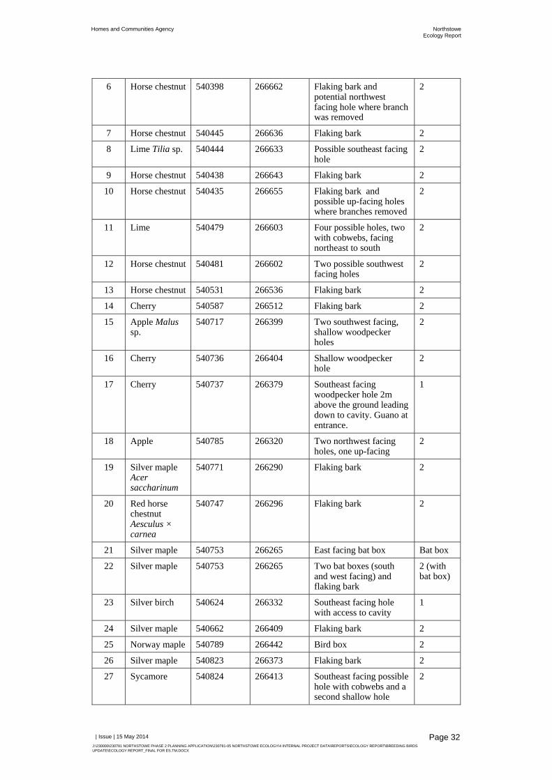
Homes and Communities Agency NorthstoweEcology Report
| Issue | 15 May 2014
J:\230000\230781 NORTHSTOWE PHASE 2 PLANNING APPLICATION\230781-05 NORTHSTOWE ECOLOGY\4 INTERNAL PROJECT DATA\REPORTS\ECOLOGY REPORT\BREEDING BIRDS UPDATE\ECOLOGY REPORT_FINAL FOR ES.TM.DOCX
Page 32
6 Horse chestnut 540398 266662 Flaking bark and potential northwest facing hole where branch was removed
2
7 Horse chestnut 540445 266636 Flaking bark 2
8 Lime Tilia sp. 540444 266633 Possible southeast facing hole
2
9 Horse chestnut 540438 266643 Flaking bark 2
10 Horse chestnut 540435 266655 Flaking bark and possible up-facing holes where branches removed
2
11 Lime 540479 266603 Four possible holes, two with cobwebs, facing northeast to south
2
12 Horse chestnut 540481 266602 Two possible southwest facing holes
2
13 Horse chestnut 540531 266536 Flaking bark 2
14 Cherry 540587 266512 Flaking bark 2
15 Apple Malus sp.
540717 266399 Two southwest facing, shallow woodpecker holes
2
16 Cherry 540736 266404 Shallow woodpecker hole
2
17 Cherry 540737 266379 Southeast facing woodpecker hole 2m above the ground leading down to cavity. Guano at entrance.
1
18 Apple 540785 266320 Two northwest facing holes, one up-facing
2
19 Silver maple Acer saccharinum
540771 266290 Flaking bark 2
20 Red horse chestnut Aesculus × carnea
540747 266296 Flaking bark 2
21 Silver maple 540753 266265 East facing bat box Bat box
22 Silver maple 540753 266265 Two bat boxes (south and west facing) and flaking bark
2 (with bat box)
23 Silver birch 540624 266332 Southeast facing hole with access to cavity
1
24 Silver maple 540662 266409 Flaking bark 2
25 Norway maple 540789 266442 Bird box 2
26 Silver maple 540823 266373 Flaking bark 2
27 Sycamore 540824 266413 Southeast facing possible hole with cobwebs and a second shallow hole
2

Homes and Communities Agency NorthstoweEcology Report
| Issue | 15 May 2014
J:\230000\230781 NORTHSTOWE PHASE 2 PLANNING APPLICATION\230781-05 NORTHSTOWE ECOLOGY\4 INTERNAL PROJECT DATA\REPORTS\ECOLOGY REPORT\BREEDING BIRDS UPDATE\ECOLOGY REPORT_FINAL FOR ES.TM.DOCX
Page 33
28 Horse chestnut 540839 266399 Flaking bark 2
29 Poplar 540809 266463 Southeast facing bat box Bat box
30 Poplar 540812 266468 Northwest facing bat box, chewed at entrance
Bat box
31 Poplar 540798 266474 Northeast facing woodpecker hole and southwest facing bat box. Line of trees providing foraging and commuting habitat.
2 (with bat box)
32 Cherry 540689 266454 Woodpecker hole only 1m above the ground
2
33 Cherry 540507 266649 East facing woodpecker hole, 1m above the ground, leading to cavity
2
34 Rowan Sorbus aucuparia
540488 266654 Northwest facing, sheltered, downward facing hole and flaking bark. Two further holes leading to a cavity. Holes 1-1.5m above the ground.
1
35 Horse chestnut 540469 266633 Flaking bark 2
36 Ash 540468 266636 West facing woodpecker hole
1
37 Ash 540459 266633 East facing possible hole where branch removed. Bird’s nest.
1
38 Rowan 540472 266733 Shallow hole where branch removed
2
39 Swedish whitebeam Sorbus lancastriensis
540472 266731 East facing hole where branch removed about 1.5m above the ground, leading to narrow cavity
2
40 Almond Prunus amygdalus
540474 266739 Rotten with holes leading to cavity
1
41 Swedish whitebeam
540478 266742 Large woodpecker hole leading to cavity and a second northeast facing hole 2m above the ground
1
42 Poplar 540495 266780 Hollow dead tree stump with flaking bark and three woodpecker holes facing various directions
1*
43 Horse chestnut 540513 266789 Possible east facing hole 2
44 Horse chestnut 540574 266710 Flaking bark 2
45 Poplar 540580 266636 Flaking bark 2
46 Walnut Juglans regia
540498 266748 Furrowed bark and three possible holes
1

Homes and Communities Agency NorthstoweEcology Report
| Issue | 15 May 2014
J:\230000\230781 NORTHSTOWE PHASE 2 PLANNING APPLICATION\230781-05 NORTHSTOWE ECOLOGY\4 INTERNAL PROJECT DATA\REPORTS\ECOLOGY REPORT\BREEDING BIRDS UPDATE\ECOLOGY REPORT_FINAL FOR ES.TM.DOCX
Page 34
47 Apple 540707 266236 Two northwest facing woodpecker holes
1
48 Apple 540666 266282 Southeast facing hole where branch removed, about 2m from the ground, leaving to small cavity
1
49 Apple 540673 266257 Southeast facing hole about 2m above the ground leading to a cavity
1
50 Poplar 540751 266154 Flaking and furrowed bark and two possible up facing holes
2
51 Poplar 540750 266147 Flaking bark and possible up facing hole
2
52 Poplar 540754 266155 Three east to northeast facing woodpecker holes and one hole where branch removed. Wasps nest.
1*
53 Apple 540750 266134 Slightly up facing hole where branch removed
2
54 Poplar 540699 266137 Woodpecker hole about 10m from the ground
1
55 White poplar 540512 266070 Large southeast facing hole leading to a cavity up into the tree and second possible northwest facing hole
1*
56 Ash 540497 266087 Dense ivy covering 1
57 White poplar 540507 266105 Large hole to large cavity within trunk. Bee flying around hole.
1*
58 Norway maple 540517 266124 Flaking bark 2
59 Poplar 540757 265731 Three bat boxes facing various directions
Bat box
60 Poplar 540805 265836 Two woodpecker holes and flaking and furrowed bark. Dead branch with a possible cavity facing northwest. Also west facing hole.
1*
61 Poplar 540837 266137 Possible up facing hole 2
62 Cherry 540837 266137 Possible northwest facing hole where branch removed
2
63 Lime 540770 266760 Loose bark 2
64 Lime 540744 266855 Southwest facing woodpecker hole
1

Homes and Communities Agency NorthstoweEcology Report
| Issue | 15 May 2014
J:\230000\230781 NORTHSTOWE PHASE 2 PLANNING APPLICATION\230781-05 NORTHSTOWE ECOLOGY\4 INTERNAL PROJECT DATA\REPORTS\ECOLOGY REPORT\BREEDING BIRDS UPDATE\ECOLOGY REPORT_FINAL FOR ES.TM.DOCX
Page 35
65 White poplar 540723 266872 Up facing hole and a lateral split
1
66 White poplar 540717 266876 Northwest facing woodpecker hole at least 10m above the ground
1
67 White poplar 540721 266906 Northeast facing woodpecker hole
2
68 White poplar 540723 266913 Northwest facing woodpecker hole about 5m above the ground
1
69 White poplar 540718 266912 West facing shallow woodpecker hole about 2m above the ground
2
70 Poplar 541096 266586 Southwest facing woodpecker hole with possible urine staining. Tree line provides potential foraging and commuting habitat.
1*
71 Poplar 541095 266586 West facing woodpecker hole about 7m above the ground and a smaller possible hole
1
72 Dead tree trunk
541677 266512 Lateral split 2
73 Field maple 541555 265107 Dense ivy covering 2
74 Field maple 541555 265107 Dense ivy covering 2
75 Poplar 541618 265037 Southeast facing small woodpecker hole
1
76 Dead tree trunk
541060 264951 Two woodpecker holes about 1.5m above the ground, facing west and south, that lead to a cavity
2
77 Poplar 541059 264967 Two northwest facing woodpecker holes with possible urine and grease staining below and around top hole. Another northeast facing hole also with possible urine staining.
1*
78 Poplar 541076 264979 Three shallow woodpecker holes, facing northeast or northwest
2
79 Poplar 541078 264974 Large northeast facing woodpecker hole with possible urine staining
1
80 Poplar 541076 264964 East facing woodpecker hole with possible urine staining
1

Homes and Communities Agency NorthstoweEcology Report
| Issue | 15 May 2014
J:\230000\230781 NORTHSTOWE PHASE 2 PLANNING APPLICATION\230781-05 NORTHSTOWE ECOLOGY\4 INTERNAL PROJECT DATA\REPORTS\ECOLOGY REPORT\BREEDING BIRDS UPDATE\ECOLOGY REPORT_FINAL FOR ES.TM.DOCX
Page 36
81 Poplar 541081 264963 Hole with possible urine staining. Wasp flying around the entrance.
1
82 Cherry 541083 264963 Loose bark 2
83 Poplar 541083 264963 Large, northwest facing woodpecker hole, with evidence of possible urine staining
1
84 Dead tree trunk
541121 264910 Loose bark, hollow tree with woodpecker holes. Cavity exposed to the elements from above.
2
85 Ash 541116 264925 Two holes facing southeast and northwest up to 1.5m above the ground
2
86 Dead tree trunk
541148 264957 Loose bark 2
87 Dead tree trunk
541214 264952 Loose bark 2
88 Dead tree trunk
541224 264997 Loose bark 2
89 Ash 541204 265053 Furrowed bark and a west facing woodpecker hole approximately 3m above the ground and 3m from the woodland edge
1
90 Poplar 541225 265053 Loose bark 2
91 Poplar 541281 265045 At least 11 woodpecker holes: seven northeast facing holes with possible urine staining on the lowest hole; three southeast facing holes; and one southwest facing hole.
1*
92 Ash 541488 265000 Possible south facing hole with cobweb over entrance
2
93 Poplar 541464 264966 Dense ivy covering 2
94 Ash 541452 264968 Two trees with dense ivy covering
2
95 Ash 541452 264976 Mature tree with dense ivy covering
1
96 Poplar 541477 264978 Northeast facing possible woodpecker hole approximately 5m above the ground
2

Homes and Communities Agency NorthstoweEcology Report
| Issue | 15 May 2014
J:\230000\230781 NORTHSTOWE PHASE 2 PLANNING APPLICATION\230781-05 NORTHSTOWE ECOLOGY\4 INTERNAL PROJECT DATA\REPORTS\ECOLOGY REPORT\BREEDING BIRDS UPDATE\ECOLOGY REPORT_FINAL FOR ES.TM.DOCX
Page 37
97 Ash 541063 264940 South east facing possible woodpecker hole about 9m above the ground with possible urine staining
1
98 Dead tree trunk
541067 264933 Loose bark 2
99 Dead tree trunk
541070 264934 Loose bark on partially fallen tree
2
100 Dead tree trunk
541062 264930 Loose bark 2
101 Ash 541201 264836 Dense ivy covering 1
102 Ash 541198 264846 No access to inspect. Mature tree that may support features
2
103 Ash 541190 264808 Dense ivy covering 2
104 Weeping willow Salix babylonica
541155 264715 Furrowed bark. Inspection only possible from west side.
2
105 Weeping willow
541155 264723 Furrowed bark 2
106 Weeping willow
541144 264703 Furrowed bark and sheltered crevice in branch
1
107 Weeping willow
541135 264698 Furrowed bark 2
108 Apple 541103 264726 Hole approximately 1.5m above the ground to a cavity. Cobweb over entrance.
2
109 Pedunculate oak Quercus robur
541106 264673 Dense ivy covering. Adjacent to site boundary.
2
110 Ash 541106 264668 Dense ivy covering 2
111 Pedunculate oak
541075 264686 Dense ivy cladding and woodpecker hole. Adjacent to site boundary; inspection only possible from north side.
1
112 Poplar 541074 264686 Woodpecker hole. Adjacent to site boundary.
1
113 Apple 540864 266222 Woodpecker holes on branches above 3m from the ground, facing north and west
1
114 Sycamore 540863 266283 Lateral split in trunk facing south and west
2
115 Cherry 540924 266259 Flaking bark 2

Homes and Communities Agency NorthstoweEcology Report
| Issue | 15 May 2014
J:\230000\230781 NORTHSTOWE PHASE 2 PLANNING APPLICATION\230781-05 NORTHSTOWE ECOLOGY\4 INTERNAL PROJECT DATA\REPORTS\ECOLOGY REPORT\BREEDING BIRDS UPDATE\ECOLOGY REPORT_FINAL FOR ES.TM.DOCX
Page 38
116 Cherry 540881 266255 Woodpecker hole at about 2m above the ground and flaking bark
1
117 Rowan 540856 266202 Small east facing hole at about 4m above the ground
2
118 Cherry 540891 266148 Crack and flaking bark at 4-6m above the ground
2
119 Cherry plum Prunus cerasifera
540890 266145 Two west facing holes at about 3m above the ground
1
120 Cherry plum 540894 266133 South facing hole about 2m above the ground
1
121 Apple 540910 266151 Snapped branch leading to potential cavity
1
122 Apple 540909 266152 Several holes facing different directions
1
123 Cherry 540921 266157 Woodpecker hole and large cavity facing north and south
1
124 Apple 540934 266214 North facing woodpecker hole at about 2m above the ground
2
125 Poplar 540922 266473 Woodpecker hole about 2m above the ground and flaking bark above 6m. Fourth tree from west.
1
126 Poplar 540917 266502 South and east facing hole and cracks at around 9-10m. Fifth tree from west.
1
127 Lime 540706 266571 Two holes at about 4m and 7m facing east and north
1
128 Cherry 540760 266634 Possible rot hole at around 4m above the ground
2
129 Lime 540757 266631 Southwest facing woodpecker hole at about 4m from the ground
1
130 Poplar 541126 266343 Bat box with cobwebs over the entrance
Bat box
131 Poplar 541130 266351 Bat box Bat box
132 Poplar 541131 266348 Bat box Bat box
133 Ash 540963 267119 Large tree with no access to inspect
2
134 Poplar 541020 265643 Southeast and northwest facing holes at about 5m and 8m above ground
1

Homes and Communities Agency NorthstoweEcology Report
| Issue | 15 May 2014
J:\230000\230781 NORTHSTOWE PHASE 2 PLANNING APPLICATION\230781-05 NORTHSTOWE ECOLOGY\4 INTERNAL PROJECT DATA\REPORTS\ECOLOGY REPORT\BREEDING BIRDS UPDATE\ECOLOGY REPORT_FINAL FOR ES.TM.DOCX
Page 39
135 Poplar 541021 265641 Northwest facing hole at 3m above ground
1
136 Poplar 541101 265589 South facing hole at about 8m above the ground
1
137 Poplar 541098 265600 Southeast facing small hole about 7m above the ground
2
138 Poplar 541106 265605 West facing hole about 8m above the ground
1
139 Poplar 541105 265609 Northwest facing hole about 9m above the ground
1
140 Poplar 541101 265596 East facing hole about 9m above the ground
1
141 Poplar 541100 265588 Northeast facing hole about 6m above the ground
1
142 Poplar 541101 265583 At least two holes between about 6m and 8m above the ground and loose bark; south and southwest facing
1*
143 Poplar 541103 265588 Northeast facing hole about 8m above the ground
1
144 Poplar 541107 265588 North facing hole about 10m above the ground
1
145 Poplar 541106 265588 East facing hole about 10m above the ground
1
146 Poplar 541113 265571 Northwest facing hole about 6m above the ground
1
147 Poplar 541113 265575 North facing hole about 11m above the ground
1
148 Poplar 541133 265543 Three holes between about 8m and 10m above the ground facing various directions
1
149 Poplar 541130 265548 South facing hole with cobwebs over the entrance
2
150 Poplar 541129 265554 Southeast facing hole about 10m above the ground
1
151 Poplar 541132 265558 South facing hole about 11m above the ground
1
152 Poplar 541133 265556 Two holes facing southeast and west approximately 5m and 10m above the ground
1

Homes and Communities Agency NorthstoweEcology Report
| Issue | 15 May 2014
J:\230000\230781 NORTHSTOWE PHASE 2 PLANNING APPLICATION\230781-05 NORTHSTOWE ECOLOGY\4 INTERNAL PROJECT DATA\REPORTS\ECOLOGY REPORT\BREEDING BIRDS UPDATE\ECOLOGY REPORT_FINAL FOR ES.TM.DOCX
Page 40
153 Poplar 540966 264967 East facing hole about 1mm above the ground, with some possible urine staining
1
154 Poplar 540941 264912 Northeast facing hole about10m above the ground
1
155 Poplar 540933 265097 North facing hole about10m above the ground
1
156 Poplar 540677 265263 Northeast facing hole about 9m above the ground with some possible urine staining below
1
157 Poplar 540593 265147 Southeast facing hole about 11m above the ground
1
158 Willow Salix sp.
540560 265114 Two east facing holes and split trunk about 10m above the ground
1*
159 Willow 540562 265117 North facing hole about 8m above the ground
1
160 Willow 540572 265115 Southeast facing hole about 5m above the ground and loose bark
1
161 Willow 540567 265119 Small holes and loose bark facing various directions and at various heights
1
162 Willow 540565 265127 Split trunk and holes at various heights and facing various directions
1*
163 Willow 540565 265124 Split trunk and holes at various heights and facing various directions
1
164 Willow 540561 265138 Southeast facing holes at about 10m above the ground
1
165 Willow 540583 265134 Several holes at various heights and facing various directions
1*
166 Pedunculate oak
538781 263711 Dense ivy covering 2
167 Lime 538717 263776 Dense ivy covering 2
168 Pedunculate oak
539343 263745 Dense ivy covering 1
169 Elder 540548 266918 Branch cavity 2
170 Ash 540539 266920 Possible up facing hole where branch removed
2

Homes and Communities Agency NorthstoweEcology Report
| Issue | 15 May 2014
J:\230000\230781 NORTHSTOWE PHASE 2 PLANNING APPLICATION\230781-05 NORTHSTOWE ECOLOGY\4 INTERNAL PROJECT DATA\REPORTS\ECOLOGY REPORT\BREEDING BIRDS UPDATE\ECOLOGY REPORT_FINAL FOR ES.TM.DOCX
Page 41
171 Ash 540442 267093 Furrowed bark and crevices in rotting branch
2
172 Ash 540442 267101 Four woodpecker holes in trunk and hole in branch at various heights and facing various directions
1
173 Ash 540463 267177 Southeast facing woodpecker hole
1
174 Ash 540463 267176 Large teardrop-shaped woodpecker hole and up facing hole about 6m above the ground and facing southeast
1
175 Ash 540492 267195 West facing woodpecker hole about 6m above the ground
1
176 Ash 540494 267197 Loose bark 2
177 Hawthorn 540503 267205 Vertical split along trunk leading to crevice
2
178 Poplar 540841 264851 Northeast facing woodpecker hole about 6m above the ground
1
179 Poplar 540756 264864 East facing woodpecker hole about 7m above the ground
1
180 Poplar 540777 264843 Southeast facing woodpecker hole
1
181 Poplar 540801 264850 Southeast facing woodpecker hole
1
182 White willow Salix alba
540800 264864 Loose bark 2
183 Dead tree trunk
540753 264875 Possible holes 2
184 White willow 540762 264908 Northeast facing woodpecker hole approximately 2m above the ground and east facing crevices in hollowing trunk
2
185 Dead tree trunk
540764 264916 At least 10 woodpecker holes
1
186 White willow 540798 264899 Loose bark 2
187 White willow 540781 264922 Southeast facing vertical crevice, two holes and split
1
188 White willow 540773 264929 Southwest facing hole into possible cavity and northwest facing hole
1

Homes and Communities Agency NorthstoweEcology Report
| Issue | 15 May 2014
J:\230000\230781 NORTHSTOWE PHASE 2 PLANNING APPLICATION\230781-05 NORTHSTOWE ECOLOGY\4 INTERNAL PROJECT DATA\REPORTS\ECOLOGY REPORT\BREEDING BIRDS UPDATE\ECOLOGY REPORT_FINAL FOR ES.TM.DOCX
Page 42
189 White willow 540711 264981 Two woodpecker holes facing northwest and southeast
1
190 White willow 540712 264961 Hole into possible cavity 1
191 White willow 540697 264991 Northwest facing woodpecker hole
1
192 Willow 540704 265006 Southeast facing woodpecker hole
1
193 Willow 540681 265022 Southeast facing woodpecker hole
1
194 Willow 540680 265026 Loose bark and vertical crevice
2
195 Willow 540657 265025 Woodpecker hole with cobwebs over the entrance
2
196 Willow 540650 265024 Woodpecker hole and hollow trunk, likely wet
1
197 Willow 540659 265037 Large woodpecker hole and loose bark to the northeast
1
198 Willow 540666 265044 Southern facing woodpecker hole approximately 2m from the ground and a second, northwest facing hole branching upwards
2
199 Willow 540669 265044 Access up into trunk cavity
1*
200 Willow 540662 265050 Woodpecker hole 2
201 Willow 540662 265047 Two holes facing northwest approximately 3m and 6m above the ground and loose bark
1
202 Willow 540639 265062 Teardrop-shaped hole to the south east approximately 6m above the ground and large holes into dead wood orientated south west
1
203 Willow 540639 265063 Large hole on the north east side of the tree
1
204 Willow 540640 265063 Shallow hole leading upwards, covered in cobwebs, approximately 2m above the ground
2
205 Willow 540622 265072 Crevice and loose bark 2
206 White willow 540749 265618 Shallow hole leading upwards
2
207 Dead tree trunk
540753 265624 Dead tree with loose bark
2
208 White willow 540777 265649 Loose bark 2

Homes and Communities Agency NorthstoweEcology Report
| Issue | 15 May 2014
J:\230000\230781 NORTHSTOWE PHASE 2 PLANNING APPLICATION\230781-05 NORTHSTOWE ECOLOGY\4 INTERNAL PROJECT DATA\REPORTS\ECOLOGY REPORT\BREEDING BIRDS UPDATE\ECOLOGY REPORT_FINAL FOR ES.TM.DOCX
Page 43
209 Dead tree trunk
540777 265649 Dead tree with loose bark
2
210 Dead tree trunk
540789 265642 Dead tree with loose bark
2
211 White willow 540808 265686 Crevice which may lead up into a cavity
1
212 White willow 540842 265735 Hollow trunk with numerous large holes to the southwest and a large hole to the northeast, cobwebbed over at the entrance
1
213 Ash 540860 265751 Vertical crevice and a hole approximately 2m above the ground on the north east side
2
214 White willow 540879 265772 Shallow, cobwebbed hole
2
215 White willow 540874 265774 Loose bark 2
216 White willow 540872 265773 North westerly hole in tree stump approximately 10m above the ground which may lead to cavity, cobwebbed over
2
217 White willow 540876 265776 Woodpecker hole approximately 3m above the ground facing south east with a clear entrance and a easterly orientated hole
1
218 White willow 540878 265770 Large teardrop shaped hole with a clear entrance approximately 3m above the ground facing north east
1
219 Dead tree trunk
540872 265748 Dead tree with loose bark
2
220 White willow 540862 265746 Hole which may lead up into a cavity
2
221 White willow 540839 265712 Dead tree with holes leading into trunk cavity
1*
222 White willow 540594 265446 Southerly facing woodpecker hole approximately 5m above the ground, cluttered entrance
2
223 White willow 540591 265451 Northerly woodpecker hole approximately 3m above the ground
1
224 White willow 540589 265447 Large woodpecker hole facing north west, two other holes facing south
1

Homes and Communities Agency NorthstoweEcology Report
| Issue | 15 May 2014
J:\230000\230781 NORTHSTOWE PHASE 2 PLANNING APPLICATION\230781-05 NORTHSTOWE ECOLOGY\4 INTERNAL PROJECT DATA\REPORTS\ECOLOGY REPORT\BREEDING BIRDS UPDATE\ECOLOGY REPORT_FINAL FOR ES.TM.DOCX
Page 44
225 White willow 540595 265453 Large woodpecker hole on the northern aspect of the tree
1
226 White willow 540598 265451 Two small woodpecker holes on the northern aspect of the tree
1
227 White willow 540617 265422 Hole on the western aspect approximately 2.5m above the ground possibly leading into a cavity, possible holes on the eastern aspect
1
228 White willow 540614 265408 Loose bark 2
229 White willow 540611 265410 Hole approximately 3m above the ground leading up into the tree
1
230 White willow 540606 265427 Approximately Four small holes
2
231 White willow 540604 265430 South east facing holes leading up into tree at approximately 4m and 10m above the ground
1
232 White willow 540583 265432 Four holes leading up into dead wood on the south eastern aspect
1*
233 White willow 540582 265431 Two possible holes on the south eastern aspect
1
234 White willow 540562 265432 Hole on the south eastern aspect
2
235 White willow 540558 265436 Large hole on the western aspect leading up into tree
1
236 White willow 540552 265439 Hole on the south eastern aspect
1
237 White willow 540531 265412 Hollow trunk with a hole on the eastern aspect approximately 2.5 – 3m above the ground
1*
238 White willow 540470 265432 Dead tree with loose bark and two holes
2
239 White willow 540470 265440 Hole on the north eastern aspect covered with cobwebs, and a crevice on the south western aspect into hollow section of the tree
1
240 White willow 540446 265436 Possible westerly facing hole
2
241 Beech 540423 265705 Hole where a branch has been removed
1

Homes and Communities Agency NorthstoweEcology Report
| Issue | 15 May 2014
J:\230000\230781 NORTHSTOWE PHASE 2 PLANNING APPLICATION\230781-05 NORTHSTOWE ECOLOGY\4 INTERNAL PROJECT DATA\REPORTS\ECOLOGY REPORT\BREEDING BIRDS UPDATE\ECOLOGY REPORT_FINAL FOR ES.TM.DOCX
Page 45
242 Poplar 540505 265514 Hole on the north western aspect leading up into tree approximately 4m above the ground
1
243 Pedunculate oak
540476 265742 Woodpecker hole approximately 8m above the ground on the north eastern aspect
1
244 Ash 540497 266070 Four woodpecker holes and a cavity on the southern aspect
1*
245 Ash 540533 266034 Large hole and decaying branch on the south eastern aspect with an ivy covered split on the other side of the tree
1
246 Horse chestnut 540443 266612 Several holes where limbs have been cut off
1
247 Horse chestnut 540516 266530 Loose bark and two holes in trunk
1
248 Lime 540520 266526 Loose bark and one small cavity
1
249 Cherry 540545 266497 Two large woodpecker holes leading into large cavities
1
250 Weeping willow
540602 266268 Loose bark 2
251 Horse chestnut 540196 266620 Loose bark 2
252 Hawthorn 540197 266623 Dense ivy covering 2
253 Horse chestnut 540208 266636 Loose bark 2
254 Horse chestnut 540246 266653 Loose bark 2
255 Norway maple 540497 266745 Southeast facing hole where branch has been removed, 2m above the ground and an easterly facing hole approximately 1.75m above the ground
1
256 Norway maple 540399 266764 Two holes on narrow branches
2
257 Horse chestnut 540461 266809 Hole and dead wood where branch has been removed and a north west facing hole leading into a cavity
1
258 Horse chestnut 540467 266814 South east facing hole leading upwards
2
259 Horse chestnut 540491 266807 West facing hole leading upwards and flaking bark
2

Homes and Communities Agency NorthstoweEcology Report
| Issue | 15 May 2014
J:\230000\230781 NORTHSTOWE PHASE 2 PLANNING APPLICATION\230781-05 NORTHSTOWE ECOLOGY\4 INTERNAL PROJECT DATA\REPORTS\ECOLOGY REPORT\BREEDING BIRDS UPDATE\ECOLOGY REPORT_FINAL FOR ES.TM.DOCX
Page 46
260 Lime 540442 266787 Two holes leading up into the tree on the south eastern aspect
1
261 Ash 538886 265340 Two holes in trunk south and southwest facing approximately 5m above the ground
1
262 Hybrid black poplar
539530 263456 North east facing hole approximately 8m above the ground and furrowed bark
1
263 White willow 539478 263457 Crevices where bark is lifted, two woodpecker holes east facing and one west facing
1
264 White willow 539460 263457 Crevices in dead wood, woodpecker hole northwest facing leading up into tree
1
265 White willow 539447 263471 West facing woodpecker hole approximately 6m above the ground. Two north facing holes approximately 12m above the ground
1
266 White willow 539417 263498 Large northeast facing hole in trunk, peeling and decaying wood. Main stem ready to fall. Further holes.
1*
267 White willow 539405 263504 Furrowed bark and peeling dead wood. Northeast and north west facing holes.
1
268 White willow 539400 263512 Furrowed bark and northeast facing woodpecker hole. Crevice where branch has been removed.
1
269 White willow 539362 263524 Woodpecker holes on dead branch, furrowed bark and other holes.
1
270 White willow 539345 263529 Furrowed bark with east facing woodpecker hole in the broken branch approximately 4m above ground. Further holes on north and west sides of tree.
1
271 White willow 539290 263533 North west facing up hole approximately 2m above ground and crevices in branch
1
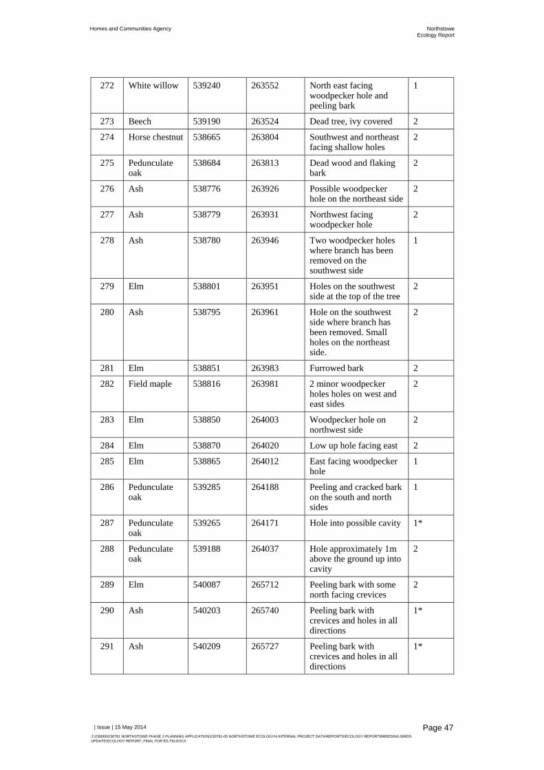
Homes and Communities Agency NorthstoweEcology Report
| Issue | 15 May 2014
J:\230000\230781 NORTHSTOWE PHASE 2 PLANNING APPLICATION\230781-05 NORTHSTOWE ECOLOGY\4 INTERNAL PROJECT DATA\REPORTS\ECOLOGY REPORT\BREEDING BIRDS UPDATE\ECOLOGY REPORT_FINAL FOR ES.TM.DOCX
Page 47
272 White willow 539240 263552 North east facing woodpecker hole and peeling bark
1
273 Beech 539190 263524 Dead tree, ivy covered 2
274 Horse chestnut 538665 263804 Southwest and northeast facing shallow holes
2
275 Pedunculate oak
538684 263813 Dead wood and flaking bark
2
276 Ash 538776 263926 Possible woodpecker hole on the northeast side
2
277 Ash 538779 263931 Northwest facing woodpecker hole
2
278 Ash 538780 263946 Two woodpecker holes where branch has been removed on the southwest side
1
279 Elm 538801 263951 Holes on the southwest side at the top of the tree
2
280 Ash 538795 263961 Hole on the southwest side where branch has been removed. Small holes on the northeast side.
2
281 Elm 538851 263983 Furrowed bark 2
282 Field maple 538816 263981 2 minor woodpecker holes holes on west and east sides
2
283 Elm 538850 264003 Woodpecker hole on northwest side
2
284 Elm 538870 264020 Low up hole facing east 2
285 Elm 538865 264012 East facing woodpecker hole
1
286 Pedunculate oak
539285 264188 Peeling and cracked bark on the south and north sides
1
287 Pedunculate oak
539265 264171 Hole into possible cavity 1*
288 Pedunculate oak
539188 264037 Hole approximately 1m above the ground up into cavity
2
289 Elm 540087 265712 Peeling bark with some north facing crevices
2
290 Ash 540203 265740 Peeling bark with crevices and holes in all directions
1*
291 Ash 540209 265727 Peeling bark with crevices and holes in all directions
1*
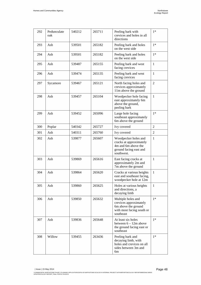
Homes and Communities Agency NorthstoweEcology Report
| Issue | 15 May 2014
J:\230000\230781 NORTHSTOWE PHASE 2 PLANNING APPLICATION\230781-05 NORTHSTOWE ECOLOGY\4 INTERNAL PROJECT DATA\REPORTS\ECOLOGY REPORT\BREEDING BIRDS UPDATE\ECOLOGY REPORT_FINAL FOR ES.TM.DOCX
Page 48
292 Pedunculate oak
540212 265711 Peeling bark with crevices and holes in all directions
1*
293 Ash 539501 265182 Peeling bark and holes on the west side
1*
294 Ash 539501 265182 Peeling bark and holes on the west side
1*
295 Ash 539487 265155 Peeling bark and west facing crevices
1
296 Ash 539474 265135 Peeling bark and west facing crevices
1
297 Sycamore 539467 265121 North facing holes and crevices approximately 11m above the ground
2
298 Ash 539457 265104 Woodpecker hole facing east approximately 6m above the ground, peeling bark
1
299 Ash 539452 265096 Large hole facing southeast approximately 6m above the ground
1*
300 Poplar 540342 265727 Ivy covered 2
301 Ash 540311 265760 Ivy covered 2
302 Ash 539877 265607 Woodpecker holes and cracks at approximately 4m and 6m above the ground facing east and southwest.
1
303 Ash 539869 265616 East facing cracks at approximately 2m and 7m above the ground
1
304 Ash 539864 265620 Cracks at various heights east and southeast facing, woodpecker hole at 12m
1
305 Ash 539860 265625 Holes at various heights and directions, a decaying limb
1
306 Ash 539850 265632 Multiple holes and crevices approximately 6m above the ground with most facing south or southeast
1*
307 Ash 539836 265648 At least six holes between 6 – 12m above the ground facing east or southeast
1*
308 Willow 539455 263436 Peeling bark and decaying limb, with holes and crevices on all sides between 3m and 6m
1*

Homes and Communities Agency NorthstoweEcology Report
| Issue | 15 May 2014
J:\230000\230781 NORTHSTOWE PHASE 2 PLANNING APPLICATION\230781-05 NORTHSTOWE ECOLOGY\4 INTERNAL PROJECT DATA\REPORTS\ECOLOGY REPORT\BREEDING BIRDS UPDATE\ECOLOGY REPORT_FINAL FOR ES.TM.DOCX
Page 49
309 Willow 539446 263420 Partially fallen tree with some peeling bark, and crevices between 2m and 3m
1
310 Pedunculate oak
539428 263400 Ivy covered 1
311 Poplar 539427 263397 Ivy covered 1
312 Oak 539429 263379 Decaying branches and some peeling bark
2
313 Oak 539414 263347 Peeling bark with crevices, one particularly significant one at approx. 7m on the south side
1*
314 Oak 539400 266309 Crevices at approximately 8m on the south side
1
315 Oak 539392 266309 Signs of decay and broken branches
1
316 Oak 529006 263805 Missing limb, crevices in all directions and heights
1*
317 Oak 539040 263845 Missing limb, crevices in all directions and heights
1*
318 Oak 539047 263853 Missing limb, crevices in all directions and heights
1*
319 Oak 539140 263978 Signs of decay and missing limbs
1
320 Oak 539170 263780 Cracks and crevices in the trunk between 6m and 10m on the northwest side of tree
1*
321 Oak 539197 263767 Some signs of decay, missing branches
1
322 Poplar 539633 263495 Cracks and crevices on the east side between 2m and 10m
1
323 Poplar 539640 263497 Limited loose bark and hole at approximately 7m on the west side of tree
1
324 Poplar 539713 263511 Limited loose bark and hole at approximately 12m on the north side of tree
2
325 Poplar 539723 263510 Limited loose bark, no obvious holes
2
326 Poplar 539764 263517 Cracks and holes between 6m and 8m above the ground on the north and east sides of tree
1*

Homes and Communities Agency NorthstoweEcology Report
| Issue | 15 May 2014
J:\230000\230781 NORTHSTOWE PHASE 2 PLANNING APPLICATION\230781-05 NORTHSTOWE ECOLOGY\4 INTERNAL PROJECT DATA\REPORTS\ECOLOGY REPORT\BREEDING BIRDS UPDATE\ECOLOGY REPORT_FINAL FOR ES.TM.DOCX
Page 50
327 Poplar 539765 263517 Cracks in various directions, woodpecker hole at 3m above the ground
1*
328 Poplar 539776 263523 Various crevices and holes, mostly east facing
1
329 Poplar 539776 263523 Various crevices and holes, mostly east facing
1
330 Poplar 539776 263523 Various crevices and holes, mostly east facing
1
331 Poplar 539833 263526 Hollow limb at approximately 10m and woodpecker hole at approximately 6m, both on the east side
1*
332 Poplar 539960 263583 Crevices at about 3m to 6m above the ground on the southeast side
1
333 Poplar 539966 263570 Large hole at approximately 3m on southeast side
1
334 Poplar 539990 263580 Holes and crevices low to the ground which appear to lead to hollow in trunk
2
335 Poplar 540064 263637 Several cracks and crevices, missing limbs, three woodpecker holes on the northeast side one of which shows potential urine staining
1*
336 Oak 540013 263692 Limited amount of cracked, peeling bark
2
337 Oak 539954 263741 Limited amount of cracked, peeling bark
2
338 Oak 539506 263966 Crevice on the southeast side between 5m and 7m
2
339 Ash 540247 262581 A few holes caused by missing branches on the east side between about 8m and 12m
2
340 Ash 540342 263667 Several holes and crevices in various directions and heights
1*
341 Ash 539897 264080 Several holes and crevices in various directions between 3m and 8m
1
342 Willow 540408 263863 Several cracks, peeling bark and holes in various directions and heights
1*

Homes and Communities Agency NorthstoweEcology Report
| Issue | 15 May 2014
J:\230000\230781 NORTHSTOWE PHASE 2 PLANNING APPLICATION\230781-05 NORTHSTOWE ECOLOGY\4 INTERNAL PROJECT DATA\REPORTS\ECOLOGY REPORT\BREEDING BIRDS UPDATE\ECOLOGY REPORT_FINAL FOR ES.TM.DOCX
Page 51
343 Willow 540443 263897 Woodpecker hole on the northwest side at approximately 6m high, minimal loose bark
1
344 Ash 540766 264202 Ivy-covered 2
345 Ash 540733 264116 Ivy-covered 2
346 Willow 539084 265368 Woodpecker hole about 10m above ground on the southeast side
1
347 Willow 539076 265353 Woodpecker hole at approximately 10m on the east side of tree, some loose bark
1
348 Willow 539052 265305 Cracks, crevices and holes at various heights and directions
1*
349 Ash 539052 265305 Cracks, crevices and holes at various heights and directions
1*
350 Willow 539037 265269 Cracks, crevices and holes at various heights and directions
1*
351 Ash 539021 265246 Cracks, crevices and holes at various heights and directions
1*
352 Ash 539001 265222 Numerous holes and loose bark at various heights and directions and possible hollow trunk
1*
W1 Mixed deciduous woodland
540391 265699 Dense ivy covering on many of the trees in the woodland
1
W2 Mixed deciduous woodland
538240 264113 Minor holes and ivy covering
2
W3 Mixed deciduous woodland
539661 263080 Minor holes and ivy covering
2
4.2.2 Activity Survey
The following species were recorded during the activity surveys:
Common pipistrelle; Soprano pipistrelle; Noctule; Leisler’s bat; Possible serotine; Probable Daubenton’s bat; and

Homes and Communities Agency NorthstoweEcology Report
| Issue | 15 May 2014
J:\230000\230781 NORTHSTOWE PHASE 2 PLANNING APPLICATION\230781-05 NORTHSTOWE ECOLOGY\4 INTERNAL PROJECT DATA\REPORTS\ECOLOGY REPORT\BREEDING BIRDS UPDATE\ECOLOGY REPORT_FINAL FOR ES.TM.DOCX
Page 52
Brown long-eared bat.
Bat activity recorded during each of the surveys is described below and key areas of foraging and commuting activity are shown on Figure 5.
4.2.2.1 Dusk Survey 29th May
Low levels of bat activity were recorded during this survey. Most activity was noted along transect 1, particularly along Oakington Brook. A probable Daubenton’s bat social call was recorded at 22:30 alongside Oakington Brook, adjacent to the road to Welney Farms Ltd. At 22:31, common pipistrelle was recorded foraging along the track adjacent to the woodland, with brief passes also recorded while walking along this track towards the A14. At 23:02, common pipistrelle was recorded foraging along the line of trees leading to the trackway between Welney Farms Ltd. and New Close Farm Business Park. No further bat activity was recorded until 00:05, when common pipistrelle was recorded foraging along Oakington Brook for approximately 5 minutes. It was suspected that foraging activity continued as the surveyors completed the transect.
Along transect 2, common and soprano pipistrelle and probable Leisler’s bat were recorded at 22:17 near to Longstanton Road, with soprano pipistrelle also recorded at 23:11 along the field edge.
Along transect 3, common pipistrelle was recorded foraging along Wilson’s Road (track), where the path turns to the left at 23:11 and further towards Longstanton between 23:52 and 23:55.
4.2.2.2 Dusk Survey 30th May
Common and soprano pipistrelle were recorded, with most activity noted along transects 5 and 6. Along transect 5, common and soprano pipistrelle bats were recorded. Common pipistrelle was seen commuting across the site early during the survey, with two pipistrelle passes at 21:26 only 18 minutes after sunset, indicating that these were roosting on the site or nearby. They were seen flying north at grid reference TL40537 66476, near to B5 (refer to Figure 5). A few common pipistrelle passes were recorded near to the western boundary of Oakington Barracks and Airfield and common pipistrelle foraging activity was noted along a line of trees at TL4067066162, also near to the western boundary. A soprano pipistrelle pass was also noted in this part of the site. Common pipistrelle foraging activity also noted along the transect further south, also near to the western boundary. Common pipistrelle foraging activity was then noted along the road heading towards the lake and then also over the lake. Some common pipistrelle passes were also noted around the blocks of plantation woodland, as well as two soprano pipistrelle passes.
Along transect 6, common pipistrelle was recorded foraging along the access road into Oakington Barracks and Airfield just beyond the entrance gate, between around 21:30 and 21:54. Intense common and soprano pipistrelle foraging activity was also later noted along Long Lane, with common pipistrelle also foraging along the hedgerow along the northern boundary to the west of Larksfield Nursery.
Very little activity was recorded along transect 7, comprising six common pipistrelle passes, including four passes along the track between arable fields in

Homes and Communities Agency NorthstoweEcology Report
| Issue | 15 May 2014
J:\230000\230781 NORTHSTOWE PHASE 2 PLANNING APPLICATION\230781-05 NORTHSTOWE ECOLOGY\4 INTERNAL PROJECT DATA\REPORTS\ECOLOGY REPORT\BREEDING BIRDS UPDATE\ECOLOGY REPORT_FINAL FOR ES.TM.DOCX
Page 53
the northeast corner of the site between 22:58 and 23:02. A similar scenario was noted along transect 4, where two common pipistrelle passes were noted along the woodlands in the southeast corner of the site.
4.2.2.3 Dusk Survey 17th June
Along transect 1, a great diversity of species were recorded when compared to the previous surveys, comprising noctule, brown long-eared bat and common and soprano pipistrelle. Noctule was recorded foraging around the plantation woodland near to Oakington Business Park at 21:43 to 21:44. The remainder of the bat activity was recorded along Oakington Brook. This comprised a brown long-eared bat at 22:40 and soprano pipistrelle at 22:44, both along the track between the brook and plantation woodland, and occasional common pipistrelle foraging activity.
Along transect 2, common and soprano pipistrelle foraging activity was recorded. Two brief common pipistrelle passes were heard along the edge of the arable field to the east of Oakington Business Park, which may have been associated with activity outside the site. The remaining activity was noted along hedgerows between pasture fields and arable land further north, comprising common pipistrelle foraging activity over the adjacent field at 22:11, soprano pipistrelle foraging along the hedgerow for about a minute at 22:19 and common pipistrelle foraging along the hedgerow and over long grass at the corner of the field adjacent to the pasture fields and Longstanton Road between 22:22 and 22:25.
Three common pipistrelle passes were heard along transect 3 at 22:25 along Longstanton Brook.
Most bat activity was recorded along transect 6. Common pipistrelle was recorded foraging along the access road into Oakington Barracks and Airfield as per the dusk survey on 30th May. Foraging activity was recorded along Long Lane; a total of 37 calls were noted between 22:06 and 22:26. These were mainly common pipistrelle (with two bats recorded at the same time), although soprano pipistrelle was also present. Common pipistrelle and a ‘big bat’ were then recorded foraging along the hedgerow in the pasture field adjacent to Long Lane. Two common pipistrelle calls were recorded along hedgerows between these fields. Further common and soprano pipistrelle foraging activity was recorded along Long Lane. Two further common pipistrelle passes were noted along St. Michael’s Way, along with a noctule pass at 23:33. Common pipistrelle was also recorded foraging along the northern edge of the field to the west of Larksfield Nursery.
4.2.2.4 Dusk Survey 8th July
Common pipistrelle was recorded along the hedgerows around the fields to the west of Long Lane; these were mainly faint passes, although one was seen flying back and forth along the hedgerow alongside Rampton Road at 21:51. Two noctule passes were also recorded in this part of the site at 21:53 and 22:02, but were not seen.
Common pipistrelle, noctule and Leisler’s bat were recorded foraging along Long Lane, with common pipistrelle and soprano pipistrelle also foraging along St. Michael’s Way. A possible serotine was noted at 22:19 along Long Lane, but could not be confirmed due to overlapping call parameters with Leisler’s bat

Homes and Communities Agency NorthstoweEcology Report
| Issue | 15 May 2014
J:\230000\230781 NORTHSTOWE PHASE 2 PLANNING APPLICATION\230781-05 NORTHSTOWE ECOLOGY\4 INTERNAL PROJECT DATA\REPORTS\ECOLOGY REPORT\BREEDING BIRDS UPDATE\ECOLOGY REPORT_FINAL FOR ES.TM.DOCX
Page 54
foraging in cluttered habitats. Up to four pipistrelle bats were seen at any one time along Long Lane, with frequent pipistrelle foraging passes also noted along St. Michael’s Way and over the fields to the northwest.
4.2.2.5 Dusk Survey 22nd August
A wide variety of species were recorded, although less bat activity was noted when compared to the July survey. Common and soprano pipistrelle calls were heard along the hedgerows around the fields near to Brookfield Farm, including some foraging activity. A Nyctalus sp. call was also recorded along Rampton Road. Occasional common and soprano pipistrelle passes were recorded along Long Lane. A probable Daubenton’s bat was recorded at 21:43, along a field edge to the west of Long Lane (woodland edge to the east of western-most field), with brown long-eared bat (22:40), Leisler’s bat (21:48) and common pipistrelle passes also noted in this part of the site. A probable Daubenton’s bat was also recorded along St. Michael’s Way at 22:34, with Leisler’s bat also recorded at 22:46. A brown-long eared bat was also heard at the field edge that runs alongside Oakington Barracks and Airfield.
4.2.2.6 Dawn Survey 23rd August
Less bat activity was recorded during the dawn transect, with only common and soprano pipistrelle passes heard. This activity was noted along the hedgerows around the fields at Brookfield Farm, around the field edges to the west of Long Lane, as well as along Long Lane.
4.2.2.7 Dusk Survey 19th September
Pipistrelle calls were recorded along St. Michael’s Lane, as well as Leisler’s bat at 19:51. Common and soprano pipistrelle foraging activity was noted along Long Lane, particularly at the southern end. Common and soprano pipistrelle foraging activity was recorded around the field edges to the west of Long Lane, particularly the edge to the west of the woodland, which was also found to provide valuable foraging habitat during the dusk survey in August (refer to Figure 5). Common and soprano pipistrelle bats were also recorded foraging along the hedgerows around the field to the west of Larksfield Nursery, with common pipistrelle also noted along Rampton Road and field edges at Brookfield Farm. Noctule was also recorded along Rampton Road at 21:44.
4.2.3 Automated Survey
The following species were recorded by the static detectors, which excludes the species only identified to genus that would fall into one of the following:
Common pipistrelle; Soprano pipistrelle; Nathusius’ pipistrelle; Noctule; Leisler’s bat; Probable serotine;
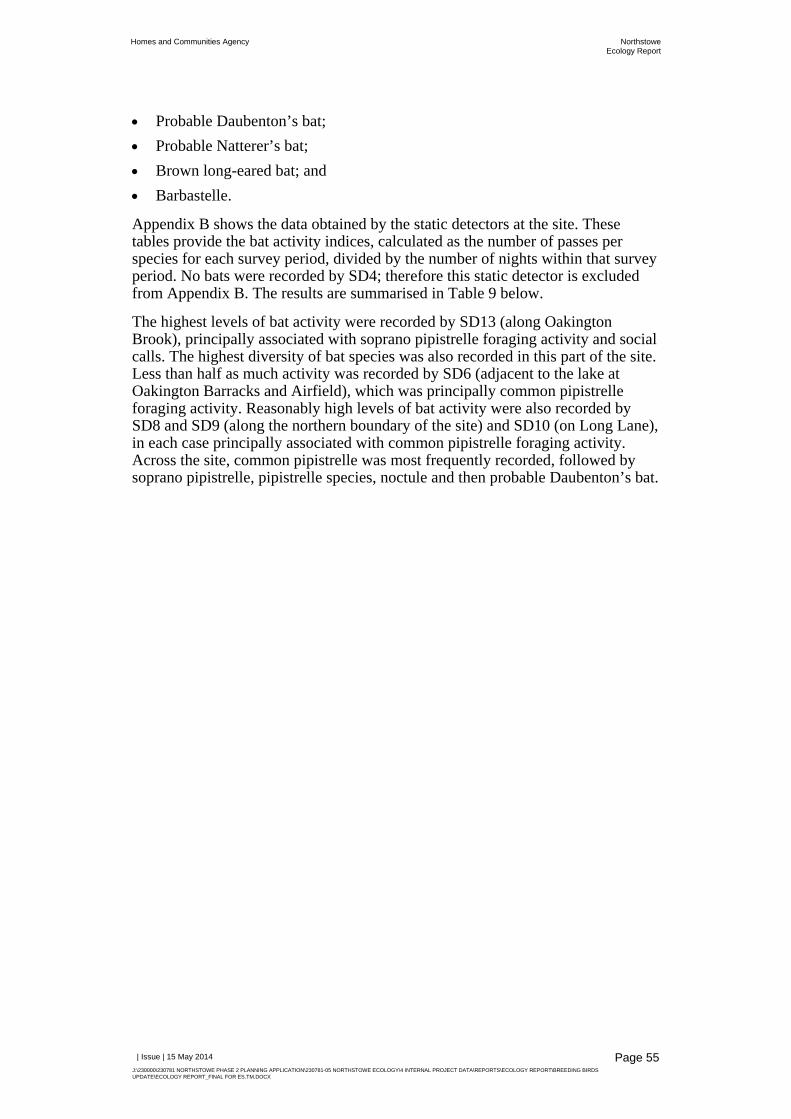
Homes and Communities Agency NorthstoweEcology Report
| Issue | 15 May 2014
J:\230000\230781 NORTHSTOWE PHASE 2 PLANNING APPLICATION\230781-05 NORTHSTOWE ECOLOGY\4 INTERNAL PROJECT DATA\REPORTS\ECOLOGY REPORT\BREEDING BIRDS UPDATE\ECOLOGY REPORT_FINAL FOR ES.TM.DOCX
Page 55
Probable Daubenton’s bat; Probable Natterer’s bat; Brown long-eared bat; and Barbastelle.
Appendix B shows the data obtained by the static detectors at the site. These tables provide the bat activity indices, calculated as the number of passes per species for each survey period, divided by the number of nights within that survey period. No bats were recorded by SD4; therefore this static detector is excluded from Appendix B. The results are summarised in Table 9 below.
The highest levels of bat activity were recorded by SD13 (along Oakington Brook), principally associated with soprano pipistrelle foraging activity and social calls. The highest diversity of bat species was also recorded in this part of the site. Less than half as much activity was recorded by SD6 (adjacent to the lake at Oakington Barracks and Airfield), which was principally common pipistrelle foraging activity. Reasonably high levels of bat activity were also recorded by SD8 and SD9 (along the northern boundary of the site) and SD10 (on Long Lane), in each case principally associated with common pipistrelle foraging activity. Across the site, common pipistrelle was most frequently recorded, followed by soprano pipistrelle, pipistrelle species, noctule and then probable Daubenton’s bat.

Homes and Communities Agency NorthstoweEcology Report
| Issue | 15 May 2014
J:\230000\230781 NORTHSTOWE PHASE 2 PLANNING APPLICATION\230781-05 NORTHSTOWE ECOLOGY\4 INTERNAL PROJECT DATA\REPORTS\ECOLOGY REPORT\BREEDING BIRDS UPDATE\ECOLOGY REPORT_FINAL FOR ES.TM.DOCX
Page 56
Table 9: Summary of Automated Survey Data within the Site Species Bat Activity Indices
SD1 SD2 SD3 SD4 SD5 SD6 SD7 SD8 SD9 SD10 SD11 SD12 SD13 SD14 SD15 SD16 Site Averages
Common pipistrelle
5 16.4 1.4 118 246.2 35.6 217 147.6 145.3 12.6 26 107.4 26.2 30 27.3 1162
Soprano pipistrelle
0.2 0.6 11.4 74.4 4.2 3 15.1 38.9 0.3 1 749.6 2 0.8 1.1 902.6
Nathusius’ pipistrelle
0.2 0.3 0.1 0.7 1 2.3
Pipistrelle 0.8 0.6 18.2 4.8 62.8 23.6 7.3 8.2 0.2 4.2 0.6 1.7 4.1 0.8 137.9
Noctule 0.8 11.4 0.6 1.6 0.8 0.3 0.5 0.8 0.6 1.2 18.6
Leisler’s bat 1.8 0.3 0.2 0.3 2.6
Probable Leisler’s bat
0.1 0.1
Probable serotine
1.6 1.6
Nyctalus sp. 0.2 0.2 0.8 0.3 0.4 0.1 0.2 0.2 2.4
Big bat 0.2 0.2
Probable Daubenton’s bat
13.4 3.4 0.2 0.1 0.9 18
Probable Natterer’s bat
0.4 0.4
Myotis sp. 10.8 1.8 0.2 0.8 0.1 0.2 0.2 14.1
Brown long-eared bat
0.5 0.3 0.8
Probable brown long-eared bat
0.4 0.5 0.9
Barbastelle 0.6 0.6
Totals 6.2 18.4 1.4 0 148.6 363.6 108.7 245.8 172.1 194.2 13.8 32.4 860.2 31.5 35.6 32.6 2265.1

Homes and Communities Agency NorthstoweEcology Report
| Issue | 15 May 2014
J:\230000\230781 NORTHSTOWE PHASE 2 PLANNING APPLICATION\230781-05 NORTHSTOWE ECOLOGY\4 INTERNAL PROJECT DATA\REPORTS\ECOLOGY REPORT\BREEDING BIRDS UPDATE\ECOLOGY REPORT_FINAL FOR ES.TM.DOCX
Page 57
4.3 Badger Survey The results of the badger survey are presented in Figure 6, which is contained in the Confidential Badger Appendix, along with a description of the setts.
A total of 31 setts were recorded, of which 25 were well-used, five were partially disused and one was disused at the time of the survey. High levels of badger activity were recorded within the site, including four main setts. Three of these were recorded within Oakington Barracks and Airfield, with the fourth recorded within the OSIA. Well-used setts with many entrance holes that are characteristic of main setts were recorded and it was clear that there are multiple social groups within the site. Considering the complex nature of the badger activity within the site, the status of badger setts within the site and the territorial boundaries of the social groups should be confirmed by conducting a badger bait-marking survey. Further details regarding this survey are outlined in Section 6.4.3.
4.4 Breeding Bird Survey A total of 73 species of bird were recorded at the site during 2013 and 2014. Table 10 lists all species recorded and indicates their likely breeding status within the site. Breeding status at the site has been deduced by analysis of field survey data alongside the standard criteria recommended by the European Bird Census Council (please refer to Appendix C).
Table 10: All Bird Species Recorded and their Site Breeding Status Common Name Scientific Name Site Breeding Status
Mute swan Cygnus olor Confirmed breeding
Greylag goose Anser anser Confirmed breeding
Canada goose Branta canadensis Confirmed breeding
Mallard Anas platyrhynchos Confirmed breeding
Cormorant Phalacrocorax carbo Non-breeding
Red-legged partridge Alectoris rufa Probable breeding
Grey partridge Perdix perdix Probable breeding
Pheasant Phasianus colchicus Probable breeding
Grey heron Ardea cinerea Non-breeding
Great crested grebe Podiceps cristatus Probable breeding
Sparrowhawk Accipiter nisus Probable breeding
Buzzard Buteo buteo Confirmed breeding
Kestrel Falco tinnunculus Confirmed breeding
Hobby Falco subbuteo Confirmed breeding
Moorhen Gallinula chloropus Confirmed breeding
Coot Fulica atra Confirmed breeding
Lapwing Vanellus vanellus Possible breeding
Snipe Gallinago gallinago Probable breeding
Black-headed gull Chroicocephalus ridibundus Non-breeding

Homes and Communities Agency NorthstoweEcology Report
| Issue | 15 May 2014
J:\230000\230781 NORTHSTOWE PHASE 2 PLANNING APPLICATION\230781-05 NORTHSTOWE ECOLOGY\4 INTERNAL PROJECT DATA\REPORTS\ECOLOGY REPORT\BREEDING BIRDS UPDATE\ECOLOGY REPORT_FINAL FOR ES.TM.DOCX
Page 58
Common Name Scientific Name Site Breeding Status
Common gull Larus canus Non-breeding
Lesser black-backed gull Larus fuscus Non-breeding
Herring gull Larus argentatus Non-breeding
Great black-backed gull Larus marinus Non-breeding
Feral pigeon Columba livia domesticus Confirmed breeding
Stock dove Columba oenas Confirmed breeding
Wood pigeon Columba palumbus Confirmed breeding
Collared dove Streptopelia decaocto Probable breeding
Turtle dove Streptopelia turtur Possible breeding
Barn owl Tyto alba Confirmed breeding
Little owl Athene noctua Probable breeding
Tawny owl Strix aluco Probable breeding
Long-eared owl Asio otus Possible breeding
Swift Apus apus Possible breeding
Green woodpecker Picus viridis Confirmed breeding
Great spotted woodpecker Dendrocopos major Confirmed breeding
Magpie Pica pica Confirmed breeding
Jay Garrulus glandarius Probable breeding
Jackdaw Corvus monedula Probable breeding
Rook Corvus frugilegus Probable breeding
Carrion crow Corvus corone Probable breeding
Blue tit Cyanistes caeruleus Confirmed breeding
Great tit Parus major Confirmed breeding
Skylark Alauda arvensis Confirmed breeding
Swallow Hirundo rustica Confirmed breeding
House martin Delichon urbicum Confirmed breeding
Long-tailed tit Aegithalos caudatus Confirmed breeding
Treecreeper Certhia familiaris Probable breeding
Chiffchaff Phylloscopus collybita Probable breeding
Willow warbler Phylloscopus trochilus Probable breeding
Blackcap Sylvia atricapilla Confirmed breeding
Garden warbler Sylvia borin Probable breeding
Lesser whitethroat Sylvia curruca Probable breeding
Common whitethroat Sylvia communis Confirmed breeding
Wren Troglodytes troglodytes Confirmed breeding
Starling Sturnus vulgaris Confirmed breeding
Blackbird Turdus merula Confirmed breeding
Song thrush Turdus philomelos Confirmed breeding

Homes and Communities Agency NorthstoweEcology Report
| Issue | 15 May 2014
J:\230000\230781 NORTHSTOWE PHASE 2 PLANNING APPLICATION\230781-05 NORTHSTOWE ECOLOGY\4 INTERNAL PROJECT DATA\REPORTS\ECOLOGY REPORT\BREEDING BIRDS UPDATE\ECOLOGY REPORT_FINAL FOR ES.TM.DOCX
Page 59
Common Name Scientific Name Site Breeding Status
Mistle thrush Turdus viscivorus Confirmed breeding
Fieldfare Turdus pilaris Non-breeding
Robin Erithacus rubecula Confirmed breeding
Dunnock Prunella modularis Confirmed breeding
House sparrow Passer domesticus Confirmed breeding
Yellow wagtail Motacilla flava Confirmed breeding
White wagtail/Pied wagtail Motacilla alba Confirmed breeding
Meadow pipit Anthus pratensis Confirmed breeding
Chaffinch Fringilla coelebs Confirmed breeding
Greenfinch Chloris chloris Confirmed breeding
Goldfinch Carduelis carduelis Confirmed breeding
Linnet Carduelis cannabina Confirmed breeding
Bullfinch Pyrrhula pyrrhula Probable breeding
Yellowhammer Emberiza citrinella Confirmed breeding
Reed bunting Emberiza schoeniclus Confirmed breeding
Corn bunting Emberiza calandra Confirmed breeding
Table 11 lists the key bird species recorded at the site. Key species are Schedule 1 species, appear on the BoCC red or amber lists, or are on the Section 41 list of species of principal importance in conserving biodiversity. Three Schedule 1 species (fieldfare Turdus pilaris, hobby Falco subbuteo and barn owl) were recorded, two of which were confirmed as breeding at the site in 2013 (hobby and barn owl). Fieldfares were only recorded on the March 2014 survey and had probably migrated back to their breeding grounds in Scandinavia and continental Europe by April. A total of 13 red list species were recorded along with 21 which are included on the amber list. In addition, 15 species listed as species of principal importance in conserving biodiversity and on the UK BAP were recorded at the site. Three Local BAP species were also recorded. Each key species is discussed in further detail in Sections 3.4.1, 4.4.2 and 4.4.3 below.
Table 11: Key Bird Species Recorded at the Site Common Name Scientific Name BoCC Category Other Designations
Greylag goose Anser anser Amber -
Mallard Anas platyrhynchos Amber -
Grey partridge Perdix perdix Red NERC, UK BAP, LBAP
Kestrel Falco tinnunculus Amber -
Hobby Falco subbuteo Green Schedule 1
Lapwing Vanellus vanellus Red NERC, UK BAP
Snipe Gallinago gallinago Amber -
Black-headed gull Chroicocephalus ridibundus
Amber -
Common gull Larus canus Amber -

Homes and Communities Agency NorthstoweEcology Report
| Issue | 15 May 2014
J:\230000\230781 NORTHSTOWE PHASE 2 PLANNING APPLICATION\230781-05 NORTHSTOWE ECOLOGY\4 INTERNAL PROJECT DATA\REPORTS\ECOLOGY REPORT\BREEDING BIRDS UPDATE\ECOLOGY REPORT_FINAL FOR ES.TM.DOCX
Page 60
Common Name Scientific Name BoCC Category Other Designations
Lesser black-backed gull
Larus fuscus Amber -
Herring gull Larus argentatus Red NERC, UK BAP
Great black-backed gull
Larus marinus Amber -
Stock dove Columba oenas Amber -
Turtle dove Streptopelia turtur Red NERC, UK BAP
Barn owl Tyto alba Amber Schedule 1
Swift Apus apus Amber -
Green woodpecker Picus viridis Amber -
Skylark Alauda arvensis Red NERC, UK BAP, LBAP
Swallow Hirundo rustica Amber -
House martin Delichon urbicum Amber -
Willow warbler Phylloscopus trochilus
Amber -
Common whitethroat Sylvia communis Amber -
Starling Sturnus vulgaris Red NERC, UK BAP
Song thrush Turdus philomelos Red NERC, UK BAP, LBAP
Mistle thrush Turdus viscivorus Amber -
Fieldfare Turdus pilaris Red Schedule 1
Dunnock Prunella modularis Amber NERC, UK BAP
House sparrow Passer domesticus Red NERC, UK BAP
Yellow wagtail Motacilla flava Red NERC, UK BAP
Meadow pipit Anthus pratensis Amber -
Linnet Carduelis cannabina Red NERC, UK BAP
Bullfinch Pyrrhula pyrrhula Amber NERC, UK BAP
Yellowhammer Emberiza citrinella Red NERC, UK BAP
Reed bunting Emberiza schoeniclus Amber NERC, UK BAP
Corn bunting Emberiza calandra Red NERC, UK BAP
Territory maps have been compiled which indicate the breeding territories of key species at the site. Species have been categorised by protection/rarity (e.g. BoCC red list, amber list) and are shown on Figure 7 and Figure 8. Please note that key species recorded but not deemed to be breeding at the site are not included in these figures, including gulls.
4.4.1 Schedule 1 Species
Two species listed on Schedule 1 of the WCA, were identified as breeding at the site in 2013. These were hobby and barn owl and are discussed in more detail

Homes and Communities Agency NorthstoweEcology Report
| Issue | 15 May 2014
J:\230000\230781 NORTHSTOWE PHASE 2 PLANNING APPLICATION\230781-05 NORTHSTOWE ECOLOGY\4 INTERNAL PROJECT DATA\REPORTS\ECOLOGY REPORT\BREEDING BIRDS UPDATE\ECOLOGY REPORT_FINAL FOR ES.TM.DOCX
Page 61
below. Fieldfare is also listed on Schedule 1, but was not breeding on the site and is therefore discussed in Section 4.4.2.3.
4.4.1.1 Hobby
Confirmation that this species was breeding on site in 2013 was gained from observations of a pair at an active nest in a mature tree within the OSIA. The pair was calling to one another and an adult bird was seen returning to the same tree with food on 25th June 2013. The nest site was in a mature tree in arable fields at grid reference TL 39191 63768. Previous surveys by URS have confirmed hobby breeding at Oakington Barracks and Airfield in 2012.
4.4.1.2 Barn Owl
The box close to the airfield landing strip (box 1673 [1] at grid reference: TL 41466 65927) was the only one found to contain breeding barn owls. A pair of adult barn owls and three juveniles were recorded in the box at this location. Previous surveys have also confirmed barn owl breeding at the site in 2003, 2006, 2007, 2011 [1] and 2012 [3]. During the 2012 URS bird surveys, two pairs of barn owl were recorded nesting on the site, including one pair nesting in a nest box.
4.4.2 Birds of Conservation Concern Red List Species
Thirteen BoCC red listed species were recorded at the site in 2013: grey partridge; lapwing; fieldfare; herring gull; turtle dove; skylark; starling; song thrush; house sparrow; yellow wagtail; linnet; yellowhammer; and corn bunting. Each species is discussed in more detail below:
4.4.2.1 Grey Partridge
During the 2013 surveys, a pair was recorded in an arable field within the OSIA, to the north of the A14 and again in March 2014. One other record was of a single bird calling in an arable field to the east of Wilson’s Road. A further pair was recorded in a field margin north of Oakington Business Park in March 2014 and a single bird was flushed from a ditch edge in the same area. This species is likely to breed in small numbers at the site.
4.4.2.2 Lapwing
Lapwing was recorded in low numbers (maximum count of four) in the arable areas within the OSIA. Pairs were seen in suitable habitat during the breeding season during 2013 and 2014, suggesting this species possibly breeds at the site.
4.4.2.3 Fieldfare
Three flocks (86, 32 and 22 birds) of fieldfares were recorded feeding on farmland during the March survey. Fieldfare is a common winter migrant, with most birds returning to their main breeding grounds in Scandinavia and continental Europe by the end of March. A few pairs breed in Northern Britain. No further records of this species occurred during 2014 surveys and it is not a site breeding species.

Homes and Communities Agency NorthstoweEcology Report
| Issue | 15 May 2014
J:\230000\230781 NORTHSTOWE PHASE 2 PLANNING APPLICATION\230781-05 NORTHSTOWE ECOLOGY\4 INTERNAL PROJECT DATA\REPORTS\ECOLOGY REPORT\BREEDING BIRDS UPDATE\ECOLOGY REPORT_FINAL FOR ES.TM.DOCX
Page 62
4.4.2.4 Herring Gull
This species was recorded in low numbers (maximum count of two) flying overhead and is not considered to breed at the site.
4.4.2.5 Turtle Dove
An incidental record of a pair of turtle doves was obtained during a site visit connected to other protected species surveys. The pair was observed in an area of scrub at the north east section of Oakington Barracks and Airfield at approximate grid reference TL 41174 66673. This was the only observation of this species at the site but previous surveys [3] have recorded it as a probable breeding species and given this was a pair in suitable habitat during the breeding season it is considered possible this species also bred at the site in 2013.
4.4.2.6 Skylark
This species was numerous in the open grassland and arable areas around the Oakington Barracks and Airfield and in the arable areas within the OSIA. Estimated number of pairs totalled 55 for the site as a whole and breeding was confirmed by numerous observations of food carried by adults to active nests.
4.4.2.7 Starling
Starling was recorded in low numbers (maximum count of 15), mostly associated with buildings and open grassy areas used for foraging. Estimated breeding territories numbered 11 and breeding was confirmed with an observation of an adult carrying food to an active nest within the OSIA.
4.4.2.8 Song Thrush
This species was mostly associated with wooded areas and those with mature trees, adjacent gardens or scrub. An estimated eight breeding territories were recorded.
4.4.2.9 House Sparrow
House sparrows were recorded in low numbers at the site (maximum count of nine). Most observations were associated with residential areas at the site boundaries, particularly along Rampton Road near Brookfield Farm. A juvenile bird was also seen in this area, confirming breeding at the site.
4.4.2.10 Yellow Wagtail
Numerous observations were made of this species, particularly in the arable areas within the OSIA. At least 13 breeding territories were present across the site as a whole and breeding was confirmed by several observations of adults carrying food to nest sites.

Homes and Communities Agency NorthstoweEcology Report
| Issue | 15 May 2014
J:\230000\230781 NORTHSTOWE PHASE 2 PLANNING APPLICATION\230781-05 NORTHSTOWE ECOLOGY\4 INTERNAL PROJECT DATA\REPORTS\ECOLOGY REPORT\BREEDING BIRDS UPDATE\ECOLOGY REPORT_FINAL FOR ES.TM.DOCX
Page 63
4.4.2.11 Linnet
Several records of this species were obtained, mostly from hedgerows within the OSIA. There was a maximum count of 14 individuals and up to nine breeding territories at the site. Adults were seen carrying food to nest sites on two occasions.
4.4.2.12 Yellowhammer
An estimated 11breeding territories were held by this species at the site. Most records came from hedges and tree lines at the south of the site and from scrub within Oakington Barracks and Airfield. An adult was seen carrying faecal sac away from a nest site close to the CGB.
4.4.2.13 Corn Bunting
Corn bunting was only recorded singing within the OSIA, where two territories were recorded in arable areas south west of Oakington Business Park. An adult was seen carrying food to a nest site in this area on one occasion, confirming breeding. No records of this species were obtained during 2014 surveys.
4.4.3 Birds of Conservation Concern Amber List Species
Twenty-one BoCC amber listed species were recorded at the site in 2013: greylag goose; mallard; kestrel; snipe; black-headed gull; common gull; lesser black-backed gull; great black-backed gull; stock dove; barn owl; swift; green woodpecker; swallow; house martin; willow warbler; common whitethroat; mistle thrush; dunnock; meadow pipit; bullfinch; and reed bunting. Each species is discussed in more detail below:
4.4.3.1 Greylag Goose
Most sightings of this species were associated with the lake within Oakington Barracks and Airfield. A maximum count of 12 adults and 24 juveniles was recorded at the lake on 18th June 2013, confirming breeding at the lake. Mallard
As with the previous species, most records were associated with the lake and nearby area. Some occasional records of birds flying over and along ditches were also obtained. There was a maximum count of three pairs and seven juveniles on 18th June 2013, confirming breeding at the lake.
4.4.3.2 Kestrel
Several records of single birds were noted, mostly when they were observed hunting. Records were predominantly from Oakington Barracks and Airfield and the arable fields near the A14 boundary within the OSIA. In both areas, breeding was confirmed by locating active nests. At the airfield, a pair nested in a stack of straw bales, south east of the entrance road. Within the OSIA, a pair nested in an old carrion crow nest in a row of trees adjacent to arable fields, north of the A14.

Homes and Communities Agency NorthstoweEcology Report
| Issue | 15 May 2014
J:\230000\230781 NORTHSTOWE PHASE 2 PLANNING APPLICATION\230781-05 NORTHSTOWE ECOLOGY\4 INTERNAL PROJECT DATA\REPORTS\ECOLOGY REPORT\BREEDING BIRDS UPDATE\ECOLOGY REPORT_FINAL FOR ES.TM.DOCX
Page 64
4.4.3.3 Snipe
Two snipe were recorded during the March 2014 survey visit. One was seen flying onto rough grassland from the direction of the Airfield lake while a second was flushed from wet grassland at the edge of an arable field near Oakington Business Park. It is considered likely that, given the suitable breeding habitat present, this species will probably be breeding on site. An incidental record of two snipe drumming next to the Lake was recorded in May 2014.
4.4.3.4 Black-headed Gull
This species was recorded in low numbers (maximum count of four) flying overhead and is not considered to breed at the site.
4.4.3.5 Common Gull
This species was recorded in low numbers (maximum count of six) flying overhead and is not considered to breed at the site.
4.4.3.6 Lesser Black-backed Gull
This species was recorded in low numbers (maximum count of seven) flying overhead and is not considered to breed at the site.
4.4.3.7 Great Black-backed Gull
This species was recorded in low numbers (maximum count of two) flying overhead and is not considered to breed at the site.
4.4.3.8 Stock Dove
Two pairs were found to be nesting in owl boxes during the barn owl box inspection, confirming breeding at the site. A maximum count of 17 birds was recorded in April 2014 and a total of nine territories were mapped. Most records were associated with disused buildings at the site.
4.4.3.9 Barn Owl
This species was discussed in Section 4.4.1.2.
4.4.3.10 Swift
This species was recorded in low numbers foraging over the site (maximum count of ten) and is likely to nest in suitable roof spaces close to the site. An incidental record of two birds exiting Building 91 during June 2014 strongly suggests breeding occurred in this building.

Homes and Communities Agency NorthstoweEcology Report
| Issue | 15 May 2014
J:\230000\230781 NORTHSTOWE PHASE 2 PLANNING APPLICATION\230781-05 NORTHSTOWE ECOLOGY\4 INTERNAL PROJECT DATA\REPORTS\ECOLOGY REPORT\BREEDING BIRDS UPDATE\ECOLOGY REPORT_FINAL FOR ES.TM.DOCX
Page 65
4.4.3.11 Green Woodpecker
Numerous registrations of this species were recorded, particularly within Oakington Barracks and Airfield. Up to ten individuals and an estimated eight territories were recorded across the site.
4.4.3.12 Swallow
Most records of this species were of birds foraging over the site (maximum count of nine) but at least two territories were considered to exist at Brookfield Farm and a nest site was confirmed at a pill box close to the CGB at grid reference TL 41710 65676.
4.4.3.13 House Martin
Most records of this species were associated with Oakington Business Park within the OSIA, where at least six active nests were recorded. A further nest site was observed at New Close Farm Business Park, east of Hatton’s Road.
4.4.3.14 Willow Warbler
This species was recorded in low numbers within the OSIA. Two territories were identified, both close to Oakington Brook, to the north west of Dry Drayton Road.
4.4.3.15 Common Whitethroat
Records of this species were numerous across the site, particularly in areas with scrub and hedges. A maximum count of twenty individuals and an estimated 31 breeding pairs were recorded across the site. Breeding was confirmed by several observations of juveniles.
4.4.3.16 Mistle Thrush
This species was recorded in low numbers at the site, with an estimated five territories at the site. Breeding was confirmed by the presence of a family group within Oakington Barracks and Airfield on 18th June 2013.
4.4.3.17 Dunnock
An estimated 20 territories were associated with this species across the site, mostly in areas with hedges and scrub at the perimeter of the site or around field boundaries.
4.4.3.18 Meadow Pipit
The majority of records of this species were from the open grassland areas around Oakington Barracks and Airfield and in grassy margins in the arable areas to the south of the site. An estimated 12 territories were recorded. Adults were seen carrying food to nest sites on three occasions.

Homes and Communities Agency NorthstoweEcology Report
| Issue | 15 May 2014
J:\230000\230781 NORTHSTOWE PHASE 2 PLANNING APPLICATION\230781-05 NORTHSTOWE ECOLOGY\4 INTERNAL PROJECT DATA\REPORTS\ECOLOGY REPORT\BREEDING BIRDS UPDATE\ECOLOGY REPORT_FINAL FOR ES.TM.DOCX
Page 66
4.4.3.19 Bullfinch
This species was recorded in low numbers (maximum count of three). One territory was recorded along Rampton Road, close to the CGB, and another was recorded in 2014 surveys along a hedge adjacent to the Longstanton to Oakington road.
4.4.3.20 Reed Bunting
Numerous observations were made of this species, the majority of which came from field ditches in the arable areas within the OSIA. A maximum count of 12 individuals and an estimated ten territories were recorded across the site.
4.4.4 Birds of Conservation Concern Green and Non-listed Species
There were an additional 39 species recorded, which have no specific nature conservation importance and have not experienced recent population declines and as such are listed on the green BoCC list [18] or are not listed at all where they have been introduced to the UK, e.g. Canada goose Branta canadensis. This includes a probable sparrowhawk nest within a band of plantation woodland at Oakington Barracks and Airfield, at grid reference TL 40844 65725.
4.5 Great Crested Newt Surveys
4.5.1 Habitat Suitability Indices
Table 12 details the HSI calculations for all eight ponds. Ponds 2 and 5 fall within the good suitability category and Ponds 1, 4 and 7 into the average suitability category. Ponds 3, 6 and 8 fall into the poor suitability category.

Homes and Communities Agency NorthstoweEcology Report
| Issue | 15 May 2014
J:\230000\230781 NORTHSTOWE PHASE 2 PLANNING APPLICATION\230781-05 NORTHSTOWE ECOLOGY\4 INTERNAL PROJECT DATA\REPORTS\ECOLOGY REPORT\BREEDING BIRDS UPDATE\ECOLOGY REPORT_FINAL FOR ES.TM.DOCX
Page 67
Table 12: Habitat Suitability Indices Results HSI Factor Criteria (HSI score)
Pond 1 Pond 2 Pond 3 Pond 4 Pond 5 Pond 6 Pond 7 Pond 8
Location Optimal (1) Optimal (1) Optimal (1) Optimal (1) Optimal (1) Optimal (1) Optimal (1) Optimal (1)
Pond area (m2) 60 (0.05) 220 (0.35) 20,471 (0.01) 33 (0.05) 400 (0.8) 90 (0.2) 4 (0.05) 640 (1)
Pond drying Rare (1) Sometimes (0.5)
Never (0.9) Rare (1) Annually (0.1) Never (0.9) Rare (1) Annually (0.1)
Water quality Poor (0.33) Moderate (0.67)
Moderate (0.67)
Moderate (0.67)
Moderate (0.67)
Moderate (0.67)
Moderate (0.67)
Moderate (0.67)
Shade 0% (1) 0% (1) 0% (1) 0% (1) 20% (1) 50% (1) 0% (1) 80% (0.6)
Fowl Absent (1) Absent (1) Minor (0.67) Absent (1) Absent (1) Absent (1) Absent (1) Absent (1)
Fish Absent (1) Absent (1) Major (0.01) Absent (1) Absent (1) Absent (1) Absent (1) Absent (1)
Ponds 1.91 (0.8) 1.91 (0.8) 1.91 (0.8) 1.91 (0.8) 1.91 (0.8) 0 (0.01) 0.58 (0.44) 0 (0.01)
Terrestrial habitat Good (1) Good (1) Good (1) Good (1) Good (1) Poor (0.33) Moderate (0.67)
Moderate (0.67)
Macrophytes 30% (0.6) 40% (0.7) 8% (0.1) 100% (0.8) 90% (0.85) 50% (0.75) 20% (0.5) 100% (0.8)
HSI Score 0.62 0.76 0.28 0.68 0.72 0.44 0.60 0.43
Pond Suitability Average Good Poor Average Good Poor Average Poor
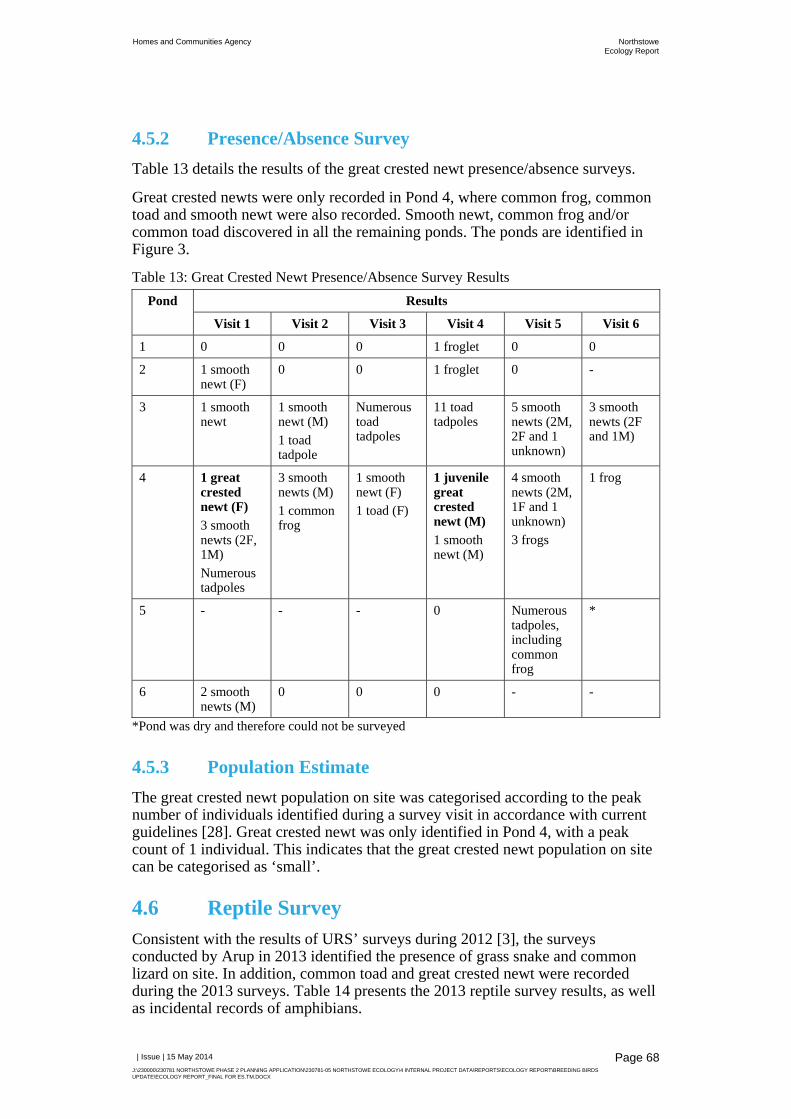
Homes and Communities Agency NorthstoweEcology Report
| Issue | 15 May 2014
J:\230000\230781 NORTHSTOWE PHASE 2 PLANNING APPLICATION\230781-05 NORTHSTOWE ECOLOGY\4 INTERNAL PROJECT DATA\REPORTS\ECOLOGY REPORT\BREEDING BIRDS UPDATE\ECOLOGY REPORT_FINAL FOR ES.TM.DOCX
Page 68
4.5.2 Presence/Absence Survey
Table 13 details the results of the great crested newt presence/absence surveys.
Great crested newts were only recorded in Pond 4, where common frog, common toad and smooth newt were also recorded. Smooth newt, common frog and/or common toad discovered in all the remaining ponds. The ponds are identified in Figure 3.
Table 13: Great Crested Newt Presence/Absence Survey Results Pond Results
Visit 1 Visit 2 Visit 3 Visit 4 Visit 5 Visit 6
1 0 0 0 1 froglet 0 0
2 1 smooth newt (F)
0 0 1 froglet 0 -
3 1 smooth newt
1 smooth newt (M) 1 toad tadpole
Numerous toad tadpoles
11 toad tadpoles
5 smooth newts (2M, 2F and 1 unknown)
3 smooth newts (2F and 1M)
4 1 great crested newt (F)
3 smooth newts (2F, 1M) Numerous tadpoles
3 smooth newts (M) 1 common frog
1 smooth newt (F) 1 toad (F)
1 juvenile great crested newt (M)
1 smooth newt (M)
4 smooth newts (2M, 1F and 1 unknown) 3 frogs
1 frog
5 - - - 0 Numerous tadpoles, including common frog
*
6 2 smooth newts (M)
0 0 0 - -
*Pond was dry and therefore could not be surveyed
4.5.3 Population Estimate
The great crested newt population on site was categorised according to the peak number of individuals identified during a survey visit in accordance with current guidelines [28]. Great crested newt was only identified in Pond 4, with a peak count of 1 individual. This indicates that the great crested newt population on site can be categorised as ‘small’.
4.6 Reptile Survey Consistent with the results of URS’ surveys during 2012 [3], the surveys conducted by Arup in 2013 identified the presence of grass snake and common lizard on site. In addition, common toad and great crested newt were recorded during the 2013 surveys. Table 14 presents the 2013 reptile survey results, as well as incidental records of amphibians.

Homes and Communities Agency NorthstoweEcology Report
| Issue | 15 May 2014
J:\230000\230781 NORTHSTOWE PHASE 2 PLANNING APPLICATION\230781-05 NORTHSTOWE ECOLOGY\4 INTERNAL PROJECT DATA\REPORTS\ECOLOGY REPORT\BREEDING BIRDS UPDATE\ECOLOGY REPORT_FINAL FOR ES.TM.DOCX
Page 69
Table 14: Reptile Survey Results Survey
Number Date Reptiles Amphibians
Species Life Stage
Number Species Life Stage
Number
1 17/09/13 Grass snake
Juvenile 0 Toad Juvenile 1
Adult 1
Common lizard
Juvenile 3 Adult 1
Adult 2
18/09/13 - Toad Juvenile 11
2 19/09/13 Common lizard
Juvenile 3 Great crested newt
Adult 2
Adult 3
25/09/13 - Toad Juvenile 6
3 25/09/13 Grass snake
Juvenile 2 Toad Juvenile 2
Common lizard
Juvenile 7
Adult 8
26/09/13 - Toad Adult 1
4 30/09/13 Grass snake
Juvenile 1 Great crested newt
Juvenile 2
Adult 1
Common lizard
Juvenile 1 Toad Juvenile 2
In addition, a water shrew Neomys fodiens was recorded at grid reference TL 41140 66602 during the survey on 30th September 2013.
The results are illustrated in Figure 9, which shows the peak counts for reptiles and amphibians recorded in any location within the site.
Most of the reptiles were recorded within Oakington Barracks and Airfield around the periphery of the site in areas of long grassland around the woodland edges and patches of scrub. Common lizard was identified in the greatest numbers in the north eastern corner of the site and further south along an area of dense scrub, close to the eastern boundary. All grass snakes were recorded within Oakington Barracks and Airfield along the edge of the woodland and scrub close to Longstanton Road (Figure 9).
Reptile numbers were low in the OSIA, with all three recordings of common lizard identified under the same mat between an arable field and private garden near to the top of Wilson’s Track.
4.6.1 Population Estimate
Using the Froglife reptile survey guidelines [30], the reptile populations were categorised according to the peak count of individuals recorded during each survey. In order to calculate the peak count, the 2013 survey results were combined with URS’ 2012 results (Table 15).

Homes and Communities Agency NorthstoweEcology Report
| Issue | 15 May 2014
J:\230000\230781 NORTHSTOWE PHASE 2 PLANNING APPLICATION\230781-05 NORTHSTOWE ECOLOGY\4 INTERNAL PROJECT DATA\REPORTS\ECOLOGY REPORT\BREEDING BIRDS UPDATE\ECOLOGY REPORT_FINAL FOR ES.TM.DOCX
Page 70
Populations of grass snake and common lizard were identified in both Oakington Barracks and Airfield and the OSIA, but it is believed these populations were likely to be distinct as Longstanton Road dissects the site, fragmenting the areas of suitable reptile habitat and limiting habitat connectivity between the north and south areas. As such, Table 15 provides the peak counts for reptiles recorded within Oakington Barracks and Airfield and the OSIA separately to inform population estimates for both areas.
Table 15: Combined Reptile Survey Results Survey Date Reptile Counts within Oakington
Barracks and Airfield Reptile Counts within the OSIA
Grass Snake Common Lizard
Grass Snake Common Lizard
18/06/12 1 0 0 0
31/08/12 – 01/09/12
0 2 0 2
04/09/12 – 05/09/12
2 0 0 0
05/09/12 and 17/09/12
2 1 0 2
18/09/12 0 0 0 3
19/09/12 3 0 0 0
20/09/12 2 2 0 0
17/09/13 – 18/09/13
1 3 0 0
19/09/13 and 25/09/13
0 6 0 0
25/09/13 – 26/09/13
2 12 0 3
30/09/13 2 1 0 0
Peak Count 3 12 0 3
Froglife [30] provides populations estimates for common lizard and grass snake, based on the peak counts, assuming that artificial reptile refugia are placed at a density of up to 10 per hectare. These criteria are set out in Table 16.
Table 16: Criteria for Estimating Common Lizard and Grass Snake Populations Species Low Population Good Population
Common lizard <5 5-20
Grass snake <5 5-10
Mats were placed at a density of less than 10 per hectare of suitable reptile habitat in both areas of the site. Using the methods outlined in Table 16, this indicates that there is:
A low population of common lizard within the OSIA; and A low population of grass snake and a good population of common lizard
within Oakington Barracks and Airfield.
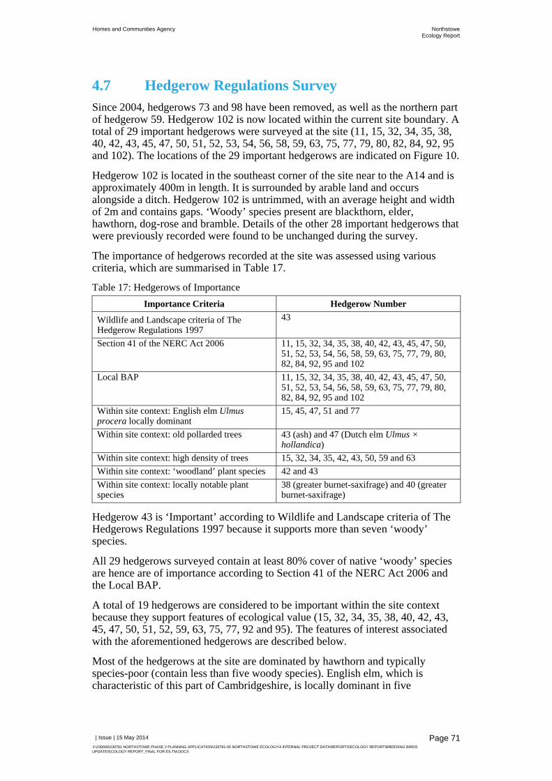
Homes and Communities Agency NorthstoweEcology Report
| Issue | 15 May 2014
J:\230000\230781 NORTHSTOWE PHASE 2 PLANNING APPLICATION\230781-05 NORTHSTOWE ECOLOGY\4 INTERNAL PROJECT DATA\REPORTS\ECOLOGY REPORT\BREEDING BIRDS UPDATE\ECOLOGY REPORT_FINAL FOR ES.TM.DOCX
Page 71
4.7 Hedgerow Regulations Survey Since 2004, hedgerows 73 and 98 have been removed, as well as the northern part of hedgerow 59. Hedgerow 102 is now located within the current site boundary. A total of 29 important hedgerows were surveyed at the site (11, 15, 32, 34, 35, 38, 40, 42, 43, 45, 47, 50, 51, 52, 53, 54, 56, 58, 59, 63, 75, 77, 79, 80, 82, 84, 92, 95 and 102). The locations of the 29 important hedgerows are indicated on Figure 10.
Hedgerow 102 is located in the southeast corner of the site near to the A14 and is approximately 400m in length. It is surrounded by arable land and occurs alongside a ditch. Hedgerow 102 is untrimmed, with an average height and width of 2m and contains gaps. ‘Woody’ species present are blackthorn, elder, hawthorn, dog-rose and bramble. Details of the other 28 important hedgerows that were previously recorded were found to be unchanged during the survey.
The importance of hedgerows recorded at the site was assessed using various criteria, which are summarised in Table 17.
Table 17: Hedgerows of Importance Importance Criteria Hedgerow Number
Wildlife and Landscape criteria of The Hedgerow Regulations 1997
43
Section 41 of the NERC Act 2006 11, 15, 32, 34, 35, 38, 40, 42, 43, 45, 47, 50, 51, 52, 53, 54, 56, 58, 59, 63, 75, 77, 79, 80, 82, 84, 92, 95 and 102
Local BAP 11, 15, 32, 34, 35, 38, 40, 42, 43, 45, 47, 50, 51, 52, 53, 54, 56, 58, 59, 63, 75, 77, 79, 80, 82, 84, 92, 95 and 102
Within site context: English elm Ulmus procera locally dominant
15, 45, 47, 51 and 77
Within site context: old pollarded trees 43 (ash) and 47 (Dutch elm Ulmus × hollandica)
Within site context: high density of trees 15, 32, 34, 35, 42, 43, 50, 59 and 63 Within site context: ‘woodland’ plant species 42 and 43Within site context: locally notable plant species
38 (greater burnet-saxifrage) and 40 (greater burnet-saxifrage)
Hedgerow 43 is ‘Important’ according to Wildlife and Landscape criteria of The Hedgerows Regulations 1997 because it supports more than seven ‘woody’ species.
All 29 hedgerows surveyed contain at least 80% cover of native ‘woody’ species are hence are of importance according to Section 41 of the NERC Act 2006 and the Local BAP.
A total of 19 hedgerows are considered to be important within the site context because they support features of ecological value (15, 32, 34, 35, 38, 40, 42, 43, 45, 47, 50, 51, 52, 59, 63, 75, 77, 92 and 95). The features of interest associated with the aforementioned hedgerows are described below.
Most of the hedgerows at the site are dominated by hawthorn and typically species-poor (contain less than five woody species). English elm, which is characteristic of this part of Cambridgeshire, is locally dominant in five

Homes and Communities Agency NorthstoweEcology Report
| Issue | 15 May 2014
J:\230000\230781 NORTHSTOWE PHASE 2 PLANNING APPLICATION\230781-05 NORTHSTOWE ECOLOGY\4 INTERNAL PROJECT DATA\REPORTS\ECOLOGY REPORT\BREEDING BIRDS UPDATE\ECOLOGY REPORT_FINAL FOR ES.TM.DOCX
Page 72
hedgerows (15, 45, 47, 51 and 77). Other elm species present in the aforementioned hedgerows are wych elm Ulmus glabra and Dutch elm.
Old pollarded trees comprise: a mature ash within Hedgerow 43 and a semi-mature Dutch elm within Hedgerow 47.
Nine hedgerows contain a high density of trees (15, 32, 34, 35, 42, 43, 50, 59 and 63).
The two hedgerows either side of Long Lane support ‘woodland’ plant species that are listed in the Wildlife and Landscape criteria of The Hedgerows Regulations 1997 (42 and 43). Hedgerow 42 supports sweet violet Viola odorata, wood avens Geum urbanum and false brome Brachypodium sylvaticum. Hedgerow 43 supports wood avens, herb-Robert Geranium robertianum, and false brome.
Hedgerows 38 and 40 support greater burnet-saxifrage Pimpinella major, which has a localised distribution in Cambridgeshire [34], [35].
5 Discussion
5.1 Bats
5.1.1 Potential and Confirmed Roosts
A confirmed roost was recorded within the roof void of the bungalow at Brookfield Farm (B55, Figure 4). The presence of fresh droppings and feeding remains, as well as the nature of roosting habitat indicate that this building supports a brown long-eared bat roost, although further emergence/return surveys are required to confirm this, as well as the nature of the roost (refer to Section 6.4.2). It was unclear where bats were gaining access into the roof void, although it is most likely that they access via crevices between the roof tiles and then via holes in the geotextile lining within the roof. There are also opportunities for bats to roost between the lining and the roof tiles, as well as between the roof tiles. Although no small bat droppings exhibiting characteristics of pipistrelle bats were recorded during the survey in 2013, it is also considered possible that pipistrelle bats also roost within this building, particularly since small bat droppings were recorded during internal inspection conducted in 2007.
Further buildings across the site were found to have a potential to support roosting bats, along with numerous trees, particularly within the belts of plantation woodland at Oakington Barracks and Airfield. Further emergence/return survey work is required to confirm the presence or likely absence of roosting bats, where these are likely to be affected as a result of the proposed Phase 2 and infrastructure developments (refer to Section 6.4.2).
5.1.2 Commuting and Foraging Activity
The most intense foraging activity was noted along Long Lane during the June and July bat activity surveys, where common and soprano pipistrelle, noctule, Leisler’s bat, possible serotine and probable Daubenton’s bat were recorded. Brown long-eared bat was also recorded by the static detector in this part of the

Homes and Communities Agency NorthstoweEcology Report
| Issue | 15 May 2014
J:\230000\230781 NORTHSTOWE PHASE 2 PLANNING APPLICATION\230781-05 NORTHSTOWE ECOLOGY\4 INTERNAL PROJECT DATA\REPORTS\ECOLOGY REPORT\BREEDING BIRDS UPDATE\ECOLOGY REPORT_FINAL FOR ES.TM.DOCX
Page 73
site (SD6). This part of the site supports a relatively high diversity of bats. This dark corridor flanked by trees along both sides provides ideal sheltered foraging habitat for bats. However, the highest levels of bat activity recorded by the static detectors were not recorded in this part of the site.
The static detector located along Oakington Brook, adjacent to the plantation woodland (SD13), recorded the highest levels of bat activity. The track between the plantation woodland and Oakington Brook was also found to support high levels of common pipistrelle foraging activity during the activity survey. The high bat activity indice calculated for soprano pipistrelle, as well as the social calls recorded, indicate that there is a soprano pipistrelle roost in this part of the site, either on the tree where the static detector was located, or another willow tree along Oakington Brook nearby. Many of these trees provide suitable roosting habitat for bats (Figure 3). A relatively high diversity of bat species were recorded in this part of the site, comprising probable serotine, Nyctalus sp and probable Daubenton’s and probable Natterer’s bat, as well as the species identified above.
The lake at Oakington Barracks and Airfield was found to provide important foraging habitat for common pipistrelle during the bat activity survey, where the level of bat activity recorded by the static detector (SD6) was second to SD13. Other species recorded here comprised soprano pipistrelle, noctule, Leisler’s bat and probable Daubenton’s bat. These results are in line with the results obtained by URS in 2012 [3], although brown long-eared bat was also recorded in 2012.
The road heading into the barracks just beyond the entrance gate, which is flanked by mature trees, was also a key foraging area for common pipistrelle and was also thought to provide a commuting corridor. One of the static detectors along the northern boundary of the site (SD8) also recorded high levels of bat activity, primarily associated with common pipistrelle foraging activity.
Wilson’s Road (track) was found to provide important foraging habitat for common pipistrelle bats during the activity survey, although the static detector located at the southern end of this track recorded very little activity (SD12).
A total of 10 bat species were recorded during the bat surveys (including serotine, Daubenton’s bat and Natterer’s bat which were recorded as probable), of the 12 species that have been recorded in Cambridgeshire. The other species that have been recorded in Cambridgeshire are Whiskered and Brandt’s bats. Due to the difficulties in identifying Myotis sp. bats to species level, it is possible that these species were also recorded.
The most significant species record was barbastelle, which was recorded by SD2 in the northern part of Oakington Barracks and Airfield. Only three calls were recorded at 00:10 on 2nd June within 15 seconds and are therefore likely to relate to a pass over the site rather than any activity within the site. This record is unsurprising though, considering that there is a maternity colony of barbastelle at Eversden and Wimpole Woods SAC. The site is therefore not considered to provide important habitat for barbastelle. A similarly low level of barbastelle activity was also recorded by URS in 2012 [3].
A low number of Leisler’s bat calls were recorded within the site by four of the static detectors (SD6, SD9, SD12 and SD16). However, of particular note, Leisler’s bat was recorded foraging along Long Lane and around the field edges to the west of Long Lane. Leisler’s bat is considered to be rare in Cambridgeshire [36], with only four records of roosts.
Homes and Communities Agency NorthstoweEcology Report
| Issue | 15 May 2014
J:\230000\230781 NORTHSTOWE PHASE 2 PLANNING APPLICATION\230781-05 NORTHSTOWE ECOLOGY\4 INTERNAL PROJECT DATA\REPORTS\ECOLOGY REPORT\BREEDING BIRDS UPDATE\ECOLOGY REPORT_FINAL FOR ES.TM.DOCX
Page 74
Serotine is considered uncommon in Cambridgeshire [36] and indeed very few probable records of serotine were recorded by one of the static detectors located along Oakington Brook (SD13). These cannot be confirmed as serotine calls due to overlapping call parameters with Leisler’s bat in cluttered habitats.
Cambridgeshire bat group has only collected a few records of Nathusius’ pipistrelle [36]. This species is considered to be a rare bat in the UK, but there have been an increase in the number of records in Britain, which may be associated with expansions to their range [37] or confusion with common pipistrelle. Only low levels of Nathusius’ pipistrelle activity were recorded by the static detectors located at Oakington Barracks and Airfield and the OSIA (SD2, SD9, SD14 and SD15).
The areas that were found to be of most value to foraging bats were the sheltered and vegetated areas that support abundant insect prey. Of particular note was Long Lane, where a wide variety of species utilise this corridor for feeding.
5.2 Badgers The presence of 31 setts across the site indicates high levels of badger activity, principally in the southern part of Oakington Barracks and Airfield, where three main setts were recorded. An additional main sett was recorded in the OSIA. The 31 setts recorded included five partially disused setts and another disused sett; however it is possible that they may be occupied again in the future. As indicated previously, considering the levels of badger activity recorded, a badger bait-marking survey should be undertaken to verify status of badger setts within the site and the territorial boundaries of the social groups (refer to Section 6.4.3).
Only outlier and subsidiary setts were recorded within northern part of the site that falls within the Phase 2 planning application boundary. However, the proposed road down to Longstanton Road and Hatton’s Road would bisect Oakington Barracks and Airfield, which would have a potential to fragment the setts and foraging habitats in the southern part of the barracks.
With reference to the results of previous badger surveys undertaken in 2007 [1] and 2012 [3], the number and distribution of setts across the site remain broadly similar when compared to these previous surveys. There have been changes to the status of badger setts across the site, as well as some additional setts recorded. It is noted that a main sett was recorded in the southeast corner of Oakington Barracks and Airfield in 2013, which is contrary to the results of the survey conducted by WSP in August 2007 [1]. Although WSP did not record a main sett in this part of the site, a main sett was recorded beyond the southeast boundary of the site, which could not be accessed during the survey in 2013. Based on a review of aerial mapping, it is possible that residential development beyond the southeast boundary of the site may have affected badger activity in the southeast corner of the site. However, the status of this sett should be verified should access be possible (refer to Section 6.4.3).
The grassland around the southern edges of the site provide valuable foraging habitat for badgers. The majority of foraging activity was noted along the edges of the woodlands, which provide cover near to the setts within the plantation woodland. Other setts were located along the field boundaries within in the OSIA, but at a lower density, indicating that the habitat is less suitable for badger compared to Oakington Barracks and Airfield.

Homes and Communities Agency NorthstoweEcology Report
| Issue | 15 May 2014
J:\230000\230781 NORTHSTOWE PHASE 2 PLANNING APPLICATION\230781-05 NORTHSTOWE ECOLOGY\4 INTERNAL PROJECT DATA\REPORTS\ECOLOGY REPORT\BREEDING BIRDS UPDATE\ECOLOGY REPORT_FINAL FOR ES.TM.DOCX
Page 75
The results indicate that more than one social group is present within the site, however the number of territories and locations of the boundaries of the territories can only be confirmed through the completion of a badger bait marking survey (refer to Section 6.4.3).
5.3 Breeding Birds A total of 73 species of birds were recorded at the site during 2013. Of these, 61 were either confirmed as breeding or probably breeding on the site. A further four species were considered as possibly breeding at the site. The remaining eight species were considered non-breeding and were utilising the site in other ways, including for roosting and/or foraging. Overall, the diversity of birds at the site was good and included a range of species typically found in similar habitats in lowland Britain. These included passerines, raptors, game birds, corvids and waterfowl.
Fuller (1980) [38] devised standard procedures for evaluating breeding bird communities on sites. Recording the number of species on a site can provide a simple measure of species diversity from which to confer a level of conservation importance to a site. The standard qualifying levels provided by Fuller are as follows:
National Importance: 85+ species; Regional Importance: 70-84 species; County Importance: 50-69 species; and Local Importance: 25- 49 species.
The confirmed breeding species list for the whole site numbered 42, which falls inside the range for Local Importance. It may be argued that proof of breeding was not achieved for some species which may have been breeding on the site. As such, this figure could well be higher. For example, if those species considered as probably breeding at the site were included, this figure would increase to 61 and the site would be considered of County level of importance.
The site supports two Schedule 1 species confirmed as breeding, one non-breeding, 13 red list species and 21 amber list species, the majority of which were considered to breed at the site. Oakington Barracks and Airfield currently provides a relatively diverse range of habitats which are beneficial to a significant number of bird species. Some of the habitats, for example the areas of open and largely undisturbed grassland, are scarce elsewhere in the local area. The areas of rough grassland, scrub and mature trees around the site boundary were particularly important for many bird species. The open water provided by the lake increased the species diversity at the site by attracting species such as great crested grebe, coot, mute swan and greylag goose. The site therefore certainly represents an area of Local Importance to birds and it could be argued it is important at a County Level, given the general lack of similar sites in the surrounding area.
The key areas for breeding birds within the OSIA were ditches, hedges, scrub and tree lines. Young plantation woodland with associated rough grassland was also important for some species, including meadow pipit, and the open arable areas were important for species such as skylark and yellow wagtail.

Homes and Communities Agency NorthstoweEcology Report
| Issue | 15 May 2014
J:\230000\230781 NORTHSTOWE PHASE 2 PLANNING APPLICATION\230781-05 NORTHSTOWE ECOLOGY\4 INTERNAL PROJECT DATA\REPORTS\ECOLOGY REPORT\BREEDING BIRDS UPDATE\ECOLOGY REPORT_FINAL FOR ES.TM.DOCX
Page 76
URS recorded 56 species of birds during the 2012 breeding bird surveys. The additional 17 species recorded at the site during the 2013 surveys probably reflect that the OSIA and land to the west of Long Lane were also surveyed, which diversified the habitat types that were surveyed. However, many of the species were recorded on both surveys and in similar numbers. For example, URS recorded an estimated 14 skylark territories at the Oakington Barracks and Airfield part of the site in 2012. The 2013 surveys of the same area estimated that 13 skylark territories were present.
Scarcer species such as quail and spotted flycatcher were recorded in low numbers by URS in 2012 but were not recorded at all during 2013. Similarly, the 2012 surveys did not note any records of long-eared owl or reed bunting whereas the 2013 surveys did. These small differences probably reflect the lower chances of seeing scarce or secretive species such as these, making them less likely to be recorded on every survey visit.
Taken as a whole, the results from the two survey seasons are likely to represent good overall indication of the types of species present and the numbers of pairs and individuals which currently utilise the site for breeding and/or foraging. The results from the two surveys are therefore likely to provide a robust set of data for the site as a whole.
5.4 Amphibians URS conducted great crested newt presence/absence surveys on five ponds in 2012, revealing the presence of great crested newts in Ponds 1, 2 and 4 [3] (Figure 3). These ponds were surveyed by Arup in 2013, although great crested newt was only recorded in Pond 4 and in lower numbers (peak count of one compared to 13). A sixth pond was incorporated into the surveys by Arup in 2013, which is located within the OSIA, but no great crested newts were recorded.
It should also be noted that a peak count of two great crested newts were recorded under artificial reptile refugia during the reptile survey. This provides valuable information regarding the distribution of great crested newt across the terrestrial habitat within the site (Figure 9). As expected, great crested newt was recorded in areas of grassland and plantation woodland within the southern half of Oakington Barracks and Airfield, where the ponds are located that have been found to support great crested newt. The long grassland, scrub and woodland habitats within the site provide important habitat for great created newt outside the breeding season.
During 2013, fewer great crested newts were recorded in fewer ponds when compared to the results of the 2012 surveys [3]. This could be because the surveys commenced too late in the survey season, or as a result of natural variations in species populations over time.
A population estimate was calculated from the 2013 results, indicating that a small population of great crested newt was present on site. However analysis of the 2012 results reveals a peak count of 13 individuals recorded during the survey on 10th to 11th May 2012. These were recorded in Pond 4, which, taken in conjunction with the results of the 2013 survey, indicates that this pond provides the most important breeding habitat for great crested newt on the site. As outlined above, great crested newt was also recorded in Ponds 1 and 2, with peak counts of three and one respectively. A peak count of 13 recorded in 2012 indicates a

Homes and Communities Agency NorthstoweEcology Report
| Issue | 15 May 2014
J:\230000\230781 NORTHSTOWE PHASE 2 PLANNING APPLICATION\230781-05 NORTHSTOWE ECOLOGY\4 INTERNAL PROJECT DATA\REPORTS\ECOLOGY REPORT\BREEDING BIRDS UPDATE\ECOLOGY REPORT_FINAL FOR ES.TM.DOCX
Page 77
medium population of great crested newt. This peak count is at the lower end of this category, which falls between 11 and 100. Taking the 2012 and 2013 results in combination and adopting a precautionary approach, it is concluded that a medium population of great crested newt is present on the site.
Ponds 1, 2 and 4 are connected by suitable habitat (grassland and woodland) and are thought to support a metapopulation of great crested newts. As such, the retention and/or creation of multiple, interconnecting ponds that provide suitable breeding habitat for great crested newts will be vital to ensuring their long-term presence at the site.
Smooth newts, common toads and/or common frogs were also recorded within all of the surveyed ponds. Pond 3 was found to support large numbers of common toad tadpoles during the surveys and is therefore considered to provide important breeding habitat for this species. As indicated above with respect to great crested newt, the grassland, scrub and woodland habitat provide valuable terrestrial habitat. This species is of conservation importance as it is listed on the UK BAP and is a species of principal importance in conserving biodiversity.
5.5 Reptiles Parts of Oakington Barracks and Airfield provides particularly suitable habitat for reptiles, including a mosaic of long grassland, scrub and woodland where reptiles can bask, forage, shelter and hibernate. A low population of grass snake and a good population of common lizard were recorded within Oakington Barracks and Airfield. A key area of the site for common lizard and grass snake comprised the southern part of the barracks, with the areas of scrub and grassland in the northern and eastern parts of the site providing important habitat for common lizard.
Although the OSIA presents limited opportunities for reptiles, being dominated by large expanses of intensively managed, arable land, common lizard exists in low numbers along Wilson’s Road track and connecting habitats, including Longstanton Brook, equating to a low population. Common lizard was recorded in more locations within the OSIA by URS in 2012 than by Arup in 2013, although the peak count was the same (3). This is likely to be on account of the low population of common lizard in this part of the site and since fewer visits were completed, rather than any changes to their distribution.
5.6 Hedgerows A total of 29 hedgerows were recorded at the site which have a combined total length of approximately 8km. All of the hedgerows are of importance according to Section 41 of the NERC Act 2006 and the Local BAP.
A total of 19 hedgerows are intrinsically important within the site context because they support features of ecological value (15, 32, 34, 35, 38, 40, 42, 43, 45, 47, 50, 51, 52, 59, 63, 75, 77, 92 and 95). Hedgerow 43 is also ‘Important’ (according to Wildlife and Landscape criteria of The Hedgerows Regulations 1997), because it supports seven ‘woody’ species.
Certain hedgerows at the site are also of importance because they support a species of nature conservation importance. For example, white-spotted pinion moth, which is nationally scarce species, was recorded alongside hedgerows where English elm is locally dominant (15, 45, 47, 51 and 77).

Homes and Communities Agency NorthstoweEcology Report
| Issue | 15 May 2014
J:\230000\230781 NORTHSTOWE PHASE 2 PLANNING APPLICATION\230781-05 NORTHSTOWE ECOLOGY\4 INTERNAL PROJECT DATA\REPORTS\ECOLOGY REPORT\BREEDING BIRDS UPDATE\ECOLOGY REPORT_FINAL FOR ES.TM.DOCX
Page 78
The hedgerows are also of importance because they facilitate species dispersal across the site and to adjacent semi-natural habitats. For example, the hedgerows along Long Lane (hedgerows 42 and 43) provide an important foraging habitat for common and soprano pipistrelle, Leisler's bat and noctule.
The majority of hedgerows at the site are species-poor and are in the need of sympathetic management to enhance their biodiversity potential. A few hedgerows support features of intrinsic importance, such as old pollarded trees, or support species of nature conservation importance, such as white-spotted pinion moth. Overall, for the aforementioned reasons the 8km hedgerow network at the site is of district/borough value.

Homes and Communities Agency NorthstoweEcology Report
| Issue | 15 May 2014
J:\230000\230781 NORTHSTOWE PHASE 2 PLANNING APPLICATION\230781-05 NORTHSTOWE ECOLOGY\4 INTERNAL PROJECT DATA\REPORTS\ECOLOGY REPORT\BREEDING BIRDS UPDATE\ECOLOGY REPORT_FINAL FOR ES.TM.DOCX
Page 79
6 Recommendations
This section outlines recommendations for mitigation, enhancements and further survey work with respect to the proposed Phase 2 and infrastructure planning applications.
6.1 General Approach In parallel with the masterplanning for Phase 2, it is recommended that an ecologist works closely with the planners and landscape architects to develop a masterplan that incorporates appropriate mitigation and enhancements. The purpose would be to ensure that appropriate mitigation, compensation and enhancements are incorporated into the proposed development.
An ecological management plan should also be prepared, which would describe the retained habitats and proposed landscaped areas within the site and how these will be managed to mitigate impacts and maximise the biodiversity potential of the site. It is expected that the preparation of this document would be a condition of planning permission.
6.2 Mitigation
6.2.1 Bats
6.2.1.1 European Protected Species Licencing
Should B55 have a potential to be affected as a result of the proposed developments, a European Protected Species (EPS) Mitigation licence would need to be issued to and approved by Natural England once planning permission is granted but prior to the commencement of the work. This would include any work that could cause an offence under the WCA and Habitats and Species Regulations (refer to Section 2.3.1), which could include temporary or permanent disturbance as well as the loss of the roost. The same would apply to any other bat roosts recorded on the site during the recommended further surveys (refer to Section 6.4.2).
Natural England would have up to 30 working days to determine a licence application. Should the licence application be declined, the 30-day decision period would restart. It is therefore recommended that the licence application is submitted as soon as possible once planning permission is granted, to avoid delays to the programme.
This licence application would need to include a full Method Statement, describing the surveys undertaken and potential impacts of the proposed development. It would need to contain sufficient evidence to allow Natural England to reach the conclusion that ‘the action authorised will not be detrimental to the maintenance of the species concerned at a favourable conservation status in their natural range’ [39]. Therefore, adequate mitigation and compensation measures would also need to be outlined to minimise impacts and account for the loss of roosting and foraging habitat as a result of the proposed development.

Homes and Communities Agency NorthstoweEcology Report
| Issue | 15 May 2014
J:\230000\230781 NORTHSTOWE PHASE 2 PLANNING APPLICATION\230781-05 NORTHSTOWE ECOLOGY\4 INTERNAL PROJECT DATA\REPORTS\ECOLOGY REPORT\BREEDING BIRDS UPDATE\ECOLOGY REPORT_FINAL FOR ES.TM.DOCX
Page 80
The specific requirements for mitigation and compensation would be developed considering the nature of the roost and specifics of the proposed development, including the scale of impacts, timescales and works involved. However, this may include programming the works to avoid the most sensitive times of year (which would depend on the nature of the roost), excluding bats from the roost and/or conducting a soft-strip or soft felling under the guidance of a licensed bat worker. With respect to compensation for the loss of bat roosts, this could include installing bat boxes and bespoke roosting habitat for bats within the proposed development. This may comprise a ‘bat house’ or features, such as voids and crevices, within the proposed buildings. It is possible that some of the pillboxes could be altered to provide suitable roosting habitat for bats and therefore provide compensation for the loss of roosting habitat elsewhere. It should be noted, however, that three of these have a moderate potential to support roosting bats; some historic feeding remains were recorded within B7 and B13; and B10 could not be inspected. An EPS Mitigation licence would be required to undertake works on these structures if they are found to support roosting bats.
A Reasoned Statement would need to be submitted with the licence application, which would need to demonstrate that there are no satisfactory alternatives to the proposed works. It also needs to provide a ‘planning’ case for the proposed work, in terms of ‘preserving public health or public safety or other imperative reasons of overriding public interest including those of a social or economic nature and beneficial consequences of primary importance for the environment’[39]. This document should be prepared by a planning consultant.
6.2.1.2 Lighting
Appropriate measures should be implemented to avoid the disturbance of roosting, foraging and commuting bats during the construction and operation of the proposed Phase 2 and infrastructure developments, in line with the BCT’s guidelines. Lighting should not be directed towards Long Lane, other retained habitats or landscaped areas or purpose-built bat houses or bat boxes installed at the site. The following general measures should also be employed:
Low or high pressure sodium lamps should be used where possible instead of mercury or metal halide lamps. Light Emitting Diodes (LEDs) are also preferable to mercury or metal halide lamps, as these are more directional with low spill;
Lighting should be directed to where it is needed and accessories such as hoods, cowls, louvres and shields used to minimise spillage. The lighting strategy should be developed in consultation with an ecologist to ensure that lights are not directed towards potential flight lines or foraging areas that are created or retained as part of the proposed developments;
The height of lighting columns should be minimised to limit the visibility of lighting and light spill to bats; and
Light levels should be as low as guidelines permit and be turned off when not required.

Homes and Communities Agency NorthstoweEcology Report
| Issue | 15 May 2014
J:\230000\230781 NORTHSTOWE PHASE 2 PLANNING APPLICATION\230781-05 NORTHSTOWE ECOLOGY\4 INTERNAL PROJECT DATA\REPORTS\ECOLOGY REPORT\BREEDING BIRDS UPDATE\ECOLOGY REPORT_FINAL FOR ES.TM.DOCX
Page 81
6.2.2 Badgers
The badger setts should be retained where possible, particularly the main setts. In order to prevent disturbance to active badger setts (which would cause an offence under the Protection of Badgers Act 1992), it would be necessary to establish buffer zones around the setts. An indicative guide as to the extent of buffer zones that would likely need to be established is provided below [41]:
No heavy machinery (generally tracked vehicles) within approximately 30 metres of any entrance to an active sett;
No lighter machinery (generally wheeled vehicles), particularly for any digging operation, within 20m; and
No light work such as hand digging or scrub clearance within 10m.
The completion of any of the above works within the specified zones may need to be undertaken under a licence. A licence would also be required to close any active setts. Furthermore, artificial setts would need to be created prior to the closure of main setts, to compensate for the loss of habitat.
It is not expected that any main setts would need to be closed in order to facilitate the Phase 2 and infrastructure developments, with the exception potentially of sett 19, due to works required to connect to the CGB. Although the future planning application(s) relating to the southern part of Oakington Barracks and Airfield could result in the most significant impacts on badger populations within the site, it is recommended that the design of the proposed development incorporates the existing main setts, as it may prove difficult to gain a licence to close them. The licence would need to demonstrate that interference is both unavoidable and will not adversely affect the population [40].
Sett closure would involve fitting a one-way gate to each entrance hole to be closed with associated weld-mesh fixed to the ground. The setts would be monitoring to check if any badgers remain. Sett interference should be avoided when dependant young may be present and badgers are particularly vulnerable (December to June inclusive).
The woodland, grassland, tall ruderal and scrub habitats that surround the setts provide foraging habitat and cover for badgers. In order to sustain the main setts within the site, this habitat would need to be retained and enhanced, maintaining connectivity across the site (refer to Section 6.3.3). It would also be necessary to maintain connectivity between the setts occupied by the same social group.
The proposed Phase 2 and infrastructure developments should incorporate suitable foraging habitat for badgers, to compensate for the loss of habitat. With respect to future planning applications within the southern part of Oakington Barracks and Airfield, the areas of grazed grassland within the southern part of the site provide ideal foraging opportunities for badgers and the loss of this habitat can be compensated through the enhancement of retained and landscaped areas around the periphery of the site. The extent of foraging habitat that should be provided will depend on the value of the habitats to badgers, in terms of the density of invertebrate prey and other food sources. However, there should be no net loss in foraging habitat, taking into consideration any increases in the carrying capacity of the habitats resulting from habitat enhancements (refer to Section 6.3.3).

Homes and Communities Agency NorthstoweEcology Report
| Issue | 15 May 2014
J:\230000\230781 NORTHSTOWE PHASE 2 PLANNING APPLICATION\230781-05 NORTHSTOWE ECOLOGY\4 INTERNAL PROJECT DATA\REPORTS\ECOLOGY REPORT\BREEDING BIRDS UPDATE\ECOLOGY REPORT_FINAL FOR ES.TM.DOCX
Page 82
6.2.3 Breeding Birds
It is recommended that the following mitigation principles are followed, with the aim of retaining the current species diversity at the site as a minimum requirement and to avoid contravention of the legislation outlined in Section 2.3.4.
Clearance works will be required prior to the commencement of construction work on the site. This is likely to entail the removal of vegetation and should therefore be preceded by various species mitigation works. Habitat clearance should occur outside of the main breeding bird season (March to August inclusive) to reduce the risk of any breeding birds, their active nests or young being harmed during construction. If this is not possible, a suitably qualified ecologist/ornithologist will need to attend the site to check for the presence of breeding birds prior to the commencement of any clearance or construction activities. Where any active nests are found during clearance, a buffer zone would need to be cordoned off around the nest to ensure the safeguarding of the nest and young. This would need to remain in place until the young had all fledged and left the immediate area around the nest site. It should be noted that whilst the main breeding season is between the periods stated above, nesting does occur at other times of the year and vigilance needs to be applied.
The mitigation strategy will also need to consider the potential effects of indirect disturbance events to breeding bird populations within the site and in the vicinity of clearance, earthworks and construction work. For example, certain construction activities could have indirect disturbance effects such as those caused by increased human presence or particularly noisy construction activities. This would particularly apply to any Schedule 1 species nesting at the site, as it is illegal to intentionally disturb any wild bird listed in Schedule 1 of the WCA while it is building a nest or is in, or near a nest containing eggs or young or to disturb the dependent young. Larger buffer zones would need to be implemented and applied around breeding sites for Schedule 1 species until all young had fledged and left the nest and immediate area.
Potential habitat loss associated with land clearance should be compensated for by the creation and enhancement of a range of habitat types. These habitats should reflect the breeding species present at the site, and therefore the habitats which currently exist at the site. Detailed enhancement recommendations are outlined in Section 6.3.4.
Specific measures for barn owls have previously been implemented at the site. Four barn owl ‘pole boxes’ were erected across Oakington Barracks and Airfield to mitigate for the loss of nest sites associated with the demolition of the disused aircraft hangers and other buildings. Three of these have since become unusable, which should be repaired or replaced. In the long-term, the preferred option would be to incorporate barn owl nesting opportunities within new buildings. This would ensure a longer term provision of nest sites. A plan should be developed to define the numbers, locations and designs of artificial nest sites for this species.
6.2.4 Amphibians
Suitable terrestrial habitat within 500m of breeding ponds is considered to have a potential to support great crested newt [28]. Ponds 1, 2 and 4 are located beyond 500m from the Phase 2 development boundary, but within 500m of the proposed access road to Longstanton Road. There is also a potential for great crested newt

Homes and Communities Agency NorthstoweEcology Report
| Issue | 15 May 2014
J:\230000\230781 NORTHSTOWE PHASE 2 PLANNING APPLICATION\230781-05 NORTHSTOWE ECOLOGY\4 INTERNAL PROJECT DATA\REPORTS\ECOLOGY REPORT\BREEDING BIRDS UPDATE\ECOLOGY REPORT_FINAL FOR ES.TM.DOCX
Page 83
to breed in Pond 7, which falls within the Phase 2 planning application boundary. As such, the proposed infrastructure development, as well as the future development of the southern part of Oakington Barracks and Airfield, will inevitably result in the loss of suitable terrestrial habitat for great crested newt, even if it were possible to retain Ponds 1, 2 and 4.
Due to the potential for the proposed developments to result in a loss of terrestrial habitat for great crested newt, an approved European Protected Species (EPS) Mitigation Licence will be required prior to the commencement of clearance of works that could otherwise result in an offence under the WCA and Habitats and Species Regulations. This can only be obtained once planning permission has been granted. The EPS Mitigation Licence would include a mitigation strategy for great crested newt, the details of which would be dependent on the proposed development design and results of further surveys recommended in Section 6.4.4. However, the general principles that would be applied are outlined below.
Where possible, Ponds 1, 2 and 4 should be retained, protected and enhanced during the future development of the site. As indicated in Section 5.4, it will also be essential to maintain and/or create suitable interconnecting terrestrial habitat to ensure the interchange of individuals between the ponds and maintain genetic diversity and viability. This could be achieved through the creation of tunnels for great crested newt beneath main roads that fragment breeding ponds or foraging habitat.
Should it be necessary to remove Ponds 1, 2 and 4, further ponds (off site or on site) would need to be created to act as receptor sites for the translocation of the great crested newts from the ponds to be lost. These would need to more than compensate for those to be lost to provide a net gain for great crested newts. The receptor site(s) (including the ponds and terrestrial habitat) should be more than capable of supporting the population of great crested newts being translocated through appropriate landscaping and management. Suitable enhancements are outlined in Section 6.3.5. Ponds should be located within 250m of each other and be connected by suitable habitat. Pond creation should take place well in advance of translocation (6 months as a minimum, ideally 1 to 2 years) in order to enable the establishment of plant and invertebrate populations. Following translocation, the habitats would need to be cleared sensitively under an ecological watching brief. All works should be undertaken between February and October inclusive, to avoid the period when amphibians are hibernating and are therefore more vulnerable to injury. Post-development monitoring will also be a requirement of an EPS Mitigation licence.
Smooth newts, toads and/or frogs were recorded in all surveyed ponds. The retention of the ponds on the site would benefit common amphibians as well as great crested newt. Of particular note was Pond 3. Although this pond was not found to support great crested newt, it provides valuable breeding habitat for common toads, with smooth newt also recorded breeding. It is understood that this pond is due to be retained during the future development of the site.
Common amphibians are only protected from sale under the WCA. However, appropriate mitigation measures should be employed to avoid unnecessary killing or injury. Any ponds that need to be removed should ideally be drained outside the amphibian breeding season; the implementation of the measures described above under an EPS Mitigation Licence would also protect common amphibians.

Homes and Communities Agency NorthstoweEcology Report
| Issue | 15 May 2014
J:\230000\230781 NORTHSTOWE PHASE 2 PLANNING APPLICATION\230781-05 NORTHSTOWE ECOLOGY\4 INTERNAL PROJECT DATA\REPORTS\ECOLOGY REPORT\BREEDING BIRDS UPDATE\ECOLOGY REPORT_FINAL FOR ES.TM.DOCX
Page 84
This would also involve the sensitive clearance of suitable terrestrial habitat under an ecological watching brief.
6.2.5 Reptiles
The implementation of development proposals will be likely to result in the loss and degradation of reptile habitat and features on site. It is therefore recommended that a mitigation strategy is developed in order to alleviate the impact of the development proposals on common lizards and grass snakes and ensure compliance with legislation.
The proposed developments will be phased, thus providing an opportunity to enhance certain areas of the site for reptiles to increase the carrying capacity. These areas would act as receptor sites for any reptiles displaced by works in other parts of the site. These enhancements should be implemented prior to the commencement of clearance works in other areas. Enhancements are discussed in Section 6.3.6.
This strategy should include the sensitive clearance of any reptile habitat, including woodlands, long grassland, tall ruderal vegetation and scrub, under an ecological watching brief, with such work being carried out between March and October when reptiles are active. Any potential hibernacula within the works area should be subject to a destructive search by an ecologist and the vegetation should be cleared in stages to allow any reptiles which may be present to escape. Following clearance, these areas should be managed such as to prevent any reptiles from returning to the work areas, by keeping the vegetation short and avoiding the creation of suitable hibernacula, such as log and stone piles. Undertaking clearance works sensitively will, in most cases, encourage reptiles to move out of harm’s way. Any reptiles that are captured during sensitive clearance or the destructive search should be translocated to the receptor sites.
6.2.6 Hedgerows
There are 20 hedgerows at the site that are either of intrinsic importance or support a nationally scarce species (11, 15, 32, 34, 35, 38, 40, 42, 43, 45, 47, 50, 51, 52, 62, 63, 75, 77, 92 and 95) that should be protected and sympathetically managed. These actions would contribute to the Local BAP objectives.
Through the master planning design process, opportunities to link together retained hedgerows by planting native species-rich hedgerows should be sought to facilitate ecosystem functioning across the site. The former airfield is virtually devoid of hedgerows and offers potential for hedgerow creation to facilitate species dispersal across this part of the site. These hedgerows should include whips and standards of native tree and shrub species that are characteristic of this part of Cambridgeshire, which would contribute to the Local BAP targets.
6.3 Enhancements
6.3.1 General Principals
The following general principals should be adhered to when developing the ecological masterplan for the site:

Homes and Communities Agency NorthstoweEcology Report
| Issue | 15 May 2014
J:\230000\230781 NORTHSTOWE PHASE 2 PLANNING APPLICATION\230781-05 NORTHSTOWE ECOLOGY\4 INTERNAL PROJECT DATA\REPORTS\ECOLOGY REPORT\BREEDING BIRDS UPDATE\ECOLOGY REPORT_FINAL FOR ES.TM.DOCX
Page 85
Appropriate enhancements should be incorporated within the site to benefit species that currently occur on the site, including great crested newt, bats, reptiles, badger and barn owl, as well as notable and protected species that have a potential to colonise the site. Consideration should be given to the UK and Local BAPs. These enhancements should ensure a net gain in biodiversity, in accordance with the National Planning Policy Framework [42];
Native planting should be incorporated where possible, including berry-bearing species. Native species support higher levels of biodiversity;
Connectivity should be ensured through habitat creation and retention, to ensure linkage through the site with other adjacent habitats and thus provide corridors for wildlife movement across the site;
Landscaped areas should be developed with a variety of species in mind to bring multiple benefits. For example, the provision of wooded areas and hibernacula could bring benefits to mammals, birds, reptiles, amphibians and invertebrates; and
A long-term management plan should be developed and adhered to (refer to Section 0) in order to ensure that the enhancement measures are appropriately managed.
6.3.2 Bats
The ecological masterplan should incorporate suitable foraging and commuting habitat for bats and the built development should incorporate suitable roosting habitat (refer to Section 6.2.1.1). Native trees, shrubs and flowering plants should be planted that attract insects that bats feed upon. Sheltered wildflower meadows and ponds also provide excellent foraging habitat for bats. Lines of trees and hedgerows should also be incorporated, ideally comprising a double line of vegetation that would create sheltered corridors across the site. These habitats would create foraging opportunities and improve connectivity.
The lake currently provides valuable foraging habitat for bats, but could be enhanced by incorporating riparian and aquatic planting, as well as trees and scrub around the edges of the lake to provide habitat for invertebrates and shelter from the wind.
6.3.3 Badgers
Ideally, the habitats that fall within the existing badger territories should be enhanced to provide improved foraging opportunities, to compensate for the inevitable loss of foraging habitat as a result of development, particularly within the southern part of Oakington Barracks and Airfield. Habitat retention and creation should favour short grazed or mown grassland and secondly broadleaved woodland, which support a high density of invertebrate prey [43]. The woodlands also provide important cover for the setts. Fruiting trees and shrubs provide an alternative source of food.
Ideally, adequate compensation for the loss of foraging habitat should be provided within the site. However, depending on the extent of habitat that can be retained and created within the site, it may be necessary to enhance adjacent habitats that fall within their territories, in order to compensate for habitat loss within the site.

Homes and Communities Agency NorthstoweEcology Report
| Issue | 15 May 2014
J:\230000\230781 NORTHSTOWE PHASE 2 PLANNING APPLICATION\230781-05 NORTHSTOWE ECOLOGY\4 INTERNAL PROJECT DATA\REPORTS\ECOLOGY REPORT\BREEDING BIRDS UPDATE\ECOLOGY REPORT_FINAL FOR ES.TM.DOCX
Page 86
6.3.4 Breeding Birds
Sufficient foraging habitat and habitat connectivity should be provided, both across the site and linking with the habitats at site boundaries where appropriate. In addition, provision of suitable artificial nesting opportunities should be included in the design of new buildings and be an integral part of their design. For example, the use of swift bricks and provision of barn owl nesting spaces within roof cavities should be included in new buildings.
Some areas of higher quality habitat which support denser populations and diversity of birds should be maintained and enhanced, including woodland areas, the lake, scrub, rough grassland, mature trees and hedgerows. The trees, hedgerows and scrub around the site boundaries are particularly important areas for many species and should be retained and enhanced. The provision of a ‘buffer strip’ of rough grassland and native planting (at least six metres wide) around these areas would provide improved foraging opportunities. The lake should be retained and the adjacent habitats enhanced by restricting public access and allowing vegetation to regenerate. Some additional riparian planting around the lake would also be beneficial by providing shelter, foraging opportunities and nesting habitat for birds.
Appropriately sized areas of compensatory land should be considered off-site for species such as skylark, meadow pipit and yellow wagtail. The areas of open grassland within Oakington Barracks and Airfield will be lost and these species will be forced to disperse to suitable habitats nearby. With appropriate funding in place, areas of farmland adjacent to the site could be enhanced for these species.
6.3.5 Great Crested Newts
As outlined in Section 6.2.4, it will be a requirement of the EPS Mitigation Licence to ensure that the future developments provide a net gain for great crested newt. This would also meet planning policy requirements.
The ecological masterplan for the site should incorporate suitable enhancements to retained breeding and terrestrial habitats within the site, as well as plans for habitat creation, to more than compensate for the habitats lost during the course of development. To achieve a net gain for great crested newt, larger areas of more suitable habitat should be provided, to increase the carrying capacity of the site for great crested newts. Ideally, this should be achieved within the site, rather than delivered as off-site mitigation, which would require that sufficient land is set-aside to accommodate these enhancements. It would also be beneficial to improve connectivity to any ponds supporting great crested newt within 500m. The results of further presence/absence surveys recommended on ponds located outside the site would help to achieve this aim (refer to Section 6.4.4).
Suitable features to incorporate into retained and new ponds include native marginal, floating and submerged vegetation, with some areas of open water and good invertebrate populations. Ponds should be created in clusters, interspaced with suitable terrestrial habitat. This should include long grassland, tall ruderal vegetation, scrub and woodland that provide foraging opportunities and shelter. Hibernacula should be created close to the ponds from rubble and log piles and earth banks.

Homes and Communities Agency NorthstoweEcology Report
| Issue | 15 May 2014
J:\230000\230781 NORTHSTOWE PHASE 2 PLANNING APPLICATION\230781-05 NORTHSTOWE ECOLOGY\4 INTERNAL PROJECT DATA\REPORTS\ECOLOGY REPORT\BREEDING BIRDS UPDATE\ECOLOGY REPORT_FINAL FOR ES.TM.DOCX
Page 87
6.3.6 Reptiles
A network of habitat corridors should be created around the site to allow reptiles to move between areas of suitable habitat. This will be developed through a mixture of ecological enhancements and an appropriate management plan involving the planting of native woodland and scrub areas, allowing grassland swathes to develop where grasses are left to grow rather than cut, and the creation of artificial hibernacula.
6.3.7 Hedgerows
Sections of retained hedgerows with greater than 5% gaps should be planted with whips. Also, standards of native tree and shrub species that are characteristic to this part of Cambridgeshire should be planted. Retained hedgerows should be trimmed (using a tractor mounted cutter) during late winter on a three year basis enhance their biodiversity potential. These actions would contribute to the Local BAP objectives.
6.4 Further Work
6.4.1 Larksfield Nursery
An extended Phase 1 habitat survey should be conducted at Larksfield Nursery, due to the lack of access to this part of the site. This survey would identify any alterations required to the Phase 1 Habitat Map (Figure 3) and assess the potential of this part of the site to support notable and protected species.
Based on aerial photography, it is evident that trees and buildings at Larksfield Nursery could support roosting bats and that there is a potential for badger setts to occur along the field boundaries. As such, bat scoping and inspection and badger scoping surveys should also be undertaken, which could be completed in conjunction with the extended Phase 1 habitat survey. The hedgerows should also be checked to update the Hedgerow Regulations survey conducted in 2004 [1].
Considering the timing for submitting a planning application in spring 2014, it is recommended that this work is carried out in March to April 2014, when badger setts are less obscured by vegetation, but also allowing time to conduct any necessary bat emergence and return surveys in May and June 2014.
6.4.2 Emergence/Return Surveys
Emergence/return surveys should be carried out on the buildings and trees that could be affected by the proposed development and have a potential to support roosting bats. In accordance with the BCT guidelines [21], this should include the buildings with at least a low potential to support roosting bats and the Category 1* and Category 1 trees.
Between one and three surveys should be undertaken on each feature, including a dawn survey with respect to moderate to high potential buildings or Category 1* trees. This survey work can be conducted between May and August (and September weather permitting), but should also be completed prior to the submission of the planning application. Considering the timing of the planning
Homes and Communities Agency NorthstoweEcology Report
| Issue | 15 May 2014
J:\230000\230781 NORTHSTOWE PHASE 2 PLANNING APPLICATION\230781-05 NORTHSTOWE ECOLOGY\4 INTERNAL PROJECT DATA\REPORTS\ECOLOGY REPORT\BREEDING BIRDS UPDATE\ECOLOGY REPORT_FINAL FOR ES.TM.DOCX
Page 88
application in late spring 2014, it may be necessary to conduct some of these surveys post-application.
6.4.3 Badger Bait-Marking Survey
Badger bait marking surveys aim to confirm the status of setts, as well as the territorial boundaries between social groups. A badger bait marking survey should be carried out when badger scoping surveys indicate that there are two or more main setts within 1km of a proposed development area [44]. The scoping survey confirmed the presence of multiple setts across the site. In addition, it will be important to confirm the status of the setts and territorial boundaries in the southern part of Oakington Barracks and Airfield, as the road proposed in this part of the site has a potential to prevent access to territories associated with multiple social groups.
It is therefore considered that a badger bait marking survey should be undertaken prior to submitting the planning application. This work should be undertaken between February and April 2014, to coincide with a peak in territorial activity and when vegetation cover is at a minimum. This work should be undertaken within 40m of the site boundary, where access is possible, and should also include the main sett recorded by WSP beyond the southeast boundary of the site.
6.4.4 Amphibian Surveys
Prior to visit four of the great crested newt presence/absence survey, an additional pond was identified (Pond 5, Figure 3), which was only subject to two surveys in early June 2013. Furthermore, no presence/absence surveys were carried out on Pond 7. These were found be of good and average suitability for great crested newt respectively (refer to Table 12). These ponds should be subject to four surveys between mid-March and mid-June 2014, including two surveys between mid-April and mid-May. An additional two surveys should be carried out if great crested newt is recorded, including one between mid-April and mid-May. No presence/absence surveys are required on Pond 8, as it was dry at the time of the survey and found to be of poor suitability for great crested newt.
Only the ponds located within the boundaries of the site were assessed for their suitability to support great crested newt and subject to presence/absence surveys. However, great crested newts typically travel up to 500m from their breeding ponds [28]. It is therefore important to survey the ponds within 500m of the site that are connected to the site by suitable habitat support great crested newt, to provide an accurate assessment of their population and inform requirements for mitigation. This work should be carried out within the timeframes outlined above.
The ponds within Cambridge Golf Course were surveyed in 2011 to inform the planning application for Phase 1 of Northstowe development and great crested newt was not recorded [45]. It is also thought likely that the CGB provides a barrier to the movement of great crested newt onto the site from the east. Based on a review of O.S mapping, there appear to be a total of six additional ponds outside the site that could support great crested newt, which should be surveyed subject to permission to access. This includes one pond that was proposed as mitigation for the CGB.

Homes and Communities Agency NorthstoweEcology Report
| Issue | 15 May 2014
J:\230000\230781 NORTHSTOWE PHASE 2 PLANNING APPLICATION\230781-05 NORTHSTOWE ECOLOGY\4 INTERNAL PROJECT DATA\REPORTS\ECOLOGY REPORT\BREEDING BIRDS UPDATE\ECOLOGY REPORT_FINAL FOR ES.TM.DOCX
Page 89
A survey should also be carried out to assess the size of the breeding population of common toad within Pond 4, in accordance with current guidelines [46].
6.4.5 Terrestrial Invertebrate Survey
A butterfly survey targeting white-letter hairstreak Satyrium w-album was undertaken during July 2013, to complement URS’ butterfly survey that did not capture this survey period. A beating tray was employed in order to record any other invertebrates of elm during these surveys. Moth trapping was also conducted during August 2013, targeting white-spotted pinion moth Cosmia diffinis. The results of this survey work are outlined in a separate report (refer to Appendix A), which includes recommendations for further survey work. For completeness, the details regarding our recommended scope of additional survey work are provided below.
Further invertebrate survey work should be carried out between April and June 2014 to assess the conservation importance of the arable margins, weedy disturbed ground, pasture with herbivore dung and wetlands within the site to invertebrates. The targeted surveys indicated that these habitats have a potential to support notable invertebrates. This work should also incorporate an additional butterfly survey targeting grizzled skipper Pyrgus malvae in May 2013.
6.4.6 Fish Survey
In February 2007, Oakington Brook and Longstanton Brook were sampled using electrofishing [1]. This survey was conducted six years ago and is therefore out of date to inform any future planning applications. Since fish populations along Oakington Brook may be impacted by the proposed new access road, it is recommended that an update fish survey is carried out.
6.4.7 Arboricultural Survey
An update arboricultural survey should be undertaken to verify the findings of previous surveys carried out on the site between 2003 and 2007 [1], as this survey information would now be out of date to inform the planning applications.
The trees should be reassessed in accordance with the guidelines set out in British Standard (BS) 5837:2012 'Trees in Relation to Design, Demolition and Construction – Recommendations' [47]. This survey should ideally be undertaken between April and September inclusive. It is recommended that the content of the Arboricultural Reports to be submitted in support of the planning applications is agreed with South Cambridgeshire District Council Tree and Landscape officers, in terms of the level of detail required with respect to tree removal and retention.
6.4.8 Biodiversity Offsetting
Biodiversity offsets are nature conservation activities designed to deliver biodiversity benefits in compensation for losses from development activity [48]. There is a formal requirement for a quantitative calculation to demonstrate the loss and gain in biodiversity during the course of a development, which is then expressed as a simple ratio. Losses (from the development footprint) and gains (from habitats created or enhanced as part of the development) are each measured

Homes and Communities Agency NorthstoweEcology Report
| Issue | 15 May 2014
J:\230000\230781 NORTHSTOWE PHASE 2 PLANNING APPLICATION\230781-05 NORTHSTOWE ECOLOGY\4 INTERNAL PROJECT DATA\REPORTS\ECOLOGY REPORT\BREEDING BIRDS UPDATE\ECOLOGY REPORT_FINAL FOR ES.TM.DOCX
Page 90
in the same way using a metric system. This allows for a direct comparison to be made between the level of biodiversity lost to a development footprint and the biodiversity gained, usually in terms of newly created or enhanced habitat areas. When retained areas are factored in, a ratio is derived. From this ratio it can be clearly seen whether there is going to be a loss in biodiversity on the site and hence if biodiversity offsetting is required.
A biodiversity offsetting assessment of the proposed developments would establish the baseline condition of the site in terms of biodiversity units and the losses and gains to biodiversity as a result of the proposed development. This quantitative assessment will identify if off-site offsetting will be required should on-site mitigation not fully compensate for any biodiversity loss and how many biodiversity units will be needed to fully compensate for the development. Through the course of the current pilot schemes already underway across the country, it has become clear that the biodiversity offsetting assessment is viewed as a particularly useful planning tool with councils lying outside the pilot areas requesting this methodology be undertaken for planning applications.

References

Homes and Communities Agency NorthstoweEcology Report
| Issue | 15 May 2014
J:\230000\230781 NORTHSTOWE PHASE 2 PLANNING APPLICATION\230781-05 NORTHSTOWE ECOLOGY\4 INTERNAL PROJECT DATA\REPORTS\ECOLOGY REPORT\BREEDING BIRDS UPDATE\ECOLOGY REPORT_FINAL FOR ES.TM.DOCX
[1] WSP Environmental Ltd, (2007); ‘Environmental Statement Appendix 10.’
[2] URS Infrastructure & Environment UK Limited (URS), (2012); Northstowe Phase 1 Ecology Report.’
[3] URS, (2013); ‘Northstowe Protected Species Report. Version 5’
[4] Homes and Communities Agency, (2012); ‘Phase 2 Boundary on Framework Masterplan Northstowe. Drawing number RPC75_A.’
[5] No author, (2012); ‘Northstowe Development Framework Document August 2012.’
[6] Ove Arup & Partner’s Ltd (Arup), (2013); ‘Ecology Scoping Report.’
[7] Her Majesties Stationary Office (HMSO), (1981); ‘Wildlife and Countryside Act 1981.’
[8] HMSO, (2010); ‘The Conservation of Habitats and Species Regulations 2010.’
[9] United Nations (UN), (1992); ‘Convention on Biological Diversity.’
[10] JNCC and Defra (on behalf of the Four Countries’ Biodiversity Group), (2012); ‘UK Post-2010 Biodiversity Framework.’
[11] UK Biodiversity Partnership, (2011); ‘UK Biodiversity Action Plan.’ Available at: http://jncc.defra.gov.uk/page-5705.
[12] HMSO, (2006); ‘Natural Environment and Rural Communities Act.’
[13] Secretary of State, (2010); ‘Section 41 of the Natural Environment and Rural Communities (NERC) Act 2006 - Habitats and Species of Principal Importance in England.’
[14] Council of Europe, (1992); ‘Council Directive 92/43/EEC on the Conservation of natural habitats and of wild fauna and flora.’
[15] Cambridgeshire and Peterborough Biodiversity Partnership, (2013); ‘Cambridgeshire and Peterborough Biodiversity Action Plan.’ Available at: http://www.cpbiodiversity.org.uk/.
[16] HMSO, (1992); ‘Protection of Badgers Act 1992 (c. 51).’
[17] HMSO, (1996); ‘Wild Mammals (Protection) Act 1996.’
[18] Eaton MA, Brown AF, Noble DG, Musgrove AJ, Hearn R, Aebischer NJ, Gibbons DW, Evans A and Gregory RD, (2009); Birds of Conservation Concern 3: the population status of birds in the United Kingdom, Channel Islands and the Isle of Man. British Birds 102, pp296–341.
[19] HMSO, (1997); ‘The Hedgerows Regulations 1997’

Homes and Communities Agency NorthstoweEcology Report
| Issue | 15 May 2014
J:\230000\230781 NORTHSTOWE PHASE 2 PLANNING APPLICATION\230781-05 NORTHSTOWE ECOLOGY\4 INTERNAL PROJECT DATA\REPORTS\ECOLOGY REPORT\BREEDING BIRDS UPDATE\ECOLOGY REPORT_FINAL FOR ES.TM.DOCX
[20] Joint Nature Conservation Committee (JNCC), (1993); ‘Handbook for Phase 1 Habitat Survey: A Technique for Environmental Audit, revised reprint 2003.’ JNCC. Peterborough.
[21] Bat Conservation Trust (BCT), (2012); ‘Bat Surveys; Good Practice Guidelines. Second Edition’
[22] Jon Russ, (2012); ’British Bat Calls. A Guide to Species Identification.’ Pelagic Publishing.
[23] Harris, S., Cresswell, P. and Jefferies, D. (1989); ‘Surveying Badgers.’
[24] Natural England, (2010); ‘London and the Southeast Region Standing Advice Species Sheet: Badgers.’
[25] Marchant, J. H., (1983); ‘BTO Common Birds Census Instructions.’ British Trust for Ornithology, Tring.
[26] Bibby C J, Burgess N D, Hill D A, Mustoe S (2000); ‘Bird Census Techniques.’ Second Edition. RSPB, BTO, Birdlife International, Ecoscope Applied Ecologists. Academic Press.
[27] Oldham, R.S., Keeble, J., Swan, M.J.S. & Jeffcote, M. (2000); ‘Evaluating the suitability of habitat for the great crested newt (Triturus cristatus).’ Herpetological Journal 10 (4), pp 143 – 155.
[28] English Nature, (2001); ‘Great Crested Newt Mitigation Guidelines Version: August 2001.’
[29] Derbyshire Amphibian and Reptile Group, (2013); ‘News’. Available at: http://www.derbyshirearg.co.uk/news/.
[30] Froglife, (1999); ‘Froglife Advice Sheet 10; Reptile Survey. An Introduction to Planning, Conducting and Interpreting Surveys for Snake and Lizard Conservation.’
[31] WSP Environmental, (2004); ‘Gallagher Estates. Northstowe New Town, Cambridgeshire. Assessment of the Tree Groups within the Southern Section of the Airfield.’
[32] English Heritage, (2011); ‘Eight Cantilevered Pillboxes at the Former RAF Oakington.’
[33] Bickmore, C J. (2002); ‘Hedgerow Survey Handbook: A standard procedure for local surveys in the UK Department for Environment, Food and Rural Affairs, London.’
[34] Perring, F.H., Sell, P.D., Walters, S.M. & Whitehouse, H.L.K., (1964); ‘A Flora of Cambridgeshire. Cambridge University Press.’
[35] Preston, C.D., Pearman, D.A. & Dines, T.D. (2002); ‘New Atlas of the British Isles. Oxford University Press.’
[36] Cambridgeshire Bat Group, (2013); ‘Welcome to the Cambridgeshire Bat Group Website.’ Available at: http://www.cambsbats.co.uk/.

Homes and Communities Agency NorthstoweEcology Report
| Issue | 15 May 2014
J:\230000\230781 NORTHSTOWE PHASE 2 PLANNING APPLICATION\230781-05 NORTHSTOWE ECOLOGY\4 INTERNAL PROJECT DATA\REPORTS\ECOLOGY REPORT\BREEDING BIRDS UPDATE\ECOLOGY REPORT_FINAL FOR ES.TM.DOCX
[37] Bat Conservation Trust, (2010), ‘Nathusius’ Pipistrelle Pipistrellus nathusii.’
[38] Fuller, R.J. (1980). ‘A Method for Assessing the Ornithological Importance of Sites for Nature Conservation. Biological Conservation 17: 229-239.
[39] Natural England, (2009); ‘European Protected Species: Mitigation Licensing – How to get a licence.’
[40] Natural England, (2013); ‘Standing Advice Species Sheet: Eurasian Badger (Badger)’.
[41] English Nature, (2002); ‘Badgers and Development.’
[42] Department for Communities and Local Government, (2012); ‘National Planning Policy Framework.
[43] Scottish National Heritage (no date); ‘Best Practice Guidance – Managing Land as a Foraging Resource for Badgers.’
[44] Scottish Natural Heritage, (no date); ‘Best Practice Guidance – Badger Surveys.’
[45] Terence O’Rourke, (2011); ‘Great Crested Newt and Breeding Bird Surveys. Preliminary Phase Development Site, Northstowe Cambridge.
[46] Joint Nature Conservation Committee, (2003); ‘Herpetofauna Worker’s Manual.’
[47] British Standards Institute, (2012), ‘BS 5837:2012 Trees in Relation to Design, Demolition and Construction – Recommendations.’
[48] Department for Environment, Food & Rural Affairs, (2013); ‘Biodiversity Offsetting.’ Available at: http://www.defra.gov.uk/environment/natural/biodiversity/uk/offsetting/.’

Figures

Legend
Site Boundary
Site Use
Land North of Rampton Road
Land West of Long Lane
Oakington Barracks and Airfield
Off-Site Infastructure Area
Contains Ordanance Survey data © Crown copyright and database right 2012
© ArupMXD Location
Job No
230781-05
Drawing No Issue
001 P1
Drawing Status
Issue
Scale at A3
1:15,000
Figure 1:Site Layout
13 Fitzroy StreetLondon W1T 4BQTel +44 20 7636 1531 Fax +44 20 7580 3924www.arup.com
Issue Date By Chkd Appd
P1 5/8/2013 EBE AB NW
Job Title
Client
Homes and Communities Agency
Northstowe
0 375 750187.5
Metres

© Arup
Contains Ordanance Survey data © Crown copyright and database right 2012
Job No
230781-05
Drawing No Issue
001 P1
Drawing Status
Issue
Scale at A3
1:15,000
13 Fitzroy StreetLondon W1T 4BQTel +44 20 7636 1531 Fax +44 20 7580 3924www.arup.com
Issue Date By Chkd Appd
P1 04/11/2013 ZW GR NW
Job Title
Client
Homes and Communities Agency
Northstowe
0 375 750187.5
Metres
Figure 2:Breeding Bird Transect Routes
Legend
Site Boundary
Transect 1
Transect 2
Transect 3
Transect 4
Transect 5
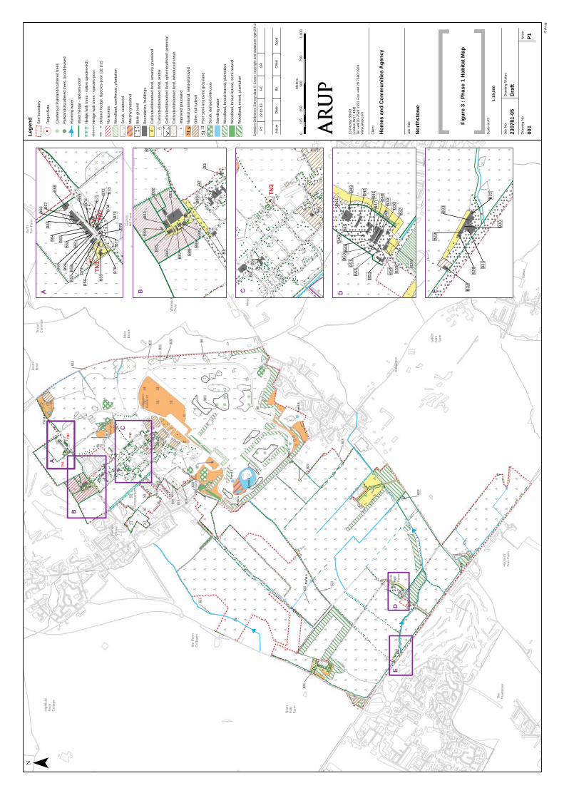
Job
No
2307
81-0
5
Dra
win
g N
oIs
su
e
001
P1
Dra
win
g S
tatu
s
Dra
ft
Job
Title
Clie
nt
13
Fitzro
y S
tre
et
Lo
nd
on
W1
T 4
BQ
Tel +
44
20
76
36
15
31
Fa
x +
44
20
75
80
39
24
ww
w.a
rup
.co
m
© A
rup
Hom
es a
nd C
omm
uniti
es A
genc
y
Nor
thst
owe
Figu
re 3
: Ph
ase
1 H
abita
t Map
Scale
at A
3
Con
tain
s O
rdn
an
ce
Surv
ey d
ata
© C
row
n c
opyrig
ht a
nd
da
tab
ase r
igh
t 2
012
Issu
eD
ate
By
Ch
kd
Ap
pd
P1
22
-11
-13
HC
GR
||
||
||
||
||
||
||
||
||
||
||
||
||
||
| | | | | | | | | | | | | | |
||
||
||
||
||
||
|||
|||
|||
||
||
||
||
||
||
||
||
||
||
|||
||||
||
||
||
||
||
VIVI
VIVI
VIVI
VIVI
VIVI
VIVI
VIVI
VI
||
||
||
|
B1
9
B1
5
B1
6
B2
0
B2
5
B2
4
B2
3
B2
6
B2
7
B2
1
B2
2
B1
7B1
8
B1
4
B1
3
B1
2
B11
B1
0
B9
B8
B7
B9
1
Po
nd
5
Po
nd
7
Po
nd
3
Po
nd
1
Po
nd
4
Po
nd
2
Po
nd
8
Po
nd
6
TN3
TN2
TN1
!
!!
!
!
!
!
!!
!
!
!!
!!
!
!
!
!
!!
!
!
! ! ! !! !
!
! !!
!!!
!
!
! ! ! !! ! !
!!
!!!!!
!!!!
!!
!!
!!
!!
!!
!!!!
!!! ! !
!
!
!
!!!!
!!
!!
!!
!!
!!!
! ! !!
! !! ! ! !
!
!
!!!
!
!
!!
!!
!!
!
!!
!
!!
!!
!!
!! !
!
!!
! !
!!
!!
!
! !
!!
!!
!
!!
!!
!!
!!
!!
!! !
!
!!
!! !
! !!! !
!! ! !
!!
!!
!!
!!
!!
!!
!!!!
!!
!!
!!
!
!
!
!!
!!
!!
!!
!!
!!
!!
!!
!!
!!!
!!
!!
!!
! !!
!
!
! !
!!!!
!!
!!
!!
!! !
!
!! !
!
!!
!
!
!
!
!!!!
!!
! !!!
!!!
!
!!!!!
!!!
!!
!!
!!
!
!!
!!
!
!!
!!
!
!
!!!
!
!
!
!!!
!!
!
!
!!
!!
!!
!!
!
!!!!
!
!!!
!
!!
!!
!
!!
!!
!!
!!
!!
!
!!!!
!!!
!!!
!!
!!
!!
!!
!!
!!!
!!! !!!!!!
!!!!!!!
!!!
!!
!!
!!
!!
!!
!!
!
!!
!
!
!
!
!!
!!!!!
!
!!!
!!
!
!
! !
! !!
!!!
!!!
!!
!!
!!
!!! !!!
!!
!
!
!
!
!
!
!!
!
!
!
!!!!!
!
!
!
!!
!
!
!
!
!
!
! ! ! !
!!! !!!
!
!
!!!
!!!!
! !!!
!
! !! !
!
!
!
! ! !
! ! ! !
!! !
!!
!
!!
!!
!!
!
!!
!
!!
!!!
!!!!!!!!!!
!!
!
!!
!!!
!!!! ! ! !!!!!
!!
!!
!
!!
!!
!!!!!!! !!
! !!
!!
!!
!!
!!!
!!!
!
!!!
!!!
!
!!!
!!!! !
!!
!
!!
! !!!!
!!!!
!!!
!!
!
!
!
!!
!
!!
!!!!
!
!
!
!! ! ! !
! !
!!!!
!
!!!!
!!!!!!!
!
!!! !
!!
!!
!!
!!
!!
! !!!
! !
! ! !
!!
!!!
!!!!!!!!
!!
!!
!!
!!!
!!
!!
!!
!!
!
!!
!!
!!!!
!! !!
!!!
!!
!
!
!!!!
!!
!!
!!!!!!
! !! !
!
!
!!
!!
! ! ! !!
!!
! !!
! !!!!
!!!!!
!!!!
!!!!!!!!!!! ! !
!!!!!
!!!!
!!
!! !
! !
!!
! !
!!!!
!!
!
! !!
!!
!!!!
!!!
!
!!! !! !
! !! !
!
!!
!
!!!!!!
!!!! !!
! !! !
!!!
!
! !! !
!
!
!! !!! !
!!
! ! !!!!
!!!!!
!!
! !!
!!!
!!!
! !
!!!
!! !
!!!!
!!!!
!! !
!
!!
!!!!
!
! !
!
!!
!!
! ! !!
!!
! !!!
!
! !!!!
! !!
!!!
!
! ! !! ! !
!
!! !
!!!! !
!!!!! ! !
! ! !!! !!! !!!!!!! ! ! !!!! !!! ! !
!!!
! !
!
!
!
!
!
!
!
!
!! !
!!!!! ! !
!!! !
!!
!!
!!!!
!
!
!
!
!!
!
!
Hig
hfield
Fa
rmC
ott
ag
e
Ba
r F
arm
Cott
ag
es
Neth
er
Gro
ve
Lo
ng
sta
nto
n
Ba
dge
rs H
olt
Oakin
gto
n
Air
field
Oakin
gto
n
Ba
rracks
Bro
ok
Fie
ld
Be
ck
Bro
okSn
out
Com
mon
Westw
ick
Fie
ld
Cucko
oB
rid
ge
Th
eH
olm
e
Nort
hF
en F
arm
Cucko
oH
ill F
arm
Fu
rthe
rF
ield
/F
arm
Fie
ld
Th
eG
ree
n
Noo
nF
olly
Fa
rm
Th
eP
lanta
tion
Sla
teH
all
Fa
rm
Hacke
r's
Fru
it F
arm
Oakin
gto
n
Gre
en
Acre
Fa
rm
Westw
ick
Girto
n
Lo
ng
fie
lds
Girto
nW
oo
d
His
ton
Woo
d
His
ton
| | | | | | | | | | | | | | | | | | | | | |
||||
|||
||||
||||
||||
||||
|
!! !!
!!
!
!
!!!
!
!
!!
! !!!
! !
!
!
!!!!!!
!!
!!
!
!
!
!
!!! !
!
!
!
!!!
! !
!!
! !!
!!
! !
!!!
! !
!
!
!!
!
!!!!!
!!
!!
!
!
!
!
!
B1
B2
B3
B8
2
B8
3B
84
B8
5
B8
6
B8
7 B8
8
B8
9B
90
B8
0B8
1
B5
5
B5
!
!
!!
!!
!!
!!
!!!
!
!!!
!!!!!!
!!
!
!!
!
!!
!
!
!! !
! !!
!!
!!!
!
!
!
!
!
!!
!!
!!!!!
!!
!
!
!
!
!
!!
!!
!
!
!!
!
!!
!
!!
!!!
!
!
!
!
!
!
!!!
!
!
!
!
!
!
!!
!
!
!!
!!
!!!
!
!!
!!
!
!
!!
!!
!
!
!!
!
!
!!
!!
!
!!
!!
!
!!
!
!
!
!
!
!!
!!!
!!! !!
!
!
!
!!
!
!
!
!!!
!!
!
!
!!
!
!!
!
!
!! !
!
!
!!
!
!!
!!
!!!!!
!!!
!
!!
!! !
! !
!!
! !
!!
!
!
!
!!
!
!
!
!!
!
!
!
!
!
!
! !!
!
!
!
!
!
!
!
!!
!
!!
!
!
!
!!
!
!!
!!
!
!
!!
!!
!!
TN3
VIVI
VIVI
VIVI
VIVI
VI
||
||
||
||
||
||
||
||
||
||
||
B4
B5
B6
!!
!
B3
5 B3
6
B4
4
B4
3
B4
6
B4
8
B4
9
B5
0
B5
1B
52
B5
4
B5
3
B3
7B3
8B3
9
B4
5
B4
1
B4
2
B4
0
B4
7
B2
8
B2
9
B3
4
B3
3
B3
2
B3
0
B3
1
!
!
!
!
!
!
Lege
nd Site
bo
un
da
ry
.Ta
rge
t N
ote
!C
on
ife
rou
s P
ark
lan
d/s
catt
ere
d t
ree
s
!P
ark
lan
ds/
sca
tte
red
tre
es,
bro
ad
-le
ave
d
Ru
nn
ing
wa
ter
Inta
ct
he
dg
e -
sp
eci
es-
po
or
VIVI
VIH
ed
ge
with
tre
es -
na
tive
sp
ecie
s-r
ich
||
||
||
He
dg
e w
ith
tre
es -
sp
eci
es-p
oo
r
De
fun
ct
he
dg
e,
Sp
ecie
s-p
oo
r (J
2.2
.2)
No
acce
ss
Wo
od
lan
d,
co
nife
rou
s,
pla
nta
tio
n
DD
Scru
b,
sca
tte
red
Ma
rsh
y g
rassla
nd
!!! !
!!
!!
Ba
re g
rou
nd
Bo
un
da
rie
s,
bu
ildin
gs
AA
Cu
ltiva
ted
/dis
turb
ed
la
nd
, a
me
nity g
rassl
an
d
AC
ulti
va
ted
/dis
turb
ed
la
nd
, a
rab
le
DDD D
Cu
ltiva
ted
/dis
turb
ed
la
nd
, e
ph
em
era
l/sh
ort
pe
ren
nia
l
Cu
ltiva
ted
/dis
turb
ed
la
nd
, in
tro
du
ce
d s
hru
b
IIm
pro
ve
d g
rassla
nd
ISN
eu
tra
l g
rassla
nd
, se
mi-
imp
rove
d
Oth
er,
ta
ll ru
de
ral
SIP
oo
r se
mi-
imp
rove
d g
rassla
nd
Scru
b,
de
nse
/co
ntin
uo
us
Sta
nd
ing
wa
ter
Wo
od
lan
d,
bro
ad
-le
ave
d,
pla
nta
tion
Wo
od
lan
d,
bro
ad
-le
ave
d,
se
mi-
na
tura
l
Wo
od
lan
d,
mix
ed
, p
lan
tatio
n
A
D
C
C
B
B
D E
E
¯
I
A A
SI
B76
B78
B77
B75B
74
B73
B72
B55
B71
B56
B70
B79
B69
B61
B57
B58
B59
B62B
63
B60
B68
B64
B65
B67
B66
TN2
TN1
!
!
!
!
!!
!
!
A
02
50
50
07
50
1,0
00
12
5M
ete
rs
1:19
,000
SI

_̂̂_
_̂̂_
_̂̂_
_̂
_̂̂_̂_
098
76
5
4
32
1
999897
969594
93
919089
888786
858483
7877
75
7473
72
7170
6968
67
6665
6463
6261
60
59
585756
55
54 535251
4948
47
46
45
44
4342
4139
3736
33
32313029
282726
2524
23
2119
1817
16
14
13
12
352351
350349
347346
345
344
343342
341
340
338
337
336
335
334333332331330329
328327
325
324
323
322
321320
319
318317
315314
312311310
308
307306
305
304303
301300
299298
297296
295294
292291
290289
288
287286
285284
283282
281280
279 278
277275274
273272
271270
268
266
263
262
261
260256
254253252
251
250
248247
245
244
243
242
241
240239238
237
236235
230
221220
218217
212211210
209208
205204
203
202 201192
191 190188
187
186183
180179
178
177176175
174
173172171
170169
168167
166
165164
163162
156
155
154
153
152151150
149148
142141
139135134
133
132131130
129128
127
126125
124
123122
120
117
116
113
112111110109
107
103102
101
W3
W1
W2
B5
B31 B39
B64
B52
B56
B10
B35
B22
B7
B26
B13
Contains Ordnance Survey data © Crown copyright and database right 2012
© ArupMXD Location
Job No
230781-05
Drawing No Issue
001 P1
Drawing Status
Draft
Scale at A3
1:2,041
Figure 4Bat Roost Potential
13 Fitzroy StreetLondon W1T 4BQTel +44 20 7636 1531 Fax +44 20 7580 3924www.arup.com
Issue Date By Chkd Appd
P1 5/8/2013 EBE AB NW
Job Title
Client
Homes and Communities Agency
Northstowe
0 50 10025
Metres
B39
B38
B41
B51B40
B37B36
B54
B50
B52
B45
B35
168
B66
B64
B56
B55
B59
BA B
A
B10
_̂̂_
_̂̂_
B2
B5
B80
0
987
6
5
4
32
1
6346
45
44
4342
4140
39
38
37
3433
32313029
25
1413
1211
10
260259258
256
249
248
247
246129128
127
C
D
D
C
B31
B29
167
166
E
E
B13B7
B22
B26
I
F G
H
G
F
HI
LegendTree categories
1*
1
2
_̂ Bat box
BuildingsConfirmed
Moderate
Low
Site Boundary

_̂
_̂
_̂
_̂
_̂
_̂
_̂
_̂
_̂
_̂
_̂
_̂
_̂
_̂
_̂_̂
© Arup
Contains Ordanance Survey data © Crown copyright and database right 2012
Job No
230781-05
Drawing No Issue
001 P1
Drawing Status
Issue
Scale at A3
1:15,000
13 Fitzroy StreetLondon W1T 4BQTel +44 20 7636 1531 Fax +44 20 7580 3924www.arup.com
Issue Date By Chkd Appd
P1 04/11/2013 ZW GR NW
Job Title
Client
Homes and Communities Agency
Northstowe
0 375 750187.5
Metres
SD1
SD2
SD3
SD4
SD5
SD6
SD7
SD8
SD9
SD10
SD11
SD12
SD13
SD14
SD15
SD16
Common pipistrelle
Common pipistrelle &soprano pipistrelle
Common pipistrelle
Common pipistrelleCommon pipistrelle,soprano pipistrelle& Leisler's bat
Common pipistrelle,soprano pipistrelle,Leisler's bat &noctule
Legend
Site Boundary
_̂ Static Detector Location
_̂ Bat Activity Indices 0 - 100
_̂ Bat Activity Indices 100 - 200
_̂ Bat Activity Indices 200 - 300
_̂ Bat Activity Indices 300 - 400
_̂ Bat Activity Indices 400+
Transect 1
Transect 2
Transect 3
Transect 4
Transect 5
Transect 6
Transect 7
Commuting
Foraging
Figure 5:Bat Activity SurveyMethods and Results
Common pipistrelle,soprano pipistrelle
Common pipistrelleCommon pipistrelle

WH
WH
WH
WH
WH
WH
WH
WH
WHWH
WH
WH
WH WH
WH
WH
WH
WH
WH
WH
WH
WH
WH
WH
WH
WH
WH
SLSL
SL
SL
SL
D.D.
D.
D.
D.
D.
D.
D.
D.
D.
D.
D.
D.
BF
WH
WHWH
G.
G.G.
G.
G.
G.
G.
G.
SD
SD
SD
SD
K.
K.
MP
MP
MP
MP MP
MPMP
MP
MP
MP
MP
M.
M.
D.
D.
RB
RB
RB
RB
RB
RB
RB RB
RB
M.
M.
WW
WW
MP
GJ GJ
GJMA MA
HM
MA
RB
SD4
HM6
D.
D.
D.
D.
D.
SD
SD
M.
SN
SNGJ
GJGJ
SI
© Arup
Contains Ordanance Survey data © Crown copyright and database right 2012
Job No
230781-05
Drawing No Issue
001 P1
Drawing Status
Issue
Scale at A3
1:15,000
13 Fitzroy StreetLondon W1T 4BQTel +44 20 7636 1531 Fax +44 20 7580 3924www.arup.com
Issue Date By Chkd Appd
P1 24/07/2014 ZW GR -
Job Title
Client
Homes and Communities Agency
Northstowe
0 375 750187.5
Metres
Legend
Site boundary Figure 8:Territory Map of Amber List Bird Species
Where two or more territories were recorded in close proximity, the appropriate number has been indicated alongside the species.
WH Whitethroat
SL Swallow
D. Dunnock
BF Bullfinch
G. Green Woodpecker
SD Stock Dove
K. Kestrel
MP Meadow Pipit
M. Mistle Thrush
RB Reed Bunting
WW Willow Warbler
GJ Greylag Goose
MA Mallard
HM House Martin
SI Swift

HSHS
HS
HSSG
SG SG
SG
SG
SG
SG3
ST
ST
ST
ST
S. S.
S.
S.
S.
S.
S. S.
S.S.
S.
S.
S.
ST
S.
S.
S. S.
S.S.
S.S. S. S.
S.
S.S.
S.S.
S.
S.S.
S.
S.
S.
S.
S.
S.
S.
S.
S.
S.
S. S.
S.
S.
S.
S.
S.
S.
S.
S. S.
S.
YW
YW
YW
YW
YW
YW
YW
YW
YW
YW
YW
ST
YW
HS
LI
LI
LI
LI
LI
Y.
Y.
Y.
Y.
Y.
Y.
P.
Y.
P.
Y. Y.
YW
S.
LI
CB
CB
LI
L.2
L.2
L.
BO
HY
SF
S.
LI
S.
SG
LI
LI
SG
Y.
Y.S.
ST
ST
SG
TD
© Arup
Contains Ordanance Survey data © Crown copyright and database right 2014
Job No
230781-05
Drawing No Issue
001 P1
Drawing Status
Issue
Scale at A3
1:15,000
13 Fitzroy StreetLondon W1T 4BQTel +44 20 7636 1531 Fax +44 20 7580 3924www.arup.com
Issue Date By Chkd Appd
P1 24/07/2014 ZW GR - Job Title
Client
Homes and Communities Agency
Northstowe
0 375 750187.5
Metres
Legend
Site boundary Figure 7:Territory Map of Schedule 1 and Red List Bird SpeciesSchedule 1 species
Red list species
Where two or more territories were recorded in close proximity, the appropriate number has been indicated alongside the species.
HS House Sparrow
L. Lapwing
LI Linnet
P. Grey Partridge
SG Starling
ST Song Thrush
S. Skylark
BO Barn Owl
HY Hobby
CB Corn Bunting
Y. Yellowhammer
YW Yellow Wagtail
TD Turtle dove
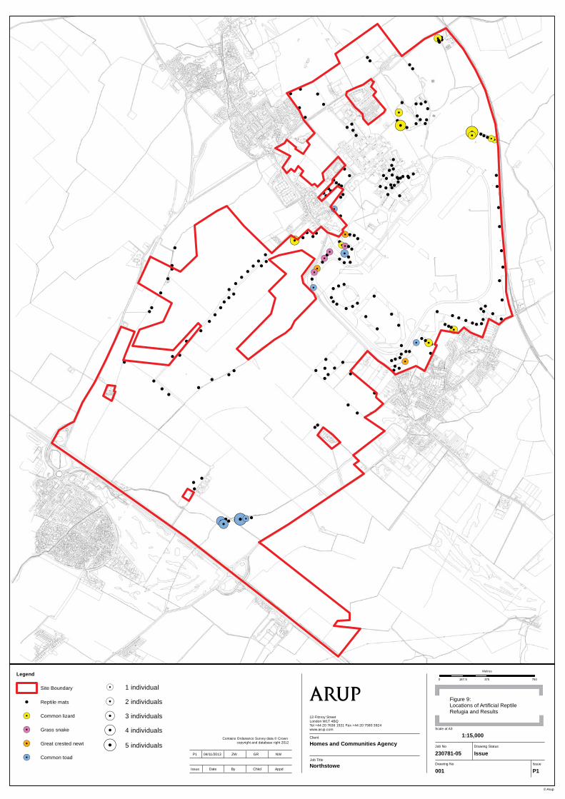
!!
!!
!!!!.!!
!
!.!.!!!!.!.
!.!!
!.
!
!!
!!
! !!
!
!!
!
!
!
!
!!
!!
!
!!
!!!
!!
!.!
!!
!
!
!.
!
!.!
!!
!.! !!
!
!.!.!!
!!.
!!.
!.!.!
!.!!
!
!!!
!!
!
!
!!
!!
!!.!!
!
!.!
!!!
!.
!!!!!!
!.!!
!
!
!
!
!!
!!!!
!
!!
!
!
!
!
!
!
!
!
!
!!
!
!
!
!
!
!
!
!
!
!
!
!
!!
!
!!
!
!!
!
!
!!
!
!
!
!
!
!
!!
!
!!
!.!
!.! !!.!.!
!!
!
!
!
!
!
!
!
!
!!
!
!!
!
!
!
!!!
!!
!
! !!
!
!!!!!!
! !!!
!
© Arup
Contains Ordanance Survey data © Crown copyright and database right 2012
Job No
230781-05
Drawing No Issue
001 P1
Drawing Status
Issue
Scale at A3
1:15,000
13 Fitzroy StreetLondon W1T 4BQTel +44 20 7636 1531 Fax +44 20 7580 3924www.arup.com
Issue Date By Chkd Appd
P1 04/11/2013 ZW GR NW
Job Title
Client
Homes and Communities Agency
Northstowe
0 375 750187.5
Metres
Figure 9:Locations of Artificial ReptileRefugia and Results
Legend
Site Boundary
! Reptile mats
!. Common lizard
!. Grass snake
!. Great crested newt
!. Common toad
!. Common Lizard, 2
!. Common Lizard, 3
!. Common Lizard, 4
!. Common Lizard, 5
!. Toad, 2
!. Toad, 3
!. Toad, 5
!. 1 individual
!. 2 individuals
!. 3 individuals
!. 4 individuals
!. 5 individuals

3538
3432
40
42
43
47 47
50
9592
5152
11
75
79
53
54
56
82
77
15
45
63
8059
58
84
102
© Arup
Contains Ordanance Survey data © Crown copyright and database
right 2012Job No
230781-05
Drawing No Issue
001 P1
Drawing Status
Issue
Scale at A3
1:15,000
13 Fitzroy StreetLondon W1T 4BQTel +44 20 7636 1531 Fax +44 20 7580 3924www.arup.com
Issue Date By Chkd Appd
P1 04/11/2013 ZW GR NW
Job Title
Client
Homes and Communities Agency
Northstowe
0 375 750187.5
MetresLegend
Site Boundary
NERC Act 2006& Local BAP
NERC Act 2006, Local BAP & within site context
Hedgerow Regs., NERC Act 2006, Local BAP & within site context
Figure 10:Important Hedgerows Location Map