extracts from my froggatt family … from my froggatt family history books jennifer’s story 15...
TRANSCRIPT

EXTRACTS FROM MY FROGGATT FAMILY HISTORY BOOKS
Jennifer’s Story
14
There are Froggatt family deeds in the Derbyshire Record Office at Matlock that
prove that our ancestors owned a considerable amount of land and several
farmhouses and farm cottages in the centre of the hamlet of Froggatt, Derbyshire
from before 1296 to 1743.
After 1618 my great grandfather x 8, Thomas Froggott, a younger son, moved to
Folds Farm Calver where the next four generations of our branch of the family
were tenants of Folds Farm.
Three generations then farmed at Moorside and Robin Hood Farm in the Robin
Hood area of Baslow.
From the latter half of the 19th century our family was centred nearer to
Chesterfield at Eastmoor and Stonelow, near Wadshelf.
From 1900 to 2015 my grandparents, my parents and I lived in Chesterfield itself.

EXTRACTS FROM MY FROGGATT FAMILY HISTORY BOOKS
Jennifer’s Story
15
From what I can gather from original documentary evidence, some of our
ancestors, 13th to 18th centuries, would have lived in the village of Froggatt,
Derbyshire where the cottages shown on the next few pages stand.
A number of documents relating to the purchase and sale of the properties are
held in the D3331 and D1490 Collections at the Derbyshire Record Office in
Matlock.
John Froggott, head of the Senior Branch of the Froggatt family, settled three
cottages and some land in Froggott on his new wife, Mary Eyre in 1647. They
lived in Froggatt until 1669.
The documents show that the houses were all semi detached. Bridgefoot Farm
has been made into one house but it is just possible to make out signs of a
second doorway on the right of the cottage.
Bridgefoot is close to a two arched bridge that gives
access to the Stoke Road. There is some debate about
when the River Derwent was first bridged at Froggatt.
There are several articles on the internet that suggest
that Froggatt always had a bridge, the early ones being
wooden. Edward Jervoise researched Derbyshire bridges
and concluded that the small arch built in 1635 was the original bridge. For over
a century the bridge had only one arch. A second arch was added when the river
was widened in order to facilitate the working of the newly built Calver Mill.
Interestingly, although the Baslow Manor Court Rolls show that villagers were
expected to repair the highway between Froggott and Curbar they do not mention
a duty to repair a bridge. Experts believe that this is significant.
Some of the Froggatt lands eventually belonged to a Charity - the Barlborough
Hospital Trust.
A 19th century Enclosure Plan indicates the position of these lands.
EXTRACTS FROM MY FROGGATT FAMILY HISTORY BOOKS
Jennifer’s Story
16
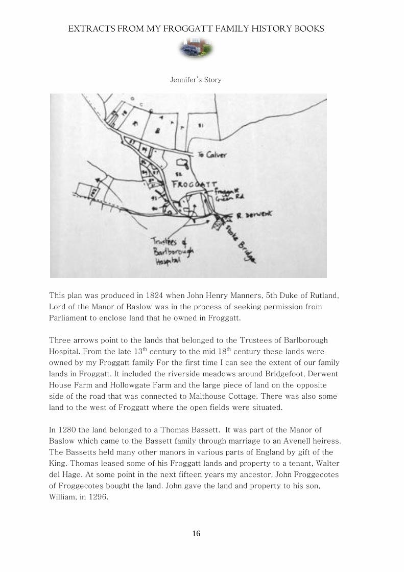
This plan was produced in 1824 when John Henry Manners, 5th Duke of Rutland,
Lord of the Manor of Baslow was in the process of seeking permission from
Parliament to enclose land that he owned in Froggatt.
Three arrows point to the lands that belonged to the Trustees of Barlborough
Hospital. From the late 13th century to the mid 18th century these lands were
owned by my Froggatt family For the first time I can see the extent of our family
lands in Froggatt. It included the riverside meadows around Bridgefoot, Derwent
House Farm and Hollowgate Farm and the large piece of land on the opposite
side of the road that was connected to Malthouse Cottage. There was also some
land to the west of Froggatt where the open fields were situated.
In 1280 the land belonged to a Thomas Bassett. It was part of the Manor of
Baslow which came to the Bassett family through marriage to an Avenell heiress.
The Bassetts held many other manors in various parts of England by gift of the
King. Thomas leased some of his Froggatt lands and property to a tenant, Walter
del Hage. At some point in the next fifteen years my ancestor, John Froggecotes
of Froggecotes bought the land. John gave the land and property to his son,
William, in 1296.

EXTRACTS FROM MY FROGGATT FAMILY HISTORY BOOKS
Jennifer’s Story
17
Lands in Froggatt owned by the Froggatts of Froggatt
The tree line left denotes the bank of the River Derwent
Derwent Cottage and Farmhouse
Bridgefoot Barn Bridgefoot Cottage
Inside Bridgefoot Cottage
Note the stone stairs. The millstone grit bedrock is very close to the surface
here and it could be that some of the stone used for building the houses was cut
from the land on which the houses stood. On the other hand there were several
quarries in the vicinity

EXTRACTS FROM MY FROGGATT FAMILY HISTORY BOOKS
Jennifer’s Story
18
Rockview and Stonecroft were originally accessed from Spooner Lane.
Subsequently several houses were built facing the river on Spooner Lane. There
is now no access to Rockview and Stonecroft from Spooner Lane.
Malthouse Cottage 1932 top left standing Malthouse Cottage 2014
on Malthouse Lane. Picture taken from Taken from a raised Malthouse
Hollowgate. The stone structure in the Lane. Several houses now stand
foreground covers a well or water course on the Froggatt family plot and
the cottage can no longer be seen
from Hollowgate .
The Malthouse on Malthouse Lane, Froggatt.

EXTRACTS FROM MY FROGGATT FAMILY HISTORY BOOKS
Jennifer’s Story
19
The houses that have been built in Froggatt in modern times face the river. This
enables residents to benefit from the superb view over the river and beyond. The
oldest houses in Froggatt face South and are side on to the River. This ensured
that the main rooms had the maximum daily benefit of light and heat from the sun.
Kitchens and pantries that needed to be cool were at the back of the houses
where the sun did not reach
These close up views of Derwent House Farm and Derwent Farm Cottage show
them standing side on to Hollowgate and to the River Derwent. A very ordinary
couple of cottages from the back but improved at the front possibly to match
Moorseats Hall when Mary Froggatt nee Eyre used this as a Dower House in the
1670s.
The House on the Green.
This lovely old house stands on the road that is shown as ‘Froggatt Green Road’
on the 1824 Enclosure Map. Now the road is just called ‘The Green.’ Standing to
the East of the other Froggatt lands could this be the site of the land and house
that William Froggott of Froggott gave to his second son Thomas in 1574?

EXTRACTS FROM MY FROGGATT FAMILY HISTORY BOOKS
Jennifer’s Story
20
Bearing in mind that the early Froggatt family property was clustered in the
centre of the hamlet I think this is likely. It looks as though the sixteenth century
heads of the family extended their land as and when neighbouring land and
property was available for sale. There are indications that they may have leased
the property before buying it.
Thomas was the head of a line of Froggatt blacksmiths and lead merchants.
There are documents at Matlock that record the purchase and sale of properties
connected with Thomas. The Welles lead merchant family of Holme Hall
Bakewell bought property in Froggatt in the first half of the 17th century from the
descendants of Thomas. The Welles family leased Stoke Hall just across the river
Derwent from Froggatt from 1608 to 1629.
Roy and I were looking for signs of old landmarks in Froggatt one day in early
January 2010. Mrs Ann Thomas, the owner of this house, was doing some
gardening and heard us talking about the old water channel that ran past her
house. She invited us in for coffee. Her house was detached but it was clear that
it had been semi detached. There were stone stairs as in Bridgefoot but the
stonework was much smoother and the house was generally more ‘up market’ as
you might say. Ann had thought that the lower part of the house had been used to
house animals and had no idea that the house had originally been a pair of semis.
She was able to tell us that her neighbour used to have a long strip of land
attached to her property. This was interesting as it confirmed information
contained in the 17th century Thomas Froggott land documents at the Derbyshire
Record Office.
The local Church for inhabitants of Froggatt was St Annes, Baslow. When I
looked at a transcript of the Parish Registers for 1570 to 1750 there were
surprisingly few family names entered for Froggatt village. This led me to believe
that Froggatt village contained no more than six or seven semi detached
dwellings providing housing for as few as twelve or fourteen families. Putting two
and two together from wills, marriage settlements and land sale documents it
seems that for a period of time in the 17th century a majority of the houses were
owned by members of the Froggatt family.

EXTRACTS FROM MY FROGGATT FAMILY HISTORY BOOKS
Jennifer’s Story
21
Froggatt Old Bridge from both banks of the River Derwent. On the Enclosure Map
it is called Stoke Bridge.
From Bridgefoot From the Stoke Hall side of the River Derwent.
The original 17th century bridge had only one rounded arch. The larger pointed
arch was built years later when the river was widened to improve the flow down
river to the cotton mill in Calver. Bridgefoot Farm lost some of its land in the
process.
For some time I was puzzled by an entry in Baslow Parish Registers for a 17th
century John Froggatt of Froggatt who did not seem to belong to any of the
known Froggott families. Then I came across a document in the Derbyshire
Records at Matlock that provided the answer. He was the son of John Froggott of
Beeley and was the Froggott family heir. He had been brought up in Beeley. His
father had moved there after his marriage to Elizabeth Greaves of Beeley in
1598.
When John Junior came of age he set up his own home in one of the family
properties in Froggott that he would eventually inherit. His Uncle Thomas, our
ancestor, had to vacate a family cottage. He moved a couple of miles away to
Calver where he was granted the tenancy of a large farm with outbuildings and a
lot of land.
EXTRACTS FROM MY FROGGATT FAMILY HISTORY BOOKS
Jennifer’s Story
22
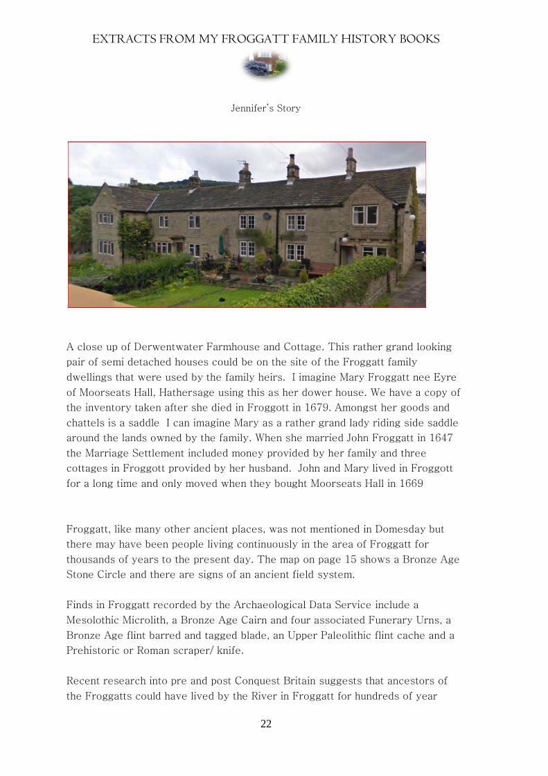
A close up of Derwentwater Farmhouse and Cottage. This rather grand looking
pair of semi detached houses could be on the site of the Froggatt family
dwellings that were used by the family heirs. I imagine Mary Froggatt nee Eyre
of Moorseats Hall, Hathersage using this as her dower house. We have a copy of
the inventory taken after she died in Froggott in 1679. Amongst her goods and
chattels is a saddle I can imagine Mary as a rather grand lady riding side saddle
around the lands owned by the family. When she married John Froggatt in 1647
the Marriage Settlement included money provided by her family and three
cottages in Froggott provided by her husband. John and Mary lived in Froggott
for a long time and only moved when they bought Moorseats Hall in 1669
Froggatt, like many other ancient places, was not mentioned in Domesday but
there may have been people living continuously in the area of Froggatt for
thousands of years to the present day. The map on page 15 shows a Bronze Age
Stone Circle and there are signs of an ancient field system.
Finds in Froggatt recorded by the Archaeological Data Service include a
Mesolothic Microlith, a Bronze Age Cairn and four associated Funerary Urns, a
Bronze Age flint barred and tagged blade, an Upper Paleolithic flint cache and a
Prehistoric or Roman scraper/ knife.
Recent research into pre and post Conquest Britain suggests that ancestors of
the Froggatts could have lived by the River in Froggatt for hundreds of year

EXTRACTS FROM MY FROGGATT FAMILY HISTORY BOOKS
Jennifer’s Story
23
before the Conquest. This area is in Danelawe /Viking territory. The Froggatts
could have been native British, Anglo Saxons or Vikings or a mixture of several
races. Could they have been of Norman origin? Another possibility but thought to
be very unlikely.
So are we descended from the people who built the stone circles and farmed on
the high gritstone edge or late comers like the Angles and Vikings.
Red hair is very common in our family. My father had red hair. Do these
photographs of Andrew and Lizzie provide the answer?

EXTRACTS FROM MY FROGGATT FAMILY HISTORY BOOKS
Jennifer’s Story
24
The reason why the area around Froggatt was inhabited over a long period must
be that it is positioned where there was a gap between the Edges giving access
to land and trackways on and across the Big Moor. There were also freshwater
streams running down to the river.
Site of the prehistoric field system above Froggatt
The Bronze Age Stone Circle on Froggatt Edge

EXTRACTS FROM MY FROGGATT FAMILY HISTORY BOOKS
Jennifer’s Story
25
One of the streams that flow from Froggatt
Edge, through Froggatt Wood and the village
into the Derwent. At some point the streams
were channelled underground through the
village.
A path through Froggatt Wood to the gap
in the Edges.
Some parts of the paths are lined with
massive stone slabs. It is incredible to
think that these were quarried, shaped
and laid by men with hand tools and
sledges / carts.
The Froggatt Wood lead smelter. So far no one has
discovered who owned or ran the smelter. Apparently
the Lords of the Manor, the Manners of Haddon, rented
out pieces of land and tenants could build their own
smelters. Some members of the Froggott family owned
woodland in Froggatt. Perhaps the Froggatts who
were connected to the lead trade started out in
Froggatt Wood.

EXTRACTS FROM MY FROGGATT FAMILY HISTORY BOOKS
Jennifer’s Story
26
Froggatt from across the river. Near the
river there is meadow and pasture land.
As the land slopes upwards the soil is
thin and the rock is close to the surface.
This is ideal for grazing sheep and
cutting stone blocks for building houses.
Note the trees. These provided white
coal for the 17th century lead smelting
mill that is hidden in the trees. A stream
provided the water to power the mill.
This is Spooner Lane. It is a continuation
of Hollowgate, Froggatt. It leads to
Grindleford Bridge. From Froggatt in the
other direction there was another narrow
lane that connected with Curbar Village.
Baslow Court Rolls refer to it as the
Highway. The inhabitants of Froggatt were
responsible for repairing the road and
keeping it generally in good order.
In 1628 at St Annes Baslow, Anthony
Spooner married Jone Oliver of Froggatt. William Wells (second husband of my
Great grandmother x 8 ) left Jone a large sum of money in his 1626 will. Was she
possibly his step daughter by his first wife?
EXTRACTS FROM MY FROGGATT FAMILY HISTORY BOOKS
Jennifer’s Story
27
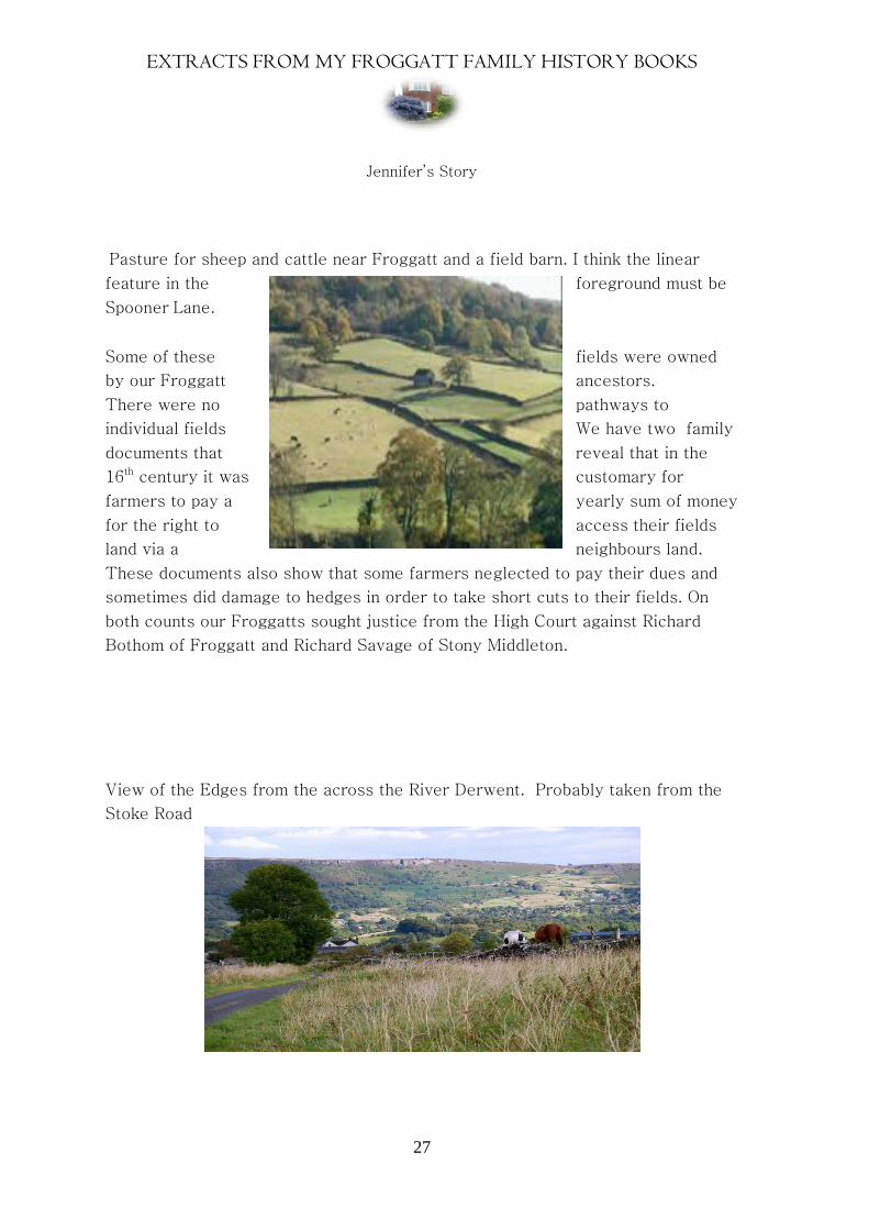
Pasture for sheep and cattle near Froggatt and a field barn. I think the linear
feature in the foreground must be
Spooner Lane.
Some of these fields were owned
by our Froggatt ancestors.
There were no pathways to
individual fields We have two family
documents that reveal that in the
16th century it was customary for
farmers to pay a yearly sum of money
for the right to access their fields
land via a neighbours land.
These documents also show that some farmers neglected to pay their dues and
sometimes did damage to hedges in order to take short cuts to their fields. On
both counts our Froggatts sought justice from the High Court against Richard
Bothom of Froggatt and Richard Savage of Stony Middleton.
View of the Edges from the across the River Derwent. Probably taken from the
Stoke Road
EXTRACTS FROM MY FROGGATT FAMILY HISTORY BOOKS
Jennifer’s Story
28
.
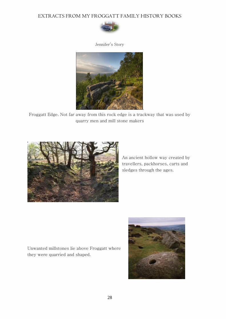
Froggatt Edge. Not far away from this rock edge is a trackway that was used by
quarry men and mill stone makers
An ancient hollow way created by
travellers, packhorses, carts and
sledges through the ages.
Unwanted millstones lie above Froggatt where
they were quarried and shaped.

EXTRACTS FROM MY FROGGATT FAMILY HISTORY BOOKS
Jennifer’s Story
29

EXTRACTS FROM MY FROGGATT FAMILY HISTORY BOOKS
Jennifer’s Story
30