exploring our home planet earth science enterprise · eases, such as malaria, dengue fever, and...
TRANSCRIPT
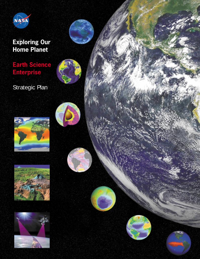
Exploring OurHome Planet
Earth ScienceEnterprise
Strategic Plan
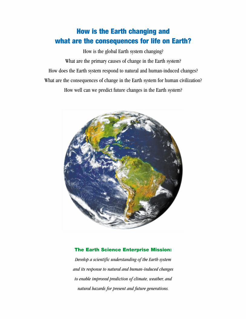
How is the Earth changing and what are the consequences for life on Earth?
How is the global Earth system changing?
What are the primary causes of change in the Earth system?
How does the Earth system respond to natural and human-induced changes?
What are the consequences of change in the Earth system for human civilization?
How well can we predict future changes in the Earth system?
The Earth Science Enterprise Mission:
Develop a scientific understanding of the Earth system
and its response to natural and human-induced changes
to enable improved prediction of climate, weather, and
natural hazards for present and future generations.

To the Reader:
NASA’s Earth Science Enterprise is dedicated to understanding the total Earth system and
the effects of natural and human-induced changes on the global environment. The vantage
point of space provides information about Earth's land, atmosphere, ice, oceans, and biota
that is obtainable in no other way. Programs of the Enterprise study the interactions among
these components to advance the new discipline of Earth System Science, with a near-term
emphasis on global climate change. Our research results contribute to the development of
sound environmental policy and economic investment decisions.
NASAs’ Earth Science Enterprise develops innovative technologies and applications of
remote sensing for solving practical societal problems in food and fiber production, natural
hazard mitigation, regional planning, water resources, and national resource management in
partnership with other Federal agencies, with industry, and with state and local governments.
Earth Science discoveries are shared with the public to enhance science, mathematics, and
technology education and increase the scientific and technological literacy of all Americans.
Earth Science combines the excitement of scientific discovery with the reward of practical
contribution to the sustainability of planet Earth.
Earth Science is science in the national interest. NASA is pleased to play a leadership role in
exploring our home planet. This Earth Science Enterprise Strategic Plan describes our
approach to science and applications research in this great endeavor. Three subordinate
documents, the Earth Science Enterprise Research Strategy, the Technology Strategy, and
the Applications Strategy, provide more detail in these important areas. I invite you to learn
more about NASA’s Earth Science Enterprise through our Web site at
http://www.earth.nasa.gov.
Ghassem R. Asrar
Associate Administrator for Earth Science
4 Introduction: Understanding the Earth System7 Mission, Goals, and Objectives
8 Framework for Strategic Planning
9 NASA Earth Science Enterprise Roadmap
10 The Current Program (Through 2002): Characterizing the Earth System
12 The Coming Program (2002-2010): Understanding the Earth System
13 ScienceGoal 1: Observe, understand, and model the Earth system to learn how it is changing, and the consequences for life on Earth
15 1.1 Variability17 1.2 Forcing19 1.3 Response21 1.4 Consequence23 1.5 Prediction
24 ApplicationsGoal 2: Expand and accelerate the realization of economic and societal benefits from Earth science, information, and technology
25 2.1 Applications26 2.2 Education
27 TechnologyGoal 3: Develop and adopt advanced technologies to enable mission success and serve national priorities
28 3.1 Observing Technologies 29 3.2 Information Technologies 30 3.3 Partnering for Monitoring and Prediction
31 Strategic Implementation Approach32 Science Questions and Missions34 Earth Science Center Roles and Missions35 Interagency Partnerships36 International Partnerships
37 A Vision of the Future: Predicting Earth System Change—Earth Science in 2025
40 Appendices
ContentsPAGE 3
Contents

NASA’s Earth observing satellites and related research have led scientists to view theEarth as a system—as a dynamic set of interactions among the land surface, atmos-phere, oceans and ice caps, and the Earth’s interior. This profound realization gaverise to the birth of the new interdisciplinary field of Earth System Science. This wayof studying the Earth is critical to understanding how global climate responds to theforces and feedbacks acting on it.
For much of human history, humankind labored to adapt itself to patterns and vari-ability of the Earth system—most notably in climate. Over the past several centuries,the balance shifted toward humankind, adapting natural world for human purpos-es, most notably in agriculture, housing, transportation, and energy generation.Most recently, the circle has been closed—human activity is now powerful enoughto begin to affect the planet. While impacts of human activities have long beenapparent at the local level, we are now seeing global-scale impacts, first in stratos-pheric ozone depletion and now perhaps in changing climate. And, as if to remindus of our limits, the Earth continues to offer disruptions of its own in the form ofearthquakes, volcanic eruptions, and severe weather.
We know that natural and human-induced changes are acting on the Earth system.Natural forces include variation in the Sun’s energy output, and volcanic eruptionswhich spew dust and gases into the atmosphere and scatter incoming sunlight.Human forces include deforestation, carbon emission from the burning of fossilfuels, methane and soil dust production from agriculture, and ozone depletion byvarious industrial chemicals. Internal climate factors such as atmospheric watervapor and clouds also introduce feedbacks which serve to either dampen orenhance the strength of climate forcing. We also know the climate system exhibitsconsiderable variability in time and space, i.e., both short and long term changesand regionally-specific impacts.
Exploring Our Home PlanetTHE EARTH SCIENCE ENTERPRISE STRATEGIC PLAN
Introduction: Understanding the Earth System
Researchers have constructed computer models to simulate the Earth
system, and to explore the possible outcomes of potential changes they
introduce in the models. This way of looking at the Earth as a system is
a powerful means of understanding changes we see around us. That has
two implications for Earth Science. First, we need to characterize (that is,
identify and measure) the forces acting on the Earth system and its
responses. Second, we have to peer inside the system to understand
the source of internal variability: the complex interplay among compo-
nents that comprise the system. Earth system changes are global phe-
nomena. Yet the system comprises many microscale processes, and the
most significant manifestations are regional. Thus, studying such
changes requires a global view at regionally-discerning resolutions. This
is where NASA comes in, bringing the unique capability to study planet
Earth from the vantage point of space. By combining observations,
research, and modeling, we create a capability to predict Earth system
change to help our partners produce better forecasts of change.
Forces Acting onthe Earth System
Earth SystemResponse
Feedback
Impacts

Knowledge gained about the Earth System has many practical applications, one of whichis improved preparedness for Natural hazards. Large natural disasters were three timesmore frequent in the 1990’s compared to the 1960’s, and disaster costs were nine timesas great. Natural hazard risks and losses are increasing with concentration of people andproperty assets in economically valuable but naturally vulnerable areas. In the UnitedStates alone, the 1990’s saw some of the most expensive natural disasters in our histo-ry, including the Missouri River floods (’92), Hurricane Andrew (’92), and theNorthridge Earthquake (’94). The linkage of natural disasters to climate and other Earthsystem changes is an active area of research.
If we understand the processes leading to earthquakes, hurricanes, volcanic eruptions,floods, and other hazards, we can help other Federal and State agencies mitigate the lossof life and property through improved planning, improved response, and more efficientpost-event recovery. Space-based technology has the potential to significantly contributeto efforts to reduce the losses due to inevitable natural disasters. ESE research is focusedon modeling the relevant Earth system processes to achieve reliable prediction capabil-ity. ESE coordinates this research with NOAA, the Federal agency with responsibility foroperational weather and climate forecasting, so they can factor these models into theirforecasts. We partner with USGS to monitor land surface motion in the Los Angles Basinand characterize land surface worldwide, and we partner with FEMA to improve theirflood plain mapping and disaster preparedness. The spread of certain infectious dis-eases, such as malaria, dengue fever, and Rift Valley fever, is a function of regional, sea-sonal climate conditions. NASA and the National Institutes of Health are employingremote sensing data to predict and hopefully head off instances of disease outbreaks.
IntroductionPAGE 5
Applying Earth Science to Practical Problems
Computer-generated 3-D visualization based on satellite observation
helps put large scale storms in perspective. Using wind speed and
direction data from the QuikSCAT satellite (a) and precipitation meas-
urements from the TRMM satellite (b), NASA-sponsored researchers are
demonstrating new capabilities to improve storm track and strength
prediction for NOAA. NASA and NIMA partnered on the Shuttle Radar
Topography Mission to produce 3-D maps of most of the Earth’s sur-
face (c). These maps will be used in applications such as flood plain
mapping and aircraft ground collision avoidance as well as for research
on how the Earth’s surface reflects changes in Earth’s interior.
(a)
(b)
(c)
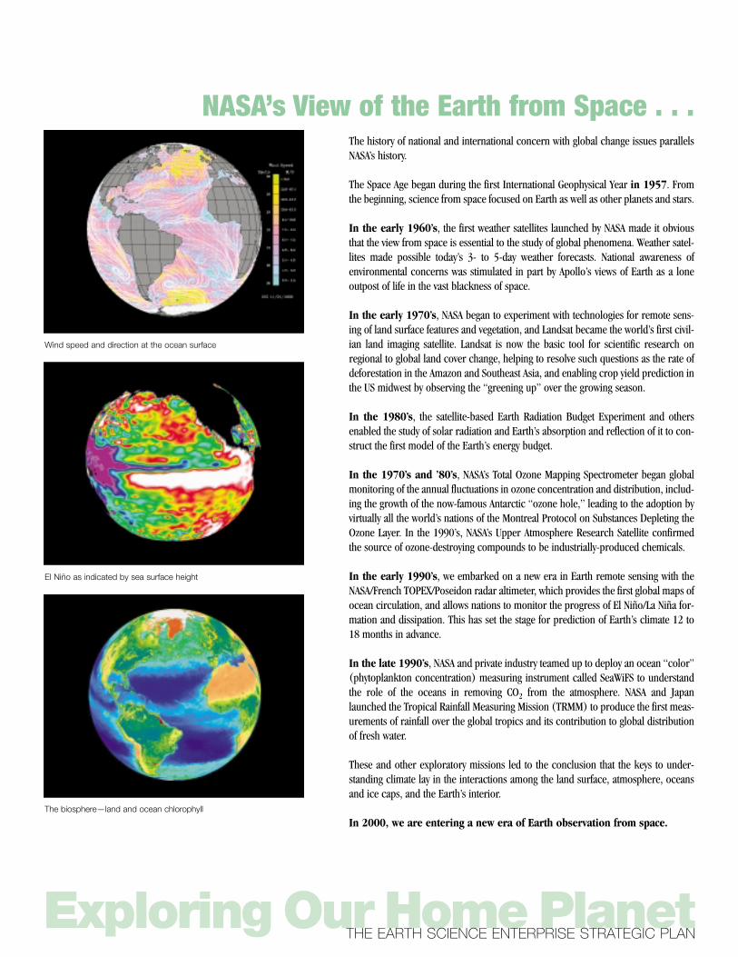
The history of national and international concern with global change issues parallelsNASA’s history.
The Space Age began during the first International Geophysical Year in 1957. Fromthe beginning, science from space focused on Earth as well as other planets and stars.
In the early 1960’s, the first weather satellites launched by NASA made it obviousthat the view from space is essential to the study of global phenomena. Weather satel-lites made possible today’s 3- to 5-day weather forecasts. National awareness of environmental concerns was stimulated in part by Apollo’s views of Earth as a loneoutpost of life in the vast blackness of space.
In the early 1970’s, NASA began to experiment with technologies for remote sens-ing of land surface features and vegetation, and Landsat became the world’s first civil-ian land imaging satellite. Landsat is now the basic tool for scientific research onregional to global land cover change, helping to resolve such questions as the rate ofdeforestation in the Amazon and Southeast Asia, and enabling crop yield prediction inthe US midwest by observing the “greening up” over the growing season.
In the 1980’s, the satellite-based Earth Radiation Budget Experiment and othersenabled the study of solar radiation and Earth’s absorption and reflection of it to con-struct the first model of the Earth’s energy budget.
In the 1970’s and ’80’s, NASA’s Total Ozone Mapping Spectrometer began globalmonitoring of the annual fluctuations in ozone concentration and distribution, includ-ing the growth of the now-famous Antarctic “ozone hole,” leading to the adoption byvirtually all the world’s nations of the Montreal Protocol on Substances Depleting theOzone Layer. In the 1990’s, NASA’s Upper Atmosphere Research Satellite confirmedthe source of ozone-destroying compounds to be industrially-produced chemicals.
In the early 1990’s, we embarked on a new era in Earth remote sensing with theNASA/French TOPEX/Poseidon radar altimeter, which provides the first global maps ofocean circulation, and allows nations to monitor the progress of El Niño/La Niña for-mation and dissipation. This has set the stage for prediction of Earth’s climate 12 to18 months in advance.
In the late 1990’s, NASA and private industry teamed up to deploy an ocean “color”(phytoplankton concentration) measuring instrument called SeaWiFS to understandthe role of the oceans in removing CO2 from the atmosphere. NASA and Japanlaunched the Tropical Rainfall Measuring Mission (TRMM) to produce the first meas-urements of rainfall over the global tropics and its contribution to global distributionof fresh water.
These and other exploratory missions led to the conclusion that the keys to under-standing climate lay in the interactions among the land surface, atmosphere, oceansand ice caps, and the Earth’s interior.
In 2000, we are entering a new era of Earth observation from space.
Exploring Our Home PlanetTHE EARTH SCIENCE ENTERPRISE STRATEGIC PLAN
NASA’s View of the Earth from Space . . .
Wind speed and direction at the ocean surface
El Niño as indicated by sea surface height
The biosphere—land and ocean chlorophyll
EARTH SCIENCE ENTERPRISE MISSION, GOALS, ANDOBJECTIVES
Develop a scientific understanding of the Earth system and its response to naturaland human-induced changes to enable improved prediction of climate, weather,and natural hazards for present and future generations.
1. Science . . . Observe, understand, and model the Earth system to learn how it is changing,and the consequences for life on Earth.❚ Discern and describe how the Earth is changing (Variability)❚ Identify and measure the primary causes of change in the Earth system
(Forcing)❚ Determine how the Earth system responds to natural and human-induced
changes (Response)❚ Identify the consequences of change in the Earth system for human civilization
(Consequence)❚ Enable the prediction of future changes in the Earth system (Prediction)
2. Applications . . .Expand and accelerate the realization of economic and societal benefits fromEarth science, information, and technology.❚ Demonstrate scientific and technical capabilities to enable the development
of practical tools for public and private sector decisionmakers ❚ Stimulate public interest in and understanding of Earth system science and
encourage young scholars to consider careers in science and technology
3. Technology . . .Develop and adopt advanced technologies to enable mission success and servenational priorities.❚ Develop advanced technologies to reduce the cost and expand the capability
for scientific Earth observation ❚ Develop advanced information technologies for processing, archiving,
accessing, visualizing, and communicating Earth science data ❚ Partner with other agencies to develop and implement better methods for
using remotely sensed observations in Earth system monitoring and predic-tion
IntroductionPAGE 7
. . . Enables Study of the Earth System
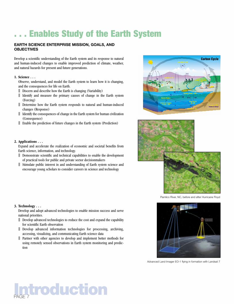
Carbon CycleCarbon Cycle
Vegetation 610
0.5
Soils1,580
Surface Ocean 1,020
Marine Biota 3
Dissolved OrganicCarbon <700
Deep Ocean38,100
Sediments 150
Atmosphere 750
Fossil Fuels &Cement Production
4,000
Rivers
121.3
60
60
5.5
1.6
0.2
91.6 100
50
40
6
46
90
92
Storage in GtCFluxes in GtC/yr
CO2
Pamlico River, NC, before and after Hurricane Floyd
Advanced Land Imager EO-1 flying in formation with Landsat 7

Exploring Our Home PlanetTHE EARTH SCIENCE ENTERPRISE STRATEGIC PLAN
Framework for Strategic Planning
Drive Enable Influence
Enable
Create
From Science Questions to Predictive Capability
Characterize
Understand
Predict
Characterize
Understand
Predict
Characterize
Understand
Predict
1998–2002 2003–2010 2010 and beyond
Discovery
Education andOutreach
ScienceQuestions
SocietalNeeds
ScienceGoal and
Objectives
ApplicationsGoal and
Objectives
TechnologyProgram
Monitoring Tech.
Information
Observation
Missions
Models
Data Analysis
Research & Missions
Verification & Validation
Demonstration
Scientific Research• Post 2002 Plan
• Disciplinary Programs
Applications Research
ScientificResults
Demonstrated
Applications
National PrioritiesProactive Earth System
s Prediction
Conduct the first systematic survey of
key Earth system interactions with the
first series of Earth Observing System
satellites.
Enable climate and natural hazard
prediction with networks of small,
smart spacecraft and an information
architecture that answers future sci-
ence questions.
Answer key science questions on Earth system forces and responses
through: systematic measurement of key Earth system parameters;
exploratory missions to probe unfamiliar Earth system processes; and
modeling and analysis to quantify the relationship among Earth system
components.

RoadmapPAGE 9
NASA Earth Science Enterprise RoadmapThrough 2002
Characterize the Earth System2003-2010
Understand the Earth System2010-2025 and Beyond
Predict Changes in the Earth System
❚ Establish a benchmark for global rainfall
❚ Estimate uptake of atmospheric CO2 from global measurements of the terrestrial biosphere
❚ Provide precise global measurements of atmospheric temperature and humidity
❚ Make global measurements of cloud properties to determine Earth’s response to solar radiation
❚ Measure global ocean winds and topography to improve accuracy and length of weather prediction and drive models of ocean impacts on climate change
❚ Produce 3-D maps of the entire inhabited surface of the Earth
❚ Achieve a quantitative understanding of the global fresh water cycle
❚ Quantify with a “high” or “moderate” degree of confidence the principal Earth system forcing and response factors
❚ Quantify the variation and trends in terrestrial and marine ecosystems; estimate global carbon stocks in forests and oceans
❚ Assess impacts of climate change on global ecosystems using interactive ecosystem-climate models
❚ Assimilate ocean surface winds, ocean topography, sea surface temperature, and precipitation into climate and weather forecasting models
❚ Conduct research to demonstrate capability for:10-year climate forecasts 12-month rain rate7-day forecast of pollution alerts60-day volcanic eruption prediction15- to 20-month El Niño forecasts5-day hurricane track forecast1- to 5-year earthquake forecast (experimental)
❚ Assess sea-level rise and effects❚ Predict regional impacts of
decadal climate change
Science ❚ Understand Earth system
variability
❚ Identify and measure primary causes of change
❚ Determine how the Earth system responds
❚ Identify the consequences for civilization
❚ Predict future Earth system changes
❚ Demonstrate applications of geospatial data to agriculture, forestry, urban, and transportation planning, etc.
❚ Expand use of commercial systems in collecting Earth system science data
❚ Collaborate with educators to develop new curricula support materials using Earth science data and discoveries
❚ Conduct research to enable 7- to 10-day weather and seasonal precipitation prediction capability; enable broad use of data in precision agriculture
❚ Enable an effective mix of private, government, and international data sources and users
❚ Incorporate Earth System Science into education curricula at the K–14 and university levels
❚ Conduct research to enable 10- to 14-day weather and annual precipitation prediction capability
❚ Enable wide spread commercial supply and use of global environmental data; integration of environmental information and economic decisionmaking
❚ Sponsor education and training programs to produce the next generation of Earth System Scientists
Applications and Education
❚ Demonstrate scientific and technical capabilities for practical tools for public and private sector decisions
❚ Stimulate public understanding of Earth science and encourage careers in science and technology
❚ Implement satellite formation flying to improve science return; New Millennium Program to space-validate revolutionary technologies
❚ Explore new instrument concepts for next decade science missions
❚ Employ high-end super computers to address Earth system modeling challenges
❚ Collaborate with operational agencies in mission planning, development, and utilization
❚ Develop and implement autonomous satellite control
❚ Demonstrate a new generation of small, highly capable active, passive, and in situ instruments
❚ Employ distributed computing and data mining techniques for Earth system modeling
❚ Transition advanced instruments for systematic measurements to operational systems
❚ Develop high data rate communications and on-board data processing and storage
❚ Deploy cooperative satellite constellations and intelligent sensor webs
❚ Design instruments for new scientific challenges; deploy advanced instruments to migrate selected observations from LEO and GEO to L1 and L2 sentinels
❚ Develop a collaborative synthetic environment to facilitate understanding and enable remote use of models and results
❚ Collaborate in an international global observing and information system; improve operational systems with new technology
Technology ❚ Develop advanced
technologies for Earth observation
❚ Develop advanced information technologies for Earth science data
❚ Partner with others for Earth system monitoring and prediction
Objectives

SCIENCE AND APPLICATIONS ACCOMPLISHMENTS:
❚ Quantified the flux of radiation from the Sun and the Earth’s planetary energybudget
❚ Created a 26-year data record of global land cover, to quantify changes such asthe rate of deforestation in the Amazon and Southeast Asian rainforests
❚ Discovered the causes of ozone depletion and formation, and established thatindustrially-produced, chlorine-containing compounds are responsible forobserved increases in ozone depletion
❚ Generated the first maps of global ocean circulation from satellite data, andenabled the world to watch the formation and dissipation of El Niño and La Niñaphenomena
❚ Determined thinning and thickening rates for the Greenland ice sheet, and pro-duced the first precise radar map of Antarctica
❚ Mapped earthquake faults and ground motions prior to volcanic eruptions usinginterferometric radars and GPS arrays
❚ Discovered that high concentrations of atmospheric pollutants can inhibit rain-fall in areas downwind of their source(s)
❚ Discovered a significant decrease in high Northern latitude sea ice thickness overthe past few decades
TRMM (11/97)• Rainfall (land/sea)
SeaWiFS (9/97)• Ocean color
SeaWinds on QuikScat (6/99)• Sea surface winds
Landsat 7 (6/99)• Terrestrial surface
Terra (12/99)• Clouds, aerosols, radiation• Terrestrial surface• Ocean color
ACRIMsat (12/99)• Solar irradiance
Shuttle Radar Topography Mission (2/00)• Land surface topography and deformation
SAGE III on Meteor 3M-1• Atmospheric aerosols• Atmospheric chemical species
EO-1 (11/00)• Land imaging technology demonstration
VCL• Vegetation canopy heights
QuikTOMS• Atmospheric ozone and aerosols
Aqua• Clouds, precipitation • radiation• Terrestrial surface• Ocean color/sea surface • temperature
Jason• Ocean circulation• Sea level
GRACE• Time variation of Earth's• gravity field
SeaWinds on ADEOS II• Sea surface winds
ICESat• Ice sheet• Topography
SORCE• Solar irradiance
Triana• Earth energy balance and diurnal• changes• Solar wind/space weather
Aura• Atmospheric chemical species• Solar wind/space weather • First global measurements• of tropospheric chemistry
SUN
HUMAN ACTIVITY
SNOW CLOUDS
RAIN
OCEAN BIOLOGYEVAPORATION
VOLCANOLOGY
SEA ICELAND BIOLOGY
<1998 1999 2000–01 2002-03
NASA’S CURRENT EARTH SCIENCE MISSIONSARE CHARACTERIZING THE MAJOR INTERACTIONS IN THE EARTH SYSTEM
Exploring Our Home PlanetTHE EARTH SCIENCE ENTERPRISE STRATEGIC PLAN
The Current Program (Through 2002):Characterizing the Earth System

The Current Program
ANTICIPATED ACCOMPLISHMENTS:
❚ Collect nearly daily global measurements of the terrestrial and marine biospherefrom which estimates of uptake of atmospheric carbon dioxide can be made
❚ Establish a benchmark for global and regional rainfall measurements whichdetermines availability of fresh water resources
❚ Provide precise global measurements of atmospheric temperature and humidityfrom satellites to improve accuracy and length of weather forecasts, and contin-ue ocean wind and topography measurements to improve accuracy and lengthof weather prediction and drive models of the ocean’s impact on climate
❚ Make global measurements of cloud properties (extent, height, reflectivity,microphysics, etc.) to determine their impact on the Earth’s response to incom-ing solar radiation and Earth’s climate
❚ Make global measurements of aerosols and ozone as indicators of air quality inthe troposphere—the portion of the atmosphere in which we live and breathe
❚ Produce a digital topographic map for the entire Earth surface between 60°Nand 56°S, useful for a wide variety of research and applications in natural haz-ards, hydrology, geomorphology, etc.; provide additional coverage with digitalelevation models generated from the Terra satellite
❚ Understand processes contributing to formation and occurrence of earthquakesand volcanic systems
IMPLEMENTATION PRIORITIES:
❚ Continue the development of the first series of EOS andselected Earth Probes missions
❚ Deliver a functioning data and information system to sup-port the processing, archival, and distribution of data andinformation resulting from these missions
❚ Implement scheduled aircraft and field campaigns, e.g.,detailed aircraft study of Pacific tropospheric chemistry,the ecology of the Amazon, and biomass burning in south-ern Africa
❚ Continue collection and analysis of data from existingNASA satellites, e.g., data on rainfall rates in the globaltropics and phytoplankton concentrations in the oceans
❚ Establish joint applications demonstration projects withother Federal, State and, local agencies (e.g., FEMA floodplain mapping, USDA precision agriculture)
❚ Conduct research on key Earth science questions in collaboration with otherAgencies, e.g., measure changing crustal strain field with USGS and NSF—“EarthScope”
❚ Support the development and implementation of U.S. Global Change ResearchProgram goals and objectives
The Current Program (continued)
The existing global distribution of terrestrial biomes derived from AVHRR
data for 1989 (Nemani and Running 1995). These land-cover data sets
are used to quantify land-surface characteristics in global climate,
hydrology, and carbon-cycling models. Land-cover monitoring is also
important for quantifying deforestation/reforestation rates and land-use
change and urbanization. EOS will produce a global land-cover product
similar to this at 1 km. resolution based on Terra satellite observations.
PAGE 11

STRATEGIC PRIORITIES
❚ Implement a focused and vigorous research program to answer fundamental ques-tions of Earth system forcing and response
❚ Fulfill our commitment to the science community to provide long-term (15 yearsor more) climate records of key Earth observations by:◆ Providing key systematic measurements as needed beyond the EOS first series
via commercial data purchases where these meet science requirements and arecost-effective
◆ Transition of mature, key systematic measurements to the national and interna-tional operational satellite systems
❚ Conduct exploratory satellite missions to probe unfamiliar Earth system processes,such as understanding the role of cloud vertical structure and properties, distri-butions and origins of aerosols on Earth’s climate and its variability, and deforma-tion of the Earth’s surface
❚ Implement an open and distributed information system architecture that willinclude Principal Investigator processing in the mix of science data processingproviders, and tie together diverse creators and users of higher level informationproducts
❚ Develop an Earth Science Extension Network to exchange information products atthe State and local level, and facilitate jointly sponsored applications research toenable broad societal benefit from Earth science knowledge
❚ Collaborate with operational mission agencies and commercial concerns todemonstrate remote sensing capabilities they want to incorporate in their decisionsupport systems
❚ Develop technologies and enhance methodologies of instrument calibration toreduce data interpretation errors and improve weather and other Earth systemmodels
❚ Pursue advanced technology to enable new observational and analysis capabilitiesand to reduce the size, cost, and development time of systematic and exploratorysatellite missions through such means as:◆ Advanced component development◆ Advanced information technology◆ Advanced component and subsystem technology development and demonstra-
tion, (e.g., instrument incubator sensor concept development)◆ In-space technology experimentation & validation (e.g., New Millennium
Program)❚ Develop and test models and data assimilation processes to bring diverse observa-
tions and research to bear on the fundamental Earth science questions❚ Support the conduct of scientific assessments of consequences of climate change
and global and regional impacts on:◆ Food and fiber production◆ Fresh water and other natural resources◆ Human health and spread of infectious diseases◆ Planning and development of roads, cities, and other infrastructure
Exploring Our Home PlanetTHE EARTH SCIENCE ENTERPRISE STRATEGIC PLAN
The Coming Program (2002-2010):Understanding the Earth System
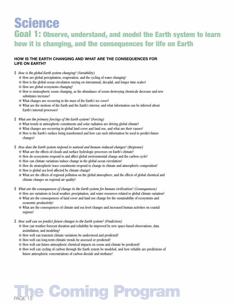
HOW IS THE EARTH CHANGING AND WHAT ARE THE CONSEQUENCES FORLIFE ON EARTH?
❚ How is the global Earth system changing? (Variability)◆ How are global precipitation, evaporation, and the cycling of water changing?◆ How is the global ocean circulation varying on interannual, decadal, and longer time scales? ◆ How are global ecosystems changing?◆ How is stratospheric ozone changing, as the abundance of ozone-destroying chemicals decrease and new
substitutes increase?◆ What changes are occurring in the mass of the Earth’s ice cover?◆ What are the motions of the Earth and the Earth’s interior, and what information can be inferred about
Earth’s internal processes?
❚ What are the primary forcings of the Earth system? (Forcing)◆ What trends in atmospheric constituents and solar radiation are driving global climate?◆ What changes are occurring in global land cover and land use, and what are their causes?◆ How is the Earth’s surface being transformed and how can such information be used to predict future
changes?
❚ How does the Earth system respond to natural and human-induced changes? (Response)◆ What are the effects of clouds and surface hydrologic processes on Earth’s climate?◆ How do ecosystems respond to and affect global environmental change and the carbon cycle?◆ How can climate variations induce change in the global ocean circulation?◆ How do stratospheric trace constituents respond to change in climate and atmospheric composition?◆ How is global sea level affected by climate change?◆ What are the effects of regional pollution on the global atmosphere, and the effects of global chemical and
climate changes on regional air quality?
❚ What are the consequences of change in the Earth system for human civilization? (Consequences)◆ How are variations in local weather, precipitation, and water resources related to global climate variation?◆ What are the consequences of land cover and land use change for the sustainability of ecosystems and
economic productivity?◆ What are the consequences of climate and sea level changes and increased human activities on coastal
regions?
❚ How well can we predict future changes to the Earth system? (Prediction)◆ How can weather forecast duration and reliability be improved by new space-based observations, data
assimilation, and modeling?◆ How well can transient climate variations be understood and predicted?◆ How well can long-term climatic trends be assessed or predicted?◆ How well can future atmospheric chemical impacts on ozone and climate be predicted?◆ How well can cycling of carbon through the Earth system be modeled, and how reliable are predictions of
future atmospheric concentrations of carbon dioxide and methane?
The Coming Program
Goal 1: Observe, understand, and model the Earth system to learnhow it is changing, and the consequences for life on Earth
PAGE 13
Science
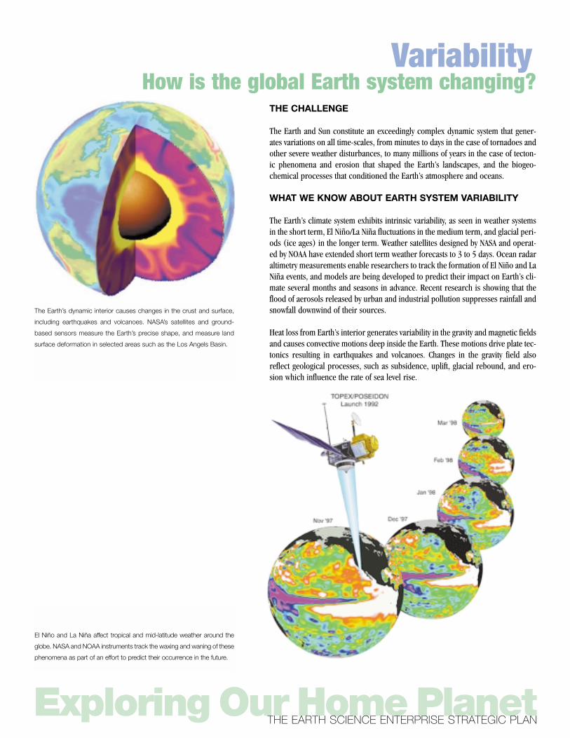
THE CHALLENGE
The Earth and Sun constitute an exceedingly complex dynamic system that gener-ates variations on all time-scales, from minutes to days in the case of tornadoes andother severe weather disturbances, to many millions of years in the case of tecton-ic phenomena and erosion that shaped the Earth’s landscapes, and the biogeo-chemical processes that conditioned the Earth’s atmosphere and oceans.
WHAT WE KNOW ABOUT EARTH SYSTEM VARIABILITY
The Earth’s climate system exhibits intrinsic variability, as seen in weather systemsin the short term, El Niño/La Niña fluctuations in the medium term, and glacial peri-ods (ice ages) in the longer term. Weather satellites designed by NASA and operat-ed by NOAA have extended short term weather forecasts to 3 to 5 days. Ocean radaraltimetry measurements enable researchers to track the formation of El Niño and LaNiña events, and models are being developed to predict their impact on Earth’s cli-mate several months and seasons in advance. Recent research is showing that theflood of aerosols released by urban and industrial pollution suppresses rainfall andsnowfall downwind of their sources.
Heat loss from Earth’s interior generates variability in the gravity and magnetic fieldsand causes convective motions deep inside the Earth. These motions drive plate tec-tonics resulting in earthquakes and volcanoes. Changes in the gravity field alsoreflect geological processes, such as subsidence, uplift, glacial rebound, and ero-sion which influence the rate of sea level rise.
Exploring Our Home PlanetTHE EARTH SCIENCE ENTERPRISE STRATEGIC PLAN
How is the global Earth system changing?Variability
The Earth’s dynamic interior causes changes in the crust and surface,
including earthquakes and volcanoes. NASA’s satellites and ground-
based sensors measure the Earth’s precise shape, and measure land
surface deformation in selected areas such as the Los Angels Basin.
El Niño and La Niña affect tropical and mid-latitude weather around the
globe. NASA and NOAA instruments track the waxing and waning of these
phenomena as part of an effort to predict their occurrence in the future.
EXAMPLES OF EXPECTED ACCOMPLISHMENTS
❚ Ocean observation in support of a practical El Niño/La Niña prediction capabil-ity by operational agencies
❚ Seasonal and annual variation in rainfall by region; decadal trend in global rain-fall rate
❚ Quantitative knowledge of variations and trends in the productivity, compositionand health of terrestrial and marine ecosystems (including their carbon uptakeand output)
❚ Estimates of ice sheet and glacier thickening and melting, and their mass balance
EXAMPLES OF PRACTICAL BENEFIT TO THE NATION
❚ Increased efficiency in agricultural production and decreased losses from sea-sonal rainfall prediction
❚ Assessment of crop and fisheries health and distribution❚ Assessment of availability of global fresh water resources❚ Assessment of future sea level rise
The Coming ProgramPAGE 15
Discern and describe how the global Earth system is changing
Required KnowledgeScience Question EOS Era Thru 2010
How are global precipitation, evaporation, and the cycling of water changing?
How is the global ocean circulation varying on interannual, decadal, and longer time scales?
How are global ecosystems changing?
How is stratospheric ozone changing, as the abundance of ozone-destroying chemicals decrease and new substitutes increase?
What changes are occurring in the mass of the Earth’s ice cover?
What are the motions of the Earth and the Earth’s interior, and what information can be inferred about Earth’s internal processes?
Atmospheric temperatureAtmospheric water vaporGlobal precipitationSoil moisture
Sea surface temperatureExtent of sea-iceOcean topographyEarth’s gravity fieldEarth’s center of mass
Ocean colorVegetation Index
Ozone total columnOzone vertical profile
Ice surface topographySea ice extent
Earth reference frameEarth’s magnetic fieldEarth’s gravity fieldStrain field
AquaAquaTRMM
AquaAqua, SeaWindsTOPEX/JasonGRACEGround networks
SeaWiFS, Terra, AquaTerra, Aqua
TOMS, Triana, AuraSAGE III
ICEsatDMSP, QuickSCAT
VLBI/SLR networksMagnetometer/GPS constellationGRACEERS-1/-2
NPOESS Bridge missionNPOESS Bridge missionFuture global precipitation missionExploratory soil moisture mission
NPOESS Bridge missionExploratory or operational missonFuture ocean topography missionFuture exploratory gravity missionGround networks
NPOESS Bridge missionNPOESS Bridge mission
Future ozone/areosol total column missionFuture ozone/areosol vertical profile mission
Future ice altimetry missionOperational systems
VLBI/SLR terrestrial networksMagnetometer/GPS constellationExploratory gravity missionExporatory interferometric SAR mission
KEY ELEMENTS OF NASA’S RESEARCH PROGRAM OVER THE NEXT DECADE
Height of cloud chimneys during Hurricane Bonnie, indicating the distri-
bution of energy within the storm. The highest reach to nearly 60,000
feet. Knowledge of energy distribution within the storm has recently
been shown to improve the prediction of storm movement.
Objective 1.1

THE CHALLENGE
Forces acting on the Earth system are both external and internal, and both naturaland human-induced. The larger challenge is to quantify both the natural andhuman-induced forces accurately enough to detect trends and discern the patternsof change they bring about in climate and ecosystems.
WHAT WE KNOW ABOUT FORCES ACTING ON THE EARTHSYSTEM
Researchers have identified the key forces acting on climate, and have estimatedtheir comparative contributions to climate change.
In recent times, the most significant anthropogenic forcing of the planetary envi-ronment has been the modification of the composition of the atmosphere, leadingto rising concentrations of a number of reactive and radiation absorbing gases thatcontribute to depleting the stratospheric ozone layer and to increasing the atmos-pheric greenhouse effect. Measurements at the Mauna Loa observatory and severalother stations have documented a recent upward trend of about 1 percent per yearin atmospheric carbon dioxide (CO2), amounting to a 30 percent increase in glob-al atmospheric concentration since the beginning of the industrial era. The magni-tude of the direct forcing of the climate by tropospheric aerosols remains one of thelargest unknown factors in climate research. The release of gases and particulatematter into the atmosphere from volcanic eruptions is also important. Motions ofEarth’s crust force significant surface deformation and topographic changes thatcan have major impacts on the land surface.
Exploring Our Home PlanetTHE EARTH SCIENCE ENTERPRISE STRATEGIC PLAN
What are the primary causes of change in the Earth system?
2.3
0.4
-0.2-0.4
-1.0
-0.2
0.4
0.2,-0.5
0
1
2
3
-1
Forces Acting on Climate
CO2
CH4
CFCsN2O
Indirect via O3
Well-mixedgreenhouse
gases
Troposphericozone
Sun
Stratosphericozone
Troposphericaerosols
Forcedcloud
changes
Vegetationand othersurface
alterations
Volcanicaerosols
Greenhouse gases Other anthropogenic forcings natural forcings
moderate
moderate
moderatehigh
high high high highhighhigh
very low very low very low very low very low very low low
lowlowlow low very low very low
moderate
pre-satellite
1979–1999
2000-2010
time line Confidence Levels
Wat
ts p
er m
eter
2
low
low
very low
moderate
high moderate
Motion of the
Earth's interior
Landcover
change
320
300
280
260
2401200 1400 1600 1800 2000
Global Atmospheric CO2 concentrations
Forcing
EXAMPLES OF EXPECTED ACCOMPLISHMENTS
❚ Each of the identified forces acting on climate will be quantified, with a “high” or“moderate” degree of confidence in its contribution to Earth’s climate
❚ The principal anthropogenic sources of aerosols and their impacts on Earth’s cli-mate will be quantified
❚ Quantitative assessment of global marine and terrestrial ecosystems and their con-tribution to cycling of carbon through the Earth system over time will be made
❚ A seasonal refresh of the global archive of land cover and change data will beaccomplished periodically
❚ The first measurements of sunrise-to-sunset changes in atmospheric ozone andaerosols, and associated maps of ultraviolet radiation at the surface will be pub-lished
❚ Spatially and temporally continuous measurements of Earth’s changing strain fieldwill be obtained
❚ Quantitative models of earthquakes and volcanic systems will be developed
EXAMPLES OF PRACTICAL BENEFIT TO THE NATION
❚ Economic and policy decisionmakers will have a robust, scientific basis on whichto compare alternate courses of action concerning activities that affect or areaffected by climate variations and natural hazards
❚ Regional, State, and local authorities and businesses will have the basic scientificknowledge and geospatial data information products to support their activities inurban, transportation, and agricultural planning and development
❚ Health officials will have maps of surface ultraviolet radiation to assess associatedhealth risks
❚ Refined natural hazards maps (e.g., fires, earthquakes, volcanoes) will result inimproved building codes and retrofit strategies to mitigate their impact
The Coming ProgramPAGE 17
Identify and measure primary causes of change in the Earth systemKEY ELEMENTS OF NASA’S RESEARCH PROGRAM OVER THE NEXT DECADE
Required KnowledgeScience Question EOS Era Thru 2010
What trends in atmospheric constituents and solar radiation are driving global climate?
What are the changes in global land cover and land use, and what are their causes?
How is the Earth's surface being transformed, and how can such information be used to predict future changes?
Total solar irradianceSolar UV irradianceTotal aerosol amountAerosol vertical profileAerosol properties
Surface trace gas concentrationTrace gas sources/total column CO2
Land cover inventoryFire occurrances
Surface topographyDeformation & stress accumulationGravity and geomagnetic fieldsEarth reference frame
ACRIMsat, SORCEUARS, SORCETerraSAGE IIITerrestrial network
Terrestrial networkTerrestrial network
Landsat 7, TerraTerra
SRTMERS-1/-2Space GPS receiversSurface networks
Future solar irradiance missionFuture solar irradiance missionNPOESS Bridge missionPICASSO, SAGE III (ISS)Terrestrial network, exploratory tropospheric chem
missionTerrestrial networkTerrestrial network, exploratory space-based
system
Domestic and/or international partnershipsNPOESS Bridge mission
Exploratory interferometric laser or SAR mission(s)Exploratory interferometric laser or SAR mission(s)Space GPS receiversSurface networks
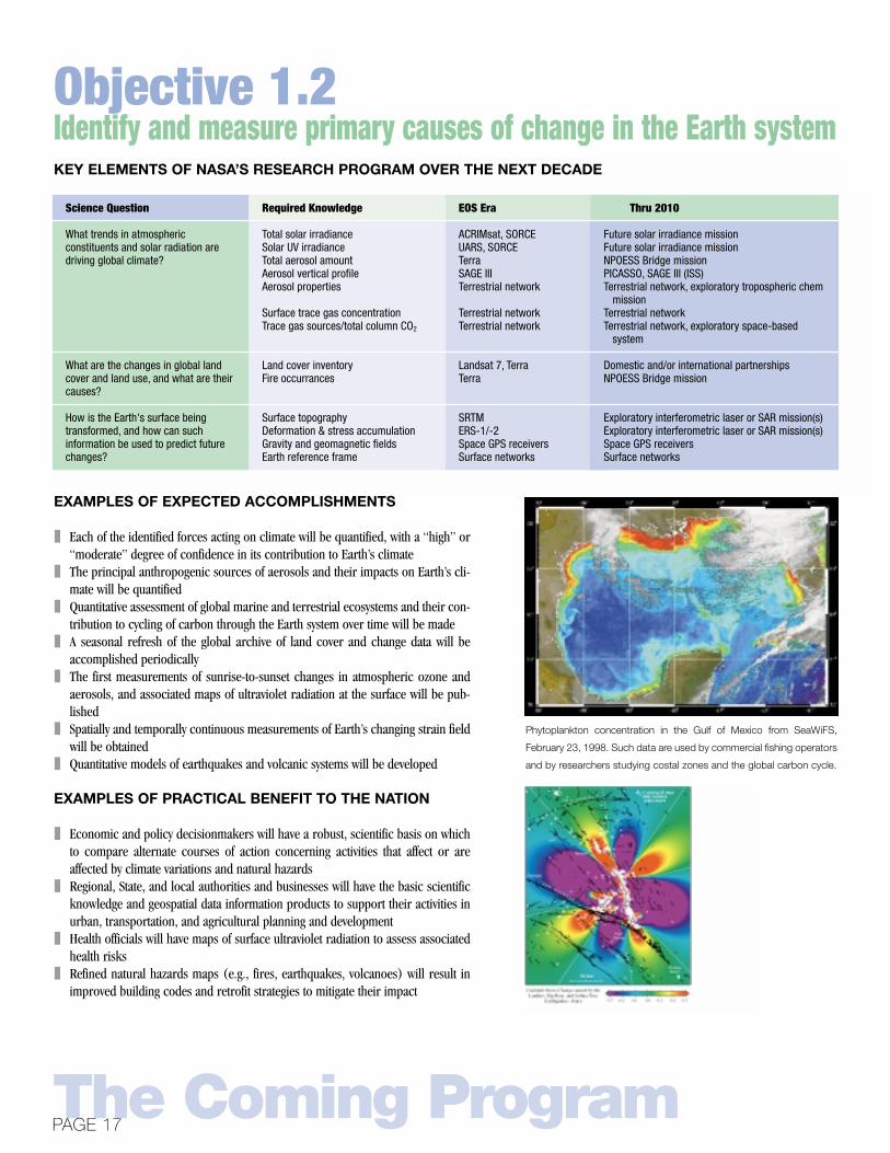
Phytoplankton concentration in the Gulf of Mexico from SeaWiFS,
February 23, 1998. Such data are used by commercial fishing operators
and by researchers studying costal zones and the global carbon cycle.
Objective 1.2

THE CHALLENGE
Linking responses to forcing factors is a difficult problem given the large naturalvariability inherent to the Earth system. Complicating the problem further are thefeedbacks—responses to Earth system changes can themselves influence and ampli-fy the responses of the system, as is the case with water vapor in the atmosphere inits effects on temperature. One key to progress is the development of models whichcouple the ocean and atmosphere and the land and atmosphere in order to probecauses and effects which cross boundaries among Earth system components.
WHAT WE KNOW ABOUT HOW THE EARTH SYSTEMRESPONDS TO CHANGE
Key Earth system response parameters have been identified, and the time scale oftheir occurrence and a general characterization of their visibility to people illus-trated below.
Exploring Our Home PlanetTHE EARTH SCIENCE ENTERPRISE STRATEGIC PLAN
How does the Earth system respond tonatural and human-induced changes?
SevereStorms
Droughtsand
FloodsEl Niño
Frequency
FreshWater
AvailabilityEcosystemChanges
OceanCirculation
Sea LevelChange
Ice SheetMass
Earthquakesand
Volcanoes
Time scale of Forcingrapid slow
high
low
Degr
ee o
f vi
sibi
lity
tohu
man
s
Increasedintensity
Change infrequency,
intensity, andlocation
Morefrequent
andintense
Geographicdistribution
changes
Desertificationand ecosystem
migration
Changes incirculationpatterns
Rise insea level
Decreasedue tomelting
Landsurface
deformation
none low none very low very low low low very low very low
low low low low moderate moderate moderate low low
moderate moderate moderate high high high high moderate moderate
ChangeCharacter-ization
Degree of Understanding
Pre-satellite
Now
2010
Response
EXAMPLES OF EXPECTED ACCOMPLISHMENTS
❚ Over the decade, each of the identified climate responses will be quantified, witha “high” or “moderate” degree of confidence in its impact on climate change
❚ Understand the chemical impacts of CFC substitutes and the efficacy of theMontreal Protocol on Substances Depleting the Ozone Layer
❚ Provide global mapping of regional air quality❚ First estimate of carbon stocks in forests and oceans globally
EXAMPLES OF PRACTICAL BENEFIT TO THE NATION
❚ Seasonal and annual variation in soil moisture for agriculture planning and floodhazard assessment
❚ Geospatial information and decision support systems to generate fire hazardmaps based on fuel-load and climate conditions for forest and rangeland management
❚ Scientific basis for air quality management decisions
The Coming ProgramPAGE 19
Determine how the Earth system respondsto natural and human-induced changesKEY ELEMENTS OF NASA’S RESEARCH PROGRAM OVER THE NEXT DECADE
Required KnowledgeScience Question EOS Era
What are the effects of clouds and surface hydrologic processes on Earth’s climate?
How do ecosystems respond to and affect global environmental change and the carbon cycle?
How can climate variations induce changes in the global ocean circulation?
How do stratospheric trace constituents respond to change in climate and atmospheric composition?
How is global sea level affected by climate change?
What are the effects of regional pollution on the global atmosphere?
Cloud system structureCloud particle properties & dist.
Earth radiation budgetSoil moistureSnow cover & accumulationLand freeze-thaw transition
Ecosystem vertical structureMarine productivity in coastal regionsCarbon sources and sinks
Sea surface salinitySubsurface temperature, currents,
salinity
Atmospheric properties near tropopause
Selected chemical speciesSelected source gasses
Polar ice sheet velocity fields
Tropospheric ozone and precursors
Terra, Aqua
Terra, Aqua, ACRIM
Terra, AquaSeawinds
Terra, Aqua
In situ ocean buoys
Aura
Aura, SAGE IIISurface network
Radarsat
Aura
Thru 2010
NPOESS Bridge missionCloudsat, PICASSO, future aerosol/cloud radiation
mission
Exploratory soil moisture missionExploratory cold climate missionExploratory cold climate mission
Exploratory vegetation recovery missionNPOESS Bridge missionExploratory CO2 column mission
Exploratory ocean salinity missionIn situ ocean buoys
Aura, Future stratospheric chemistry mission
Future stratospheric chemistry mission, SAGE III (ISS)Surface network
Exploratory interferometric laser or SAR mission(s)
Exploratory tropospheric chemistry mission
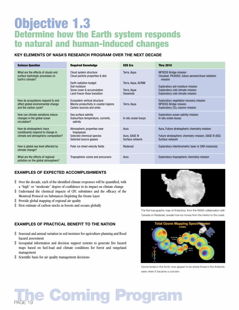
The first topographic map of Antarctica, from the NASA collaboration with
Canada on Radarsat, reveals how ice moves from the interior to the coast.
Ozone levels in the Arctic now appear to be where those in the Antarctic
were when it became a concern.
Objective 1.3

THE CHALLENGE
Small changes in the global distribution of Earth system properties, such as meansurface temperature or sea-level pressure, can entail changes of much greater sig-nificance in regional weather, productivity patterns, water resource availability, andother environmental attributes. We already know, for example, El Niño warm oceanwater episodes shut down regional marine productivity and broader climate pat-terns. El Niño events appear to be correlated with fewer hurricanes in the Atlanticbut more typhoons in the Pacific. La Niña climate episodes, manifested by coolingof surface waters in the eastern tropical Pacific ocean by a few degrees Celsius,appear to be associated with more active hurricane seasons in the Atlantic basin,featuring more frequent and generally stronger tropical cyclones than normal years.
WHAT WE KNOW ABOUT THE CONSEQUENCES OFCHANGES IN THE EARTH SYSTEM
Frequency of extreme rainfall events (greater than two inches per day) hasincreased in recent years at most locations, although the causes have yet not beenunambiguously revealed.
The growing season appears to have lengthened in much of the mid-latitude north-ern hemisphere by about 10 to 14 days over the next 30 years.
Exploring Our Home PlanetTHE EARTH SCIENCE ENTERPRISE STRATEGIC PLAN
What are the consequences of change inthe Earth system for human civilization?
Landsat 7 images of the Outer Banks of North Carolina show the river
discharge effects of Hurricane Floyd (Sept. 23, 1999).
QuikSCAT ocean surface winds data enables scientists to study severe
storms in their broader climate context. These same data improve
marine weather forecasts and predictions of storm movement.
Consequence

EXAMPLES OF EXPECTED ACCOMPLISHMENTS
❚ High resolution structure of the global ocean surface wind field through opera-tional satellites to enhance short-term weather forecasts
❚ Fully interactive ecosystem-climate models to assess impacts of various climatechange scenarios on ecosystems responses and impact on the goods and servic-es they provide
❚ Understanding the year-to-year variations in net primary production of terrestrialecosystems and regional agricultural and forest productivity
❚ Quantitative assessments of global land cover change, and assessments of conse-quences of land use change
❚ Understanding the exchanges of nutrients and sediments between the land andcoastal oceans worldwide
EXAMPLES OF PRACTICAL BENEFIT TO THE NATION
State and local planning authorities will have geospatial-based information and nec-essary tools to aid in decisionmaking for such areas as coastal zone management,transportation and utility planning, and a host of livability issues.
Human health organizations will have access to geospatial and health informationand data analysis and visualization tools to assess the consequences of climatechange on the spread of vector borne diseases.
The Coming ProgramPAGE 21
Identify the consequences of changes in theEarth system for human civilizationKEY ELEMENTS OF NASA’S RESEARCH PROGRAM OVER THE NEXT DECADE
Required KnowledgeScience Question EOS Era Thru 2010
How are variations in local weather, precipitation and water resources related to global climate variation?
What are the consequences of land cover and land use change?
What are the consequences of climate and sea level changes and increased human activities on coastal regions?
Global precipitationOcean surface winds
Meteorological properties around storms
Lightning rateRiver stage height & discharge rate
Primary productivityLand cover inventories
Coastal region properties & productivity
TRMMSeawinds
GOES
LISJason
TerraLandsat 7, Terra
Landsat 7, Terra
Future global precipitation missionFuture national/international cooperative
missionGOES w/improvements
UNESS, Transition to operational missionsFuture national/International cooperative
mission
NPOESS Bridge missionDomestic and/or international partnership
Commercial sources of data and/or exploratory missions
URBAN HEAT ISLAND EFFECT IN ATLANTA: These data were collect-
ed May 11 and 12, 1997. While daytime air temperatures on that date
were only about 80 degrees, surface temperatures reached as much as
118 (F); nighttime air temperatures hovered between 50 and 55, but due
to the heat sink, surface temperatures hung on as high as 75 degrees.
Objective 1.4

THE CHALLENGE
The overarching purpose of Earth system science is to develop the knowledge basisfor predicting future changes in the coupled physical, chemical, geological, andbiological state of the Earth and assessing the risks associated with such changes.Of particular interest are changes in physical climate on the time scale of a humangeneration, e.g. changes in the composition and chemistry of the atmosphere, andchanges in biogeochemical cycles and primary productivity. A first step towards pre-dicting the future of the Earth system is building a capability to simulate realistical-ly the present state and short-term variations of the global environment.
WHAT WE KNOW ABOUT THE PREDICTABILITY OFFUTURE CHANGES?
Researchers have described the major cycles in the Earth system, including thewater and carbon cycles shown here, and have attempted to quantify the variouscomponents in each. This understanding is represented in a variety of climate mod-els which are initialized with data from satellites and other sources. Currentresearch is focused on coupling models of the key Earth system components, e.g.,ocean-atmosphere and land-atmosphere interactions to represent larger segmentsof the climate system. Research over the next decade is aimed at filling gaps in ourunderstanding and reducing the significant uncertainties in our current under-standing.
Exploring Our Home PlanetTHE EARTH SCIENCE ENTERPRISE STRATEGIC PLAN
How well can we predict future changes in the Earth system?
The carbon cycle—how carbon circulates among the land, atmosphere, and oceans—is a major
focus of climate change research.
Accurate knowledge of soil moisture would greatly improve predictabil-
ity of precipitation. NASA has used aircraft-based instruments to
demonstrate the feasibility of soil moisture measurement before pursu-
ing a space-based system.
Carbon CycleCarbon Cycle
Vegetation 610
0.5
Soils1,580
Surface Ocean 1,020
Marine Biota 3
Dissolved OrganicCarbon <700
Deep Ocean38,100
Sediments 150
Atmosphere 750
Fossil Fuels &Cement Production
4,000
Rivers
121.3
60
60
5.5
1.6
0.2
91.6 100
50
40
6
46
90
92
Storage in GtCFluxes in GtC/yr
CO2
Index of Precipitation Predictability (JJA):Given Predictability of SSTs
1.00
0.80
0.60
0.40
0.20
0.00
1.00
0.80
0.60
0.40
0.20
0.00
Given Predictability of SSTs and Land Moisture
Prediction

EXAMPLES OF EXPECTED ACCOMPLISHMENTS
❚ Incorporation of cloud effects in regional climate change models❚ Assimilation of ocean winds, sea surface temperature, and precipitation radar
measurements into climate and weather forecasting models❚ Incorporation of tropospheric winds measurements into operational weather
forecasting systems❚ Demonstrate enhanced accuracy of 3- to 5-day weather forecasts❚ Significantly improve knowledge of the sources and sinks of carbon as it circu-
lates among the land, atmosphere, and oceans❚ Acquisition and analyses of geophysical data to significantly improve assessments
of earthquake and volcanic risks
EXAMPLES OF PRACTICAL BENEFIT TO THE NATION
❚ Demonstrate extended range of weather prediction to 7–10 days❚ Expanded ability to assess ecosystem health, with related benefits such as disease
vector prediction❚ Scientific basis for assessing impacts of human activities on Earth’s climate and
ecosystems
The Coming ProgramPAGE 23
Enable the prediction of Earth systemchanges that will take place in the futureKEY ELEMENTS OF NASA’S RESEARCH PROGRAM OVER THE NEXT DECADE
Required KnowledgeScience Question
How can weather forecast duration and reliability be improved by new space-based observations, data assimilation, and modeling?
How well can transient climate variations be understood and predicted?
How well can long-term climatic trends be assessed or predicted?
How well can future atmospheric chemical impacts on ozone and climate be predicted?
How well can cycling of carbon through the Earth system be modeled, and how reliable are predictions of future atmospheric concen-trations of carbon dioxide and methane?
Tropospheric windsOcean surface windsSoil moistureSea surface temperature
Ocean surface windsSoil moistureSea surface temperatureSea level heightDeep ocean circulation
Assimilation of most of the data from these missions into models
Assimilation of atmospheric data into models
Estimates/scenarios of fossil fuel consumption, methane generation, etc., from DOE
EOS Era Thru 2010
Sea winds
Operational satellites
Seawinds
AquaJasonIn situ measurements
Improve and apply coupled climate system models
Improve and apply atmospheric models with chemical constituent transport and reactions
Couple carbon cycle models to climate system model and use to project future CO2 & climate
Develop similar for methane
Domestic and/or international partnershipFuture national/international cooperative missionExploratory soil moisture missionOperational satellites
Exploratory or operational missionExploratory soil moisture measuring missionNPOESS Preparatory ProjectFuture national/international partnership in situ
measurements
Same, but with increased resolution, and regionalization of global predictions
Same, but with increased resolution; model regional aerosols including indirect effect on clouds and albedo
Improve modeling capability to make future projections of CO2, methane, and resulting climate change
Better models run on faster computers can derive more precise predic-
tion of storm fronts based on satellite observations.
Objective 1.5

The Enterprise and its community stakeholders identified these areas where Earthscience at NASA can make a direct, substantial contribution to the Nation’s economyand society.
The Applications and Education component of the Earth Science Enterprise worksto assess and prioritize applications and educational requirements against ESE’scapabilities and help transform science and technology results into improved pub-lic policy, operations, and commercial opportunities. This activity is structuredaround three functional lines:
The Applications group will focus on understanding thepriority issues that face public and private sector decision-makers, and determining how these issues can be addressedby the scientific and technical capabilities of ESE.
The Education group will stimulate broad interest in andunderstanding of Earth system science, research technolo-gies, and applications, and will encourage young scholars toconsider careers in science and technology.
The Outreach group will focus on providing information todecisionmakers and stakeholders concerning ESE results,the status of projects, and the benefits derived from applica-tions. Outreach will also act as a conduit back to ESE con-cerning public and commercial needs, requirements, andexpectations.
The Earth Science Enterprise pursues applications researchand demonstration projects in partnership with other agen-cies, State and local governments, industry, and academia.We provide the cutting-edge science and technology, and ourpartners adapt them for their products and services.Successful projects become self-sustaining, and NASA moveson to develop the next set of applications.
Exploring Our Home PlanetTHE EARTH SCIENCE ENTERPRISE STRATEGIC PLAN
Goal 2: Expand and accelerate the realization of economic andsocietal benefits from Earth science, information, and technology
Resource Management❚ Agriculture❚ Range lands❚ Forestry❚ Fisheries
Disaster Management❚ Natural hazards❚ Environment and health
Community Growth❚ Transportation❚ Infrastructure❚ Quality of life
Environmental Quality❚ Air and water quality❚ Land use/land cover change
Applications
Over the past 10 years, NASA has been successful in stimulating the development ofa robust U.S. commercial remote sensing industry, now measured in billions insteadof millions of dollars in annual revenues. NASA now engages industry as a partneralong with academia and other Federal, State and local agencies to demonstrate newapplications of remote sensing data to practical problems.
Regional Applications—NASA is creating a program to foster the developmentand demonstration of applications of geospatial data to a wide variety of State andlocal uses. This program is national in scope, employs merit-based selection, andis implemented via collaborative partnerships with user organizations.
Natural Hazard Applications—In partnership with the Federal EmergencyManagement Agency, NASA is pioneering the use of satellite observations and mod-eling of natural phenomena for hazard vulnerability assessment. High resolutionterrain mapping systems are being used to produce more accurate flood insurancerate maps for the National Flood Insurance Program.
EXAMPLES OF EXPECTED ACHIEVEMENTS
❚ Within the next 5 years:◆ ESE results are shown to benefit decisionmaking in areas such as environ-
mental quality, resource management, community growth, and disaster man-agement
◆ A regional infrastructure that coordinates and maximizes the benefit of ESEprograms has been implemented across the United States
◆ ESE science and technology results are being applied to support regional andnational assessments of climate
❚ Within the next 10 years:◆ Results of regional Earth science applications have been implemented nation-
wide in community-based environmental programs, multi-jurisdictional haz-ard mitigation efforts, and by sustainable community organizations
The Coming ProgramPAGE 25
ApplicationsTurn ESE scientific and technical capabilities intopractical tools for solving real world problems.
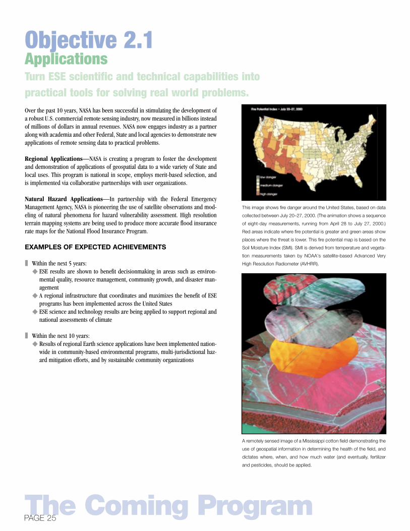
This image shows fire danger around the United States, based on data
collected between July 20–27, 2000. (The animation shows a sequence
of eight-day measurements, running from April 28 to July 27, 2000.)
Red areas indicate where fire potential is greater and green areas show
places where the threat is lower. This fire potential map is based on the
Soil Moisture Index (SMI). SMI is derived from temperature and vegeta-
tion measurements taken by NOAA's satellite-based Advanced Very
High Resolution Radiometer (AVHRR).
A remotely sensed image of a Mississippi cotton field demonstrating the
use of geospatial information in determining the health of the field, and
dictates where, when, and how much water (and eventually, fertilizer
and pesticides, should be applied.
Objective 2.1

Earth Science Education activities focus on communicating the results of ESE throughnon-formal/informal learning venues and through formal classroom venues. Theseactivities will include creation of ESE content materials for these venues, develop-ment of special education programs that amplify the efforts of ESE and stimulatebroad awareness and understanding, and the identification of new skills and trainingthat is required to incorporate the rewards of ESE into the fabric of our everyday life.
The Education program aims to:❚ Increase public awareness and understanding of how the Earth functions as a sys-
tem and NASA’s role in enabling development of that knowledge ❚ Enable the use of Earth science information and results in teaching and learning
at all levels of education❚ Build capacity for productive use of Earth science results, technology, and infor-
mation in resolving everyday practical problems
EXAMPLES OF EXPECTED ACCOMPLISHMENTS
❚ In 5 years:◆ At least 20 leading undergraduate institutions in education (K-12) are accred-
ited to certify future High School science educators in Earth system science◆ 10 of the 50 states have a middle school or a high school graduation compe-
tency requirement in Earth science and 5 percent of the respective teachersare certified in this field
◆ 20 percent of the American adult populace knows of an Earth system sciencephenomenon or an applied use and they know that NASA enables this work
◆ A prototype accreditation program, national in scope, exists for undergradu-ate or vocational instruction of Earth remote sensing principles and tech-niques, with a companion professional certification program for individualpractitioners (basic to advanced, plus areas of expertise).
❚ In 10 years:◆ At least 30 leading undergraduate institutions in education (K-12) are accred-
ited to certify future high school science educators in Earth system science ◆ 20 of the 50 states have a middle school or a high school graduation compe-
tency requirement in Earth science and 30 percent of their teachers are certi-fied in this field
◆ SAT or ACT tests ask questions on key concepts in Earth system science◆ 30 percent of the American adult populace knows of an Earth system science
phenomenon or an applied use and they know that NASA enables this work◆ A national accreditation and certification program in Earth remote sensing in
place◆ 10 percent of the Nation’s 4-year masters granting universities and colleges are
accredited in remote sensing instruction, and 5 percent of two-year institu-tions are accredited. Five percent of practitioners using remote sensing in theworkplace are certified.
Exploring Our Home PlanetTHE EARTH SCIENCE ENTERPRISE STRATEGIC PLAN
EducationStimulate public interest in and understanding of Earth system science and
encourage young scholars to consider careers in science and technology
Objective 2.2

Science-driven advances in technology pave a crucial pathway on the Enterprise’sroadmap toward a proactive Earth system prediction capability. The Enterprise seekstechnology solutions to both lower the cost of meeting existing observing require-ments and make possible measurements that have never been made. NASA is both asupplier of and customer for advanced technologies, provoking and leveraging threeongoing technology revolutions to shape the future of Earth observation.
Geospatial: New sensor technologies are making new kinds of observations and datapossible. Where passive remote sensing systems (e.g., Landsat) yield two-dimension-al imagery, active remote sensing systems (radars and lidars) enable three-dimen-sional views of the Earth’s surface and atmosphere. We can begin to see beyond activesensors to “photon-less” sensors that measure gravity and magnetic fields. These willallow us to “see” the internal structure of the Earth. With such tools we could studychanges in the world’s fresh water aquifers, make reliable predictions of volcaniceruptions, and even attempt 1- to 5-year prediction of earthquake activity at the neigh-borhood level. To go with new sensor types, the geospatial revolution also offers newvantage points. Sensors now flying in low Earth orbit can be migrated to geostationaryorbit, or even to L1 and L2 a million miles away. These vantage points offer instanta-neous, full-time continental or global views, in contrast to the narrow slices and infre-quent revisit times available from low Earth orbit. Finally, the geospatial revolution willinclude networks of sensors, working in tandem to form intelligent, reconfigurableconstellations that can respond to rapidly emerging events on Earth, or recover fromfailures on orbit. We will demonstrate this “sensorweb” concept in the EOS era by‘formation flying’ several EOS satellites and processing the data as if the formationwere a single “superinstrument.”
Computing: The computing requirements for such a system will be enormous, grow-ing from today’s terabytes (1012) to tomorrow’s petabytes (1015) of data per day.Industry will provide the advances in computing; NASA’s job will be to put these capa-bilities in space to enable on-board data processing and data compression. NASA willalso need to do the software design that will allow these high performance computingmachines to run the coupled Earth system models that make prediction possible. Wewant to help drive weather forecasting, for example, to the theoretical limits of pre-diction (about 14 days), rather than be limited by the capacity of computers to han-dle the large volumes of data and numerous complex model calculations required.
Communications: Advanced communications are also needed to enable broadaccess to knowledge. Our goal is to enable Earth system prediction that is broadlyavailable in society. In our space-based observing context, it could mean on-boarddata fusion to allow transmission of tailored information products directly to a user’sdesktop at no more than the cost of today’s international telephone call. As with com-puting, many of the tools will come from industry. NASA’s role will focus on thoseaspects with particular utility to Earth science, such as knowledge presentation vianew visualization techniques like immersive environments, and knowledge generationvia data mining.
The Coming ProgramPAGE 27
Goal 3: Develop and adopt advanced technologies toenable mission success and serve national prioritiesAdvanced Technologies
Technology

Instrument development strategy will focus on new measurement approaches thatwill enable more capable science missions. Space platform development support-ing the instruments will focus on reducing volume, weight, and operational com-plexity. Furthermore, when these technologies are developed prior to a missionimplementation phase, costs and schedule uncertainties and risks can be signifi-cantly reduced. Development strategies include:❚ Smaller, smart detector arrays and passive sensing systems that reduce sensor
subsystem mass and power, to simplify calibration, integration, and operation.These will make use of the entire information content of the entire electromag-netic spectrum
❚ Instrument architectures such as active sensors for space-based laser, lidar, andradar applications with improved lifetime, efficiency, and performance and withreduced mass, volume, and cost
❚ Platform architectures that provide significant reductions in life-cycle costs bydecreasing mass, volume, power, and operations complexity and increases inautonomy of on-board operations
❚ Techniques and algorithms that enable formation flying of small scientific space-craft
❚ Advanced miniaturization that will enable smaller, more capable sub-orbital andsurface-based platforms
❚ Develop technology demonstration and validation testbeds based on airborne,sub-orbital, and space-based platforms.
For example, the Instrument Incubator Program is intended to reduce the risk ofinnovative, high-payoff technologies that will be incorporated into future scientificinstrument subsystems and systems. The New Millennium Program provides an on-orbit validation testbed for new technologies that have matured to a level where theunique conditions of space are needed to assess their feasibility prior to their infu-sion into science missions.
Exploring Our Home PlanetTHE EARTH SCIENCE ENTERPRISE STRATEGIC PLAN
Observing TechnologiesDevelop advanced technologies to reduce the cost and
expand the capability for scientific Earth observation
GPS-based Oceanographic and Atmospheric Low Earth Orbiting
Sensor (GOALS). Technology area: performing surface altimetry using
GPS reflections.
Spaceborne Microwave Instrument for High Resolution Remote
Sensing Using a Large Aperture Mesh Antenna. Technology area:
6-meter deployable mesh reflector.
Two Dimensional Synthetic Aperture Radiomenter for Microwave
Remote Sensing from Space. Technology area: 6x10 meter deploy-
able thin array antenna, small digital corrolators.
Efficient, Conductively-Cooled, Double-Pulsed 2-mibron Laser
Transmitter for Multiple Lidar Applications. Technology area: high
thermal conductivity C-C composit dissipaters.
Objective 3.1
Advanced computing and communications concepts that permit the transmissionand management of terabytes of data are essential to the ESE’s vision of a globalobservational network. Information provided to a nation-wide community of userswill result in significant leaps of knowledge of Earth system dynamics benefiting aglobal community. This advanced information network, for example, will enhanceand enable data-gathering and physical-modeling activities intended to distinguishbetween natural and human-induced changes in the Earth system.
The information systems element of the ESE Technology Program focuses on an“end-to-end architecture” approach to advance technologies—from the space seg-ment where the information pipeline begins to the end user where knowledge isadvanced. Developments in hardware and software technologies include:❚ On-board hardware and software architectures that introduce new mission oper-
ations capabilities such as intelligent platform and sensor control. This programelement is coordinated with the NASA Space Operations ManagementOrganization (SOMO)
❚ Effective approaches for linking multiple data sets and extracting and visualizingEarth system data and information
❚ Tools to expand access to Earth science information by commercial and localusers in forms suitable for their own applications
❚ Translation of High Performance Computing and Communications (HPCC) con-cepts into elements of the future space/ground communications infrastructure
The Coming ProgramPAGE 29
Information TechnologiesDevelop advanced information systems for processing, archiving,accessing, visualizing, and communicating Earth science data
Objective 3.2
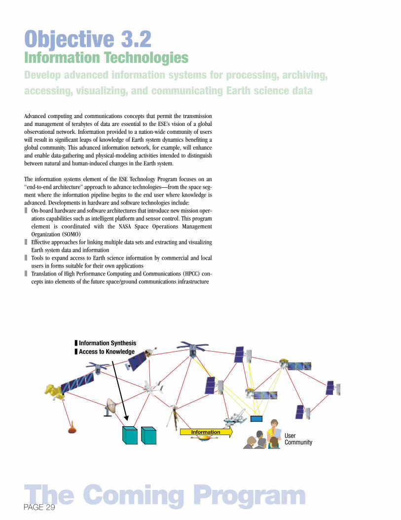
❚ Information Synthesis❚ Access to Knowledge
Sensor Web
UserCommunity
Information

As a research and technology Agency, NASA provides new tools and knowledge toenable improved assessment and prediction of Earth system changes and impacts.NASA began with the first weather satellites, and continues today with satellites thatmonitor globally the state of atmosphere, oceans, land, and ice from space. Otheragencies, most prominently NOAA and USGS, adopt these capabilities to improvetheir operational weather forecasting and and monitoring of land surface changes,respectively. NASA’s job is to help them do it more effectively and efficiently basedon new and advanced technologies.
For example, NOAA and DoD are working to converge their separate weather satel-lite programs. NASA is currently partnering with them to develop new instrumentsfor the converged National Polar-orbiting Operational Environmental SatelliteSystem (NPOESS). These will fly first on the NPOESS Bridge mission, which willserve both to extend science measurements for NASA and to mitigate technologyrisks prior to infusion into the NPOESS. Such enhanced capabilities will enableenhanced accuracy and duration of short-term weather forecasts as well as estab-lish key observations required for long-term climate studies and monitoring.
NASA is also working with USGS on the acquisition of Landsat and other land sur-face remote sensing technologies. For example, NASA is partnering with USGS andNSF on GPS arrays to monitor the motions of continents and faults leading to earth-quakes and volcanoes.
As the business of space-based Earth observations grows in the private sector, theTechnology Program will emphasize the development of the sensors, space archi-tectures, and information systems that underpin the ability of commercial flight sys-tems to meet some of the Enterprise’s needs. An area of particular interest is thepursuit of partnering possibilities with domestic and international organizationsinvesting in micro-satellite technology to stimulate interest in a “Sensor-web”approach to a global Earth observing network.
Exploring Our Home PlanetTHE EARTH SCIENCE ENTERPRISE STRATEGIC PLAN
Partnerships for Monitoring and PredictionPartner with other agencies to develop and implement better methods for using
remotely sensed observations in Earth system monitoring and prediction
NASA
NOAA
/Do
D
1960’s 1980’s 2000’s 2020’s 2040’s
BUILDING THE SENSORWEB
Nimbus Series EOS Series Pre-Operational Missions µ Series
POES/DMSPGOES
NPP/NPOESSGOES Improvemtns
Objective 3.3
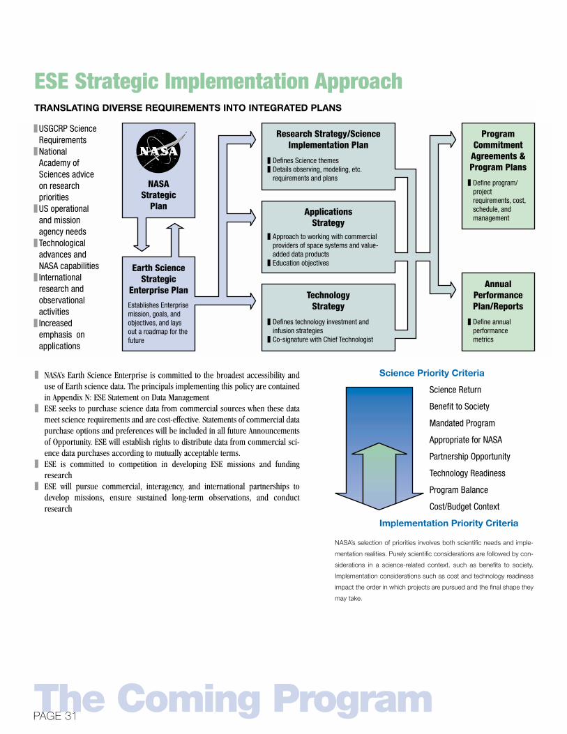
❚ NASA’s Earth Science Enterprise is committed to the broadest accessibility anduse of Earth science data. The principals implementing this policy are containedin Appendix N: ESE Statement on Data Management
❚ ESE seeks to purchase science data from commercial sources when these datameet science requirements and are cost-effective. Statements of commercial datapurchase options and preferences will be included in all future Announcementsof Opportunity. ESE will establish rights to distribute data from commercial sci-ence data purchases according to mutually acceptable terms.
❚ ESE is committed to competition in developing ESE missions and fundingresearch
❚ ESE will pursue commercial, interagency, and international partnerships todevelop missions, ensure sustained long-term observations, and conductresearch
The Coming ProgramPAGE 31
ESE Strategic Implementation Approach
Earth Science Strategic
Enterprise Plan
❚ USGCRP Science Requirements
❚ National Academy of Sciences advice on research priorities
❚ US operational and mission agency needs
❚ Technological advances and NASA capabilities
❚ International research and observational activities
❚ Increased emphasis on applications
NASAStrategic
Plan
Establishes Enterprise mission, goals, and objectives, and lays out a roadmap for the future
Research Strategy/Science Implementation Plan
ApplicationsStrategy
TechnologyStrategy
❚ Defines Science themes❚ Details observing, modeling, etc.
requirements and plans
❚ Approach to working with commercial providers of space systems and value-added data products
❚ Education objectives
❚ Defines technology investment and infusion strategies
❚ Co-signature with Chief Technologist
Program Commitment
Agreements & Program Plans
Annual Performance Plan/Reports
❚ Define program/ project requirements, cost, schedule, and management
❚ Define annual performance metrics
TRANSLATING DIVERSE REQUIREMENTS INTO INTEGRATED PLANS
Science Return
Benefit to Society
Mandated Program
Appropriate for NASA
Partnership Opportunity
Technology Readiness
Program Balance
Cost/Budget Context
Science Priority Criteria
Implementation Priority Criteria
NASA’s selection of priorities involves both scientific needs and imple-
mentation realities. Purely scientific considerations are followed by con-
siderations in a science-related context. such as benefits to society.
Implementation considerations such as cost and technology readiness
impact the order in which projects are pursued and the final shape they
may take.

Three types of satellite missions will be developed to provide observations required to answer ESE’s science questions:
❚ Systematic Missions (e.g., Landsat, EOS follow-ons)◆ Meets NRC goal “Priority must be given to identifying and obtaining accurate data on key variables carefully select-
ed in view of the most critical scientific questions. . .” emphasizing those parameters that cannot be inferred fromother independent parameters
◆ Strong focus on connection between successive data sets, calibration, and validation over lifetime of the mission◆ Typically involve technology evolution rather than revolution ◆ Preferably but not necessarily continuous (depends on variability and calibration)
❚ Exploratory Missions (e.g., Earth System Science Pathfinders)◆ One-time missions designed to address a focused set of scientific questions, frequently measuring related param-
eters for closure tests◆ May involve first application of advanced technology to address question in new way
❚ Operational Precursor and Technology Demonstration Missions (e.g., tropospheric winds, New MillenniumProgram)◆ Invest in innovative sensor technologies and develop more cost-effective versions of pioneer scientific instruments◆ Identify “bridging” missions for transition between research and operational systems◆ Close cooperation between NASA and operational agency is needed to fulfill both research and operational needs◆ Result in fulfilling “long-term” scientific observational needs
The challenge of managing the data coming down from these satellites and generating from them the information prod-ucts is an ongoing one. The Earth Observing System Data and Information System (EOSDIS) performs this function forEOS. A federation comprising the EOSDIS Distributed Active Archive Centers, Earth Science Information Partners, andRegional Earth Science Applications Centers serve specialized needs of science and applications users. As the march ofinformation and communications technology continues, ESE must evolve its data and information system servicesapproach. Work is underway on a data and information system services concept for the next decade which builds onthe capabilities being put in place today, and evolves to leverage the science and technology advances of tomorrow.
Exploring Our Home PlanetTHE EARTH SCIENCE ENTERPRISE STRATEGIC PLAN
The Earth Science Enterprise observing and information systemcapabilities serve to accomplish science and applications goals.
Forces Acting onthe Earth System
Earth SystemResponse
Feedback
ImpactsOceans and Ice Solid Earth
AtmosphericChemistry,
andClimate Coupling
Global Waterand
Energy Cycle
Ecosystemsand Global
Carbon Cycle
Earth SystemModeling

Italics indicates 2003-2010 candidate mission concepts. The actual missions to bepursued and the order in which they occur will be determined by applying the sci-ence and implementation criteria shown on the preceding page. Rather than estab-lish a 10-year queue of missions, the Enterprise will enable advances in science andtechnology to influence mission planning more frequently. All future missions willbe solicited through open announcements and selected based on established scien-tific and technical evaluation processes.
The Coming ProgramPAGE 33
Observing Missions/Next Decade Mission Conceptsto Address Earth Science Questions
SevereStorms
Droughtsand
FloodsEl Niño
Frequency
FreshWater
Availability
EcosystemChanges
OceanCirculation
Sea LevelChange
Ice SheetMass
Earthquakesand
Volcanoes
high
low
Degr
ee o
f vi
sibi
lity
tohu
man
s
QuikSCAT/SeaWinds Future ocean winds mission, Tropospheric winds partnership
Soil Moisture Mission
JasonOcean
topography mission
GRACEExploratory gravity mission
ICEsatIce altimetry mission, Exploratory cold climate mission
TRMMGlobal PrecipitationMission
AquaNPOESS Preparatory Project
Landsat 7Landsat continuity missionVegetation Canopy LidarExploratory vegetation recovery missionTerraNPOESS Preparatory Project
Ocean Salinity Mission
Interferometric SAR Mission
Terra/PM-MODISNPOESS PreparatoryProject
TOMS, SAGE, AuraFuture StratosphericChemical mission
CloudSatTerra-MISR/CeresExploratory Aerosol/Cloud Radiation mission
ACRIMSORCE
Ground NetworksFuture exploratory gravity mission,Future interferometric SAR mission
Terra-MOPITTExploratory TroposphericChemical Mission
Aura, TOMSExploratory TroposphericChemical Mission
PICASSOTrianaTerra-MISR
Landsat 7Landsat continuitymission
Terra/Aqua-MODIS, VCLNPOESS PreparatoryProject
SAGE III
2.3
0.4
-0.2-0.4
-1.0
-0.2
0.4
0.2,-0.5
0
1
2
3
-1
CO2
CH4
CFCsN2O
Indirect via O3
Well-mixedgreenhouse
gases
Troposphericozone
Sun
Stratosphericozone
Troposphericaerosols
Forcedcloud
changes
Vegetationand othersurface
alterations
Volcanicaerosols
Greenhouse gases Other anthropogenic forcings natural forcings
Wat
ts p
er m
eter
2
Motion of the
Earth's interior
Landcover
change
Eart
h Sy
stem
For
cing
Eart
h Sy
stem
Res
pons
e

NASA’s research and spaceflight Centers are the engines of progress in Earth SystemScience. Scientists at these Centers conduct leading-edge research as well as enableresearch performed at universities. They assure the scientific quality of our satelliteand aircraft projects. The Centers are program and project managers and imple-menters, developing advanced technologies and integrating them into research mis-sions. The Center Directors together with the Headquarters Office of Earth Scienceleadership comprise the senior management team planning and directing the EarthScience Enterprise. Each Center’s role reflects its unique expertise.
Exploring Our Home PlanetTHE EARTH SCIENCE ENTERPRISE STRATEGIC PLAN
Earth Science Center Roles and Missions
COE/Agency Mission:Lead Center Assignments:
Science Role:
Mission Role:
Agency Mission:Lead Center Assignment:
Science Contribution:Mission Contribution:
Agency Mission:Lead Center Assignment:
Science Contribution:
Agency Mission:Lead Center Assignment:
Science Role:
Mission Contribution:
COE:Mission Role:
COE/Agency Mission:Lead Center Assignment:
Science Contribution:Mission Contribution:
Science Contribution:
Mission Contribution:
Goddard Space Flight Center (GSFC—Greenbelt, MD)Earth ScienceEOS/Earth Explorers/ES Technology Program/Weather Satellites/Education Comprehensive Earth Science and Interdisciplinary Earth System ScienceTechnology Development (Instruments, Spacecraft, Ground Systems)/Airborne Science Operations (Wallops)
Jet Propulsion Laboratory (JPL—Pasadena, CA)Instrument TechnologyFocused Physical Oceanography and Solid Earth Science/New Millennium Program Oceanography, Solid Earth Sciences, and Atmospheric ChemistryInstrument Development
Stennis Space Center (SSC—Stennis, MS)Remote Sensing ApplicationsRemote Sensing ApplicationsCoastal Research
Langley Research Center (LaRC—Hampton, VA)Atmospheric Science Focused Atmospheric Science MissionsAtmospheric Aerosols and Chemistry, Earth Radiation BudgetAtmospheric Science-related Technologies, Engineering and Instrument Development
Dryden Flight Research Center (DFRC—CA)Atmospheric Flight OperationsAirborne Science Operations
Ames Research Center (ARC—Moffet Field, CA)Information Technology/Astrobiology/HPCCInformation Technology/Astrobiology/HPCCTerrestrial Ecology and Atmospheric AssessmentsInformation Systems and Technology/Airborne Instrument Development
Marshall Space Flight Center (MSFC—Huntsville, AL)Hydrometeorology/Hydroclimatology, includes Passive Microwave Data Analysis and Atmospheric Electricity/Land Processes/Regional ApplicationsInstrument Development
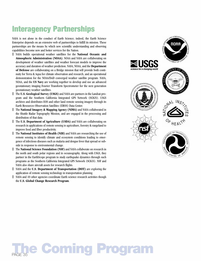
NASA is not alone in the conduct of Earth Science; indeed, the Earth ScienceEnterprise depends on an extensive web of partnerships to fulfill its mission. Thesepartnerships are the means by which new scientific understanding and observingcapabilities become new and better services for the Nation.❚ NASA builds operational weather satellites for the National Oceanic and
Atmospheric Administration (NOAA). NOAA and NASA are collaborating ondevelopment of weather satellites and weather forecast models to improve theaccuracy and duration of weather prediction. NASA, NOAA, and the Departmentof Defense are collaborating on a Bridge mission that will provide both conti-nuity for Terra & Aqua for climate observation and research, and an operationaldemonstration for the NOAA/DoD converged weather satellite program. NASA,NOAA, and the US Navy are working together to develop and use an advancedgeostationary imaging Fourier Transform Spectrometer for the next generationgeostationary weather satellites.
❚ The U.S. Geological Survey (USGS) and NASA are partners in the Landsat pro-gram and the Southern California Integrated GPS Network (SCIGN). USGSarchives and distributes EOS and other land remote sensing imagery through itsEarth Resources Observation Satellites (EROS) Data Center.
❚ The National Imagery & Mapping Agency (NIMA) and NASA collaborated inthe Shuttle Radar Topography Mission, and are engaged in the processing anddistribution of that data.
❚ The U.S. Department of Agriculture (USDA) and NASA are collaborating onresearch in applications of remote sensing to agriculture, forestry & rangeland toimprove food and fiber productivity.
❚ The National Institutes of Health (NIH) and NASA are researching the use ofremote sensing to identify climate and ecosystem conditions leading to emer-gence of infectious diseases such as malaria and dengue fever that spread or sub-side in response to environmental change.
❚ The National Science Foundation (NSF) and NASA collaborate on research inthe north and south polar regions and in oceanography. Along with USGS, theypartner in the EarthScope program to study earthquake dynamics through suchprograms as the Southern California Integrated GPS Network (SCIGN). NSF andNASA also share aircraft assets for research flights.
❚ NASA and the U.S. Department of Transportation (DOT) are exploring theapplication of remote sensing technology in transportation planning
❚ NASA and 10 other agencies coordinate Earth science research activities thoughthe U.S. Global Change Research Program.
The Coming ProgramPAGE 35
Interagency Partnerships
DE
PA
R
TMENT OF DEFEN
SE
UNITED STATES OF AMERICA
UN
ITE
D S
TA
TES
DEPARTMENT OF A
GR
ICU
LT
UR
E
18891862
AGRICULTURE IS THE AND COMMERC E
FOUNDATION OF MANUFACTURE

Earth Science is inherently international; global scientific questions require globalcollaboration to obtain solutions. No single nation or region can afford comprehen-sive systems required to understand Earth system science. Decisionmakers aroundthe world need an objective scientific knowledge base to plan their actions; credi-bility depends on international participation in the scientific process. Further, cali-bration/validation of space-based observations requires specialized local knowledgeand in situ data from around the world. ESE has partnerships with 45 countriesaround the world. International contributions to EOS satellite missions total $5 bil-lion. Examples include:❚ Japan is currently ESE’s largest partner, conducting the Tropical Rainfall
Measuring Mission, providing instruments to EOS missions and accommodatingEOS instruments on its missions
❚ France and NASA are partners in the highly successful TOPEX/Posiedon mission,its successor, Jason-1, and the PICASSO-CENA mission
❚ Germany and NASA are partners in the Shuttle Radar Laboratory and the CHAMPand GRACE missions
❚ The UK and the Netherlands and Finland are contributing instruments to theEOS Aura mission
❚ Canada provided the MOPITT instrument for the Terra mission, and NASAlaunched Canada’s Radarsat 1 mission
❚ Brazil is providing the Humidity Sounder-Brazil (HSB) instrument for the EOSAqua mission
❚ Argentina’s SAC-C satellite will be launched by NASA.to form a constellation ofland observing satellites with EOS Terra and Landsat 7
❚ Russia is providing a platform and launch vehicle for SAGE III instruments tomeasure atmospheric ozone concentration
The Committee on Earth Observation Satellites facilitates international participationin the construct of an Integrated Global Observing Strategy.
A number of international research organizations sponsor scientific programs inwhich ESE is an active contributor of research and observations. These include:❚ World Climate Research Program❚ International Geosphere/Biosphere Programme❚ Intergovernmental Panel on Climate Change ❚ Food and Agriculture Organization❚ European Center for Medium-Range Weather Forecasting❚ International Oceans Commission
Exploring Our Home PlanetTHE EARTH SCIENCE ENTERPRISE STRATEGIC PLAN
International Partnerships

WHAT’S POSSIBLE IN 25 YEARS?❚ 10-year climate forecasts
❚ 15- to 20-month El Niño prediction
❚ 12-month regional rain rate
❚ 60-day volcano warning
❚ 10- to 14-day weather forecast
❚ 7-day air quality notification
❚ 5-day hurricane track prediction to +/- 30 km
❚ 30-minute tornado warning
❚ 1- to 5-year earthquake experimental forecast
A Vision of the FuturePAGE 37
A Vision of the Future: Predicting EarthSystem Change—Earth Science in 2025

WHAT WILL IT TAKE TO MAKE IT HAPPEN?
Advances in observing and information technologies, research, and modeling are allrequired to fulfill our long-term vision for Earth system prediction. The observingsystem of the future will include satellites in a variety of orbits. These will include a“sensorweb” of small, smart satellites in low Earth orbit, large aperture sensors ingeostationary orbits, and sentinel satellites at L1 and L2 (about 1.5 kilometers fromEarth) to provide synoptic day/night views of the entire globe from pole to pole. On-board data processing and high speed computing and communications will enabledelivery of tailored information products from satellites direct to users at the cost oftoday’s international telephone calls.
As important as the technology advances to the success of this vision are the part-nerships that transition new capabilities to the providers of services. NASA can pro-vide the science and technology tools, but it will be agencies like NOAA, USGS, USDA,and FEMA, and commercial industry that make these services broadly available tothe Nation.
Exploring Our Home PlanetTHE EARTH SCIENCE ENTERPRISE STRATEGIC PLAN
Long-Term: 2010–2020
Observing Systemof the Future
❚ Information Synthesis❚ Access to Knowledge
❚ Advanced Sensors
Sensor Web
Partners❚ NASA❚ DoD❚ Other Govt❚ Commercial❚ International
UserCommunity
Information

WHAT TECHNOLOGY INVESTMENTS SHOULD WE BEMAKING NOW TO MAKE THIS FUTURE HAPPEN?
❚ Advanced sensorsActive and large aperture remote sensing instruments to make new measure-ments, or known measurements with higher spatial and temporal resolution.
❚ Networks of sensorsGlobal sensor networks capable of functioning autonomously, of being reconfig-ured to meet user needs, and of surviving failures of component sensors.
❚ Information synthesis and modelingComputational modeling systems that improve predictive modeling to the limit ofscientific understanding rather than of computing capability
❚ Access to knowledgeComputing and communications systems that can rapidly search, tailor, and pro-vide useful information products in response to user queries.
The Enterprise will continue to evolve this 25-year vision through workshops andother forms of dialog with the external science, applications, and technology com-munities.
A Vision of the FuturePAGE 39
Long-Term: 2010–2020 continued

Exploring Our Home PlanetTHE EARTH SCIENCE ENTERPRISE STRATEGIC PLAN
Appendices

1999
MISSION: Landsat 7PURPOSE: Global land cover inventory
LAUNCH DATE: April 1999LAUNCH VEHICLE: Delta
MISSION: QuikSCATPURPOSE: Measure winds at the ocean surface
LAUNCH DATE: June1999LAUNCH VEHICLE: Titan
MISSION: TerraPURPOSE: Clouds, aerosols, terrestrial & marine biosphere, Land surface, energy budget at top of atmosphere
LAUNCH DATE: April 1999LAUNCH VEHICLE: Delta
MISSION: ACRIMsatPURPOSE: Solar irradiance & influence on climate
LAUNCH DATE: December 1999LAUNCH VEHICLE: Taurus
2000
MISSION: Shuttle Radar Topography MissionPURPOSE: Land surface topography
LAUNCH DATE: February 2000LAUNCH VEHICLE: Space Shuttle (11 day mission)
MISSION: Geostationary Operational Environmental Satellite (GOES-L)PURPOSE: Geostationary weather satellite for NOAA
LAUNCH DATE: May 2000LAUNCH VEHICLE: Atlas
MISSION: CHAMP (GPS receiver on German satellite)PURPOSE: Part of GPS receiver constellation for Earth’s magnetic field & experimental atmospheric sounding
LAUNCH DATE: July 2000LAUNCH VEHICLE: Russian COSMOS
MISSION: Earth Observer-1PURPOSE: Land imaging technology demonstration
LAUNCH DATE: Fall 2000LAUNCH VEHICLE: Delta
MISSION: NOAA-L Polar Operational Environmental Satellite (POES)PURPOSE: Polar-orbiting weather satellite for NOAA
LAUNCH DATE: September 2000LAUNCH VEHICLE: Titan
AppendicesPAGE 41
Appendix 1: Earth Science Enterprise Missions

MISSION: QuikTOMSPURPOSE: Total column ozone mapping
LAUNCH DATE: Fall 2000LAUNCH VEHICLE: Taurus
2001
MISSION: SAGE III on Russia’s Meteor 3MPURPOSE: Stratospheric aerosols & gases
LAUNCH VEHICLE: Russian/Ukraine Zenit-2
MISSION: JasonPURPOSE: Ocean surface topography
LAUNCH VEHICLE: Delta
MISSION: AquaPURPOSE: Atmospheric temperature & moisture, terrestrial & marine biosphere, sea surface temperature,
energy budget at top of atmosphereLAUNCH VEHICLE: Delta
MISSION: Vegetation Canopy Lidar (VCL)PURPOSE: 3-D forest canopy measurement
LAUNCH VEHICLE: TBD
MISSION: GRACEPURPOSE: Precise map of Earth’s geoid
LAUNCH VEHICLE: Russian ROCKOT
MISSION: ICEsatPURPOSE: Ice sheet topography
LAUNCH VEHICLE: Delta
MISSION: SeaWinds on Japan’s ADEOS 2PURPOSE: Ocean surface topography
LAUNCH VEHICLE: Japan’s H-IIA
Exploring Our Home PlanetTHE EARTH SCIENCE ENTERPRISE STRATEGIC PLAN
Appendix 1: Earth Science Enterprise Missions

2002-2003
MISSION: TrianaPURPOSE: Earth remote sensing from L1
LAUNCH VEHICLE: Space Shuttle
MISSION: SORCEPURPOSE: Total and UV solar irradiance
LAUNCH VEHICLE: Pegesus
MISSION: PICASSO-CENAPURPOSE: Aerosol vertical profiles
LAUNCH VEHICLE: Delta (w/Cloudsat)
MISSION: CloudsatPURPOSE: Cloud vertical profiles
LAUNCH VEHICLE: Delta (w/PICASSO-CENA)
MISSION: AuraPURPOSE: Stratospheric & tropospheric chemistry
LAUNCH VEHICLE: Delta
MISSION: Stratospheric Aerosol & Gas Experiment (SAGE III)PURPOSE: Stratospheric aerosols & gases
LAUNCH VEHICLE: Deployed via Space Shuttle to the International Space Station
AIRBORNE SCIENCE ASSETS
AppendicesPAGE 43
Appendix 1: Earth Science Enterprise Missions
CRAFT: DC-8PURPOSE: Heavy lift laboratory for remote
sensing and upper troposphere insitu observations.
CRAFT: ER-2PURPOSE: High altitude aircraft for stratos-
pheric in situ observations andsatellite simulations.
CRAFT: P3-BPURPOSE: Rugged, heavy lift laboratory for
low altitude remote sensing.
CRAFT: Uninhabited Aerial Vehicles (UAV’s)PURPOSE: Long duration autonomous vehicles
for in situ and remote sensing.

This Statement elaborates on Executive Branch and other legal guidance for data management by the Earth Science Enterprise. The following 11 statementssummarize the main principles drawn from that guidance. The full Statement is available on the ESE Home Page at: http://www.earth.nasa.gov/visions/data-policy.html
1. NASA shall plan and follow data acquisition policies that ensure the collection of long-term data sets that will satisfy the research requirements of theEarth Science Enterprise.
2. NASA is committed to the full and open sharing of Earth Science data obtained from U.S. Government-funded and -owned systems with all users as soonas such data become available. All Earth System Enterprise missions, projects, grant proposals shall include data management plans to facilitate imple-mentation of this principle.
3. For data from government-owned or -funded systems, NASA will enforce a principle of non-discriminatory access so that all users within the same datause category will be treated equally. Preferential treatment for U.S. government users and affiliates will be allowed only where expressly permitted bylaw.
4. NASA shall make data from the Earth Science Enterprise available at a reasonable price to facilitate access and encourage use. Data from NASA and itsU.S. government partners shall be priced at the cost of dissemination or, in cases where such pricing would unduly inhibit use, below that cost. For datafrom industry and foreign partners in the Earth Science Enterprise, pricing and access policies shall be established by negotiation between NASA andthe relevant Earth Science Enterprise provider and system operator. NASA will seek to ensure consistency in negotiate pricing and access policies in amanner consistent with the principles in this Statement.
5. All data required for long-term global change research shall be archived. Data archives shall include easily accessible information about the data hold-ings, including quality assessments, supporting relevant information, and guidance for locating and obtaining data.
6. Where cost-effective, NASA shall make purchases of commercial data to meet the scientific objectives of the Earth Science Enterprise. Data purchasearrangements should, at a minimum, permit appropriate use, distribution, and duplication of the data for Earth Science Enterprise purposes by allresearchers affiliated with the Earth Science Enterprise. NASA may purchase data on behalf of, and through, other federal agencies for research andinvestigation purposes.
7. For each cooperative activity with industry, domestic or foreign, NASA shall seek agreement on all major data management and distribution issues dur-ing the project definition phase. The respective contributions of the parties to the activity shall be considered in allocating rights and control over resultsfrom the activity. NASA shall seek to ensure meaningful use of the data for Earth Science Enterprise purposes by all researchers affiliated with theEnterprise.
8. NASA shall engage in on-going cooperation with other federal agencies, particularly those involved with space-based activities or Earth Science research,to increase the effectiveness and reduce the cost of the Earth Science Enterprise. This interagency cooperation shall include: sharing of data from satel-lites and other sources, mutual validation and calibration of data, and consolidation of duplicative capabilities and functions.
9. NASA shall, in compliance with applicable federal law and policy, negotiate and implement arrangements with its international partners, with an empha-sis on meeting the Nation's own data acquisition, distribution, and archival needs.
10. NASA may allow for exceptions to the guidance contained in this Statement on a case-by-case basis where permitted by law and in furtherance of thepublic interest.
11. NASA shall review and, if warranted, update this Statement as part of the biennial review of the Earth System Enterprise.
Exploring Our Home PlanetTHE EARTH SCIENCE ENTERPRISE STRATEGIC PLAN
Appendix 2: Earth Science Enterprise Statement on Data Management
J.F. CreedonDirectorLangley Research Center
Roy S. EstessDirectorStennis Space Center
A.V. DiazDirectorGoddard Space Flight Center
Henry McDonaldDirectorAmes Research Center
Kevin PetersenDirectorDryden Flight Research Center
Ed StoneDirectorJet Propulsion Laboratory
Ghassem R. AsrarAssociate Administrator for Earth ScienceNASA Headquarters

National Aeronautics andSpace Administration
Earth Science Enterprise
Code Y
November 2000
NASA HeadquartersWashington, DC 20546
www.earth.nasa.gov