exploitation of geothermal energy resources from …
TRANSCRIPT

POLITECNICO DI TORINO Master’s degree programme in Petroleum and Mining Engineering
EXPLOITATION OF GEOTHERMAL ENERGY
RESOURCES FROM ABANDONED OIL&GAS WELLS
LOCATED IN THE AZERBAIJAN TERRITORY
Supervisors Prof. Lo Russo Stefano, Supervisor
Dott.ssa Taddia Glenda, Co-Supervisor
Dott.ssa Gizzi Martina, Co-Supervisor
Candidate Ibrahim Hasanov (s250340)
18/11/2020

EXPLOITATION OF GEOTHERMAL ENERGY RESOURCES FROM ABANDONED OIL&GAS WELLS LOCATED IN THE AZERBAIJAN TERRITORY
2
Table of Contents
LIST OF TABLES ........................................................................................................................................ 4
LIST OF FIGURES ....................................................................................................................................... 5
CHAPTER 1: INTRODUCTION ................................................................................................................. 6
1.1 Energy Sources .................................................................................................................................. 6
1.2 Advantages and Limits of Renewable Energy Sources .................................................................. 6
1.3 Purposes of Geothermal Energy Researches .................................................................................. 7
1.4 Extraction of Geothermal Energy Resources in Oil and Gas Bearing Regions ........................... 8
1.5 Extraction of Geothermal Resources in Azerbaijan ...................................................................... 8
1.6 Thesis objectives ................................................................................................................................ 9
CHAPTER 2: GEOTHERMAL ENERGY RESOURCES ......................................................................... 10
2.1 Origin of Geothermal Energy ........................................................................................................ 10
2.2 Parameters of Geothermal Fields .................................................................................................. 10
2.3 Thermo-physical Properties of Rocks ........................................................................................... 11
2.4 Classification of Geothermal Fields ............................................................................................... 12
2.5 Thermal Water ................................................................................................................................ 12
2.6 Thermal Water Fields ..................................................................................................................... 13
2.7 Generation of Electricity from Geothermal Resources ............................................................... 13
2.7.1 Direct Use (without condenser) ............................................................................................... 13
2.7.2 Direct Use (with condenser)..................................................................................................... 14
2.7.3 Binary Cycle.............................................................................................................................. 14
2.8 Using Geothermal Energy for Heating .......................................................................................... 15
2.8.1 Categories of Thermal Water Used for Heat Supply ............................................................ 15
2.8.2 Heat Supply with Extremely Mineralized and High-Temperature Thermal Water ......... 15
2.8.3 Heat Supply with Weakly Mineralized and Low-Temperature Thermal Water ............... 16
CHAPTER 3: OVERVIEW OF GEOLOGICAL STRUCTURE OF AZERBAIJAN AND INFORMATION ON OIL AND GAS BEARING REGIONS ................................................................... 18
3.1 Geological Structure of Azerbaijan ............................................................................................... 18
3.2 History of Oil and Gas Industry in Azerbaijan ............................................................................ 20
3.3 Oil and Gas Bearing Regions in the Territory of Azerbaijan ..................................................... 20
3.3.1 Absheron Oil and Gas Bearing Region .................................................................................. 21
3.3.2 Lower-Kura Oil and Gas Bearing Region ............................................................................. 22
3.3.3 Baku Archipelago, Shamakhi-Gobustan, Precaspian-Guba OGBRs .................................. 23
3.3.4 Yevlakh-Agjabedi Oil and Gas Bearing Region .................................................................... 23
CHAPTER 4: GEOTHERMAL ENVIRONMENT IN OIL AND GAS BEARING REGIONS IN THE TERRITORY OF AZERBAIJAN ............................................................................................................... 24

EXPLOITATION OF GEOTHERMAL ENERGY RESOURCES FROM ABANDONED OIL&GAS WELLS LOCATED IN THE AZERBAIJAN TERRITORY
3
4.1 History of Geothermal Researches in Azerbaijan ........................................................................ 24
4.2 Thermal Waters in Territory of Azerbaijan ................................................................................. 26
4.3 Geothermal Conditions of OGBRs ................................................................................................ 28
4.3.1 Absheron Oil and Gas Bearing Region .................................................................................. 29
4.3.2 Baku Archipelago Oil and Gas Bearing Region .................................................................... 31
4.3.3 Precaspian-Guba Oil and Gas Bearing Region ..................................................................... 31
4.3.4 Lower-Kura Oil and Gas Bearing region ............................................................................... 32
4.3.5 Yevlakh-Agjabedi Oil and Gas Bearing Region .................................................................... 32
4.3.6 Ganja Oil and Gas Bearing Region ........................................................................................ 34
CHAPTER 5: GEOTHERMAL RESEARCH DATA OF OIL AND GAS BEARING REGIONS IN THE ABSHERON PENINSULA ........................................................................................................................ 35
5.1 Geological Characteristics of the Absheron Peninsula ................................................................ 35
5.2 Thermal Water Resources of Absheron Peninsula ...................................................................... 36
5.3 Geothermal Research on the Absheron Peninsula ....................................................................... 37
5.3.1 Lokbatan Field.......................................................................................................................... 37
5.3.2 Balakhani – Sabunchu – Ramana oil field ............................................................................. 39
5.3.3 Surakhany Field ....................................................................................................................... 40
5.3.4 Neft Dashlary (Oil Rocks) field ............................................................................................... 41
5.3.5 Zig – Hovsan Fields .................................................................................................................. 41
5.3.6 Turkan – Zira Fields ................................................................................................................ 42
5.3.7 Bibi – Eibat Field ...................................................................................................................... 43
5.3.8 Gum-Deniz Field ...................................................................................................................... 44
CHAPTER 6: RESULTS AND CONCLUSION ........................................................................................ 46
6.1 Final Geothermal Indicators of Lokbatan Field .......................................................................... 46
6.2 Final Geothermal Indicators of Hovsan Field .............................................................................. 47
6.3 Final Geothermal Indicators of Bibi-Eibat Field ......................................................................... 49
6.4 Final Geothermal Indicators of Gum-Deniz Field ....................................................................... 49
6.5 Final Geothermal Indicators of Balakahny – Sabunchu – Ramana Field ................................. 50
6.6 Final Geothermal Indicators of Surakhany Field ........................................................................ 50
6.7 Final Geothermal Indicators of Neft Dashlary Field ................................................................... 51
6.8 Conclusion ........................................................................................................................................ 51
REFERENCES ............................................................................................................................................ 53

EXPLOITATION OF GEOTHERMAL ENERGY RESOURCES FROM ABANDONED OIL&GAS WELLS LOCATED IN THE AZERBAIJAN TERRITORY
4
LIST OF TABLES
Table 9 Change of temperature by depth (Gum-Deniz Field)
Table 4 Change of temperature by depth (Balkhany-Sabunchi-Ramana field)Table 5 Change of temperature by depth (Surkahani field)
Table 8Table 7Table 6 Change of temperature by depth (Zig-Hovsan fields)
Change of temperature by depth (Bibi-Eibat Field)Change of temperature by depth (Turkan-Zira fields)
Table 1 Different categories of thermal waterTable 2 Energy potential of different hydrogeological areasTable 3 Change of temperature by depth (Lokbatan field)

EXPLOITATION OF GEOTHERMAL ENERGY RESOURCES FROM ABANDONED OIL&GAS WELLS LOCATED IN THE AZERBAIJAN TERRITORY
5
LIST OF FIGURES
Fig. 22Fig. 23
Hovsan well N 1501Hovsan well N 1507
Geothermal step graph for Bibi-Eibat fieldHovsan well N1816
Fig. 19 Geothermal step graph for Lokbatan fildFig. 20Fig. 21
Fig. 16 Geothermal section of the Gazanbulag areaFig. 17 Geothermal profiles of several well in Lokbatan FieldFig. 18 Geothermal profiles of several well in Gum-Deniz Field
Fig. 13 Geothermal section of the Kyurovdag areaFig. 14 Temperature dependence on depth for wells in Yevlakh-Agjabedi areaFig. 15 Geothermal section of the Muradkhanly field
Fig. 10Fig. 11 Dependence of temperature on depth at Surakhany field measured in the following years
Dependence of temperature on depth at Bibi-Eibat field measured in the following years
Fig. 12 Temperature dependence on depth for wells in Precaspian-Guba area
Fig. 7 Oil Fountain in Balakhani (Baku, Azerbijan, 1887)Fig. 8 Heat flow map of depression zones of AzerbaijanFig. 9 Map of regions with thermal fields in the territory of Azerbaijan Republic
Fig. 4 Geothermal heat supply with heat exchangersFig. 5 Schematic diagram for supply of thermal water in parallel for heating and hot water with peak reheatingFig. 6 Orographic Map of Azerbaijan
Fig. 1 Geothermal power plant with direct use (without condenser) of natural steamFig. 2 Geothermal power plant with a condensing turbine and direct use of natural steamFig. 3 Geothermal power plant with a steam converter (binary cycle)
EXPLOITATION OF GEOTHERMAL ENERGY RESOURCES FROM ABANDONED OIL&GAS WELLS LOCATED IN THE AZERBAIJAN TERRITORY
6
CHAPTER 1: INTRODUCTION
Alternative types of energy sources as solar, wind, hydro, geothermal and biomass energy
sources are actively used in the world and their usage will represent one of the priorities in the near
future. According to 2030 UN Agenda for Sustainable Development, every nation should reduce
the amount of the energy produced by means of conventional fuels, looking for new sustainable
solutions and alternative energy sources that are increasingly sustainable and distant from those
based on fossil fuel, through technological development and environmental values [1].
1.1 Energy Sources
Energy sources in terms of exhaustibility can be subdivided into:
Non-renewable energy sources
Renewable energy sources
Non-renewable energy sources includes exhaustive natural resources that diminish as they
are used. This kind of resources are natural reserves of substances and materials as nuclear fuel,
coal, oil, gas etc. that can be used by people for energy production. Energy from non-renewable
resources is found in nature in a bound state and is released with purposeful human actions.
Unlike non-renewable, renewable energy, sources are based on energy flows permanently
existing or periodically occurring in the environment. In contrast to non-renewable energy,
renewable energy is not a consequence of purposeful human activity, and this is its unique
characteristic. Alternative (renewable) energy sources include flows of solar energy, wind energy,
heat of the Earth (geothermal energy), biomass, seas and oceans, rivers, existing constantly or
periodically in the environment that are practically inexhaustible.
1.2 Advantages and Limits of Renewable Energy Sources
In the complex of existing environmental problems, energy resources occupies one of the
leading places. Renewable energy resources in comparison with traditional non-renewable
resources have the following advantages:
practically inexhaustible resources;
extremely lower negative impact on the environment, including emissions of
various pollutants, greenhouse gases, radioactive and thermal pollution, etc.;

EXPLOITATION OF GEOTHERMAL ENERGY RESOURCES FROM ABANDONED OIL&GAS WELLS LOCATED IN THE AZERBAIJAN TERRITORY
7
The main limiting factors that have to be noted in use of renewable energy resources are
the following:
low energy flux density;
significant unevenness of energy production over its use;
high capital cost of used equipment and generated electricity;
1.3 Purposes of Geothermal Energy Researches
Thermal energy accumulated in the Earth subsurface represents geothermal energy
resources, which can be extracted efficiently and competitively (in terms of expenses) with other
types of energy [2].
Geothermal Energy resources is stable, environmentally friendly and especially weather-
independent resource among different alternative energy resources and are accessible to be used
for power generation and direct use as one of the significant future energy solutions.
The study of the geothermal heat regime of lithosphere is needed to solve a wide variety of
scientific and practical problems in geology, geochemistry and geophysics. This include modeling
of thermal evolution of the Earth and issues of energy and dynamics of geological processes –
tectonic movements and seismicity, metamorphism and magmatism, hydrothermal activity, the
origin and dynamics of thermal waters and origin and methodology of mineral deposit exploration.
In addition, there are important tasks that include the practical use of the Earth's deep heat reserves
for heating of industrial and agricultural facilities and generation of electricity, as well as the
development and implementation of thermal methods for the exploitation of mineral deposits.
The reserves of geothermal energy are enormous and in a number of countries (Italy,
Iceland, Hungary, Mexico, New Zealand, Russia, USA and Japan) are still widely used for heating
purposes and electricity generation.
There are steam power plants that are functioning primarily on hydrothermal steam. These
are the oldest geothermal power plants, the first of which was built in Larderello (Italy) in 1904,
and it is still operating today.

EXPLOITATION OF GEOTHERMAL ENERGY RESOURCES FROM ABANDONED OIL&GAS WELLS LOCATED IN THE AZERBAIJAN TERRITORY
8
Geothermal energy provides heating to Iceland's capital city Reykjavik. In 1943, 32 (nine
of them are still operating) wells were drilled there to the 440 – 2400 m depth interval, through
which thermal water rises to the surface with 60 – 30°C temperature [3].
1.4 Extraction of Geothermal Energy Resources in Oil and Gas Bearing Regions
Because of different reasons as water flooding or very low production rates, oil and gas
wells are abandoned or dismissed in oilfields. Taking high depth of petroleum wells into account,
they can be promising carrier of high temperature fluids and therefore adequate structures for
harnessing deep geothermal energy resources. Unlike special geothermal fields, in oil and gas
bearing zones, which are at late stage of development, there is usually an enough number of wells
that are not used for hydrocarbon production due to mentioned above reasons.
Drilled oil-gas wells and partly water wells discovered many underground artesian basins
of thermal waters. Generally, artesian basins located in plain areas and foreland basin contain water
with a temperature of 100-150°C at a depth of 3-4 km [4].
Another advantage of geothermal energy resources extraction in oil and gas fields is
existing production data and reservoir properties collected over long periods of production and
exploration that could empower new potential geothermal projects by reducing capital costs,
minimising risks and significant inconveniences.
In addition, by reusing abandoned wells in oilfields for geothermal energy production there
is a possibility to compensate energy use required for various processes done on hydrocarbons, for
instance increasing of mobility of heavy oil with help of thermal treatment.
1.5 Extraction of Geothermal Resources in Azerbaijan
Over the past, as Azerbaijan is an oil country, there was no real need in alternative energy;
geothermal energy potential has not been studied separately, with the exception for some
researches about resources associated to thermal waters.
However, ensuring of the dynamic and sustainable growth of the non-oil sector is a key
focus in the Azerbaijan’s development strategy: the extraction of geothermal energy resources
available as associated to hydrocarbon wells in oil and gas field could contribute in achieving this
goal.

EXPLOITATION OF GEOTHERMAL ENERGY RESOURCES FROM ABANDONED OIL&GAS WELLS LOCATED IN THE AZERBAIJAN TERRITORY
9
Azerbaijan possesses vast potential of the alternative energy, such as thermal water
resources associated to hydrocarbon wells. Considering long development period of several oil
and gas fields in the territory of Azerbaijan and therefore, number of non-active wells, this issue
needs to be investigated in detail.
Geological and hydrogeological observations in oil and gas bearing zones, conducted with
the help of exploration and production wells, have indeed ascertained the presence of productive
aquifers with associated thermal water resources.
Given the above, providing overview of the geothermal environment in oil and gas bearing
regions located in the territory of Azerbaijan, the paper targets mainly to give information on
geothermal energy resources associated to deep hydrocarbon wells in the territory and possibilities
of use these resources for various purposes.
1.6 Thesis objectives
The paper aims to analyses, also from a geological and energetic point of view, and give
information about the following main topics:
Geothermal energy resources associated to deep hydrocarbon wells in oilfields
Geothermal energy researches carried out in the territory of Azerbaijan
Potentialities of geothermal energy resources associated to hydrocarbon wells in
the Azerbaijan territory as future renewable source of energy

EXPLOITATION OF GEOTHERMAL ENERGY RESOURCES FROM ABANDONED OIL&GAS WELLS LOCATED IN THE AZERBAIJAN TERRITORY
10
CHAPTER 2: GEOTHERMAL ENERGY RESOURCES
2.1 Origin of Geothermal Energy
Contemporary energy usage is mainly based on non-renewable energy sources, which have
limited reserves and thus are exhaustible and cannot guarantee sustainable development of world
energy consumption in long term. Their use is one of the main factors leading to global
environmental degradation. Taking these issues into account geothermal energy as one of the
promising alternative energy sources should be investigated widely.
The expression "geothermal energy" literally means the energy of the Earth's heat ("geo" -
earth, "thermal" - heat). The main source of heat in the Earth's bowels is heat flow, the intensity of
which for a very long geological time can remain constant.
Geothermal energy sources of the Earth can be divided (in terms of origin) into two
different groups [5]:
-internal
-external
Internal sources include Earth's initial internal heat, change of the kinetic energy of Earth's
rotation, radioactive decay and different chemical processes. The main source of external energy
is solar radiation and it is an order of magnitude greater than the heat flow from the subsoil.
However, about 40% of the energy is immediately reflected from the Earth’s surface. The rest
undergoes a number of transformations in the Earth's geospheres and goes on the destruction of
native rocks. Part of this energy in another form is accumulated in the organic matter of
sedimentary rocks, including in combustible minerals.
2.2 Parameters of Geothermal Fields
The main parameters characterizing the thermal field include a geothermal gradient, which
is an increase in temperature with a depth of usually 100 m or 1 km and a geothermal step (distance
in depth at which the temperature increases by 1°C). In practice, a geothermal gradient is more
often used as °C/km. Due to the change in the intensity of solar radiation, thermal regime of 1.5 –
40 m of the earth's crust is characterized by daily and annual fluctuations.

EXPLOITATION OF GEOTHERMAL ENERGY RESOURCES FROM ABANDONED OIL&GAS WELLS LOCATED IN THE AZERBAIJAN TERRITORY
11
Observations in boreholes related to the upper 2 - 3 km of the Earth's crust show that the
temperature rises with depth by an average of 3°C for every 100 m. However, there are known
cases when an increase in temperature by 1°C occurs with a deepening of 2-3 m [6].
2.3 Thermo-physical Properties of Rocks
Thermo-physical properties of rocks are characterized by such parameters as:
thermal conductivity,
heat capacity
thermal diffusivity;
heat flux density;
One of the most important parameters is thermal conductivity that is amount of heat passing
per unit time, through a unit area with a temperature difference of 1°С per unit length. Thermal
conductivity is generally measured in W/m*K.
According to [5], the following factors determines the thermal conductivity of rocks:
1. Rock density
2. Granulometric composition and material sorting
3. Saturation with fluids
4. Orientation with respect to flow (lamination direction)
5. Degree of rock crystallinity
6. Pressure
Heat capacity – the amount of heat dQ supplied to 1 kg of a body in any process and often
expressed through the temperature increment dT of this body: dq = cdT. The factor c is specific
heat capacity of the substance.
Thermal diffusivity (coefficient of thermal diffusivity) is a physical quantity that
characterizes the change rate of the temperature (of substance) in non-equilibrium thermal
processes. Numerically equal to the ratio of thermal conductivity to volumetric heat capacity at
constant pressure and it is measured as m²/s in SI [7]:
(1) 𝛼 = 𝑘
𝜌𝑐𝑝

EXPLOITATION OF GEOTHERMAL ENERGY RESOURCES FROM ABANDONED OIL&GAS WELLS LOCATED IN THE AZERBAIJAN TERRITORY
12
Here, k – thermal conductivity, ρ*cp – volumetric heat capacity (cp – specific heat capacity).
Another parameter characterizing the thermal field is the value (density) of the heat flux
(q). It is expressed by the Fourier equation:
(2) 𝑞 = 𝜆 ∙ 𝑔𝑟𝑎𝑑 𝑇
where λ – thermal conductivity, grad T – thermal gradient. Unit of (q) is W/m2.
2.4 Classification of Geothermal Fields
Geothermal energy fields in terms of resources can be subdivided into the following types
[5]:
hydrothermal systems – reservoirs of hot or warm water;
steam hydrothermal systems – steam and steam-water mixture fields;
petro-geothermal zones – heat of dry rocks;
Geothermal energy resources in terms of reservoir temperature (enthalpy) can be
subdivided into the following types [8]:
Lower enthalpy (I - <90°C, II - <125°C, III - 100°C, IV - ≤150°C)
Medium enthalpy (I – 90-150°C, II – 125-225°C, III – 100-200°C)
Higher enthalpy (I - >150°, II – 225°C, III - >200°C, IV - >150°C)
References to this classiffication: I – Muffler and Cataldi, 1978, II – Hochstein, 1990, III –
Benderitter and Cormy, 1990, IV – Haenel 1988, Dickson, 1990
2.5 Thermal Water
In the Earth's crust, there is a mobile energy carrier with extremely high heat capacity that
is water, which plays an important role in the heat balance of the upper geospheres. Thermal waters
are capable to come out to the surface in the form of hot springs, if there is a possibility of flowing
through fractures. Moreover, for the water to remain thermal, its rise to the surface must occur
very quickly, for example, through wide cracks. Over a slow rise, hydrothermal fluids cool down,
releasing the accumulated heat and energy to the host rocks. However, if there is a drilled well to
a depth of 3000 – 4000 meters and it ensures a rapid rise in water, thermal water can be extracted
with a temperature of up to 100°C [4].
EXPLOITATION OF GEOTHERMAL ENERGY RESOURCES FROM ABANDONED OIL&GAS WELLS LOCATED IN THE AZERBAIJAN TERRITORY
13
In any point on the Earth's surface, at a certain depth, depending on the geothermal features
of the area, there are layers of rocks, containing thermal waters. Areas of distribution of thermal
water fields include the volcanic ring of the Pacific Ocean basin, the Alpine folded belt, continental
rift valleys, mid-ocean ridges, platform dips and foreland basin.
2.6 Thermal Water Fields
Fields of thermal water can be subdivided in terms of thermal energy transfer way, into the
following types:
convectional origin
conductive heating
The first type is located in the volcanic areas and characterized by high temperature of
waters and steam discharging to the surface.
The second type of geothermal fields is concentrated in deep platform depressions and
foreland basin. They are located in non-volcanic areas and are characterized by normal geothermal
gradient as 30 – 33°С/km [3].
2.7 Generation of Electricity from Geothermal Resources
Systems of electricity generation from geothermal resources in terms of structure can be
subdivided generally into the following types [9]:
Direct Use
-With Condenser
-Without Condenser
Binary Cycle
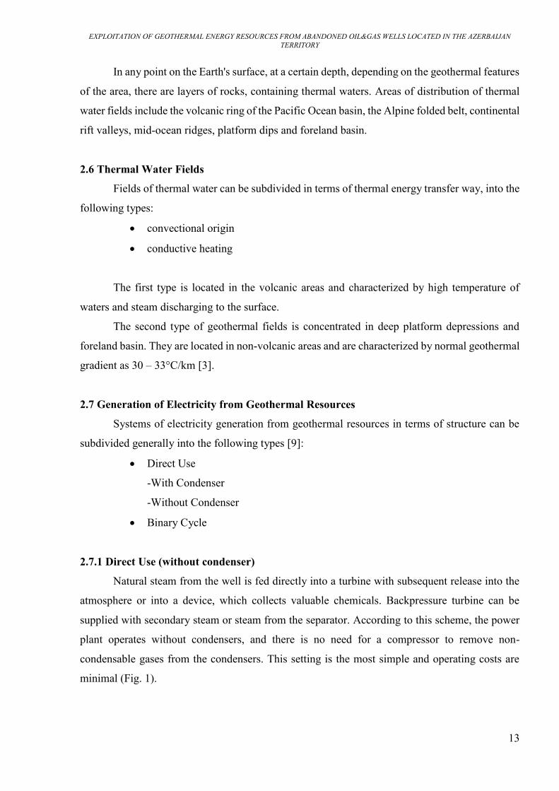
2.7.1 Direct Use (without condenser)
Natural steam from the well is fed directly into a turbine with subsequent release into the
atmosphere or into a device, which collects valuable chemicals. Backpressure turbine can be
supplied with secondary steam or steam from the separator. According to this scheme, the power
plant operates without condensers, and there is no need for a compressor to remove non-
condensable gases from the condensers. This setting is the most simple and operating costs are
minimal (Fig. 1).
EXPLOITATION OF GEOTHERMAL ENERGY RESOURCES FROM ABANDONED OIL&GAS WELLS LOCATED IN THE AZERBAIJAN TERRITORY
14
Fig. 1. Diagram of a geothermal power plant with direct use (without condenser) of natural
steam: 1 - well; 2 - turbine; 3 - generator; 4 - outlet to the atmosphere or to a chemical plant [4]
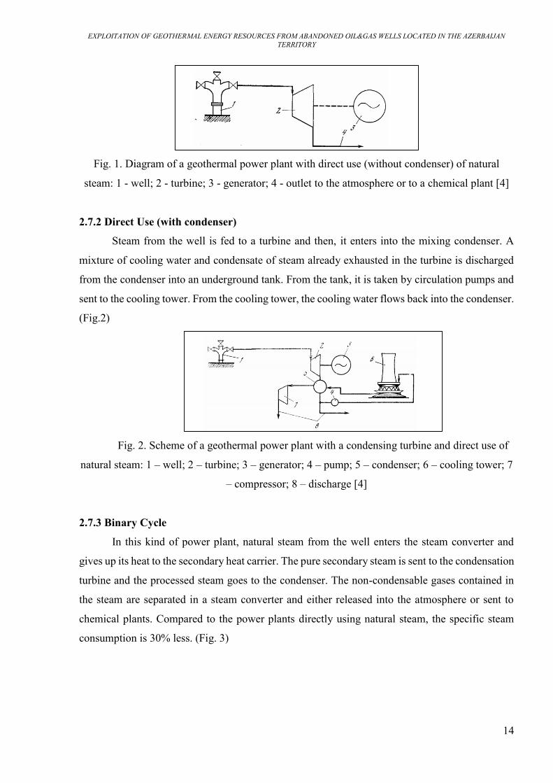
2.7.2 Direct Use (with condenser)
Steam from the well is fed to a turbine and then, it enters into the mixing condenser. A
mixture of cooling water and condensate of steam already exhausted in the turbine is discharged
from the condenser into an underground tank. From the tank, it is taken by circulation pumps and
sent to the cooling tower. From the cooling tower, the cooling water flows back into the condenser.
(Fig.2)
Fig. 2. Scheme of a geothermal power plant with a condensing turbine and direct use of
natural steam: 1 – well; 2 – turbine; 3 – generator; 4 – pump; 5 – condenser; 6 – cooling tower; 7
– compressor; 8 – discharge [4]
2.7.3 Binary Cycle
In this kind of power plant, natural steam from the well enters the steam converter and
gives up its heat to the secondary heat carrier. The pure secondary steam is sent to the condensation
turbine and the processed steam goes to the condenser. The non-condensable gases contained in
the steam are separated in a steam converter and either released into the atmosphere or sent to
chemical plants. Compared to the power plants directly using natural steam, the specific steam
consumption is 30% less. (Fig. 3)
EXPLOITATION OF GEOTHERMAL ENERGY RESOURCES FROM ABANDONED OIL&GAS WELLS LOCATED IN THE AZERBAIJAN TERRITORY
15
Fig. 3. Scheme of a geothermal power plant with a steam converter (binary cycle): 1 – well; 2 –
steam converter; 3 – turbine; 4 – generator; 5 – condenser; 6 – vacuum pump; 7 – cooling tower;
8 – pump; 9 – degasser; 10 – discharge [4]
2.8 Using Geothermal Energy for Heating
For heating and hot water supply for residential and industrial buildings temperature of the
used water, have to be at least 50 – 60°C [6]. The most rational use of thermal waters can be
achieved with their consistent operation: initially in heating, and then in hot water supply.
However, this presents some difficulties, since the demand for hot water is relatively constant over
the season, while heating is seasonal. It depends on the climatic conditions of the area, outside
temperature, time of year and day. Currently, various schemes have been developed for the use of
thermal waters for heating and hot water supply of residential and industrial buildings.
2.8.1 Categories of Thermal Water Used for Heat Supply
Thermal Waters used for heat supply can be subdivided in terms of temperature and
mineralization into the following categories [9]:
extremely mineralized and high-temperature thermal water;
weakly mineralized and low-temperature thermal water;
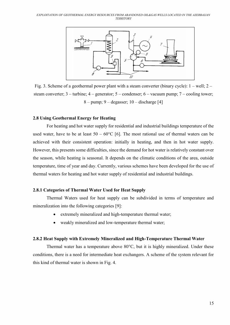
2.8.2 Heat Supply with Extremely Mineralized and High-Temperature Thermal Water
Thermal water has a temperature above 80°C, but it is highly mineralized. Under these
conditions, there is a need for intermediate heat exchangers. A scheme of the system relevant for
this kind of thermal water is shown in Fig. 4.

EXPLOITATION OF GEOTHERMAL ENERGY RESOURCES FROM ABANDONED OIL&GAS WELLS LOCATED IN THE AZERBAIJAN TERRITORY
16
Fig. 4. Schematic diagram of geothermal heat supply with heat exchangers: 1 - well; 2 - heat
exchanger of the heating system; 3, 4 - heat exchangers for hot water supply of the 1st stage and
2nd stages; 5 - heating system [4]
2.8.3 Heat Supply with Weakly Mineralized and Low-Temperature Thermal Water
Thermal water is weakly mineralized, but with a low thermal potential, thus, temperature
is below 80°C. In this case, increase of the thermal water potential is needed and following systems
can be applied:
supply of thermal water in parallel for heating and hot water and peak reheating of
heating water;
drainless geothermal heating system;
use of heat pumps;
combined use of heat pumps and peak heating.
Fig. 5. Schematic diagram for supply of thermal water in parallel for heating and hot water with
peak reheating: 1 - well; 2 - peak heater; 3 - heating system; 4 - storage tank [4]
EXPLOITATION OF GEOTHERMAL ENERGY RESOURCES FROM ABANDONED OIL&GAS WELLS LOCATED IN THE AZERBAIJAN TERRITORY
17
According to the first type of scheme, thermal water from wells enters into system (hot
water supply) and boiler. Here it gets warm to a temperature corresponding to meteorological
conditions, and served in heating systems (Fig. 5). This scheme is especially suitable for areas with
expensive drilling, since the peak boiler house allows reducing number of wells.
In the second type of scheme thermal water coming from wells is heated 160-200°C
temperature. The third type of scheme provides heating with low-temperature thermal waters using
a certain heat pump. Fourth type of scheme is integrated heat supply system with transformation
of discharge water heat in combination with peak heating and high-quality regulation [9].

EXPLOITATION OF GEOTHERMAL ENERGY RESOURCES FROM ABANDONED OIL&GAS WELLS LOCATED IN THE AZERBAIJAN TERRITORY
18
CHAPTER 3: OVERVIEW OF GEOLOGICAL STRUCTURE OF
AZERBAIJAN AND INFORMATION ON OIL AND GAS BEARING REGIONS
3.1 Geological Structure of Azerbaijan
Sedimentary, volcanic, volcanic-sedimentary, intrusive, metamorphic deposits and
continental rocks of the Mesozoic and Cenozoic, and partly of the Paleozoic age are widespread
on the territory of the Azerbaijan Republic.
In terms of geological structure and geotectonic development, the territory of the Republic
of Azerbaijan belongs to the alpine fold belt formed in the collision zone of the Eurasian and
Africa-Arabian lithospheric plates. The composition of the main tectonic elements includes mega-
structures of the Greater and Lesser Caucasus, Talish, the Kura depression located between them,
in the northeast part of the Pre-Caucasian trough, in the east the Middle and South-Caspian
depressions (Fig. 6) [10].
The complexity and diversity of the history of the geological and tectonic structure of the
Eastern Caucasus, including the territory of Azerbaijan, is due to the repeated manifestation of
tectonic-magmatic processes over a long period of its formation. Paleozoic-Mesozoic-Cenozoic
periods were cycles reflecting the evolution of the Caucasus.
In terms of seismicity, the territory of the Republic of Azerbaijan is one of the most active
regions of the Alpine orogeny (fold belt). According to historical information, strong and
destructive earthquakes have repeatedly occurred here.
In terms of the number of mud volcanoes, their size, morphological features, vigorous
activity and the variety of eruption products, Azerbaijan is on the top in the world. All types of
mud volcanic manifestations as active, extinct, buried, underwater, island, abundantly oily are
found in the territory. There are more than 300 mud volcanoes on the east land of Azerbaijan and
the adjacent Caspian Sea. There are over 200 underwater mud volcanoes in the South Caspian and
8 islands in the Baku archipelago of mud volcanic origin. [11, 12]

EXPLOITATION OF GEOTHERMAL ENERGY RESOURCES FROM ABANDONED OIL&GAS WELLS LOCATED IN THE AZERBAIJAN TERRITORY
19
Azerbaijan is rich in some ferrous, non-ferrous metals, as well as rare earth elements and
minerals. Ore deposits of iron, aluminum, mercury, gold, copper, lead, zinc, cobalt etc. are known
on its territory.
In the Azerbaijan Republic, iron ores create industrial fields and among them, the most
important and largest in the Caucasus is the Dashkesan iron ore deposit. In addition, commercial
deposits of cobalt ore have been identified in this region.
Fig. 6. Orographic Map of Azerbaijan [13]

EXPLOITATION OF GEOTHERMAL ENERGY RESOURCES FROM ABANDONED OIL&GAS WELLS LOCATED IN THE AZERBAIJAN TERRITORY
20
3.2 History of Oil and Gas Industry in Azerbaijan
The territory of the Republic of Azerbaijan, especially the Absheron Peninsula, is one of
the richest in term of hydrocarbons and most ancient oil-producing regions in the world. In
Absheron, in 1594, the first oil well was drilled with a depth of 35 m. In 1847, the first well in the
world was mechanically drilled in the Bibiheybat area (Absheron) [14]. Fig. 7 shows one of the
oil well fountained in an ancient oil field Balakhani in Baku, Azerbaijan, in 1887.
Fig. 7. Oil Fountain in Balakhani (Baku, Azerbijan, 1887)
The dynamics of oil production over 1882 – 1897 was form 832 thousand tons to 6921
thousand tons per year. The maximum production was reached in 1901 reached about 11000
thousand tons, which amounted to more than half of world production and Azerbaijan came out
on top among countries producing oil [15].
3.3 Oil and Gas Bearing Regions in the Territory of Azerbaijan
Main oil and gas fields are concentrated in the deposits of the productive stratum (layer),
the thickness of which is 1200-3000 m and in some areas reaches 4000 m. Presently, 90% of oil
and gas production in Azerbaijan is carried out from the productive strata and 80-85% of oil
production is carried out from offshore fields [16].
EXPLOITATION OF GEOTHERMAL ENERGY RESOURCES FROM ABANDONED OIL&GAS WELLS LOCATED IN THE AZERBAIJAN TERRITORY
21
In the central part of the Absheron threshold of the South Caspian, oil and gas fields
Gunashli, Azeri and Chirag have been discovered with large reserves, when in the Baku
archipelago the Bakhar and Shah Deniz gas condensate fields opened.
List of the main oil and gas bearing regions (OGBR) in the territory of Azerbaijan is given
below (Fig. 6) [16]:
- Absheron OGBR
- Baku archipelago OGBR
- Lower-Kura OGBR
- Shamakhi-Gobustan OGBR
- Precaspian-Guba OGBR
- Ganja OGBR
3.3.1 Absheron Oil and Gas Bearing Region
Absheron oil and gas bearing region. On the Absheron Peninsula in Balakhani-Sabunchi-
Ramana, Bibiheybat, Surakhani, Gala, Lokbatan and other old oil fields, the entire section of the
productive strata is oil and gas bearing. Onshore gas-condensate fields Garadagh and Zira are
located in this region. Besides, there are several significant offshore fields related to this region in
the Caspian Sea.
Balakhani – Sabunchu – Ramana field, located in the central part of the Absheron
peninsula, is the largest field in terms of oil production and reserves, among the developed onshore
fields. Reservoir properties of productive horizons as porosity and permeability are accordingly
23-27% and 90-600 mD [16]. Development regime is mainly the regime of the dissolved gas.
Taking into account that this field has been operated since ancient times, it can be noted that the
field is on the last stage of development also according to water cut percentages.
Average daily debit of one well was 0.6 tons/d of oil and 11.9 t/day of total liquid, water
cut of produced fluid is about 95.3%.
The diversity in geological and physical properties influenced technological indicators.
Development indicators in the formations of the upper section of the Productive Stratum relatively
higher than in the lower one, which is associated with the characteristics of the collectors, energy
feature, as well as the intensity of the operation process. From the total oil produced in the field

EXPLOITATION OF GEOTHERMAL ENERGY RESOURCES FROM ABANDONED OIL&GAS WELLS LOCATED IN THE AZERBAIJAN TERRITORY
22
since the beginning of development, 75.5% is related to the upper section, and 24.5% to the lower
section.
Artificial stimulation methods applying on layers also affected to the development results.
So that, in 2004 through 107 water injection wells, 2292 thousand m3 of water was injected, due
to which 54.4 thousand tons of oil received. Therefore, consumption per ton of oil production
increase is 42 m3 of water [16].
Neft Dashlari (Oil Rocks) is one of the large offshore fields in terms of production and
reserves of oil and gas. This field entered to industrial development in 1950. The field is multi-
layered and reservoir porosity changes averagely from 9.16 to 29%, permeability from 0.011 to
1.3 μm2. The density of oil varies from 843 to 929 kg/m3, and the viscosity from 1.3 to 13 MPa*s.
Average flow rate of one well was 5.7 tons/day oil and 10.1 tons/d liquid, water cut of produced
fluid is about 42.7%.
Gunashli oil field is located in the deep-water part of the Azerbaijan shelf of the Caspian
Sea. Average values of porosity along the horizons range from 12 to 22% and permeability values
vary widely from 0.001 to 0.15 μm2. Oil density in standard conditions varies from 845 to 863
kg/m3. Industrial development of Gunashli field began in 1985. Average production rate of one
well is 90.7 tons/d and 38.5 ton/day for oil and condensate correspondingly. The percentage of
water cut is 12.8% for oil production and 25.8% for condensate [16].
3.3.2 Lower-Kura Oil and Gas Bearing Region
Oil and gas fields are associated with a productive stratum, in the section of which 20 oil-
bearing horizons have been identified and about 10 deposits have been discovered here. Kurovdag,
Kursangi, Mishovdag fields located in this region are large ones in terms of oil and gas reserves.
Kurovdag field is the largest oil field of developed Lower-Kura OGBR (oil and gas bearing
region). The reservoir properties of productive horizons have porosity within 19.7-29.4%,
permeability 25.0-388.10-3 μm2, oil density 850-918 kg/m3 and viscosity 11.9-25.9 MPa*s.
EXPLOITATION OF GEOTHERMAL ENERGY RESOURCES FROM ABANDONED OIL&GAS WELLS LOCATED IN THE AZERBAIJAN TERRITORY
23
Industrial development of the field began in 1955 and the maximum annual production of
2254 thousand tons was reached in 1966. Oil production rate of one well is averagely 2.1 tons,
liquid 11.1 tons and water cut of the produced liquid is about 80.8%.
Water injection was started at the Kurovdag field in 1958 and in 2004, through 13 injection
wells, 422.1 thousand m3 of water was injected and as a result, 15.6 thousand tons of oil produced
additionally [16].
3.3.3 Baku Archipelago, Shamakhi-Gobustan, Precaspian-Guba OGBRs
In Baku Archipelago OGBR, the oil and gas content is associated with the upper section of
the productive strata. Currently, the Sangachal-Deniz, Duvanny-Deniz, Khare-Zira Island (gas-
condensate-oil), Khare-Zira-Deniz (gas-condensate), Alat-Deniz and Garasu Island are being
exploited.
In Shamakhi-Gobustan oil and gas bearing region several promising areas have been
identified. The oil-gas-condensate fields Duvanny, Dashgil, Kyanizadag are associated with the
productive strata, the Umbaki oil field with Miocene deposits.
In Precaspian-Guba oil and gas bearing region, Chandagar-Zarat, Siyazan-Nardaran,
Saadan, Amirkhanly, Zagly and Zeyva deposits are being developed along the Siyazan monocline.
3.3.4 Yevlakh-Agjabedi Oil and Gas Bearing Region
In this region, at the Muradkhanli field, for the first time in Azerbaijan, oil with industrial
importance was found in the Upper Cretaceous volcanogenic deposits. The Muradkhanly field,
which is part of the Middle-Kura oil and gas-bearing region, is the only field in the province where
oil reservoir opened in volcanogenic deposits. The density of oil is 877 kg/m3, the oil is paraffinic.
The average depth of occurrence of productive horizons varies within 2750-4050 m. This field is
characterized by abnormally high reservoir pressure. The maximum oil production was in 1978
with volume of 446 thousand tons [16].

EXPLOITATION OF GEOTHERMAL ENERGY RESOURCES FROM ABANDONED OIL&GAS WELLS LOCATED IN THE AZERBAIJAN TERRITORY
24
CHAPTER 4: GEOTHERMAL ENVIRONMENT IN OIL AND GAS BEARING
REGIONS IN THE TERRITORY OF AZERBAIJAN
4.1 History of Geothermal Researches in Azerbaijan
Considering the purpose and nature of the works carried out in Azerbaijan, as well as
current direction of geothermal researchs, the history of study of the territory can be distinguished
into three periods [17]:
1st stage (1880-1920). The beginning of geothermal observations in the oil wells of the
Absheron peninsula dates back to 1880, when L. Batsevich made temperature measurements in oil
wells of Sabunchu area (village on the Absheron peninsula). Absheron peninsula is located on the
western coast of the Caspian Sea, in Azerbaijan. Based on interval temperature measurements with
maximum thermometer in three different wells he found the fact of temperature increase by rise
in depth. According to M.V. Abramovich geothermal step for Ramana (village on the Absheron
peninsula) area fluctuates from 21 to 35 m/°C and wells with abnormal temperatures caused by an
influx of less mineralized deep water were also observed along with wells with normal
temperatures.
2nd stage (1920-1968). Over this period, systematic geothermal researchs in Azerbaijan
have been carried out mainly by academician S.F. Mekhtiyev and his associates. Based on
measurement results made by S.F. Mekhtiyev and based on large actual field material geothermal
step values were calculated for a number of fields in the Absheron area and patterns of temperature
distribution in the subsoil due to tectonics revealed.
3rd stage (1968-currently). Geothermal properties (as thermal conductivity, heat capacity
and thermal diffusivity) of rocks located in the territory of Azerbaijan, were studied widely over
this period. Development of instruments for geothermal research and determination of density of
heat flux through the bottom of the Caspian Sea began in 1970s. Full range of geothermal
researches made over this stage includes thermal water studies, surface geothermal survey, studies
of radiogenic heat generation in the Earth's subsoil, studies of the relationship between the thermal
field and seismicity, studies of the thermal field of mud-volcanic regions, modeling of the thermal
field of sedimentary basins in the territory of Azerbaijan.
EXPLOITATION OF GEOTHERMAL ENERGY RESOURCES FROM ABANDONED OIL&GAS WELLS LOCATED IN THE AZERBAIJAN TERRITORY
25
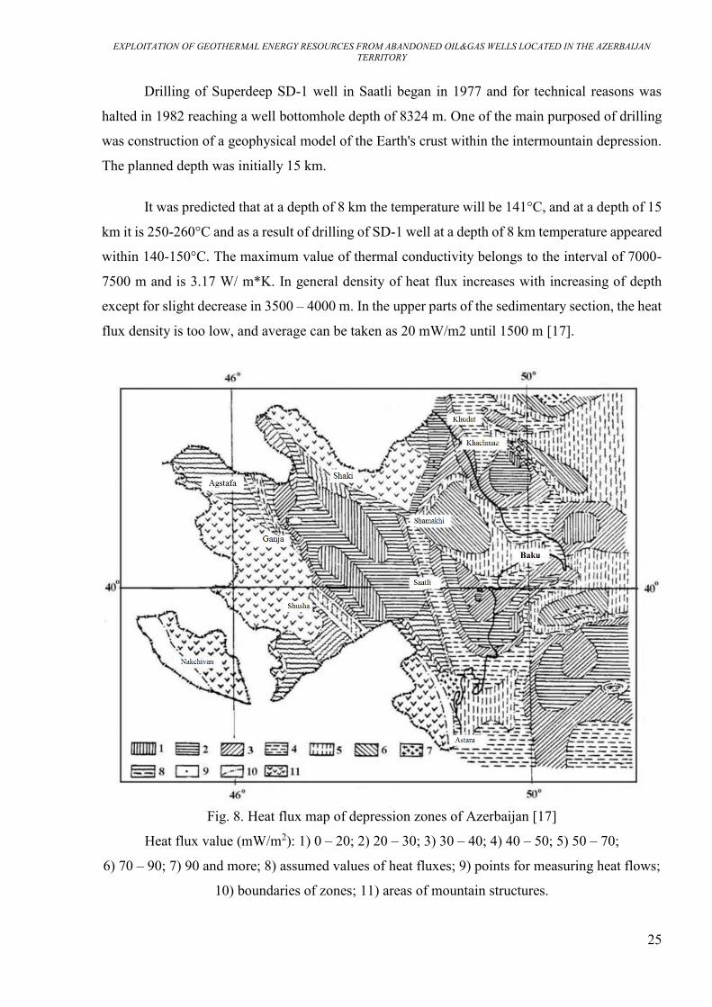
Drilling of Superdeep SD-1 well in Saatli began in 1977 and for technical reasons was
halted in 1982 reaching a well bottomhole depth of 8324 m. One of the main purposed of drilling
was construction of a geophysical model of the Earth's crust within the intermountain depression.
The planned depth was initially 15 km.
It was predicted that at a depth of 8 km the temperature will be 141°C, and at a depth of 15
km it is 250-260°C and as a result of drilling of SD-1 well at a depth of 8 km temperature appeared
within 140-150°C. The maximum value of thermal conductivity belongs to the interval of 7000-
7500 m and is 3.17 W/ m*K. In general density of heat flux increases with increasing of depth
except for slight decrease in 3500 – 4000 m. In the upper parts of the sedimentary section, the heat
flux density is too low, and average can be taken as 20 mW/m2 until 1500 m [17].
Fig. 8. Heat flux map of depression zones of Azerbaijan [17]
Heat flux value (mW/m2): 1) 0 – 20; 2) 20 – 30; 3) 30 – 40; 4) 40 – 50; 5) 50 – 70;
6) 70 – 90; 7) 90 and more; 8) assumed values of heat fluxes; 9) points for measuring heat flows;
10) boundaries of zones; 11) areas of mountain structures.

EXPLOITATION OF GEOTHERMAL ENERGY RESOURCES FROM ABANDONED OIL&GAS WELLS LOCATED IN THE AZERBAIJAN TERRITORY
26
4.2 Thermal Waters in Territory of Azerbaijan
For a hydrothermal deposit to form and exist, three following lithological parameters are
required [5]:
1. large volume of sufficiently hot rocks (at a certain depth)
2. an aquifer or permeable formation above the these rocks
3. an impermeable layer above this aquifer preventing significant amount of heat carrier
from reaching the surface.
The Republic of Azerbaijan is rich in thermal waters penetrated by numerous oil-gas and
water wells, which are known in a number of regions of the Greater and Lesser Caucasus,
Absheron Peninsula, Talysh, in the vast territory of the Kura depression and the Caspian-Guba
regions.
Thermal waters in Masalli, Lankaran and Astara regions confined to the regional fault that
crosses the entire mountain Talysh. In Masalli, wells drilled to 500 m deep revealed thermal waters
with a temperature of 44-45°C at the outlet. Temperature of water in various springs varies from
50 to 64°C. Well flow rate is 10 – 15 l/sec, water is mineralized and with calcium chloride
composition. In Lankaran, a number of wells drilled with a depth of 465 – 1000 m, which opened
thermal water with temperature up to 50°C. Water temperature in the springs is 30 – 43°С, flow
rate – 2260 m3/day. Water is mineralized with sodium chloride-calcium composition. The water
temperature in the wells at the outlet is 23 – 39°С, the flow rate is up to 46 l/sec [17].
Geothermal conditions of the southern and northeastern slopes of the Greater Caucasus
poorly studied, but there are indicators of the wide spread of thermal waters. These areas include
thermal water fields in the Gakh region – Ilisu with a source temperature of up to 40°C and
Kurmukh with temperatures up to 30.5°C. In Gabala region, there are springs with a temperature
of 39.4°C, in Oguz region there are Khalkhal springs with a temperature of 32°C.
The thermal waters of the Precaspian-Guba region with hydrocarbonate-calcium-sodium
composition wand salinity of 0.8 – 1.9 g/l possess total water flow rate as 20470 m3/day.
Temperature of these thermal waters changes from 50 to 84°C.
The Kura depression is an artesian basin with a complex structure, temperature distribution
and water composition. In 1969, in the Dzharly area, thermal water with a flow rate of 20,000

EXPLOITATION OF GEOTHERMAL ENERGY RESOURCES FROM ABANDONED OIL&GAS WELLS LOCATED IN THE AZERBAIJAN TERRITORY
27
m3/day and temperature of 100°C was opened. There are several geothermal researches dedicated
to the Dzharly well.
In the Kurdamir region, one well penetrated thermal waters with a flow rate of 10000
m3/day with 82°C temperature at the wellhead. In the Shirvanli area, thermal water with a flow
rate of 3000 m3/day and temperature of 60°C was opened by a well.
Fig. 9. Map of regions with thermal fields in the territory of Azerbaijan Republic [18]
1 – Only thermal waters; 2 – Mud volcanoes; 3 – Oil and gas fields; 4 – Petro-thermal systems

EXPLOITATION OF GEOTHERMAL ENERGY RESOURCES FROM ABANDONED OIL&GAS WELLS LOCATED IN THE AZERBAIJAN TERRITORY
28
Hydrogeological studies of the thermal waters in the territory of Azerbaijan made it
possible to identify vertical and horizontal hydro-geochemical zoning. By dipping of sediments
from the foothills of the Lesser and Greater Caucasus, mineralization and hydro-chemical
properties changes. Salty, bicarbonate-sodium and chloride-sodium waters gradually replace fresh,
bicarbonate-calcium waters. Table 2. demonstrates energy potential of different hydrogeological
areas in the territory of Azerbaijan [18].
Table 2 Energy Potential of Various Hydrogeological Areas
4.3 Geothermal Conditions of OGBRs
Geothermal conditions of the following Oil and Gas Bearing Regions (OGBRs) given
below:
Absheron OGBR
Baku archipelago OGBR
Precaspian-Guba OGBR
Lower-Kura OGBR
Yevlakh-Agjabedi OGBR
Ganja OGBR
In structures that do not contain oil and gas deposits, thermal activity much lower than in
productive ones. Thermal activity of structures containing accumulations of gas and gas-
condensate, significantly lower than that of structures saturated with oil, which is explained by
cooling during adiabatic expansion of gas and limited flow at these structures of deep hyper-
thermal waters [17].

EXPLOITATION OF GEOTHERMAL ENERGY RESOURCES FROM ABANDONED OIL&GAS WELLS LOCATED IN THE AZERBAIJAN TERRITORY
29
There are certain features of temperature change by section and area. Zones of abnormally
high reservoir temperatures and low values of geothermal stages, as a rule, are confined to areas
complicated by mud volcanoes, diapirs, characterized by groundwater discharge [17].
In the sections of individual areas, the increase in temperature with depth slows down, and
the values of geothermal steps increase averagely from 20 – 25 m/°C at depths of 0 – 500 m to 100
– 125 m/°C in the interval 4500 – 5000 m.
If all other geological and hydrogeological properties are same, geothermal step in the
sections of fields are minimal in clay and maximum in sandy interval. This feature is associated
with the thermal conductivity of rocks.
Almost all oil fields compared to surrounding areas is characterized by elevated
temperatures. Within individual fields, areas of mud volcanoes and large disturbances are
characterized by local positive thermal anomalies [19].
4.3.1 Absheron Oil and Gas Bearing Region
Background value of temperature field within the region sections 3000 and 4000 m is equal
respectively to 74 and 88°С. Heat flux density values vary widely from 20 to 90 mW/m2. Wide
information on geothermal conditions of Absheron region is given in the Chapter 5.
According to academician S.F Mekhtiyev, development of the field also affects local
distribution temperatures in the earth's crust. One of the reasons influencing a decrease in the
temperature of oil layers over time, apparently, is artificial flooding of reservoirs with cold water,
as well as the duration of the operation processes and the associated drop in reservoir pressure.

EXPLOITATION OF GEOTHERMAL ENERGY RESOURCES FROM ABANDONED OIL&GAS WELLS LOCATED IN THE AZERBAIJAN TERRITORY
30
Fig. 10. Dependence of temperature on depth at Bibi-Eibat field (Absheron peninsula)
measured in the following years: 1 – 1911, 2 – 1913, 3 – 1944, 4 – 1962 [17]
Fig. 11. Dependence of temperature on depth at Surakhany field (Absheron peninsula)
measured in the following years: 1 – 1913, 2 – 1944, 3 – 1950, 4 – 1961 [17]
At the Surakhany and Bibi-Eibat fields (Absheron peninsula) at the same depth, the
temperature decreases over time (years) by an average of 2-5°C and can be explained as a result
of millions cubic meters of cold water injection into the layer during development (Fig. 10, Fig.11).

EXPLOITATION OF GEOTHERMAL ENERGY RESOURCES FROM ABANDONED OIL&GAS WELLS LOCATED IN THE AZERBAIJAN TERRITORY
31
4.3.2 Baku Archipelago Oil and Gas Bearing Region
Background temperature within the archipelago, at depths of 3000 and 4000 m is equal to
62.6 and 75.4°C, accordingly. The average value of the heat flux density for the given region is
30-50 mW/m2.
4.3.3 Precaspian-Guba Oil and Gas Bearing Region
In the most part of this region, the values of the heat flux density are low. The indicators
does not exceed 30 mW/m2. In the southeast part of the Siyazan monocline, the heat flux density
reaches 50 mW/m2.
Fig. 12. Temperature dependence on depth for wells in Precaspian-Guba area with >100°C [18]
In this zone, with several wells thermal waters opened with 12360 m3/day total output and
temperature 50 – 84°C. In Khachmaz district (Fig. 6) thermal waters with 1228 m3/day output and
58°C temperature opened by a certain well. The amount of heat carried by the thermal waters was
4.4*105 Gcal. In addition, by a one well, thermal waters with 500 m3/day output and 95°C
temperature opened in Yalama region. The amount of heat carried by the water was 3.5.105 Gcal.

EXPLOITATION OF GEOTHERMAL ENERGY RESOURCES FROM ABANDONED OIL&GAS WELLS LOCATED IN THE AZERBAIJAN TERRITORY
32
4.3.4 Lower-Kura Oil and Gas Bearing region
The region has a background temperature as 64.5 and 76.4°C for 3000 and 4000 m depths,
respectively and is characterized by 20 – 50 mW/m2 heat flux density. On the example of the
Kyurovdag area of the Lower-Kura depression change of temperature by depth shown in the Fig.
13.
Fig. 13. Geothermal section of the Kyurovdag area [17]
4.3.5 Yevlakh-Agjabedi Oil and Gas Bearing Region
For depths of 3000 and 4000 m, background temperature values are respectively 75°С and
95°С. Two temperature zones are distinguished, in which, compared to the background, positive
and negative local temperature anomalies are determined. In this region, the average value of heat
flow density changes mainly from 20 to 50 mW/m2.

EXPLOITATION OF GEOTHERMAL ENERGY RESOURCES FROM ABANDONED OIL&GAS WELLS LOCATED IN THE AZERBAIJAN TERRITORY
33
Fig. 14. Temperature dependence on depth for wells in Yevlakh-Agjabedi area with >100°C [18]
Fig. 15. Geothermal section of the Muradkhanly field [17]

EXPLOITATION OF GEOTHERMAL ENERGY RESOURCES FROM ABANDONED OIL&GAS WELLS LOCATED IN THE AZERBAIJAN TERRITORY
34
4.3.6 Ganja Oil and Gas Bearing Region
Background temperature values at the depths of 3000 and 4000 m, respectively, are 99.5°C
and 129°С. For this area, the heat flow density varies from 30 to 70 mW/m2. On the example of
the Gazanbulag area of the Ganja OGBR, change of temperature by depth shown in the Fig. 16.
Fig. 16. Geothermal section of the Gazanbulag area [17]

EXPLOITATION OF GEOTHERMAL ENERGY RESOURCES FROM ABANDONED OIL&GAS WELLS LOCATED IN THE AZERBAIJAN TERRITORY
35
CHAPTER 5: GEOTHERMAL RESEARCH DATA OF OIL AND GAS
BEARING REGIONS IN THE ABSHERON PENINSULA
5.1 Geological Characteristics of the Absheron Peninsula
The region can be in terms of orography divided (by Fatmai – Balkhany – Surakhany – Zig
anticline boundary) into the following parts [20]:
Western part
Eastern part
Eastern part is more plain type (flat) compared to western part of the peninsula, which
possesses several mud volcanoes.
Geological structure of the Absheron peninsula contains the following types of deposits:
Cretaceous
Paleogene-neogene
Quaternary
Cretaceous deposits widespread in northeastern part of the region and contains sandy
limestone and gray clays in terms of lithology. Paleogene deposits come out to the surface in this
part of the peninsula and contains clays, marl and sandstone. Neogene deposits consist of clays,
volcanic ash and marl.
Productive stratum (oil-bearing) of the Absheron peninsula has a complex structure
composed by alternating sand-clay deposits. Thickness of the stratum in southern part is 2000 m,
however, in in eastern part is higher than 3000 m. Productive stratum is subdivided into the
following sections:
Upper (Surakhany, Sabunchu, Balkhany suites)
Middle (Sandy section, 200 – 300 m)
Lower (On-Girmaki, On-Girmaki-Sand, Girmaki suites)

EXPLOITATION OF GEOTHERMAL ENERGY RESOURCES FROM ABANDONED OIL&GAS WELLS LOCATED IN THE AZERBAIJAN TERRITORY
36
5.2 Thermal Water Resources of Absheron Peninsula
At the oil fields of productive stratum in the territory of Absheron peninsula 18 water-
bearing horizons being in complex communication with oil-bearing layers are determined.
Formation water of the upper part of productive stratum in Absheron peninsula are
subdivided into the following zones:
cold (< 20°C)
thermal (20 – 40, 40 – 50, 50 – 75, 75 – 100°C)
Western and northwestern parts of the Asbheron peninsula are related to the cold zone. In
this region, deposits of productive stratum comes to the surface or lies down in 110 – 200 m from
the surface.
Depths from 110 – 180 m to 560 – 950 m is considering as a zone of formation waters with
20 – 40°C when depth from 560 – 980 to 830 – 1440 m related 40 – 50°C.
High-temperature water-bearing horizons are related southern oil fields of the Absheron
peninsula, where temperature changes from 38 to 68°C. In northern and north-eastern fields of the
peninsula temperature changes from 25 – 30 to 45 – 50°C.
Wells located in the upper part of productive stratum have water rate from 0.1 to 6 l/sec.
These formation waters is highly mineralized and sodium-chloride type.
On the Absheron Peninsula, thermal waters are met by wells at a wide variety of depths
and in natural outlets. In a peninsular part of Absheron, to the east of the village of Hovsan,
temperature of the mineralized waters from the drilled depths reaches 100-135°C. Chloride-
hydrocarbonate-sodium water fountain was observed with mineralization of 16.5 g/l with
temperature of 71°C and flow rate of more than 18450 thousand-liters/day at Bibi-Eibat directly
near Baku. Temperature of thermal waters increases, and mineralization decreases with increasing
depth [17].
EXPLOITATION OF GEOTHERMAL ENERGY RESOURCES FROM ABANDONED OIL&GAS WELLS LOCATED IN THE AZERBAIJAN TERRITORY
37
5.3 Geothermal Research on the Absheron Peninsula
During the 1944 – 1967 years at the oil fields of Absheron Peninsula, academicians S.F.
Mekhtiyev A.K. Mirzadjanzade and S.A. Aliyev carried out geothermal observations, collected,
systematized and processed valuable temperature measurement data from several non-active and
operational wells. A part of the geothermal data is given below for the following oil fields:
Lokbatan Field
Balakhany – Sabunchu – Ramana Fields
Surakhany Field
Neft Dashlary (Oil Rocks) Field
Zig – Hovsan Fields
Bibi-Eibat Field
Gum-Deniz Field
5.3.1 Lokbatan Field
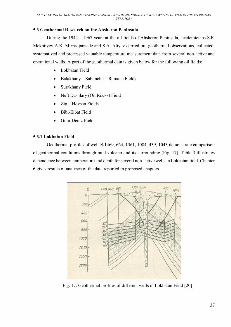
Geothermal profiles of well №1469, 664, 1361, 1084, 439, 1043 demonstrate comparison
of geothermal conditions through mud volcano and its surrounding (Fig. 17). Table 3 illustrates
dependence between temperature and depth for several non-active wells in Lokbatan field. Chapter
6 gives results of analyses of the data reported in proposed chapters.
Fig. 17. Geothermal profiles of different wells in Lokbatan Field [20]

EXPLOITATION OF GEOTHERMAL ENERGY RESOURCES FROM ABANDONED OIL&GAS WELLS LOCATED IN THE AZERBAIJAN TERRITORY
38
Well (№)
Duration of well non-activity
(years)
Depth (m)
Temperature (°C)
423 1 684 37 1368 54
192 1 361 35 723 43
338 1,5 600 36 1286 52
436 1 638 39 1260 53
416 1 684 37 1384 54
493 2 474 34 949 54
1377 1,5
215 32 415 33 615 36 815 40
219 1,5
203 30 403 31 603 34 803 39 1003 44
1348 1,5
974 44 774 40 574 35 374 31 174 30
1289 1,5
325 31 525 35 725 34 925 40 1125 43
1064 1,5
190 32 390 32 590 35 790 39 990 45 1100 50
Table 3. Temperatue indicators of different wells in Lokbatan field [20]

EXPLOITATION OF GEOTHERMAL ENERGY RESOURCES FROM ABANDONED OIL&GAS WELLS LOCATED IN THE AZERBAIJAN TERRITORY
39
5.3.2 Balakhani – Sabunchu – Ramana oil field
Temperature indicators at different depths of five non-active wells in Balakhani –
Sabunchu – Ramana field are shown in the table 4. Temperature measurements were conducted in
1967 for well №1562, in 1961 for well №1524, in 1962 for well №2197 and for well №1512, in
1963 for well №1374 [20].
Depth (m) Well (№)
1562 1524 2197 1512 1374 200 - - - 22,3 - 300 - - - 25,2 - 400 - - - 27,8 - 500 - - - 31 - 600 - 37,9 - 33,9 - 700 42,8 41,3 - 36,3 38 800 45,3 44,7 35,1 38,5 42 900 48 4,4 37,9 40,7 43,5 1000 52,7 49,7 39,5 42,2 45 1100 53,3 51,7 41,6 45,6 46 1200 54,5 53,3 44 47,1 48 1300 - 54,9 45,6 - 49 1400 56,1 56,8 47,6 - 50,5 1500 57,5 58,3 49 - 52,5 1600 58,5 59,5 50,4 - 53,5 1700 59,4 - 51,1 - 54 1800 60,6 - 52,3 - 54,5 1900 - - 53,4 - - 2000 - - 54,5 - - 2100 - - 55,7 - -
Table 4. Temperatue indicators (°C) of different wells in Balakhani – Sabunchu - Ramana field
[20]
EXPLOITATION OF GEOTHERMAL ENERGY RESOURCES FROM ABANDONED OIL&GAS WELLS LOCATED IN THE AZERBAIJAN TERRITORY
40
5.3.3 Surakhany Field
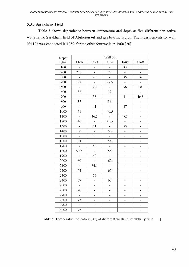
Table 5 shows dependence between temperature and depth at five different non-active
wells in the Surakhani field of Absheron oil and gas bearing region. The measurements for well
№1106 was conducted in 1959, for the other four wells in 1960 [20].
Depth (m)
Well № 1106 1598 1403 1697 1268
100 - - - 33 31 200 21,5 - 22 - - 300 - 23 - 35 36 400 27 - 27,5 - - 500 - 29 - 38 38 600 32 - 32 - - 700 - 35 - 41 40,5 800 37 - 36 - - 900 - 41 - 47 -
1000 41 - 40,5 - - 1100 - 46,5 - 52 - 1200 46 - 45,5 - - 1300 - 51 - 55 - 1400 50 - 50 - - 1500 - 55 - - - 1600 54 - 54 - - 1700 - 59 - - - 1800 57,5 - 58 - - 1900 - 62 - - - 2000 60 - 62 - - 2100 - 64,5 - - - 2200 64 - 65 - - 2300 - 67 - - - 2400 67 - 67 - - 2500 - - - - - 2600 70 - - - - 2700 - - - - - 2800 73 - - - - 2900 - - - - - 3000 76 - - - -
Table 5. Temperatue indicators (°C) of different wells in Surakhany field [20]

EXPLOITATION OF GEOTHERMAL ENERGY RESOURCES FROM ABANDONED OIL&GAS WELLS LOCATED IN THE AZERBAIJAN TERRITORY
41
5.3.4 Neft Dashlary (Oil Rocks) field
This field located in the Caspian Sea, on 110 km distance to the East direction from Baku.
According to the 104 measurements conducted over 1952 – 1956 in 35 production wells,
temperature changes from 39 to 59°C at the 457 – 964 m depth interval. Geothermal step value for
the given depth interval changes from 21 to 22 m/°C [20].
5.3.5 Zig – Hovsan Fields
Temperature measurement results for the Zig and Hovsan fields are given in Table 6. In
1944, temperature measurements in this field were carried out in several non-active wells.
Depth (m)
Zig Hovsan
Well №
18 1501 1507 1816
Temperature (°C)
200 30 25 - 20
400 35 31 33 24
600 42 37 39 29
800 46,5 42 42 33
1000 51 43 45 38
1200 56 52 47 -
1400 60 56 50 48
1600 64 60 53 54
1800 6 64 55 58
2000 70 68 58 62
2200 4 2 60 66
2400 7 75 64 68
2600 79 78 67 71
2800 - 81 70 74
3000 - 83 73 77
3200 - 85 76 80
3400 - 87 79 -
3600 - 89 81 -
Table 6. Temperatue indicators of different wells in Zig – Hovsan Fields [20]

EXPLOITATION OF GEOTHERMAL ENERGY RESOURCES FROM ABANDONED OIL&GAS WELLS LOCATED IN THE AZERBAIJAN TERRITORY
42
5.3.6 Turkan – Zira Fields
In the table 7 given below, there are temperature measurement indicators related to
well№1820 and well№1306 of Turkan field, and Well №22 of Zira Field [20].
Depth (m)
Turkan Zira Well №
1820 1306 22 Temperature (°C)
400 - 25 - 500 26 - - 900 34 36 - 1000 - - - 1100 39 - - 1300 43,5 - - 1500 49 - - 1600 - - - 1700 52 56 - 1900 56 - - 2000 - - - 2100 60 - - 2300 62 65,2 - 2500 64 - - 2600 - - - 200 69 - - 3000 - 73 - 3100 76 - - 3250 - - 71 3500 - - 74 4000 - - 79,5 4500 - - 86 4700 - - 88
Table 7. Temperatue indicators of different wells in Turkan – Fields [20]

EXPLOITATION OF GEOTHERMAL ENERGY RESOURCES FROM ABANDONED OIL&GAS WELLS LOCATED IN THE AZERBAIJAN TERRITORY
43
5.3.7 Bibi – Eibat Field
For Bibi-Eibat field over 1951-1962 years measurement data collected, systemized and
processed from non-active (for a long period) and production wells. Results of the measurements
in non active wells are given in the Table 8 [20].
Well № Depth (m) Temperature (°C)
2840 1010 54 1210 67 1812 80
2701 1160 55 1460 67 1760 75
2008 748 48 848 51 948 54
2940
1000 47 1250 54 1500 60 1750 64 1875 65
3282 1000 51 1250 56 1500 58
1286 1000 48 1200 54 1350 57
Table 8. Temperatue indicators of different wells in Bibi – Eibat field [20]

EXPLOITATION OF GEOTHERMAL ENERGY RESOURCES FROM ABANDONED OIL&GAS WELLS LOCATED IN THE AZERBAIJAN TERRITORY
44
5.3.8 Gum-Deniz Field
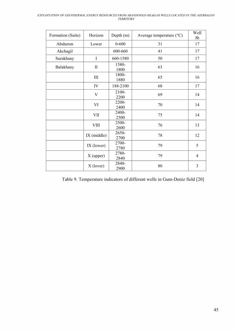
Fig. 18 demonstrates geothermal profiles of wells №178, 154, 189 field in Gum-Deniz
Field [16]. Description of this geothermal environment is reported in the Chapter 6. Table 9 shows
dependence between average temperature and depth in Gum-Deniz Field related to various
production wells.
Fig.18. Geothermal profiles of different wells in Gum-Deniz field [20]
EXPLOITATION OF GEOTHERMAL ENERGY RESOURCES FROM ABANDONED OIL&GAS WELLS LOCATED IN THE AZERBAIJAN TERRITORY
45
Formation (Suite) Horizon Depth (m) Average temperature (°C) Well №
Absheron Lower 0-600 31 17 Akchagil 600-660 41 17
Surakhany I 660-1580 50 17
Balakhany II 1580-1800 63 16
III 1800-1880 65 16
IV 188-2100 68 17
V 2100-2200 69 14
VI 2200-2400 70 14
VII 2400-2500 75 14
VIII 2500-2600 76 13
IX (middle) 2650-2700 78 12
IX (lower) 2700-2780 79 5
X (upper) 2780-2840 79 4
X (lover) 2840-2900 80 3
Table 9. Temperature indicators of different wells in Gum-Deniz field [20]

EXPLOITATION OF GEOTHERMAL ENERGY RESOURCES FROM ABANDONED OIL&GAS WELLS LOCATED IN THE AZERBAIJAN TERRITORY
46
CHAPTER 6: RESULTS AND CONCLUSION
Wells drilled in the bowels of oil fields of the Caucasus region bring to the surface
significant amount of heat contained in thermal waters with a temperature from 40- 45 to 80-90°C
(sometimes higher) and with a total flow rate of hundreds of millions of cubic meters per year.
Oil fields, in the last stage of their development, can be characterized by a high percentage
of water cut and number of repair processes. In this kind of fields, due to low productivity of the
wells, expenses and production costs for oil and gas extraction are more than their selling price.
Several oil and gas fields developing more than 70-80 years in Absheron region and so with high
possibility in possessing abandoned or non-active (for various reasons) wells are demonstrated in
this paragraph.
6.1 Final Geothermal Indicators of Lokbatan Field
Abnormal high temperatures and geothermal gradients for a given area recorded in the well
№1084 located in the area of the active mud volcano. Lokbatan field (Absheron) is located on the
slopes of the mud volcano with the same name and, undoubtedly, it has considerable influence on
such a deviation in the distribution of the temperature regime of the observed well (Fig. 17).
In addition, characteristics of lithology and tectonics also have effect on geothermal
indicators of the given region. Layers within the productive strata are crushed until considerable
depth and broken by tectonic faults. Thus, by increasing depth, geothermal step increases when
geothermal gradient decreases. This kind of behavior of parameters can be explained by increase
of rock density and decease of clayiness. The section of the Lokbatan field is more clay compared
to the deposits of the eastern part of the Absheron Peninsula.
According to collected and processed 90 temperature measurements from 80 production
wells, for 320 – 1765 m depth interval temperature changes from 30 to 64°C. Geothermal step
changes from 29.8 to 41 m/°C for 500 – 5000 depth interval (Fig. 19), according to 37
measurements conducted in eleven non-active wells.

EXPLOITATION OF GEOTHERMAL ENERGY RESOURCES FROM ABANDONED OIL&GAS WELLS LOCATED IN THE AZERBAIJAN TERRITORY
47
Fig. 19. Change of Geothermal Step in Lokbatan Field
Geothermal energy conditions of Lokbatan field (southwestern Absheron) depend
significantly on hydrodynamic regime and high temperature of circulating formation waters, which
enter into the layers through fractures from the bowels of the Earth. Thermal waters moving inside
high permeable sandy layers warm up intensively surrounding rocks and create high temperature.
6.2 Final Geothermal Indicators of Hovsan Field
In the well №1501, temperature changes from 78 to 89 °C for 2600 – 3600 m depth interval.
In the well №1507, temperature changes from 67 to 81 °C for 2600 – 3600 m depth interval. In
the well №1816, temperature changes from 66 to 80°C for 2200 – 3200 m depth interval. (Fig. 20,
21, 22). In Absheron peninsula, nearby Hovsan district, with help of wells drilled in oil and gas
region, existence of subsurface water with temperature of 100 – 135°C has been determined.
Therefore, Hovsan Field can be considered one of the perspective fields as a source of geothermal
energy.
0
500
1000
1500
2000
2500
3000
3500
4000
4500
0 5 10 15 20 25 30 35 40 45
De
pth
(m
)
Geothermal Step (m/°C)

EXPLOITATION OF GEOTHERMAL ENERGY RESOURCES FROM ABANDONED OIL&GAS WELLS LOCATED IN THE AZERBAIJAN TERRITORY
48
Fig. 20. Temperature change in well N1501 (Hovsan Field)
Fig. 21. Temperature change in well N1507 (Hovsan Field)
Fig. 22. Temperature change in well N1816 (Hovsan Field)

EXPLOITATION OF GEOTHERMAL ENERGY RESOURCES FROM ABANDONED OIL&GAS WELLS LOCATED IN THE AZERBAIJAN TERRITORY
49
6.3 Final Geothermal Indicators of Bibi-Eibat Field
According to thirty temperature measurements conducted with help of 30 production wells,
it is defined that temperature changes from 34 to 54°C in 500 – 1500 m depth interval. Geothermal
step value changes from 27 to 41 m/°C in 500 – 5000 m depth range (Fig. 23).
Fig. 23 Change of Geothermal Step in Bibi-Eibat Field
6.4 Final Geothermal Indicators of Gum-Deniz Field
To determine geothermal gradient and geothermal step values temperature measurement
data received from 17 production wells is used. It is defined that temperature changes linearly and
until 1400 – 1600 m defining with following equation:
(3) t=14+0.0323z
In this interval for each 1000 m, temperature increase is equal to 31°C and geothermal step
is about 32 m/°C. From 1400 – 1600 m this pattern is violated, because geothermal gradient and
step values change sharply. From 1600 to 3000 m, increase of temperature is observed, however
intensity of rise decreases approximately two times obeying linearity. Considering these depths
values, temperature growth for every 1000 m is 15°C, geothermal step is equal approximately to
66 m/°C.
To determine temperature from 1500 m in the central II block, where IX and X horizons
are complicated by disorders, water flooding and developing intensively with deviated wells the
following equation should be used:
0
1000
2000
3000
4000
5000
6000
0 5 10 15 20 25 30 35 40 45
De
pth
(m
)
Geotermal Step (m/°C)

EXPLOITATION OF GEOTHERMAL ENERGY RESOURCES FROM ABANDONED OIL&GAS WELLS LOCATED IN THE AZERBAIJAN TERRITORY
50
(4) t=60+0.0149z
Where z – depth (from 1500 m); 60 – average temperature in 1500 m depth determined
with the formula mentioned above.
According to geothermal profiles of wells №178, 154, 189 it can be seen that there is
anomaly from 1500 m depth. From this point the second equation (4) given above is applied.
6.5 Final Geothermal Indicators of Balakahny – Sabunchu – Ramana Field
According to the data received from 61 production wells, temperature changes from 35 to
54.5°C for 409 – 1500 m depth interval. Geothermal step value changes from 35 to 45 m/°C for
518 – 1500 depth range.
Balakhany-Sabunchu-Ramana field (Absheron) is at a late stage of development which
began more than 150 years ago. Exploitation in this field is carried out under conditions of low
formation pressure, the average daily production rate is 0.3 tons, and the water cut of products
varies within 80-98%.
One of the important factors impeding the increase in oil production with an increase in PI
(productivity index) is the natural intensive increase of water cut of wells, which is characteristic
for fields at a late stage of development.
In this case, the increase of water cut of wells practically nullifies the results of activities
to affect the bottomhole zone of wells and increase PI. In this regard, the implementation of
measures to limit water inflows along with the increase in PI is a very urgent problem for all long-
term developing fields.
6.6 Final Geothermal Indicators of Surakhany Field
Totally, in Surakhani field 431 temperature measurements were held in 235 production
wells in the depth interval of 608 – 2386 m, where temperature fluctuates from 35 to 78°C.
Magnitude of geothermal step for this depth changes from 30 to 70 m/°C.

EXPLOITATION OF GEOTHERMAL ENERGY RESOURCES FROM ABANDONED OIL&GAS WELLS LOCATED IN THE AZERBAIJAN TERRITORY
51
6.7 Final Geothermal Indicators of Neft Dashlary Field
According to the data from five non-active 35 production wells located in the Neft Dashlary
(Oil Rocks) field temperature changes from 39 to 59°C in 457 – 964 m depth interval. Geothermal
step value the given depth is about 21 – 22 m°C.
6.8 Conclusion
The territory of Azerbaijan turned out to be rich in thermal waters: sources of thermal water
were found in the Greater and Lesser Caucasus, on the Absheron Peninsula and Talysh. Also, in
the vast territory of the Kur basin and the Precaspian-Guba area numerous wells drilled for oil and
gas discovered aquifers with thermal water.
The review work carried out on the proposed and described large quantity of material and
data related to geothermal researches demonstrated a considerable variety of geothermal
conditions of subsoil in the territory of Azerbaijan. In a number of regions of the Azerbaijan
territory, available thermal waters resources can be used for practical purposes as a source of
geothermal energy.
In the territory of Azerbaijan, thermal waters extracted from oil and gas wells with
temperature from 40 – 45°C to 80 – 90°C and with total production rate 75 – 80 mln. m3/year can
take out about 3*109 MJ of heat per year [16].
As a result of the study about geothermal environment of oil and gas bearing regions in the
territory of Azerbaijan, Absheron oil and gas bearing region can be considered as one of the main
promising zones with its thermal waters of which can have great practical importance.
In the territory of Absheron peninsula, thermal waters with 20 – 90°C were found to be
associated to numerous oil wells in the depth of 300 – 5000 m. For instance, in Bibi-Eibat oil-gas
bearing region a well with enough high production rate of thermal water demonstrated a
temperature value of 71°C.
Hydrodynamic regime and high temperature of circulating waters penetrating into the
layers through numerous fractures have considerable effect on geothermal conditions of southwest
Absheron fields. Flowing through high-permeable sandy layers, thermal waters warm up
intensively surrounding sediments creating high temperatures. Forecasted thermal water reserves

EXPLOITATION OF GEOTHERMAL ENERGY RESOURCES FROM ABANDONED OIL&GAS WELLS LOCATED IN THE AZERBAIJAN TERRITORY
52
in this region related to aquifers of productive layer constitute about 20000 m3/d. A certain number
of wells in oil-gas fields of this region has been abandoned due to water invasion and is not used
for oil production. The presence of industrial facilities in the peninsula makes possible a future
usage of available thermal waters as a source of heat for municipal, household and agriculture
needs by means of direct use-geothermal technologies.
In addition, the existence of thermal waters with 100 – 135 °C temperature in Hovsan field
(Absheron peninsula) was proved with the help of wells drilled for oil and gas. Taking into account
that the recorded temperature values of the thermal waters were higher than 120°C, available
geothermal resources could be efficiently used for electric power generation through indirect use-
geothermal technologies. Zig – Hovsan fields can be considered as a promising region for future
geothermal research.
Finally, taking high temperature indicators in the observed data into account, Yevlakh-
Agjabedi and Precaspian-Guba region should be researched additionally in terms of defining
promising thermal waters.
Long development period of the several hydrocarbon fields located in the territory of
Azerbaijan could increase possibility of the existence of a number of abandoned wells, therefore
making possible practical exploration and extraction activities of identified geothermal resources.
Taking observed above data into consideration, it can be comprehended that extraction of
geothermal energy from oil and gas bearing regions in this territory could be a perspective topic
for discussions and further researches.

EXPLOITATION OF GEOTHERMAL ENERGY RESOURCES FROM ABANDONED OIL&GAS WELLS LOCATED IN THE AZERBAIJAN TERRITORY
53
REFERENCES
1. Voluntary National Review, Azerbaijan – 2030: From the Millennium Development Goals
towards the Sustainable Development Goals, Baku, 2017.
2. Muffler, L.J.P., Cataldi, R., 1978, Methods for Regional Assessment of Geothermal
Resources. Geotermics, 7, 53-89.
3. Buryachok, T.A., Butsyo Z.Y., Varlamov, G.B., 2013, Electricity and Environmental
Protection. Energy Functioning in the Modern World.
4. Ageev V.A., 2004, Non-Traditional and Renewable Energy Resources. Ageev V. MRSA.
5. Edward R. Berman, 1975, Geothermal Energy, Noyes Data Corporation, Park Ridge, New
Jersey.
6. Dvorov I.M., 1976, Geothermal Energy, Moskow:Nauka.
7. Isachhenko V.P., Osipova V.A., Sukomel A.S., 1969, Heat Transfer, Mir Publishers,
Moscow.
8. Templeton J, 2013, Abandoned Petroleum Wells as Sustainable/Renewable Sources of
Geothermal Energy, Energy 70.
9. Andryushchenko A.I., 1985, Fundamentals of Thermodynamics of Heat and Power Cycles,
2nd ed. M.Higher school.
10. Khain, V.E., Alizade A.A., 2005, Geology of Azerbaijan, Tom IV, Tectonics, Baku, Nafta
Press
11. Yagubov A.A., Alizade A.A., M.M. Zeinalov, 1971, Mud Volcanoes of Azerbaijan,
Environmental Geology volume 46, 1012–1023.
12. Aliev A.A., Guliev I.S., Raxmanov R.R., 2009, Catalogue of mud volcano eruptions in
Azerbaijan (1810 – 2007),
13. Alizadeh Akif A., Guliyev Ibrahim S., Kadirov Fakhraddin A., Eppelbaum, Lev V.,
Geosciences of Azerbaijan, Volume I “Geology”, Springer Nature.
14. Socar.az (State Oil Company of Azerbaijan Republic) data.
15. Babazadeh, B.K., 1964. Classification of Oil and Gas Pools and Deposits of Azerbaijan
and Rational Methodology of their Prospecting. Nedra, Moscow (in Russian).
16. Geology of Azerbaijan, 2003, Minerals (Natural Resources) Baku: Nafta Press, Vol. VI.
Minerals, 576.
17. Aliyev, S.A, Aliyev, C.S, Askerhanova, H.Q, Balakishibeyli, Sh. A, Qasanov, A.O,
Qasanov, A.B., Zolotovichaya, T.A, Ismailzade, A.D, Isayeva, M.I, Kadirov, F.A, Mukhtarov, A.
Sh, Rzayev, A.Q, Cafarov, I.B, Khalafly, A.A, 2005, Geology of Azerbaijan, Vol. V, Physics of
the Earth.

EXPLOITATION OF GEOTHERMAL ENERGY RESOURCES FROM ABANDONED OIL&GAS WELLS LOCATED IN THE AZERBAIJAN TERRITORY
54
18. Mukhtarov A.S., Nadirov R.S., Mammadova (Asadova) A.V., Mammadova V.A., 2015,
Geological Conditions and Business Opportunities for Geothermal Energy Development in
Azerbaijan, Proceedings of Azerbaijan National Academy of Sciences, The Sciences Of Earth n°3.
19. Azerbaijan State News Agency, 2008, Geology of Azerbaijan, Oil and Gas.
20. Mehtiyev, S.F., Mirzadjanzade, A.H., Aliev, S.A. 1971. Geothermal studies of oil and gas
fields. Moscow: Nedra, 216.