experimental 5 day genesis forecasts
TRANSCRIPT

Experimental 5‐day genesis forecastsExperimental 5‐day genesis forecasts
Eric BlakeNational Hurricane Center
2013 National Hurricane ConferenceMarch 28 2013
Eric BlakeNational Hurricane Center
2013 National Hurricane ConferenceMarch 28 2013

Outline
• Extending period of Tropical Weather Outlook• Science behind the longer‐term outlooks• Prototypes of new graphical/text formats• Timeline

Background
• Transitioning TWO into a probability‐based product has been very successful
• Users are also very interested in a forecast beyond 48 hours
• Our ability at medium‐range genesis forecasts is now well documented and we are ready to make them available to the public

• General assessment of activity in the tropics, pertaining to tropical cyclone formation
• Discusses areas of disturbed weather and their potential, including probabilities, for genesis during the next 48 hours
• Issued every 6 hours during the hurricane season
• 0000, 0600, 1200, 1800 UTC • 2 AM, 8 AM, 2 PM, 8 PM EDT
Tropical Weather OutlookTropical Weather Outlook

Verification Results for 2-Day Genesis Forecasts
Sometimes substantialinterannual variation in
results
Long-term results have been quite promising
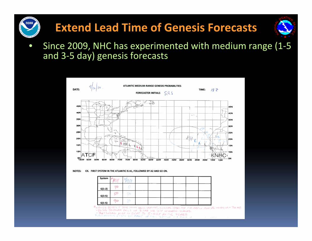
Extend Lead Time of Genesis Forecasts• Since 2009, NHC has experimented with medium range (1‐5
and 3‐5 day) genesis forecasts

Verification of 2009-12 Genesis Probabilities
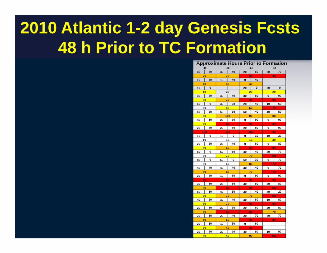
2010 Atlantic 1-2 day Genesis Fcsts48 h Prior to TC Formation
Approximate Hours Prior to Formation10 10 40 20 10 50 20 30 40 20 30 30 40 30 30 40 20 60 20 70
20 0 20 10 40 20 20 50 20 30 20 30 10 30 10 40 0 40
10 0 10 0 10 0 10 0 20 0 20 0
10 0 30 20 40 20 20 20 30 20 30 40 30 60 0 90
20 0 20 0 20 0 20 0 30 0 60 0 60 0 30 20 20 40 10 60
40 0 50 0 60 0 60 0 60 0 60 20 60 20 50 30 50 40 40 50
20 0 30 0 30 0 40 10 20 60 0 90 0 90
10 10 50 0 30 20 30 60 30 60 20 80 20 80 20 80 20 80 0 90
10 0 10 0 10 0 0 10 10 20
20 0 10 0 40 0 40 0 20 20 20 40 0 60 0 80
20 0 30 0 30 0 50 0 50 0 60 0 60 10 30 40 30 70
30 0 40 0 50 0 70 0 80 0 50 0 50 30 0 70
40 0 40 10 50 0 40 60 40 60 40 50 40 40 40 40 30 40 0 70
70 10 70 0 70 10 50 10 40 30 40 40 20 60 10 80 0 90 0 90
10 0 10 0 10 0 10 10 20 0 60 20 30 50 20 60 30 60 20 80
30 0 30 0 50 0 50 0 70 0 60 10 60 10 40 30 30 40 80 20
10 30 20 20 30 20 40 10 40 10 30 20 40 20 30 40 30 60 10 80
30 0 30 0 30 10 30 20 30 10 30 20 20 30 20 60 20 60 20 50
40 10 40 10 40 20 30 20 20 20 20 30 20 30 20 40 20 70 20 70
10 0 40 0 20 0 20 20 0 20 0 20 10 10 30 0 60
10 0 10 0 10 0 10 0 20 10 20 20 20 20 40 50 10 9030 40 40 90 100Tomas 10 10 10 10
20 20 30 40 60
50 50 60 90 9040
Shary 10 40 20 20
Richard 50 50 60 50
40 50 50 80 80 70
50 60 70 90 9050
Paula 30 30 40 50
Otto 40 40 50 50
70 70 70 70 70 100
80 80 80 90 10020
Nicole 30 30 50 50
Matthew 10 10 10 20
70 80 80 90 90 90
90 80 80 70 70100
Lisa 80 70 80 60
Karl 40 50 50 100
50 70 80 50 80 70
50 60 70 70 10050
Julia 30 40
Igor 20 30 30
9030
Hermine 20 10
Gaston
40 40 40 60 60 80
10 10 10 10 30
50 60 7030
Fiona 20 50 50 90
Earl 20
100 100 100 100 100 90
30 50 80 90
10 10 20 20 2010
Danielle 40 50 60 60
Five 20 20 20 20
60 80 80 100 90 90
60 60
50 40
60 70 70 80 90
Colin 10 50
Bonnie 10
60 40 50 70 90 90
Two 20 30 60 70
-48 -36 -24 -12
Alex 20 60 60 50 60
-120 -108 -96 -84 -72 -60
50 50 40

2010 Atlantic 1-5 day Genesis Fcsts120 h Prior to TC Formation
Approximate Hours Prior to Formation10 10 40 20 10 50 20 30 40 20 30 30 40 30 30 40 20 60 20 70
20 0 20 10 40 20 20 50 20 30 20 30 10 30 10 40 0 40
10 0 10 0 10 0 10 0 20 0 20 0
10 0 30 20 40 20 20 20 30 20 30 40 30 60 0 90
20 0 20 0 20 0 20 0 30 0 60 0 60 0 30 20 20 40 10 60
40 0 50 0 60 0 60 0 60 0 60 20 60 20 50 30 50 40 40 50
20 0 30 0 30 0 40 10 20 60 0 90 0 90
10 10 50 0 30 20 30 60 30 60 20 80 20 80 20 80 20 80 0 90
10 0 10 0 10 0 0 10 10 20
20 0 10 0 40 0 40 0 20 20 20 40 0 60 0 80
20 0 30 0 30 0 50 0 50 0 60 0 60 10 30 40 30 70
30 0 40 0 50 0 70 0 80 0 50 0 50 30 0 70
40 0 40 10 50 0 40 60 40 60 40 50 40 40 40 40 30 40 0 70
70 10 70 0 70 10 50 10 40 30 40 40 20 60 10 80 0 90 0 90
10 0 10 0 10 0 10 10 20 0 60 20 30 50 20 60 30 60 20 80
30 0 30 0 50 0 50 0 70 0 60 10 60 10 40 30 30 40 80 20
10 30 20 20 30 20 40 10 40 10 30 20 40 20 30 40 30 60 10 80
30 0 30 0 30 10 30 20 30 10 30 20 20 30 20 60 20 60 20 50
40 10 40 10 40 20 30 20 20 20 20 30 20 30 20 40 20 70 20 70
10 0 40 0 20 0 20 20 0 20 0 20 10 10 30 0 60
10 0 10 0 10 0 10 0 20 10 20 20 20 20 40 50 10 90
Two 20 30 60 70
-48 -36 -24 -12
Alex 20 60 60 50 60
-120 -108 -96 -84 -72 -60
50 50 40 50 40
60 70 70 80 90
Colin 10 50
Bonnie 10
60 40 50 70 90 90
10 10 20 20 2010
Danielle 40 50 60 60
Five 20 20 20 20
60 80 80 100 90 90
60 60 50 60 7030
Fiona 20 50 50 90
Earl 20
100 100 100 100 100 90
30 50 80 90 9030
Hermine 20 10
Gaston
40 40 40 60 60 80
10 10 10 10 30
Julia 30 40
Igor 20 30 30
50 70 80 50 80 70
50 60 70 70 10050
Lisa 80 70 80 60
Karl 40 50 50 100
70 80 80 90 90 90
90 80 80 70 70100
Nicole 30 30 50 50
Matthew 10 10 10 20
70 70 70 70 70 100
80 80 80 90 10020
Paula 30 30 40 50
Otto 40 40 50 50
40 50 50 80 80 70
50 60 70 90 9050
Shary 10 40 20 20
Richard 50 50 60 50
20 20 30 40 60
50 50 60 90 9040
30 40 40 90 100Tomas 10 10 10 10

TC Genesis Forecasting at the NHCTC Genesis Forecasting at the NHC
• Primary guidance comes from global models
• GFS and ECMWF seem to have greatest skill, but more systematic verification is needed
• Models appear to have some geographical biases, and perform better in the eastern Atlantic, and worse in the subtropics.
• Genesis forecasts are also more problematic in Gulf of Mexico since models have difficulty depicting genesis in that region (smaller-scale processes play a bigger role?)
• Considerable subjectivity involved in NHC genesis forecasts
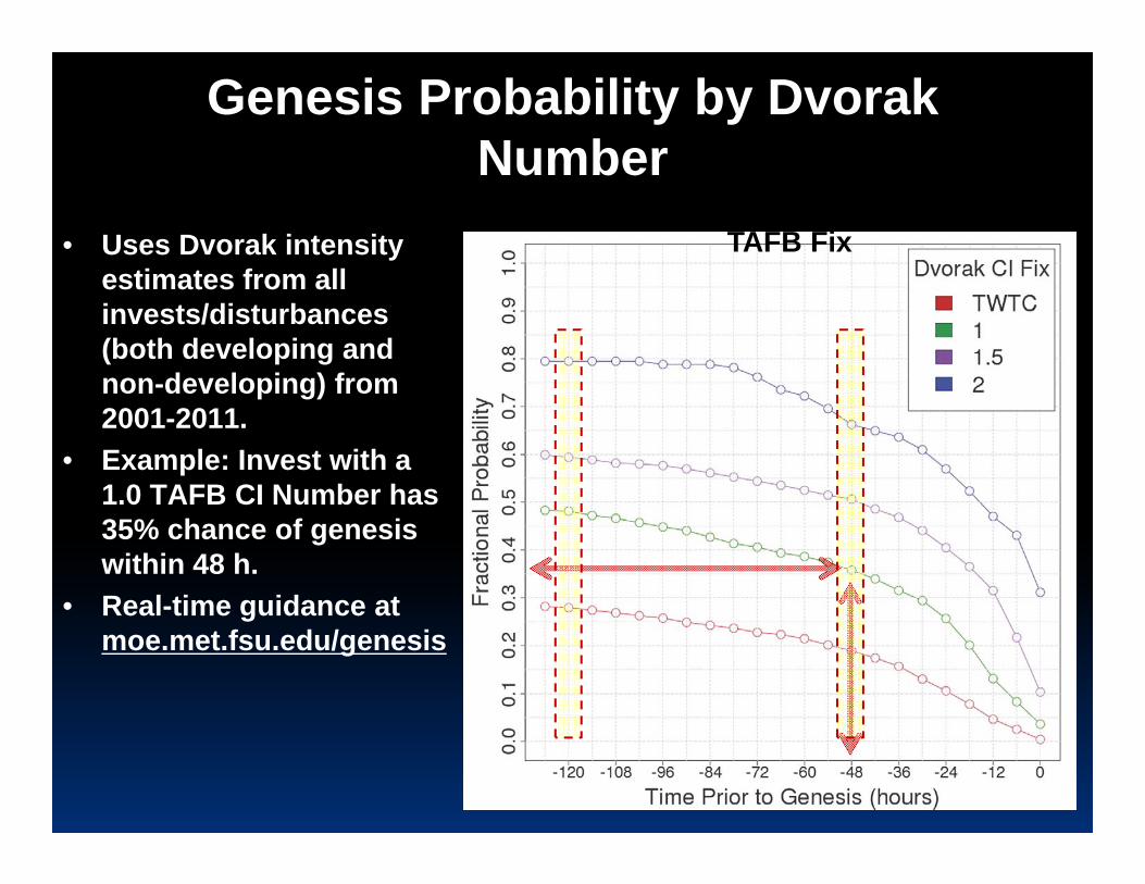
Genesis Probability by Dvorak Number
• Uses Dvorak intensity estimates from all invests/disturbances (both developing and non-developing) from 2001-2011.
• Example: Invest with a 1.0 TAFB CI Number has 35% chance of genesis within 48 h.
• Real-time guidance at moe.met.fsu.edu/genesis
Atlantic TC Genesis Probability by TAFB Fix

CIRA – Tropical Cyclone Formation Probability Guidance Product
http://www.ssd.noaa.gov/PS/TROP/TCFP/atlantic.html

TIME SERIES OF TC GENESIS PARAMETERS -- 2012

Model Genesis Page Now Includes Global Model Ensembles
Sandy: forecasts from 2012102012 (24h prior to genesis) -- Hit

Important intraseasonal predictors for the 5 day genesis forecasts
Magenta dots are TC genesis points in early 2012
Blue–favorable upper-level conditions (lower shear and more unstable)
Unlike conventional tropical waves, this signal moves from west to east

5‐day Genesis Forecasts
THIS SYSTEM HAS A MEDIUM CHANCE…40 PERCENT…OF BECOMING A TROPICAL CYCLONE DURING THE NEXT 48 HOURS…
THIS SYSTEM HAS A HIGH CHANCE…80 PERCENT…OF BECOMING A TROPICAL CYCLONE DURING THE NEXT 5 DAYS.

ZCZC MIATWOAT ALLTTAA00 KNHC DDHHMM
TROPICAL WEATHER OUTLOOK NWS NATIONAL HURRICANE CENTER MIAMI FL800 PM EDT THU SEP 20 2012
FOR THE NORTH ATLANTIC...CARIBBEAN SEA AND THE GULF OF MEXICO...
THE NATIONAL HURRICANE CENTER IS ISSUING ADVISORIES ON TROPICAL STORM NADINE…LOCATED ABOUT 250 MILES SOUTHWEST OF THE AZORES.
SHOWERS AND THUNDERSTORMS ASSOCIATED WITH AN AREA OF LOW PRESSURE LOCATED ABOUT 1175 MILES EAST‐NORTHEAST OF THE NORTHERN LEEWARD ISLANDS HAVE BECOME A LITTLE BETTER ORGANIZED. ALTHOUGH UPPER‐LEVELS WINDS ARE ONLY MARGINALLY FAVORABLE FOR DEVELOPMENT…THEY ARE EXPECTED TO BECOME MORE FAVORABLE DURING THE NEXT DAY OR TWO. THIS SYSTEM HAS A MEDIUM CHANCE…40 PERCENT…OF BECOMING A TROPICAL CYCLONE DURING THE NEXT 48 HOURS AS IT MOVES WEST‐NORTHWESTWARD AT 10 MPH. AFTER THAT TIME… ENVIRONMENTAL CONDITIONS APPEAR FAVORABLE…AND THIS SYSTEM HAS A HIGH CHANCE…80 PERCENT…OF BECOMING A TROPICAL CYCLONE DURING THE NEXT 5 DAYS AS IT TURNS NORTHWESTWARD.
A BROAD LOW PRESSURE AREA ASSOCIATED WITH A TROPICAL WAVE IS LOCATED ABOUT 450 MILES SOUTHWEST OF THE CAPE VERDE ISLANDS. WHILE THIS SYSTEM IS PRODUCING A LARGE AREA OF CLOUDINESS AND SCATTERED SHOWERS…ENVIRONMENTAL CONDITIONS ARE ONLY MARGINALLY FAVORABLE FOR DEVELOPMENT. THIS SYSTEM HAS A MEDIUM CHANCE…40 PERCENT…OF BECOMING A TROPICAL CYCLONE DURING THE NEXT 48 HOURS AS IT MOVES GENERALLY WESTWARD AT 10 TO 15 MPH. HOWEVER…THESE CONDITIONS ARE FORECAST TO BECOME MORE CONDUCIVE FOR DEVELOPMENT DURING THE NEXT SEVERAL DAYS…AND THIS SYSTEM HAS A HIGH CHANCE…80 PERCENT…OF BECOMING A TROPICAL CYCLONE AS IT CONTINUES GENERALLY WESTWARD.
AN AREA OF DISTURBED WEATHER HAS FORMED IN ASSOCIATION WITH A BROAD LOW PRESSURE AREA ABOUT 700 MILES NORTHEAST OF THE NORTHERN LEEWARD ISLANDS. SLOW DEVELOPMENT OF THIS SYSTEM IS POSSIBLE DURING THE NEXT SEVERAL DAYS AS THE LOW MOVES GENERALLY WESTWARD AT ABOUT 10 MPH. THIS LOW HAS A LOW CHANCE…NEAR 20 PERCENT…OF BECOMING A TROPICAL CYCLONE DURING THE 48 HOURS AS IT TURNS NORTHWESTWARD. BEYOND 48 HOURS… ENVIRONMENTAL SHOULD REMAIN MARGINALLY FAVORABLE FOR DEVELOPMENT. ..AND THIS SYSTEM HAS A MEDIUM CHANCE…30 PERCENT…OF BECOMING A TROPICAL CYCLONE DURING THE NEXT 5 DAYS AS THE LOW GRADUALLY TURNS NORTHWARD.
OTHER SYSTEMS WITH FORMATION POTENTIAL BEYOND 48 HOURS
THE REMANT CIRCULATION OF HURRICANE ISAAC IS LOCATED OVER THE OHIO VALLEY. THIS SYSTEM IS FORECAST TO GENERALLY DRIFT SOUTHWARD AND REACH THE WATERS OF THE NORTH‐CENTRAL GULF OF MEXICO IN A FEW DAYS. ENVIRONMENTAL CONDITIONS ARE EXPECTED TO BE FAVORABLE IN THE GULF OF MEXICO FOR SOME SLOW DEVELOPMENT. THERE IS A LOW CHANCE…NEAR 0 PERCENT…OF THIS SYSTEM REFORMING DURING THE NEXT 48 HOURS. HOWEVER…THERE IS A MEDIUM CHANCE…40 PERCENT…OF THIS SYSTEM REFORMING DURING THE NEXT 5 DAYS AS IT MOVES LITTLE OVER THE GULF OF MEXICO.
ALTHOUGH THE NORTHWESTERN CARIBBEAN SEA IS CURRENTLY QUIET…AN AREA OF LOW PRESSURE IS EXPECTED TO FORM IN THAT AREA IN 3 TO 5 DAYS. ENVIRONMENTAL CONDITONS APPEAR CONDUCIVE FOR DEVELOPMENT DURING THAT TIME AS THE LOW MOVES SLOWLY NORTHWARD. THERE IS A LOW CHANCE…NEAR 0 PERCENT…OF THIS SYSTEM BECOMING A TROPICAL CYCLONE DURING THE NEXT 48 HOURS. HOWEVER…THERE IS A HIGH CHANCE…NEAR 60 PERCENT…OF THIS DISTURBANCE BECOMING A TROPICAL DURING THE NEXT 5 DAYS.
&&AN EXPERIMENTAL 5‐DAY FORMATION PROBABILITY IS ALSO INCLUDED IN THIS PRODUCT FOR THE 2013 HURRICANE SEASON. COMMENTS ON THE EXPERIMENTAL PORTION OF THIS PRODUCT CAN BE SENT TO [email protected].
FIVE‐DAY FORMATION PROBABILITIES ARE EXPERIMENTAL IN 2013.
$$FORECASTER KIMBERLAINNNNN

Graphical Prototype

Also available system-by-system

Graphical Tropical Weather OutlookGraphical Tropical Weather Outlook

Timeline
May 15– Produce text products in‐house for further testing
July 15‐August 31– If technical considerations are worked out, issue text 5‐day genesis forecasts
Graphical product is dependent on resources but we are hopeful to have it functional with text

Conclusions
• New 5‐day genesis forecasts are accurate enough to be issued publically
• Technically considerations due to understaffing are the biggest concern to prevent experimental issuance
• Optimistic that this will be in place during the busiest part of the hurricane season
• Note that this product will also be issued for the eastern Pacific (where the skill is a bit higher)
National Hurricane Center – Hurricane Specialist UnitNational Hurricane Center – Hurricane Specialist Unit
…the faces behind the forecasts…the faces behind the forecasts