existing zoning ind-1 map td - raleighnc.gov recommendation raleigh planning commission cr# 11417...
TRANSCRIPT
R-4
TD
CUD TD
IND-1
CUD R-6
CUD O&I-2
CM
CUD SC
CUD R-10
CUD IND-1
RR
CAPIT
AL
THORNTON
WADFORD
NEUSE WOOD
CLARKS FORK
BIG SANDYWILD WOOD FOREST
NEUSE TOWN
SAN MARCOS
PERRY CREEK
NEUSE FOREST
BOCA
BIG NANCE
BEARGRASS
PLANO
BRAMBLEBERRY
COOSA
SATILLO
KISSIMMEE
SANDY BANKS
BOYSENBERRY
HAINES CREEK
NEUSE STONE
PERRY COMMONS
THOR
NTON
COM
MONS
RIVER HAVEN
NEUSE HUNTERDUCK CREEK
NEUSE COMMONS
SAND BAR
MERYTON PARK
MANATEESH
ILOH CR
EEK
NEUSE VISTA
THORNTON TOWN
RIVER STREAM
EEL
HARD
ETH
THORNTON KNOLL
NEUSE CLUB
FARS
IDECAPI
TAL
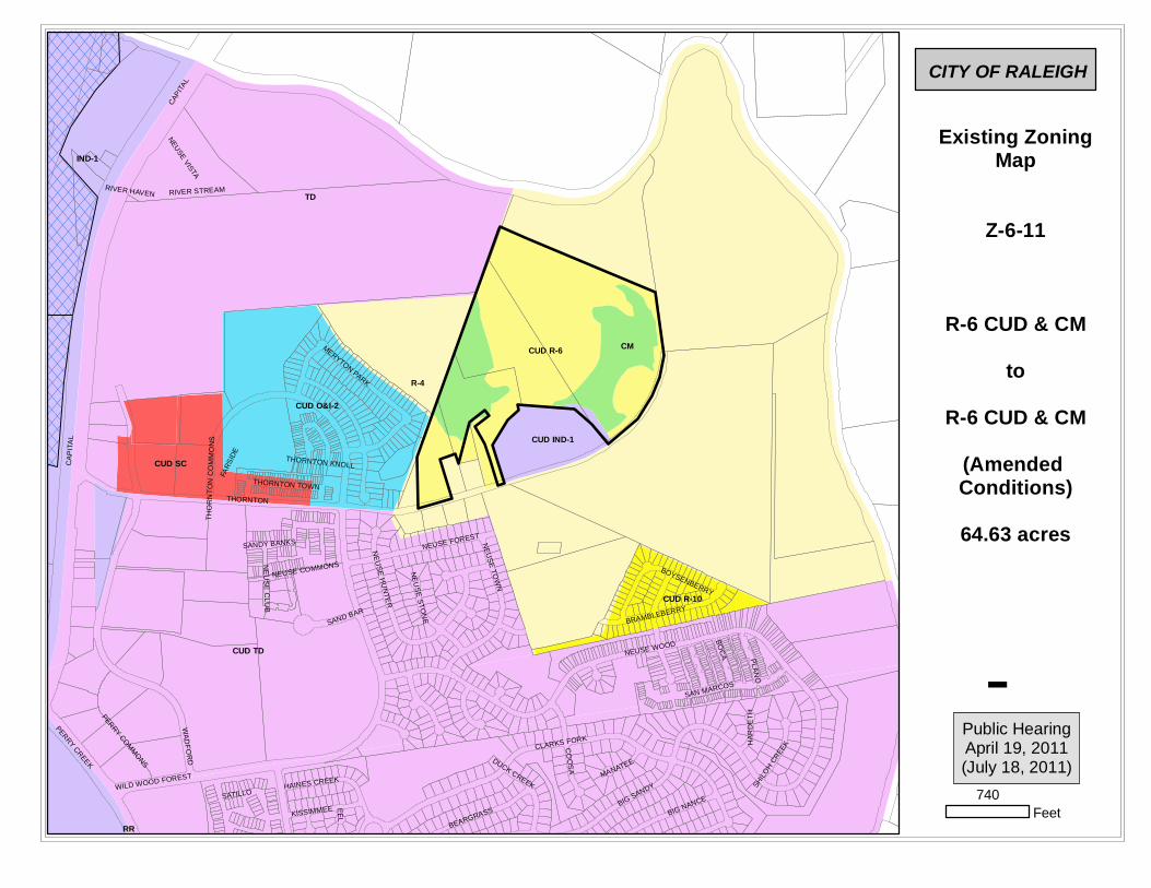
Existing ZoningMap
Z-6-11
R-6 CUD & CMto
R-6 CUD & CM(Amended Conditions)64.63 acres
CITY OF RALEIGH
740Feet
Public HearingApril 19, 2011(July 18, 2011)

Certified Recommendation Raleigh Planning Commission
CR# 11417
Certified Recommendation Z-6-11 / Thornton Rd and Thornton Common Dr
Case Information Z-6-11 Location North side of Thornton Road, East of its intersection with Thornton
Commons. Size 64.63 acres
Request Amend conditions for property zoned Residential-6 Conditional Use and Conservation Management
Comprehensive Plan Consistency Consistent Inconsistent Consistent Future Land Use
Designation
Low Density Residential and Public Parks and Open Space
Applicable Policy Statements
Policy LU 1.3 – Conditional Use District Consistency Policy LU 2.6 – Zoning and Infrastructure Impacts Policy LU 5.6 – Buffering Requirements Policy EP 2.2 – Environmentally Sensitive Development Policy EP 2.5 – Protection of Water Features Policy EP 3.4 – Low Impact Systems for Parking Policy EP 3.12 – Mitigating Stormwater Impacts Policy EP 4.2 – Floodplain Conservation Policy EP 4.3 – Development in the Floodplain
Summary of Conditions Submitted
Conditions • Limitation on permitted uses • Additional stormwater retention • Site debris removal • Transitional Buffer/Berm • Trip generation
Issues and Impacts
Outstanding Issues
1. Comprehensive Plan
policies related to development within the floodplain.
Suggested Conditions
1. Consider increased
stormwater mitigation.

Certified Recommendation Z-6-11 / Thornton Rd and Thornton Common Dr
Public Meetings Neighborhood
Meeting Public
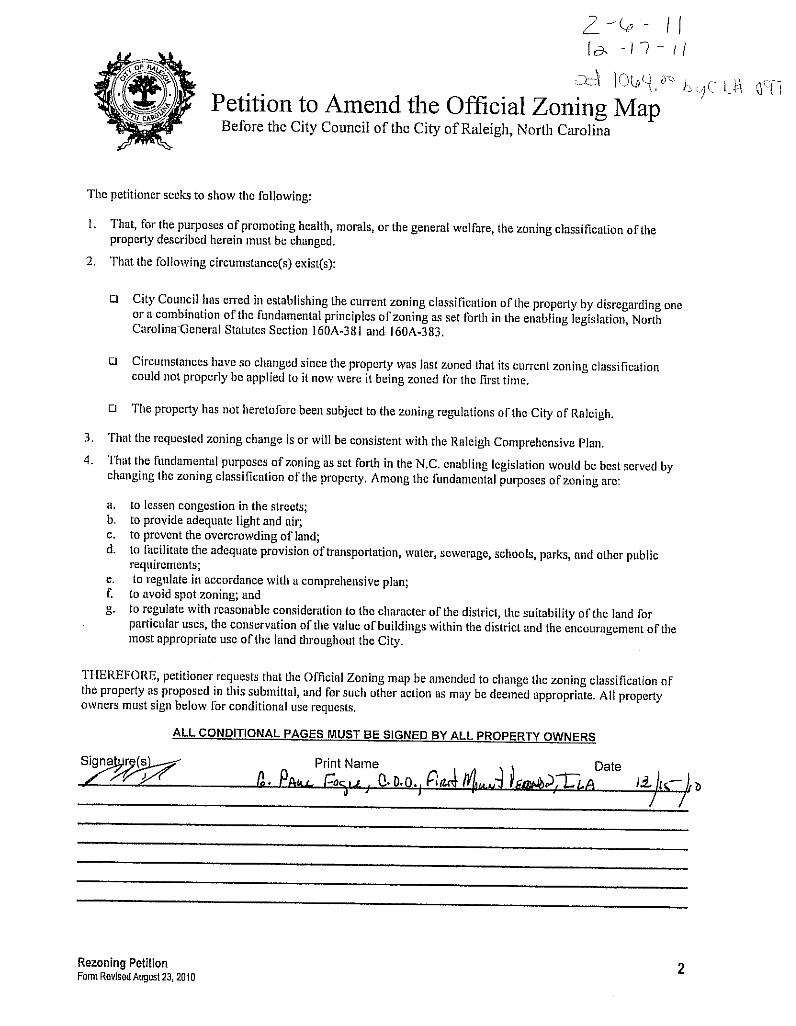
Hearing Committee Planning Commission 12/16/2010 4/19/2011 Date: Action 5/24/11–Recommend Approval
Valid Statutory Protest Petition
Attachments 1. Staff report 2. Existing Zoning/Location Map 3. Future Land Use
Planning Commission Recommendation Recommendation The Commission finds that this case is consistent with the
Comprehensive Plan and recommends that this case be approved in accordance with zoning conditions dated May 25th, 2011.
Findings & Reasons 1. The request is consistent with guidelines set forth in the Comprehensive Plan. The Future Land Use Map designates this area as being appropriate for Low Density Residential and Public Parks & Open Space. The proposed zoning will match these designations and be consistent with this designation.
2. The request is reasonable and in the public interest. The proposed zoning conditions will have no additional impact on this site, and will enable the applicant to develop multi-family residential dwellings. Allowing for this type of development could lessen the impact on this site. The applicant has also provided additional conditions that would limit trip generation and provide for clean up of the site.
3. The proposal is consistent and compatible with the surrounding area. The site is located in an area of mixed housing types and the proposal to introduce multi-family development to this property would be compatible.
Motion and Vote Motion: Anderson Second: Haq In Favor: Anderson, Bartholomew, Batchelor, Butler, Haq, Harris Edmisten, Mattox, Schuster, Smith, Sterling Lewis
This document is a true and accurate statement of the findings and recommendations of the Planning Commission. Approval of this document incorporates all of the findings of the attached Staff Report. ________________________________ ______________________________5/24/11__ Planning Director Date Planning Commission Chairperson Date Staff Coordinator: Stan Wingo [email protected]

Zoning Staff Report – Z-6-11 Conditional Use District
Request Location North side of Thornton Road, East of its intersection with Thornton
Commons. Request Amend conditions for properties zoned Residential-6 Conditional
Use and Conservation Management. Area of Request 64.63 acres Property Owner ProDev VIII LLC
PC Recommendation Deadline
July 18th, 2011
Subject Property Current Proposed
Zoning Residential-6 Conditional Use and Conservation Management
Residential-6 Conditional Use and Conservation Management
Additional Overlay N/A N/A Land Use Vacant Land Residential Development
Residential Density 180 dwelling units per conditions 387 dwelling units
Surrounding Area North South East West
Zoning Residential-4, Thoroughfare District
Residential-4 Residential-4 Residential-4, O&I-2 Conditional Use
Future Land Use
Low Density Residential
Low Density Residential, Public Parks and Open Space
Low Density Residential, Public Parks and Open Space
Low Density Residential, Public Parks and Open Space
Current Land Use
Vacant Land Vacant Land, Future Park Location, Single Family
Future Park Location, Vacant Land
Single Family Residential Subdivision, Vacant Land
Comprehensive Plan Guidance Future Land Use Low Density Residential, Public Parks and Open Space
Area Plan N/A Applicable Policies Policy LU 1.3 – Conditional Use District Consistency
Policy LU 2.6 – Zoning and Infrastructure Impacts Policy LU 5.6 – Buffering Requirements Policy EP 2.2 – Environmentally Sensitive Development

Staff Evaluation Z-6-11 / Thornton Rd and Thornton Common Dr 2
Policy EP 2.5 – Protection of Water Features Policy EP 3.4 – Low Impact Systems for Parking Policy EP 3.12 – Mitigating Stormwater Impacts Policy EP 4.2 – Floodplain Conservation Policy EP 4.3 – Development in the Floodplain
Contact Information Staff Stan Wingo – (919)516-2663 [email protected]
Applicant Mack Paul – (919)743-7326, Michael Birch – (919)743-7314 Citizens Advisory Council Northeast – Paul Brant
Case Overview This site is located on the north side of Thornton Road, east of its intersection with Thornton Commons Drive. The property is in close proximity to the Neuse River and is located almost entirely within the 100 year floodplain. The property is currently undeveloped, and is a mixture of wooded areas and wetlands. The site is bordered by Meryton Subdivision to the west, a waste transfer station and single family residential to the south, vacant land to the east, and the Neuse River to the north. The rezoning proposal requests a change in current zoning conditions on the property. The property was recently rezoned in 2008 (Z-22-08). The current Conservation Management zoning on site would remain, as would the majority of the zoning conditions. The applicant proposes to remove zoning conditions that would limit development to single family detached, and removal of the current restriction on density of 180 dwelling units. Conditions also limit the number of vehicle trips generated from development of the site.
Exhibit C & D Analysis Staff examines consistency with the Comprehensive Plan, compatibility with the surrounding area, public benefits and detriments of the proposal, and summarizes any associated impacts of the proposal.
1. Consistency of the proposed rezoning with the Comprehensive Plan and any applicable City-adopted plan(s)
1.1 Future Land Use
This area is designated as being appropriate for Low Density Residential and Public Parks and Open Space on the Future Land Use map. The Conservation Management zoning would not be amended, and would remain consistent with the Future Land Use Map. The allowable density for the proposed zoning district of Residential-6 Conditional Use would be the maximum allowed within the Low Density designation. While six units per acre is consistent with this designation, given the location and environmental constraints on the site, the applicant should consider less residential density to help mitigate environmental impacts.
Staff Evaluation Z-6-11 / Thornton Rd and Thornton Common Dr 3
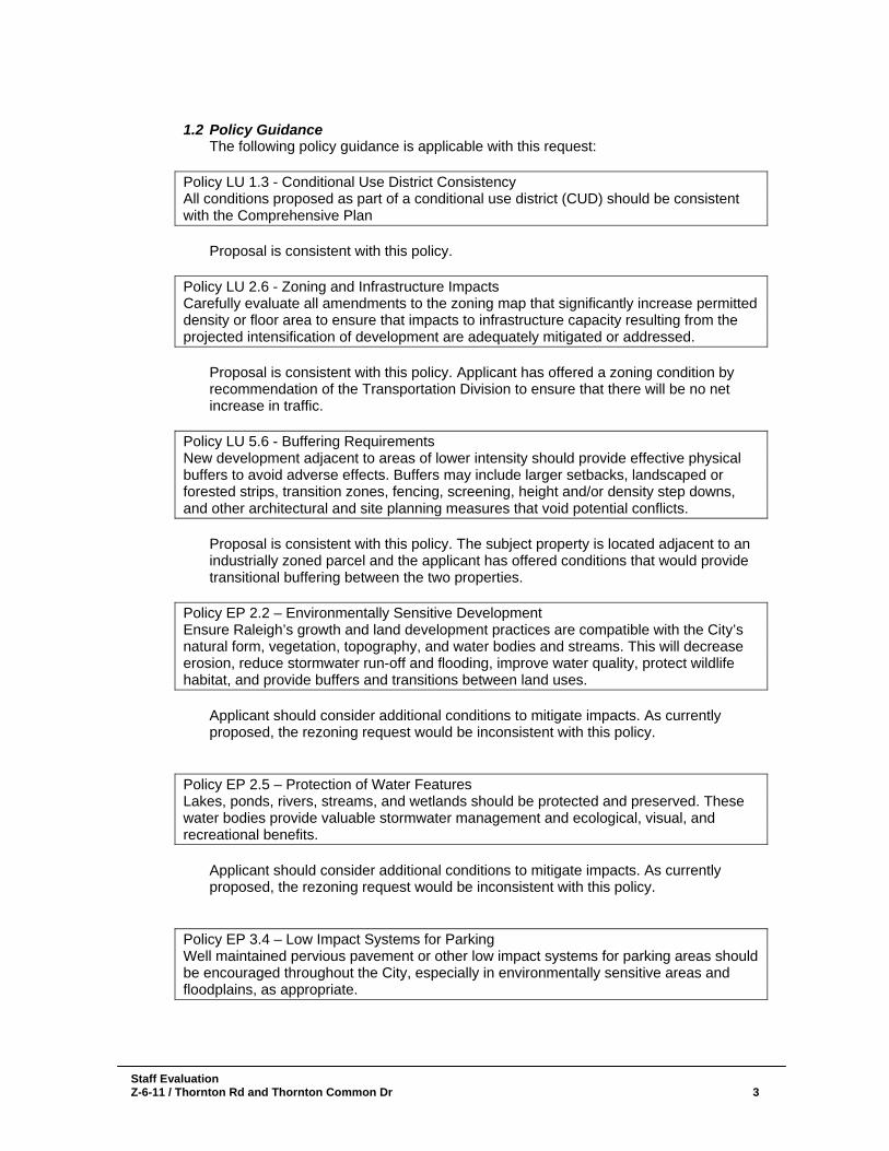
1.2 Policy Guidance
The following policy guidance is applicable with this request:
Policy LU 1.3 - Conditional Use District Consistency All conditions proposed as part of a conditional use district (CUD) should be consistent with the Comprehensive Plan
Proposal is consistent with this policy.
Policy LU 2.6 - Zoning and Infrastructure Impacts Carefully evaluate all amendments to the zoning map that significantly increase permitted density or floor area to ensure that impacts to infrastructure capacity resulting from the projected intensification of development are adequately mitigated or addressed.
Proposal is consistent with this policy. Applicant has offered a zoning condition by recommendation of the Transportation Division to ensure that there will be no net increase in traffic.
Policy LU 5.6 - Buffering Requirements New development adjacent to areas of lower intensity should provide effective physical buffers to avoid adverse effects. Buffers may include larger setbacks, landscaped or forested strips, transition zones, fencing, screening, height and/or density step downs, and other architectural and site planning measures that void potential conflicts.
Proposal is consistent with this policy. The subject property is located adjacent to an industrially zoned parcel and the applicant has offered conditions that would provide transitional buffering between the two properties.
Policy EP 2.2 – Environmentally Sensitive Development Ensure Raleigh’s growth and land development practices are compatible with the City’s natural form, vegetation, topography, and water bodies and streams. This will decrease erosion, reduce stormwater run-off and flooding, improve water quality, protect wildlife habitat, and provide buffers and transitions between land uses.
Applicant should consider additional conditions to mitigate impacts. As currently proposed, the rezoning request would be inconsistent with this policy.
Policy EP 2.5 – Protection of Water Features Lakes, ponds, rivers, streams, and wetlands should be protected and preserved. These water bodies provide valuable stormwater management and ecological, visual, and recreational benefits.
Applicant should consider additional conditions to mitigate impacts. As currently proposed, the rezoning request would be inconsistent with this policy.
Policy EP 3.4 – Low Impact Systems for Parking Well maintained pervious pavement or other low impact systems for parking areas should be encouraged throughout the City, especially in environmentally sensitive areas and floodplains, as appropriate.

Staff Evaluation Z-6-11 / Thornton Rd and Thornton Common Dr 4
Applicant should strongly consider the guidance of this policy. As this development will be almost entirely within the 100-year floodplain, a zoning condition requiring pervious paving materials will help to mitigate the impact of additional stormwater runoff from parking areas.
Policy EP 3.12 Mitigating Stormwater Impacts Potential stormwater impacts from new development on adjoining properties should mimic pre-development conditions and control the rate of runoff so as to avoid erosion of stream banks, inundation of natural waterways and to allow the recharging of groundwater. The intent is to avoid environmental and economic damage to the adjacent properties and City infrastructure.
Applicant should consider additional stormwater control measures to help mitigate impacts. As currently proposed, the rezoning request would be inconsistent with this policy.
Policy EP 4.2 – Floodplain Conservation Development should be directed away from the 100-year floodplain.
Proposal is inconsistent with this policy just based on its location. Nearly the entirety of this property is within the 100-year floodplain. The Zoning Code allows development of up to 50% of the 100-year floodplain.
Policy EP 4.3 – Development in the Floodplain Pursue regulatory approaches that avoid the future expansion of the floodplain. Floodplain development should not abridge the natural role of the floodplains to absorb water, recharge the groundwater and avoid flooding downstream.
Proposal is inconsistent with this policy; however, conditions could be offered to help mitigate impacts to the floodplain. Applicant should consider pervious paving and additional stormwater control measures.
2. Compatibility of the proposed rezoning with the property and
surrounding area The site is bordered to the north and east by vacant, undeveloped Residential-4 zoning. Industrial-1 Conditional Use zoning is adjacent to the south, and is developed with a waste transfer facility. Residential-4 zoning is located across Thornton Road to the south. The property to the west is vacant undeveloped Thoroughfare District zoning, undeveloped Residential-4, and Office and Institution-2 Conditional Use zoning which is developed as the Meryton Subdivision. The site is also in close proximity to the Neuse River and the majority of the property is within the 100-year floodplain. There are also low-lying wetland areas on site, which are currently zoned Conservation Management. If additional zoning conditions are proposed by the applicant, the request for rezoning could be compatible with the surrounding area. Due to the location and environmental constraints, conditions to help mitigate any additional impacts associated with grading and developing this site should be strongly considered. At a little over 64 acres, over 30 acres of this site could be graded and filled for development.

Staff Evaluation Z-6-11 / Thornton Rd and Thornton Common Dr 5
3. Public benefits of the proposed rezoning
The proposal requests to remove zoning conditions that currently limit development to single family detached, and a total of 180 units. This would allow for the potential development of multifamily residential on this site, with significantly more density. While this would require parking lots and significant amounts of impervious surface, additional zoning conditions could help mitigate the potential increased impacts associated with the removal of these conditions. The introduction of multifamily development could also encourage the consolidation of density, which would lessen the amount of land area affected by grading and fill. Additional stormwater provisions could actually decrease the impact of potential development on this site, and would therefore be considered a benefit to the surrounding area. Applicant should consider limiting impervious surfaces and increased stormwater measures.
4. Detriments of the proposed rezoning As currently proposed, the request does not meet several policies related to stormwater mitigation, and its location within the floodplain. The development of this site without increased measures for stormwater retention and impervious surfaces could negatively impact the surrounding area. As noted previously, the majority of the site is within the 100 year floodplain.
5. The impact on public services, facilities, infrastructure, fire and safety, parks and recreation, etc.
Primary Streets
Classification
Current Volume (ADT)
2035 Forecasted Volume (ADT)
Thornton Road
Collector
N/A
N/A
Street Conditions Thornton Road
Lanes
Curb and Gutter
Right-of-Way
Sidewalks
Bicycle Accommodations
Existing 2
None
60'
None
none
City Standard 2
Back-to-back curb and gutter section
60'
5' sidewalks on minimum
of one side
N/A Meets City Standard? YES NO YES NO N/A Expected Traffic Generation [vph]
Current Zoning
Proposed Zoning
Differential
AM PEAK 135 281 146
PM PEAK 178 356 178
Suggested Conditions/ Impact Mitigation:
Traffic Study Determination: Staff has reviewed a trip generation report for this case. Based on the increase of development intensity proposed on the subject property a traffic impact analysis is recommended for this case. The traffic impact analysis will need to evaluate the intersections on Capital Blvd at Thornton Road and Durant Road. The traffic impact analysis will also need to include the existing multi-modal level of service.
Additional Information:
Neither NCDOT nor the City of Raleigh have any roadway construction projects scheduled in the
Staff Evaluation Z-6-11 / Thornton Rd and Thornton Common Dr 6
5.1 Transportation Impact Identified: Applicant has offered a zoning condition that ensures that there will be no net increase in traffic.
5.2 Transit This area is not slated for transit in the mid range transit plan. Therefore, no transit easements or amenities are requested. Impact Identified: None
5.3 Hydrology
Floodplain FEMA Floodplain present (majority of site) Drainage Basin Neuse
Stormwater Management
Subject to Part 10, Chapter 9
Overlay District none Impact Identified: none
5.4 Public Utilities
Maximum Demand (current)
Maximum Demand (proposed)
Water 226,205 gpd 226,205 gpd Waste Water 226,205 gpd 226,205 gpd
The proposed rezoning will not affect the wastewater collection or water distribution systems of the City. There is an existing forty-two (42”) inch sanitary sewer traversing the property within an existing easement. The proposed sanitary sewer mains of the subsequent development can only make connection to the City’s sanitary sewer system at the existing manholes of the forty-two (42”) inch sanitary sewer main. The owner will need to extend the existing twelve (12”) inch water main, which terminates just west of the requested properties, along the properties’ road frontage within the Thornton Road right-of-way. All sanitary sewer and water mains required by the proposed development will be at the owner’s costs.
5.5 Parks and Recreation The subject tract is not located adjacent to greenway corridor. Recreation services for the subject tract will be provided at the Thornton Road Park site. Impact Identified: This rezoning case does not impact the level of recreation service of the area.
5.6 Urban Forestry Impact Identified: If the rezoning and the zoning lines stay the same, there will not be any impact on the tree conservation requirements.
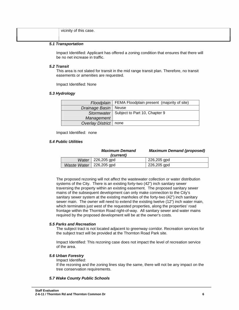
5.7 Wake County Public Schools
vicinity of this case.
Staff Evaluation Z-6-11 / Thornton Rd and Thornton Common Dr 7
School name Current
EnrollmentCurrent Capacity
Future Enrollment
Future Capacity
Wildwood Forest 1,025 119.2% 1,079 125.5% East Millbrook 1,116 95.3% 1,148 98.0% Wakefield 2,626 93.4% 2,649 94.2%
Impact Identified: Proposal could potentially increase elementary school enrollment to over 125% capacity. The additional number of units could increase middle school enrollment to 98%, and high school enrollment to over 94%.
5.8 Designated Historic Resources This site is not located within a Historic District, and does not contain any Historic Landmarks. Impact Identified: None
5.9 Impacts Summary • There were no known impacts identified.
5.10 Mitigation of Impacts
• Impacts have been mitigated through zoning conditions.
6. Appearance Commission This proposal would not be subject to review by the Appearance Commission.
7. Conclusions As proposed this rezoning request is consistent with the Comprehensive Plan. The Future Land Use Map designates this area as being appropriate for Low Density Residential, and Public Parks & Open Space. Both designations are consistent with the proposed zoning as amended. Although the request is consistent overall with the Comprehensive Plan’s vision for this area, there are several outstanding policy items that should be noted. These applicable guidance policies are primarily within the Environmental Protection element of the Comprehensive Plan. As this site is covered in majority by the 100-year floodplain, several policies would be applicable to help lessen any impacts associated with development. As currently conditioned, the proposed amendment would not be consistent with the above mentioned policies. With additional zoning conditions the proposal could mitigate any potential additional impacts to the environment, while potentially lowering the current development impact potential. Consolidating density, decreasing impervious surfaces and increasing stormwater retention would significantly reduce the impact of development on this site.

Staff Evaluation Z-6-11 / Thornton Rd and Thornton Common Dr
Existing Zoning Map

Staff Evaluation Z-6-11 / Thornton Rd and Thornton Common Dr 9
Future Land Use Map