executive summary - pittsburghapps.pittsburghpa.gov/pwsa/pwsa_wwfs_executive_summary.pdfexecutive...
TRANSCRIPT

Executive Summary
PWSA Wet Weather Feasibility Study ES-1 July 2013
The Pittsburgh Water and Sewer Authority (PWSA) is submitting this Wet Weather Feasibility Study to the Pennsylvania Department of Environmental Protection (PaDEP) and the Allegheny County Health Department (ACHD) on July 31, 2013. The Executive Summary provides an overview of the Wet Weather Feasibility Study report, including the regulatory background, the alternative evaluation and recommended plan, financial and affordability analysis, implementation of the plan, and the integrated watershed planning approach.
REGULATORY REQUIREMENTS
Administrative Consent Orders (ACOs) and Consent Order and Agreements (COAs) were issued in early 2004 to the City of Pittsburgh and the other 82 communities tributary to the Allegheny County Sanitary Authority (ALCOSAN) conveyance and collection system, directing compliance with the Pennsylvania Clean Streams Law of 1937 and the Federal Clean Water Act (CWA).
The ACOs were issued to separate sewer communities by the Allegheny County Health Department, and the COAs were issued to combined sewer communities, like the City of Pittsburgh, by the Pennsylvania Department of Environmental Protection. The initial COA among the PWSA, the City of Pittsburgh, the PaDEP, and the ACHD was entered into on January 29, 2004, and later amended in July 2007. Subsequent to that, in January 2008, ALCOSAN entered into a Consent Decree (CD) with the US Department of Justice and the US Environmental Protection Agency (USEPA), PaDEP, and ACHD. ALCOSAN’s CD required them to prepare and submit an approvable Wet Weather Plan (WWP) by January 2013.
These ACOs, COAs, and the ALCOSAN CD require the respective entities to gather data and information, characterize their respective systems, analyze and perform alternatives analyses, and submit feasibility studies addressing work required to bring their systems into compliance with the Pennsylvania Clean Streams Law and the CWA, eliminate sanitary sewer overflows (SSO), and fulfill the Pennsylvania and USEPA combined sewer overflow (CSO) Policy obligations. ALCOSAN’s CD not only requires ALCOSAN to submit a plan to the regulators by January 2013, but also requires the facilities, including the municipal facilities, be constructed and in operation by 2026. Municipalities tributary to ALCOSAN, including PWSA, are required to submit their feasibility studies to the regulators within six months of ALCOSAN’s submission (by July 31, 2013).

Executive Summary
PWSA Wet Weather Feasibility Study ES-2 July 2013
BACKGROUND WORK BY PWSA
This Wet Weather Feasibility Study is the culmination of several studies and activities to fulfill the requirements of the City of Pittsburgh/PWSA COA. The first, most significant of these studies was the PWSA Feasibility Study Report (October 2008) which identified and presented technology, cost, and non-cost analyses that would allow the PWSA to select appropriate CSO control alternatives that best meet the environmental requirements. The technology screening process and analysis used to identify and select CSO control alternatives for the October 2008 plan are still valid, were summarized, are presented in this Wet Weather Feasibility Study and form the foundation upon which this Feasibility Study is based.
In addition, the intent of the October 2008 report was to place the PWSA in a position to work with ALCOSAN in an effort to mutually develop the best regional plan as their work proceeded. The October 2008 report built upon the information presented in a series of CSO abatement reports prepared for PWSA, which included the following:
• Closed-Circuit Television Report (February 2006)
• Receiving Water Quality Assessment Program Technical Memorandum (December 2006)
• PWSA Combined Sewer Overflow Report (January 2007)
• CSO Quality Assessment Technical Memo (June 2007)
• Collection System Inventory and Characterization Report (August 2008)
• Hydraulic and Hydrologic Characterization Report (September 2008)
As part of the more recent coordination process, ALCOSAN requested that they be provided with municipal draft feasibility study information by July 2012 so that such information could be considered as they prepared their Wet Weather Plan. PWSA provided ALCOSAN with a document entitled Report on the Current Status of the Development of the Wet Weather Feasibility Study for the City of Pittsburgh Sewerage System, dated July 31, 2012. The preliminary information described the currently identified system improvements, approximate locations and general arrangements of facilities, estimated costs of facilities, anticipated performance in terms of CSO discharges, and the anticipated flows to be conveyed through the PWSA system to ALCOSAN interceptor facilities. The information in the report is organized by the name of the ALCOSAN Point of Connection (POC) at which the PWSA system

Executive Summary
PWSA Wet Weather Feasibility Study ES-3 July 2013
connects to the ALCOSAN system. The report addresses both the internal PWSA alternatives that were evaluated for POC sewersheds in which the PWSA is the sole contributor of flow, and for POC sewersheds in which both PWSA and tributary municipalities are flow contributors.
OBJECTIVES OF THE WET WEATHER FEASIBILITY STUDY
The objectives of PWSA’s Wet Weather Feasibility Study were generated from a combination of objectives outlined in the Feasibility Study Working Group (FSWG) Document 027 and the PaDEP’s Draft Feasibility Study Outline. The objectives of this feasibility study include:
• Identify and present technology, cost, and non-cost analyses that will allow PWSA to select appropriate CSO control alternatives that best meet the requirements set forth in the City of Pittsburgh/PWSA COA (as amended)
• PWSA will, at the same time, lay the framework for maximizing utilization of green infrastructure technologies and explore the benefits of integrated watershed planning.
• Participate and cooperate with ALCOSAN in the development of their WWP.
• Submit a municipal flow management compliance plan, also known as a Feasibility Study (FS), by the end of July 2013. The FS will evaluate a range of practicable alternatives to:
o Meet CWA and Clean Stream Law requirements
o Eliminate SSOs
o Fulfill Pennsylvania and USEPA CSO Policy obligations
o Develop POC Feasibility Studies in conjunction with municipalities that are tributary to PWSA. These POC reports will be named by both the PWSA sewershed name and the ALCOSAN POC sewershed name, to enhance future coordination between the PWSA and ALCOSAN.
o Develop short-term and long-term flow management proposals that will meet the PWSA’s flow management objectives through September 30, 2046, in a manner that is affordable and acceptable to the PWSA and the City of Pittsburgh.

Executive Summary
PWSA Wet Weather Feasibility Study ES-4 July 2013
PWSA COORDINATION OVERVIEW
There are 24 communities adjacent to the City of Pittsburgh that are tributary to, and contribute flow to, the PWSA collection system. In accordance with the January 24, 2004 COA (as amended), PWSA has been coordinating directly with representatives from these municipalities and through the 3 Rivers Wet Weather Demonstration Program (3RWWDP). PWSA has maintained a close working relationship with 3RWWDP in order to facilitate an on-going exchange of mapping information and data.
In order for ALCOSAN to develop and formalize a Wet Weather Plan (WWP) in accordance with their CD, its service area was divided into seven planning basins and commissioned consulting firms with the task of studying each planning basin so that a uniform WWP approach can be achieved. This planning and study process was completed in 2012. ALCOSAN has integrated the recommended controls for each of the planning basins into a comprehensive WWP that was submitted to the appropriate regulatory agencies on January 30, 2013.
The PWSA sewage collection system is largely located within ALCOSAN’s Main Rivers planning basin; however, the PWSA service area also extends into ALCOSAN’s Upper Allegheny/Pine Creek, Lower Ohio/Girty’s Run, Saw Mill Run, Chartiers Creek, and Upper Monongahela planning basins. To date, the PWSA has shared the results of their wet weather planning with ALCOSAN and the affected tributary municipalities, and will continue to coordinate with all involved parties as required such that all plans are complementary.
A map of the ALCOSAN service area and the seven planning basins is shown in Figure ES-1.

Figure ES - 1: ALCOSAN Service Area & Planning Basins
Up p er M o no n ga he l aUp p er M o no n ga he l a
2, 5 & 1 0 Y e ar S to r m s
2, 5 & 1 0 Y e ar S to r m s
2, 5 & 1 0 Y e ar S to r m s
5 & 1 0 Y e ar S to r m s
5 & 1 0 Y e ar S to r m s
Chartiers Creek
Lower Ohio River/Girty's Run
Main Rivers
Saw Mill Run
Upper Allegheny/Pine Creek
Upper Monongahela
Pittsburgh
Plum Borough
Murrysville
Monroeville
Moon Township
Findlay Township
Peters Township
North Fayette Township
North Huntingdon Township
Ross Township
Indiana Township
Elizabeth Township
Penn Hills Township
Penn Township
South Fayette Township
Hampton Township
Collier Township
Robinson Township
McCandless Township
Jefferson Hills Borough
West Mifflin Borough
Shaler Township
West Deer Township
Franklin Park Borough
Bethel Park Borough
Frazer Township
Ohio Township
McKeesport
South Park Township
Upper St. Clair Township
Mount Lebanon
Clairton
Fox Chapel Borough
Forward Township
Harmar Township
Baldwin Borough
White Oak Borough
Pine Township
North Versailles Township
Lincoln Borough
Kennedy Township
Bell Acres Borough
Sewickley Heights Borough
Scott Township
Richland Township
O Hara Township
O Hara Township
Duquesne
Harrison Township
Marshall Township
Whitehall Borough
Wilkins Township
Kilbuck Township
Fawn Township
Stowe Township
Neville Township
East Deer Township
Crescent Township
Pleasant Hills Borough
Churchill Borough
Springdale Township
Leet Township
Reserve Township
Wilkinsburg Borough
Aleppo Township
Green Tree Borough
Oakmont Borough
Glassport BoroughLiberty Borough
Carnegie Borough
Edgeworth Borough
Tarentum Borough
Port Vue Borough
Swissvale Borough
Glenfield Borough
Springdale Borough
West View Borough
Munhall Borough
Sewickley Hills Borough
Trafford Borough
Forest Hills Borough
Coraopolis Borough
Brentwood Borough
Crafton Borough
Castle Shannon Borough
Bellevue Borough
North Braddock Borough
Leetsdale Borough
Sewickley Borough
Etna Borough
Bridgeville Borough
Dravosburg Borough
McKees Rocks Borough
Turtle Creek Borough
Avalon Borough
Dormont Borough
Millvale Borough
Braddock Hills Borough
West Homestead Borough
South Versailles Township
Verona Borough
Emsworth Borough
Braddock Borough
Osborne Borough
Homestead BoroughRankin Borough
Wall Borough
Pitcairn Borough
Sharpsburg Borough
Edgewood Borough
Cheswick Borough
Versailles Borough
Baldwin Township
Oakdale Borough
Ingram Borough
Brackenridge Borough
Blawnox Borough
Ben Avon Borough
Rosslyn Farms Borough
Thornburg Borough
Wilmerding Borough
Elizabeth Borough
Aspinwall Borough
Whitaker Borough
McDonald Borough
East Pittsburgh Borough
Mount Oliver Borough
East McKeesport Borough
Heidelberg Borough
Haysville Borough
West Elizabeth Borough
Trafford BoroughMcDonald Borough
Chalfant Borough
Ben Avon Heights Borough
Pennsbury Village Borough
ALCOSAN Service Area Overview
Path: P:\Water\PWSA FS\Working\400 Technical\GIS FILES\FIGURE ES-1_ALCOSAN SERVICE AREA_PLANNING BASIN.mxd
¹
14,000 0 14,0007,000 Feet
July 2013
Turtle Creek
LegendMunicipal BoundaryChartiers CreekLower Ohio River / Girty's RunMain RiversSaw Mill RunTurtle CreekUpper Allegheny / Pine CreekUpper MonongahelaRiver

Executive Summary
PWSA Wet Weather Feasibility Study ES-6 July 2013
DESCRIPTION OF SEWER SYSTEM
PWSA’s downstream regional wastewater treatment provider is ALCOSAN. The ALCOSAN wastewater treatment plant (WWTP), which was first placed into operation in 1959, is located on a 50-acre site along the north shore of the Ohio River, downstream from Woods Run, in the City of Pittsburgh. Although the WWTP currently processes an average of 250 million gallons per day (mgd) of wastewater, which represents treatment service for the City of Pittsburgh and the other 82 customer municipalities, during wet weather events combined sewer overflows (CSOs) are discharged into the rivers.
This regional sewage treatment provider also maintains approximately 92 miles of interceptor sewer consisting of over 300 regulator structures, five pump stations, two ejector stations, deep tunnels, shallow-cut interceptor sewers, and river crossings. A number of the CSO diversion structures are located along ALCOSAN interceptors. The purpose of the diversion structures is to intercept and convey dry weather flows to the wastewater plant while diverting combined flows that would exceed the capacity of the interceptor and treatment plant to receiving waters. Overflows are discharged into receiving waters by a CSO outfall either located at the diversion structure or at the downstream end of an overflow pipe. Many diversion structures that have low invert elevations are equipped with flap gates to prevent water and sediment components of the receiving waters from entering the diversion structure and associated interceptor.
The PWSA sewer system is primarily a combined collection system that serves the City of Pittsburgh. The PWSA sewage collection system also serves as a conveyance system for portions of flows from 24 neighboring municipalities. Wastewater flows generated in neighboring communities are conveyed through parts of the PWSA collection system to the ALCOSAN interceptor system.
The PWSA sewer collection system consists of approximately 1,080 miles of sewer ranging in size from six inches to 156 inches, and 29,000 manholes. Approximately 77 percent of the PWSA service area is served by combined sewers; however, the percentage of separate sanitary and storm sewers is gradually increasing as required sewer separation occurs during redevelopment. There are 74 active diversion structures, also known as diversion chambers, within the PWSA sewer system.

Executive Summary
PWSA Wet Weather Feasibility Study ES-7 July 2013
There are four sewage pump stations within the PWSA sewer system.
The current NPDES permit that authorizes PWSA to discharge combined sewage requires that the Authority maintain all of its facilities in accordance with the Nine Minimum Controls (NMC) to minimize the duration and frequency of CSO discharges. PWSA has recently reconciled the number of permitted CSOs within their system, as some of them had been modified or closed as part of their COA compliance activities. A map of the PWSA sewer service area, including major trunk sewers, is shown as Figure ES-2 on the following page.
Multi-Municipal Systems and POC Reports
There are some points of connection (POCs) that receive flow from more than one municipality. These are considered to be “multi-municipal” systems and a solution for managing flow would have to consider each of the contributing municipalities. Based on the complexity and size of PWSA’s system as well as potential required coordination with upstream municipalities and the downstream treatment provider ALCOSAN, PWSA has developed a total of 14 POC reports, one for each of the sewersheds in which improvements are proposed. Ten of the 14 sewersheds are multi-municipal; two of those have very minor tributary area contribution (A-51 and MH-11). A list of the POC reports, which are included in Appendix A of the Wet Weather Feasibility Study, is as follows:
1. A-42 Negley Run 2. A-51 East Street 3. C-25 Bells Run 4. M-34 Becks Run 5. M-42 Streets Run 6. M-47 Nine Mile Run 7. MH-11 McCartney Run 8. MH-18 Little Saw Mill Run 9. MH-55 Timberland Street 10. MH-77 Brookline Boulevard 11. MH-80 Englert Street 12. S-15 McNeilly / McDonough’s Run 13. S-23 Brook Street 14. SMRE-40 Plummer’s Run
Figure ES-3 shows the location of each of the 14 POC sewersheds relative to PWSA’s service area.

Figure ES - 2: PWSA Service Area
Pittsburgh
West Mifflin Borough
Penn Hills Township
Ross Township
Collier Township
Robinson Township
Shaler Township
Mount Lebanon
McKeesport
Baldwin Borough
Kennedy Township
Scott Township
Bethel Park Borough
Upper St. Clair Township
Fox Chapel Borough
O Hara Township
Duquesne
Whitehall Borough
O Hara Township
North Versailles Township
Stowe Township
Wilkins Township
Munhall Borough
Kilbuck Township
Churchill Borough
Neville Township
Reserve Township
Wilkinsburg Borough
Green Tree Borough
Oakmont Borough
Carnegie Borough
Pleasant Hills Borough
Swissvale Borough
Port Vue Borough
West View Borough
Ohio Township
South Fayette TownshipWhite Oak Borough
Forest Hills Borough
Brentwood Borough
Crafton Borough
Castle Shannon Borough
Bellevue Borough
North Braddock Borough
Etna Borough
Bridgeville Borough
Dravosburg Borough
McKees Rocks Borough
Turtle Creek Borough
Plum Borough
Avalon Borough
Dormont Borough
Millvale Borough
Braddock Hills Borough
West Homestead Borough
Glenfield Borough
Verona Borough
Emsworth Borough
Braddock Borough
Homestead BoroughRankin Borough
Sharpsburg Borough
Edgewood Borough
Baldwin Township
Glassport Borough
Ingram Borough
Blawnox Borough
Ben Avon Borough
Rosslyn Farms Borough
Thornburg Borough
South Park Township
Aspinwall Borough
Whitaker Borough
Harmar Township
East Pittsburgh Borough
Mount Oliver Borough
Wilmerding BoroughHeidelberg Borough
Chalfant Borough
Liberty Borough
Ben Avon Heights Borough
East McKeesport Borough
Pennsbury Village Borough
Jefferson Hills Borough
PWSA Service Area Overview
Path: P:\Water\PWSA FS\Working\400 Technical\GIS FILES\FIGURE ES-2 PWSA SERVICE AREA.mxd
7,000 0 7,0003,500 Feet
July 2013
¹
LegendTrunk SewersPWSA Service Area BoundaryExtended PWSA Service Area BoundaryMunicipal BoundaryRiver
Existing ALCOSAN InterceptorDeep TunnelShallow Cut

Figure ES - 3: POC Sewersheds
PWSA Service Area Overview
Path: P:\Water\PWSA FS\Working\400 Technical\GIS FILES\FIGURE ES-3 POC SEWERSHED MAP.mxdJuly 2013
¹
LegendTrunk SewerPWSA Service Area BoundaryMunicipal BoundaryM-47 Sewershed BoundaryS-15 Sewershed BoundaryS-23 Sewershed BoundaryMH-55 Sewershed BoundaryMH-77 Sewershed BoundaryMH-80 Sewershed BoundaryA-42 Sewershed BoundaryM-34 Sewershed BoundaryMH-11 Sewershed BoundaryM-42 Sewershed BoundaryC-25 Sewershed BoundaryA-51 Sewershed BoundaryMH-18 Sewershed BoundarySMRE-40 Sewershed BoundaryRiver
Existing ALCOSAN InterceptorDeep TunnelShallow Cut
6,000 0 6,0003,000 Feet

Executive Summary
PWSA Wet Weather Feasibility Study ES-10 July 2013
Direct Stream Inflows
PWSA completed an evaluation of the cost effectiveness of disconnecting direct stream inflow (DSI) connections from their sewage conveyance system. The evaluation was conducted in accordance with Paragraph 8.a.ii of the COA. Significant stream inflow exists at these locations:
• Discharge from Panther Hollow Lake and the tributary stream in the Four Mile Run drainage area, tributary to ALCOSAN CSO structure M-29.
• Multiple locations in the Woods Run drainage area, tributary to ALCOSAN CSO structure O-27.
• Stream inflow into the Spring Garden drainage area in Reserve Township, tributary to ALCOSAN CSO structure A-60.
• Stream inflow from Corks Run drainage area, tributary to CSO O-13.
• Stream inflow in Sheraden Park, tributary to ALCOSAN CSO C-07.
• Stream inflow into the storm sewer system in the vicinity of Freid and Reineman Streets, tributary to ALCOSAN CSO A-66.
Conceptual approaches for the removal of the identified stream connections were developed. Sizing of separate storm sewer systems was completed using 5-year design storm conditions, and sizing of new separate sanitary sewer facilities was based on the 10-year design storm. Estimates of the cost of the facilities required to disconnect stream inflows from the PWSA and ALCOSAN systems were developed.
It was determined that the following two stream removal projects located within or directly impacting the PWSA system were cost effective and have either been completed or are in the process of being completed:
• Sheraden Park Direct Stream Inflow Removal and Stream Restoration. ALCOSAN, the City of Pittsburgh, PWSA, and the U.S. Army Corps of Engineers have and continue to partner in the removal of direct stream inflows into PWSA’s combined sewer system in Sheraden Park. PWSA has completed rerouting of the combined sewer system from the culverted stream. The stream is being daylighted to flow into Chartiers Creek.
• Jack’s Run Direct Stream Inflow Removal and Stream Restoration. ALCOSAN, the City of Pittsburgh, PWSA, Ross Township, and Bellevue Borough partnered to remove a major direct stream inflow into ALCOSAN’s Lower Ohio River interceptor sewer. The stream was re-routed and the stream bed was reconstructed.

Executive Summary
PWSA Wet Weather Feasibility Study ES-11 July 2013
System Characterization
PWSA and Regional Flow Monitoring. In support of the previous planning studies, PWSA conducted a comprehensive sewer flow monitoring program in 2004. The purpose of the program was to collect sewer flow and rainfall data for the PWSA collection system, including inputs from outlying communities.
Potential monitoring sites were investigated between October 2003 and January 2004, and 418 monitors were then installed in selected sites between January and March 2004. Data from those meters were collected from March 2004 to July 2004, at which time 397 of the 418 flow monitors were removed. The remaining 21 flow monitors were left in place and continued to monitor flows through October 2004. The flow monitoring locations are shown in Figure ES-4 below.
FIGURE ES-4. FLOW MONITORING LOCATIONS

Executive Summary
PWSA Wet Weather Feasibility Study ES-12 July 2013
On June 1, 2006, a Regional Flow Monitoring Plan (RFMP), which was assembled by 3RWW with direct input from ALCOSAN, PWSA, and the Flow Monitoring Working Group (FMWG), was submitted to the PaDEP and the ACHD for review and approval. The FMWG was composed of engineers and technical representatives from ALCOSAN, regulatory agencies, and approximately 50 municipalities within the ALCOSAN service area, including PWSA.
In response to the Agencies’ comments and provisions of the ALCOSAN CD, ALCOSAN prepared a Regional Collection System Flow Monitoring Plan (RCS-FMP) that incorporated most of the provisions of the RFMP and provided comprehensive flow monitoring of both the ALCOSAN system and the municipal collection systems.
In regards to sewer defects and repairs, PWSA is actively pursuing through a currently ongoing storm water drainage study the potential remedies to the identified illicit connections found via a COA mandated dye testing program. During the period from 2006 to 2012, sewers segments were rehabilitated in both the combined and sanitary portions of the collection systems by PWSA through a cured-in- place-pipe (CIPP) lining process. This is an important step in limiting the opportunities for infiltration to enter the sewer system and rehabbing defects such as fractured, broken, and deformed sections of pipe. Sewer lining has the additional benefit of reducing the number of lateral connections by only reinstating the active laterals.
Development and Calibration / Verification of H&H Models. The original 2008 Preliminary Draft Feasibility Study was updated for the 2012 Feasibility Study by utilizing the regional hydrologic and hydraulic (H&H) model developed by ALCOSAN. ALCOSAN’s wet weather planning process included the development of a regional sewer system H&H model that built upon and expanded the initial PWSA H&H model. The ALCOSAN model extends deeper into the municipal systems tributary to the PWSA system, and provides information about the performance and impacts of those tributary systems on the existing PWSA system. PWSA agreed to use the ALCOSAN H&H model in its planning process as a means of improving modeling resolution throughout the regional system and achieving consistency with the basis of planning throughout the region.
PWSA has coordinated with ALCOSAN by providing planning level information throughout the basin planning process. PWSA’s information was used by
Executive Summary
PWSA Wet Weather Feasibility Study ES-13 July 2013
ALCOSAN and their basin planners to determine a number of conditions which were the basis for the ALCOSAN H&H models. The conditions are the following:
• Existing Condition. The state of the system and service area in 2008, with an ALCOSAN plant capacity of 250 mgd (as of the first quarter of 2009).
• Baseline Condition. The state of the system and service area in 2008, with any planned ALCOSAN and municipal projects which are certain to be implemented.
• Future Baseline Condition. The state of the system and service area in 2046, including changes due to planned development/re-development, but without implementation of the wet weather plan improvements.
• Future Condition (2046). The predicted state of the system and the service area 20 years after the implementation of the planned improvements.
The planning horizon date for the H&H models is September 2046.
PWSA Sewer Capacity Analysis. The performance of the existing sewerage facilities was evaluated under the projected future loadings, current diversion structure settings and 2-year, 5-year, and 10-year design storm conditions. Performance was evaluated in terms of the basic criteria that no flooding or overflows from sanitary sewers or significant manhole surcharging should occur.
There have been about 144 locations where more than one basement backup complaint between January 1, 2004 and December 31, 2012 was reported through PWSA’s complaint/dispatch center. However, there is no conclusive correlation between these complaints and capacity constraints. A large majority of the complaints in the record were considered to be unrelated to insufficient capacity in the sewer. The complaint records include brief descriptions of the responses by PWSA operations staff to each report and often identify the apparent causes for the complaint. Typical causes for backups included: problems with the customer’s lateral, the need for cleaning of the public sewer, and the need for cleaning of nearby catch basins. In many cases, the causes of the reported problems were not evident to the field personnel. Addresses for which more than one incident is reported were considered to be potentially caused by public sewer capacity problems.
Executive Summary
PWSA Wet Weather Feasibility Study ES-14 July 2013
Water Quality Issues. Water quality issues are the driving force behind the PWSA’s COA requirements. These requirements stem from the existing water quality criteria in local streams that are not being met, some as a result of combined and separate overflows.
To develop a “water-quality based” plan for PWSA, initial water quality objectives were established:
• Receiving water quality must meet the requirements corresponding to its designated use.
• If the above requirements are not being met, PWSA must understand the corresponding impairment(s) to “designated use.”
• Remaining CSO discharges must not contribute to the impairment of “designated use,” i.e. “neither cause nor contribute to a violation of WQS.”
• If “designated uses” are still not met, discussions should be initiated with PaDEP regarding the development of a Use Attainability Analysis (UAA) which, by definition, is a structured scientific assessment of the factors affecting the attainment of the use, which may include physical, chemical, biological, and economic factors.
Wherever a “designated use” is not being met due to water quality issues, the stream is said to be impaired. For example, if bacteria counts are consistently above 400 CFU/100 ml in streams, it means that partial or total body contact cannot be allowed. In other words, swimming, water skiing, and similar sports cannot be undertaken due to violations of the bacteria standards. “Use impairments” are normally documented in the USEPA’s 303(d) list. The USEPA website states: “The term, '303(d) list’, is short for the list of impaired waters (stream segments, lakes) that the Clean Water Act requires all states to submit for USEPA approval every two years (even-numbered years). The states identify waters where required pollution controls are not sufficient to attain or maintain applicable water quality standards and rank the waters taking into account the uses of the water and severity of the pollution problem.
PWSA has over 150 outfalls that are jointly permitted with ALCOSAN. These outfalls are addressed in ALCOSAN’s WWP. There are also a number of PWSA outfalls that discharge into various tributaries. Most of these PWSA-owned outfalls discharge into receiving waters classified as warm water fisheries (WWF). The only exception is Nine Mile Run, which is a trout stocking fishery (TSF). Applicable

Executive Summary
PWSA Wet Weather Feasibility Study ES-15 July 2013
PaDEP water quality standards, i.e. those parameters most likely to be impacted by CSO discharges, are bacteria, dissolved oxygen, and pH. In addition, standards for aesthetics and public health protection are applicable.
The PWSA water quality monitoring program was initiated in 2005. Review of available data concluded that the fecal coliform level for the three main rivers is often within the established limits during dry weather conditions, except at some selected sites that are just downstream of major tributaries. Other water quality parameters, such as DO and pH, are often within acceptable limits during both dry and wet weather conditions. The CSO outfall water quality assessment consisted of monitoring CSOs during storm events in 2006 at six monitoring locations within the PWSA service area. Sampling was conducted in 2006 at seven monitoring sites located along the five streams that flow through the City of Pittsburgh limits: Becks Run, Chartiers Creek, Nine Mile Run, Saw Mill Run, and Streets Run. Monitoring sites were either downstream from most of the outfalls within a stream and at the upstream boundaries of two of the streams: Chartiers Creek, and Saw Mill Run.
Pollutants typically found in CSOs include floatables, TSS, BOD, metals, bacteria, phosphorus, ammonia, and oil and grease. Impacts from these pollutants include dissolved oxygen depletion, public health impacts, and impairment of physical characteristics standards that include aesthetics. ALCOSAN also conducted extensive CSO outfall and receiving water quality monitoring, which encompassed a much larger area than PWSA’s program, as required by their CD. The ALCOSAN sampling program also included monitoring for industrial discharges and polychlorinated biphenyls (PCB) sampling. Water quality sampling was conducted at 51 locations along the three main rivers (Allegheny River, Monongahela River, and Ohio River) and select tributaries in and around the service area and also where receiving waters enter the service area. Each location was sampled for three wet weather and three dry weather events between 2006 and 2011. Monitoring was conducted in the three rivers and selected tributaries during wet and dry weather conditions beginning in 2006 and extending through the fall of 2011. Receptors, transects, and tributaries were sampled during the recreational season of April 1 to October 31. According to ALCOSAN, the results of the water quality monitoring program indicate that under existing conditions, water quality standards are not being met for all the monitored receiving waters with fecal coliform bacteria being the primary concern.
Executive Summary
PWSA Wet Weather Feasibility Study ES-16 July 2013
CSO CONTROL LEVELS
The USEPA CSO Control LTCP Guidance Manual allows for the evaluation of the effectiveness of CSO control alternatives at various levels of control, based upon a “typical year” of rainfall or other rainfall design conditions. The CSO control level should contribute to achievement of WQS for each receiving water body. However, the CSO control levels address only CSO-related conditions that contribute to non-attainment of beneficial uses. They do not address control of other sources such as stormwater and upstream loads. In certain receiving water segments, pollution contributed by CSOs is only part of the total pollutant loads from all such sources. In these areas, even complete elimination of CSO discharges would not result in the attainment of WQS, since other sources of pollution alone are enough to prevent the attainment of beneficial uses. However, CSO pollution must be reduced so that CSOs will not prevent the attainment of WQS, despite the existence of these other pollution sources.
For PWSA’s Feasibility Study, a range of CSO control levels were assessed. For the typical year, 0, 4, and 10 overflows per year (OF/yr) were calculated. This provided a range of conditions. The 4 OF/yr also aligned with the criterion of 4-6 OF/yr used by ALCOSAN, which according to their analysis, met WQS in accordance with the demonstration approach conditions.
IMPACT OF ALCOSAN’S CONSENT DECREE
ALCOSAN’s Wet Weather Plan was finalized during the preparation of PWSA’s Wet Weather Feasibility Study. The ALCOSAN CD requires that ALCOSAN handle all flows that its “customer municipalities,” one of which is PWSA, can deliver through connection points to the ALCOSAN interceptor. Flows delivered to the connection points would then be handled by ALCOSAN per its WWP. This requirement allows PWSA the option of controlling CSOs via PWSA-owned facilities, or transferring the overflow volumes to the nearest ALCOSAN connection point. If transferred, the flows become the responsibility of ALCOSAN.
Under ALCOSAN’s selected alternative in their draft WWP, larger CSOs served by the new regional tunnel are controlled to 4 to 6 overflows per year per facility. CSOs discharging to sensitive areas are controlled to zero overflows per year or re-located downstream of the sensitive areas. CSOs discharging to the existing tunnel vary by

Executive Summary
PWSA Wet Weather Feasibility Study ES-17 July 2013
outfall and depend on the existing drop shaft capacity. A two-year level of control was used for ALCOSAN SSOs. At the 4 to 6 OF/yr control level, ALCOSAN demonstrated that the alternative would meet water quality standards in the main rivers (Ohio, Allegheny, and Monongahela) and the main tributaries (Chartiers Creek, Turtle Creek, and Saw Mill Run).
PWSA CSO CONTROL LEVELS
For this Feasibility Study, the demonstration approach for CSO control levels was preferred as the method for developing CSO control technology alternatives. ALCOSAN’s WWP receiving water modeling and assessment demonstrated that the outfalls with PWSA CSO flow would meet water quality standards by implementing CSO controls that will not allow more than an average of 4 to 6 overflow events per year on an annual average basis.
Based on the PWSA system model, CSO statistics (volume and peak flow) were generated for every outfall as well as for a selection of outfall groupings for control levels of 0, 4, and 10 overflow events per year, based on a “typical year” storm.
Since Saw Mill Run has a TMDL which requires a high level of phosphorous removal (98%), a higher level of control will be required. While 10, 4 and 0 OF/year were analyzed, 0 OF/year will be necessary for compliance. The TMDLs for Streets Run and Chartiers Creek (including its tributary Bells Run) are related to acid mine drainage parameters, and as such, maintaining 4 overflows per year for these tributaries is judged reasonable. For Chartiers Creek, ALCOSAN’s receiving water modeling has demonstrated compliance with WQS at 4 to 6 overflows per year.
A range of design storms (2-year, 5-year, and 10-year) were evaluated for transport of flows. PWSA plans to use the 2-year storm. During project improvement design, the option of going to a higher level of service will be considered based on localized issues such as the existence of basement flooding complaints.

Executive Summary
PWSA Wet Weather Feasibility Study ES-18 July 2013
ALTERNATIVES EVALUATION
The approach used by PWSA to evaluate alternatives included:
• Determine the adequacy of existing PWSA collection systems
• Develop and implement a control technology screening process
• Develop control alternatives
• Evaluate control alternatives
To determine the adequacy of the PWSA collection systems upstream of the ALCOSAN operated diversion structures, the ALCOSAN H&H model was run under future baseline conditions. If the model results indicated that the PWSA collection systems could convey flows generated during typical year rainfall conditions, without excessive system surcharging (manhole flooding, basement backups, etc.) the system was considered adequate.
ALCOSAN’s Consent Decree (CD) contains a requirement that they must accept and treat all flows that tributary municipalities convey to the ALCOSAN interceptor. Thus, for a selected level of control, if it could be shown that PWSA’s existing collection system could adequately convey all flows to the nearest ALCOSAN interceptor, no additional PWSA control facilities would be required. On the other hand, if it is shown that PWSA’s existing collection system could not adequately convey those flows, PWSA would need to develop and evaluate CSO control alternatives to achieve the selected level of control. If the PWSA collection system was shown to be adequate, the PWSA control alternative for that sewershed defaulted to “Convey All Flows to ALCOSAN.” If not, the PWSA control alternative was developed and selected.
CONTROL TECHNOLOGY SCREENING PROCESS
The technology screening process provided a way of eliminating technologies from consideration that did not meet the basic criteria for consideration and would therefore not likely achieve program goals. First implemented by the PWSA during the development of the PWSA Feasibility Study Report (October 2008), the process was mirrored by ALCOSAN during the development of their Wet Weather Plan.
The technology screening process and results contained in the 2008 report are still applicable, and as such technology screening was not repeated during the

Executive Summary
PWSA Wet Weather Feasibility Study ES-19 July 2013
development of this report. As part of the 2008 study, a technology review, initial analysis, and screening was performed to identify and categorize feasible wet-weather management technologies for use in developing CSO control alternatives. More than 70 individual wet-weather management technologies were reviewed for potential use as CSO controls in the PWSA combined sewer system. The review was based on experience with CSO control activities in other communities, technical literature, and information provided by manufacturers, vendors, and other industry sources. Key to the technology screening process were the four functional categories of wet weather management technologies used: source control, collection system control, storage, and treatment. From these categories, detailed screening criteria were developed, with the focus being on the impact the technology would have on PWSA costs, the environment, overall implementation and PWSA operations. The criteria were used to determine whether a particular CSO control technology should be used to develop short- and long-term control alternatives. From the functional categories listed above, detailed screening criteria were developed and used to determine whether a particular CSO control technology should be used to develop short- and long-term control alternatives. The four main categories of criteria included economic, environmental, implementation, and operational. The following technologies were considered feasible:
• Source Controls. Source reduction.
• Collection System Controls. Maintenance and repair, conveyance, and sewer separation.
• Storage. In-line storage, tunnel storage, and tank storage.
• Treatment. Screening, suspended solids control, disinfection, re-aeration, and secondary treatment.
CSO control alternatives were then developed for potential use within the PWSA system. During this process, it became evident that most of the control technologies considered to be feasible needed to be combined with one or more other feasible control technologies. As a result, viable combinations of control technologies were evaluated as CSO control alternatives. In order to properly evaluate the relative merit of each of the control alternatives, a consistent set of design criteria were established with which the sizes, costs, and physical impacts of each alternative could be estimated.

Executive Summary
PWSA Wet Weather Feasibility Study ES-20 July 2013
CONTROL ALTERNATIVES EVALUATION
As detailed in the PWSA Feasibility Study Report (October 2008), an evaluation process was performed to select the “highest ranked alternative” for every outfall-specific, regional, and subsystem alternative. The process was initiated for each sewershed at each selected level of control, and was completed in its entirety for the level of control equal to four untreated overflows per year. However, since the completion of the October 2008 report, the issuance of the ALCOSAN Consent Decree has further clarified that ALCOSAN must accept all flows that their tributary municipalities are able to convey to them. The outfall-specific, regional, and subsystem alternative evaluations contained in the October 2008 report are thus still valid, but many have since been superseded by the Convey All Flows alternative.
The PWSA alternative evaluation process utilized 13 economic, environmental, implementation, and operational evaluation criteria to objectively assign scores to each alternative. PWSA also developed and applied “scaling” and “weighting” factors to each criterion to tailor the evaluation to PWSA needs. Scaling factors were used to represent the PWSA-specific measure of the benefit of each criterion, while weighting factors were used to represent the relative importance of each criterion amongst the overall group of criteria. For each outfall/region/subsystem/level of control, the evaluation process consisted of: estimating costs of each alternative, developing evaluation criteria, determining the alternative’s objective scores relative to each evaluation criteria, developing and applying scaling and weighting factors, and then ranking each alternative. This process was repeated for each level of control under which the alternative was to be considered for use.
It was noted that the conclusions of the October 2008 report were limited to a level of control of 4 OF/yr. The intent of the report was to place PWSA in a position to work with ALCOSAN in an effort to mutually develop the best regional plan as ALCOSAN’s work proceeded.
There are 14 POC sewersheds for which PWSA’s existing collection system could not adequately convey all typical year flows to the ALCOSAN interceptor. These 14 POCs are listed in the table below. Each of these POCs and their associated improvements are described in their respective POC reports, which are located as Appendix A to this Wet Weather Feasibility Study.

Executive Summary
PWSA Wet Weather Feasibility Study ES-21 July 2013
TABLE ES-1. POC SEWERSHEDS REQUIRING PWSA CONTROL ALTERNATIVES
POC Sewershed Common Name Receiving Water ALCOSAN Planning Basin
M-34 Becks Run Monongahela River Upper Monongahela M-47 Nine Mile Run Monongahela River
M-42 Streets Run Monongahela River C-25 Bells Run Chartiers Creek Chartiers Creek
MH-18 Little Saw Mill Run Saw Mill Run
Saw Mill Run
MH-11 McCartney Run Saw Mill Run S-15 McDonoughs Run Saw Mill Run S-23 Brook Street Saw Mill Run
MH-77 Brookline Blvd. Saw Mill Run MH-80 Englert Street Saw Mill Run MH-55 Timberland Street Saw Mill Run MH-89 Weymans Run Saw Mill Run
SMRE-40 Plummers Run Saw Mill Run A-42 Negley Run Allegheny River Upper Allegheny A-51 East Street Valley Allegheny River Main Rivers
RECOMMENDED ALTERNATIVES
The recommended improvements for these 14 POC sewersheds consist mainly of new or upsized conveyance, modified or new regulators, screens, and a storage tank. A summary of the total estimated project cost for the recommended alternatives for addressing the entire PWSA sewer system is presented in the Table ES-2. These recommended improvements are also shown in the Figure ES-5.

TABLE ES-2. SUM M ARY OF ESTIM ATED WET WEATHER PLAN COSTS
POC CONTROL
TOTAL PW
CAPITAL COST ($MM)
TOTAL PW
TOTAL COST ($MM)
PWSA ONLY PW
CAPITAL COST ($MM)
PWSA ONLY PW
TOTAL COST ($MM)
A-42 (Negley Run)
A-51 (East Street)
C-25 (Bells Run)
M-34 (Becks Run)
M-42 (Streets Run)
M-47 (Nine Mile Run)
MH-11 (McCartney Run)
MH-18 (Little Saw Mill Run)
MH-55 (Timberland Street)
MH-77 (Brookline Boulevard)
MH-80 (Englert Street)
S-15 (McNeilly/McDonough’s Run)
S-23 (Brook Street)
SMRE-40 (Plummers Run)
MH-89 (Weymans Run) *
Adaptive Management Plan
Tank / Conveyance
Conveyance / Sewer Separation / Diversion Structures
Conveyance / Diversion Structures
Diversion Structures
Conveyance / Diversion Structures
Conveyance / Diversion Structures
Conveyance / Diversion Structures
Conveyance / Diversion Structures
Sewer Separation
Conveyance / Diversion Structures
Diversion Structure
Conveyance / Diversion Structures
Conveyance / Diversion Structures
Conveyance / Sewer Separation / Diversion Structures
Diversion Structures
Green Infrastructure and Integrated Watershed Planning
$22.68
$5.59
$18.13
$1.26
$22.59
$33.97
$6.10
$27.81
$0.14
$7.25
$0.45
$21.83
$2.80
$29.55
$9.11
$9.60
$23.30
$5.68
$18.51
$1.27
$22.95
$34.45
$6.25
$28.27
$0.14
$7.37
$0.46
$22.27
$2.86
$29.95
$9.15
$9.86
$15.47
$5.59
$16.05
$1.26
$7.55
$18.38
$6.10
$24.73
$0.14
$7.25
$0.45
$14.83
$2.80
$28.08
$2.37
$9.60
$15.89
$5.68
$16.48
$1.27
$7.75
$18.88
$6.25
$25.40
$0.14
$7.37
$0.46
$15.23
$2.86
$28.84
$2.43
$9.86
TOTAL WET WEATHER PLAN COSTS $218.86 $222.74 $160.65 $164.79
* = Not one of the 14 POC sewersheds TOTAL = Cost for entire project (all municipalities) PWSA ONLY = PWSA portion of the cost PW = Present Worth Total Cost = Capital Cost + O&M Costs

Figure ES - 5Recommended Alternatives
PWSA Service Area Overview
Path: P:\Water\PWSA FS\Working\400 Technical\GIS FILES\FIGURE ES-5 RECOMMENDED ALTERNATIVES.mxd
6,000 0 6,0003,000 Feet
July 2013
¹
Legend!(! PWSA Diversion Structure Modification!( PWSA Sewer Outfall
Relief/Consolidation SewersPumping Station6.15 MG Storage TankSewer Separation Sewershed BoundaryPWSA Service Area BoundaryExtended PWSA Service Area BoundaryRiver
Existing ALCOSAN InterceptorsDeep TunnelShallow Tunnel
A-51East Street
A-42Negley Run
C-25Bells Run
M-34Becks Run
M-42Streets Run
MH-11McCartney Run
MH-18Little Saw Mill Run
M-47Nine Mile Run
S-15McNeilly/McDonough's Run
SMRE-40Plummers Run
MH-55Timberland Street
MH-80Englert Street
S-23Brook Street
MH-77Brookline Blvd

Executive Summary
PWSA Wet Weather Feasibility Study ES-24 July 2013
By implementing the recommended CSO Control alternatives listed above, the total CSO volume will be significantly reduced. Table ES-3 shows the modeled CSO volumes by POCs before and after the recommended CSO control implementation under the typical year. There is a total modeled reduction in CSO volume of 94% for the 14 POC specific alternatives in the PWSA system.
TABLE ES-3. EXISTING AND FUTURE ANNUAL UNTREATED CSO VOLUMES
POC LEVEL OF CONTROL
UNTREATED CSO DISCHARGE ANNUAL VOLUME (MG) IN THE
TYPICAL YEAR PERCENT REDUCTION EXISTING
CONDITIONS
FUTURE CONDITIONS W/ CONTROL
A-42 (Negley Run) 4 OF/year 23.00 5.3 77%
A-51 (East Street) 4 OF/year 111.40 0.4 ~100%
C-25 (Bells Run) 4 OF/year 26.00 2.8 89%
M-34 (Becks Run) 4 OF/year 0.28 0.1 64%
M-42 (Streets Run) 4 OF/year 4.40 1.2 73%
M-47 (Nine Mile Run) 4 OF/year 170.50 13.2 92%
MH-11 (McCartney Run) 0 OF/year 2.10 0.0 ~100%
MH-18 (Little Saw Mill Run) 0 OF/year 12.00 0.0 ~100%
MH-55 (Timberland Street) 0 OF/year 0.54 0.0 ~100%
MH-77 (Brookline Boulevard) 0 OF/year 1.99 0.0 ~100%
MH-80 (Englert Street) 0 OF/year 0.01 0.0 ~100% S-15 (McNeilly/McDonough’s Run) 0 OF/year 12.00 0.0 ~100%
S-23 (Brook Street) 0 OF/year 0.77 0.0 ~100%
SMRE-40 (Plummer’s Run) 0 OF/year 5.60 0.0 ~100%
Total 370.59 23.0 94%

Executive Summary
PWSA Wet Weather Feasibility Study ES-25 July 2013
ADAPTIVE MANAGEMENT, GREEN INFRASTRUCTURE, AND INTEGRATED WATERSHED PLANNING
PWSA is proposing an evaluation of the ability of green infrastructure and integrated watershed management (IWM) to assist in the control of combined sewer overflows as the first step of a broader adaptive management plan aimed at optimizing the recommended approach to meeting the requirements of the COA. An integrated approach which utilizes a combination of ‘green’ and ‘gray’ solutions to address combined sewer overflows and which considers all types of pollutant sources in the watershed to holistically address water quality challenges has the potential to be more cost-effective than a ‘gray’ only approach and may result in additional triple-bottom-line benefits to the Authority, the city, and its rate payers.
Assessment and implementation of green infrastructure and IWM is proposed through an adaptive management plan designed to objectively assess the ability of green infrastructure to assist in the control of combined sewer overflows and IWM to achieve more efficient compliance with broader water quality standards. This process would utilize an upfront four-year-long, short-term adaptive management implementation plan which would be conducted at the same time as initial ‘gray’ improvements called for in the baseline compliance approach, but would be completed in time to allow for development of an optimized compliance approach should findings indicate a hybrid ‘green/gray’ solution or an IWM approach would result in lower costs and greater benefits. The short-term adaptive management implementation plan includes planning and analysis, education and outreach, and implementation and monitoring of demonstration projects.
Green infrastructure refers to a variety of strategies designed to mitigate the effects of development on the surrounding environment, typically using smaller, distributed management practices which infiltrate, evapotranspirate, and/or detain stormwater runoff on-site. Source control, or practices which prevent, eliminate or control the collection of stormwater or groundwater in combined or sanitary sewer systems, is considered a form of green infrastructure. Controlling the total volume of stormwater, timing of discharge, and peak discharge rate through the use of green infrastructure can assist in reducing or eliminating the frequency and total volume of sewer overflows. In addition, the widespread use of green infrastructure practices to manage urban stormwater runoff has been shown to offer numerous other social, economic, and environmental benefits. These include urban greening
Executive Summary
PWSA Wet Weather Feasibility Study ES-26 July 2013
and revitalization, increases in property value, creation of urban habitat, increases in tree cover and reduction of the urban heat island effect, creation of community spaces and amenities, and traffic calming.
In addition to evaluation of the ability of green infrastructure to assist in the control of CSOs, the adaptive management plan also includes exploration and evaluation of IWM approaches. PWSA’s IWM evaluation will focus on the Saw Mill Run watershed and aims to consider CSOs and SSOs in context with others pollutant sources that impact waterway water quality (such as stormwater runoff and dry weather sources). The proposed evaluation is in alignment with USEPA’s June 2012 Integrated Planning Framework.
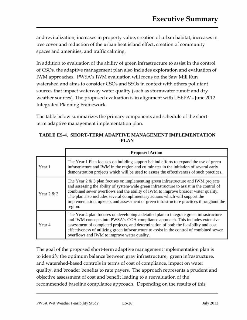
The table below summarizes the primary components and schedule of the short-term adaptive management implementation plan.
TABLE ES-4. SHORT-TERM ADAPTIVE MANAGEMENT IMPLEMENTATION PLAN
Proposed Action
Year 1 The Year 1 Plan focuses on building support behind efforts to expand the use of green infrastructure and IWM in the region and culminates in the initiation of several early demonstration projects which will be used to assess the effectiveness of such practices.
Year 2 & 3
The Year 2 & 3 plan focuses on implementing green infrastructure and IWM projects and assessing the ability of system-wide green infrastructure to assist in the control of combined sewer overflows and the ability of IWM to improve broader water quality. The plan also includes several complimentary actions which will support the implementation, upkeep, and assessment of green infrastructure practices throughout the region.
Year 4
The Year 4 plan focuses on developing a detailed plan to integrate green infrastructure and IWM concepts into PWSA’s COA compliance approach. This includes extensive assessment of completed projects, and determination of both the feasibility and cost effectiveness of utilizing green infrastructure to assist in the control of combined sewer overflows and IWM to improve water quality.
The goal of the proposed short-term adaptive management implementation plan is to identify the optimum balance between gray infrastructure, green infrastructure, and watershed-based controls in terms of cost of compliance, impact on water quality, and broader benefits to rate payers. The approach represents a prudent and objective assessment of cost and benefit leading to a reevaluation of the recommended baseline compliance approach. Depending on the results of this

Executive Summary
PWSA Wet Weather Feasibility Study ES-27 July 2013
assessment, at the end of the initial four-year short-term adaptive management implementation period, a revised Feasibility Study may be submitted to formally request permission to modify or alter the baseline compliance approach. This process may also include or culminate in a formal proposal to PaDEP, ACHD, and US EPA to utilize an integrated planning framework.
MOU AND INTER-MUNICIPAL AGREEMENTS
A Memorandum of Understanding (MOU) has been drafted to document the intent to complete and submit a coordinated Feasibility Study for each POC sewershed. Each contributing municipality was responsible for providing the PWSA with supplemental information regarding municipality-specific projects and required improvements.
In general, each MOU states that, for the purpose of submitting the Feasibility Study, the municipalities agree on the estimated cost of the recommended alternative. Each municipality shall have the right to void the MOU if the total cost exceeds a certain threshold above the estimated cost. The MOU also states that the municipalities agree that the basis of allocation for costs of each segment is based on percentage of peak flow contributed to each segment at the time of the MOU, multiplied by the preliminary estimated total cost of each segment agreed to by the municipalities that will share in such costs. Each MOU summarizes the preliminary estimate of the percentage and amount of the total cost of implementation of the recommended alternative for each municipality. It is intended that an agreement will be entered into by all parties after an implementation order has been issued by the PaDEP and/or the ACHD. Signature pages of executed MOUs or other expressions of agreement as provided by the municipalities are provided as Addenda to their respective POC reports.
AFFORDABILITY AND FINANCIAL CAPABILITY ANALYSIS
A financial capability assessment of the wet weather plan was developed in accordance with USEPA’s Combined Sewer Overflows – Guidance for Financial Capability Assessment and Schedule Development, February 1997, and serves two purposes: it supports the development of a workable implementation schedule for the wet weather plan, and it can help determine the amount of external funding needed to maintain affordable rates for customers.

Executive Summary
PWSA Wet Weather Feasibility Study ES-28 July 2013
The residential indicator (RI) is an approximation of households’ abilities to pay their total wastewater costs. An RI less than 1% of MHI is considered a low impact, RHI between 1% and 2% is a mid-range impact, and an RI greater than 2% of MHI is considered a high impact. The annual wastewater cost per household for the PWSA service area is comprised of two components: current (2012) PWSA sewer (collection and conveyance system) costs of $139, and ALCOSAN (conveyance and treatment) costs of $260, for a total of $399. The current (2012) MHI for Pittsburgh is $38,090. Thus, the current condition (2012) RI is approximately 1.05%, which means that the current wastewater costs within the PWSA service area impose mid-range burden on the residential users.
The financial capability indicator (FCI) complements the residential indicator analysis of household affordability by providing an assessment of PWSA’s ability to finance the wet weather plan. The FCI compares PWSA, or the city of Pittsburgh, to six EPA-defined benchmarks in the areas of debt burden, socioeconomic conditions, and financial operations. EPA’s debt and financial indicators are based on the use of tax revenues to finance wastewater system improvements through general obligation bonds. As a municipal authority, PWSA finances major capital improvements through revenue bonds. As such, where appropriate, a blend of PWSA and Pittsburgh data was used for this analysis. Table ES-5 summarizes the analysis of these financial indicators.
TABLE ES-5. FINANCIAL CAPABILITY INDICATORS
Metric Value Score Score Value
Bond Rating 2.5 Mid-Range 2 Overall Net Debt (as a Percent of Full Market Property Value ) 10.09% Weak 1
Unemployment 0.3% Mid-Range 2 Median Household Income 30% Weak 1 Property Tax Revenues (as a Percent of Full Market Property Value) 2.1% Mid-Range 2
Property Tax Revenue Collection Rate 93% Weak 1
Indicators Score - Mid-Range 1.50

Executive Summary
PWSA Wet Weather Feasibility Study ES-29 July 2013
The current financial capability indicator is “mid-range” but very close to “weak.” The scores in multiple areas would need to improve substantially in order to reach a “strong” rating, though a slight deterioration of any of the scores could make the indicator “weak.”
The costs of PWSA’s ongoing Capital Improvements Program along with capital cost inflation of 3.10% will result in increasing annual costs for the existing PWSA collection and conveyance system. The annual costs for the current PWSA facilities are projected to increase from an estimated $26 million in 2012, to $42 million in 2027, and the projected costs in 2046 would be approximately $62 million. The typical cost per household for PWSA’s wastewater collection and conveyance services is estimated to be $139 in 2012. Without including the recommended wet weather projects, PWSA costs per typical household would be projected to grow at an annual rate of about 3.34% through 2046. The annual PWSA cost per typical household without the recommended wet weather projects would be projected at $207 in 2027. The ALCOSAN Draft Wet Weather Plan includes estimates for the impacts of a $1.5 billion program completed by 2026 on residential customers. As part of the analysis, an estimate of residential sewer costs without including the PWSA recommended wet weather projects determined that the ALCOSAN cost per household is estimated to increase to nearly $400 annually by 2027. Thus, the total cost per typical household in 2027 without the PWSA wet weather projects and without the ALCOSAN Wet Weather Plan would be approximately $600 annually. Over the time period, household income is projected to increase by 2.50% annually. The PWSA median household income of $38,090 in 2012 would therefore increase to $55,166 in 2027. Dividing the total wastewater costs by the median income yields a Residential Indicator of 1.1%.
The total cost for PWSA customers will be tripled from a projected $399 for the current system to a total of $1,113 during the first full year of operation (2027 dollars). Projected PWSA cost per household will total $306, including about $98 for wet weather plan improvements. The addition of the projected $808 in ALCOSAN costs to the projected $305 in PWSA system costs results in an estimated cost per household in 2027 of $1,113. The current (2012) Pittsburgh median household income of $38,090 is projected to increase to $55,166 in 2027. Dividing the projected annual cost per household of $1,113 by the projected MHI results in a Residential Indicator of 2.02%, or a “high burden” based on the EPA Guidance criteria. The

Executive Summary
PWSA Wet Weather Feasibility Study ES-30 July 2013
Residential Indicator is projected to stay between 1% and 2% until 2026, after which it is expected to remain above 2% until 2035, before declining again.
The implementation of the wet weather plan and the related ALCOSAN improvements will result in a dramatic increase in the number of households within the PWSA service area for whom annual wastewater costs will constitute a high burden. The number of households in the service area with a high burden will increase from about 20,000 households in 2012 (15%) to more than 90,000 households in 2027 (68%). Over the same time period, the number of households with a low burden will decrease from around 43,000 (32%) to 4,000 households (2.8%).
Key variables beyond PWSA’s control reduce the accuracy of long-term financial projections. Through a sensitivity analysis, PWSA has identified four factors, including residential share of wastewater costs, total capital cost, income growth, and bond interest rates that could materially affect the future residential indicator. The sensitivity analysis conducted on the best-case and worst-case scenarios for critical assumptions suggests a residential indicator range of 1.76% to 2.52%, as shown in the figure below:
FIGURE ES-6. RESULTS OF SENSITIVITY ANALYSIS ON RESIDENTIAL INDICATOR

Executive Summary
PWSA Wet Weather Feasibility Study ES-31 July 2013
Since the ALCOSAN plan cost and timeframe is a significant uncertainty, for the sensitivity analysis, the ALCOSAN WWP is assumed to cost $1.5 billion and be completed by 2026 for all scenarios. For every $100 million increase in the cost of the ALCOSAN program (with no change in schedule), the 2027 PWSA residential indicator increases by 0.05%. Therefore, if the ALCOSAN program requirement reaches $3.1 billion, as some alternative Wet Weather Plans showed, the residential indicator for PWSA customers would increase by an additional 0.8% to nearly 3%.
The impact of implementation of the PWSA Wet Weather Feasibility Study is likely to diminish the future financial capability of the City of Pittsburgh and PWSA. Indicators such as the bond rating indicator and the property tax collection rate are likely to be adversely affected during the period of the Wet Weather Feasibility Study.
In summary, implementing the Wet Weather Feasibility Study and the related ALCOSAN improvements is anticipated to result in a Residential Indicator above 2%. The 2012 Financial Capability Score of 1.5 under current conditions falls into the bottom of the EPA “mid-range” and is at the threshold for a “weak” rating. The Wet Weather Program could easily push the Financial Capability Score below the “weak” threshold due to the increased risk to bond ratings as well as to tax collection rates. Therefore, the overall matrix score is “high burden.” The maximum RI produced by the affordability analysis performed based on the ALCOSAN 2026 Recommended Plan and PWSA construction ending in 2026 is 2.02%. The maximum RI increases to 2.62% when the analysis is changed to reflect the ALCOSAN Selected Plan and an extended construction schedule for PWSA to construct its improvements in alignment with ALCOSAN’s implementation of its Selected Plan.
STAKEHOLDER INVOLVEMENT
PWSA is committed to raising public awareness of the PWSA sewer infrastructure needs so that public support of capital improvement projects can be achieved. Stakeholder involvement and public awareness provide a mechanism to ensure that rate payers, system users, and the public understand the regulatory/environmental drivers for undertaking the wet weather projects and the economic impact that implementation will have on the region. PWSA's continuing goals are to promote stakeholder involvement and undertake a municipal coordination initiative.

Executive Summary
PWSA Wet Weather Feasibility Study ES-32 July 2013
PWSA considered it important to engage with the public and convey information on wet weather planning and receive feedback. PWSA’s public involvement process included presentations to city council and various stakeholder groups. PWSA also presented at and attended the annual 3RWW sewer conferences, which are open to the public.
PWSA led a series of Wet Weather Feasibility Study coordination meetings with most of the contributing municipalities that are within each multi-municipal sewershed. These meetings with the contributing municipalities were utilized to discuss the information and findings in each of the respective POC feasibility studies.
The “Greening the Pittsburgh Wet Weather Plan” Charrette Project was developed in early 2013 with the primary objective to develop a consensus approach to reviewing, recommending, and incorporating a plan for the implementation of green stormwater infrastructure technologies and policies into the PWSA Wet Weather Feasibility Study. Overall, 125 independent individuals/ stakeholders participated, representing a diverse array of public, private, and non-profit organizations. Each charrette had nearly equal representation from all three sectors. These individuals collectively donated over 1,000 hours of their time to assist PWSA in its effort to better understand the challenges and opportunities associated with green infrastructure.
ALCOSAN created various stakeholder groups under their public participation and municipal coordination programs that were responsible for fostering a consensus-based planning process as well as a stakeholder-supported wet weather plan. PWSA committed to its direct and continuing involvement and cooperation with these stakeholder groups. They provided a forum or conduit for PWSA to convey its constituencies' thoughts and concerns to ALCOSAN so that the best interests of the PWSA and its rate payers were reflected in the regional plan. PWSA had an active role in the Customer Municipality Advisory Committee (CMAC) providing municipal feedback during ALCOSAN’s planning process. PWSA and its representatives attended ALCOSAN public meetings and benefited from these opportunities to share public and municipal information and resources.
Executive Summary
PWSA Wet Weather Feasibility Study ES-33 July 2013
INTEGRATION WITH THE REGIONAL WET WEATHER PLAN
The selected PWSA improvements are intended to meet the COA requirements, be implemented in conjunction with the ALCOSAN WWP, and integrate new controls from tributary municipalities that discharge flows through the PWSA systems.
The PWSA municipal improvements are typically upstream of the ALCOSAN POCs and generally increase flow capacity in the system, whereas the ALCOSAN improvements are generally downstream of the POC and accept larger volumes of wastewater in order to reduce overflow volumes.
ALCOSAN’s WWP consists of the following improvements:
• WWTP upgrades • Regional tunnels with cross connections to the existing system • Parallel relief sewers and storage tanks • Tributary municipal improvements
ALCOSAN acknowledges that the WWP improvements may not be completed by 2026 and suggests a phased approach where a portion of the WWP facilities would be completed by 2026 and the remaining facilities to be completed after 2026.
Only a portion of the PWSA POCs will have their outfalls connected to new regional wet weather facilities. Regulator modifications will be completed at the remaining POCs in order to reduce overflows to the extent possible.
IMPLEMENTATION SCHEDULE
The overall Feasibility Study implementation schedule has been organized by POC sewershed, and has been synchronized with the regional (ALCOSAN) wet weather plan wherever possible. Affordability was also taken into consideration by balanced distribution of the costs of the POC specific and system-wide projects in phases. Inclusion of the adaptive plan management and the Act 537 submittal obligations were also considered in the schedule development process. The schedule assumes the period for review of the PWSA Plan ends July 2014, one year after submission of the FS to the regulatory agencies.

Executive Summary
PWSA Wet Weather Feasibility Study ES-34 July 2013
Large-scale design and construction projects require completion of a number of major tasks to progress from project initiation to project closeout. These major tasks considered during this schedule development process include:
• Funding and Public Coordination
• Preliminary Design (includes siting and property acquisition)
• Final Design
• Permitting
• Public Bid / Contract Award
• Construction
• Commissioning and Project Closeout
The current ALCOSAN WWP plan includes a schedule that shows the municipal improvements being completed by 2026, but is only included for reference purposes. The WWP acknowledges that the schedule of municipal improvements is controlled by the municipality/agency.
In developing the schedule, the sequencing of the POC specific projects was synchronized with the regional WWP wherever possible. Since the PWSA improvements are intended to increase the amount of flow that can discharge to the ALCOSAN POC, it is important to ensure that the ALCOSAN system downstream of the POCs have the capacity to retain, store, convey and/or treat the flows delivered from PWSA. Also it is recommended to have the PWSA improvements up and running as soon as possible after the ALCOSAN improvements are in place to realize the benefits of the system improvements as soon as possible. Therefore, the schedule is made with the construction of the PWSA improvements coinciding closely the ALCOSAN capacity improvements within the portion ALCOSAN is constructing.
The overall implementation schedule is divided into five phases as described below and as shown in the following Figure ES-7.
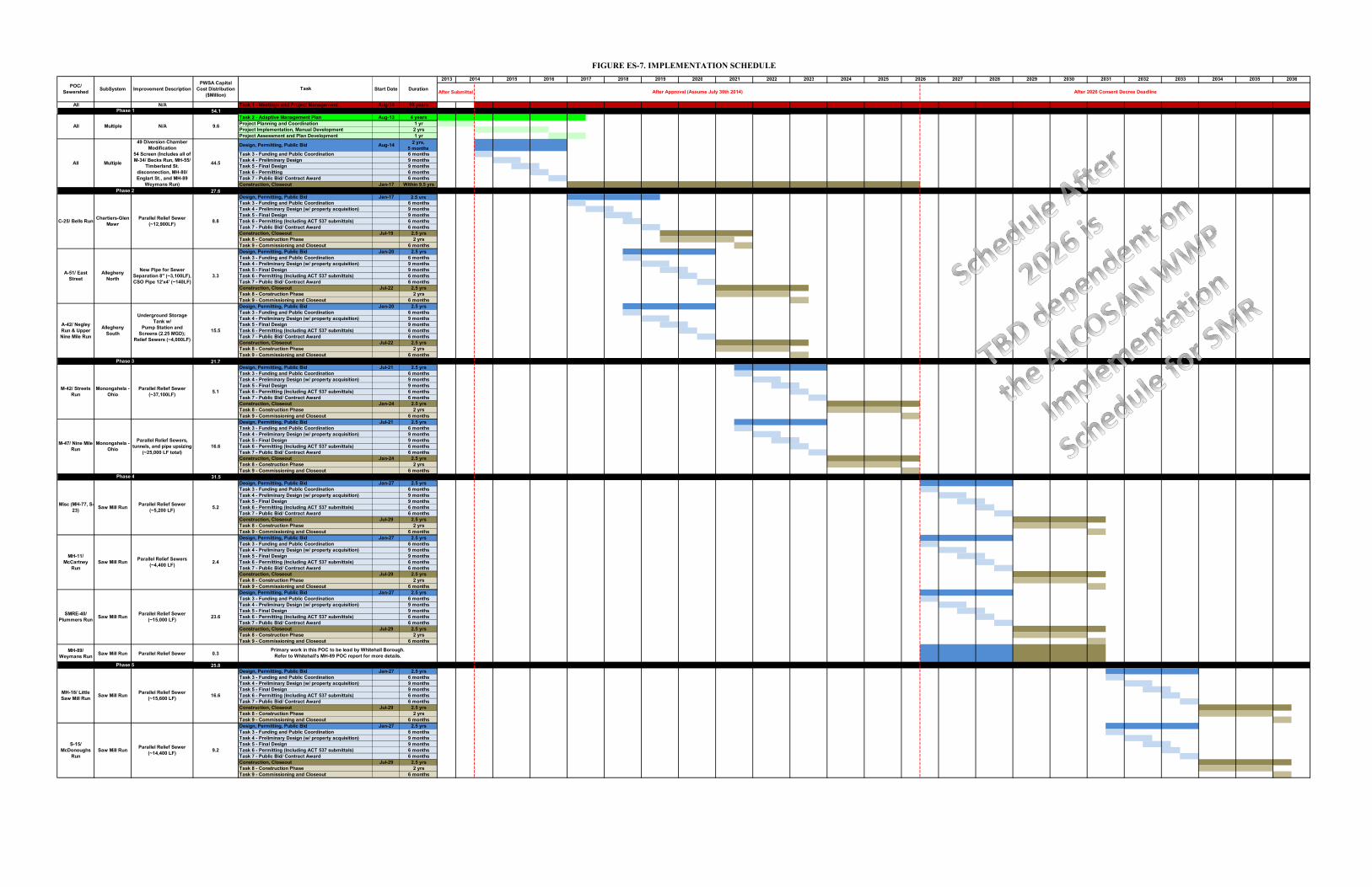
All N/A Task 1 - Meetings and Project Management Aug-14 10 years54.1
Task 2 - Adaptive Management Plan Aug-13 4 yearsProject Planning and Coordination 1 yrProject Implementation, Manual Development 2 yrsProject Assessment and Plan Development 1 yr
Design, Permitting, Public Bid Aug-14 2 yrs, 5 months
Task 3 - Funding and Public Coordination 6 monthsTask 4 - Preliminary Design 9 monthsTask 5 - Final Design 9 monthsTask 6 - Permitting 6 monthsTask 7 - Public Bid/ Contract Award 6 monthsConstruction, Closeout Jan-17 Within 9.5 yrs
27.6Design, Permitting, Public Bid Jan-17 2.5 yrsTask 3 - Funding and Public Coordination 6 monthsTask 4 - Preliminary Design (w/ property acquisition) 9 monthsTask 5 - Final Design 9 monthsTask 6 - Permitting (Including ACT 537 submittals) 6 monthsTask 7 - Public Bid/ Contract Award 6 monthsConstruction, Closeout Jul-19 2.5 yrsTask 8 - Construction Phase 2 yrsTask 9 - Commissioning and Closeout 6 monthsDesign, Permitting, Public Bid Jan-20 2.5 yrsTask 3 - Funding and Public Coordination 6 monthsTask 4 - Preliminary Design (w/ property acquisition) 9 monthsTask 5 - Final Design 9 monthsTask 6 - Permitting (Including ACT 537 submittals) 6 monthsTask 7 - Public Bid/ Contract Award 6 monthsConstruction, Closeout Jul-22 2.5 yrsTask 8 - Construction Phase 2 yrsTask 9 - Commissioning and Closeout 6 monthsDesign, Permitting, Public Bid Jan-20 2.5 yrsTask 3 - Funding and Public Coordination 6 monthsTask 4 - Preliminary Design (w/ property acquisition) 9 monthsTask 5 - Final Design 9 months Task 6 - Permitting (Including ACT 537 submittals) 6 monthsTask 7 - Public Bid/ Contract Award 6 monthsConstruction, Closeout Jul-22 2.5 yrsTask 8 - Construction Phase 2 yrsTask 9 - Commissioning and Closeout 6 months
21.7Design, Permitting, Public Bid Jul-21 2.5 yrsTask 3 - Funding and Public Coordination 6 monthsTask 4 - Preliminary Design (w/ property acquisition) 9 monthsTask 5 - Final Design 9 monthsTask 6 - Permitting (Including ACT 537 submittals) 6 monthsTask 7 - Public Bid/ Contract Award 6 monthsConstruction, Closeout Jan-24 2.5 yrsTask 8 - Construction Phase 2 yrsTask 9 - Commissioning and Closeout 6 monthsDesign, Permitting, Public Bid Jul-21 2.5 yrsTask 3 - Funding and Public Coordination 6 monthsTask 4 - Preliminary Design (w/ property acquisition) 9 monthsTask 5 - Final Design 9 monthsTask 6 - Permitting (Including ACT 537 submittals) 6 monthsTask 7 - Public Bid/ Contract Award 6 monthsConstruction, Closeout Jan-24 2.5 yrsTask 8 - Construction Phase 2 yrsTask 9 - Commissioning and Closeout 6 months
31.5Design, Permitting, Public Bid Jan-27 2.5 yrsTask 3 - Funding and Public Coordination 6 monthsTask 4 - Preliminary Design (w/ property acquisition) 9 monthsTask 5 - Final Design 9 monthsTask 6 - Permitting (Including ACT 537 submittals) 6 monthsTask 7 - Public Bid/ Contract Award 6 monthsConstruction, Closeout Jul-29 2.5 yrsTask 8 - Construction Phase 2 yrsTask 9 - Commissioning and Closeout 6 monthsDesign, Permitting, Public Bid Jan-27 2.5 yrsTask 3 - Funding and Public Coordination 6 monthsTask 4 - Preliminary Design (w/ property acquisition) 9 monthsTask 5 - Final Design 9 monthsTask 6 - Permitting (Including ACT 537 submittals) 6 monthsTask 7 - Public Bid/ Contract Award 6 monthsConstruction, Closeout Jul-29 2.5 yrsTask 8 - Construction Phase 2 yrsTask 9 - Commissioning and Closeout 6 monthsDesign, Permitting, Public Bid Jan-27 2.5 yrsTask 3 - Funding and Public Coordination 6 monthsTask 4 - Preliminary Design (w/ property acquisition) 9 monthsTask 5 - Final Design 9 monthsTask 6 - Permitting (Including ACT 537 submittals) 6 monthsTask 7 - Public Bid/ Contract Award 6 monthsConstruction, Closeout Jul-29 2.5 yrsTask 8 - Construction Phase 2 yrsTask 9 - Commissioning and Closeout 6 months
MH-89/Weymans Run Saw Mill Run Parallel Relief Sewer 0.3
25.8Design, Permitting, Public Bid Jan-27 2.5 yrsTask 3 - Funding and Public Coordination 6 monthsTask 4 - Preliminary Design (w/ property acquisition) 9 monthsTask 5 - Final Design 9 monthsTask 6 - Permitting (Including ACT 537 submittals) 6 monthsTask 7 - Public Bid/ Contract Award 6 monthsConstruction, Closeout Jul-29 2.5 yrsTask 8 - Construction Phase 2 yrsTask 9 - Commissioning and Closeout 6 monthsDesign, Permitting, Public Bid Jan-27 2.5 yrsTask 3 - Funding and Public Coordination 6 monthsTask 4 - Preliminary Design (w/ property acquisition) 9 monthsTask 5 - Final Design 9 monthsTask 6 - Permitting (Including ACT 537 submittals) 6 monthsTask 7 - Public Bid/ Contract Award 6 monthsConstruction, Closeout Jul-29 2.5 yrsTask 8 - Construction Phase 2 yrsTask 9 - Commissioning and Closeout 6 months
S-15/ McDonoughs
RunSaw Mill Run Parallel Relief Sewer
(~14,400 LF) 9.2
Primary work in this POC to be lead by Whitehall Borough. Refer to Whitehall's MH-89 POC report for more details.
Phase 5
MH-18/ Little Saw Mill Run Saw Mill Run Parallel Relief Sewer
(~15,600 LF) 16.6
MH-11/ McCartney
Run Saw Mill Run Parallel Relief Sewers
(~4,400 LF) 2.4
SMRE-40/ Plummers Run Saw Mill Run Parallel Relief Sewer
(~15,000 LF) 23.6
M-47/ Nine Mile Run
Monongahela - Ohio
Parallel Relief Sewers, tunnels, and pipe upsizing
(~25,000 LF total)16.6
Phase 4
Misc (MH-77, S-23) Saw Mill Run Parallel Relief Sewer
(~5,200 LF) 5.2
A-42/ Negley Run & Upper Nine Mile Run
Allegheny South
Underground Storage Tank w/
Pump Station and Screens (2.25 MGD);
Relief Sewers (~4,000LF)
15.5
Phase 3
M-42/ Streets Run
Monongahela - Ohio
Parallel Relief Sewer (~37,100LF) 5.1
Phase 2
C-25/ Bells Run Chartiers-Glen Mawr
Parallel Relief Sewer (~12,900LF) 8.8
A-51/ East Street
Allegheny North
New Pipe for Sewer Separation 8" (~3,100LF), CSO Pipe 12'x4' (~140LF)
3.3
Phase 1
All Multiple N/A 9.6
All Multiple
49 Diversion Chamber Modification
54 Screen (Includes all of M-34/ Becks Run, MH-55/
Timberland St. disconnection, MH-80/ Englart St., and MH-89
Weymans Run)
44.5
2033 2034 2035 2036
After Submittal After Approval (Assume July 30th 2014) After 2026 Consent Decree Deadline
2027 2028 2029 2030 2031 20322021 2022 2023 2024 2025 20262015 2016 2017 2018 2019 2020
FIGURE ES-7. IMPLEMENTATION SCHEDULE
POC/ Sewershed SubSystem Improvement Description
PWSA Capital Cost Distribution
($Million)Task Start Date Duration
2013 2014

Executive Summary
PWSA Wet Weather Feasibility Study ES-36 July 2013
Phase 1. Phase 1 includes the four-year Adaptive Plan Management and all of the diversion structure modifications and outfall screen installations for all the POC-specific improvements. The results of the Adaptive Management Plan potentially can affect the size and amount of “gray” facilities within all of the other POC-specific improvements other than the diversion chamber modifications and outfall screen installations. The diversion chamber modifications and outfall screens installation work can be started immediately and concurrently with the adaptive management plan since the results of the adaptive management work are not anticipated to affect either the need for or the major design elements of these improvements. The capital cost estimate is $54.1 million, and the phase is implemented between 2013 through 2026. This phase includes all the improvements for M-34, MH-55, and MH-80 which are significantly smaller projects (diversion structure modifications and installation of screens).
Phase 2. Phase 2 includes improvements for C-25, A-42, and A-51, which coincide with the improvements for the Allegheny River Segment and Chartiers Creek retention treatment basin in the ALCOSAN WWP. It is assumed that although the Allegheny River Segment of the regional tunnel does not extend up to the A-42 POC, that the capacity relief would extend upstream and benefit A-42. The capital cost estimate of Phase 2 is $27.6 million. Phase 2 would begin in 2017 and extend to 2023. There is a potential the C-25 construction period may extend to 2026 depending on the ALCOSAN WWP Chartiers Creek construction, which extends from 2018 to 2026.
Phase 3. Phase 3 includes improvements for M-42 and M-47, which coincide with the improvements for the Monongahela River Segment RTB in the ALCOSAN WWP. It is assumed that although the Monongahela River Segment of the regional tunnel does not extend up to these POCs, that the capacity relief would extend upstream and benefit M-42 and M-47. The capital cost estimate of Phase 3 is $21.7 million. Phase 3 would begin in 2021 and extend to 2026.
Phases 4 and 5. Phases 4 and 5 are the SMR POC improvements divided into two phases to distribute the costs if possible. As stated before, the ultimate schedule for SMR depends on the Regional Wet Weather Plan schedule to implement improvements in SMR. Phase 4 includes MH-11, MH-77, S-23, and SMRE-40. The capital cost estimate is $31.5 million. Phase 5 includes MH-18, and S-15 and the

Executive Summary
PWSA Wet Weather Feasibility Study ES-37 July 2013
capital cost estimate is $25.8 million. The implementation dates are to be determined.
PWSA and their tributary municipalities intend to continue to cooperate in the joint planning and implementation of the recommended alternative. All associated parties in the POC sewershed have participated in planning meetings to review and discuss the selected flow management plan and required improvements, associated cost estimates and proposed method of allocating shared costs. While there is agreement on the flow management strategy and the general approach to the allocation of costs, additional time, discussions and negotiations will be required in order to finalize municipal agreements.