evolution of warning servicesintegrated hazard information services workshop - oct 2009 greg stumpf...
TRANSCRIPT

Evolution of Warning ServicesIntegrated Hazard Information Services Workshop - Oct 2009
Greg StumpfCIMMSNWS-MDL
Evolution of Warning Services
Experiments in Convective Hazard Concepts of Operations,Here and Abroad

Evolution of Warning ServicesIntegrated Hazard Information Services Workshop - Oct 2009
NWS Warnings, (then and) now…

Evolution of Warning ServicesIntegrated Hazard Information Services Workshop - Oct 2009
One-size-fits-all polygons: “monotonic” information.
Each location under same threat for same time period
Limited Time of Arrival information (pathcasts)
No Time of Departure info beforehand
Each location is assumed 100% certainty of threat
NWS warnings are area forecasts verified by point events.
Just draw larger polygons with longer valid times to improve verification scores!
Drivers for Improvement
Evolution of Warning ServicesIntegrated Hazard Information Services Workshop - Oct 2009
Drivers for Improvement
Forecaster cannot control motion uncertainty
Difficult to adjust to storm changes after warning issuedSVS procedure very limiting (can’t add areas)
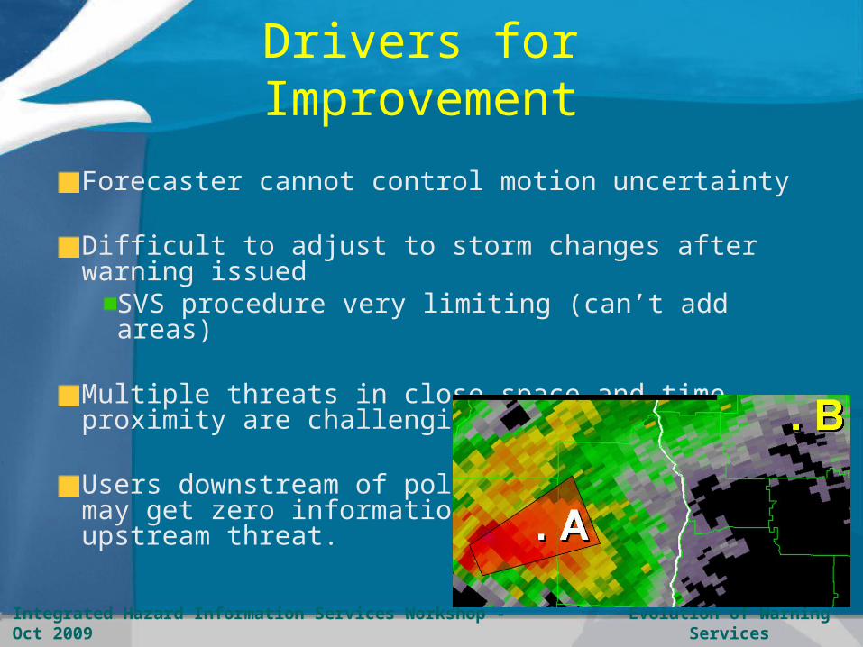
Multiple threats in close space and time proximity are challenging
Users downstream of polygon may get zero information on upstream threat.

Evolution of Warning ServicesIntegrated Hazard Information Services Workshop - Oct 2009
A B
User “A” gets many minutes lead time…
A B…while User “B” gets only 0-5 minutes
Very little overlap between adjacent warnings can lead to inequitable lead times for nearly-adjacent locations
Drivers for Improvement

Evolution of Warning ServicesIntegrated Hazard Information Services Workshop - Oct 2009
Zero Lead Time
Drivers for Improvement
Reflectivity Hail Size
Zero Lead Time
Evolution of Warning ServicesIntegrated Hazard Information Services Workshop - Oct 2009
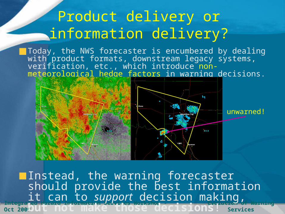
Product delivery or information delivery?
Today, the NWS forecaster is encumbered by dealing with product formats, downstream legacy systems, verification, etc., which introduce non-meteorological hedge factors in warning decisions.
Instead, the warning forecaster should provide the best information it can to support decision making, but not make those decisions!
unwarned!

Evolution of Warning ServicesIntegrated Hazard Information Services Workshop - Oct 2009
Storm-based warnings:April 2008 - June 2009

Evolution of Warning ServicesIntegrated Hazard Information Services Workshop - Oct 2009
Future Nowcasting systems:
Blending extrapolation and NWP
Warn On Forecast with an aim to provide longer lead times.
Warnings (which are just short-term forecasts) become more uncertain with time, therefore the solution will require a probabilistic approach.
Longer lead times really means
Less uncertainty at longer forecast
periods

Evolution of Warning ServicesIntegrated Hazard Information Services Workshop - Oct 2009
The meteorologist is the expert on interpreting the hazard and its uncertainty.
The meteorologist cannot anticipate everyone’s exposure and response time
How can weather hazard information be made more adaptable to those that do know their own exposure and response time?
Beyond Storm-Based Warnings:
Adaptive Warnings
Little Sioux Camp
Concrete Dome Home

Evolution of Warning ServicesIntegrated Hazard Information Services Workshop - Oct 2009
How will we shape our future?
NWS is moving from a paradigm of issuing products to providing services (Don Berchoff, NWS OS&T Director).
Support the legacy now, but also be adaptable to new operational concepts and foster innovation.
"The future is not something we enter, the future is something we create." -Leonard I. Sweet
"The future is made of the same stuff as the present." -Simone Weil
"The future has already happened, it just isn't very well distributed." -William Gibson

Evolution of Warning ServicesIntegrated Hazard Information Services Workshop - Oct 2009
Experimental Warning/Nowcast
Systems
Probabilistic Hazard Information (PHI)U.S. – NSSL Hazardous Weather Testbed
Auto-NowCaster (ANC)U.S. – NCAR
Thunderstorm Interactive Forecast System (TIFS)AustraliaThunderstorm Environmental Strike Probability Algorithm (THESPA)
Canadian Radar Decision Support system (CARDS)
Short-range Warning of Intense Rainfall in Localized Systems (SWIRLS)Hong Kong Observatory (HKO)
SIGnificant weather Object Oriented Nowcasting System (SIGOONS)France

Evolution of Warning ServicesIntegrated Hazard Information Services Workshop - Oct 2009
Some characteristics of each system
Digital Hazard Grids
Object-based 2D threat areas
Continuously translating 2D threat areas
Human-machine mix
Uncertainty information

Evolution of Warning ServicesIntegrated Hazard Information Services Workshop - Oct 2009
Digital Hazard Grids
Supports emerging products and servicesFlexibility in resolution and refresh rates
Grid layers can provide multi-dimensional infoThreat type, intensity, time of arrival/departure,uncertainty
Can be aggregated into simpler formatsSupport legacy systems/products
Multiple ways to create/modify grids:WarnGen / Drag-Me-To-Storm2D object trackingGrid editorsStorm algorithmsProbabilistic guidance from statistics/NWPHuman-machine mix
HAILWINDTORNADOLIGHTNING

Evolution of Warning ServicesIntegrated Hazard Information Services Workshop - Oct 2009
NSSL Probabilistic Hazard Information (PHI)
For each storm object, the forecaster determines
the initial threat area (polygon or ellipse) at time=0, along with
the motion vector, and adds
motion uncertainty information
Parameters used to derive gridded hazard informationtranslating threat area, swath, time of arrival/departure
Each storm object’s properties are adjusted in 10-20 minute intervals to account for changes in motion and intensity.
Right now, this is done completely by the human.
Object-based 2D threat areas

Evolution of Warning ServicesIntegrated Hazard Information Services Workshop - Oct 2009
Object-based 2D threat areas
Anticipate discretedevelopment alongsouth flank
Anticipateareaorientationchange
Anticipatenon-linearmotion
PHI Mock-up: Interact with current and forecast states, morphing

Evolution of Warning ServicesIntegrated Hazard Information Services Workshop - Oct 2009
Warning automatically translates downstream based on storm motion until adjusted or cancelled.
Provides meaningful information about times of arrival and departure.
Removes warning from area where threat has passed.
A B
Both “A” and “B” get equitable lead time
Continuously translating threat information

Evolution of Warning ServicesIntegrated Hazard Information Services Workshop - Oct 2009
Human-Machine Mix
Thunderstorm Interactive Forecast System (TIFS – Australia)Forecaster can interact with past and forecast positions to correct for deficiencies in the automated algorithms
Real-time verification system

Evolution of Warning ServicesIntegrated Hazard Information Services Workshop - Oct 2009
SIGnificant weather Object Oriented Nowcasting System (SIGOONS – France)Human can correct past and forecast tracks, motion, intensity, other parameters
Human-Machine Mix

Evolution of Warning ServicesIntegrated Hazard Information Services Workshop - Oct 2009
NCAR Auto-NowCaster (ANC)
Forecaster-entered boundary
Initiation
Growth and Decay
Human-Machine Mix

Evolution of Warning ServicesIntegrated Hazard Information Services Workshop - Oct 2009
Uncertainty Information
Include uncertainty information on the grids
Based on existence, motion, location, evolution Integration over time results in a probabilistic swath
Probabilities can be derived from a combination of:
Human expertise (e.g., PHI)Storm-motion uncertainty (e.g., PHI) Storm morphology statistics (e.g., THESPA)Storm-type climatology statistics Nowcast and NWP ensembles (e.g., FDP-B08)
PHI
FDP-B08:TIFS/CARDS/SWIRLS
THESPA

Evolution of Warning ServicesIntegrated Hazard Information Services Workshop - Oct 2009
Thunderstorm Environmental Strike Probability Algorithm (THESPA - Australia)±10 km h-1; ±30°degWhich probability envelope to use?
Depends on user, acceptable cost-loss (POD, FAR).Note – envelope is NOT a trapezoid!
. A
. B
50%
10%
Slow-moving storm
Uncertainty Information

Evolution of Warning ServicesIntegrated Hazard Information Services Workshop - Oct 2009
Real-Time Testing
WMO Forecast Demonstration Projects (FDP)2000 (Sydney); 2008 (Beijing)
Nowcast systems demoed, discussed, etc.
FDP-B08: T-storm strike probability combined three algorithms (TIFS,CARDS, SWIRLS)

Evolution of Warning ServicesIntegrated Hazard Information Services Workshop - Oct 2009
Real-Time Testing
NOAA Hazardous Weather Testbed (HWT)Experimental Warning Program (EWP)
Probabilistic Hazard Information (PHI) demoed

Evolution of Warning ServicesIntegrated Hazard Information Services Workshop - Oct 2009
Multi-layered dissemination systems: Exploit emerging GIS and GPS and wireless technology, so we can phase out limiting legacy systems (incl. even NWR voice broadcasts!)
Adaptive warnings allow users to set their threshold criteria, or allow third-party enabling technology/systems to do this for them
For super-users: Longer lead time … greater uncertainty, TOA and TOD.
Point warnings for anyone
Geo-located cell phones and navigation systems
Facilities with long lead-time needs
Potential uses

Evolution of Warning ServicesIntegrated Hazard Information Services Workshop - Oct 2009
Can issue hazard grids at probability values below expected thresholds for issuing today’s warnings.
Provide greater lead time to high risk users. Will require uncertainty and Time of Arrival/
Departure information
Seamless hazard information across all time and space scales.
Many actions/decision are hierarchical across the hazard timeline
60%
60%
40%
40%
20%
10%
10%
10%
10%
Potential uses

Evolution of Warning ServicesIntegrated Hazard Information Services Workshop - Oct 2009
For each grid point in the warning, the intersection of the threat area over time provides time of arrival and time of departure information, and probabilities of the event.
A’B’
1
0
Threat Prob
Time BA
Time Of ArrivalTime Of Departure
Potential uses

Evolution of Warning ServicesIntegrated Hazard Information Services Workshop - Oct 2009
Recommended actions:Move indoorsEvacuate mobile homes
Anytown
Tornado threat indexValid 10:00 pm-10:15 pm XDTLast updated: 6 minutes ago
Whatever Co.
Convert probabilities to a “Threat Level Index”.
Intersect threat GIS layer with demographic GIS layers to create tailored calls-to-action
Different calls-to-action based on combination of hazard threat level and unique (and sometimes dynamic) exposure/response times of the individual users.
Potential uses

Evolution of Warning ServicesIntegrated Hazard Information Services Workshop - Oct 2009
Any high resolution grid (space and time) can be aggregated into simpler formats
Supports legacy U. S. county-based warning systems (television crawls, local and NOAA Weather radio).
Not every user needs to see the probabilities.
Potential uses
Evolution of Warning ServicesIntegrated Hazard Information Services Workshop - Oct 2009
A vision?
A digital gridded weather hazard database that:Will supply hazard information seamlessly across all time and space scalesIs wholly adaptable to users and systems to support and enable their decision making
From this databaseThe NWS can provide some derived watch, warning, and advisory products for public customers (including supporting legacy capabilities). Other public and private partners can derive specific customer-centric start-of-the-art products.

Evolution of Warning ServicesIntegrated Hazard Information Services Workshop - Oct 2009
How do we achieve the vision?
Emerging concepts must be vetted across many intersecting disciplines:
MeteorologyTechnologySocial ScienceHuman Factors / Ergonomics
What is the best way to balance innovation and user needs?
"If I had asked people what they wanted, they would have said faster horses." -Henry Ford

Evolution of Warning ServicesIntegrated Hazard Information Services Workshop - Oct 2009
Snack on these ideas for the next
2 ½ days!